Click here to go to the US Drought Monitor website. Here’s an excerpt:
Summary
Early in the drought week, moderate precipitation fell in an area covering southern Minnesota stretching southeastward through central Iowa and Illinois, southern Indiana, Kentucky, southwestern Virginia, and much of North Carolina. Heavier precipitation fell in coastal California and the Sierra range. Coastal Oregon and Washington also saw moderate to heavy precipitation amounts during the first half of the drought week. The Northeast experienced its fourth Nor’easter in as many weeks. Near the end of the drought week, a swath of precipitation fell from Texas, eastern Oklahoma, into Missouri and Indiana. The dry pattern continued for the drought stricken areas of the southern Rockies and Plains and parts of the Southeast…
South
Precipitation was generally above normal (0.5-2.0 inch surpluses) across north central Texas, eastern Oklahoma and extreme northwestern Arkansas during the USDM period. During the last 30 days, much of Texas, Oklahoma and Louisiana were running 1-3 inches below normal while Arkansas was as much as 5 inches above normal. According to the USDA, 65 percent of wheat in Texas was in poor to very poor condition while 72 percent of topsoil moisture across the state was short to very short. Moderate and Extreme drought was expanded in central and parts of southern Texas. Precipitation continues to miss western Oklahoma where 28-day streamflows are running below the fifth percentile and precipitation for the last 6-months is around 20 percent of normal. Extreme drought was expanded to cover more of the Panhandle of Oklahoma, reaching into Kansas and Texas. Drought and dryness is not currently affecting the majority of the other states of the region…
High Plains
Precipitation was light across the region during the USDM period as, generally speaking, less than 1 inch of precipitation fell. Aside from Kansas and Colorado, precipitation during the past 30-days was just ahead of normal as surpluses of 0.50 to 1 inch fell in much of North Dakota, eastern South Dakota and eastern Nebraska. Winter wheat conditions were rated 49 percent poor to very poor in Kansas while 69 percent of topsoil moisture across the state was short to very short. In southern Kansas, 180-day precipitation departures are 4-8 inches below normal. In southwestern South Dakota, recent precipitation allowed for D0 and D1 to be contracted. Severe drought (D2) was contracted in west central Colorado and in the Dakotas. Extreme drought (D3) was expanded southern and western Colorado and southern Kansas…
West
Copious amounts of precipitation fell in the West during the USDM period, helping to restore the below-normal seasonal mountain snowpack in the Sierra. In the lower elevations, the atmospheric river event caused flash flooding and mudslides in the same area where forest fires last December charred the landscape. Little to no precipitation fell during the week in Arizona and New Mexico. Despite the recent precipitation in California, departures are evident beyond 30 days. At the 6-month time scale, precipitation amounts are 30-50 percent of normal in Southern California. However, for the same period (6-month), the recent storm brought the precipitation totals closer to normal in the central and northern Sierra. River basin snow water content now measures 75-90 percent of average in the central Sierra. The recent storm allowed the contraction of drought across much of the West this USDM period. However, where the precipitation did not fall (Desert Southwest and northwestern New Mexico), Severe and Extreme drought (D2-D3) was expanded.
*For details on Eastern Colorado and Eastern Wyoming, refer to the High Plains region…
Looking Ahead
During the next 5 days, precipitation amounts are forecast to be high (3-5 inches) in an area stretching from Louisiana, Arkansas, Alabama, western Tennessee and into Kentucky. Elsewhere, lighter precipitation is forecasted to fall in the northern and central Rockies, High Plains, and Northeast. The drought-stricken Four Corners region, western Texas and the Southwest are expected to continue to be dry.
The 6-10 day outlook from the Climate Prediction Center calls for an increased chance of below-normal precipitation in the High Plains stretching into the Great Lakes region while the highest probability of above normal temperatures is centered around the Southwest. The probability of above-normal precipitation is highest in the South. Below-normal precipitation is most likely to occur across parts of the Southwest.
“Everybody talks about 2001 and 2002,” [Chuck] McAfee says. “That one was a very dry time just like this is. This is appearing to be scarier and worse.”
By most measures, portions of the American southwest in the Colorado River Basin are in their 18th year of drought. A handful of wet years dot the historical record in that stretch of time, but storms haven’t brought enough moisture to fill reservoirs and replenish groundwater. It’s the longest period of sustained dry and warm weather since consistent records have been kept.
That’s leading some to ask: If a drought lasts that long, is it still a drought or something else entirely?
[…]
The lack of robust conversations about the dry conditions might be a symptom of our limited vocabulary to describe what’s going on, says Brad Udall, a climate and water researcher with Colorado State University.
“Language is how you think, right? It’s how your opinions form and how your thought processes work. If you have the wrong words in your thoughts, you might actually come up with the wrong solutions,” Udall says.
Udall and other academics with the Colorado River Research Group published a paper arguing that our conversations about drought in the southwest need to change — specifically the word “drought.” It’s no longer a helpful concept in talking about the fundamental climate shifts reshaping the southwest, Udall says.
“Drought is often viewed as a lack of water and is viewed as a temporary situation,” Udall says.
But the latest science points toward a drier, warmer future for the Colorado River Basin, Udall says. If we see that change as “drought,” as something that eventually goes away, we hold onto false hope and fail to adequately prepare…
“This isn’t really drought,” [Udall] says. “This is the ongoing aridification of the Colorado River Basin and we think we should start to talk about it in these terms rather than this older term, ‘drought.’”
Here’s the March 2018 Drought Update from the Colorado Water Conservation Board (Taryn Finnessey) and Colorado Division of Water Resources (Tracy Kosloff):
Despite near normal precipitation across most of the state in February, March precipitation has been well below average statewide. Currently Colorado is experiencing the 3rd lowest snowpack on record, with only 2002 and 1981 being drier. Extreme drought has expanded to cover most of Southwestern Colorado, The San Luis Valley and Southeastern Colorado. West Slope providers with limited storage are concerned about the demand season and thinking about possible restrictions, while Front Range providers are thinking about conservation messaging.
As of March 23rd, statewide snowpack at SNOTEL sites is 69 percent of average. The North and South Platte basins have experienced the highest levels of precipitation in the state, at 90 and 81 percent, respectively. While the Yampa & White and Colorado River Basins are slightly lower at 80 percent. The southern half of the state has been significantly drier with the Southwest basins of the San Miguel, Dolores, Animas & San Juan, Rio Grande, Gunnison and Arkansas all well below normal precipitation at 54, 54, 61 and 58 percent respectively.
Many basins’ year –to-date precipitation, based on SNOTEL is tracking near 2002, as is the state as a whole.
74 percent of the state is in some level of drought classification with 24 percent in moderate drought, 30 percent in severe drought and 20 percent classified as extremely dry. An additional 16 percent of the state is experiencing abnormally dry conditions (see image on reverse side).
Reservoir storage statewide is at 116 percent of normal, with all basins above average. The Arkansas basin is reporting the highest average storage at 145 percent. The Southwest basins of the San Miguel, Dolores, Animas & San Juan have the lowest storage levels in the state at 105 percent of normal.
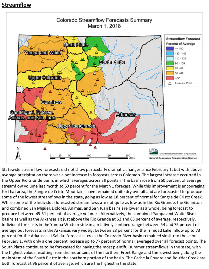
The Surface Water Supply Index(SWSI) values improved slightly for March 1, but remain below normal with much of the western slope classified as moderate to extremely dry. These values are expected to decline when new numbers are released on April 1, this is largely the due to below average streamflow forecasts.
Streamflow forecasts are well below average for the vast majority of the state and near normal in isolated areas including the Blue River, St. Vrain and Cache La Poudre basins (see image on reverse side).
Short term forecasts show that temperatures will be more seasonal with a normal chance of precipitation, however longer term forecasts indicate increased likelihood of below average precipitation and above average temperatures.
A weak La Niña remains active and is projected to transition to neutral conditions in May or June, indicating that warm and dry conditions are likely to persist through the spring. While the monsoonal rainfall forecast is still uncertain, above average temperatures should continue into the summer months.
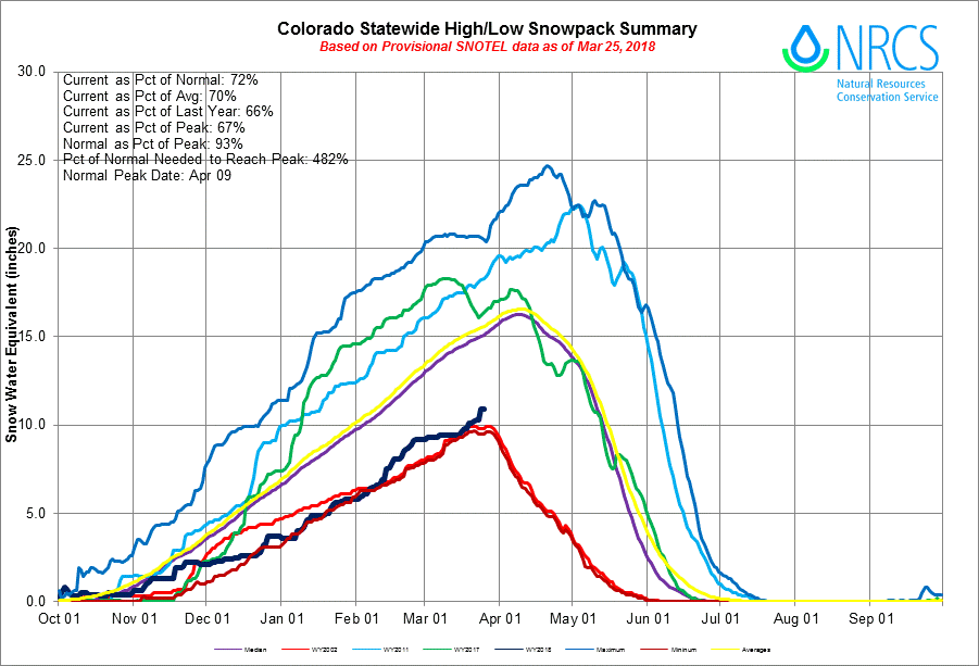
Statewide Basin High/Low graph March 25, 2018 via the NRCS.
Statewide SNOTEL snowpack is well below average at [72] percent of normal, and tracking close to 2002 levels. To reach a normal snowpack peak we would need to 480 percent of normal accumulation. Snowpack typically peaks in early to mid April.
March 1 streamflow forecasts are below 60 percent of average for nearly all of southern Colorado, while the central portion of the state ranges from 70-80 percent of average. With dry conditions throughout March the April 1 streamflow forecasts are projected to decline.
Click here to read the current drought assessment from the Colorado Climate Center. Click here to go to the NIDIS website hosted by the Colorado Climate Center.
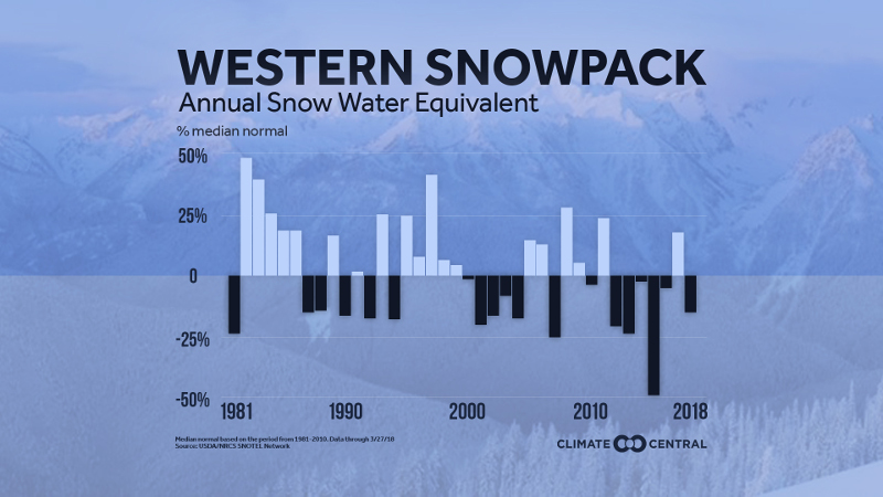
Western spring snowpack has been below normal six of the past seven years, meaning less water during the traditionally dry summer months. Graphic credit: Climate Central
Even with the heavier snow in parts of the West last week, the snowpack depth measured at the end of the season for the West as a whole is below normal. It is a shift from last year’s snow surplus but is more representative of the long-term trend; 2011 and 2017 were the only two years this decade in which the snowpack was above normal. The Northwest had a favorable snowfall season, but drought returned to California after last year’s wet season, with extreme drought now extending eastward from California to the Southern Plains. Arizona and New Mexico are particularly dry, with each state receiving less than half of its normal snowfall through the end of March.
As the world continues to warm from increased concentrations of greenhouse gases in the atmosphere, early spring snowpack has been trending downward. In addition to more intense droughts from decreased snowpack, warming winters mean that the percentage of winter precipitation that falls as snow is decreasing, which also contributes to the snowpack decline.
While the West has a long history of droughts and wet periods, the droughts have been getting more intense over the past century. This has led to a depletion of deeper groundwater, which takes more than a single wet season to recover. According to the National Environmental Education Foundation, water managers in 40 states expect water shortages in some parts of their states in the next 10 years.
The Roaring Fork Conservancy’s weekly snowpack report has the watershed as a whole at 75 percent of normal — better than the southwestern part of the state but not as robust as parts of northern Colorado and the Front Range. According to Education & Outreach Coordinator Liza Mitchell, area snowpack usually peaks around April 1, but that’s just a milestone, not a point of no return.
“We’re going to have above average years and we’re going to have below average years,” she said. “While there’s definitely concern, there is sort of a silver lining in that we’re coming off of two years that were well above average… Our reservoirs are like savings accounts for a not-so-rainy summer. When it becomes really bad is when we have back-to-back years like this.”
The Conservancy and local partners have also put effort into programs that will help residents, ranchers and wildlife weather tough years. The Crystal River Management Plan, for instance, makes it possible for irrigators to reduce their usage without losing their water rights.
“The only certainty is that things will become more unpredictable, so we’re trying to set ourselves and the river up for success — be proactive instead of reactive,” Mitchell said. “Each and every one of us is a water user and therefore water diverter.”
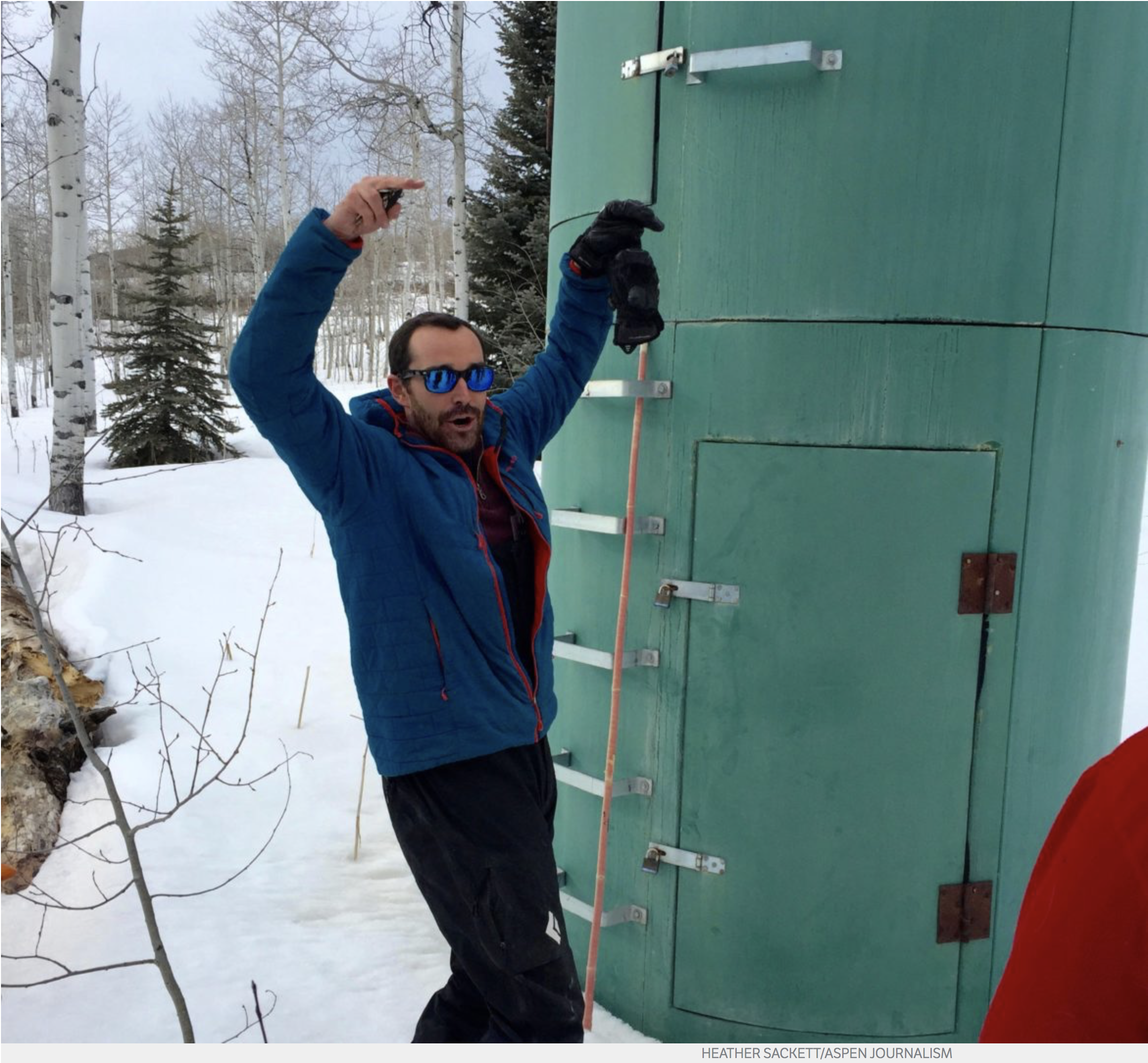
Karl Wetlaufer, a hydrologist and assistant supervisor with the National Resources Conservation Service Colorado Snow Survey, gestures to indicate how high snowpack has been in past years at the McClure Pass site. Data collectors would have to climb the rungs up to the second, higher door to access the shelter.
For much of the winter, the snowpack at McClure Pass hovered around the second-lowest measurement on record for a 30-year period.
By Thursday, March 22, the McClure Pass site and the Independence Pass site had dipped to the lowest ever recorded snow-water equivalent for that date.
“It’s a very notable statistic because [McClure Pass] has a pretty long period of record — 38 years,” said Karl Wetlaufer, a National Resources Conservation Service hydrologist and assistant supervisor with the Colorado Snow Survey. “It definitely indicates there will be well below normal streamflow resulting from those areas.”
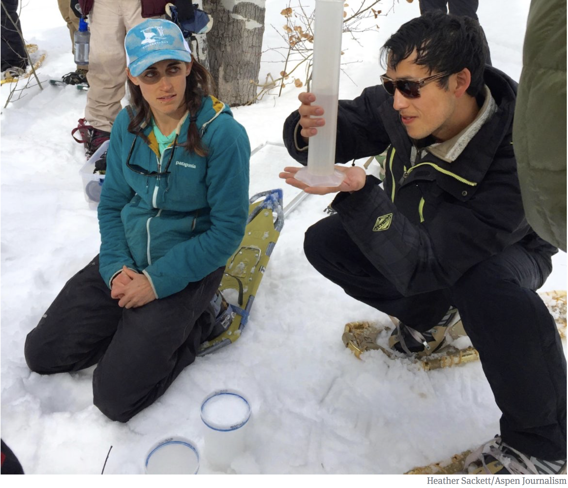
It’s one thing to read about record low snowpack in a graph, and quite another when you see what it looks like on the ground where the data is gathered.
At an early March Water Education Colorado workshop, participants traipsed around McClure Pass on snowshoes digging snow pits, measuring snow depth, and testing the snow-water equivalent of snow samples, looking for clues about this year’s spring runoff.
That’s because today’s snow is tomorrow’s water.
At the top of the 8,755-foot pass is a SNOTEL (short for snow telemetry) site, which is an automated system of sensors that collect weather and climate data hourly and beam it to the NRCS office in Boise, Idaho. There are 115 SNOTEL sites across Colorado, mostly in remote, mountainous watersheds.
SNOTEL sites have a precipitation gauge, a pressure-sensing snow pillow, a snow-depth gauge, and an air temperature sensor. Some enhanced sites measure soil moisture content and humidity. They run on solar panels and also come equipped with a small shelter that housees the cables and wires that run the unit.
Currently, the snow-water equivalent at McClure Pass is around 55 percent of normal and the water year-to-date precipitation is around 62 percent. Manual measurements from the group recorded the McClure Pass snowpack at around two feet deep and the snow-water equivalent, which is the liquid content of the snow, measured around 21 percent.
The information gleaned from SNOTEL sites as well as from manual measurements by hydrologists can reveal a lot about what to expect from spring runoff.
The entire Roaring Fork watershed is at 76 percent for snow-water equivalent and 67 percent of normal for water year-to-date precipitation. The National Resources Conservation Service releases a monthly water supply outlook report based on SNOTEL data. For March 1, the Roaring Fork Basin was predicted to be at 59 percent of average volume for April through July. That dropped to 49 percent of average by mid month.
Liza Mitchell, education and outreach coordinator with the Roaring Fork Conservancy, left, and a participant in the Water Education Colorado SNOTEL workshop measure the snow-water equivalent of different layers of the snowpack. The liquid content of snow from this site measured roughly 21 percent. (March 2018)
Not just depth
Snow-water equivalent is the best predictor of streamflow volume, but there are other factors that can affect the volume, and especially the timing, of spring runoff. Some of those include the date when the ground becomes free of snow cover, solar radiation, whether there is a layer of dust in the snowpack, and the soil moisture conditions prior to winter’s first hard freeze.
Liza Mitchell, education and outreach coordinator with the Roaring Fork Conservancy, explained that an earlier bare ground date means thirsty plants sprout earlier and absorb the water out of the soil, leaving less to flow into streams. Likewise, a dry fall means lower runoff. If dried-out soil froze with empty pore space, the snowmelt will fill these empty spaces in the soil first, instead of flowing into waterways.
Dust on snow and solar radiation also can affect streamflow volume and timing. Spring storms from the southwest can deposit a layer of dark-colored dust on top of the snowpack causing it to melt quicker. Sometimes the dust layer is buried several inches or feet down.
“If you have bright white snow, most of the solar radiation is going to get bounced off,” Mitchell said. “If there’s a dust event, it can change the reflectivity of the snow. Now that solar radiation is hitting a darker surface, most of the energy is being absorbed by the snowpack.”
NRCS streamflow forecasts are created using only the SNOTEL data and don’t take into account these other environmental variables. The reason for this is mostly for simplicity’s sake. NRCS manages about 600 streamflow forecasts throughout the western United States with a limited staff, said Angus Goodbody, a Portland, Oregon-based NRCS forecast hydrologist.
“If you have a good way to account for these other factors, then yes, they should improve your forecast,” Goodbody said. “But the biggest impact [these other factors] will have is not on the total volume, but the timing of runoff. We are predicting total volume, not when it’s going to happen.”
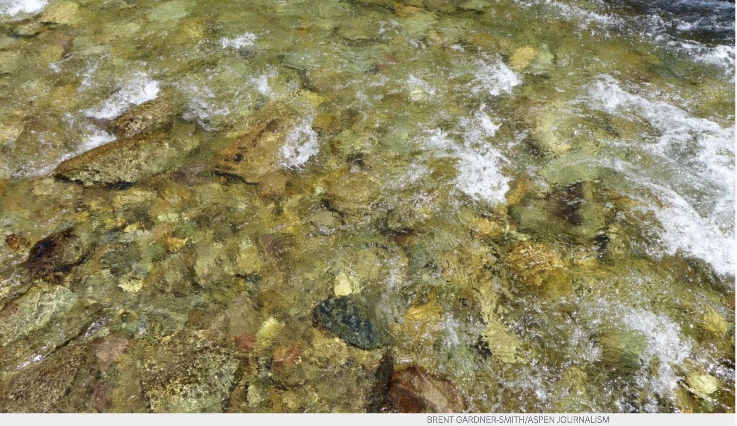
A detail of a section of Castle Creek, the city of Aspen’s main water supply. Photo credit: Aspen Journalism
Stream management
So who could potentially be affected by low stream flows this year? The city of Aspen, for starters.
Margaret Medellin, utilities portfolio manager for the city, said she will meet with City Council in April to discuss whether to implement water shortage restrictions in the coming months. The municipality does not have much water storage in the form of reservoirs, and it is required to keep a minimum amount of water in its stream sources of Maroon and Castle creeks.
In Stage 1 restrictions, the city would ask residents to voluntarily reduce their water usage by 10 percent in what is essentially an awareness campaign. Stage 2 would require some restrictions on outdoor water use and Stage 3 could ban it altogether. All three stages would see an accompanying increase in water rates.
“The city is committed to not drying up the creeks, so if they fall below a certain level, we stop diverting,” Medellin said. “We will use the little storage we do have or switch between one creek and the other.”
Some irrigators, especially those with lower priority water rights, could suffer as a result of low stream flows. But the biggest loser would probably be instream flows and ecosystems, said Andy Schultheiss, executive director of the Colorado Water Trust.
Instream flow rights are typically junior to most other water rights and streams can go dry in years when there isn’t much snowmelt coming down from the high country.
“People in their homes won’t notice much of a difference, but that doesn’t mean there aren’t some really bad things happening,” Schultheiss said. “In even moderately dry years, the fish and the whole ecosystem tends to congregate in smaller and smaller pools, which creates disease and competition for food.”
One potential solution is a pilot program that would let water rights owners lease water rights to the Colorado Water Conservation Board in order to keep more water in the stream. The Colorado Water Trust is a partner in this new voluntary water-sharing program that would benefit the state’s instream flow efforts.
FromThe Glenwood Springs Post Independent (Jon Nicolodi):
SnoTel sites are automated stations that collect data on snow, operated by the Natural Resources Conservation Service, and there are 115 in Colorado alone. While numerous measurements are taken, the most commonly used is snow water equivalent. Snow height is measured, but it doesn’t take into account the density of the snow, which can vary between 5 percent and 20 percent.
The snow water equivalent is measured in inches and can best be thought of as what the depth of the water would be if you instantaneously melted the entire snowpack. Snow height is a favorite measurement of skiers and snowboarders. Snow water equivalent is a favorite measurement of scientists and anyone looking at water beyond the winter, which is a popular notion in Colorado.
In an end-of-February report, Nick Barlow at the Colorado Avalanche Information Center reported the snow water equivalent of all of Colorado to be averaged at 73 percent, compared to what it historically is at the end of February.
But not all areas of Colorado are favored equally with snowfall. The Front Range, including the North and South Platte basins, are at 90 percent and 91 percent, respectively. The lower half of the state, including the Arkansas, Gunnison, Upper Rio Grande and the southwesternmost watersheds, are in the low 60s or high 50s, bringing down that state average. The Yampa and the White in northwestern Colorado are at 81 percent of snow water equivalent compared to a median year.
The Colorado River watershed, including the Roaring Fork and any other tributaries joining the Colorado along the I-70 corridor, comes in at 85 percent relative to its median snow water equivalent. On the whole, not too shabby. But not inspirational either.
In most of Colorado, higher-than-average snowfall in February greatly helped these percentages. All of the previous months had been a bit dismal for winter, with November and December being particularly dry. The storms that did come were flanked by warm weather, so large portions of our snowpack melted away. In an average year, that snowpack and its snow water equivalent reach peak numbers by April 9 before melting as a whole, contributing to all of the industries that rely upon a hearty spring thaw, ample soil moisture and flowing water as deep into our dry summers as possible.
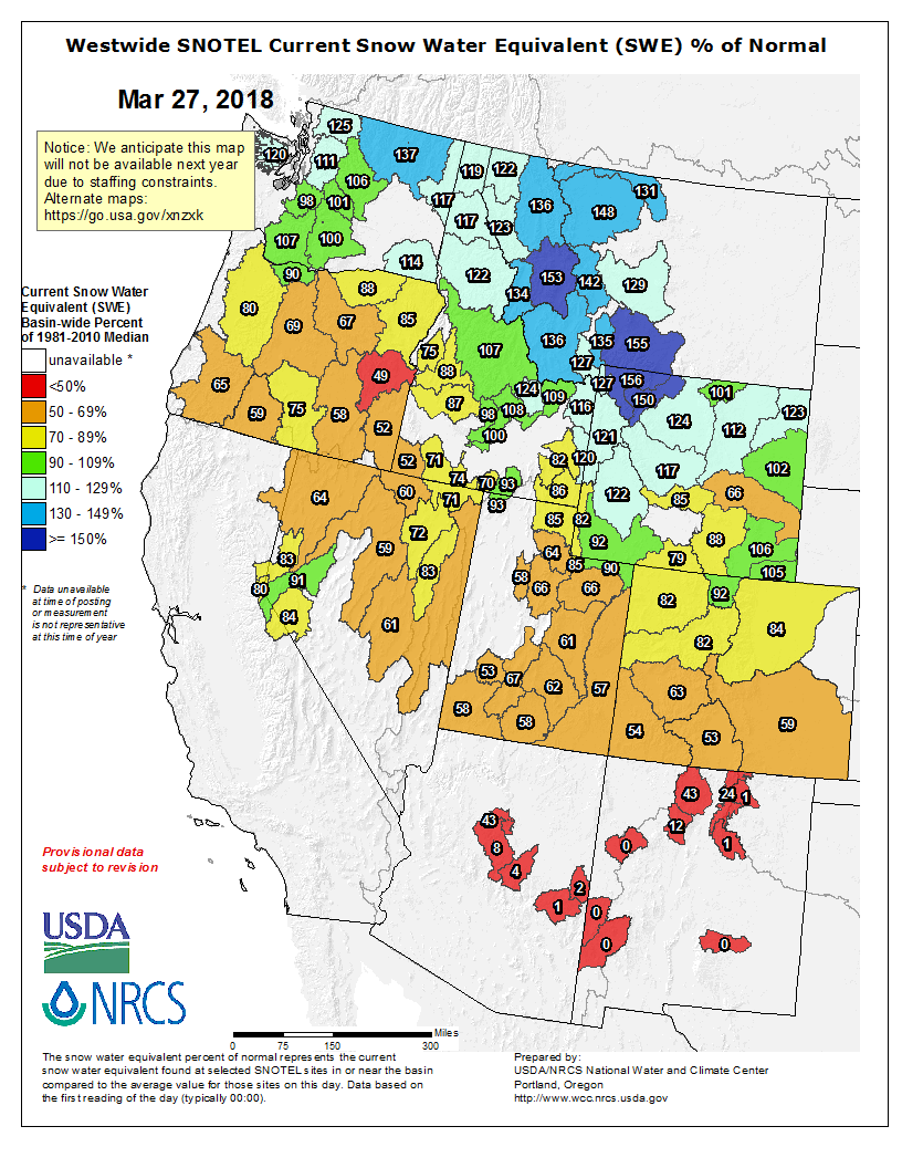
Westwide SNOTEL basin-filled map March 27, 2018 via the NRCS.
During a recent meeting in Broomfield, the Colorado Water Conservation Board (CWCB) approved a $60,000 grant from its Water Reserve Supply account for the town to conduct a water system analysis. Half of the grant money will come from the Southwest Basin Roundtable account, while the other $30,000 will be from the CWCB statewide fund. Rico and Southwestern Water Conservation District will contribute an additional $30,000 each for a project total of $120,000.
The town will hire a water engineer to conduct the study, which will find ways to increase water efficiency, quality and productivity for residents.
Kari Distefano, who became Rico’s town manager in May 2017, said one of the first things she did was to hold a community meeting to assess residents’ priorities regarding the town’s infrastructure.
“Water rose to the top,” she said. “Our water system is problematic. I looked in our reserves and decided we needed some help.”
Rico has two water sources — an alluvial well just north of town and Silver Creek, which flows into the east side of town and is a tributary of the Dolores River. The Silver Creek system is currently offline because it does not meet the Colorado Department of Health and Environment turbidity standards for surface-water filtration and is only used as an emergency backup system.
The well, which has junior water rights, only provides .178 cubic feet per second because it must comply with instream flow requirements on the Dolores River. That amount of water is adequate for Rico’s current population of roughly 200 year-round and 500 summer residents, but would not be enough if the town were to grow. The well provides water to 31 commercial and 242 residential taps, respectively.
The study will determine what it would take to re-establish Silver Creek as a water supply.
“I’m hoping (the study) will tell us what it’s going to cost to upgrade the filtration system,” Distefano said. “The ultimate goal would be to combine the two systems and have a redundant source of water. To allow more growth, Rico needs a little more volume.”
[…]
The water analysis also aims to find a way to relocate the aging outdoor water meter boxes to inside residences, making them less vulnerable to damage from the elements.
Pat Drew, a Rico water consultant for Rico, has been helping the town with regulatory compliance issues. He said the water study also will evaluate weaknesses and leaks in the system…
The project also will meet some of the goals laid out in Colorado’s Water Plan, which Gov. John Hickenlooper unveiled in late 2015, as well as goals identified by the Southwest Basin Roundtable Basin Implementation Plan. Those goals include providing safe drinking water to southwest Colorado’s citizens and visitors, promoting wise and efficient water use through municipal conservation, and supporting water reuse strategies.