The Headwater Alliance and Willow Creek Reclamation Committee (WCRC) worked with local volunteers on April 27, to plant several willow trees in the floodplain located below Creede. The planting has been an ongoing project for several years. By utilizing willow plants, the organization enhances the natural ability the plant has to filter water through the root system and ultimately releases cleaner water into the creek.
According to Willow Creek Reclamation Committee Engagement Coordinator Laurel Smerch, on Saturday, April 21, in a partnership with Colorado Parks and Wildlife, volunteers with the Headwaters Alliance and the Willow Creek Reclamation Committee came and harvested several willows. Colorado Parks and Wildlife will be expanding a boat ramp on the Rio Grande at the south end of Airport Road in Creede and allowed volunteers to come and collect parts of willows from the ramp location. The organization soaked the shoots for a week, developing root systems before placing them in the floodplain on Friday.
“The cool thing about willows is that if you cut part of it and put it in water for enough time, it will start to develop roots. Willows are also good at filtering water, making them especially useful in mine reclamation. We left these willows soaking in water for a week. On Friday, April 27, some volunteers came out and planted these willows on the floodplain, were they will do the important work of making the creek cleaner,” said Smerch.
The organization is also planning a highway cleanup day on May 21 and a creek cleanup day in June. Both efforts depend on the participation of local volunteers; the organization will welcome anyone wanting to help.
Update: I’ve deleted the original post. Please see Brent’s longer and more detailed version of the story that ran in the Aspen Times by clicking here.
Illustration shows water availability, in blue circles, compared with demand at various places along the South Platte River. The yellow area is the study area. (Illustration by Stantec).
The outdoor recreation economy is officially a big deal. On [February 14, 2018], the federal Bureau of Economic Analysis (BEA) released numbers detailing the economic power of the outdoor recreation industry, showing it comprises 2 percent ($373.7 billion) of the entire 2016 U.S. Gross Domestic Product.
It’s an impressive figure that puts it on the scale of industries like construction (4.3 percent); legal services (1.3 percent); agriculture, including farming, forestry, and fishing (1 percent); and, most significantly, mining, oil, and gas extraction (1.4 percent). The report also stipulates that the outdoor industry is growing by 3.8 percent, a faster rate than the overall economy (2.8 percent).
The BEA report was two years in the making, initiated when President Obama signed the Outdoor Recreation Jobs and Economic Impact Act. Signed in 2016, it directed the federal agency to measure the outdoor economy with the same tools it uses to chart other industries and the economy as a whole. “We’ve wanted our industry to be counted as a discrete sector of the economy for more than a decade now,” says Amy Roberts, executive director of the Outdoor Industry Association (OIA). “We are really pleased to have data that allows us to talk about our industry in the same ways that other industries that use public lands are discussed.”
In some ways, the impact of our work as a land trust is obvious. There is the stunning view of our valley from the overlook south of town. That is something every Taoseño treasures when coming home from a trip to Santa Fe, Albuquerque or further afield. There are the wide vistas to Taos Mountain across the fields north of Overland Sheepskin Company or the rolling forested mesas of Wolf Springs Ranch on the drive to Tres Piedras. Visually, our work protecting Taos’ landscape is kind of hard to miss.
Perhaps not quite as visible are the economic benefits that come with preserving these lands and building a connection between land and community. As Taos grows and changes Taos Land Trust aims to be a partner in bringing the positive economics of conservation to Taos.
Even though most conservation easements are placed on private land, there are huge benefits to the community as a whole. These include water supply protection, flood control, fish and wildlife habitat, hunting, fishing, hiking, bird watching and other outdoor activities, carbon sequestration, erosion control, agricultural crop production – AND economic growth. HOW?
Tax Benefits
For those who have placed land under a conservation easement with a land trust there is an upfront tax benefit. By removing the land’s development potential, the easement typically lowers the property’s market value, which in turn lowers potential estate tax. In New Mexico landowners at any income level can qualify for a tax credit worth 50% of the appraised value of the conservation easement up to a maximum of $250,000. That means money in people’s pockets that can be spent in the community or saved to enhance economic security.
Property is More Valuable
When a community protects open space, that community becomes a more desirable place to be. People enjoy vistas, parks, recreational opportunities and accessible natural areas. A trip to Kit Carson Park or Fred Baca Park on any given day will prove this point. These amenities in turn make land surrounding these protected areas more attractive.
Travel and Tourism
Tourism is a key component of the Taos County economy. In fact, we are the most tourism-dependent county in the state. There is no mystery as to why people come to Taos. From the wilderness areas in our surrounding mountains to the National Monument in our backyard, the Taos economy is built on open space recreation. All those people coming for our amazing open lands spend money on recreational equipment sales and rentals, special events, food, lodging and so on. Our open spaces and parks attract visitors and locals alike, creating revenue for local businesses.
Attracting New Businesses
Increasingly, the American economy is dominated by tech and knowledge companies. These type of businesses are not tied to a specific location as manufacturers are. These businesses have more freedom in choosing where to locate.
We all know that Taos needs more jobs. A wide range of studies show that when many businesses consider relocating they increasingly take into account the quality of life in the places where they might want to relocate. A number of studies note that these types of businesses (that typically pay well above minimum wage) seek to locate in places with open space, parks and protected lands. It is the same with retirees. Retired people bring money into communities and, again, surveys indicate that they typically to live in a place where recreation opportunities are plentiful. Communities that fail to provide recreation opportunities for retirees tend to see their tax base erode when retirees leave the community.
Beyond just open spaces and parks both tech business and retirees look for towns that are walk-able or bike-able and while Taos is not quite there yet, we are working with our partners to make bike paths, sidewalks and trails more available to Taoseños.
Reduced Costs to Town and County
The fact is that sprawl development is expensive. It costs more to hook people up to vital infrastructure like water, sewer and electricity that more they are spread out. Not to mention the road building and other transportation issues. Compact or focused development reduces state and municipal costs on road maintenance and delivery of services from water to solid waste to transit, to fire and police protection and school buses. Taos needs to protect its most valuable landscapes while increasing its densification.
Support Farming and Ranching
Land conservation supports working landscapes on which many in our county depend.
Farms and ranches are sometimes referred to as “working lands,” because they produce products and value for communities. The category also includes forests that produce timber and other wood products in a sustainable manner. The Trust for Public Land points out that:
“Lori Lynch, an economist at the University of Maryland, studied what farmers do with the money they earn from selling development rights as part of farmland preservation. Farmers in Maryland who had participated in conservation programs were more likely than other farmers to have invested in their farm over the past five years and to have attended workshops to learn new technologies and enhance their farming skills. According to the research, money paid to the farmers for the easement purchases circulated back into the local economy via debt reduction, savings or farm investment, farm operation financing , or retirement investment. Some bought more land or equipment.”
Clean Water, Clean Air
Parks and conserved lands reduce storm water by capturing precipitation, slowing its runoff, and reducing the volume of water that enters the storm water system. Think of our Rio Fernando property and how our work to restore that wetland will increase clean water in our community and better manage the flow of that water.
Many communities have to build expensive infrastructure like drainage channels and storm sewers to deal with flooding from storms or big winter runoff. There is also the question of how to pay for and deal with nonpoint-source pollution caused when water picks up chemicals and contaminants from parking lots and other impermeable surfaces. As the impacts of climate change become more severe (think of Hurricane Harvey) a resilient community will need to rely on ecosystem services to deal with increased rainfall and other severe weather events.
Trees and shrubs in parks and open spaces remove air pollutants that endanger human health and damage structures. Trees and other vegetation promote air quality by taking up pollutants through their leaves and diffusing them into their cells.
Health
We all know that one key way to incorporate exercise into daily activity is to walk or bike for errands near home. However, many towns such as ours unfortunately do not facilitate easy exercise. As mentioned before, we are working with local governments and citizens to develop land use regulations, mapping and paths to shape our community into one where Taoseños can easily integrate exercise into daily activity. And our conservation work has a role too. Some of the land we have protected can eventually be used for greenways that support hiking, biking, and other human-powered transportation.
We’re all in this together. Taos Land Trust is a partner and resource in building a resilient and thriving future – and economy! – for our northern New Mexico community.
The Xeriscape Garden at Denver Water. Xeriscaping is a cost-effective way to save water and beautify your yard.
From the City of Northglenn via Colorado Community Media:
The City of Northglenn is partnering with nonprofit group Resource Central on its popular ‘Garden In A Box’ program to provide low-water gardens to local residents.
The program helps Colorado residents conserve water and save money. It’s a regional water conservation program that provides an assortment of water-wise plants and flowers that can reduce outdoor water use by up to 60 percent. As a participating community, Northglenn residents can get a limited number of $25 discounts on these water-saving plants through this nonprofit program.
“Local families are rethinking their grassy yards,” said Neal Lurie, president of Resource Central, a Boulder-based nonprofit. “Traditional turf lawns are surprisingly thirsty and expensive.
After years of watering and mowing, people are starting to look at how drought-tolerant gardens can help simplify their yards.”
There are five new Garden In A Box kits this year, with a big focus on colors and pollinators. The new kits include “Hummingbird Delight,” “Butterfly Bounty,” and “Colors of Colorado.”
Additional kits focus on vegetable gardens, shaded areas, sun-loving flowers, and attracting honeybees. All gardens are Colorado-grown, pollinator-friendly, and available for pickup in May or June.
Garden In A Box is one of the largest programs of its kind in the United States, helping Front Range families transition more than 1.4 million square feet of land to beautiful, low-water landscaping. This initiative has saved more than 100 million gallons of water since the program started in 1997.
“It’s heartening to see so many people embracing this program,” said Devon Booth, water program manager at Resource Central. “Garden In A Box makes water conservation simple – change happens one family at a time.”
For more information about the program and to register for a box, visit http://ResourceCentral.org/gardens online or call them at 303 999-3820, extension 222.
The water supply is greater than normal, with Turquoise at 121 percent of normal, Twin Lakes at 98 percent of normal and Pueblo Reservoir at 135 percent of normal. The Pueblo Reservoir must be down to a certain level by April 15, making a spill possible to avoid flooding. Farmers are taking water they can use as requested to ease the situation. Reservoirs in the area are full or nearly full.
Since the rainfall has been less than usual in winter 2017-2018, the abundant water supply is good news for area farmers. The snowpack in the Arkansas River Basin is 59 percent of normal and 54 percent of last year. The normal peak date is April 11 and these figures are as of March 19. All the water in the flood pool must be out by May 1, so that an upriver rainstorm will not cause flooding on the lower river. Therefore, the reservoir will start spilling excess water on April 15. A spill benefits whatever entity has the call on the river; for example, it could be the Rocky Ford Highline, or Holbrook or Fort Lyon by priority dates (original priority date).
The hydroelectric plant being constructed at Pueblo Reservoir is progressing as planned. The Lease of Power Privilege has been finalized with the South East Colorado Water Conservancy District. Reclamation has approved the design, specifications, and submittals for phase 1 and 2 and is currently reviewing the final phase. Construction on the plant began in September 2017. The anticipated start-up for the first turbine is early June 2018.
The hydro produced will be purchased by Fountain and Colorado Springs, said Chris Woodka of the SECWCD on Thursday. “The reason is that Black Hills declined to incorporate the power into its portfolio.” SECWCD has a carriage agreement with Black Hills when the plant starts producing. Woodka continued, “The annual average for production is around 28 million kWh per year, which is basically enough for 4,500 homes.” Revenue from the plant will benefit the Southeastern District, but a 30-year contract with Fountain and a 10-year contract with Springs accounts for all power generated.
EVs improve our air quality. Vehicles are one of the two largest sources of air pollution, and a majority of Colorado residents live in areas of the Front Range that violate federal air quality standards. Dirty air is unhealthy for all of us, and it has a particularly negative impact on children, the elderly, and people suffering from asthma or lung disease. Electric vehicles have no emissions from the tailpipe and are so much more efficient than gas cars. A 2017 study for the Regional Air Quality Council found that EVs emit 99 percent less volatile organic compounds and 30 percent less nitrogen oxides than a new gas car today.
EVs bring real economic benefits to consumers. Fuel cost savings can approach $1,000 per year for every electric vehicle. If Colorado is able to achieve the goals set out in the state’s recently adopted EV plan, consumers will save over $500 million per year by 2030. Those consumer dollars will be reinvested in our communities, supporting local businesses and creating jobs…
But the economic benefits don’t just help EV drivers; getting more EVs on the road also will lower everyone’s electric bills. EVs help utilities make more efficient use of their existing power plants and grid infrastructure (which all of us have to pay for), thereby spreading out the costs more and reducing the share that each of us pay.
Here’s how that works. Utilities have to build their power plants for peak electrical use, which normally happens during the day – and all of us pay a portion of that infrastructure cost. But most EV drivers charge at night in preparation for the next morning’s drive, and night is when other electrical demands are low and power plants have excess capacity. So by charging their cars at night, EV drivers help utilities pay down their fixed costs. A study by a national consulting firm found that every EV on the road drives down the total electricity costs paid by other customers by $650 — and by 2030, ratepayers could be saving $70 million per year! The same study found that high levels of EV adoption would lead to total net economic benefits across Colorado of $43 billion by 2050.
Despite all of these benefits, the state Senate recently voted in a party line vote to end the state electric vehicle tax credits (the House rejected this bill). Others have called for new fees on EVs, based on the argument that EV drivers don’t pay gas tax. But EV owners already pay an extra vehicle registration fee, that is designed to pay the same amount into the highway fund as a gasoline vehicle that is as efficient as an EV would pay. It doesn’t make sense to add even more fees at a time when EVs still make up a very small part of the market.
If we want to achieve all the benefits that EVs bring, we need to get a lot more on the road. Because Colorado has supported EVs with a tax credit and state investment in charging stations, the EV market here is one of the best in the country, with the sixth-highest market share of any state in 2017. Sales are growing by over 50 percent per year.
Colorado River Basin. Graphic credit: Water Education Colorado
Here’s a deep-dive into pressures on the Colorado River from Daniel Rothberg writing for Water Deeply. Click through and read the whole article. Here’s an excerpt:
Low runoff means that water users have less buffer room to prevent the river’s two major reservoirs from dropping below critical elevations, which would have considerable impacts on how water and hydropower are managed.
“This year we might be able to skirt by,” said James Eklund, an attorney at Squire Patton Boggs appointed by Colorado governor John Hickenlooper to represent the state’s interests on the Upper Colorado River Commission. But back-to-back years of low inflow like this year, “That’s a crisis. That’s a big problem,” he said. “That means we are going to almost certainly trigger a shortage in the Lower Basin or be below minimum power in Powell in the Upper Basin.”
The seven Colorado River states have closely watched reservoirs decline for years as the West has started what scientists view as a transition to a more arid environment. With lower runoff expected to become the “new normal,” both basins are facing two related questions: How do you boost reservoir elevations? And where is the best place to store the system’s water?
The answer for Upper Basin states is complicated, but stakeholders are facing more and more pressure to figure out a solution.
How to Make a Bank
For Lower Basin water users in California, Arizona and Nevada, the answer to the first question is easier. Because Lake Mead is upstream from its users, they can leave, or “bank,” parts of their Colorado River entitlements in the reservoir during shortages. In good years, they can make a call and get that water back.
Creating a “bank” in the Upper Basin states of Colorado, New Mexico, Utah and Wyoming is more difficult. Its major reservoir, Lake Powell, is located downstream of its users. If they conserve water to keep Lake Powell elevations high, it is lost to them forever.
FromThe Grand Junction Daily Sentinel (Gary Harmon):
So far, that drought looks to be worse than recent drought years, Grand Valley water officials gathered on the banks of the Colorado River said Friday morning in announcing the implementation of voluntary water restrictions.
The river, still tinged green instead of the muddy red it normally is as the runoff begins, was about half its normal size as well on a cloudless morning that heralded 70-degree temperatures.
“It’s running about 3,900” cubic feet per second, said Steve Ryken, office manager of Ute Water Conservancy District, gesturing to the river from the Blue Heron boat ramp. “It should be 7,500 in a normal flow.”
“And we’ve seen it 40,000,” said Larry Clever, Ute general manager.
That’s the tale that the water managers hope gets across to their customers: The water that almost always is here at the beginning of the runoff simply isn’t, and it’s not stored in high country snow, either.
Dealing with that shortage is a matter of good stewardship of a natural resource, said Dave Reinertsen, assistant manager of the Clifton Water District.
It also can stave off the day that water purveyors have to try controlling water use by imposing higher rates, said Joe Burtard, external affairs manager for Ute.
Grand Junction has plenty of storage and is benefiting from recent dam improvements, but its most recent snow survey showed the water equivalent of 37 percent of normal for the last 30 years, Utilities Director Randi Kim said.
Since the drought year of 2012, Clifton Water District has taken several steps to improve water quality, Reinertsen said, pointing to the construction of a new treatment plant, so customers are unlikely to notice a deterioration in taste.
Water quality is likely to be the first indicator of a drought and Ute customers might notice some taste difference, Clever said.
Here’s the release from the Northern Colorado Water Conservancy District (Jeff Stahla):
Colorado native Brad Wind has been chosen to lead Northern Water as the organization’s sixth general manager in its 81-year history.
Wind, who most recently had served as the assistant general manager, Administration Division, was formally named to the position April 6 by the Northern Water Board of Directors.
Wind joined Northern Water in 1994 as an engineer and previously served as the organization’s assistant general manager, Operations Division. Wind holds a Master of Business Administration degree from Colorado State University, a master’s degree in agricultural engineering from University of California at Davis and bachelor’s degrees in civil engineering and agricultural engineering from Colorado State University.
Wind grew up in Northeastern Colorado, the area served by Northern Water. He was raised on a farm in Washington County and graduated from Brush High School.
“Brad Wind has 25 years of experience built on the Northern Water tradition of teamwork and continual improvement,” said Board President Mike Applegate.
“The Board is confident he will provide excellent leadership and vision as we move forward in service to the region,” he added.
Wind takes over for previous General Manager Eric Wilkinson, who retired in April. Wilkinson will continue to work on a part-time role as a policy adviser for Northern Water.
“I am thrilled to be named Northern Water’s next general manager, and I appreciate the legacy Eric has left us all,” Wind said.
“We have a lot on our plate and our staff is up to the challenges of maintaining a reliable water supply and pursuing additional storage for northeastern Colorado,” he added.
Some much needed rain and snow fell the past two days – but not where Colorado really needed it.
The Southern part of Colorado is seeing some of the worst drought conditions since September 2013. Those conditions are impacting farmers, the fire danger and our water supply…
“It’s kind of like water in the bank,” 9NEWS Meteorologist Cory Reppenhagen said. “We have that snowpack, we know how much is there, we can kind of figure out how much is going to melt and run down.”
[…]
We’re at almost 50 percent of the average snowpack. 80 percent of our water comes from snow – that’s 4 out of 5 cups of water. Reppenhagen says when the snowpack is this low, water managers start to get nervous…
Things are especially dry in the southern part of the state. The drought monitor map shows an expanding level of severe drought.
Given the dearth of snow, less than half of the average amount of runoff is forecast to run off from the mountains into Lake Powell along the Colorado River between April and August. As of May 1st, the forecast is for flows into Lake Powell — the second largest reservoir in the West — to reach just 43 percent of average.
If conditions turn out to be unusually warm and dry, that number could drop significantly.
The situation is particularly grim in New Mexico, with some areas having essentially no snow. With runoff dramatically depleted, a 19-mile stretch of the Rio Grande has already dried up. Portions of the river don’t typically go dry until August.
Elephant Butte Reservoir, New Mexico’s largest, is forecast to be at just 5 percent capacity this summer.
What we’re experiencing today is no fluke. The average snowpack in U.S. western states has dropped by 15 to 30 percent since 1915.
The cause is not so much declines in snowfall as warming temperatures, in large measure a result of humankind’s emissions of greenhouse gases. In fact, recent studies have shown that “a given level of winter snowpack today results in less river runoff than in the past,” according to a report issued in March by the Colorado River Research Group…
New Mexico has seen a particularly significant warming trend. Average temperatures in the Rio Grande basin have risen a bit less than 1 degree F per decade between 1971 and 2011.
Warming isn’t the only way that we are influencing river flows in the West. Another is a phenomenon known as “dust on snow.”
This slideshow requires JavaScript.
Foothill Front Range Pikes Peak Back-Roads
Snow drop early May
perks up the Ramparts,
bridges the South Platte
and the Arkansas,
leaks into the pores
of recurrent ancestral
well springs.
Greg Hobbs, May 6, 2018
Westwide SNOTEL basin-filled map May 3, 2018 via the NRCS.
Highlighting the event was newly hired state climatologist Russ Schumacher. He gave a presentation offering some explanations about the extremely dry season we experienced this past winter. Schumacher confirmed that Colorado experienced one of the driest winters on record, after experiencing the 30th wettest year in 2017. The state experienced a bump after a heavy snowstorm in early April pushed precipitation numbers a bit closer to average.
Schumacher also confirmed that snowpack was terrible this past season. While Summit and most of the northeast portions of the state did OK, the southern part of the state did not. In the southwest, for example, snowpack levels averaged out between 30 and 40 percent of normal.
“There’s a clear dividing line between north and south,” Schumacher said. “Summit County is kind of at the middle of that. North of Summit, snowpack and precipitation are pretty OK, even above average. But in the south, they really struggled.”
Schumacher said warmer temperatures was a big factor for why the southern part of the state has been suffering.
“Everywhere in the southwest was extraordinarily warm,” Schumacher said. “Pretty much everywhere west of the divide was record warm, everywhere else that wasn’t was close to that.”
Schumacher attributed the warmer temperatures, especially in the southern part of the state, to the La Niña weather pattern that pushes the jetstream north and creates dry, warm conditions in the south and western parts of the state.
The long-term problem for Colorado’s waterways is how long these patterns can continue before it becomes a crisis. That’s where Andy Mueller, the new general manager for the Colorado River District and the night’s other featured speaker, came in.
Mueller pointed out that the current U.S. drought monitor has over 80 percent of Colorado’s population experiencing some form of drought, with the southwest experiencing extreme drought. But the problem extends beyond Colorado’s boundaries. However, Mueller said the biggest concern going forward are water flows going west to Lake Powell, one of the most important water reservoirs in the country.
Mueller called Lake Powell the state’s “water savings account.” Under the Colorado River Compact signed in 1922, the Upper Basin states — Colorado, Utah, Wyoming, and New Mexico — are required to keep an annual flow of 7.5 million acre-feet per year flowing from Lake Powell to Lake Mead and the Lower Basin states — Arizona, Nevada and California. At the moment, flow into Lake Powell is forecasted to be at around 3.1 million acre-feet, or around 43 percent of average, because of the lack of snow melt…
If Lake Mead — which is currently at 1,084 feet above mean sea level and has been less than half full for well over a decade — drops to 1,075 feet, [the 2007 Shortage Sharing Agreement] will activate and force cuts to water users downstream. That will have a domino effect that may lead to water cuts for Upper Basin states as well. There may be severe water rationing, shutdowns of hydroelectric dams and a whole other set of emergency measures that have never before been instituted by the Department of the Interior. That means economic uncertainty for a wide variety of industries including ranching, skiing and electricity.
“To avoid that, Lake Powell is expected to pump out and drop 20 feet this summer,” Mueller said. “It’s currently at 54 percent of capacity.”
Mueller added that while catastrophe will probably be avoided this summer, it might not be next year or the year after that. Because of this complex water dance, Mueller said it was important for agricultural water users with senior claims in the Western Slope to maintain those claims, because if they’re abandoned they are abandoned forever.
“It keeps the water in our streams for our recreational users and for our quality of life here on the Western Slope,” Mueller said. “It keeps that water flowing to the West. Because they have those senior rights, they are able to pull that water downstream and not let it get diverted away.”
Mueller attributed the dangerously low water levels to overusage from lower basin states, but also in large part to climate change…
That means the overdevelopment in Colorado — which includes water-hungry lawns and outdoor irrigation — is not sustainable. Mueller ended his presentation with a dire warning and plea for the land-use people to start listening to water-use people.
“From the Colorado River District’s perspective, this has to stop,” Mueller said, pointing to a slide of a cookie-cutter subdivision near Denver. “We need the folks across the state putting these massive subdivisions in to realize that this is not OK. This is putting all of us in danger of significant chaos and the possibility of a compact curtailment.”
The upper Colorado River, above State Bridge. Photo: Brent Gardner-Smith/Aspen Journalism
From Governor Hickenlooper’s office via The Loveland Reporter-Herald:
Gov. John Hickenlooper signed Senate Bill 18-066 into law Monday, reauthorizing the Colorado Lottery through 2049.
“The Colorado Lottery is the only lottery in the nation that commits nearly all of its yearly proceeds to outdoor recreation or habitat and wildlife conservation,” Michael Hartman, executive director of the Colorado Department of Revenue, said in a press release. “Coloradans can rest assured that their lottery game spending will continue to support the incredible resources that make our state so special, including supporting the capital needs of our state’s great school systems.”
According to the release, in the last five fiscal years, the lottery has distributed more than $670 million to its four beneficiaries — the Conservation Trust Fund, Colorado Parks and Wildlife, Great Outdoors Colorado and the Building Excellent Schools Today program.
Since its start in 1983 through fiscal year 2017, the Colorado Lottery has returned to more than $3.1 billion to its beneficiaries.
The money is distributed 50 percent to the Great Outdoors Colorado Trust Fund, 40 percent to the Conservation Trust Fund, and 10 percent to Colorado Parks and Wildlife. GOCO funds in fiscal year 2018 are capped at $66.2 million and funds that exceed the cap will go to the Colorado Department of Education’s Public School Capital Construction Assistance Fund, according to the lottery website.
The current structure of the primary lottery beneficiaries has been in place since 1992, when the people of Colorado voted to the amend the Colorado constitution and create the Great Outdoors Colorado Trust Fund.
Lottery funds have been used to create and restore hundreds of miles of trails, protect hundreds of miles of rivers, create thousands of jobs, add thousands of acres to the state parks system, create more than 1,000 parks and recreation areas, and protect over 1 million acres of land.
Under a reauthorization passed by the Colorado Legislature in 2002, the Lottery division was extended 15 years from 2009 to 2024. The new bill adds 25 years, authorizing the lottery until 2049.
From Western Resource Advocated (Bart Miller @WaterBart). Click through and read the whole article for the in-depth look at western snowpack by state. Here’s an excerpt:
Snowpack in the West is essential to creating healthy flowing rivers that support recreation, tourism, and habitat for thousands of species. Communities also rely on the snowpack to fill reservoirs that supply cities and towns with a steady supply of drinking water all year-round.
Why is snowpack important to the West?
Snowpack in the West is essential to creating healthy flowing rivers that support recreation, tourism, and habitat for thousands of species. Communities also rely on the snowpack to fill reservoirs that supply cities and towns with a steady supply of drinking water year-round.
What are the major trends in snowpack in the West this year?
We can monitor how current snowpack will impact streamflow later in the year by measuring something called Snow Water Equivalent (SWE). SWE is the amount of water contained within the snowpack. The Natural Resources Conservation Service maps below show percentage of SWE on the first of every month compared to what has been considered normal over an almost 30-year period.
Any basin colored in red, orange, or yellow means there is currently less snowpack than what is considered normal.
Any basin colored in green or blue means there is currently the same or more snowpack than what is considered normal.
Westwide SNOTEL basin-filled map May 3, 2018 via the NRCS.
Here’s the discussion from the Colorado Basin River Forecast Center:
The Colorado Basin River Forecast Center (CBRFC) geographic forecast area includes the Upper Colorado River Basin, Lower Colorado River Basin, and Eastern Great Basin.
Water Supply Forecast Summary:
The month of April was generally dry over much of the CBRFC forecast area. While the month was not void of storm systems the greatest precipitation impacts were limited to the northern Bear River Basin, Yampa River Basin, Colorado mainstem headwaters, and parts of the Gunnison River Basin. In every month of the 2018 water year dating back to last October at least some part of the Colorado River Basin or Great Basin has experienced very dry conditions with monthly precipitation less than 50 percent of average. Only February of 2018 saw widespread precipitation that was near or above average in areas that are the primary contributors to the April-July runoff. However, even then impacts were limited to the upper Colorado River Basin as very dry conditions were widespread in the Great Basin.
April-July water supply volume forecasts increased from those issued in early April in parts of the Yampa River Basin, Colorado River headwaters, eastern headwaters of the Gunnison River Basin and some headwaters of the Green River Basin in Wyoming. The most significant decreases from early April occurred in the Dolores River Basin, Sevier River Basin, and Duchesne River Basin.
Forecasts are highest with respect to average in the Green River Basin of Wyoming, Colorado mainstem headwaters, and in northern parts of the Bear River Basin. Lowest forecasts with respect to average are in the southern basins of the forecast area and include the Dolores River Basin, San Juan River Basin, Sevier River Basin, and Virgin River Basin.
April-July unregulated inflow forecasts for some of the major reservoirs in the Upper Colorado River Basin include Fontenelle Reservoir 900 KAF (124% of average), Flaming Gorge 1000 KAF (102% of average), Blue Mesa Reservoir 350 KAF (52% of average), McPhee Reservoir 62 KAF (21% of average), and Navajo Reservoir 200 KAF (27% of average). The Lake Powell inflow forecast is 3.00 MAF or 42% of average.
Upper Colorado, Great, Virgin River Basins: 2018 April-July forecast volumes as a percent of 1981-2010 average (50% exceedance probability forecast)
On Wednesday, scientists at the University of California in San Diego confirmed that April’s monthly average atmospheric carbon dioxide concentration breached 410 parts per million for the first time in our history.
We know a lot about how to track these changes. The Earth’s carbon dioxide levels peak around this time every year for a pretty straightforward reason. There’s more landmass in the northern hemisphere, and plants grow in a seasonal cycle. During the summer, they suck down CO2, during the winter, they let it back out. The measurements were made at Mauna Loa, Hawaii — a site chosen for its pristine location far away from the polluting influence of a major city.
Increasingly though, pollution from the world’s cities is making its way to Mauna Loa — and everywhere else on Earth.
In little more than a century of frenzied fossil-fuel burning, we humans have altered our planet’s atmosphere at a rate dozens of times faster than natural climate change. Carbon dioxide is now more than 100 ppm higher than any direct measurements from Antarctic ice cores over the past 800,000 years, and probably significantly higher than anything the planet has experienced for at least 15 million years. That includes eras when Earth was largely ice-free.
Not only are carbon dioxide levels rising each year, they are accelerating. Carbon dioxide is climbing at twice the pace it was 50 years ago. Even the increases are increasing.
That’s happening for several reasons, most important of which is that we’re still burning a larger amount of fossil fuels each year. Last year, humanity emitted the highest level of greenhouse gas emissions in history — even after factoring in the expansion of renewable energy. At the same time, the world’s most important carbon sinks — our forests — are dying, and therefore losing their ability to pull carbon dioxide out of the air and store it safely in the soil. The combination of these effects means we are losing ground, and fast.
Without a bold shift in our actions, in 30 years atmospheric carbon dioxide will return back to levels last reached just after the extinction of the dinosaurs, more than 50 million years ago. At that point, it might be too late to prevent permanent, dangerous feedback loops from kicking in.
This is the biggest problem humanity has ever faced, and we’ve barely even begun to address it effectively. On our current pace, factoring in current climate policies of every nation on Earth, the best independent analyses show that we are on course for warming of about 3.4 degrees Celsius above pre-industrial levels, enough to extinguish entire ecosystems and destabilize human civilization.
Climate change demands the urgent attention and cooperation of every government around the world. But even though most countries have acknowledged the danger, the ability to limit our emissions eludes us. After 23 years of United Nations summits on climate change, the time has come for radical thinking and radical action — a social movement with the power to demand a better future.
Of the two dozen or so official UN scenarios that show humanity curbing global warming to the goals agreed to in the 2015 Paris Accord, not one show success without the equivalent of a technological miracle. It’s easier to imagine outlandish technologies, like carbon capture, geoengineering, or fusion power than self-control.
Our failed approach to climate change is mostly a failure of imagination. We are not fated to this path. We can do better. Yes, there are some truly colossal headwinds, but we still control our future. Forgetting that fact is sure to doom us all.
On Tuesday, the Mauna Loa Observatory recorded its first-ever carbon dioxide reading in excess of 410 parts per million (it was 410.28 ppm in case you want the full deal). Carbon dioxide hasn’t reached that height in millions of years. It’s a new atmosphere that humanity will have to contend with, one that’s trapping more heat and causing the climate to change at a quickening rate.
In what’s become a spring tradition like Passover and Easter, carbon dioxide has set a record high each year since measurements began. It stood at 280 ppm when record keeping began at Mauna Loa in 1958. In 2013, it passed 400 ppm. Just four years later, the 400 ppm mark is no longer a novelty. It’s the norm.
“Its pretty depressing that it’s only a couple of years since the 400 ppm milestone was toppled,” Gavin Foster, a paleoclimate researcher at the University of Southampton told Climate Central last month. “These milestones are just numbers, but they give us an opportunity to pause and take stock and act as useful yard sticks for comparisons to the geological record.”
Earlier this year, U.K. Met Office scientists issued their first-ever carbon dioxide forecast. They projected carbon dioxide could reach 410 ppm in March and almost certainly would by April. Their forecast has been borne out with Tuesday’s daily record. They project that the monthly average will peak near 407 ppm in May, setting a monthly record.
Carbon dioxide concentrations have skyrocketed over the past two years due to in part to natural factors like El Niño causing more of it to end up in the atmosphere. But it’s mostly driven by the record amounts of carbon dioxide humans are creating by burning fossil fuels.
“The rate of increase will go down when emissions decrease,” Pieter Tans, an atmospheric scientist at the National Oceanic and Atmospheric Administration, said. “But carbon dioxide will still be going up, albeit more slowly. Only when emissions are cut in half will atmospheric carbon dioxide level off initially.”
Even when concentrations of carbon dioxide level off, the impacts of climate change will extend centuries into the future. The planet has already warmed 1.8°F (1°C), including a run of 627 months in a row of above-normal heat. Sea levels have risen about a foot and oceans have acidified. Extreme heat has become more common.
All of these impacts will last longer and intensify into the future even if we cut carbon emissions. But we face a choice of just how intense they become based on when we stop polluting the atmosphere.
Right now we’re on track to create a climate unseen in 50 million years by mid-century.
Click here to go to the US Drought Monitor website. Here’s an excerpt:
Summary
This U.S. Drought Monitor week saw a series of storm systems track across the continental U.S. bringing beneficial rains to portions of the Mid-Atlantic, Northeast, and South. Out West, the storm systems brought rain and mountain snow to higher elevations as well as cooler temperatures to the northern half of the region coming into the weekend after a period of record-setting warmth across parts of the West last week. Unfortunately, the storm systems steered north of drought-stricken areas of the Southwest that saw further deterioration in conditions on this week’s map. In the southern Plains, light shower activity provided some minor relief to dry pasture and rangelands as well as helped to reduce wildlife danger. In Texas, some isolated heavy rainfall activity brought relief to the western Panhandle and Trans-Pecos region. Moving eastward, cool temperatures and scattered shower activity helped improve drought-related conditions in parts of the Mid-Atlantic and Southeast…
On this week’s map, conditions continued to deteriorate in parts of the region, including southwestern Oklahoma and portions of Texas that have largely missed out on recent rainfall events during the past 30 days. In southwestern Oklahoma and north-central Texas, areas of Exceptional Drought (D4) expanded in response to poor soil moisture conditions and below normal precipitation during the past several months. According to the Oklahoma Mesonet, southwestern Oklahoma received only 37% of normal precipitation for the last 60-day period. The April 30th USDA NASS Oklahoma Crop Weather Report noted that 66% of the wheat crop was reported to be in poor to very poor condition while rye was worse off at 83% (poor to very poor). In Texas, some isolated shower activity helped to reduce areas of Extreme Drought (D3) in the western Panhandle and areas of Severe Drought (D2) in the Trans-Pecos region. According to the May 1st USDA Weekly Weather and Crop Weather Bulletin, topsoil moisture statewide in Texas was reported as 67% (short to very short). Elsewhere in the region, drought-free areas of northern Mississippi and southwestern Tennessee received 2-to-3 inches of precipitation during the past week. Average temperatures for the week were below normal (1-to-8 degrees) across the region with the largest negative anomalies observed in Mississippi and Tennessee…
On this week’s map, areas of Abnormally Dry (D0) and Moderate Drought (D1) expanded in North Dakota including the introduction of Severe Drought (D2) in the northern part of the state in response to reported poor soil moisture conditions and precipitation shortfalls during the past 60 days. According to the April 30th USDA NASS North Dakota Crop Progress and Condition Report, topsoil moisture was reported as 45% (short to very short moisture) with subsoil moisture at 50% (short to very short). Additionally, hay and roughage supplies were rated 55% (short to very short). In northeastern Montana, improvements were made in areas of Abnormally Dry (D0), Moderate Drought (D1), and Severe Drought (D2) in response to overall improvement in conditions (streamflows, soil moisture, lack of drought-related impacts) since last fall. Since the beginning of the Water Year (Oct. 1st), precipitation across the region has been below normal with the exception of eastern Montana, northwestern Wyoming, and central/north-central Nebraska. During the past week, the region was generally dry and temperatures were generally above normal…
A series of storm systems passed through the region beginning late last week, bringing rain and mountain snow as well as cooler temperatures to the northern half of the region. In contrast, most of the drought-stricken Southwest remained warm and dry with areas of southeastern California and southwestern Arizona reaching the low-100s during the 7-day period. This continued dry pattern led to expansion of areas of Severe Drought (D2) and Extreme Drought (D3) in the western half of Arizona. In Mohave County, Extension Agents are reporting very poor rangeland conditions with stock ponds going dry and water hauling necessary. Despite record-to-near-record low snowpack conditions across the mountains of Arizona, the Salt River Project is not expecting shortages or restrictions. In north-central New Mexico and south-central Colorado, an area of Exceptional Drought (D4) was introduced, covering the Sangre de Cristo Range to reflect record-to-near-record snowpack levels since the beginning of the Water Year. According to the May 1st USDA Weekly Weather and Crop Weather Bulletin, topsoil moisture in New Mexico was rated 90% short to very short while subsoil moisture was rated 89% short to very short. During the past week, average temperatures were near normal in the Far West and above normal (5-to-15 degrees) across the remainder of the West…
Looking Ahead
The NWS WPC 7-Day Quantitative Precipitation Forecast (QPF) calls for moderate-to-heavy accumulations ranging from 2-to-3 inches across the eastern Central Plains, Texas, and the Midwest (Iowa, northern Illinois, Michigan, southern Wisconsin). Out West, lesser accumulations (<1.5 inches) are expected in parts of the Intermountain West, central Rockies, and southern portions of the northern Rockies. Similar accumulation totals are forecasted for the Northeast and portions of the Mid-Atlantic. The CPC 6-10-day outlook calls for a high probability of above-normal temperatures across the West, the Plains, New England, and the Southeast while below-normal temperatures are expected in Michigan and south Texas. In terms of precipitation, below-normal precipitation is expected across most of the eastern half of the continental U.S. with the exception of Florida where there is a high probability of above- normal precipitation. Above-normal precipitation is expected in a swath extending from west Texas through New Mexico and Colorado to Idaho. Further west, below normal precipitation is expected in northern California and much of the Great Basin.
Westwide SNOTEL basin-filled map May 3, 2018 via the NRCS.
Winter Park Resort reported 10 inches of new snow last night, with up to 7 inches more expected today. Arapahoe Basin and Loveland also had significant new snow.
According to meteorologist Joel Gratz at OpenSnow.com, between the official reports above, which were measured at 5 a.m., and when he wrote his report at 7 a.m., it appears an additional 2-4 inches of snow have already accumulated.
The so-called “Ag Barometer” is a survey of 400 agricultural producers representing corn, soy, wheat, cotton, dairy, pork and beef. It shows optimism among farmers has dipped dramatically.
David Widmar is an Agricultural Economist at Purdue University where the surveys are compiled. He pointed to NAFTA and trade tariffs with China as some of the main culprits for the uncertainty in US agriculture right now.
On top of that, he pointed out, we’ve had some “pretty tough weather” lately. He said warmer temperatures and droughts particularly in the West have discouraged farmers about their prospects this year. That makes them more cautious.
There you have it folks: It was a crappy winter in the Four Corners Country. As of May 1, the San Juan Mountain snowpack, also known as the gargantuan “reservoir” at the headwaters of the region’s major rivers, is just about drained dry. While the snow season is not quite over — a winter storm has settled into the San Juans as I write this — the current numbers almost guarantee that the spring runoff will be meagre and fire season will be rough.
The only bit of good news is that this winter is turning out to be only the second driest over the last three decades — at most monitoring stations, 2002’s numbers were even lower. Also, as one moves northward, the situation tends to improve somewhat. On Red Mountain Pass, for example, the snowpack is currently at about 50 percent of average for this date, and is tracking above levels of 2002, 2012 and 1981.
At the Vail Town Council’s afternoon meeting on Tuesday, May 1, representatives from the Eagle River Water & Sanitation District provided an update about current snowpack, as well as the progress of a water-efficiency plan for the district.
As you’d expect, the snowpack on Vail Mountain is far below “normal” levels, based on a 30-year median. The most recent data shows that snowpack is still far below that level, but spring storms finally boosted Vail’s snowpack above the record-low snow year of 2011-12. Better yet, while snowpack on Vail Mountain had melted away at this point in 2012, there’s still snow on the hillsides right now…
The news is better at measurement sites on Copper Mountain and Fremont Pass, the sites nearest the headwaters of Gore Creek and the Eagle River, respectively.
At Copper Mountain, snowpack is very close to normal, while Fremont Pass’ snowpack is slightly above normal.
That’s good news for both Gore Creek and the Eagle River.
Still, water supplies won’t be plentiful, perhaps closer to the drought of 2001-02.
District communications manager Diane Johnson told council members that 2012 compelled the district to do some serious work on water conservation. District employees have kept up that work, she said.
In addition to day-to-day work, the district is also working on a water efficiency plan required by the Colorado Water Conservation Board. Local districts that have those plans are eligible for grants and loans from that state agency.
Following a Monday meeting in Salt Lake City, Colorado River water users are pledging to move past two weeks of public fighting between an Arizona agency and four states that divert water from the river. The Arizona utility — the Central Arizona Water Conservation District (CAWCD) — said at the meeting that it regretted having used rhetoric that inflamed tensions…
On Monday, the agency apologized for its rhetoric and said it hoped to begin to repair its frayed relationship with the state agency, an arm of the governor’s office, to work on the drought plan.
“CAWCD regrets that intra-Arizona issues have impacted other parties in the Colorado River basin,” a CAWCD spokesperson wrote in a statement. “Specifically, CAWCD regrets using language and representations that were insensitive to Upper Basin concerns, and resolves to have a more respectful and transparent dialogue in the future. As a result of the meeting, CAWCD has committed to beginning a fresh conversation within Arizona, including with ADWR and other stakeholders, to chart a path forward for an effective Drought Contingency Plan.”
The meeting was less an attempt to resolve the conflict and more a chance to start talks.
“Our objective for this meeting was not to resolve all issues but, rather, to identify a path forward for our talks,” James Eklund, who represents the state of Colorado in the negotiations, said Tuesday in a statement. “Despite these encouraging messages, the jury is still out.”
He said that any progress forward would be in the district’s actions.
It’s unclear how much of an impact the meeting will have in solving the issue that upset the Upper Basin enough to send a rare letter that singled out CAWCD. While CAWCD said it regretted its rhetoric, the agency was quiet about whether it would change its strategy.
The meeting didn’t resolve the issue, says James Eklund, the Colorado representative on the Upper Colorado River Commission, but CAP officials did offer an apology.
“District representatives expressed regret about their use of rhetoric in describing the policy of maximizing reservoir releases solely for the benefit of the [Central Arizona Water Conservancy] District at the expense of the rest of the Colorado River Basin,” Eklund said in a written statement.
States in the river’s Upper Basin — Colorado, Wyoming, Utah, New Mexico — accused CAP and CAWCD of manipulating how much water the project received to avoid a shortage, while still gaining more water from those states’ biggest reservoir, Lake Powell.
In response to a series of public statements and an infographic sent to CAP’s Twitter followers demonstrating this strategy, Upper Basin representatives sent a letter in mid-April saying CAP’s behavior, while within the rules, was a violation of the watershed’s collaborative spirit. The larger basin-wide feud was borne out of a dispute within the state of Arizona over which agencies have final authority to decide how to conserve water…
Meeting attendees did not schedule a follow up meeting to further address the issue, and a meeting between CAWCD and state of Arizona water officials has yet to be scheduled.
The dust up caused at least one city to pull out of a Colorado River conservation program meant to boost reservoir levels. The city of Pueblo, Colorado’s water department cited CAP’s behavior in rescinding its proposal to participate in the System Conservation Pilot Program.
“This river really only works and functions the way we’ve designed it if trust is in abundance and we’re truly viewing the entire basin as connected,” Eklund says. The discussion in Salt Lake City was a starting point, “but the proof of progress will be in [CAP’s] actions.”
In addition to the April 2018 24-Month Study based on the Most Probable inflow scenario, Reclamation conducted model runs to determine a possible range of reservoir elevations under Probable Minimum and Probable Maximum inflow scenarios. The Probable Minimum inflow scenario reflects a dry hydrologic condition which statistically would be exceeded 90% of the time. The Most Probable inflow scenario reflects a median hydrologic condition which statistically would be exceeded 50% of the time. The Probable Maximum inflow scenario reflects a wet hydrologic condition which statistically would be exceeded 10% of the time. There is approximately an 80% probability that a future elevation will fall inside the range of the minimum and maximum inflow scenarios. There are possible inflow scenarios that would result in reservoir elevations falling outside the ranges indicated in these reports.
The water year 2018 unregulated inflow into Lake Powell under the April Probable Minimum inflow scenario is 4.32 maf, or 40 percent of average. Consistent with the Interim Guidelines, the Most Probable 24-Month Study set an April adjustment to balancing releases at Glen Canyon Dam for the remainder of water year 2018. With the Probable Minimum inflow forecast, the Probable Minimum 24-Month Study results in a projected annual release volume from Glen Canyon Dam of 9.00 maf in water year 2018 and 8.81 maf in water year 2019.
A new Bureau of Reclamation analysis puts some numbers to the fear – a credible risk that Lake Mead could drop to elevation 1,062 by the end of 2019, just 20 short months away.
This nice chart put together by the Metropolitan Water District of Southern California, part of Met’s Water Supply Conditions Report (pdf), nicely illustrates what’s been going on in recent years:
Credit: Metropolitan Water District of Southern California
There’s a point my friend and book-writing partner Eric Kuhn has been making that shows up nicely in this graph. We’ve had four consecutive decent years. From 2014 to 2017, we have’t been in “drought” (whatever that word even means any more). That string of relatively good years (or at least “not bad years”?) has enabled the 9 million acre foot per year releases that has so exercised the interbasin conflict between the Central Arizona Project and other basin water users. 9 million acre feet per year – well above the Law of the River-mandated 8.23 million acre foot release from Lake Powell – has bought time for negotiations over new management rules to reduce everyone’s demand on the system. But even with those big releases – the Upper Basin from 2014 to this year has delivered 2.3 million acre feet more than the Law of the River requires – Lake Mead has dropped 10 feet.
The development of drought is a complex process that involves multiple, interwoven relationships between precipitation, land surface temperatures, soil moisture, humidity, and atmospheric patterns. Often, drought is typified by the combination of a lack of precipitation and hot temperatures. However, the exact relationship between the two is not yet fully understood, nor is the role that temperature plays in the development of drought.
The particular challenge that the Drought Task Force faced was something of a chicken-and-egg dilemma; droughts are driven and exacerbated by high temperatures and land surface dryness, but when is temperature the leading driver of a drought, and when is it a response to dry conditions?
There is an interesting relationship between surface temperatures and surface moisture, known in the scientific community as the Bowen ratio; when the ground is dry, incoming solar radiation will heat the land more than it would have otherwise. This can also be explained as follows: when the ground is dry, heat from the sun does not have to expend energy to evaporate the already-dry soil, and instead heats the air to a more intense degree, causing air temperatures to rise.
This relationship suggests that dry soils can drive a rise in temperature, like a heat wave. However, on the flip side, hot temperatures can accelerate the evaporation of moisture in the ground (also known as high evaporative demand), which dries out the surface, which, in turn, can lead to a feedback loop of increased surface temperatures and heat waves. There are other factors, as well, that further complicate and blur the dynamics of heat and moisture; relative humidity and winds also play a role in depleting or sustaining surface moisture.
The Drought Task Force explores this complicated process and examines the potential for more extreme droughts and heat waves to impact the United States. The findings also reveal opportunities for further research to improve sub-seasonal drought prediction.
EcoFlight celebrated its 15th anniversary in 2017. Over that time it has whisked thousands of journalists, policymakers of both political parties and stakeholders such as ranchers, scientists and environmentalists up in aircraft for an aerial perspective of landscapes at the center of one environmental debate or another.
“The airplane is such an incredible tool,” said Bruce Gordon, who founded EcoFlight and serves as executive director and its other primary pilot. The advantage is people in a plane have a 360-degree view. They aren’t trying to absorb the vast Western landscape by looking left and right out a car windshield. That creates a unique, broader perspective and often results in greater understanding of issues.
Gordon calls it conservation in the cockpit. EcoFlight, he said, is the environmental air force.
“We can give the land a voice,” Gordon said.
Basalt-based photographer Peter McBride learned the value of the bird’s-eye view when he enlisted EcoFlight’s help on his project tracing the Colorado River and what happens to it before it reaches the Sea of Cortez.
“In general, they offer a perspective on water and natural resources that we don’t get on the ground,” he said.
He recalled he once gained a new perspective on the effects of logging in a national forest via the air. A 50-yard-wide swath of trees was left untouched next to a highway but beyond that the forest was clear-cut. The perspective wouldn’t have been possible without the flight.
McBride was so impressed with EcoFlight’s mission that he started volunteering a few years ago on its board of directors.
EcoFlight works with about 300 conservation groups on efforts such as preservation of national forests from oil and gas development, opposition to uranium mining on the rim of the Grand Canyon, expansion of coal mines in Wyoming and various effects of climate change.
In many cases, its conservation partners ask EcoFlight for assistance getting people up in the air for a different perspective.
“People now see this as a tool they try to factor into their (planning),” Gordon said.
In other cases, EcoFlight takes the initiative to offer flights, such as with the Thompson Divide oil and gas controversy west and southwest of Carbondale (see related story). It aims to help direct policy in those cases.
“What stokes my passion and fire is the people I work with, the donors, and the scientists and activists, the people on the ground,” Gordon said.
The groups accomplish more by working together. “All of these conservation groups are a piece of the puzzle,” he said…
Gordon’s partner in life and at EcoFlight is Jane Pargiter, who joined the organization in 2004 and is vice president. Pargiter grew up in South Africa and was a lecturer at a university when she got involved in the anti-apartheid movement. She got blacklisted for her activism and moved to the U.S. for safety at the urging of her father. She ended up in Aspen and found her activism spirit renewed by EcoFlight.
“What it did was it enabled me to have the kind of passion I had when I was fighting the end of apartheid. It’s the same sort of thing where you are using your soul and your heart but you’re also using your mind,” Pargiter said.
EcoFlight averages about 400 hours of flying with people per year but 2017 was particularly busy. The number of flights jumped 40 percent.
Journalists were present in 63 percent of the flights last year. The influence of news coverage that results from taking reporters up in the air is incalculable. EcoFlight also has multiple files of still photography and video of imperiled Western landscapes that media outlets can use simply by giving credit.
The organization also takes a large number of high school and university students up in the air each year to study environmental issues. The nonprofit organization’s budget for 2017 was about $480,000.
Just as rewarding as the media coverage and work with students, Pargiter said, is taking up elected officials and policymakers on different sides of issues and seeing a meeting of the minds unfold.
“The plane happens to provide a really great platform for that because you’re putting people from different backgrounds into this tiny little bubble of a cockpit together where they’re physically touching, they’re all nervous, they’re all excited,” she said. “So they’re sharing similar emotions even though they could be from opposite sides of the aisle politically or morally even, but they find that they have a lot in common so it allows them to suddenly see the landscape in a different way.”
Once on the ground, parties often discuss what they saw and that’s when the value of the flights becomes evident.
“They learn that they’re really not that far apart,” Pargiter said.
In this national political climate, that’s more important than ever, she said.
Colorado River Road. Once you get on it, it’s hard to get off. Brent Gardner-Smith/Aspen Journalism
Here’s the release from the Central Arizona Project (DeEtte Person):
Central Arizona Water Conservation District (CAWCD) is grateful for the opportunity to have met on April 30th with the Upper Colorado River Commission representing Colorado, New Mexico, Utah, Wyoming, and the United States. In addition, the Arizona Department of Water Resources (ADWR) and Denver Water participated in the meeting on the phone.
Concerns from the Upper Basin Commissioners were heard and respected, and there was a productive discussion. All parties recognize there is still much work to do. The Commissioners and CAWCD are resolved to returning to the collaborative processes, and important relationships, that have defined the successes for which the Colorado River Basin has been famous for two decades. The meeting was an opportunity to express intent, and going forward we must focus on results.
CAWCD regrets that intra-Arizona issues have impacted other parties in the Colorado River basin. Specifically, CAWCD regrets using language and representations that were insensitive to Upper Basin concerns, and resolves to have a more respectful and transparent dialogue in the future. [ed. emphasis mine]
As a result of the meeting, CAWCD has committed to beginning a fresh conversation within Arizona, including with ADWR and other stakeholders, to chart a path forward for an effective Drought Contingency Plan. We believe that a renewed collaborative process will ultimately support development of broad-based solutions with our Colorado River Basin colleagues to benefit the entire Colorado River system.
The Central Arizona Project, which provides water to about 5 million people, pledged to be more cooperative with other river users and promised “to have a more respectful and transparent dialogue in the future.”
[…]
The tension boiled over last month after the Arizona utility said it was trying to keep water levels in a major reservoir high enough to avoid any reduction in its share but low enough to require other users to send more water into the river.
That angered officials in Colorado, New Mexico, Wyoming and Utah, who accused the Central Arizona Project of manipulating the water at the expense of others and putting the entire river system in jeopardy.
James Eklund, Colorado’s representative on Colorado River issues, said the Arizona utility’s goal was “gaming the system.”
The Central Arizona Project initially denied the accusations and described its approach as good management. But after meeting with its critics Monday in Salt Lake City, the utility released a statement saying it “regrets using language and representations that were insensitive” to other river users.
It also pledged to cooperate on drawing up a multi-state plan for possible shortages in the river, which appear more and more likely because of the drought and climate change.
Other users had grown impatient over delays in completing the drought plans and accused the Central Arizona Project of stalling to avoid the water cutbacks the plans might require.
Colorado and Wyoming officials said Tuesday they were encouraged by the Central Arizona Project’s new statement but were waiting to see how it follows through.
“I think we heard an apology yesterday, certainly for the rhetoric they used,” said Patrick T. Tyrrell, Wyoming’s representative on the Colorado River. “The jury’s probably still out till we see what happens with their actions going forward.”
No single authority oversees the river — instead, it is governed by international treaties, interstate agreements and court rulings known collectively as “the law of the river.” The seven states in the Colorado River system are Arizona, California, Colorado, Nevada, New Mexico, Utah and Wyoming…
For years, the seven states, the federal government and Mexico have relied largely on negotiations to settle their disagreements without public rancor or lawsuits. That made the Arizona dispute stand out and prompted critics to say the Central Arizona Project was threatening to wreck the cooperative spirit of the river states.
At the April 16 Windsor Town Board work session, Dennis Wagner, director of engineering for Winds or, said the town has several options as it considers how best to meet the water needs of current and future residents.
Right now, the town is reliant on other sources to treat its water, so it has to pay the city of Greeley and the Fort Collins-Loveland and North Weld County water districts.
But some town board members want to give Windsor a way to avoid those price tags, even if that doesn’t happen for many years.
The regional water treatment plant also would serve Severance, Eaton and the Fort Collins-Loveland Water District.
Eaton is also feeling the pressures of providing for future growth, said Gary Carsten, town administrator for Eaton, so being part of the regional project would help prepare the town to serve future residents.
In 2017, the partners hired Black and Veatch Engineering to study the possibility. That plant would be east of Interstate 25 and just north of Colo. 14. The challenge with that plant, Wagner said, will be finding enough water to treat to justify the cost at $25 million for Windsor’s portion.
At its April 9 meeting, the Windsor Town Board also approved a plan to continue discussions with Broe Infrastructure about another water treatment plant at Great West Industrial Park.
That plant, which the town would eventually buy, would pull about 1,300 acre-feet of water per year from the ground and treat it.
If all goes according to plan, Windsor Town Attorney Ian McCargar said construction on that water treatment plant would start in 2019 and be finished by 2021.
Windsor is hoping much of that water will come from Northern Integrated Supply Project, of which Eaton is also a part. The project, which would create two new reservoirs to supply the region, has been in the works for about 18 years, said Mayor Kristie Melendez.
Windsor gets its water rights from the Colorado Big Thompson project, which brings water across the Continental Divide from the upper Colorado River and North Poudre Irrigation Co. It’s enough for now, but town officials are concerned it won’t stretch as the town grows and everyone in northern Colorado is trying to provide enough water to serve their residents.
Buying into NISP, Windsor officials said, could ensure that water is available.
The town is expected to spend $86.6 million on the project before it’s completed, including a $2 million payment next year.
Wagner said the project cost keeps going up as the project keeps getting put off and construction costs rise.
Melendez said some partners are skeptical about NISP ever being completed, because the project is taking so long. Currently, it’s expected to be built from 2021-25, if the planning and approval process continues without any issues, but Melendez said she’s not convinced that will happen, because of continual postponements.
Fearsome gusts of desert wind routinely kicked up swirling clouds of choking dust over Owens Lake on the east side of the Sierra Nevada after 1913, when its treasured snowmelt and spring water was first diverted into the Los Angeles Aqueduct.
It was not until 2001, and under a court order, that the Los Angeles Department of Water and Power began transforming the lake’s grim heritage, flooding portions where toxic, powder-fine dust exceeded federal pollution standards.
In what is now hailed as an astonishing environmental success, nature quickly responded. First to appear on the thin sheen of water tinged bright green, red and orange by algae and bacteria were brine flies. Then came masses of waterfowl and shorebirds that feed on the insects.
On Saturday, Owens Lake was designated a Western Hemisphere Shorebird Reserve Network site of international importance, joining an exclusive group of 104 areas between Alaska and the southern end of South America certified for their outstanding numbers of birds.
Saturday’s designation is part of a growing movement across the nation and around the world that sees wetlands as crucial connections to natural vistas that are receding as the planet heats up and development spreads.
Rob Clay, director of the shorebird reserve network headquartered in Plymouth, Mass., said it is also testament to a Los Angeles dust mitigation project that “demonstrates how human welfare and biodiversity conservation are intrinsically linked.”
The county commissioners on Tuesday approved a contract to work with the nonprofit river coalition on continued revegetation in key areas of the flood-damaged canyon with a $175,342 grant from the Colorado Water Conservation Board. To match the grant, the county and watershed coalition will put in $175,386, part in cash and part in staff and volunteer resources.
Commissioners Donnelly and Steve Johnson voted 2-0 at their weekly administrative matters meeting to approve the contract, allowing county resources to be used for the project. Lew Gaiter, the third commissioner, was absent.
The county’s in-kind contribution will be worth $23,490, including work by weed specialist Casey Cisneros, and its cash share will be $94,797 from the Larimer County Disaster Fund. The watershed coalition will pitch in $7,250 in cash and $49,849 of in-kind help, including volunteer labor.
This project will focus on the Big Thompson River near Drake, Cedar Cove and Jasper Lake as well as the North Fork of the Big Thompson from Drake all the way to Glen Haven.
Restoration projects have focused heavily on both private and public land along these areas, but additional work is needed for continued weed management and erosion control, said Shayna Jones, coalition director.
“These are areas that received a lot of time and effort in the past,” said Jones. “This is about making sure those improvements are maintained and stay on the right trajectory. … We’ll be able to identify the key focal areas that need a little more attention.”
This work, Donnelly said, is important to the fishery of the river, which is an economic driver for the region, to recreation along the river and to the quality of water that the river delivers to residents, including those who live in Loveland. These projects, he said, help restore the ecosystem and all river functions.
Led by California, the states of the Lower Colorado River Basin had their lowest consumptive water use in 2017 since 1992, according to a near-final tally by the U.S. Bureau of Reclamation. The final numbers won’t be out until mid-May, so could change slightly, but at this point they won’t change much. And they show that, despite the chaotic politics you’ve been hearing about lately, Lower Colorado River Basin water users are pushing their water use in the right direction.
In each case, the three Lower Basin states in different ways and on different time scales have been confronting the reality that they had come to depend on more water than the river could provide in the long run. Policy interventions that include municipal conservation, agricultural conservation, and ag-to-urban water transfers are shifting the water balance in the right direction…
At 6.782 million acre feet, that’s the lowest since 1992, before the Central Arizona Project was completed – the last big straw sucking water out of Lake Mead.
When the final numbers are completed, they’ll be published here.
FromThe Grand Junction Daily Sentinel (Dennis Webb):
A public presentation related to an ongoing study might seem to envision a possible new, million-acre-foot reservoir not far upstream of Lake Powell in southeast Utah as a means of helping Powell’s water levels…
The presentation, which the consultant doing the study has been using to provide public updates on it, includes a map showing a triangle over what Wockner says is the Dirty Devil River near its confluence with the Colorado River. A label pointing to the triangle refers to a million-acre “Water Bank Reservoir.” But Kuhn, who is involved with the risk study, said the consultant, John Carron of Hydros Consulting, placed the reservoir there just for demonstration purposes.
Kuhn said the idea was to discuss storing that much water for banking purposes anywhere within the Upper Basin river system, from Powell itself to upstream reservoirs. That storage could include newly created storage, he said, but any new storage would likely have to overcome the challenge of cost-competitiveness versus using existing storage space, not to mention considerations such as environmental impacts and political viability.
The water-banking concept — discussed again Wednesday in a meeting in Grand Junction of representatives of stakeholder groups for West Slope basins of the Colorado River watershed — would entail conserving water through temporary irrigation fallowing and other means and then storing that water to help shore up Powell levels. Water officials are concerned that continuing drought could drop those levels low enough that it could jeopardize hydropower generation and the ability of Upper-Basin states to meet legal obligations to deliver water downstream.
Powell itself, with its huge size and current large amount of unused storage space, is an obvious and convenient place to consider banking water, according to Kuhn and other water officials. The Bureau of Reclamation reports that as of the end of March, it had about 13 million acre-feet of water in it, and was about 53 percent full. Many upstream reservoirs are less well-positioned to bank water for the long term because they’re designed to fill in wet years.
However, the challenge when it comes to Powell is how to figure out how to ensure any water that’s banked there can actually go toward helping protect the reservoir’s levels rather than being subject to release downstream based on other agreements dictating operations of Powell as part of the larger Colorado River system.
But Kuhn says there’s a precedent for what’s called intentionally created storage or surplus already in place in the Lower Basin, taking advantage of vacant storage space in Lake Mead.
“It’s more than just a conceptual idea. It actually works,” said Kuhn, who said that shows the concept can work elsewhere in the Colorado River Basin.
If new storage is considered, one possibility that could be evaluated is in far northwest Colorado. The Rio Blanco Water Conservancy District in Rangely has been looking at a possible storage project at Wolf Creek, a tributary to the White River on the Moffat County line. Kuhn said that reservoir could be built for local needs in Rio Blanco County, but also sized up to help bank water for Powell. But he said it wouldn’t provide enough space, nor is the White River big enough, for such a reservoir to meet the entire water bank needs.
Rather, storage for a bank could be spread out among multiple reservoirs.
Kuhn believes new storage can’t be ruled out as a possibility.
“I think the (Upper) Basin has to be open to all suggestions and then weed them out,” he said.
The U.S. Department of Agriculture’s (USDA) National Institute of Food and Agriculture (NIFA) today announced the availability of up to $80 million in funding for integrated projects to increase sustainable production of food and agricultural products. Funding is made through a new program in NIFA’s Agriculture and Food Research Initiative (AFRI) – Sustainable Agricultural Systems (SAS) program. AFRI is authorized by the 2014 Farm Bill, which aims to address challenges in food, agriculture, natural resources, and human sciences.
SAS program focuses on system-level approaches that promote transformational changes in food and agricultural systems within the next 25 years. SAS supports trans-disciplinary projects that aim to transform agricultural systems that provide safe, nutritious, abundant, and affordable food for a growing population, while enhancing economic opportunities for Americans, especially those in rural areas.
Applications are solicited for projects focused on increasing agricultural productivity; optimizing water and nitrogen use efficiency; protecting yield losses from stresses, diseases and pests; reducing food-borne diseases; and advancing development of biobased fuels, chemicals, and coproducts.
Eligible applicants include colleges and universities, 1994 Land-Grant Institutions, and Hispanic serving agricultural colleges and universities. NIFA reviews all proposals accepted in NIFA’s competitive grant programs through an external peer review process. Specific details on panel meetings, review formats, and evaluation criteria may vary among programs.
A letter of intent is a prerequisite for the submission of an application. The deadline to submit a letter of intent is June 27, 2018.
Solutions to water needs lie in the hands of the next generation, said U.S. Secretary of Agriculture Sonny Perdue. He was in Denver April 27 for a conversation about water with former Secretary of Agriculture Tom Vilsack, who serves as a special advisor to Colorado State University, as part of the inaugural Water in the West Symposium.
“We’re seeing a lot of millennials getting their hands back into the soil,” Perdue said.
Perdue and more than 30 experts in water – ranging from conservationists, politicians, researchers, farmers, to business professionals – shared their insights during the two-day event. The sold-out Symposium drew more than 400 attendees and highlighted the greatest challenges surrounding water in the Western region. Experts explored best practices and proposed solutions to address emergent challenges – all efforts that will be continued at the future Water Resources Center at the National Western Center.
Topics discussed during the Symposium included:
Funding for water projects
Federal, state, and local policies surrounding water
Water is an endless topic of discussion in the West. Especially in Colorado – the only headwater state in the continental United States, which means all of the water in the state flows outside state boundaries – everyone has an interest and a stake in water, but leaders at the Symposium firmly held the importance of collaboration in working toward solutions around water challenges.
“These issues are not partisan, and we should not allow them to become partisan,” said U.S. Senator Michael Bennet (D-Colo.), during the Symposium. “We can actually solve these problems; and we might find ourselves able to accomplish a lot — and we should.”
Tony Frank, president of CSU and chancellor of the CSU System, joined other speakers in reiterating the theme that water needs to be at the forefront of conversations around growth of cities, agricultural production, economic development, recreation – and all aspects of the future.
“As you’ve heard virtually every speaker say, what happens around water will in a very real sense influence the world we leave to future generations,” said Frank.
More from Colorado State University:
Related news from the Water in the West Symposium
A $10 million grant to fund the Irrigation Innovation Consortium was announced; the consortium is a collaborative research hub involving five university partners, including CSU, that will be built in Fort Collins in the next three years.
Bicycling the Colorado National Monument, Grand Valley in the distance via Colorado.com
FromThe Grand Junction Daily Sentinel (Gary Harmon):
Stage I fire restrictions are to go into effect Friday, far earlier than the May 22 restrictions in 2012, according to the Mesa County Sheriff’s Office and fire chiefs of several municipalities and fire-protection districts. That year, an extremely dry winter, coupled with a hot, dry summer, fueled multiple, destructive wildfires across the state, including a blaze that burned nearly 14,000 acres southwest of De Beque.
Authorities said this is the earliest imposition of fire restrictions they could recall.
“One reason we are going in so early with restrictions is that we are seeing severe to extreme drought conditions and the predictions are that it’s going to be a pretty bad fire season,” sheriff’s spokeswoman Megan Terlecky said.
“The conditions we are experiencing are the most dangerous fire conditions we have had in recent memory and the potential for serious wildfire is staggering,” Mesa County Sheriff Matt Lewis said. “We want to ensure everyone has ample opportunity to understand these fire restrictions and adjust their plans accordingly.”
Firefighters in the Grand Valley already have battled the 12-acre Rosevale and 220-acre Skipper Island fires, both of which were started by humans and whipped by gusting winds. The Rosevale fire destroyed a mobile home and several outbuildings and vehicles.
Another reason to move quickly was to put residents and others on early notice that fireworks won’t be allowed this year…
Under the restrictions, campfires are allowed only in designated fire pits or fire rings and smoking is allowed outdoors only in a developed recreation site or in an area at least 6 feet in diameter that is clear of all combustible material.
Open-burn season was closed in the county immediately. Agricultural burns are allowed only with a permit issued by the fire marshal, who is to conduct an on-site inspection to verify precautions have been met, issuing permits on a case-by-case basis.
Open-burning season in the city of Grand Junction already was scheduled to end on Monday.
Gross Dam enlargement concept graphic via Denver Water
FromThe Boulder Daily Camera (Lurline Underbrink Curran):
I would like to share why I support Denver Water’s Gross Reservoir Expansion project.
While located in Boulder County, the project obtains the water from Grand County — a county that is currently the most impacted county in the state of Colorado for transbasin diversions. You must wonder why the county and its citizens, stakeholders in the Colorado River Basin, along with Trout Unlimited support this project.
The reason is the Colorado River Cooperative Agreement, which is an historic agreement with statewide environmental benefits which were fought for and gained through sometimes difficult and long negotiations. It has been hailed as a new paradigm and one that will serve as an example of what can be gained when dealing with a finite resource like water. The signatories to this agreement represent the entire Colorado River Basin, and I had the honor of acting as Grand County’s lead negotiator in this agreement. I worked for Grand County for 33 years, retiring as county manager in 2015. I have lived in Grand County over 60 years and have deep roots and interest in the well-being of our waterways.
The environmental benefits gained by Grand County, which include additional flows, river ecosystem improvements, use of Denver Water’s system, participation in an adaptive management process called Learning by Doing, money for river improvements, just to name a few, are necessary to protect and enhance the Fraser and Colorado rivers. Without these benefits, these rivers will continue to degrade, with no hope of recovery or improvement.
Those who oppose the project offer no solutions to the already stressed aquatic environment of the Fraser and Colorado rivers. Through the Learning By Doing format and a public private partnership, partners have already implemented a river project on the Fraser as an example of what can be done. This project immediately produced improvements that were astounding. Colorado Parks and Wildlife can verify this claim. This essential work will not continue without the CRCA.
The impacts that are associated with the construction of the Gross Reservoir Enlargement are substantial and one sympathizes with those who will experience them, but the reality is they will end. Mitigation for the construction impacts can be applied. However, without the CRCA, the impacts to the Fraser and Colorado rivers will continue with no hope of improvement.
The environmental enhancements and mitigation that are part of the CRCA cannot be replicated without the reservoir expansion project, and the loss of these enhancements and mitigation will doom the Fraser and Colorado rivers in Grand County to environmental catastrophe.
Here’s the release from NASA (Steve Cole, Alan Buis):
A pair of new spacecraft that will observe our planet’s ever-changing water cycle, ice sheets, and crust is in final preparations for a California launch no earlier than Saturday, May 19. The Gravity Recovery and Climate Experiment Follow-On (GRACE-FO) mission, a partnership between NASA and the German Research Centre for Geosciences (GFZ), will take over where the first GRACE mission left off when it completed its 15-year mission in 2017.
GRACE-FO will continue monitoring monthly changes in the distribution of mass within and among Earth’s atmosphere, oceans, land and ice sheets, as well as within the solid Earth itself. These data will provide unique insights into Earth’s changing climate, Earth system processes and even the impacts of some human activities, and will have far-reaching benefits to society, such as improving water resource management.
“Water is critical to every aspect of life on Earth – for health, for agriculture, for maintaining our way of living,” said Michael Watkins, GRACE-FO science lead and director of NASA’s Jet Propulsion Laboratory (JPL) in Pasadena, California. “You can’t manage it well until you can measure it. GRACE-FO provides a unique way to measure water in many of its phases, allowing us to manage water resources more effectively.”
Illustration of the NASA’s Gravity Recovery and Climate Experiment Follow-On (GRACE-FO) spacecraft, which will track changes in the distribution of Earth’s mass, providing insights into climate, Earth system processes and the impacts of some human activities. GRACE-FO is a partnership between NASA and the German Research Centre for Geosciences. Credits: NASA/JPL-Caltech
Like GRACE, GRACE-FO will use an innovative technique to observe something that can’t be seen directly from space. It uses the weight of water to measure its movement – even water hidden far below Earth’s surface. GRACE-FO will do this by very precisely measuring the changes in the shape of Earth’s gravity field caused by the movement of massive amounts of water, ice, and solid Earth.
“When water is underground, it’s impossible to directly observe from space. There’s no picture you can take or radar you can bounce off the surface to measure changes in that deep water,” said Watkins. “But it has mass, and GRACE-FO is almost the only way we have of observing it on large scales. Similarly, tracking changes in the total mass of the polar ice sheets is also very difficult, but GRACE-FO essentially puts a ‘scale’ under them to track their changes over time.”
At the Harris facility at Vandenberg Air Force Base in California, one of the twin GRACE-FO satellites is integrated with the multi-satellite dispenser structure that will be used to deploy the satellites during launch. Credits: Airbus
A Legacy of Discoveries
GRACE-FO will extend the GRACE data record an additional five years and expand its legacy of scientific achievements. GRACE chronicled the ongoing loss of mass from the Greenland and Antarctic ice sheets and mountain glaciers. That wealth of data shed light on the key processes, short-term variability, and long-term trends that impact sea level rise, helping to improve sea level projections. The estimates of total water storage on land derived from GRACE data, from groundwater changes in deep aquifers to changes in soil moisture and surface water, are giving water managers new tools to measure the impact of droughts and monitor and forecast floods.
GRACE data also have been used to infer changes in deep ocean currents, a driving force in Earth’s climate. Its atmospheric temperature profile data, derived from measurements of how signals from the constellation of GPS satellites were bent as they traveled through the atmosphere and received by antennas on the GRACE satellites, have contributed to U.S. and European weather forecast products. GRACE data have even been used to measure changes within the solid Earth itself, including the response of Earth’s crust to the retreat of glaciers since the last Ice Age, and the impact of large earthquakes.
According to Frank Webb, GRACE-FO project scientist at JPL, the new mission will provide invaluable observations of long-term climate-related mass changes.
“The only way to know for sure whether observed multi-year trends represent long-term changes in mass balance is to extend the length of the observations,” Webb said.
An Orbiting Cat and Mouse
Like its predecessors, the two identical GRACE-FO satellites will function as a single instrument. The satellites orbit Earth about 137 miles (220 kilometers) apart, at an initial altitude of about 305 miles (490 kilometers). Each satellite continually sends microwave signals to the other to accurately measure changes in the distance between them. As they fly over a massive Earth feature, such as a mountain range or underground aquifer, the gravitational pull of that feature tugs on the satellites, changing the distance separating them. By tracking changes in their separation distance with incredible accuracy – to less than the thickness of a human hair – the satellites are able to map these regional gravity changes.
A global positioning system receiver is used to track each spacecraft’s position relative to Earth’s surface, and onboard accelerometers record non-gravitational forces on the spacecraft, such as atmospheric drag and solar radiation. These data are combined to produce monthly maps of the regional changes in global gravity and corresponding near-surface mass variations, which primarily reflect changes in the distribution of water mass in Earth’s atmosphere, oceans, land and ice sheets.
In addition, GRACE-FO will test an experimental Laser Ranging Interferometer, an instrument that could increase the precision of measurements between the two spacecraft, by a factor of 10 or more, for future missions similar to GRACE. The interferometer, developed by a German/American instrument team, will be the first in-space demonstration of laser interferometry between satellites.
“The Laser Ranging Interferometer is an excellent example of a great partnership,” said Frank Flechtner, GFZ’s GRACE-FO project manager. “I’m looking forward to analyzing these innovative inter-satellite ranging data and their impact on gravity field modeling.”
GRACE-FO will be launched into orbit with five Iridium NEXT communications satellites on a commercially procured SpaceX Falcon 9 rocket from Vandenberg Air Force Base in California. This unique “rideshare” launch will first deploy GRACE-FO, then the Falcon 9 second stage will continue to a higher orbit to deploy the Iridium satellites.
GRACE-FO continues a successful partnership between NASA and Germany’s GFZ, with participation by the German Aerospace Center (DLR). JPL manages the mission for NASA’s Science Mission Directorate in Washington.
Lake Powell April 12, 2017. Photo credit Patti Weeks via Earth Science Picture of the day.
Click here to read the newsletter. Here’s an excerpt:
Powell Forecast (USBR)
Expected Operations
The operation of Lake Powell and Lake Mead in this April 2018 24-Month Study is pursuant to the December 2007 Record of Decision on Colorado River Interim Guidelines for Lower Basin Shortages and the Coordinated Operations of Lake Powell and Lake Mead (Interim Guidelines), and reflects the 2018 Annual Operating Plan (AOP). Pursuant to the Interim Guidelines, the August 2017 24-Month Study projections of the January 1, 2018, system storage and reservoir water surface elevations set the operational tier for the coordinated operation of Lake Powell and Lake Mead during 2018.
Consistent with Section 6.B of the Interim Guidelines, Lake Powell’s operations in water year 2018 will be governed by the Upper Elevation Balancing Tier. With an 8.23 million acre-feet (maf) release from Lake Powell in water year 2018, the April 2018 24-Month Study projects the end of water year elevation at Lake Powell to be above 3,575 feet above sea level (feet), and the end of water year elevation at Lake Mead to be below 1,075 feet. Therefore, in accordance with Section 6.B.4 of the Interim Guidelines, Lake Powell operations will shift to balancing releases for the remainder of water year 2018. Under Section 6.B.4, the contents of Lake Powell and Lake Mead will be balanced by the end of the water year, but not more than 9.0 maf and not less than 8.23 maf shall be released from Lake Powell. Based on the most probable inflow forecast, this April 24- Month Study projects a balancing release of 9.0 maf in water year 2018; however, the actual release in water year 2018 will depend on hydrology in the remainder of water year and will range from 8.23 to 9.0 maf. The projected release from Lake Powell in water year 2018 will be updated each month throughout the remainder of the water year.
Whatever destruction beavers inflict, however, is far outweighed by their immense ecological value. In the course of reporting my book, Eager: The Surprising, Secret Life of Beavers and Why They Matter, I’ve witnessed these miraculous mammals helping people tackle just about every environmental problem under the sun. In droughty Nevada beaver ponds are raising water tables, sub-irrigating pastures and helping ranchers feed their cattle. In Washington they’re storing water to compensate for declining snowpack. In Rhode Island they’re filtering out agricultural pollution. According to one report, restoring beavers to a single river basin, Utah’s Escalante, would provide tens of millions of dollars in benefits each year.
And beavers don’t just furnish us with ecosystem services — they also sustain a vast menagerie. From wood frogs to warblers, mink to mergansers, sage grouse to salmon, there’s hardly a creature in North America that doesn’t seek sustenance in beaver-built ponds, marshes or meadows. In North Carolina biologists are even mimicking beavers to create habitat for the St. Francis satyr (Neonympha mitchellii francisci), an endangered butterfly whose preferred sedges flourish only in sunlit, beaver-sculpted wetlands.
The conundrum, then, is this: What will it take to square beavers’ proclivity for nurturing life with their tendency to damage infrastructure? How do we reap their benefits without incurring their costs?
Last week I traveled to the town of Agawam, Mass., for some hands-on training in castorid coexistence. My companion for the day was Mike Callahan, founder of the nonprofit Beaver Institute. Since 1999 Callahan has installed more than 1,300 flow devices — pipe-and-fence contraptions that control beaver flooding without requiring trappers to kill the offending rodents. If you appreciate having beavers in your backyard but aren’t keen on snorkeling through your basement, a flow device might just be the solution you’re looking for.
On this day the conflict fell along a road: Beavers had wedged gooey wads of cattails, sticks and mud into a culvert, preventing the adjacent wetland from draining through the pipe. If the water rose too high, Callahan explained, it could wash out the road. To forestall that disaster, we assembled a rectangular wire fence, its sides 16 feet long, and pounded its posts into the mud at the wetland’s bottom. As we worked the vibrato screech of red-winged blackbirds and jackhammering of pileated woodpeckers attested to the pond’s fecundity. The completed flow device effectively surrounded the culvert, preventing beavers from plugging the aperture. (Other designs incorporate concealed pipes to keep water flowing without alerting rodents to the source of the leak.) While beavers would likely be tempted to dam along the fence, Callahan hoped its considerable length would discourage them.
“The goal is to end up with a truce,” he told me.
Callahan’s apparatuses might look simple, but they’re sufficient to thwart nature’s most tireless builders. In one 2005 paper, Callahan found that his culvert-protecting flow devices succeeded 97 percent of the time. Other researchers have observed equally impressive results. A 2008 study found that for every dollar the Virginia Department of Transportation spent on flow devices along the state’s roads, it reaped more than eight dollars in savings on road maintenance and beaver trapping — over $370,000 altogether. And beaver researcher Glynnis Hood recently calculated that a dozen flow devices installed in a wetland park near Edmonton could save Alberta’s government around $180,000.
Even Wildlife Services, beavers’ bete noire, shows fitful signs of coming around. In a 2013 review of various flow device models, Wildlife Services biologists acknowledged that “tools and techniques are currently available to integrate non-lethal beaver management into landscape-scale management plans.” Although the agency’s trappers have been notably slow to apply flow devices in the field, there’s reason to hope that future springs will bring lower kill counts.
“To keep every cog and wheel,” wrote Aldo Leopold, “is the first precaution of intelligent tinkering.” Beavers, the animals who double as ecosystems, are among our most important cogs, fundamental to the conservation of North America’s water, wetlands and wildlife. Here’s hoping our tinkering gets more intelligent in the years to come.
Researchers with the U.S. Geological Survey are hoping a monthslong experiment to release low, steady flows of water from Glen Canyon Dam will give the eggs that bugs lay just below the water’s surface a better chance at survival. It starts this weekend…
Scientists are anticipating a 26 percent increase in black flies and midges by next summer, and the eventual return of bigger bugs seen in other stretches of the Colorado River that largely have disappeared from a prized fishery known as Lees Ferry. When insects thrive, so do fish, bats, birds and other predators, scientists say.
Insects attach their eggs to hard surfaces like rocks, wood or cattails near the river’s shore. Fluctuations in the water for hydropower create artificial tides that can expose the eggs and dry them out.
If they’re not back underwater within an hour, they die, said Jeff Muehlbauer, a research ecologist with the Geological Survey.
The so-called bug flows are part of a larger plan approved in late 2016 to manage operations at Glen Canyon Dam, which holds back Lake Powell. The plan allows for high flows to push sand built up in Colorado River tributaries through the Grand Canyon as well as other experiments with the flow that could help non-native trout.
“It’s an ongoing endeavor to understand first, what’s the status of all these different resources — the fish, the sandbars, the cultural resources — and then making adjustments based on how the ecosystem is changing,” John Hamill said, a volunteer with Trout Unlimited who helped work on the plan.
The flows won’t change the amount of water the U.S. Bureau of Reclamation must deliver to three states and Mexico. The lower water levels on the weekend would be offset by higher peak flows during the week, the agency said. Still, hydropower is expected to take a $335,000 hit.
The Department of the Interior will conduct the first experimental flow at Glen Canyon Dam since implementing its Long-Term Experimental and Management Plan (LTEMP) in 2016. The goal is to provide enhanced habitat for the lifecycle of aquatic insects that are the primary food source for fish in the Colorado River.
Experiments under LTEMP consist of four flow regimes: high flows, bug flows, trout management flows, and low summer flows. Collaborative discussions among technical experts resulted in a decision to begin this first experiment on May 1 and continue through August 31, 2018. It will slightly modify the schedule and flow rates of water releases from Lake Powell through Glen Canyon Dam, Arizona. The normally scheduled monthly and weekly release volumes will not be affected.
Flows during the experiment will include steady weekend water releases with routine hydropower production flows on weekdays that include normal hourly changes in release rates. Those steady weekend flows are expected to provide favorable conditions for aquatic insects to lay and cement their eggs to rocks, vegetation, and other materials near the river’s edge. Steady weekend flows will be relatively low, within four inches of typical weekday low water levels. It is unlikely casual recreational river users will notice the changes in water levels.
“Experiments like these are an important tool as we continue to work collaboratively to balance the need to deliver water and power resources with our obligation to actively preserve and protect the river system through Glen, Marble, and Grand canyons,” said Dr. Timothy Petty, Assistant Secretary for Water and Science. “We expect this experiment will positively benefit crucial insect populations, which will benefit the entire ecosystem while limiting the impact on other resources and Colorado River users.”
The decision to conduct this experiment was based on input from a collaborative team, including Department of the Interior agencies—Bureau of Reclamation, National Park Service, U.S. Geological Survey, U.S. Fish and Wildlife Service, Bureau of Indian Affairs—the Department of Energy’s Western Area Power Administration, six consulting American Indian Tribes, and all seven of the Colorado River Basin States. Before proceeding with these experiments, experts determined there would be no unacceptable adverse impacts on other resource conditions. Technical experts with the Department of the Interior have coordinated the experiment’s design to optimize benefits to the aquatic ecosystem throughout the Grand Canyon while meeting all water delivery requirements and minimizing negative impacts to hydropower production.
Insects expected to benefit from this experiment are an important food source for many species of fish, birds, and bats in the canyon. Beyond expected resource benefits, this experiment will also provide scientific information that will be used in future decision making.
For more information about flow volumes, please visit the following websites:
Brad Udall, a senior water and climate research scientist at CSU, telling a crowd of water mavens on April 27 in Denver that Colorado faces a drier future, which means more fires. Udall studies the Colorado River basin and says there's been a 20 percent decline in water in the system since 2000.
DENVER – Some heavy hitters were invited by Colorado State University to speak at the inaugural Water in the West Symposium in Denver last week, including U.S. Secretary of Agriculture Sonny Perdue, the prior secretary of agriculture; Tom Vilsack of Iowa; U.S. Sen. Michael Bennett; and Gov. John Hickenlooper.
But the two players likely to have the biggest long-term impact on water in the West — climate change and drought — were escorted to the event at the McNichols Civic Center Building in downtown Denver by Brad Udall, a senior water and climate research scientist at CSU who studies the Colorado River Basin.
Udall’s version of climate change came wearing a T-shirt Udall designed with five “climate basics” listed on it: “It’s warming; It’s us; Experts agree; It’s bad; We can fix it.”
“The outlook is for a much drier Colorado” Udall told an audience of about 400 people on Thursday, which means less water and more fires in the state.
And he noted, “climate change is water change.”
Brad Udall, a climate researcher at CSU, has boiled down his findings to fit on a t-shirt. He told an audience at the inaugural Water in the West Symposium to expect a drier Colorado due to rising temperatures caused by human-induced climate change.
‘Odd and unusual’
Colorado State is preparing to build a new water center in partnership with Denver Waver on the National Western Center campus that’s being developed on the site of the long-running stock show in Denver.
And the symposium was a way of illustrating how one aspect of the new water center will function by bringing people together to talk about water policy and science.
The current 18-year-drought in the Colorado River Basin now has a name: the “Millennium Drought,” and it’s got Udall spooked.
“Something very odd and unusual is going on here,” Udall told the symposium crowd.
He said the period from 2000 to 2017 “is the worst drought in the gauged record” of the Colorado River and that flows have declined an average of 20 percent a year since the turn of the century due to rising temperatures.
It’s also time, Udall said, to consider that “drought” is no longer an apt description for what Colorado is facing, which is really long-term “aridification.”
“‘Drought’ implies we’re going to get out of it,” Udall said.
A slide from Brad Udall's presentation on April 26, 2018 at the CSU Water in the West Symposium. The slide describes the 20 percent drop in Colorado River flows since 2000, a condition Udall expects to also be the case in 2050.U.S. Secretary of Agriculture Sonny Perdue, left, shakes hands with Tom Vilsac, the prior secretary of agriculture, on Friday in Denver during the Water in the West Symposium put on by CSU. Perdue, a Republican, and Vilsac, a Democrat, had a civil and well-informed exchange about water and ag in front of about 400 people.
Insidious issue
Perdue, who was governor of Georgia in 2007 during an extreme drought in that state, said Friday that he learned that drought brings out intense emotions in competing water users.
“Drought is probably one of the most insidious, stressful occasions that I can think of,” Perdue said, in large measures because “you have no idea when it is going to end.”
He acknowledged that water shortages in Georgia are rare compared to Colorado and the West.
“We found ourselves with some of the issues that I know you all are wrestling with, and that is the things that happen between municipalities, agriculture, recreationalists, endangered species, and all those things,” Perdue said.
Perdue, a Republican in President Donald Trump’s cabinet, was interviewed onstage by Vilsack, a Democrat who led the Department of Agriculture under President Barack Obama and is now working with CSU on food and water issues.
The exchange between the two was civil, given the current political climate, and it ended with the two of them reaching out to warmly shake hands and look each other in the eye.
Sen. Michael Bennett (D-Colorado) said Friday at the Water in the West Symposium in Denver that Coloradoans are going to have to trust each other when it comes to water, even if they disagree on things. Bennett also praised Colorado's 2015 state water plan, saying it is a testament to people coming together.
Fire budget
Perdue had also been praised earlier in the day by Sen. Bennett, a Democrat, for Perdue’s help in passing a bill to restore operational funds to the U.S. Forest Service that had been eaten up by the cost of fighting major fires in the West.
Bennett said he’d been working on the issue for nine years and considered both Perdue and Vilsack, for his earlier help on the issue, “heroes of Colorado.”
Bennett also praised the Colorado Water Plan published by the Colorado Water Conservation Board in 2015.
While acknowledging that the plan is “not perfect” and some people find it lacking in details, while others consider it too detailed, Bennett said the plan is a testament to how the state came together over water, “understanding that there is no way we can address this issue if we are at each other’s throats.”
Gov. Hickenlooper leaving the stage Thursday at the Water in the West Symposium in Denver. Hickenlooper, who said he is literally counting the days until his term ends, can count as his legacy the 2015 Colorado Water Plan.
Legacy plan
Gov. Hickenlooper, who signed the executive order in 2013 calling for a state water plan by 2015, spoke to the symposium Thursday, noting that with 259 days to go, he is now actually counting the days until his term of office ends.
He said the water plan, which weighs 4 pounds and took countless meetings over two years to produce, was referred to in the governor’s office during the process as “the colossal exercise.”
Regardless of what one thinks of the plan itself, the governor’s water-planning process did result in a working agreement between water interests on Colorado’s Front Range and Western Slope over a future potential new transmountain diversion under the Continental Divide.
Senior water mangers from both the Front Range and West Slope praised that agreement, or “conceptual framework,” as recently as April 18 at a regional water meeting in Grand Junction.
Given this year’s low snowpack, Hickenlooper also said Thursday the state was now “drawing up the paperwork” to activate the second stage of the state’s drought management plan.
Editor’s note: Aspen Journalism is covering rivers and water in collaboration with The Aspen Times, which published this story on Monday, April 30, 2018, and with the Glenwood Springs Post Independent, which published the story on Tuesday, May 1, 2018, the Vail Daily, which published the story on May 1, 2018, and the Summit Daily News, which published it on May 1, 2018.
Fifteen miles of the Rio Grande are dry in the Bosque del Apache Wildlife Refuge area south of Socorro, but that’s no accident of nature.
The drying out of the river, which started April 1, is an intentional process aimed at preserving water resources, according to David Gensler, water operations manager for the Middle Rio Grande Conservancy District…
“We don’t have enough water to keep everything wet,” Gensler said. “We began drying the river while we had some water (in storage) to work with, drying it slowly and controlled so fish can migrate upstream.” He said the U.S. Fish and Wildlife Service has been rescuing endangered silvery minnows trapped in pools during the drying-out operation.
West Drought Monitor April 24, 2018.
Gensler has good reason to be cautious. Exceptional drought, which translates into “as bad as it gets,” has invaded portions of New Mexico for the first time since May 2014…
The most recent map, released by the U.S. Department of Agriculture’s drought monitor, shows 9 percent of New Mexico – in the northeast and northwest parts of the state – in exceptional drought. About 37 percent of the state is in extreme drought, the second-most serious category, and almost 99 percent is experiencing some level of drought.
There has been little or no snowpack in the mountains, and, as a result, next-to-no runoff.
But there will be water for farmers this year, Gensler said, because of good storage in El Vado and Heron reservoirs in Rio Arriba County. He said there are about 84,000 acre feet in El Vado and 40,000 acre feet in Heron…
And although Gensler notes that this has been an abysmally bad year for precipitation, he said some rain north of Chama earlier this month put 10,000 acre feet of water into El Vado.
That rain was indeed a rare occurrence in New Mexico the past six months. What water there is in New Mexico reservoirs is due, in large part, to really good rains in late September and early October. But since then, not much…
Exceptional drought conditions started creeping into the northern part of the state earlier this month. Before then, Fontenot said, May 27, 2014, was the last time that degree of drought had been recorded in New Mexico. If history is any indicator, it could get much worse than the 9 percent it is now. Fontenot said that in a drought that stretched from May 2011 to May 2012, as much as 49 percent of the state was in exceptional drought and that in 2013, exceptional drought blanketed up to 45 percent of New Mexico.
According to Brian Domonkos, Colorado Snow Survey Supervisor at the U.S. Department of Agriculture’s Natural Resources Conservation Service, precipitation in April brought the northern half of the state to near-average levels of snowpack for the year. That was a surprise, he said, since by this time of year, snowpack already is starting to melt, but from the Gunnison River Basin north, nearly all basins saw gains in snowpack numbers.
The southern half of the state, though, fell further behind average. The snowpack south of the Gunnison River Basin has already started to melt, and this part of the state didn’t receive as much moisture as its northern counterpart…
The majority of Colorado is considered to be in some level of a drought, according to the University of Nebraska-Lincoln’s U.S. Drought Monitor, last released on April 26 with data updated on April 24. Areas of extreme drought expanded in southern Colorado. The only area of the state not considered to be in a drought or abnormally dry is the northeastern and north central parts of the state.
Eric Brown, spokesperson for Northern Water, which collects water on the West and East Slope and provides water for much of northeastern Colorado, said April’s moisture was very beneficial for the area, especially considering the abnormal dryness throughout the month of March…
The South Platte River Basin was at 89 percent of normal levels as of April 26, after peaking at 93 percent after some of the storms in April, Brown said. The Colorado River Basin, which is where Northern Water’s large Colorado-Big Thompson project captures the majority of its water, has also seen increases from the recent moisture. Before the storms in April, it hovered around 80 percent of the average, and is now at 86 percent of the historic average, according to snowpack data from the USDA’s Natural Resources Conservation Service.
The added moisture in some parts of the state should make for better runoff this spring, which helps paint a prettier picture for farmers in the northern part of the state. Plus, Brown said the direct moisture falling on farmland should have improved soil quality…
And those gains in soil moisture were much needed. According to the Drought Monitor, topsoil moisture in Colorado was 53 percent very short to short as of April 22, but that was an 8-point improvement from the previous week. That said, winter wheat conditions declined for the week ending on April 22, with a 5 percent increase to 29 percent of the crop rated very poor to poor in Colorado.
In early April, the Northern Water board of directors voted to increase their C-BT project quota allocation for 2018 to 80 percent from its 50 percent quota in November. The C-BT quota sets the percentage of water from the project each participant can use for the year, and the 80 percent quota means that in 2018, each water user can use 8/10 of each acre-foot of water they own. For example, if someone owns rights to 100 acre-feet of water, they can use 80 of those acre-feet of water over the year.
Brown said the allocation was increased based on strong levels of regional water storage and the below-average precipitation this winter. As a whole, Colorado’s reservoir system is at 110 percent of its historic average, according to the Natural Resources Conservation Service. He also said that the quota each year is set to ensure enough water is left in the reservoir system to protect future years’ water supply.
As we move into the spring and summer, Domonkos said the further south you go in Colorado, the more worried farmers are likely starting to get about moisture levels — and they’re not wrong, he said.
On April 19, Monte Vista City Council approved a resolution enacting watering restrictions for all of the city’s water customers. The restrictions take effect on May 1, 2018 and are as follows.
Residential and Commercial businesses with odd numbered addresses are allowed to water on odd numbered calendar days and even numbered addresses can water on even numbered calendar days. No watering is allowed on Sundays and no watering is allowed between 10:30 a.m. and 5:00 p.m.
The restrictions are in effect beginning May 1, 2018 and extending until October 1, 2018. City Council exempted gardens from watering restrictions. For those that want to plant new grass, they can request a variance with a simple letter containing their name, address, and approximate area they want to landscape. The City Manager or his designee will draft a letter back either approving or disapproving the request.
United Fire Authority’s public information officer Eric Holmes warns residents to exercise caution near waterways, which are colder and flowing stronger than people might suspect…
The spring runoff is now starting to get underway, and that means more dangerous conditions, added Brian McInerney, hydrologist with the National Weather Service in Salt Lake City…
Utah is coming off a much below-average snow accumulation season, with most areas of the state picking up just half of the snow than is typical.
McInerney said that while runoff volumes are low — they will be half of what the state gets on average between April and the end of July — the water will still pose a threat.
The Elkhead Reservoir filled April 11, and Stagecoach Reservoir is expected to fill within the next two weeks, as long as flows remain steady. Snowpack in the Yampa/White River Basin is at 86 percent of the average, according to the Natural Resource Conservation Service. The Yampa River is projected to flow at 64 percent of its long-term average flow this year, according to the Colorado River District.
Still, water managers are concerned about the impacts a long-term drought could have on Moffat County and its rivers.
Statewide graphs of snowpack this year have been similar to the water year in 2002, which was a record low year for reservoir storage and river runoff. Twelve Colorado counties, including Bent, Crowley, Delta, Garfield, Gunnison, Kiowa, Montrose, Las Animas, Pitkin, Pueblo, Mesa and Otero have been designated as primary natural disaster areas by the U.S. Department of Agriculture due to losses and damages caused by the recent drought.
During the winter, drought conditions have crept toward Moffat County from the southwestern part of the state. Southwestern Moffat County is experiencing severe drought conditions. Central Moffat County faces moderate drought conditions, and eastern Moffat County is abnormally dry, according to the U.S. Drought Monitor.
On April 1, the Colorado River District said it anticipated it would send only 43 percent of the long-term average amount of water it sends downstream to Lake Powell between April and July…
With more and more drought years occurring, water managers are growing more and more concerned about meeting compact requirements.
The Colorado River basin is expected to contain 20- to 35-percent less water in the Upper Colorado River Basin by 2100, due to rising temperatures. Compound that with population growth and a growing demand for Colorado River Basin water on both Colorado’s Front Range and in Lower Basin communities, the river is being “pulled at both ends,” said Andy Mueller, general manager of the Colorado River District, during last week’s State of the River event.
When the elevation of the waterline in Lake Powell falls below 3,525 feet, the Glen Canyon Dam cannot reliably produce power, Mueller said. Power generated by the dam produces revenue to operate several major reservoirs, including the Blue Mesa, Morrow Point and Crystal Reservoirs in Colorado and the Flaming Gorge Reservoir in Wyoming and Utah. It also helps fund the Upper Colorado Endangered Fish Recovery Program.
On [April 24, 2018], Lake Powell sat a few inches above 3,609 feet, only 84 feet above that critical line.
Within Colorado, Western Slope agriculture is the largest consumptive use of water in the Colorado River Basin, according to the Colorado River District. About 69 percent of the water depleted in the basin goes to growing food, feed and livestock on the Western Slope. The next greatest portion of use is municipal and industrial use on the Front Range, which takes 18 percent of the depletions in the Colorado River.
That’s how Socorro County farmer Chris Lopez feels about the drying Rio Grande…
“They may make us cut back on the water, but if we’re able to water between the cutting, we’ll be able to make a crop. That’s what happened five or six years ago.”
That said, Lopez doesn’t remember a time when the Rio Grande has dried up in this area so early in the spring. His family farms along the river between Luis Lopez and San Antonio.
“It is completely dry in San Antonio,” Lopez said.
Bosque del Apache National Wildlife Refuge Manager Kevin Cobble told El Defensor Chieftain last week the river is dry for a stretch of at least 14 miles, including on the refuge. Travelers will notice a completely dry Rio Grande as they drive over the river bridge on U.S. 380 in San Antonio.
“It started on the refuge and went north,” Cobble said. “I know it’s up to the bridge on 380 in San Antonio. It may be a little beyond that.”
“It usually doesn’t get this dry until the end of May,” Lopez said. “But then they’ll usually release the water to save the silvery minnow.”
[…]
The early drying of the Rio Grande has threatened the silvery minnow on the refuge. It forced the U.S. Fish and Wildlife Service to perform a rescue of about 15,000 silvery minnows on the refuge.
The Bureau of Reclamation is coordinating with the U.S. Fish and Wildlife Service to ensure fish rescue crews are active in the areas of the river that have dried. It is working with the Middle Rio Grande Conservancy District, Albuquerque Water Utility Authority, and other stakeholders on an operational pulse to facilitate silvery minnow egg collection efforts.
Cobble said the drying of the river could impact other endangered species that live on the refuge…
A dry winter is being blamed for the early drying of the river.
“It was one of the worst snow melts, if not the worst, in about 80 years,” Cobble said.
Middle Rio Grande Conservancy District chief hydrologist David Gensler said the water flowing in the river is about 1/6th of what it was last year when snow melt was above average.
“I think we had 18 percent of the snowpack we had last year,” Gensler said.
The lack of moisture in the winter had an effect on Lopez.
“Last winter, we didn’t get any moisture,” Lopez said. “I planted alfalfa in the fall and lost the entire crop.”
[…]
Gensler said a change in regulations to protect species such as the silvery minnow forced water in storage to be released into the river earlier.
Lopez has a well, and has had to do some adjusting this spring. Lopez said he has done some shifting around with his chile crop.
Middle Rio Grande Conservancy District Board Member Valarie Moore agrees with Lopez that farmers won’t be affected as much by the drying of the river.
“Thankfully, we don’t have to entirely depend on the Rio Grande,” Moore said. “Thankfully, we have a lot of water stored in El Vado (Reservoir).”
[…]
Officials expect the river to dry within the Albuquerque reach later this spring or early summer before monsoon rains can perhaps provide some relief.
The Town of Ridgway recently announced voluntary outdoor water restrictions — which isn’t necessarily surprising, given the current drought engulfing the entire state, and beyond — but mandatory restrictions could soon follow, according to town manager Jen Coates.
That’s alarming, especially since Coates explained mandatory outdoor water restrictions haven’t been implemented in town for at least a decade, if not longer. (Coates has lived in Ridgway for the past 13 years, and been town manager since 2010.)
[…]
Colorado, along with several other Western states, has been experiencing harsh drought conditions this season. According to a map released April 19 by the U.S. Drought Monitor — a partnership between the National Drought Mitigation Center at the University of Nebraska, the USDA and NOAA — dry conditions in Colorado have moved from “extreme” to “exceptional,” the monitor’s highest category. The monitor ranks drought conditions on a scale of five, from D0 (abnormally dry) and D1 (a moderate drought) all the way to D3 (extreme drought) and D4 (exceptional).
Mandatory restrictions in Ridgway may come down from the town or be the consequence of a “water call,” which would be made by officials in Montrose County, Coates said. During such an event, the town would be required to send its water elsewhere, per the call decision.
Coates explained that the town uses a couple of different water sources — mainly ditch water — which are either directed to the town water-treatment plant for the potable-water system or used to irrigate public parks as part of the town’s non-potable water system that doesn’t require treatment at the water plant. All of the town’s water sources contribute to the town’s water reservoir. Currently, the town isn’t using water from the reservoir, but it would have “a limited supply of water (in the reservoir) if other water sources are restricted (or called elsewhere),” Coates said.
Water-usage concerns are nothing new to Ridgway, she added, but the town hasn’t had an official plan outlining ways to deal with such circumstances until this year, when town officials adopted a Water Conservation and Management Plan at the April 11 council meeting. The plan includes six stages and accompanying actions, including restriction practices, for water use…
The current voluntary restrictions include no irrigating between the hours of 9 a.m. and 6 p.m., as well as no irrigating at all on Mondays. The restriction also instructs people not to irrigate when it’s windy, in an effort to “minimize evaporation,” according to a town news release. Properties on the south side of State Highway 62 and Hunter Parkway may irrigate on Tuesdays, Thursdays and Saturdays. North side property owners have Wednesdays, Fridays and Sundays to irrigate…
For more information about the recently adopted Water Conservation and Management Plan, visit the town’s website at http://colorado.gov/ridgway and scroll to the Public Notices section at the bottom of the page.
The Four Corners drought has reached a more critical level, and as the wildfire threat heightens, forecasters say there is little hope for relief this summer.
The drought is rooted in a dry spell that began in October and reaches from southern California to central Kansas. Conditions are even worse in the Four Corners, where Montezuma and La Plata counties have warranted the description “exceptional drought.”
Brad Rippey, a meteorologist with the U.S. Department of Agriculture, said the conditions that arise for an “exceptional drought” are considered a 1-in-50-year chance.
“It’s pretty significant in the context of history,” Rippey said.
He authored the U.S. Drought Monitor, a partnership between the National Drought Mitigation Center at the University of Nebraska, the U.S. Department of Agriculture and the National Oceanic and Atmospheric Administration. It ranks drought conditions on five levels ranging from “abnormally dry to “exceptional drought.”
Rippey blamed the current conditions on a dry winter and early spring…
In the Cortez area, National Weather Service forecaster Matt Aleksa said only 1.6 inches of precipitation has fallen since Jan. 1. That’s 2.4 inches less than the 4 inches the county normally receives by this time of year. Last year, the area accumulated 4.07 inches of precipitation by mid-April. Meteorologist intern James Fowler added that Cortez also hit record high temperatures four times this year. Temperatures on Jan. 1 reached 57 degrees, beating the record of 54 degrees, and Jan. 10 beat the record of 59 degrees with a high of 61. On Jan. 20 and Feb. 2, the temperatures were tied with the highest temperatures ever recorded on those dates – 60 and 61 degrees, respectively…
The drought has already resulted in fire bans and a lower expectations for irrigators.
A Dolores Basin snowpack that came in at half its normal level means McPhee Reservoir will not fill to capacity, and farmers may receive 20 percent less water this season. The Dolores Water Conservancy District estimates that full-service irrigators will have 17 inches of water per acre available for their crops, down from 22 inches per acre when McPhee is full.
The carryover storage of 125,500 acre-feet – water left in the reservoir from last winter’s above-average snowpack – is only helping to ease the pain…
Aleksa said the short-term outlook for Montezuma County remains bleak, with lower-than-normal precipitation and higher-than-normal temperatures through June. But he offered a glimmer of hope, saying that some climate models predict a monsoon will carry heavy precipitation into the area starting in July.
According to the Arizona Department of Water Resources, 2018 is a record year, but this is not a record to cheer for. The water runoff season (January-May) in the Salt-Verde watersheds is likely to be the driest since records have been collected. ADWR’s Arizona Water News summarized the situation with information from multiple sources. The Salt River Project’s runoff totals in the Salt and Verde reservoir systems for the period January-March are at their lowest since 1913. These discouraging totals come in the wake of a disappointing December-February snowpack season, which produced most of the snowpack only at the highest elevations in the watershed. Using SNOTEL data, the Natural Resource Conservation Service estimated snowpack values in the range of zero to 40 percent of normal. The spring does not hold much hope for moisture either. Forecasts indicate Arizona will experience drier than normal weather through at least the first half of April, and chances do not look good for a “Miracle May” like the one that rescued the Colorado River in 2015.
Here’s the Westwide SNOTEL basin-filled map via the NRCS.
Westwide SNOTEL basin-filled map April 30, 2018 via the NRCS.
Colorado, New Mexico, Utah and Wyoming met with the Central Arizona Project in Salt Lake City Monday. There was no immediate word on the outcome.
The states have accused the Arizona utility of trying to avoid a reduction in its share of the river while others are conserving.
The states said that threatens to wreck years of cooperation aimed at protecting the river, which serves 40 million people in seven U.S. states and Mexico.
The utility denied the allegations. It serves about 5 million people.
James Eklund, Colorado’s representative at the meeting, declined to discuss specifics. Central Arizona Project spokeswoman DeEtte Person had no immediate comment.
The real problem isn’t one water user striving to achieve a “sweet spot” in reservoir levels to maximize its own water use; it’s the failure so far of the basin states to adjust to the new hydrology. Region-wide aridity and a warming climate just might force that hand for them.
Over the last week, those of us who eat, sleep, and drink Colorado River issues have watched with alternating measures of surprise, concern, and alarm as water users from the Upper Basin states publicly called out the operators of the Central Arizona Project (CAP) for “gaming” reservoir levels to maximize water deliveries to Arizona. The worry is that CAP’s efforts to find a “sweet spot” in managing the Colorado River has the effects of undoing nearly a decade of collaborative conservation successes and threatens to pull the entire Basin into shortage more quickly than is already likely.
Media coverage of this dustup has been welcome, highlighting the complexity and conflicting motivations at the heart of efforts to manage the Colorado River as a water supply for seven states and 40-plus million people. The states and major water users along the river agreed in 2007 to a set of guidelines that spelled out collaborative responses to drought and shortages in water supply. But these guidelines don’t resolve the tension between an ethic of “we’re all in it together” and the long-practiced tendency of each state to maximize their own water use. More critically, the guidelines are a good effort to respond to short-term drought, but deftly avoid the substantive management changes needed to address permanently diminished flows associated with long-term aridity.
Conflict between states and water users is regrettable, but more so, there is a missed opportunity within ongoing multi-state negotiations to fully acknowledge what all of us privately admit… there isn’t going to be enough water in the Colorado River in the future to fulfill all of the previously made promises. If the Colorado basin ever really provided a reliable fifteen to seventeen million-acre-foot (MAF) supply, those days were brief, and they are long gone. The consensus of climate science and hydrology points toward a future in which Colorado River flows total 12 MAF or less, perhaps as low as 9 MAF. The real problem isn’t one water user striving to achieve a “sweet spot” in reservoir levels to maximize its own water use; it’s the failure so far of the basin states to adjust to the new hydrology. Region-wide aridity and a warming climate just might force that hand for them.
In this regard, Arizona certainly could be doing more. Individual users of Colorado River water, some of the major urban water providers, and an irrigation district or two, have shown innovation and commitment to conserving water and creating more flexible tools for sharing their water resources. Likewise, cities in southern Nevada and southern California have demonstrated real foresight, either in reducing demand or developing resilient local water supplies as alternatives to uncertain and declining Colorado River imports. But as a whole, the states that share the river haven’t yet shown a full commitment to solving the underlying problem of getting by with a smaller share of Colorado River water.
If there’s a silver lining in last week’s airing of dirty laundry, maybe, just maybe, it’s in the way the family feud has highlighted our need to get to the real issues. As the basin looks toward negotiations around a new set of operating guidelines to succeed those adopted in 2007, let’s hope they can bring a spirit of innovation and honest, intentional, collaboration to meet this challenge.


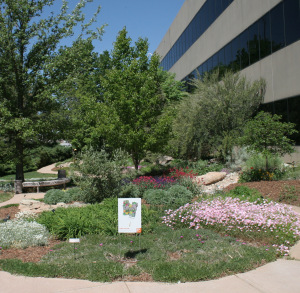

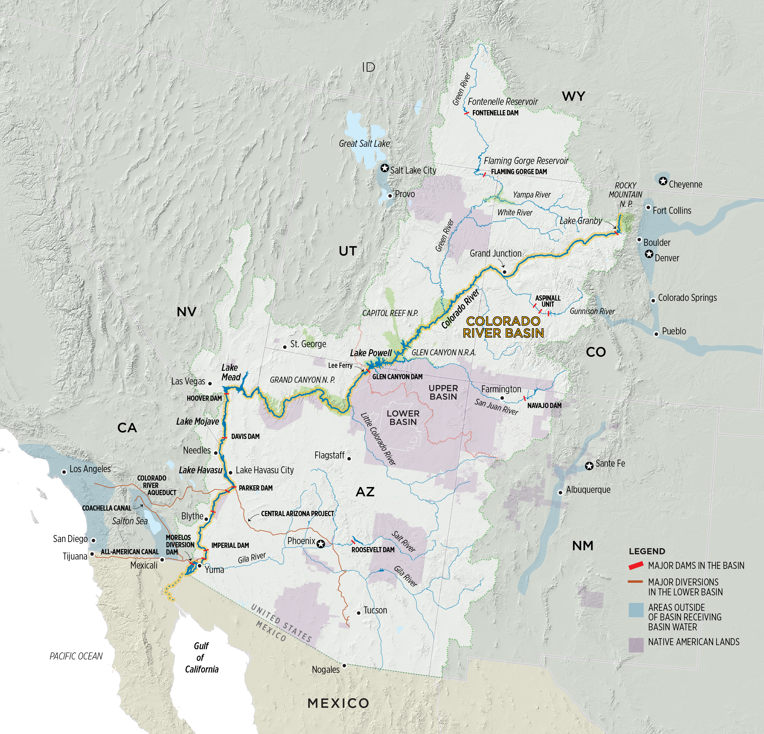


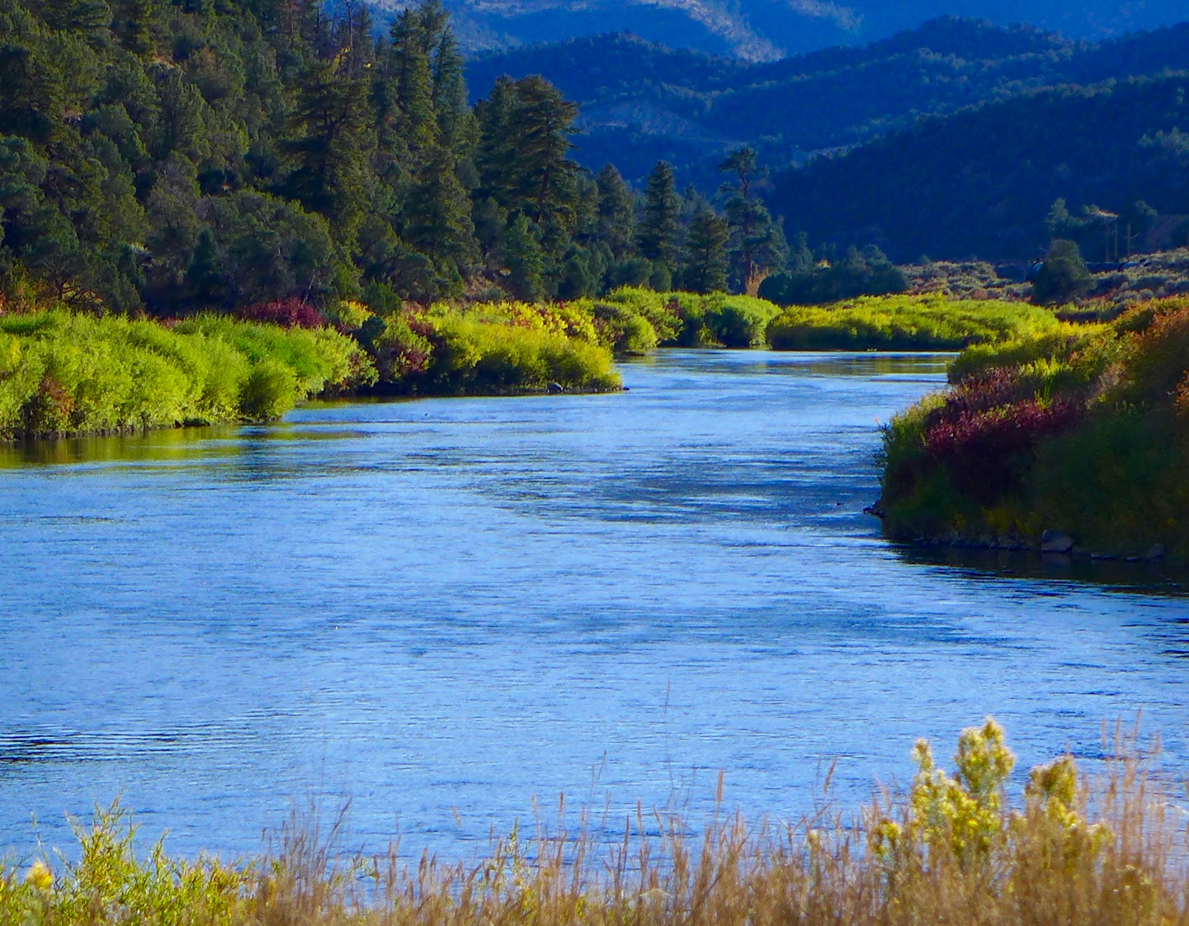
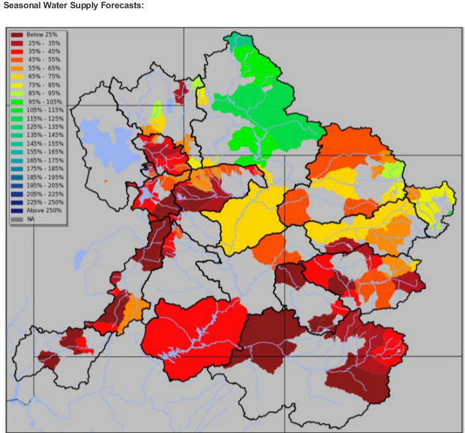
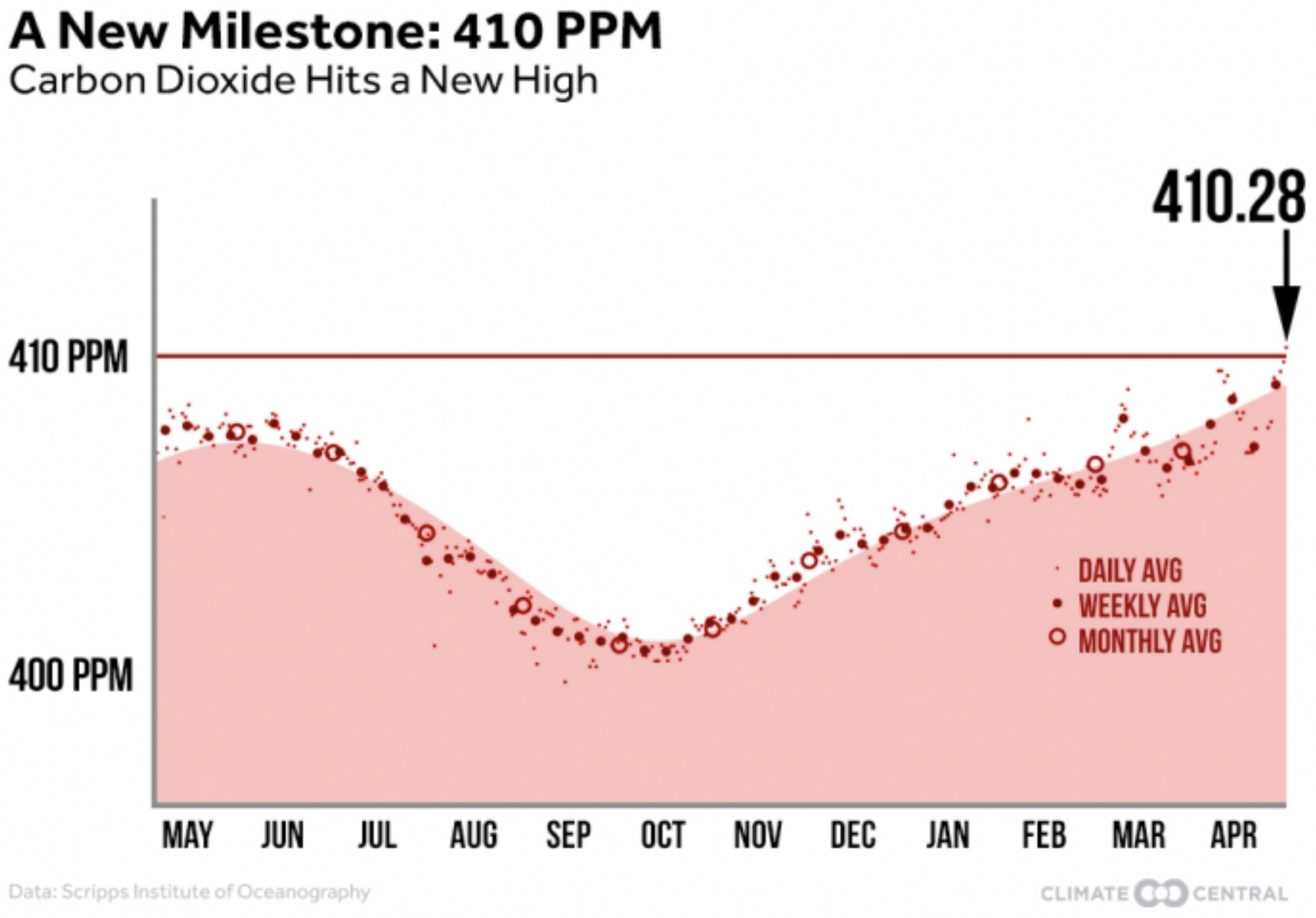


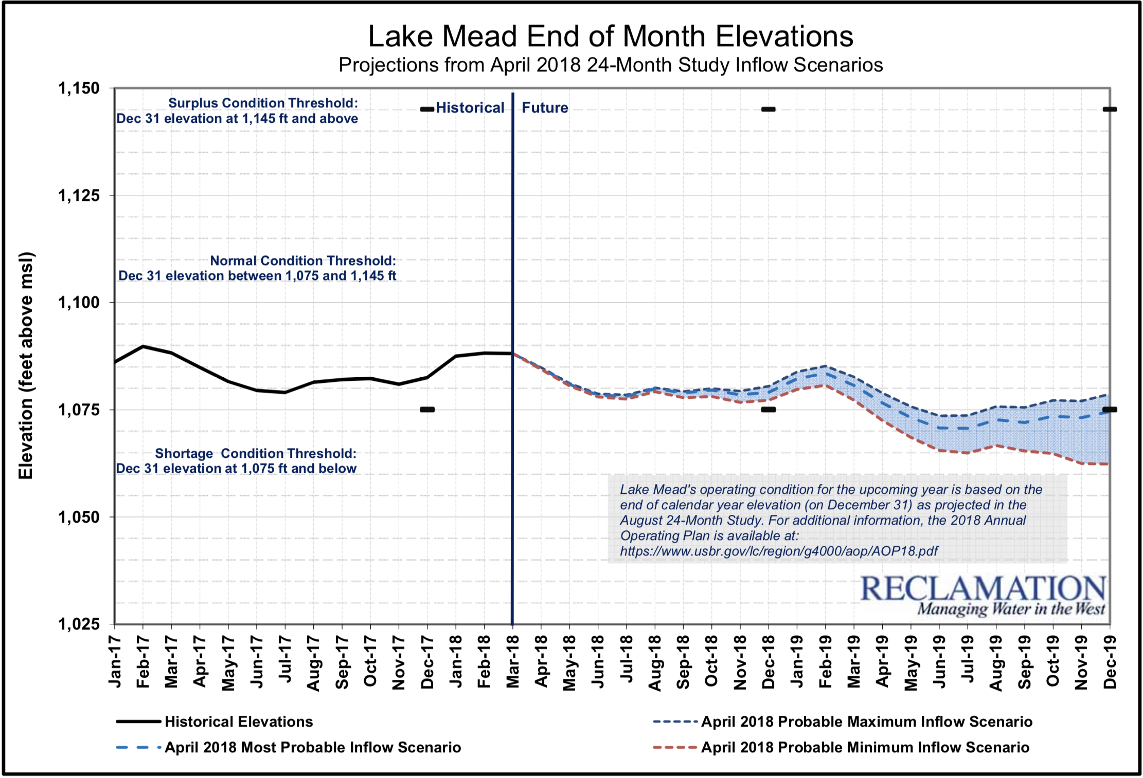


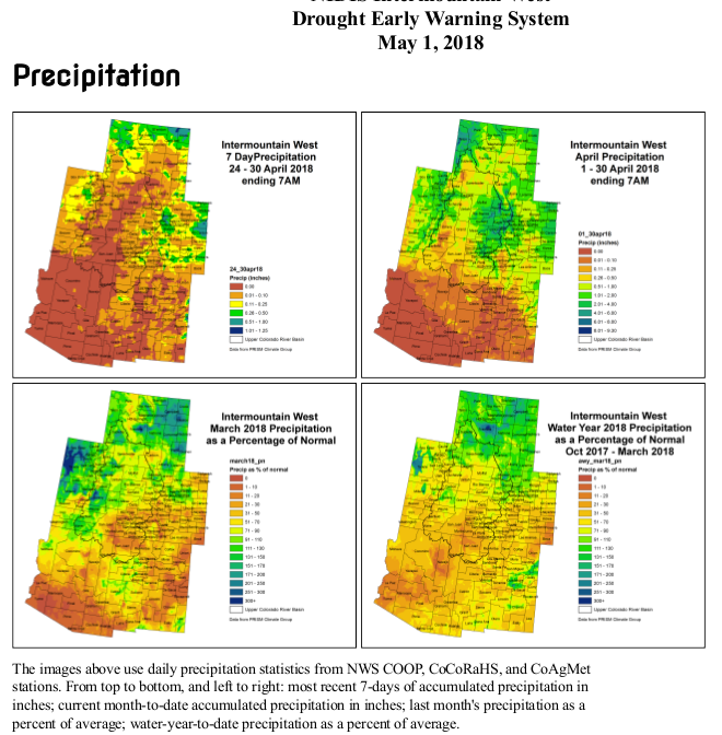


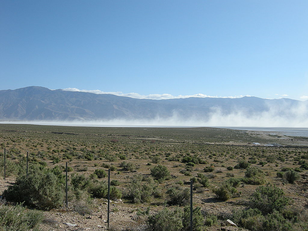


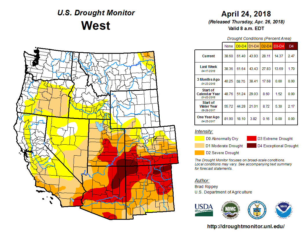

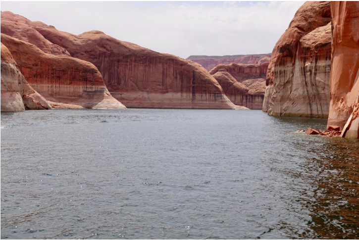

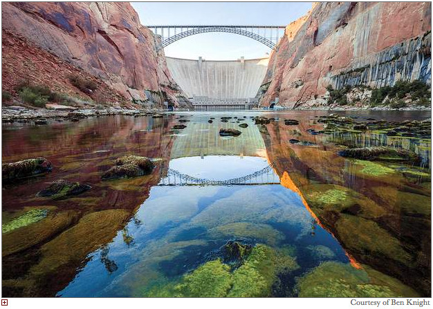


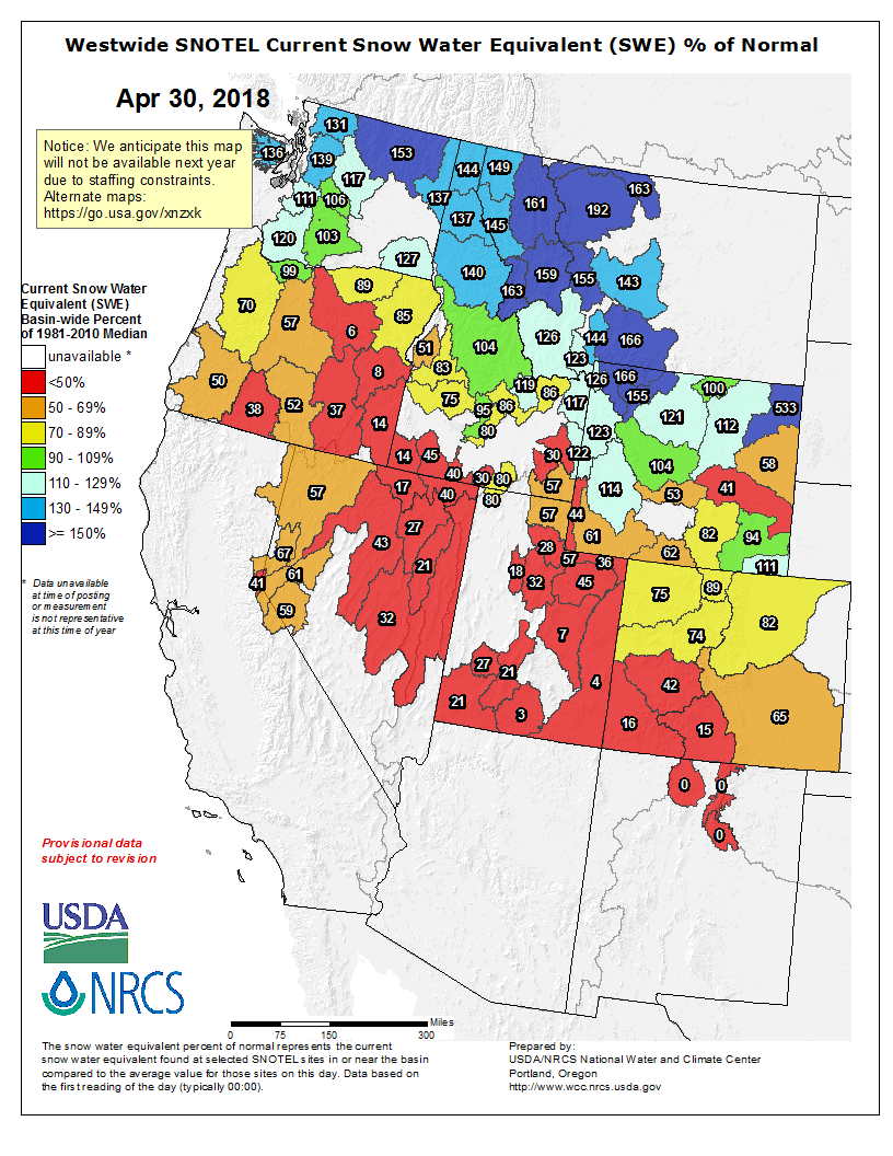


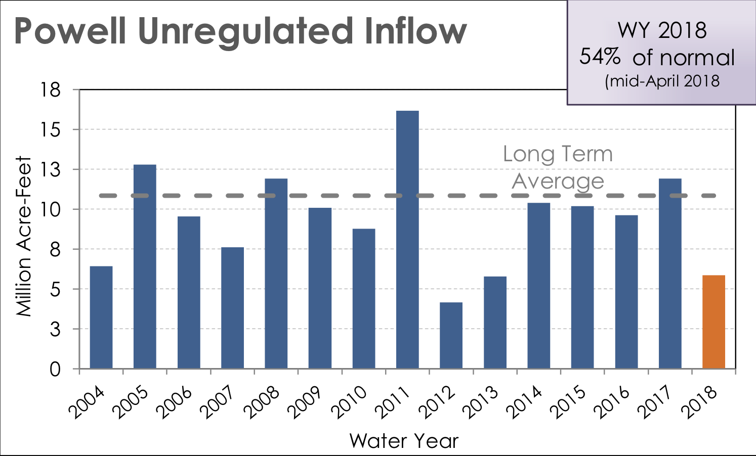

