How Water Reuse Can Help Meet the West’s Water Needs — @wradv

Water reuse via GlobalWarming.com.

From Western Resource Advocates (Laura Belanger):

The West faces a water supply gap, and the reasons are simple. Our quickly growing cities and towns are adding demands on our already stretched water supplies. Water reuse can help us fill the gap.

So what is water reuse and why is it important? First, it’s important to understand the difference between the two primary types of reuse: potable and non-potable reuse. Many states in the West currently allow for non-potable – or purple pipe – reuse for things like landscape irrigation, industrial purposes, commercial laundries, and fire protection, among other things. But a majority of purple pipe reuse is for outdoor landscape irrigation which really only benefits us during irrigation months (less than half of the year). But with potable reuse – where water is treated to very high quality standards to ensure it’s safe and often blended with other supplies – that water can be used anytime, anywhere and for anything. Potable reuse helps stretch supplies and meet more demand with the same volume of water. And it doesn’t require an entirely separate set of pipes (purple) to deliver it.

Western Resource Advocates is working with water utilities, local and state agencies, and other organizations to help increase water reuse around the West to address this growing problem. In Colorado specifically, WRA is working with a diverse group of stakeholders to help develop regulations for direct potable reuse and advance legislation to increase reuse to help the state’s water supplies. Recycled water has been used for decades in Colorado and states across the nation and has long been proven to be a safe, cost-effective tool for additional water supply. In fact, the State of the Rockies Poll found that 78% of westerners “support using our current water supply more wisely by encouraging more conservation and increasing water recycling.“

Currently, WRA and our partners are working to advance four bills in the Colorado legislature that would allow recycled water to be used for:

  • toilet flushing,
  • marijuana cultivation,
  • edible crop and community garden irrigation, and
  • growth of industrial hemp.
  • Other states, like Florida, Washington, Oregon, and Idaho, currently allow for recycled water to be used for toilet flushing and edible crop irrigation, and have successfully supplemented their water supplies this way. Colorado’s Water Plan also specifically calls for state agencies to identify how the state can foster increased reuse to help address growing demands, and these initiatives are a great step in that direction. By embracing water reuse for these applications and others we can help bolster our stretched water supplies, and work to help shrink the gap between those supplies and the demands of our growing cities and towns. Water reuse, in concert with other water-smart tools and strategies, can help us provide for our communities while also protecting our beloved rivers and lakes, keeping them healthy and preserving the quality of life that they afford for all of us.

    We are all neighbors along the Rio Grande — Wild Earth Guardians

    The drying riverbed of the Middle Rio Grande near the Bosque del Apache National Wildlife Refuge on April 4, 2018. Photo credit: USBR

    From Wild Earth Guardians (Jen Pelz):

    To protect the river as a whole, we must join together in a basin-wide community

    I admit that I personally had all but abandoned the 1,250 miles of the Rio Grande from Elephant Butte Reservoir in New Mexico to the Gulf of Mexico. It is difficult to work on more than 600 miles of the river, let alone the entire 1,896 miles. It seemed necessary for self-preservation. The reality of the problems the Rio Grande faces from source to sea is vast:

  • Climate change is predicted to reduce flows in the Rio Grande by 25 percent in Colorado, 35 percent in New Mexico, and over 50 percent in Texas and Mexico in the remainder of this century;
  • A border wall (or series of walls) could destroy connections between countries as well as migratory corridors for rare and beautiful ocelots and jaguars, among other species;
  • A 200-mile stretch of the Rio Grande known as “the forgotten reach”, between El Paso and Presido, Texas (or Ojinaga, Mexico), is already channelized and bone-dry year round;
  • Flows in the 75-mile stretch of one of America’s first Wild & Scenic Rivers—the Rio Grande from the Colorado-New Mexico state line to south of Taos, NM—is in danger of disappearing due to unsustainable use in Colorado and implementation of the Rio Grande Compact, especially during dry years; and
  • The lack of flooding and peak flows, as well as the lack of accountability of agricultural water use from the Rio Grande in central New Mexico, threatens to increase ecological damage to one of the largest contiguous cottonwood forests in the world.
  • There is no doubt the solutions to these problems are complicated and hard, but we can chart a new course for this iconic river.

    You should hear what these two rock stars of climate change have to say — The Mountain Town News

    Katharine Hayhoe. Photo credit: Allen Best

    From The Mountain Town News (Allen Best):

    Gina McCarthy and Katharine Hayhoe both can hold a stage like few others. McCarthy, the former administrator of the Environmental Protection Agency, brims with Boston sass, her arms slicing the air as her words pound out her arguments.

    “The simple fact of the matter is that these two actions by the (Trump) administration—to pull out of the Paris agreement and also to try to repeal the Clean Power Plan—use a fundamentally flawed strategy,” she said during a recent speech at the Climate Leadership Conference in Denver. “It is fundamentally a misread of the United States of America. It is a misread of what we care about. … They have made a serious error of judgment.”

    That error, she went on to say, was to think that a new president could stop the world from changing. “The world ain’t stopping, baby. It’s changing. You can’t look at the planet and say you’re not changing.”

    Hayhoe, who is both an atmospheric scientist and an associate professor of political science at Texas Tech, lays out her arguments with less overt fire. But she, too, dazzles, her talking points sequenced like dominoes, one tripping over into the next. She employs powerful analogies.

    “Why does climate change matter?” she asked in a speech at the same conference. She pointed out that building codes, plans for snow removal, and flood-plain planning are all based on the assumption that past intervals predict those of the future.

    “What happens if the past is no longer a reliable guide and what if the variability is changing?” she asked.

    She then showed an aerial map of West Texas, flat as few places are, and the roads that are straight as arrows. You can, she said, drive down most roads looking in the rear view mirror to guide forward movement.

    But there is a highway that, after miles and miles of straight, takes a turn. She showed a picture of that curve in West Texas. Science, she went on to say, has three very important things to say about this planetary climate curve that we’re one.

    One, the climate is curving. Weather observations made over the last 20 to 30 years clearly represent a collective change in the climate. It is now changing faster than any time in the history of human civilization.

    Science can also tell us why this is happening. It’s not because of the change in solar intensity. Sunlight has been weakening for the last 40 years. Our global climate should be cooling. Instead, it is heating rapidly. Debris spewed into the atmosphere by volcanoes also fails to explain what is being observed.

    “There is no convincing alternative explanation to the warming that we see today—and trust me, we have looked at all of them,” she said.

    “There is no analog in the last 100 million years to what we see happening.”

    What does explain this rapid warming is the accumulation of carbon dioxide and other greenhouse gases in the atmosphere, caused primarily by the exhausts from combustion of fossil fuels.

    The third thing science tells us is that the risk is serious.

    “We care about a changing climate because it takes the threats we face today and exacerbates them.” We are already, she added, in the crosshairs of change because of the impacts of floods, droughts, wildfire, heat waves, and hurricanes. They are natural events, “but they are being amplified. “

    This gives us three choices: mitigation, adaptation, and suffering, said Hayhoe.

    Hear and see Katharine Hayhoe talk about “Bridging the Gap between the Science and Stakeholders.”

    McCarthy, now a professor at Harvard University, was EPA administrator when the Clean Power Plan was drawn up. In Denver before her keynote address, she told reporters she doesn’t think the Trump administration will be able to cast aside the Clean Power Plan, as Trump has promised.

    “This is not going to be a downhill glide for them. It will be a big slog, and it will be in court for a very long time if they choose to do it,” said McCarthy, minus the theatrics but no less analytical.

    She said that the Clean Power Plan was carefully premised in science, every step taken to create a sturdy legal foundation. In issuing the rule in 2015, the EPA estimated it would reduce greenhouse gas emission from the power sector 32 percent below 2005 levels by 2030.

    In fact, by 2016, emissions from the energy sector had fallen 14 percent compared to 2005 levels, according to the U.S. Energy Information Agency. But more narrowly within the electricity sector of energy, they were 25 percent below 2005 levels, according to a 2017 Congressional Research Service report. This occurred even as prices of wind and solar began tumbling with comparable price reductions for storage.

    Carl Pope, the former long-term executive director of the Sierra Club, drew from “Climate of Hope,” the book he and co-author Michael Bloomberg, the former New York mayor. In it, they argued that there was “actually nothing the president of the United States could do to prevent” the United States from its rapid adoption of a non-carbon-based economy. “So far, we look like pretty good prophets,” said Pope.

    The United States has continued to cut its carbon dioxide emissions, he added, and the pace of retirement of coal-fired power plants has accelerated.

    “We are retiring coal plants twice as fast since Donald Trump became president as we were in the period before Trump became president.”

    Transportation, now the largest source of greenhouse gas emissions, is also changing. Electric vehicles are coming on like a tsunami, as one speaker at the conference said. Pope pointed out that the adoption rate is accelerating. Each year, new predictions are issued for 2030. Each year is 20 percent more aggressive than the year before.

    See and hear Carl Pope.

    Pope’s observations jibed with those of McCarthy in her remarks with reporters. “The world is changing,” she said. “Are we losing any momentum? Maybe, but I haven’t see that happen yet.”

    But if the changes the Clean Power Plan sought to instigate are already happening, what should happen now is investment for innovation and technologies of the future. She said restarting the Clean Power Plan will not be enough for the next presidential administration.

    Several hours later, in a keynote address at the conference, McCarthy was back to her sassy self before a friendly, even adoring audience. Here, she skewered a favorite argument of environmentalists. Saving the planet, she said, is not an effective political argument.

    “The planet will be just fine. We won’t be able to live on it. That’s a significant clarification,” she said.

    “We need to stop talking to people about the health of the planet. I don’t give a damn about the health of the planet. I give a damn about my kids’ and my future. That is what we need to remind people of. That’s what this is all about. That’s what the Paris agreement was all about.”

    It being an awards banquet, McCarthy then swiveled to recognize the businesses being recognized for their efforts to effect an energy transition. That was a theme of the conference, perhaps a play to donors. But conveniently, there’s abundant evidence that businesses—along with cities and states —are, in fact, driving the change in the absence of federal leadership.

    “We are celebrating companies that are not really doing business as usual,” said McCarthy. “They are actually doing business as unusual. That’s what we want to celebrate. That’s not the same old, same old. Businesses, cities and states are stepping up.”

    The most effective action, especially in the environmental realm, has been driven by the grassroots. “It takes a lot of us working together,” she said.

    And then she also had this key message, another theme of the conference: Government has a key role in helping disadvantaged sectors. McCarthy spoke to this “sense of equity that government can provide when we level the playing field. ,I want everybody’s world to be stepped up, everybody’s world to be elevated.”

    Hayhoe had come at the same topic a little differently. A self-described evangelical Christian, she said part of the discussion needs to be about suffering, what does it look like around the world?

    She also talked about how to talk about climate change with those who may be dubious about the need for changes. She suggested there are ample opportunities, because the changing climate “affects everything that is already high on our priority list.”

    To create a common ground with disbelievers or those who don’t think it’s a problem, first find out what they do indeed care about it.

    If it’s about water, then talk about water variability. If they care about their kids, talk about how it can affect their kids. If they’re birders or people of faith – almost everything that people consider important offers a shared value for continued conversation. Then talk about solutions. “It’s everything to do with what they perceive to be solutions.”

    Partnering to Ensure Healthy Farms on a Healthy River — @WaltonFamilyFdn

    The Grand Valley Irrigation Canal, in Palisade, heading for Grand Junction. Photo: Brent Gardner-Smith/Aspen Journalism

    From The Walton Family Foundation (Sheldon Alberts):

    In Colorado, Farmers and Conservationists Unite to Save Water, Protect Agriculture

    High above the fertile fields of Colorado’s Grand Valley, a century-old dam stretches almost 550-feet across the mighty Colorado River.

    For 100 years, the water stored behind the gates of this iconic ‘roller’ dam – an early 20th century engineering marvel built by the US Bureau of Reclamation – has been diverted down dozens of canals and pipeline to irrigate 33,000 acres of farmland on the state’s western slope.

    Water is why agriculture remains the engine of the economy in Grand Valley. Its reliable supply is the only reason peach orchards and corn and vineyards can thrive in this arid desert landscape at all.

    Mark Harris intends to keep it that way.

    As general manager of the Grand Valley Water Users Association – the largest irrigation provider in the region – Mark’s job is to make sure he delivers the water his member farmers need to grow their crops.

    As population growth in the West fuels higher demand for water, and a changing climate increases scarcity, Mark and the GVWUA are embracing creative conservation measures – such as water banks –designed to keep the Colorado River flowing and western farms and ranches in business.

    “If you have two dry years here on the Colorado River, your toes are sticking out over the edge of the abyss from a water supply perspective,” says Mark. “We have good water here. We have a high percentage of very senior water rights. But that doesn’t make any difference if there isn’t any water in the river.”

    Concerns about water have grown steadily over the past 18 years as the West suffered through one of the most prolonged droughts in history.

    In the Colorado River’s Upper Basin, farmers and ranchers began to think the unthinkable: Would they ever be forced to curtail water use, or pressured to sell water rights, because of shortages in major cities like Denver, Phoenix or Los Angeles.

    “If we’ve got 40 million people down the river from us, looking up the river at our water, we definitely have a target on our back as far as being a potential place to look for water,” Mark says. “We wanted to get ahead of this curve a little bit. We needed to be thinking about how we protect our interests.”

    Seeking to avoid the potential chaos created by a shortage, the GVWUA is working closely with The Nature Conservancy (TNC), federal and state agencies and private funders, including the Walton Family Foundation, to test the viability of water banks as a way to prevent future crises.

    This market-based approach to conservation pays willing ranchers and farmers to temporarily limit their water use, giving them the opportunity to lease their water without selling their rights.

    In 2017, 10 Grand Valley farmers who enrolled in the Conserved Consumptive Use Pilot Project withdrew 1,250 acres of land from agricultural production, saving water they would have otherwise used to irrigate crops.

    The conserved water – about 1 billion gallons, or 3,200 acre feet – was not sent in the ditch to irrigate farms. Instead it was sent through a different ditch to the association’s hydropower plant, and returned back to the Colorado River just upstream of critical habitat for threatened native fish species. The conserved water benefited hydropower revenues and endangered fish, and bolstered storage at Lake Powell, the main reservoir in the Colorado River’s Upper Basin.

    “We are attempting to create conservation benefit that’s economically sustainable. The farmer is made whole. They receive income in lieu of his crop that he would have grown,” says Mark.

    “Instead of growing corn, or wheat, or alfalfa, on those acres, they’re actually creating available water. That’s the yield.”

    In addition to compensating farmers, the Grand Valley Water Users Association received payments to fund irrigation infrastructure improvements that will increase efficiency and keep even more water in the river.

    The $2 million program was conceived and developed over several years by the Colorado Water Bank Work Group, which brought together water users and conservationists, groups often at odds with each other.

    Taylor Hawes, director of TNC’s Colorado River Program, says farmers are willing to explore ways to protect the river because they can protect themselves in the process.

    “The one thing all water users want is certainty. Farmers and ranchers understand that if a crisis occurs on the Colorado River, they will be some of the first impacted,” she says. “They are interested in crafting a solution proactively rather than having a solution imposed on them.”

    Those scented products you love? @NOAA study finds they can cause air pollution

    Here’s the release from NOAA (Theo Stein):

    Emissions from volatile chemical products like perfumes, paints and other scented consumer items now rival vehicles as a pollution source in greater Los Angeles, according to a surprising new NOAA-led study.

    Even though 15 times more petroleum is consumed as fuel than is used as ingredients in industrial and consumer products, the amount of chemical vapors emitted to the atmosphere in scented products is roughly the same, said lead author Brian McDonald, a CIRESoffsite link scientist working at NOAA.

    The chemical vapors, known as volatile organic compounds or VOCs, react with sunlight to form ozone pollution, and, as this study finds, also react with other chemicals in the atmosphere to form fine particulates in the air.

    “As the transportation sector gets cleaner, these other sources of VOCs become more and more important,” McDonald said. “A lot of stuff we use in our everyday lives can impact air pollution.”

    Pollution sources then, and now

    Since adoption of the Clean Air Act in 1970, air quality programs have focused on controlling transportation-related pollution emitted by everything from cars and trucks to oil and gas refineries. But McDonald and his colleagues couldn’t reconcile atmospheric measurements made over Los Angeles in 2010 with estimates of transportation emissions. So, they reassessed urban pollution sources by cataloging chemical production statistics, evaluating indoor air quality measurements made by others and then determining if the new information filled the gap.

    All emissions are not created equal

    The disproportionate air-quality impact of chemical products is because of a fundamental difference between those products and fuels, said NOAA atmospheric scientist Jessica Gilman, a co-author of the new paper.

    Fuel systems minimize the loss of gasoline to evaporation in order to to maximize energy generated by combustion, she said. But common products like paints and perfumes are literally engineered to evaporate.

    “Perfume and other scented products are designed so that you or your neighbor can enjoy the aroma,” Gilman said. “You don’t do this with gasoline.”

    A pollution source hiding in plain smell?
    Gilman added that researchers studying the problem ended up taking a close look at things they once took for granted. “Some of my colleagues at NOAA literally spent days watching paint dry,” said said. “We learned a lot.”

    While the focus of this study was Los Angeles, the authors believe the results are applicable to all major urban centers.

    “We hope this study spurs collaboration between atmospheric scientists, chemical engineers and public health researchers, to deliver the best science to decision-makers,” said McDonald. “The strategies that worked in the past might not necessarily work as well in the future.”

    Variability of hydrological #droughts in the conterminous United States, 1951 through 2014

    Click here to go to the USGS website to read the report. Here’s the abstract:

    Abstract

    Spatial and temporal variability in the frequency, duration, and severity of hydrological droughts across the conterminous United States (CONUS) was examined using monthly mean streamflow measured at 872 sites from 1951 through 2014. Hydrological drought is identified as starting when streamflow falls below the 20th percentile streamflow value for 3 consecutive months and ending when streamflow remains above the 20th percentile streamflow value for 3 consecutive months. Mean drought frequency for all aggregated ecoregions in CONUS is 16 droughts per 100 years. Mean drought duration is 5 months, and mean drought severity is 39 percent on a scale ranging from 0 percent to 100 percent (with 100% being the most severe). Hydrological drought frequency is highest in the Western Mountains aggregated ecoregion and lowest in the Eastern Highlands, Northeast, and Southeast Plains aggregated ecoregions. Hydrological drought frequencies of 17 or more droughts per 100 years were found for the Central Plains, Southeast Coastal Plains, Western Mountains, and Western Xeric aggregated ecoregions. Drought duration and severity indicate spatial variability among the sites, but unlike drought frequency, do not show coherent spatial patterns. A comparison of an older period (1951–82) with a recent period (1983–2014) indicates few sites have statistically significant changes in drought frequency, drought duration, or drought severity at a 95-percent confidence level.

    Agricultural resiliency in the face of #drought

    The headwaters of the Yampa River. Photo: Brent Gardner-Smith/Aspen Journalism

    From the CSU Extension Office (Todd Hagenbuch) via Steamboat Today:

    If it feels dry and warm this winter, it’s because it is. While our snowpack water equivalent is lower than average in Northwest Colorado, it’s the warm temperatures that make it feel like even less snow as it has melted and condensed the snow considerably. In fact, every point west of the Continental Divide, from Idaho to New Mexico, has experienced unseasonably warm temperatures all winter, further exacerbating our low moisture levels.

    When comparisons are made on percentage of snow level or temperatures, they are measured against an average, even if it is sometimes listed as a percentage of normal. The reality in our area is that normal weather is variable, really variable.

    So how do landowners and agricultural producers make themselves resilient to dramatic weather?

  • Make a grazing plan for the longterm. Plan to have enough pasture for your animals no matter what happens. Yes, you may not use it all to maximum effectiveness every year, but having land in reserve for dry periods pays dividends in the longterm. Range grasses overgrazed even one year will lead to long-term, decreased production. Stressed grasses take even longer to recover from grazing, so allowing plenty of time for grass to rest during the growing season is critical, too.
  • Cull animals as appropriate while preserving genetics. If times get tough and you need to reduce the amount of forage consumed on your property, it may be time to cut numbers. Older, larger animals take more resources than smaller, younger ones, so consider that when culling. If you’ve raised your own replacement livestock, then keeping heifers/ewes and young bulls/rams with the same genetic makeup as the older animals allows you to keep the genes you’ve worked hard on promoting while reducing the forage required to keep the herd going.
  • Take advantage of moisture when it’s more likely to come. Consider taking on seeding projects and fertilization in the fall, when winter snows are more likely to guarantee moisture than unpredictable spring rains. Fertilizer depends on moisture, so move it into the soil profile quickly after application. Applying it right before snow-up helps guarantee it will move into the soil before dry air can cause volatilization of the nitrogen you’re trying to supply to your plants.
  • Use water wisely, for conservation sake and for better grass. Grass plants do not want to be wet all of the time, but do need water. Thoroughly soaking grass then letting it dry for a period of time before wetting it again helps grass remain resilient and helps your pasture retain the grasses that are best for grazing, not sedges and other water-loving plants. If you have little water, you’ll be more likely to manage it well if you’ve been practicing your irrigation skills in times of plenty.
  • Always plan for the unthinkable. Forest fires and other natural disasters can happen any summer. Be prepared with an evacuation plan for yourself, family and animals. Share the plan with your family and neighbors, and find out what their plans are. Practice when possible and make sure that everyone is on the same page so when the time comes, you’re ready.
  • There is only so much one can do to thwart the challenges Mother Nature throws at us. But thinking through possible scenarios and having a drought mitigation plan in mind before disaster strikes is paramount. Weather variability and extreme events are here to stay, and by planning ahead, you can assure that you can weather whatever comes our way.

    Todd Hagenbuch is the interim county director and agriculture agent for the CSU Extension office.

    2018 Protect Our Winters Economic Report

    Click here to read the report. Here’s the executive summary:

    THE IMPACTS OF CLIMATE CHANGE ARE HITTING THE U.S. WINTER SPORTS TOURISM INDUSTRY PARTICULARLY HARD.

    In mountain towns across the United States that rely on winter tourism, snow is currency. For snow lovers and the winter sports industry, predictions of a future with warmer winters, reduced snowfall, and shorter snow seasons is inspiring them to innovate, increase their own efforts to address emissions, and speak publicly on the urgent need for action.

    This report examines the economic contribution of winter snow sports tourism to U.S. national and state-level economies. In a 2012 analysis, Protect Our Winters and the Natural Resources Defense Council found that the winter sports tourism industry generates $12.2 billion and 23 million Americans participate in winter sports annually. That study found that changes in the winter season driven by climate change were costing the downhill ski resort industry approximately $1.07 billion in aggregated revenue over high and low snow years over the last decade.

    This analysis updates the 2012 study and furthers our understanding of how warming temperatures have impacted the industry since 2001, what the economic value of the industry is today (2015-2016) and what changes we can expect in the future under high and low emissions scenarios.

    Taking another look at the changing winter sports tourism sector in America, we find:

    • In the winter season of 2015–2016, more than 20 million people participated in downhill skiing, snowboarding, and snowmobiling, with a total of 52.8 million skiing and snowboarding days, and 11.6 million snowmobiling days.

    • These snowboarders, skiers and snowmobilers added an estimated $11.3 billion in economic value to the U.S. economy, through spending at ski resorts, hotels, restaurants, bars, grocery stores, and gas stations.

    • We identify a strong positive relationship between skier visits and snow cover and/ or snow water equivalent. During high snow years, our analysis shows increased participation levels in snow sports result in more jobs and added economic value. In low snow years, participation drops, resulting in lost jobs and reduced revenue. The effects of low snow years impact the economy more dramatically than those of high snow years.

    • While skier visits averaged 55.4 million nationally between 2001 and 2016, skier visits during the five highest snow years were 3.8 million higher than the 2001-2016 average and skier visits were 5.5 million lower than average during the five lowest snow years.

    • Low snow years have negative impacts on the economy. We found that the increased skier participation levels in high snow years meant an extra $692.9 million in value added and 11,800 extra jobs compared to the 2001–2016 average. In low snow years, reduced participation decreased value added by over $1 billion and cost 17,400 jobs compared to an average season.

    • Climate change could impact consumer surplus associated with winter recreation, reducing ski visits and per day value perceived by skiers.

    • Ski resorts are improving their sustainability practices and their own emissions while also finding innovative ways to address low-snowfall and adapt their business models.

    The winter sports economy is important for the vitality of U.S. mountain communities. This report shows the urgency for the US to deploy solutions to reduce emissions and presents a roadmap for the winter sports industry to take a leading role in advocating for solutions.

    WHAT OF JUSTICE?

    This report is about the challenge that climate change poses to winter sports economies, but in the end, it’s about the impact warming is having on snowsports themselves. Which brings up an important question related to climate justice: Who cares? In the last year, climate-enhanced disasters—the sorts of catastrophes we can expect more of as the world continues to warm—have had a tremendous impact on human beings’ ability to simply survive, let alone ski.

    In the face of disasters like we saw in Puerto Rico or Houston this year which included the loss of lives, grid shut-downs, health crises, and housing crises, why worry at all about snowsports?

    To many Americans, the fading of winter is a visible reality, and the consequences create an emotional reaction connected to a sense of place and personal experience. Talking about snow is one particularly accessible way to engage the American population on an issue that has been viciously difficult to bring to the fore. By protecting winter and snow in mountain communities, we are also protecting the most vulnerable communities and connecting both. We hope that this report will help galvanize all Americans to act on climate —for skiing, snowboarding, and snowball fights, sure, but most importantly for a safer, more equitable future for all. Snowpack doesn’t only support winter sports, it also serves as a water reservoir and increases the albedo effect.

    Ultimately, winter sports join ranks with arts and culture, literature, music and song, to create the space for reflection that enables citizenry to care about more than just themselves and their powder turns, but also about what their role is in society. Losing snow to a warming world when we have human innovation and all of the technology at hand to save it, would be a greater loss than pure numbers can quanitfy.

    A revolution in hydropower makes waves in rural Colorado — @HighCountryNews

    From The High Country News (Carl Segerstrom):

    Big dams were the hydro giants of yesteryear. The future of hydropower is small.

    This story is a part of the ongoing Back 40 series, where HCN reporters look at national trends and their impacts close to home.

    On the Western Slope of the Colorado Rockies, winter opens the door to spring as fruit tree buds flit away and green shoots emerge from their slumber — that fish-dark sound of slow-moving water returns to the hillsides. Moving water is how the arid West has been brought to bear fruit. Now people are eyeing the irrigation works of the past as clean electricity sources for the future.

    Around three thousand years ago the San Pedro people brought water from nearby streams to maize fields near modern-day Tucson, Arizona. As waves of European settlers pushed west they introduced different technologies to irrigate the thirsty land. Beginning in 1909, canal projects in the Uncompahgre Valley, of southwest Colorado, moved water from the mighty Rockies, greening the arid lands below. For a century these canals made agriculture possible in the high desert. But only in the last five years have they started to bring electricity to the communities of Delta and Montrose.

    The big hydroelectric dams of the 20th century put the rivers of the West under their imposing concrete thumbs, but their unintended consequences have water managers and entrepreneurs thinking the future of hydroelectric power is small. Advances in technology, federal reforms and Colorado’s ideal geography and friendly policies are paving the way for a new wave of small hydropower projects in the state that could be the template for a new generation of hydroelectric power.

    This slideshow requires JavaScript.

    In Montrose, Colorado, in the shadows of the Elk and San Juan mountain ranges, five small hydroelectric facilities are now incorporated into a canal system that delivers water to more than 83,000 acres of farmland for the Uncompahgre Valley Water Users Association. The hydroelectric generators combine a diversion from the canal with metal gates and a large metal pipe that carries water into what from the outside looks like an average metal storage shed. Inside the shed the deafening drone of the turbine equipment hums along during the seven months of the year when water moves through these irrigation canals.

    One of the major selling points of this technology is that it takes advantage of the power generating potential of water that is already moving through man-made infrastructure. “It’s the same amount of water as if (the turbines) weren’t there,” says Steve Anderson, who was born about 30 miles from Montrose and is following in his father’s footsteps as the manager of the UVWUA. Anderson, who is in his sixties, wears overalls, a long-sleeved maroon shirt and a black baseball hat and “loves showing off our hydros.” He says that if for some reason the hydroelectric facilities stopped working, it wouldn’t affect the delivery of irrigation water that the surrounding communities depend on. For the stakeholders in the irrigation association, the projects have become a source of income without any sacrifice of water delivery.

    Projects like the hydroelectric facilities in Montrose are popping up across the West — in part thanks to a lobbying effort by hydroelectric interests and the advocacy group American Rivers. These groups came together in support of a 2013 bill, the Hydropower Regulatory Efficiency Act, which passed the house by a unanimous vote and was signed into law by President Barack Obama. The bill encourages new projects by lessening the regulatory and permitting hurdles for hydroelectric installations. In the past small projects like these were subject to a lengthy Federal Energy Regulatory Commission permitting process that, according to small hydro advocate Kurt Johnson, could be more expensive than the hydroelectric hardware itself. He says the new law is a “game changing improvement” for developing these projects on private water infrastructure.

    The Montrose hydroelectric facilites, which are part of a Bureau of Reclamation water system, have different permitting requirements. Anderson says that the permits for their hydro projects went through in about two months and were a simple process because they only affect man-made infrastructure.

    Small hydroelectric installations, like the ones in Montrose, hit a sweet spot for water managers and conservationists. These so-called conduit hydropower projects don’t inherently disrupt natural river systems and instead use existing off-stream infrastructure. Conduit hydropower can take different forms, from diversion and turbine systems on irrigation canals to micro-hydro installations that are inserted in the place of pressure-reducing valves, which are a necessary and ubiquitous component of water delivery and treatment infrastructure. Kelly Catlett, with the advocacy group Hydropower Reform Coalition, says that from an ecosystem and watershed health standpoint the only real worries are making sure that diversion points from rivers have proper fish screens and that new conduit hydropower projects aren’t used to justify larger diversions of water. Catlett says that as long as those issues are addressed, “this is one area a lot of us can agree on and be supportive of.”

    But not all of the small hydro projects promoted by the 2013 law hit this sweet spot, because the law also allows the electrification of on-stream dams that don’t already have turbines. American Rivers, which lobbied for the bill but also promotes the removal of some dams, got pushback in the conservation community for supporting the bill. Matt Rice, the program director for American Rivers in the Colorado Basin, says updating old dams and adding energy producing turbines can ultimately help improve ecosystem conditions like dissolved oxygen and stream flow, and in some cases prevent the building of additional dams on free-flowing rivers. Other river advocates see the powering of unpowered dams as a potential roadblock to restoration. Eric Wesselman, the executive director of the California-based advocacy group Friends of the River, says he’s concerned about expedited reviews of small hydropower projects because “the influence of power production could delay dam removal in the future.”

    The combination of extensive irrigation works, mountainous terrain and friendly state policies make Colorado an epicenter for the growth of small hydroelectric projects in the United States. The state is second only to California in small hydro installations and is pushing to expand in the future. Colorado Energy Office analyst Samantha Reifer says that the state is promoting small hydro projects through a combination of outreach, assistance with navigating regulatory barriers and low-interest finance programs. “Hydropower isn’t people’s first idea because in the past it’s been giant dams,” Reifer says. “We are working to raise awareness that this is an opportunity on existing water infrastructure.”

    Kurt Johnson has been at the forefront of lobbying for regulatory reform, advising Colorado on hydropower policies, and facilitating small hydropower projects as the president of the Colorado Small Hydro Association and CEO of Telluride Energy. He foresees the future of hydropower being in smaller installations more akin to rooftop solar than the large dams of the past. “It’s a political slam dunk because the industry and the environment are hand-in-hand,” Johnson says.

    Small hydropower is not a silver bullet to sate our energy appetite. But in places like Montrose and Delta counties it is already playing an important role. The five hydropower projects of the UVWUA are generating about half a million dollars of annual profit for the water users association, which it uses to keep rates low and reinvest in improving water infrastructure. The facilities, which the association is eyeing to add to in the future, account for about 13 percent of the power used by the roughly 70,000 people served by the Delta-Montrose Electric Association. “An old cowboy once told me every blade of grass is important,” Anderson says. “Well, every electron is, too.”

    San Luis Valley wetlands are critical to wildlife

    From The Valley Courier (Helen Smith):

    Wetlands are a critical part of the San Luis Valley. Not only are they a key water resource, but they also provide habitat for numerous bird species and bring tourism dollars to the local economy. They are truly part of what makes the Rio Grande Basin distinct.

    The San Luis Valley has three refuges that are overseen by the U.S. Fish and Wildlife Service under the direction of the United States Department of the Interior. They are the Monte Vista, Alamosa and Baca National Wildlife Refuges. The first refuge to be established was Monte Vista in 1952, followed by Alamosa in 1962, and finally the Baca in 2000. These areas make up the San Luis Valley Refuge Complex and are three in a system that consists of over 560 refuges nationwide. The Monte Vista Refuge is 14,804 acres and Alamosa comprises 12,026 acres and the Baca is 92,500 acres. The primary purpose of setting these lands aside is to protect vital wildlife corridors as well as water assets that are key to the well- being of the aquifer system that is crucial to the sustainability of the valley.

    These refuges also serve as prime habitat and nesting grounds for over 200 species of birds as well as other species of native wildlife such as deer, elk, beaver, and coyotes. The Alamosa Refuge is also home to the historic Mum Well which serves as a key data collection point for Colorado and San Luis Valley Water users. The primary purpose, is to protect lands that are important and that make the San Luis Valley a beautiful place. The landscapes seen in the refuges also highlight the distinct regions of the Valley as well.

    The Monte Vista Refuge was established for the purpose of protecting migratory bird species, especially the Sandhill Crane. The San Luis Valley U. S. Fish and Wildlife Service Office estimates that between 23 and 27,000 Sandhill Cranes make the San Luis Valley a rest stop during their annual migration to and from breeding grounds in the northern US.

    The success of the migration north in the spring from winter habitat in New Mexico and Texas to summer habitat in Montana, Idaho, Wyoming, and Canada and south in the fall is based largely on the birds eating enough food in the SLV to complete the trek, survive winter, and arrive healthy enough to nest and raise the next generation. Grain left after harvest on privately owned fields in the SLV is a major food source necessary to complete a successful migration. Nearly the entirety of the Rocky Mountain Population of Greater Sandhill Cranes passes through Colorado during their migration. The feed from the abundant barley and rest in wetlands that the cranes get in the SLV is critical to the success of the migration and upcoming breeding, and the most important part of the migration in Colorado is the availability of grain and roost sites in the SLV.

    Colorado Parks and Wildlife also protect wetland areas across the San Luis Valley. According to a 2012 report by CPW, “The value of wetlands can’t be overstated. About 125 species that are found here in Colorado are dependent on wetlands for their survival, including 98 species of migratory birds.” The species that benefit include waterfowl and 20 priority non-game species.

    The agency mitigates wetlands based on a set of criteria that include hydrology, vegetation, land use and conservation. To manage the hydrology the goal is to maintain adequate width and depth (4–8 inches deep) for roosting, maintain flowing water to prevent spread of disease. Vegetation goals include monitoring for the availability of vegetation that produces food, controlling woody vegetation where needed, control encroaching coarse emergent vegetation and the use of livestock and controlled burns to maintain grass overstory.

    Land use surveys look at the roosting and feeding sites, provide grit (e.g., pebbles and small gravel) at roost sites if needed, and remove unused fences. Conservation goals include monitoring harvest rates to maintain desirable population numbers and forming and maintaining partnerships between agencies agricultural producers, landowners and the public.

    Like the US Fish and Wildlife Service and Colorado Parks and Wildlife, the Bureau of Land Management (BLM), National Park Service (NPS), US Forest Service (USFS) and the Natural Resources Conservation Service (NRCS) also work to protect wetland habitats. The Blanca Wildlife Habitat Area, managed by the BLM, serves as a refuge for birds, fish and other wildlife. The wetlands are a key area for birds since they provide habitat for migrating water and shorebirds. The bald eagle and the peregrine falcon also use the wetlands. Other Species of Management Priority that have been documented are American bittern, avocet, common yellowthroat, eared grebe, Forster’s tern, greater Sandhill crane, hen harrier, Savannah sparrow, snowy egret, sora rail, western grebe and yellow-headed blackbird. Shorebirds such as gulls, sandpipers and pelicans are at home in the salty environment, as well as 158 other species including a colony of breeding Snowy Plover. The Blanca Wildlife Habitat is a duck breeding concentration area, with mallards by far the most common, but good numbers of pintail and green-winged teal are also utilizing the area.

    The Valleys farms and ranches also support the areas wetlands and see them as important part of the hydrologic cycle. Wetlands work as a sponge that helps to ensure that working ag lands maintain a water source in lean years and symbiotically rotationally grazed wetland remain healthier due do reduced grass overstory and less noxious weeds. San Luis Valley agriculture producers and water managers are partnering to do timed releases of water from area reservoirs to only supply irrigation water, but to insure river and wetland habitats benefit.

    In the long run, wetlands provide wildlife habitat, grazing opportunities, groundwater recharge and sustainability of water resources.

    Helen Smith is the Outreach Specialist for the Rio Grande Basin Roundtable.

    Measuring snow persistence can help predict streamflow — @ColoradoStateU

    Abnormal snow conditions in the San Juan Mountains near Red Mountain Pass, January 2018. Photo: John Hammond/CSU

    Here’s the release from Colorado State University (Mary Guiden):

    With warming climates around the world, many regions are experiencing changes in snow accumulation and persistence. Historically, researchers and water managers have used snow accumulation amounts to predict streamflow, but this can be challenging to measure across mountain environments.

    In a new study, a team of researchers at Colorado State University found that snow persistence — the amount of time snow remains on the ground — can be used to map patterns of annual streamflow in dry parts of the western United States. The ultimate goal of this research is to determine how melting snow affects the flow of rivers and streams, which has an impact on agriculture, recreation and people’s everyday lives.

    Scientists said the findings may be useful for predicting streamflow in drier regions around the world, including in the Andes mountains in South America or the Himalayas in Asia.

    The study was published in Water Resources Research, a journal from the American Geophysical Union.

    Watch a video from one of the research sites at the Michigan River watershed above Cameron Pass in north central Colorado.

    John Hammond, a doctoral student in the Department of Geosciences at CSU and lead author of the study, said the research is the first of its kind to explicitly link snow persistence and water resources using hard data. Similar research has only been conducted using computer-generated models.

    Watch a video showing how Hammond and the research team monitor snowpack, soil moisture and streamflow at different elevations across the state.
    The research team examined how snow and changes in climate relate to streamflow measurements for small watersheds across the western United States, using data from MODIS, a satellite sensor, and from stream gauging stations operated by the U.S. Geological Survey. They studied mountainous regions with varying climates in the western United States, Cascades of the northwest, the Sierras and the northern and southern Rockies.

    Stephanie Kampf, associate professor in the Department of Ecosystem Science and Sustainability and study co-author, said the snow persistence data is particularly useful in dry mountain regions.

    “If we look at how increases in snow relate to annual streamflow, we see basically no pattern in wet watersheds,” she said. “But we see a really strong increase in streamflow with increasing snow persistence in dry areas, like Colorado.”

    CSU researchers also explored snow persistence in middle to lower elevations, which are often ignored in snow research, said Hammond.

    Learn more about Stream Tracker, a citizen science-driven project Kampf oversees to improve the mapping and monitoring of smaller streams in Colorado.

    “Half of the streamflow for the Upper Colorado River Basin came from a persistent snowpack above 10,000 feet,” he said. “The snow-packed areas above 10,000 feet are really small and are also very isolated across the West. The middle to lower elevations don’t accumulate as much snow, but they cover much more area.”

    Streamflow in the Upper Colorado River Basin showed a reliance on snow persistence in these lower elevation areas, according to the study. Researchers said that this highlights the need to broaden research beyond the snow at high elevations, to not miss important changes in lower-elevation snowpack that also affect streamflow.

    Katharine Hayhoe Honored With Stephen H. Schneider Award — Texas Tech Today #ActOnClimate

    Graphic credit KatharineHayhoe.com.

    From Texas Tech Today (George Watson):

    The award recognizes leaders around the world in the realm of science communication.

    As an undergraduate nearing her degree in astrophysics from the University of Toronto, Katharine Hayhoe needed and extra course to reach the credit requirements and chose a class on climate science because it sounded interesting.

    That undergraduate class was taught by a professor named Danny Harvey, who had just finished studying under Stephen H. Schneider, a leading climate scientist and innovator of science communication. Little did she know that seemingly insignificant decision would not only change her life but also give the world one of its utmost authorities on climate science.

    Hayhoe, a professor in the Department of Political Science in the Texas Tech University College of Arts & Sciences, continues that work today as the director of the Texas Tech Climate Science Center, engaging with stakeholders in agriculture, public health, energy, infrastructure and more to communicate the relevance of a changing climate to our society today.

    In her career as a climate scientist, Hayhoe had the chance to work with Schneider, before his untimely death in 2010, on an assessment of climate impacts in California, the first study in North America to quantify the impacts of a higher-versus-lower future scenario on a broad range of impacts for a given region. That study was later cited in an executive order from the governor of California, making the state the first in the U.S. to have mandatory greenhouse gas emission reduction targets.

    “Steve had a talent for attracting a huge variety of smart, engaged scholars to the field of climate science, and I still work with many of his former students and protégés today,” Hayhoe said.

    So, of all the awards and recognitions Hayhoe has earned in her lengthy career, it’s not hard to understand what it means to earn the eighth annual Stephen H. Schneider Award for Outstanding Climate Science Communication from Climate One, a consortium under the Commonwealth Club of California that utilizes the top minds from business, government, academia and advocacy groups to advance the discussion about a clean energy future. The $15,000 award is presented to a natural or social scientist who has made significant contributions to science and communicated their findings to the public in a clear, concise manner.

    “This is such a tremendous honor,” Hayhoe said. “Stephen Schneider was a leader and an inspiration in the field of climate science, and indirectly, he is the reason I’m a climate scientist today. The foundation that Steve laid has led to the incredible work done by so many in the field, and I am honored to be included in such a prestigious group of award winners.”

    Hayhoe is considered one of the world’s leading experts on climate science. Her research focuses on evaluating future impacts of climate change on human society and the natural environment by developing and applying high-resolution climate projections. She also presents the realities of climate change by connecting the issue to values people hold dear instead of being confrontational with scientific facts.

    “For many years, Katharine Hayhoe has been a unique voice in the climate communication world,” said Naomi Oreskes, a juror for the award and a professor of the history of science at Harvard University. “With her patience, her empathy and her abiding Christian faith, she has been able to reach audiences that other climate scientists have not been able to reach.”

    In 2017, Hayhoe played a big role in the Fourth U.S. National Climate Assessment published by the U.S. Global Change Research Program, authoring the chapter on climate models, scenarios and projections, and co-authoring the chapters on temperature trends and the potential for surprises in the climate system.

    She was also named one of the 50 World’s Greatest Leaders by Fortune Magazine, which honors men and women across the globe who are helping to change the world and inspire others to do the same. In 2016, she was named to the annual Politico 50 list, which recognizes those in society who help shape policy and thinking in the U.S.

    Hayhoe reaches a global audience as well through the KTTZ PBS Digital Short Series “Global Weirding,” an online series that focuses on exploring the arguments, science, religion, culture and psychology where politics and climate change intersect.

    “Dr. Hayhoe is an exceptional scientist and communicator whose work brings international recognition to Texas Tech,” said Michael Galyean, Texas Tech provost. “Her passion for providing both the public and the scientific community with understandable messages about climate science make her an outstanding choice to receive this prestigious award.”

    #Runoff news: Early peak for the #ColoradoRiver? #COriver #Drought

    From the Associated Press via KUTV.com:

    The Daily Sentinel reports that peak flows are expected Sunday on the Colorado and Gunnison rivers, at about 8,500 cubic feet per second near the Utah line.

    Only the dry years of 1977, 2002 and 2012 have seen lower levels in 85 years of records kept by the Colorado River Conservation District. If Sunday is the peak, it will also be the third-earliest, according to district records.

    Persistent drought is affecting water levels in the river…

    River managers forecast Arizona’s Lake Powell will receive only 42 percent of its long-term average flow from the Colorado this year.

    From The Aspen Daily News (Jordan Curet):

    The Roaring Fork Conservancy is a nonprofit that works on behalf of its namesake watershed, which includes all water sources from high in the Elk Mountains and the Fryingpan basin that confluence with the Colorado River in Glenwood Springs. The Roaring Fork Conservancy works year-round to provide the best science possible to decision makers and the public, taking real-world water issues and interpreting them at various levels. This includes understanding snowpack and how much water goes where, getting to know the macroinvertebrates that live in our streams and working on policy issues.

    “Our mission is to inspire individuals to explore, value and protect the Roaring Fork watershed,” said Roaring Fork Conservancy education and outreach coordinator Liza Mitchell. If people value the water, they are more likely to work together for its protection, she added.

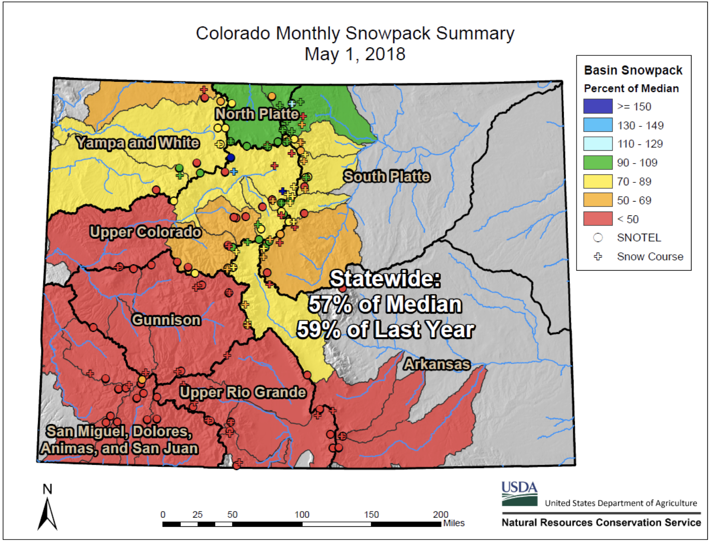
    “Right now, we are at 61 percent of normal — that’s the snow-water content in the snowpack,” Mitchell said.

    The numbers are compared to a 30-year rolling average, from 1980-2010. “So it does not include the past eight years in that average. 2012 was a pretty dry year; in relation we are sitting just higher in terms of snowpack at this time of year,” she said.

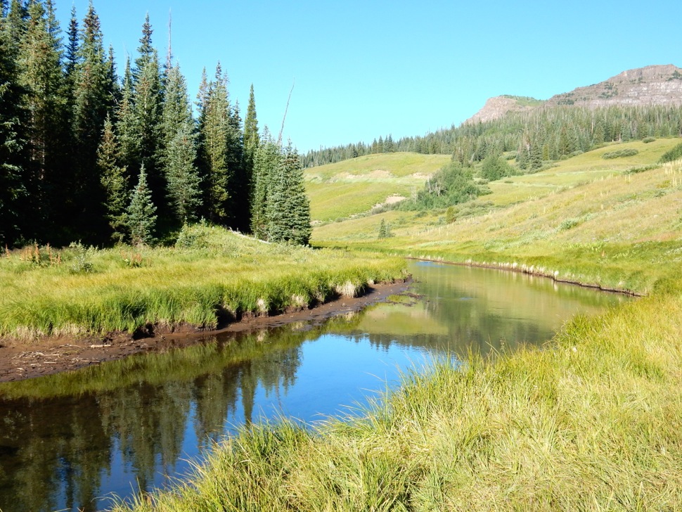
    The seasonal snowpack peaked around April 7 and has been decreasing since then. Some of that snowpack evaporates, some saturates the soil and the rest flows into streams and rivers. Most everything below 10,000 feet has melted, but there is still a high-alpine snowpack that, while well below average for May, is still to come down as the temperatures rise.

    “We are starting to see stream flows increase,” Mitchell said. “They are still on the up, so it hasn’t peaked yet. That said, they are not predicted to get anywhere near average stream flow.”

    Cleansing flow is critical

    According to Mitchell, the local ecosystem has evolved over millennia in a manner dominated by the snowmelt cycle.

    “There is a pattern of low flow all winter, while it’s snowing. [Then] it rises, it peaks, and then it drops back down to base flow.”

    The ecological processes that occur during peak flow are of the utmost importance for the overall health of the rivers and surrounding environs. Peak flows can move rocks, which changes the substrate of the stream, knocking loose algae and debris from previous years. As the water pushes sediment downstream and clears up space between the rocks, the base of the food web can grow in those interstitial places. Macroinvertebrates are aquatic insects, at their juvenile or nymph stage. May flies, caddis flies and stone flies are most common in the Roaring Fork watershed.

    “If you never have those peak flows, flushing flows, then those areas build up with mud and suffocate the macroinvertebrates; without macroinvertebrates you don’t have trout; without trout there is no food for eagles and ospreys,” Mitchell said. Runoff also inundates the flood plains, bringing water to the riparian vegetation, which then provides shade to keep the streams cool.

    Peak flows also assist in scouring the river channel, creating a spawning habitat for trout.

    “Trout like loosely packed cobbles with water flowing through — it’s good for bug habitat as well as for laying eggs,” said Kendall Bakich, aquatic biologist for Colorado Parks and Wildlife. “This is particularly an issue with recurring low-flow years, so it may not be an issue this year as long as we return to average in the future.”

    From The Durango Herald (Jonathan Romeo):

    The snowpack of the San Juan Mountains face an increasingly alarming problem that may further vex water issues in the West: dust…

    Early findings aren’t good.

    In 2003, water districts throughout Colorado, concerned about the issue, put funding toward the creation of the Center for Snow & Avalanche Studies, which among other tasks, researches the effects of dust on snow.

    While the impacts of dust deposited on snowpack can be found in other parts of Colorado, the southwest part of the state – and the San Juan Mountains in particular – are by far the most troubled by the issue.

    “This is really ground zero,” Phil Straub, a researcher with the Center for Snow & Avalanche Studies, said last week from atop Red Mountain Pass. “It’s a growing concern that’s gaining more attention.”

    In Southwest Colorado, here’s how it works:

    Windstorms out of the southwest pick up dust from deserts in parts of the Navajo Nation in northern Arizona and New Mexico and carry it to the mountain snowpack in the high country of the San Juan Mountains.

    When dust lands on snowpack, it speeds up the rate snow melts – think how much hotter a black car is than a white car, Straub said.

    On average, this process causes snowpack to melt off 25 to 50 days earlier than normal based on about 100 years worth of data. And, runoff can decrease by 5 percent because of water evaporating through plants and soils as well as snow turning to water vapor.

    Naturally, this causes issues for water districts in timing dam releases for ranchers, and it causes the loss of water supply for the Colorado River basin, which supports more than 40 million people and millions of acres of agriculture.

    In a study published in October 2010 for the Pacific Institute for Studies in Development, Environment and Security, researchers painted a grim outlook if the issue went unchecked.

    “Climate-change studies suggest that earlier runoff and a reduction in flow will cause management challenges, including uncertainty in timing of reservoir release, large reservoir fluctuations and regular shortages,” the study said…

    Researchers from the University of Northern Arizona published a paper in 2016 that looked back on periods of dust over the last 3,000 years. Medieval times, for instance, were associated with high levels of dust.

    “These records indicate the Southwest is naturally prone to dustiness,” according to the study.

    Add human-caused factors like climate change, overgrazing and poor water management, and the situation enters the realm of unprecedented.

    “These new records confirm anomalous dustiness in the 19th and 20th centuries, associated with recent land disturbance, drought and livestock grazing,” the report said. “As global and regional temperatures rise … the Southwest will likely become dustier, driving negative impacts on snowpack and water availability, as well as human health.”

    Since 2003, researchers at the Center for Snow & Avalanche studies have noted this increase. It is likely that the San Juan Mountains have the longest and most comprehensive study on the dust-on-snow effect in the country, Straub said.

    This year, for instance, the region has already tracked seven dust storms that left a layer of dirt on snow in the San Juan Mountains, and the season for dust storms isn’t over yet. The average amount of dust storms in a full season, which can last until late June, is about seven, data indicates.

    “We’re still learning the impacts,” Straub said. “And dust is only one part in understanding the changes to snow hydrology.”

    Bruce Whitehead, executive director for the Southwest Water Conservation District, which manages the waters of nine counties in Southwest Colorado, said there’s a consensus about the need to see how dust affects water in the West.

    “It’s just one more tool we have to look and plan for runoff, or in this case, maybe how it’s going to impact drought conditions,” Whitehead said. “We really are on the front lines.”

    From The Durango Herald (Jim Mimiaga):

    A minor boost of snowfall in April helped to stave off more shortages for local farmers who rely on McPhee Reservoir, water officials said.

    As of this week, the forecast is still for full-service farmers to receive about 17 inches per acre, said Ken Curtis, of the Dolores Water Conservancy District, which manages the reservoir.

    But the final runoff amount will not be known until June, and it will be impacted in coming weeks by variables such as wind, precipitation, dust on snow and soil moisture. Overall, the spring runoff into McPhee is dismal because of a winter with barely 50 percent of average snowpack, Curtis said.

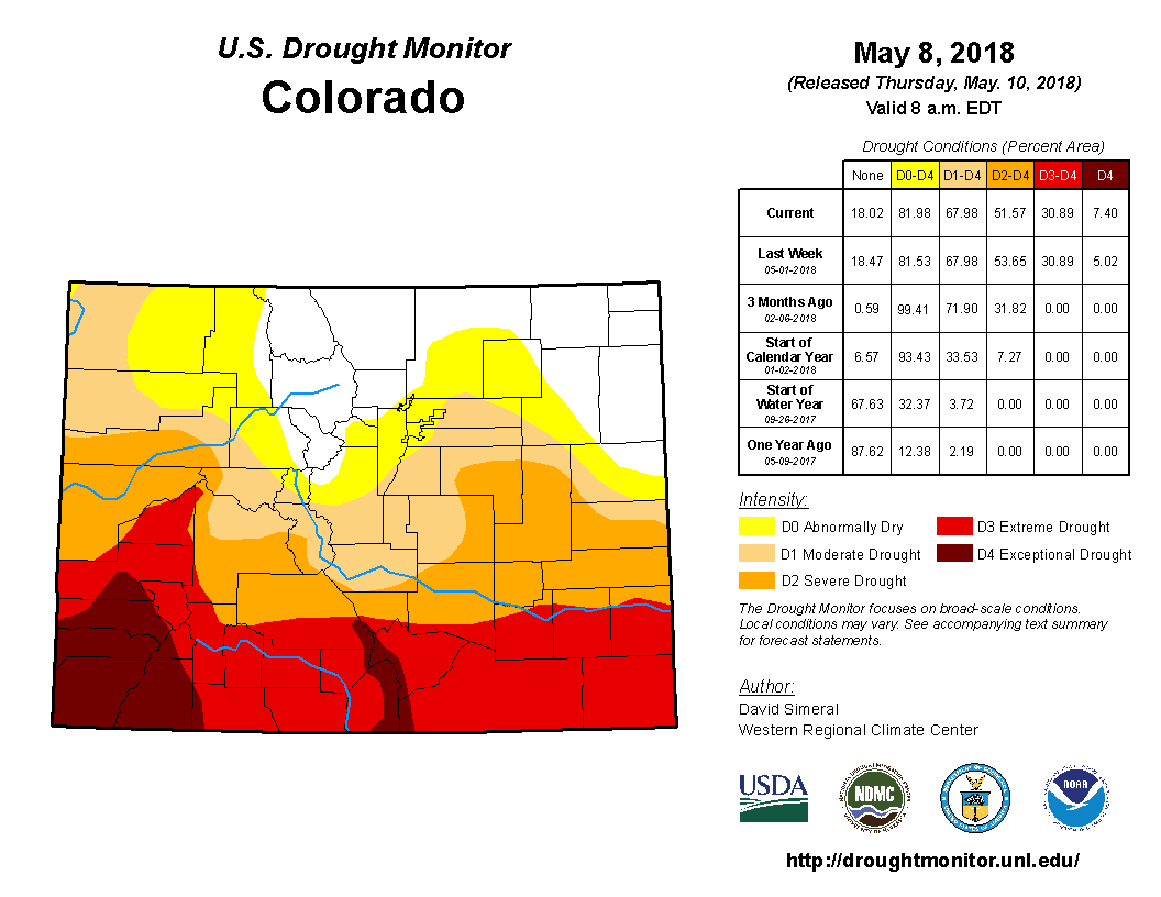
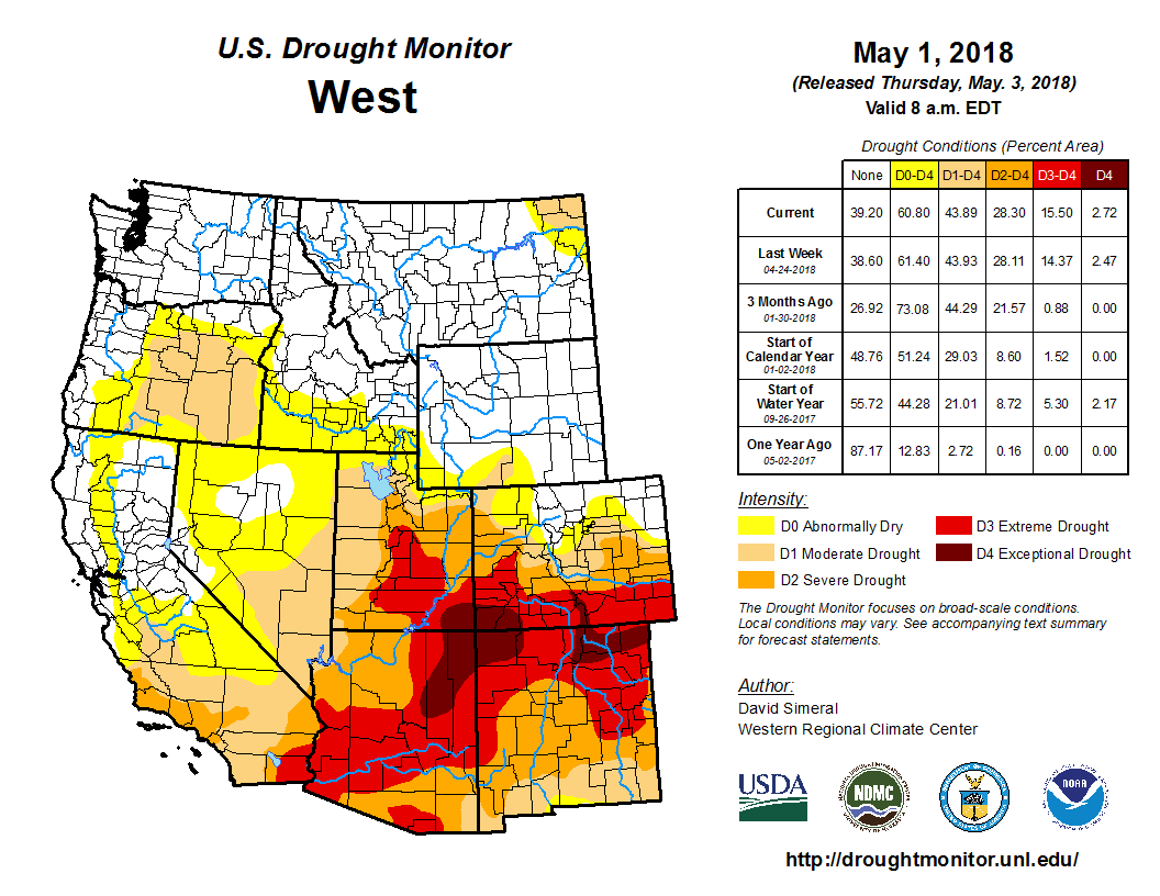
    It is thought that dry mountain soils from a dry fall are absorbing a lot of the water before it makes it to the river. According to the U.S. Drought Monitor, Southwest Colorado is in an exceptional drought, the most severe of five categories.

    When the reservoir fills during more average winters, farmers typically receive a full allocation of 22 inches per acre, enough for three cuttings of alfalfa.

    But significant carryover water from the previous winter’s above-average snowpack is saving farmers this year, Curtis said. “As far as runoff, we are getting close to the project’s worst year in 2002, but the difference this year is we have good carryover,” he said.

    Based on 30-year runoff data, average McPhee inflow is 295,000 acre-feet of water from the Dolores River Basin from April through July.

    This year, it is expected to be 62,000 acre-feet, or 21 percent of normal. In 2002, the reservoir received just 45,000 acre-feet, and farmers suffered more drastic shortages, receiving less than 50 percent allocation.

    For boaters, there will be no whitewater release below McPhee dam. Also, the Dolores River above McPhee will not run as high or as long this year.

    Peak flows from Rico to Dolores are coming early, and are not expected to reach more than 1,000 cubic feet per second, down from more typical peak flows of 2,000-2,500 cfs. Currently the river is running at 700 cfs at Dolores, but boatable flows are expected to end by before early June, instead of in late June or early July during more average years.

    The next chance for substantial moisture in Southwest Colorado is the monsoon season of July through September, when summer monsoons typically draw up subtropical moisture from Mexico.

    “Next year’s supply will depend slightly on monsoons later this summer and mostly on next winter’s snowpack,” Curtis said. “Ending the 2018 water year with little to no carryover increases the risk of a deeper project shortage next 2019 irrigation season.”

    Montezuma Valley Irrigation has more senior rights than McPhee Reservoir, including a direct flow right on the Dolores River up to 700 cfs. The private company stores water in Groundhog, Narraquinnep and McPhee reservoirs and closely monitors water supplies to determine potential impacts to customers.

    A recent court case that upheld a new 900 cfs in-stream flow right on the lower Dolores River from April 15 to June 15 below the San Miguel confluence does not impact McPhee Reservoir, officials said.

    The in-stream flow rights are junior to McPhee Reservoir’s more senior rights so they have no impact on the local water supply. Decreed by the state for environmental purposes, the new Dolores River in-stream flows are only available when snowpack produces sufficient natural runoff to provide the 900 cfs.

    From The Arizona Daily Star (Tony Davis):

    Longer-range outlooks for Lake Mead and the Central Arizona Project are increasingly grim due to this year’s bad runoff, the U.S. Bureau of Reclamation said Wednesday.

    The result is that the bureau is pushing hard for states in both the Upper and Lower Basins of the Colorado River to reach agreement this year on drought planning to ease the pain of future shortages, after negotiations have so far failed.

    The bureau’s new forecast for the river shows that the chance of a CAP shortage next year is almost nil, but in 2020, it’s over 50 percent. Looking farther ahead, the chances of a shortage for 2021 through 2023 exceed 60 percent each year, the bureau said. The CAP provides drinking water to Tucson and Phoenix.

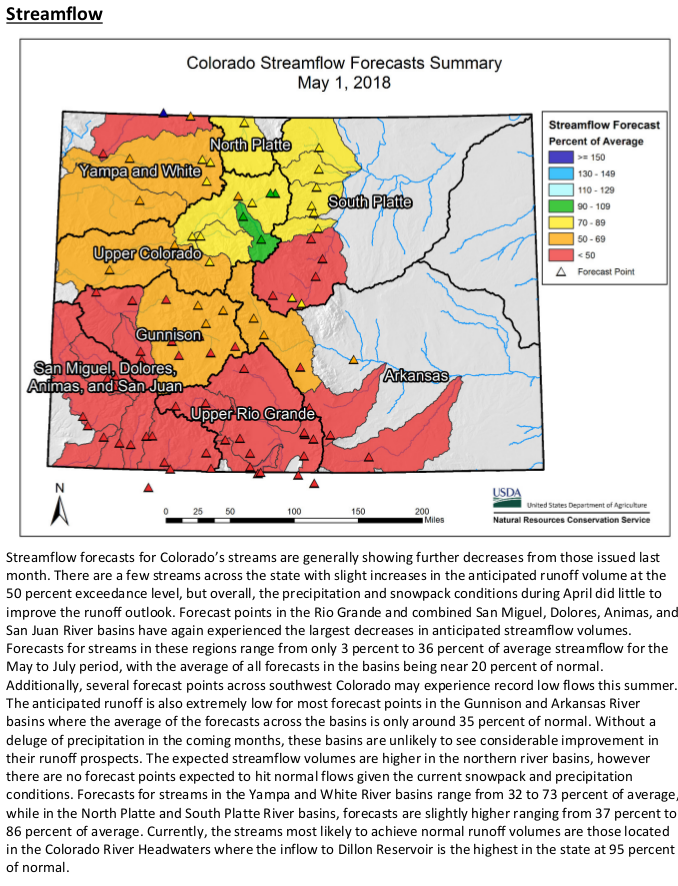
    The gloomy forecasts are based on this year’s expected poor spring-summer runoff into Lake Powell at the Utah border from the Upper Basin states of Colorado, Wyoming, Utah and New Mexico. The most recent forecast, last week, was 42 percent of average runoff.

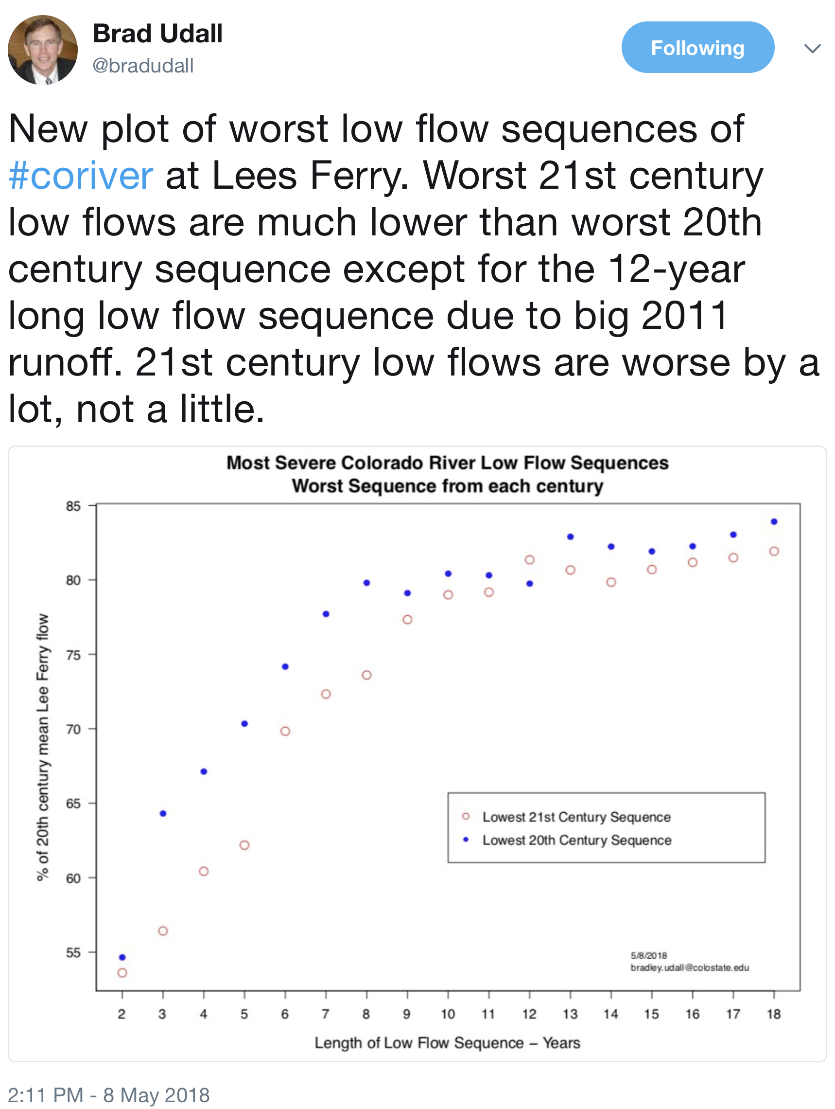
    This year “has brought record-low snowpack levels to many locations in the Colorado River Basin, making this the driest 19-year period on record,” the bureau said in a news release announcing the new forecasts. “With drought and low runoff conditions dating back to 2000, this current period is one of the worst drought cycles over the past 1,200 plus years.”

    Specifically, the bureau predicted:

  • A 52 percent risk of a 2020 shortage.
  • Shortage odds of 64 to 68 percent in 2021, 2022 and 2023.
  • The most likely shortage would cut CAP deliveries by about 20 percent. Those cuts would mainly slice water supplies to Central Arizona farmers and the Arizona Water Bank, a state program that recharges Colorado River water. Such a shortage will occur when Lake Mead drops below 1,075 feet at the end of a given year.

    Cuts would likely also affect the Central Arizona Groundwater Replenishment District, a related agency to CAP that buys and recharges river water into the ground to compensate for groundwater pumping that serves new suburban development.

    Starting in 2021, the odds are more than 20 percent of Arizona facing a more severe shortage, in which it would lose about 26 percent of its CAP water. That shortage would happen when Lake Mead drops to between 1,050 feet and 1,025 feet.

    Lake Mead sat at nearly 1,085 feet elevation at the end of April. It’s expected to drop to 1,079 feet by the end of December.

    The Lower Basin Drought Contingency Plan would require Arizona, Nevada and California to reduce their use of river water more than already required when the first shortages hit. The plan’s purpose is to prevent Lake Mead from dropping to catastrophically low levels over the coming decade.

    The plan’s approval has been delayed significantly. That’s in large part because of conflicts between the CAP and the Arizona Department of Water Resources over how this state’s share of the river’s water should be managed and who should manage it.

    The state water department and Gov. Doug Ducey tried to get the Legislature to pass bills this year to make conservation for the plan easier, but the Legislature didn’t go along.

    Last week, representatives of the three Lower Basin states met in Las Vegas to discuss river issues. At the meeting, Reclamation Commissioner Brenda Burman sought to get the CAP and the state water department to meet and settle their dispute, said Sally Lee, an ADWR spokeswoman, and Bart Fisher, chairman of the Colorado River Board of California.

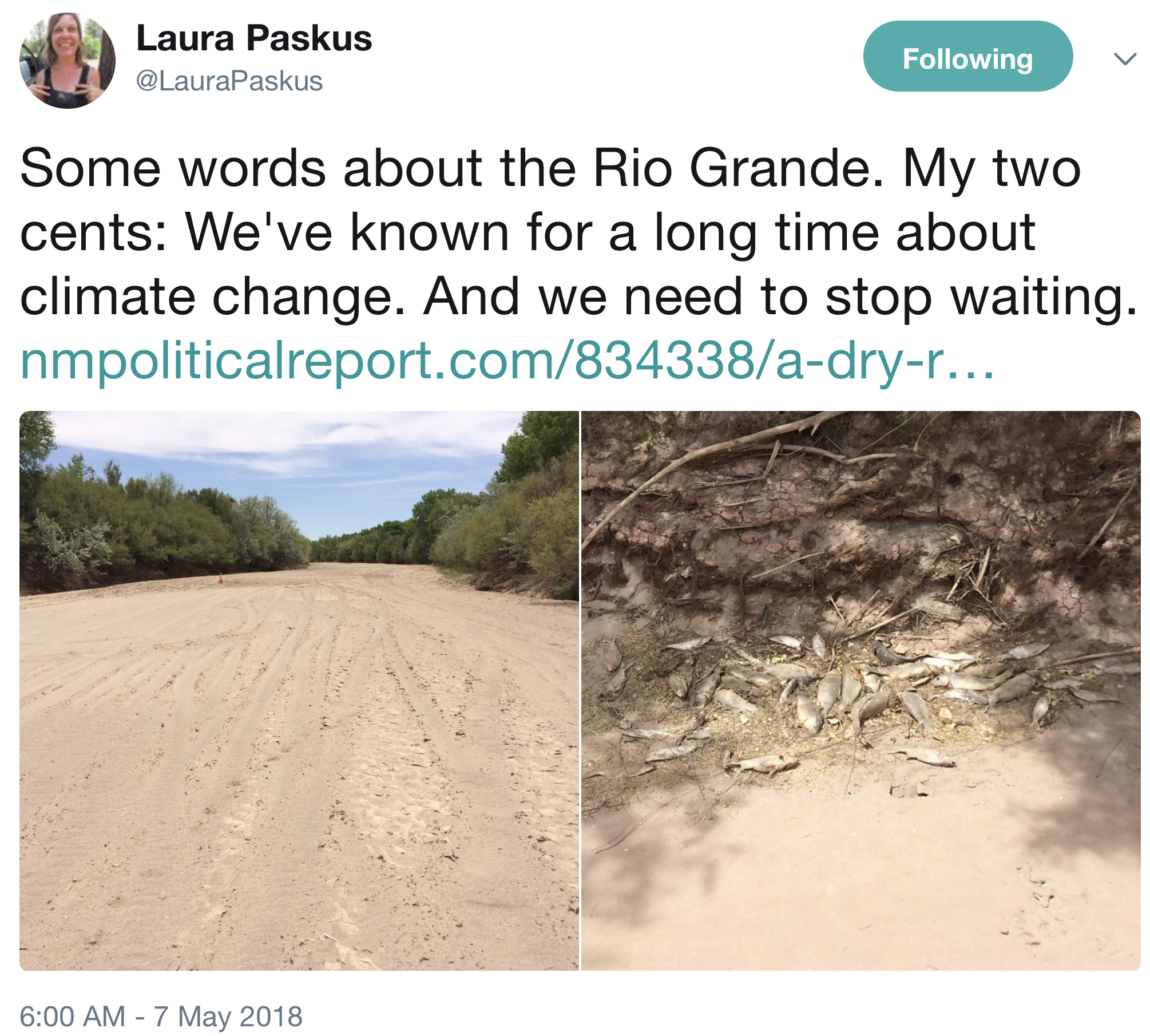
    From The New Mexico Political Report (Laura Paskus):

    Last week, a new study in the peer-reviewed journal, Nature, also heralded troubling news. According to the authors, more than 90 percent of snow monitoring sites in the western United States showed declines in snowpack—and 33 percent showed significant declines. The trend is visible during all months, states and climates, they write, but are largest in the spring and in the Pacific states and locations with mild winter climates. To drive home the numbers, they noted the decrease in springtime snow water equivalent—the amount of water in snow—when averaged across the entire western U.S. is 25 to 50 cubic kilometers, or about the volume of water Hoover Dam was built to hold in Lake Mead.

    And conditions on the Colorado River, which feeds Lake Mead, don’t look good this year.

    The March forecast for the Colorado River Basin remains “well below average.” Lake Mead, the largest reservoir in the United States, has already dipped below 40 percent of capacity and its “bathtub ring” is about 130 feet tall. As of Sunday, the lake’s water level was 1,088 feet above sea level. If it reaches 1,075 feet, that will trigger federal rules that cut the amount of water Nevada, Arizona and California can take.

    Meanwhile, water users in the three states, including cities like Las Vegas and Los Angeles, the Central Arizona Project, irrigation districts in southern California and tribes, are all keeping a close eye on Lake Mead—and trying to work out a drought contingency plan to avoid those federally-mandated cuts if the reservoir keeps dropping.

    Hard choices

    At the same time, water managers in New Mexico know they’re also in for a tough year.

    The U.S. Bureau of Reclamation watches snowpack and streamflow forecasts closely, said spokeswoman Mary Carlson: “And the current outlook is grim,” she said.

    “We are grateful in years like this, when it appears we will have very little runoff from snowmelt, that we are able to rely on the water that has been stored in our reservoirs in previous years,” she said. “Without those reservoirs, conditions on the Rio Grande would be much more extreme in a year like this.”

    Reclamation currently has about 12,400 acre-feet of supplemental water in storage, she said, and the agency expects to get another 9,000 to 14,000 acre feet to augment Middle Rio Grande flows.

    “We are working with our partners, including our sister agency the Fish and Wildlife Service to determine when and how to use that water to benefit the Rio Grande silvery minnow and other endangered species in the area,” she said.

    The Rio Grande Silvery Minnow was listed for protection under the Endangered Species Act in 1994. Two years later, in 1996 about 90 miles of the Rio Grande south of Albuquerque dried. Biologists scrambled over the fish, environmental groups sued, political wars waged and water managers tried to figure out how to serve cities and farmers while keeping the fish from going extinct. For 15 years, the U.S. Fish and Wildlife Service (FWS) required water managers to keep at least 100 cubic feet per second (cfs) of water in the Albuquerque stretch of the river—even if it dried to the south, as it did many years, typically between Las Lunas and the southern boundary of the Bosque del Apache National Wildlife Refuge. Then in 2016, FWS pivoted. Under its new biological opinion for the silvery minnow, the agency said water operations in the Middle Rio Grande were not jeopardizing the fish’s survival. It stopped requiring flow minimums and instead expects Reclamation and its partners to manage the river to improve fish densities.

    David Gensler, the hydrologist for the Middle Rio Grande Conservancy District (MRGCD) said the district still has water stored in upstream reservoirs for the valley’s farmers. “But not enough. Reclamation has storage for fish, but not enough,” he said. “(There are) some hard choices facing us.”

    Typically, irrigation season runs from March 1 to Oct. 31, but due to dry conditions and low soil moisture, this year, the district started its diversions earlier.

    Last year dealt water managers a good hand, Gensler said, but this year will be the opposite. And 2018 is shaping up to be similar to that notoriously-dry 1996. “I’m optimistic we will all come together and manage through it,” he said.

    ‘This is not a place we’ve been’

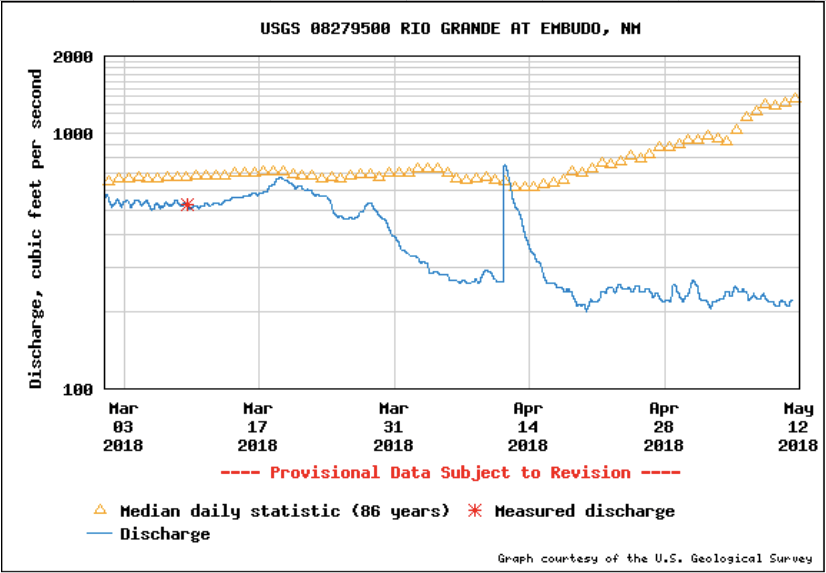
    It’s not only the middle valley that’s causing concern. WildEarth Guardians attorney Jen Pelz said she’s been looking at flows in northern New Mexico in anticipation of the 50th anniversary of the Wild and Scenic Rivers Act, which Congress passed in 1968 to protect “outstanding” river stretches. Specifically, when looking at Rio Grande records from the late 1960s until now, she noticed some very low years, such as 2013.

    “I was looking at how many days were below 100 and 50 cfs, and it was shocking,” she said. “This year’s way worse, and it’s going to be a problem. It’s going to be a huge challenge to do anything good for the river.”

    “Colorado’s attitude is that they only have to deliver what the [Rio Grande Compact] said, and if that means no boating in New Mexico, that’s not their problem,” she said, noting that about 150 cfs typically comes in below Colorado and also feeds the Wild and Scenic stretch. “But I’m skeptical and a little scared of what those gages are going to look like, and whether the recreation community in Taos can survive off really low flows.”

    She’s also wary about what might happen to the silvery minnow population in the Middle Rio Grande this year. After 2017’s flows, the fish’s population saw a bump, and the fall monitoring numbers were good. “My worry, is all the fish in the river you did have, and the stress of the low flows for an extended time—April through October, large stretches of the river can and will dry —and will you find any fish in the river in October?”

    She doesn’t want to see the fish’s population boom, only to bust again. “I’m really concerned about going on good faith that Reclamation, Fish and Wildlife Service, MRGCD will do the right thing,” Pelz said. “They’re stressed and they have their own constituencies.”

    Pelz added that last year’s snowpack and water supply was an anomaly in the new climate regime.

    “Last year lulled people into this place where, there will always be a wet year that follows,” she said. “It’s swinging back the other way: now, people are hoping 2019 will be a 2017, when really it could be the first of the 2011-2013 period.”

    Existing laws, like the Endangered Species Act, don’t do enough to protect species and habitats, she said. In fact, she said, it’s time for a whole new language about rivers, as the region continues warming. “This is not a place we’ve been,” she said. “And we don’t know what it looks like.”

    Jury’s still out

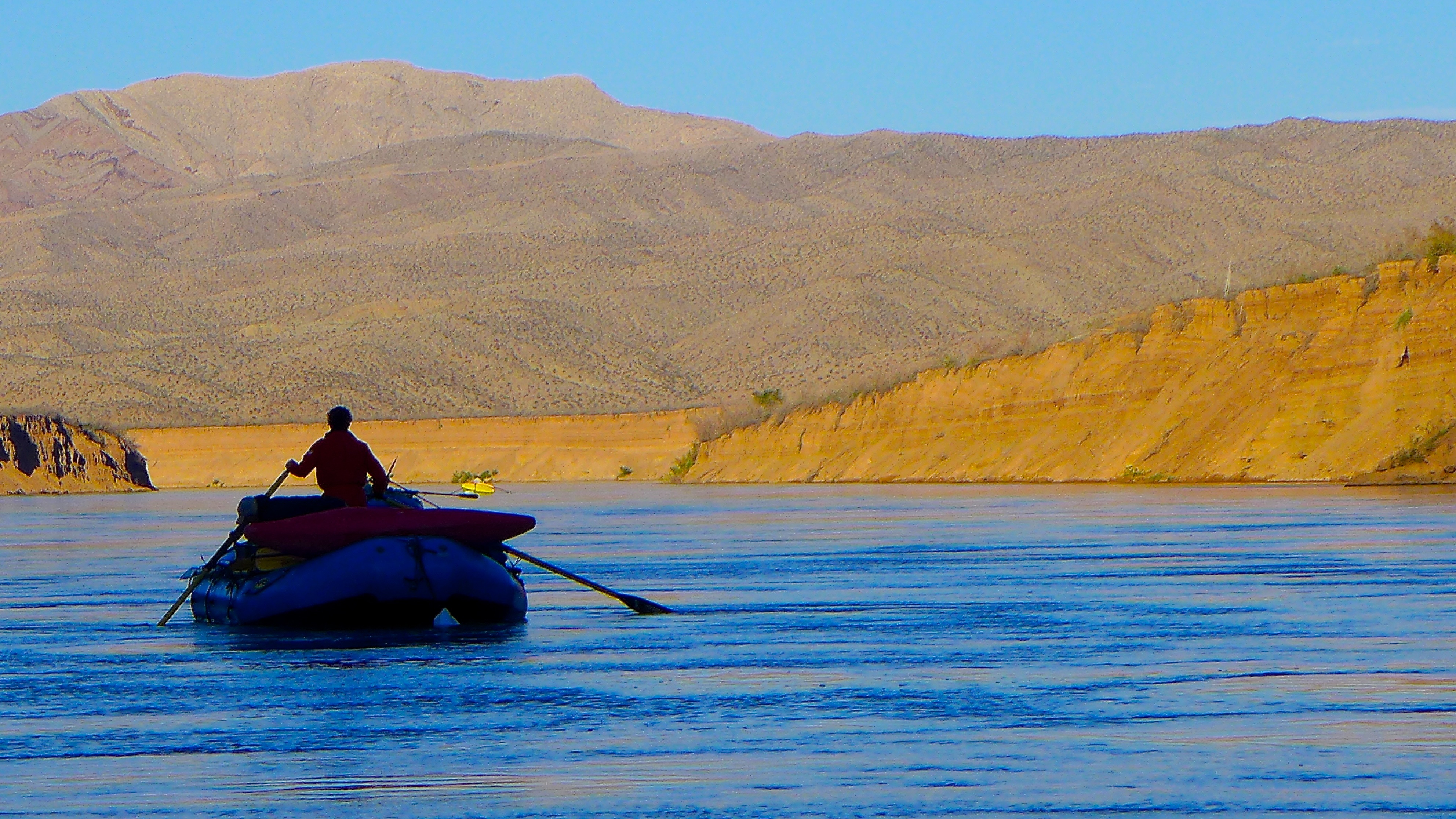
    River runner and conservationist Steve Harris lives alongside the Rio Grande above New Mexico’s major diversions. Right now near Pilar, the river is clipping along at about 500 cfs, he said.

    “It’s beautiful, but soon, irrigation will start and we’ll see what’s really on the mountain,” he said. “Last year was a real joy because it was good for the river and all its denizens, and we had a great rafting season.”

    According to Harris, New Mexico has been bailed out by late-season snow before. “But when you think about the long-term climate projections—later onset of snowpack, a shorter snow season, earlier runoff—to me, this year is fulfilling the prophecy.”

    Having lived for decades in Terlingua, Texas, Harris also pays attention to the river in his old stomping grounds around Big Bend State Park. “Fifteen years ago, I had a sense we might be moving toward managing the river below the irrigation in El Paso and Juarez,” he said of the roughly 400 miles of the river that are dry in Texas. “Now, it’s not on the horizon to restore the ‘forgotten river.’”

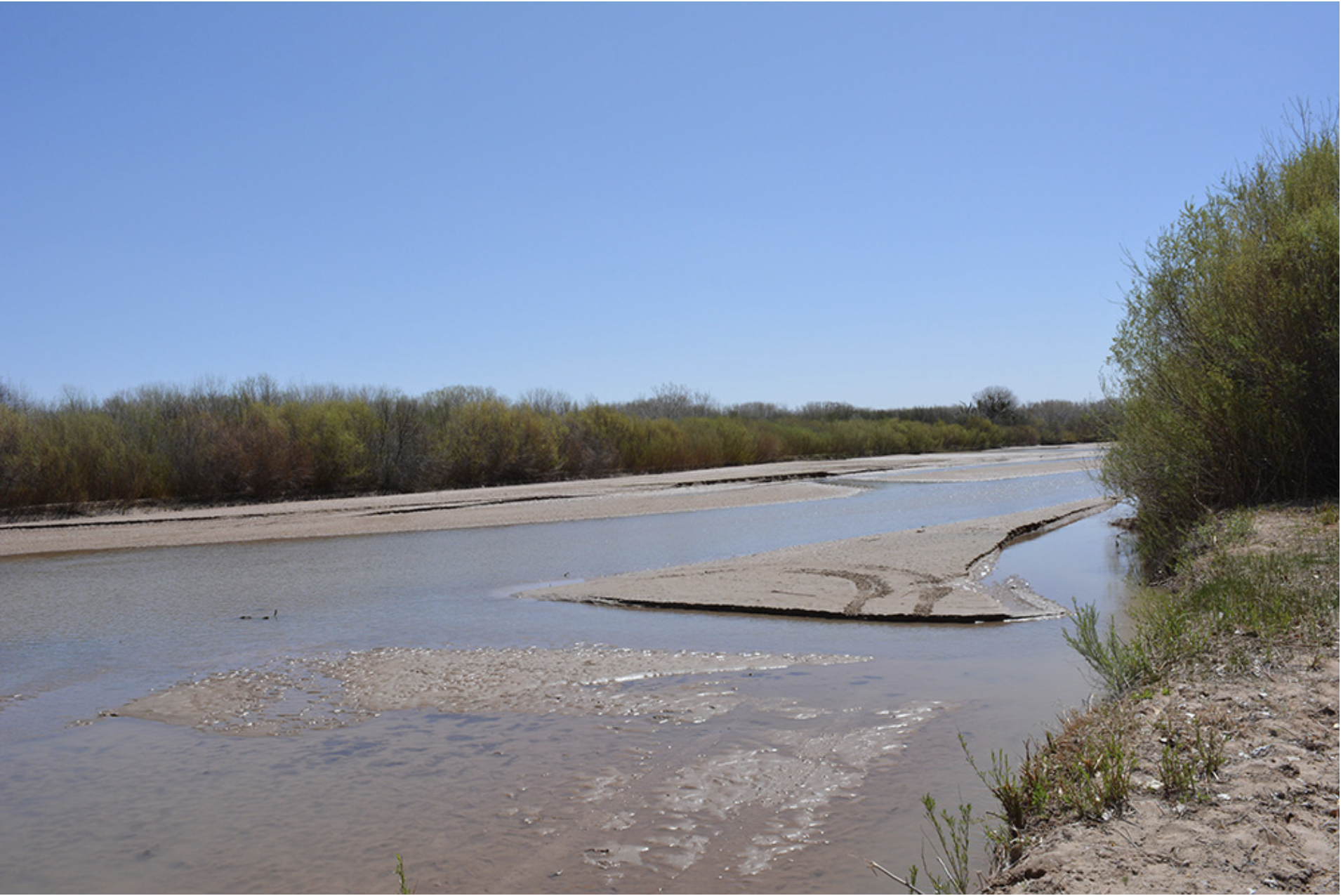
    The river dries in southern New Mexico, too. Except during irrigation season when water is moved to farmers, or when storms flood the channel, about 100 miles of the Rio Grande above Mesilla is dry.

    “I’m at the point in my life, where I’m thinking, ‘So, what are we doing about the Rio Grande problem? How is society responding?’ Of course, the jury is still out,” he said. “People care, but people tend to be paralyzed by pessimism sometimes, particularly the policy makers, heads of agencies and legislators.”

    That doesn’t mean it’s time to give up on the Rio Grande. “I think the Rio Grande’s problem is people expected a lot more out of it than it could normally deliver,” he said. “There has to be a shift of focus back toward the Rio Grande and the dawning general realization that the river’s in trouble if we don’t act, and act on a lot of fronts.”

    ‘We’re doomed’: Mayer Hillman on the climate reality no one else will dare mention — The Guardian

    From The Guardian (Patrick Barkham):

    The 86-year-old social scientist says accepting the impending end of most life on Earth might be the very thing needed to help us prolong it

    “We’re doomed,” says Mayer Hillman with such a beaming smile that it takes a moment for the words to sink in. “The outcome is death, and it’s the end of most life on the planet because we’re so dependent on the burning of fossil fuels. There are no means of reversing the process which is melting the polar ice caps. And very few appear to be prepared to say so.”

    Hillman, an 86-year-old social scientist and senior fellow emeritus of the Policy Studies Institute, does say so. His bleak forecast of the consequence of runaway climate change, he says without fanfare, is his “last will and testament”. His last intervention in public life. “I’m not going to write anymore because there’s nothing more that can be said,” he says when I first hear him speak to a stunned audience at the University of East Anglia late last year…

    Our society’s failure to comprehend the true cost of cars has informed Hillman’s view on the difficulty of combatting climate change. But he insists that I must not present his thinking on climate change as “an opinion”. The data is clear; the climate is warming exponentially. The UN Intergovernmental Panel on Climate Change predicts that the world on its current course will warm by 3C by 2100. Recent revised climate modelling suggested a best estimate of 2.8C but scientists struggle to predict the full impact of the feedbacks from future events such as methane being released by the melting of the permafrost.

    Hillman is amazed that our thinking rarely stretches beyond 2100. “This is what I find so extraordinary when scientists warn that the temperature could rise to 5C or 8C. What, and stop there? What legacies are we leaving for future generations? In the early 21st century, we did as good as nothing in response to climate change. Our children and grandchildren are going to be extraordinarily critical.”

    […]

    Although Hillman has not flown for more than 20 years as part of a personal commitment to reducing carbon emissions, he is now scornful of individual action which he describes as “as good as futile”. By the same logic, says Hillman, national action is also irrelevant “because Britain’s contribution is minute. Even if the government were to go to zero carbon it would make almost no difference.”

    Instead, says Hillman, the world’s population must globally move to zero emissions across agriculture, air travel, shipping, heating homes – every aspect of our economy – and reduce our human population too. Can it be done without a collapse of civilisation? “I don’t think so,” says Hillman. “Can you see everyone in a democracy volunteering to give up flying? Can you see the majority of the population becoming vegan? Can you see the majority agreeing to restrict the size of their families?”

    Hillman doubts that human ingenuity can find a fix and says there is no evidence that greenhouse gases can be safely buried. But if we adapt to a future with less – focusing on Hillman’s love and music – it might be good for us. “And who is ‘we’?” asks Hillman with a typically impish smile. “Wealthy people will be better able to adapt but the world’s population will head to regions of the planet such as northern Europe which will be temporarily spared the extreme effects of climate change. How are these regions going to respond? We see it now. Migrants will be prevented from arriving. We will let them drown.”

    @NOAAClimate: 2016 #Arctic heat would have been virtually impossible without #globalwarming

    From NOAA (Rebecca Lindsey):

    In the fall of 2016, the Arctic experienced heat that was so extreme that one expert called it a black swan event. That warmth helped set a new annual temperature record that was double the magnitude of the record set the year before. New NOAA-led research confirms that the event could not have happened without human-caused global warming and sea ice loss.

    These maps compare the observed differences from average temperature in 2016 (left) to two computer simulations of 2016 (right). The top right map shows results from models that included only natural climate influences, using estimated conditions from the late nineteenth century. The bottom right map shows results from models in which things like greenhouse gases, sea surface temperatures, and sea ice were allowed to change as they have in the real world due to human activities.

    None of the simulations using only natural climate influences were able to reproduce the extreme warmth that overtook the Arctic in 2016. Instead, those models projected that there would have been some areas that were cool and some that were warm, but not extremely so. Only the simulations that mirrored human-caused changes in greenhouse gases and the resulting sea ice loss were able to generate a realistic picture of the extreme heat. The most realistic simulations were generated by models in which sea ice was not only allowed to shrink in area, but also to thin—just as it has in the real world.

    The scientists concluded that there was virtually zero chance that such an extreme heat event would have occurred without human influence on the climate. But they also concluded that its severity—exactly how far above average the temperatures were— was partially due to natural variability, including the influence of the strong 2015-16 El Niño event in the tropics.

    This overlap of the impacts of human-caused climate change and natural variability is a common theme for many types of extreme weather events from high-tide flooding to heavy downpours. Events like the extreme warmth in the Arctic in 2016 are an early preview of what “normal” may look like within as little as a decade if greenhouse gas emissions continue their rapid rise.

    References:
    Sun, L., Allured, D., Hoerling, M., Smith, L., Perlwitz, J., Murray, D., & Eischeid, J. (2018). Drivers of 2016 record Arctic warmth assessed using climate simulations subjected to Factual and Counterfactual forcing. Weather and Climate Extremes, 19, 1–9. https://doi.org/10.1016/j.wace.2017.11.001

    Thornton Water Project update

    Map via ThorntonWaterProject.com.

    From TheDenverChannel.com (Russell Haythorn):

    Residents along Douglas Road north of Fort Collins are standing in the way of the pipeline project that would deliver Poudre River water to Thornton. It’s water the city of Thornton says it will desperately need in just seven years, in order to sustain its current and projected population booms.

    “This will (help) take us from the current population of about 130,000 up to about 242,000,” said Mark Koleber, water project director for the City of Thornton.

    Koleber said Thornton is simply trying to tap the water rights it bought from Weld County farmers decades ago.

    “The city started — in the mid-1980’s — to acquire these water rights and the farms that went along with it,” Koleber said…

    “We’re certainly going to give it our best try,” said Lynn Utzman-Nichols, Hillman’s neighbor who also lives just a few blocks from Douglas Road. “We really hope we can find a solution that works for everyone.”

    One of those solutions: Keep the water in the Poudre River until it’s further downstream near I-25.

    Thornton says that plan doesn’t work for them, because then it becomes a water quality issue; the further the water must travel, the more contaminated and polluted it becomes, especially passing through the City of Fort Collins. And that would add to the cost of water treatment.

    Thornton wants the water to come directly out of the reservoirs it owns north of Fort Collins.

    “Those are the reservoirs that Thornton invested in back in the mid-1980’s,” Koleber said…

    But Larimer County officials also see an opportunity in working with Thornton on the plan to bury the pipeline under Douglas Road. The county wants to widen the road – and sees the pipeline as a chance to widen the road earlier than expected.

    “If (Larimer County is) going to be tearing up the pavement, there’s an opportunity there to put the pipeline in at the same time and minimize the disruption to the area residents,” Koleber said.

    Pagosa Area Water and Sanitation District shows #drought management plan at public hearing

    West Drought Monitor May 8, 2018.

    From The Pagosa Sun (Chris Mannara):

    The Pagosa Area Water and Sanitation District (PAWSD) board held a public hearing on [May 1, 2018] evening to discuss the 2018 Drought Management Plan and to take public comment.

    PAWSD District Manager Justin Ramsey began the presentation by briefly discuss- ing the precipitation levels for the district.

    “We’re just a little bit more than 50 per- cent of what we usually get,” Ramsey said. In regard to snow-water equivalency,
    Ramsey noted that, for 2018, “we’re out.”

    […]

    Triggers and levels of plan

    “The triggers are basically going to be a combination of the amount of water in the reservoirs plus the amount of water we have pulled in from the river,” Ramsey explained. “It’s going to be a ratio between that and what our expected water use for the year is going to be.”

    PAWSD is going to base these triggers off of what the district used in 2017, Ramsey noted.

    When 90 percent of that use is met, that is what will trigger level one of the drought management plan, Ramsey stated.

    Level two is triggered by 70 percent use, 50 percent would trigger level three, 40 percent triggers level four and 30 percent use will trigger level five, Ramsey described.

    Photo gallery: @WaterEdCO President’s Reception History Museum May 11, 2018 — Greg Hobbs

    This slideshow requires JavaScript.

    Acknowledging sea level rise, #Connecticut legislature passes sweeping #climatechange bill, Costa Rica sets fossil free transport goal (2021) #ActOnClimate

    From ThinkProgress.org (E. A. Crunden):

    The Connecticut Senate passed a sweeping climate change bill Wednesday, in a move that could push the state ahead of much of the coastal United States. The legislation centers on adapting to accommodate rising sea levels as well as setting new pollution targets.

    Senate Bill 7, “An Act Concerning Climate Change Planning and Resiliency,” passed overwhelmingly early Wednesday morning. In a 34-2 vote, the state senate agreed to adopt recommendations to reduce greenhouse gas by 45 percent below 2001 levels within the next 12 years, the Connecticut Post reported Wednesday morning.

    Assuming a sea level rise of nearly two feet by 2050 based on projections by the Connecticut Institute for Resilience and Climate Adaptation, the bill also updates pre-existing statutory references guiding building and development.

    The legislation would require all federally-funded development projects or similar endeavors funded or undertaken by a state agency to adhere to the new restrictions. Meaning these new projects will have to take sea level rise into account when being built.

    “Climate change is real, it’s man-made, and it’s here,” said Gov. Dannel P. Malloy (D) following the vote.

    Environmental advocates and organizations cheered the bill’s passage. In a statement sent to ThinkProgress and other publications, the Nature Conservancy Connecticut Chapter’s director of government relations, David Sutherland, emphasized the importance of accounting for sea level rise in particular.

    From The Independent (Tom Embury-Dennis):

    Costa Rica’s new president has announced a plan to ban fossil fuels and become the first fully decarbonised country in the world.

    Carlos Alvarado, a 38-year-old former journalist, made the announcement to a crowd of thousands during his inauguration on Wednesday.

    “Decarbonisation is the great task of our generation and Costa Rica must be one of the first countries in the world to accomplish it, if not the first,” Mr Alvarado said.

    “We have the titanic and beautiful task of abolishing the use of fossil fuels in our economy to make way for the use of clean and renewable energies.”

    Symbolically, the president arrived at the ceremony in San Jose aboard a hydrogen-fuelled bus.

    Last month, Mr Alvarado said the Central American country would begin to implement a plan to end fossil fuel use in transport by 2021 – the 200th year of Costa Rican independence.

    From TruckingInfo.com:

    According to Volvo Group’s European division, just three weeks after the unveiling of Volvo Trucks’ first all-electric truck, the FL Electric, the OEM is expanding its product range with yet another electric truck. The Volvo FE Electric is designed for heavier city distribution and refuse transport operations with gross weights of up to 30 tons. Sales will commence in Europe in 2019…

    Rüdiger Siechau, CEO of Stadtreinigung Hamburg, the city’s largest waste-removal provider, sees large potential for environmental benefits with electric trucks in the city. “Today, each of our 300 conventional refuse vehicles emits approximately 31.300 kg carbon dioxide every year,” he said. “An electrically powered refuse truck with battery that stands a full shift of eight to ten hours is a breakthrough in technology. Another benefit is the fact that Stadtreinigung Hamburg generates climate-neutral electricity that can be used to charge the batteries.”

    The new Volvo FE Electric will be offered in several variants for different types of operations. For instance,Volvo’s low-entry cab makes it easier to enter and exit the cab and gives the driver a commanding view of surrounding traffic. Volvo also said the working environment is improved thanks to the low noise level and vibration-free operation of electric power. Battery capacity can be optimized to suit individual needs, with charging taking place either via main power lines or quick-charge stations.

    “Our solutions for electrified transport are designed to suit the specific needs of each customer and each city,” said Volvo’s Oldermalm. “In addition to the vehicles, we will offer everything from route analysis to services and financing via our network of dealers and workshops throughout Europe. We also have close partnerships with suppliers of charging infrastructure.”

    According to Volvo, features of its electric trucks include:

    Volvo FE Electric

  • Fully electrically powered truck for distribution, refuse collectio,n and other applications in urban conditions; GVW of 30 tons.
  • Driveline– Two electric motors with 370 kW max power (260 kW cont. power) with a Volvo 2-speed transmission. Max torque electric motors 626 lb-ft. Max torque rear axle 28 kNm.
  • Energy storage– Lithium-ion batteries, 200–300 kWh. Range– Up to 124 miles.
  • Charging–: Two different charging systems are available. CCS2: Maximum charge power 150 kW DC. Low Power Charging: Maximum charge power 22 kW AC.
  • Charging time– From empty to fully charged batteries (300 kWh): CCS2 150 kW appr. 1.5 hours, low power charging approximately 10 hours.
  • Volvo FL Electric

  • Fully electrically powered truck for distribution, refuse collection. and other applications in urban conditions; GVW of 17 tons.
  • Driveline– Electric motor with 185 kW max power (130 kW cont. power) with a Volvo 2-speed transmission. Max torque electric motor 313 lb-ft. Max torque rear axle 16 kNm.
  • Energy storage– Lithium-ion batteries, totaling 100–300 kWh. Range– Up to 186 miles.
  • Charging– Two different charging systems are available. CCS2: Maximum charge power 150 kW DC. Low Power Charging: Maximum charge power 22 kW AC.
  • Charging time– From empty to fully charged batteries: fast charge 1-2 hours (DC charging), night charge up to 10 hours (AC charging) with maximum battery capacity of 300 kWh.
  • For more information: http://www.volvotrucks.com/electromobility

    @USDA: 2018 Predicted to be Challenging Wildfire Year

    Sprague Fire September 2017. Photo credit the Associated Press via The Flathead Beacon.

    From the USDA (Jennifer Jones):

    Secretary of Agriculture Sonny Perdue, Secretary of the Interior Ryan Zinke, and Forest Service Interim Chief Vicki Christiansen briefed members of Congress yesterday on what to expect in the coming fire season. (To view photos from yesterday’s briefing, please view the 2018 Fire Briefing and MOU Signing Flickr album)

    The USDA Forest Service is well prepared to respond to wildfires in what is currently forecast to be another challenging year. In 2018, the agency has more than 10,000 firefighters, 900 engines, and hundreds of aircraft available to manage wildfires in cooperation with federal, tribal, state, local, and volunteer partners.

    Large parts of the western U.S. are predicted to have above-average potential for significant wildfire activity this year, according to the latest forecast released by the National Interagency Fire Center (NIFC). The “National Significant Wildland Fire Potential Outlook,” released May 1st, predicts above-average significant wildland fire potential in about a dozen Western states at various times between now and the end of August, including Arizona, California, Colorado, Idaho, Kansas, Montana, Nevada, New Mexico, Oregon, Texas, Utah, and Washington.

    Wildland fire potential depends on weather and fuel conditions, which can and often do change, so NIFC issues an updated Outlook on the first day of each month. The number of wildfires and acres burned annually depends not only on wildland fire potential, but also on the number and timing of lightning strikes and human-caused ignitions.

    “By mid-summer, we expect warmer and drier-than-average conditions, large amounts of grass, melting of below-average snowpack, and increasing potential for thunderstorm activity and lightning starts to create above-average potential for significant wildfire activity in a large part of the western U.S.,” said Ed Delgado, National Program Manager, Predictive Services, NIFC.

    An interview with Delgado on the May 1 Outlook is available at http://www.nifc.gov.

    At this time, the Forest Service believes the number of firefighters, engines, aircraft, and other wildfire suppression assets to be appropriate to meet its needs within available funding. However, if the wildfire season turns out to be as severe as the current NIFC Outlook indicates, the agency’s wildfire suppression costs could exceed available funding, requiring the Forest Service to transfer funds from non-fire programs to make up the difference.

    In 2017, the Forest Service’s wildfire suppression costs reached a historic high of $2.4 billion. Through the 2018 Omnibus Bill, Congress provided the Forest Service with a total of $1.5 billion for wildfire suppression this year and changed the way that wildfire suppression is funded beginning in Fiscal Year 2020. In the long run, this will allow us to continue our non-fire mission operations uninterrupted, including on-the-ground forest health improvements that prevent catastrophic wildfires from threatening lives, homes, and communities.

    Nationally, nearly nine out of ten wildfires are human-caused. Members of the public can help the Forest Service and other wildland fire agencies by learning how to prevent human-caused wildfires. The fewer human-caused wildfires that agencies like the Forest Service have to respond to, the more they can focus on the lightning-caused wildfires that can’t be prevented. Campfires are the single biggest source of human-caused wildfires on land the Forest Service manages.

    For more information about campfire safety and how to prevent other types of human-caused wildfires, visit http://smokeybear.com.

    Downstream From a Dry Western Winter — Western Resource Advocates

    Sprague Lake via Rocky Mountain National Park.

    From Western Resource Advocates (Jon Goldin-Dubois):

    If you watched the skies this past winter, you know that in much of the West it was a dry one. With few exceptions, precipitation across the region was far below normal over the past season. In parts of southern Colorado and New Mexico, snowfall this winter was half of what we’ve come to expect – and rely on – over the last four decades. Snowpack is well below average in most of the West, and this shortfall is causing serious concern for our spring and summer water supplies, the river activities we all enjoy, and the risk of wildfire in our alpine forests.

    Admittedly, it could have been worse. A few late-season storms in February, March, and April have gone a long way to boost our snowpack. If this long, dry winter has taught us anything, it’s that we can’t live storm to storm, and month to month, hoping for the best. The effects of climate change in the region have made the storms we rely on more erratic and less predictable. It’s also causing the dry spells between storms and rainy, snowy seasons to be longer, deeper, and more devastating.

    This means that stream flows in many rivers across the West are going to be slim this year, sometimes disastrously so. In some places, flows could be as much as 40 percent below normal as we head into spring and summer. This spells trouble for farmers and ranchers, and for the thousands of anglers, rafters, kayakers, and other outdoorists who spend millions of dollars in our region. If a rising tide lifts all boats, falling stream flows may leave too many of those boats stranded.

    But this dry winter is an unmistakable message that the impacts of a changing climate are playing out right now in the West – and are likely to get worse in the coming years. The skiers among us saw it this winter when the snows didn’t fall consistently, and the rest of us will feel it when there’s little snow to melt this spring. We’re seeing it first-hand, and we know that a changing climate is transforming the West.

    We can and should tighten our belts to conserve water wherever we can, and we can get smarter about long-term efficiency and reuse strategies to get us through dry summers. But we can also work to solve the climate problem at its core by focusing on aggressively reducing carbon emissions in the energy sector – the largest contributor to the increasing impacts of climate change. Our window is closing rapidly, but it is still open, providing an opportunity for urgent action from all of us to restore a healthy climate.

    By working with utility companies and energy users across the West and leveraging the cost parity between renewables and traditional fossil fuel energy, we can create a business environment where investing in clean energy and cutting carbon pollution are good for utility bottom lines, save customers money and protect the planet. Grid-by-grid, we can transform the West into a clean energy leader to address climate change and its impact on our snowpack, our rivers, and our communities. Your support is what makes this work possible.

    #ColoradoRiver Basin forecast = 42% of average inflow to #LakePowell #COriver #drought #aridification

    A wall bleached, and stained, in Lake Powell. Photo credit Brent Gardner-Smith @AspenJournalism.

    From KUNC (Luke Runyon):

    “It was an extreme year on the dry side, widespread across the Colorado River Basin,” says Greg Smith, a hydrologist at the Colorado Basin River Forecast Center (CBRFC) in Salt Lake City…

    The Colorado River’s tributaries in Colorado, Utah, Arizona and New Mexico are all projected to flow at below average levels. The San Juan, Animas, Dolores and Duchesne rivers in Colorado and Utah are among the regions worse projections for flows.

    “These are the really sad basins,” Smith says, noting that each basin saw snow measurement sites at record low levels, ranging from just 51 to 66 percent of normal. The only river within the watershed projected to flow above average is the Upper Green River in southwestern Wyoming…

    Already depleted reservoirs along the Colorado River like lakes Powell and Mead are likely to take a hit with low river flows. Lake Powell is expected to see its fifth lowest runoff season in 54 years, according to the CBRFC. The reservoir is forecast to receive 43 percent of average inflow. That’s a downgrade from April’s forecast when it was projected to record its sixth-lowest runoff.

    Smaller reservoirs within the system will see their supplies drop as well. McPhee Reservoir in southwestern Colorado is expected to have its second lowest runoff on record, and Navajo Reservoir in northern New Mexico is on track to record its third lowest…

    More than 68 percent of the Colorado River watershed is experiencing drought conditions that are classified as severe or worse. Smith says warm weather throughout the basin could cause many Rocky Mountain rivers and streams to reach their highest seasonal flows within the next week.

    Reusing water becoming a theme, but Colorado River snowpack a mystery — The Mountain Town News #WaterintheWest2018

    The Dolores River, below Slickrock, and above Bedrock. Photo: Brent Gardner-Smith/Aspen Journalism.

    From The Mountain Town News (Allen Best):

    Recycled and reused water was a recurrent theme in comments at the inaugural Water in the West Symposium in downtown Denver on April 26, particularly in regards to Colorado’s South Platte River Basin.

    The 243,000-square-mile basin includes Denver and other cities of the northern Front Range, with a population now of 3.5 million expected to grow to 6.1 million by 2050. Viewed as an economic region, it includes not only the nation’s 9thmost agriculturally productive county, Weld County, but also arguably what Mazdak Arabi, associate professor at Colorado State University, suggested is the fastest-growing economic river basin in the United States.

    But the South Platte Basin has, from the 1890s forward, outstripped its native supplies, depending instead upon vast amounts of water imported from across the Continental Divide.

    “Any water imported from the Western Slope should be reused and recycled to extinction,” said Mizraim Cordero, vice president of government affairs for the Denver Metro Chamber of Commerce.

    Bruce Karas, vice president of environment and sustainability for Coca-Cola North America, talked about “cleaning up water as much as they can and reusing it” in its operations.

    Dan Haley, chief executive of the Colorado Oil & Gas Association, talked about recycling of water used in hydraulic fracturing. Fracking, he said, uses only 0.10 percent of Colorado’s water each year, and the wells created by the fracking operation typically produce for 25 to 30 years.

    Colorado always has had de facto water reuse. Water drained off a farmer’s field goes into the river and becomes the source for another farm downstream. Ditto for sewage treatment. The South Platte River is virtually a trickle at times as it flows through Denver—until enlivened once again (at least by standards of the arid West) by the gushing waterfall of releases from the Metro Wastewater Reclamation District’s treatment plant.

    Beginning in 2010, with completion of Aurora’s Prairie Water Project, reuse was stepped up. Aurora drilled wells along the South Platte near Brighton and now pumps the water 34 miles and 1,000 feet higher to a high-tech treatment plant along E-470 and then mixes it with more water imported directly from the mountains.

    This water infrastructure has also been put to use in the expanded WISE partnership, which was directly referenced by Bart Miller, of Western Resource Advocates. Denver Water provides some of its rights to reuse its water imported from the Western Slope to be used again by south metro communities that have been heavily reliant upon diminishing aquifers.

    That recycling itself combined with stepped up conservation in the metro area does itself pose a growing problem of its own. Jim McQuarrie, chief innovation officer at the Metro Wastewater Reclamation District, said total dissolved solids in the South Platte River have been rising. “The river is getting saltier and saltier and saltier,” he said. “We are creating a salt loop.”

    Salt can be removed, creating a brine that poses a disposal problem. The technology is also expensive, as was mentioned by Mike Reidy, senior vice president of corporate affairs for Leprino Foods.

    Leprino is the nation’s largest supplier of mozzarella cheese, most of which is produced in Western states and most of which is consumed in Eastern states. Part of that production comes from two cheese factories in Colorado, the first in Fort Morgan and more recently a plant in Greeley on the reclaimed site of the former Great Western sugar factory along the Poudre River.

    In its operations, Leprino can reuse water, but not as completely as it would like. Reverse osmosis does a “pretty good job” of cleaning up water, but is very expensive. “It uses a lot of electricity. There has to be a better way.”

    Figuring out that better way, Reidy went on to say, might be one role for the new water research campus being developed jointly by Denver Water with Colorado State University.

    This was the coming-out conference for this new partnership. The Water Resources Center is to be located on the grounds of the soon-to-be-redeveloped National Western Complex north of downtown. Site of the annual stock show and rodeo, it’s bisected by I-70, with the most visible infrastructure being the aging but still functional Denver Coliseum. Both policy and technology research foci are envisioned.

    The partnership was formally announced last September, but even then, much was yet to be worked out.Jim Lochhead, chief executive of Denver Water, at the initial announcement, said the exact research area was yet to be determined,as well as how to set the work apart from that being done elsewhere.

    A continued exploration of that question was another theme in the first day of the Water in the West Symposium. Denver Water plans to move its water quality laboratories to the campus. Lochhead said the agency conducts 200,000 water-quality studies per year.

    Lochhead also talked about emerging water issues: nutrient loading, abandoned mine pollution and – yet again – the push to use recycled water. That reuse, he added, “will require innovation and a number of different policy innovations to ensure we protect public health while using water efficiently.”

    Yet another suggestion came from Brad Udall, a senior climate research scientist at Colorado State University. He has carved out a specialty in trying to understand how the changing climate is impacting the Colorado River Basin. A 20 percent decline in precipitation has occurred in the basin—the source of much of the water of both cities and farms in eastern Colorado —from 2000 to 2017. This is despite a 5 percent increase in moisture content in the warming atmosphere.

    “Something very odd and unusual is going on,” Udall said.

    About half the volume of the reservoirs has been lost during this period, about two-thirds of which can be explained by reduced precipitation.

    Increased temperatures is driving what is commonly thought of as drought. Temperature inducted losses in the basin will more than triple by 2050, he said, and increase almost six-fold by the end of the century.

    Snowpack remains a mystery. “We really don’t know what is going on (with the snowpack),” he said in suggesting a topic area.

    Perhaps the most over-arching statement came from Cordero, from the Denver Metro Chamber of Commerce, who suggested that the campus can became the NREL (National Renewable Energy Laboratory) for water.

    Lochhead neatly summarized the reason for the symposium and the new partnership and research center at the 250-acre National Western Complex by using a phrase he has often used since becoming chief executive of Denver Water. Colorado, he said, cannot grow the next 5 million people the same way it did the first five million residents.

    More more about water reuse in Colorado, see WateReuse Colorado.

    Governor Hickenlooper Activates #Colorado #Drought Mitigation & Response Plan for Agricultural Sector — CWCB_DNR

    Colorado Drought Monitor May 8, 2018.

    From email from the Colorado Water Conservation Board (Ben Wade):

    On May 2, 2018, in response to persistent and prolonged drought in portions of Colorado, the Governor activated the Colorado Drought Mitigation and Response Plan for the agricultural sector in the following counties:

    Montezuma, La Plata, Archuleta, Conejos, Costilla, Las Animas, Baca, Prowers, Bent, Otero, Huerfano, Alamosa, Rio Grande, Mineral, Hinsdale, San Juan, Dolores, San Miguel, Ouray, Montrose, Saguache, Custer, Pueblo, Crowley, Kiowa, Cheyenne, Lincoln, El Paso, Elbert, Gunnison, Mesa, Delta, Garfield, Rio Blanco. [ed. emphasis mine]

    All of these counties are experiencing severe, extreme or exceptional drought as classified by the US Drought Monitor, and many have already received some level of drought designation from USDA. If present trends continue, other regions and sectors of the state’s economy may also be affected. We will continue to monitor conditions in those areas.

    As a result of this activation the following actions will be taken:

    1) The Drought Task Force will be activated under chairmanship of directors from the Departments of Natural Resources, Local Affairs, and Agriculture. The first meeting of the Task Force was held on May 7th.
    2) The Agricultural Impact Task Forces (ITF) will be formally activated. The Ag ITF chairpersons have scheduled a call for the 16th of May. All other ITFs should be on notice should conditions deteriorate.
    3) All agencies will assign: (1) A senior level manager who can commit the resources of the department to act as a drought coordinator and (2) Task Force chairpersons and participants as indicated in the Colorado Drought Mitigation and Response Plan.
    4) Lead agencies will be prepared to take action for drought response and to mitigate drought impacts as appropriate.

    Should you have specific questions about the activation please contact Taryn Finnessey, Sr. Climate Change Specialist at taryn.finnessey@state.co.us or 303-868-5302.

    “Eagle River Valley State of the River Meeting ” recap

    In 1922, Federal and State representatives met for the Colorado River Compact Commission in Santa Fe, New Mexico. Among the attendees were Arthur P. Davis, Director of Reclamation Service, and Herbert Hoover, who at the time, was the Secretary of Commerce. Photo taken November 24, 1922. USBR photo.

    From The Vail Daily (Scott Miller):

    At an Eagle River Valley State of the River Meeting held at Colorado Mountain College in Edwards on Wednesday, May 9, Colorado River District Director Andy Mueller talked about the potential impacts of curtailment. The district, funded by a small property tax levy, includes 15 counties that fall into the Colorado River watershed.

    Mueller said under current state water law, the burden could fall most heavily on municipal and industrial water users on the Western Slope and Front Range.

    That’s because state water law operates on a “first in time, first in line” system. That means agricultural users on the Western Slope, many of whom have held their water rights since before 1922, have priority over other users.

    But those other users include the state’s main population centers, including Denver, Aurora and Colorado Springs. Mueller said taking water from politically powerful areas could create “chaos” in the state.

    “It’s not realistic” to curtail home water taps and fire hydrants, Mueller said.

    Again, a curtailment order has never been issued. And, Mueller said, the current prospects of such an order, even during the present prolonged drought cycle in the west, is only about 25 to 30 percent.

    But, he said, the risks to upper basin states are enormous.

    That’s why state and federal agencies are working on planning for drought.

    Brent Newman, of the Colorado Water Conservation Board, said that planning includes researching ways to manage water demand and continued cloud seeding to boost winter snowfall.

    Demand management is the state’s “last line of defense,” Newman said, but it has to be evaluated.

    The ultimate goal is avoiding a drop in Lake Powell water levels that makes it impossible to spin the hydroelectric generators at Glen Canyon Dam.

    Newman said if that day comes, everything from streamflows to Lake Mead to income from the power produced would be affected. Electricity prices would rise, Newman said, and the federal Bureau of Reclamation would lose income that’s used to pay for existing and future water projects, as well as fish-recovery and other environmental efforts. The impact spans the continent “from Jackson Hole to Tijuana,” Newman said.

    The clock is already ticking on drought contingency planning. Newman said a 2007 agreement based on the original compact expires in 2026, with the states set to re-convene starting in 2020.

    And, Newman said, it’s not just upper basin states that are planning. Lower basin states are also looking at voluntary reductions in water use, he said. A draft of that plan cuts 1.1 million acre-feet per year in use.

    “There are a lot of opportunities and challenges,” Newman said. “We need to ensure users aren’t being harmed.” And, he added, “a lot needs to be investigated before implementing anything.”

    #RioGrande River: “Once the water for the farmers runs out, the river will just dry up and that could come as soon as July” — @JFleck #drought #runoff #aridification

    From InkStain (John Fleck):

    The final forecast numbers put this year’s runoff at just 18 percent of the long term average. The flow right now at Embudo, as the Rio Grande is entering New Mexico’s populous middle valleys, is the second lowest it’s ever been at this time of year. Records there go back to 1889 – the oldest USGS gauge in the nation.

    It’s not clear yet whether we’ll have complete drying through the Albuquerque reach, but it’s a possibility. The last time that happened – a zero cfs reading at the Central Avenue gauge – was 1977. The last time we’ve been under 30 cfs – which is still a trickle, but for all practical purposes is dry – was 1983.

    From KOB.com (Eddie Garcia):

    “Once the water for the farmers runs out, the river will just dry up and that could come as soon as July,” Fleck said.

    So far, Fleck says, it’s the second-worst year on record for the once-mighty river.

    “Unprecedented in many, many decades – certainly in the lifetime of most of the people who live in Albuquerque today – to see a dry Rio Grande through the middle of this town,” he said.

    Some areas have already dried up, like a section near Bosque del Apache in Socorro County. That’s why Fleck says, it’s more important than ever to conserve water.

    Aspen moves closer to settling Castle and Maroon creek dam cases

    Under conditional water rights held by the city of Aspen since 1965, a 155-foot-tall dam would be built in this location on Maroon Creek to store 4,567 acre-feet of water. The city of Aspen is moving closer to reaching agreements with 10 opposing parties in water court to move the water rights to other locations.

    By Brent Gardner-Smith, Aspen Journalism

    City of Aspen officials are hoping to reach an agreement by May 29 with the 10 opposing parties in two water court cases over the city’s conditional water rights tied to potential dams on Maroon and Castle creeks.

    While that timeline may be ambitious, one of the parties in the two cases, Double R Creek Ltd., which owns a residential property that would be flooded by the Castle Creek Reservoir, recently signed a settlement agreement with the city.

    “My client has settled and feels that the settlement is a good one for my client since it eliminates the threat of the development of that reservoir anywhere in the Castle Creek valley,” said Kevin Patrick, a water attorney with Patrick, Miller and Noto who represents Double R Creek Ltd. “We’re pleased.”

    The potential Castle Creek Reservoir, which would store 9,062 acre-feet of water behind a 170-foot-tall dam 2 miles below Ashcroft, would flood portions of the residential property owned by Double R Creek Ltd.

    It also would flood residential property across Castle Creek owned by Asp Properties LLC, which also is opposing the city in water court.

    The Maroon Creek Reservoir would hold 4,567 acre-feet of water behind a 155-foot-tall dam, located just below the confluence of East and West Maroon creeks on U.S. Forest Service property, within view of the Maroon Bells.

    A graphic from Wilderness Workshop that shows how the potential Maroon Creek Reservoir would appear behind a 155-foot-tall dam just below the confluence of East and West Maroon creeks.

    Other locations

    Under similar settlement proposals sent to all the parties in the cases, the city would agree to move its conditional storage rights out of the Maroon and Castle creek valleys to six other potential locations in the Roaring Fork River valley, according to sources close to the court cases.

    If the change in location of the water-storage rights is approved in water court, the city could retain the right to transfer as much as 8,500 acre-feet of water storage across those locations, down from the potential combined total of 13,629 acre-feet in Castle and Maroon creeks, but only in those six new locations.

    The locations include the existing gravel pit in Woody Creek on land the city recently purchased for water storage next to the gravel pit, on the city’s golf course, on the Moore Open Space near the roundabout, on land near the Burlingame housing development and on the Cozy Point Open Space at the bottom of Brush Creek Road.

    On May 29, city staff plans to present the signed agreement with Double R Creek Ltd. to the City Council in a regular public meeting for its final review and approval. They also are working to present signed agreements, or stipulations, with the other nine opposing parties in the cases, as well.

    “We’re hopeful that when we come to council we’re going to have stipulations from all the parties,” said Margaret Medellin, utilities portfolio manager for the city. “And if we don’t, we will take what we have and continue to work toward a point of settlement.”

    Outstanding areas of agreement among some of the opposing parties and the city revolve around assurances that the city won’t try and move its conditional rights, fail in its attempt, and then return to seeking to maintain its conditional rights in the Castle and Maroon valleys.

    Patrick said the agreement he signed on behalf of his client includes those assurances.

    An illustration prepared by Wilderness Workshop of the potential Castle Creek Reservoir, based on plans filed by the city of Aspen with the state in 1965 to create water rights for the reservoir. The city is now moving closer to reaching agreement with parties opposing the city’s 2016 due-diligence application to maintain the rights.

    Ongoing process

    The other parties in the two cases include two property owners in Maroon Creek, Larsen Family LP and Roaring Fork Land and Cattle Co., Pitkin County, the U.S. Forest Service, Wilderness Workshop, Western Resource Advocates, American Rivers, and Trout Unlimited.

    The city first applied for the conditional water storage rights for the two potential reservoirs in 1965 and the decree for the rights carries a 1971 priority date. (See timeline.)

    In October 2016, the city submitted two due-diligence applications for the reservoirs and the cases attracted opposition from 10 parties across the two cases.

    In July 2017, the city announced its intention to move the conditional storage rights out of both valleys and has been in negotiations with the opposing parties in the case since then.

    On Tuesday, the city’s water attorney, Andrea Benson of Alperstein and Covell in Denver, updated the Division 5 water court referee, Susan Michelle Ryan, on the city’s settlement efforts.

    “Since the last status conference, I believe we’ve made some good progress toward settlement with all of the opposers,” Benson said.

    Benson said in addition to having a signed stipulation with Double R Creek Ltd., the city has also reached a “settlement in concept” with both Western Resource Advocates and Wilderness Workshop. (See “minute order” on status conference from the water court referee.)

    Will Roush, the conservation director at Wilderness Workshop, said his organization’s main goal in the cases has been “protecting those two creeks and ensuring that there wasn’t the possibility of building dams on either creek. Dams obviously fragment streams and the riparian habitat. So our goal has always been to protect the ecosystems of those two valleys.”

    Paul Noto, a water attorney also with Patrick, Miller and Noto, is representing American Rivers, Trout Unlimited, and the Roaring Fork Land and Cattle Co. in the cases.

    “We’ve been working with the city toward settlement, and it seems like we’re making progress, and we hope to have the case wrapped up shortly,” Noto said Tuesday.

    Medellin, who declined to discuss the specifics of the proposed settlements, said city staff has been “negotiating with council’s direction.”

    She also said the city’s position is that all of the parties in the case need to agree to settle for the final deal to be struck.

    “We think we’ve been able to come to a place where we are all going to get what we want, or close to it,” she said.

    Aspen Journalism is covering water and rivers in collaboration with The Aspen Times. The Times published this story on Wednesday, May 9, 2018.

    #Drought news: D4 (Exceptional Drought) expanded in SW #Colorado, rainfall NE Colorado

    Click on a thumbnail to view a gallery of drought data from the US Drought Monitor.

    Click here to go to the US Drought Monitor website. Here’s an excerpt:

    Summary

    This U.S. Drought Monitor week saw scattered showers and thunderstorms across portions of the South, southern and central Plains, Midwest, and Northeast. This week’s storm activity led to targeted improvements in drought-related conditions in portions of Texas, Kansas, Iowa, and Florida while conditions deteriorated in parts of the Desert Southwest, northern Plains, and the Midwest. Across most of the continental U.S., average temperatures for the week were well above normal including some recording-breaking heat last week in parts of the Mid-Atlantic and Northeast where temperatures soared into the 90s. In the southern and central Plains, concerns continue with regard to the condition of the winter wheat crop with the USDA World Agricultural Outlook Board reporting 50% of the Kansas winter wheat crop in poor to very poor condition while Oklahoma and Texas are worse off at 68% and 60%, respectively. In the Southwest, a very dry winter and spring season are taking a toll on the vegetation with the USDA reporting 95% of Arizona pasture and rangeland in poor to very poor condition with New Mexico at 60%…

    South

    On this week’s map, improvements were made across parts of Texas (central, southern, western) where scattered showers and thunderstorms late last week and into the weekend produced locally heavily rainfall accumulations ranging from 2-to-5 inches while the drought-stricken Panhandle region remained hot and dry leading to slight expansion of areas of Extreme Drought (D3) and Exceptional Drought (D4). According to the May 7th USDA Texas Crop Progress and Condition report, winter wheat in the north-central Plains remained in poor condition. In Oklahoma, heavy rainfall (2-to-4 inches) was observed in parts of the state including southwestern, south-central, and east-central, leading to some targeted minor improvements along the sharp gradient between drought and drought-free areas. Elsewhere in the region, northwestern Arkansas and portions of northern Mississippi received rain during the past week with accumulations ranging from 2-to-3 inches. Temperatures were above normal across most of the region with the largest positive anomalies in western Oklahoma and the Texas Panhandle where maximum daily temperatures reached the mid-90s…

    High Plains

    On this week’s map, locally heavy rains (3-to-5 inches) impacted isolated areas of northeastern Kansas leading to reduction in areas of Moderate Drought (D1). Meanwhile, short-term precipitation deficits during the past 30 to 60 days led to expansion of areas of Abnormally Dry (D0) in eastern North Dakota where local pastures are in need of rainfall and some cattle producers are running low on feed. According to the May 7th USDA NASS North Dakota Crop Progress and Condition Report, pasture and range conditions were reported as 5% very poor and 22% poor. In southeastern Nebraska and the eastern half of Kansas, dryness during the past 30 to 60 days has led to low streamflows especially in Kansas where many rivers and creeks are currently flowing well below normal levels. For the week, the region was warm and dry (with the exception of portions of northeastern Kansas, northeastern Colorado, and southeastern Wyoming) with temperatures well above normal and maximum daily temperatures exceeding 80°F…

    West

    On this week’s map, areas of Extreme Drought (D3) expanded in north-central Arizona and central New Mexico. In north-central Arizona, precipitation for the current Water Year (October to present) is the driest on record or falling within the bottom 10th percentile, according to the Western Regional Climate Center’s WestWide Drought Tracker. Looking at statewide precipitation rankings, Arizona experienced its 3rd driest October-through-April period on record while New Mexico had its 10th driest, according to the NOAA NCEI. Elsewhere in the region, areas of Exceptional Drought (D4) expanded in southwestern Colorado where precipitation totals for the current Water Year at a number of NRCS SNOTEL stations (in the San Juan Mountains) are at record low levels with well below normal runoff forecasted. Overall, the West was hot and dry during the past week – with some light shower activity (generally less than 1 inch) observed in the Intermountain West, central and northern Rockies, and portions of the Pacific Northwest. Average temperatures were well above normal in the northern half of the region while the southern half was near normal…

    Looking Ahead

    The NWS WPC 7-Day Quantitative Precipitation Forecast (QPF) calls for moderate-to-heavy accumulations ranging from 2-to-3 inches across portions of the northern Rockies (south-central Montana, Wyoming), northern portions of the Midwest and southern portions of the Northeast, and southern Florida. Drought-stricken areas of the Desert Southwest are forecast to remain in a dry pattern as well as much of the Southern Plains, South, and Southeast. The CPC 6–10-day outlook calls for a high probability of above-normal temperatures across all of the continental U.S. with the exception of southern California and southwestern Arizona where temperatures are expected to be near normal. In terms of precipitation, above normal amounts are expected in the Great Basin, Intermountain West, portions of the southern Rockies, Southern and Central Plains, and most of the eastern U.S. while below normal precipitation is forecast for the Pacific Northwest and northern California.

    @USBR: Another dry year in the Colorado River Basin increases the need for additional state and federal actions

    Out of the Grand, and into Lake Mead. Photo: Brent Gardner-Smith/Aspen Journalism

    Here’s the release from Reclamation (Patti Aaron/Marlon Duke):

    2018 has brought record-low snowpack levels to many locations in the Colorado River Basin, making this the driest 19-year period on record. With the depressed snowpack and warming conditions, experts indicate that runoff from the Rocky Mountains into Lake Powell this spring will yield only 42 percent of the long-term average.

    With drought and low runoff conditions dating back to 2000, this current period is one of the worst drought cycles over the past 1,200 plus years.

    While many water users in the Colorado River Basin have already experienced significant hardships, three factors have avoided a crisis – so far – in the Basin:

  • Water stored in Colorado River reservoirs during prior years of plentiful snowpack and runoff has helped ensure continued and reliable water and power from Reclamation infrastructure.
  • Reclamation reservoirs were nearly full when drought conditions began in 2000 providing ample water supplies that have carried the Basin through this period of historic drought.
  • Voluntary water conservation efforts taken by Reclamation, the seven Colorado River Basin states, water districts and Mexico have stabilized the decline of Lake Mead – delaying the onset of reductions to water users in Arizona, Nevada, Mexico, and ultimately California. But these efforts by themselves would not protect Lake Mead and Lake Powell if drought conditions persist.
  • The infrastructure built by prior generations is working, but the best information available shows a high likelihood of significant water reductions in the Colorado River Basin in the years ahead. Concerns are increasing as forecast models predict a 52 percent chance of shortage conditions at Lake Mead beginning in 2020, with a greater than 60 percent likelihood of shortage thereafter. Over the past decade, the risk of declining to critical reservoir levels has approximately tripled.

    Following strong calls for action in 2017, Reclamation Commissioner Brenda Burman is focused on the increased risk from another dry year in the Colorado River Basin. She noted that there is no indication that the current low runoff and drought conditions will end anytime soon. She emphasized that the extended drought and increased risk of crisis in the Colorado River Basin requires prompt action.

    “We need action and we need it now. We can’t afford to wait for a crisis before we implement drought contingency plans,” said Reclamation Commissioner Burman. “We all—states, tribes, water districts, non-governmental organizations—have an obligation and responsibility to work together to meet the needs of over 40 million people who depend on reliable water and power from the Colorado River. I’m calling on the Colorado River basin states to put real – and effective – drought contingency plans in place before the end of this year.”

    In 2017, the United States and Mexico agreed to a new strategy that would lead to increased savings of water by Mexico, but that agreement will only go into effect if the Lower Basin states of Arizona, California and Nevada finalize their drought contingency plan.

    “Adoption of additional water conservation measures now is the best approach to protect Lake Mead as we continue to work on long-term solutions,” said Lower Colorado Regional Director Terry Fulp.

    Upper Colorado Regional Director Brent Rhees added, “We’ve weathered the past two decades of drought thanks to our water storage infrastructure. Completing drought contingency plans will provide better certainty for continued reliable water and power.”

    The following individual statements were provided by the Governors’ Representatives of the Colorado River Basin States:

  • Pat Tyrrell, Wyoming’s State Engineer stated: “This is a critical juncture and we must complete drought contingency plans in both the Upper Basin and the Lower Basin prior to crisis. Further delay is not an option, and I have to believe we can get to ‘yes.’ Full implementation of Minute 323 with Mexico is only possible when the drought contingency plans are complete, and with Lower Basin shortages likely by 2020, we have no other palatable solution.”
  • “Colorado is heartened by Commissioner Burman’s call to action, stands at the ready to move drought contingency planning forward, and agrees that the situation is urgent. Paraphrasing Ben Franklin, the states must hang together or we’ll hang separately,” said Colorado’s James Eklund.
  • “With the threat of this unprecedented drought continuing, the Colorado River Basin States and Mexico need to complete drought contingency planning efforts in the near future. We need the participation of all these parties in order to ensure this goal’s accomplishment. It has never been more important to work together,” said Eric Millis, Director of the Utah Division of Water Resources.
  • “New Mexico believes that drought contingency plans are a key step to surviving this exceptional drought. Now is the time for us to come together and establish a path for the future of the Colorado River Basin,” said Tom Blaine, New Mexico State Engineer.
  • “This ongoing drought is a serious situation and Mother Nature does not care about our politics or our schedules,” said John Entsminger, Southern Nevada Water Authority general manager. “We have a duty to get back to the table and finish the Drought Contingency Plan to protect the people and the environment that rely upon the Colorado River.”
  • California’s Colorado River Commissioner, Bart Fisher, stated that, “California’s Colorado River agencies recognize the continuing poor hydrologic conditions within both California and the Colorado River Basin, and remain fully committed to collaborate with our partner states in completing the Lower Basin Drought Contingency Plan and ensuring activation of the Mexican Binational Water Scarcity Contingency Plan contained within Minute No. 323.”
  • “The completion of the lower basin states’ Drought Contingency Plan is vitally important to Arizonans. The plan reduces the likelihood of Lake Mead declining to critically low levels and incentivizes the use of tools to conserve water in the Lake so that reductions in delivery of Arizona’s Colorado River supplies are avoided or lessened,” said Thomas Buschatzke, Director of the Arizona Department of Water Resources.
  • In addition to Reclamation’s ongoing work with the Colorado River Basin states, it also coordinates with the Upper Colorado River Commission. Felicity Hannay, Chair of the Upper Colorado River Commission, said that “The Commission takes the position that implementation of drought contingency plans in both basins is critical to get us through this dry spell.”

    Projections of Lake Powell and Lake Mead operations for the next five years can be found at https://go.usa.gov/xQNM7.

    A dry #RioGrande in springtime isn’t normal. But it will be — New Mexico Political Report #ActOnClimate

    The headwaters of the Rio Grande River in Colorado. Photo: Brent Gardner-Smith/Aspen Journalism

    From the New Mexico Political Report (Laura Paskus):

    In early April, when the Middle Rio Grande should have been rushing with snowmelt, New Mexico’s largest river dried. It started through Bosque del Apache National Wildlife Refuge, spreading to more than 20 miles by now. The Albuquerque stretch may dry come June or July, which would mean some 120 miles dry altogether this summer.

    Already, if you live in Albuquerque, you may have peered over the bridges and seen sandbars and slow water this spring. Even in places like Velarde or Española, historically low flows are trickling through your town, the result of not enough snow in the mountains this winter.

    To see this happening in spring is shocking. But we shouldn’t be surprised. We knew this could happen. Just like we knew the climate was changing.

    We know, for example, that warming makes an arid climate even drier.

    On average, our snowpack is decreasing, moving north and melting earlier. That leads to less water in the rivers when we need it—spring and early summer before monsoons arrive.

    And even when there is snow, warmer temperatures transform more of it to water vapor before it can liquefy its way into the watershed. Warming dries out soils and sends more dust into the air. That’s bad news, both for breathing creatures and snowpack, as topsoil-coated snowpack melts faster.

    Warming means less water in rivers and reservoirs, and also less water underground.

    Groundwater isn’t being recharged through snowmelt and streamflows, and we’re pumping more to compensate for the lack of surface water. New Mexicans survived the drought of the 1950s by pumping groundwater when the rivers slowed and the rains failed to fall. Since then, we’ve kept pumping, depleting aquifers and groundwater supplies.

    Warmer, drier conditions also mean bigger, hotter wildfires and a longer wildfire season.

    And after the fires, some of our forests can’t regenerate. Where they once thrived, ponderosa pine and mixed conifer forests can’t survive because it’s too warm—not to mention dry. In some places, even hardy junipers are drying out and dying off.

    Before the Dome Fire and then Las Conchas, which burned here in the Jemez Mountains seven years ago, this was a dense conifer forest. Today, the climate is too warm for those trees to return.

    In some places across this 30,000-acre burn scar, aspens and locust trees are sprouting where firs used to grow. In other places, the ground remains bare. When rains fall here, floods drive torrents of mud, ash and debris downstream.

    Climate change means our forests change; our rivers and our grasslands change. It means our cities and small towns, farms and orchards change.

    And we’ve known this for a long time.

    In 1965, President Lyndon B. Johnson’s science advisers told him humans were “unwittingly conducting a vast geophysical experiment” by burning within a few generations fossil fuels that had accumulated over hundreds of millions of years. The carbon dioxide humans were injecting into the atmosphere would cause changes, they wrote, that would harm human beings.

    In 1988, the New York Times reported on its front page that the Earth was warming. NASA scientist James Hansen testified before Congress, urging action to cut carbon emissions.

    We knew what was happening.

    In 2005, New Mexico released a report on the potential effects of climate change on the state. The 51-page summary report laid out a range of problems and potential solutions, related to everything from water and infrastructure to public health, wildfire and environmental justice.

    New Mexicans then elected a governor who ended all state programs under her authority related to climate change.

    Ten years later, scientists, economists and hydrologists worked together to understand New Mexico’s drought vulnerabilities. They handed off a report to the legislature that revealed problems with groundwater supplies in the Lower Rio Grande.

    Our state Legislature didn’t renew their funding.

    For decades, there have been scientific papers, government reports, planning documents, economic studies and international agreements.

    We knew what was going to happen.

    And yet, here we are.

    No matter what you might hear from certain voices, this drying in the Middle Rio Grande is not normal for springtime.

    That’s not to say that the river here has never dried in the spring, since records have been kept or before.

    But just because something has happened before doesn’t mean it’s normal.

    As it continues happening—as a river that supports millions of people in three states and two countries continues to dry—we all need to pay attention.

    We also need to understand what biological, chemical and hydrological impacts are occurring, says Clifford Dahm, professor emeritus at the University of New Mexico’s Department of Biology and an expert on intermittent and ephemeral rivers.

    “The aquatic creatures that live in the river, as it’s drying and staying dry longer, are going to change,” he said. “There will be a shift towards completely different communities of fish, algae, invertebrates and trees.”

    Right now, we don’t know how quickly those shifts will occur, which species will survive, die or recover. But when the water table drops to more than ten feet below the surface, we do know cottonwood trees struggle and then die, Dahm said.

    Right now, we know that in the Rio Grande Basin, warming will lead to a four to fourteen percent reduction in flow by the 2030s and an eight to 29 percent reduction by the 2080s.

    On the Colorado River—which New Mexico also relies upon—scientists have predicted a 20 to 30 percent decrease in flows by 2050. And a 35 to 55 percent decrease by the end of the century.

    Even on the Gila River in southwestern New Mexico, warming will decrease flows by about 5 to ten percent due to decreasing snowmelt runoff.

    Report: Politics & Global Warming, March 2018

    Click here to read the report from the Yale Program on Climate Change Communication and the George Mason University Center for Climate Change Communication. Here’s the executive summary:

    Executive Summary

    Drawing on a nationally representative survey (n=1,278; including 1,067 registered voters), this report describes how Democratic, Independent, and Republican registered voters view global warming, climate change and energy policies, and personal and collective action. Among other important findings, this survey documents an increase in Republican understanding of the reality of human-caused global warming, worry about the threat, and support for several climate policies over the past 6 months.

    Global Warming Beliefs and Attitudes

  • Most registered voters (73%) think global warming is happening, including 95% of liberal Democrats, 88% of moderate/conservative Democrats and 68% of liberal/moderate Republicans, but only 40% of conservative Republicans.
  • A majority of registered voters (59%) think global warming is caused mostly by human activities, including 84% of liberal Democrats, 70% of moderate/conservative Democrats, and 55% of liberal/moderate Republicans (14 percentage points higher than in October 2017), but only 26% of conservative Republicans.
  • A majority of registered voters (63%) are worried about global warming, including 88% of liberal Democrats, 76% of moderate/conservative Democrats, and 58% of liberal/moderate Republicans, but only 30% of conservative Republicans. Worry about global warming has increased among liberal/moderate Republicans by 15 percentage points since May 2017 and by seven points among conservative Republicans since October 2017.
  • Global Warming and Energy Policies

    Large majorities of registered voters across the political spectrum support a range of policies that promote clean energy and reduce carbon pollution and dependence on fossil fuels. These include:

  • Funding more research into renewable energy sources such as solar and wind power (87% of registered voters, 94% of Democrats, 83% of Independents, and 79% of Republicans).
  • Generating renewable energy on public land in the United States (86% of registered voters, 91% of Democrats, 82% of Independents, and 81% of Republicans).
  • Providing tax rebates to people who purchase energy-efficient vehicles or solar panels (85% of registered voters, 91% of Democrats, 82% of Independents, and 77% of Republicans).
  • Regulating carbon dioxide as a pollutant (81% of registered voters, 91% of Democrats, 80% of Independents, and 69% of Republicans).
  • Setting strict carbon dioxide emission limits on existing coal-fired power plants to reduce global warming and improve public health, even if the cost of electricity to consumers and companies would likely increase (73% of registered voters, 87% of Democrats, 70% of Independents, and 56% of Republicans, a nine percentage-point increase since October 2017).
  • Requiring fossil fuel companies to pay a carbon tax and using the money to reduce other taxes (such as income tax) by an equal amount (71% of registered voters, 84% of Democrats, 68% of Independents, and 56% of Republicans, a seven percentage-point increase since October 2017).
  • Three in four registered voters (77%) support continued S. participation in the Paris Climate Agreement, including almost all Democrats (92%), three in four Independents (75%), and a majority of Republicans (60%).
  • A majority of registered voters (66%) oppose President Trump’s decision to pull out of the Paris Climate Agreement, including 91% of Democrats and 63% of Independents, but only 36% of Republicans.
  • A majority of registered voters (59%) think protecting the environment improves economic growth and provides new jobs. An additional 21% think protecting the environment has no effect on economic growth or jobs. By contrast, only 18% think protecting the environment reduces growth and costs jobs. Conservative Republicans are the only political group more likely to think protecting the environment reduces growth and jobs (39%) versus improves it (32%).
  • When there is a conflict between environmental protection and economic growth, 71% of registered voters think environmental protection is more important, including 85% of Democrats, three in four Independents (75%), and more than half of Republicans (52%).
  • A large majority of registered voters (81%, including 94% of Democrats, 81% of Independents, and 65% of Republicans) say that schools should teach children about the causes, consequences, and potential solutions to global warming.
  • Solid majorities of Democrats, Independents, and Republicans say the United States should use more solar energy (80% of registered voters, 84% of Democrats, 80% of Independents, and 75% of Republicans) and wind energy (73% of registered voters, 82% of Democrats, 75% of Independents, and 62% of Republicans).
  • Only about one in ten registered voters think the United States should use more coal (12% of registered voters; 6% of Democrats, 14% of Independents, and 18% of Republicans) and oil (11% of registered voters; 7% of Democrats, and 16% of both Independents and Republicans). Slightly more than one in three think the United States should use more natural gas (36% of registered voters; 31% of Democrats, 39% of Independents, and 42% of Republicans), and about one in four (23%) think the United States should use more nuclear energy (19% of Democrats, 36% of Independents, and 26% of Republicans).
  • About half of registered voters support expanding drilling for oil and natural gas off the U.S. coast (49% of registered voters, 31% of Democrats, 43% of Independents, and 73% of Republicans).
  • Forty-five percent of registered voters support drilling and mining for coal, oil, and natural gas on public land in the United States (27% of Democrats, 35% of Independents, and 69% of Republicans).
  • Only one in three registered voters support drilling for oil in Alaska’s Arctic National Wildlife Refuge (32% of registered voters, 15% of Democrats, 28% of Independents, and 52% of Republicans).
  • Global Warming as a Voting Issue

  • Nearly four in ten registered voters (38%) say a candidates’ position global warming will be very important when they decide who they will vote for in the 2018 Congressional election.
  • Of 28 issues asked about, global warming was ranked the 15th most important voting issue among all registered voters. However, it was the fourth most important issue for liberal Democrats.
  • Acting on Global Warming

  • Across party lines, a majority of registered voters say corporations and industry should do more to address global warming (70% of registered voters; 84% of Democrats, 70% of Independents, and 55% of Republicans).
  • At least half of registered voters – including Democrats, Independents, and liberal/moderate Republicans, but not conservative Republicans – think citizens, the U.S. Congress, President Trump, their own member of Congress, and/or their local government officials should do more to address global warming. Half or more Democrats and Independents think their governor and/or the media should do more.
  • A majority of registered voters (54%) think global warming should be a high or very high priority for the president and Congress, including a majority of Democrats (78%) and Independents (58%), but fewer Republicans (25%).
  • A strong majority of registered voters (70%) think the United States should reduce its greenhouse gas emissions, regardless of what other countries do. Majorities of liberal Democrats (91%), moderate/conservative Democrats (77%), and liberal/moderate Republicans (63%) take this position, as well as 46% of conservative Republicans.
  • Individual and Collective Action

  • A total of one in three registered voters (34%) are either participating (3%), or would definitely (10%) or probably (22%) participate, in a campaign to convince elected officials to take action to reduce global warming (51% of Democrats, 31% of Independents, but only 15% of Republicans).
  • However, fewer than half of that number (13%) say they have actually contacted an elected official during the past 12 months to urge them to take action to reduce global warming, including one in five liberal Democrats (21%).
  • A majority of registered voters (54%) would vote for a candidate for public office because of their position on global warming (72% of Democrats, 42% of Independents, and 36% of Republicans).
  • About one third of registered voters say that, if asked by someone they like and respect, they would donate money to an organization working on global warming (37%), contact a government official about global warming (35%), volunteer for an organization working on global warming (33%), and/or meet with an elected official or their staff about global warming (32%).
  • Aaron Million’s proposed project and the #ColoradoRiver #COriver

    The blues. On the Green River. Photo: Brent Gardner-Smith/Aspen Journalism

    From Aspen Public Radio (Elizabeth Stewart-Severy):

    “It’s a plumbing project,” Million said. “We’re just looking at a small piece of the surpluses to bring new water supplies over.”

    But others say it isn’t so simple; it’s not clear that there actually is extra water. More than 30 protests have been filed with the Utah Division of Water Rights. Many of these come from organizations that think Million’s team is skirting some major issues.

    “What you’re doing is putting everyone at great risk,” said Andy Mueller, executive director of the Colorado River District, which is tasked with safeguarding Colorado’s water supply. Much of that comes from the Colorado River Basin.

    That’s a big, complex system that feeds 40 million people across seven states and part of Mexico. The Green River is part of that; it connects to the Colorado River in Utah. So when you pull water from the Green, it affects a delicate balance that has been in the works for nearly a century.

    The Colorado River Compact

    In 1922, seven states signed the Colorado River Compact, a legally binding agreement. The four upper basin states — Wyoming, Colorado, Utah and New Mexico — agreed to let a set amount of water flow downriver into the lower basin, comprised of Arizona, Nevada and California.

    But it’s really dry in these states and climate change means there’s even less water in the river. So when new players like Million try to jump in the game, it adds some real tension.

    In the worst-case scenario — a serious, long-term drought — the lower basin states can cash in on that agreement, the so-called compact call.

    As Zane Kessler with the Colorado River District explained, we’ve never been through that before, but he thinks a proposal this big would push us closer to the edge.

    “We don’t know what’s on the other side of that cliff, because we’ve never been through it,” Kessler said. “We do know that it could cause chaos on a number of different levels, and that’s the biggest concern for a lot of us.”

    But Million isn’t too concerned about a compact call. He’s said basically it’s an empty threat, and he points blame for any shortages at the lower basin states, saying they use more than their share. Plus, he said, this water is needed right here in Colorado.

    “We shouldn’t let the water go to the lower basin when we are faced with the impacts we are on the upper basin,” Million said.

    The River District thinks he’s over-simplifying, because it’s actually not totally clear how much water Colorado has left to claim. Mueller explained that recent studies have shown the state is probably already using its full share.

    “We think that we are at a point where we no longer have water to develop in the state of Colorado in the Colorado river system,” Mueller said.

    He said the key to managing water in this complex system is working together; it’s what has worked so far.

    “The entire river system is short of water, and we’re all watching this very careful balance,” he said. “That’s the biggest concern, I think, is that [Million is] going around this developed consensus in our state.”

    The consensus surrounds all kinds of water users, concerning everything from how to conserve water in cities to how to protect fish. Bart Miller is with Western Resource Advocates, which opposes Million’s project on environmental grounds.

    “The Green River is really a stronghold, has been a stronghold, for some of these endangered fish, and so it’s a place that I think a lot of folks are concerned about the impacts of a large quantity of water being taken out,” he said.

    Plus, Miller said, it’s not clear how exactly the diverted water will be used and that breaks the anti-speculation rules in water law.

    Million has said the water would be used for hydropower, irrigating agricultural lands and for municipal uses, like drinking water. But he hasn’t said specifically who would use it in those ways…

    “There aren’t any identified users of the water,” he said. “And in both Utah and Colorado, speculation — developing water just so you can have it — is highly discouraged.”

    That could set the foundation of a legal fight. For now, it’s up to the Utah Division of Water Rights to decide if the project moves forward.

    #Drought news: Aspen implements voluntary watering restrictions

    From The Aspen Times (Carolyn Sackariason):

    City Council on Tuesday agreed with city staff’s recommendation to declare that “stage one” water shortage conditions exist. A formal resolution will be adopted Monday during council’s regular meeting.

    The first phase of water restrictions is a 10 percent reduction in use and it is voluntary. Of course, the city encourages people to conserve on their own. The government suggests people water their properties at night and not during the day when it’s hot and dry. Odd/even watering days based on address also will be suggested.

    It will be a mandatory 10 percent reduction for the municipal government’s public properties, said Margaret Medellin, the city’s utilities portfolio manager.

    Snow water equivalent in the area is below average and tracking with conditions experienced in 2012, when stage one restrictions last went into effect.

    Aspen and Pitkin County are fairing pretty well so far this spring, compared with the rest of the state. As of May 1, the U.S. Drought Monitor identified Pitkin County as having moderate drought conditions, with a severe classification in the western tip and abnormally dry in the northeastern section.

    Aspen is somewhere in the middle of the state, between normal to wet in the northeastern part and exceptionally dry in the southwest region, according to Medellin.

    Southern Colorado is experiencing exceptional and extreme drought, and conditions are worsening. City officials expect that Gov. John Hickenlooper will activate the Colorado drought plan for at least part of the state.

    In terms of snowpack, March was one of the driest on record for the Aspen area. But with the storms and cool temperatures last month, it resulted in minimal snowmelt, Medellin said, adding that she and her colleagues were preparing for worse conditions.

    “April was really good to us,” she told council. “We got some good snow.”

    However, stream flows in local watersheds are expected to be lower than the median. Water supply forecasts prepared by the National Weather Service indicate that runoff in the Roaring Fork River is expected to be between 50 and 70 percent of average.

    Planning for population growth

    West Drought Monitor May 1, 2018.

    From TheDenverChannel.com (Anne Trujillo):

    This year we had we had a lousy winter in terms of moisture, with our drought map showing Colorado ranging from moderate drought status to exceptional drought.

    Yet, we see more and more people move here every day.

    At Denver7, we are committed to sharing stories that get to the heart of Coloradans’ concerns and what you are telling us is you are worried. Do we have enough water?

    […]

    How is our water used?

    Agriculture uses the most: production of our food and other resources account for about 86 percent of water usage.

    Our cities and towns use about 5 to 10 percent.

    The rest is used by businesses and industries.

    And all that water? The reality is, long ago, the rights were all bought up.

    “All the easy water rights, all the easy water supplies were gone years ago, decades ago. So now, figuring out where to go and look for new water for a growing city is more challenging,” said Marshall Brown, the director at Aurora Water.

    Since 2010, our population has grown by nearly 600,000 people.

    The last census estimate, made in July, put our Colorado population at just over 5.6 million. When you think about that growth and look at the expanding skyline, you have to wonder whether our water entities are planning for the future.

    Rueter Hess Reservoir

    Ron Rodd, the District Manager for Parker Water and Sanitation, sat in in front of Reuter Hess Reservoir as he spoke to Denver7 about just that.

    “What you see in the background is 6 years of filling,” Rodd said. “There’s about 27,000 acre-feet of water there.”

    Rodd is talking about Parker Water’s plan, which is to store water when it is plentiful.

    Reuter Hess Reservoir is about 105 feet deep right now; the plan is to get it 165 feet deep.

    You might look at it and think it looks like a nice recreation area, but Reuter Hess was built to take water from Cherry Creek and store it.

    “It’s a bucket for us to stick water in during wet years and pull water out during dry years,” Rodd said.

    Parker has also bought up water rights 150 miles away, near Iliff, Colorado, because Parker is expecting its population to triple by the year 2045.

    The city of Aurora too, has been building, buying and planning.

    Its population of 365,000 is expected to double by 2070.

    They will live in places like Aurora Highlands, which is just one of Aurora’s many planned developments. The city has room to grow, with plenty of acreage of undeveloped land, and Brown says Aurora’s 50-year plan has enough water to handle it all.

    “We’re 95 percent surface water,” Brown said. “We get almost all of our water from snowpack.”

    Brown says getting water from several sources, and not just one, is key to its supply…

    Aurora has bought up rights to water from the Colorado River, the South Platte and the Arkansas River basins, along with rights to a reservoir called Wild Horse located more than 100 miles away – near Alma in Park County.

    And now, the city is looking at a new source. It’s an old gold mine called London Mine, located near Breckenridge in Park County. The mining there has stopped, but its water rights are still tied up…

    “Denver has been a great example of that, because despite growth over the last 10 to 15 years, the amount of water used has remained steady if not dropped a little bit.”

    Conservation is key. Aurora is also using a third less water per person compared to the year 2000.

    Still, as consumers, it is important to do your homework. Just like you look at the quality of schools or property taxes before you move into a neighborhood, you should be asking, does this community or my water district have a water plan?

    Fountain Creek: Lower Ark and other agencies wonder if the @EPA will stay the course on lawsuit v. #ColoradoSprings

    The Fountain Creek Watershed is located along the central front range of Colorado. It is a 927-square mile watershed that drains south into the Arkansas River at Pueblo. The watershed is bordered by the Palmer Divide to the north, Pikes Peak to the west, and a minor divide 20 miles east of Colorado Springs. Map via the Fountain Creek Watershed Flood Control and Greenway District.

    From The Colorado Springs Independent (Pam Zubeck):

    …in November 2016, the EPA and Colorado Department of Public Health and Environment sued, alleging violations of the Clean Water Act and the city’s Municipal Separate Storm Sewer System (MS4) permit to discharge into creeks, streams and rivers. As a federal judge looks to set a trial date this summer, the state and lawsuit intervenors, Pueblo County and the Rocky Ford-based Lower Arkansas Valley Water Conservancy District, urge the EPA in a March 26 letter to “re-commit” to the case, suggesting a dismissal or settlement might be in the works.

    That would be a mistake, says Lower Ark executive director Jay Winner, because the city has broken promises in the past involving stormwater. “I started this in 2005 and we’ve had three or four deals, and something always goes south,” he says. “We’ve got to make sure we have good clean water, not just for now but for the future.”

    The city’s struggle to fund stormwater dates to two failed ballot measures in 2001, and City Council’s adoption of fees in 2007 only to rescind them in 2009. In April 2016, the matter became a sticking point as the city prepared to activate the Southern Delivery System, a $825 million, 50-mile water pipeline from Pueblo Reservoir. Having issued a construction permit for it, Pueblo County demanded the city fix its storm system to relieve Fountain Creek flooding, or face revocation. In response, Mayor John Suthers and Council pledged $460 million over 20 years for city drainage work.

    In November 2017, Suthers and Council proposed shifting that cost from the city’s general fund to fees. Voters approved, and the city begins collections in July. (See sidebar.)

    By all indications, the city is working to comply with its MS4 permit. Its March 30 annual report for 2017 says the city:

  • Increased the number of drainage structures it maintained, from 53 in 2016 to 70, and for the first time, city workers walked every foot of the city’s 270 miles of creeks and channels to assess needs.
  • Boosted by 56 percent its reviews of drainage reports and construction and grading plans — to 1,590 last year. The city also rolled out new grading, erosion and sediment control permitting programs.
  • Launched Stormwater University, which instructs developers, engineers and consultants, as well as citizens, on MS4 mandates.
  • More than doubled the number of cleanup events along city waterways in 2017, to 88 from 37 in 2016, increasing public participation by 54 percent, to 6,014 people. Those volunteers removed 18 tons of trash. “We now have the capacity and people in place to run the programs,” says Jerry Cordova, who oversees the volunteer “trash mob” events, “so we can develop them and continue to grow.”
  • Beefed up development inspections, a key EPA lawsuit criticism. While no monetary penalties were imposed, the city stepped up enforcement, issuing 47 compliance actions last year compared to only 16 in 2016.
  • Inspections are more robust, says stormwater manager Rich Mulledy, because the city has more inspectors focused on drainage issues alone. “If you do a lot more inspections,” he says, “you’re going to catch more.” And the city did. It issued six stop-work orders last year, compared to only two in 2016, and 41 letters of noncompliance, the step that precedes a stop-work order — triple the 14 issued in 2016.

    Pockets of noncompliance, such as Wolf Ranch in the northeast, which gave rise to 23 percent of last year’s enforcement actions, stem from multiple adjacent job sites, Mulledy says. “We have a lot of different home builders and different contractors, and they’re all trying to play in the same sandbox, and they step on each other’s toes. You might have 100 pieces of equipment being used by 20 to 30 different companies.”

    Mulledy also warns against thinking that no monetary fines means no penalties. “Stop-work — that’s a very serious thing. That is a big deal,” he says. “They can’t work till it’s fixed.” Which is why stop-work orders span only a day or so, he says.

    The industry is aware of the heightened scrutiny, says Kevin Walker, spokesperson for the Housing & Building Association of Colorado Springs. That’s why the HBA instituted “Wet Wednesdays,” a series of tutorials about drainage rules for builders and developers.

    But it’s worth noting that builders applaud the Trump administration’s efforts to roll back clean-water and stormwater-runoff regulations. The HBA even funded EPA director Scott Pruitt’s “luxury hotel stay” at The Broadmoor in October 2017, according to Politico, which quoted HBA CEO Renee Zentz as saying it was “our chance to make sure the concerns of our industry are being listened to.”

    It’s not publicly known if the EPA’s lawsuit was discussed during Pruitt’s visit, but there’s been no filing that hints a negotiated settlement is imminent. Still, the March 26 letter from the state, Pueblo County and the Lower Ark says they “are now seriously concerned about whether the EPA continues to share our commitment to working together to protect Fountain Creek…”

    The CDPHE tells the Indy in an email the letter’s intent was to “reiterate the importance … of remedying the ongoing discharge of pollutants” into the Arkansas River watershed.

    But Lower Ark’s Jay Winner is more pointed: “I think there is a genuine distrust that the EPA may try to cut a deal,” he says. “We’re hoping that doesn’t happen. We’ve got to live with Fountain Creek for a very, very long time. Colorado Springs is doing a great job. Mayor Suthers is doing a great job. But we had a mayor before him [Steve Bach] that wasn’t doing a good job, and I don’t know if the mayor after John Suthers is going to do a good job.”

    More coverage of the Colorado Springs stormwater enterprise from Pam Zubeck writing for the Colorado Springs Independent:

    Starting July 2, billings for the city’s Stormwater Enterprise will be mailed to all Colorado Springs residents and property owners.

    The charges were authorized by voters last November under a 20-year plan that would raise roughly $20 million a year. The fee revenue will free up general fund money Mayor John Suthers and City Council had previously committed to its 20-year, $460-million deal with Pueblo County for projects to reduce erosion and flooding along Fountain Creek and other waterways. That general fund money, in turn, will be used for other purposes, such as hiring more cops.

    Since the November vote, the city has been working to set up billing procedures. Residential billings, including those for apartment dwellers, will be made by Colorado Springs Utilities, with one exception. Multi-family buildings that don’t have individual apartment water meters will be handled under nonresidential rates.

    City CFO Charae McDaniel says water service connections will trigger the stormwater fee for residential properties. Residential fee payers who don’t pay the $5 charge on their utility bills will be subject to disconnect under standard Utilities policies, which require payment within 14 days of the billing date. Utilities spokesman Steve Berry wouldn’t say how long Utilities provides service for overdue accounts, but it assesses a $20 fee for disconnection. Reconnection costs $30 during normal business hours and $40 after hours.

    If a residential customer refuses to pay the $5 fee, it rolls onto the next bill. If left unpaid for a period of time, accumulated fees could exceed the usage billings for water, sewer, electric and gas.

    “That couldn’t continue in perpetuity,” Berry says. “They [customers] will then eventually go into arrears, and they would be eligible for disconnection. There’s a point it becomes untenable for the customer, and they would be held responsible, just as in nonpayment of any service we offer.” But, Berry notes, Utilities gives customers “plenty of opportunity” to pay bills prior to disconnection.

    Nonresidential property owners of developed tracts up to 5 acres will be billed $30 per acre per month; if the land isn’t developed at all, no fee will be assessed. Owners of properties larger than 5 acres will be assessed $30 per acre per month on only those portions that are developed. Portions of those properties that remain in a natural state won’t be assessed a fee. Undeveloped land won’t pay any fee.

    There are currently 1,005 parcels that are over 5 acres that will be charged a fee, city spokesperson Jamie Fabos says. McDaniel says when properties are developed, based on monthly reports from the El Paso County Assessor’s Office, they’ll be added to the stormwater fee rolls.

    But Assessor Steve Schleiker says he changes a tract’s status only once a year, on Jan. 1, for tax purposes, and doesn’t generate a monthly report regarding development status; rather, those reports merely describe changes to property ownership.

    Asked about that, Fabos says, “Although we will be receiving monthly updates from the assessor’s office that show current ownership, acreage, and use, each property will be determined as developed or undeveloped by aerial investigation and through additional GIS technologies.” She adds that updates to parcel status will be made every six months — meaning new, nonresidential construction might not be assessed the fees until six months after they’re built.

    Nonresidential customers — which includes businesses, industry, churches, nonprofits and governments, including the city — won’t face disconnection of utility bills, because the city, not Utilities, will collect the fees. Nor will they be assessed late fees.

    “We will be going through collection processes if they become delinquent on the nonresidential side,” McDaniel says, meaning a collection agency could be used. If the fees become 150 days past due, she says, “We will process a lien on the property and record that with El Paso County to be added to property taxes.” That procedure carries a cost of 10 percent of the bill.

    Last fall, City Council President Richard Skorman said nonresidential billing information should be made public. Now, McDaniel says the City Attorney’s Office has said stormwater fees fall under the Colorado Open Records Act’s exemption for utility bills, so they’ll be kept confidential.

    That means citizens, or the media, can’t check how much various tracts are being assessed in stormwater fees.

    “It’s an issue I’d like to bring up,” Skorman says, “because I did make that promise, and I didn’t check with lawyers at the time, and I said, of course we would reveal it.”

    One possible alternative, he says, would be for Council to direct an appointed stormwater fee advisory committee to analyze and monitor fees assessed to assure they’re applied fairly. “That’s something that we definitely want to put in place,” he says.

    Moving forward, the fees can be raised by Council action, but only to satisfy a court order, comply with federal or state laws or permits, or fund the agreement with Pueblo County.

    New plot of worst low flow sequences of #coriver at Lees Ferry — @BradUdall #ColoradoRiver #aridification

    “My new plot of #LakePowell” — @BradUdall #ColoradoRiver #COriver #aridification

    Natural gas and wind energy killed coal, not ‘war on coal’ — @CUBoulderNews

    Colorado Green, located between Springfield and Lamar, was Colorado’s first, large wind farm. Photo/Allen Best

    Here’s the release from the University of Colorado (Andrew Sorensen):

    Cheap natural gas prices and the increasing availability of wind energy are pummeling the coal industry more than regulation, according to a new economic analysis from the University of Colorado Boulder and North Carolina State University.

    Co-lead author Daniel Kaffine, CU Boulder associate professor in economics, looked at natural gas, wind and coal-fired power generation across 20 U.S. states from 2008 to 2013 in the study, which was published in the American Economic Journal this month.

    The study found a “significant” link between plummeting natural gas prices, increased wind generation capability and the drop-off in U.S. coal burning.

    “While either factor in isolation would have cut into coal’s share of the market, the combination of the two factors proved to be a potent one-two punch,” Kaffine said.

    When the researchers applied 2013 natural gas prices and wind generation levels to the 2008 energy market, they found utilities likely would have cut coal-fired generation overnight. That suggests federal regulations like the 2014 Clean Power Plan have not been main drivers in the decline of coal-generated electricity in the U.S.

    “The biggest single factor here is the decline in natural gas prices due to advances in drilling and production technologies used in natural gas extraction,” Kaffine said. “To the extent there is a ‘war on coal’, it’s a war being fought primarily in the marketplace between gas and coal.”

    Coal-fired generation, according to the paper, dropped roughly 25 percent from 2007 to 2013, while natural gas prices decreased dramatically, largely due to hydraulic fracturing, or fracking. Wind generation increased over that period thanks to state-level renewable energy portfolio standards and declining costs.

    The study, The Fall of Coal: Joint Impacts of Fuel Prices and Renewables on Generation and Emissions, found natural gas prices had a larger impact on nationwide coal-fired generation than wind, but geography plays a factor Kaffine said.

    “In the eastern U.S., where wind generation is less prominent and natural gas was particularly cheap, the fall in coal generation is almost completely driven by declining natural gas prices,” Kaffine explained. “However, in the central part of the U.S., wind played a more important role, though was still relatively less important than falling gas prices.”

    Along with the blame for killing coal, natural gas and renewables also deserve some credit. According to the study, the decrease in coal burning from 2007 to 2013 curbed carbon dioxide emissions by 500 million tons annually, the equivalent of taking more than 100 million cars off the road each year.

    Kaffine and his co-author Harrison Fell plan to follow up their research by diving into the local environmental impacts of wind generation in densely populated areas.

    Scaling back a corrosive topic: lead pipes – News on TAP

    Denver Water is pushing for a more thorough review before changing treatment methods to further minimize water corrosivity.

    Source: Scaling back a corrosive topic: lead pipes – News on TAP

    “My new plot of #LakeMead” — @BradUdall #ColoradoRiver #COriver #aridification

    Water Supply Conditions Vary Widely Across #Colorado #drought #snowpack #runoff

    Here’s the release from the NRCS (Brian Domonkos):

    In a given year, more than half of Colorado’s annual water supply comes from seasonal mountain snowmelt. “Maximum snowpack each year is an important factor in how much water individual basins might expect because as this snow melts it drives the highest river flows of the year and a substantial portion of total annual streamflow” says Brian Domonkos, Colorado Snow Survey Supervisor. Maximum snowpack values, otherwise known as peak snowpack, were mostly below to well below normal this year. The South Platte snowpack this year peaked near 90 percent of normal while the Upper Rio Grande and the combined Southwestern Colorado basins’ snowpacks peaked near 50 percent of normal. While peak timing was near normal this year at various points in April, since then nearly all mountain snowpacks have started to melt. April temperatures and lack of precipitation caused steep snowpack declines specifically in the Rio Grande and combined Southwest basins bringing snowpack to 12 percent of median on May 1. The situation is somewhat better in northern Colorado where snowpack is generally between 76 and 92 percent of normal. In between, the Gunnison river basin is at 38 percent of normal snowpack. Statewide snowpack also fell from 68 percent of normal last month to 57 percent this month.

    Weather patterns typical of a La Niña year continue to deprive the southern half of Colorado of normal precipitation while allowing near to slightly below normal precipitation for the northern half of Colorado. According to mountain SNOw TELemetery (SNOTEL) stations, areas showing the greatest shortages occurred in the combined San Miguel, Dolores Animas & San Juan basins with a recorded 38 percent of average monthly precipitation this April and the Upper Rio Grande with 43 percent of normal. In stark contrast to the southern basins, near normal precipitation occurred in the northern reaches of the state including the Colorado, South Platte, & combined Yampa, White & North Platte basins, where month-to-date precipitation was 107, 94, and 98 percent of normal respectively. The Gunnison basin was on the more favorable side of the storm patterns this month receiving 78 percent of normal month-to-date precipitation, which compared to other months proved to be the second best month since the start of the water year, second only to the month of February with 107 percent of average precipitation.

    Below normal snowpack peaks combined with a shortage in recent precipitation across most of the state means many watersheds in Colorado will see below normal streamflows this summer. Nowhere in the state is the low snowpack more evident than the southern half where many rivers are forecast below 50 percent of normal.

    For more detailed information about May 1 mountain snowpack and streamflow forecasts refer to the May 1, 2018 Colorado Water Supply Outlook Report. For the most up to date information about Colorado snowpack and supporting water supply related information, refer to the Colorado Snow Survey website. Or contact Brian Domonkos – Brian.Domonkos@co.usda.gov – 720-544-2852.

    #Drought/#Snowpack/#Runoff news: Most SNOTEL sites below 10,000 feet are melted-out

    From The Aspen Daily News (Madeleine Osberger):

    Rafting companies, who count novices and families among their core clientele, might actually see more customers when rapids are less intimidating and the rivers are running slower, said two people in the industry Monday. The local fly fishing industry, another popular visitor activity, also doesn’t foresee negative impacts to business, at least during the first part of summer.

    “In a light snow year when rivers drop and clear sooner, it’s better for the fishing industry,” said Will Sands, senior manager at Taylor Creek Fly Shops. “In our valley there are more visitors here in June, when the water typically is too high to fish.”

    The statewide rafting industry that in 2017 carried a record number of boaters — about 575,000 — has the flexibility to take advantage of the preferable flows, be they on the Arkansas, Roaring Fork or Colorado rivers, said David Costlow, executive director of the Colorado River Outfitters Association.

    Aspen Whitewater Rafting owner Jim Ingram, who has commercial permits to run those rivers, agreed.

    “We’re not going to see epic water. It should be decent in Slaughterhouse through June and maybe into July,” he said, using one local example.

    The city of Aspen may also be proactive in reacting to the drought conditions.

    During today’s city council work session, in which Aspen snowpack and stream flows will be discussed, staff is expected to recommend that a stage one water-storage resolution be adopted at the next regular council meeting, which is May 14…

    A recent map produced by the U.S. Drought Monitor “identified Pitkin County as displaying mostly moderate drought conditions, with severe drought conditions in the western tip of the county and abnormally dry conditions in the northeastern tip,” wrote Margaret Medellin, the city’s utilities portfolio manager, in a memo to council members…

    The snow-water equivalent in the Roaring Fork watershed as of Monday was 61 percent of median. Last year at this time it was 116 percent of median; in 2016 it was 94 percent of median and in 2015, snow-water equivalent was 76 percent of median, she said.

    Measurements are taken at seven stations, ranging from Ivanhoe Lake above Ruedi Reservoir, which is a little over 100 percent of normal right now, to McClure Pass…

    “All SnoTel sites below 10,000 feet are completely melted out or are reporting negligible amounts of snowpack left,” said Mitchell.

    She added that the Ivanhoe reporting station has been reporting relatively high snow totals all season, but it may be at a location where wind loading occurs.

    Upper Colorado, Great, Virgin River Basins: 2018 April-July forecast volumes as a percent of 1981-2010 average (50% exceedance probability forecast)

    From the Associated Press (Dan Elliott):

    The National Oceanic and Atmospheric Administration said the Colorado River is expected to carry only 43 percent of the average amount of water into Lake Powell, one of two huge reservoirs that store and distribute the river.

    It’s the fifth-lowest forecast in 54 years…

    But officials have said that Lake Powell and its companion, Lake Mead, will be high enough to avoid mandatory cutbacks for water users this year…

    The river is under increasing stress because of rising demand and declining flows. The region has been in a drought for 18 years — long enough that some researchers say it may represent a permanent shift.

    Global warming is also contributing to the reduced river flows, scientists said.

    Last year’s snowfall was uneven but mostly below average across the mountains that feed the Colorado.

    The western Wyoming mountains that give rise to the Green River, the Colorado’s largest tributary, received 116 percent of their average snow at the peak of the winter, Smith said.

    But river valleys in southwestern Colorado ranged from 44 to 56 percent of average at their best.

    “Southwest Colorado had their lowest precipitation on record,” Smith said.

    One significant storm hit the Colorado River region in April, but snow fell only at the highest elevations, Smith said. Lower regions got mostly rain, and unlike snow, rain runs off immediately and can’t be as easily captured in reservoirs for later use.

    Water levels in some mountain rivers will peak in the next week or so as the snow melts, Smith said. That’s earlier than usual but mostly within the normal range, he said.

    West Drought Monitor May 1, 2018.

    From The Produce News (Kathleen Thomas Gaspar):

    As a means to cope with water shortages in Colorado’s Lower Arkansas Valley, Hirakata Farms in Rocky Ford will cut back its melon acreage this season, according to sales rep Gene Schneider.

    “There’s a drought situation in the Arkansas Valley,” Schneider said. “Last year we suffered from it as well.”

    He noted that water officials have told growers to plan on a 40 percent reduction in surface water.

    “That means we have to cut back on acreage in most of our crops,” he said.

    Schneider said in mid-April the 2018 planting, which began in late April, would see cantaloupe and seedless watermelon acres each down by 10 percent. Honeydew is down by 30 percent, he said. Acreage for the operation’s mini watermelons, which have proven to be a favorite with consumers, will remain the same.

    “We know if we don’t plant and perfect the mini watermelons, we’re losing out on an important market segment,” he said. “We can grow a really tasty mini — a very flavorful watermelon — and we’re pretty happy about that,” he said.

    Staggered seeded field plantings began the third week of April, and transplants were scheduled to start early May. Schneider said the majority of product comes from transplants, and 90 percent of the operation’s organic volume is from transplants.

    The planting is planned for orderly harvests, with cantaloupe traditionally coming off July 17 and running through Sept. 21. Honeydew come off Aug. 1 and run through Sept. 14; watermelon, both mini and full sized, come off Aug. 3 and run through Oct. 1; and pumpkins for pie and carving come off Aug. 25 and run through the third week of October.

    Dan Hobbs planting near Avondale. Photo credit: Greg Hobbs

    From KOAA.com (Tom Kackley):

    The Town of Monument announced water restrictions will start next Tuesday and will last through the end of September this year.

    The announcement applies to all Town of Monument water customers. People living at even numbered addresses will be able to water Tuesday, Thursday and Saturday while people living at odd numbered addresses will be able to water Monday, Wednesday and Friday.

    Watering will only be allowed on those days before 9 am. and after 5 p.m.

    No outdoor watering will be allowed on Sundays.

    Anyone who needs sod permits should call 719-884-8037.

    The restrictions will be in place from May 15 to Sept. 30.

    Orr Manufacturing Vertical Impact Sprinkler circa 1928 via the Irrigation Museum

    Eagle River “State of the River” meeting, May 9, 2018 #ColoradoRiver #COriver

    From email from the Eagle River Water and Sanitation District (Diane Johnson):

    Join us Wednesday, May 9 at Colorado Mountain College in Edwards for the annual Eagle River Valley State of the River community meeting!

    Presented by the Eagle River Water & Sanitation District, the Colorado River District, and the Eagle River Watershed Council, this annual community meeting is free and open to the public.

    A casual reception begins at 5:15 p.m. with light dinner, soft drinks, and information tables that include the town of Vail’s Restore the Gore program. Presentations will follow from 6 to 8 p.m. You may RSVP via Evite, but none is required.

    Colorado’s assistant state climatologist, Becky Bolinger, will address what this winter’s snowpack means for rivers and water supply, both locally and downstream in the Colorado River system. Colorado River basin inflow into Lake Powell is projected to be less than 45 percent, while levels at lakes Powell and Mead continue an overall downward trend. Brent Newman with the Colorado Water Conservation Board will discuss how the seven basin states involved in the 1922 Colorado River Compact have been working to mitigate shrinking supplies.

    Andy Mueller will speak about West Slope water priorities: how the Shoshone Power Plant keeps flows in the Eagle River basin and how western slope agriculture provides recreational and environmental flows throughout the Colorado River basin. In January, Mueller became general manager of the Colorado River District, an 81-year old organization that works to protect Western Colorado water throughout its 15-county service area.

    Local experts will discuss how water needs in the upper Eagle River valley are met and what steps are being taken to better understand water resources within the county. Eagle River Water & Sanitation District staff will discuss the downward trend in local water use and how the Eagle River regional water efficiency plan will help valley residents and businesses waste less water and support stream health.

    Seth Mason of Lotic Hydrological will present an overview of the Eagle River Watershed Council’s exciting new project, the Eagle River integrated water management plan. The multi-year project is just beginning and has broad support and funding from local municipalities, Eagle County, Homestake Water Project, Climax Mine, Vail Resorts, Colorado River District, Eagle River Water & Sanitation District, and the Colorado Water Conservation Board.

    Agenda:
    5:15 p.m. Reception: Light dinner and soft drinks

    6:00 p.m. Welcome and Overview: Diane Johnson, Eagle River Water & Sanitation District

    6:05 p.m. Water Year 2018: Colorado snowpack, streamflow, and climate update
    Becky Bolinger, Colorado Climate Center, Colorado State University

    6:25 p.m. Colorado River water supply and demand – what‘s happening
    Brent Newman, Colorado Water Conservation Board

    6:50 p.m. Western Slope water challenges and priorities
    Andy Mueller, Colorado River District

    7:15 p.m. Meeting water needs in the upper Eagle River valley

    · More people using less water – the Eagle River regional water efficiency plan Linn Brooks, Amy Schweig, Maureen Mulcahy, Eagle River Water & Sanitation District

    7:40 p.m. The Eagle River Integrated Water Management Plan
    Seth Mason, Eagle River Watershed Council

    8:00 p.m. Adjourn

    For more information, contact Diane Johnson at 970-477-5457.

    #Colorado Water Supply Outlook Report — NRCS

    The servers are down this morning so click here to read the Coyote Gulch copy.

    Arkansas Headwaters Recreation Area State Park in 360 – @COParksWildlife

    Mostly known for our 150 mile stretch of epic whitewater rafting opportunities, we have a few more tricks up our sleeve here at AHRA. We also have 6 campgrounds, trails for hiking and mountain biking, gold medal waters for fishing, picnic areas, rock climbing, and snowmobiling. Did you know you can also pan our waters for gold?

    For more information on the Arkansas Headwaters Recreation Area, visit: http://cpw.state.co.us/placestogo/parks/ArkansasHeadwatersRecreationArea

    Wringing what’s left out of the booming South Platte river basin

    Development along the I-25 corridor north of Denver is booming, according to water providers in the South Platte basin. A new proposed storage and re-use plan will help meet demands they say.

    By Brent Gardner-Smith, Aspen Journalism

    KEYSTONE – Representatives of various water providers in the South Platte River basin said Wednesday they intend to develop a new water-storage project that includes 175,000 acre-feet of storage at three locations on the South Platte River system.

    The potential project would store 50,000 acre-feet of water in Henderson, just north of Denver, 100,000 acre-feet in Kersey, downstream of Greeley, and 25,000-acre-feet further downriver on the Morgan County line at the Balzac Gage, east of Snyder.

    By comparison, Ruedi Reservoir above Basalt holds about 100,000 acre-feet of water and Dillon Reservoir in Summit County holds about 257,000 acre-feet.

    “We think we have something that could help the Front Range and the South Platte, and the state as a whole,” said Jim Yahn, who represents the South Platte basin on the Colorado Water Conservation Board and is manager of the North Sterling Irrigation District.

    The proposal, which does not include a new transmountain diversion, is coming from an informal and collaborative working group that included officials from Denver Water, Aurora Water, and Northern Water, along with officials from other water providers and users, such as Yahn.

    The group called itself the South Platte Regional Opportunities Working Group, or SPROWG, which rhymes with frog.

    Now a new regional water organization is expected to be formed to guide the proposal toward permitting and funding, said Lisa Darling, the executive director of the South Metro Water Supply Authority.

    Darling was on the working group and she was presenting the project to the members of the Interbasin Compact Committee, or IBCC, in Keystone on May 2.

    She said the various water providers in the South Platte realized that “not unifying was not an option” and that the group developed “a series of projects that could be linked together to benefit everybody as a whole.”

    Darling also said, “We have to be able to maintain control of the supply, and not have it leave the state unnecessarily.”

    The South Platte River rises in the mountains west of Denver, runs through the city north to Greeley, and then turns east toward the Nebraska line.

    According to slides presented to the IBCC, the reasons to do the big project because it would “maximize use and effectiveness of available water on South Platte” and “minimize traditional agricultural ‘buy and dry.’”

    “There is no choice,” Darling told the IBCC. “We have to work together to do this, and we really don’t have a choice.”

    The project, which would provide 50,000 acre-feet of “firm yield,” is based on capturing water in the river at times when it is physically and legally available, such as in wet years, and then storing it for release as needed in a regional water re-use system.

    New facilities would include off-channel reservoirs, reclaimed gravel pits, and underground storage facilities, at the three strategic locations along the river to give providers more flexibility. There might also be some storage at Julesburg, near the Nebraska state line.

    A key component of the project is a long pipeline and pump system from the lower river back to the metro area north of Denver, in order to re-use the water released earlier from the upstream storage facilities. Each time the water went through the system, up to 40 percent could be re-used, Yahn said.

    “It’s a big one,” said Yahn, of the project. “It doesn’t fulfill all the needs, especially on the other basins, but on the South Platte it could be a pretty big deal.”

    He also said the storage and re-use project would be in addition to all the other planned water projects in the South Platte basin, as listed in the “basin implementation plan” developed by the Metro and South Platte basin roundtables.

    “It’s not in place of anything,” Yahn said. “It’s not in place of NISP (Northern Integrated Supply Project). It’s not in place of Gross (Reservoir) enlargement. It’s not in place of any of those other things that all of our entities are trying to do on the South Platte to meet some of our water demand.”

    The project also builds upon a recently completed study of available storage sites in the lower South Platte basin. That study found there was available water to store, and a “long list of possible storage sites,” as well as a wide range of types of facilities, and costs.

    A map shown by representatives of the South Platte Regional Opportunities Working Group to the members of the Interbasin Compact Committee on May 2, 2017, Keystone. The map shows three large water-storage facilities and a re-use pipeline back to the north metro area.

    Help ag, and cities?

    Yahn said that storage on the river upstream of irrigators on the lower South Platte would allow farmers to sell their water to cities in a more flexible way. They could, for example, fallow a portion of their fields instead of selling the whole farm.

    He also said that would spread the potentially negative economic impact of “buy and dry,” which can change the economies of agricultural communities, across a bigger area in the South Platte basin.

    “You’re not hurting, economically, any one area,” Yahn said. “You’re spreading it out and farmers are getting a little bit of extra money for their water, using it a little differently, treating it as a commodity, getting some interest out of it. But really, to do that, you need storage.”

    Yahn also told the IBCC, “Basically, we’re trying to give farmer’s options. But you’ve got to have a place to put the water.”

    Sean Cronin, the executive director of the St. Vrain and Left Hand Water Conservancy District in Longmont, also served on the working group, which was formed after the 2015 Colorado Water Plan was completed.

    “I want to emphasize how significant this analysis and this effort has been, because it’s really a fundamental shift in how the South Platte was thinking of things at that time,” Cronin told the IBCC members. “It was told ‘you need to get your house in order.’ And this is very much in that vein, of getting the South Platte’s house in order.”

    He also said “there is a sense of urgency for this. If you’ve traveled on I-25 between, say, north of Thornton to Ft. Collins, there is an absolute crazy boom going on right now in that corridor.”

    A new home, complete with lush lawn, not far from I-25 in Thornton. The northern metro area is booming and water providers are willing to use 'buy-and-dry' as a way to move water from the ag sector to the municipal sector.

    Price tag?

    The project proponents did not provide a cost estimate during their presentation on Wednesday.

    “As for costs, the number is, gazillions,” Darling told the IBCC members. “It is a very, very large number.”

    But not large enough that the working group thought state funding would be needed.

    “That was never really talked about at SPROWG, as to where the funding was coming from, or whether there was going to be state funding,” Cronin said. “In fact, it was sort of a presumption that the individual water providers would find enough value in this on a cost per acre foot that they could collectively get there and pull off a project. But we didn’t get there. There was no cost-benefit analysis.”

    He said water from the Colorado-Big Thompson project, which serves the northern Front Range, was now “going for $38,000 an acre-foot, and developers aren’t even batting an eye, because houses are now going for $400,000. So, it is on in the South Platte.”

    He said the storage and re-use project might actually take pressure off of water supplies from the Western Slope.

    “The urgency for what we’re trying to do I think helps, ultimately, the West Slope because these guys are going to be scrambling for buy-and-dry, and when that’s all done they’re going to be looking elsewhere,” he said.

    The Moffat Tunnel and water pipe, at Winter Park, is an example of existing transmountain diversion that brings water to the South Platte River basin. While the South Platte working group's project does include new transmountain water, there are concerns it could lead to more such water being shipped under the Continental Divide.

    Interbasin view

    The Interbasin Compact Committee, or IBCC, operates under the auspices of the Colorado Water Conservation Board and is charged with sorting out potential conflicts between basins, especially those brought up by transmountain diversions under the Continental Divide.

    It includes two representatives from each of the state’s nine basin roundtables, six governor’s appointees and two members of the state legislature.

    The South Platte project does not include new sources of West Slope water, but concerns were still raised by West Slope interests on the IBCCC last week that the South Platte project could eventually draw more water through existing transmountain diversions.

    Eric Kuhn, the former general manager of the Colorado River Water Conservation District who remains a governor’s appointee to the IBCC, suggested that the West Slope might want to see “some protections that these reservoirs don’t end up sitting there empty for a long time and that it doesn’t just drag additional transmountain water over the hill.”

    T. Wright Dickinson, a rancher along the Green River, also serves as a governor’s appointee on the IBCC.

    “I think the South Platte is clearly demonstrating what many around this table has asked, in the context of fully utilizing your own resources,” Dickinson said. “But I have a concern that the project could in fact pull water through existing projects – more water across the divide.”

    Bruce Whitehead, the executive director of the Southwestern Water Conservation District in Durango, commented on the South Platte basin’s apparent stance that the project was happening regardless of what the West Slope thought.

    “I’m a little concerned about ‘we’re moving forward, with or without you,’” Whitehead said. “I’m not sure that’s the way we’re going to get cooperation.”

    He also suggested the West Slope might embrace the project if it also included “an acknowledgement there won’t be any more development of water from the West Slope.”

    That drew a chuckle from some IBCC members, as Front Range water interests have said they do not intend to walk away from the Western Slope as a source of water.

    There are two “water development concept workshops” set up for the public to learn more about the South Platte project, one on May 10 at 1:30 p.m. at Denver Water’s headquarters in Denver and one on May 15 at 3 p.m. at Northern Water’s headquarters in Berthoud.

    Yahn said the two meeting locations does not mean the project is coming from Denver Water and Northern Water.

    “Denver and Aurora were part of it, and Northern, but it wasn’t them,” Yahn said. “It was all of us just thinking outside the box together. And taking off our agency hats.”

    Editor’s note: Aspen Journalism is collaborating on the coverage of rivers and waters with The Aspen Times. The Times published a shorter version of this story on Monday, May 7, 2018.

    Increasing confidence in Denver’s water quality – News on TAP

    Learn about your water supply, risks and water-use practices in your own home.

    Source: Increasing confidence in Denver’s water quality – News on TAP