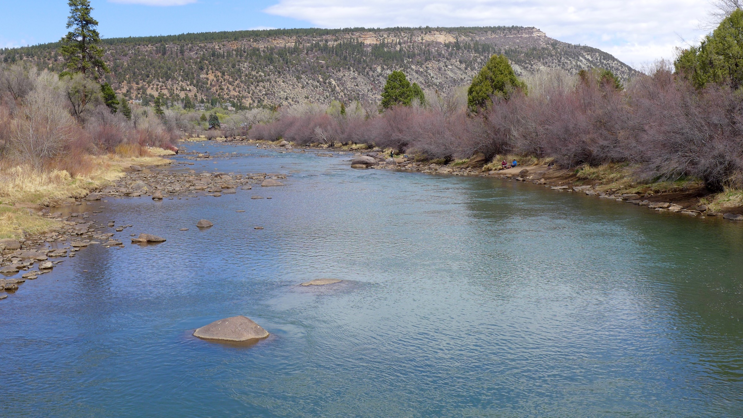
Gov. John Hickenlooper signed an executive order Tuesday to ensure vehicles sold in Colorado meet current emissions standards even if the Trump administration decides to slash regulations for the automobile industry.
The executive order requires Colorado to adopt California’s limits on greenhouse gases that spew from tailpipes. California has a legal waiver under the Clean Air Act that allows it to have more stringent emission standards than those set by the federal government. Colorado will join a dozen states, including California, and the District of Columbia seeking to lock in place current Obama-era vehicle emission standards.
Those 2012 standards are designed to lead to more fuel-efficient vehicles on the market in coming years. New cars, light trucks and SUVs will have to average 55 miles per gallon come 2025, a rule that was incorporated into California’s regulations.
This would complement Colorado’s goal of cutting 2005 greenhouse gas emission levels 26 percent by 2025. Vehicles on the road make up the state’s second-largest source of greenhouse gas emissions after electricity generation from power plants, according to the state’s most recent data.
Environmental groups are lauding the executive order as a win for the state at a time when the White House is rolling back environmental protections.
“I think this is a very big moment for the work that is being done in the country on climate policy,” said Jessica Goad, deputy director for the environmental advocacy group Conservation Colorado. “States are going to need to lead the way on this.”
A legal showdown between the Trump administration and California is expected over that state’s decision to set emission requirements that are more stringent than under the Clean Air Act.
Attorney General Cynthia Coffman, a Republican who often has opposed government regulations and is sympathetic to the oil and gas industry, did not return a request for comment on whether Colorado will defend California’s stance.
That call ultimately may fall to whichever attorney general candidate is elected in November. Democrats Joe Salazar and Phil Weiser say they would be willing to defend California’s waiver if challenged by the Trump administration. Republican candidate and 18th Judicial District Attorney George Brauchler did not return a request for comment.
Today’s order requires the Colorado Department of Public Health and Environment to propose a rule that incorporates California’s regulations by August for possible adoption by the end of the year.
Hickenlooper’s executive order said the expected plan by the Environmental Protection Agency to roll back greenhouse gas and fuel efficiency standards could have “serious consequences” for Colorado’s effort to meet its own clean energy goals.
In a statement, he said the executive order was also about protecting Coloradan’s quality of life.
“Low emissions vehicles are increasingly popular with consumers and are better for our air,” he said. “Every move we make to safeguard our environment is a move in the right direction.”
The auto industry, however, is raising concerns about costs for consumers. Tim Jackson, CEO and president of the Colorado Automobile Dealers Association, said according to most recent reports on car sales, Coloradans drive more trucks than Californians do. That’s one reason why he says it’s crazy to have Colorado’s adhere to California’s emission standards.
“It’s going to be a harder standard for automakers to achieve so they will have to disincentivize, which means raise the price on the vehicles that Coloradans like to drive,” he said. He added that if consumers can’t afford new cars they may keep older, more polluting ones.
A May report by Denver’s Department of Public Health and the Environment says Denver was ranked the 11th most polluted city in the nation for ozone levels in 2017 and the leading cause is vehicle emissions. Last year, the Colorado Department of Public Health and Environment issued 45 Action Day Alerts, meaning air pollution levels were so high that the agency recommended that people with certain health conditions like asthma stay inside for certain activities such as exercise. There have been 11 such warnings so far this year.
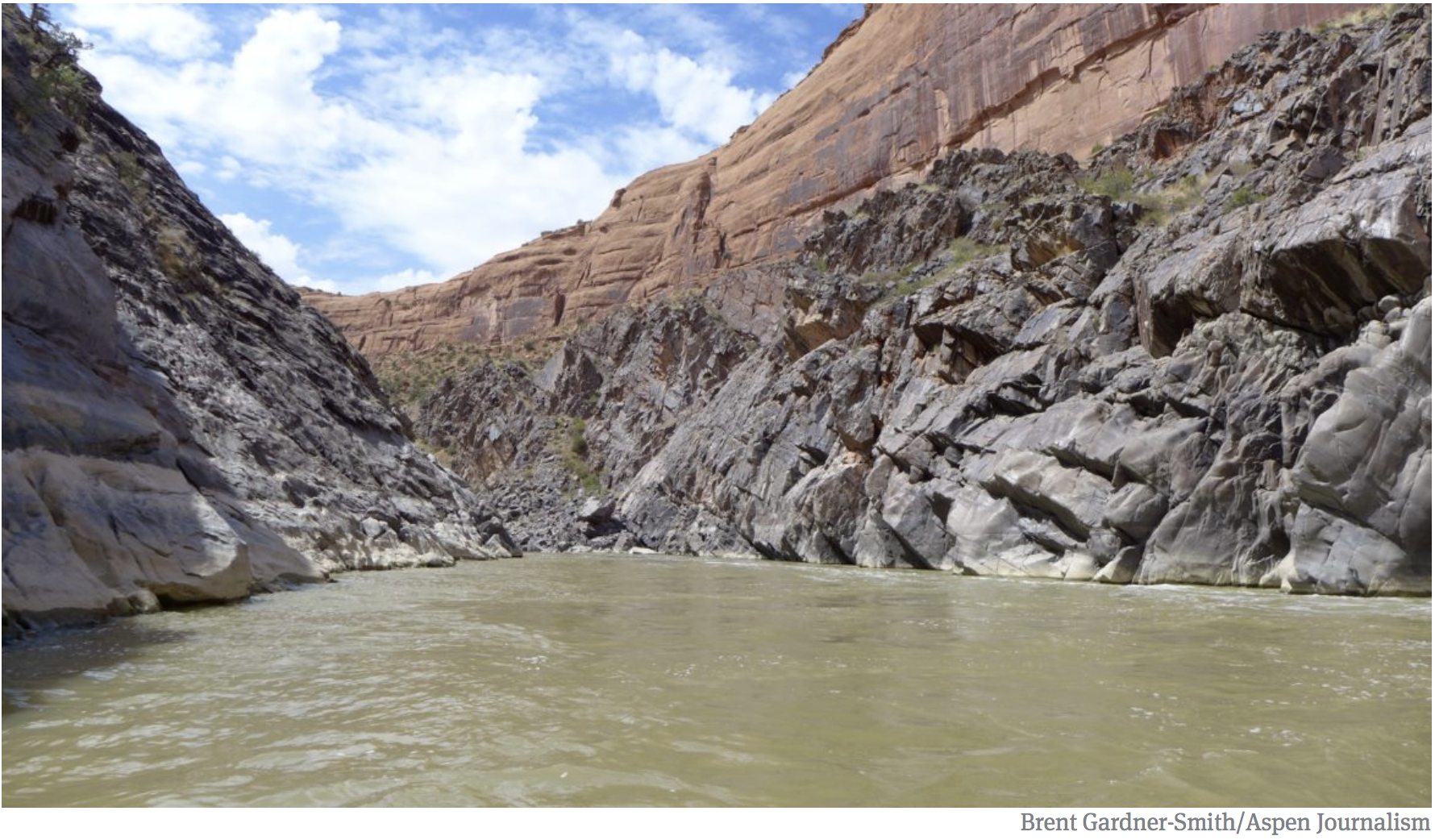
Much of the water that leaves Colorado bound for Lake Powell passes through Westwater Canyon, An ongoing study suggests that in the face of a severe drought, not enough water is left in the Colorado River basin to keep Lake Powell high enough, or Westwater wet enough. Photo credit Brent Gardner-Smith.
Not so coincidental, really. [Jeffrey] Kightlinger and I converged with other Colorado River folks on Santa Fe for an Upper Colorado River Commission meeting this week. A bunch of side meetings are also underway to, in the words of one of the convergents, “try to jump start” the stalled Drought Contingency Plan discussions.
Kightlinger’s right about the “uncharted territory” thing. The DCP is an effort to cobble together a map of the water management terrain ahead as we’re speeding toward – well, speeding toward something that we’re not quite sure what it is but it’s probably really bad.
My main reason for tagging along to the Santa Fe meetings is the chance for some “side meeting” time with Eric Kuhn, my collaborator on a new book that is looking closely at how we got here. In particular, we’re looking at the “charts” (to borrow Kightlinger’s metaphor) that we did make beginning with the 1922 Colorado River Compact – the rules guiding how we would develop the river’s water, and our hydrologic understanding that was used to draw them. The reason this is so “uncharted” is because we (they?) didn’t do a good job at all of contemplating the “what if” scenario of river less than their rosy planning assumptions of a booming Colorado River with surpluses for all.
In fact, the framers did make a roadmap of sorts, with the Colorado River Compact’s long forgotten article III(f):
(f) Further equitable apportionment of the beneficial uses of the waters of the Colorado River System unapportioned by paragraphs (a), (b), and (c) may be made in the manner provided in paragraph (g) at any time after October first, 1963, if and when either Basin shall have reached its total beneficial consumptive use as set out in paragraphs (a) and (b).
So bad were their maps at the time that they actually thought there was not only plenty of water for full development of the farms and cities we now see, but that they would have to reconvene in 1963 to parcel out an additional allocation of more water!
By 1963, there was not only no discussion of a surplus, but active discussion of how to cope with the fact that there wasn’t enough water for even the basic allocations laid out in the compact. And yet, here we are today, 50 years later (and a nearly century after the compact was signed), still with no chart.
Wildfires can contaminate nearby streams and watersheds through mobilization of sediments, nutrients and dissolved organic matter, straining the capabilities of downstream municipal treatment facilities, a new report co-authored by CU Boulder researchers shows.
The research, which was funded by The Water Research Foundation (WRF) and presented at CU Boulder earlier this month, outlines a multitude of challenges posed by wildfires, including short- and long-term effects on the availability and quality of drinking water sources used by major metropolitan areas such as Denver, Colorado. The report also outlines potential remediation solutions to help utilities plan for worst-case scenarios.
“A great number of drinking water utilities draw water from forested watersheds,” said Fernando Rosario-Ortiz, an associate professor in CU Boulder’s Department of Civil, Environmental and Architectural Engineering and the lead author of the report. “When these watersheds are impacted by a wildfire, the impacts on source water quality can be severe, forcing utilities to respond in order to continue to provide safe drinking water to their customers.”
Wildfires have increased in duration and extent in recent decades due to climate change, creating concern about added strain to existing treatment resources. The 2012 High Park Fire burned sections of the Cache la Poudre watershed, which serves northern Colorado communities including Fort Collins. That same year, the Waldo Canyon Fire burned through Pike National Forest, temporarily jeopardizing water supplies for Colorado Springs.
While ecologists and land managers have studied fires extensively, the scope of post-wildfire effects on drinking water remains uncertain. Current research indicates that fires can degrade surface water quality through erosion, ash deposition, increased sediment loads and/or elevated nutrient runoff (i.e., nitrogen and phosphorus) that can spur algal blooms.
To simulate the effects of a medium-temperature wildfire, the researchers heated soil and organic deadfall in a furnace to 225 degrees Celsius (437 degrees Fahrenheit). The materials were then leached into tap water and treated using conventional processes.
The results showed that the heated materials increased the turbidity of the water and responded poorly to chemical coagulants, leading to additional downstream filtration difficulties.
“Our work has shown that source waters impacted by wildfires can be difficult to treat, resulting in additional costs in the form of additional chemical coagulants and the potential need for capital improvements,” Rosario-Ortiz said.
A recent workshop conducted at CU Boulder brought together representatives from different water utilities across the Front Range to discuss the challenges posed by wildfires, including the aforementioned issues with water quality and the need to coordinate the response with local and federal agencies.
The report recommends that utilities serving fire-prone regions of the U.S. expand water storage capacity, expand use of pre-sedimentation basins and diversify clean water sources in order to prepare for potential disasters.
Additional co-authors of the study include Amanda Hohner, Jackson Webster and Kaelin Cawley of CU Boulder.
Here’s a podcast on the same subject from CU Boulder News:
Studies done in Colorado have shown that wildfires contaminate fresh water sources. Fernando Rosario-Ortiz is a professor in CU boulders Department of Civil, Environmental and Architectural Engineering and was apart of this study. CU Lab R.A.T.S talks to Fernando about the findings
Click here to read the update from Taryn Finnessey and Tracy Kosloff:
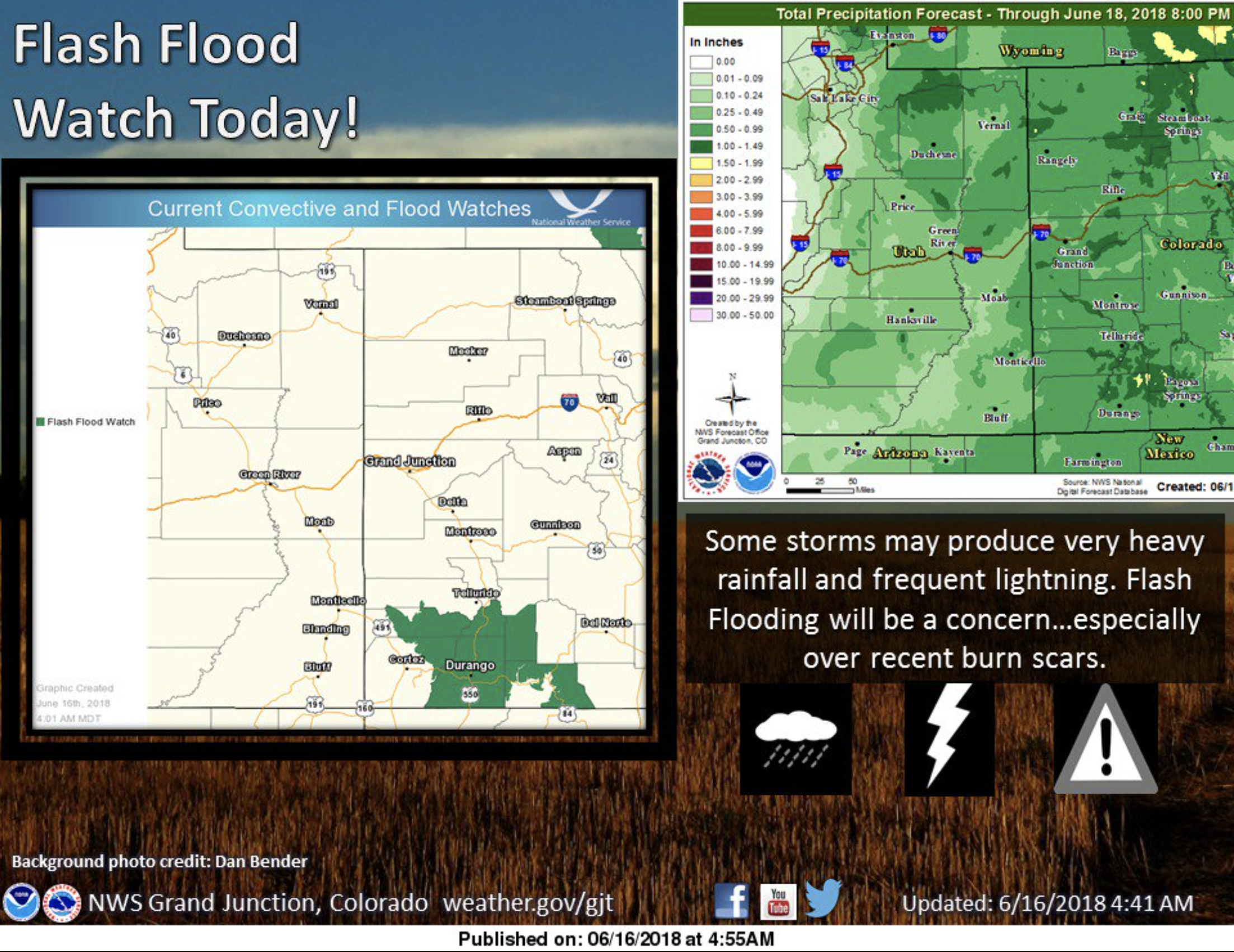
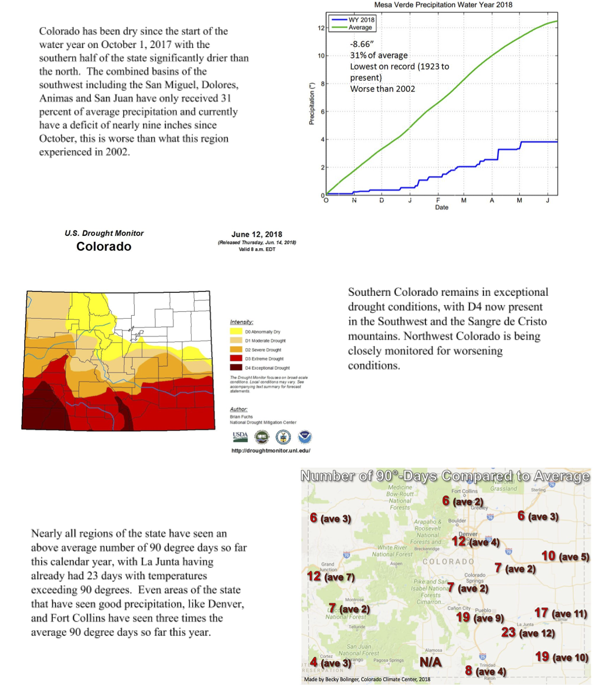
In response to persistent and prolonged drought conditions throughout the southern half of the state and along the western border,the Governor activated the Colorado Drought Mitigation and Response Plan for the agricultural sector on May 2, 2018, additional information can be found HERE.
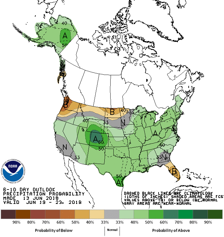
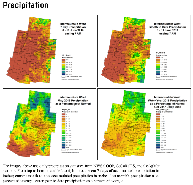
The month of May was, on average, the second warmest on record and the warmest since 1934. While daytime highs were above normal, night time highs were also well above normal, which may have contributed to early snowmelt across much of Colorado. June has continued to see well above average temperatures with most of the state experiencing temperatures 4-10 degrees above normal. Precipitation for both May and June to-date has largely been well below average statewide, these conditions contribute to fire danger.
■ SNOTEL sites from the Grand Mesa to Mesa Verde National Park have broken low records for both peak snow accumulation as well as water-year to date precipitation.
■ Water demand is increasing; and reservoir storage in the Southwest basins of the San Miguel, Dolores, Animas & San Juan, Gunnison and Rio Grande have seen significant decreases in reservoir storage in recent months. The reservoir storage for the Southwest basins of the San Miguel, Dolores, Animas & San Juan has dropped from 91 percent of normal storage last month to 75 this month and has the lowest storage levels in the state.
■ Isolated cattle sell off and prevented planting of some acreage has been reported. High hay prices make purchasing adequate supplies to maintain livestock a challenge. There are some reports of cattle being moved to alternative grazing areas, including out of state, and we anticipate additional cattle sell off. Unless conditions improve additional prevented and failed crop acres are likely.
■ Windy, dry conditions have continued to fuel fires in June leading to numerous large wildfires, including the 416 Fire near Durango that is now the 5th largest fire in Colorado history. Weather forecasts indicate the potential for large scale moisture statewide in the coming week and in particular in southwest Colorado. While this will help alleviate drought and fire potential, it also introduces the potential for floods near burn scars.
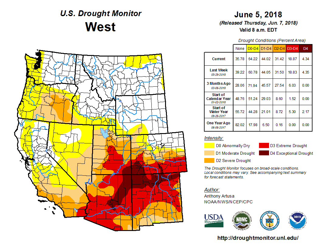
■ As of June 12, exceptional drought, D4, continues to affect southwest Colorado and the Sangre de Cristo mountains, covering eight percent of the state. Extreme drought, D3, covers 27 percent of the state; severe drought 16 percent and 16 percent is classified as moderate drought. An additional 12 percent of the state is currently experiencing abnormally dry conditions (see image on reverse side).
■ Reservoir storage statewide is at 106 percent of normal. The Arkansas basin is reporting the highest average storage at 127 percent. Front Range water providers are seeing an increase in demand but mainly draw water resources from areas of the state that received near normal winter precipitation, and therefore have adequate supplies and are not anticipating any water use restrictions outside normal operations.
■ The Surface Water Supply Index (SWSI) values have declined slightly in June, with most of the western slope classified as extremely dry. These values are largely driven by well below average streamflow forecasts. Low streamflows are also a contributing factor to aquatic wildlife impacts that have been reported in isolated areas.
Swim class on the San Juan River. Photo: Brent Gardner-Smith/Aspen Journalism
Click here to read the newsletter. Here’s an excerpt:
How Municipalities are Dealing With Drought
As one of the worst droughts on record continue to create havoc throughout Colorado, counties in the southern half of the state and along the western border are starting to see impacts to their water supplies.
The Water Information Program connected with a few authorities in the region to see how they are dealing with the drought conditions and what they are doing about it.
The U.S. Bureau of Reclamation projects a 52 percent chance of a water shortage on the Colorado River in 2020. In a statement from KNAU’s Melissa Sevigny’s report, Marlon Duke of the U.S. Bureau of Reclamation says reservoirs are depleted from 19 years of drought. He says, “This is the worst drought in at least the last 100 years of our recorded history, and as we look back further than that, we can see signs that this one of the worst droughts probably the last 1,200 years of the paleo-record.”
The city of Durango is in the process of drought planning for this season as well as long term. They are in the early stages of working with their 10 largest commercial water users for water conservation. Right now, the Florida River is meeting the city’s water demand, however, should that change, Fort Lewis College, the city’s Parks and Recreation, Durango School District 9-R and Hillcrest Golf Course will voluntarily cut back on irrigation by 10 percent.
“We can save a lot more water by working with our larger water user groups, be more productive and have a better relationship with them than by implementing voluntary or mandatory water restrictions on residents. That is the direction we want to go. Asking for voluntary water cutbacks from residents doesn’t work as a water management practice,” stated Levi Lloyd – City of Durango Utilities Director.
They are watching the flows being released from Lemon Reservoir and are anticipating by mid- June the release will be cut off and will then run the pumps out of the Animas River. At that point the city will work with Parks and Recreation and other users on conservation measures. The city is working to get grasses, turfs and vegetation health robust enough to get through any restrictions that may be implemented.
The Norwood Water Commission put into effect a conservation measure with a mandatory water cutback on outside watering. The provision stated that outside watering is to be conducted before 9AM or after 5PM on even calendar days for town customers and odd calendar days for rural customers. At the water fill station card holders are only allowed 5000 gallons at this point. “Wells are starting to dry up in the area. The Gurley Reservoir is releasing limited water for irrigation. This will be on our agenda in our town water commission meeting this week to discuss further water restrictions,” stated Patti Grafmyer – Town Administrator.
“We have not put restrictions in place yet but we have been planning drought contingencies (including water use restrictions) since April,” noted John Sites – Public Works Director, Town of Silverton. “We are gauging triggers for restrictions based upon the flows of our two main sources: Boulder and Bear Creeks. We have installed staff gauges and visually monitor the intakes twice a week. When the flows begin to show visible signs of deterioration, we will begin instituting staged restrictions. At this time, the Town of Silverton is using such a small amount of water (about 70 gallons per minute) that the vast majority of both stream flows reach the Animas.”
This story is a part of the ongoing Back 40 series, where HCN reporters look at national trends and their impacts close to home.
Following a dry winter, Colorado’s already low snowpack is rapidly dwindling and extreme drought has been declared in a third of the state. Many communities, not only in Colorado, but also in other parts of the West, are wondering about their future water security.
For the city of Aspen, located in the headwaters of the Upper Colorado River Basin, planning for a warmer climate is no longer about the distant future. The 6,500-population municipality relies on pulling water from creeks fed by the snowpack, which sat at just eight percent of its median as of June 11, according to snow monitoring data. And the future doesn’t look any better: Recent research suggests climate change will further disrupt the snowpack in the coming years.
In Aspen, the need for water security is being met with a search for alternative storage solutions that have less damaging environmental impacts than the big dams of yesteryear. Over the past two years the city has begun testing several potential water storage sites, including beneath the municipal golf course, as a means to deal with future water shortages. “We are at that point now were it is time to start putting those (storage) plans into action,” said Margaret Medellin, the city’s utilities manager.
The dam site of the potential Maroon Creek Reservoir. Photo: Brent Gardner-Smith/Aspen Journalism
While Aspen pulls its water from nearby Crystal and Maroon creeks, the city doesn’t have any storage capacity. Currently, the city can stockpile just a day’s worth of water, something Medellin said could be a problem this year. “People right now are conserving water and we could still be in a real hardship at the end of the summer because we have no way to store that water,” she said. “When talking about other communities in Colorado and the West that is a level of vulnerability that is not really acceptable as a water management practice.”
This vulnerability is part of the reason why, since 1965, the city has quietly renewed a filing in Colorado’s water court that kept alive the possibility of building two dams on Castle and Maroon creeks. In 2016, when area environmental groups including the Wilderness Workshop and Western Resource Advocates got wind of the renewal, they announced their opposition to the filing, urging the City of Aspen to relinquish its storage rights. If developed, those rights would have flooded some of the state’s most pristine landscape.
In May the city agreed to forego its conditional water storage rights in these wilderness areas, marking the end of Aspen’s ties to the era of large federal dams like Hoover and Glen Canyon. As part of the agreement, the city is now entering a new period for water storage and conservation policy. One option includes storing water under the city’s municipal golf course. The water could either be injected into the underlying aquifer, or would reach it through a basin specifically designed to draw water underground, Medellin said. This would allow the city to store up to 1,200 acre-feet, or about enough to supply 2,400 households for one year, and would eliminate evaporation, a problem that worsens with rising temperatures. “As a concept it really does help you preserve a lot of the water with minimal loss,” Medellin said.
The groups also identified a former gravel pit, and land adjacent to it, that could accommodate up to 8,000 acre-feet of water, which could be diverted from the Roaring Fork River, if the city transfers its water rights. Seen as a win-win by environmentalists, retrofitting old gravel pits has been used successfully on Colorado’s Front Range since the 1980s. The key would be diverting water from the river at the right time, which, according to Ken Neubacker, Colorado projects director at American Rivers, is right after the river reaches its peak flows. “It all depends on how they do it,” he said.
Aspen’s water management plans include irrigating with reused water and introducing a net metering system, which would help the city’s residents track — and reduce — water use. In collaboration with environmental groups, the city is also looking at a program which would allow farmers to temporarily lease some of their water rights during dry periods, letting the municipality use them instead.
For Aspen, much like other communities across the West, storage will increasingly become a part of water planning strategy, but at least now environmental groups are part of the discussion. “Coming to the table and talking these problems through will be essential,” said Robert Harris, an attorney with Western Resource Advocates. As climate change reduces available water, “we can’t depend on the past being any guarantee of the future.”
Jessica Kutz is an editorial intern at High Country News. This article was first published online at The High Country News on June 19, 2018.
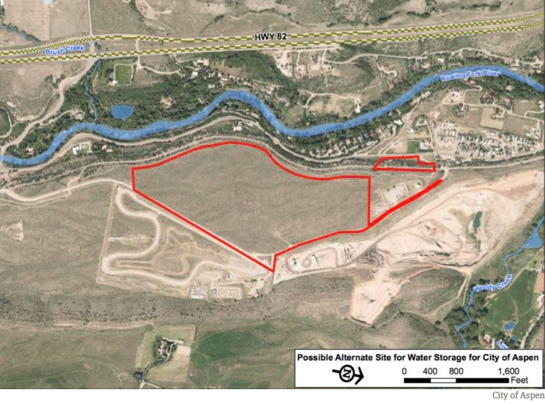
A map provided by the city of Aspen showing the two parcels in Woody Creek it has under contract. The city is investigating the possibility of building a reservoir on the site, as well as looking at the possibility of a reservoir in the neighboring Elam gravel pit.
Wildfires have broken out across southwestern Colorado this June, burning thousands of acres in the San Juan National Forest and nearby private lands. The largest fire in southwestern Colorado, dubbed the 416 fire, has affected more than 33,000 acres (36 square miles) of land and was only 30% contained as of June 18.
According to the Denver Post, this fire, located about 16 miles north of Durango, led to the closure of San Juan National Forest for the first time in its 113-year history. The National Interagency Fire Center estimates that suppression costs are up to $17.3 million as of June 18. The fire got started during the beginning of month and grew rapidly, taking advantage of favorable fire conditions.
One of those conditions is the presence of plenty of fuel in the form of dry plants. It has been painfully dry in the Four Corners region of the country for quite a while. This part of Colorado in particular has been suffering through the worst category of drought (D4 or Exceptional Drought) for the last two months and some form of drought since November 2017.
Fortunately, some rain fell over the fire area over the weekend, which enabled scientists at the National Weather Service’s Storm Prediction Center to lower the fire weather risk. The 3-8-day outlook for critical fire weather issued on June 17 indicated no areas of elevated risk for several days.
Wildfire climatology in the Four Corners
The best chance of a wildfire in the southwestern United States occurs during the early summer months, peaking in early July. It is then that the desert southwest is sweltering under the summer sun, but still waiting for the rains of the North American Monsoon. This dry heat creates a relatively short window of peak fire risk that stretches from late June through the middle of July.
Afterwards, rains associated with the North American Monsoon normally begin to roll into the area. We have written before about the devastating flash floods that can accompany the Southwest monsoon (as it is known in the United States), but these showers also provide enough moisture to reduce (though not eliminate) the risk of wildfires, especially across mountainous terrain, where rainfall is often the highest.
Future wildfire risk
As has been noted in previous Event Tracker articles about wildfires across the United States, the nature of wildfires is already changing. In particular, the number of large wildfires in the western United States, like where the Colorado wildfire is burning, has increased over the last thirty years.
Many decades of forest management during which all fires were suppressed has contributed to the problem, as has widespread tree death due to insect damage (which itself may be linked to climate change). But human-driven climate change is also playing a significant role by warming and drying already fire-prone regions as well as by reducing the length of the spring and early summer snow melt season.
These trends toward larger fires in the West is very likely to continue into the future thanks to climate change as we continue to emit a high level of greenhouse gases. In recent research looking at trends in weeks where conditions are favorable for very large fires, scientists found that the potential for the development of very large fires is expected to be up to six times as likely by mid-century (2041-2070) compared to 1971-2000. For the Four Corners region, the number of weeks each year where conditions are favorable for the occurrence of very large fires is likely to increase by 200-400%.
These increases in very large, destructive fires have enormous economic and ecological costs.
Forest fires have been growing in intensity, frequency and cost across Colorado and the West. What do those fires mean for our watersheds, water supplies, and the millions of water users across the state? And how do we fund the fire treatment work that will maintain healthy forests and reduce the risk to our watersheds?
Join us to answer these questions and more. We’ll discuss the funding challenges posed by increased fire incidence, as well as the partnerships and creative funding strategies that could help Colorado build healthier forests, watersheds, and more water-secure communities.
Hear from speakers:
Steve Lohr, U.S. Forest Service
Rob Addington, The Nature Conservancy
Ellen Roberts, Colorado State Forest Service consultant, former state senator, and past chair of the Colorado legislature’s Wildlife Matters and Water Resources committees
When
June 26th, 2018 12:00 PM through 1:00 PM
Webinar Fee
WEco member $ 10.00
non-WEco member $ 15.00
The Mussel-free Colorado Act came from the interim water resources review committee and was signed into law by Gov. John Hickenlooper on April 23.
Since they were first found in a lake outside of Detroit in 1988, zebra and quagga mussels have become a huge problem for waterways in the eastern half of the United States, particularly the Great Lakes.
Sightings have been rare in Colorado but they have happened: at Lake Pueblo in 2008, at Green Mountain Reservoir in 2016 and in March outside of Grand Junction. In 2017, according to the state Division of Parks and Wildlife, 25 boats were found contaminated with mussels, up from 22 boats in 2016. Those boats had all come from other states, with Lake Powell in Arizona and Lake Havasu in California as the places where the mussels most likely came from…
Fears that the nuisance could to do to Colorado’s water system what it’s done to systems back east prompted lawmakers to ramp up the state’s aquatic nuisance detection program, which has been underfunded for years.
Under House Bill 1008 — the mussel-free law — beginning January 1, Colorado residents will pay $25 for an aquatic nuisance stamp for their boats in addition to the boat registration free. Non-residents will pay $50 to use their motorboats or sailboats in state waterways.
The fee is expected to raise $2.2 million that will help Colorado Parks and Wildlife keep boat inspection sites open for longer hours and for a longer season. Doug Kreiger of CPW told the interim water committee last year that budget cutbacks have meant boaters could avoid inspections, such as putting their boats in reservoirs on private land or at the public ramps when inspectors aren’t available.
The law also will allow the division to recoup the cost of decontaminating boats that show up with mussels attached to boat or boat motors, anchors, anchor ropes, fishing gear, and boat trailers.
The water committee also carried two of the recycled water bills: to allow recycled water to be used for industrial hemp and for irrigating marijuana crops.
Recycling water — the process for treating water and then reusing it — isn’t new in Colorado; it’s been a part of irrigation for agriculture for years. But it’s gaining new attention, thanks in part to the state water plan. It noted that 25 utilities, mostly on the Eastern Slope, are already treating and recycling non-potable water and would look for additional ways for using recycled water as a way of addressing Colorado’s looming water shortage, with a goal of finding 170,000 acre-feet through recycling.
The water plan cites as an example the Colorado Springs utility, which uses recycled water for irrigation at golf courses, parks and other properties, as well as for cooling towers at local power plants. The utility reported in 2016 that reuse saves one billion gallons of drinking water every year.
Senate Bill 38, signed into law on April 28, would add industrial hemp on the list of approved crops irrigated with recycled domestic wastewater and in accordance with existing water rights. Industrial hemp is a crop that under the bill could not be used for food production.
Sen. Don Coram of Montrose, the bill sponsor, explained that hemp is a high-protein crop, higher than alfalfa, and that it poses no risk to cattle, for example. The bill was supported by the Colorado Water Rights Association, the Colorado Water Congress and the hemp industry.
The bill was amended to address concerns about water quality.
The bill allowing recycled water for irrigation of marijuana — House Bill 1053 — wasn’t as lucky and died in the Senate Finance Committee, at the request of its sponsor. The marijuana industry opposed the bill, based on concerns that the law would require cultivators to use recycled water that could contain pesticides that cannot by law used on cannabis plants.
Would you use recycled water to flush toilets? Colorado law changed a couple of years ago to allow developers to build greywater systems in new homes, but left out existing homes and businesses.
House Bill 1069, signed on April 30, would let businesses and multifamily residences, such as apartments, condos and townhomes, to flush toilets with recycled domestic wastewater. The state’s plumbing code is changed under the law, and toilet plumbing would have to be retrofitted to accommodate the rerouting of recycled water.
The General Assembly also changed state law on water quality to allow recycled water to be used to irrigate food crops, but only if that water meets the water quality standards for commercial crops under the Food and Drug Administration’s Food Safety Modernization Act. That bill was signed into law on April 28.
The law does not apply to big agriculture, according to the sponsor, Democratic Rep. Jeni Arndt of Fort Collins. She said the intention is to use recycled water to replace drinking water that is used to irrigate indoor grows;l community gardens; community-supported agriculture, usually farms of one acre or less; and other forms of urban agriculture.
Finally, the General Assembly put another $7 million toward implementing the state water plan. Under Senate Bill 218, $3 million would go toward developing additional storage, recharging aquifers and dredging existing reservoirs to add capacity; $1 million for agricultural projects; $1 million for grants that would implement long-term strategies for conservation, land use and drought planning; $500,000 for grants on water education and $1.5 million for environmental and recreation projects. That bill was signed into law on May 30.
On June 19, the interim water resources review committee is scheduled to meet in Denver to review a study commissioned in 2016 to look for new or enhanced water storage opportunities along the South Platte River, primarily in northeastern Colorado.
Four filters supplied by the Air Force will allow Fountain residents this week to resume using groundwater that was found to be contaminated by firefighting chemicals more than two years ago.
Two filters were tested [June 18, 2018] and the other two are scheduled to be in operation next month.
The test had to be stopped, however, after the filtering system produced too much pressure, ruptured some seals and sprang a leak.
“We’ll try again (Tuesday),” said Curtis Mitchell, director of Fountain Utilities. “We only have one more set of seals, so we want to make sure we figure out what caused the problem before we risk rupturing the other seals.
Since the contamination from a firefighting foam at Peterson Air Force Base was discovered in the fall of 2015, the city stopped using water from its underground aquifer and began using surface water from the Pueblo Reservoir.
The filters cost around $700,000 to reduce the amount of the three most dangerous chemicals to well below levels deemed safe by the U.S. Environmental Protection Agency.
The filtering agent is a sandy, charcoal-like material that is inserted into the tanks.
But, according to research last year by the Colorado School of Mines, the same filters didn’t do well in reducing the levels of more than two dozen other chemicals.
“We know that customers will choose to use bottled water for drinking and cooking, as they have been,” Mitchell said. “But we want them to know we’ve tested the filtering system and the water is safe.”
City officials estimate that only 15 percent of the city’s water usage will come from the aquifer on peak days, and that groundwater is needed to supplement the surface water supply.
Many residents remain skeptical about the water quality, fearing that they’ve been exposed to the contamination for years.
City leaders say the water is now safe to drink, with a new process called Granular Activated Carbon (GAC) which gets rid of any PFC’s found in the water.
‘We did laboratory testing a week ago,’ said Fountain Utilities Dir. Curtis Mitchell, ‘the results came back non-detect, so now we’re comfortable that we can provide safe drinking water in addition to the surface water that we use from pueblo reservoir to our customers.’
Still, a majority of the water will come from the Pueblo Reservoir.
Additionally, the city will test the water every week for the entire lifespan of the water facility.
More facilities are on the way, but Mitchell says that’s about 2 years out.
The 416 Fire started at about 10 a.m. on June 1, 2018, approximately 10 miles north of Durango, CO. Rocky Mountain Type 1 Incident Management Team is managing the fire. The fire is burning on the west side of State Highway 550 on some private land and on the San Juan National Forest. The fire is burning in grass, brush, and timber. The Weather conditions remain critical and fuels are ideal for significant fire growth. The fire has been very active and continues to burn in rough and inaccessible terrain. Many homes have been evacuated and structure protection is in place. Map via Inciweb
For longtime Southwesterners, this year’s low snowfall and high temperatures bring back memories of 2002, a year that seemed to stand as the region’s come-to-Jesus climate moment. The snow cover was thin to nonexistent, even in the high country. Fields dried up and Lake Powell began its big shrink. Record-breaking fires burned across the region.
But as the warm spring of 2002 moved into a scorching summer, I wasn’t worried. I lived in Silverton, Colorado, at 9,318 feet in elevation, where extreme drought for everyone else just meant a more pleasant summer for us. We could actually barbecue on Memorial Day instead of suffering through a blizzard, ride our bikes up the high passes before July 4, and swim in the Animas River without instantly contracting hypothermia. I believed that Silverton, which at the time was looking for new economic engines after the loss of mining, offered a refuge people would flee to, not from, when climate change manifested elsewhere in the form of drought, fire and desertification.
And so, on an early June afternoon in 2002, while the lowlands broiled, my friends and I sat in the lawn sipping cold beverages and enjoying perfect temperatures in our T-shirts and shorts. It was an uncommon pleasure during any month in Silverton. If this is global warming, I declared, then bring it on.
Just moments later, we noticed what looked like a puffy cumulonimbus cloud rising up in the gap formed by the Animas River gorge. It wasn’t a cloud at all, but a billowing tower of smoke from what would become known as the Missionary Ridge Fire. Over the coming weeks the blaze would eat through 73,000 acres of parched scrub oak, aspen, ponderosa pine and spruce forest, burn 83 structures, and batter the regional economy.
Flash forward to June 2018. Much like the Missionary Ridge Fire, the 416 Fire has been ripping through forests north of Durango since June 1, sending up roiling clouds of smoke and diminishing the air quality for miles around. The current fire was sparked almost exactly 16 years after the former in similar vegetation. This time, though, the flames were no surprise. We knew that the dry winter of 2018 would usher in an explosive fire season, which is not to say that the region took enough precautions.
During the Missionary Ridge Fire, and in its immediate aftermath, Silverton did not become a destination for refugees fleeing fire, heat and drought. To the contrary, despite the fact that the flames never got anywhere near Silverton, the mining-turned-tourist town’s economy took the biggest blow of all the region’s communities.
This year looks to be no different. The Durango & Silverton Narrow Gauge Railroad — the primary artery for delivering tourist dollars to Silverton — has suspended service for the month of June because the coal-fired locomotives are a fire hazard. (In fact, the train is suspected of igniting the 416 Fire, though the official cause remains “unknown.”) One of just two highways connecting Silverton to the outside world has been closed on-and-off due to the fire, further hampering the ability of tourists to get to the town. Now, the Forest Service indefinitely closed the 1.8 million-acre San Juan National Forest, cutting off mountain bike and hiking trails, campgrounds and jeep roads —along with a major revenue stream for the entire region’s outdoor recreation-oriented businesses.
Eventually, the rains will come and the fire danger will diminish and television screens will no longer be alight with images of southwestern Colorado’s forests engulfed by hellish flames. But the pain undoubtedly will resonate through the rest of the summer, just as it did in 2002 after the Missionary Ridge Fire subsided.
Repercussions may still be felt for years to come, too, particularly when it comes to the steam-powered train. In the wake of the 416 Fire, social media has stoked a movement pushing the railroad to switch to diesel locomotives — or not run at all — during times of extreme fire danger, before a blaze can erupt.
Such suggestions spark fervent pushback from train-reliant sectors of the economy and their supporters. Since diesel locomotives lack the authenticity and aesthetic appeal of their steam-powered cousins, they argue, such a switch could result in fewer passengers and less tourism revenue overall. “You must be a complete IDIOT,” says a representative commenter on Facebook. “This town is alive because of that steam train! You must be a transplant trust funder to think we don’t need the train.”
Replace “train” with your local industry of choice — mining, say, or oil and gas drilling — and the exchange repeats one that has resounded around the West for decades. Concerned citizens ask the mining companies to stop polluting the rivers, or the oil companies to plug their methane leaks, or the train to stop spewing sparks, and the industry and its foot soldiers always lash back: Even minor protective measures, they say, could kill the industry and bring down the whole economy with it.
This sort of short-term thinking, of prioritizing today’s bottom line over future environmental or public health, rarely pays off in the long term. Yesterday’s failure to address mining pollution is the Gold King Mine disaster of 2015, and today’s unfettered methane leaks are tomorrow’s climate change-caused water shortage. Today’s yearning for the authenticity of coal-fired locomotives is tomorrow’s economy-obliterating megafire.
Thirty years ago, coal trains could run without consequence through the “asbestos forest” of the San Juan Mountain high country. The drought of 2002, however, woke up the railroad’s owners to a changing world, one in which the ravages of climate change can — and will — affect even a quaint little tourist train and the quaint little town that relies on it. The railroad adjusted accordingly, having a firefighting team follow behind each train to extinguish blazes in their infancy. The 416 Fire — particularly if it is found to have been started by the train — will prove an even more brutal moment of reckoning, a grim reminder that yet more adaptation is needed.
I had my own moment of reckoning following that unusually toasty day back in 2002 when Silverton’s economy went up in smoke for the remainder of that summer. I realized then that Silverton will never become the sanctuary from global warming that I dreamed it would. This year the point is being driven home. There is no sanctuary, not really. In one way or another, the climate catastrophe that we have wrought reaches into every corner of our planet and our lives — even at 9,318 feet.
Jonathan Thompson is a contributing editor at High Country News. He is the author of River of Lost Souls: The Science, Politics, and Greed Behind the Gold King Mine Disaster. This article was first published on June 15, 2018 by The High Country News.
The 416 Fire near Durango, Colorado, reached 30 percent containment [June 18, 2018] as temperatures rose and humidity dropped.
Firefighters don’t expect the fire to grow above the current 34,161 acres today, but say there’s a potential for things to pick up later this week.
“Much of the fire is now in a state of smoldering and creeping, and active flames have been infrequent,” the 416 Fire team reported in Monday morning’s roundup. “Today, however, starts a weather trend that will quickly dry out fuels and re-elevate fire potential as the week goes on.”
The fire team echoed a statement made Sunday at a community meeting in Durango: the blaze that has burned more than 50 square miles is down, but it isn’t over.
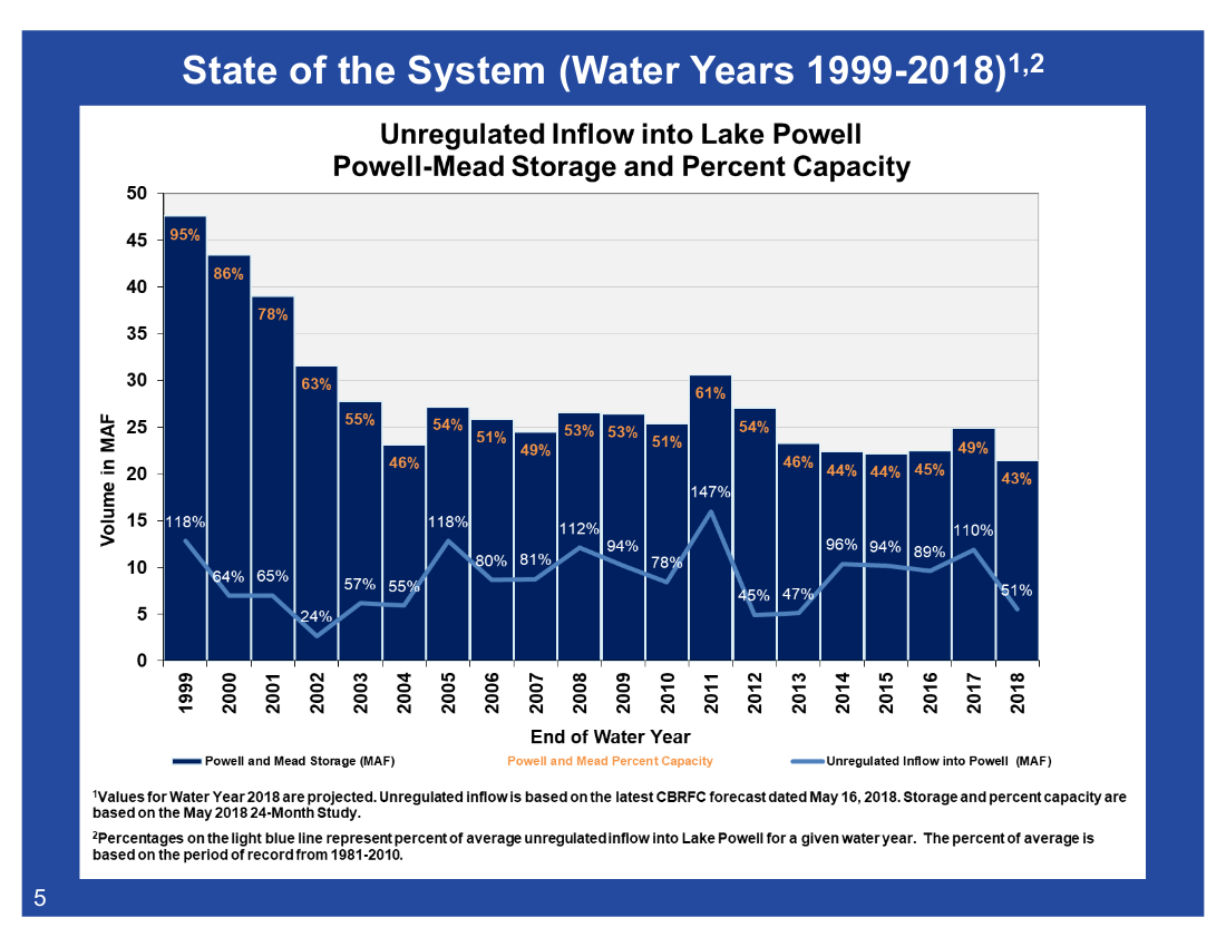
Lake Powell is expected to drop to just 45 percent full by the end of 2018, says Andy Mueller, the new general manager for the Colorado River District based in Glenwood Springs.
The lake, which Coloradans rely on as a water source when the rivers are low, will not have enough water in it to supply all of Colorado and its surrounding states, such as Wyoming, Utah and New Mexico…
Locally, the Colorado River east of Glenwood Canyon was declared unboatable last weekend.
The Colorado River below the Roaring Fork River confluence dipped below 4,000 cubic feet per second this week, and hovered around 3,200 to 3,400 cfs on Thursday, June 14. That’s well below the historical 50-year mean of around 10,300 cfs for this week of June.
In this extremely low spring runoff season, the Colorado at Glenwood Springs at Two Rivers Park peaked at less than 7,000 cfs back in mid-May.
As temperatures rise upstream on the Roaring Fork River in Aspen and Basalt, particularly in July and August, the Parks and Wildlife Commission may prohibit fishing in the area due to overheated waters, which will endanger the fish.
Shoshone Power Plant in Glenwood Canyon is expected to release water on June 20, which will sustain boatable flows throughout Glenwood Springs for the rest of the summer, Mueller said.
As intense drought continues to plague southern and western Colorado, two more counties have received designations as primary natural disaster areas by the United States Department of Agriculture.
This week, Elbert and El Paso counties were added to the list of designated counties. Primary counties now account for 33 of the state’s 64 counties. Ten more counties are eligible for assistance as neighboring counties…
Since December, drought conditions have been increasing across the state, with over one-third of Colorado in extreme or exceptional drought – the two worst categories.
As counties have been designated in groups since early March, varying eligibility dates have been created as neighboring counties received designations at different times. For example, a county surrounded by four other counties could become eligible up to five times: four if each of its neighbors receives a primary designation on different dates, and once for its own primary designation.
Further confusion arises when a county receives a primary designation, and a neighboring county is designated later. In most cases, the more recent date – whether primary or as an adjoining county – will determine the deadline for assistance applications. Applications are due eight months after the most recent designation date.
KiowaCountyPress.net has developed the interactive map below to help sort through designation and eligibility dates. Red shading indicates a county which has received a primary designation, while yellow shading indicates a Colorado county that neighbors a primary county. Counties in other states that share a border with a Colorado primary county are also eligible to apply for assistance. Counties shaded grey do not currently have a designation for drought. San Juan county is shaded blue since it received an SBA-only primary designation.
Additionally, the USDA has designated a number of Colorado counties eligible for disaster assistance due to blizzard, fire and high winds that occurred earlier in the year. Separate maps available here show those counties.
FromThe Grand Junction Daily Sentinel (Dennis Webb):
Hotchkiss-area ranchers Dixie and Dion Luke raise hay and registered Angus cattle, and sell some bulls and bred heifers.
But they’d never sold cows before. Not until this year, with its woefully low snowpack. They have second-in-line water rights on a creek at the bottom of McClure Pass in the upper North Fork Valley, and the creek never had enough water to let them irrigate and raise hay on some 60 acres of pastureland that Dixie Luke’s family owns there. Less than usual irrigation water also meant the Lukes got behind in watering some of their hay acreage near Hotchkiss.
After initially telling someone looking to buy cow-calf pairs that she wasn’t selling any, Dixie Luke reconsidered, deciding to part with some late-calving and older cows to take some pressure off when it comes to feeding their herd…
This is the kind of calculation a lot of area agricultural producers are having to make these days after one of the driest winters in memory in much of western Colorado has robbed streams of spring runoff that is counted on by irrigators. They face choices ranging from selling cattle at a discount, to looking to buy hay at premium prices for feed because of poor hay-growing and range conditions, to leasing water to others and fallowing land.
All the while, ranchers and farmers can only look to the skies for rainy relief this summer and hope for improved precipitation next winter so that what’s now a crisis doesn’t turn into a catastrophe…
[Bret Neal] said that irrigators will drain reservoirs on the Grand Mesa this year.
Jason Ullmann, assistant division engineer for state Water Division 4, based in Montrose, said that while it’s going to be rough for agricultural producers in the region this year, he thinks most will get through it. But it will be important to get adequate snowpack to refill reservoirs that will be drawn down this year, such as on Grand Mesa, or it could be hard for people to get through another such year, he said.
PERFECT STORM — OR LACK THEREOF
While snowpack levels held up better in northern Colorado basins this year, other river basins all had peak accumulation levels of less than 60 percent of normal, with southwestern Colorado faring particularly poorly, the Natural Resources Conservation Service has reported. The particularly low accumulations occurred as far north as Grand Mesa, resulting in paltry runoff in streams such as Surface Creek in the Cedaredge area and Plateau Creek in the Collbran area. And Ullmann noted that May and this month have continued to be dry and also have been windy, which exacerbates drought.
Ullmann said cumulative runoff flows in Surface Creek for April through July probably will end up around 26 percent to 29 percent of average. That would be less than in 1977, the driest in most people’s lifetimes in that area, he said.
While it’s hard to say how this winter fits in historically, “you hear some people say it was as bad as their grandparents said it was in the 1930s, back in the Dust Bowl years,” he said.
Ullmann’s office works as far south as the San Miguel River and Lower Dolores River region. He said some of the areas in the office’s jurisdiction are about as bad off for moisture as people have ever seen. The year 2002 was generally worse than 1977 in those areas in terms of snowpack and streamflows, “and we’re at or below 2002,” he said…
MAKING ADJUSTMENTS
[Paul] Kehmeier irrigates some of the land he grows on with water from Surface Creek, but his allocation this year is less than half of normal, he said.
He said that in April, conditions were dry and there was no lower-elevation snow to melt to satisfy irrigators. At the same time, headgates were still frozen on reservoirs on Grand Mesa. State water commissioners later began belatedly releasing that reservoir water, Kehmeier said…
But Kehmeier was speaking early this week, and he said those water releases were expected to end by late in the week, leaving little water in the creek as it runs just on natural flows.
Kehmeier said a reservoir his family owns on Grand Mesa almost always fills but filled to only about a third of capacity this year.
Kehmeier has about 105 acres he irrigates from Surface Creek but decided to put water on just 20 of those acres, to get one cutting of hay. He has better water rights in the nearby Tongue Creek drainage, so the situation is better there, he said…
He said he could have used reservoir water to irrigate more land, but instead decided to lease some water to orchard owners. He said there are more serious consequences for orchard growers if their trees die than if he temporarily stops watering crops like alfalfa.
Kehmeier also is leasing water to Orchard City for domestic uses. His actions are partly a community service and partly a business decision because he can make good money leasing water, although it still will be a financially tough year for him, he said.
He’s harvesting far less hay than normal.
Still, “I’ve been selling hay for the highest price that I’ve ever sold it for, and the highest price my dad (Norman) has ever sold it for,” he said.
MAKING HAY ON HAY
Dixie Luke said that last year on July 4 they paid $120 a ton for hay.
“If you can buy hay now, it’s every bit of $250” a ton, she said…
[Carlyle] He said a lot less hay than normal likely will be raised in Plateau Valley this year, meaning people will have to either pay high prices for hay or sell cows. And cow prices currently aren’t that good, as cattle owners in Colorado and beyond have been moving to cull herds.
Currier said he culled heavily this spring, just this week sending to market cows that failed to have good calves. He didn’t want to buy hay for unproductive cows…
Kehmeier said he knows of cattle people who are trying to decide between selling cows before prices get worse, or hoping for rain that would improve range and hay-growing conditions. The decision is complicated by the fact that most ranchers have built up a good set of cows, he said…
Currier, who is involved in water policy as a member of Colorado’s Interbasin Compact Committee, said Vega Reservoir filled to about 85 percent of capacity, which was probably a bit better than he expected. But with low creeks in the Plateau Valley, even water for most senior water right owners has been curtailed, and everyone is relying on reservoir water, he said.
A lot of years those senior water flows will last into late July or even August, he said. But this year, reservoir water that normally is being used later in the summer is being used now…
For now, Luke is glad that federal officials allowed Paonia Reservoir to begin filling Dec. 22 of last year because of forecasts for a below-average snowpack for the winter. That ensured it reached a full level now. Normally operators don’t begin filling it until the spring so it can play a role in flood-prevention during runoff…
She said that once the canal company begins pulling water from the reservoir, it will have about 45 days of supply, depending on factors such as wind and monsoon moisture. She said most farmers and ranchers have been cutting their first hay crop in anticipation of irrigating fields and growing a second crop, unlike the typical three crops in a normal year.
She said the drought is having other impacts on ranchers. Her nephew ranches on the Uncompahgre Plateau and has been hauling water up to a cow camp because of a lack of water there, she said…
That’s why Luke decided to sell some of her cows early.
“There will be a lot of cattle in the sale barn down here in Delta and in Loma the first of October if this thing doesn’t turn around,” she said.
A week after extreme drought expanded in southeast Colorado, conditions have also deteriorated in the northwest.
Jackson, Grand and Summit counties, which had been largely drought-free, shifted to abnormally dry. Moderate drought expanded to cover most of Moffat county and a larger portion of Eagle county. Severe drought expanded further into eastern Garfield county.
Slight improvements were observed in southeast Kit Carson and northeast Cheyenne counties…
Overall, 20 percent of the state is drought-free, down from 25 percent one week earlier. Abnormally dry conditions increased slightly to 12 percent, and moderate drought increased to 16 percent from 13 percent. Areas of severe, extreme and exceptional drought are unchanged from the previous week.
One year ago, 94 percent of the state was drought-free, while six percent was abnormally dry.
The U.S. Department of Agriculture on Thursday designated drought-stricken El Paso County a primary natural disaster area, making agricultural producers eligible for emergency loans.
The agricultural producers “who suffered losses and damages caused by a recent drought” can apply for the Farm Service Agency’s emergency loans until Feb. 4.
Much of El Paso County is in severe drought, according to a U.S. Drought Monitor report released Thursday. A northwest portion of the county is in moderate drought.
Producers in contiguous counties – Crowley, Douglas, Elbert, Fremont, Lincoln, Pueblo and Teller – also are eligible to apply.
“FSA will consider each loan application on its own merits, taking into account the extent of losses, security available and repayment ability,” a USDA news release says. “FSA has a variety of programs, in addition to the emergency loan program, to help eligible farmers recover from the impacts of this disaster.”
Dr. James E. Hansen, a NASA scientist and leading expert on climate change, testified before Congress in 1988. Photo credit: The New York Times
FromThe Associated Press (Seth Borenstein and Nicky Forster) via US News:
On June 23, 1988, a sultry day in Washington, James Hansen told Congress and the world that global warming wasn’t approaching — it had already arrived. The testimony of the top NASA scientist, said Rice University historian Douglas Brinkley, was “the opening salvo of the age of climate change.”
Thirty years later, it’s clear that Hansen and other doomsayers were right. But the change has been so sweeping that it is easy to lose sight of effects large and small — some obvious, others less conspicuous.
Earth is noticeably hotter, the weather stormier and more extreme. Polar regions have lost billions of tons of ice; sea levels have been raised by trillions of gallons of water. Far more wildfires rage.
Over 30 years — the time period climate scientists often use in their studies in order to minimize natural weather variations — the world’s annual temperature has warmed nearly 1 degree (0.54 degrees Celsius), according to the National Oceanic and Atmospheric Administration. And the temperature in the United States has gone up even more — nearly 1.6 degrees…
Warming hasn’t been just global, it’s been all too local. According to an Associated Press statistical analysis of 30 years of weather, ice, fire, ocean, biological and other data, every single one of the 344 climate divisions in the Lower 48 states — NOAA groupings of counties with similar weather — has warmed significantly, as has each of 188 cities examined.
The effects have been felt in cities from Atlantic City, New Jersey, where the yearly average temperature rose 2.9 degrees in the past 30 years, to Yakima, Washington, where the thermometer jumped a tad more. In the middle, Des Moines, Iowa, warmed by 3.3 degrees since 1988.
South central Colorado, the climate division just outside Salida, has warmed 2.3 degrees on average since 1988, among the warmest divisions in the contiguous United States.
When she was a little girl 30 years ago, winery marketing chief Jessica Shook used to cross country ski from her Salida doorstep in winter. It was that cold and there was that much snow. Now, she has to drive about 50 miles for snow that’s not on mountain tops, she said…
And then there’s the effect on wildfires. Veteran Salida firefighter Mike Sugaski used to think a fire of 10,000 acres was big. Now he fights fires 10 times as large…
In fact, wildfires in the United States now consume more than twice the acreage they did 30 years ago.
The statistics tracking climate change since 1988 are almost numbing. North America and Europe have warmed 1.89 degrees — more than any other continent. The Northern Hemisphere has warmed more than the Southern, the land faster than the ocean. Across the United States, temperature increases were most evident at night and in summer and fall. Heat rose at a higher rate in the North than the South.
Since 1988, daily heat records have been broken more than 2.3 million times at weather stations across the nation, half a million times more than cold records were broken.
Doreen Pollack fled Chicago cold for Phoenix more than two decades ago, but in the past 30 years night time summer heat has increased almost 3.3 degrees there. She said when the power goes out, it gets unbearable, adding: “Be careful what you ask for.”
The AP interviewed more than 50 scientists who confirmed the depth and spread of warming.
Clara Deser, climate analysis chief at the National Center for Atmospheric Research, said that when dealing with 30-year time periods in smaller regions than continents or the globe as a whole, it would be unwise to say all the warming is man-made. Her studies show that in some places in North American local — though not most — natural weather variability could account for as much as half of warming.
But when you look at the globe as a whole, especially since 1970, nearly all the warming is man-made, said Zeke Hausfather of the independent science group Berkeley Earth. Without extra carbon dioxide and other greenhouse gases, he said, the Earth would be slightly cooling from a weakening sun. Numerous scientific studies and government reports calculate that greenhouse gases in the big picture account for more than 90 percent of post-industrial Earth’s warming…
Others cautioned that what might seem to be small increases in temperature should not be taken lightly.
“One or two degrees may not sound like much, but raising your thermostat by just that amount will make a noticeable effect on your comfort,” said Deke Arndt, NOAA’s climate monitoring chief in Asheville, North Carolina, which has warmed nearly 1.8 degrees in 30 years.
Arndt said average temperatures don’t tell the entire story: “It’s the extremes that these changes bring.”
The nation’s extreme weather — flood-inducing downpours, extended droughts, heat waves and bitter cold and snow — has doubled in 30 years, according to a federal index.
The Northeast’s extreme rainfall has more than doubled. Brockton, Massachusetts, had only one day with at least four inches of rain from 1957 to 1988, but a dozen of them in the 30 years since, according to NOAA records. Ellicott City, Maryland, just had its second thousand-year flood in little less than two years.
And the summer’s named Atlantic storms? On average, the first one now forms nearly a month earlier than it did in 1988, according to University of Miami hurricane researcher Brian McNoldy.
The 14 costliest hurricanes in American history, adjusted for inflation, have hit since 1988, reflecting both growing coastal development and a span that included the most intense Atlantic storms on record…
Climate scientists point to the Arctic as the place where climate change is most noticeable with dramatic sea ice loss, a melting Greenland ice sheet, receding glaciers and thawing permafrost. The Arctic has warmed twice as fast as the rest of the world.
Alaska has warmed 2.4 degrees annually since 1988 and 5.4 degrees in the winter. Since 1988, Utqiagvik (oot-GAR’-vik), Alaska, formerly known as Barrow, has warmed more than 6 degrees yearly and more than 9 degrees in winter…
The amount of Arctic sea ice in September, when it shrinks the most, fell by nearly one third since 1988. It is disappearing 50 years faster than scientists predicted, said Michael Mann, a climate scientist at Pennsylvania State University…
The vast majority of glaciers around the world have shrunk. A NASA satellite that measures shifts in gravity calculated that Earth’s glaciers lost 279 billion tons of ice — nearly 67 trillion gallons of water — from 2002 to 2017. In 1986, the Begich Boggs visitor center at Alaska’s Chugach National Forest opened to highlight the Portage glacier. But the glacier keeps shrinking…
Ice sheets in Greenland and West Antarctica have also have shriveled, melting about 455 billion tons of ice into water, according to the NASA satellite. That’s enough water to cover the state of Georgia in water nearly 9 feet deep.
And it is enough — coupled with all the other melting ice — to raise the level of the seas. Overall, NASA satellites have shown three inches of sea level rise (75 millimeters) in just the past 25 years.
With more than 70 percent of the Earth is covered by oceans, a 3-inch increase means about 6,500 cubic miles (27,150 cubic km) of extra water. That’s enough to cover the entire United States with water about 9 feet deep.
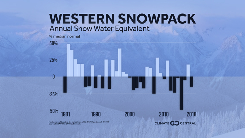
Western spring snowpack has been below normal six of the past seven years, meaning less water during the traditionally dry summer months. Graphic credit: Climate Central
A group of community stakeholders traveled part way up Mount Elbert last Wednesday to evaluate the logistics of installing a head gate and flume on Corske Creek.
The group, which included representatives from the Lake County Board of County Commissioners and Public Works, Parkville Water District, the United States Forest Service, United States Fish and Wildlife Service, Colorado Department of Public Health and Environment and the City of Aurora, examined potential sites for the flume, as well as environmental impacts.
In January 2017, the Colorado Division Two Water Court approved Lake County’s augmentation plan after approximately six years in water court.
The court decision granted Lake County administrative use of 34-acre-feet of consumptive use water, stemming from the water right associated with Derry Ditch No. 3.
Additionally, the augmentation plan changed the water’s use from solely agricultural to also allow for commercial and residential uses.
In order to start storing and leasing the 34-acre-feet of water, Lake County must measure and report the amount of water physically flowing through the area. To do so, the county must construct a head gate and flume on the creek.
Last Wednesday’s outing clarified that installation of a flume will have to wait until at least next summer.
Obtaining a permit for the installation of the flume would take between six to 18 months, representatives from the USFS said.
Depending on the location of the infrastructure, wetland and beaver habitat disruption are also potential concerns.
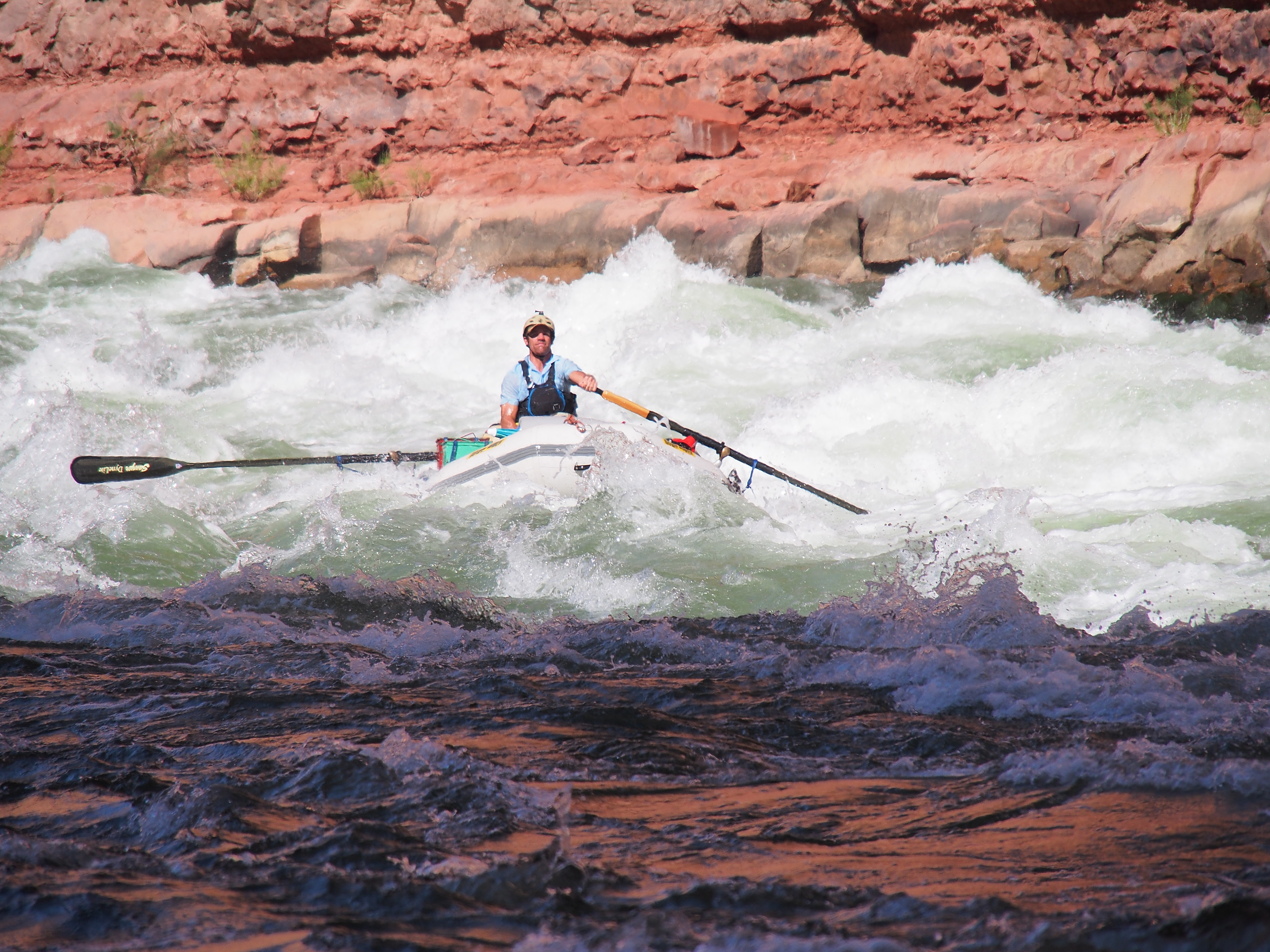
Sean, recreating, on the Colorado River. Photo: via Aspen Journalism
From the Water Education Foundation (Gary Pitzer):
It’s high-stakes time in Arizona. The state that depends on the Colorado River to help supply its cities and farms — and is first in line to absorb a shortage — is seeking a unified plan for water supply management to join its Lower Basin neighbors, California and Nevada, in a coordinated plan to preserve water levels in Lake Mead before they run too low.
If the lake’s elevation falls below 1,075 feet above sea level, the secretary of the Interior would declare a shortage and Arizona’s deliveries of Colorado River water would be reduced by 320,000 acre-feet. Arizona says that’s enough to serve about 1 million households in one year.
The task of charting a path around shortage hasn’t been easy. The state’s main water agencies — the Central Arizona Water Conservation District (CAWCD), which runs the Central Arizona Project, and the statewide Arizona Department of Water Resources — have been unable to reach an accord regarding who should speak for Arizona before committing to a proposed Lower Basin Drought Contingency Plan (DCP). Their standoff — and particularly the Central Arizona district’s management of Colorado River water — has resulted in bruised relations between Arizona and Upper Colorado River Basin states — Colorado, Utah, New Mexico and Wyoming.
Still, there is an increased sense of urgency to get something done, with a record-low snowpack contributing to the driest 19-year period on record. A meager runoff this year from the Rocky Mountains into Lake Powell — the Upper Basin’s key reservoir — is expected to be 42 percent of the long-term average.
“It’s very important for us to start thinking about, what do we need to do to protect Lake Mead and to protect the water users?” Brenda Burman, commissioner of the Bureau of Reclamation, told the Imperial Irrigation District board May 22. “We need to be talking about what does a drought contingency plan in the Lower Basin look like? And we need action. We need action this year. If you take one message from what I’m saying today, it’s that we face an overwhelming risk on the system, and the time for action is now.”
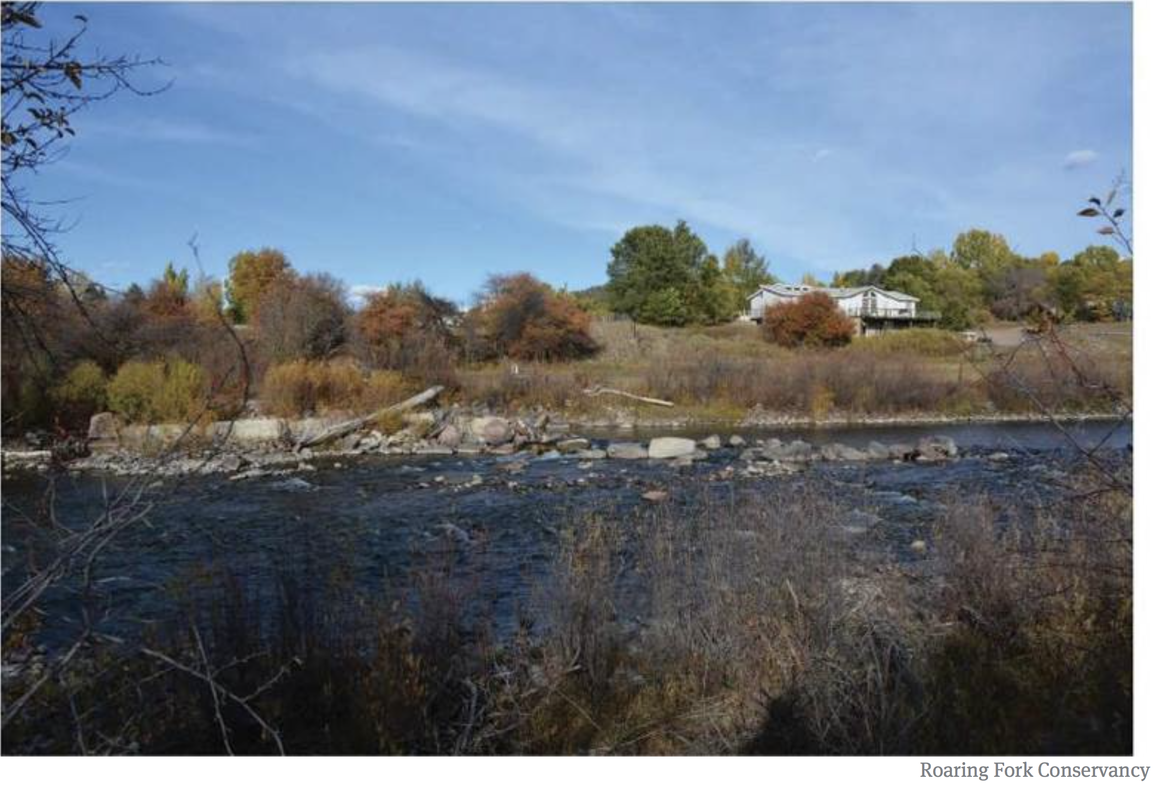
The Weaver Ditch as it winds through Sopris Park in Carbondale. While the ditch is an amenity for the community, the water in the ditch comes directly out of the Crystal River, which is often stressed from lack of water.
A project funded by Pitkin County aims to keep more water in the Crystal River by improving the efficiency of Carbondale’s Weaver Ditch.
The Weaver Ditch Existing Conditions Assessment will survey the roughly three miles of ditch that flow through downtown Carbondale from its diversion point at the headgate just west of state Highway 133 near South Crystal Bridge Drive to its confluence with the Roaring Fork River.
From the survey will come a detailed engineering plan to pinpoint where improvements could increase efficiency, delivery and use of the irrigation water. Four gauges will be installed in the ditch to help measure and understand the flow pattern.
The Weaver Ditch (also known as the Weaver and Leonhardy Ditch) is mostly used for raw water irrigation of Carbondale’s open space, parks, golf courses, schoolyards and residents’ yards. The Weaver Ditch runs through Carbondale and Sopris Park, and residents can use it to water their lawns and gardens for free.
Built over a century ago, the open (unpiped) and unlined Weaver Ditch could potentially be leaking water into the surrounding soil in some areas.
“Most of these ditches are pretty old, and the folks get in there and they clean them out and they do everything they can with them with the resources they have, but they were built and designed and created basically with the technology from the 19th century,” Ken Neubecker told the audience at a May 31 State of the River meeting in Carbondale.
Neubecker is associate director of the Colorado Basin Program for American Rivers and a Pitkin County Healthy Rivers and Streams board member.
The Weaver Ditch diversion structure, known as a ‘push-up dam,’ will be upgraded as part of the Weaver Ditch Efficiency Project. A conditions assessment this fall will survey the three miles of ditch that run through Carbondale.
Town rights
Carbondale has three water rights that allow it to divert water from the Crystal River into the Weaver Ditch, a total decreed use of 12.36 cubic feet per second. The oldest of these rights dates back to 1885.
According to Carbondale Utilities Director Mark O’Meara, the town diverts on average about 3.5 cfs from the Weaver Ditch during the irrigation season and has not diverted its full decreed amount in quite some time.
Part of the reason, O’Meara said, is because there often isn’t enough water in the Crystal River, especially during the late summer irrigation season, for the town to divert its full decreed amount.
The survey is a collaboration between the town of Carbondale, the Roaring Fork Conservancy and American Rivers. Pitkin County commissioners approved $30,000 in funding for the project from the county’s Healthy Rivers and Streams Fund at a May 8 work session.
The survey has a total cost of $40,000 and work is slated to begin this fall once the ditch has been turned off for the season. The remaining $10,000 in funding will come from private donors, according to Heather Tattersall Lewin, watershed action director at the Roaring Fork Conservancy.
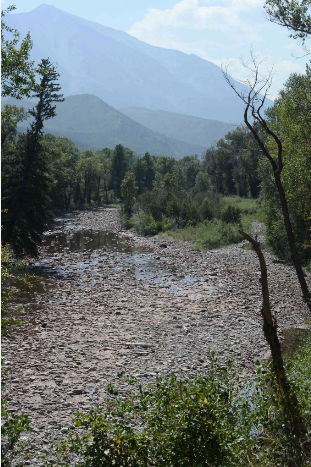
In the hot, parched summer of 2012, the Crystal River south of Carbondale was reduced to a trickle. Photo/Ken Neubecker via The Mountain Town News.
By example
Besides leaving more water in the river, another goal of the project is to serve as an example for other upstream irrigators on the Crystal, especially those who might be reluctant to participate in a ditch survey.
“This is a pilot project within the town,” Neubecker said. “Hopefully it’s something that we will be able to expand with the other ditches in the town, the ranch irrigators and other people around the Crystal and Roaring Fork valleys and get this to work.”
Not having enough water in the lower Crystal River has been a concern in recent years. The 2012 drought left a section of the Crystal between Thompson Creek and the state fish hatchery dry during the late summer irrigation season.
Leaving more water in the lower Crystal River — an additional 10 to 25 cfs during times of moderate drought — is a goal of the 2016 Crystal River Management Plan.
To accomplish this, the plan calls on the town of Carbondale to line its leaky irrigation ditches. It also suggests creating non-diversion agreements, or paying irrigators to reduce their diversions, and helping them improve ditches and install sprinkler systems.
According to the Crystal River Management Plan, converting an earthen ditch to a concrete ditch or pipeline conserves as much as 30 percent of diverted water because it reduces water loss to seepage and evaporation.
The Colorado Water Conservation Board holds a junior instream flow right of 100 cfs in summer and 60 cfs in winter, which is currently the only permanent mechanism in place to ensure there is water for ecological purposes. But during times of drought, the instream flow right is often not met due to the board’s junior status to most other diverters under Colorado water law.
The Weaver Ditch is downstream from where the worst dewatering takes place. But Lewin Tattersall hopes the Carbondale project will inspire upstream diverters to survey their own ditches.
“We know there are places upstream where efficiencies could be beneficial and having the town of Carbondale demonstrate that they bought into the process and be an example is great because anywhere on that lower Crystal River could use more water,” Tattersall Lewin said.
Fix the headgate
The Weaver Ditch also will see its headgate and diversion structure improved as part of the Crystal River Restoration and Weaver Ditch Efficiency Project. In March, the board approved $20,700 in funding for the project.
Currently, town staff adjusts the headgate manually, depending on demand, rainstorms and other factors. But the goal, O’Meara said, is for the system that opens and closes the headgate to eventually become telemetry-based and automated.
“It’s a demand-based system that can automatically make adjustments so that you aren’t wasting water,” O’Meara said. “We are constantly looking at areas where we can improve on the ditches.”
Ultimately, the Weaver Ditch survey is a first step toward addressing the potential of a future with less water. As climate change raises temperatures, that could mean longer growing seasons for crops and a greater demand for more water.
“Overall, the need for water is going to grow,” Neubecker said. “It’s going to come down to how efficiently can you use your water.”
Editor’s note: Aspen Journalism is collaborating with The Aspen Times, the Glenwood Springs Post Independent, the Vail Daily and the Summit Daily News on the coverage of rivers and water. The Times published this story on Saturday, June 16, 2018.
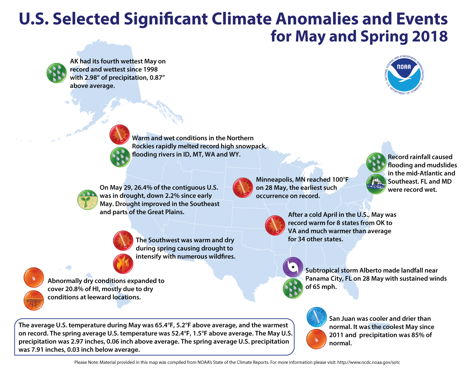
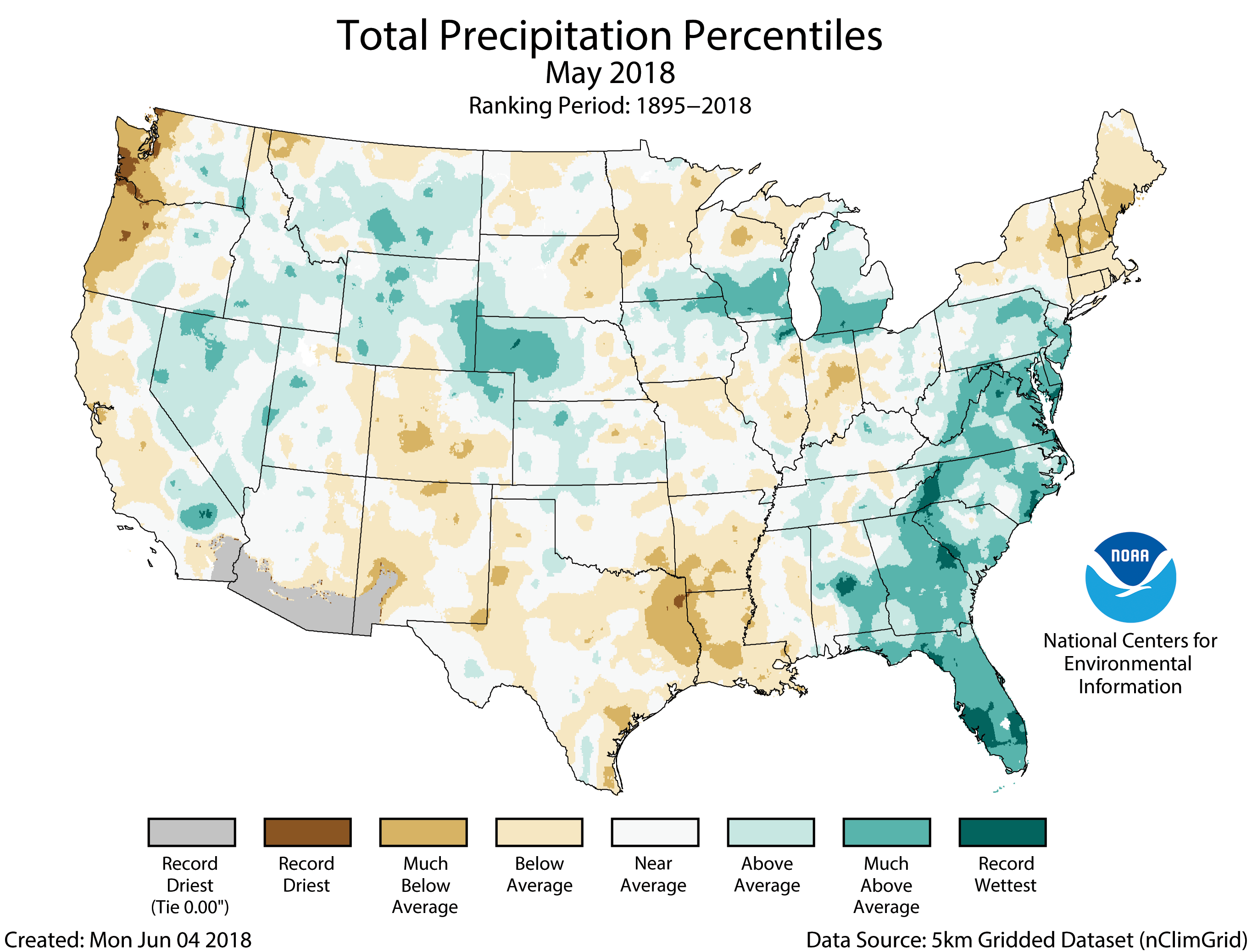
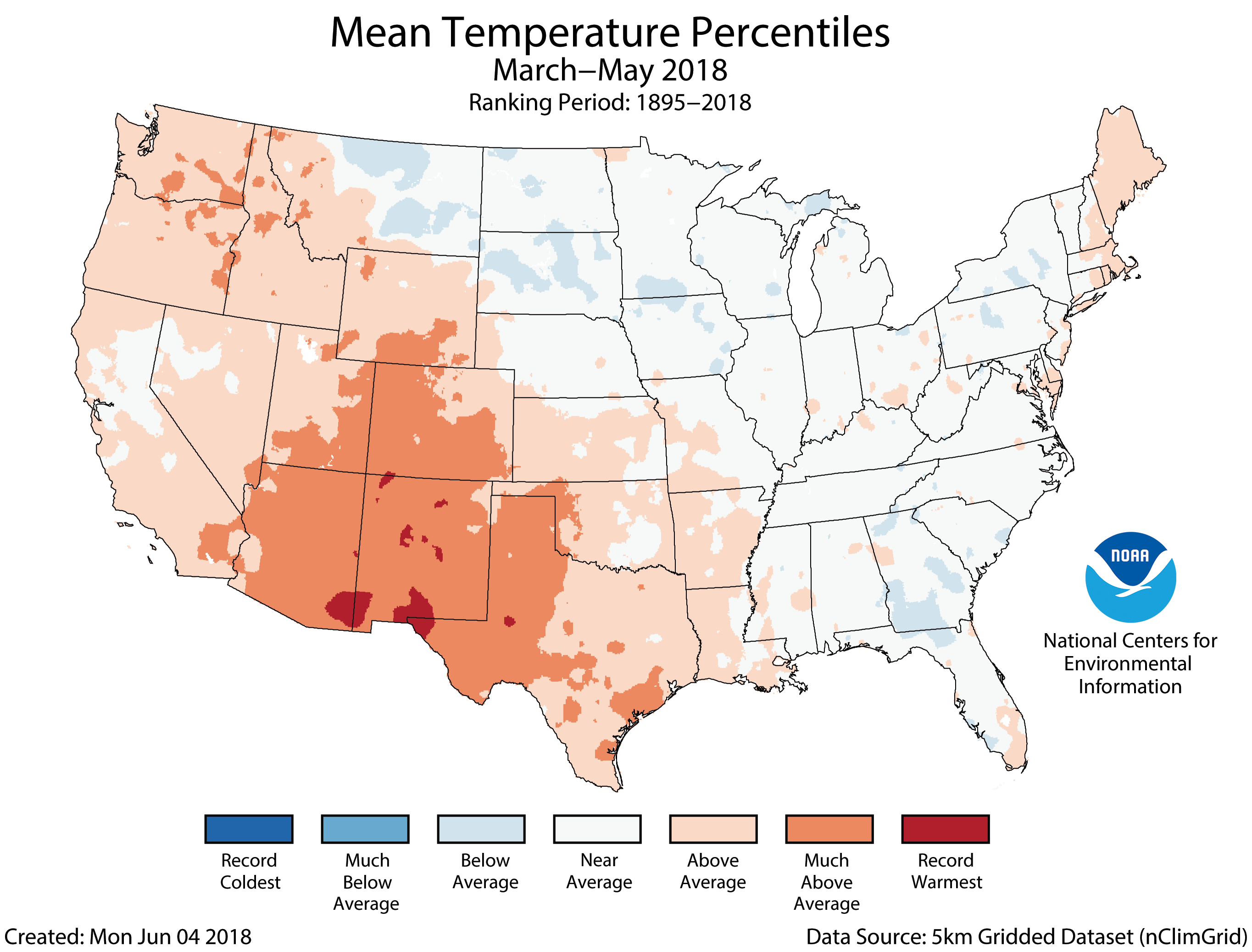
For May, the average contiguous U.S. temperature was 65.4°F, 5.2°F above the 20th century average. This surpassed the previous May record of 64.7°F set in 1934. During meteorological spring (March-May), the warm May more than balanced the cold April. The seasonally averaged temperature for the Lower 48 was 52.4°F, 1.5°F above average and ranked as the 22nd warmest spring on record. The first five months of 2018 were marked by large month-to-month swings in temperature, but when averaged, the contiguous U.S. temperature was 45.0°F, 1.6°F above the 20th century average and was the 21st warmest January-May on record.
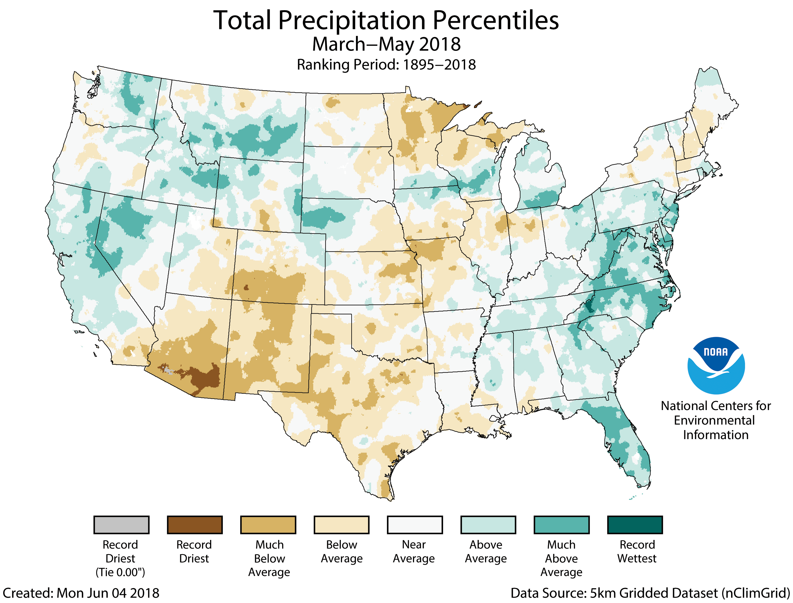
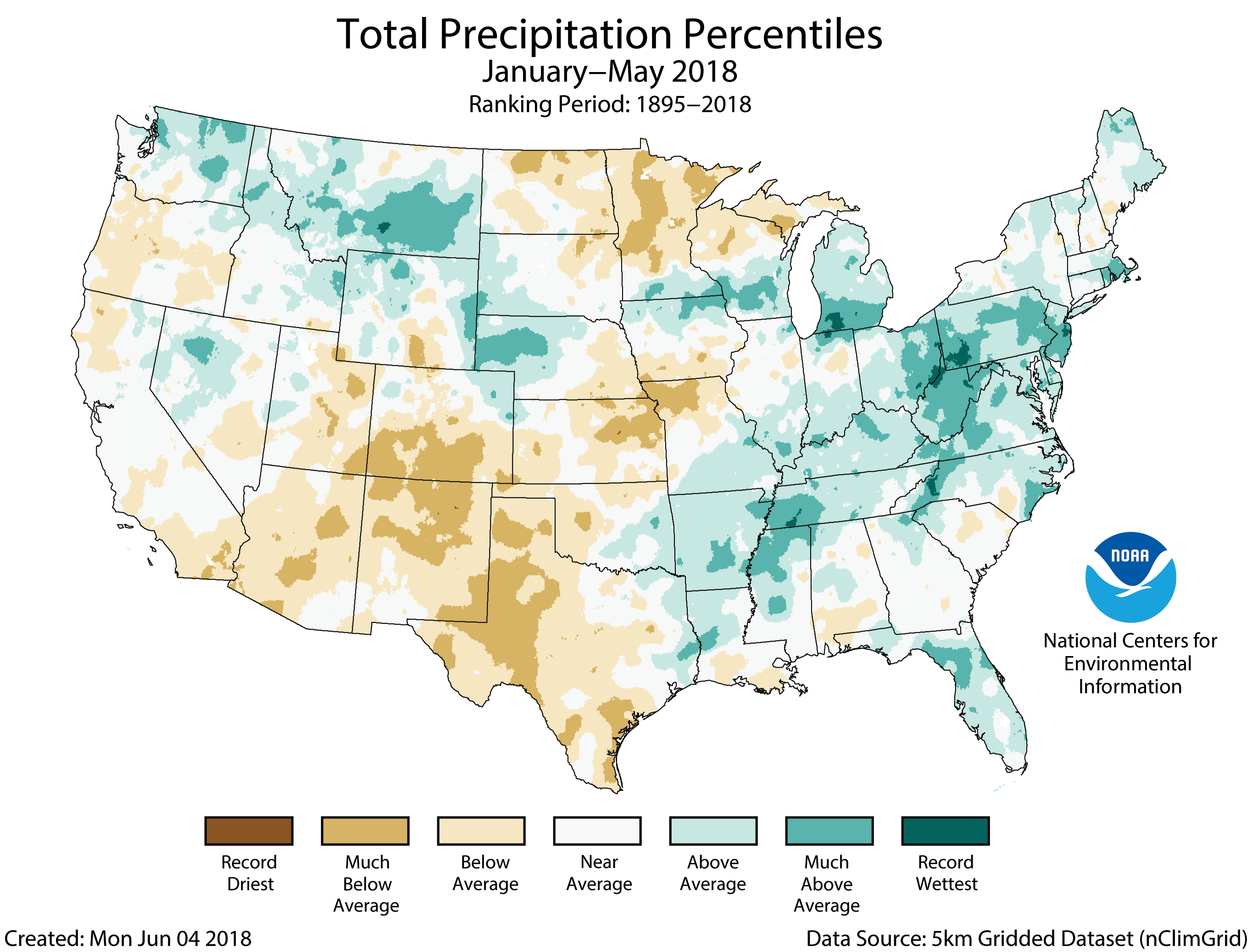
The May precipitation total for the contiguous U.S. was 2.97 inches, 0.06 inch above average, and ranked near the middle of the 124-year period of record. Subtropical storm Alberto made landfall along the Florida panhandle, bringing heavy rain to the Southeast. Both the spring and year-to-date precipitation totals for the contiguous U.S. were near average but masked regional extremes. The spring precipitation total was 7.91 inches, slightly below average, while the year-to-date precipitation total was 12.66 inches, 0.27 inch above average.
This monthly summary from NOAA’s National Centers for Environmental Information is part of the suite of climate services NOAA provides to government, business, academia and the public to support informed decision-making.
May Temperature
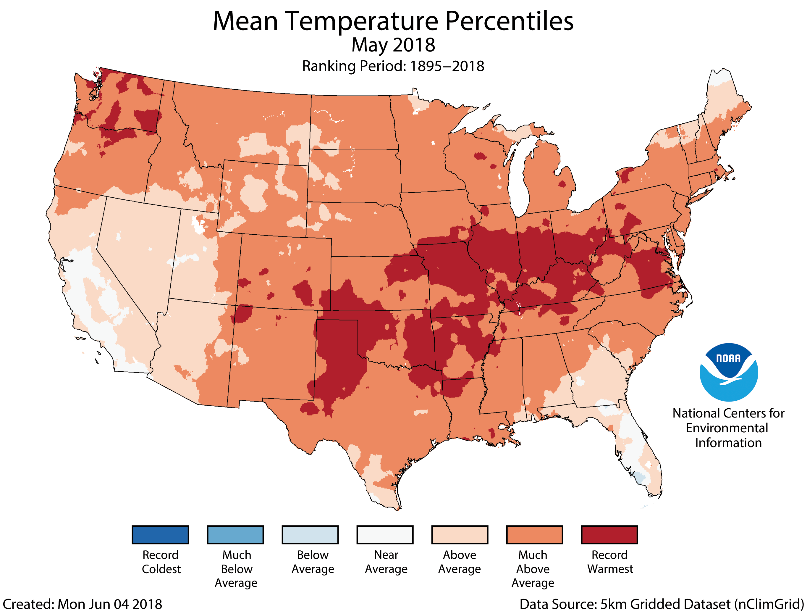
Above-average May temperatures stretched from coast to coast with every state having an above-average temperature. Record warmth was observed in parts of the Northwest and stretching from the Southern Plains through the Midwest and into the Mid-Atlantic. Forty-two states had monthly temperatures that were much above average with eight of those states – Arkansas, Illinois, Indiana, Kentucky, Missouri, Ohio, Oklahoma and Virginia – being record warm.
The nationally averaged minimum temperature (overnight lows) was exceptionally warm during May at 52.5°F, 5.1°F above average and 2.0°F warmer than the previous record set in 1987. Fourteen states had a May minimum temperature that was record warm with 29 additional states having much-above-average minimum temperatures.
On the daily scale, there were more than 8,590 daily warm temperature station records broken or tied during May. This was 18 times more than the approximately 460 daily cold temperature station records during the month. Several of the daily records were noteworthy, including 100°F on May 28 in Minneapolis, Minnesota – the earliest such occurrence on record.
May Precipitation
Record and near-record precipitation was observed across the Southeast and Mid-Atlantic, partially due to two slow-moving weather systems, including subtropical storm Alberto in late May. Flooding and mudslides were widespread across the region, and Florida and Maryland each had their wettest May on record. On the station level, Asheville, North Carolina, the home of NCEI headquarters, observed its wettest month of any month on record, with 14.68 inches of rain. Several other locations, including Key West, Florida, had their wettest May on record. Above-average precipitation was also observed across parts of the West, Central Plains and Midwest.
Below-average precipitation was observed along the West Coast, Southwest, Southern Plains, the Northeast and parts of the Midwest. The combination of warm and dry conditions contributed to ongoing drought concerns across these regions.
After observing record-high spring snowpack across the interior Northwest and Northern Rockies, above-average May temperatures and precipitation caused rapid snowmelt, flooding rivers across the region. Flooding was observed in parts of Idaho, Montana, Washington and Wyoming.
According to the May 29 U.S. Drought Monitor report, 26.4 percent of the contiguous U.S. was in drought, down from 28.6 percent at the beginning of May. Drought conditions improved in the Southeast and parts of the Plains. Drought conditions intensified and expanded in parts of the Southwest, interior Northwest, Southern Plains and Northern Plains. Abnormally dry conditions developed across leeward locations on the Hawaiian Islands.
Spring (March–May) Temperature
Above-average temperatures were observed across parts of New England and from the West Coast to the Southern Plains. Four states in the Southwest and Southern Plains had one of their 10 warmest springs on record.
Across much of the East, the warm May counterbalanced the cold April, resulting in a near-average spring temperature. In the Great Plains and Midwest, the temperature jump from April to May was stark. For example, Wisconsin had its coldest April on record, followed by its second warmest May, with a month-to-month temperature increase of 28.6°F.
Spring (March–May) Precipitation
Year-to-Date (January–May) Temperature
The year-to-date has been marked by large swings in temperatures, particularly from the Great Plains to East Coast. When averaged for the first five months of the year, much of the West, Southern Plains and East Coast were warmer than average. Eight states had a year-to-date temperature that was much above average. Near- to below-average temperatures were observed across the Northern and Central Plains and Midwest.
The Alaska year-to-date temperature was 20.7°F, 4.9°F above average, ranking as the ninth warmest on record. Much-above-average temperatures were observed across western and northern Alaska with record warmth along parts of the Aleutians. The record low sea ice for parts of the year in the Bering and Chukchi seas likely contributed to the Alaskan warmth. Southern parts of Alaska had a near-average year-to-date temperature.
Year-to-Date (January–May) Precipitation
Much of the eastern U.S. was wetter than average for the first five months of the year, with much-above-average precipitation across parts of the Midwest, Mid-Atlantic and Northeast. Pennsylvania, New Jersey, Rhode Island and West Virginia each had a top ten wet January-May. Above-average precipitation was also observed across parts of the Northern Rockies and Plains, which fell mostly as snow earlier in 2018. Below-average precipitation was observed across much of the Southwest, Great Plains and Upper Midwest.
This month’s State of the Climate report includes an annual update of the state of coastal high tide flooding. This type of flooding occurs when water levels measured at NOAA tide gauges exceed heights based on national flooding thresholds released in February by NOAA’s Center for Operational Oceanographic Products and Services. During the 2017 meteorological year (May 2017-April 2018), the U.S. average number of high tide flooding days was the highest measured at 98 NOAA tide gauges. More than a quarter of the coastal locations tied or broke their individual records for high tide flood days. Additional information is available in the 2017 High Tide Flooding Report.
River shimmer, on the Yampa River. Photo: Brent Gardner-Smith/Aspen Journalism
If you are concerned with the lack of action on the environment make sure to put Mother Nature at the top of your list of issues in the primary election.
In a presentation on May 22 before the board of the nation’s largest irrigation district, the Imperial Irrigation District of southern California, the newly appointed commissioner of the federal Bureau of Reclamation spoke candidly about her concerns for the integrity of the Colorado River system.
“As commissioner, I am here to tell you that we absolutely need more action on the Colorado River,” said Bureau Commission Brenda Burman. “The risk we are facing right now is too great.”
In an address that drew extensive coverage by California media, Burman strongly urged the IID board – and, by extension, all seven Colorado Rivers system states – to take action “this year” on drought contingency plans to reduce the risk that Lake Mead may fall below tolerable levels.
At just 39 percent full, Lake Mead is expected to end 2018 just a foot or so above levels that would trigger delivery cutbacks. Earlier this month, the Bureau of Reclamation projected a 52 percent chance that in 2020 the reservoir would fall below shortage trigger levels.
“We can take our fate in our own hands,” said Burman.
“There are ways to buy down this risk. To invest. To create insurance policies, if you will.
“We have been calling those (policies) ‘drought contingency plans.’ The Upper Basin states have been working on a Drought Contingency Plan. The Lower Basin states for several years have been working on a Drought Contingency Plan. Those talks have sort of fallen off.
“I am here to say for (Interior Secretary Ryan Zinke), for this Administration, that those talks need to be starting again. We need action. We need action this year.”
Assisting the Commissioner in her presentation was Terry Fulp, the Regional Director of the Bureau’s Lower Colorado Region.
In a slide presentation, Fulp illustrated how the nearly two-decade Southwestern drought has withered water volumes in the Colorado River system, as well as how recent efforts to retain water in Lake Mead have helped stabilize the reservoir, adding nearly 20 feet to its water levels since 2007.
Graphic credit: Terry Fulp/USBR
Arizona water users — including the Central Arizona Water Conservation District and the Gila River Indian Community, among several others – have contributed significantly to those stabilization efforts.
“We have to do more,” said Fulp. “More conservation. More saving.”
Burman’s candid assessment before the IID board mirrored her Bureau’s strongly worded statement, released on May 9, that called for both state and federal action on behalf of the Colorado River basin following the notoriously dry winter of 2017-2018.
Unregulated flow from the Colorado River watershed into Lake Powell this year stands at just 52 percent of average, based on 1981-2010 recorded in-flow records.
“We all – states, tribes, water districts, non-governmental organizations – have an obligation and responsibility to work together to meet the needs of over 40 million people who depend on reliable water and power from the Colorado River,” said Burman in the May 9 press statement.
“I’m calling on the Colorado River basin states to put real – and effective – drought contingency plans in place before the end of this year.”
The 416 Fire ten miles north of Durango in southwestern Colorado continues to burn out of control, and the National Wildfire Coordinating Group, which is overseeing efforts to snuff it out, predicts that total containment won’t be achieved until July 31. Moreover, an expert on water throughout this part of the country feels the conditions that have helped fuel this blaze and others in the state (such as the Buffalo Mountain Fire near Silverthorne) could be with us for the foreseeable future.
“We’ve been at one phase of a drought or another over the past seventeen or eighteen years,” notes Bart Miller of Boulder-based Western Resource Advocates. “And many scientists say we’re at a new normal as far as snowpack and drought conditions [go].”
As the director of the Healthy Rivers program for WRA, Miller stresses that fire danger is only one side effect of water shortages in Colorado — a reality exemplified by the early peak of the Colorado River this season.
“Some of the related impacts of when rivers reach their peak are things like low flows and temperature in the water,” he points out. “Low flows usually mean higher temperatures, and that means more stress on fish. Anglers are concerned about what things like that will mean at the end of the summer, when the flows are even lower. And low flows also make it harder for communities to meet their water-quality requirements. If you’re discharging water from a water treatment plant, high flows are good, because they dilute what’s coming out of these facilities. And, of course, higher temperatures and drier soils mean a much more increased chance of fire danger.”
For most communities, Miller acknowledges, “a drier year is not that big of a deal. Many communities have ground water and water storage that can make up for it.” But that’s not the situation in which Colorado and much of the West currently finds itself, as indicated by what’s going on at Lake Powell, which Miller describes as “a storage bucket for the upper Colorado River basin.” As of this week, the Lake Powell Water Database notes that the water level is down 13.69 feet from this time a year ago and is just 53.26 percent of what’s known as “full pool.”
Such scenarios have been all too common in recent decades. The following graphic shows that water levels at Lake Powell have been below average in twelve of the past twenty years.
According to Miller, such figures are even more dire than they seem at first blush.
“When people look at flows or snowpack as compared to average, they usually use the most recent thirty-year average,” he says. “But because the last seventeen or eighteen years or so have mostly been below average, that thirty-year average has dropped. What used to be average is now a lower marker, so the point of measurement is even lower. Something that’s 90 percent of average now used to be 80 or 85 percent of average.”
[…]
Miller offers the following example to illustrate the challenges: “Think about stream regions that have temperature issues, where temperatures get too high for some fish species to exist or that stress the species. As river flow drops, they have to spend more of their time in small pools. So some of the stakeholder groups have tried to figure out if there are things we can do by providing more shade — planting vegetation that will keep the temperatures lower. But the costs are very high. It could be a million dollars a river mile to address these issues on a meaningful scale, and Colorado has thousands upon thousands of river miles. Clearly, we’ve got a big project ahead of us.”
[…]
“Water is the most essential element in Colorado,” he says. “It’s important that we figure out how to secure our future, and that means putting resources toward it: money, people and energy.”
FromThe Glenwood Springs Post Independent (Megan Webber):
Colorado, Utah, Wyoming and northern New Mexico are known as the upper-basin states, nourished by the water from the upper half of the Colorado River before it reaches Lake Powell.
The Colorado River District and other water-conscious groups in the upper-basin states are hoping to formulate a drought contingency plan to sustain Lake Powell. They are looking at three possible solutions.
The first involves releasing water from Flaming Gorge Reservoir, Blue Mesa Reservoir and Navajo Reservoir into Lake Powell, which would keep the levels up for up to two dry years.
If the drought were to last longer than two years after 2018, non-native vegetation could be removed from the river beds to let more water into the river system.
“I would say that the science there is mixed,” [Andy] Mueller said. “It’s not clear that it won’t work, so we’re still doing it, but we need better signs.”
The third possibility involves monitoring the amount of water actively consumed by Colorado and the other three upper-basin states. The extra water would be saved in Lake Powell as insurance for not only the upper-basin states, but also for lower-basin states and Mexico, should the need arise. City water can also be recycled for agriculture and recreation.
The River District is also committed to preserving the aesthetically pleasing areas of Colorado for agricultural and recreational purposes, Mueller said.
In order to preserve the beauty, reduced demand is once again necessary from all over the state. The Front Range sees 450,000 to 600,000 acre feet of water flow through it every year, which feeds cities and fields in eastern Colorado.
“And we feel like they should share the pain, if you will, that they should also reduce their uses over there. If we’re gonna be asked to, they should. Our cities should reduce their use through land-use controls,” Mueller said.
Locally, the Colorado River east of Glenwood Canyon was declared unboatable last weekend.
The Colorado River below the Roaring Fork River confluence dipped below 4,000 cubic feet per second this week, and hovered around 3,200 to 3,400 cfs on Thursday. That’s well below the historical 50-year mean of around 10,300 cfs for this week of June.
In this extremely low spring runoff season, the Colorado at Glenwood Springs at Two Rivers Park peaked at less than 7,000 cfs back in mid-May.
As temperatures rise upstream on the Roaring Fork River in Aspen and Basalt, particularly in July and August, the Parks and Wildlife Commission may prohibit fishing in the area due to overheated waters, which will endanger the fish.
Shoshone Power Plant in Glenwood Canyon is expected to release water on June 20, which will sustain boatable flows throughout Glenwood Springs for the rest of the summer, Mueller said.
Extreme conditions have been expanding northward for several weeks and entered southwest Kiowa county recently. With the latest report, the southern two-thirds of the county moved into extreme drought. The north central part of the county briefly improved to moderate drought but returned to severe conditions this week. Extreme drought also expanded to cover the remainder of Prowers county, and expanded slightly in northeast Crowley county.
Across the rest of the state, conditions were stable. Northeast and north central Colorado have benefitted from spring storms and remained drought-free, while the northwest continues abnormally dry to moderate drought conditions.
The southern one-third of the state remains in extreme to exceptional drought, which has triggered disaster designations by the United States department of Agriculture and Small Business Administration. Assistance to agriculture producers and businesses dependent upon ag is available for a limited time. Assistance is also available to producers impacted by earlier fires, high wind and blizzard conditions.
Overall, 25 percent of the state is drought-free, unchanged from the prior week. Abnormally dry conditions were also unchanged at 11 and 13 percent, respectively. Moderate drought dropped to 16 percent from 17 last week, while extreme drought was up one percent to 27. Exceptional drought was unchanged at eight percent.
One year ago, 94 percent of the state was drought-free, while six percent was abnormally dry.
Rio Grande Silvery Minnow via Wikipedia
FromThe New Mexico Political Report (Laura Paskus):
The Rio Grande has been running far below normal this spring due to drier-than-normal conditions in the mountains this winter. About 20 miles of the river are currently dry south of Albuquerque.
This week, [Middle Rio Grande Conservancy District] told Water Bank participants they can no longer irrigate this spring.
The MRGCD delivers water to about 10,000 irrigators across 70,000 acres between Cochiti dam and Elephant Butte Reservoir. Those irrigators own the water rights and it’s the district’s job to deliver the water through a system of canals and ditches.
The district had also set up a Water Bank so that landowners who sold their pre-1907 water rights could still irrigate their lands when surplus water is available in the system. But when the amount of water stored by the district in upstream reservoirs dipped below a critical threshold last weekend, Water Bank participants were informed deliveries would stop.
Hydrologist David Gensler told MRGCD board members at their regular meeting Monday that the district currently has 92,500 acre feet of water in storage.
“We’re going through our water pretty quickly this spring,” Gensler said, though he noted that they’re ahead of where they thought they’d be due to planning earlier in the year.
“Generally, people are doing all right,” he said, though irrigators might be receiving somewhat less water than they’d like. The best news, he said, is that the forecast for summer monsoons still looks “pretty good.”
MRGCD board member Glen Duggins, an irrigator in Lemitar, followed up Gensler’s comments: “Pray for rain and bale your hay.”
MRGCD Chief Engineer Mike Hamman reported to the board that a coalition—including the district, two federal agencies and the Middle Rio Grande pueblos—agreed to store and move water owned by the pueblos in a way that also ensures the district’s water lasts as long as it can this year. “It’s important that whatever water supply we have, to stretch it out,” Hamman said. He added that this agreement, which he said meets the pueblos’ needs and the irrigation district’s demands, is just for one year…
Rain and supplemental water
Despite “grim discussions” around snowmelt, runoff and the drying river, Jennifer Faler, Albuquerque area manager of the U.S. Bureau Reclamation, told board members that recent rains and agency operations have produced a bounty of silvery minnow eggs this spring. “I just want to remind people that the population can get very, very small, or very, very big in one year,” she said.
Spokeswoman Mary Carlson provided additional information.
Reclamation has already released 8,748 acre-feet of supplemental water for endangered species so far this year. She said the minnows appear to have “responded favorably” to the operational pulses of water by MRGCD and the Albuquerque-Bernalillo County Water Utility Authority, and U.S. Fish and Wildlife Service biologists have been able to collect more than 100,000 eggs to be raised in hatcheries.
“There is no immediate threat of drying in the Albuquerque reach and all water management entities continue to coordinate closely to make every effort to avoid this for as long as possible,” Carlson said. “We are pleased to see more rain in the forecast for this week.”
FromThe Grand Junction Daily Sentinel (Dennis Webb, Erin McIntyre and Wyatt Hurt):
Garfield County commissioners on Monday approved an immediate ban on use of fireworks in the unincorporated part of the county, and Garfield sheriff emergency manager Chris Bornholdt told commissioners the Sheriff’s Office is thinking about imposing Stage 2 fire restrictions as well, which prohibits fireworks, campfires or any open burning of any kind. Smoking outdoors is also outlawed unless it’s in an enclosed vehicle or building.
Ouray County on Monday imposed Stage 2 restrictions, and the Bureau of Land Management likewise has done so for the San Juan County portion of the Gunnison Field Office. Lesser Stage 1 restrictions already in place across much of the region allow fires in designated fire grates in developed campgrounds…
He cited “beyond exceptional” drought conditions in the region, while Bornholdt pointed to four major fires currently burning in the state, including ones in Eagle County and the Durango area.
Meanwhile, the U.S. Forest Service said it would bar most entry to the 1.8 million-acre San Juan National Forest starting today in an effort to keep fires from being ignited due to campfires or other causes there. The forest stretches across southwestern Colorado from just north of Durango to Ouray, and includes the area of the 416 and Burro wildfires that have burned more than 22,000 acres since June 1. The ban doesn’t impact U.S. highways or state or county roads that cross the forest.
While it’s more common for national forests in Arizona and New Mexico to close for fire danger, it’s unusual for this to happen in Colorado, according to Cam Hooley, acting public affairs officer for the San Juan National Forest…
The county’s fireworks ban does not include a ban on sales, whereas such bans have been enacted by Mesa County at the county level and by municipalities. The city of Rifle’s municipal code has a standing open-burn ban from Memorial Day to Labor Day that includes a ban on fireworks sales, possession or use.
Garfield commissioners had imposed a temporary ban on fireworks sales and use in 2013 before agreeing to provide a one-week exemption to the sales portion of the ban around July 4 of that year after a plea from a longtime seasonal fireworks vendor.
Meanwhile, July 4 fireworks shows in Ouray, Glenwood Springs and the New Castle area have been canceled due to the fire danger. Glenwood Springs is planning a laser show instead after the city’s fire chief, Gary Tillotson, urged cancellation of the fireworks show there due to the danger it posed.
Rochelle Firth, office manager for Apple Tree Mobile Home Park, which puts on the annual fireworks show near New Castle, said this year’s show could end up proceeding if drenching rains come before July 4, but she added, “I don’t see that happening.”
[…]
The town of Parachute hasn’t done a fireworks show in the summer for years because of the fire danger, said Town Manager Stuart McArthur. Instead, it puts on a show in the last week in September…
Based on recommendations from the BLM and the Mesa County Sheriff’s Office, Lower Valley Fire Chief Frank Cavaliere said he has recommended to the city of Fruita that it call off its annual July 3 show at Snooks Bottom Open Space…
The decision rests with the Fruita Parks and Recreation Department. Director Ture Nycum said Monday he expects an announcement by the end of the week. Should city officials cancel the show, they’ll announce an alternative celebration, he said. In the past, they’ve sponsored a community barbecue or hosted events downtown…
De Beque Town Manager Lance Stewart said the town won’t make a decision until a day or two before the holiday…
The town has already purchased the fireworks, which puts them in a difficult spot. In the past, when they’ve had to cancel, they’ve done a New Years’ Eve show instead with the fireworks.
Officials with the cities of Grand Junction, Montrose and Delta and the town of Collbran say they plan to light up the July 4 night sky with professional displays, barring drastic changes.
The San Juan National Forest in southwestern Colorado is closed to visitors on Tuesday because of a large wildfire and dry, warm conditions that raise the risk of further blazes. Forests are also closed in Arizona and New Mexico in areas that are suffering from a severe drought…
Fire risks are at “historic levels,” San Juan National Forest Fire Staff Officer Richard Bustamante said, adding, “Under current conditions, one abandoned campfire or spark could cause a catastrophic wildfire, and we are not willing to take that chance with the natural and cultural resources under our protection and care, or with human life and property.”
The San Juan National Forest makes up some 1.8 million acres across nine counties. The full closure, which the Associated Press reports last took place in 2002, does not affect roads that cross through the forest.
In New Mexico, the Santa Fe National Forest was closed days ago “due to extreme fire danger,” the Forest Service said. The area in and around the forest southwest of Santa Fe has seen a string of fires since April.
Farther south, northeast of Albuquerque, extreme fire danger is also forcing parts of the Cibola National Forest to close to the public starting on Friday, New Mexico fire officials said.
The interim plan concentrates on controlling or removing contaminants at 26 sites including campgrounds, mine waste piles, ponds and rivers. It will cost about $10 million and take up to five years, the agency said.
Five of the locations are recreation sites where people could be exposed to arsenic or lead, the agency said.
“EPA is interested in expediting cleanup so that we can show improvements in water quality wherever possible,” said Christina Progess, manager of the Superfund project…
The Gold King is not on the list of 26 sites chosen for interim work. The EPA said that’s because a temporary treatment plant was installed two months after the spill and is cleaning up wastewater from the mine.
The Superfund cleanup will eventually cover 48 mining sites, but the EPA said it chose 26 for interim work to reduce human and environmental risks while a long-term solution is studied.
The EPA said the 26 sites have elevated levels of aluminum, cadmium, copper, iron, lead or zinc.
Two of the recreation sites on the list are campgrounds and three are parking areas or locations where people meet for tours, the EPA said. The plan calls for covering mine waste piles and contaminated soil with gravel or plant growth to reduce human exposure and keep the contaminants from being kicked into the air.
The other work includes dredging contaminated sediment from streams and from ponds near mine openings, and digging ditches and berms to keep water from flushing contaminants out of waste piles and into streams.
The EPA is seeking public comment on the plan. The deadline for comments is July 16.
Synopsis: ENSO-neutral is favored through Northern Hemisphere summer 2018, with the chance for El Niño increasing to 50% during fall, and ~65% during winter 2018-19.
ENSO-neutral continued during May, as indicated by mostly average sea surface temperatures (SSTs) across the central and eastern equatorial Pacific. The latest weekly Niño indices were between +0.2°C and 0.0°C, except for the Niño-1+2 index, which remained negative (-0.5°C). Positive subsurface temperature anomalies (averaged across 180°-100°W) increased over the past month, as another downwelling equatorial oceanic Kelvin wave reinforced the already above-average subsurface temperatures. Convection remained suppressed near the Date Line and was slightly enhanced over Indonesia. Low-level and upper-level winds were near average across the equatorial Pacific Ocean. Overall, oceanic and atmospheric conditions reflected ENSO-neutral.
The majority of models in the IRI/CPC plume predict ENSO-neutral to continue through the Northern Hemisphere summer 2018, with El Niño most likely thereafter. The forecaster consensus favors the onset of El Niño during the Northern Hemisphere fall, which would then continue through winter. These forecasts are supported by the ongoing build-up of heat within the tropical Pacific Ocean. In summary, ENSO-neutral is favored through Northern Hemisphere summer 2018, with the chance for El Niño increasing to 50% during fall, and ~65% during winter 2018-19 (click CPC/IRI consensus forecast for the chance of each outcome for each 3-month period).
Two separate courts ruled this week that the Environmental Protection Agency (EPA) must enforce regulations that restrict states from emitting pollution that could cross borders into neighboring states.
U.S. district courts in Maryland and New York both ruled separately that EPA was derelict in its duty by not enforcing states to comply with the “Good Neighbor provision” under the Clean Air Act meant to address smog pollution.
The New York court found that EPA failed to meet an August 2017 deadline that would begin the process of enforcing the law throughout states. The court’s judge ruled that EPA must take necessary steps to limit the smog that blows into New York and Connecticut from five surrounding states: Illinois, Pennsylvania, West Virginia, Michigan and Virginia.
The court set a Dec. 8 deadline for compliance.
In Maryland, a similar verdict found that EPA must take a final action by Sept 15.
“The court notes that it does not grant the above extension lightly,” Maryland’s district court wrote in its verdict. “On the contrary, the court is troubled by EPA’s apparent unwillingness or inability to comply with its mandatory statuary duties within the timeline set by Congress.”
An EPA spokesperson said said the agency plans to propose a new action that will address the good neighbor policies in CAA by the end of the month.
“As we have already publicly announced, we intend to propose – by the end of June – and finalize – by December – an action that will address any remaining good neighbor obligations related to the 2008 ozone standard for these and other states,” the EPA said in a statement.
Click here to go to the US Drought Monitor website. Here’s an excerpt:
Summary
Over the last week, dry conditions continued in the Desert Southwest and in parts of the Central Rockies, leading to drought persistence and degradation in these areas. Farther east across the Great Plains, scattered thunderstorms led to some areas improving or staying out of drought, while some areas that missed the rain were degraded. In the Upper Midwest and Northern Plains, precipitation patterns also dictated areas which experienced degrading and improving conditions. Near normal or wetter than normal conditions occurred over most of the eastern United States, where few changes to the USDM depiction were made…
Warm weather occurred over much of the Southern region; the warmest temperatures (6 or more degrees warmer than normal) took place in the Texas Panhandle, western Oklahoma, and the Dallas-Fort Worth Metroplex. Paltry rain amounts for this week combined with high temperatures and long term precipitation deficits added additional stress to the water systems in parts of the Texas Panhandle, leading to the expansion of extreme and exceptional drought conditions. Moderate to heavy rain over the Interstate 35 corridor in Oklahoma and in north-central to west Texas allowed for 1-category improvements in some areas that were experiencing abnormal dryness, moderate drought, severe drought, and extreme drought. Meanwhile, continued dry and hot conditions led to the introduction of extreme drought west of Lubbock and in areas near Corpus Christi where soil moisture deficits and mid to long term precipitation deficits supported degradation. Additionally, extreme drought was expanded in the Del Rio area northeast of the Rio Grande and in a corridor north of Houston and College Station in response to building precipitation deficits in these areas. The drought impact designation in far south Texas was changed from S to SL, indicating that drought conditions are present at both short and long term timescales. Elsewhere in the South, a few areas of abnormal dryness and moderate drought formed or expanded in Louisiana, Mississippi, Arkansas, and eastern Oklahoma that missed out on the moderate to heavy rains in the region…
Significant rainfall fell in parts of the High Plains region, while most of the mountainous areas remained dry. Thunderstorms in northeast Colorado, Nebraska, and northwest and eastern Kansas delivered between 0.5 and 3 inches of rain, helping to prevent additional drying caused by the high temperatures. Similar rainfall totals in southwest Kansas were enough to lessen precipitation deficits and result in an improvement from extreme to severe drought. Aside from the Black Hills, much of the Dakotas saw rainfall amounts over a half inch, with some areas exceeding 2 inches. This rainfall led to the removal of abnormal dryness in some areas west of the Missouri River in South Dakota and far southern North Dakota. Recent rainfall also helped decrease moderate drought in northwest South Dakota, though if recent hot weather and a high atmospheric demand for moisture continues, a reversion back to moderate drought conditions may occur. Severe drought was reduced in coverage in north-central North Dakota, where precipitation deficits over multiple time scales had decreased sufficiently for an improvement. Meanwhile, over the central Rockies, continued warm, dry weather exacerbated longer term precipitation deficits leading to an expansion of drought and abnormal dryness in north-central Colorado and south-central Wyoming…
During the past week, precipitation fell in the mountainous areas of western Washington and Oregon, northern and central Idaho, and parts of western Montana. The highest amounts, with isolated spots in the 2 to 3 inch range, fell in western Washington, western Oregon, southwest Montana, and the southern Idaho Panhandle. Precipitation, some heavier, also fell over the high plains of Montana. Elsewhere across the region, conditions were quite dry, aside from some isolated precipitation south of Tucson. In the drier areas of central Washington and north-central Oregon, abnormal dryness developed as 1 to 2 month precipitation deficits increased. Severe drought crept south in southwest and south-central New Mexico due to increasing short- and medium-term precipitation. Relatively cool conditions occurred in most of central and northern California and in much Oregon and Washington, while above normal temperatures were found in eastern Montana, parts of Idaho, Utah, most of Nevada, and Arizona. The warmest areas, primarily in New Mexico and Utah, had temperatures reach at least 6 degrees above normal for the weekly average, while the coolest areas saw mercury drop 4 to 8 degrees below normal…
Looking Ahead
The National Weather Service medium range forecast calls for two significant areas of wet weather over the next 7 days (June 13 to June 20). Widespread and potentially heavy rainfall is expected to bring 2 to 5 inches of rain to coastal and central Texas and southern Louisiana. Rainfall may also extend into the Southern Plains and the remainder of the Gulf Coast region.
Farther north, showers and thunderstorms are likely from the Northern Rockies to the High Plains and Upper Great Lakes. Rainfall over the northern tier is likely to be locally heavy (3 to 5 inches) creating the potential for isolated flooding. In contrast, dry weather is expected to prevail over the Pacific Coast and the drought inflicted areas of southern California, southern Nevada, and western Utah.
Bicycling the Colorado National Monument, Grand Valley in the distance via Colorado.com
FromThe Grand Junction Daily Sentinel (Charles Ashby):
The district’s three-member board of directors voted 2-1 Tuesday to forego any legal challenge to District Judge Lance Timbreza’s ruling last week, saying there was no guarantee they would prevail in an appeal and they didn’t want to subject district businesses and residents to more legal uncertainty.
As a result, the board said it would refund the $7.2 million it’s collected so far — plus interest — to the 40,000 property owners who have been assessed the tax since 2016, but exactly how that will happen is yet to be determined.
That’s partly because the district has already spent about $2.2 million of the money, and isn’t yet sure how much in interest it is obligated to pay.
The district’s board and staff is to spend the next couple of weeks trying to figure all that out, said district manager Tim Ryan.
First, the district staff has to figure out how much in interest it is obligated to pay, and then — because it doesn’t have the cash to cover the entire refund and interest — how it will do so. That could involve taking out a loan, laying off some workers, declaring bankruptcy of the enterprise fund the district formed to finance the stormwater improvements, or a combination of those options.
Under the state’s Taxpayer’s Bill of Rights, any overcollected tax that isn’t refunded within a year requires a 10 percent interest payment along with it, Ryan said.
“The ruling was (the fee) exceeded TABOR, and that it’s an extra tax, so those who paid it are entitled to what they paid plus 10 percent,” he said. “It’s no longer a fee, that’s the conundrum. Now we have to go back to 2016 and 2017. Those are the years that require interest because we’ve held their money for over a year. Everybody else will get their refunds within a year.”
While board member Mary Brophy was adamantly opposed to appealing the decision, and Jim Grisier cast the lone dissenting vote against not going ahead with one, board chairman Cody Davis stood somewhere in the middle.
While he ultimately cast the deciding vote not to appeal, Davis said part of him wanted to because there are aspects to Timbreza’s ruling that he saw as incomplete. The judge ruled that unlike fees charged in other jurisdictions that were for specific purposes, such as Aspen’s grocery bag fee, this fee was for a core function of the district’s mission, to handle drainage needs.
MARRIAGE OF DATA AND WATER LAY THE FOUNDATION FOR TOMORROW’S SMARTER CITIES
The water industry has reached a turning point. Utilities are finally recognizing the power in digitizing operations and increasing economies of scale to extend asset life and address legacy funding issues. As the industry focuses more on sustainability, value and innovation, a new water economy appears to be emerging: Utilities are embracing data and infrastructure in
new ways to maximize efficiencies.
The reality conveyed throughout the 2018 Strategic Directions: Water Report is that capital costs will continue to rise as infrastructure ages well beyond end-of-life expectations and regulatory uncertainty increases. Skepticism about a proposed federal infrastructure plan adds additional complexity to questions about who will pay for vital repairs and upgrades. Calls to prepare for climate change and build resilience against extreme weather events also are stretching already thin budgets. However, water industry leaders in the United States and abroad are now innovating at an unprecedented pace, reinventing how technology is used to solve industry challenges.
The water industry’s digital evolution continues to be linked to conversations regarding sustainability, as maintaining or expanding asset life again was chosen as the most significant sustainability issue for utilities. As we see throughout this report, utilities are examining how data analytics can inform smarter operations and maintenance decisions and they are integrating these programs in their capital planning. Technology also is helping utilities communicate more effectively within their workforces and to their ratepayer and stakeholders, as well as within their infrastructure systems.
This year’s report explores how data are supporting innovations in alternative water supply, smart water solutions and case studies from state-of-the-art water infrastructure projects from around the world.
After a very dry winter and spring, Arizona is desperate for any moisture to help relieve some of the extreme drought.
There are indicators that Arizona could experience a wetter than normal summer, but there’s still a question mark because several weather factors have to come together in the atmosphere for the skies to open up…
While Monsoon is not as helpful as winter rains, the desert and High Country do benefit, says meteorologist, Marvin Percha…
Percha said there are signs Monsoon could start sooner and dump more rain.
“When we have years like this when the winters are dry, that high pressure that normally moves northward, tends to move northward earlier,” Percha said.
When that happens, it draws moisture from the south. Combine that with desert heat and thunderstorms and walls of dust can erupt.
“We get impulses of moisture that move up and it’s difficult to predict when and how much rain they will bring, if and when they do occur,” Percha said.
Another good sign is warmer Eastern Pacific waters for tropical storms.
“[It] gives more moisture and energy to develop so they tend to be stronger,” he said.
Percha said that could mean more Pacific hurricane moisture moving into the southwest, especially during August and September.
July 4 weekend, Percha said, is when Arizona really starts to see Monsoon action across the state and the upcoming weekend appears to be an earlier start.
Meteorologists are also looking to a better than average chance of an El Niño developing, which could bring us more rain in late summer and early fall.
While the odds appear to be in the favor of a busier Monsoon and El Niño, it’s still early.
Cheesman Reservoir is named for Walter S. Cheesman, who helped Denver Water’s predecessor – the privately-owned Denver Union Water Company – build the dam.
“It was completed in 1905, and it really is the beginning of Denver Water’s story, and actually the beginning of Denver itself,” Mahaffey said.
The 221-foot dam, constructed with gray granite from a nearby quarry, was at the time the largest dam in the world. It’s proof they were thinking of water needs long into the future.
Thirteen years later, in 1918, the citizens of Denver voted to purchase the private company running their water, and the utility Denver Water was born.
In 1963, Denver Water built an even larger reservoir in Summit County. They had to relocate the town of Dillon to do so, and the former town site is still below the waters of the reservoir that now bears its name.
To get that water down to the city of Denver, they had to build the Harold D. Roberts tunnel. At 23 miles in length, it was the longest tunnel of its kind.
It took some incredible feats of engineering to lead Denver Water through its first 100 years, and more innovation will be needed to sustain the booming population in the Mile High City into the future.
FromKUNC (luke Runyon, Matt Bloom & Esther Honig):
“Buy and dry” describes a class of water transactions that typically involve a municipality or other local government paying the owner of a farm for some or all of their available water rights.
It’s a slow, mostly invisible flow of water from the region’s heritage industry — agriculture — to a new powerhouse: real estate development and urban growth.
The transactions go back decades, with plenty of cautionary tales to guide both farmers and government officials, casting various Front Range cities and Eastern Plains farming communities as both villains and victims.
Concern about the practice has reached a fever pitch. The state’s water plan, adopted in 2015, frowns at buy and dry tactics. Water prices continue to rise. Some alternative methods for leasing water are slowly being implemented, at the same time multi-million dollar checks are passed from developers and city planners to farm families.
Urban growth is a driver
The practice of buy and dry is primarily driven by the growth of water-short cities – of all sizes – along the Front Range. According to Colorado’s State Demography Office, communities along the I-25 corridor in Weld and Larimer counties are the fastest growing. Populations there are increasing at a rate twice as fast as the state as a whole…
Windsor, like many fast-growing Front Range communities, sees agricultural water as a viable source to supplement future growth. As recently as May, Windsor purchased water rights from at least two different farming families, according to allotment contracts from the Northern Colorado Water Conservancy District.
One purchase was of units of water within the Colorado-Big Thompson Project from the John Ernest Lucken Revocable Trust. The other with the Andrew H. Blase Family Trust.
In both cases Wagner says he doesn’t know whether the town’s purchases led to farms “drying up.”
“I’m not sure of what’s happened to those farms,” he said. “Whether they still have enough water rights to irrigate or whether they’ve reduced the farming acreage.”
Wagner added that Windsor, unlike other cities, has not specifically purchased farms to own them and take the water off them. When asked about the likelihood of the town doing that, Wagner said it very well could…
Water rights worth millions
For farmers in the West, access to water is a key part of making agriculture possible in an arid region. Without irrigation farmers are significantly limited on the range of crops they can grow and in the profitability of the land they own.
With commodity crop and milk prices at low points, selling water rights can help make a farm operation whole.
That’s the case for Colorado dairy farmer Timothy Bernhardt, just down the road from Windsor in Milliken. The Bernhardt family has farmed there since the 1920s. Access to water to quench the thirst of his 900 dairy cows is essential, Bernhardt says.
“Cattle drink a lot of water, so about 50 to 100 gallons of water a day,” he says. “So it’s critical for milk production because milk is made up mostly of water.”
In May Bernhardt and his brother made the choice to sell 175 units of water within the Colorado-Big Thompson Project — about 57 million gallons — to the city of Milliken for nearly $5 million.
That money will be used to pay off debt, Bernhardt says. Like many businesses, farms rely on loans and credit to operate and the brothers wanted to pay it off because they’re each older than 60 and looking at retirement. Their children aren’t interested in running a dairy farm, so when they retire, the business ends with them…
Cautionary tales
There’s no arm-twisting in buy and dry, cities are often quick to say. These transactions involve willing buyers and sellers. Cities get what they need — new water supplies — and farm families get an opportunity to pay off debt, make on-farm upgrades or retire.
But on a regional-scale, water managers and government officials are troubled. Water flowing from farms to the Front Range means a movement of power and economic activity, from rural areas to cities. Take the Colorado-Big Thompson Project as an example.
When the vast network of reservoirs was originally built in the 1930s to transport water from the state’s wetter Western Slope to the east, agriculture was the majority user of its stored water. Today, 70% of the project’s water is used by municipalities and industry…
Conversations about buy and dry often turn to the Arkansas River valley and the communities of Crowley, Ordway and Sugar City. Water managers don’t really have to imagine what a future of rampant buy and dry could look like. It has already happened there…
Cronin and a handful of other water managers in the South Platte Regional Opportunities Working Group recently started a conversation about what it would take to allow Front Range cities to keep growing, without draining farms in the process. It looked like at least three — maybe four — new reservoirs positioned along the South Platte River to the stateline with Nebraska to supplement water supplies for cities and farmers.
Cronin cautions that these are preliminary discussions.
He calls the discussion of new reservoirs a “generational” one — if the idea gains enough supporters for it to happen at all. Large-scale water projects often take decades in planning, permitting and litigation before a shovel hits the ground. This one would likely follow a similar timeline, Cronin says. Questions still linger about how much it would cost, another big hurdle to bringing it to fruition.
Tens of thousands of people on the Navajo Nation lack running water in their homes. But that could change in the coming years, as the Navajo-Gallup Water Supply Project goes into effect. It’s expected to deliver water to the reservation and nearby areas by 2024, as part of a Navajo Nation water rights settlement with New Mexico, confirmed by Congress in 2009.
Survey work begins for the Navajo-Gallup Water Supply Project on the Navajo Nation. Photo credit: U.S. Bureau of Reclamation via The High Country News
Three other Native water settlements currently await congressional approval. They arise from federal legal decisions recognizing that many tribes in the West hold water rights that largely pre-date — and therefore override — the water rights of non-Native settlers.
Many tribal nations are currently asserting those rights as a way to ensure economic vitality, affirm sovereignty and provide basic services that some communities lack. In many places, however, Native water rights have yet to be quantified, making them difficult to enforce. Settlement is usually the preferred remedy; it’s cheaper, faster and less adversarial than a lawsuit, and can include funding for things like pipelines or treatment plants. With settlements, “the tribes are able to craft solutions that work for them and that can be more flexible than anything that could be achieved through litigation,” says Kate Hoover, a principal attorney for the Navajo Nation Department of Justice water rights unit.
Once negotiations are complete, Congress has to confirm the settlements. Here are the three introduced in the Senate this session:
Pipes are laid for the Navajo-Gallup Water Supply Project on the Navajo Nation. Photo credit: Northwest New Mexico Council of Governments via The High Country News
THE TAKEAWAY: This settlement allocates 4,000 acre-feet of Colorado River water per year from the Central Arizona Project to the 2,300-member Hualapai Nation. It also authorizes federal spending for a water pipeline to Peach Springs, the reservation’s main residential community, and Grand Canyon West, an economically important tourist destination featuring a horseshoe-shaped “skywalk” jutting out over the canyon.
WHY IT’S IMPORTANT: The legality of Native water rights settlements stems from a 1908 U.S. Supreme Court case involving agricultural irrigation. Winters v. United States established that when reservations were created, they included an implied right to water.
Subsequent legal decisions confirmed that so-called “reserved water” could also be used for livestock, drinking water and even commercial purposes. That’s crucial for this settlement, because the Hualapai Nation plans to use a portion of their water to expand Grand Canyon West — and their economy. “We have done everything possible to provide jobs and income to our people in order to lift them out of poverty — but the lack of a secure and replenishable water supply on our Reservation is our major obstacle to achieving economic self-sufficiency,” wrote Damon Clarke, chairman of the Hualapai Nation, in testimony to the U.S. Senate Committee on Indian Affairs.
THE TAKEAWAY: This settlement affirms the Navajo Nation’s right to 81,500 acre-feet of water each year — enough to serve about 160,000 households — from the Utah portion of the San Juan River, a Colorado River tributary. In addition, it would establish funds for treating and transporting drinking water.
WHY IT’S IMPORTANT: In many Native water rights settlements, tribes agree to give up a portion of the water to which they’re entitled — often allowing other groups to continue using that water, which might otherwise have been cut off — in return for expensive water projects, typically built by a federal agency.
The Navajo Utah settlement is different: It would transfer money directly to the tribe for water infrastructure. During a U.S. Senate Committee on Indian Affairs hearing in December, Russell Begaye, the president of the Navajo Nation, explained why the tribe, rather than the U.S. government, should lead the work: “It’s important as a sovereign nation that we are able to do that — employ our people, use our laws — in order to build and construct any kind of construction that may take place.”
WHY IT’S IMPORTANT: Kansas, like much of the West, is prone to drought. This settlement would help the Kickapoo deal with dry periods by allowing the tribe to store more than 18,000 acre-feet of water in a reservoir that has yet to be built, but that has been contemplated for at least 40 years. A dispute over how to acquire the private land that the reservoir would flood led to a 2006 lawsuit, and, eventually, to settlement negotiations, which concluded in 2016.
Experts say it’s not unusual for settlements to take years or even decades to complete, and that securing congressional approval requires balance. “Ultimately, these settlements are political instruments,” says Steven Moore, a staff attorney at the Native American Rights Fund and an advisor to the Kickapoo Tribe in Kansas. “You really have to work these settlements out so that it’s a win-win for everybody.”
Emily Benson is an assistant editor at High Country News.
This article was published in the June 22, 2018 print edition of High Country News.
Paired historical and current photographs of the Cheesman Reservoir landscape (near Denver CO) illustrating the general increase in forest density and loss of openings that occurred from the late 1890’s to 2000. These types of paired photos can help us to give scientists a broad idea of how forests have changed over time (photos from 2000 by M. Kaufmann) via the Rocky Mountain Research Station.
Click here to read the January/February Bulletin from the Rocky Mountain Research Station. Here’s the summary:
Historically, the ponderosa and dry mixed-conifer forests of the Colorado Front Range were more open and grassy, and trees of all size classes were found in a grouped arrangement
with sizable openings between the clumps. As a legacy of re suppression, today’s forests are denser, with smaller trees. Proactive restoration of this forest type will help to reduce fuel loads and the risk of large and severe wild res in the Colorado Front Range. Using the best-available information on the historical conditions of these forests to develop “desired conditions” for restoration, the Rocky Mountain Research Station has published Principles and Practices for the Restoration of Ponderosa Pine and Dry Mixed-Conifer Forests of the Colorado Front Range (RMRS-GTR-373).
This guide was produced and reviewed by a range of scientists and managers from federal agencies, environmental non-pro ts, and academia to address the unique forest structure and re regime of this area as well as synthesize current Front Range forest science. It aims to help the management community understand the desired conditions for these forests, the principles behind the restoration recommendations made, and steps for implementing the principles. The guide is being released with a companion document, Visualization of Heterogeneous Forest Structures Following Treatment in the Southern Rocky Mountains, (RMRS-GTR-365) which allows users to “see” what the recommended treatments may look like at the stand level.
“Bergen Park” was painted by John Frederick Kensett circa 1870. The painting illustrates the open, spatially-variable structure of a ponderosa pine stand with an open understory typical of some Front Range forests at that time. (Bergen Park, at an elevation of 7800 ft., is located near Evergreen, CO, 25 miles west of Denver.) via Rocky Mountain Research Station
Take a moment to picture Colorado in your imagination. You’re probably seeing mountain vistas with postcard-perfect evergreen forests. There’s a good chance what you’re imagining looks like Hall Ranch — a 220-acre carpet of pointy green trees flooding the landscape in Boulder County.
Ecologists who know the state’s forest history say it wasn’t always this way. Colorado’s lower elevation vistas have become too crowded.
“The first thing I see is we’re missing the meadows. Where are the meadows?” asked Tony Cheng, director of the Colorado Forest Restoration Institute at Colorado State University.
Euro-American settlement in the 1860s dramatically changed Colorado’s lower elevation forests. Before 1860, there would have been plenty of large open meadows. Small stands of ponderosa pines of various ages would have broken up the negative space. And low intensity wildfires would have moved through the stands of trees far more regularly.
Compare that to today where some crowded forests haven’t seen wildfire in more than a century. When fire comes it’s more likely to burn hot and intense, killing off all the trees.
Researchers care about this historical range because they want to make landscapes like Hall Ranch more wildfire friendly. Workers who manage forests now have specific guidelines on how to manage trees based on this framework. A new paper, published in April in Forest Ecology and Management, gives metrics to help guide and evaluate restoration projects.
“We’re not trying to exclude fire,” Cheng said. “We’re actually trying to set the landscape up to receive fire.”
Cheng, along with Peter Brown of the Rocky Mountain Tree-Ring Research organization, looked into the ranch’s historical forests and found that it’s pretty crowded today. Brown said, “there’s 10 times as many trees in these stands as there were historically.”
Click here read the briefing (scroll down). Here’s an excerpt:
The latest monthly briefing was posted today on the Intermountain West Climate Dashboard. The highlights, also provided below, cover current snowpack and drought conditions, runoff and reservoir conditions, May precipitation and temperature, and ENSO conditions and outlooks.
Below-normal precipitation for May and early June in most areas has clinched an extremely poor runoff season for Utah and southern and western Colorado. Meltout and peak runoff occurred 3-6 weeks earlier than normal in most of those basins. The low winter and spring precipitation and warm May temperatures have led to very high wildfire risk, with multiple large fires currently burning in Colorado and Utah.
As of June 11, snow remains at less than 10% of the SNOTEL sites in Utah, Colorado, and Wyoming, and the current SWE is well below normal at nearly all of those sites. Even in those areas that had near-normal or above-normal peak SWE this spring, the snowmelt since mid-May has been unusually rapid.
Observed monthly flows for May were around or below the 10th percentile for most gages in central and southern Utah and southern Colorado, with record-low May flows at a handful of gages in those areas. Observed flows in northern Colorado and northern Utah have been generally closer to average, while Wyoming had above-normal to record-high May flows in most basins. Due to the low May inflows, June 1 reservoir storage in Utah and Colorado has slipped compared to May 1, but is still slightly above average overall.
May precipitation was below normal to well below normal for western and southeastern Colorado, western and far southern Utah, and south-central Wyoming. The rest of Wyoming, northeastern Colorado, and northwestern Utah had wetter-than-normal conditions. May temperatures were much warmer than normal across the region, with some parts of western Colorado experiencing the warmest May on record.
Since early May, drought conditions have worsened in northeastern Utah and southeastern Colorado, while improving in north-central Colorado. D4 conditions persist in the Four Corners region and the Sangre de Cristo Mountains. The total area in the region affected by drought is similar to one month ago. As of June 5, 60% of Utah is in D2 or worse, and the remainder in D0 or D1; in Colorado, 51% is in D2 or worse, and 24% in D0-D1; and in Wyoming, only 14% is in D0-D1, with no D2-D4.
The La Niña event has finally petered out and ENSO-neutral conditions prevail in the tropical Pacific. The majority of models predict ENSO-neutral conditions to continue through fall 2018, with 50-50 odds for the emergence of El Niño conditions by winter 2018. The CPC seasonal precipitation outlooks for the June-August and July-September periods show slightly enhanced chances for an above-normal monsoon season affecting southern Utah and western Colorado, which would be most welcome if it occurs.
From email from Colorado Parks and Wildlife (Joe Lewandowski):
To assist federal and local agencies during the current dangerous fire conditions and recently enacted public land closures, Colorado Parks and Wildlife has announced that some State Wildlife Areas in southwest Colorado are now closed to all public access. But in addition, several other water-based wildlife areas and two state parks remain open to the public.
In and near Durango the Bodo, Perins Peak, Haviland Lake, Devil Creek and Williams Creek state wildlife areas are closed until further notice. In Bayfield the Lion’s Club shooting range, managed by CPW, is also closed.
West of Durango in Dolores and Montezuma Counties, Lone Dome and Fish Creek State Wildlife Areas are also closed.
“We regret having to enact these closures, but we do so in an effort to protect the public and protect natural resources. These measures will also help with compliance to the recent closures enacted by the U.S. Forest Service and La Plata County,” said Adrian Archuleta, a District Wildlife Manager with CPW.
CPW also wants area residents and visitors to know that there are several other State Wildlife Areas and State Parks that remain open for recreation. CPW asks that people comply with any current local fire restrictions so that these areas can remain open for recreation.
The areas that are open include: Echo Canyon SWA in Archuleta County; Pastorious SWA in La Plata County; in Montezuma and Dolores counties — Summit, Puett, Narraguinnep, Totten, Twin Spruce, Dolores River, Joe Moore and Ground Hog Reservoir state wildlife areas.
Also open are Navajo State Park in Archuleta County; and Mancos State Park in Montezuma County. Both parks offer campsites, hiking, fishing and other water recreation.
From Kevin Duggan writing on the opinion pages of The Fort Collins Coloradoan:
The cost of a water-storage project Fort Collins has been pursuing for more than a decade continues to float higher and higher.
But even at its current estimated cost of $74.1 million — $27.3 million more than estimated just a few years ago — city officials say expanding Halligan Reservoir along the North Fork of the Poudre River remains the city’s best and most affordable option for securing future water supplies that would be needed in the event of drought.
That’s a big-ticket item by any measure. The cost would be covered by reserves in a fund that gets money from water rates paid by Fort Collins Utilities customers and fees charged to developers for tapping into the city’s water system.
Those development fees could go up 23 percent in coming years to help pay for Halligan, according to a memo to City Council…
Part of the reason for the project’s rising cost estimates is the uncertainty that comes with going through the National Environmental Policy Act process. The current projected cost includes $16.3 million in contingency funds to cover potential surprises in federal and state requirements for permitting and mitigation.
Fort Collins has been working on and paying for an Environmental Impact Statement, or EIS, for the proposed expansion of Halligan for 12 years. The latest estimate for when a draft EIS for the project will be released by the U.S. Army Corps of Engineers is April 2019, said Adam Jokerst, the city’s project manager.
Construction costs have gone up over the years and continue to rise. If the project is permitted, construction on the expansion, estimated to cost $31.3 million, could begin in 2023 and be completed in two years.
It would be quite an effort. The city has proposed enlarging Halligan’s capacity from 6,400 acre-feet to about 14,525 acre-feet by raising its concrete dam 25 feet…
The Halligan project has faced a lot of issues over the years. For a time, the EIS process included the city of Greeley’s proposal to expand its Milton Seaman Reservoir, which also is on the North Fork of the Poudre. Greeley wanted to expand its 5,000-acre-foot reservoir to 53,000 acre-feet.
The Halligan-Seaman project included the cities in partnership with North Poudre as well as the Fort Collins-Loveland, East Larimer County and North Weld County water districts, also known as the Tri-Districts.
The Tri-Districts backed out of the project in 2009, citing mounting costs and a lack of progress on environmental studies. North Poudre withdrew in 2014 over the same concerns.
Those withdrawals required scaling back the project, changing its environmental impacts and adding time to the review process, Jokerst said. There’s also been a lot of turnover at the Corps over the years with personnel overseeing the EIS.
The Seaman project was separated from Halligan in 2015 because of changing scopes for the projects and differing time frames. Greeley is now proposing to expand Seaman to 88,000 acre-feet to meet its water supply needs to 2065, according to the Corps’ website.
Fort Collins officials maintain the Halligan project still makes sense for the city even with its escalating costs. It makes use of an existing reservoir and could potentially improve flows on the North Fork through mitigation. The city has the water rights it needs to fill the reservoir, Jokerst said.
And Halligan is still less expensive than other water supply sources, according to the city. The going rates for an acre-foot of firm yield from the Colorado-Big Thompson project is $60,000. Under current estimates, water from the Halligan project would cost $8,800 per acre-foot.
So far, Fort Collins Utilities has spent $12.6 million on the project. The city has appropriated $37.4 million for it and would have to come up with another $36.7 million under current projections.
The upper Roaring Fork River, east of Aspen, near the river’s confluence with Difficult Creek. The stretch of river between Difficult Creek and Maroon Creek is often plagued by low flows in late summer and fall.
As a way to settle a 2009 state water court case led by Pitkin County and the Colorado River District, the Front Range city of Aurora has agreed to let as much as 1,000 acre-feet of water run down the upper Roaring Fork River each year instead of diverting the water under Independence Pass.
The pending settlement could mean that about 10 to 30 cubic feet per second of additional water could flow down the river through Aspen in summer and fall.
It’s an amount of water that Pitkin County Attorney John Ely said would be “visibly noticeable” and would help bolster flows in the often water-short stretch of the Roaring Fork between Difficult and Maroon creeks.
“It’s exciting,” Ely said. “It’s not very often you get to put water into the upper Roaring Fork. These opportunities are pretty limited, and I’m not sure if we’ll ever see another one.”
A June 13 memo from Ely on the agreement states that “the Pitkin County Healthy Rivers and Streams Board has long recognized this reach of the Roaring Fork as one of the most stressed reaches of the Roaring Fork” and that “the Roaring Fork Conservancy’s State of the Watershed report identifies the upper Roaring Fork just above Aspen and heading into town as being severely degraded.”
The Pitkin Board of County Commissioners is expected to approve the settlement in the form of an intergovernmental agreement with Aurora on Wednesday.
Aurora’s city council also is expected to approve the agreement, as is the Colorado River District board of directors at its July meeting. A Water Court judge has set a July 20 deadline for the parties to file the settlement.
Officials with Pitkin County and the Colorado River District see the deal with Aurora as a victory, especially as some estimates, according to Ely, place the value of water in Aurora at $50,000 an acre-foot, which makes the 1,000 acre-feet of water potentially worth $50 million.
The settlement is also of high value to officials at the Colorado River District, who led the efforts of the West Slope entities in the case.
“I think it’s a big deal,” said Peter Fleming, the general counsel for the Colorado River District, which represents 15 counties on the Western Slope. “I think it’s going to be a good deal for Pitkin County, the Roaring Fork River, and the West Slope as a whole. And frankly, I think it’s a pretty good deal for Aurora, as well.”
But Tom Simpson, a water resource supervisor with Aurora, said it’s a “bittersweet” deal for the growing Front Range city.
“We’ve worked hard on this agreement over the last year,” Simpson said. “It is bittersweet, but we are happy that we are finally there.”
The deal lets Aurora retain its current use of 2,416 acre-feet of water it diverts on average each year from the top of the Fryingpan River Basin, but Aurora also is giving up 1,000 acre-feet of water it now diverts from the top of the Roaring Fork River Basin.
Aurora also is agreeing to abide by operating protocols and future potential use of the senior water rights on the Colorado River now tied to the Shoshone hydropower plant in Glenwood Canyon. That agreement could limit the amount of additional water Aurora can divert in the future from the Colorado River Basin.
The provisions of the agreement relating to the Shoshone water right also include an acknowledgement that the senior water right might someday be changed to include an instream flow right rather than the water being diverted out of the river and sent to the hydropower plant.
“Aurora will not oppose an agreement between a West Slope entity or entities, the Colorado Water Conservation Board, and any other entity entered for the purpose of adding instream flow as an additional use of the senior hydropower right,” the agreement states.
Simpson agreed the overall deal represented a “haircut” for Aurora’s water rights in the Colorado River Basin.
“Yes, we’re going to get the 2,416 acre-feet out of Busk, but we’re going to make these other deliveries on the Roaring Fork, and we might lose just a little bit of water on the Shoshone protocol,” he said. “It’s a haircut, absolutely.”
On the other hand, Simpson said “while this agreement is not perfect, we feel like it is a good agreement, and preserves some of our Busk-Ivanhoe water and lets us all move forward.”
A view of Ivanhoe Reservoir, where water from the upper Fryingpan River headwaters is collected before being sent under the divide to Busk Creek, Turquoise Reservoir, and then the Front Range.
Started in 2009
In December 2009, Aurora filed a water rights application in Division 2 Water Court in Pueblo to change the use of its water rights in the Busk-Ivanhoe transmountain diversion system in the Fryingpan River headwaters.
The system, built in the 1920s, gathers water from Ivanhoe, Pan, Lyle, and Hidden Lake creeks and diverts the water through the Ivanhoe Tunnel to Turquoise Reservoir near Leadville before it is sent to East Slope cities. The system was built to deliver water to irrigators in the lower Arkansas River basin.
The water rights to the system carry appropriation dates from 1921 to 1927, which makes them junior to the senior water rights on the Colorado River near Grand Junction known as the “Cameo call.”
The Pueblo Board of Water Works bought half of the Busk-Ivanhoe system in 1972, and Aurora gradually secured its half-ownership in the system between 1986 and 2001.
In its 2009 application, Aurora told the water court it wanted to change the use of its water in the Busk-Ivanhoe system from irrigation to municipal use.
However, it also conceded it had already been using the Busk-Ivanhoe water for municipal purposes in Aurora, even though its water-right decree limited the use of the water to irrigation in the lower Arkansas River valley. It also came to light that Aurora was first storing the water in Turquoise Reservoir without an explicit decreed right to do so.
That caught the attention of Pitkin County, the Colorado River District, a host of other Western Slope water interests, and the state engineer’s office, which administers water rights.
As Ely put it in a June 13 memo to the Pitkin County commissioners, “In 1987, Aurora began using Busk-Ivanhoe water for undecreed municipal and residential purposes in an undecreed area, the South Platte Valley, after storing the water in an undecreed manner in Aurora system reservoirs.”
Aurora’s stance was that since the water had been diverted under the Continental Divide, it didn’t matter how it used or stored the water, as it should make no difference to the West Slope. But an array of West Slope entities, including the Colorado River District, disagreed with Aurora’s position.
In July 2013 the Western Slope entities and the state took Aurora to a five-day trial in Div. 2 Water Court in Pueblo, arguing that Aurora should not get credit for its 22 years of undecreed water use and storage.
“It was always an issue of fact at trial as to how much water was in play because it depends on how you calculate the yield of the project,” Ely said.
In 2014, thought, the district court judge in Division 2 ruled in Aurora’s favor, and the West Slope interests then appealed to the state Supreme Court.
The appeal process prompted a host of entities on both sides of the Continental Divide to come forward and argue aspects of the case before the court. It also prompted a scolding of Aurora by former Supreme Court Justice Greg Hobbs over the use of undecreed water rights.
In 2016, the Colorado Supreme Court reversed the lower court’s decision, ruled in favor of the Western Slope, and remanded Aurora’s original change application back to the lower court.
“The Supreme Court wrote that notwithstanding the fact that the change application and original decree concerned developed transmountain water, water used for undecreed purposes cannot be included in a calculation for historic consumptive use and is therefore excluded from water available for change of use,” Ely wrote in his June 13 memo.
So, rather than going back to Water Court and continuing to fight over the potential size of the Busk-Ivanhoe rights, which the West Slope now saw as being between zero and well-less than 2,416 acre-feet, Aurora began negotiating in January 2017 with the Western Slope entities still in the case, which included Pitkin County, Eagle County, the Colorado River District, the Grand Valley Water Users Association, the Basalt Water Conservancy District, Eagle County, Orchard Mesa Irrigation District, and Ute Water Conservancy District.
Today, each of those entities is also a party to the intergovernmental agreement expected to be submitted to the water court in July, along with a proposed decree for Aurora’s Busk-Ivanhoe rights.
Ely said Pitkin County didn’t start out in the case with an eye on securing 1,000 acre-feet for the Roaring Fork, but did have a local interest in the operation of the Busk-Ivanhoe project.
“We weren’t doing it to obtain an end result, we were doing it because the [Busk-Ivanhoe] project is in our backyard and we felt it was the right thing to do,” Ely said. “And all the other dialogue developed after the trial and the Supreme Court decision.”
At the time of the 2016 Colorado Supreme Court decision, Pitkin County had spent $353,000 in legal and other fees in the case, using money brought in by a tax to fund the county’s Healthy River and Streams program, which includes litigation in water court.
Since then, Ely said the county had spent an additional $27,300 for hydrology and engineering work, but had not spent more on additional outside legal help, as he and Assistant County Attorney Laura Makar handled the settlement negotiations for the county.
The dam across the main stem of the upper Roaring Fork that diverts water from Lost Man Creek and the Roaring Fork into a tunnel under Green Mountain and, eventually, into Grizzly Reservoir and the tunnel under Independence Pass to the Arkansas River basin. Some of the water owned by Aurora will be bypassed at this point to run down the Roaring Fork.
Pan, or Fork?
For Pitkin County and other Western Slope entities, it made more sense to negotiate with Aurora for some of the water it owns in the Independence Pass-Twin Lakes system rather than the Busk-Ivanhoe system, as any water bypassed by the Busk-Ivanhoe system would be scooped up by the Fry-Ark Project, which sits below the Busk-Ivanhoe system in the upper Fryingpan valley and also diverts water to the East Slope.
Aurora owns 5 percent of the shares in the Twin Lakes Reservoir and Canal Co., which operates the Independence Pass Transmountain Diversion System. Its share of the water diverted each year from the top of the Roaring Fork equals about 2,100 acre-feet a year, so the 1,000 acre-feet of water equals about half of Aurora’s water in the Twin Lakes company.
In the 10 years from 2007 through 2016, Twin Lakes Co. diverted a total of 485,762 acre-feet of water from the upper Roaring Fork River Basin through its diversion system, putting the 10-year average for that period at 48,567 acre feet. 2011 was the biggest year of diversions since 2007, with 67,463 acre-feet diverted, and 2015 was the lowest year since 2007, with 18,374 acre-feet diverted.
Colorado Springs owns 55 percent of the shares in Twin Lakes Co., Pueblo 23 percent, Pueblo West 12 percent, and Aurora 5 percent. There are also other minority shareholders, holding 5 percent of the shares, still using the water from the system for agriculture.
Twin Lakes is not a party to the intergovernmental agreement between Aurora and the West Slope entities, but it is willing to work with all involved to make the water deliveries as beneficial as possible for the Roaring Fork River.
Ely said Pitkin Country was grateful for the willingness of the Twin Lakes Co. to work with the county and the Colorado River District to release the water in a way that benefits the river, even if it means more work for the operators of the Independence Pass-Twin Lakes system.
According to Kevin Lusk, the president of the Twin Lakes Reservoir and Canal Co. and a senior engineer at Colorado Springs Utilities, the company is simply responding to the desires of a shareholder in the company, Aurora.
He also said it’s legal under a 1976 water-rights decree held by Twin Lakes to bypass water for use on the West Slope instead of diverting it under the Continental Divide.
“The decree allows for this type of operation and so really all we’re doing as a company is accommodating the request of one of our shareholders to do something that was contemplated and provided for in the decree,” Lusk said.
And as part of the agreement, representatives from Pitkin County, the Colorado River District, Aurora, and Twin Lakes will meet each year to agree on a delivery schedule for the water that describes the “desired rate, timing, amount, location and ultimate use of the water, as well as the operational needs and constraints” of the Independence Pass-Twin Lakes diversion system.
In a letter attached to the agreement laying out how Aurora and the Twin Lakes Co. plan to manage the releases, Aurora said it “would prefer the water to be delivered at times of the year and at locations that will provide the most benefit to the Roaring Fork River stream flow. Typically this will be in the second half of the summer, beginning July 15, through the fall season.”
And Pitkin County feels the same way, according to Ely.
“We would like it delivered later in the year when the flows of the river start to go down,” he said.
However, Lusk at Twin Lakes said if the West Slope entities wait too long in the season to bypass the water, it may not be there to bypass.
“I know that there is a great interest in saving a lot of this water and bypassing it at the end of the season,” Lusk said. “But it’s going to be a bit of a balancing act. You’ve got to take the water when it’s there, because if you don’t take advantage of it there won’t be any to release later.”
Lusk also said that if the West Slope really wanted to take full advantage of the water, it might consider building a reservoir above Aspen to store the water at peak runoff and then release it later in the season.
Grizzly Reservoir on Lincoln Creek, well above its confluence with the Roaring Fork River at Lincoln Gulch Campground. The reservoir briefly stores water before it is diverted under the Continental Divide.
Flows on the Fork
According to a draft resolution to be voted on by the Pitkin County commissioners Wednesday, there were several factors that went into the county’s goal of acquiring 1,000 acre-feet per year of water for the upper Fork, including “the expected amount of yield for Aurora in the Busk-Ivanhoe system; existing in-basin and out-of-basin diversions from the Roaring Fork River between Independence Pass through the City of Aspen; potential future demand on the river; extent of existing conditional water rights; and the results of a stream analysis and channel measurement study.”
If the deal is approved, as soon as next year 700 acre-feet of Aurora’s water is expected to be captured briefly in the Independence Pass system, which includes dams on Lost Man Creek, the main stem of the Roaring Fork River, and on Grizzly Creek, and then released down either the Fork or Lincoln Creek toward Aspen.
Another 200 acre-feet of Aurora’s Twin Lakes water will be held in Grizzly Reservoir on Lincoln Creek, which holds 570 acre-feet of water. That water will then be released late in the year, after most transmountain diversions have stopped, to bolster late-season flows in the river.
“So it’s actually reservoir release of previously stored water, while the [700 acre-feet] is a true bypass of water that would have gone through the tunnel that day to the other side,” Lusk said. “It’s new for us. We typically don’t operate the reservoir that way. Typically we would run that reservoir quite a bit lower, just for safety-of-dam reasons. But this change in operation is going to be holding the reservoir up much fuller for a lot longer, and we just need to watch the behavior of the dam.”
Another 100 acre-feet of water could also eventually be left in the Roaring Fork each year after a complicated exchange-of-water arrangement is worked out with Aurora and other parties on the Fryingpan River, which brings the potential total water left in the Fork to 1,000 acre-feet.
There is also a drought contingency provision which will allow Aurora to bypass 100 acre-feet less than they would have under the deal if the water level in their system of reservoirs falls below 60 percent on April 1 in a given year. So in a dry year, that could bring additional flows in the Roaring Fork back to 900 acre feet.
The upper Roaring Fork River at the Cascades at about 6 p.m. on Thursday, June 16, 2016, after Lincoln Creek surged into the Fork, about an hour after the Twin Lakes Tunnel was closed. When the Twin Lakes system is closed for whatever reason, as it has been the past several seasons, the Roaring Fork River leaps to life with renewed intensity.
Other provisions
The pending Busk-Ivanhoe settlement also includes a provision that allows the Basalt Water Conservancy District to store 50 acre-feet of water in Ivanhoe Reservoir, which holds 1,200 acre-feet of water and serves more as a forebay for the Ivanhoe Tunnel diversions than a storage reservoir.
And, in a provision to Aurora’s benefit, the West Slope entities, including Pitkin County, have agreed not to fight, at least on a wholesale basis, the permitting of two potential reservoirs that Aurora is working on, Wild Horse Reservoir in South Park and Box Creek Reservoir, which could hold between 20,000 and 60,000 acre-feet on private land on the south flank of Mt. Elbert.
“Any participation in the permitting processes by the West Slope Parties will not seek to prevent the project in its entirety and comments or requests may be raised only for the purpose of addressing water related impacts caused directly by either of the two above specified projects on the West Slope,” the draft agreement between Aurora and the West Slope says.
The concession from the West Slope is significant as Box Creek Reservoir will be able to store water from the West Slope.
The West Slope entities also agree not to oppose changes in diversion points tied to the Homestake transmountain diversion system in the Eagle River Basin, not to oppose Aurora’s efforts to repair the Ivanhoe Tunnel, which is also called the Carlton Tunnel. The tunnel was originally built as a railroad tunnel, and then used as a highway tunnel.
Finally, the parties to the deal have agreed, in what’s called a “diligence detente,” not to challenge in water court for 15 years a list of conditional water rights, held by both East Slope and West Slope entities, that are required to periodically file due-diligence applications with the state.
The list of conditional water rights includes rights held by Aurora tied to the Homestake project and rights by the Southeastern Water Conservancy District tied to the Fry-Ark Project. They also include rights held by the Colorado River District on a number of West Slope water projects, including the potential Iron Mountain Reservoir near Redcliff and the Wolcott Reservoir near Wolcott.
Notably, the agreement does not include provisions to legally shepherd the water from the Independence Pass-Twin Lakes system all the way to the confluence of Maroon Creek, so it’s possible that diverters on the river near Aspen, such as the Salvation Ditch, could pick up the water left in the river.
However, Ely said the county will seek cooperation from diverters on the river near Aspen.
“We’ve had some conversations with water users on this side of the hill, and we’ve had conversations with the Division 5 engineer’s office, and we’re hopeful that when the water is being bypassed and put in the river and there is an increase of flow, folks won’t take advantage of that and we’ll be able to get it down through Aspen,” Ely said. “And eventually, you know things will change, and we hope to have that water associated with its own water right, so we can call it further down, but that won’t be the case right away.”
An additional benefit to the deal, according to Ely, is that the management of the 1,000 acre-foot pool of water from Aurora may also lead to better management of a 3,000 acre-foot pool of water also available in the Independence Pass-Twin Lakes system.
That pool was created to mitigate the impacts to the Roaring Fork River from diversions by the Fry-Ark Project on Hunter, Midway, and No Name creeks, which drain into the Fork in central Aspen. And while Twin Lakes releases the water down the Roaring Fork, releases from the Fry-Ark Project replace the water in Twin Lakes Reservoir, where both transbasin diversion systems can send water.
For years, the water from the 3,000 acre-foot pool has been released at a rate of 3 cfs on a year-round basis and has not been timed to help bolster low-season flows. Now, given the greater cooperation over the management of the 1,000 acre-foot pool from Aurora, how the 3,000 acre-foot pool from Fry-Ark is managed may also change, to the benefit of the river.
Aspen Journalism is collaborating on the coverage of rivers and water with The Aspen Times. The Times ran a shorter version of this story on Tuesday, June 12, 2018.
The state shut down Milliken’s water plant in May 2014 following at least a year of warnings regarding the high-salinity brine water — a product of the town’s drinking water treatment process — the town was discharging into the river.
The town faced fines of up to $10,000 per day, which could have totaled in the millions of dollars, but the fine was reduced to $140,000.
Milliken officials have since spent $400,000 on engineering studies, which helped officials come up with a new process for treating the leftover water. It’s the same process mining companies use, involving a variety of filters to treat the brine water.
It’s a $2.9 million fix, and town officials announced Wednesday the town has received a $900,000 grant from the Department of Local Affairs.
The results, for Milliken, won’t be felt until December at the earliest, and it will put an end to an expensive alternative the town has employed for the past four years…
In the past, Milliken has treated about one-third of its residents’ drinking water, relying on Greeley and Central Weld County Water District for the rest.
The past four years have seen Milliken’s reliance on Greeley and Central Weld increase to make up for the town’s inability to treat its own water, Wiest said.
Wiest wasn’t sure how much more that setup cost Milliken, but he said the town has been paying more for water from the outside suppliers than it would have cost to treat its own.
In one of the latest bids to save the Navajo Generating Station, the West’s largest coal-burning power plant, the Department of Interior has stepped in to try and stave off its closure. Last week, Timothy Petty, the Interior Department’s assistant secretary for water and science, sent a letter to the Central Arizona Project, a regional water utility, pressuring it to continue purchasing electricity from the power plant, which is slated to close in 2019.
In the past, the water project, which is operated by the Central Arizona Water Conservation District, has purchased most of its power from the generating station. However, with the impending closure of the plant, the utility began looking to new and cheaper energy sources, including renewables like solar. On Thursday, despite the Interior Department’s recommendation, CAP’s board voted to sign a 20-year power purchase agreement with a solar company.
Navajo Generating Station. Photo credit: Wolfgang Moroder.
Those working to save the plant fear that CAP’s decision to move forward with alternative suppliers will prevent any potential investors from coming forward to buy the generating station. However, the utility has said it will still consider purchasing electricity from the power plant if a new owner can “provide competitively priced power,” CAP spokeswoman DeEtte Person said in an email.
The battle to keep the coal-fired power plant running is emblematic of a larger national effort to keep coal in operation, despite market forces that favor natural gas. As part of his “energy dominance” mandate, President Donald Trump’s administration has tried to bolster the country’s coal production, moving to lift regulatory burdens to increase the profitability of the energy source. Time and again those efforts have proven inadequate to save the struggling industry.
Several attempts have already been made in the case of the Navajo Generating Station. In April, Arizona Gov. Doug Ducey signed a bill that would provide a multi-million dollar tax break for coal in Arizona, as a way to attract a potential buyer for the generating station. A few weeks ago, Rep. Paul Gosar, R-Ariz., revealed a draft bill that would require the operator of CAP to purchase as “much of its total power requirements as possible” from the station until the utility has paid off its $1.1 billion debt. In addition to that mandate, the bill would temporarily exempt any potential new owner of the plant from having to conduct a National Environmental Policy Act review, and would waive Clean Air Act requirements, according to AZ Central.
If no buyer comes forward — a Chicago-based company has said it might make an offer — the plant will close in December 2019. The generating station supplies over 700 jobs, 90 percent of which are held by citizens of the Navajo Nation. In a statement, Navajo Nation President Russell Begaye asked for more time to find a buyer before utilities like the CAP pursue alternatives. “We should continue to work to find solutions to keep the plant operating while supporting both the Navajo economy and families,” he said. Both the Hopi Tribe and Navajo Nation also receive royalties from coal production, with 85 percent of the Hopi Tribe’s annual budget coming from the generating station.
In the same week that the Interior Department put pressure on the Arizona utility to buy power from the generating station, a leaked White House draft memo directed the Department of Energy to save struggling coal and nuclear plants across the country. The memo described plans to order grid operators to buy energy from coal and nuclear plants for at least two years, allegedly to boost the resilience of the power grid, according to a statement from the White House.
Despite a coal-friendly administration, Thursday’s vote for solar by the CAP board suggests that coal is no longer considered an economically viable option for future energy generation. Addressing representatives from both the Hopi Tribe and Navajo Nation at Thursday’s board meeting, CAP’s Board President Lisa Atkins stated that the utility was “not at war with coal.” Rather, it was seeking a “long-term, cost-effective, reliable and diverse power portfolio.” Coal, it would appear, no longer has a prime spot in that energy mix.
Jessica Kutz is an editorial intern at High Country News.
This article was first published June 8, 2018 on The High Country News.
Upper Colorado Basin states are working on innovative conservation projects that will protect the economic benefits from the river, support agriculture, and encourage the long-term health of the Colorado River. Listen today to We Are Rivers Episode 11: How Water Management and Flexibility Can Save the Colorado River.
For several years, an array of Colorado River Upper Basin stakeholders, including state agencies, farmers and ranchers, conservationists and municipal water managers have been partnering on innovative water conservation pilot projects to help ensure healthy flows and habitat in the river, maintain levels in Lake Powell and protect our vibrant agricultural communities.
Additional support is needed, though, to turn those pilot projects into a sustained, effective demand management and system conservation program that includes a water bank in Lake Powell to store the conserved water. Expanded funding for these projects will help implement market-based solutions on a larger scale to maintain healthy flows in the Colorado River and sustain the jobs, wildlie and communities that depend on it. Additionally, states will need to enact water policies and procedures that allow water conserved through these projects to be left in the river and allowed to reach Lake Powell.
In Episode 11 of We Are Rivers, we explore the ideas and efforts behind expanded demand management and increased conservation across the Upper Basin with Scott Yates of Trout Unlimited and Taylor Hawes of The Nature Conservancy, both of whom are deeply integrated into the nuance and detail of developing a system that works for everyone who relies on the Colorado River, as well as the long-term, sustainable health of the Colorado River itself.
Sanpete County Commissioner Scott Bartholomew, also a farmer, noted the harsh truth: “All these storms brought was wind. And you can’t water with wind.”
Jensen says irrigation company records show it hasn’t been this dry in Sanpete County in 41 years.
“We are definitely in panic mode.”
He’s harvesting his first cut of hay, but will idle 75 percent of the rest of his field for the second round…
“It’s pretty serious. Unless you have some sort of irrigation, there is nothing growing at all.”
Sanpete County, Utah, however, is not alone.
Multiple counties across the state made an emergency disaster declaration because of the low water year and dry conditions. May was the hottest on record in the lower 48 states in 84 years, eclipsing a Dust Bowl-era record set in 1934, according to the National Oceanic and Atmospheric Administration.
“The future is very dismal,” said Norman Johnson, from the San Juan County Water Conservancy District. “There will be no carryover for next year unless we get snowpack. We had zero runoff from the Abajo Mountains.”
Hay farmers will get one cutting.
“Then they will run out of water,” he said.
Johnson said farmers usually get two cuttings, sometimes a third. But even this first crop will be somewhat stunted.
Across these most severely affected counties in Utah, the $332 million hay and alfalfa industry is taking a hit.
“Alfalfa is the No. 1 crop of Utah,” said Earl Creech, an agronomist with Utah State University’s Extension Service.
“We’re in love with it and we are really good at growing it,” Creech said. “We export hay all over the United States and the world.”
Creech said the drought’s impacts on the crop will be felt across the state.
“It will be a huge hit, not only to the farmers, but the rural communities they live in and the state as a whole. It is a big economic driver for Utah.”
The drought has farmers making tough choices.
Some farmers like Jensen aren’t planting corn for cattle and poultry feed — corn takes more water than a crop like oats — so the effects are hurting ranchers and other agricultural producers who depend on it.
Pastures are drying up as well.
“There’s no feed for the cattle out in their normal grazing areas,” Johnson said. “We are not getting any natural grasses growing.”
Allen Henrie, president of the West Panguitch Irrigation System, said almost everyone will start selling off cattle early before the prices get more depressed.
His system is blocking off the Sevier River — running it nearly dry in some locations — so water can get to the farmers. Along its route, it will recharge from groundwater.
“Sevier River is dismal, dismal. I have never seen it this dry on the Sevier River side,” Henrie said.
Sometimes, a low snowpack year finds some respite with a rainy spring that delays the need to irrigate.
This hasn’t been that year for southern and central Utah.
“There’s no good news anywhere, and we are the worst of the worst,” Johnson said.
It’s a different story for other parts of the state.
Most northern Utah reservoirs are close to full. Deer Creek is at 94 percent capacity, East Canyon sits at 98 percent and Jordanelle is at 97 percent. Those reservoirs may save the irrigation season, but water managers are anxiously hoping to hang onto enough storage going into the fall — in case next year is just as bad.
There will be little to no carryover in other areas, when you consider that Gunnison Reservoir on the San Pitch River is dry, Yuba is 21 percent and Piute is at 23 percent.
Some farms may be eligible for disaster assistance from the federal government via low-interest loans.
Johnson, however, said it is bitter comfort.
“No amount of declarations or government assistance is going to fix it,” he said. “It is dry.”
Water curtailments are also in effect and more are looming in Washington County, where the Virgin River Basin sits at 20 percent of average.
Some with junior water rights will have to forgo any water this season.
“Honestly, in terms of snowpack and runoff, I think it is probably the worst I’ve seen in my career,” said Ron Thompson, who has been with the Washington County Water Conservancy District for 35 years and is now its general manager.
Creech said funding from the Utah Legislature is kick-starting new research from USU looking at alternative crops and ways to get water to crops more efficiently.
“But in a year when there is no water in the system, it doesn’t matter how efficient it is, there is nothing there,” he said.
Creech grows hay in Cache Valley and as a farmer understands the constant challenges.
“It’s heartbreaking. There is really nothing you can do about it. It’s the weather,” he said. “You just sit there and watch your crops burn up.”
In June 2017, the Cucharas River in Huerfano County was overflowing its banks, resulting in localized flooding and the issuance of evacuation orders for some residents.
This year, large portions of the riverbed are exposed and there’s only a trickle of water inching its way along.
An extremely dry winter left no snowpack on the peaks of Southern Colorado, and there’s been very little rain so far this spring.
“It’s devastating,” said Doug Brgoch, District 16 water commissioner with the Colorado Division of Water Resources, the agency that administers water rights and interstate compact agreements.
“We had no — absolutely no — spring runoff. If you look at our hydrological graphs, it’s just flat. There wasn’t even a bump in it for a day.
“We’re in extremely dire conditions. We’re actually approaching the drought conditions of 2002, which was statewide, and 2007, which was confined to this area. For example, on (June 1) of 2002, we had about 3 feet of water in the (Cucharas) river, and this year we have 4. So that’s really how close we are to 2002.
“Actually we’ve had less precipitation this winter than we did in the winter of 2002. But because of that huge amount of water we had over last year from the flooding and the extensive moisture, we had a much higher ground-moisture content going into this spring.
“But that only lasts so long, and I tell everybody it’s kind of like picking up a sponge by a corner. You know, all the water will drain out the bottom corner and then it’ll all be gone, and pretty soon the sponge starts to crinkle and dry up.”
[…]
The communities of La Veta and Walsenburg rely on the Cucharas River for their water.
Brgoch, who also serves as the mayor of La Veta, estimates there is enough water in storage to supply the town for 280 to 300 days, if it’s used wisely. The town’s board of trustees passed a resolution last week limiting the hours and days its residents can water their lawns and gardens.
“And I would suspect Walsenburg would be in a similar situation,” he said. “They use quite a bit more water than La Veta, but they have substantially more storage. So I would say they probably have a year’s supply, also, and maybe even a little more.”
Drought and ranching
Drought conditions exist across Southern Colorado, border to border. This year’s snowpack was the third lowest on record, with only 2002 and 1981 being drier, reports the Colorado Department of Natural Resources.
As of May 30, statewide snowpack was 29 percent of average: 78 percent of the state is in some level of drought classification, with 33 percent in extreme drought and almost 8 percent — in the southwestern corner of the state and the Sangre de Cristo range, which traverses Chaffee, Fremont, Custer, Saguache and Huerfano counties — in the worst classification of exceptional drought.
Much of the land affected by the drought is agricultural.
In Colorado, rights to water do not go with the land: they’re a separate commodity. Water distribution is based on the appropriation doctrine, which essentially means that the oldest — or most senior — water rights have priority over less-senior right holders. In good years, when rivers and streams are full, the doctrine basically dictates who gets their water when. In dry years, it could mean that lower-priority right holders may not get any water at all.
Don Andreatta, whose family has been farming and ranching in Southern Colorado for generations, usually produces 250 to 300 tons of hay a year on his operation near La Veta, which he uses to feed his cattle.
Despite possessing very senior water rights, Andreatta won’t be growing any hay this year. There’s so little water moving in the irrigation ditches that it won’t even reach his ranch.
“So even those most senior rights, the cream of the crop, there’s not even enough water in the stream now to be used effectively by them,” said Brgoch.
Andreatta is luckier than some, maybe most, other ranchers. He has natural springs on his property, so he won’t have to sell cattle, although the size of the herd isn’t quite what it was before the 2002 drought. But he will have to buy all of his hay this year.
“In this country, to winter a cow in this country, it’s going to take two ton per cow,” he said.
The Edmundson family has been ranching in Southern Colorado for close to 150 years.
Lewis “Beaver” Edmundson, his wife, two sons and their families run cattle on three ranches — two in Huerfano County and the other in Crowley County — that encompass about 96,000 acres. They don’t farm any of their land; instead, they rely on the natural grass and supplements to feed the herd.
“We’ve had less than 20 percent normal precipitation since September, and our grass never greened up this spring,” said Edmundson.
The lack of water and natural forage has forced the Edmundsons to sell some of their cattle.
“We had about 1,400 cows three weeks ago,” Edmundson said. “We sold 200.”
And it’s possible they’ll have to sell more.
“We can go a little longer but not much longer,” Edmundson said.
They’ve also sent another 200 head to Wyoming, where they’ve leased grazing land, and another 450 are headed to the Castle Rock area, where conditions are better.
John Campbell is the general manager of Winter Livestock in La Junta. He saw firsthand the devastation the drought of 2002 brought to the industry.
Asked whether he anticipates seeing the same number of cattle move through the auction house this year as he did in 2002, Campbell said, “Everybody was in a lot better posture grass-wise prior to this drought versus in ’02. … However, the places that are dry, they’re every bit as dry as they were in ’02.
“(The price) of feed has gotten extremely high,” continued Campbell. “It’s in very short supply. Hay has probably come close to doubling in price versus where it was a year ago.
“That (2002) drought actually lasted about 12 years,” continued Campbell. “We were, just in the last three years, starting to get ranchers in a position where they were trying to build back numbers. That’s how devastating the 2002 drought was. I question whether we have the number of cattle available now that we did in 2002.”
A healthy amount of precipitation in 2017 resulted in good snowpack and runoff levels heading into this spring. All but the basins in Southwestern Colorado experienced above-average reservoir storage, meaning irrigators on the Front Range and Eastern plains of the state who have storage rights received their full allotment of water.
The irrigation account at Trinidad Lake — which receives its water from the Purgatoire River — will be declared “empty” around June 15, said Brgoch, the water commissioner, and within a few days, farmers and ranchers with shares in that account won’t receive anymore water.
“Same with Pueblo reservoir,” Brgoch said. “It was full, and (the irrigation account holders) are going to be out of water here somewhere around the first of July or something like that.”
The U.S. Department of Agriculture has designated 18 counties in Colorado — including Huerfano, Chaffee and Alamosa counties — as natural disasters, opening the door for agricultural producers in those areas to receive financial assistance.
FromThe Grand Junction Daily Sentinel (Gary Harmon):
With most of that snow now gone from the state’s high elevations, reservoirs are being increasingly tapped by irrigators due to low streamflow levels, especially in southwestern Colorado. That has triggered sizable drops in storage levels in some areas.
The Natural Resources Conservation Service says that statewide, Colorado hasn’t experienced as poor a snowpack year since 2012. But in southwest Colorado, the year was only slightly better than 2002, the worst winter on record based on Colorado automated SNOTEL measurement site data.
While generous May snowfall has helped rescue some past Colorado snowpack seasons, precipitation this May was just 55 percent of normal statewide, 54 percent of normal in the upper Colorado River Basin in Colorado, and only 34 percent of normal in the Gunnison River Basin.
The service said in a news release Friday that in a normal year, on June 1, 21 of the 115 SNOTEL sites in the state have at least an inch of snow water equivalent.
This year just 10 sites had any measurable snow.
“While these conditions are more favorable for hiking Colorado’s mountains, snowpack and precipitation shortages in May further depleted Colorado’s summer water supply outlook,” Brian Domonkos, Colorado snow survey supervisor for the NRCS, said in the release.
Statewide snowpack was at just 24 percent of average at the start of June, and as warm and dry conditions have continued it had fallen to just 12 percent by Friday.
“Even sites that reached close to normal snowpack peaks this year have melted out earlier than normal, some more than two weeks early,” the NRCS said in a separate monthly water supply outlook for Colorado.
Domonkos said that in dry years in particular, “When streamflows peak early, less water is available later in the summer when it is needed most.”
Measurement sites in far-southwestern Colorado are virtually free of snow, and the Arkansas River Basin on Friday had the largest remaining snowpack level, at 29 percent of average.
A key measure of snowpack each year is the peak accumulation level, which typically is reached in April.
Northern Colorado did fairly well this year, with the North Platte River Basin having a peak that was slightly above normal, and the South Platte, Colorado, and Yampa-White River basins peaking at 91, 88 and 87 percent of normal respectively. But remaining river basins all peaked with less than 60 percent of normal accumulations.
May was the second-driest month of the current water year, which started in October. December’s precipitation was just half of normal.
“While reservoir storage was above average in all major Colorado basins through most of the water year, we are starting to see the effects of the minimal snowpack in southern Colorado with low natural streamflows and resulting declines in reservoir storage,” the servicesaid in its water supply outlook.
It said water restrictions are already in place in many parts of the state.
Statewide reservoir storage remained at 106 percent of average as of June 1. But it had fallen to just three-quarters of average in far-southwestern Colorado, 90 percent of average in the Upper Rio Grande River Basin, and 92 percent of average in the Gunnison basin. Those areas all had been above average a few months earlier.
The service said that in the Gunnison basin, current streamflow forecasts range from 48 percent of average for the Slate River near Crested Butte to just 10 percent for the inflow to Paonia Reservoir.