Click here to read the discussion. Here’s an excerpt:
ENSO Alert System Status: El Niño Watch
Synopsis: El Niño is favored to form in the next couple of months and continue through the Northern Hemisphere winter 2018-19 (70-75% chance).
ENSO-neutral continued during September, but with increasingly more widespread regions of above-average sea surface temperatures (SSTs) across the equatorial Pacific Ocean. Over the last month, all four Niño index values increased, with the latest weekly values in each region near +0.7C. Positive subsurface temperature anomalies (averaged across 180°-100°W) also increased during the last month, due to the expansion and strengthening of above-average temperatures at depth across the equatorial Pacific. Convection was increasingly suppressed over Indonesia and around the Date Line. Low-level westerly wind anomalies were evident over the western and east-central Pacific, with some of the strongest anomalies occurring over the eastern Pacific during the past week. Upper-level wind anomalies were easterly over the east-central Pacific. Overall, the oceanic and atmospheric conditions reflected ENSO-neutral, but with recent trends indicative of a developing El Niño.
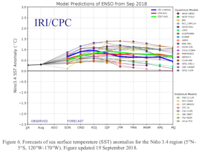
The majority of models in the IRI/CPC plume predict El Niño to form during the fall and continue through the winter. The official forecast favors the formation of a weak El Niño, consistent with the recent strengthening of westerly wind anomalies and positive temperature trends in the surface and subsurface ocean. In summary, El Niño is favored to form in the next couple of months and continue through the Northern Hemisphere winter 2018-19 (70-75% chance; click CPC/IRI consensus forecast for the chance of each outcome for each 3-month period).


