Colorado statewide snowpack basin-filled map February 7, 2019 via the NRCS.
FromThe Glenwood Springs Post Independent (Thomas Phippen):
In the Colorado River basin, snowpack was 112 percent of normal as of Feb. 1, according to a Natural Resources Conservation Service report released Wednesday. Statewide mountain snowpack improved from 94 percent of normal Jan. 1 to 105 percent of normal Feb. 1…
Mid-January marked the halfway point to peak snowpack accumulation, which is usually in April. February snowfall will be an indicator of how positive the year will be for water. But, with precipitation highest in March and April, the critical months of the winter and early spring season are still to come.
“It could go south, but I’m encouraged by where we are right now,” [Brian] Domonkos said. “Hopefully, this above-average weather pattern will continue.”
The state as a whole is slightly above normal snowpack, but there are still areas in southern Colorado with below-average snow. The Rio Grande basin is at 81 percent of median snowpack, but still has more than double the snowpack compared with last year.
More locally, as of Jan. 31, snowpack in the Roaring Fork River watershed was at 116 percent of median, according to the latest Roaring Fork Conservancy snowpack and river report.
While the news is good so far, the Colorado River Basin will need quite a bit more snowpack to have a normal runoff year, according to Don Meyer, senior water resources engineer with the Colorado River District.
“The snowpack is currently above average, but in order to get normal or average runoff, we need additional snowpack,” Meyer said.
Since 2000, the Rocky Mountains have had sub-average snowpack, and the runoff is getting earlier and lasting shorter amounts of time.
VIC modeled soil moisture February 6, 2019 via the Colorado Climate Center.
Much of the Colorado River Basin still has drier than average soil, or low soil moisture content, according to data from the Colorado Basin River Forecast Center.
Before the melting snow reaches the streams and rivers, it has to go over soil that will absorb the water if it’s still too dry.
“Soil moisture has to improve in order to provide some impetus for an efficient runoff,” Meyer said. That most likely won’t happen until the snow begins to melt.
It’s difficult to know how much above average the snowpack needs to be to replace the moisture in the soil.
Meyer cautioned that one good season wouldn’t be enough to show that the drought trend is ending, and that becomes difficult as climate change leads to more variability, he said.
Platte River photo credit US Bureau of Reclamation.
Click here to read the newsletter. Here’s an excerpt:
The Platte River Recovery Implementation Program
The Platte River Recovery Implementation Program is an innovative and successful approach to endangered species recovery and water development in Colorado. For almost 13 years, this program has been running smoothly in the background allowing for economic growth in the North and South Platte Basins, as well as species conservation in the Central Platte. Now, Colorado and other partners are taking steps to extend the program for another 13 years. Program partners are confident that the success of the program will speak for itself during the process of seeking congressional re-authorization. Learn more about what the CWCB and program partners are doing to reauthorize the Platte River Recovery Implementation Program in this article.
Through an Intergovernmental Agreement, the Upper Thompson Sanitation District (UTSD) and the Town of Estes Park (TEP) are partnering to complete a utility infrastructure project that will impact the Fish Creek Lift Station and Mall Road.
The work, which is expected to start on Jan. 28, will start with replacing a single, 45-year-old sanitary sewer force main with new, dual-force mains. These will extend from the Fish Creek Lift Station, located on Fish Creek Road next to Lake Estes, across U.S. 36 to UTSD’s gravity sewer main near Joel Estes Drive.
“UTSD recognized the lift station force main was a critical piece of infrastructure, had been in operation for 40 years, and due to its design features, had received minimal maintenance,” said UTSD District Manager Chris Bieker.
Bieker explained that force mains are pressurized sewer pipes that convey wastewater where gravity is not possible.
“Moving the flow uphill requires a pump,” he said. “Pumping facilities called lift stations may be required to transport the wastewater through the collection system.”
According to Bieker, “The Fish Creek Lift Station and approximately 1,000 linear feet of 14-inch diameter cast iron force main was constructed in the mid-1970s. The interior of the force main is cement mortar lined. Approximately 600 linear feet of force main is located south of Highway 36. The remaining 400 feet crosses north underneath HWY 36 and discharges to a manhole located in Mall Road. Wastewater then flows along Mall Road through approximately 1200 linear feet of gravity sewer main to the treatment facility…
In late 2016, the District televised the interior of the force main. The video indicated cracking and delamination of the cement mortar pipe lining within sections of the force main. The televising operation prematurely ceased when the camera could not proceed any further due to the internal conditions of the pipe.”
New piping and valves will be added to the Fish Creek Lift Station. Old, aging pipes and valves will be replaced to facilitate new parallel force mains. As the Fish Creek Lift Station manages over a third of all of the district’s water flows, these improvements are critical to UTSD operations and public health.
A big beach on the banks of the Green River in September 2018, one of the lowest months on record for inflow into Lake Powell. Runoff is 2019 is expected to be better than 2018, but still below average due to dry soil conditions in the area drained by the Green and Colorado river systems. Photo: Brent Gardner-Smith/Aspen Journalism
The regional director of the Upper Colorado River Basin for the Bureau of Reclamation told water managers and users last week to expect below-average runoff this year, despite encouraging snowfall this winter.
Brent Rhees — who oversees the federal reservoirs in the upper basin for the Bureau of Reclamation, including Lake Powell, Flaming Gorge and Blue Mesa — said that although this winter’s snowfall, or “snow water equivalent,” in the upper basin above Lake Powell was now above average (109 percent on Feb. 7) the parched ground left in the wake of a hot, dry 2018 likely would soak up a lot of the resultant moisture in the spring.
As such, this year’s runoff is not expected to reach the average level, although storms in February and March could push it up to the 80 percent range.
“What we’re suffering from is last year’s dry year,” Rhees told the members of the Colorado Water Congress on Feb. 1. “And so, the runoff that is forecast is not that great. Last year, you all remember, it was the third-lowest on record inflow into Lake Powell. So, it’s not looking really good.”
Since Rhees’ remarks, it has been snowing a lot in Colorado, and the snowpack in the Roaring Fork River basin was at 115 percent of average on Feb. 6. But, again, Rhees was looking at future runoff over a thirsty landscape.
The inflow into Lake Powell during water year 2018 (Oct. 1 to Sept. 30) totaled about 4.5 million acre-feet, or MAF, while about 9 MAF was released from Glen Canyon Dam to run down the Colorado River and into Lake Mead, Rhees said.
“So, the math is pretty simple, isn’t it?” Rhees said. “More went out than came in. And so, we saw a significant drop in reservoir elevation.”
As of Jan. 1, the Bureau of Reclamation forecast that 6.98 MAF, or 64 percent of average, would most likely flow into Lake Powell, but releases from Lake Powell are expected to be about 8.6 MAF.
“We’re going to release a little bit more than comes in, likely this year,” Rhees said.
That means Lake Powell is expected to continue to shrink in 2019.
On Feb. 3, the elevation of the reservoir, as measured against the upstream face of Glen Canyon Dam, was 3,575 feet above sea level, or 39 percent full, and held 9.6 MAF.
A diagram showing the intake structures on the upstream face of the Glen Canyon Dam, which forms Lake Powell.
Three efforts
The first ongoing effort to bolster water levels in Lake Powell is weather modification in the form of cloud seeding.
Rhees said the federal government’s position on funding cloud seeding has moved from funding only research to funding active operations, too.
“That’s good news from my perspective,” he said.
The second effort is “drought-response operations,” which will begin if Lake Powell drops to the triggering elevation of 3,525 feet, or 35 feet above minimum power pool (which it is not yet forecasted to do in either 2019 or 2020).
But should the reservoir hit 3,525 feet, the drought-response operations will entail releasing up to 2 MAF of water from federal reservoirs in the upper basin, primarily from Flaming Gorge Reservoir on the Green River, which can hold 3.7 MAF; Blue Mesa Reservoir on the Gunnison River, which can hold 829,500 acre-feet; and Navajo Reservoir on the San Juan River, which can hold 1.69 MAF.
Rhees said Flaming Gorge is “the one that can have the biggest impact, (but) all (federal) reservoirs can participate in propping up that minimum power pool of 3,490 (feet).”
He also said the releases from the reservoirs would be “indiscernible” to river users and the water would not come down the river in a big wave of water, as some might imagine.
“You won’t know, if you are on the river, that it’s even happening,” he said.
The third effort to add more water to the river system is “demand management,” or a purposeful reduction in the amount of water diverted from rivers and put to a consumptive use, such as growing a crop or a lawn.
Voluntary demand-management programs are now being investigated in Colorado, Utah and Wyoming, and the water saved by irrigators fallowing fields — for money — is to be stored in a new regulatory pool of up to 500,000 acre-feet in Lake Powell.
Editor’s note: Aspen Journalism covers rivers and water in collaboration with The Aspen Times and other Swift Communications newspapers. The Times published this story on Thursday, Feb. 7, 2018.
This image shows the far side of the Moon, as well as our own planet Earth. It was taken with a camera linked to an amateur radio transceiver on board the Chinese DSLWP-B / Longjiang-2 satellite (call sign BJ1SN), currently in orbit around the Moon, and transmitted back to Earth where it was received with the Dwingeloo Telescope.
From the folks at the Dwingeloo Radio Telescope – C.A. Muller Radio Astronomy Station:
This image shows the far side of the Moon, as well as our own planet Earth. It was taken with a camera linked to an amateur radio transceiver on board the Chinese DSLWP-B / Longjiang-2 satellite (call sign BJ1SN), currently in orbit around the Moon, and transmitted back to Earth where it was received with the Dwingeloo Telescope.
This image represents the culmination of several observing sessions spread over the past few months where we used the Dwingeloo telescope in collaboration with the Chinese team from Harbin University of Technology, who build the radio transceiver on board Longjiang-2, and radio amateurs spread across the globe.
During these sessions we tested receiving telemetry through low-bit rate and error-resistant digitally modulated transmissions, as well as the JT4G modulation scheme designed by radio amateur and Nobel prize winning astrophysicist Joe Taylor (K1JT) for weak signal Moon bounce experiments. Besides telemetry, we performed a VLBI experiment by simultaneously observing Longjiang-2 from China and Dwingeloo, and also downloaded images taken by Longjiang-2 of the lunar surface, lens flares, and the starry sky as seen from lunar orbit.
The transceiver on board Longjiang-2 was designed to allow radio amateurs to downlink telemetry and relay messages through a satellite in lunar orbit, as well as command it to take and downlink images. In that it has succeeded, as many radio amateurs have received telemetry and image data. Being able to use the Dwingeloo telescope to help with this has been a lot of fun.
This full color adjusted image is received by radio amateurs, including the radio amateurs of the Dwingeloo Radio Telescope (PI9CAM) operated by Tammo Jan Dijkema and myself. Commands were created by MingChuan Wei (BG2BHC) and uplinked by Reinhard Kuehn (DK5LA). The color correction of the image is done by Wei.
An annual survey reveals a leap in support of conservation policies.
According to a recent poll, voters across the West are substantially more worried about climate change now than they were just two years ago. What’s more, a majority identify as “conservationists.” These attitudes are at odds with the priorities of President Donald Trump’s administration, which have included aggressively cutting environmental regulations while shrinking national monuments and encouraging fossil fuel production on public lands.
These findings come from Colorado College’s annual Conservation in the West poll, which surveys residents in Arizona, Colorado, Idaho, Montana, Nevada, New Mexico, Utah and Wyoming on issues of climate, energy and public lands. This year, a majority of the approximately 400 respondents in each state rated climate change a serious problem, and every state saw an increase in climate concern.
Photo credit: The High Country News
These fears may be driven by climate change’s growing impacts in the West, such as drought and fire. Nearly 70 percent of poll respondents said that wildfires where more of a problem today than ten years ago. Climate change is playing an increasing role in the West’s lengthening fire season and intensifying blazes, according to the Union of Concerned Scientists.
Indeed, the survey found that climate impacts have started to surpass more traditional political preoccupations, like the economy: Respondents rated low river and stream levels, water quality and insufficient water supplies of greater concern than wages and unemployment.
Approximately two thirds of respondents also prioritized environmental protections and public lands access for recreation, compared to 24 percent who support Trump’s “energy dominance” policy of ramping up energy production on federally regulated land. Almost every state polled had at least a 30 percent margin in favor of conservation, including states that tend to vote red in statewide elections, including Arizona, Idaho and Utah. Only Wyoming stood apart, with just an eight percent gap between those who emphasize public lands and those who support increased energy production. In all, a significant bipartisan majority — almost 90 percent of respondents — rated the outdoor recreation economy as important to their state, while 70 percent called themselves “outdoor recreation enthusiasts.”
The poll has habitually found bipartisan support for the outdoor recreation industry and land access, said Corina McKendry, director of the State of the Rockies Project and an associate professor of political science at Colorado College. But “the rejection of the current administration’s priorities is particularly intense here,” she said in a press release.
Whether that influences upcoming elections — such as 2020 re-election bids by Trump and by the politically vulnerable Colorado. Sen. Cory Gardner, R, who will face questions about his ties to the administration and support of fossil fuel industries — is unclear. Public opinion polls often find widespread concern regarding climate change and support for policies to address the crisis. But these issues rarely swing elections, where foes of climate policies often highlight the economic and social costs of increased environmental regulations. In Colorado, where poll respondents overwhelmingly claimed to prefer environmental protection over energy production, voters roundly rejected a ballot measure in 2018 to limit hydraulic fracturing, following an industry-backed publicity campaign against the measure.
“There is strong evidence that Americans support environmental protection and conservation efforts and that they have substantial concerns about environmental issues such as climate change,” said Christopher Borick, director of the Muhlenberg College Institute of Public Opinion, who has worked on other environmental polling projects. “However, their concerns are often less intense than those regarding other issues.” Midterm exit polls showed healthcare, immigration, the economy and gun control as the top national issues for voters in 2018.
According to Borick, achieving robust climate policy requires that the environment compete with, and even surmount, these other political concerns. How soon this happens is an open question, even as Westerners increasingly worry about rising temperatures, drying streams and hotter fires.
Nick Bowlin is an editorial intern at High Country News.
Click a thumbnail graphic to view a gallery of drought data from the US Drought Monitor.
US Drought Monitor February 5, 2019.
West Drought Monitor February 5, 2019.
Colorado Drought Monitor February 5, 2019.
Click here to go to the US Drought Monitor website. Here’s an excerpt:
Summary
Significant precipitation evaded most areas of dryness and drought this week, with one major exception. Heavy precipitation pelted much of California, particularly along the coast and in the higher elevations. Most of the higher Sierra Nevada received 4 to 8 inches, with locally higher amounts. Coastal areas from Los Angeles northward through the Bay Area received 3 to 6 inches of precipitation, as did much of the Cascades and interior northwestern California. Only parts of the interior valleys, the Mojave Desert, and northeastern sections of the state received less than an inch. In sharp contrast, the only dry areas recording over an inch of precipitation in the rest of the 48 contiguous states were in parts of the northern Intermountain West, Isolated higher elevations in the central Rockies, a few patches in western parts of Washington and Oregon, and a small sliver along the southeastern Florida coast…
Only a few patches of dryness were observed in the northern half of the Great Plains, but dryness and drought remained far more intense and widespread in Wyoming and especially Colorado. In the Great Plains, recent precipitation was sufficient to remove the area’s only remaining area of drought in northeastern North Dakota, and restrict D0 conditions to the northern tier of the state. In contrast, D0 expanded through northeastern Colorado and the Nebraska Panhandle, where little precipitation has been observed for the last couple of months. But it is a cold and dry time of year in the region, and few impacts have been observed despite only 10 to 30 percent of normal precipitation has fallen on parts of the new D0 area since late last year. Farther west, dryness and drought is generally more intense and far more widespread. Little precipitation fell on either state last week, generally keeping conditions in Wyoming ( mostly D0 to D1) and Colorado (D3 to D4 in southwestern quarter of the state). Once east of the Colorado Rockies, however, no severe drought exists anywhere from the Plains eastward to the Atlantic Coast…
In this region extending from New Mexico and Montana [westward] to the Pacific Coast, precipitation was unremarkable this past week outside California, and only isolated tweaks were made to the Drought Monitor depiction to cover some spots of deficient snowpack. In contrast, heavy precipitation continued to chip away at the dryness and drought across California. A large swath from western Nevada through the Sierra Nevada, much of the central valleys, and the Bay Area is now free of any significant dryness, and continued heavy precipitation removed most of the moderate drought that had covered southern and southwestern sections of California from around San Luis Obispo and Santa Maria through the southern tier of the state. D1 was kept in a small southwestern part of the state from east of Los Angeles to the Mexican border. Though this area has received surplus precipitation for the water year to date (since Oct. 1, 2018), several reservoirs have failed to significantly respond, remaining at or near their lowest levels in at least a year, to as long as three years in one case…
Little or no precipitation fell on the few areas of dryness depicted in the Drought Monitor, specifically in the Texas Panhandle and adjacent Oklahoma, parts of west Texas and the Big Bend, and parts of southern Texas. As a result, the dry areas expanded somewhat, and the extent of moderate drought increased very slightly. Further increases should be slow as this is climatologically the driest time of year in southern Texas and especially the High Plains. The dry weather allowed for enhanced fire activity was observed in the Texas Panhandle and western Oklahoma…
Looking Ahead
During the next 5 days (February 7-11, 2019) a large storm system is expected to bring heavy rain, freezing rain, and snow to a broad area across the eastern Great Plains, the Ohio and Mississippi Valleys, the Great Lakes region, and the Northeast. Precipitation totals exceeding an inch will be common throughout these regions, with totals as high as 4 to 6 inches forecast in parts of Tennessee. But with respect to areas of dryness and drought, its impact will be limited at best. Only the D0 areas in the east half of the Dakotas will be affected by the fringes of the system, with a few tenths of an inch of precipitation resulting in several inches of snow.
Outside the higher elevations, only a few tenths of an inch of precipitation at best is expected over the entrenched and extensive areas of D0+ from the Intermountain West and Great Basin to the High Plains. Amounts topping an inch should be restricted to the highest elevations from central Idaho into northeastern Oregon. Similarly, a few tenths of an inch are expected in southeast Florida, the dry patches in Texas, and southern California from greater Los Angeles and the Mojave Desert southward to the Mexican Border. But another round of moderate to heavy precipitation is expected across central and northern California, this time extending northward through parts of Washington and Oregon from the Cascades to the Pacific Coast. Most of these areas should pick up at least an inch of precipitation, with a little less possible in the central California Valleys, but significantly more (2 to locally 4 inches) likely throughout the Sierra Nevada. Temperature anomalies should be divided by the Ohio Valley, lower Mississippi Valley, and southern Texas, with warm weather expected to the south and east, and below-normal temperatures farther north and west. Daily highs will average 6 to 10 degrees F above normal in the interior Southeast while temperatures 15 to 35 degrees F below normal cover northern reaches of the Plains and Rockies, with the most severe conditions covering Montana
The CPC 6-10 day extended range outlook (February 12-16, 2019) calls for an almost identical temperature pattern featuring enhanced chances for warmth in the Southeast, and extremely high probabilities for below-normal temperatures from the northern Plains through the Pacific Northwest. southeastern Alaska also has elevated chances for colder than normal weather.
The odds favor dryness in southeast Alaska during this period, but enhanced chances for surplus precipitation covers most of the contiguous 48 states. Chances for a wet 5 day period are particularly high from the California coast between Los Angeles and San Francisco eastward into southwestern Nevada. The only areas without elevated chances for heavy precipitation are western Washington, the Florida Peninsula, and from central and southern Texas westward through the southern High Plains.
US Drought Monitor one week change map through February 5, 2019.
FromThe Grand Junction Daily Sentinel (Charles Ashby):
Hard rock mines would have to find the money up front to show they have the ability to assure that any water supplies are protected from contamination under a bill that won preliminary approval in the Colorado House on Wednesday.
The measure, HB19-1113, stems from issues with abandoned mines throughout the state that have led to contamination of Colorado’s water supplies, not the least of which was the dramatic spill in the Animas River from the long-closed Gold King Mine in 2015.
While the measure doesn’t address similarly abandoned mines, one of its sponsors said it is an attempt to prevent future mishaps with active mines.
“Up until now, people can self-bond,” said Rep. Barbara McLachlan, D-Durango. “They can put the money down and promise that they will pay to clean up the water after their mining operations are finished. In many, many cases they go bankrupt before they can actually clean up the mine, and you the taxpayers are left with the bill of cleaning it up.”
Under current law, mining companies can submit audited financial statements to show they have the financial wherewithal to deal with any environmental issue from their operations, and can handle proper reclamation when those operations cease.
But several companies either have walked away without doing any reclamation or went out of business and had no way to pay for the cleanup. As a result, there are more than 23,000 abandoned mines in the state, according to the Colorado Geological Survey.
The bill, which requires a final House vote before heading to the Senate, would eliminate the audited statement and require new mining permits to include sufficient bonds to handle reclamation costs. Active mines that used audited statements to get their permits would have a year to establish a bond.
McLachlan, who introduced the bill with Rep. Dylan Roberts, D-Avon, pointed to the Summitville Mine in the San Luis Valley as an example. That closed gold mine became a Superfund site because of environmental damage in the 1980s from byproducts that leaked into the Alamosa River.
“Summitville is one we’re going to be starting to pay $2.2 million,” McLachlan said. “This company went in and they showed all the paperwork saying they had the money to clean this up, but by the time the mine was done, they went bankrupt and we the taxpayers have to pay.”
Supporters of the measure say the Colorado Mining Association no longer opposes the bill, but some lawmakers still questioned it.
While Rep. Marc Catlin, R-Montrose, said the state should support more mining in Colorado, if for no other reason than to stop supporting questionable mining practices in other countries, Rep. Kimmi Lewis, R-Kim, said she opposes the measure because one mining company asked her to do so.
“That one independent business owner who owns that mine, I’m going to stand with them,” she said. “And I’m going to remind you all … how much we need those small independent business owners.”
Summitville Mine superfund site
Acid mind drainage Cement Creek watershed
Commodore waste rock superfund site Creede
California Gulch back in the day
One of the many smelters that once operated in the Pueblo area. Photo credit: Environmental Protection Agency
San Juan Smelter Durango via
Workers pose in front of the Boston and Colorado Smelter at Argo Photo Colorado Historical Society
A canal delivers water to Phoenix. Photo credit: Allen Best
Here’s a report from Jim Robbins writing for Yale 360. Click through and read the whole article and to check out the photo gallery (from Ted Wood). Here’s an excerpt:
Once criticized for being a profligate user of water, fast-growing Phoenix has taken some major steps — including banking water in underground reservoirs, slashing per-capita use, and recycling wastewater — in anticipation of the day when the flow from the Colorado River ends. Fourth in a series.
The Hohokam were an ancient people who lived in the arid Southwest, their empire now mostly buried beneath the sprawl of some 4.5 million people who inhabit modern-day Phoenix, Arizona and its suburbs. Hohokam civilization was characterized by farm fields irrigated by the Salt and Gila rivers with a sophisticated system of carefully calibrated canals, the only prehistoric culture in North America with so advanced a farming system.
Then in 1276, tree ring data shows, a withering drought descended on the Southwest, lasting more than two decades. It is believed to be a primary cause of the collapse of Hohokam society. The people who had mastered farming dispersed across the landscape.
The fate of the Hohokam holds lessons these days for Arizona, as the most severe drought since their time has gripped the region. But while the Hohokam succumbed to the mega-drought, the city of Phoenix and its neighbors are desperately scrambling to avoid a similar fate — no easy task in a desert that gets less than 8 inches of rain a year.
“We are fully prepared to go into Tier 1, 2, and 3 emergency,” said Kathryn Sorensen, Phoenix’s water services director, referring to federally mandated cutbacks of Colorado River water as the levels of Lake Mead, the source of some of the city’s water, continue to drop. And what of the dreaded “dead pool,” the point at which the level in the giant man-made lake falls so low that water can no longer be pumped out?
“I can survive dead pool for generations,” says Sorensen, pointing to a host of conservation and water storage measures that have significantly brightened the city’s water outlook in an era of climate change and drought.
These days, Phoenix’s alternative water supplies are not dependent on the Colorado. But there’s a caveat. Phoenix may have enough water to secure its near-term future, but it still needs to build $500 million of infrastructure to pipe it to northern parts of the city that now rely on Colorado River water. And Phoenix may need the water sooner than it planned. “You could hit dead pool in four years,” Sorensen said. “That’s worst case.”
Many cities and towns in the Southwest — including Los Angeles, San Diego, and Albuquerque — are trying to figure out solutions to a dwindling Lake Mead, the key reservoir on the Colorado. One of the most ambitious efforts is a new $1.35 billion, 24-foot-wide tunnel — the so-called Third Straw — that Las Vegas drilled at the very bottom of Lake Mead to function like a bathtub drain. Las Vegas gets 90 percent of its water from the Colorado via the lake, which is located just east of the gambling and tourist mecca. In 2000, as the lake’s level dropped, the city placed a second, deeper straw to replace the original outtake. As the region moved into its second consecutive decade of drought and lake levels continued to drop, Las Vegas officials got more nervous and the third straw was completed in 2015; it should continue to siphon off water unless the lake dries up completely.
In Arizona, the modern equivalent of the Hohokam irrigation system is the 17-foot-deep and 80-foot-wide concrete aqueduct called the Central Arizona Project, which carries water from the Colorado River to Phoenix, Tucson, and elsewhere. It was a feat of engineering when it was finished in 1993, snaking across the sere desert landscape for 336 miles as it pumps water up 2,900 feet in elevation. So much power is needed to flush this water along its route that the massive coal-fired Navajo Generating Plant was built to provide it.
Supplying enough water to sustain a city this size in the desert has long been controversial, and as Phoenix and its neighbors continue their unrelenting sprawl — Arizona’s population has more than tripled in the past 50 years, from 1.8 million in 1970 to 7.2 million today — the state has often been regarded as the poster child for unsustainable development. Now that Colorado River water appears to be drying up, critics are voicing their “I told you so’s.”
That’s a bad rap though, at least for Phoenix, according to Sorensen. The city is prepared to carry on with business as usual even if the last of the Colorado River water evaporates into the desert sky, depriving Phoenix of 40 percent of its water supply. City officials have been busy planning for this eventuality, and much of the responsibility for that has fallen to Sorensen.
Gila River watershed. Graphic credit: Wikimedia
As she stands behind her large desk on the 9th floor of the municipal building in the heart of downtown Phoenix, surrounded by windows that look out on glass office towers gleaming in the desert sun, Sorensen deftly handles questions about the city’s water future. On her desk sits a crystal ball, a joke gift that she says she wishes was real. She’s proud of the work she has done since she was appointed in 2013 — before that she served four years as head of Mesa, Arizona’s water department — although she admits it has been a challenge.
The Phoenix Water Services Department is one of the nation’s largest, with 1.5 million customers spread out across 540 square miles. It maintains 7,000 miles of water lines and 5,000 miles of sewer lines.
The Salt River is the single biggest source of water for metro Phoenix, and provides about 60 percent of its needs. It is a large desert river, some 200 miles long, that begins at the confluence of the snow-fed White and Black rivers, is joined by a series of perennial, spring-fed streams, and then meets the Verde River east of Phoenix.
Just after the turn of the 20th century, the first of four dams was constructed on the Salt for a growing Phoenix, and today those reservoirs are Phoenix’s main water supply. However, Phoenix’s north side gets only Colorado River water, and should that source dry up one day, constructing infrastructure to connect north Phoenix to new sources of water would cost a half-billion dollars. Funding for such a project would hardly be a fait accompli; in late December, the Phoenix City Council rejected a water rate increase to pay for the infrastructure expansion. The Salt and Gila rivers also may someday be severely impacted by climate change. “They could be affected by a mega-drought,” said Andrew Ross, a sociology professor at New York University and author of Bird on Fire: Lessons from the World’s Least Sustainable City. “They are in the bullseye of global warming, too.” Perennial streams could dry up and snowfall in Arizona’s White Mountains could dwindle, as it has done in the Rockies, further depriving the rivers of a steady supply of water.
Beyond the Salt River, Phoenix has undertaken some innovative water strategies. Among the first of these was the Arizona Water Bank. California is entitled to 4.4 million acre-feet of water a year from the Colorado, but because Arizona was not using its full allotment of 2.8 million acre-feet, its excess water was being slurped up by a perpetually thirsty California. So the water bank, a unique system of underground storage, was created in 1996 as a way to store Colorado River water that the state couldn’t use, rather than letting it flow through to California. It turned out to be a prescient move, but not for the reason it was created. In that era, few people foresaw the crash of the Colorado River system.
Arizona has since created seven water banks, largely in empty underground aquifers. A series of large pools has been built above the aquifers and, as water is pumped into them, it slowly leaches through a layer of gravel and rock and fills the aquifer. So far the water banks have cost the state $330 million, storing 3.6 million acre-feet in 28 sites across three counties — more than a year’s worth of Colorado River water.
One of the largest water banks is 40 miles west of Phoenix near the tiny town of Tonopah, Arizona. The nearly $20 million facility has 19 infiltration basins covering more than 200 acres. It was constructed alongside the Central Arizona Project canal, and a pipe delivers 300 cubic-feet-per-second of Colorado River water a day to fill the basins.
In addition, other aquifers underneath Phoenix are brimming with 90 million acre-feet of water, some natural and some pumped in — enough to last the city for years. One problem is that much of it is contaminated, both from natural sources of arsenic and chromium and from the city’s many Superfund sites, which include manufacturing sites polluted by industrial solvents and unlined landfills that contain hazardous waste. But Sorensen dismisses the cleanup challenges as surmountable. “As long as the contamination isn’t nuclear, we can fix it,” she says. “What matters here is that the water is wet.”
Phoenix also recycles almost every bit of wastewater that journeys through its system. The vast majority of it — more than 20 billion gallons of recycled water a year — goes to cool the Palo Verde Nuclear Power Plant. Another 30,000 acre-feet is traded to an irrigation district as gray water to use on agricultural fields and the district, in turn, sends potable water from the Salt River to the city.
And the city is working on “toilet-to-tap” technology aimed at someday making sewage water so clean it will be drinkable. The technology for recycling wastewater into drinking water exists, but is only used in a few places, including San Diego. Arizona says it will play a role in its water supply some day — if, that is, the city can sell the idea to consumers.
Desalinization of seawater has long been floated as a possibility for Arizona, and much of the U.S. Southwest, and officials say it too will be part of Arizona’s water mix — someday. The process, which forces water through an extremely fine filter, is energy-intensive, extremely expensive, and a major environmental problem because of the waste it generates. Nonetheless, Arizona sits on top of 600 million acre-feet of brackish water, and officials have also considered treating water from the Gulf of California, nearly 200 miles to the southwest.
For now, though, Phoenix appears to have positioned itself well for a new era of drought. Sorensen credits the people of Phoenix for adapting to the desert by using far less water per capita. “We’ve decoupled growth from water,” she said. “We use the same amount of water that we did 20 years ago, but have added 400,000 more people.” In 2000, Some 80 percent of Phoenix had lush green lawns; now only 14 percent does. The city has done this by charging more for water in the summer. Per capita usage has declined 30 percent over the last 20 years. “That’s a huge culture change,” Sorensen says.
In fact, the decoupling of water from growth through conservation has taken place throughout the Lower Colorado Basin. “Actual municipal water use across the basin, with the exception of Utah, is declining, even as population rises,” said John Fleck, director of the University of New Mexico Water Resources Program. “Albuquerque has built its long-range plan around conserving more than its demand for decades to come, and Las Vegas’ demonstration of its ability to use less water is stunning.”
But while Phoenix and Las Vegas are pursuing conservation strategies as a partial solution to the withering of the Colorado River, others entities in the region aren’t. Much of conservative Arizona is in denial about what the potential drying of the West may mean, if they recognize it at all. “We’re just starting to acknowledge the volatile water reality,” said Kevin Moran, senior director of western water for the Environmental Defense Fund. “We’re just starting to ask the adaptation questions.” Ross, of New York University, argues that the biggest problem for Arizona is not climate change, but the denial of it, which keeps real solutions — such as reining in unsustainable growth or the widespread deployment of solar energy in this sun-drenched region — from being considered. “How you meet those challenges and how you anticipate and overcome them is not a techno-fix problem,” he said, “It’s a question of social and political will.”
So, for now, Arizona’s rampant growth continues. To the west of Phoenix a new tech city is emerging. Mt. Lemmon Holdings, a subsidiary of computer magnate Bill Gates’s investment firm, Cascade Holdings, has plans to built a “smart city,” for example, on the outskirts of Phoenix near the town of Buckeye. The new city, on 24,000 acres — about the same size as Paris — would have infrastructure for self-driving cars, hi-tech factories, and high-speed public wi-fi.
Meanwhile, the so-called Sun Corridor — 120 miles of Sonoran Desert between Phoenix and Tucson — is seen as the state’s next burgeoning megalopolis. It’s one of the fastest-growing regions in the country and its population of more than 5.5 million — anchored by Phoenix in the northwest and Tucson to the southeast — is expected to double by 2040.
And what about the water for this growth? Under state law, a developer must prove it has a 100-year supply for any new housing development. The primary solution for that has been for the Central Arizona Groundwater Replenishment District to fill or replenish aquifers where growth is planned — and the source for that is the precarious Colorado River water.
This slideshow requires JavaScript.
The reality, though, is that all of these well-intentioned measures may fall far short of being able to cope with a full-blown climate crisis. Someday the desert may reclaim what has been built here — as it did with the Hohokam.
Whether that unfolds remains to be seen. By Ross’s reckoning, the withering of Arizona will not be uniform, and those most affected will be the people least able to find alternatives, such as impoverished communities in South Phoenix.
“The well-resourced communities in the northeast are well set up,” for a drier future, said Ross. “And there are communities like South Phoenix that have been poisoned for decades that are not. It’s obvious who is going to suffer the most when the shortage really hits.”
“Here, we are all looking at Cape Town in shock,” said Taylor Hawes, of the Nature Conservancy’s Colorado River program, referring to the crisis last year when that South African city appeared on the brink of running out of water. “We’re not that far from that if things go south.”
Read the resolution here. Thanks NPR for posting it and thank you Representative Alexandria Ocasio-Cortez for your leadership on this issue.
Youth activists rally for climate justice in front of the US Capitol in Washington,DC (photo from earlier in the year). Image: Lorie Shaull,CC BY-SA 2.0, via Wikimedia Commons
Boulder County Solar Contractor Residential Commerical. Photo credit: Flatiron Solar
David Wallace-Wells’s apocalyptic depiction of a world made uninhabitable by climate chaos caused an outcry when it was published in New York magazine in 2017. Based on the worst-case scenarios foreseen by science, his article portrayed a world of drought, plague and famine, in which acidified oceans drown coastal homelands, dormant diseases are released from ancient ice, conflicts surge, economies collapse, human cognitive abilities decline and heat stress becomes more intolerable in New York City than in present-day Bahrain. Critics called this irresponsibly alarmist. Supporters said it was a long-overdue antidote to climate complacency. Whatever your view, it was among the best-read climate articles in US history. Now he is back with a book-length follow-up.
Jonathan Watts: You have written a hell of a book. Your now-famous opening lines – “It’s worse, much worse, than you think” – are like a voice from a nightmare. Are you deliberately upsetting people about the climate?
David Wallace-Wells: That is one of the intentions. My hope is first of all to tell the story as I see it. That has a couple of components. One is to show the crisis is happening much faster and is more all-encompassing than people think. And then also to think how those dramatic changes are going to cascade through the lives we live, the way we relate to one another, our politics, our culture, our psychology, all that stuff. I would like people to be scared of what is possible because I’m scared. And because I am motivated by fear, I also hope they will be motivated.
The sense of speed comes across very strongly. It is as if people have got used to seeing the climate crisis as an old horror film with slow-lurching zombies but, in your version, the zombies are the much faster, scarier ones you see in modern horror films. You address the risks of heat death, hunger, drowning, wildfire, dying oceans, economic collapse and conflict, and suggest the climate problem driving them has super-accelerated beyond what many people think.
That is the thing that first opened my eyes to the change. When I learned the astonishing fact that more than half of the carbon we have emitted into the atmosphere from burning fossil fuels was emitted in the past 25 years, that really shocked me. This means we have burned more fossil fuels since the UN established the Intergovernmental Panel on Climate Change (IPCC) than in all of the centuries before – so we have done more damage knowingly than we ever managed in ignorance. That is a horrifying fact. It also means we are engineering our own devastation practically in real time. How much will depend on how we act, how we behave, how we respond.
Xcel Energy proposes to close two of its coal-fired generating units at Comanche, indicated by smokestacks at right. The stack at left, for the plant completed in 2010, provides energy for a portion of Aspen and for the Roaring Fork and Eagle valleys. In the foreground is the largest solar farm east of the Rocky Mountains at its opening. Photo/Allen Best
The book is based on the piece you wrote for New York magazine last year that focused on worst-case climate scenarios. Were you prepared for the storm that caused?
It had about 6m page views. Within a couple of days, it was the most-read article we had ever published. It was a true phenomenon. That was thrilling in a way because the conventional wisdom about climate writing – at least in American journalism – was that it was traffic Kryptonite, that nobody would read these stories. I felt that was in part because we had left a lot of storytelling tools on the table and weren’t embracing a certain kind of writing that might reach people dramatically. I felt the article was a proof of concept for that.
In the book, you focus more on warming of around 2-4C, which is more likely than the worst-case scenarios, though still bad enough. Was this different approach an attempt to tighten up because there was quite a lot of scientific pushback on some of the claims you made in the original article?
I had anticipated a pushback. I wrote in the original article about scientific reticence and the way many researchers were reluctant to talk about their own scary findings in public in the terms they might have included in their papers. But I do not feel the science of my story was irresponsible. We ended up publishing four corrections to the piece. What it motivated me to do – and not just me, but my fact checker and the editor – was to publish this fully annotated version of the piece within a couple of days, in which we footnoted every fact with a paper. I do believe that basically answered that first reflexive criticism of the piece as being scientifically irresponsible.
There were also questions about rhetoric. Scientists said your article was “hyperbolic” and “exaggerated”, and your alarmism was as irresponsible as climate denial. In the book, you are unapologetic. You write: “The facts are hysterical” and the only way to address them is with the language of theology and mythology. Is this Armaggeddonising a way to reach new audiences and break down barriers?
Yes, and to activate people who are only casually engaged. To me, that is the most important messaging mission. It is important to mobilise people who at the moment are concerned, but basically complacent, and turn them into people who are much more activated and essentially voting about climate as a first-order political priority rather than a third- or fourth-order priority – judging politicians on the basis of their climate policy.
Disruption is important. But to what extent? You talk of last year’s UN IPCC 1.5C report. It is a science paper and it is sober. It spells out the huge – and horrifying – differences between 1.5C and 2C of warming, and the actions we need to take right now if we are to avoid the extra half a degree, which will require a 45% reduction in emissions by 2030. You say the message of the report is: “It’s OK now to freak out.” But I guess most scientists would say: “Don’t freak out! Act! Focus! Do not succumb to paralysing fear.” Is “freak out” what you really mean?
The short answer is yes. We should not sit back and feel complacent that the world beyond us will figure this out without political pressure. We cannot continue on the path we are on and believe our future will be secure and stable. We need to dramatically change our climate policy globally. That was the very clear message of the UN report. You are right that, in a certain way, it was written soberly, but it is also the case that it was saying we need mobilisation on the scale that we saw in the second world war in Europe and the US – and that is not a keep-calm message. It is saying we have to light the fuse and get going.
On the question of what kind of motivation is most effective, I don’t believe fear and alarm are the only options; there is a place for hope and optimism. There are many shades in between. But fear is what animated me. We do not tell people only about the positive benefits of quitting smoking. We tell them about what will happen to them if they smoke. And to go back to the second world war analogy, we did not mobilise in that way because we were optimistic about the future. We mobilised in that way out of fear, because we thought nazism was an existential threat. And climate change is obviously an existential threat and it is naive to imagine we could respond to it without some people being scared. I think it is silly to throw that rhetorical tool away. My basic perspective is that any story that sticks is a good one. If you can get people engaged, it is good, however you do it.
But I also come to this subject not as an advocate, not as an environmentalist. I have been drawn into that role to some extent as a result of this work. I come into it as a journalist and as a storyteller and, at some level, the imperative for me is to tell the story true, to tell it as I see it. As you say, and as I wrote in the book, it is simply the case that the facts are hysterical. To shy away from that, I think, is irresponsible – in part because it would encourage complacency but also from the basic truth-telling level. We know these things are true to the extent that scientists can know them. I don’t think the public should be shielded from them.
What struck me in the book was that you shake the reader up and say, “Look, wake up, get going!”, and yet there isn’t much there in terms of where to go next. You delved into solutions, but you didn’t give them much chance of achieving anything. Do you believe there isn’t much out there that could help us?
I think the book does a fair amount of hope-giving. The most important thing anybody can do is vote. If people are mobilised, we can relatively quickly usher in – perhaps not globally, but in many of the more important nations – a much stronger commitment to a more aggressive climate policy.
My hope is that the US and China, with support from some other countries, start making dramatic investments in [negative-emissions] climate technology in the near future. I’m sceptical of conventional decarbonisation. We will need these additional technologies. We need to invest in them quickly.
Putting hope in technology is the excuse George HW Bush gave for not doing anything decisive in the late 1980s when he was president and it is the message of the Trump administration. You don’t sound as if you are aligned with them. What about a carbon tax?
We have to do everything we can. I would absolutely support a carbon tax and what we are talking about now in the US: a green new deal of massive investment in renewable energy. But when you look around the world, small taxes on carbon haven’t had a meaningful impact. I think we have to learn from that and realise we need much more aggressive taxes or other solutions.
In the past year, we have seen more radical action such as student strikers led by Greta Thunberg and protests by Extinction Rebellion. Do you think groups like this are useful?
Absolutely. I’m an enormous admirer of Thunberg and I am in awe of how much energy and attention Extinction Rebellion has generated in such a short time. I think their imperative to tell the truth is very important and powerful.
Would you join?
They are organising another major event soon in New York that I will be going to. Temperamentally, and by background, I am not an activist and I still think of myself primarily as a journalist and storyteller. But no matter how disinclined you are, how temperamentally reluctant you are to be a joiner, it is hard to think about the state of the climate and not be called to action.
What about individual choices? Early in the book, you state very clearly you are not environmentalist, you eat meat, and you think it is better to have economic growth than protect nature. But then you write: “Like many Americans, I am fatally complacent and wilfully deluded.” That was your starting point. How has writing this book changed you?
Everybody should live according to their values. There are people who want to radically change their lives to reduce their carbon footprint, and there are people who want to make symbolic gestures. Air travel is the one thing that I really do feel guilty about. I make choices about travel with that in mind in a way that I didn’t even a year ago.
And meat?
Personally, I don’t feel that it is my thing. I admire people who give up meat for this reason. I think globally we need to be eating less meat, especially those of us in the wealthy parts of world who eat too much of it; for health reasons, too. But if I go from eating three hamburgers a year to zero, the impact on my carbon footprint is quite trivial. I have to say right now it feels so overwhelmingly the case that political action is the most important thing anyone could do, including me, that it overwhelms any of the other things.
In the book, you ask whether it is moral to have children in this climate. In the past year, you have done just that. What hope do have that your child won’t live in the uninhabitable world of your title?
I come at the question of hope from the perspective that truly total devastation is possible and something close to that is where we are heading now. So every degree cooler, every tick of temperature that we prevent, is an improvement and therefore a reason for hope. So, if we stabilise the planet at 3C that is better than 3.5C, 2.5C is better than 3C, and so on.
For reasons independent of climate, I wanted to have children. Most people do. I don’t think this is an impulse we need to disavow before we have finished the final act of this story. I think it is a reason to fight now so that we can continue to have those children and continue to live in the ways we want to live. It is possible regardless of how bad the news from science is.
Dan Gibbs via Twitter FromThe Summit Daily (Deepan Dutta):
The senate confirmed Gibbs unanimously in a 34-0 vote, with one abstention. Gibbs had already been preparing for the role in the weeks since he resigned as Summit County commissioner, meeting staff and attending meetings to get up to speed on the department’s work.
The state agencies Gibbs will oversee include the Division of Forestry; Division of Reclamation, Mining and Safety; the Colorado Oil and Gas Conservation Commission; Colorado Parks and Wildlife; the Colorado Avalanche Information Center; the State Land Board; the Water Conservation Board and the state’s Division of Water Resources.
Gibbs said he was thrilled to be confirmed, and was already engaged in high-level work, including the seven-state Colorado River Basin Drought Contingency plans that is seeking to create an updated water distribution compact in the West.
“It’s really amazing being a part of that, and being part of those important conversations happening right now,” Gibbs said. “What we do will have legacy impact on how we manage the Colorado River moving forward. It involves everything from human services to road and bridge to environmental health, I’m learning about a lot of different positions.”
Along with conserving water, other precious natural resources Gibbs oversees includes Parks and Wildlife, which will be the largest department under Gibbs’ purview with 900 employees. One of his priorities with CPW is to find a more sustainable funding model for the agency aside from hunting and fishing license fees…
Gibbs, who had served as a Congressional staffer, state house representative and state senator before his eight years as commissioner, said that his experience working at the federal, state and local levels made him realize the unnecessary barriers that spring up between various levels of government. He plans to use his experience to negotiate among the different players and break down those barriers.
“I want to work to try to demolish those silos isolating them from each other,” Gibbs said. “I want to look at how we manage our land, water and minerals and do what’s best for Colorado as a whole, not just piecemeal management based on federal, state and local ownership. I want a more holistic approach on how we manage and steward on natural resources.”
Ultimately, Gibbs’ most important responsibility as steward of the state’s natural resources is to preserve them for later generations, so they can experience and enjoy the grandeur and freedom this wild country has to offer.
“I have two young kids, and every day I wake up thinking about how we can shape natural resources policy not just now, but for future generations,” Gibbs said. “With 80,000 people moving to the state every year, a lot of it depends on how we manage growth, and how to avoid loving our natural resources to death.”
Parts of the Uncompahgre River have become “unstable” and “injured” over time due to past land use practices, leaving some areas packed with landfill material like debris and rubble, City Engineer Scott Murphy said.
But now, the City of Montrose will be able to refine portions of the river, in part due to a $400,000 grant given to the city by the Colorado Water Conservation Board (CWCB). The funds come through the Colorado Watershed Restoration Program to enhance the Uncompahgre.
The grant will begin the first phase of river restoration improvements for 0.65 miles of the Uncompahgre within city limits…
Additionally, aerial images have shown the river channel has migrated around 400 feet in some places over the past 50 years, Murphy indicated.
“It’s a pretty unstable breach of the river which is bad for the habibat because once the fish habibat gets established it gets wiped out as the river moves,” he said.
City of Montrose grant coordinator Kendall Cramer also said the Uncompahgre has experienced flow modifications and encroachment, which has developed a wider channel, bank stabilization issues and a lack of aquatic and riparian habitat.
“It’s an excellent project that’s going to enhance the river corridor,” Cramer said. “It’ll invest in the Uncompahgre River, which is one of our greatest assets in terms of tourism and recreation.”
He added the project will fix those problems as well as create better aquatic environments, stabilize the river banks and give the public better access to the water.
The city is hopeful this project will be the first step in receiving a gold medal fishery designation within the Uncompahgre River, Murphy said. Once completed, this section of the river will join a section of the Gunnison River which connects to the Black Canyon of the Gunnison National Park and joins the Gunnison Gorge…
The project design is being done by Ecological Resource Consultants, which won the bid for it in 2017. The River Restoration Committee and volunteers have helped the project come to fruition and have given input on the design, Cramer said.
The city anticipates construction to begin in winter of 2019-2020. Due to the river flow, work has to be completed within a four-month timeframe of November to February, when the water is at its lowest point.
Kelly Nelson, a member of the Ecosystem Science and Sustainability Club at CSU, drops wood chips to compact the soil near Left Hand Canyon in attempts to restore the land from the floods. The flood restoration event was open to members of the ESS Club, the Watershed Club, the Fly Fishing Club, and the Boulder community on Saturday. (Jenna Van Lone | Collegian)
Click here to go to the Expanding Your Horizons website to register:
About the conference
Expanding Your Horizons (EYH) is a conference for girls in middle school. This day-long event will include hands-on activities in science, technology, engineering, and math (STEM). At the conference, girls will get a chance to meet STEM role models and learn more about careers in those fields. Our ultimate goal is to motivate girls to become innovative and creative thinkers ready to meet 21st Century challenges.
PLEASE NOTE: You will not be able to register for specific workshops at the time you reserve your space at the conference. Please see the FAQs section for more information. Find out more about the National Expanding Your Horizons Organization by going to the National EYH Website.
Colorado officials and regional water managers are poised to start working together on a plan to reduce water use in Colorado, mainly by paying willing irrigators to fallow hayfields, in order to bolster falling water levels in Lake Powell and guard against a compact call on the Colorado River system.
After a series of meetings held last week by the Colorado Water Conservation Board and by Western Slope and Front Range water interests, state officials are now set to begin investigating the feasibility of a “demand management” program that’s “voluntary, temporary and compensated,” and water users and managers throughout Colorado will be asked to help shape the new program.
“Demand management, reduction in consumptive use, is an incredibly threatening concept to Western water users, and certainly to West Slope water users,” Andy Mueller, the general manager of the Colorado River District, told a ballroom full of water professionals Friday during the last day of a three-day Colorado Water Congress meeting here. “Our agricultural community is concerned that what this is really about is taking water from ag and bringing it into urban areas.”
Nonetheless, Mueller said, “this is a time where we have to work collaboratively, with both our urban friends and our rural friends, to figure how we do this together, and how we recognize the values that are important to each of us.”
Mueller also told the Water Congress audience that “the River District is committed to proactively engaging and working with the CWCB and the Front Range to figure out how we can stand up a program that truly protects all of us in this situation. To not do so, to not engage proactively in that conversation, would be irresponsible of every one of us in this room.”
He also laid out the Western Slope’s vision for the program, which centered on sustaining rural communities.
“We want, from a West Slope perspective, our agriculture and our industries and our cities that are going to participate in these programs to have the opportunity to use the water when they need it, and to monetize their assets into a program when they can figure out ways not to use it,” Mueller said.
Demand management is based on the idea that if water that otherwise would be used to grow hay, or turf in suburban settings, can instead be left in the river system to flow into Lake Powell, and into a new regulatory pool of water within the big reservoir, it will help boost water levels in the reservoir, allow for continued hydropower production at Glen Canyon Dam and help the upper-basin states meet their obligations to deliver a minimum amount of water to the lower-basin states under the terms of the Colorado River compact.
A recently concluded four-year test program called the System Conservation Pilot Program paid irrigators in the Upper Colorado River Basin an average of about $200 per acre-foot of conserved consumptive use of water.
Fresh turf, in Thornton, near Denver.
Denver engaged
Jim Lochhead, CEO and manager of Denver Water, was sharing the stage with Mueller on Friday during a panel discussion, after they together had met Thursday with other Front Range water providers in a behind-the-scenes meeting.
Lochhead said the Front Range and the Western Slope are united in their desire to avoid violating the terms of the compact.
“No one wants the result of a situation where we haven’t come together collectively to arrive at a solution,” Lochhead said.
And, he stressed, “Colorado needs to do our part to make sure that the demand-management piece is done in a way that protects all water users in Colorado, East Slope and West Slope.”
“From Denver Water’s perspective, we’re prepared to engage productively, as I’ve indicated many times in the past,” Lochhead said. “We’re prepared to contribute our share of water into a solution that would be collectively agreed to within Colorado and the other upper-basin states, if it is necessary, for our own mutual benefit and survival.”
The state’s emerging demand-management program is tied to the ongoing effort to approve “drought-contingency planning,” or DCP, agreements in the seven states in the Colorado River Basin: Colorado, Utah, Wyoming, New Mexico, California, Arizona and Nevada.
Arizona’s governor on Thursday signed a required piece of state legislation in order to meet a federally imposed deadline, but there are still other DCP agreements that need to be finalized by a new working deadline, March 4. Federal legislation also is required to implement the regional agreements designed to keep both Lake Powell and Lake Mead operating as designed.
Sand and silt are piling up on the Colorado River above Lake Powell, as water levels continue to fall due to persistent drought and encroaching aridification. Water managers from San Diego to Wyoming are working to find ways to keep the river’s reservoirs, and water delivery systems, functioning.
State investigating
On Tuesday during a regular public meeting held in Westminster, the directors of the Colorado Water Conservation Board indicated they were in support of a staff proposal to form seven different work groups in 2019 to study demand management.
Brent Newman, the CWCB’s interstate, federal and water information section chief, and point person on Colorado River issues, told the agency’s board of directors that the state is not yet starting up a demand-management program; it is only studying the feasibility of doing so.
He also said the state is not studying how a curtailment, or mandatory cutback in water use, would be administered by the state if the Colorado River Compact were to be violated.
Karen Kwon, a first assistant attorney general of Colorado, echoed that stance in her remarks to the CWCB directors Tuesday.
“We are not talking about how we would administer a curtailment,” Kwon said.
Newman and Kwon are proposing that the CWCB set up work groups, staffed by hand-picked experts, to explore a “plethora of issues” raised by demand management, including policy; monitoring and verification; water administration; the environment; economics; funding; and education and outreach.
The staff also proposed to set up a quarterly series of workshops for water users, managers and stakeholders, as well as engaging the state’s basin roundtables, which meet regularly in each of the state’s major river basins, on the issues raised by demand management.
A detailed work plan for the proposed process is to be presented by CWCB staff to the agency’s directors in March.
Editor’s note: Aspen Journalism covers rivers and water in collaboration with The Aspen Times and other newspapers owned by Swift Communications. The Times published this story Feb. 4.
Community members wanting to comment next month at a Boulder County commissioners hearing on whether Denver Water can move forward with an expansion of Gross Reservoir can start signing up next week…
Online sign-ups for the March 14 hearing start Feb. 14, while in-person sign-ups will start an hour before the hearing.
Commissioners plan to continue to take public testimony until all speakers have had an opportunity to comment, according to a news release.
After the public hearing, commissioners will hear Denver Water’s appeal of a decision by the county’s Land Use Department that Denver Water must run the project through what is known as a “1041” review process before construction can begin.
Named for the bill number by which it was enacted in 1974, the 1041 legislation gives local governments the right to control development by agencies beyond their boundaries through a local permitting process.
Denver Water argues the Gross Reservoir expansion is exempt from 1041 requirements. Boulder County claims it is not.
The public hearing will focus on the limited scope of the determination and is not a hearing or decision on the perceived impacts or merits of the reservoir expansion project, according to a news release…
Written comments can be submitted through an online comment form available at bit.ly/GrossDamExpansion. Comments also can be mailed to the Boulder County Commissioners’ Office, P.O. Box 471, Boulder, 80306. Comments need to be received by noon March 12.
Western voters have significant concerns around water issues and the increasingly visible impact of climate change; optimism for benefits of outdoor recreation economy
The ninth annual Colorado College State of the Rockies Project Conservation in the West Poll released [January 31, 2019] shows voters in the Mountain West continue to support efforts to keep public lands protected and accessible, putting them at odds with the Trump administration’s “energy dominance” agenda.
The poll surveyed the views of voters in eight Mountain West states (Arizona, Colorado, Idaho, Montana, Nevada, New Mexico, Utah, and Wyoming) on policies impacting the use and protection of public lands. The role of public lands and the outdoor way of life continued to be of deep importance to Western voters. 70 percent view themselves as “outdoor recreation enthusiasts” and 68 percent label themselves as “conservationists.” For 63 percent of respondents, the ability to live near, recreate on, and enjoy public lands like national forests, parks, or trails are a factor in why they live in the West. An overwhelming majority—87 percent—believe the outdoor economy is important to the future of their state.
“Our state’s mountains, rivers, and prairies are the foundation of the Colorado way of life. Protecting our public lands not only strengthens our local economies by promoting outdoor recreation and tourism, it ensures that future generations will continue to have a vibrant place to live, work, start a business, raise a family, and retire,” said Colorado Governor Jared Polis. “This poll once again shows that Coloradans are adamant about protecting our natural spaces, reversing the harmful effects of climate change, and moving to a future of clean, affordable renewable energy.”
When asked about the Trump administration’s agenda for public lands, majorities viewed key actions over the past two years with strong disapproval.
“Over the history of the Conservation in the West Poll, we have consistently seen bipartisan support for protecting public lands and outdoor spaces,” said Corina McKendry, Director of the State of the Rockies Project and an Associate Professor of Political Science at Colorado College. “That a leadership agenda out of step with those values is met with disapproval in the West is no surprise, although the rejection of the current administration’s priorities is particularly intense here.”
Looking forward, voters in the Mountain West want the newly elected Congress to challenge the Trump administration’s priorities on national public lands. Just 24 percent want Congress to ensure the production of more domestic energy by maximizing the amount of national public lands available for responsible oil and gas drilling and mining. That is compared to 65 percent who prefer Congress ensures the protection of clean water, air quality, and wildlife habitat while providing opportunities to visit and recreate on national public lands.
Impacts of uncontrollable wildfires and water issues topped the list of voter concerns this year. Those concerns are associated with the impacts of climate change, which 46 percent of voters view as a very serious or extremely serious problem in their state—a steady increase over the duration of the history of the poll. 67 percent of voters believe wildfires are more of a problem than ten years ago, with changes in climate and drought being the top reasons given for the shift. Voters also have significant concerns about water levels in the West; 67 percent view water supplies as becoming less predictable every year.
Solar power and wind power ranked highest among energy sources voters said they would like to see encouraged in their state. Voters also gave strong majority support for a variety of potential efforts at the state level to conserve land, water and wildlife, including migration corridors for species including deer and elk. Notably, 68 percent of voters said they would support a small increase in local taxes to fund those projects.
“The poll underscores that people living in the West are overwhelmingly outdoor recreationists. Whether they enjoy the outdoors through hiking, biking, fishing, or camping with family and friends, our outdoor recreation lifestyle translates to healthy communities and healthy economies across the West,” said Amy Roberts, executive director of Outdoor Industry Association. “The poll also shows that most of us want our elected officials to support policies that protect and maintain access to our public lands and waters. We hope they now take an opportunity to build bipartisan support on these issues.”
This is the ninth consecutive year Colorado College has gauged the public’s sentiment on public lands and conservation issues. The 2019 Colorado College Conservation in the West Poll is a bipartisan survey conducted by Republican pollster Lori Weigel of New Bridge Strategy and Democratic pollster Dave Metz of Fairbank, Maslin, Maullin, Metz & Associates.
The poll surveyed at least 400 registered voters in each of eight Western states (Arizona, Colorado, Idaho, Montana, Nevada, New Mexico, Utah, and Wyoming) for a total 3,204-person sample. The survey was conducted between January 2-9, 2019 and has a margin of error of ±2.65 percent nationwide and ±4.9 percent statewide. The full survey and individual state surveys are available on the State of the Rockies website.
Authorized and funded by the Colorado Department of Local Affairs, the South Platte Master Plan was launched two years ago to find ways to make the river more “flood resilient,” both to handle the flooding as it occurs, with minimal damage to property and structures, and to quickly recover from a flood in the aftermath.
The project area includes 130 miles of the South Platte River from the Weld-Morgan County Line to the Nebraska state line.
Project representatives will present the plan Feb. 12 at the Lower South Platte Water Conservancy District’s board of directors meeting at 9 a.m., then meet with the Logan County Water Conservancy District board at 11 a.m. The plan will be presented again at 1 p.m. at the CSU Engagement Center.
Both conservancy districts are interested in seeing how they can work with the Master Plan…
The LCWCD recently decided to change its focus away from the idea of building a flood control dam across Pawnee Creek. Miller has said the “big project” simply isn’t feasible and may not be for some time. Instead, the district will shift its focus to smaller projects that will mitigate flooding in the immediate future.
The Lower South Platte district, meanwhile, is interested in finding water storage potential and funding for storage projects along the lower reaches of the river.
The meetings on Feb. 12 are public meetings but space is limited in all of the venues.
Oil and gas development on the Roan via Airphotona
FromThe Grand Junction Daily Sentinel (Dennis Webb):
Bernhardt — the department’s deputy secretary, who has been acting secretary since Ryan Zinke’s departure from the top job at the end of the year amidst ethics probes — was announced as the President’s choice to replace Zinke…
It’s believed that if Bernhardt is confirmed, he would be the first Western Slope native to hold a Cabinet-level position, at least in recent history.
His nomination was heralded in some quarters Monday and met with staunch criticism in others, reflecting that Bernhardt, like Zinke, has been a somewhat polarizing figure at Interior.
“This is fantastic news for Colorado,” U.S. Sen. Cory Gardner, R-Colo., said in a news release. “I’ve known David Bernhardt for many years and have worked closely with him over the last two years to advance Colorado priorities. As a native Coloradan from the Western Slope, David knows how important public lands are to our state and has a keen understanding of the issues Coloradans face every day.”
[…]
But Jennifer Rokala, executive director of the Center for Western Priorities, called Bernhardt’s nomination “an affront to America’s parks and public lands.”
She calls Bernhardt a “walking conflict of interest” because of his prior work as an attorney representing oil and gas, water and other industries and interests.
“As an oil and gas lobbyist, Bernhardt pushed to open vast swaths of public lands for drilling and mining. As deputy secretary, he was behind some of the worst policy decisions of Secretary Zinke’s sad tenure, including stripping protections for imperiled wildlife. Bernhardt even used the government shutdown to approve drilling permits for companies linked to his former clients,” Rokala said in a news release.
“As senators consider Bernhardt’s nomination, it’s crucial they remember that the ongoing investigations into Ryan Zinke’s conduct intersect with policies that David Bernhardt has helped enact. Otherwise, we’ll see another Interior secretary fall into the same ethical abyss that ended Ryan Zinke’s political career.”
Chris Saeger, executive director of the Western Values Project, said in a statement, “Bernhardt is an ex-lobbyist and the ultimate DC-swamp creature with so many potential conflicts of interest that he has to carry around a list of his former clients. He is simply too conflicted to be our next Interior Secretary, and the Senate should vote his nomination down.”
Last week, the Center for Western Priorities released a poll by Keating Research that it said showed more than 60 percent of Coloradans were extremely or somewhat concerned that clients Bernhardt once lobbied for have business before the department he now runs.
The poll reportedly found that just 18 percent of Coloradans think increasing oil and gas development should be Interior’s most important issue, while 74 percent said what matters most is striking a better balance between preserving public lands and responsible oil and gas development.
Bernhardt has sought to recuse himself at times from potential conflicts of interest. In September, he bowed out of tentative plans to speak at a water forum in Grand Junction because of a potential conflict.
Mike Samson, a Garfield County commissioner who taught Bernhardt at Rifle High School, said he thinks anyone in government faces the potential for conflicts of interest to some degree.
He said Bernhardt, who was “a great student,” is smart enough to make sure that what he does is right, so as not to create problems down the road.
Bonnie Petersen, executive director of Associated Governments of Northwest Colorado, said that based on her limited interactions with Bernhardt, he is strict about avoiding conflicts of interest.
“He seems to be very adamant in that regard,” she said.
Local government representatives such as Samson and Petersen are thrilled at the prospect of a western Coloradan running a department so influential in the West.
“We had thought that he would be a good candidate for the position and apparently the president thinks so as well,” Petersen said…
Bernhardt has worked in roles including serving on the staff of Mesa County Commissioner Scott McInnis when McInnis served in the U.S. House of Representatives, and as Interior’s solicitor during the George W. Bush administration. More recently he has been instrumental in carrying out the Trump administration’s energy-dominance agenda.
Gardner, Samson and Petersen all credit him for the role he played during the Trump administration in getting oil and gas revenue returned to western Colorado governments that was left over after the cleanup of the Anvil Points oil shale research site near Rifle.
Petersen said he worked closely with governor offices in the West to consider comments from local governments regarding revising greater sage-grouse management plans, after local governments weren’t listened to when the plans were first issued in 2015.
Whit Fosburgh, president and chief executive officer of the Theodore Roosevelt Conservation Partnership, said that his group has worked closely with Bernhardt, “and we have found him to be accessible, fair, and true to his word,” and the group supports his nomination.
He said the nomination “places him in an unenviable position to balance the priorities of the Trump Administration with the mission of the (Interior) Department. We have often disagreed on policies, such as the pace and siting of energy development and the failure of the department to require developers to mitigate the damage they do to the lands that belong to all Americans. At the same time we have worked productively with Mr. Bernhardt to expand recreational access to public lands and protect big-game migration corridors.”
Youth activists rally for climate justice in front of the US Capitol in Washington,DC. Across Australia last week, children skipped school as part of the School Strike 4 Climate protests . Image: Lorie Shaull,CC BY-SA 2.0, via Wikimedia Commons FromThe New York Times (Milan Schreuer, Elian Peltier and Christopher F. Schuetze):
Tens of thousands of children skipped school in Belgium on Thursday to join demonstrations for action against climate change, part of a broader environmental protest movement across Europe that has gathered force over the past several weeks.
In Germany, France, Sweden, Switzerland and elsewhere, activists have come together on social media to gather in large numbers and without much apparent preparation, the protests taking a different shape in each country.
In Germany, students have protested on Fridays, communicating mainly through the messaging app WhatsApp; in Belgium, they organize on Facebook and have skipped school by the thousands on four consecutive Thursdays.
Last Sunday, climate protests in Brussels swelled to an estimated 100,000 people of all ages. That same day, an estimated 80,000 took part in cities across France — more than turned out for the “Yellow Vest” protests the day before.
Greta Thunberg via Twitter
The climate movement has no obvious leaders or structure, but a 16-year-old Swede, Greta Thunberg, has drawn worldwide attention and inspired many of the protesters. She has called for school strikes to raise awareness of global warming, scolded world political and economic leaders at this month’s gathering in Davos, Switzerland, and even has her own TED Talk.
Most older people do not feel the urgency young people do about global warming, said Axelle Kiambi, 17, who joined a demonstration in Brussels on Thursday with her sisters, Pauline, 16, and Elisa, 19.
“To us, it is so self-evident that we can’t keep on going in this direction,” said Axelle, raising her voice above the drumming, whistling and shouting of her fellow protesters.
“We come here with the right intentions, to protest in peace and to raise awareness about climate change, because we want to be on the right side of history,” Elisa Kiambi said. “It is time for the government to act.”
After meeting this week with a delegation of climate activists, Belgium’s prime minister, Charles Michel, said he was prepared to act, but not at any cost.
Many Indian reservations are located in or near contentious river basins where demand for water outstrips supply. Map courtesy of the Bureau of Reclamation.
Having gained an endorsement from its members, a tribe with one of the largest and most secure claims to water in the Colorado River basin will seek approval from Congress to lease water for use off of its riverside reservation.
The Colorado River Indian Tribes, or CRIT, have lands that stretch along 56 miles of the lower Colorado River. Eighty-five percent of the reservation is in Arizona, with the remainder in California. The tribe’s right to divert nearly 720,000 acre-feet from the river is more than twice the water that is allocated to the state of Nevada.
By law, that water is to be used on the reservation. But if CRIT convinces Congress to allow off-reservation leasing, the change would free up a large volume of water that would be highly desirable for cities and industries in Arizona’s fast-growing Sun Corridor, spanning Phoenix and Tucson, where four out of five state residents live.
CRIT members signaled their approval on January 19, with 63 percent voting in favor of pursuing legal changes that would allow leasing. The vote was prompted by an attempt to recall all nine tribal council members last spring over some residents’ objections to leasing.
“This referendum was a successful effort of our people to understand the value and importance of our natural resources,” Dennis Patch, CRIT chairman, said in a statement. “Our members have shown they understand that it is time to make our water work for all of us. With this responsibility in mind, our Council will continue to work on ways to protect and maximize full economic benefits for our people.”
CRIT has said that it could make as much as 150,000 acre-feet available for off-reservation use in the next decades. The tribe’s administration referred questions about the leasing vote to the attorney general, who did not return repeated phone calls from Circle of Blue…
Robert Glennon, a University of Arizona law professor who focuses on water policy, called CRIT “an enormously powerful player” in those negotiations.
“The tribe is absolutely critical to the willingness of the parties in Arizona to go forward with the drought plan,” Glennon told Circle of Blue. “Critical because of their willingness to put such a large amount of water on the table to prop up Lake Mead or to potentially lease water to cities.”
CRIT pledged to fallow farmland and leave 50,000 acre-feet per year in Lake Mead for three years, starting in 2020. For its effort, the tribe will be paid $38 million dollars.
CRIT’s water is desirable because the rights are among the most senior in the state, meaning they would be fulfilled before other users if all claims to the river cannot be delivered. The flow of the Colorado River is declining and the addition of heat-trapping gases in the atmosphere is causing the basin to become drier.
The relative security of senior water rights is a lure for cities, which value reliable water. Preserving that seniority is essential for any lease deal, said Mike Pearce, an attorney with Maguire, Pearce, and Storey, a water law firm in Phoenix.
“It’s an attractive marketing point and all effort would be made to protect [the status of the senior rights] if the water were to be leased,” Pearce told Circle of Blue.
Tribes, in general, are powerful players in the Colorado River basin, holding approximately 20 percent of the water rights, some 2.9 million acre-feet. In interior Arizona and in other states they have negotiated lease deals that secure long-term water availability for cities while bringing in revenue for the tribe.
CRIT hopes to be next to do so. Larry MacDonnell, a water law professor at the University of Colorado, told Circle of Blue that CRIT’s banking of water in Lake Mead is a “potentially helpful precedent” that acknowledges the tribe’s ability to provide water for use off of the reservation.
Since 2016, CRIT has participated in a small-scale water banking project, in which the tribe fallowed nearly 1,600 acres and left the conserved water, roughly 8,500 acre-feet, in Lake Mead.
As major reservoirs shrink with the changing climate, seven states seek a sustainable future for the critical regional water source.
The Colorado River watershed may be reaching a climate tipping point, drying under the influence of global warming to the point that states and tribes in the basin can no longer put off a day of reckoning about the water allocations that have been their lifeblood for the past century.
On Thursday night, Arizona joined other states that share the river basin in agreeing to voluntary water conservation plans. Its legislature approved a plan that helps balance the state’s competing water rights with of those of California, Colorado, Nevada, New Mexico, Utah and Wyoming, along with Native American tribes and Mexico. The states faced a Jan. 31 deadline for completing interstate contingency plans on water rights; without them, federal officials could order mandatory cuts later this year. Only a California water district had yet to agree.
U.S. Bureau of Land Reclamation Commissioner Brenda Burman said Friday that with details in the complex web of agreements still being finalized in California and Arizona, her office would start the federal review process but halt it if all states had formal agreements in place by March 4.
A crisis point in the region has been approaching for years. When the regional water arrangements were first devised in 1922, assumptions about the river’s bounty were way off because they were based on data from wet years. Even when the mistake was recognized decades later, managers continued to permit new withdrawals.
And as dry heat has enwrapped the Southwest, the great river’s flow has been going down while cities and farms slurp up ever more water. The gap between supply and demand can no longer be papered over by shunting billions of gallons of the river’s waters back and forth among reservoirs in what has been one of the nation’s most significant attempts to adapt to climate change.
To the contrary, recent scientific research shows that the Colorado’s flow is very likely to drop even more in the years ahead.
Since 2000, temperatures have persistently run well above average. The heat sucks water out of the ground, as do thirsty plants. And the high country snowpack has dwindled, too.
From 1916 to 2014, flows in the Colorado dropped 16.5 percent, even though total precipitation in the upper basin increased slightly during that period, said Jonathan Overpeck, a climate researcher at the University of Michigan, who has written several studies showing the lasting impacts of warming.
In a recent study, Brad Udall and other researchers found that rising temperatures and changing precipitation patterns reduced Colorado River flows between 2000 and 2014 by 19 percent compared to the 1906–1999 average.
“This drought is not going to end until we stop global warming,” Overpeck said. “It’s not just precipitation, it’s temperatures. We need to understand how what’s happening on the land and to plants affects flows. It would be crazy to bet on increased precipitation.”
What’s Reducing the Basin’s Runoff?
If recent research shows the fingerprints of global warming all across the basin, advanced modeling helps explain why.
A 2018 study used hydrology models to tease out what was causing the reduced runoff. It blamed a little more than half of the decline on unprecedented regional warming, which melted the snowpack and increased water use by plants. The rest was due to lower snowfall in four key pockets of Colorado where most of the water originates.
Model simulations run by Keith Musselman of the University of Colorado for a 2017 study indicated that some Western mountains could be expected to lose 10 percent of their mountain snowpack for every 1 degree Celsius of warming. (The models simulated flows in the Southern Sierra Nevada.)
A third application of advanced models across six mountainous regions of the West saw global warming driving the snowline — the altitude where snow falls above, but rain below — significantly higher up the slopes. Rain runs off immediately, while snow is stored until spring or summer.
The results “overwhelmingly indicate” the vulnerability of snowpack to a warmer climate,” wrote the authors, from the University of Utah.
More Warming and Drying Ahead
Alarmingly, climate scientists expect another 2.5 to 4.5 degrees Fahrenheit of warming in the region by 2070 even if global greenhouse gas emissions are substantially reduced.
By mid-century, flows could drop another 20 percent, and there is a significant risk of long droughts in the coming century that will cut river flows even if there is an increase in precipitation. Some climate models do suggest that precipitation may increase — warmer air holds more water — but there is a lot of uncertainty around the projections.
The term “drought” may not be useful anymore because it implies a short-term condition with an end in sight, said Udall, who works for the Colorado River Research Group. He calls it aridification instead, and says the negotiating over sharing the water is a dry run for the future of water use in the Southwest under climate change.
Ominously, some studies have already suggested the region is at the beginning of a megadrought, based in part on reliable projections that global warming will drive an expansion of subtropical dry areas, which means the deserts of the Southwest could encroach on what are now the water producing-areas of the Colorado River Basin, he added.
The lower end of the river basin, in Southern California and Southern Arizona, is already one of the hottest parts of the country. The 2018 National Climate Assessment shows places like Phoenix and Las Vegas will have more frequent heat waves with extreme life-threatening temperatures in the decades ahead. Those extremes will also affect agriculture in the lower basin, but these types of impacts haven’t even been considered in the current Colorado River talks, Udall said.
State Contingency Plans
The Drought Contingency Plans are designed to keep Lake Mead’s water level above a threshold that would trigger disruptive mandatory cutbacks in water use. Upper Basin states have agreed to keep enough water flowing to the desert lowlands. And the lower basin states, now including Arizona, have agreed to divert less for farms and cities in order to bolster Lake Mead.
The Southwest is going to have to live with less water, said Doug Kenney, director of the Western Water Policy Program at the University of Colorado, Boulder. “We can do it with people kicking and screaming, or we can try to do it in a way that’s fair to everybody.”
The process still has a long way to go, but Gary Wockner, director of the conservation advocacy group Save the Colorado, said getting past the Jan. 31 deadline was a small sign that water managers recognize the elephant in the room.
It acknowledges that the agencies involved know that the collapse of the Colorado River management system is impending. Now the collapse is happening faster than they thought it would. But because of global warming time is running out. Incrementalism not adequate any longer. We have a global climate emergency, everyone needs to first and foremost approach every issue based on that.”
Water engineers, planners and scientists understand how global warming threatens water supplies and are generally averse to risk, Overpeck said. That’s not always the case in politics.
“The polarization that exists on climate policy in the U.S. has prevented a lot of conservative politicians from doing something,” he said. “And the decisions that are being made now, or the lack of decisions being made now, are going to condemn the Colorado to additional flow reductions.”
Overpeck, who recently moved from Arizona to Michigan, said global warming was part of his family’s decision to leave. Among other things, they were worried about the value of their property in the coming years.
“If we don’t deal with climate change, the Southwest will become a place of exodus. It was getting depressing to see politicians writing off the future of the Southwest,” he said.
A fleet of rafts makes its way down the Green River toward its confluence with the Yampa River. Future potential releases of water out of Flaming Gorge Reservoir to boost levels in Lake Powell shape the flows on the Green River, although it’s not clear how the releases may change flow levels. Photo credit: Aspen Journalism/Brent Gardner-Smity
After 19 years of extended drought in the Colorado River basin, water users in Northwest Colorado are concerned that the region could become a “sacrificial lamb” as the state seeks to reduce water use to meet downstream demands.
As Colorado water officials begin work on a new “demand management” system to reduce water consumption, members of the Yampa-White-Green Basin Roundtable, which met Jan. 9 in Craig, are seeking to make sure the cutbacks don’t disproportionately impact their river basins, including the Yampa, White and Green rivers. The concerns prompted the creation of a new Big River Committee, which met for the first time Jan. 9, to advocate for the basin on state and regional issues across the Colorado River system.
“We’re already doing our fair share,” said Routt County Commissioner Doug Monger, a basin roundtable member and fourth-generation cattle rancher. “[In the Yampa basin] we already use only 10 percent of our water — 90 percent of our water goes to Lake Powell.”
There is relatively little reservoir storage on the Yampa River — less than 72,000 acre feet of water on the main stem and a total of 113,000 acre feet in the basin — compared to other major rivers in the West, meaning most of the water feeds into the Colorado River system and eventually Lake Powell.
“Such a small part of our native flow is developed, and there are concerns about how much should fall on the shoulders of our basin to send past the state line when we already don’t use very much,” said Yampa White Green Basin Roundtable Chair Jackie Brown, who is the natural resources policy advisor for Tri-State Generation and Transmission.
Indeed, data shows that consumptive water use in the Yampa basin averaged about 182,000 acre feet of water annually between 1990 and 2013, or about 10 percent of the basin’s total 1.74-million acre feet of average annual stream flow, according to hydrologic models used by the state.
By comparison, upper Colorado River stream flows averaged about 3.8 million acre feet of water over the same time period, not including the Gunnison River. Consumptive use equaled about 908,000 acre feet, or about 24 percent of the basin’s total water, according to the same data source.
But Colorado water law doesn’t account for such discrepancies across basins, and prioritizes water use according to a system based on dates tied to the initiation of a water right, often described as “first in time, first in right.”
“The Yampa and the White both were settled at such a later time period than the Front Range and some other areas, and we’re that much further behind in priority dates,” Monger said. “If we want to go forward on the prior appropriation system for allocating future water — last one in is the first one cut — that absolutely doesn’t work for us.”
Yampa River
Demand management
Many roundtable members believe the Yampa and White river basins should have the right to develop their water resources further in the future.
“We’re the sacrificial lamb if they were to lock things in the way they are now,” said Kevin McBride, general manager of the Upper Yampa Water Conservancy District and a member of the Big River Committee.
However, such worries are largely speculative at the moment, as the mechanisms of a demand management program are far from decided and drought contingency planning hasn’t yet been finalized.
“This is the very, very beginning of the demand management conversation,” said Brent Newman, the interstate, federal and water information section chief for the Colorado Water Conservation Board.
The board has already committed to avoiding “disproportionate negative economic or environmental impacts to any single sub-basin or region within Colorado while protecting the legal rights of water holders,” according to a policy statement adopted by the agency’s board in November.
“We want to make sure no basin is a target basin, and as best we can, make sure reductions are shared equitably across the state, across basins and the divide,” Newman said. “We’re trying to make things fair.”
If a compact call were to occur — a demand by lower basin states for more water to be sent downstream according to the Colorado River Compact — then it is widely expected that Colorado water officials will use the prior appropriation doctrine to curtail water use based on seniority.
“We want to be proactive and avoid a compact call instead of being reactive and responding to crisis if it came to pass,” Newman said.
“Big river” issues aside, Northwest Colorado water users are feeling the squeeze after record-breaking heat and drought in 2018 prompted the first-ever call on the Yampa River.
Furthermore, officials at the Colorado Division of Water Resources will examine this year whether the Yampa and the White rivers should be designated as “over-appropriated,” Division Engineer Erin Light told roundtable members at the Jan. 9 meeting.
The designation would signal that there is not enough water to meet demands during dry years, and new water rights would be conditional to available water supply.
But even as water users start to adjust to the new local reality, roundtable members are preparing for an uphill battle to argue their case regarding demand management.
“We’re already sending as much water as we can,” Monger said. “We’re paying the bill for Colorado.”
Editor’s note: Aspen Journalism is collaborating with the Steamboat Pilot & Today, the Craig Press and other Swift Communications newspapers on coverage of rivers and water. The Pilot published this story online on Thursday, Jan. 31, 2019 and the Press published it online on Jan. 30, 2019.
San Luis People’s Ditch March 17, 2018. Photo credit: Greg Hobbs
FromThe Grand Junction Daily Sentinel (Charles Ashby):
Reps. Marc Catlin, R-Montrose, and Don Valdez, D-La Jara, won preliminary approval in the Colorado House on Wednesday for HB19-1082 (Water Rights Easements) that makes it clear that those who own easements for water rights, such as irrigation ditches, also have the right to go onto private property to maintain them.
The two lawmakers said that as the state has become more urbanized, and people move into previously rural areas, they are blocking so-called ditch riders from doing their jobs, which is to ensure that whatever water supplies they are overseeing get where they’re supposed to go, whether it be an agricultural operation or for municipal use.
“What we’re trying to do is make it so that the easement holder for a ditch or a pipe or any water transference infrastructure can get onto the easement, improve the easement, can put in a pipe, can do the kind of things that we do in agriculture even though some of these ditches are now flowing through suburban newly developed areas,” Catlin said.
“We’ve had some pushback (from) landowners who say, ‘No, I do not want that easement improved on my land.’ That goes against the easement right holder’s rights, too,” he added. “What we’re trying to do is make this much easier for everybody, and we don’t have to have lawsuits in order to find out that you have the right to improve and to repair and maintain the easements across another piece of land.”
Catlin said that oftentimes disputes end up in court, causing both sides to expend money they shouldn’t.
Rep. Jeni Arndt, D-Fort Collins, said that people who purchase property in formerly rural areas don’t realize that a waterway that may run through it is more than just a landscaping feature.
“Some people when they buy a private property, they simply don’t understand that what they think is a river in their backyard, is a ditch,” Arndt said. “People have a right to maintain that ditch. In fact, if they didn’t we’d be in real trouble.”
Other lawmakers, however, said they feared the bill gives away too much power to water rights owners over landowners.
Republican Reps. Perry Buck of Windsor and Kimmi Lewis of Kim said private property rights should be observed, at least those of surface landowners. “I’m hoping that both, property owners and ditch owners, can come to an agreement before we give all the rights to a ditch owner and an easement,” Buck said.
“I am worried that this is a little too far,” Lewis added. “I am concerned that we are creating a water right out of an easement right. These people don’t have that right to tromp over private land to redo theirs.”
From the Colorado Cattleman’s Ag Water NetWORK via The Fencepost:
Colorado Cattlemen’s Association Ag Water NetWORK is surveying agricultural producers to determine their familiarity with watershed management plans. The state water plan sets a goal of having 80 percent of critical watersheds covered by watershed management plans by 2030. The plan sets a similar goal for locally prioritized streams.
The web-based survey asks producers about their water-related needs and priorities, and solicits feedback on their interests in being involved in local watershed management planning efforts.
Watershed management plans are developed through locally led efforts that address the needs of a diverse set of local water interests. The watershed management planning and implementation process evaluates local water resources, identifies needs, and secures funding to implement solutions that help protect and improve existing uses, including agricultural, and support healthy rivers and streams.
Colorado’s farmers and ranchers own and control much of the water and land in Colorado, so their involvement in shaping local watershed management plans is crucial to creating comprehensive, well-balanced plans.
The results of the survey will be used to guide outreach about watershed management planning and its importance to agricultural producers. Training will also be provided to ag-oriented individuals seeking to engage in local watershed management planning efforts. Partial funding for the project comes from a grant from the Colorado Water Conservation Board.
[Gardner] told POLITICO he expected there would be a federal role in regulating the chemicals, but he wanted to see the results of a health study included in the fiscal 2018 National Defense Authorization Act.
“I think it’s very important that we get as much information as we can and then act appropriately,” he said.
While adjoining streets and buildings were quickly removed, the Eagle River today flows in a ditch created at Camp Hale in 1942. Photo credit Allen Best The Mountain Town News.
Photo via The Mountain Town News.
In 1942, a new channel for the Eagle River was built at Camp Hale to replacing the naturally meandering route. Photo/Denver Public Library Western History Department via The Mountain Town News.
On Friday, U.S. Senator Michael Bennet (D-CO) and U.S. Representative Joe Neguse (D-CO-2) attended the Outdoor Retailer + Snow Show, where they toured the floor, met with Outdoor Industry Association’s recreation advisory council, and convened stakeholders from across the state to celebrate the introduction of the Colorado Outdoor Recreation and Economy (CORE) Act. At the event, the Outdoor Industry Association announced its official endorsement of the legislation.
“Outdoor Industry Association is one hundred percent in support of the Colorado Outdoor Recreation and Economy Act because it would protect nearly half a million acres of public lands across Colorado and support the state’s $28 billion outdoor recreation economy while honoring its history in protecting Camp Hale, the origin of the 10th mountain division during WWII,” said Amy Roberts, Executive Director of Outdoor Industry Association. “We cannot be prouder of Senator Michael Bennet and our own congressman, Congressman Joe Neguse, for their leadership in supporting this legislation. We hope it gets done soon!”
“The name of the bill says it all: We don’t have to choose between protecting public lands and boosting the economy,” said Bennet. “Coloradans reject that idea. We believe protecting the places we love drives economic growth. Congressman Neguse and I are grateful for the diligence and compromise of communities across Colorado that created this legislation over the last ten years. It’s a testament to their work that the Outdoor Retailer show takes place in Colorado and that the Outdoor Industry Association now supports the CORE Act.”
“Outdoor recreation in Colorado employs over 500,000 workers and brings in $10 billion in wages for our state’s economy,” said Neguse. “When we invest in our public lands, we invest in our economy and the health and well-being of people and outdoor recreation across our state. I’m grateful for the support of many outdoor businesses for championing the CORE Act and enabling us to stand up for the public lands that make us who we are as Coloradans.”
The CORE Act protects approximately 400,000 acres of public land in Colorado, establishing new wilderness areas and safeguarding existing outdoor recreation opportunities to boost the economy for future generations. Of the land protected, about 73,000 acres are new wilderness areas, and nearly 80,000 acres are new recreation and conservation management areas that preserve existing outdoor uses, such as hiking and mountain biking. The bill also includes a first-of-its-kind National Historic Landscape to honor Colorado’s military legacy and prohibits new oil and gas development in areas important to ranchers and sportsmen.
FromThe Grand Junction Daily Sentinel (Joel L. Evans):
While the CORE Act itself is new, it draws from four previously introduced bills going back years and relating specifically to the Continental Divide and Camp Hale, the San Juan Mountains, the Thompson Divide, and the Curecanti National Recreation Area.
Recreation groups, sportsmen, conservationists, governments, businesses, landowners, and other interested parties have worked together to discuss the issues and craft the language of the bill.
Packaged together as one bill, Sen. Bennet and Congressman Neguse summarized the four proposals in this way:
The Continental Divide Recreation, Wilderness, and Camp Hale Legacy Act, which establishes permanent protections for nearly 100,000 acres of wilderness, recreation, and conservation areas in the White River National Forest along Colorado’s Continental Divide. It also designates the first-ever National Historic Landscape around Camp Hale to preserve and promote the 10th Mountain Division’s storied legacy.
The San Juan Mountains Wilderness Act provides permanent protections for nearly 61,000 acres of land located in the heart of the San Juan Mountains in Southwest Colorado. It designates some of the state’s most iconic peaks as wilderness, including two 14ers: Mount Sneffels and Wilson Peak.
The Thompson Divide Withdrawal and Protection Act protects the Thompson Divide—one of Colorado’s most treasured landscapes — by withdrawing approximately 200,000 acres from future oil and gas development, while preserving existing private property rights for leaseholders and landowners. It also creates a program to lease excess methane from nearby coal mines, supporting the local economy and addressing climate change.
The Curecanti National Recreation Area (NRA) Boundary Establishment Act formally establishes the boundary for the Curecanti NRA. Although created in 1965, the boundary has never been designated by Congress, limiting the ability of the National Park Service to effectively manage the area. The bill improves coordination among land management agencies and ensures the Bureau of Reclamation upholds its commitment to expand public fishing access in the basin…
According to the bill’s sponsors “the bill permanently withdraws around 200,000 acres in the Thompson Divide near Carbondale and Glenwood Springs from future oil and gas development, while preserving existing private property rights for leaseholders and landowners” and “creates a program to lease and generate energy from excess methane in existing or abandoned coal mines in the North Fork Valley — supporting the local economy and addressing climate change”.
In Denver, an alliance of ski and outdoor organizations resolves to tackle “the most pressing environmental issue of our time”
Kicking off the annual Outdoor Retailer Snow Show in downtown Denver, three of the industry’s largest trade groups announced the Outdoor Business Climate Partnership. The alliance of Boulder’s Outdoor Industry Association, SnowSports Industries America and the National Ski Areas Association will not only encourage their thousands of members to embrace a lighter carbon footprint but will use its surging political clout to encourage policies that reduce greenhouse gas emissions and renewable energy at state and utility levels.
“Without a doubt, climate change is something that needs attention from all of us,” said Nick Sargent, the head of SIA, the non-profit, member-owned trade association that represents thousands of snow sports suppliers and retailers. “It is truly the most pressing environmental issue of our time.”
Wednesday’s call to arms urged the thousands of businesses that feed the country’s $887 billion outdoor recreation economy to lead a movement against a warming climate that threatens livelihoods and lifestyles.
OIA, which represents 1,300 outdoor manufacturers, suppliers and retailers, has spent the last decade assembling tools to help its members reduce their environmental impacts. By partnering with NSAA and SIA, the group now hopes to begin pushing for state and federal climate legislation. It’s a confident step into the political realm for an industry that is relishing its political muscle as one of the country’s most vibrant economic engines.
“Now is the time to offer action and every one of us to figure out how we are going to make a difference,” said Kelly Pawlak, the head of Lakewood’s NSAA, which represents more than 300 ski resorts and 400 businesses that supply those resorts. “Warming is happening faster than we expected, and the impacts are going to be greater. The time for climate action is now.”
Patricia Campbell, the president of the 18-property Vail Resorts, said: “Climate change is the biggest threat facing our community today.”
She pointed to her company’s 2017 commitment to have zero net carbon emissions, send zero waste to landfills and have a zero net operating impact on forests by 2030 as her company’s industry-leading strategy to protect the environment.
“We have a unique and special obligation to do the right thing by the environment,” she said.
Here’s a report from Laura Paskus writing for the New Mexico Political Report. Here’s an excerpt:
The groundwater below Holloman Air Force Base near Alamogordo tested positive for hazardous chemicals—and the contamination levels are more than 18,000 times higher than what the federal government says is safe.
A November 2018 site inspection report provided to the New Mexico Environment Department (NMED), and obtained by NM Political Report this week, details the contamination. Currently, the state is trying to understand the extent of the problem and what might be done.
According to the report, in 2016, the U.S. Air Force identified 31 potential release sites at Holloman. Two years later, in 2018, contractors tested five areas to determine if PFAS were present in soil, sediment, ground or surface water. PFAS, or per- and polyfluoroalkyl substances, are a class of human-made chemicals, and include perfluorooctanoic acid (PFOA) and perfluorooctane sulfonate (PFOS).
The Government Highline Canal, in Palisade. The Government Highline Canal near Grand Junction. The Grand Valley Water Users Association, which operates the canal, has been experimenting with a program that pays water users to fallow fields and reduce their consumptive use of water. Photo: Brent Gardner-Smith/Aspen Journalism
Here’s a report from Jim Robbins writing for Yale 360. Click through to view the great photo gallery from Arizona:
Communities along the Colorado River are facing a new era of drought and water shortages that is threatening their future. With an official water emergency declaration now possible, farmers, ranchers, and towns are searching for ways to use less water and survive. Third in a series.
From the air, the Grand Valley Water Users Association canal — 10 feet wide and 8 feet deep — tracks a serpentine 55-mile-long path across the mountain-ringed landscape of Mesa County, Colorado. It’s a line that separates parched, hard-baked desert and an agricultural nirvana of vast peach and apple orchards and swaying fields of alfalfa.
The future of this thin brown line that keeps the badlands of the Colorado desert at bay, however, is growing more uncertain by the day.
Since 2000, the snow that blankets the Colorado Rockies each winter — the source of most of the river’s water — has tapered off considerably. Last year it was less than half of normal. So far, the farmers here have gotten their share of water, but this year could bring the first emergency declaration by water administrators. That would mean that some “junior” water users — those whose allocations came later — may have to forego their share in favor of senior users.
The nearly two decades of low snowpack is being called a drought, and tree rings show it’s the most severe in over 1,200 years. The term drought, however, implies it will end someday. But there are serious questions about whether this is a drought or a permanent drying of the West due to a changing climate.
Few doubt that things are building toward crisis. Last year junior water users on the Yampa River, a tributary to the Colorado, were forced to face the new reality when officials ordered them to stop taking their allocated water and allow it to flow to senior users downstream. In places, the river channel was dry; fishing and float trips were also halted.
As things get tighter throughout the Colorado River Basin, irrigators, who control 80 percent of the water on the river, fully expect others to come looking for their water. One place that has been preparing a strategy to try and head off a raid on its water is in Mesa County in western Colorado.
“There is not an active attack on our water at this time,” said Mark Harris, general manger of the Grand Valley Water Users Association and a farmer himself, as we walked along a row of peaches in a sea of orchards near Palisade, Colorado. “But we do have a huge target on our back. The crisis will require draconian measures that will savage ag. If municipalities run out of sanitary water or fire water, those steps are going to have to be taken.”
Bicycling the Colorado National Monument, Grand Valley in the distance via Colorado.com
The Grand Valley Water Users Association was founded in 1905 as part of the U.S. Bureau of Reclamation. It operates the canal, as well as 150 miles of pipe and open ditch that carry water to a little more than 23,000 acres of land. Without water to service this network — and with only 9 annual inches of precipitation — a new dust bowl could be in the offing.
Water law in the West is based on something called the Prior Appropriation Doctrine, or “first in time, first in line.” While water is a public asset, rights to it were promised to those who came West to homestead, ranch, and grow crops in the late 19th and early 20th centuries. They have the most senior rights, and these are considered private property rights, enshrined in law. The rights of cities and towns are usually junior to these senior rights, and junior users stand to lose out first if cutbacks are mandated. However, cities and towns have considerable political and economic heft, especially in metropolitan areas in the Lower Basin, such as Phoenix, Las Vegas, and Los Angeles. The fear is that the policy of “first in time, first in line” could be discarded in a time of emergency and replaced with one that adheres to a different adage — “water flows uphill toward money.”
The water that many farmers and ranchers use on the Colorado is now cheap. Senior users like those in the Grand Valley pay from $25 to $50 for an irrigated acre for the season. A hundred acres of, say, alfalfa, the single largest crop along the river, needs up to 2 feet of water per acre. Water to irrigate for the season then, would cost the farmer about $2,500 to $5,000. The net profit from the hay is about $300 an acre, so the farmer would make about $30,000 on the 100 acres after costs.
Roller Dam near Palisade. Photo credit: Hutchinson Water Center
Currently water is selling on the open market for about $200 to $250 an acre-foot for a season, well above what farmers in the Grand Valley are paying. The rules of the Grand Valley Water Users Association do not permit separating water from the land; but if the exigencies of the drought were to cause the rules to change, on today’s market the value of the water from those 100 acres would be worth about $40,000 for a season. In that case, farmers could make more money selling their water rights than by continuing to farm. And if the crisis were to deepen and junior users such as the city of Denver were to lose their water and needed to look elsewhere, the lease price of an acre-foot for the season could go as high as $1,000, some experts say. That would mean farmers could make $100,000 annually by selling their water rights and fallowing their 100 acres.
“We don’t want an unfettered free market for water,” said Harris. “That would be a disaster,” with a range of unintended consequences.While many farmers could do well financially in the advent of a crisis, those who continued farming would see their neighbors start to disappear as farms and ranches were abandoned. And if the crisis was prolonged or permanent, and more and more water was siphoned off to cities, it could threaten the very existence of farming communities around the basin.
It’s happened on a large scale before — most famously in California in the Owens River north of Los Angeles in the early 1900s, as depicted in the fictional 1974 film “Chinatown.” William Mulholland, head of the Los Angeles Department of Power and Water, secretly began buying up ranch and farmland with water rights along the Owens River in the eastern Sierras. Officials then built an aqueduct and piped that water to Los Angeles to fuel the city’s growth. The Owens Valley is now mostly arid.
Beyond the impact on the rural social fabric, dewatering agricultural areas in the Colorado Basin would cause other serious problems, from reducing food security, to less open space if the land were developed for housing, which would release the carbon sequestered in farm fields and eliminate wildlife habitat.
That’s why places like the Grand Valley are taking unprecedented measures. “It’s time for preparation,” said Harris. “Preparation not panic, it’s a delicate balance.”
The Grand Valley Water Users Association has partnered with The Nature Conservancy, which is taking a lead role in helping agricultural interests find ways to survive the future, here in Mesa County and elsewhere in the Colorado River Basin.
In the last several years, an array of projects has been initiated around the basin — from western Colorado, to central and southern Arizona, to the upper Green River of Wyoming, to the borderlands of Mexico — to try to find solutions and, if they work, scale them up all along the Colorado. The Nature Conservancy, for example, has helped create a water bank here in the Grand Valley. Under a two-year pilot program, some farmers are paid to fallow their land — not grow anything on it — and leave the water they would have used in the river.
So far, Grand Valley farmers have fallowed 2,200 acres, which has enabled them to leave 6,000 acre-feet of water flowing in the Colorado. They were compensated for the loss of their crops, plus paid a premium for participating. Saving that water also helped the local irrigation district meet its obligations under the Endangered Species Act to protect fish by keeping more water in the river.
Grand Valley Irrigation Canal. Photo: Brent Gardner-Smith/Aspen Journalism
“We created a contract between all these states and Mexico that the hydrology doesn’t support,” said Taylor Hawes, head of the Colorado River program for The Nature Conservancy, referring to the 1922 Colorado River Compact which governs the allocation of water. “Ag and the environment will be the big losers if things continue, so we’re creating a more flexible system that adapts to the reality of our hydrology. Our goal is that whatever solutions we come up with for people also work for nature.”
The states of the compact are also working to find solutions. The Upper Basin states — Utah, New Mexico, Colorado, and Wyoming — have instituted a multi-faceted conservation program that tests ways to reduce water use, including fallowing land with compensation, irrigating crops with less water, and cutting back on municipal water use. The Lower Basin states — Nevada, Arizona, and California — are funding a host of initiatives; the city of Needles, California, for example, was given $500,000 to tear up sod at the city golf course and install drought-tolerant landscaping.
The Lower Basin states are also working on a Drought Contingency Plan. As drought conditions continue to worsen, they are coming up with ways to voluntarily give up hundreds of thousands of acre-feet of water to keep Lake Mead, the key reservoir on the Colorado, above crisis levels. This would avoid the imposition of an officially declared emergency, which would force these states to make even larger cuts.
In Arizona’s Verde Valley, between Phoenix and Flagstaff, a different approach is being used. The Verde River is small, but a rare perennial desert river, borne of mountain springs in Arizona’s central highlands — a true oasis. It’s a tributary to the Salt River, which flows into the Gila River and on to the Colorado. It’s hard to overestimate the importance of desert rivers like this to biodiversity — 90 percent of all wildlife in deserts is found within a mile of a river. It’s also a critical water source for metro Phoenix.
A decade ago, The Nature Conservancy’s Kim Schonek came to the Verde Valley to work with local farmers to improve the river’s flow. The meandering, cottonwood tree-lined river is home to several endangered species, including the southwestern willow flycatcher and the loach minnow and spike dace, desert fish that are adapted to natural flows.
The project’s goal is to keep the flows no lower than at least 30 cubic feet per second or so, about a third of its natural level, but high enough to protect species. “We’re trying to re-establish the natural flow regime to the Verde,” says Schonek. “At that level, you have water in all your riffles and no stagnant pools, and that’s good for fish.”
The Nature Conservancy raised money from Coca-Cola, PepsiCo Recycling, Boeing, and other companies in Phoenix, as well as the city itself, all of which get water from the Verde and who have a stake in a more secure supply. With this funding, they are doing things such as updating irrigation technology to keep more water in the river.
Some of the fixes were simple. There were old-fashioned hand-cranked headgates along the river that farmers used to open or close by turning a wheel on top. Notoriously inefficient, the whole flow of the river was often diverted, and sections were inadvertently dried up for miles. The cantankerous headgates have been replaced with $40,000 electronic ones that neither the farmers nor the ditch companies could afford on their own.
Verde River near Clarkdale along Sycamore Canyon Road. Photo credit: Wikimedia
“I used to have to go out at 2 in the morning and close that gate,” said Claudia Hauser, whose family has the largest agricultural holdings in the valley and has partnered with The Nature Conservancy to conserve water. “Now I can do it from the house with my phone.”
Other strategies have been more challenging. The Hausers are part of an experiment to swap out 144 acres of alfalfa and replace it with barley. Not only does barley use about half the water of alfalfa, it uses that water in the spring when the flows are high and doesn’t take water out of the river during critical summer periods. The Nature Conservancy has also raised money to build a small barley malting facility, Sinagua Malt, to get the malt ready for beer brewers. Local breweries have snapped up this malt and use it for their beer, and the fact that it is helping save the Verde has become a marketing point. “It’s the essence of naturalism and conservation that truly excites this brewery!” the Arizona Wilderness Brewing Company boasts on its homepage.
Zach and Heather Hauser — part of the same Verde Valley farm family as Claudia — have also removed a field of alfalfa that was nourished by flood irrigation and replaced it with a higher value pecan orchard, using micro-jets that spray water in a circle around each tree. It was paid for by one of the project’s corporate donors. It not only saves a good deal of water, it’s better for the orchard than flooding and creates a more uniform crop. “Alfalfa is a huge issue for the West,” says Schonek, “because so much is grown and it takes so much water.”
The funding has also allowed the Hausers to install drip irrigation to raise their watermelons and their locally-renowned sweet corn — so good, it’s said, that many people eat it raw — with a lot less water.
SIEP Project design via United Water and Sanitation
The city of Phoenix, which sources water from the Salt and the Verde, is contributing to these conservation initiatives. It pays for forest thinning to prevent wildfires so the river won’t be inundated with post-fire ash and mud and become unusable for the city’s water supply.
The efforts here are paying off. “We floated the river all year this year,” said Schonek, noting the increase in the flow from the conservation measures. “You couldn’t have done that five years ago.”
Groundwater, too, is an issue that environmentalists are looking to address along the Colorado and its tributaries. The Nature Conservancy has a groundwater-focused project in southern Arizona to protect the San Pedro, the longest undammed free-flowing river in the Southwest and home to an astonishing array of biodiversity: nearly 400 bird species, several dozen reptile and amphibian species, 84 mammal species, including jaguars, and a suite of terrestrial and aquatic endangered species. The San Pedro — one of only two major rivers that flow north out of Mexico into the United States — flows into the Gila, a major tributary to the Colorado.
Groundwater pumping for homes and farms are reducing the San Pedro’s flows so that some sections of the river have dried up, which is impacting biodiversity. Among other strategies, The Nature Conservancy has, with partners, purchased properties that capture stormwater runoff and funnel it into zones where it can seep into the ground and recharge groundwater supplies.
“The important thing now,” said Hawes of The Nature Conservancy, “is to look for innovative ways to reduce demand and learn to live within our water budget.”
About Rights of Nature
Only 20% of the world’s wild ecosystems (biotic communities) remain intact and undisturbed.
More than 95% of U.S. land in the lower 48 has been modified.
The wild population of vertebrates worldwide is down 60% from 50 years ago.
According to the national Audubon Society, nearly half of North American bird species are at risk of losing habitats by 2080 due to climate change.
The world loses a species about every ten minutes …
E.O. Wilson has predicted that 25% wild species will survive to the year 2100.
Rights of Nature is an integral piece of the current conservation movement. The concept has taken off around the world since Ecuador recognized Nature’s rights in its constitution in 2008. Yet in most places in the United States Nature is still treated as property: legally it is a commodity.
Boulder Rights of Nature, a group of citizen activists lobbying for legal rights for the environment, is hosting the first symposium on rights of nature in Boulder County on Saturday at the Lafayette Public Library.
Running from 10 a.m. to 4 p.m., the free symposium was created to gauge the community’s interest in the issue and gather public feedback on a resolution Boulder Rights of Nature is currently formulating to protect the Boulder Creek watershed.
“The symposium offers an exciting opportunity for the community in Boulder Country to learn about the rights of nature movement and consider how it can protect our own precious ecosystems,” Grant Wilson, vice president of Boulder Rights of Nature and Directing Attorney at the environmental group Earth Law Center, said in a statement. “With the global environment trending towards collapse, we must consider new frameworks of governance that are protective of nature, including in Boulder.”
Several communities around the world have already begun this process, including Santa Monica, California, where Marsha Jones Moutrie, one of Saturday’s symposium speakers, helped lead the Santa Monica’s Rights of Nature Ordinance as city attorney from 1994 through 2016.
Like many Westerners, giant sequoias came recently from farther east. Of course, “recent” is a relative term. “You’re talking millions of years (ago),” William Libby said. The retired University of California, Berkeley, plant geneticist has been studying the West Coast’s towering trees for more than half a century. Needing cooler, wetter climates, the tree species arrived at their current locations some 4,500 years ago — about two generations. “They left behind all kinds of Eastern species that did not make it with them, and encountered all kinds of new things in their environment,” Libby said. Today, sequoias grow on the western slopes of California’s Sierra Nevada.
The Department of the Interior, through the Bureau of Reclamation, submitted a notice to the Federal Register today seeking recommendations from the governors of the seven Colorado River Basin states for protective actions Interior should take amid ongoing severe and prolonged drought. This notice recognizes the need for prompt action to enhance and ensure sustainability of Colorado River water supplies throughout the southwestern United States.
Recognizing growing risks in the basin, Reclamation and the basin states have worked for several years to develop meaningful drought contingency plans for the Upper and Lower Colorado River basins. The governor’s representatives from each state endorsed a Reclamation goal to complete DCPs by the end of 2018. The four Upper Basin states approved their DCP in December 2018. However, efforts among the Lower Basin states of California and Arizona have delayed DCP completion past the January 31, 2019, deadline set by Reclamation Commissioner Brenda Burman at the Colorado River Water Users Association conference last December.
“Nobody questions the growing risk and urgent need for action along the Colorado River,” said Commissioner Burman. “Completion of drought contingency plans is long overdue. Action is needed now. In the absence of consensus plans from the Basin states, the federal government must take action to protect the river and all who depend on it — farmers and cities across seven states.”
The Colorado River is a vital water resource in the southwestern United States and northwestern Mexico. It irrigates nearly 5.5 million acres of farmland and sustains life and livelihood for over 40 million people in major metropolitan areas including Albuquerque, Cheyenne, Denver, Las Vegas, Los Angeles, Phoenix, Salt Lake City, San Diego and Tucson. Since 2000 the Colorado River Basin has experienced its most severe drought in recorded history and the risk of reaching critically low elevations at Lakes Powell and Mead—the two largest reservoirs in the United States—has increased nearly four-fold over the past decade.
A top federal water official announced Friday that because California and Arizona haven’t finished Colorado River drought plans, the Interior Department is asking the governors of all seven states that rely on the river for recommendations on how to prevent reservoirs from continuing to drop.
Federal Reclamation Commissioner Brenda Burman said there has been tremendous progress toward a deal, including the Arizona Legislature’s quick passage of drought legislation before a Thursday night deadline.
But she said that doesn’t change the fact that the states haven’t completed the Drought Contingency Plan for the river’s lower basin, which aims to reduce the risks of Lake Mead falling to perilously low levels.
“Neither California nor Arizona have completed all of the necessary work,” Burman told reporters on a conference call. “Close isn’t done.”
Arizona officials insisted they succeeded in meeting Burman’s deadline, but the federal government’s decision to put out a call for input seemed geared toward sending a message that Washington will only wait a little longer for the states to sign off on the remaining details.
Even though the federal government is stepping in, the states still could handle the situation on their own — if they act within the next month. Burman said that while the government asks the states for recommendations, the whole process could be called off and the notice could be rescinded if California and Arizona sign the plan.
“If all seven states are able to complete the Drought Contingency Plan before March 4, we will rescind and terminate that request,” Burman said.
The federal government plans to receive input from the states for a 15-day period starting March 4. The notice says the Interior Department is considering “potential federal actions to revise Colorado River operations in an effort to enhance and ensure sustainability of Colorado River water supplies for the southwestern United States.”
[…]
Patrick Ptak, a spokesman for Ducey’s office, said the deliberations in Arizona are done. He said the state took the necessary action before Burman’s Jan. 31 deadline.
“We met the deadline yesterday with the passage of the legislation,” Ptak told The Arizona Republic. “And now it’s time for California, the lone state that has not passed DCP, to do so.”
In California, water agencies including the Imperial Irrigation District and Coachella Valley Water District failed to meet the deadline to sign on.
IID’s board, which holds the largest entitlement to Colorado River water, has placed conditions on participating. They’ve said they want to be the last to review and sign the deal, and they want $200 million in federal funds for projects to control dust and build wetlands around the shrinking Salton Sea…
Burman said following Arizona’s “giant step” of approving the drought plan in the Legislature, there still are several agreements within the state that need to be completed.
“Arizona took a very important step yesterday and I applaud their efforts,” she said. “But we’re not done yet.”
[…]
The legislation that Ducey signed on Thursday includes a resolution granting Department of Water Resources Director Tom Buschatzke the authority to sign the plan on the state’s behalf.
The resolution also includes provisions saying that other steps should occur for Buschatzke to put pen to paper: Congress should authorize the Interior secretary to enter into the agreement, and all parties in other states must have authorization to sign.
Theoretically, that shouldn’t present a major hurdle if all seven states are on board. Burman said while the states were formulating the plans, “they determined they would like to see federal legislation.”
It’s not clear how long it might take for Congress to act.
Senator Martha McSally said Friday she will work on passing the federal legislation once the Lower Basins states are ready. She said Ducey and state lawmakers achieved a “historic agreement.”
“However, our work is not yet finished,” McSally said in a statement. “We await approval of the DCP by water users in the State of California. Then, Congress must pass legislation authorizing Acting Department of Interior Secretary (David) Bernhardt to implement the DCP agreements.”
[…]
Burman said she hopes the states will complete the agreements, at which point “we anticipate terminating our request for input” from the seven states’ governors.
But she also made clear that the federal government is prepared to act if necessary. She pointed out that when the Supreme Court issued its landmark opinion in 1963 and a related 1964 decree settling a dispute over Colorado River water in the case Arizona v. California, the court found that the Interior secretary has “broad authority” in managing the river.
“We are looking to the governor’s representatives to come to us with their solutions. It’s better to have consensus,” Burman said. “We’re at a point where two roads are diverging in the woods, and we need to decide which path we’re going to follow.”
She said the states have shown tremendous efforts to make progress on the deal in a limited timeframe.
“While we are getting closer, we are still not done,” Burman said. “Only done will protect this basin.”
[…]
Desert Sun Reporter Janet Wilson in Palm Springs, Calif., contributed to this story.
Environmental coverage on azcentral.com and in The Arizona Republic is supported by a grant from the Nina Mason Pulliam Charitable Trust. Follow The Republic environmental reporting team at http://environment.azcentral.com
On Friday morning, the U.S. Bureau of Reclamation, a federal agency that manages waterways and dams across the West, submitted a formal notice asking each Colorado River Basin state to submit comments about how to manage the river in lieu of a drought plan. In December, Reclamation Commissioner Brenda Burman told the states that the states had until Jan. 31 to finish negotiating a drought deal that has been in the works for about three years.
Despite Friday’s action, Burman said the agency’s preferred approach would be to implement the drought plan, which is nearly complete. If a plan is approved before March 4, when states start submitting comments, Burman said the agency would rescind its action. But if Arizona and California, the two states that have not finished the plan, cannot come to an agreement before then, Burman vowed to move down a path giving her broad authority to manage the river.
Such an action, Burman said, was not the agency’s “preferred approach.”
“However, any further delay elevates existing risk for the basin to unacceptable levels,” Burman told reporters. “The basin is teetering on the brink of shortage and there is a potential for Lake Powell and Lake Mead to decline to critically low elevations in the very near future.”
What’s New
Sea-surface temperatures in the equatorial Pacific have cooled slightly since this time last month. The SST conditions of the Niño3.4 region, shown in tweet image below, are used as key metric when evaluating the status of El Niño and La Niña. Since late September, that metric has been pointing towards El Niño. Averaged over the last four weeks, the SST anomaly in the Niño3.4 region was +0.5ºC, right on the borderline of neutral conditions and weak El Niño conditions.
The Niño3.4 metric is also what’s used in forecasting El Niño and La Niña status. The probabilities shown later in this blog reflect only the chance that the SST anomaly in that area will be at or above +0.5ºC. But Niño3.4 doesn’t summarize the whole El Niño story. Certain conditions in the atmosphere must also change for the impacts of El Niño to propagate through the global climate system.
Often, if the ocean begins to exhibit El Niño characteristics, the atmosphere will follow suit, but so far in this event, that hasn’t really happened. Most atmospheric indicators currently suggest neutral conditions — neither El Niño nor La Niña. The exception right now is the convection (i.e. rainfall) pattern in the equatorial Pacific — it’s starting to look a little more like what we might see during El Niño. Barnston said there have been cases in the past where that convection pattern doesn’t appear until February during an El Niño cycle, so it’s possible this event could still rally. But by then, many of the strongest known El Niño climate impact signals are fizzling out.
Outgoing longwave radiation is displayed, with blue tones indicating more convection, and orange tones indicating less convection.
The Madden-Julian Oscillation is another mode of climate variability that also influences convection in the equatorial Pacific, and can in turn influence the development or demise of El Niño events. A recent MJO event produced conditions counter to El Niño development and likely contributed to the recent weakening of warm SST anomalies.
ENSO Forecasts
To predict ENSO conditions, computers model the SSTs in the Nino3.4 region over the next several months. The plume graph below shows the outputs of these models, some of which use equations based on our physical understanding of the system (called dynamical models), and some of which use statistics, based on the long record of historical observations.
The models’ predictions are on the whole slightly cooler than last month’s data. The dynamical models are showing a more dramatic weakening predicted in the latter part of the forecast period compared to what was predicted last month. Nonetheless, the mean of both dynamical and statistical models stays above the weak El Niño threshold of +0.5ºC through most of the forecast period.
This graph shows forecasts made by dynamical and statistical models for SST in the Nino 3.4 region for nine overlapping 3-month periods. Note that the expected skills of the models, based on historical performance, are not equal to one another.The IRI/CPC probabilistic ENSO forecast issued mid-January 2019. Note that bars indicate likelihood of El Niño occurring, not its potential strength. Unlike the official ENSO forecast issued at the beginning of each month, IRI and CPC issue this updated forecast based solely on model outputs. The official forecast, available at http://1.usa.gov/1j9gA8b, also incorporates human judgement.
The probability for El Niño is also down some from last month, but still above 80% for the next several months. The El Niño odds are similar for the next few months in the official probabilistic forecast issued by CPC and IRI in early January than in this mid-month CPC/IRI forecast. This early-January forecast uses human judgement in addition to model output, while the mid-month forecast relies solely on model output. In early January, there had not yet been several weeks of weakened Niño3.4 SSTs, which will likely influence the next official forecast to be issued in a couple of weeks. More on the difference between these forecasts in this IRI Medium post.
IRI’s Global Seasonal Forecasts
Each month, IRI issues seasonal climate forecasts for the entire globe. These forecasts take into account the latest model outputs and indicate which areas are more likely to see above- or below-normal temperatures and precipitation.
For the upcoming February – April season, odds are moderately to strongly tipped in favor of below-normal precipitation for the Philippines, western and northern coastal Australia and parts of Indonesia. Slight odds for below-normal precipitation are showing up in southern Africa, southern South America and Central America, as well as some smaller spots around the globe.
The nation’s intelligence community warned in its annual assessment of worldwide threats that climate change and other kinds of environmental degradation pose risks to global stability because they are “likely to fuel competition for resources, economic distress, and social discontent through 2019 and beyond.”
Released Tuesday, the Worldwide Threat Assessment prepared by the Director of National Intelligence added to a swelling chorus of scientific and national security voices in pointing out the ways climate change fuels widespread insecurity and erodes America’s ability to respond to it.
“Climate hazards such as extreme weather, higher temperatures, droughts, floods, wildfires, storms, sea level rise, soil degradation, and acidifying oceans are intensifying, threatening infrastructure, health, and water and food security,” said the report, which represents the consensus view among top intelligence officials. “Irreversible damage to ecosystems and habitats will undermine the economic benefits they provide, worsened by air, soil, water, and marine pollution.”
In just the past two weeks, the Pentagon sent a report to Congress describing extreme weather and climate risks to dozens of critical military installations. (House leaders on Wednesday asked for more details, including an assessment of the 10 bases in each service most vulnerable to climate change.) The Government Accountability Office also recommended the State Department resume providing guidance to U.S. diplomats about climate change and migration. Last week, a scientific paper concluded that drought driven by climate change and the subsequent fights over water resources increased the likelihood of armed conflict in the Middle East from 2011–2015, which in turn triggered waves refugees.
The United Nations Security Council also held a discussion on Friday devoted to understanding and responding to how climate change acts as a “threat multiplier” in countries where governance is already fragile and resources are sparse.
Robert Mardini, the permanent observer to the UN from the International Committee of the Red Cross, said his group’s fieldwork confirms the “double impact” of climate change and war.
“Climate change exacerbates vulnerabilities and inequalities, especially in situations of armed conflict, where countries, communities and populations are the least prepared and the least able to protect themselves and adapt,” Mardini told the Security Council, according to his published remarks. “Conflicts harm the structures and systems that are necessary to facilitate adaptation to climate change.”

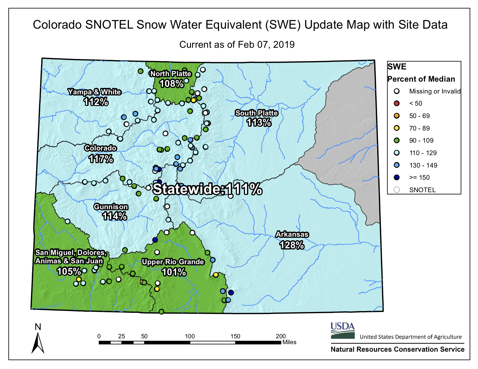
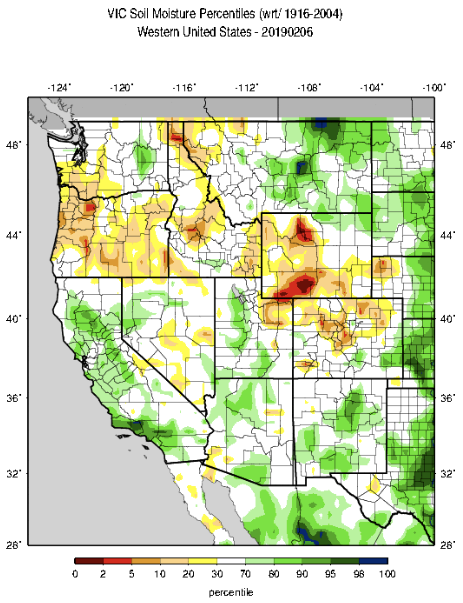


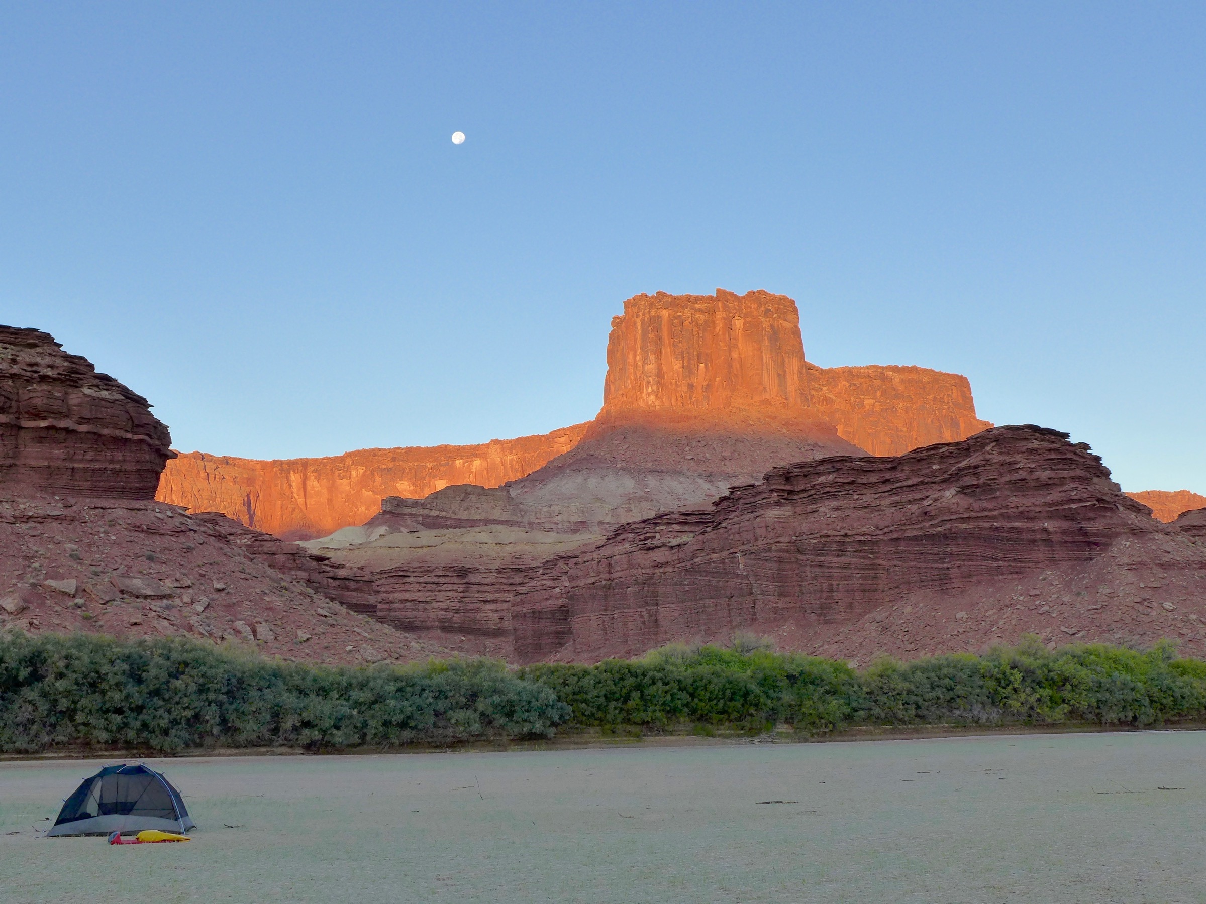
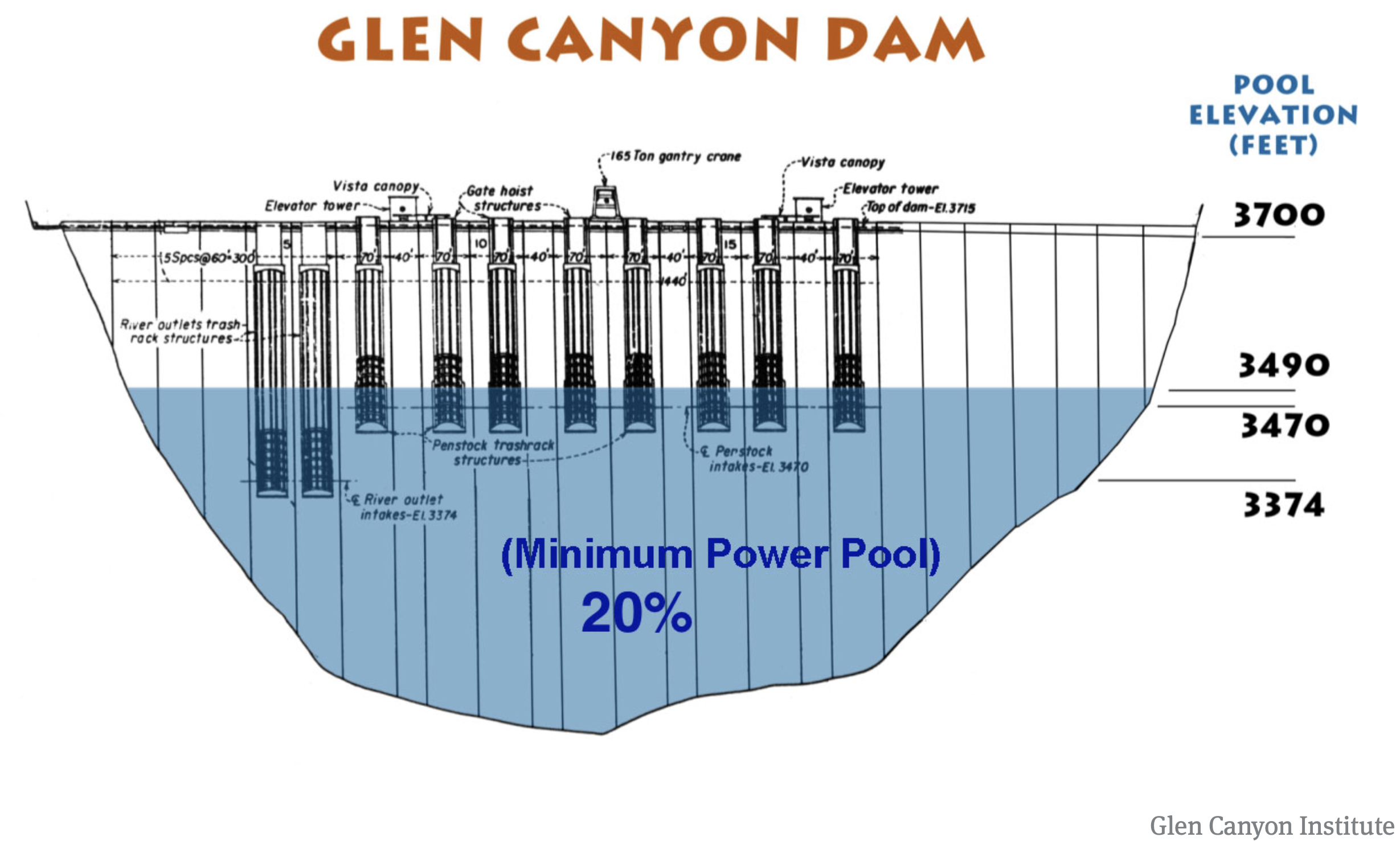

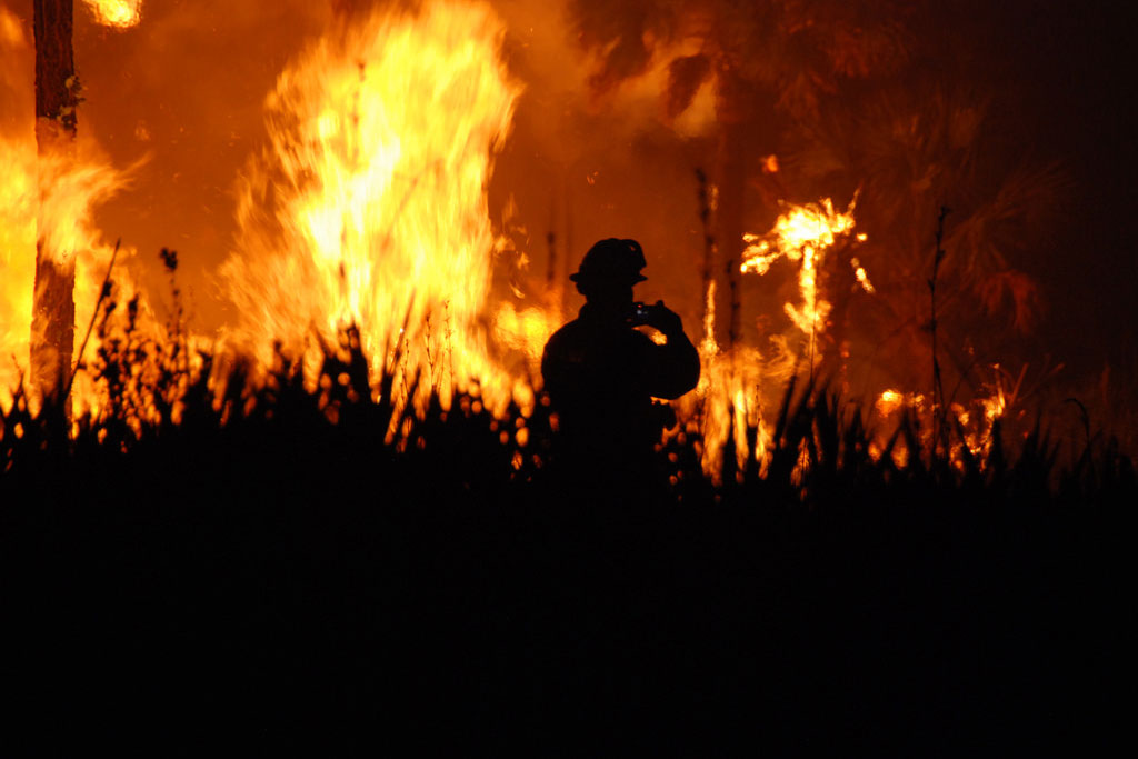
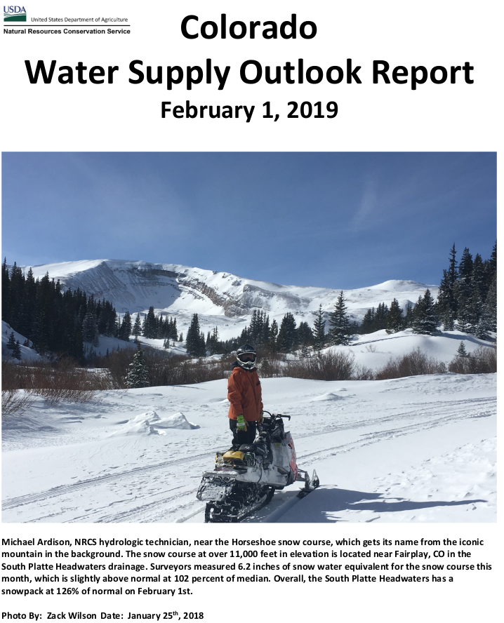

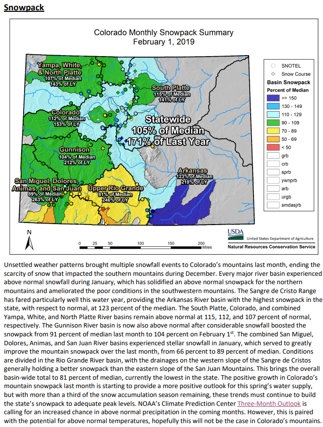
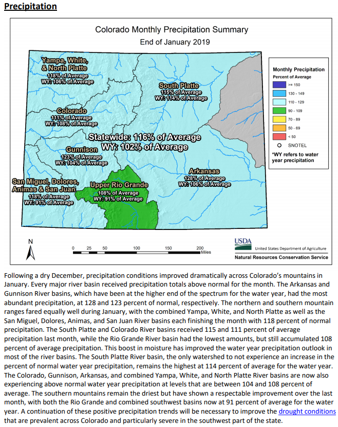
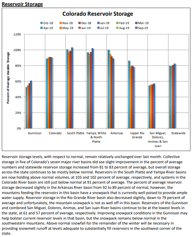
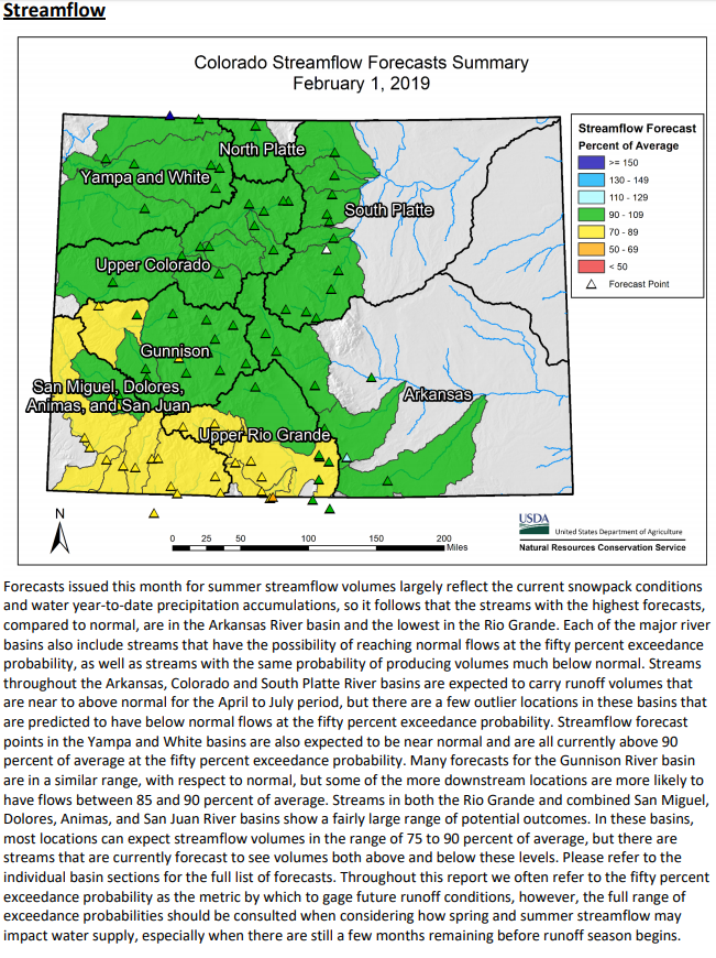


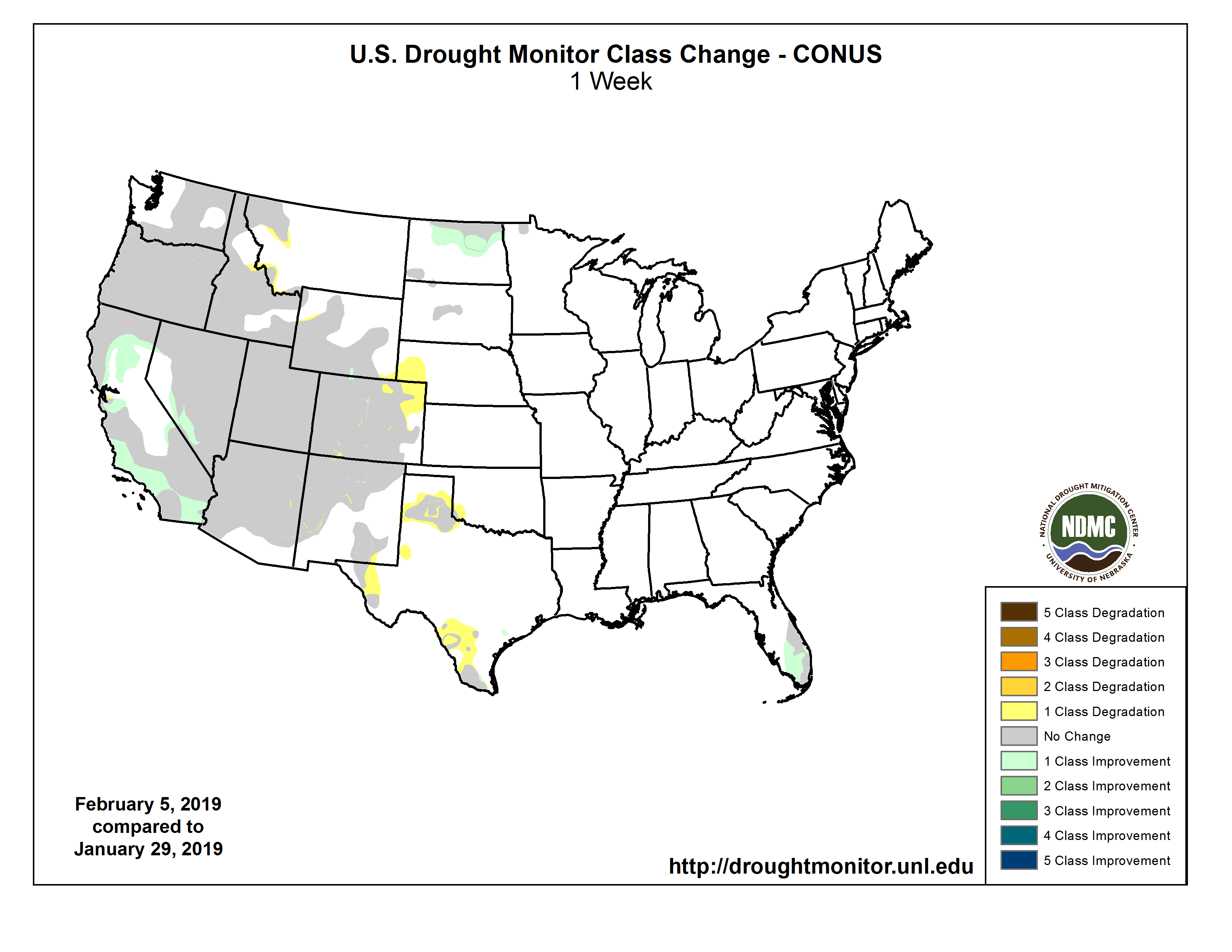


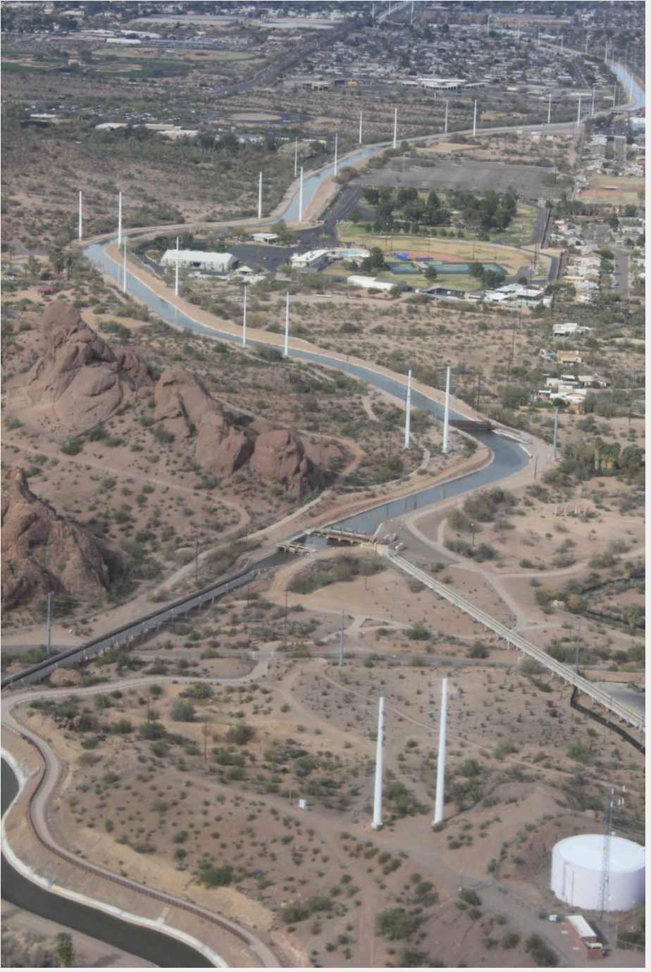


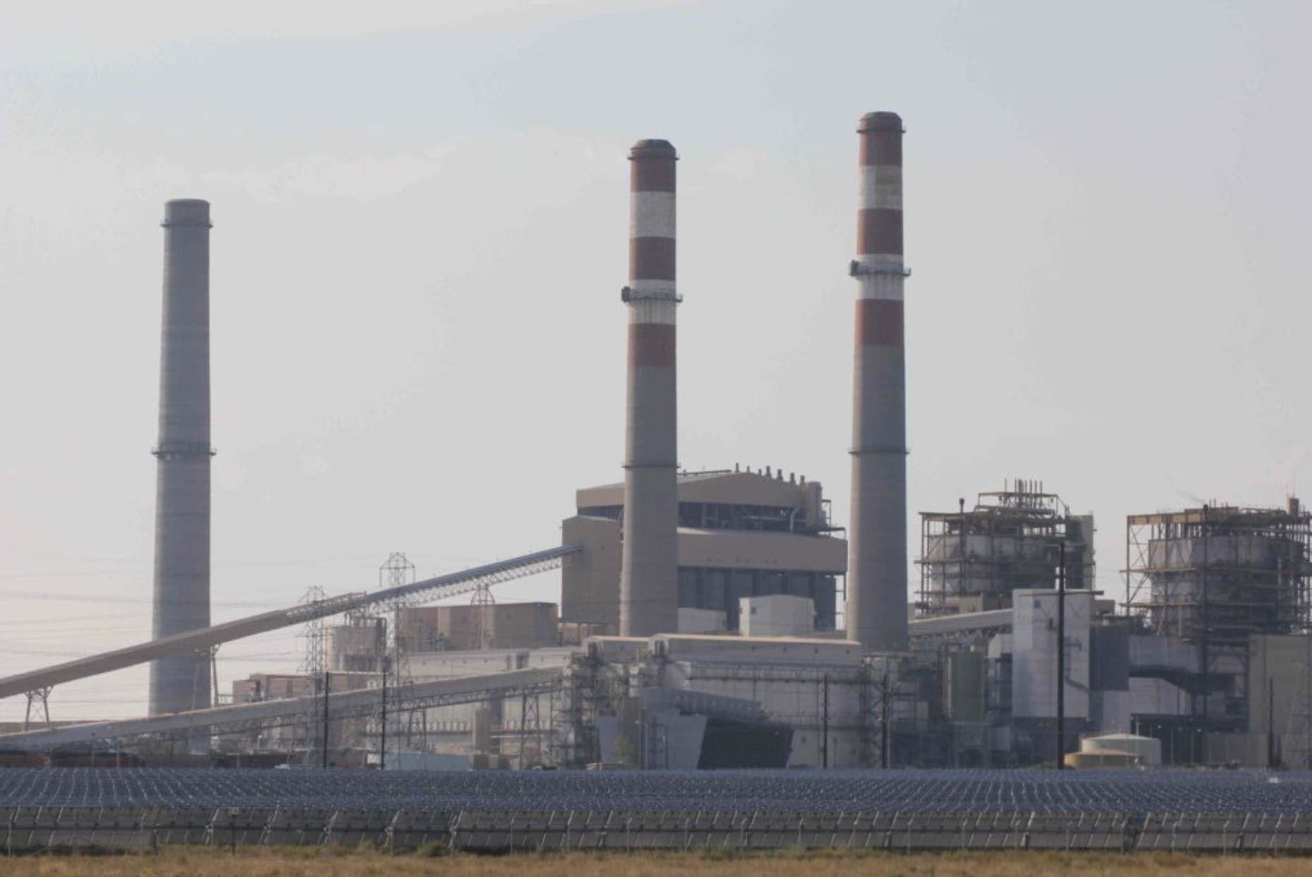
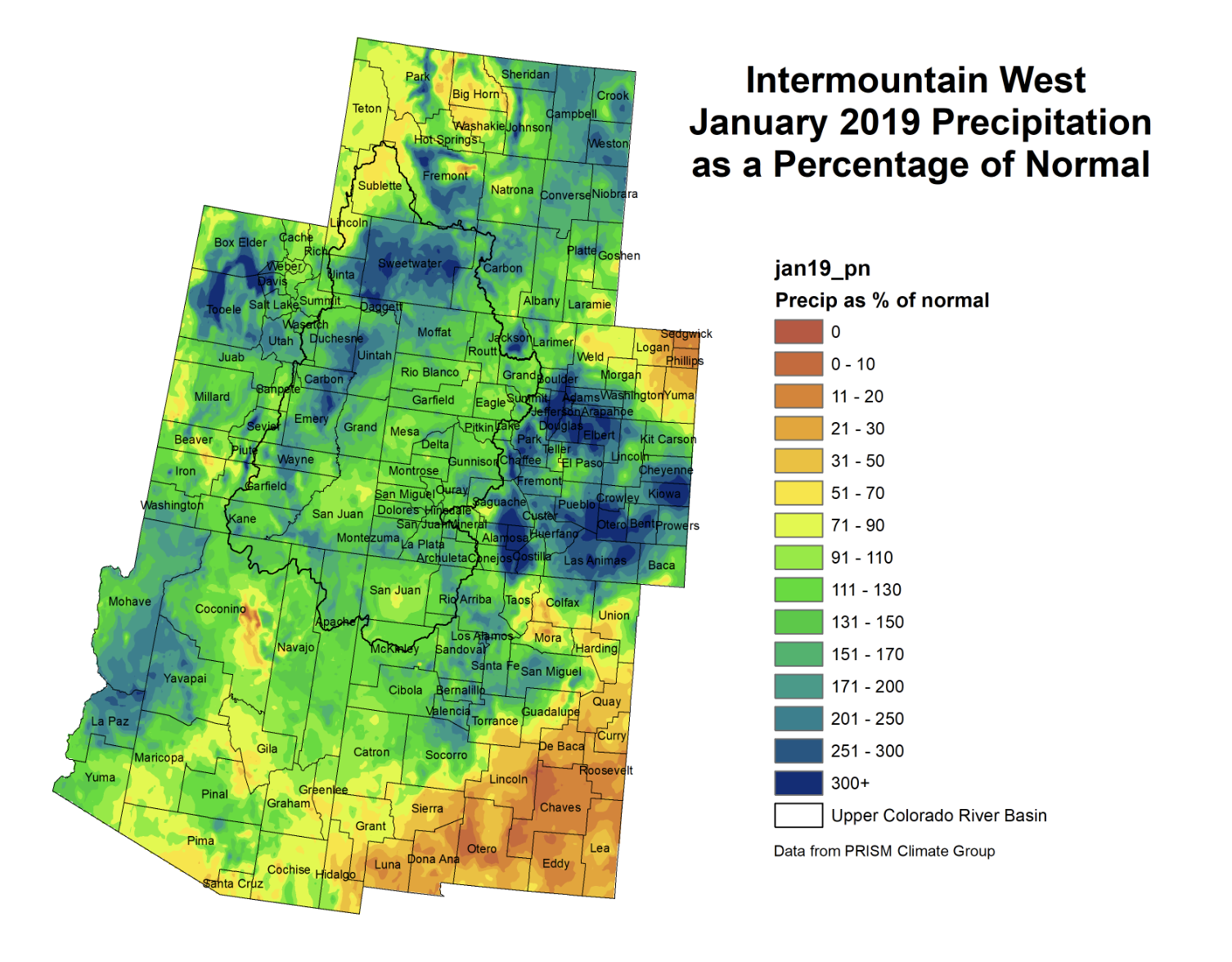


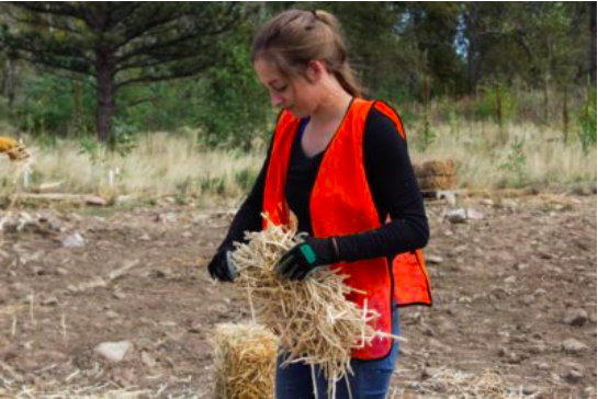
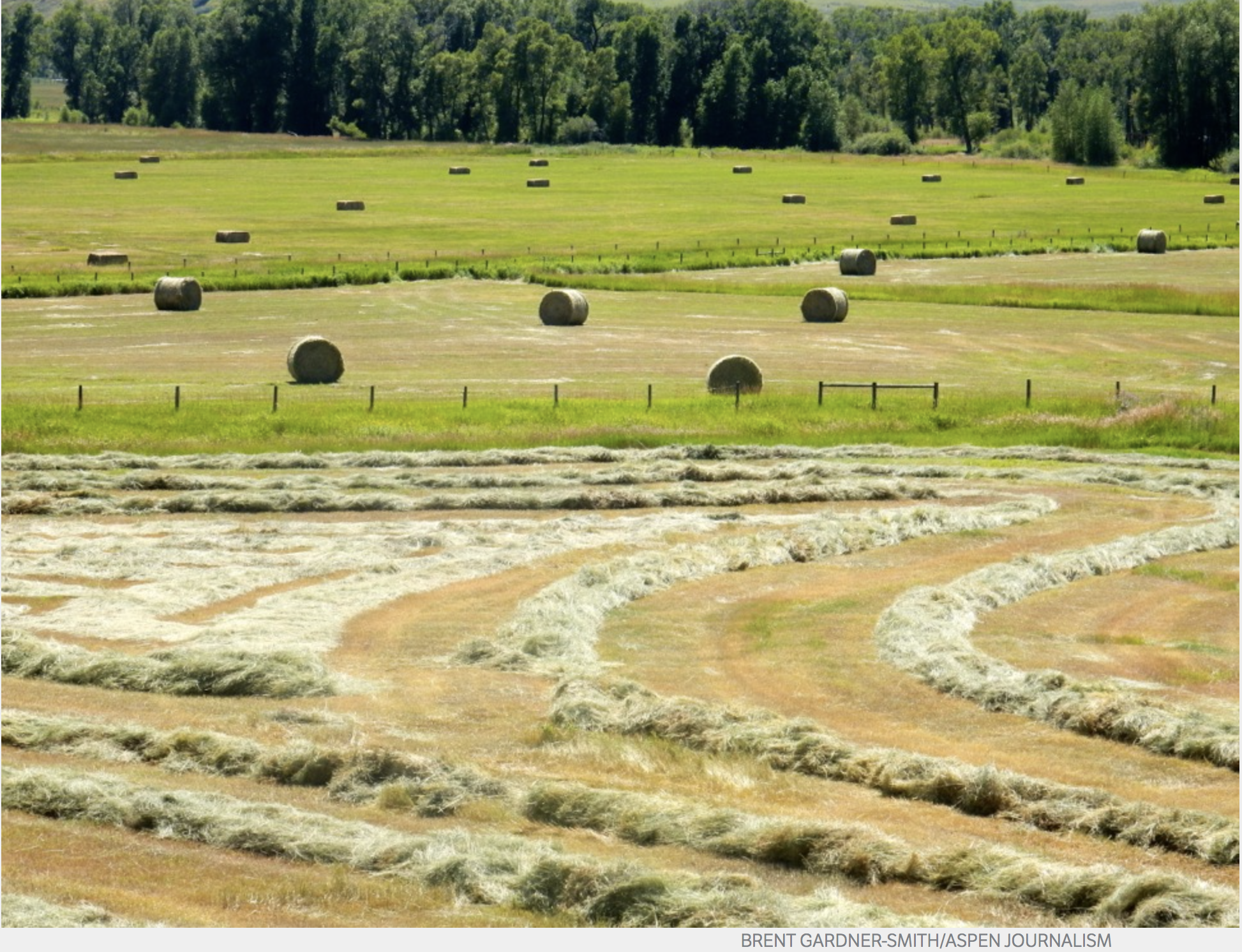

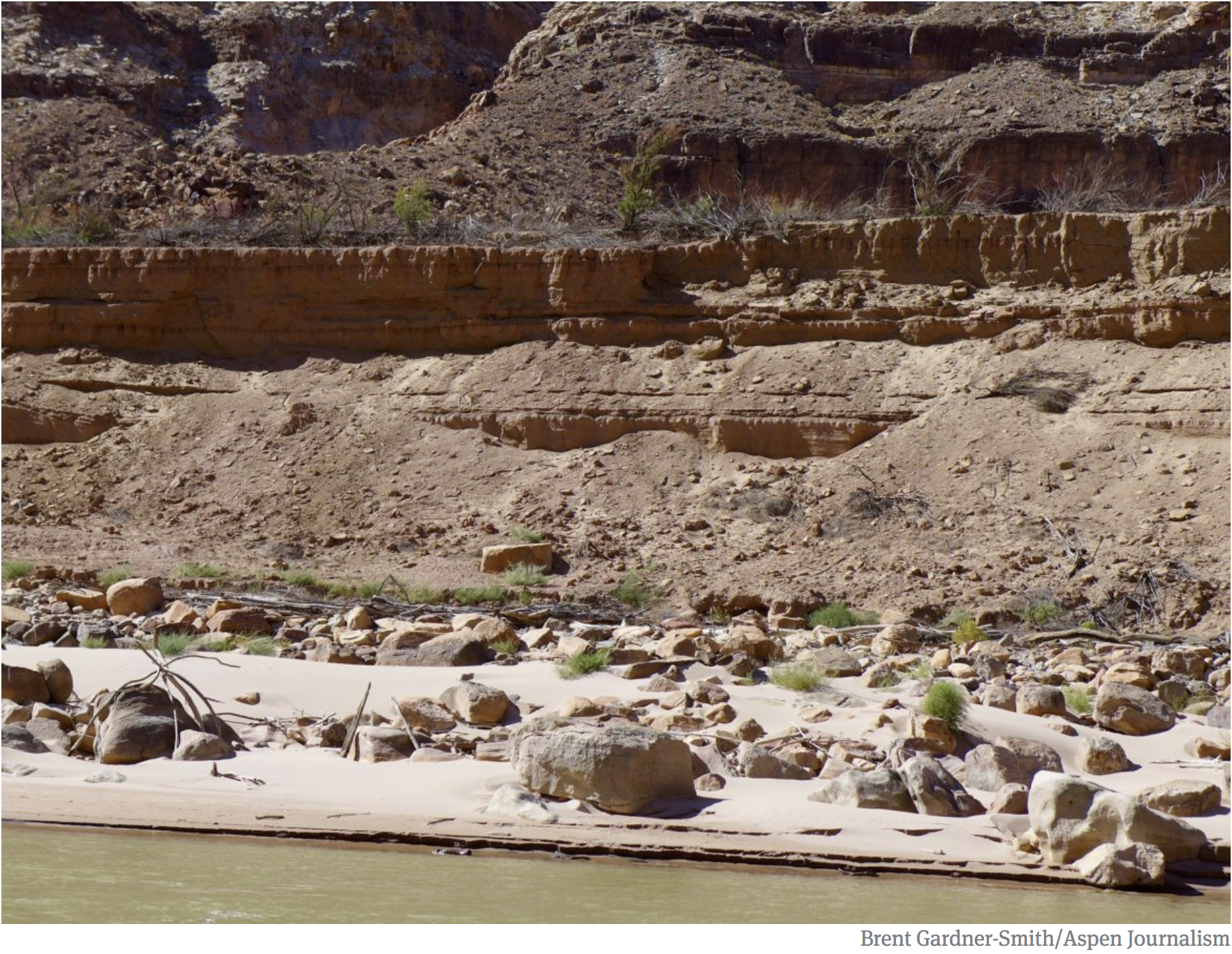
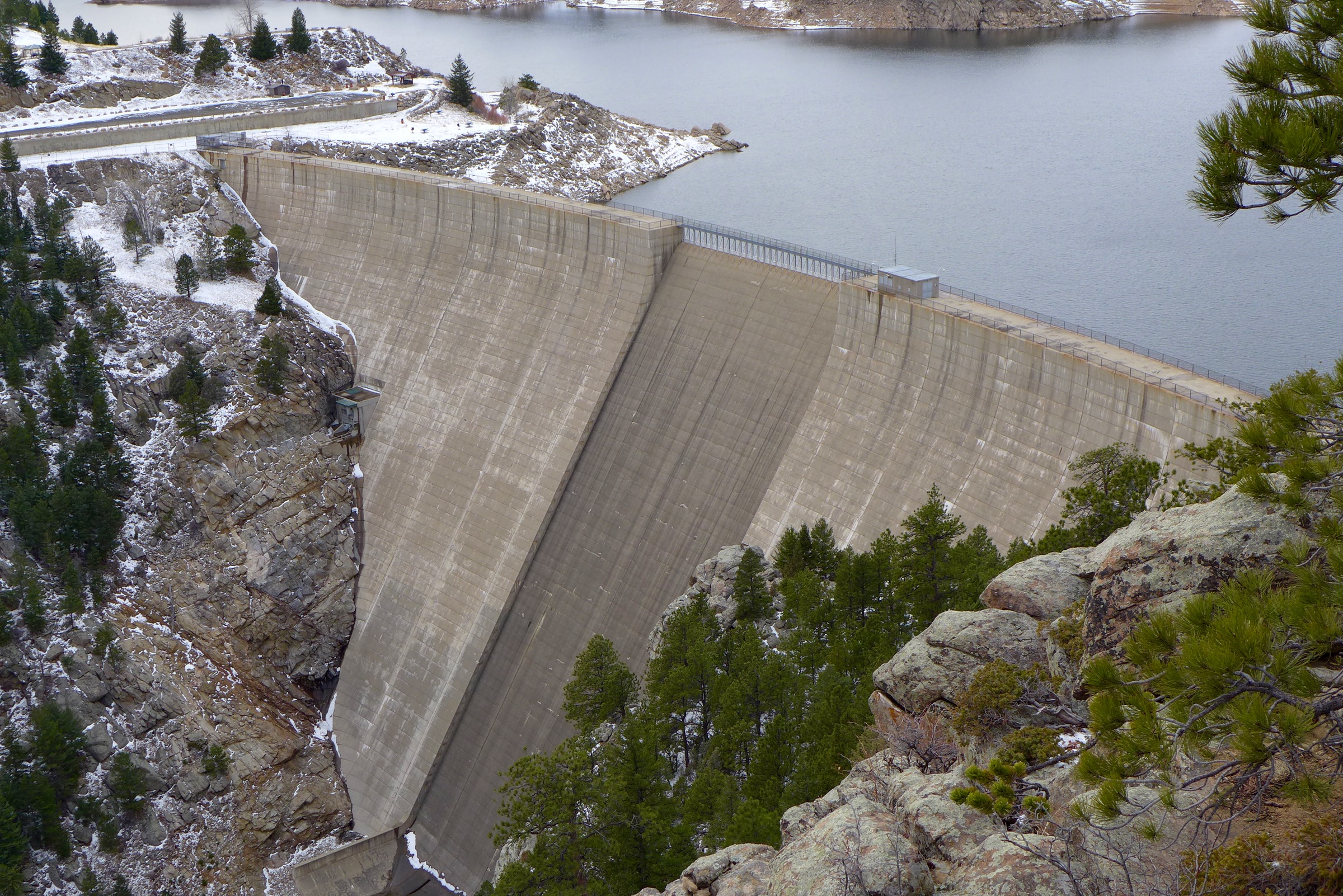


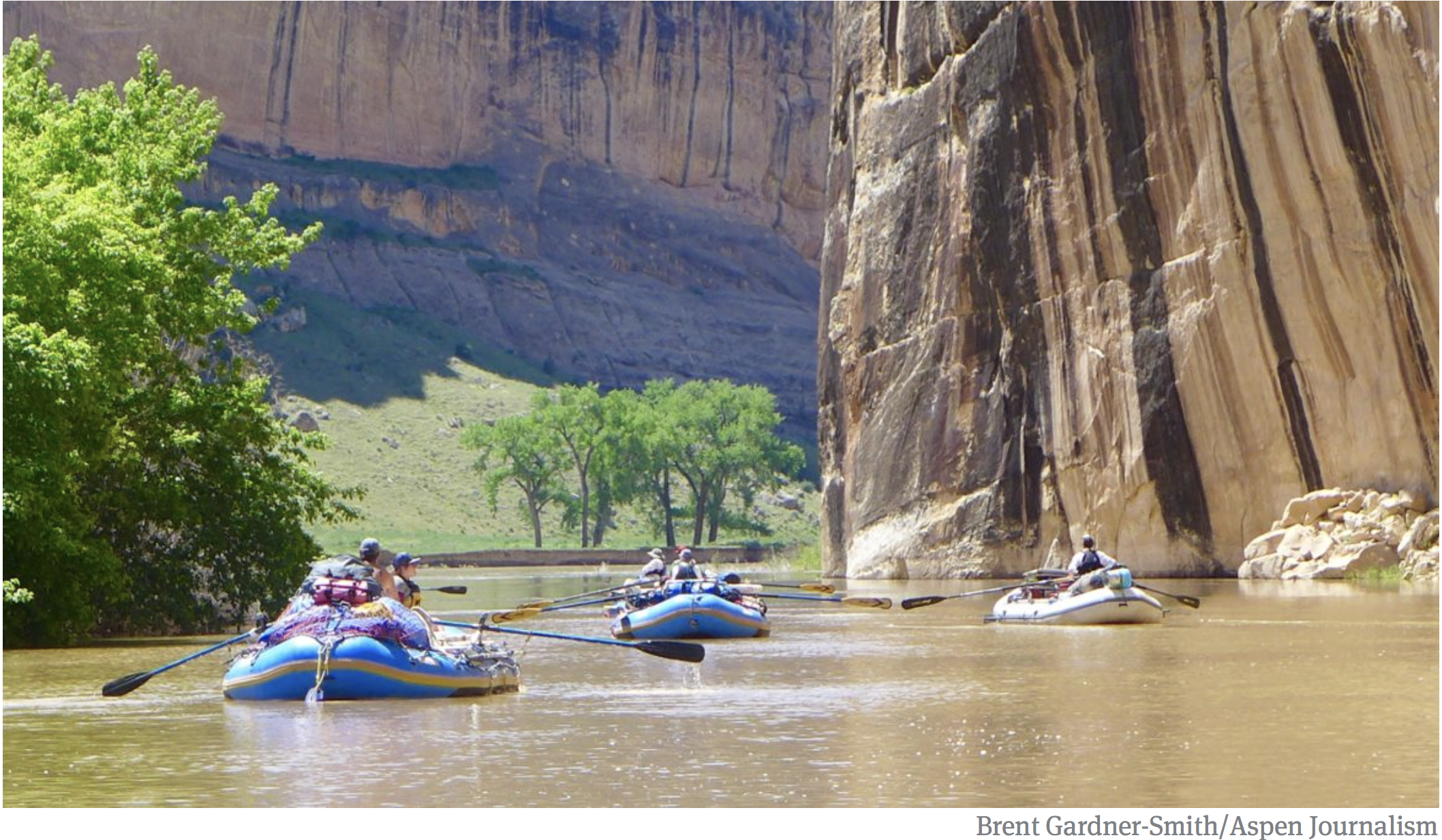
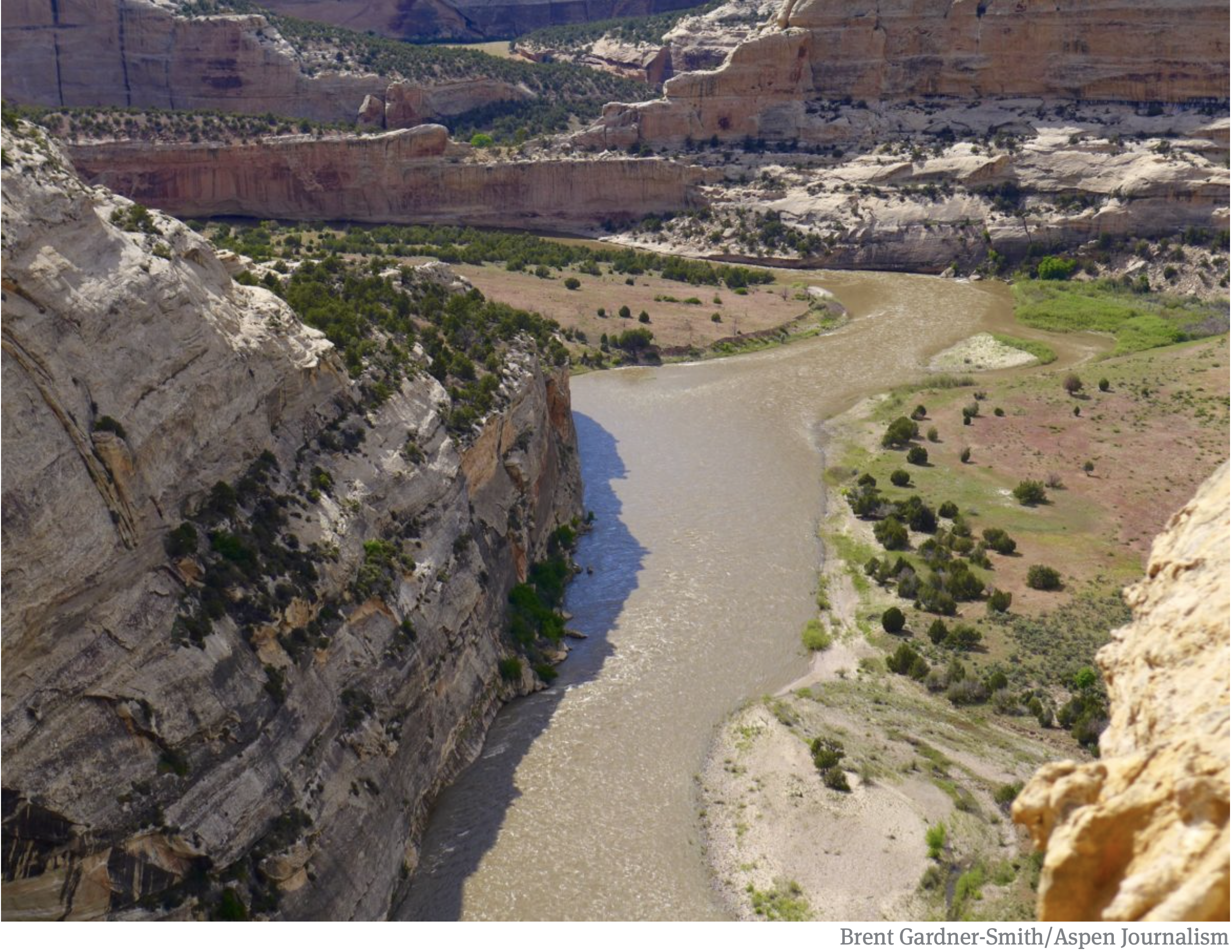


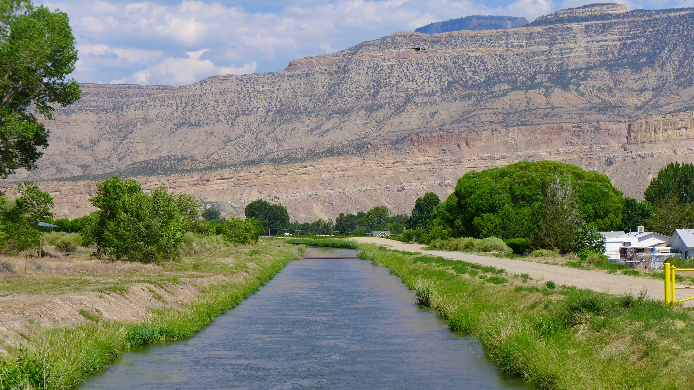


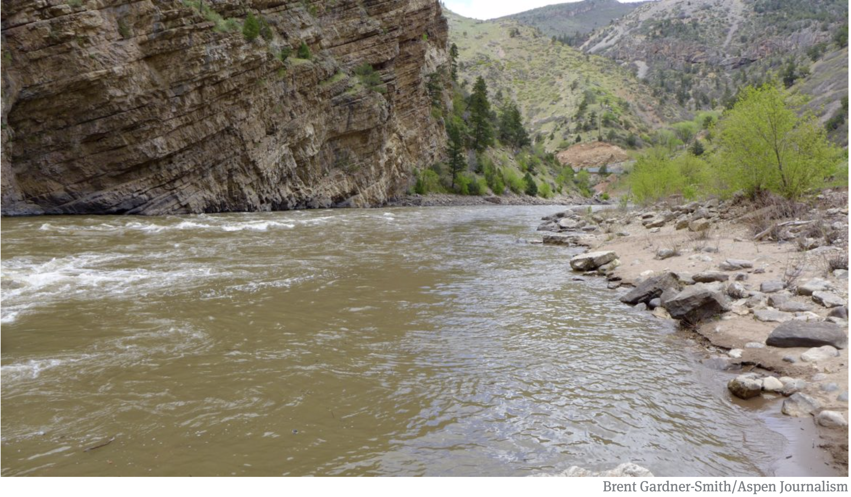


