The health of our waters is the principal measure of how we live on the land — Luna Leopold
#Drought news (December 2, 2021): Drying soils, high evapotranspiration, low mountain #snowpack, and mounting precipitation deficits resulted in expansion of moderate to extreme drought in many parts of #Colorado
Click on a thumbnail graphic to view a gallery of drought data from the US Drought Monitor.
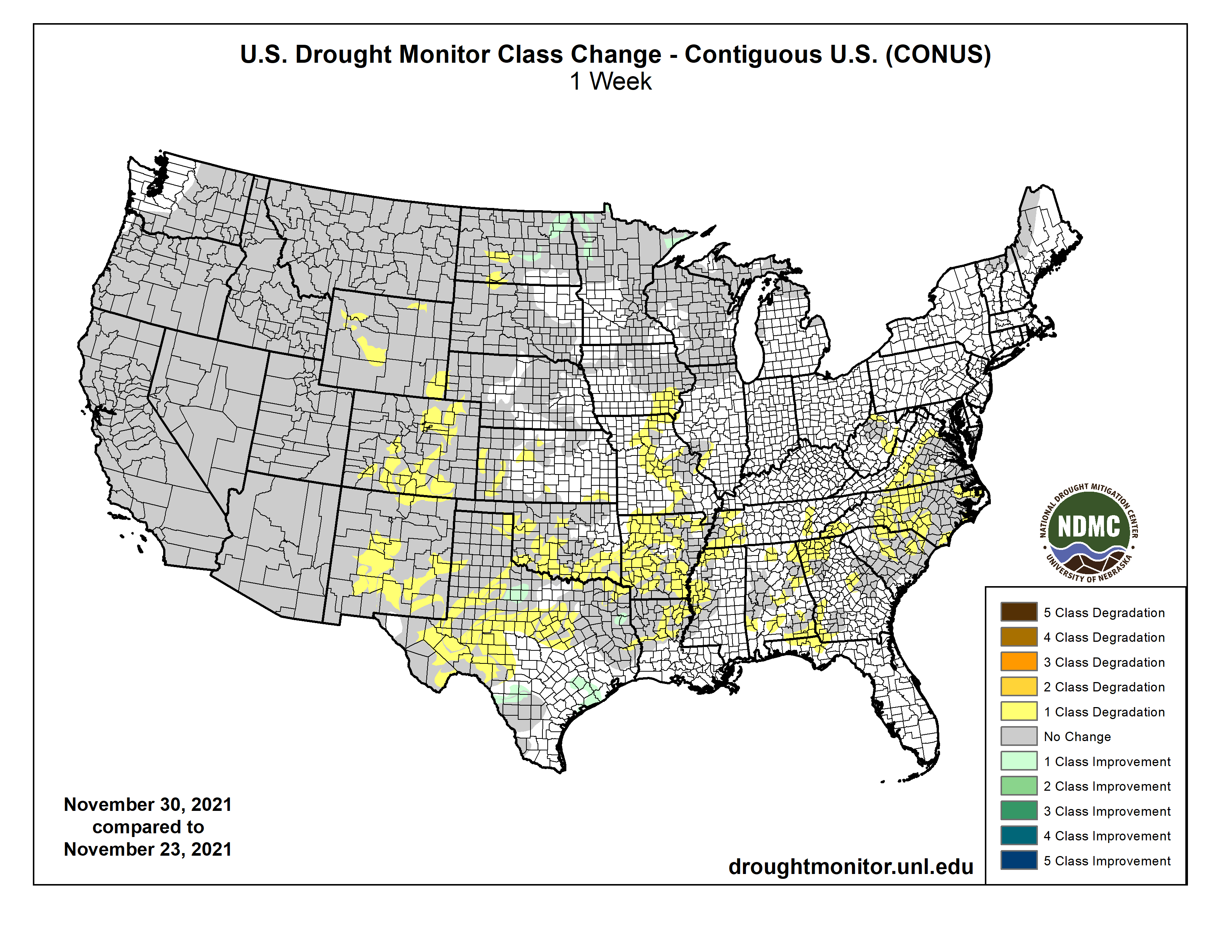
US Drought Monitor map November 30. 2021.
High Plains Drought Monitor map November 30. 2021.
West Drought Monitor map November 30. 2021.
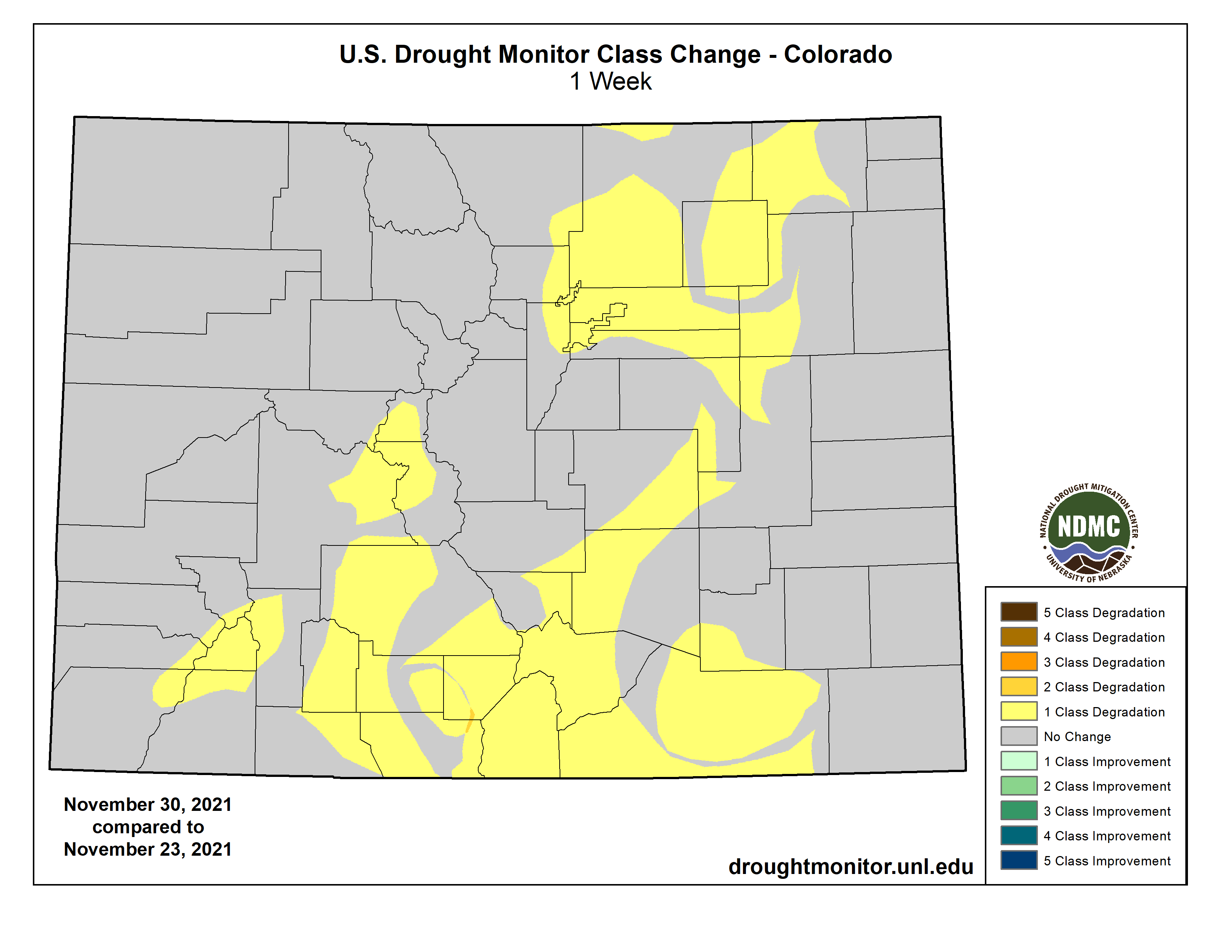
Colorado Drought Monitor map November 30. 2021.
Click here to go to the US Drought Monitor website. Here’s an excerpt:
This Week’s Drought Summary
Several Pacific weather systems moved across the contiguous U.S. (CONUS) during this U.S. Drought Monitor (USDM) week. An upper-level ridge over the western CONUS directed the systems across the northern states, while a cutoff low trekked across Texas then into the Gulf of Mexico. The Pacific systems dragged cold fronts with them that stretched the width of the CONUS, from the Great Lakes to the Gulf of Mexico coast. The fronts triggered rain and snow over parts of the country, but they were starved of precipitation by the western ridge and its northwesterly flow over the central CONUS. As a result, the week was wetter than normal only in parts of the Pacific Northwest, northern Rockies, Great Lakes, and Texas. The weather was drier than normal across the rest of the CONUS with large parts of the West, Great Plains, Upper Mississippi Valley, and Southeast receiving no precipitation. Most of the West and Great Plains were warmer than normal thanks to the western ridge. The persistent above-normal temperatures contributed to excessive evapotranspiration in western portions of the Great Plains as well as parts of the West, as seen in EDDI and ESI indicators. Lack of precipitation, excessive evapotranspiration, and windy conditions further dried soils, again especially in western portions of the Plains, as seen in several soil moisture indicators. Drought indicators such as the Standardized Precipitation Index (SPI) and Standardized Precipitation Evapotranspiration Index (SPEI) reflected the mounting precipitation deficits. The continued dryness expanded or intensified drought in parts of the southern to central Rockies, Great Plains, Lower to Mid-Mississippi Valley, Southeast, and Mid-Atlantic states, as well as Puerto Rico…
Little to no precipitation fell across the High Plains region this week. Reassessment of the last 2 months’ precipitation led to contraction of moderate drought in northeast North Dakota and severe drought in the central part of the state. But water levels in ponds and dugouts remained low in spite of late summer to early fall rains, thus prompting expansion of severe drought in other parts of central North Dakota. Above-average temperatures and no precipitation for the last 2 weeks resulted in expansion of moderate drought in southern parts of North Dakota and adjacent South Dakota. In Wyoming, many basins had below to well below normal snowpack with no snow across the High Plains portion of the state, and snow, where it has occurred, was confined to the highest peaks (above 8500 ft). The snow conditions combined with excessive evapotranspiration, drying soils, short-term dryness, and longer-term dryness to prompt expansion of moderate to extreme drought in parts of the state. In Colorado, drying soils, high evapotranspiration, low mountain snowpack, and mounting precipitation deficits resulted in expansion of moderate to extreme drought in many parts of the state. November 28 USDA statistics had 84% of Colorado’s topsoil short or very short of moisture and 33% of the winter wheat in poor to very poor condition. Abnormal dryness and moderate drought expanded in southern and western parts of Kansas…
Colorado Drought Monitor one week change map ending November 30, 2021.
Pacific weather systems brought 0.5-3.0 inches of precipitation to coastal portions of Oregon and Washington, with 5 inches or more falling in non-drought areas of northwest Washington. Half an inch to locally 2 inches also fell over parts of the northern Rockies, while locally up to half an inch occurred over a few parts of the southern Rockies. Otherwise, much of the West was dry. Drying soils and mounting 3-month precipitation deficits prompted expansion of moderate to extreme drought in parts of New Mexico. November 28 USDA reports had 81% of New Mexico’s topsoil short or very short of moisture. Otherwise, no change occurred to the vast areas of moderate to exceptional drought which covers the West…
Half an inch to 1.5 inches of rainfall was widespread across coastal to eastern Texas, and into adjacent parts of Louisiana, and locally over 2 inches fell over parts of Texas. Smaller swaths of half an inch of rain occurred over north Texas and parts of Arkansas, Mississippi, and Tennessee. But the rest of the region had less than half an inch, with much of western Texas to most of Oklahoma receiving little to no precipitation. Moderate to severe drought contracted in a few parts of Texas where the heaviest rains fell, but much more of the state, as well as parts of Oklahoma, Arkansas, and Louisiana, saw expansion of abnormal dryness and moderate to severe drought. Areas of abnormal dryness expanded in western Tennessee and developed in eastern portions of the state. With every passing day of no precipitation, low humidity, high evapotranspiration, the wildfire threat continued to grow in Texas and Oklahoma. According to November 28 USDA statistics, 64% of the topsoil moisture in Texas was short or very short (dry to very dry) and 45% of the winter wheat crop was in poor to very poor condition. In Oklahoma, the statistics were 59% for topsoil moisture and 16% for winter wheat condition…
Looking Ahead
The upper-level ridge will dominate the weather over the western CONUS for the first half of the next USDM week, with a couple Pacific frontal systems moving in later in the week. For December 2-7, the fronts will bring an inch to locally 3 inches of precipitation to parts of coastal Washington and Oregon and the northern Rockies, with 1 to 2 inches in a wide swatch from eastern Oklahoma to the southern Appalachians and north across the Ohio Valley to parts of New England. Half an inch to an inch will spread from the swath to the central Gulf of Mexico coast and across the Great Lakes. Most of the Plains and Southwest, as well as much of Virginia, the Carolinas, and Florida, will receive little to no precipitation. Temperatures are expected to average warmer than normal across most of the CONUS during this period. For December 7-15, odds favor above-normal precipitation across the West and Ohio Valley, with lesser chances for above-normal precipitation in the northern Plains and along the East Coast. Odds favor near to below-normal precipitation in the southern Plains and southern Florida. Much of Alaska is likely to be wetter than normal. Odds favor warmer-than-normal temperatures across most of the CONUS, with near to below-normal temperatures in the Pacific Northwest and early in the Great Lakes. Alaska is likely to be colder than normal, especially in southern portions of the state.
US Drought Monitor one week change map ending November 30, 2021.