This past summer I was part of a crew that conducted conservation work at the site of River House, located along the San Juan River. In this link –> HERE, the Bureau of Land Management (BLM) – Utah Division, presents a blog post and short video of the work conducted. I have much appreciation for […]
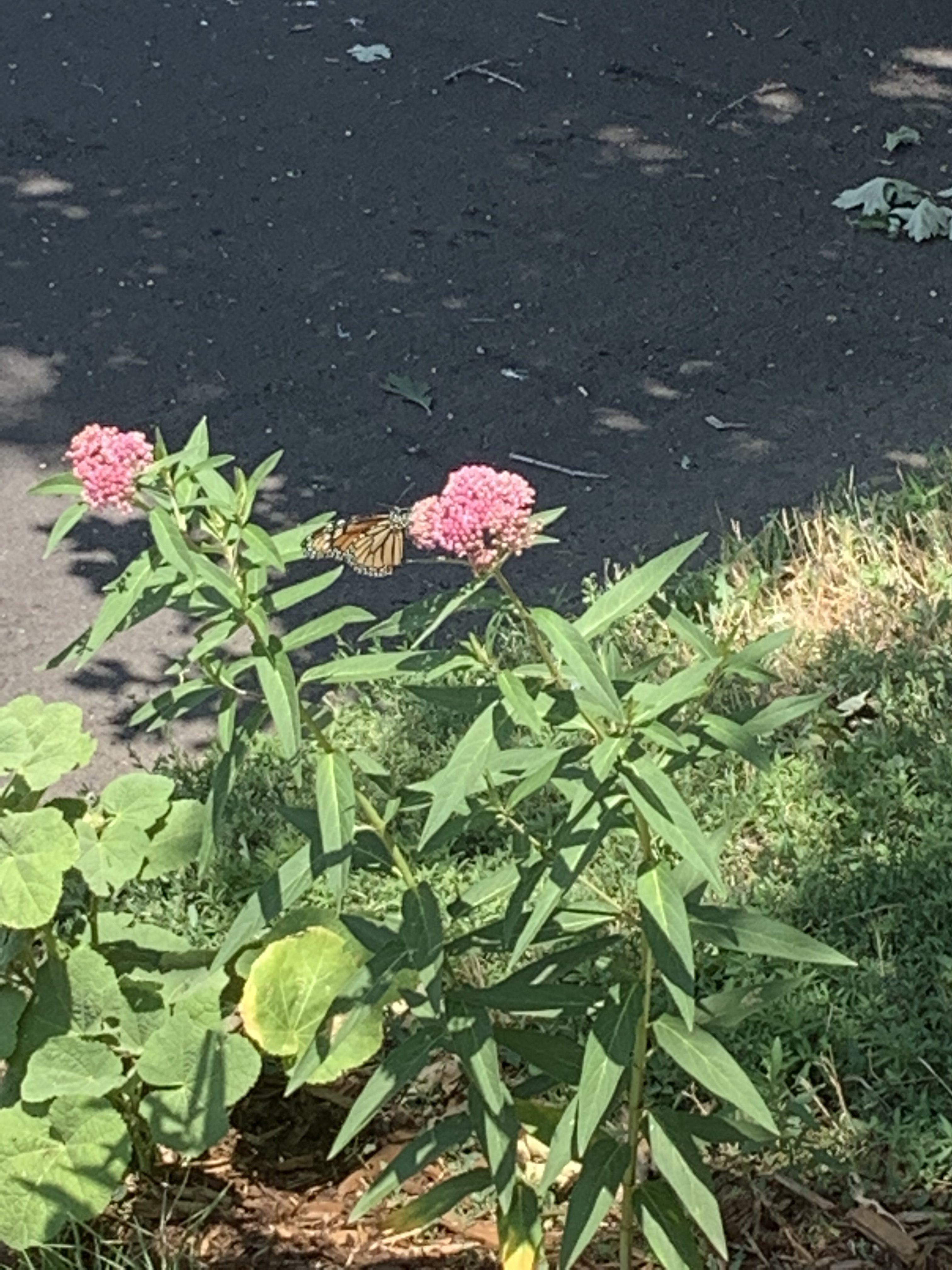
Monarch butterfly on milkweed in Mrs. Gulch’s landscape July 17, 2021.
FromNational Public Radio (Michael Levitt and Christopher Intagliata):
Every year, monarch butterflies from all over the western U.S. migrate to coastal California, to escape the harsh winter weather. In the 1980s and ’90s, more than a million made the trip each year.
Those numbers have plummeted by more than 99% in recent years.
“The last few years we’ve had less than 30,000 butterflies,” biologist Emma Pelton said. “Last year, we actually dropped below 2,000 butterflies. So really an order of magnitude change in a short time period.”
Pelton works with the Xerces Society for Invertebrate Conservation and says pesticides and habitat loss play a role in that decline.
But this year, the numbers are starting to pick up. Biologists and volunteers across California have already counted more than 100,000 monarchs.
Richard Rachman is the coordinator for the Xerces Society’s annual Thanksgiving monarch count in Los Angeles County, and has been buoyed by the numbers.
[December 3, 2021], the U.S. Environmental Protection Agency (EPA) announced that 39 new projects are being invited to apply for Water Infrastructure Finance and Innovation Act (WIFIA) loans and four projects are being added to a waitlist. The agency anticipates that, as funds become available, $6.7 billion in WIFIA loans will help finance over $15 billion in water infrastructure projects to protect public health and water quality across 24 states.
“Far too many communities still face significant water challenges, making these transformative investments in water infrastructure so crucial,” said EPA Administrator Michael S. Regan. “The WIFIA invited projects will deliver major benefits like the creation of good-paying jobs and the safeguarding of public health, especially in underserved and under-resourced communities. This program is a shining example of the public health and economic opportunities that will be achieved under President Biden’s Bipartisan Infrastructure Law.”
EPA’s WIFIA program will provide selected borrowers with innovative financing tools to address pressing public health and environmental challenges in their communities. Consistent with its announced priorities, the WIFIA program is making $1.2 billion in loans available to support infrastructure needs in historically underserved communities. Additionally, 14 projects will help protect infrastructure from the impacts of extreme weather events and the climate crisis. New and innovative approaches, including cybersecurity, green infrastructure, and water reuse, are included in 24 projects.
By diversifying its geographic reach and the types of selected borrowers, the WIFIA program will also expand the types of projects it supports. For the first time, entities in Connecticut, Delaware, and Hawaii are invited to apply. Three small communities, with populations of 25,000 or less, are selected for WIFIA loans totaling nearly $62 million. In addition, seven projects submitted by private borrowers and public-private partnerships totaling over $1.5 billion in WIFIA financing are included.
EPA is also inviting state agencies in Indiana and New Jersey to apply for a total of $472 million in WIFIA loans through EPA’s state infrastructure financing authority WIFIA (SWIFIA) program. EPA’s SWIFIA loans are available exclusively to state infrastructure financing authority borrowers, commonly known as State Revolving Fund (SRF) programs, and will allow these programs to finance more infrastructure projects in their states. These programs will combine state resources, annual capitalization grants, and the low-cost, flexible SWIFIA loans to accelerate investment in drinking water and wastewater infrastructure to modernize aging systems and tackle new contaminants.
WIFIA Invited Projects:
Baltimore City Department of Public Works (Md.): $36 million for the Water Infrastructure Advancement 2021 project.
Charlotte Water (N.C.): $169 million for the Mallard Creek Sewer Basin Wastewater Collection and Treatment Improvements Program.
City of Ashland (Ore.): $36 million for a 7.0 Million Gallons per Day Water Treatment Plant.
City of Bellingham (Wash.): $136 million for the Post Point Resource Recovery Plant Biosolids Project.
City of Boise (Idaho): $272 million for Water Renewal Services Capital Investments Projects.
City of Chattanooga (Tenn.): $186 million for Wastewater Compliance and Sustainability Projects.
City of Cortland (N.Y.): $12 million for the Homer Avenue Gateway Project.
City of Memphis (Tenn.): $44 million for Stormwater Upgrades.
City of Oregon City (Ore.): $12 million for Water Rehabilitation, Resiliency and Improvement Projects.
City of Philadelphia (Pa.): $260 million for the Water Department 2021 project.
City of Port Washington (Wis.): $12 million for the Water Treatment Plant Improvement Project.
City of Santa Cruz (Calif.): $164 million for the Santa Cruz Water Program.
Westminster
City of Westminster (Colo.): $130 million for the Water2025 project.
City of Wichita (Kan.): $181 million for the Wastewater Reclamation Facilities Biological Nutrient Removal Improvements Project.
County of Hawaii (Hawaii): $24 million for Hawaii Wastewater Treatment Upgrades.
EPCOR Foothills Water Project Inc. (Ore.): $76 million for the Lake Oswego Wastewater Treatment Replacement Project.
Fishers Island Water Works Corporation (N.Y.): $14 million for Water System Improvements.
Gainesville Regional Utilities (Fla.): $14 million for the Sanitary Sewer Replacement and Improvement Project.
Helix Water District (Calif.): $16 million for the Drinking Water Reliability Project.
King County (Wash.): $287 million Master Agreement.
Marin Municipal Water District (Calif.): $11 million for Marin Water.
Metropolitan St. Louis Sewer District (MSD) (Mo.): $278 million for MSD Project Clear – Deer Creek Watershed / Lemay Service Area System Improvements.
Metro Water Services (Tenn.): $186 million for the Process Advancements at Omohundro and K.R. Harrington Water Treatment Plants Project.
Narragansett Bay Commission (R.I.): $28 million for Field’s Point Resiliency Improvements.
New Castle County (Del.): $32 million for the Christina River Force Main Rehabilitation Project.
Ridgway via AllTelluride.com
Project 7 Water Authority (Colo.): $39 million for the Ridgway Water Treatment Plant.
Rialto Water Service LLC (Calif.): $68 million for Microgrid and System Improvements.
San Francisco Public Utilities Commission (Calif.): $618 million for Wastewater Capital Plan Resilience Projects.
Santa Clara Valley Water District (Calif.): $575 million for the Pacheco Reservoir Expansion Project.
Santa Clara Valley Water District (Calif.): $80 million for the Safe, Clean Water and Natural Flood Protection Program.
Santa Margarita Water District (Calif.): $22 million for Recycled Water Conversion.
Sharyland Water Supply Corporation (Texas): $14 million for Sharyland Water Supply Corporation Water System Infrastructure Improvements.
South Central Connecticut Regional Water Authority (Conn.): $20 million for Lake Whitney Dam and Spillway Improvements.
Tualatin Valley Water District (Ore.): $16 million for the Water System Upgrades Program.
United Water Conservation District (Calif.): $52 million for the Santa Felicia Safety Improvement Project.
Upper Santa Ana River Watershed Infrastructure Financing Authority (Calif.): $177 million for the Watershed Connect project.
Village of New Lenox (Ill.): $70 million for Phase 1 Improvements projects.
Waitlist Projects:
American Infrastructure Holdings (S.D.): $20 million for the Sioux City Biosolids to Fertilizer Project.
Lake Restoration Solutions, LLC (Utah): $893 million for the Utah Lake Restoration Project.
U.S. Highway 287 runs through the future site of Glade Reservoir. The Larimer county Board of County Commissioners approved the 1041 Land Use Permit for NISP in September, 2020. Photo credit: Northern Water
Northern Water (Colo.): $464 million for the Northern Integrated Supply Project – Glade Reservoir Complex.
Southland Water Agency (Ill.): $479 million for the Southland Water Agency Infrastructure System.
Background on WIFIA
Established by the Water Infrastructure Finance and Innovation Act of 2014, the WIFIA program is a federal loan and guarantee program administered by EPA. WIFIA’s goal is to accelerate investment in the nation’s water infrastructure by providing long-term, low-cost supplemental credit assistance for regionally and nationally significant projects.
In a week or so, CDOT will announce it has completed repairs of Interstate 70 in Glenwood Canyon. Crews have finished rebuilding the roadway, thanks to a unified push by a host of federal and state agencies.
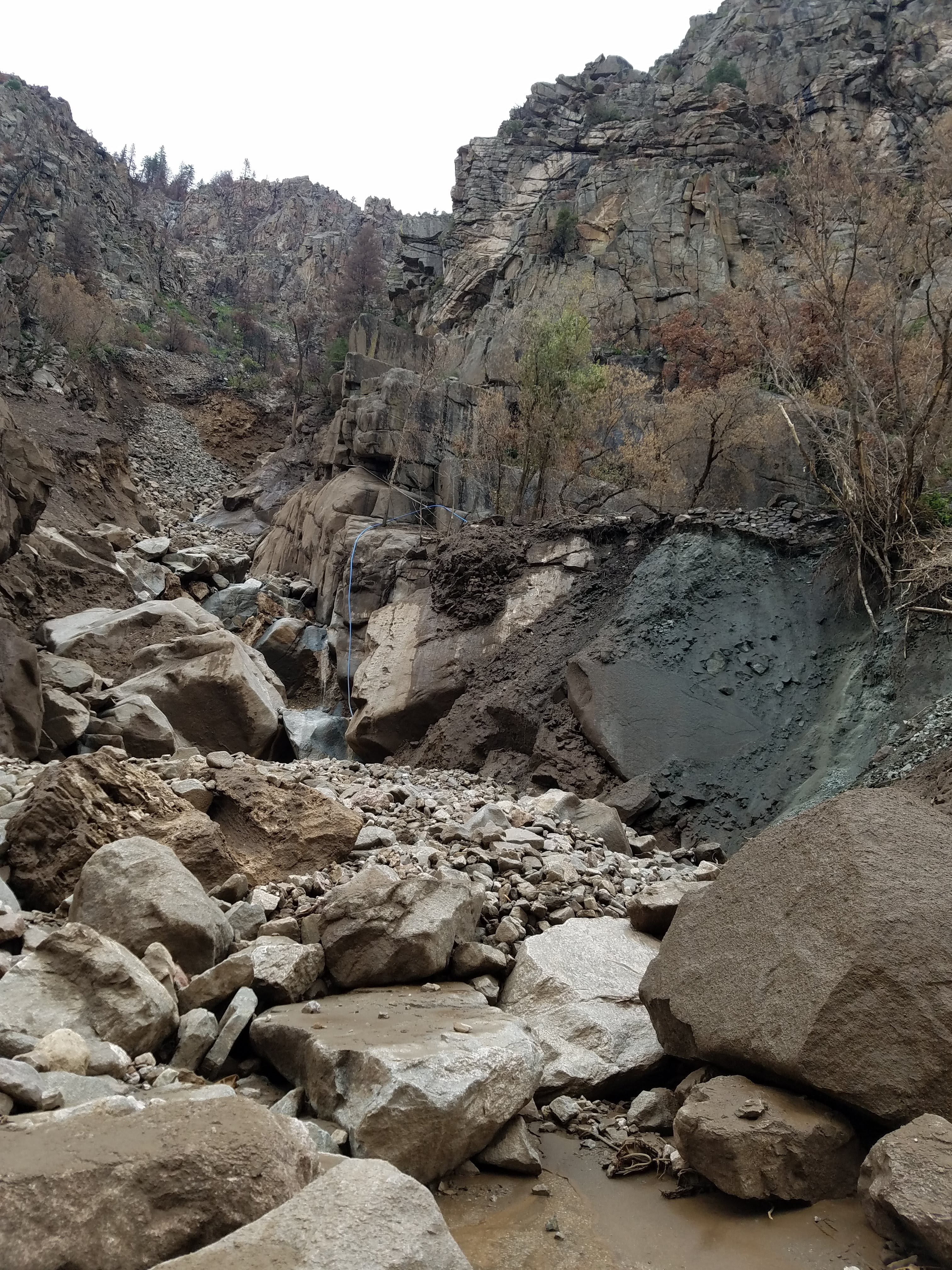
The impacts of the 2020 Grizzly Creek Fire that burned more than 32,000 acres in the canyon remain acute, with the scar still likely to shed rocks, timber and mud during next spring’s melt. More than 4 inches of rain on July 29 — following several days of rainstorms — shed rocks, mud and trees from atop the canyon. Six massive debris piles span a 3-mile stretch of highway and river in Glenwood Canyon. Early attempts to measure the muddy mess set it at more than 100,000 cubic yards. If it was just dry sand, that would be about 150,000 tons. CDOT estimates it has already removed about 44,000 tons of debris off the highway and recreation path.
The worst-ever debris-flow damage to the vital interstate corridor has been repaired in a little more than four months. It would probably be easier to list the federal and state agencies that were not involved in the restoration work, but CDOT led an effort with input from the Army Corps of Engineers, the U.S. Forest Service, the Federal Highway Administration, the Colorado Department of Natural Resources and just about every nearby community and Colorado River water guardians…
With teams working on the debris-choked Hanging Lake Trail as well as seeding the burn zone to hasten growth that can prevent devastating runoff, the final stage in the restoration of the Colorado River in Glenwood Canyon begins now, with plans to clear plumes of rocks and mud blocking the Colorado River in the canyon. Crews soon will position heavy machinery in the river bed as part of a complicated plan to clear six river-jamming piles.
CDOT officials flew over the canyon this summer and mapped the river and the new debris fields using laser technology. Then a hydrology consultant created models for various runoff scenarios, looking at how the jumbles of rocks in the river might disrupt flows when the dam at Hanging Lake spills and the narrow canyon sees the river swell to 5,000, 10,000 and even 15,000 cubic feet per second next spring.
“Based on those models, we are showing the potential for catastrophic damage to eastbound 70 if the river is left in its current configuration,” Knapp said. “That is the main driver for the removal of that debris.”
[…]
CDOT will start digging soon, chipping away at the piles until trucks have hauled away at least 60% and up to 90% of the debris choking the river and bike path in the canyon. That’s good news for downstream water users, anglers and rafters. But CDOT isn’t spending federal dollars to keep trout biting and rafts floating. It’s all about protecting the highway to the north and the railroad to the south of the river…
Six debris piles threatening I-70
CDOT plans to remove six debris piles by the end of April next year, before the spring runoff swells the Colorado River. Its emergency road repair contractor, Lawrence Construction Co., is on board to work the two piles that flowed from the north. The Lawrence group also plans to clear the recreation path along the river, but the priority is to clear the river before the end of April 2022.
Looking up at the source of the debris flow in Glenwood Canyon August 2021. Photo credit: CDOT
The debris pile that poured down Blue Gulch on the north side of the highway and damaged both the westbound and eastbound lanes did the most damage to the highway and buried the largest portion of the river. That pile erased a Class IV rapid known as Barrel Springs. One mile upstream, debris from from the north side’s Wagon Gulch went beneath the westbound lanes but buried the low-lying eastbound pavement. That’s the debris pile that could most easily force the river onto the highway, Knapp said…
Those two piles — below the Blue and Wagon gulches — are more logistically straight forward, with Lawrence Construction crews able to access them both from a single closed lane on the eastbound highway. And they are in the stretch of river between the Shoshone Dam at the Hanging Lake rest area and the Shoshone Generating Station, which is regularly dewatered in the winter months as Xcel Energy diverts the Colorado River into a tunnel that feeds the hydroelectric power plant.
The piles that came from the south, over and under the railroad, are more challenging for removal crews. CDOT will soon begin seeking contractors who can work with the Union Pacific railroad to access two of those piles above the Shoshone power plant, which are below Devil’s Hole Canyon and an unnamed gulch that CDOT has dubbed Unnamed…
Later this winter, the transportation department will hire contractors to help remove the two piles downstream of the power plant, which are below Deadman Gulch and above the Maneater rapid. (Those last two will be trickier, because the river is flowing there and crews will likely be unable to access the highway to remove debris.)
CDOT has a unique plan for the Devil’s Hole and Unnamed piles. The rocks and mud that flowed down Devil’s Hole Canyon funneled beneath the railroad tracks and slammed into the eastbound highway retaining wall, completely blocking the river. CDOT hopes a contractor can work with the railroad to deliver equipment to the debris piles but then build a temporary debris bridge across the river so earthmovers can load trucks on the highway. The plan for a debris bridge is the same for the Unnamed pile. That way no debris would be removed via the railroad.
But downstream, in the heavily rafted Shoshone stretch of the Colorado River, the two piles at Deadman and Maneater will require more coordination with Union Pacific. The railroad has given CDOT a four-hour midday window between its passing trains to load and remove train cars with debris. CDOT’s yet-to-be-issued request for contractors is hoping to find a company that can speedily fill train cars while working on the edge of the moving Colorado River…
The Forest Service and CDOT, recognizing the critical role rafting plays in the local economy, opened early access to the river for several owners of rafting companies.
It was quite a scene, said Ken Murphy, the owner of the Glenwood Adventure Company. Nine or so competitors, working together in the middle of rapids with ropes, chainsaws and winches to clear dense walls of timber clogging the rapids above Glenwood Springs.
“We just had to get it open,” Murphy said, “and get our businesses back up and running. The river is an important economic driver for our community. There is huge support to get that cleaned up and ready.”
After two days of sawing and yanking, they cleared a path for rafts. Then the owners brought in their guides, who had to learn how to navigate a completely different river. The jagged piles of rock at Deadman and Maneater have changed how rafts and kayaks descend the rapids.
That’s not necessarily new. After exceptionally snowy seasons in Colorado, Shoshone stretch can see flows reach 15,000 or even 18,000 cubic-feet-per-second in the spring. (For comparison, the stretch typically runs around 1,200 cfs.)
Those rowdy runoff flows shift rocks and reorient rapids. Murphy said commercial and private whitewater paddlers are closely watching how the debris removal might change rapids…
CDOT’s Knapp is a kayaker. He lived in Glenwood Springs. He’s confident that removing debris from the side of the river channel will not alter the rapids. When the project is wrapped, he expects the river to look and paddle a lot like it did before the summer rockfall. He knows he’s not spending millions in taxpayer dollars so whitewater paddlers can still enjoy the river. But recreation is an important consideration and one of the resources the Forest Service wants to protect in Glenwood Canyon.
Managing water collected from the mountain snow’s spring runoff has plenty of challenges — and will become more complex in the future due to climate change.
“As water planners, we prefer to see predictable weather patterns,” said Nathan Elder, water supply manager at Denver Water. “Unfortunately, every year is different and with climate change we’re seeing more variability and that makes it tougher to manage our water supply.”
That challenge may be most acute during runoff season, that critical — and brief — window of time when snow melts, flows into streams and fills reservoirs. Climate change may lead to changes in runoff timing that, in turn, require more nimble reservoir operations.
What’s happening?
Since the 1960s, average temperatures in Colorado have increased 2.5 degrees, according to the Colorado Water Conservation Board. That change is manifesting in significant ways.
“We’re seeing more swings between wet and dry years, more variation in year-to-year stream runoff and earlier runoff,” said Laurna Kaatz, climate program manager at Denver Water. “We’re also expecting to see more extreme weather events like extreme heat and enhanced drought, but we could also see more intense rainstorms and flooding especially if heavy rain falls on top of a lot of snow.”
Timing is everything
The timing of the snow runoff in Summit County, which is home to Dillon Reservoir, provides an example of how climate change impacts not only water collection but also recreation and flooding.
Rapid snowmelts caused by rain falling on snow could lead to a greater risk of flooding below Dillon Dam.
During a gradual runoff, Denver Water can take steps to minimize the risk of flooding below the dam, however, if there are more instances of warm weather combined with rain falling on snow, large amounts of water can fill Dillon quickly and send water through the dam’s overflow spillway. This scenario can lead to high water levels on the Blue River through Silverthorne.
“We do our best to minimize high flows out of our reservoirs, but if there is a fast runoff, we can only do so much and there’s a greater chance for flooding downstream if there’s a major rain-on-snow event,” Elder said.
Changes in runoff and precipitation also impact when Dillon Reservoir fills — or doesn’t fill — which plays a role in boating season and water levels for the Dillon and Frisco marinas.
The timing of the runoff also impacts Denver Water’s ability to make the most of its water rights.
“Later runoff allows us to use our water rights to match higher customer demand during the summer watering season,” Elder said. “Early runoff means we have to let some water go downstream before we can put it to use on the Front Range. This also impacts how much water we can store for times of drought.”
When Dillon Reservoir is full, water flows down its overflow spillway into the Blue River. Photo credit: Denver Water.
Extreme weather events
Colorado has seen several big swings in weather over the last 20 years, suggesting the kind of uncertainty that may be more pronounced as climate change intensifies and the resulting complexity in managing the snow runoff.
Most recently, the winter of 2017-2018 was exceptionally dry across the state but was followed by above average snow in 2018-2019.
The years 2012 through mid-2013 were another period of drought, followed by record flooding in September 2013. Two wet years followed in 2014 and 2015.
The dramatic weather turnaround in 2002 and 2003 is another example of how extreme weather impacts Denver Water’s water supply and planning.
Those years marked a major period of drought. In 2003, Denver Water was preparing to have water restrictions and Dillon Reservoir was more than half empty and critically low. But in March 2003, the Front Range and central mountains got hit with a major snowstorm that filled Denver Water’s reservoirs.
“A drought could last one year or several and then be followed by big snow years,” Elder said.
“We could get most of our water for the year from one or two big storms, so we have to be prepared for these situations.”
Swings in weather patterns and extreme events could have Denver Water planning for drought conditions with watering restrictions for customers and end up with a surplus of water after a big storm.
Cheesman Reservoir during the 2002 drought. Photo credit: Denver Water.
Planning for climate uncertainty
Denver Water has relied primarily on historical weather patterns and data to plan for how much water it will collect from mountain streams. Now the utility is incorporating climate change into its long-range preparation through scenario planning.
“One component of scenario planning involves creating a variety of potential climate scenarios instead of simply assuming patterns will stay the same over the next 50 to 100 years,” said Jeff Bandy, a water resource manager at Denver Water. “This approach helps us plan for potential changes in climate and evaluate our system’s reliability.”
Denver Water takes data from global climate models and uses the information to create various outcomes on streamflow and precipitation in its water collection system.
The planning team develops scenarios that include variables such as warmer temperatures, more precipitation and shifts in timing of precipitation, all of which result in changes to volume and timing of runoff in Denver Water’s watersheds.
“We evaluate the scenarios and determine if future infrastructure projects or operational changes are needed,” Bandy said.
Denver Water collects water from 4,000 square miles in Colorado’s central mountains and foothills. With such a large area, getting accurate and timely information about weather and streamflow conditions is critical to water supply management.
“We use a lot of different data sources to manage and forecast water supply and a lot of these data sources are based off historical climate data,” Elder said. “With a changing climate, the current data sources are no longer as reliable as they used to be. This makes it more difficult to manage our reservoirs.”
In preparation for more weather extremes and variability, Denver Water has begun investing in new technology to get a more accurate picture of the snowpack above Dillon.
Looking to the south from a plane above Dillon Reservoir in June 2019, during an Airborne Snow Observatory flight to gather data on the snowpack above the reservoir for Denver Water. Photo credit: Quantum Spatial.
“In April 2019 we used NASA’s Airborne Snow Observatory, which uses a plane, to measure snowpack over the mountains in our watershed,” Elder said. “The more we know about the snow, water content and runoff, the better decisions we can make when it comes to managing our water supply for our customers and the communities where our reservoirs are located.”
Nathan Elder, Denver Water’s manager of water supply, tracks a variety of factors to keep tabs on the snowpack and water supply. Photo credit: Denver Water.
What can customers do?
The best way communities can be prepared for the impacts of climate change is to use water wisely.
“Our water supply is vulnerable to climate and our customers play a major role in how we manage our system,” Elder said. “That’s why we always ask our customers to be efficient with their water all year long and even in wet years.”
Water is a limited resource in Colorado so climate change will impact communities on both sides of the Continental Divide.
“Climate change means water change and that’s important to us all,” Kaatz said. “So, it’s our goal at Denver Water to make sure we’re thinking about it and actively preparing for the changes we’re going to experience.”
The Fountain Creek Watershed is located along the central front range of Colorado. It is a 927-square mile watershed that drains south into the Arkansas River at Pueblo. The watershed is bordered by the Palmer Divide to the north, Pikes Peak to the west, and a minor divide 20 miles east of Colorado Springs. Map via the Fountain Creek Watershed Flood Control and Greenway District.
One of the Pikes Peak region’s largest real estate development companies is planning thousands of homes on roughly 5,600 acres on Fountain’s east edge, but it might take Colorado Springs’ water to transform the prairie.
La Plata Communities had banked on Fountain to provide at least some of the water necessary for a new company development, known as Amara; a southern portion of the property, the Kane Ranch, was annexed by Fountain in 2008.
Now the company is asking to remove, or de-annex, the 2,400-acre Kane Ranch from Fountain’s boundaries, likely in favor of requesting Colorado Springs to annex the land.
The company framed its need to leave Fountain as a failure of the city to plan ahead for future water needs, according to documents La Plata submitted to the city. Fountain officials say they are facing unprecedented demands on the city’s water system and could not have anticipated so much growth at once.
The unusual de-annexation proposal by La Plata Communities — the Springs-based developer of Briargate, a master-planned residential and commercial development that covers 10,000 acres on the city’s north side — underscores water’s importance as the lifeblood of development in the Pikes Peak region.
In an arid climate where water is precious, developers who don’t have it can’t do business. And that’s why Colorado Springs and its vast water resources have always been appealing.
Colorado Springs Utilities is planning to serve nearly 54% more people — an increase from 470,000 to 723,000 — in the next 50 years. The agency has developed an extensive plan that includes new reservoirs, water reuse and conservation to meet future needs.
Some of the hundreds of thousands of new residents could move into new subdivisions to the city’s north, east and south.
A city of Colorado Springs map shows 158 square miles that the city would consider annexing for new development. The map is not a commitment to annex those properties, but it does help guide decisions, Planning and Community Development Director Peter Wysocki said.
A large portion of La Plata Communities’ new Amara development is considered an area Colorado Springs would annex and it would make sense for the whole project to be annexed, if the city determines it can provide services to it, Wysocki said.
The proposed Amara development is composed of two areas.
The 3,200-acre Tee Cross Ranch Properties lies in unincorporated El Paso County, east and north of Fountain; the late rancher, developer and philanthropist Robert Norris, known as the Marlboro Man because of his appearance in advertisements for the cigarette brand, owned the property as part of the more than 95,000 acres he controlled in the county.
The 2,400-acre Kane Ranch, south of Squirrel Creek Road, is within Fountain’s boundaries and at the heart of La Plata’s frustration outlined in a fiery petition the company submitted seeking to remove it from the city’s boundaries…
Fountain’s decision to ask the developers to bear the costs of infrastructure development and water storage also was “unworkable,” it said…
Fountain has faced a flood of developer requests to build — together representing 30,000 new homes across 24 projects in 14 months — more than it could immediately serve, said Todd Evans, Fountain’s deputy city manager…
It would be like the city of Colorado Springs trying to expand from 600,000 taps, or buildings needing water service, to 1.8 million, he said.
Demand just from the Kane Ranch property would have represented 25% of the demand of the city’s entire system, Fountain Utilities Director Dan Blankenship said…
The Fountain City Council will decide in the coming months whether to grant La Plata’s de-annexation request and return the Kane Ranch to El Paso County’s jurisdiction. If the property is removed from Fountain’s city limits, La Plata could ask for annexation by Colorado Springs.
Colorado Springs already is weighing the annexation of a northern portion of Amara and a decision on that parcel is possible in 2022, Wysocki said.
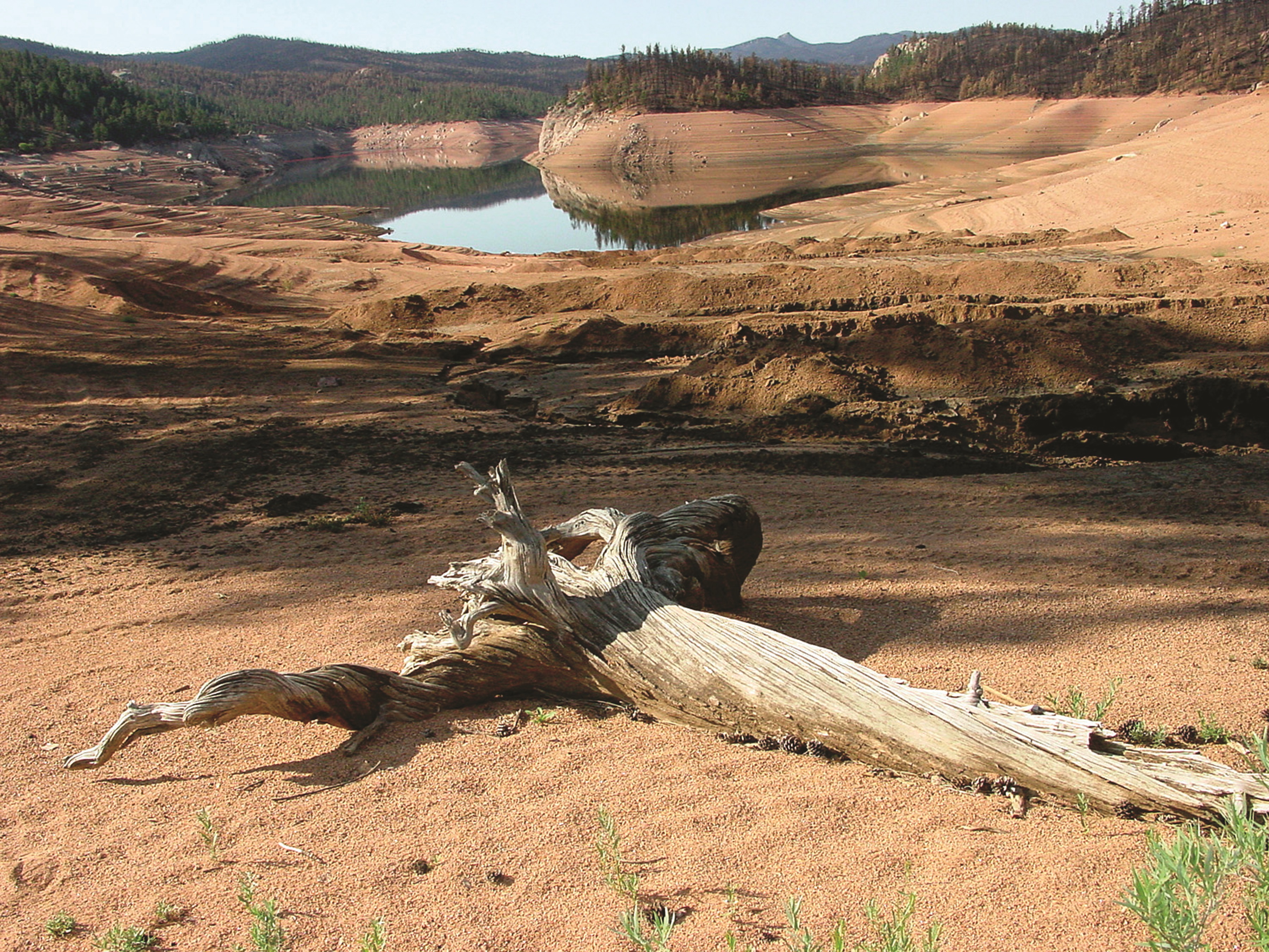
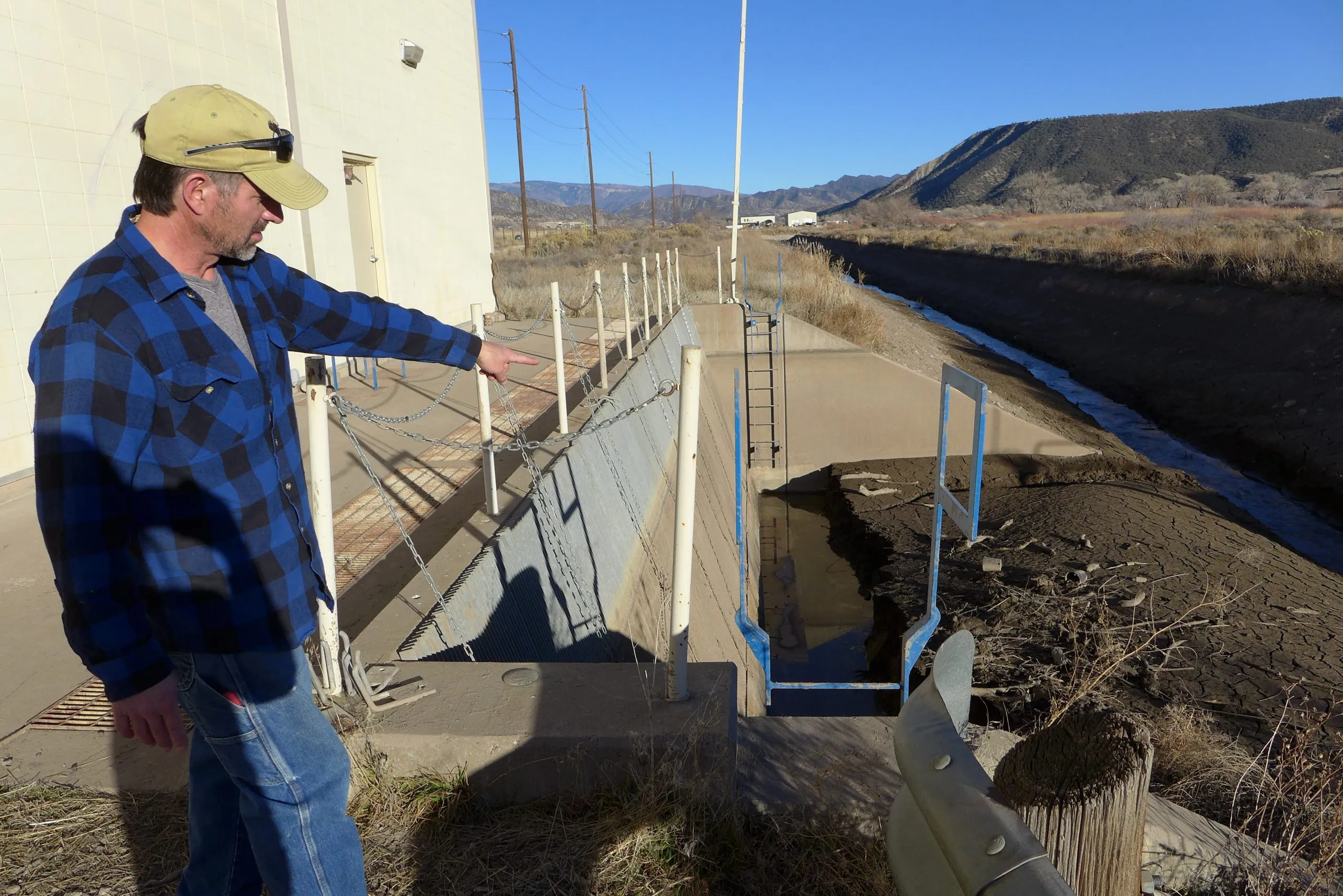
Nathan Bell, a consultant with the Silt Water Conservancy District points to the sediment built up where the canal that takes water from the Colorado River feeds into the pump house. An upstream water quality monitoring project, which received funding approval from the Colorado Basin Roundtable, could help alert the district when mudslides occur in Glenwood Canyon. CREDIT: HEATHER SACKETT/ASPEN JOURNALISM
Water managers are dealing with the after effects of the Grizzly Creek Fire and subsequent mudslides in Glenwood Canyon by continuing a water quality monitoring program.
The Middle Colorado Watershed Council received funding approval this week for the second phase of a program that will continue to collect and distribute data about weather and river conditions downstream of the Grizzly Creek burn scar. The Colorado Basin Roundtable approved $72,200 in state grant money for continued data collection at seven rain gauges in Glenwood Canyon, which will provide information to the National Weather Service, an automatic water quality sampler, soil moisture sensors, a new stream gauge and water quality monitoring station in the Rifle/Silt area and a data dashboard for easy access of the information.
The first phase of the project, which was implemented early last summer before the monsoons, addressed immediate water quality issues, collecting data at the rain gauges every 15 minutes.
The second phase of the project amounts to an early warning system that will let water users downstream of Glenwood Canyon know when dirty water from mudslides is headed their way. The MCWC hopes to have all the pieces in place before spring runoff.
“With the way post-fire events happen, we are going to be looking at impacts for the next two to five years,” said Paula Stepp, executive director of the Middle Colorado Watershed Council. “The part I’m really excited about is the cooperation between stakeholders and downstream users.”
On July 29, a heavy rainstorm triggered mudslides in Glenwood Canyon, which left some motorists stranded overnight, and closed Interstate 70 for weeks. Because soils scorched by the 2020 Grizzly Creek Fire don’t absorb moisture, the rain sent rocks, sediment and debris flowing down drainages, across the highway and into the Colorado River.
But the mudslides didn’t just affect the river at the site of the rainstorm. The cascade of dirty water also had impacts to agricultural and municipal water users downstream in Silt, whose only source of water is the Colorado.
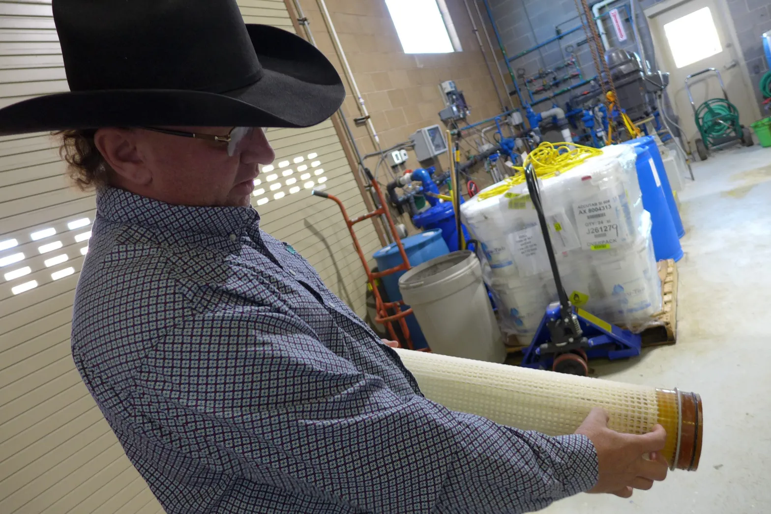
The sediment-laden water caused problems for the town of Silt’s water treatment plant, which had to use more chemicals to get the sand to settle out. The increased manganese and iron suspended in the water gave it a brownish tint at taps. It also fouled a set of filters, which the town spent $48,000 to replace. The filters normally last four to five years, but had to be replaced after just one, said Trey Fonner, public works director for the town.
“If we knew what was coming down the river, we could shut off the intake and we could let the river clean up a little bit before we turned it back on,” Fonner said. “If our tanks are full, we can shut off and let the worst part of it go by.”
Town of Silt Public Works Director Trey Fonner points out how the water treatment plant’s filters were affected by turbid water from the mudslides in Glenwood Canyon last summer. The town had to replace them at a cost of $48,000. CREDIT: HEATHER SACKETT/ASPEN JOURNALISM
Conservancy district impacts
The mudslides also created challenges for the Silt Water Conservancy District, which delivers water from the river to about 45 headgates via a canal and pumphouse. Although the town can temporarily shut down its intake because it has about a three-day supply of water in storage, the conservancy district pumps water continuously and shutting off for a brief period of time is difficult.
“It’s not really a system that can be shut down easily,” said Nathan Bell, a consultant for the district and roundtable member. “It’s extremely cumbersome. It’s a nightmare.”
The main problem for the district is that the earthen canal which takes water from the river to the pump station silts up. The turbid water also acts like sandpaper, causing more wear and tear on the machinery and reducing its lifespan. The district is planning on more frequent canal cleanings and installing drop structures to catch the mud before it makes it to the pump house.
The data generated from the monitoring project will allow the district to better plan and budget for the inevitable increased maintenance and repairs, Bell said.
“It reduces the variables you’re having to manage,” he said. “It lets us get ahead of the game.”
The data dashboard will let downstream users and the general public set up text alerts for when a parameter of interest is too high or outside a specific window. Silt water users, for example, could set an alert for when rain gauges in Glenwood Canyon record a certain amount of rain, which increases the likelihood a plume of dirty water is headed their way.
The total cost of phase two of the project is nearly $1.3 million. The watershed council is asking the Colorado Water Conservation Board for about $650,000 in grant money and they also expect funds from the U.S. Geological Survey. Garfield County has committed to $15,000 over the next three years and the Colorado Department of Public Health and Environment will contribute $50,000.
Aspen Journalism covers rivers and water in collaboration with The Aspen Times. This story ran in the Dec. 4 edition of The Aspen Times and the Glenwood Springs Post-Independent.
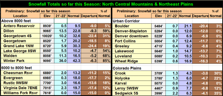
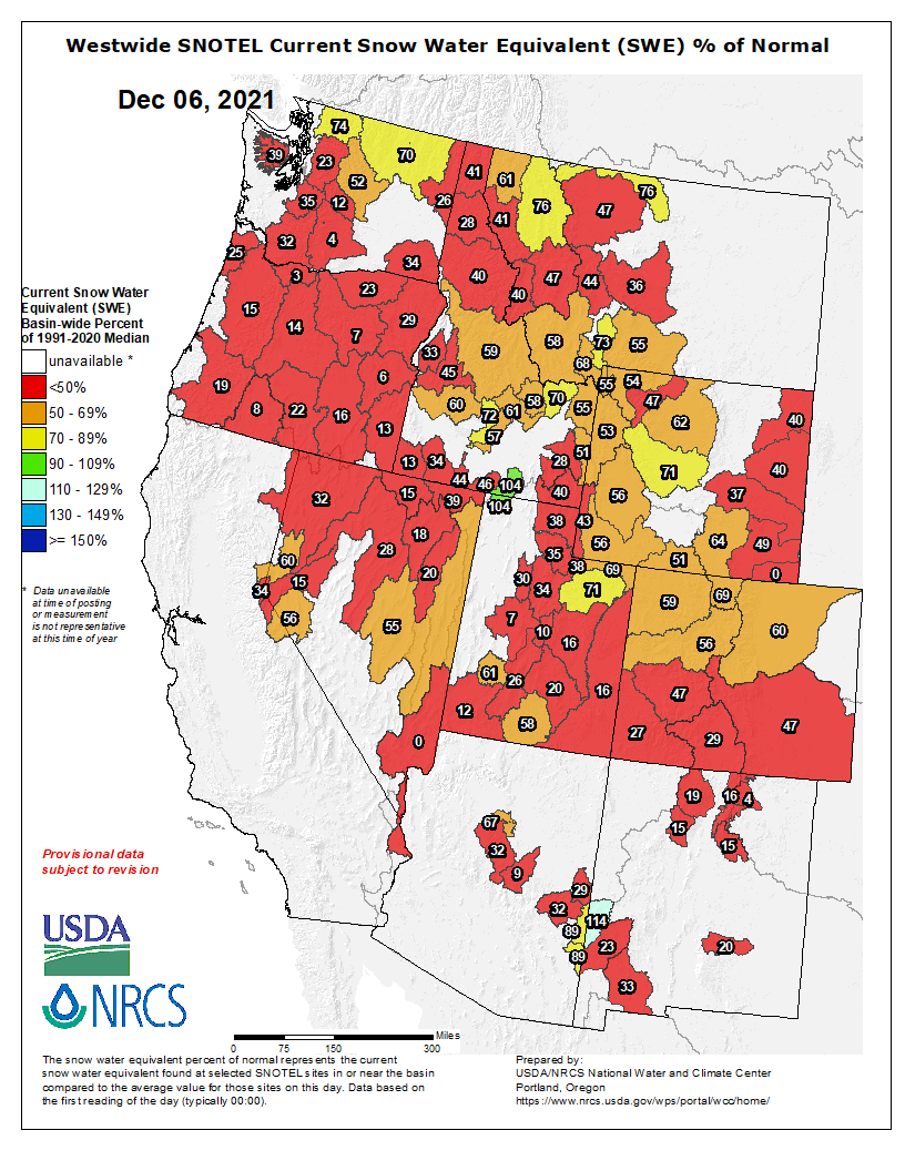
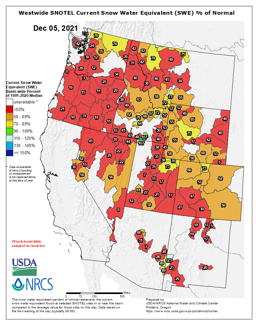
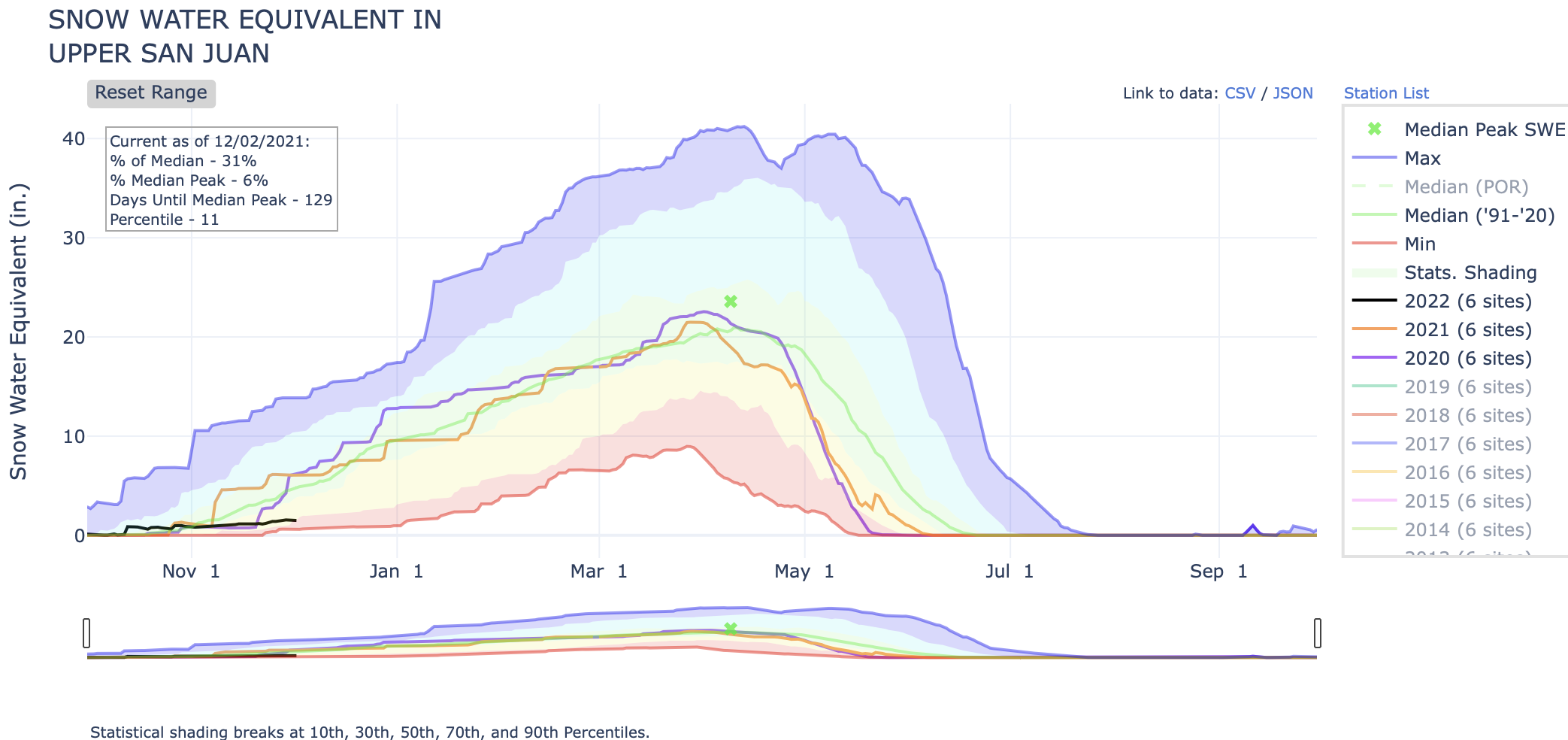
According to the U.S. Department of Agriculture (USDA) National Water and Climate Center’s snow pack report, the Wolf Creek summit, at 11,000 feet of elevation, had 4.2 inches of snow water equivalent as of 11 a.m. on Wednesday, Dec. 1.
That amount is just 53 percent of that date’s median snow water equivalent.
The San Miguel, Dolores, Animas and San Juan river basins were at 33 percent of the Dec. 1 median in terms of snow pack.
River report
The Piedra River near Arboles continues to flow at record low rates.
According to the U.S. Geological Survey (USGS), the Piedra River was flowing at a rate of 37.1 cfs as of 11 a.m. Wednesday, Dec. 1.
The highest recorded rate for this date was 360 cfs in 1987.
Based on 59 years of water re- cords at this site, the average flow rate for that date is 85 cfs.
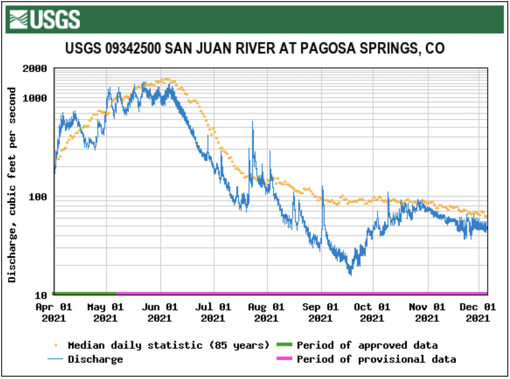
According to the USGS, the San Juan River was flowing at a rate of 52.6 cfs in Pagosa Springs as of 11 a.m. Wednesday, Dec. 1.
Based on 86 years of water records at this site, the lowest recorded flow rate for this date is 33 cfs, recorded in 1938.The highest recorded rate for this date was in 2008 at 761 cfs. The average flow rate for this date is 83 cfs.
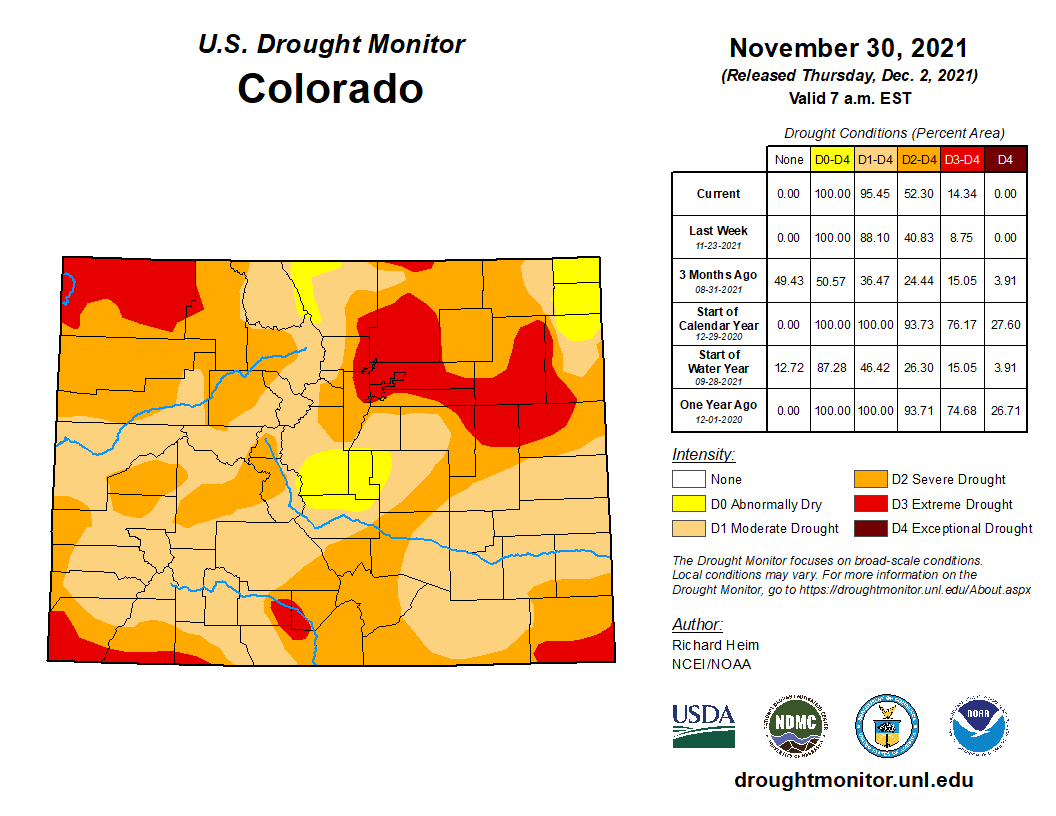
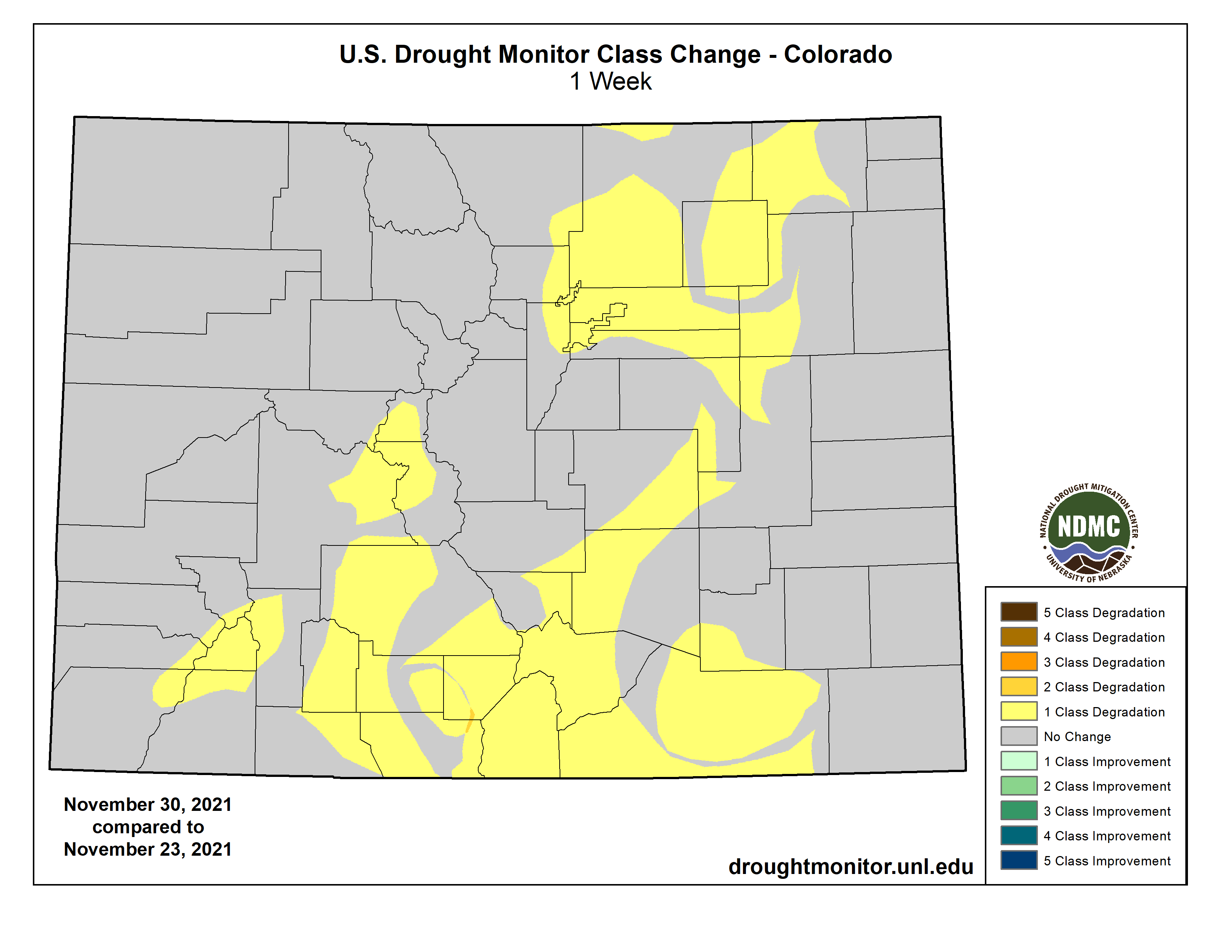
Colorado Drought Monitor map November 30. 2021.
Drought report
The National Integrated Drought Information System (NI- DIS) was last updated on Nov. 23.
The NIDIS website indicates 100 percent of Archuleta County is abnormally dry.
The percentage of the county in a moderate drought is listed at 70.86, which is consistent with the previous report.
The NIDIS website also notes that 47.66 percent of the county is in a severe drought stage, consis- tent with last week’s report.
Additionally, the NIDIS website notes that 10.33 of the county remains in an extreme drought, consistent with last week’s report.
No portion of the county is in exceptional drought.
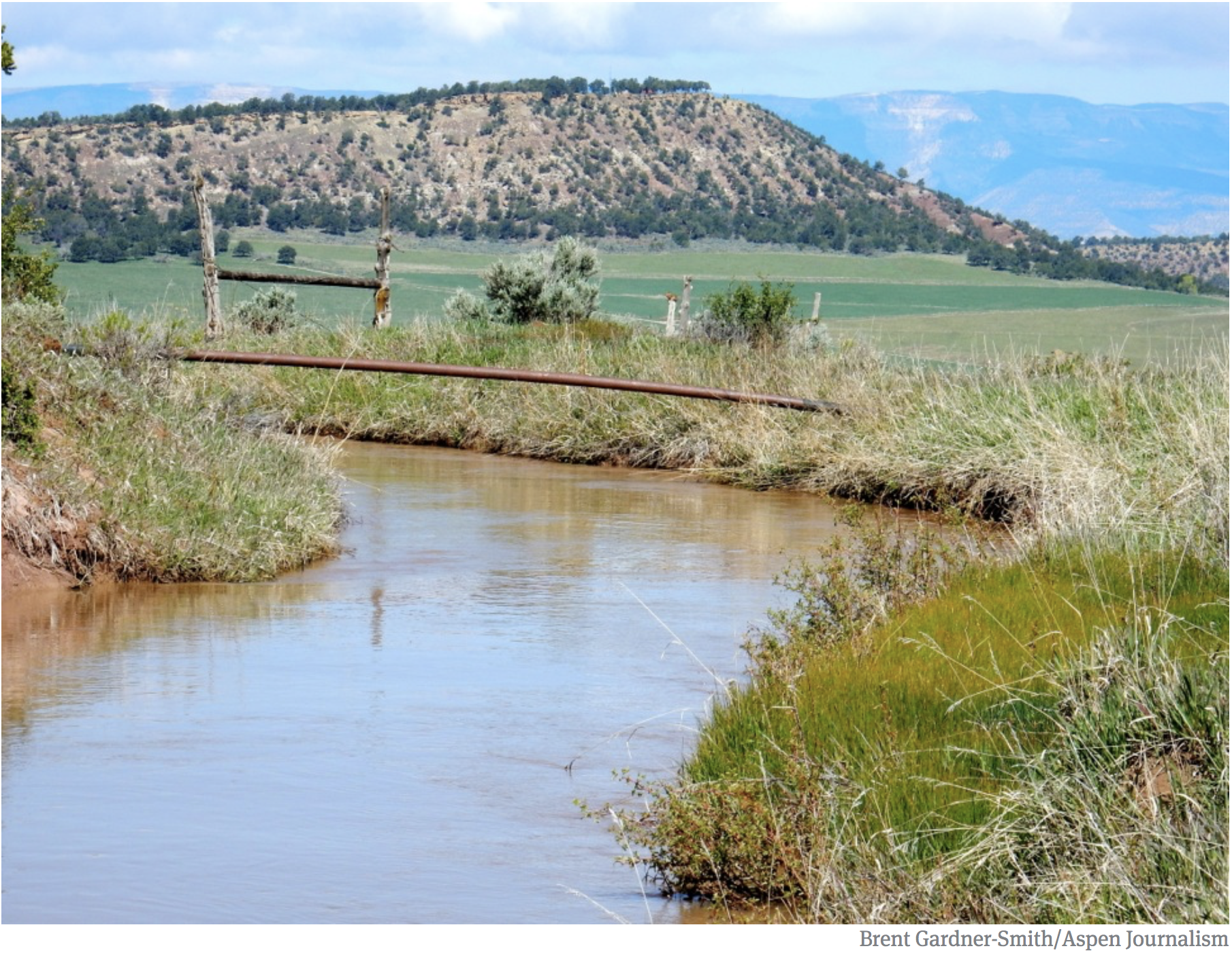
An irrigation ditch south of Silt, and the Colorado River. Photo credit: Brent Gardner-Smith
FromThe Glenwood Springs Post-Independent (Ray K. Erku):
Debris flows that wreaked havoc through Glenwood Canyon over the summer are causing Silt’s water treatment center to work harder to remove pollutants from the Colorado River, a town official said.
Silt Town Manager Jeff Layman said the facility isn’t in any kind of crisis, but it’s simply having to treat water with higher levels of turbidity. The cloudy water also has higher levels of manganese and iron.
“The facility’s able to treat the water that’s coming in,” he said. “But there’s an increased amount of foreign debris that came off the burn scar.”
Silt is working with state and federal resources in the hopes of obtaining funding for either updates for the current plant or purchasing a new one.
Preliminary figures for these potential updates is around $13 million, Layman said. A new plant could potentially cost between $25 million and $30 million…
Roughly 21 miles west of Glenwood Canyon, Silt pulls its water supply from the Colorado River, and it relies on a micro-filtration water treatment system built about 15 years ago. New Castle pulls its water supply from Elk Creek.
With the treatment center having to filter out more debris, the city is already having to allocate extra funds to replace equipment. The past month saw the town approve a $48,000 payment to replace filters. Each filter costs about $1,000, and the treatment center is equipped with 96 filters.
“Usually the filters would last a number of years,” Layman said. “These lasted less than a year because of this problem.”
Silt Public Works Director Trey Fonner said he’s concerned the town’s water treatment system could go through filters more quickly than in the past.
Snowflakes began falling in Denver on Dec. 1, 1913, and didn’t stop for four days, leaving the city blanketed under 45 inches of snow. Some mountain towns saw even more snowfall, with 86 inches recorded in Georgetown, 53 in Estes Park and about 44 in Boulder.
The anniversary of Denver’s biggest blizzard comes amid a much different record for the city: 225 days without snow.
But climatologists say they’re more worried about the meager snowpack levels in the mountains this season…
West Drought Monitor map November 30. 2021.
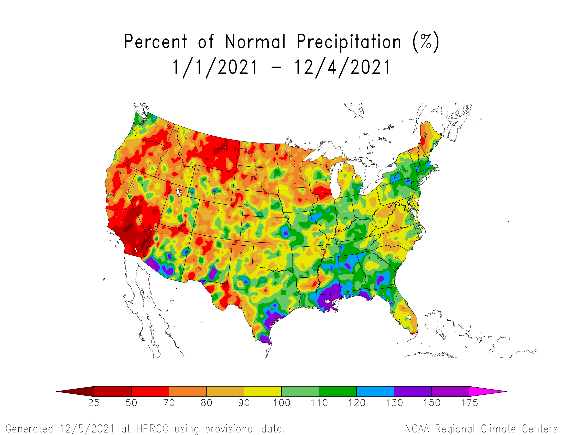
According to the latest map from the U.S. Drought Monitor, the entire state is facing drought conditions and about 40% of Colorado is facing “severe to exceptional” drought levels, further depleting low reservoir levels. Snowpack is below average, too, with the lowest levels in Colorado’s southwest mountains, according to the data released this week by the U.S. Department of Agriculture…
November tied for Denver’s 9th driest on record, with just 0.07 inch of precipitation, according to the National Weather Service office in Boulder…
Denver also finished its warmest and driest combined summer and fall on record. Between June 1 to Nov. 30, less than 2 inches of precipitation was recorded, while an average amount in that period is about 9 inches, Bianchi said.
Temperatures during the same time period averaged about 65.6 degrees — 3.5 degrees above average…
There’s no one answer to explain the lack of snow, but a La Niña weather pattern and climate change are two factors impacting the state’s parched conditions, especially in the southwest, according to Greg Hanson, a meteorologist with the National Weather Service in Boulder.
At some point over the past three years, 27 states – all east of the Rocky Mountains – hit their highest 30-year precipitation average since record keeping began in 1895.
A dozen states, including Iowa, Ohio and Rhode Island, saw five of their 10 wettest years in history over the past two decades.
Michigan saw six of its wettest 10 years on record over the past 13 years.
In June, at least 136 daily rainfall records were set during storms across five states along the Mississippi River.
At the opposite extreme, eight states – including five in the West – had at least three record-dry years in the same time period. That’s double what would be expected based on historical patterns.
Michael Mann, a climatologist at Penn State University, told our reporters the greenhouse effect is important to keep Earth from freezing, but excess heat greatly reduces the temperature difference between the warmer tropics and cooler polar regions in the summer.
Mann said that reduction in the temperature difference slows down the jet stream, which makes it weaker and wavier in the summer. That means weather systems moving across the country can slow or stall more often.
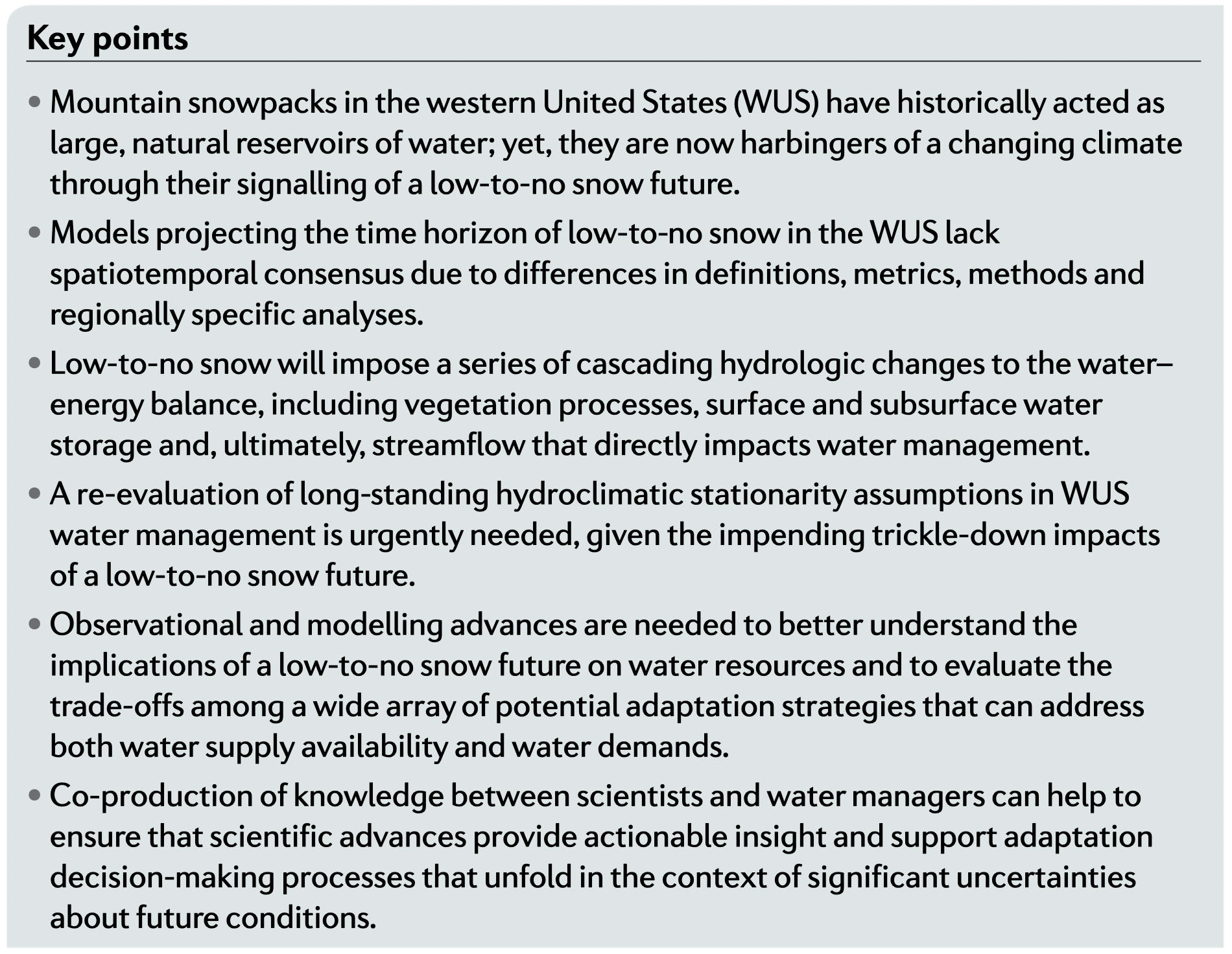
A new study provides a glimpse into the future of Western U.S. snow and the picture is far from rosy: In about 35 to 60 years, mountainous states are projected to be nearly snowless for years at a time if greenhouse gas emissions continue unchecked and climate change does not slow.
Due to rising temperatures, the region has already lost 20 percent of its snowpack since the 1950s. That’s enough water to fill Lake Mead, the nation’s largest human-made reservoir. It stands to lose another half, and possibly more, later this century, from the Rockies to the Sierra Nevada and into the Cascades of the Pacific Northwest, according to a literature synthesis conducted in the study leveraging dozens of peer-reviewed climate model projections.
The current snow situation in the West offers a preview of what the future may hold. Snow water equivalent, or the liquid water from snowpack, is much lower than normal in much of the Western United States. Snow cover across the nation is only at 6 percent — the lowest since records began in 2003.
Decades ahead, the “potential for persistent low-to-no snow to disrupt the [Western U.S.] water system is substantial, potentially even catastrophic,” the study’s authors write…
Published in Nature Reviews Earth and Environment in October, the paper provides an overview of how Western snowpack has changed and what it will look like over the course of this century.
In addition to the 20 percent loss, snowpack is peaking and melting off earlier in the year and is expected to continue on that track. Atmospheric rivers are also warming and dropping more rain than snow, which increases flood risk.
The demands of a warmer atmosphere are already translating into water stress. Although this past year was not a “low snow” year for California, much less snowmelt made it to reservoirs because of an unusually warm spring.
Snowpack: Here today, gone tomorrow?: A recent study finds that climate change means less water from melting snow. So what are we doing about it?
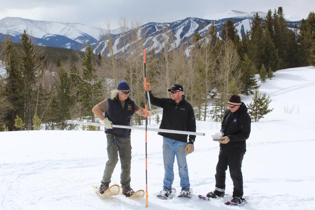
Denver Water employees stationed in Winter Park take measurements of snowpack in 2014. Photo credit: Denver Water.
Denver Water’s extensive reservoir system helps us monitor water supplies, even as a new climate change study warns of a shrinking snowpack.
A 2015 study from the Earth Institute at Columbia University found that the snowpack in the Northern Hemisphere has a 67% risk of declining — greatly reducing the amount of drinking water available from that source.
The study focused on river basins that rely on snowpack and are not adequately replenished by rainwater. The study identified the Colorado River basin among those at high risk for greatly reduced snowpack in the future, when demand for water will outpace availability. The river provides water to seven states, including Colorado.
As worrisome as that sounds, the study doesn’t provide a complete picture of how climate change may affect Denver’s water supplies, said Laurna Kaatz, Denver Water’s climate adaptation program manager.
She isn’t raising any alarm bells.
“This study is a big-picture look at how sensitive systems are to different conditions,” Kaatz said. “It’s not a deep examination into the full range of possible climate changes Colorado could experience in the future.” Nor does it dive into how water managers in Colorado are contending with those potential changes.
“We have to consider all of the local variables in our planning,” she said.
Those variables include population growth, how efficiently customers use water, environmental and ecosystem needs, and local climate and weather patterns.
Denver Water’s supply is mostly from snowpack. The snowpack — the total amount of ice and snow on the ground — fluctuates from year to year. In warm, dry years, it can be gone by mid-summer; in wet years it can last through the next winter season.
“Our region experiences huge fluctuations — or variability — in weather and climate conditions,” Kaatz said. “Fluctuations, especially in precipitation, mean that the rivers and streams that supply our water are also highly variable. This is why reservoirs are so important in Colorado. Colorado’s high peaks protect the snow for months out of the year, and our strong reservoir system protects our water supply against seasonal and annual variability.”
Making sure water is available when customers need it requires careful management of how water flows in and out of reservoirs. Kaatz explained, that when the snowpack melts, we capture what we need and store it for future use. In years of drought, reservoir levels go down, and customers need to be even more conscious of water use.
Denver Water works with the scientific community to stay up-to-date on the latest models and trends because we live in such a variable climate.
“As the climate continues to warm, we do anticipate that snowpack will not live as long into the summer and fall months, especially in warm, dry summer and fall seasons, and that variability will increase,” Kaatz said. “At Denver Water, we plan for the long-term and look at the many different challenges we could be up against in the future, including climate change.”
While the study gives a potential glimpse into our water future, the full story is really told in how well Coloradans have embraced water conservation. Water use by Denver Water customers between January and May 2021 represented the lowest usage for those months since 1968.
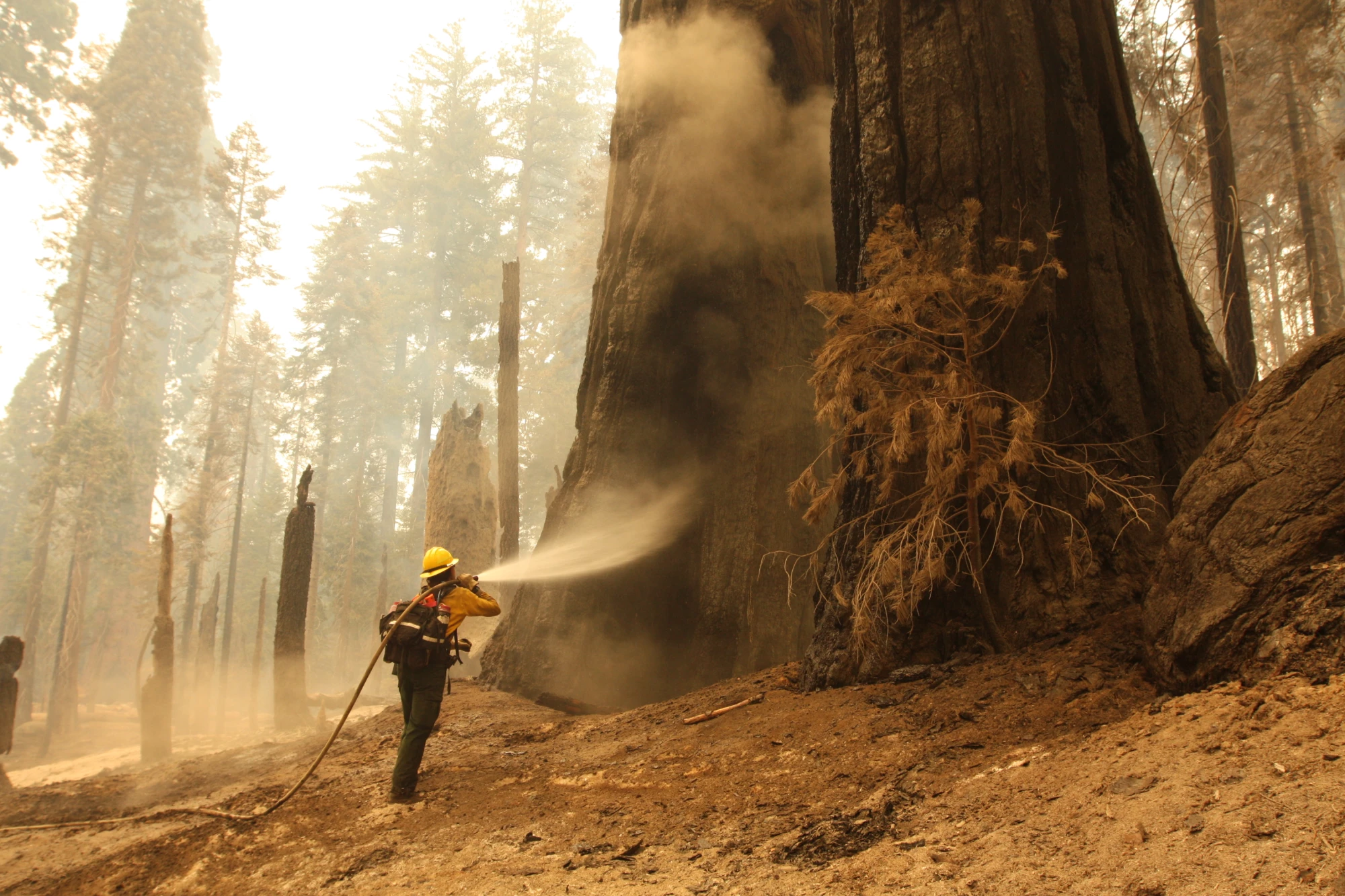
Firefighter Lindsay Freitag sprays down a giant sequoia along the Trail of 100 Giants to extinguish heat.(Garrett Dickman / National Park Service)
FromThe Los Angeles Times (Sammy Roth, Tony Barboza, Anita Chabria, Ian James, Anna M. Phillips, Lila Seidman, Hayley Smith, Alex Wigglesworth and Rosanna Xia):
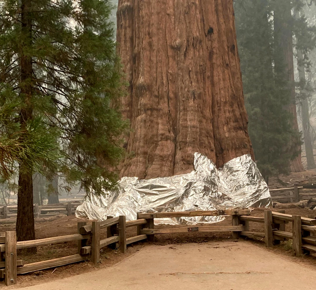
To visualize the hellishness of the climate crisis in 2021, look no further than General Sherman, the world’s largest tree, wrapped in fire-resistant foil to protect the legendary giant sequoia from flames burning a path of destruction through the Sierra Nevada.
California’s so-called Ancient Ones evolved with fire. It’s crucial to their reproductive cycle. But they aren’t prepared for blazes like those of the last year, which are burning hotter and more intensely as Earth warms, mostly because of the combustion of fossil fuels. Last year, flames killed roughly 10% of the world’s giant sequoias.
The General Sherman sequoia tree is wrapped in fire-resistant foil to protect it from the KNP Complex fire. (National Park Service)
The sight of General Sherman wrapped in foil this fall was a cry for help. It was also a sign that the American West has entered a dangerous new era of hotter heat waves, ever-more-brutal droughts and a growing threat of violent extremism on public lands.
There’s still hope for the future. But in a part of the country mythologized for its rugged individualism, going it alone will be a recipe for disaster, climate experts say. States and tribes, big cities and rural towns, liberals and conservatives alike will need to cooperate…
Though climate continued to polarize Washington, D.C. — see the near total lack of Republican support for the clean energy investments proposed by President Biden — there were at least some encouraging signs west of the 100th meridian.
Take the Colorado River and its tributaries, whose waters quench the thirst of tens of millions of people and irrigate millions of acres of farmland from Wyoming to Mexico…
West Drought Monitor map November 30. 2021.
The region has always whipsawed between drought and floods, but now global warming is exacerbating the swings, with an overall drying trend that scientists call aridification. As summer turned to fall, nearly 95% of the American West was saddled with drought conditions. The “bathtub ring” at Lake Mead outside Las Vegas kept growing, showing how much water had vanished from the nation’s largest reservoir…
In August, federal officials declared the first-ever water shortage on the Colorado, triggering cutbacks in Arizona, Nevada and Mexico.
The shortage declaration, while scary-sounding, was the result of a landmark pact in which Southwestern states agreed to forgo some of the water to which they’d otherwise be entitled, in an effort to keep Lake Mead from falling even farther and prompting a true emergency.
If the situation worsens, California will accept cutbacks too. John Fleck, a water resources professor at the University of New Mexico, has described the agreement as a model for the future cooperation that will be needed as the Colorado dwindles.
“The river’s future is not all dark,” Fleck and Eric Kuhn wrote. “Innovation, cooperation and an expanded reliance on science are now the foundation for basin-wide solutions.”
There were signs of long-overdue action on the wildfire side of the climate equation too, as the Biden administration raised pay for federal firefighters and worked with California to reduce fire risk by thinning overgrown forests — a stark change in approach from President Trump, who bluntly blamed the Golden State for not “raking” its forests. California Gov. Gavin Newsom signed a $15-billion climate package that included money to fight fires, droughts, extreme heat and sea level rise.
Officials also increasingly agreed on the need to set intentional, low-intensity fires — known as “prescribed burns” — of the type that helped protect Lake Tahoe this summer…
Record temperatures compounded the threat, drying out landscapes and making fires harder to put out. California, Idaho, Nevada, Oregon and Utah endured their hottest summers on record, with the nation as a whole tying the Dust Bowl for the hottest summer in modern history.
In the Pacific Northwest, a heat wave killed hundreds of people, whose bodies failed them as they roasted in their homes, or on the streets — a dark reminder that heat waves are deadlier than hurricanes and fires, and are only getting more dangerous…
The combination of heat, fire and drought wreaked havoc on the electric grid. A blaze in Oregon took down an interstate power line and nearly forced much of California into rolling blackouts…
Declining reservoirs, meanwhile, produced less hydroelectricity, which in a cruel twist forced utilities to burn more natural gas, one of the fossil fuels heating the planet.
Brad Udall: Here’s the latest version of my 4-Panel plot thru Water Year (Oct-Sep) of 2021 of the Colorado River big reservoirs, natural flows, precipitation, and temperature. Data (PRISM) goes back or 1906 (or 1935 for reservoirs.) This updates previous work with @GreatLakesPeck.
Federal officials warned that by 2023, there’s a 1 in 3 chance that Lake Powell on the Arizona-Utah border will fall so low that Glen Canyon Dam, one of the region’s largest producers of cheap, zero-emission power, won’t be able to generate electricity at all…
Though some Western states at least tried to follow California’s lead on climate — Colorado, Oregon and Washington in particular — others followed a different playbook…
In Arizona, regulators backtracked on a plan to require 100% clean energy, only to backtrack again and offer a preliminary sign-off — but with a deadline of 2070, decades beyond what global climate commitments will require. New Mexico’s Democratic governor, Michelle Lujan Grisham, talked a big game on climate but also criticized President Biden for attempting to limit oil and gas production. Wyoming lawmakers kept up a years-long effort to protect the state’s coal, oil and gas companies from economic headwinds.
Then there was Utah Gov. Spencer Cox, who responded to worsening drought by declaring a need for “divine intervention” and asking Utahns to pray for rain.
The same worldview that led some elected officials to dismiss the urgency of the climate crisis fueled a burgeoning movement that protested pandemic-era vaccine mandates, demonized public health officers and sought to wrest control of hundreds of millions of acres of public lands from the federal government…
Rising demand for sprawling solar and wind farms created new pressure on public lands, forcing the Biden administration to balance the needs of conservation and climate action…
Rising temperatures threatened iconic species, with a federal judge ordering the Biden administration to reconsider its decision not to protect Joshua trees under the Endangered Species Act.
Coastlines weren’t spared, either: The Pacific Ocean kept rising, hastening a reality of vanishing beaches, dangerously eroding cliffs and saltwater intruding on precious groundwater supplies. Nobody wanted to confront the possibility of “managed retreat,” but some communities finally felt they had no choice. Marine heat waves took a deadly toll on ocean ecosystems already stressed by a history of overfishing and pollution…
Environmental activists rallied around the idea of “30 by 30,” a campaign to protect 30% of America’s lands and waters by 2030. The goal is to protect habitat, promote biodiversity, preserve landscapes that keep carbon in the ground and otherwise save some semblance of the natural world as we know it. Biden endorsed the concept…
In one positive development, firefighters managed to protect General Sherman and other iconic sequoias from this fall’s fires.
But thousands of the giants were still killed by flames. And the climate emergency is just getting started. 2021 will probably go down as one of the coolest years this young century. There’s still plenty of time for the rest of the Ancient Ones to meet their match.
Here’s the release from the Bureau of Reclamation (Peter Soeth):
The Bureau of Reclamation selected 20 projects to share $3.1 million in applied science grants to develop tools and information to support water management decisions. These projects in 11 western states include improved water data, modeling and forecasting capabilities.
“Water managers today need more accurate and reliable information to make the best water management decisions in a changing climate,” said Chief Engineer David Raff. “Applied Science Grants are an important tool to assist water managers getting the information they need so they can make those informed decisions.”
Projects selected range from $48,000 for the Big Bend Conservation Alliance in Texas to develop a common data management platform for shared aquifers to several receiving the maximum of $200,000. Texas A&M University-Kingsville is receiving $107,497 to develop a web-based tool to simulate post-wildfire hydrologic changes in Northwest Montana.
Applied Science Grants are for non-federal entities to develop tools and information to support water management for multiple uses. Selected projects must provide at least a 50% non-federal cost-share. Project types include:
Enhancing modeling capabilities to improve water supply reliability and increase flexibility in water operations.
Improving or adapting forecasting tools and technologies to enhance management of water supplies and reservoir operations.
Improving access to and use of water resources data or developing new data types to inform water management decisions.
For more than 100 years, Reclamation and its partners have developed sustainable water and power future for the West. This program is part of the Department of the Interior’s WaterSMART Program, which focuses on improving water conservation and reliability while helping water resource managers make sound decisions about water use. To find out more information about Reclamation’s WaterSMART program, visit https://www.usbr.gov/watersmart.
One Colorado award was listed:
Colorado
Reclamation Funding: $200,000 Total Project Cost: $440,000
The Grand Mesa Water Users Association, located on the Grand Mesa in Delta County, Colorado, will produce digitized capacity surveys for 50 reservoirs. The reservoirs on the Grand Mesa were built to capture and conserve available water from snowpack for irrigation and municipal use. This project includes conducting reservoir capacity surveys using drone technology, installing water measuring sensors at each reservoir to monitor water level heights, and developing a water distribution control system with multiple functions such as an interactive map of the reservoirs, a database with data on the reservoirs, a dashboard showing water administration activity, and a forecasting tool. These tools will enhance the management of water supplies and reservoir operations.
The U.S. Department of Agriculture (USDA) is making updates to crop insurance to respond to the needs of agricultural producers, including organic producers, as well as to support conservation of natural resources on agricultural land.
Specifically, USDA’s Risk Management Agency (RMA) is making permanent a new provision that allows producers to hay, graze or chop cover crops and still receive a full prevented planting payment. To accommodate the different farming practices across the country, RMA is also increasing flexibility related to the prevented planting “1 in 4” requirement, as well as aligning crop insurance definitions with USDA’s National Organic Program.
“We are responsive to the needs of producers, and we are updating several key policies to encourage the use of cover crops and other conservation practices,” RMA Administrator Marcia Bunger said. “We want to provide producers tools to help mitigate and adapt to climate change as well as ensure crop insurance works well for a wide variety of producers, including organic producers.”
Haying, Grazing, and Chopping of Cover Crops
In July, RMA announced producers can hay, graze, or chop cover crops for silage, haylage, or baleage at any time and still receive 100% of the prevented planting payment. Previously, cover crops could only be hayed, grazed or chopped after Nov. 1. Otherwise, the prevented planting payment was reduced by 65% if producers took those actions on the cover crop.
RMA added this flexibility starting with the 2021 crop year as part of a broader effort to encourage producers to use cover crops, an important conservation and good farming practice. Cover crops are especially important on fields prevented from being planted because they cover ground that would otherwise be left bare, which helps reduce soil erosion, boost soil health and increase soil carbon sequestration.
This change builds on the advanced research and identified benefits cover crops have supporting healthy soils and cropland sustainability efforts. Studies also show that cover crops provide increased corn and soybean yields. While results vary by region and soil type, cover crops are proven to reduce erosion, improve water quality and increase the health and productivity of the soil while building resilience to climate change. Additionally, RMA provided a premium benefit to producers who planted cover crops through the Pandemic Cover Crop Program to help producers maintain cover crop systems amid the financially challenging pandemic.
“1 in 4” Requirement Flexibilities
For the 2020 crop year, RMA implemented a policy stating that for land to be eligible for prevented planting coverage, the acreage must meet the “1 in 4” requirement, which means the land must be planted, insured and harvested in at least one of the four most recent crop years. Now, RMA is adding flexibilities to recognize different farming practices and crops grown, as well as the availability of risk management options.
New flexibilities allowed in order to meet the “1 in 4” requirement include:
The annual regrowth for an insured perennial crop, such as alfalfa, red clover, or mint, to be considered planted.
Allow a crop covered by the Noninsured Crop Disaster Assistance Program (NAP) to meet the insurability requirement.
If crop insurance or NAP coverage was not available, allow the producer to prove the acreage was planted and harvested using good farming practices in at least two consecutive years out of the four previous years to meet the insurability requirement.
Aligning Organic Terms
RMA is revising four organic definitions to be consistent with USDA’s National Organic Program. Consistency across USDA programs is important to eliminate the potential for confusion between the various programs that USDA is committed to providing to the producers.
This change builds on other RMA efforts to expand and improve current options for organic producers. In Sept. 2021, RMA announced several updates to Whole-Farm Revenue Protection (WFRP), including increasing farm operation growth limits for organic producers to the higher of $500,000 or 35% over the five-year average allowable income, and to allowing a producer to report acreage as certified organic, or as acreage in transition to organic, when the producer has requested an organic certification by the acreage reporting date. In addition, RMA announced it will be offering the new Micro Farm policy through WFRP that specifically targets coverage for small, diversified farmers, including organic growers.
Other Changes
RMA made other changes to Common Crop Insurance Policy Basic Provisions, Area Risk Protection Insurance Regulations, Coarse Grains Crop Insurance Provisions, and other insurance provisions, which published today:
RMA is providing an option for producers to delay measurement of farm-stored production for 180-days through the Special Provisions, similar to flexibilities already available to grain crop producers.
RMA added earlage and snaplage as an acceptable method of harvest for coarse grains. During the 2020 Derecho, many producers salvaged their damaged corn crop by harvesting as earlage or snaplage instead of grain or silage.
“By recognizing earlage and snaplage, we are providing confidence to producers that their crop is covered when a disaster changes their planned harvest method or if they choose to harvest in a manner other than reported on their acreage report,” Bunger said.
More Information
Crop insurance is sold and delivered solely through private crop insurance agents. A list of crop insurance agents is available at all USDA Service Centers and online at the RMA Agent Locator. Learn more about crop insurance and the modern farm safety net at http://rma.usda.gov.
USDA touches the lives of all Americans each day in so many positive ways. In the Biden-Harris Administration, USDA is transforming America’s food system with a greater focus on more resilient local and regional food production, fairer markets for all producers, ensuring access to safe, healthy, and nutritious food in all communities, building new markets and streams of income for farmers and producers using climate smart food and forestry practices, making historic investments in infrastructure and clean energy capabilities in rural America, and committing to equity across the Department by removing systemic barriers and building a workforce more representative of America. To learn more, visit http://www.usda.gov.
From email from the Colorado Department of Natural Resources (Chris Arend):
The Directors of the Colorado Department of Natural Resources and its Colorado Water Conservation Board, and Division of Water Resources released the following statements on the passing of Justice Greg Hobbs.
“Few people have had such a profound and broadscale influence on the landscape and character of Colorado as Justice Greg Hobbs. His energy, his brilliance and his inclusiveness ensured that all people, no matter their status or background, had access to understand and influence water and natural resource policy. His wisdom lives on in those of us in the natural resources field that he guided, mentored, and empowered to serve the people of this state justly and effectively. May the landscapes he so prolifically praised in his poetry and prose persist for generations as a tribute to his fair and thoughtful approach to managing Colorado’s water resources and natural landscapes.”
– Dan Gibbs, Executive Director, Colorado Department of Natural Resources
“If you worked in the Colorado water world, then you have been inspired by Justice Hobbs. A truly dedicated and passionate water leader, he had the unique ability to convey the complexities of western water issues in a creative and artistic manner. Justice Hobbs is a leader who will be missed and whose legacy will live on.”
– Rebecca Mitchell, Director, Colorado Water Conservation Board
“Greg Hobbs has led us as we’ve dealt with the most difficult water issues of our time; as a Supreme Court Justice, as a teacher and mentor, and as a friend who elevated all of those that he met. His legacy will be a body of inquisitive and critical thinkers with an inspired passion for learning.”
– Kevin Rein, Colorado State Engineer and Director, Colorado Division of Water Resources
Click on a thumbnail graphic to view a gallery of drought data from the US Drought Monitor.
US Drought Monitor map November 30. 2021.
High Plains Drought Monitor map November 30. 2021.
West Drought Monitor map November 30. 2021.
Colorado Drought Monitor map November 30. 2021.
Click here to go to the US Drought Monitor website. Here’s an excerpt:
This Week’s Drought Summary
Several Pacific weather systems moved across the contiguous U.S. (CONUS) during this U.S. Drought Monitor (USDM) week. An upper-level ridge over the western CONUS directed the systems across the northern states, while a cutoff low trekked across Texas then into the Gulf of Mexico. The Pacific systems dragged cold fronts with them that stretched the width of the CONUS, from the Great Lakes to the Gulf of Mexico coast. The fronts triggered rain and snow over parts of the country, but they were starved of precipitation by the western ridge and its northwesterly flow over the central CONUS. As a result, the week was wetter than normal only in parts of the Pacific Northwest, northern Rockies, Great Lakes, and Texas. The weather was drier than normal across the rest of the CONUS with large parts of the West, Great Plains, Upper Mississippi Valley, and Southeast receiving no precipitation. Most of the West and Great Plains were warmer than normal thanks to the western ridge. The persistent above-normal temperatures contributed to excessive evapotranspiration in western portions of the Great Plains as well as parts of the West, as seen in EDDI and ESI indicators. Lack of precipitation, excessive evapotranspiration, and windy conditions further dried soils, again especially in western portions of the Plains, as seen in several soil moisture indicators. Drought indicators such as the Standardized Precipitation Index (SPI) and Standardized Precipitation Evapotranspiration Index (SPEI) reflected the mounting precipitation deficits. The continued dryness expanded or intensified drought in parts of the southern to central Rockies, Great Plains, Lower to Mid-Mississippi Valley, Southeast, and Mid-Atlantic states, as well as Puerto Rico…
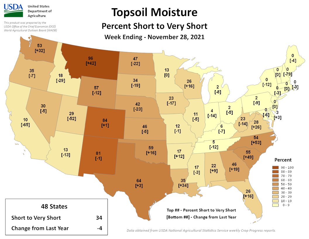
Little to no precipitation fell across the High Plains region this week. Reassessment of the last 2 months’ precipitation led to contraction of moderate drought in northeast North Dakota and severe drought in the central part of the state. But water levels in ponds and dugouts remained low in spite of late summer to early fall rains, thus prompting expansion of severe drought in other parts of central North Dakota. Above-average temperatures and no precipitation for the last 2 weeks resulted in expansion of moderate drought in southern parts of North Dakota and adjacent South Dakota. In Wyoming, many basins had below to well below normal snowpack with no snow across the High Plains portion of the state, and snow, where it has occurred, was confined to the highest peaks (above 8500 ft). The snow conditions combined with excessive evapotranspiration, drying soils, short-term dryness, and longer-term dryness to prompt expansion of moderate to extreme drought in parts of the state. In Colorado, drying soils, high evapotranspiration, low mountain snowpack, and mounting precipitation deficits resulted in expansion of moderate to extreme drought in many parts of the state. November 28 USDA statistics had 84% of Colorado’s topsoil short or very short of moisture and 33% of the winter wheat in poor to very poor condition. Abnormal dryness and moderate drought expanded in southern and western parts of Kansas…
Colorado Drought Monitor one week change map ending November 30, 2021.
Pacific weather systems brought 0.5-3.0 inches of precipitation to coastal portions of Oregon and Washington, with 5 inches or more falling in non-drought areas of northwest Washington. Half an inch to locally 2 inches also fell over parts of the northern Rockies, while locally up to half an inch occurred over a few parts of the southern Rockies. Otherwise, much of the West was dry. Drying soils and mounting 3-month precipitation deficits prompted expansion of moderate to extreme drought in parts of New Mexico. November 28 USDA reports had 81% of New Mexico’s topsoil short or very short of moisture. Otherwise, no change occurred to the vast areas of moderate to exceptional drought which covers the West…
Half an inch to 1.5 inches of rainfall was widespread across coastal to eastern Texas, and into adjacent parts of Louisiana, and locally over 2 inches fell over parts of Texas. Smaller swaths of half an inch of rain occurred over north Texas and parts of Arkansas, Mississippi, and Tennessee. But the rest of the region had less than half an inch, with much of western Texas to most of Oklahoma receiving little to no precipitation. Moderate to severe drought contracted in a few parts of Texas where the heaviest rains fell, but much more of the state, as well as parts of Oklahoma, Arkansas, and Louisiana, saw expansion of abnormal dryness and moderate to severe drought. Areas of abnormal dryness expanded in western Tennessee and developed in eastern portions of the state. With every passing day of no precipitation, low humidity, high evapotranspiration, the wildfire threat continued to grow in Texas and Oklahoma. According to November 28 USDA statistics, 64% of the topsoil moisture in Texas was short or very short (dry to very dry) and 45% of the winter wheat crop was in poor to very poor condition. In Oklahoma, the statistics were 59% for topsoil moisture and 16% for winter wheat condition…
Looking Ahead
The upper-level ridge will dominate the weather over the western CONUS for the first half of the next USDM week, with a couple Pacific frontal systems moving in later in the week. For December 2-7, the fronts will bring an inch to locally 3 inches of precipitation to parts of coastal Washington and Oregon and the northern Rockies, with 1 to 2 inches in a wide swatch from eastern Oklahoma to the southern Appalachians and north across the Ohio Valley to parts of New England. Half an inch to an inch will spread from the swath to the central Gulf of Mexico coast and across the Great Lakes. Most of the Plains and Southwest, as well as much of Virginia, the Carolinas, and Florida, will receive little to no precipitation. Temperatures are expected to average warmer than normal across most of the CONUS during this period. For December 7-15, odds favor above-normal precipitation across the West and Ohio Valley, with lesser chances for above-normal precipitation in the northern Plains and along the East Coast. Odds favor near to below-normal precipitation in the southern Plains and southern Florida. Much of Alaska is likely to be wetter than normal. Odds favor warmer-than-normal temperatures across most of the CONUS, with near to below-normal temperatures in the Pacific Northwest and early in the Great Lakes. Alaska is likely to be colder than normal, especially in southern portions of the state.
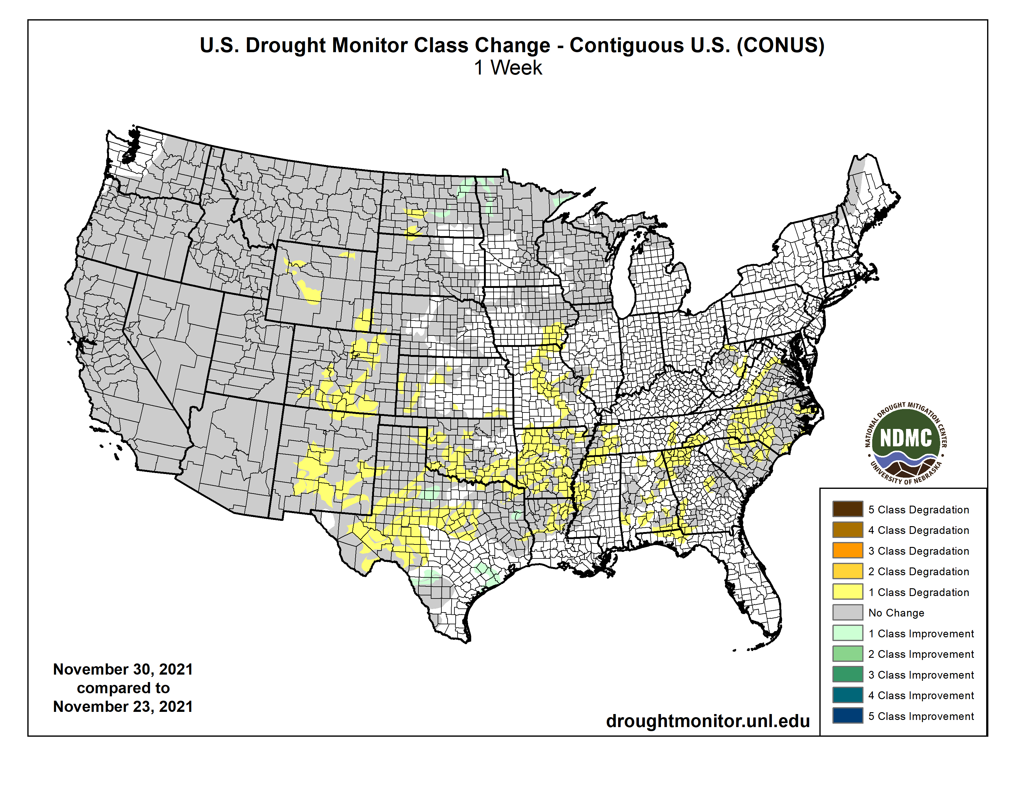
US Drought Monitor one week change map ending November 30, 2021.
I learned that Greg Hobbs had passed from an email sent out yesterday by Water Education Colorado (reproduced below).
Greg was a friend of Coyote Gulch and I will always be grateful for his encouragement and appreciation of the work I do here on the blog. When our paths would cross he took the time to say hello and catch up a bit and I will miss him dearly.
I’ve published many of his poems and have dozens of his photographs in the archives here.
Red Rocks from Ruby Hill in Denver. Photo credit: Greg Hobbs
RED ROCKS
We gathered here for farming,
for mining and for trees,
came to work the traplines
and gold upon our knees,
we prayed to God for guidance
and mapped a thousand peaks,
built the gleaming cities
and plugged the wildest creeks.
The Rockies have a hold of us
and of our ancestry,
plains and rivers tell us
there’s granite in the sea,
an ocean where the canyons are,
each rock a history,
Colorado is as old as us
as young as we might be.
Now each of us has had a day
we’ve done our best and worst,
said our share of lying
and placing mankind first,
we’ve but to see that lupine
is the future at our feet
and marmots running sprightly
over Rocky Mountain peaks.
Thunder’s booming sharply
across the plains below,
we see the lightning flashing,
hear the wind begin to blow,
mountains all are burning
in sunset’s awesome glow,
it’s all up there before us
in clouds piled up like snow.
Red Rocks, Justice Greg Hobbs,
Colorado Mother of Rivers, Water Poems at 26
(Colorado Foundation for Water Education 2005)
Will Hobbs, Greg Hobbs, Dan Hobbs, and a string of fish for dinner, Mary Alice Lake, Weminuche Wilderness, 1986 via Greg Hobbs
Here’s an article that I wrote for Colorado Central Magazine on the occasion of his retirement from the Colorado Supreme Court:
Hobbs to Say Adiós to the Colorado Supreme Court
Greg Hobbs is calling it quits after 19 years as the Colorado Supreme Court’s “water expert.”
Early in his career he clerked for the 10th Circuit, worked with David Robbins at the EPA, and worked at the Colorado Attorney General’s office. AG duties included the natural resources area – water quality, water rights and air quality issues. He represented the Northern Colorado Water Conservancy district before forming his own firm, his last stop on the way to the Court.
He told the Colorado Statesman that he always had his eye on the Supreme Court. While serving at the 10th circuit, Judge William Doyle told encouraged him to set his sites on the Supreme Court, saying “They do everything over there.”
When he appointed Hobbs to the court, Governor Roy Romer told him to “get a real tie,” according to the Statesman. A bolo tie, as Hobbs usually wears, didn’t seem to qualify.
The justice is hardworking outside his court duties. He is often asked to speak at conventions and meetings around the state. He is deeply driven to learn about others and to share his knowledge of law and history.
A few years ago, over in Breckenridge, the Summit Daily News reported that Hobbs said, “The water ditch is the basis of civilization.”
His passion is to explain current opportunities and problems within a historical context. He describes himself as a “failed PhD,” having dropped out of a PhD Latin American History program at Columbia University.
One opinion in particular illustrates the importance of history to Hobbs:
The University of Denver Water Law Review honored Justice Hobbs at their annual shindig. Former Justice Mike Bender told attendees about a case where a man had been arrested after police entered and searched his zippered tent in a campground.
In his opinion, Hobbs detailed the history of Coloradans that lived in tents. The plains Indians and their teepees, the miners camps dotted all over the mineral belt and elsewhere, and more than a few homesteaders, also. He said that in Colorado, there is an expectation of privacy when you close up your tent dwelling, and that it is no different from the expectation for a more permanent structure.
The police violated the man’s Fourth Amendment rights by not obtaining a search warrant, he said.
The justice credits luck for his interest in water law. He got in on the ground floor of the environmental movement during the early days of the Clean Water Act and the Clean Air Act.
He has a deep and abiding respect for Colorado water law.
During his time on the court, there were two interesting cases dealing with the “speculation doctrine” – that is, a water diverter must put the water to beneficial use, not hold on to it and auction it to the highest bidder.
Pagosa Springs Water and Sanitation District was told it was not allowed a 100-year planning horizon. High Plains A&M was denied a change of use – agricultural to municipal and industrial – for lower Arkansas Basin water on the High Line Canal, because they didn’t have any firm customers for the water they were changing.
The Court recognized the Legislature’s legal ability to create whitewater parks as a beneficial use.
Perhaps one of the most remarkable insights that Justice Hobbs realized pertains to environmental flows within Colorado water law:
When Amy Beatie, director of the Colorado Water Trust, was clerking for the justice, she told him that her primary interest was working for the environment. He advised her to go into private practice, learn about the workings of water law, the mechanics and hydrology of diversions, and the art of finding common ground at water court. Then, he said, have faith that there will be a way to work for the environment within the water rights system.
Ms. Beatie paid attention.
Her organization just secured an instream flow right for the Colorado Water Conservation Board on a tributary of the Gunnison River, the Little Cimmaron River. The trust purchased shares of the McKinley ditch and assigned them to the CWCB – the only entity under state law that can hold rights for instream flows.
The water rights are senior and near the confluence with the Gunnison. Therefore, in times of low flows they are capable of calling out diversions above them. Water bypasses the McKinley headgate and stays in the stream for the fish and other critters. Further development of junior water rights won’t affect the arrangement, since the instream flow will always be in line ahead of newer ones.
This agreement and decree were a big deal since they were the first of their kind, with a willing seller, an organization dedicated to finding deals that benefit instream flows, an entity that can legally hold those rights, and an active water rights market.
At this summer’s Martz Conference hosted by the CU law school, Justice Hobbs spoke about Colorado’s water market. Many groups and individuals decry the current state of water in the western U.S. Brad Udall, for example, told attendees at last fall’s Colorado River District Annual Symposium, that we are living with 19th-century laws, 20th-century infrastructure and 21st-century problems.
Hobbs reminded attendees at Martz 2015 that Colorado has the most active water market in the U.S. and it evolved under those 19th-century laws. Colorado water law is there to protect all appropriators and works very well, albeit slowly. Things move along more quickly as case law grows.
The basis of Colorado water law is the “doctrine of prior appropriation,” which is really a doctrine of scarcity, as just about anyone can administer a stream with average or above average flows. The art comes when there are low flows, so the state engineer has the priority system in his toolbox for those dry times.
Greg is also a prolific poet. I’ve published many of his poems over the years on my blog, Coyote Gulch. Here’s one of my favorites:
Coloradans
(Reprinted with permission from
Colorado, Mother of Rivers by Greg Hobbs.)
To each of us
The land, the air, the water,
Mountain, canyon, mesa, plain,
Lightning bolts, clear days with no rain,
At the source of all thirst,
At the source of all thirst-quenching hope,
At the root and core of time and no-time,
The Great Divide Community
Stands astride the backbone of the continent,
Gathering, draining, reflecting, sending forth
A flow so powerful it seeps rhythmically
From within,
Alive to each of us,
To drink, to swim, to grow corn ears
To listen to our children float the streams
Of their own magnificence,
Out of their seeping dreams,
Out of their useful silliness,
Out of their source-mouths
High and pure,
The Great Divide,
You and I, all that lives
And floats and flies and passes through
All we know of why.
Greg has become a friend to me over the years and I already miss him on the court.
He assures me that he will keep writing and speaking. After all, he asserts, “Coloradans love a good story.”
You tell a good story, Greg.
Greg Hobbs. Photo credit: Water Education Colorado
From Water Education Colorado (Brian Werner, Amy Beatie and Jayla Poppleton, on behalf of the Hobbs Family):
The Colorado water community lost a legend yesterday with the passing of Justice Greg Hobbs. Greg, who would have turned 77 on Dec. 15, passed away peacefully with his family – wife Bobbie, son Dan and daughter Emily – by his side after suffering a pulmonary embolism.
For both the legal and water communities, and really all whose paths crossed his, the loss is heartbreaking. We not only lost one of our most knowledgeable legal minds, but also lost one of our most able and accomplished speakers, teachers, writers and historians. Those who knew Greg understand.
Greg, who first began practicing law in Colorado in 1973, retired as a Colorado Supreme Court Justice in 2015 and continued to share his water expertise and speaking and writing eloquence in a variety of ways.
He was the longstanding Vice-President of Water Education Colorado, an organization he helped create in 2002 and for which he was a tireless advocate and ambassador. For the past 19 years, he served as WEco’s Publications Chair, where he oversaw the publication of its well-known Headwaters magazine and Citizen’s Guide series. He was known to greet each new publication with a celebratory, “This is our best issue yet,” and was always championing the publications’ distribution, even toting boxes around in his trunk so that they were always at the ready. He was also a frequent presenter in WEco programs, mentored numerous individuals through the Water Leaders Program, and provided sound guidance in the organization’s strategic growth and evolution over the years to ensure it stayed true to its nonpartisan mission.
In recent years Greg served as a senior water judge working as a mediator for water rights cases and continued to mentor current and future water lawyers with his knowledge of the legal nuances of Colorado’s water rights system. He taught a water court practice seminar and continued to write and speak about all matters water.
Greg wrote extensively, whether about the legal intricacies of water or his beloved poetry. He authored a number of books, the most recent of which was published in 2020 entitled Confluence: The Story of Greeley Water, which he co-authored with Michael Welsh.
During his nearly two decades on the bench, he authored more than 250 majority opinions, many of which dealt with water law. He was an exceptional jurist, principled and deliberate, noting that every word in every opinion mattered. As a perfect reflection of his generous spirit, he hired nearly 60 law clerks over his time on the bench, and ensured that they all knew each other, supported each other professionally, and treated each other like family. He always talked about how proud he was of his clerks and where they are now, many of whom, like him chose careers as public servants.
Greg’s early legal career included stops with the U.S. Environmental Protection Agency, where he worked for two years beginning in 1973, followed by nearly four years with the Colorado Attorney General’s Office in the Natural Resources Section, where he became a leader in environmental law specializing in air and water quality issues.
In 1979, he became a partner with Davis, Graham and Stubbs and soon after the principal counsel for the Northern Colorado Water Conservancy District, where he became well-known for his advocacy and protection of Northern Water’s water rights. In 1992, he helped form the law firm of Hobbs, Trout and Raley with two other well-known water lawyers – Bob Trout and Bennett Raley.
In 1996, Gov. Roy Romer appointed him to the Colorado Supreme Court where he took his water knowledge to an even higher level. Greg was a staunch supporter of Colorado’s system of water rights and wrote extensively and spoke often of his support for the unique water law system that has evolved since the state was created in 1876. He had a studied and nuanced approach to the prior appropriation system and defended it against those who felt it no longer suited Colorado.
Greg did his undergraduate studies at the University of Notre Dame. After Notre Dame, he attended Columbia University to study Latin American history. Following their 1967 wedding, Greg and Bobbie joined the Peace Corps, moving to Colombia. The couple returned in 1968 and had Dan. Emily followed in 1971.
Greg spent his early years of family life in law school at Berkeley Law, completing his degree in 1971. He then clerked for Judge William Edward Doyle of the Tenth Circuit Court of Appeals in Denver, a critical part of his career and his interest in the bench. In 1973, the Hobbs family returned to Denver and made it their home for good.
There will be a celebration of Greg’s life at a later, more COVID-safe time. The family asks that in lieu of flowers donations be made to Water Education Colorado. You can donate in Greg’s memory online at http://wateredco.org/greg-hobbs-memoriam.
Or, mail a check with your donation to:
Water Education Colorado
1600 N Downing St., Suite 200
Denver, CO 80218
Please include Greg’s name in the check memo line.
Now for a gallery of photos of and by Greg Hobbs from the archives.
Justice Gregory Hobbs
Flood irrigation in the Arkansas Valley via Greg Hobbs
David Robbins and J.C. Ulrich (Greg Hobbs) at the 2013 Colorado Water Congress Annual Convention
San Juan Mountains March, 2016 photo credit Greg Hobbs.
Greg Hobbs and Coyote Gulch at Colorado College State of the Rockies Speaker Series 2011
Colorado Columbine photo via Greg Hobbs
Greg Hobbs, Diane Hoppe
Fryingpan River downstream of Ruedi Reservoir. Photo credit Greg Hobbs
Greg Hobbs and Ken Wright
Colorado River headwaters tributary in Rocky Mountain National Park photo via Greg Hobbs.
Lake Mead December 2017. Photo credit: Greg Hobbs
San Luis People’s Ditch March 17, 2018. Photo credit: Greg Hobbs
Colorado Territorial Map early 20th Century via Greg Hobbs. Note the large rectanglular area from Four Corners north and east. Those were the lands originally promised to the Ute tribes.
Upper Gunnison watershed May 2019. Photo credit: Greg Hobbs
Photo credit: Greg Hobbs
Photo credit: Greg Hobbs
Photo credit: Greg Hobbs
Photo credit: Greg Hobbs
Delph Carpenter’s original map showing a reservoir at Glen Canyon and one at Black Canyon via Greg Hobbs
Brad Udall: Here’s the latest version of my 4-Panel plot thru Water Year (Oct-Sep) of 2021 of the Colorado River big reservoirs, natural flows, precipitation, and temperature. Data (PRISM) goes back or 1906 (or 1935 for reservoirs.) This updates previous work with @GreatLakesPeck.
Two and a half years after signing a deal aimed at averting a damaging crisis along the Colorado River, water officials from California, Arizona and Nevada are discussing plans to take even less water from the shrinking river and leave it in Lake Mead in an effort to prevent the reservoir from falling to dangerously low levels.
Representatives of water agencies from the three states said they are firming up the details of a deal that would leave an additional 500,000 acre-feet of water in the reservoir next year, and the same amount again in 2023 — about double the quantity of water used annually by Las Vegas and the rest of southern Nevada.
For California, the deal would mean participating in water reductions prior to Lake Mead reaching levels that would otherwise trigger mandatory cuts.
The talks took on urgency this summer after federal projections showed growing risks of Lake Mead falling to critically low levels, despite plans for mandatory cutbacks throughout the Southwest that the states agreed to in 2019.
With the reservoir in a first-ever shortage and those cuts still insufficient, water management officials settled on a goal of together leaving half a million acre-feet of additional water in the reservoir instead of sending it flowing to farms, cities and tribal lands. The stored water would be roughly as much as 1.5 million average single-family households use in a year.
“We’ve got to stabilize the lake with this plan,” said Tom Buschatzke, director of the Arizona Department of Water Resources. He said representatives of California, Arizona and Nevada developed the framework of the deal within about two months after they saw projections showing growing risks of Lake Mead dropping to lows that would trigger much larger water reductions in all three states.
“I think coming together in that short a period of time is indicative of urgency we’re feeling to do more,” Buschatzke said. “If the lake keeps falling, cuts are going to be deeper and deeper and deeper. So I think it’s indicative of the risks.”
The deal would nearly double the reductions in planned water deliveries next year among the three states beyond those already planned under the 2019 agreement, called the Drought Contingency Plan. This new proposal, dubbed the 500+ Plan, would partially involve securing money to pay some water users to voluntarily relinquish water.
The water would come from various sources, including farmers who would be paid for leaving portions of their land dry, tribes that would contribute water supplies, and water agencies that would leave some water in Lake Mead instead of taking it out as planned.
Negotiations on the details are continuing, and officials from California and Arizona said they hope to have the overarching agreement ready to be signed next month at [the Colorado River Water Users Association] conference in Las Vegas.
Arizona has pledged $40 million toward the deal. Board members of the Southern Nevada Water Authority are scheduled to consider approving up to $20 million in contributions this week.
The board of the Metropolitan Water District of Southern California is scheduled to consider the proposed agreement next month…
If the details of the proposal come together as planned, 500,000 acre-feet of water over two years would translate into water levels about 16 feet higher in Lake Mead…
For now, the talks have focused on lining up funds and water for two years. But Buschatzke said it’s intended to be a five-year plan, lasting until the current agreement expires at the end of 2026, by which time the states will need to have negotiated new rules for dealing with shortages.
If the winter were to bring heavy snow to the Rocky Mountains, it could still help ease the shortages. But the region’s water managers said they’ve decided to plan for more of the dismal runoff they’ve seen in the watershed during the past two years of extreme heat and parched conditions.
Bill Hasencamp, MWD’s manager of Colorado River resources, said if such extreme dryness persists for another year or two, then Mead could end up at such low levels that cuts would become “unmanageable.”
[…]
When Buschatzke testified in a congressional hearing on the Colorado River last month, he noted that snowpack in the Colorado River Basin peaked at 89% of average this year, but runoff in the watershed was only 33% of average.
“This phenomenon is likely the result of the hotter and drier conditions caused by climate change,” Buschatzke said in his written testimony. “This trend is one that water managers must take into account as we plan for the future of the Colorado River.”
[…]
Since 2000, the Colorado River has been ravaged by a series of mostly dry years, which have been compounded by the heating of the planet with the burning of fossil fuels. In that time, the flow of the Colorado River has declined nearly 20% below the 20th century average.
Scientists have estimated that about half the decrease in runoff in the watershed since 2000 has been caused by unprecedented warming. And this heat-driven aridification is projected to significantly worsen as temperatures continue to climb.
Brad Udall, a water and climate scientist at Colorado State University, recently likened the planned water reductions under the existing deal to a parachute — one that is too small and being opened too close to the ground…
Given the alarming declines in the river’s reservoirs, the flaw with the parachute analogy is that the end of the story would put the parachutist safely on the ground, Udall said.
“We’re landing on the edge of a cliff, if you will. And there’s still further to fall. We need another parachute here,” Udall said.
Hopefully that next parachute will be ready well before 2027, he said, when the existing rules expire, and the Southwest needs to have long-term plans in place for adapting to a hotter, drier watershed and a river that yields less water.
Lake Mead behind Hoover Dam. Lake Mead last month [May 2021] fell to its lowest level since the Hoover Dam was built in 1936. The shoreline has dropped 45 meters since the reservoir was last full in 2000. Photo by Ken Neubecker via American Rivers
Tests at the Cross and Caribou mine that drains into drinking water supplies show elevated levels of lead, cadmium and other toxic minerals, as the state threatens high fines.
State water quality officials have issued a cease and desist order and threatened substantial fines against owners of the Caribou gold mine above Nederland because of heavy metals leaking into drinking water sources, hammering Grand Island Resources over repeated violations.
The dripping heavy metals are not a current threat to Middle Boulder Creek, Barker Reservoir or the parts of Boulder County downstream, state officials said. But they ordered the owners to build a new containment and cleanup system, and threatened to impose fines of up to $54,833 per day for each of multiple violations for the toxic metals and for failing to report test results.
“A notice of violation is one of the most serious actions we take, and I think this shows that we really are committed to protecting the resource up there,” said Kelly Morgan, an environmental protection specialist for water quality in the Colorado Department of Public Health and Environment. “This is a big deal to us.”
In a statement from a Nederland address, Grand Island Resources acknowledged the violations, and said that it had been moving since before the state’s notice to solve the problems and “replace the last 50 years of antiquated and obsolete water purification methods and treatments.”
“We are working hand in hand with federal, state and local agencies. . . to make all the necessary investments and capital improvements that were not made by previous operators of the Cross and Caribou Mines,” the statement said. The company said it has hired a top engineering team to design new water capture and treatment facilities as ordered by the state.
Nederland wants the Boulder County Commissioners to help monitor the situation, and is keeping careful track of water supplies fed by Coon Track Creek, where the mine discharges water, and downstream waters, town trustee Alan Apt said. Nederland over the summer passed a “natural rights of rivers” resolution for exactly this reason: protecting western Boulder County’s natural resources for the public, he noted…
The once-thriving mine is near popular backcountry attractions a few miles northwest and northeast of Nederland, including Eldora ski area, to the Rainbow Lakes and Fourth of July trailheads, to the Caribou Ranch Open Space playgrounds…
Apt said Grand Island wants to increase the amount of ore it mines at Cross and Caribou and hopes to build an ore crushing and processing plant at the site…
The company’s attorney Ed Byrne said Boulder County approved an ore processing facility in 2008 and Grand Island still plans to build it, which would save dozens of truck trips a day…
In terms of how high the eventual fines might be, Byrne said, “there was no chemical spill or release of ore processing water. The higher fine levels are typically reserved for damaging or reckless releases, not rare exceedances of stringent numerical aquatic life standards.”
[…]
The state’s cease and desist order says mine owners failed to make some required pollutant reports in March and April of this year. When the state looked deeper, it found pollutant violations in those months but also many more alleged violations before and after, spanning a period of December 2020 through August 2021.
In April, for example, Cross/Caribou self-reported copper traces of 50 micrograms per liter of water, when the state standard is a daily maximum of 20. In January, the mine reported lead of 10 micrograms per liter, when the state 30-day average limit was 3.8. The state’s order charges the mine with violating the Colorado Water Quality Control Act. The notice of violations and cease and desist order in early November say the state is continuing to investigate and may have “additional enforcement actions.”
[…]
Grand Island Resources must also answer to the state’s Division of Reclamation, Mining and Safety, and will be subject to a hearing in front of the division’s board in mid-December. The company was trying to make improvements in recent months, Morgan said, but the state hasn’t found them effective…
The violations related to failing to report tainted water were not intentional, Byrne, the company’s attorney, said. Some were “a misinterpretation on our part of the state reporting protocols,” he said, and others were related to weather delaying timely deliveries to a lab in Montana.
There’s a feeding frenzy going on in east Greeley and it has nothing to do with cows. Rather, Greeley’s “bugs” are chomping away while keeping the city’s wastewater environmentally sustainable.
These bugs — what our wastewater treatment operators lovingly refer to as the “Nitrifiers” and PAOs — have been happy little workers for decades. But soon, their microscopic lives will change for the better.
Wastewater treatment basin construction. Photo credit: City of Greeley
Keeping the bugs happy
Let’s face it, cleaning wastewater has never been glamorous, but these bugs might as well have a red carpet to an all-star premiere where they will munch away in the all-you-can-eat line at the buffet. Put simply, the city is working to expand their buffet table. In wastewater terms, the city is building new treatment basins where microorganisms that make up the city’s nitrifying force can eat more alongside a lot more friends.
Removing nutrients to meet new state regulation
A new regulation, also known as “Reg. 85” by the Water Quality Control Division, mandates that municipalities work even harder to reduce the amount of “nutrients” that are put back into bodies of water such as the Poudre River after treatment at the Greeley Wastewater Treatment and Reclamation Facility. There, the waste is cleaned and filtered out, with remaining treated water pumped back downstream of the Poudre River.
The regulation mandates municipalities reduce nitrogen and phosphorous levels in their effluent (treated wastewater). Nutrients — nitrogen and phosphorous — are byproducts of human and animal waste and common fertilizers. Excess nutrients in water creates blooms of algae, which use up the oxygen in the water that marine life need to survive. Too much algae can kill off an entire food chain in bodies of water such as the growing ‘dead zone’ in the Gulf of Mexico.
Creating the right conditions for biology to work
The city’s job is to keep the feeding frenzy going, using biology to keep the algae fuel to a minimum. In the right conditions, monitored 24/7, nitrifiers and PAOs (phosphorous accumulating organisms) feed on the nutrients present in the municipal waste. That leads them through a complex biological process in which the nitrifiers convert ammonia into nitrogen gas, which is released into the atmosphere. PAOs collect phosphorus in the waste and congeals where operators can remove it. That is later applied to agricultural land as fertilizer.
Construction of new basins to meet regulation
To meet the new requirements, the city is undertaking a $35.5 million construction project at the WTRF. Greeley is constructing specialized treatment basins that will upgrade the site’s organic treatment capacity. The city also is rerouting the water flow in the basins, allowing the ability to take a basin off line while keeping the bugs happy and complying with the new state regulations. This is the first phase of scheduled plant improvements through 2036.
What the construction and enhancements do now to remove more nutrients will potentially earn the city extra time before having to implement even stricter nutrient removal guidelines that will come into play in the future.
Treating wastewater is getting more complicated, but Greeley operators are on top of making the entire process more environmentally sustainable so not only the state but Mother Nature can be happy – just like the bugs.
Efforts are about to get under way to drill a core of ice in Antarctica that contains a record of Earth’s climate stretching back 1.5 million years.
A European team will set up its equipment at one of the highest locations on the White Continent, for an operation likely to take four years.
The project aims to recover a near-3km-long cylinder of frozen material.
Scientists hope this ice can help them explain why Earth’s ice ages flipped in frequency in the deep past.
“Beyond EPICA”, as the project is known, is a follow-up to a similar venture at the turn of the millennium called simply EPICA (European Project for Ice Coring in Antarctica).
The new endeavour will base itself a short distance away from the original at Little Dome C, an area located roughly 40km from the Italian-French Concordia Station, on the east Antarctic plateau.
At an altitude of 3,233m above sea level and over 1,000km from the coast, Little Dome C will be an inhospitable place to work. Even in summer, temperatures won’t get much above -35C.
The camp where the drill team will base itself was set up in the 2019/20. This coming season will largely be about putting in the necessary drilling infrastructure. But the technicians do aim to at least start on their core quest by getting down beyond the first 100m.
This should take the borehole past the lightly compacted snow layers, or firn, into the impervious ice layers that are the real interest for scientists.
The deep ice in Antarctica contains tiny bubbles of air. These little gas pockets are a direct snapshot of the historic atmosphere.
Scientists can read off the levels of carbon dioxide and other heat-trapping components, such as methane.
Analysing the atoms in the water-ice molecules encasing the gases also gives an indication of the temperature that persisted at the time of the snowfall that gave rise to the ice.
When researchers drilled the original EPICA core, they uncovered a narrative of past climate temperature and atmospheric carbon dioxide stretching back 800,000 years.
It’s become one of the key climate data-sets of recent decades.
It showed that CO2 and temperature moved in lock-step. Whenever the Earth went into an ice age and temperature fell, the concentration of greenhouse gases in the atmosphere would also decline. And when the climate warmed back up again, the CO2 rose in parallel.
These cycles occurred roughly every 100,000 years – a phasing that is most likely linked to slight shifts in the eccentricity of Earth’s orbit (a larger or smaller ellipse) around the Sun.
But it is recognised from an alternative record of past climate, which has been deciphered from ocean sediments, that deeper back in time the ice age cycle was much shorter – at about every 41,000 years.
That is a period probably dominated by the way the Earth tilts back and forth on its axis. But why the switch occurred, no-one is really sure. The new Beyond Epica core may contain some clues if its ices can extend the climate narrative back to 1.5 million years ago.
“We believe this ice core will give us information on the climate of the past and on the greenhouse gases that were in the atmosphere during the Mid-Pleistocene Transition (MPT), which happened between 900,000 and 1.2 million years ago,” said team-leader Carlo Barbante, the director of the Institute of Polar Sciences of the National Research Council of Italy.
“During this transition, climate periodicity between ice ages changed from 41,000 to 100,000 years: the reason why this happened is the mystery we hope to solve.”
To achieve an 800,000-year record, the original EPICA project drilled to a depth of 2,774m. The bedrock at Little Dome C is just over 2,800m down. The extra 700,000 years being sought by the new project should be in the additional metres of layered ice.