#COP30 Backpedals on #Climate Action: Offering no new plans to cut fossil fuels, the UN’s climate conference failed to produce a roadmap to stop #GlobalWarming — Bob Berwyn (InsideClimateNews.org)

The convention center in Belem, Brazil, where COP30, the United Nations annual climate talks, took place over the past 12 days. Credit: Bob Berwyn/Inside Climate News

November 22, 2025

BELÉM, Brazil—After negotiators at COP30 retreated from meaningful climate action by failing to specifically mention the need to stop using fossil fuels in the final conference documents published Saturday, the disappointment inside the COP30 conference center was as pervasive as the diesel fumes from the generators outside the tent.

This year’s United Nations Framework Convention on Climate Change was billed as the “COP of Truth” by host country Brazil, but it could go down in history “as the deadliest talk show ever,” said Harjeet Singh, founding director of the Satat Sampada Climate Foundation in India and strategic advisor to the Fossil Fuel Non-Proliferation Treaty Initiative.

COP30 was yet another “theater of delay” with endless discussions, and the creation of yet more administrative duties, “solely to avoid the actions that matter—committing to a just transition away from fossil fuels and putting money on the table,” he said.

A draft text released Nov. 18 clearly spelled out the need to transition away from fossil fuels, but in the final version, the language was watered down, merely acknowledging that “the global transition towards low greenhouse gas emissions and climate-resilient development is irreversible and the trend of the future.”

After setting out ambitious targets ahead of the climate talks, COP30 President André Corrêa do Lago, the secretary for climate, energy and environment in Brazil’s Ministry of Foreign Affairs, acknowledged the disappointment. 

“We know some of you had greater ambitions for some of the issues at hand. I know the youth civil society will demand us to do more to fight climate change,” he said during the opening of the final plenary.

Do Lago pledged to press for more action during his upcoming year as the COP president.

“I, as president of COP30, will therefore create two roadmaps, one on halting and reversing deforestation and another on transitioning away from fossil fuels in a just, orderly, and equitable manner,” he said.

That was not enough for some leading climate scientists. 

“Implementation requires concrete roadmaps to accelerate the phase out of fossil fuels, and we got neither,” said Johan Rockström, director of the Potsdam Institute for Climate Impact Research in Germany.

Indigenous climate activists marched on Friday through the conference hall at COP30 in Belem, Brazil, to protest continued fossil fuel exploitation on Indigenous lands. Credit: Bob Berwyn/Inside Climate News

During the closing plenary, a representative from Colombia said that her country refused to accept parts of the decision as written. “Denying the best available science not only puts the climate regime at risk, but also our own existence. Which message are we sending the world, Mr. President?”

In a post on X, Colombian President Gustavo Petro elaborated, saying, “I do not accept that in the COP 30 declaration. It is not clearly stated, as science says, that the cause of the climate crisis is the fossil fuels used by capital. If that is not said, everything else is hypocrisy.”

He noted that life on the planet is only possible “if we separate from oil, coal, and natural gas as a source of energy … Colombia opposes a COP 30 declaration that does not tell the scientific truth to the world.”

After several similar objections, do Lago suspended the plenary to consult with the UNFCCC secretariat about how to proceed, since the entire process is built on consensus. And while consensus isn’t the same as unanimity, the U.N.’s climate body has faced repeated criticism in recent years for ignoring the pleas of smaller countries amid the rush to finalize COP agreements.

But apparently there was enough consensus to proceed.

Looking for bright spots, former Irish President Mary Robinson, now a member of The Elders, a group of global leaders that works to address issues, including climate change, said the deal is far from perfect, but it shows that countries can still work together “at a time when multilateralism is being tested.”

Robinson said the COP30 outcome includes concrete steps toward establishing a mechanism to ensure no countries are left behind in the transition away from fossil fuels.

“We opened this COP noting the absence of the United States administration,” she said. “But no one country, present or absent, could dampen the ‘mutirao’ spirit,” or collective effort.

Given the recent rise of global political tensions, she said Belém “revealed the limits of the possible, but also the power of the determined. We must follow where that determination leads.”

In another of the final documents, COP30 emphasized “the inherent connection between pursuing efforts to limit the global temperature increase to 1.5 °C and pursuing just transition pathways,” and that such a pathway leads to “more robust and equitable mitigation and adaptation outcomes.”

The conference’s adoption of a just transition mechanism was hailed as a huge win by the Climate Action Network International, an umbrella group that represents hundreds of local, regional and national grassroots organizations working on climate justice. In a statement, the group called it “one of the strongest rights-based outcomes in the history of the UN climate negotiations.”

The outcome could have been even better with stronger leadership from the European Union, which publicly advocated for more ambition, but opposed key provisions in closed-door negotiations, several observers said.

“With the U.S. absent, the European Union had a chance to lead; instead, they stepped into the vacuum as the primary obstructionist,” said Singh, including opposition to language on fossil fuel phaseout timetables.

He said the European Union member countries were “playing a cynical blame game while the planet burns.” Decisions made at this and previous COPs provided the tools needed to address the crisis, but the political will and the money to implement them are still lacking.

Many eyes on the #ColoradoRiver. The #RioGrande may be more urgent: New study of river from headwaters in #Colorado to the Gulf of Mexico demonstrates need for changes — Allen Best (BigPivots.com)

San Luis Valley farm. Photo credit: Allen Best/Big Pivots

Click the link to read the article on the Big Pivots website (Allen Best):

November 20, 2025

In November 2023, I stopped by the office of Cleave Simpson, then (and still now, at least for a brief time more), the general manager of the Rio Grande Water Conservancy District.

There, in Alamosa, he shared with me his observation that the Rio Grande during the 21st century has had water declines parallel to those of the Colorado River.

Both rivers originate in Colorado, and neither river has been able to deliver the water assumed by any number of diversion projects. Problems began in the 20th century but have intensified greatly in the 21st century because of drought but also rising temperatures.

The Rio Grande has had 17% reduced flows since 2000. The Colorado River flows have declined 20%.

Of the two rivers, the Rio Grande is longer, at 1,900 miles but carries less water, 9.1 million acre-feet/year. The Colorado flows 1,450 miles and has been carrying an average 15.4 million acre-feet. Neither river has delivered water into oceans with any reliability in decades.

Sandhill cranes and a few mallard ducks roost at sunset on a sandbar of the Rio Grande in Albuquerque during January. Photo(and copyright)/WWF-us, Diana Cervantes. Top: The San Luis Valley near Del Norte. Photo/Brian Richter

Despite these parallels, the Colorado has received far more attention, as is pointed out in a new report by Brian Richter of the World Wildlife Fund and nine others from academic institutions in Arizona, California, and other states.

Why is that? The Colorado provides drinking water for about 40 million people compared to 15 million for the Rio Grande. In irrigated agriculture, it’s a similar story: 22,300 square kilometers in the Colorado River Basin vs. 7,800 square kilometers in the Rio Grande.

“However, the water crisis facing the Rio Grande Basin is arguably more severe and urgent than the Colorado River Basin,” Richter and his colleagues contend. They argue for some rethinking and institutional alignments to help ratchet water use down to sustainable levels.

The study is the first full accounting of how water is consumed across the entire Rio Grande Basin. Mexico calls it the Rio Bravo.

Doesn’t Colorado also have a strong accounting system, as necessary to meet requirements of the 1938 compact among states that share the Rio Grande?

Yes, says Richter. However, he adds a “but.” He reports difficulty in getting estimates of  how much water is being consumed by each sector and by each crop. He believes he has succeeded.

“To my knowledge, nobody has laid out the numbers at the level of clarity and accuracy that we were able to accomplish,” he said.

Another major contribution of the paper is the estimation of the degree to which water consumption is unsustainable, he said.

“We estimate that 11% of water consumption in Colorado is unsustainable. Natural replenishment from snowmelt runoff, precipitation, and groundwater recharge supplies only 89% of the water being consumed; the remainder (deficit) is being met by depleting groundwater.”

“The Rio Grande basin is at a tipping point, and everyone needs to be part of the solution,” said Enrique Prunes, a co-author and the World Wildlife Fund Rio Grande manager. “These findings will help us rethink how we manage water to secure a future for everyone.”

For the second time in the 21st century, this segment of the Rio Grande in Albuquerque went dry, leaving this image of cracked sediment on a blistering afternoon on Aug. 7, 2025. Photo(and copyright)/WWF-us, Diana Cervantes

Dry cracked sediment from the Rio Grande on a blistering afternoon on Aug. 7, 2025 in Albuquerque, N.M. For the second time in the 21st century the Rio Grande has gone dry in the Albuquerque stretch. (TC) (EDITOR’S NOTE:
T/C, to fact check).

Agriculture uses 99.9% of the water in Colorado’s San Luis Valley and 87% in the basin altogether.

Dramatic declines in reservoir storage illustrate the scope of problem. Altogether, 12% of reservoir storage has been lost in the 21st century. The decline is most severe in New Mexico, where 71% less water was stored at the end of 2024 compared to 2002.

Groundwater depletion has been even more drastic. Roughly 15 times more groundwater has declined compared to surface storage. The two are coupled. As surface water supplies decline, groundwater mining grows.

Draining of aquifers has been a particularly vexing problem, as was explained in a story published in Headwaters magazine in June (and published in installments at BigPivots.com during July). See in particular 20th century expansion and 21st century realities in the San Luis Valley

“In the San Luis Valley of Colorado, diminished river flows and aquifer recharge have led to continued over-pumping, causing aquifers levels to decline,” Richter and his team write. “The Colorado state engineer has threatened to shut off hundreds of groundwater wells if the aquifer supporting irrigated farms cannot be stabilized.”

The San Luis Valley is famous for its potatoes as well as the barley to make Coors beer, but potatoes use just 7% of the water and barley 9%. The vast majority of water in the valley produces feedstocks for livestock: 47% for alfalfa, 27% for other hay, and 6% for pasture lands.

The study finds that groundwater in the San Luis Valley has been depleted at a rate of 89,179 acre-feet/year, equivalent to 11% of the annual average of direct water consumption in the valley.

What can be done? Large cities have done more with less. Albuquerque’s population grew 40% while its water use declined by 17%. However, municipal and commercial water consumption account for only 7% of all direct consumption in the three-state and two-country basin.

Strategies for reducing consumption in irrigated agriculture have been proven but must be rapidly deployed at sufficient scale and financially sustained by governments, companies, and credit institutions to rebalance the basin’s water budgets, state, and binational levels.

At the same time, water shortages have contributed to the loss of 18% of farmland in the river’s headwaters in Colorado, 36% in New Mexico, and 49% in the Pecos River tributary in New Mexico and Texas.

Strategies being embraced to curb groundwater drafting in the closed basin of the San Luis Valley have been controversial. A key case is likely to go before the Colorado Supreme Court. In Mexico, cutbacks have led to violence. One protestor died.

The study points to several strategies that could reshape how water is used in the basins. These include restoring river habitats, adjusting dam operations to better support seasonal flows, improving water-sharing agreements, and helping farmers switch to crops that require less water.

That effort to encourage crop-switching has been underway in the San Luis Valley, but with successes only at the margins.

Rio Grande and Pecos River basins. Map credit: By Kmusser – Own work, Elevation data from SRTM, drainage basin from GTOPO [1], U.S. stream from the National Atlas [2], all other features from Vector Map., CC BY-SA 3.0, https://commons.wikimedia.org/w/index.php?curid=11218868

#Snowpack news November 24, 2025

Westwide SNOTEL basin-filled map November 23, 2025.
Colorado SNOTEL basin-filled map November 23, 2025.

In burned forests, the West’s #snowpack is melting earlier: As blazes expand to higher elevations, the impacts cascade downstream — Mitch Tobin (WaterDesk.org)

A high-severity burn in Colorado’s Rocky Mountains. Wildfires are altering the snowpack, a crucial source of water in the West. Photo by Arielle Koshkin.

Click the link to read the article on the Water Desk website (Mitch Tobin):

November 13, 2025

As the American West warms due to climate change, wildfires are increasingly burning in higher-elevation mountains, charring the watersheds where the region’s vital snowpack accumulates. 

new study has found that in the immediate aftermath of fires across the region, the snowpack disappears earlier in burned areas. This change can threaten forest health and affect the downstream farms, cities and species that rely on the snowpack for their water, according to other research.

Scientists who study the effects of wildfires on the snowpack and streamflows are finding that the story is complex and nuanced. The impacts can vary greatly across the West’s diverse ecosystems and topography. Plus, each wildfire burns differently, so the severity of the blaze is another critical factor. 

While streamflow volume typically increases after a wildfire, the peak flows come earlier in the season, and the water may be clogged with sediment that can harm wildlife and water infrastructure. 

The new study, published in the September 17 issue of Science Advances, used satellite data to track when the snowpack disappeared each season and examined how that timing changed after a fire burned through forests. The research also concluded that warming temperatures due to climate change will further accelerate post-fire melting. 

In the first year after a fire, the researchers found that under average winter conditions, snow melts earlier in 99% of the snow zone. “Postfire snow cover loss is more extreme in relatively low-elevation, warm environments compared to that in high-elevation, cold regions,” wrote the researchers from the Colorado School of Mines and the University of Colorado Boulder’s Institute of Arctic and Alpine Research.

The loss of the forest canopy due to a fire can actually increase snow accumulation on the ground below because scorched trees that are missing branches and needles intercept fewer falling snowflakes. But opening up the canopy changes the flow of energy in the forest by exposing the underlying snowpack to more solar radiation that can melt the snow.

Wildfires also cause soot and darkened debris to fall on the snowpack, which reduces its reflectivity, allows more heat to be absorbed and leads to quicker melting. Burned forests are also more susceptible to wind, which can further erode the snowpack.

“It’s basically just a big energy balance puzzle, but it seems like that increase in sunlight and decrease in the reflectivity of the snow are both leading to (an) earlier snow disappearance date,” said lead author Arielle Koshkin, a doctoral candidate in hydrologic science and engineering at the Colorado School of Mines. “Even if we do see more snowfall in the forest, it’s not overriding those energy balance changes.”

The study notes that previous research has found that the acreage of Western forests burned in the seasonal snow zone increased by up to 9% annually between 1984 and 2017, with the biggest rise in burned area occurring above an elevation of 2,500 meters (8,202 feet).

“Fire is burning higher and higher in elevation, which increases this overlap between where burned forests are and where it snows,” Koshkin said.

Stephanie Kampf, a professor of watershed science at Colorado State University who wasn’t involved in the study, said the findings are “pretty consistent with prior research” showing that snow disappears earlier after a fire and that lower-elevation locations with more “transitional” snowpacks are more vulnerable. “This study shows it really nicely with a big dataset,” Kampf said. 

Climate change speeds up melting

Looking ahead, the authors project that post-fire melting will accelerate further as the West gets hotter due to rising atmospheric levels of greenhouse gases. If warming increases by 2 degrees Celsius—something that’s possible by the middle of the 21st century under some emissions scenarios—“73% of the snow zone would experience more extreme earlier postfire snowmelt compared to historically average conditions,” according to the paper.

“Under two degrees (Celsius) warming, the areas that already showed large changes are going to show even larger changes,” Koshkin said. “That warming is going to really have (an) impact on those warmer snow climates. So think maritime, Cascades, Sierras, comparative to the higher, colder, Rocky Mountain West.”

Previous research has also looked at what happens to the snowpack after a fire and found that the snow disappearance date moves up four to 23 days. Some of those studies have used ground-based observations, but the papers typically focused on one to three fires. Other research has examined snowpack readings from the automated SNOTEL network, but those snow sensors are usually placed in gaps in the forest canopy and may not capture the diversity of the West’s landscapes.

This new study relies on images captured by the MODIS instruments aboard two satellites to provide a Westwide look at wildfire’s effects. Currently, satellites cannot measure the water content of the snowpack, known as the snow water equivalent. But repeated satellite imagery can detect whether snow is present on the ground, allowing researchers to measure when the snowpack disappears during the year.

“I was really interested in seeing if we could leverage remote sensing to look at it on a pixel-by-pixel scale across the whole Western United States to really try to understand, are we seeing the same responses in the Pacific Northwest as in Colorado?” Koshkin said. 

Each pixel in the MODIS satellite imagery represents a square on the ground with 500-meter (1,640-foot) edges. That’s a somewhat coarse resolution for measuring the snowpack, which can vary dramatically over very short distances, but the satellites provide daily or near-daily coverage. 

While satellite data offers broad coverage of the region, it has significant limitations. 

“The satellites can’t really peek underneath the forest canopy,” said Anne Nolin, a professor in the geography department at the University of Nevada, Reno, who wasn’t involved in the study. (Koshkin is a former student of Nolin’s.) “The other issue is that the satellite data can’t measure snow at times when there’s rain occurring or anytime there’s cloudiness. And so if you have a rain-on-snow event that’s changing your snowpack, which we’re having more and more, and which we would anticipate to occur more frequently, then you’re probably missing short-term changes in snowpack.”

Nolin said that the satellite-based estimates of the snowpack were “likely to be inaccurate in places where you have remaining forest, and especially in low-elevation snow zones and under warmer winter conditions.” That’s because previous studies have found that in warmer forests, the snow melts off under the canopy early, but it’s retained in the gaps between the trees, so the algorithm used to process the satellite imagery can overestimate the amount of snow in the pixel. “There’s less snow there than you think,” Nolin said. 

Stark regional differences

Elevation, temperature, burn severity, vegetation type and the amount of incoming solar radiation are among the drivers explaining when the snow disappears. The variability of these factors across the West may help explain why previous studies have found such a wide range in the timing of the snow disappearance date. 

“Everywhere we looked was disappearing earlier, but there were these kind of hotspots that disappeared way earlier,” Koshkin said. “I think the disruption in streamflow from these earlier melting-out pixels will be much more significant in Oregon, Washington and California.”

Wildfires had the biggest effect on the snowpack during the first five years after the blaze. In the first year after a fire, the snow disappearance date advanced by an average of 3.3 days. That might not sound like much, but the figure is just an average for the entire West—in some parts of Northern California and Oregon, the snow disappeared up to two weeks earlier. 

Over time, the effects of fire declined. Ten winters after a blaze, for example, the average snow disappearance date moved up by less than a day. 

While the advance of the snow disappearance date was most pronounced at lower elevations, the snowpack actually persisted slightly longer in some burned areas in Colorado and Utah, where the colder temperatures at higher elevations can insulate the snowpack from changes.

The finding that some higher elevation locations had a later snow disappearance date “would definitely be something to explore because everything that we know so far suggests that snow disappearance should be earlier after a fire,” Kampf said. 

Higher elevations may be less vulnerable to an early disappearance of the snowpack due to late-season storms. “Here in Colorado,” Kampf said, “we get a fair amount of spring snow, and so that’s one of the reasons why we’re not as sensitive because sometimes that snow just comes in May and it resets everything and you don’t see the big change in snow disappearance date.”

Another factor in explaining the regional differences is the West’s diversity of vegetation. 
“The forests are different in places that are colder, so you have different tree species and different densities of forest and different ecosystems in general,” Nolin said. “The northern tier of states and the high country—that’s where you would be probably seeing the least amount of change. It doesn’t mean, though, that you have the least amount of fire because some of these places, especially in places like Idaho and Washington state, have significant amount of fire, and there’s some interesting studies that have shown earlier snowmelt in those locations as well.”

A large burn scar in the Northern Rocky Mountains. Post-fire changes to the snowpack vary significantly across the West’s diverse landscapes. Photo by Arielle Koshkin.

How wildfires change streamflow

Previous research has found that wildfires can significantly alter the timing and magnitude of runoff in burned watersheds, but scientists are still unraveling the details.

“If you burn down the forest, you don’t have as many trees that are using that water,” Nolin said. “You probably expect the streamflow to be earlier because the snow’s melting off earlier.”

Fires can not only kill trees and ground cover that would absorb water—they can also eliminate organic material in the soil, which causes the ground to become more water repellent and makes the snowmelt more likely to run off into streams. 

2022 study that examined 72 forested basins that burned across the West found that average streamflow was significantly higher after a wildfire for an average of six years. The increase in streamflow was greater in areas where the extent of wildfire was larger. That study also found that the annual acreage burned by wildfires in the West skyrocketed by more than 1,100% from 1984 to 2020. 

Kampf said more research is needed to understand how streamflow changes after a fire. “We don’t have all those interactions figured out yet, but there have been some studies that have shown that streamflow actually decreases after fire,” Kampf said. “We certainly know it will affect streamflow timing, but the amount of streamflow we’re less sure.”

Fire intensity is one key determinant of subsequent streamflow. 

“If the forest is totally torched, then the increased solar radiation that’s coming into the snowpack is going to have a much bigger effect than if the trees still have live branches on them,” Kampf said. “Similarly, when you get down to the soil, if the soil is totally burned to a crisp, then its infiltration impacts will be much greater than if a lot of the litter and other stuff in the soil is still there.”

Nolin said she would have liked to see the authors distinguish between areas of high, moderate and low burn intensity. 

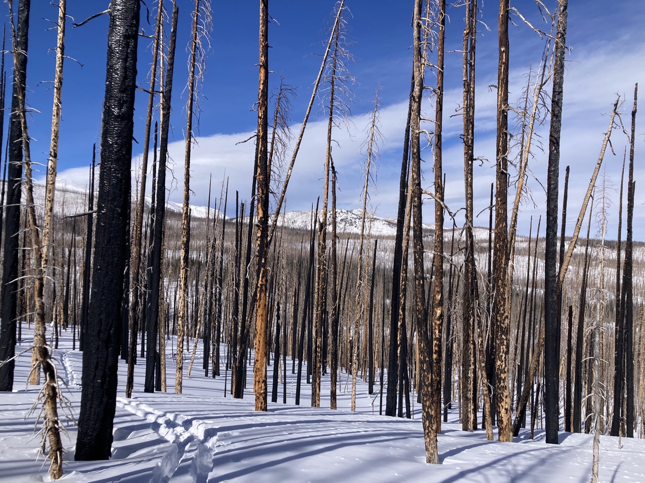
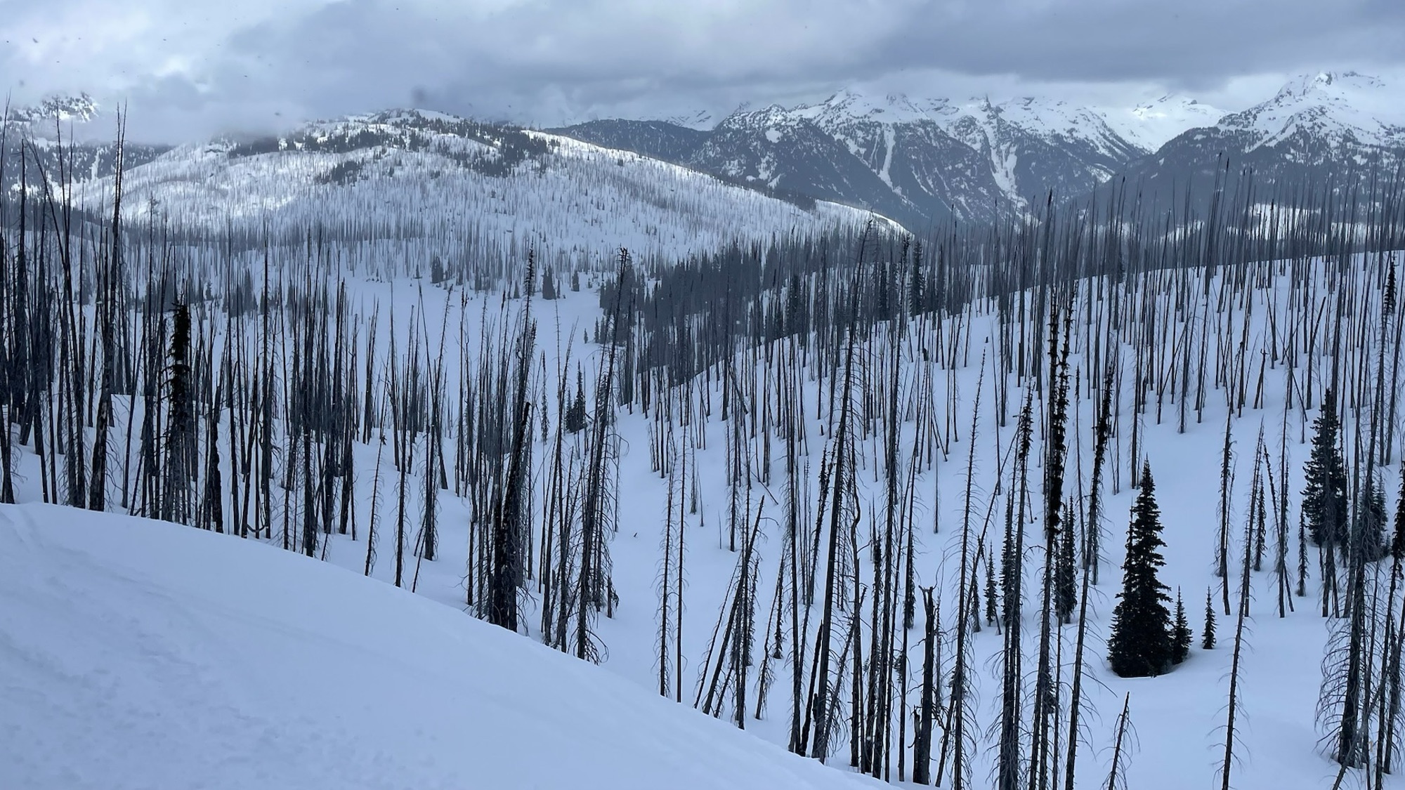
“When you see photographs of burned areas, we tend to show the photos that are most dramatic with just charred trunks that have (been) left behind, but in fact, most fires are mainly low to moderate burn severity that maintain the forest canopy,” Nolin said. “To not distinguish between different burn severities and to indicate that it’s all about the canopy being burned off and all of this carbon shedding on the snow—I think that stretches the results.”

The speed of vegetation recovery also shapes how the snowpack and streamflows respond to wildfire over time.

“If it’s a forest type where the vegetation can respond quickly and come back, that’s going to be a really different response than if the vegetation is slow to grow,” Kampf said. “Here in Colorado, we have some fires where it’s not coming back as forest at all, and where there are just no seedlings, and so we would expect the fire effect on snow to persist for a long time because we just don’t have trees coming back.”

The post-fire effects on streamflow tend to be localized, so it can be difficult to detect their effects on major river basins. 

“Even though the fires we’ve been experiencing have been really large, they’re still not huge compared to the size of the watershed as a whole,” Kampf said. “If you looked at something like the Colorado River Basin, it might be hard to detect the fire effect on the flow because there’s such a huge area that’s contributing to that flow. So in terms of how water is managed in forecasting and dam operations, I don’t think we’re there yet in terms of knowing how to account for fire.”

A major worry for water managers is the threat of high-intensity fires burning through dense stands of forest in the watersheds above their systems. 

“Those are places that water managers are concerned about because if the forest burns, then they experience problems with post-fire erosion and sedimentation and harms to water infrastructure, so it’s kind of a different side of the water management issue,” Kampf said.

Impacts on ecosystems

Besides posing challenges for water managers, wildfires can have profound effects on wildlife and forest health.

For aquatic ecosystems, “having a shift in the timing of when flow is coming in could also have an impact,” Kampf said, but “probably the greater impact is when that flow is bringing in with it a lot of sediments that are changing the habitat more profoundly.”

More rapid melting of the snowpack after a fire can also lead to a longer dry season for forests.

“If the snow disappears earlier, plants will start greening up sooner,” Kampf said. “If they’re not getting a lot of summer rain, they may find drier conditions later in the growing season that can stress plants.”

In addition to snow disappearing earlier due to fires, Nolin said the weather in November is getting drier. “If you have an earlier snow disappearance date and a later snowfall date, that dry season’s really getting quite a bit longer, and so it means that you have a decline in forest health and you also have an increase in the potential” for a longer fire season, Nolin said.

How burned ecosystems will respond to fire remains an open question as the climate continues to warm. In many parts of the West, decades have passed since flames swept through a forest, but trees have yet to return.

The burned trees may be centuries old, “and the climate was different than when those little seedlings sprouted and became the big trees that ultimately were involved in the fire,” Nolin said. “They grew initially under a different climate, and we don’t have that climate anymore, so we might see a lot more shrubs.”

Nolin said the paper “used a very simplistic approach to looking at future impacts on snow” by only examining what will happen under 2 degrees Celsius of warming. Climate change will also alter such factors as relative humidity and precipitation, so including these other effects “would’ve been more nuanced and perhaps a little more supportable,” Nolin said. She would have liked to see the results for various temperature increases up to 4 degrees Celsius, noting that mountains are warming faster due to climate change, and a key question is whether rain or snow will fall under warmer conditions. 

“Just having a single temperature change to look at helps us understand the impacts of temperature, and that’s great, but there is a lot more to be done in this area,” Nolin said.

This story was produced and distributed by The Water Desk at the University of Colorado Boulder’s Center for Environmental Journalism.

The latest seasonal outlooks through February 28, 2026 are hot off the presses from the #Climate Prediction Center

Study warns of ‘existential water crisis’ in the #RioGrande Basin: Urges action to avoid ‘continued loss of farmland due to financial insolvency from lowered crop production’ — AlamosaCitizen.com

Chart showing water use trends in US and Mexico. Credit: Overconsumption gravely threatens water security in the binational Rio Grande-Bravo basin. Map via Springer Nature.

Click the link to read the article on the Alamosa Citizen website:

November 21, 2025

major new study on the nearly 1,900-mile long Rio Grande Basin — from the San Luis Valley into the Gulf of Mexico — shows a “severe water crisis emerging” with total reservoir storage in decline at around 4.24 million acre-feet or 26 percent of capacity.

The study brings together detailed water consumption estimates of surface and ground water use throughout the basin and concludes “a likely outcome will be continued loss of farmland due to financial insolvency from lowered crop production and other factors including the aging of farmers and lack of affordable farm labor,” without urgent action.

“Climate scientists have reframed the long-running drought as the onset of long-term aridification and are forecasting additional river flow diminishment of 16-28% in coming decades as the climate continues to warm,” the study notes.

The authors’ analysis shows that during 2000–2019, Colorado lost 18 percent of its farmland in the Upper Rio Grande Basin, New Mexico lost 28 percent along its Rio Grande sub-basins, and the Pecos River sub-basin lost 49 percent.

Further drying puts farmers and cities who rely on the Rio Grande in an “existential water crisis.”

Brian Richter, one of the authors of the study, says San Luis Valley farmers are central to the development and implementation of solutions for the rapidly drying Rio Grande given that “the vast majority of the direct human consumption of water in the SLV takes place on irrigated farms.”

Researchers estimate that the present level of over-consumption of both surface and groundwater in the Valley is approximately 11 percent. “That means that water consumption needs to be reduced by that percentage,” Richter said.

Richter is president of Sustainable Waters and senior freshwater fellow for the World Wildlife Fund. The two organizations teamed with researchers to provide a full accounting of the consumptive uses as well as evaporation and other losses within the Rio Grande Basin. 

The Rio Grande stretches nearly from the San Luis Valley through New Mexico, El Paso, Texas, and empties into the Gulf of Mexico. It provides drinking water for more than 4 million in Colorado, New Mexico and Texas, and 11 million people in Mexico, the study notes. More than 1.9 million acres of irrigated farmland is tied to the Rio Grande.

The study, “Overconsumption gravely threatens water security in the binational Rio Grande-Bravo basin,” relies on data from annual runoff volumes, municipal and commercial consumptive use estimates from the U.S. Geological Survey, and reservoir storage levels, among other data sets.

Snowmelt runoff has decreased 17 percent over the past 25 years, according to the report. At the same time, total direct water consumption has been increasing since 2000, largely due to increasing water usage by farmers in Mexico.

When comparing challenges of Colorado River users to the Rio Grande, researchers say the “water crisis facing the RGB is arguably more severe and urgent than the CRB,” given the fact groundwater in the San Luis Valley has been depleted at a rate of 89,000 acre-feet per year; New Mexico has a water debt to Texas; and Mexico has a mounting water debt to the U.S. under a 1944 treaty that is causing political tension between the two countries.

The Upper Rio Grande here at the end of 2025 is benefitting from heavy October rainsthat materialized across the southwest and provided a stopgap to what were some of the worst summer river flows ever recorded on the river.

Management of the Upper Rio Grande Basin will be back in the spotlight come January 2026 when Colorado Water Court Division Three takes up the Fourth Amended Plan of Water Management for Subdistrict 1 of the Rio Grande Water Conservation District. The new strategy calls for a groundwater overpumping fee of $500 per acre-foot any time an irrigator in Subdistrict 1 exceeds the amount of natural surface water tied to the property of their operation. The rule punishes farmers who do not have natural surface water coming into their fields but instead rely solely on groundwater pumping for their crops.

The whole point of the plan for the agricultural-rich area of the San Luis Valley is to let Mother Nature dictate the pattern of how irrigators in Subdistrict 1 restore the unconfined aquifer and build a sustainable model for farming in the future.

Richter credits Colorado and irrigators in the Valley for taking steps to address the Rio Grande. The proposed $500 fee for overpumping in Subdistrict 1, he says, “is going to set off a lot of change in the Valley, because many/most farmers won’t be able to continue producing the same crops they’ve been growing in recent years.”

“Colorado has definitely taken some important steps, and manages its water resources far better than New Mexico or Texas,” Richter says. “But Colorado still has not been able to reduce pumping to anywhere near the needed degree, so it’s no surprise the aquifer continues to decline.”

The study looks at crops grown along the Rio Grande and how agricultural fields account for 87 percent of direct water consumption. “Overall, agricultural consumption is nearly seven times the volume of all other direct uses combined.”

Alfalfa and grass hay – water-intensive crops that dominate the landscape in the Valley and in Northern and the Middle Rio Grande of New Mexico – account for nearly 45 percent of the irrigation water consumed along the Rio Grande Basin. A shift to less-intensive crops, as the Rye Resurgence Project advocates, and a moratorium on new wells in over-drafted areas of basin in New Mexico and Texas, are necessary first steps to addressing the Rio Grande’s challenges, according to researchers of the study.

“Potatoes might be one of the few crops that remain sufficiently profitable to persist in the Valley,” says Richter. “If those transitions to other crops or to permanent farmland retirement lead to reduced water consumption to the level needed (11 percent), there is hope that the (unconfined) aquifer can be rebalanced with natural replenishment. However, it will require a greater level of pumping reductions to enable the aquifer to recover to the level required by the state engineer.”

San Luis Valley center pivot August 14, 2022. Photo credit: Allen Best/Big Pivots