Western water: Where values, math, and the “Law of the River” collide, Part I: Part I of a two-part essay and Data Dump — Jonathan P. Thompson (www.landdesk.com) #ColoradoRiver #COriver #aridification

Milkweed, sweet peas, and a plethora of other flora billow from Farmerโ€™s Ditch in the North Fork Valley of western Colorado. Jonathan P. Thompson photo.

Click the link to read the article on The Land Desk website (Jonathan P. Thompson):

September 12, 2024

Note to readers:ย Sorry this piece is late. I injured my hand in a way that makes typing a bit difficult and that has slowed me down a bit. And to non-paid subscribers: Sorry for the paywall and all, but we gotta pay the bills โ€” and give the paid folks their premium content! If youโ€™re interested, consider knocking down that paywall and accessing all the archives by becoming a paid subscriber!

This spring, I had the pleasure to sit on a panel on water in the West with Paolo Bacigalupi and Heather Hansman, two writers Iโ€™ve long admired. During the question & answer period, a local woman lamented the fact that some ditches were being piped or lined with concrete, because it would dry out the wetlands and ecosystems that had come to rely on the leaky laterals and ditches. And she was angry because the point, as she understood it, was to save water only to send it downstream to California. Her beloved valley, it seemed, was being dried out to fill up LA pools, which just seems wrong.

Jonathan P. Thompson, Paolo Bacigalupi, and Heather Hansman on a writer’s panel in Paonia in April, 2024.

Iโ€™ve thought about this a lot in the months since, because I think it gets down to the big, conceptual tug-of-war thatโ€™s happening around the Colorado River. Thereโ€™s one battle between the different users of the riverโ€™s water. And then thereโ€™s another in which the values different communities hold are clashing with the โ€œlaw of the riverโ€ and the overwhelming math that is driving the need to make massive changes.

The following meditation on this clash was catalyzed by a slide a friend sent me from a Family Farm Alliance presentation at the Colorado Water Congressโ€™s summer meeting. It accused me โ€” via a piece I wrote for High Country News โ€” of โ€œdemonizingโ€ alfalfa.

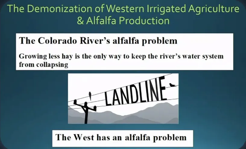
Well, Family Farm Alliance, this is my response to you:

VALUES

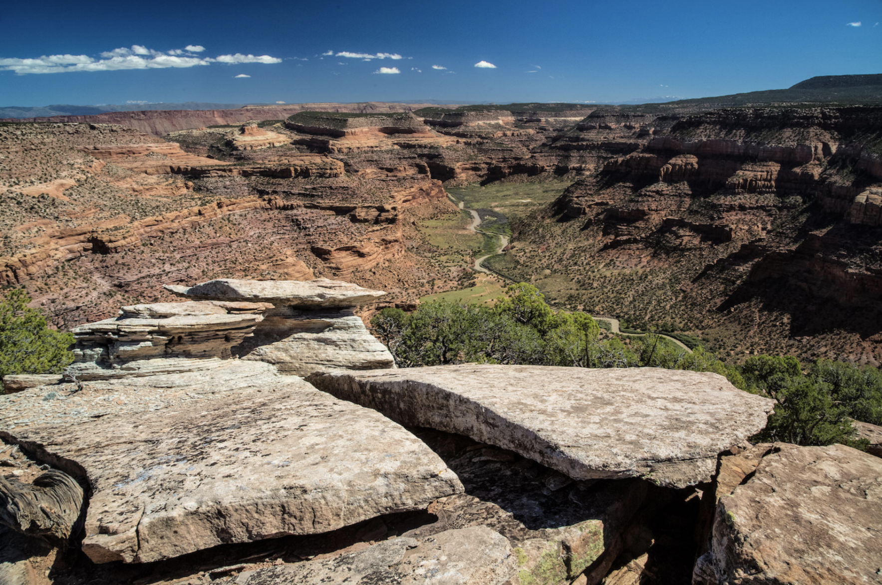
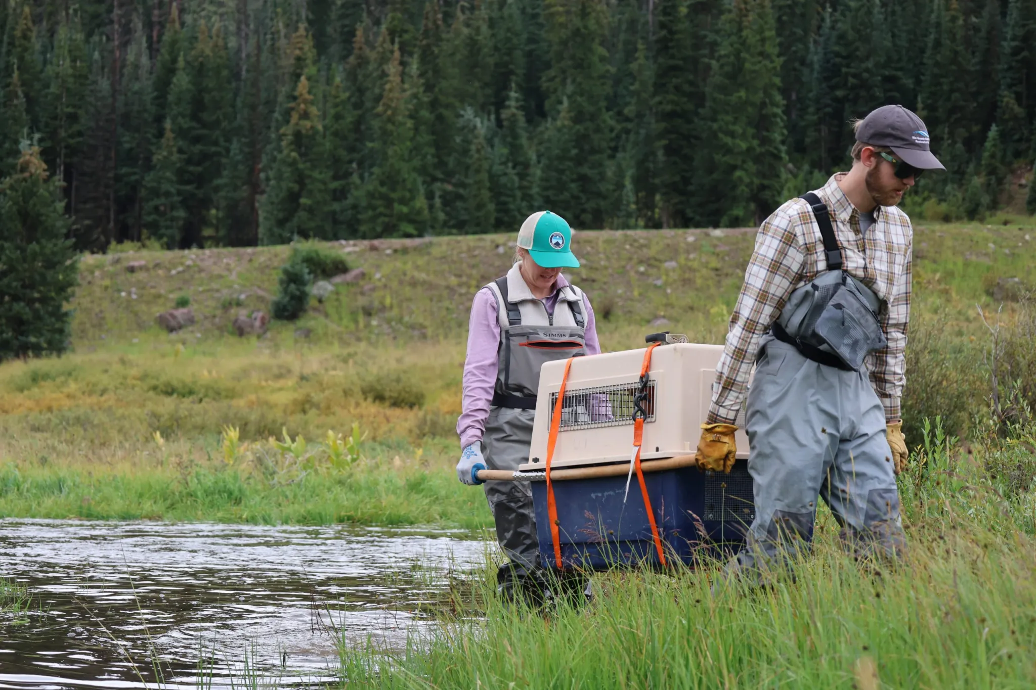
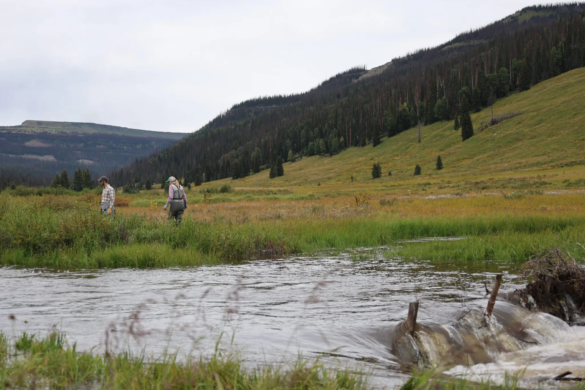
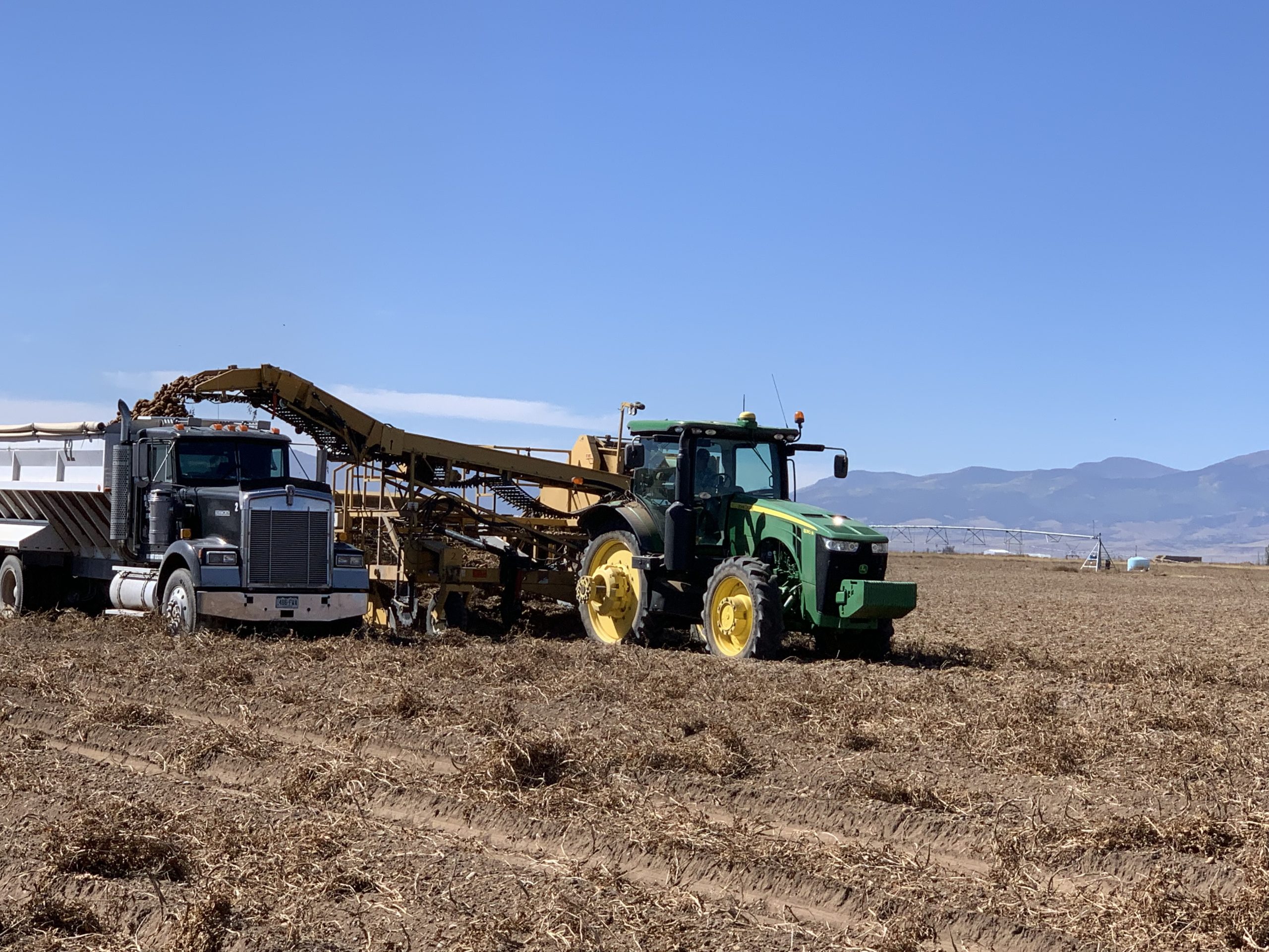
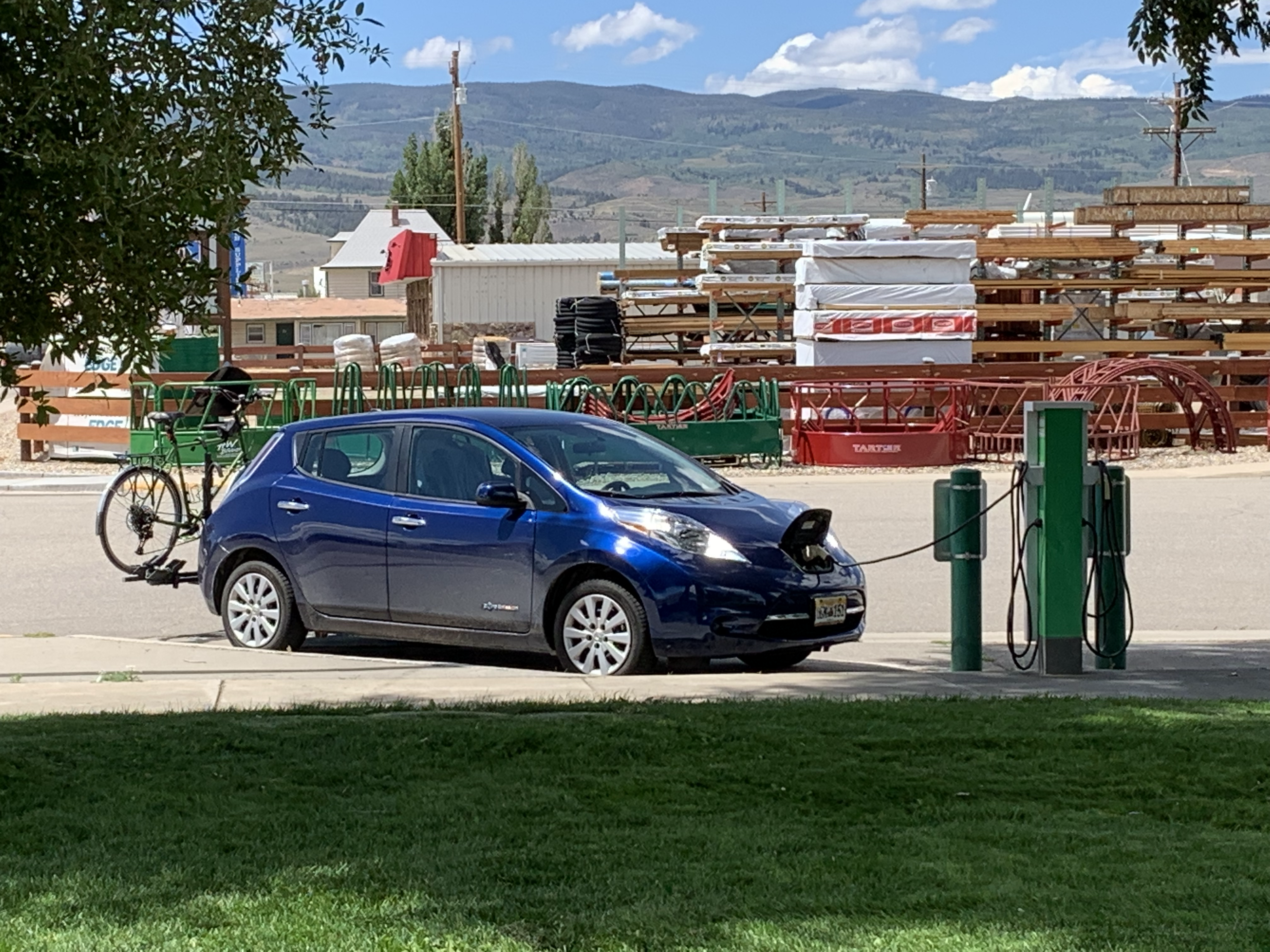
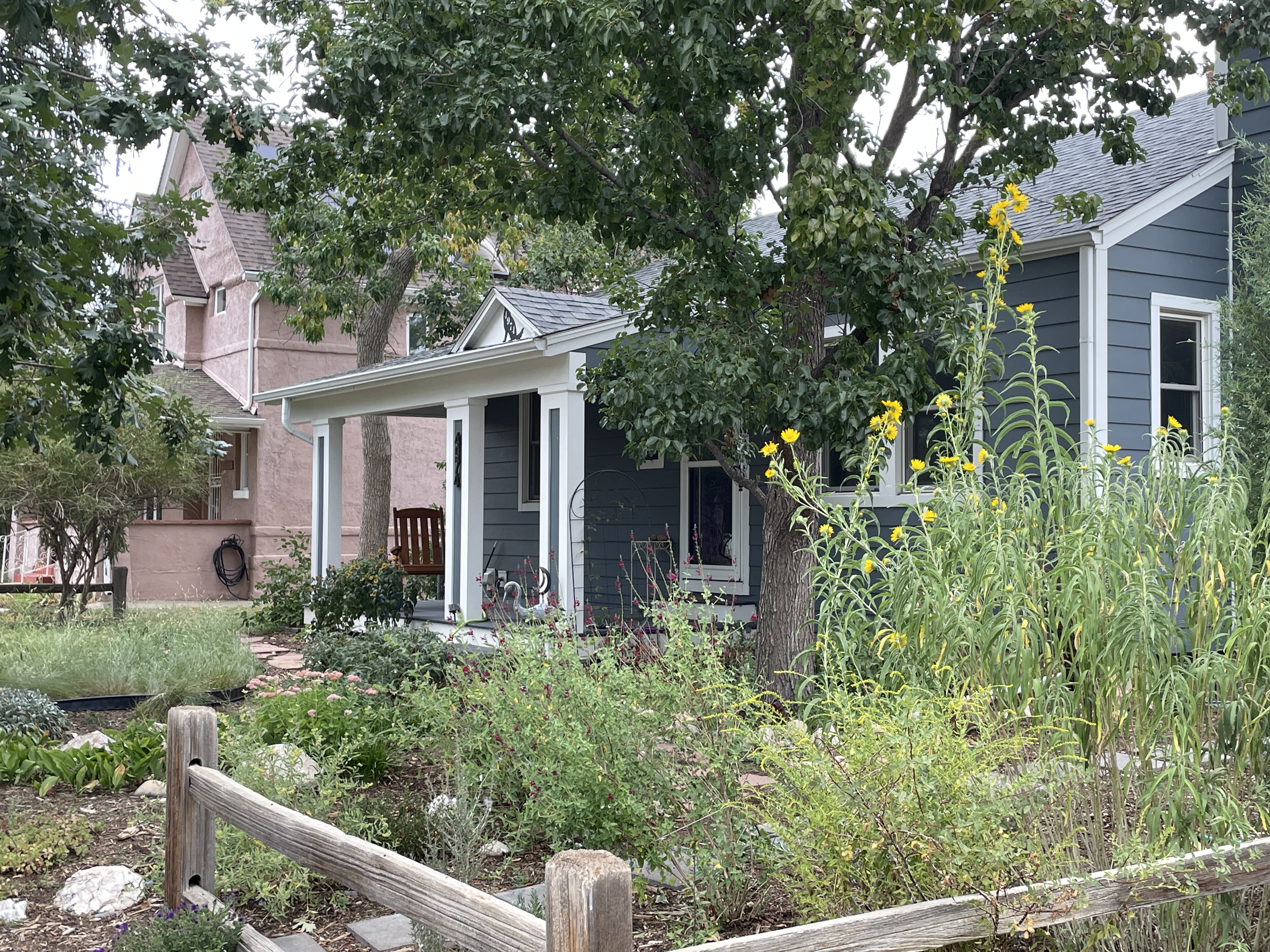
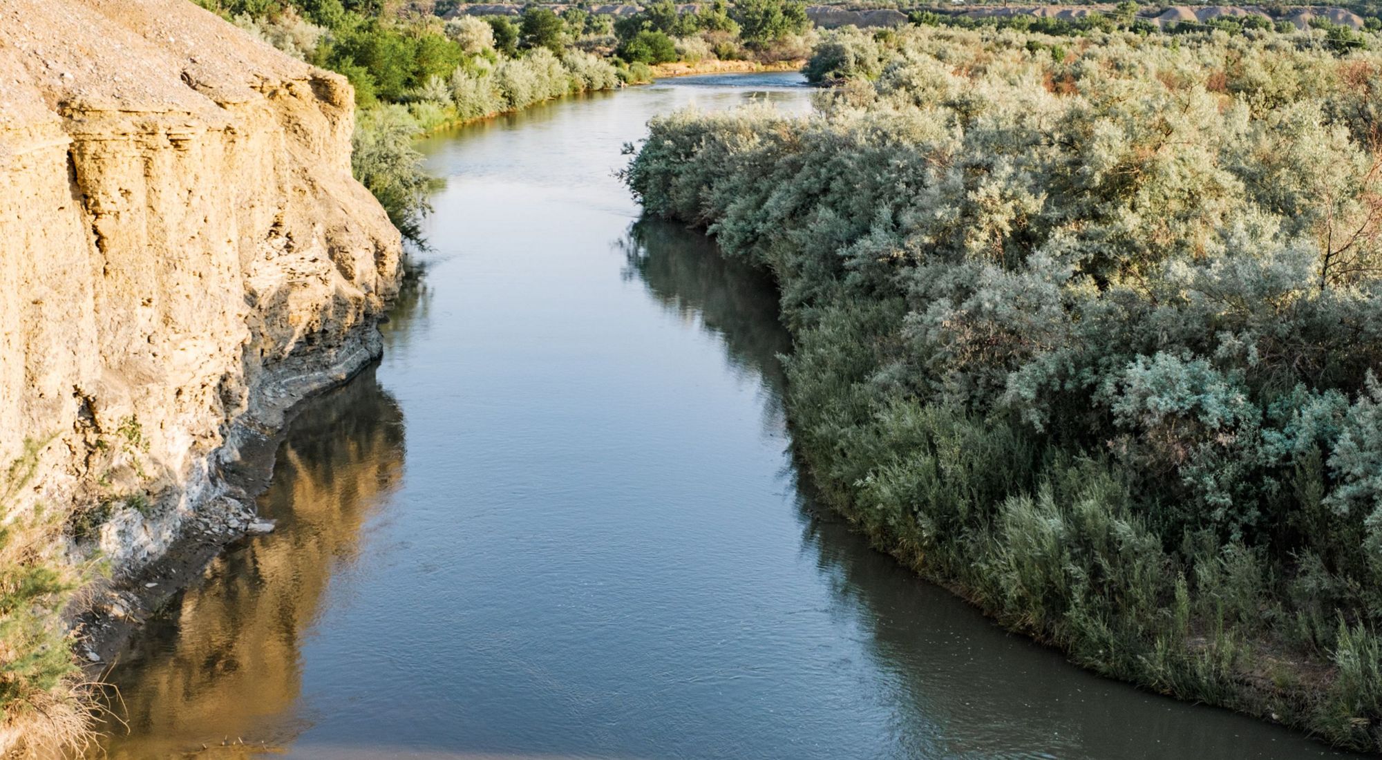
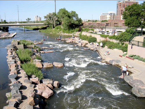
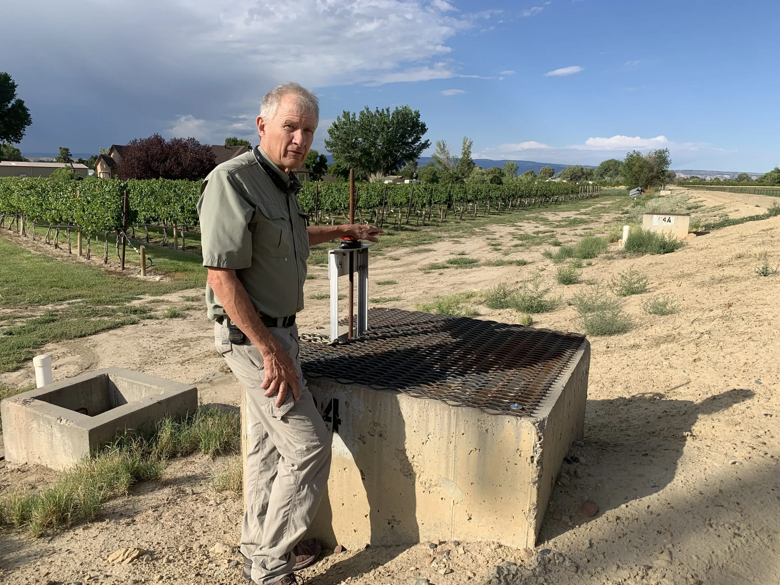
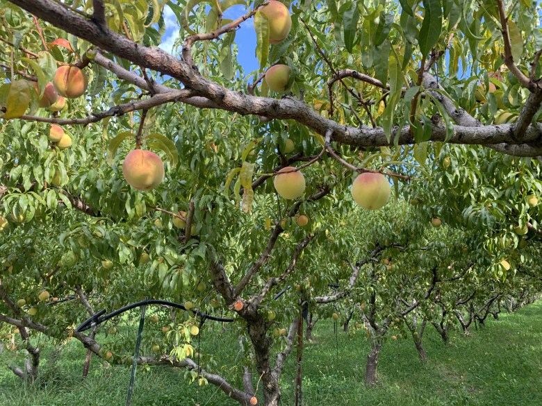
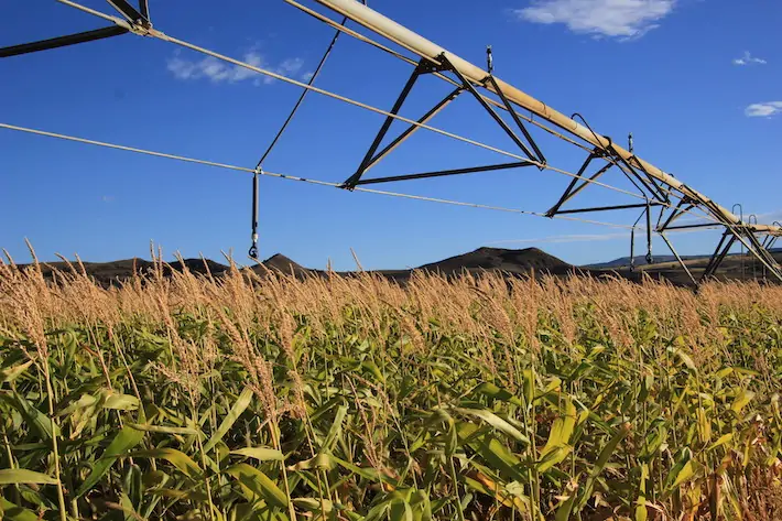
The woman at the panel was referring to the North Fork Valley in western Colorado, a place with an extensive network of open canals, laterals, and ditches that irrigate peach, apple, and pear orchards, small vineyards, organic farms, and alfalfa fields. A handful of center-pivot sprinkler systems reveal themselves in the geometric perfection of their dependent fields, but most of the farms rely on older methods to bring water to the crops, namely by flooding the field or directing water down dirt rows where they soak into the plantsโ€™ roots. 

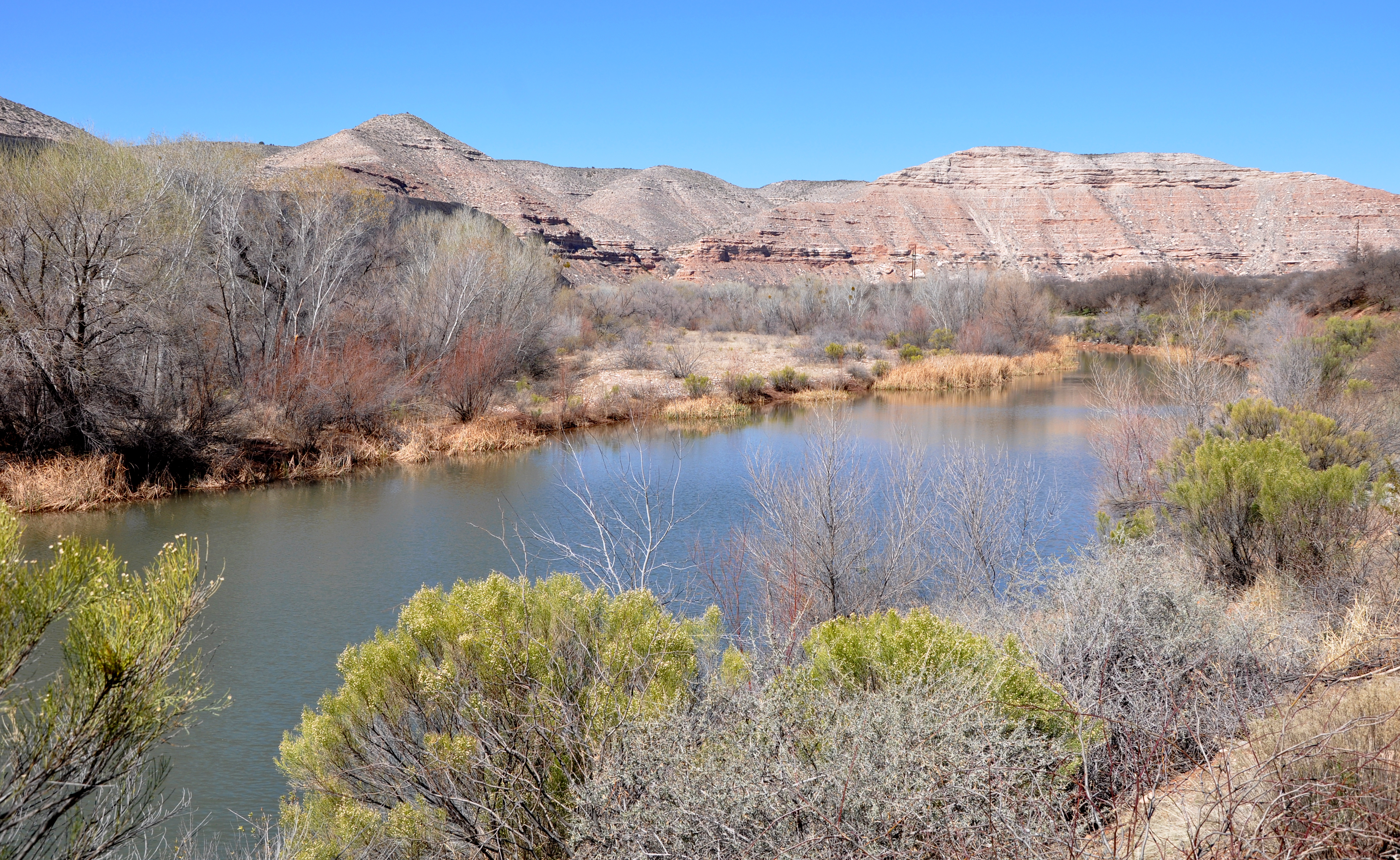
Most of the canals and ditches are unlined and uncovered, and have been that way since they were built over a century ago. Many of them leak, some prolifically, their fugitive water blanketing the beige-gray earth with grass and nourishing cottonwoods, feral apricot and plum trees, sunflowers, willows, cosmos, reeds, sweet peas, milkweed, and cattails โ€” along with a host of fauna that depend on those plants. 

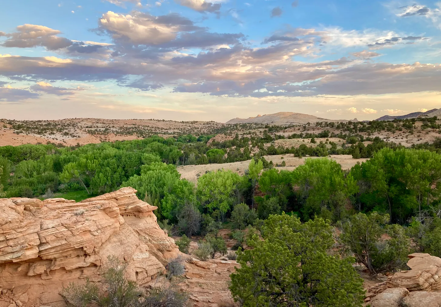
The intentional and accidental irrigation combine to form an irregular, pastoral patchwork of relative lushness amid the arid landscape of the kind that can be found in northern New Mexico, where a network of acequias irrigate long, rock-lined fields, or McElmo Canyon, where voluptuous pink sandstone rises up from a sea of emerald alfalfa. These places, where the cultivated and feral and wild collide, evoke the Provence of Jean Gionoโ€™s novels. 

These are artificial landscapes, colonial ones, even, created by damming rivers and diverting their waters away from the fish and aquatic life in the streams and throwing off the natural balance of things. They rely heavily on inefficiencies in the system, from leaky laterals and ditches to flood-irrigation runoff. But they are, to my eye, lovely nonetheless, and contrast favorably with the more efficient farming areas, where high-tech irrigation systems deliver every drop of water to the linearly planted crops in laser-leveled fields. 

Agricultural productivity has grown 20% in the 21st century. Organic corn in Coloradoโ€™s North Fork Valley. Photo credit: Allen Best

And yet, because of math and water laws and compacts and the need to devote every drop of the shrinking Colorado River to โ€œbeneficial uses,โ€ the character of these landscapes is likely doomed. It wonโ€™t happen next month or even next year, but over time. Nor will the lands be dried up altogether: In places like the North Fork the ditches โ€” at least the ones with senior water rights โ€” will continue to deliver water to the fields. 

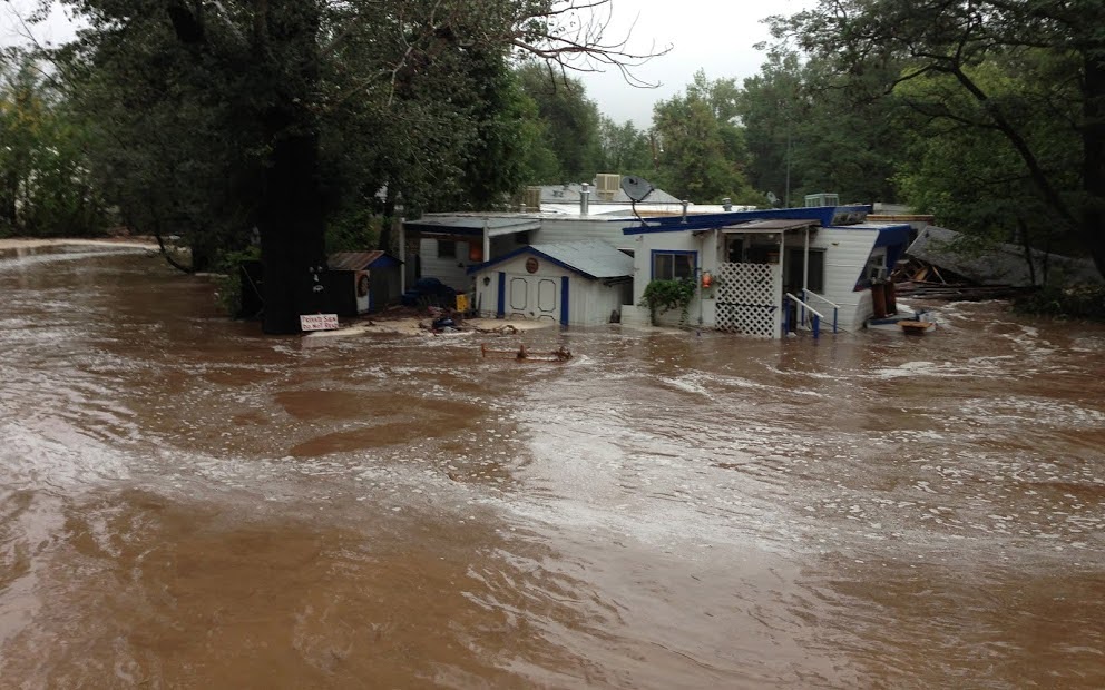
But more and more, those old leaky ditches will be upgraded, lined with concrete or other impermeable materials, or even put into pipes so that all of the water goes to those who hold the rights to that water, not to evaporation or the accidental ecosystems that have sprung up along the ditchesโ€™ banks. The farmers, too, may be forced or incentivized to become more efficient, replacing the flood irrigation with sprinklers or drip lines. Some will be paid to not irrigate at all. Most of the open ditches like the ones my cousins and I held stick-boat races in on my grandparentsโ€™ Animas Valley farm will be gone, along with the runoff of the kind that spilled from their corn and alfalfa fields to fill the cattail- and willow-tangled slough down below.

It is this loss that the woman in Paonia is mourning. It is heartbreaking. And itโ€™s something I think about every time I write about the Colorado River and the looming crisis it and the communities and industries that rely on it face in the not-so-distant future. 

If the crisis could only be solved โ€” and the needed cuts in consumption made โ€” based on our values alone, things would certainly be a lot easier. There would likely be fairly wide agreement that we should fallow the golf courses and drain the swimming pools before drying up the leaky-ditch wetlands and leaving the red-winged blackbird homeless. Farmers might join me in calling for tearing out thirsty turf lawns from Denver to San Diego, implementing progressive water rates to stem gluttony, and putting hard limits on household water use โ€” if it meant keeping the sprinklers flowing to food crops, including alfalfa and other forage. After all, I value cheese and ice cream and green-chile burgers over the Sultan of Brunei or Miriam Adelson, who guzzled 12 million and 10 million gallons of water, respectively, last year to keep their Las Vegas estates green.  

Ah, and yes, if all of this could be solved by prioritizing cuts based on values, alone, the Family Farm Alliance would have no reason to accuse me of โ€œdemonizingโ€ alfalfa and other livestock forage crops (though I imagine the golf groupies would get me for vilifying them). But, alas, itโ€™s just not that simple. Why? Because even the most lofty values are trumped by the cold, hard math. 

MATH

The pertinent numbers in the equation include:

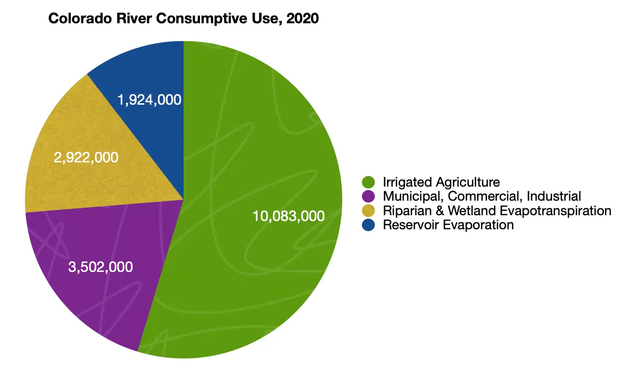
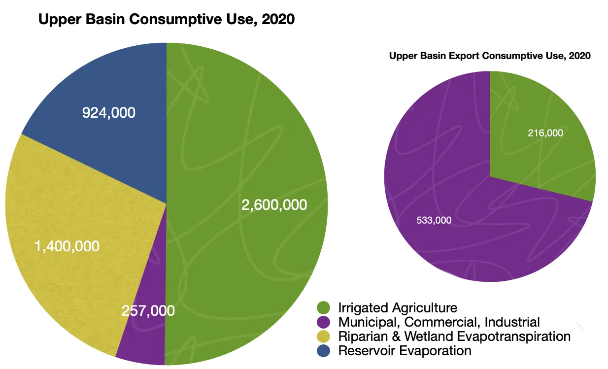
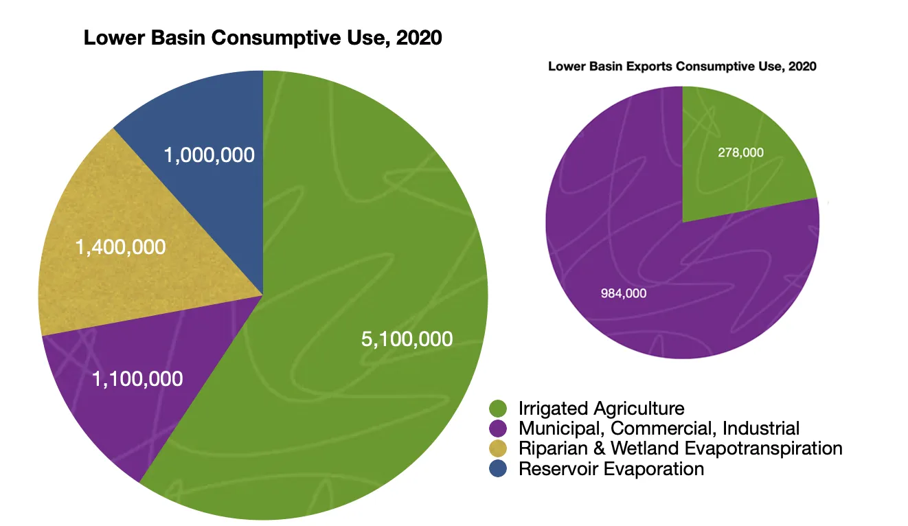
  • 16.5 million acre-feet: Total human-related consumptive use of Colorado River water in 2020. This means all of the water that was withdrawn from the river and not put back into it, including reservoir evaporation. It doesย notย include the 2.8 million acre-feet consumed via riparian and wetland evapotranspiration, nor does it include the 1.7 million acre-feet of water use from the Gila River, a tributary to the Colorado.ย 
  • 14.5 million acre-feet: The Colorado Riverโ€™s median โ€œnatural flowโ€ at the Lee Ferry stream gage, which is the official dividing line between the Upper Basin and Lower Basin, from 1906 through 2023. This is used as a measure of how much water is in the Colorado River, since downstream tributaries are relatively insignificant.ย 
  • 12.4 million acre-feet: The Colorado Riverโ€™s average natural flow at Lee Ferry from 2000 through 2023.

This leaves us a few options for the big math problem that needs solving:ย 

  • The optimistic equationย (assumes the last 20 years was an anomaly and the river will go back to its old-normal flow soon, i.e. the median for 1906-2023):
    • 14.5 million – 16.5 million = 2 million acre-feet deficit
  • The new-normal equationย (assumes the next few decades will look like the most recent couple of decades โ€” which is to say a megadrought) :
    • 12.4 million – 16.5 million = 4.1 million acre-feet deficit
  • The pessimistic (realistic?) equationย (assumes human-caused climate change will continue to deplete the river):
    • 10.4 million – 16.5 million = 6.1 million acre-feet deficit
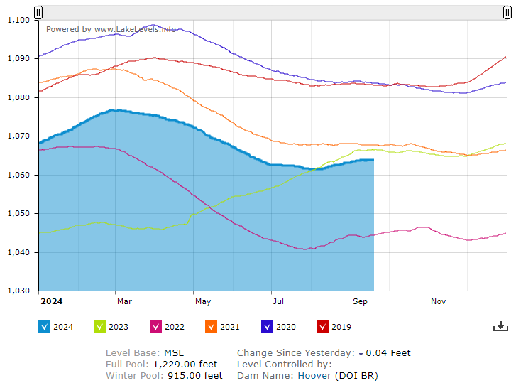
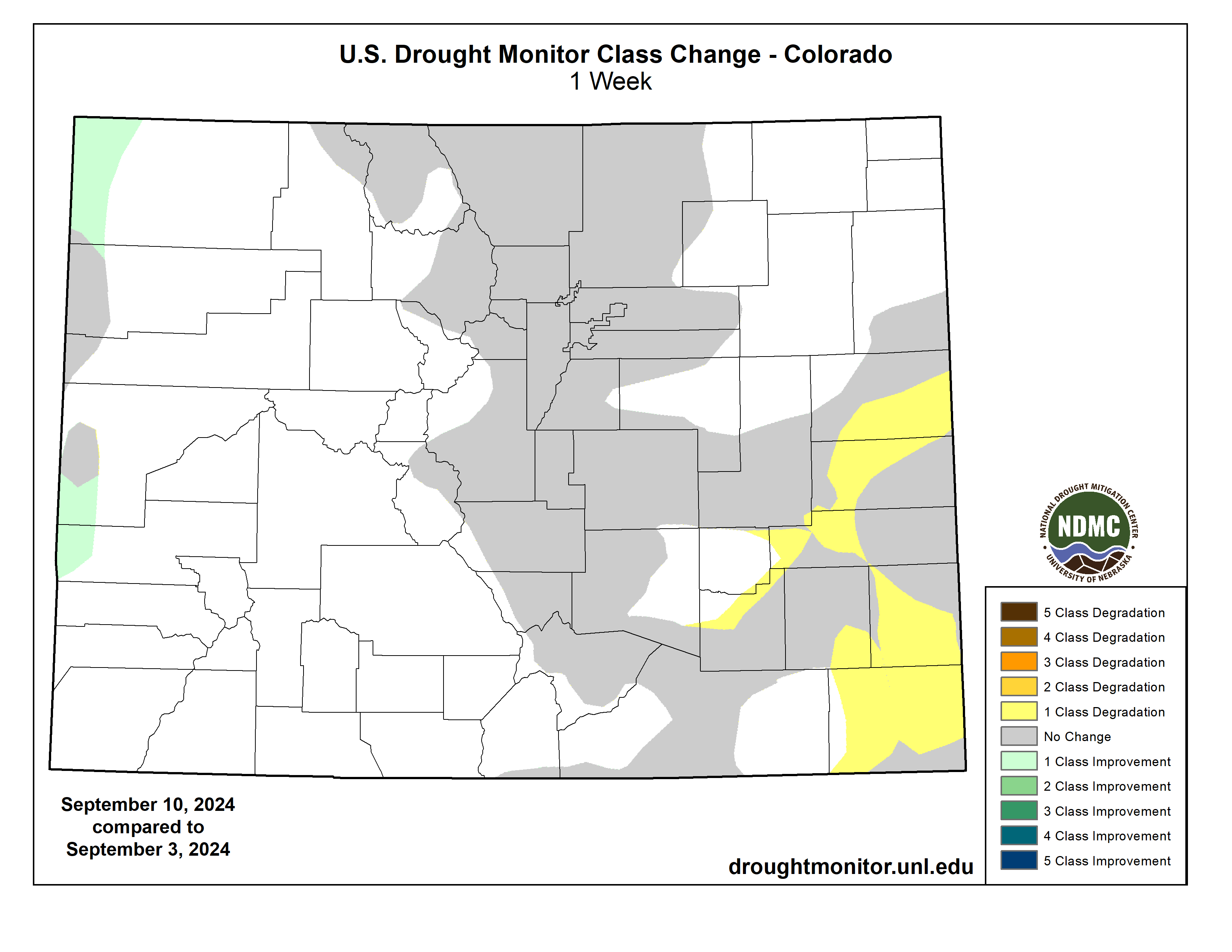
Estimated natural flow of the Colorado River at Leeโ€™s Ferry (the dividing line between the Upper Basin and the Lower Basin). The natural flow is basically the total amount of water the river delivers each year, or the volume that would pass by Leeโ€™s Ferry if there were no upstream diversions. Source: USBR.

Which is to say โ€ฆ weโ€™re screwed no matter how you juggle the numbers! Sorry, thatโ€™s not very solution-oriented is it? No matter how you cut it, though, the Colorado River budget is running a massive deficit and has been for a while. Thatโ€™s why Lake Powell, the Upper Basinโ€™s savings account, has been shrinking and now is less than 40% full โ€” even after a couple of decent winters. A couple of consecutive new-normal winters could bring the reservoir down below minimum power pool, shutting down the hydropower turbines and potentially setting the scene for a mega plumbing disaster. 

While itโ€™s highly unlikely that the Colorado Riverโ€™s flows will increase enough to fill Lakes Powell and Mead to capacity anytime soon, itโ€™s not impossible. During the extraordinarily wet and snowy four years between 1983 and 1986, nearly 80 million acre-feet of water ran into Lake Powell โ€” which should be enough to fill both reservoirs and still deliver adequate flows downstream. If it happens, great! It would be foolish and potentially catastrophic to bet on a repeat, however. 

That means the users of the river must erase the deficit by cutting anywhere from 2 million to 6 million acre-feet of consumption annually. The big question, and one that the basins and their member states have been debating, is: Where will those cuts come from? Iโ€™m not going to get into the many layers of these negotiations here, as thatโ€™s not the purpose of this essay, which is a bit of a thought experiment. Suffice it to say itโ€™s complicated, and made more so by glaring errors and injustices committed when the Colorado River Compact was originally crafted. 

Letโ€™s say weโ€™re going to make these cuts based on values. Obviously everyone has different values, so weโ€™ll just go with those expressed at the Q&A session I lead this piece with, which can be summed up as prioritizing rural farmland, food crops, and the artificial wetlands that can be found in the North Fork Valley over urban lawns, golf courses, and billionairesโ€™ estates. 

Where better to begin than Las Vegas? Letโ€™s pull up some water user data and, holy cow! Look at those numbers. The Vegas resorts and the rich sure know how to use water: 

The Venetian and Mandalay Bay resorts each use more than 500 million gallons of water per year. Meanwhile the top residential water users are mostly billionaires: 99 Spanish Gate Dr. โ€” which goes through 12 million gallons per year โ€” was owned by the Sultan of Brunei until tech-giant Jeff Berns purchased the 37,500 sf mansion for $25 million. Other top water gluttons include Miriam Adelson โ€” a top Trump donor โ€” and UFC CEO Dana White. The average Las Vegas household uses about 120,000 gallons per year, though newer, more efficient homes use far less.

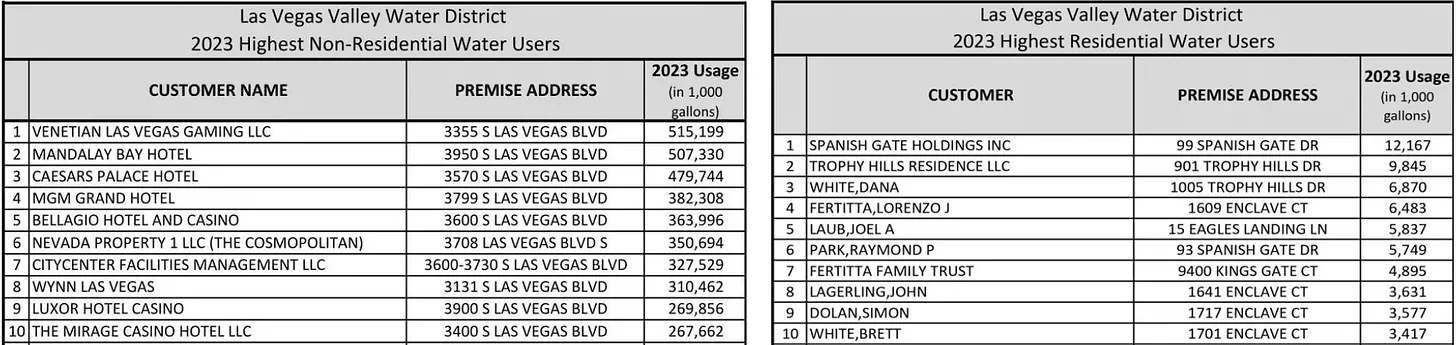
When folks start throwing $25 million around for an unfinished house is when you know itโ€™s time for a wealth tax. And when they use 100 times as much water as the average home, itโ€™s also time for a new, progressive water rate structure, that incentivizes conservation and punishes gluttony. Las Vegas already has something like this, but the rates in the upper tiers are too low to be meaningful; they need to be so high that this kind of profligacy will sting even a billionaireโ€™s pocketbook. Hell, better yet, why not just fallow these properties and xeriscape them?

When the numbers are added up, youโ€™ve got:

  • 227,243,000 gallonsย Top 100 Las Vegas residential water usersโ€™ combined consumption in 2023.ย 
  • 3,774,780,000 gallonsย Top 10 Las Vegas non-residential water usersโ€™ combined consumption in 2023.ย 

Wow, so by shutting down just these folks, we could save 4 billion gallons of water, or โ€ฆ 12,275 acre-feet? Oh, thatโ€™s not as much as it seemed.

So how about we go to other cities and tear out turf, mandate low-flow appliances, ban lawn watering and swimming pools. I mean, if you could get Scottsdale and St. George residents to cut back to Tucson or Los Angeles per capita water levels, youโ€™d make some more huge cuts.

If Scottsdaleโ€™s per-capita consumption were cut to Tucsonโ€™s levels it would save about 42 million gallons per year.

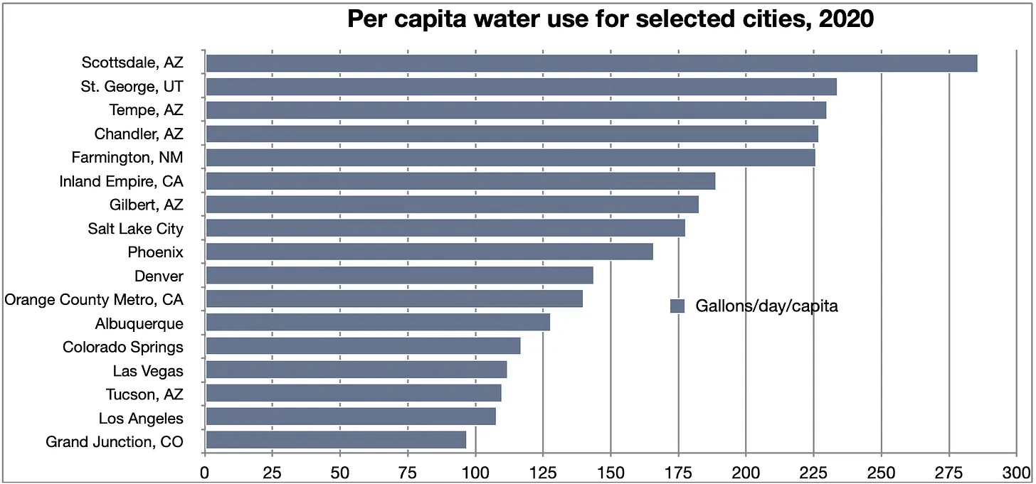
You could save millions of gallons through that effort, which is great. The problem is, this problem requires bigger thinking โ€” youโ€™ve got to make multiple cuts in the tens of billions of gallons range for it to make a significant difference. Once again, math, the ultimate buzz killer, raises its ugly head. See, as noble as all of these efforts might be, there just isnโ€™t enough overall water use in the urban sector to come up with all the necessary cuts. You could drain the pools, dry up the lawns, seal up the Bellaggio fountains โ€” hell, even shut off the massive pumps that convey water from Lake Mead to the Las Vegas metro area altogether โ€” and you would still need to come up with at least another 1.6 million acre-feet of cuts. Entirely cutting off all of the Basinโ€™s cities and industrial applications wouldnโ€™t even get you to 4 million acre-feet of cuts. But boy, it sure would be interesting to watch โ€” from afar.

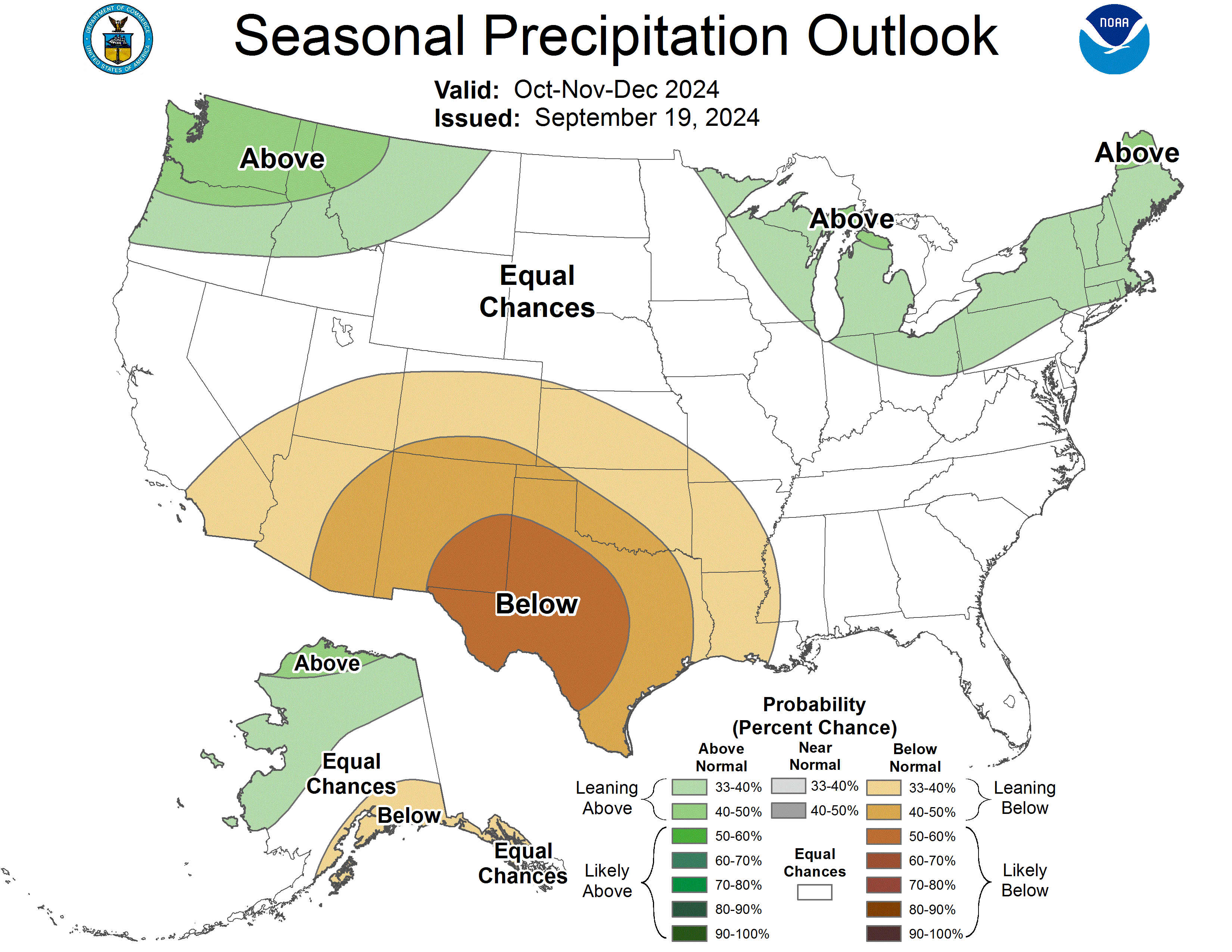
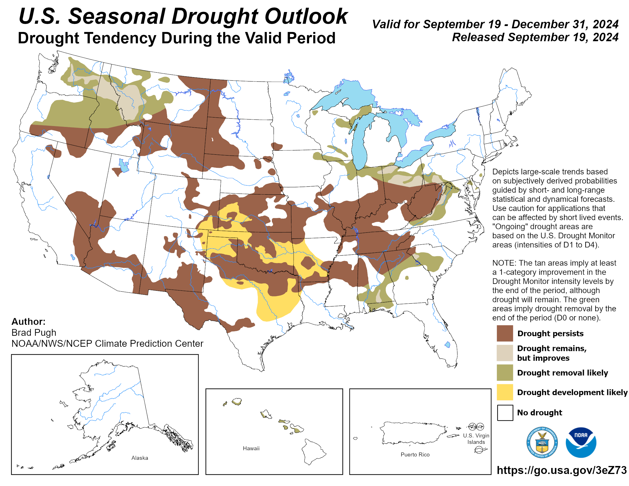
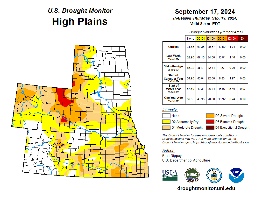
To conclude Part I, some charts that drive the point home:

Irrigated agriculture gulps up about 10.1 million acre-feet per year, accounting for about 52% of the total consumptive use on the Colorado River. Meanwhile the municipal, commercial, industrial sector only uses 3.5 million acre-feet, meaning if you cut off all of the water to every Southwestern city, you still might have a water deficit in the Colorado River Basin. Source: New water accounting reveals why the Colorado River no longer reaches the sea, by Brian Richter et al
The chart on the left shows consumptive use within the Colorado River watershed only, where irrigated agriculture uses about 50% of the water. By contrast, Colorado River water sent over the Continental Divide to Coloradoโ€™s Front Range and New Mexicoโ€™s Rio Grande watershed is mostly used by cities, with about one-third going to agriculture.
About 59% of the non-exported Lower Basin consumptive use goes to irrigated agriculture. Exports follow the same pattern as in the Upper Basin, with most of the water going to urban use.

SOURCES:ย New water accounting reveals why the Colorado River no longer reaches the sea,ย by Brian Richter et al.;ย Decoupling Urban Water Use from Population Growth in the Colorado River Basin, by Brian Richter; Bureau of Reclamation, Las Vegas Valley Water District, Southern Nevada Water Authority, Zillow.ย 

Map credit: AGU

#Colorado Department of Public Health and Environment approves higher capacity of safe drinking water for 150,000 residents in Northern Colorado: Soldier Canyon Water Treatment Plant expands from 60 to 68 million gallons per day — North Weld County Water District

The Soldier Canyon Dam is located on the east shore of Horsetooth Reservoir, 3.5 miles west of Fort Collins, Colorado. The zoned earthfill dam has an outlet works consisting of a concrete conduit through the base of the dam, controlled by two 72-inch hollow-jet valves. The foundation is limey shales and sandstones overlain with silty, sandy clay. Photo credit Reclamation.

Click the link to read the release on the North Weld County Water District website:

September 17, 2024

Nearly 150,000 residents will have greater access to safe drinking water without high costs for decades to come, after an approval by the Colorado Department of Public Health and Environment (CDPHE). This authorization will increase capacity at the Soldier Canyon Water Treatment Plant from 60 to 68 million gallons per day (MGD).

โ€œThe approval from CDPHE is a big win and a huge savings in dollars for the Tri-Districts all operating from the Soldier Canyon Water Treatment Authorityโ€™s Plant,โ€ says Eric Reckentine, General Manager of North Weld County Water District.

The re-rating by the CDPHE which increases capacity from 60 to 68 million gallons per day (MGD), was successfully accomplished by the collective work of the three water districts operating out of Northern Colorado โ€“ North Weld County Water District (NWCWD), East Larimer County Water District (ELCO), and the Fort Collins-Loveland Water District (FCLWD).

โ€œThe expansion ensures that we can continue to provide water supplies to match our customersโ€™ future growth needs and provide added resilience to our water supply systems,โ€ states Mark Kempton, P.E, CWP, General Manager of Soldier Canyon Water Treatment Authority. โ€œThe Authority achieved the 8 MGD expansion using the Plantโ€™s existing facilities, resulting in no construction and minimal costs. This efficiency has allowed us to keep our water rates low for our customers while continuing to provide a reliable, safe, and affordable drinking water supply to the Tri-Districts.โ€

The CDPHE expansion will provide water and larger capacity many years into the future for the tremendous development and population growth that Northern Colorado towns are experiencing.

โ€œWe continue to see projections for additional growth in the northern Colorado region and expanding water treatment capacity is a fundamental building block to sustain that growth. This treatment capacity increase represents the most cost-effective expansion in Soldier Canyonโ€™s history and ensures all three partners can continue delivering high-quality drinking water well into the future,โ€ explains Chris Pletcher, P.E., General Manager of Fort Collins โ€“ Loveland Water District.

โ€œLike much of Northern Colorado, we anticipate continued growth within the East Larimer County Water District (ELCO) service area, and this addition of water treatment capacity will aid in meeting that new demand,โ€ states Mike Scheid, General Manager of ELCO.

โ€œI am very proud of the work of the other water districts and the staff and board of North Weld County Water District for helping to make accomplishments like this happen โ€“ it further stands by our commitment that we follow-through on what we promise for our customers,โ€ says Reckentine. โ€œThis collaborative undertaking between the districts ensures we have secured the highest quality treated water for our Northern Colorado customers today, tomorrow, and into the future.โ€

ABOUT THE SOLDIER CANYON WATER TREATMENT AUTHORITY:

The Soldier Canyon Water Treatment Authority (SCWTA) owns and operates the Soldier Canyon Filter Plant, which is a 68 million gallon per day (MGD) conventional water treatment plant located in Fort Collins, CO. Since 1961, the Authority has provided high quality, reliable, safe, and affordable drinking water to over 145,000 people living in three water districts and adjacent communities in the Northern Colorado region. The three water districts (Tri-Districts) are:

Albuquerque Bernalillo County Water Utility Authority unimpressed by Air Force cleanup plan: โ€˜Not includedโ€™ in plan for mitigating 20th-century leak — City Desk Albuquerque Journal

Monitoring wells being drilled near KAFB (Roberto E. Rosales / The Paper.)

Click the link to read the article on the City Desk Albuquerque Journal website (Rodd Cayton):

September 9, 2024

The U.S. Air Force has a plan for cleaning up a decades-old jet fuel spill from a base near Albuquerque.

However, the local water authority said last week that the plan is inadequate, in part because it scales back current remediation efforts and doesnโ€™t mention how the Air Force will address sudden issues.

In 1999, officials discovered a fuel leak, assumed to be more than 24 million gallons, in the jet fuel loading facility at Kirtland Air Force. The leak could be twice the size of the infamous Exxon Valdez oil spill of 1989, according to the Global Atlas of Environmental Justice.

Itโ€™s unclear when the leak โ€“ the largest underground toxic spill in U.S. history โ€“ first occurred, but it had been spilling fuel into the ground for decades by the time it was discovered, according to Kelsey Bicknell, environmental manager at the Albuquerque Bernalillo County Water Utility Authority.

An Air Force report says existing measures have prevented further migration of the fuel contaminants and that officials are regularly taking groundwater samples to ensure that drinking water remains safe both on and off-base.

Bicknell said there are concerns with the way the Air Force plans to go forward, including a lack of forward-looking analysis and the absence of a โ€œtrigger action planโ€ that identifies possible changes and prescribes a response to those changes.

She told the water authorityโ€™s Technical Customer Advisory Committee that the fuel soaked its way through almost 500 feet of soil, and ultimately reached the water table, where rock wouldnโ€™t permit it to drop further. Then, she said, it began to pool underground.

Bicknell said the fuel not only contaminated the groundwater but also released volatile vapor into the nearby atmosphere.

She said the Air Force used a vapor extraction system to clean up more than a half-million gallons of fuel.

โ€œThis was a really successful system,โ€ Bicknell said, adding that the program was shuttered after about a decade.

Bicknell said the Air Force is now using a groundwater pump-and-treat system that targets the dissolved fuel components that have moved away from the source of the leak and area. There are also four extraction wells, brought online between 2015 and 2018; they draw out and treat groundwater.

Bicknell said the Air Force has announced plans to turn off two of the wells. But that was done without input from the water authority and without including the agency in decision-making.

Air Force representatives did not immediately respond to phone and email requests for comment.  

Bicknell said the goal now is to try to get the Air Force to reverse its decision before the wells are shut down. State and federal regulators have jurisdiction over the cleanup plan, she said, but the water authority cannot veto what the Air Force wants to do.

โ€œUltimately, weโ€™re the water carrier, the ones that are impacted,โ€ Bicknell said. โ€œIf the Air Force messes up, it is our source water thatโ€™s impacted, and itโ€™s us that lose out on access to a supply source, so including us in the room and in project discussions and decision-making is something that is paramount.โ€

The San Juan Water Conservancy District releases โ€˜The Value of Snowโ€™ film — The #PagosaSprings Sun #SanJuanRiver

San Juan Mountains. Photo credit: NRCS

Click the link to read the article on the Pagosa Springs Sun website (Sally High). Here’s an excerpt:

September 19, 2024

The San Juan Water Conservancy District (SJWCD), with a grant from the Colorado Water Conservation Board, has released the first of three short educational films regarding the watershed and the future of the water supply in Archuleta County. The video, โ€œThe Value of Snow,โ€ will be shown in multiple venues in the county and can also be viewed online via the SJWCD website: sjwcd. org. The SJWCD is organized and funded by the citizens of Archuleta County to be an active leader in all issues affecting the water resources of the Upper San Juan River Basin. In order to enhance the understanding of our limited water resources, the district employed professional filmmaker Christi Bode to produce these films.

All water uses โ€” environmental, agricultural, recreational, industrial and municipal โ€” are important and need to be understood. It is the goal of the SJWCD to use these tools to help our constituents gain knowledge and understanding of the benefits and the risks associated with our watershed and the water it provides. Our communityโ€™s economy and our residentsโ€™ well-being are directly dependent on the health of our watershed. The risks are many and include drought, wildfires, mass earth movements (landslides), pollution and diversions.

Opinion: Hunters and anglers call for Biden to designate #DoloresRiver Canyons National Monument — The #Montrose Press

A view of the Dolores River in Colorado. (Bob Wick/BLM/Public domain 1.0)

Click the link to read the guest column on The Montrose Press website (David Lien). Here’s an excerpt:

August 24, 2024

Currently, Coloradoโ€™s hunters and anglers have perhaps a once-in-a-lifetime opportunity to protect a wide swath of public lands habitat in southwest Coloradoโ€™s Dolores River Canyons region. In April, we joined hunters, anglers, rafters, business owners, and many others from across the state and region inย supportingย a proposed Dolores River Canyons National Monument…The Dolores River faces threats from industrial scale mining, habitat fragmentation, and unmanaged recreation. Protecting intact habitat for mule deer, elk, and desert bighorn sheep, particularly winter range and movement corridors, is essential for retaining quality sporting opportunities. Now is the time forย action. A national monument designation will help everyone better manage the change that is already occurring while also protecting public lands habitat and ensuring future generations of hunters, anglers, and many others experience the area as we have.ย For additional information seeย Sportsmen for theย Dolores.

Dolores River watershed

How Coca-Cola, Google and REI are Joining Efforts to Protect #Arizonaโ€™s #VerdeRiver — Walton Family Foundation

Verde River near Clarkdale along Sycamore Canyon Road. Photo credit: Wikimedia

Click the link to read the article on the Walton Family Foundation website (Ted Kowalski and Todd Reeve):

August 29, 2024

Decades of drought and taking more water from the Colorado River than it can afford to give have put both the river and the $1.4 trillion economy it supports in jeopardy. Investing in water resilience is essential for companies operating in the region, but it requires a different approach than many are used to.

A tested and successful model can be found on the Verde River, a Northern Arizona tributary of the Salt River in the Colorado River Basin. The Verde River provides water for local farms and delivers up to 40 percent of in-state surface water for major urban locations in the Phoenix metro area. But its long-term health is at risk from withdrawals, groundwater pumping, a warming climate and drought.

Companies including Boeing, REI, Coca-Cola, Meta, Microsoft, Cox, PepsiCo, Google, Procter & Gamble, EdgeCore and Intel have partnered with groups such as The Nature Conservancy, Friends of the Verde River, National Forest Foundation and the Salt River Project to support dozens of resilience projects over the past decade in the Verde River. The Nature Conservancy (TNC) reports that over the past five years, projects spanning seven irrigation districts have saved nearly 50,000 acre-feet of water. Thatโ€™s enough to support 100,000 U.S. households for a year.

These projects have focused on creating healthier streams and wetlands, reducing the risk of catastrophic wildfires and increasing the efficiency of water delivery systems. Here are some examples.

Reducing wildfire risk

An overabundance of small shrubs and trees in the Verde Riverโ€™s forested headwater areas significantly increased the risk of devastating wildfires that would affect communities and regional water supplies and infrastructure. Partnerships that include agencies, nongovernmental organizations and corporate funders have scaled up projects that remove overgrowth and restore healthy forest conditions. This work has reduced fire risk, improved water availability and increased water security for the region. Corporate partners, including EdgeCore, PepsiCo, Apple, Meta and Google, were critical to the success of these projects.

โ€œMetaโ€™s water stewardship efforts include investing in projects that help put in place the enabling conditions for sustainable water management,โ€ said Stefanie Woodward, water stewardship lead at Meta. โ€œWeโ€™re proud to support projects that help to restore healthy forest conditions in the Verde and empower environmental nonprofits and communities to build long-term capacity in Arizona.โ€

Increasing water conservation

Outdated irrigation ditches convey water from the Verde River to farms across the middle Verde watershed. Leakage across many miles of the system increased the amount of water withdrawn from the river and made it difficult to irrigate farmland.

Multiple Verde River irrigation districts partnered with The Nature Conservancy to pipe more than 4 miles of irrigation ditch and improve water management by installing new water control structures. The work has increased water conservation and improved streamflows. Companies participating in the project include Swire Coca-Cola USA, Coca-Cola, Procter & Gamble, Meta, Coors Seltzer, Microsoft, PepsiCo, Advanced Semiconductor Materials (ASM) and Pulliam Trust.

โ€œTogether with The Coca-Cola Company, our support of conservation organizations along the Verde River aims to address the critical water challenges facing this vital ecosystem,โ€ said Mike Bernier, director of sustainability at Swire Coca-Cola. โ€œBy funding projects like the piping of the Verde Ditch, weโ€™re helping implement a long-term solution to reduce leakage, in turn improving water-efficiency and ensuring the sustainability of this water source for millions downstream.โ€

Shifting agricultural water demand

Many traditional crops in the Verde Valley are water-intensive and require significant irrigation during summer months when river flows are low. A partnership that includes Sinagua MaltTNC and local farmers implemented an innovative program that replaced high-water-use crops, such as alfalfa, with barley, which requires less water in the summer season. The project delivered a solution that provides brewers with premium Arizona malt while improving water flows in the Verde River.

Tamarisk

Improving river flows

In addition to conservation and efficiency projects, removing invasive plant species can also improve water flows. Companies and funders including REI, Intel and Forever Our Rivers each funded work to remove invasive Arundo and Tamarisk plants from the middle Verde River and areas near the mouth of the Verde on the Salt River. These plants force out native vegetation and can use water at a higher rate. Removing them has helped restore habitat, improve biodiversity and keep more water flowing in the Verde River.

Setting the stage for success

Ready-to-fund water resilience projects that directly reinforce corporate goals are rare. Understanding the history and context for the Verde River work can help companies replicate success in other areas.

Social stronghold: Most projects in the Verde developed in areas where extensive groundwork had already been done by organizations that would later partner with corporations. Nonprofit groups and agencies spent time building relationships and credibility with landowners, agencies and partners prior to corporate investment. A foundation of social infrastructure was in place, or was positioned to expand.

Takeaway:Consider the need to support essential enabling actions such as planning, project design or outreach. Itโ€™s rare that โ€œshovel-ready projectsโ€ are lined up in the right places and on the right timeline to perfectly align with corporate goals. Understanding and supporting pre-project strategies, including relationship building, can be essential.

Community relevance: A shared understanding of water challenges and solutions is necessary to achieve progress. There must be an overlap between community, corporate and conservation goals. On the Verde River, an analysis conducted by TNC and others of water issues, challenges and solutions helped identify areas where community interests intersected with corporate and conservation priorities.

Takeaway: Long-term, larger-scale resilience projects require significant community buy-in to succeed. Specific corporate stewardship, volume or replenishment goals should be based on a solid understanding of local priorities and context. This includes current public sentiment as well as the availability, likelihood, cost and timing of projects in a given location.

The long game: Many projects require years of preparation โ€” for example, overhauling and improving centuries-old irrigation ditches that cross many land ownership boundaries required years of trust-building, engineering, problem-solving and fundraising. In the case of the Verde, several philanthropic organizations, including the Walton Family Foundation and the Nina Mason Pulliam Charitable Trust, provided early funding that allowed on-the-ground partners to build trust incrementally and set the stage for later success. It took 5-10 years to fully develop a pipeline of projects that could be funded and linked to corporate goals.

Takeaway: Be realistic and informed about the timeline and partnerships required for success. Corporate timelines should reflect real conditions and needs on the ground.

Setting flexible goals: Goals that rigidly define success metrics can create a scenario in which targets cannot be achieved โ€” or where corporate goals do not address the real issues and concerns of local communities. For example, a narrow, inflexible goal such as โ€œby 2030, our company will support projects that reduce water contaminants by at least 20 percent in all regions where we operateโ€ will make it difficult to adapt to real conditions and needs that reflect evolving water challenges and community priorities across diverse locations.

Takeaway: Invest in multiple projects and set goals that are flexible enough to respond to local conditions, needs and context. Donโ€™t expect a single project or narrow approach to meet both corporate water objectives and relevant regional needs.

By understanding and applying critical lessons learned throughout the Colorado River Basin, we can create a more water-secure future. Learn more about how to build a water-positive community and partner to implement nature-based solutions.

This article was originally published on Aug. 27, 2024 at Trellis.net

Map of the Verde River Watershed. Created with the free Global Watersheds web app and data from the United States Geological Survey. Permalink to interactive map: https://mghydro.com/watersheds/shared/824CBE.html. By Mheberger – Own work, CC BY-SA 4.0, https://commons.wikimedia.org/w/index.php?curid=151809415

Giving troublesome beavers a second chance: Translocation program gives them a new home in the #RioGrande National Forest, where their dams help the watershed — @AlamosaCitizen

Credit: Owen Woods

Click the link to read the article on the Alamosa Citizen website (Owen Woods):

August 31, 2024

On a cold, wet Monday morning, hidden away in a tall aspen stand, Rosalee Reese and Connor Born whisper so they donโ€™t disturb the nearby rehabbing bears and bobcats. They walk into a large chain-link enclosure. In one corner sits a stock tank filled with murky water. In the other corner is a den-like structure of hay. A piece of plywood is laid over the top. Reese, Born and two employees of the Frisco Creek animal rehab center use sticks and their wits to corral five beavers into kennels.ย 

Credit: Owen Woods

These beavers are part of the Beaver Translocation Program and are the third group this year to be relocated from the Valley floor to the Rio Grande National Forest. โ€œProblemโ€ or โ€œnuisanceโ€ beavers are more often than not, just killed. When their dam building collides with agriculture or when they are perceived to be displacing water levels or threatening water rights, beavers are seen as pests and are treated as such. The hope is that this program will eventually lead to less conflict and more coexistence.

The future, Reese and Born say, is coexistence. 

From Frisco Creek to Rios de los Piรฑos

The Beaver Translocation Program is a part of the Rio Grande National Forest Wet Meadows Restoration Project. The Rio Grande Headwaters Restoration Project and the Forest Service have partnered on a new pathway for beavers to be placed higher in the mountains where they can have more direct influence on the watersheds and avoid the nuisance label. Projects like these have sprung up over the United States and in Canada, but work really didnโ€™t start in Colorado until about two years ago. 

โ€œThereโ€™s always going to be conflicts on the Valley floor,โ€ said Born, stewardship coordinator for the Rio Grande Headwaters Restoration Program. โ€œI think of this as much a service to irrigators and water rights holders in the Valley as it is a benefit to the forest.โ€ 

Beavers play a vital role in watershed health; their impacts on the environment as a whole are widespread and well-known. However, where beavers excel in some places, they can be real problems in others. Particularly on the Valley floor, where their work and the work of farmers and ranchers collide. 

โ€œIf you have suitable habitat for beaver, youโ€™re going to continue to have problems with beavers,โ€ said Reese, forest fisheries biologist for the Forest Service. โ€œIf we come and trap them out and move them, if you shoot them, the likelihood is that theyโ€™re going to come back at some point.โ€ 

She said that coexistence and making areas resilient against the beavers can โ€œmake your life easier because youโ€™re not going to be dealing with the same issue over and over again. Because youโ€™re not going to be able to eliminate beaver from the Rio Grande Basin.โ€ 

There are ways to create cohabitation, but it takes time and it takes money. The money, though, wonโ€™t come out of the pockets of those in conflict with the beavers. In fact, Born said, the approach is to offer funds to encourage people not to kill nuisance beavers and allow the animals to be relocated.

Credit: Owen Woods

Reese and Born, with two adult beavers, two yearlings and a kit, load into a Forest Service truck and drive the length of the Valley until they are high in the Rio Grande National Forest. For those few hours, the five beavers traveled faster and further than they ever have before. 

Beavers are natureโ€™s engineers, second perhaps only to humans. Yet there is an age-old tension between us and them that has forced us to think differently about what techniques can reduce conflicts and make sure that the Rio Grande National Forestโ€™s watersheds and the Rio Grande stay healthy. 

Overgrazing and drought are two factors at play that threaten watersheds and streams. The  relocated beavers will call the Rios de los Piรฑos home and even though their future is somewhat cloudy, they have been given another shot at life and an opportunity to do their jobs. 

If thereโ€™s enough habitat, theyโ€™ll stay together as a multi-generation family unit. But if thereโ€™s limited food or habitat theyโ€™ll move away. 

At the release site, Reese and Born pull on their waders. Reese comforts the beavers who at this point have huddled into the corners or against the gates of the kennels, eyes wide and hearts racing.

Credit: Owen Woods

Reese and Born tie two ratchet straps around the kennel and thread two wooden poles on either side. They take three trips from the truck to the drop off site, up to their thighs in water, carrying the beavers on makeshift gurneys. 

The summer rains have created a swift and flowing rush of water. 

The three kennels sit side by side. Reese and Born open the gates and coax the beavers with words of encouragement. Nothing happens for a moment. The animals are afraid and a little camera shy. 

The kennels are tipped up and lightly shaken. The first beaver to take a swim is the baby. Then one by one, the other four beavers make their way into the water, where they slide in and slip under the surface. 

And just like that, the job is done. 

Credit: Owen Woods

The Forest

Beavers are considered an Aquatic Focal Species or Aquatic Priority Species. This means biologists and experts can look to them as an indicator of watershed health. 

โ€œSo then we monitor a beaver and do the beaver relocation program as a metric of monitoring our watershed and riparian health and hopefully improving it in areas where we can re-establish them,โ€ Reese said.

The beavers are being introduced to some areas they inhabited 20 to 30 years ago, but were pushed out due to drought or overgrazing, food and habitat pressures, or even simply by being killed.

In the short term, beavers are most threatened by predation, mostly by bears and mountain lions. 

In the long term, besides climate change and overgrazing, human conflict remains the biggest threat to beaver populations. 

Reese said that even when problem beavers are moved up into the mountains, they can still be seen as a problem and killed. And thereโ€™s not really a lot anyone can do about it. 

โ€œTheyโ€™re just getting killed,โ€ she said. โ€œWe have to change peopleโ€™s perspectives on beavers. Humans are going to be one of the major issues for recovering larger beaver populations.โ€ 

Beavers are a protected species in Colorado, but if beavers are damaging property or causing problems to irrigation or agriculture they can be killed under state law.

Not all farmers and ranchers are so eager to kill beavers. Some are quite understanding of beaversโ€™ role in nature, but just donโ€™t want them gunking up agricultural gears. Born said that some landowners who are willing to participate in the relocation program are also willing to wait until next season to have their problem animals removed. 

Understanding beaversโ€™ role in the ecosystem is half the battle. 

However, it doesnโ€™t mean that people like Reese and Born wonโ€™t continue to try and give the watersheds and the beavers another shot. In the national forest, thereโ€™s no shortage of good places for beavers to be left alone to do their work. Particularly in meadows. 

In the meadows that beavers occupy, their dams act like sponges, soaking up water and dispersing it far and wide. Born said, โ€œYou have this whole mini-aquifer of groundwater that if the beaver dam is there is just full. And that sponge is going to help release water longer into the season and keep the river wet. Itโ€™s just the same as the Rio Grande and the aquifers here.โ€ 

Thereโ€™s a direct relationship between beavers and water health. 

Credit: Owen Woods

โ€œIf the stream is cut off or forced to one side of the Valley,โ€ he said, โ€œthat sponge is no longer fully wet so youโ€™re more prone, if thereโ€™s no rainfall or low snowpack, then all of a sudden you lose flows completely or greatly reduced.โ€ 

On the car ride to the Rio Grande National Forest office in Del Norte, Born tells The Citizen that because of this mini-aquifer effect, some people may take it a step further and say that beavers and processed-based restoration have a potential to create a โ€œsecond run off.โ€

โ€œI donโ€™t exactly like that terminology because I think it really overplays the potential,โ€ he said.

Thinking on a stream-by-stream basis, he said, โ€œwe are so, so far from having any kind of meaningful influence on a river like the Rio Grande or Conejos. These are small streams that weโ€™re doing habitat improvements for fish, for riparian habitat, and the groundwater recharge is almost secondary in these projects.โ€ 

On a statewide level, specifically through the Colorado Water Conservation Board, there is an effort to determine the exact influence that beaver structures have on streamflows. 

Born said that would entail installing groundwater transducers and streamflow gauges before and after one of these restoration projects. That has never really occurred in the San Luis Valley before. The hope, he said, is to show that they are either increasing flows or doing very little.

The Valley Floor

Born said no one knows how many beavers live on the Valley floor. It would be a tough number to gauge. He thinks that there are far fewer beavers on the Valley floor than there are up in the national forest. 

However, to give The Citizen an idea of just how often beaver conflicts occur, Born said that a farmer just a few miles upstream from Alamosa killed nearly 70 beavers in 2023. That number is normally around 30 to 40 a year. 

โ€œAlamosa proper might have a lot more beaver conflict if he wasnโ€™t there. Ultimately, you have this philosophical issue of beavers are ecosystem engineers, we are the top ecosystem engineers. Beavers are pretty much number two. Which is really awesome. But we donโ€™t like sharing.โ€

There are ways to create cohabitation. One of those methods is through the use of a โ€œbeaver deceiver.โ€ 

The most common and most frustrating headache beavers cause is building dams up against culverts. Using hog panel fencing, about six or so feet offset from the culvert, the beavers would be able to build a dam around that fence but wouldnโ€™t limit the ability of the culvert to pass water. 

Beaver deceivers arenโ€™t always successful, Born said. โ€œThereโ€™s always going to be a place for trapping and relocating.โ€ He said there are many more beavers on the Valley floor than they are able to deal with, meaning they have to be โ€œpretty choosy.โ€ 

That typically means establishing a priority list and going after the beavers giving people the most trouble and going after the largest colonies.

To do that, youโ€™ve got to have someone who knows how to humanely trap beavers. Their trapper, who works through the USDAโ€™s Animal and Plant Health Inspection Service, works pretty much alone and often has to trap animals other than beavers โ€“ like mountain lions, for example. 

Because there is only one trapper, that priority list is important as the team doesnโ€™t want to waste his time with beavers that arenโ€™t quite a big enough problem. 

Colorado Parks and Wildlife permits trapping beavers for this relocation program from June 1 to Sept. 1, but work doesnโ€™t really kick off until closer to July. The team wants to make sure that the kits are grown enough to be able to survive and to make sure that mothers arenโ€™t pregnant. Due to the Valleyโ€™s limited window of warm days, it leaves about eight weeks to trap, quarantine, and release. 

Credit: Owen Woods

Beavers are good vectors. The Rio Grande Cutthroat trout is a threatened species and is currently seeing a resurgence in the Rio Grandeโ€™s watersheds, but it is a sensitive species, particularly to Whirling Disease. When beavers are taken from one water source to another they have to be quarantined for three days and have their water changed every 24 hours to ensure they wonโ€™t be carrying any diseases with them. 

They are also quarantined to avoid the spread of Chytrid fungal disease, which affects amphibians. 

All of these precautions are taking place because Reese and Born want to see these animals thrive and they want to ensure the health of the environment. Again, beavers are second only to humans in their ecosystem engineering. They are the waterโ€™s guides, and despite their conflict with humans, are a keystone species that we would sorely miss. 

What comes out of this program has yet to be seen, but itโ€™s promising. Whatever data and answers can be drawn will be shared for years to come. 

Even if the success rate is 30 to 50 percent and not every beaver released doesnโ€™t make it, Reese said she still feels โ€œlike the effort weโ€™re putting in is worthwhile for the potential benefits of having more beaver on the landscape.โ€

Workers breach key dams, allowing salmon to swim freely in the #KlamathRiver for the first time in a century — Associated Press

Click the link to read the article on the Associated Press website (Hallie Golden). Here’s an excerpt:

August 30, 2024

Workers breached the final dams on a key section of the Klamath River on Wednesday [August 28, 2024], clearing the way for salmon to swim freely through a major watershed near the California-Oregon border for the first time in more than a century as theย largest dam removal projectย in U.S. history nears completion. Crews used excavators to remove rock dams that have been diverting water upstream of twoย dams, Iron Gate and Copco No. 1, both of which were already almost completely removed. With each scoop, more and more river water was able to flow through the historic channel. The work has given salmon a passageway to key swaths of habitat just in time for the fall Chinook, or king salmon, spawning season.

Amy Cordalis brings in a salmon for processing at the family dock at Requa, California. Photo credit: Daniel Cordalis

Standing at Iron Gate Wednesday morning, Amy Bowers Cordalis, a Yurok tribal member and attorney for the tribe, cried as she watched water spill over the former dam and slowly flow back into the river. Bowers Cordalis has fought for the removal of the Klamath dams since 2002, when she saw some of the tens of thousands of salmon die in the river from a bacterial outbreak caused by low water and warm temperatures. She said watching the river return to its natural channel felt like she was witnessing its rebirth.

Reaction to demolition of smokestacks at San Juan Generating Station — Tรณ Nizhรณnรญ รnรญ

Credit: Ecoflight and Benjamin Hunter

Click the link to read the release on the Tรณ Nizhรณnรญ รnรญ website (Mike Eisenfeld, Jane Pargiter,ย Robyn Jackson, Eleanor Smith,ย Rose Rushing):

August 24, 2024

Advocates have been working for years to facilitate a transition to clean energy, ending coalโ€™s polluting legacy and the regionโ€™s economic over-dependence on fossil fuels.

Waterflow, N.M. โ€“ At 9 a.m. on Saturday morning, explosions rocked the bases of the four massive smokestacks that dotted the horizon just west of Farmington for a half century, and they then came crashing down in a thundering cloud of dust. The demolition of the 400-foot-tall behemoths at San Juan Generating Station (โ€œSJGSโ€) marks the close of yet another chapter in more than 50 years of coal and its domination of the economy in the Four Corners region. 

The San Juan Generating Station in mid-June of 2022 The two middle units (#2 and #3) were shut down in 2017 to help the plant comply with air pollution limits. Unit #1 shut down mid-June 2022 and #4 was shut down on September 30, 2022. Jonathan P. Thompson photo.

The plant opened in 1973 and originally had four coal-burning units. Units 2 and 3 were closed in 2017 and Units 1 and 4 continued operating until September 2022, when they were also retired permanently. Units 1 and 2 were jointly owned by Public Service of New Mexico (โ€œPNMโ€) and Tucson Electric Power. Units 3 and 4 provided power to PNM and a mix of municipal utilities and rural electric cooperatives in New Mexico, Colorado, Utah and as far as California.

Operating at full capacity, the plant was a major source of pollution, pumping more than 12 million tons a year of greenhouse gases into the atmosphere and emitting more than 10,000 tons of nitrogen oxides annually, a major component of the regionโ€™s notoriously smoggy air. It also consumed billions of gallons of water every year from the San Juan River. 

Following are reactions of local and regional advocates who collectively have been working for decades to accelerate the regionโ€™s transition from polluting fossil fuels to renewable resources for generating electricity, most of which serves distant communities.

***

โ€œIndigenous advocates have long brought attention to the many adverse public health, land, and water quality impacts resulting from the operations at SJGS and Four Corners Power Plant (โ€œFCPPโ€), pointing out the environmental injustice that Indigenous and local communities were saddled with in living so close to two coal mines and plantsโ€, said Robyn Jackson, executive director of Dinรฉ C.A.R.E. โ€œWe can remember the terrible air quality that both plants produced in our region. It therefore came as no surprise that health disparities existed among our population, compared to the rest of the U.S. general population when it came to childhood asthma, as well as other illnesses like heart disease, cancer, and stroke. Our tribal-led organization recognizes that it is necessary and inevitable that our local economy be rebuilt around development that is renewable, sustainable, and regenerative. The health of our communities, economy and climate will require a transition away from fossil fuels if we are to survive and succeed.โ€

***

โ€œWe are hopeful that after the demolition of San Juan Generating Station, the Four Corners area and its communities will no longer have to sacrifice our health and safety for fossil fuels,โ€ said Rose Rushing, attorney at Western Environmental Law Center. โ€œThere is work to be done to ensure that the region can transition to a sustainable, diversified economy, starting with fulfilling the commitments of the Energy Transition Act. We look forward to working with community groups in the next year to make sure our community receives the full benefits the Energy Transition Act promises.โ€ 

***

โ€œThe closure and demolition of PNMโ€™s San Juan Generating Station marks yet another milestone, a step in the right direction away from fossil fuels and a step toward what we hope will be a just and equitable transition to more fossil-free energies such as wind, solar, and other sustainable, renewable, and real solutions that will truly combat climate change, said Eleanor Smith,  Community Organizer of the Dinรฉ grassroots community organization Tรณ Nizhรณnรญ รnรญ. โ€œOur hope is also that false solutions such as blue hydrogen and carbon capture sequestration are not sought nor implemented. The Navajo Nation and the Four Corners area have long histories of environmental injustices that continue to contribute to the climate chaos we are in.  Now is the time for us, the impacted people who live and work in the Four Corners area, to plan and write the narrative of our fossil-free energy future, rather than the historical dictation by industry, energy companies, or others.  We must say Kโ€™adรญ (stop) the harm to Nihimรก Nahasdzรกรกn, our Mother Earth, which includes us all.โ€   

***

โ€œIโ€™ve lived in Farmington for 26 years, and it wasnโ€™t until 2022 when the plant finally shut down that the brown haze lifted and we could see to the horizon,โ€ said Mike Eisenfeld, the climate and energy program director for San Juan Citizens Alliance. โ€œItโ€™s always difficult to close one chapter and begin a new one, but knowing that children can breathe air that isnโ€™t as polluted and being able to see this region for its beauty, which has been cloaked in smog for 50 years, is a good thing. There is huge potential for clean energy development and for diversifying our economy beyond just energy, and the demolition of these smokestacks is important symbolically for turning that page.โ€

#LakeMead projections higher despite long hot summer; Las Vegas water use up 2% — 8NewsNow.com #ColoradoRiver #COriver #aridification

Click the link to read the article on the 8NewsNow.com website (Greg Haas). Here’s an excerpt:

September 19, 2024

A hot summerย in Las Vegas pushed water consumption in August to the highest it has been all year, but the 2-year outlook for Lake Mead continues to improve. The U.S. Bureau of Reclamationโ€™s 24-month study, updated each month with projections that guide how dams along the Colorado River are managed, shows continued stability for Lake Mead for the rest of the year and through 2025. Currently, Lake Mead is at 1,063.77 feet, about the same as it has been since mid-June, give or take a foot. Lake levels are expressed as feet above sea level โ€” altitude, not depth. Lake Mead is the nationโ€™s largest reservoir, and itโ€™s currently about 165 feet down from โ€œfull poolโ€ level โ€” 1,229 feet. Itโ€™s down to a third of its maximum capacity.

A chart shows Lake Meadโ€™s levels from 2019 to present. The lake is currently at 1,063.77 feet.

Southern Nevada used 188,000 acre-feet of water in 2023. Thatโ€™s far less than the stateโ€™s allocation from the Colorado River. So far this year, use is at 157,872 acre-feet.

Article: The Ecology and Evolution of Beavers: Ecosystem Engineers that Ameliorate #ClimateChange — Annual Reviews

American beaver, he was happily sitting back and munching on something. and munching, and munching. By Steve from washington, dc, usa – American Beaver, CC BY-SA 2.0, https://commons.wikimedia.org/w/index.php?curid=3963858

Click the link to read the article on the Annual Reviews website (Emily Fairfax,ย andย Cherie Westbrook):

Beavers,ย Castor canadensisย in North America andย Castor fiberย in Eurasia, are widely referred to as nature’s engineers due to their ability to rapidly transform diverse landscapes into dynamic wetland ecosystems. Few other organisms exhibit the same level of control over local geomorphic, hydrologic, and ecological conditions. Though freshwater ecosystems are particularly vulnerable to changing climate, beavers and their wetland homes have persisted throughout the Northern Hemisphere during numerous prior periods of climatic change. Some research suggests that the need to create stable, climate-buffered habitats at high latitudes during the Miocene directly led to the evolution of dam construction. As we follow an unprecedented trajectory of anthropogenic warming, we have the unique opportunity to describe how beaver ecosystem engineering ameliorates climate change today. Here, we review how beavers create and maintain local hydroclimatic stability and influence larger-scale biophysical ecosystem processes in the context of past, present, and future climate change.

The latest seasonal outlooks through December 31, 2024 are hot off the presses from the #Climate Prediction Center

The gift of a historic Boulder County reservoir in the wilderness gives nonprofit a financial lifeline — Fresh Water News

Jasper Reservoir, in the Indian Peaks Wilderness Area in Western Boulder County, has been sold under a set of covenants will ensure it waters are available to Middle Boulder Creek during the fall, when it is driest. Courtesy: The Colorado Water Trust

Click the link to read the article on the Water Education Colorado website (Jerd Smith):

September 19, 2024

Ten years ago, an anonymous benefactor approached the Colorado Water Trust intent on providing it with an interesting gift: a reservoir high in the forests of the Indian Peaks Wilderness Area in western Boulder County.

The 23-year-old nonprofit was thrilled, understanding that the ultimate sale of the gift would insure its financial future, and making sure its mission to keep water in rivers continues.

The trust set to work immediately looking for a buyer who would agree to some very tough restrictions: permanent public access for fishing, hunting and camping, keeping the tiny reservoir full during the summer, and releasing the water down through Barker Reservoir in Nederland into Middle Boulder Creek during the fall, when the 37-mile stream segment is driest. Equally important is a conservation easement that prohibits any development of the water and land around the reservoir.

โ€œThe covenants are quite strict,โ€ said Kate Ryan, the trustโ€™s executive director. โ€œWeโ€™ve taken away the development potential of the reservoir, so we had to have the right person come along.โ€

The trustโ€™s day job is to connect private water-right owners with threatened streams, helping set up financing and the legal agreements necessary to ensure the water can be transferred to the state, where it becomes part of the stateโ€™s environmental program leaving water in streams that would otherwise be diverted.

Jasper Reservoir/Boulder Creek. Credit: Colorado Water Trust

If that sounds like a tall order, it often is. And finding a buyer for this reservoir would prove equally daunting. It turns out there arenโ€™t a lot of people interested in buying covenant-restricted reservoirs, even in a water-short state such as Colorado.

But in August, the trust and Boulder Countyโ€™s Tiefel family finalized the deal.

โ€œThe trust wanted a partner to help manage the reservoir and run the water down Boulder Creek,โ€ said Doug Tiefel, a real estate developer whose family farms in eastern Boulder County and also has a small reservoir of its own. The family uses its reservoir to irrigate its operations and it leases any excess water to other growers in the area when water is available.

Tiefel said the Jasper Reservoir deal fit his familyโ€™s water needs, and their environmental ethic.

โ€œFor the ecosystem it is critical to keep more water in the river in late summer and early fall, and thatโ€™s why we forged this partnership agreement,โ€ Tiefel said.

Prior to the sale, the reservoirโ€™s water was often leased to other entities, such as the City of Boulder, which would in turn lease it to growers east of town. But the reservoir was managed differently every year. Under the Tiefelโ€™s management plan, the water will flow more consistently, providing Middle Boulder Creek more certainty than it has had in the past, and a continuing supply of water for growers, Tiefel said.

Kim Hutton, the City of Boulderโ€™s senior water resources manager, said the sale is a step forward for the entire Boulder Creek watershed, especially as climate change continues to reduce stream flows.

โ€œThe benefit of this sale is to release water when stream flow is low, and that is complementary to what weโ€™re doing,โ€ said Hutton, referring to the cityโ€™s efforts to keep water in the creek system.

Ryan hopes the deal will be the first of many in Colorado in which permanent protective easements can be placed on water. She said sheโ€™s also grateful for the financial security it provides the nonprofit.

โ€œThe revenue gives us the certainty for years to come that we will be able to add water back into Coloradoโ€™s rivers and streams,โ€ she said.

More by Jerd Smith

Jerd Smith is editor of Fresh Water News. She can be reached at 720-398-6474, via email at jerd@wateredco.org or @jerd_smith.

#Drought news September 19, 2024: On September 15, 2024 rangeland and pastures were rated 40 to 70% very poor to poor in eight Western Statesโ€”all but #California, #Utah, and #Colorado

Click on a thumbnail graphic to view a gallery of drought data from the US Drought Monitor website.

Click the link to go to the US Drought Monitor website. Here’s an excerpt:

This Week’s Drought Summary

On September 11, Francine became the third and strongest hurricane of the season to strike the U.S. Gulf Coast, following Beryl (in Texas) in early July and Debby (in Florida) in early August. Francine briefly achieved sustained winds near 100 mph while making landfall around 5 pm CDT in Louisianaโ€™s Terrebonne Parish. Hurricane-force wind gusts (74 mph or higher) spread as far inland as New Orleans, where a gust to 78 mph was clocked at Louis Armstrong International Airport. Meanwhile in the Mississippi Delta, antecedent dryness minimized flooding, although rainfall topped 4 inches in many locations and localized wind gusts briefly topped 50 mph. As the former hurricane drifted farther inland, days of locally heavy showers led to pockets of flash flooding, extending as far east as Alabama and the Florida Panhandle. Less than a week later, on September 16, Potential Tropical Storm Eight moved ashore in northeastern South Carolina and delivered flooding rainfall (locally a foot or more) across southeastern North Carolina. By the morning of September 17, the end of this drought-monitoring period, much of North Carolina and portions of neighboring states had received significant rain. The remainder of the country largely experienced dry weather, leaving widespread soil moisture shortages across the Plains and Midwestโ€”a classic late-summer and early-autumn flash drought. In the western U.S., a cooling trend was accompanied some rain and high-elevation snow, heaviest across the northern Rockies and environs. As the long-running Western heat wave subsided, late-season warmth replaced previously cool conditions across the Plains, Midwest, and Northeast. Nationally, nearly one-half (46%) of the rangeland and pastures were rated in very poor to poor condition on September 15, according to the U.S. Department of Agriculture, up from an early-summer minimum of 19%…

High Plains

Warm, mostly dry weather led to general expansion of abnormal dryness (D0) and various drought categories. Across the six-state region, topsoil moisture rated very short to short on September 15 ranged from 30% in North Dakota to 80% in Wyoming. In fact, values were above 50% in all states, except North Dakota. Some of the worst conditionsโ€”extreme drought (D3)โ€”existed across northeastern Wyoming and southeastern Montana, an area still recovering from last monthโ€™s Remington and House Draw Fires, which collectively burned across more than 370,000 acres of vegetation, including rangeland. Wyoming led the region on September 15 with 70% of its rangeland and pastures rated very poor to poor, followed by Nebraska at 45% and South Dakota at 42%…

Colorado Drought Monitor one week change map ending September 17, 2024.

West

Despite widespread precipitation in the northern Rockies and environs, only slight drought improvement was introduced, as concerns related to poor vegetation health and water-supply shortages were ongoing. In one piece of good news, however, a summer-long Western heat wave effectively ended. On September 17, the maximum temperature of 93ยฐF in Phoenix, Arizona, halted a record-setting, 113-day streak (May 27 โ€“ September 16) with afternoon readings of 100ยฐF or greater. Given the turn toward cooler weather and the gradual increase in cool-season precipitation, the wildfire threat has diminished in some areas. In southern California, however, the Airport, Bridge, and Line Fires collectively burned more than 115,000 acres of vegetation earlier this month. On September 15, topsoil moisture in agricultural regions ranged from 54 to 80% very short to short in eight of eleven Western Statesโ€”all but California, Arizona, and Utah. Similarly, rangeland and pastures were rated 40 to 70% very poor to poor in eight Western Statesโ€”all but California, Utah, and Colorado…

South

Hurricane Francine delivered heavy rain across much of Mississippi, as well as parts of Arkansas, Louisiana, and Tennessee. On September 11, daily-record totals included 7.33 inches in New Orleans, Louisiana, and 4.14 inches in Gulfport, Mississippi. For New Orleans, it was the second-wettest September day on record, behind only 7.52 inches on September 25, 2002. On September 12, Apalachicola, Florida, received a daily-record sum of 6.29 inches, helping to boost the 3-day (September 11-13) total to 12.77 inches. Elsewhere on the 12th, daily-record totals reached 4.22 inches in Memphis, Tennessee; 3.95 inches in Jonesboro, Arkansas; and 3.05 inches in Tupelo, Mississippi. By September 13, rain loosely associated with the remnants of Francine spread as far east as Georgia, where Columbus collected a daily-record total of 3.22 inches. In Alabama, daily-record amounts for September 14 totaled 4.72 inches in Muscle Shoals and 3.63 inches in Birmingham. A separate area of heavy rain, prior to Francineโ€™s arrival, soaked a small geographic area in southeastern Oklahoma, northeastern Texas, and southwestern Arkansas. However, areas outside the range of these downpours largely experienced worsening drought conditions. On September 15, Oklahoma led the region with topsoil moisture rated 61% very short to short, followed by Texas at 54%. Meanwhile, Texas led the region with rangeland and pastures rated 48% very poor to poor, followed by Oklahoma at 35%. On that date, Texas led the country with 36% of its cotton rated very poor to poor, well above the national value of 26%. Several patches of extreme drought (D3) continued to affect key agricultural regions of both Oklahoma and Texas. In Texasโ€™ northern panhandle, record-setting highs for September 13 included 102ยฐF in Borger and 101ยฐF in Amarillo. For Amarillo, it was the latest triple-digit reading on record, supplanting 101ยฐF on September 11, 1910. Both Borger (101ยฐF) and Amarillo (100ยฐF) logged triple-digit, daily-record highs again on September 14. Meanwhile, Texas led the region with rangeland and pastures rated 48% very poor to poor, followed by Oklahoma at 35%. On that date, Texas led the country with 36% of its cotton rated very poor to poor, well above the national value of 26%. Several patches of extreme drought (D3) continued to affect key agricultural regions of both Oklahoma and Texas. In Texasโ€™ northern panhandle, record-setting highs for September 13 included 102ยฐF in Borger and 101ยฐF in Amarillo. For Amarillo, it was the latest triple-digit reading on record, supplanting 101ยฐF on September 11, 1910. Both Borger (101ยฐF) and Amarillo (100ยฐF) logged triple-digit, daily-record highs again on September 14…

Looking Ahead

During the next 5 days, active weather across the nationโ€™s mid-section could lead to significant precipitation in from the central sections of the Rockies and Plains into the upper Midwest. While rain could slow agricultural fieldwork, including harvest activities, rangeland, pastures, and recently planted winter wheat will benefit from a boost in topsoil moisture. In contrast, generally dry weather will prevail across the remainder of the country, excluding the Atlantic Coast States. However, the western Caribbean Sea will need to be monitored for tropical cyclone development, with possible future implications for the eastern U.S.

The NWS 6- to 10-day outlook for September 24-28 calls for of near- or above-normal temperatures nationwide, with the West, North, and southern Texas having the greatest likelihood of experiencing warmer-than-normal weather. Meanwhile, near- or below-normal precipitation across the western and north-central U.S., as well as northern New England, should contrast with wetter-than-normal conditions from the central and southern Plains to the Atlantic Coast, extending as far north as the Ohio Valley and southern New England.

US Drought Monitor one week change map ending September 17, 2024.

How a California county got #PFAS out of its drinking water — National Public Radio

On April 16, 2024, the Yorba Linda Water District (YLWD/District) Board of Directors rededicated its state-of-the art PFAS Water Treatment Plant in honor of former YLWD Board President Dr. J. Wayne Miller. The J. Wayne Miller, Ph.D. Water Treatment Plant โ€“ capable of treating up to 25 million gallons of water per day โ€“ provides clean drinking water for the 80,000 customers the Yorba Linda Water District serves. Credit: Yorba Linda Water District

Click the link to read the article on the National Public Radio website (Pien Huang). Here’s an excerpt:

September 12, 2024

…in the past few years, Yorba Linda has picked up another distinction: Itโ€™s home toย the nationโ€™s largestย per- and polyfluoroalkyl (PFAS) water treatment plant of its kind, according to the city.

โ€œThis December will be [three] years we’ve been running, and weโ€™re the largest PFAS treatment plant using resin,โ€ saysย J. Wayne Miller, former board president at the Yorba Linda Water District, for whom the plant is named.

The Yorba Linda PFAS treatment plant took over a long, narrow strip of the water districtโ€™s parking lot, not quite the length of a football field. A series of giant tanks sit atop a concrete platform. โ€œHonestly, they look like large propane cylinders,โ€ says Todd Colvin, chief water system operator for the district. Each tank looms about 10 feet tall and can hold around 4,500 gallons. There are 22 of them, arranged in a double row, painted pristine ivory white. The tanks are packed half-full with a kind of resin โ€“ special polymer beads โ€“ that pull PFAS out of the water. Every gallon of water pumped from the districtโ€™s wells now passes through a few of these tanks for treatment, before going to the homes and businesses of 80,000 people.

The Yorba Linda Water District built the largest PFAS water treatment plant of its kind because it had a big PFAS problem. In February 2020, the water district had to take all of its wells offline because they were drawing groundwater contaminated with PFAS…But where is all this PFAS coming from? In Orange County, one of the primary culprits appears to be the Santa Ana River Almost a hundred miles long, the Santa Ana River flows through mountains and canyons, the cities and suburbs of San Bernardino and Riverside. Along the way, it picks up PFAS. โ€œWe find it in some of just the natural runoff that goes into the river during the winter, during storms,โ€ saysย Jason Dadakis, executive director of water quality and technical resources at the Orange County Water District. โ€We also detect some PFAS coming out of the sewage treatment plants upstream.โ€ Thereโ€™s also the legacy of factories and military bases in the area.

#Aspen proposes second turbine for Ruedi hydro plant: Increased fish flows make power production inefficient — @AspenJournalism #FryingPanRiver #RoaringForkRiver #ActOnClimate

Utilities Engineer for the City of Aspen Phil Overeynder at the hydroelectric plant at Ruedi Reservoir. Releases from the reservoir in recent years have been too high in the summer and too low in the winter for Aspen to make hydropower efficiently. Credit: Heather Sackett/Aspen Journalism

Click the link to read the article on the Aspen Journalism website (Heather Sackett):

September 18, 2024

The city of Aspen wants to add a second turbine and generator unit to its hydroelectric plant at the base of Ruedi Dam, which officials say will allow for more power generation during times of high and low flows. 

Officials say an additional turbine, which is estimated to cost about $4.6 million, will restore the plantโ€™s power production capacity to its originally intended 5 megawatts and allow the city to maintain its renewable energy goals. Since 2012, increased releases from Ruedi to benefit downstream endangered fish have meant that late summer and early fall flows are too high for the existing turbine to operate efficiently. 

Adding another turbine requires amending Aspenโ€™s license for the Ruedi facility with the Federal Energy Regulatory Commission. According to the cityโ€™s draft FERC application for an amendment posted on the Aspen Community Voice website, which officials say they plan on filing by the end of the month, the timing and amount of water released from Ruedi Reservoir has changed since the hydro project began operating in 1986. Power production has diminished in recent years to just 68% of what was originally intended.

Hydroelectric Dam

โ€œAfter 40 years of reservoir and hydroelectric operations, it is now clear that achieving power output (maximum capacity and energy values) that approximates the original level authorized under the license will require additional generation equipment,โ€ the application reads.

The City of Aspen has a hydroelectric power plant at the base of Ruedi Reservoir, which helps them meet renewable energy goals. Aspen officials want to add a second turbine to make power more efficiently. Credit: Heather Sackett/Aspen Journalism

The facility is most efficient at flows between 100 and 225 cfs. But summer and fall flows are often higher than this range and winter flows often lower. Aspen has no control over how much water is released from the reservoir, which is managed by the U.S. Bureau of Reclamation.

According to the cityโ€™s application, gross energy production has declined from an average of 18.5 million kilowatt hours annually from 1986 to 2004 to 15 million kWh over the last decade. 

โ€œThe equipment is kind of mismatched for whatโ€™s going on with those releases,โ€ said Phil Overeynder, utilities engineer for the city of Aspen. โ€œSo weโ€™re losing all of that energy above 225 cfs. If we have an additional turbine, weโ€™ll be able to hit the sweet spot for the releases and generate the full amount of energy when itโ€™s available.โ€

Also, an error in the design of the powerplant introduces air into the water column, reducing the efficiency of the turbine. Because of this flawed design, the hydro plant canโ€™t efficiently make power above about 225 cfs. The city looked at options to fix this problem, Overeynder said, including raising the floor of the building, but the least expensive solution is adding another turbine.

A new turbine would be rated for 1.2 megawatts of production and the original turbine would be downgraded to a 3.8 megawatt capacity, for a total of 5 megawatts โ€” the same as the plantโ€™s current rating, but split between two turbines. During periods of higher releases, about 230 cfs would be routed through the existing turbine and 70 cfs would be routed through the new turbine for about 92% efficiency.

The project would also upgrade the hydro plant so it can be operated remotely, and would let the city continue making hydropower with one turbine if the other one is down for maintenance. The total project cost including the new turbine would be around $8.6 million, according to Overeynder.

โ€œThe proposed second turbine at Ruedi, together with other planned actions, will enable Aspen to restore the balanced power supply, which will maintain grid reliability and resiliency while continuing to provide 100% renewable energy,โ€ the application reads.

Ruedi Reservoir on the Fryingpan River is operated by the U.S. Bureau of Reclamation. Releases for the Colorado River Endangered Fish Recovery Program have boosted late summer and fall river flows in recent years. Credit: Heather Sackett/Aspen Journalism

Fish flow

Releases out of Ruedi have changed since the hydro plant began operating, with the reservoir now one of the most important sources of water for the Colorado River Endangered Fish Recovery Program. The program, designed to get water into a chronically de-watered section of the Colorado River near Grand Junction known as the 15-mile reach, has about 15,000 acre-feet of water available most years in Ruedi. Entities that own water in Ruedi such as Garfield County, Caerus Energy, Grand Junction area water provider Ute Water and the Colorado River Water Conservation District have also in recent years leased their water to the recovery program to boost flows beyond the dedicated 15,000 acre-foot pool. 

All of the recovery programโ€™s releases are made in July through October, when streamflows naturally are reduced, but irrigation demands in the Grand Valley leave diminished river levels for endangered fish. According to numbers provided by recovery program staff, the Ruedi fish water releases increased from an average of 18,586 acre-feet in the time period from 1998 to 2012, to 20,460 acre-feet in the time period of 2013-2023. 

โ€œRuedi is an essential piece of our ability to manage water for the endangered fish,โ€ said Juile Stahli, director of the Upper Colorado Endangered Fish Recovery Program. โ€œRuedi has become really critical in helping us affect the ecology downstream.โ€

According to Tim Miller, a hydrologist with the U.S. Bureau of Reclamation who manages Ruedi, the current reservoir release pattern โ€” higher flows in the late summer and lower flows in the winter โ€” began after 2012 when the water in the reservoir was fully contracted. The owners of this contracted water (like those mentioned above) release it when they need it, and many lease it to the recovery program. Because more contract water is released from Ruedi, Miller said he has to make up that loss to the reservoir by releasing less water over the winter, resulting in low winter flows. 

โ€œI can tell you with absolute certainty that since Ruedi has been fully contracted we have released more water for fish augmentation than we did since the program started,โ€ Miller said. โ€œBecause weโ€™ve released more contract water, given an average fill, itโ€™s going to take more water to fill the reservoir the next year. So my releases during the winter were lower to recover that.โ€

According to data from USBR, the average flow out of the reservoir from July to October before the endangered fish recovery program started from 1980 to 1997 was 180 cfs. The average release after the program began in 1998 has been 204 cfs. The number of days releases have exceeded 225 cfs has also been trending upward since the recovery program began.

Aspenโ€™s 100% renewable energy goals

Aspen first achieved its goal of 100% renewable energy in 2015, when a project that retrofit the Ridgway Reservoir dam in the Uncompahgre River basin to generate hydroelectric power came online. The city of Aspen was integral in launching the project, funding a feasibility study in the early 2000s and signing a 10-year contract in 2012 to purchase about 10 million kwh a year from Ridgway once it became available. Ridgway now accounts for about one-seventh of Aspenโ€™s total power portfolio, according to Overeynder. In an effort to continue meeting its 100% renewable goal, the city is also looking to continue and potentially expand its hydroelectric power generation capacity on Maroon Creek. 

Aspen has begun the process of relicensing the project with FERC, which is smaller than the Ruedi project and has a capacity of 450 kilowatts. Aspen is also proposing to add additional units on Maroon Creek for a total of 500 kw. 

Hydropower, including energy Aspen buys from projects at Ridgway Reservoir and Western Area Power Administration, is supposed to make up about 45% of the cityโ€™s energy portfolio. But that percentage has dropped with the declining power production at Ruedi in recent years. The city also buys wind and solar power to achieve 100% renewable energy.

โ€œIf we do this (project at Ruedi) plus what we did already at Ridgway and are proposing to do at Maroon Creek, we will get back up to that 45%,โ€ said Justin Forman, Aspenโ€™s Utilities Director. โ€œFor us, every megawatt counts and if itโ€™s something local like this, weโ€™re super proud of it and it certainly fits into the values that we have.โ€

The FERC relicensing process will take several years, with sign-offs also needed from the Colorado Department of Public Health and Environment, the U.S. Army Corps of Engineers and Pitkin County. Overeynder expects the new turbine to be operating sometime in 2027.

The city of Aspen supports Aspen Journalism with a community nonprofit grant. Aspen Journalism is solely responsible for its editorial content.

Map of the Roaring Fork River drainage basin in western Colorado, USA. Made using USGS data. By Shannon1 – Own work, CC BY-SA 4.0, https://commons.wikimedia.org/w/index.php?curid=69290878

Mt. Emmons land exchange finalized — @AlamosaCitizen

Northern slope aspects below Mt. Emmons summit Credit: US Forest Service

Click the link to read the article on the Alamosa Citizen website:

September 13, 2024

The U.S. Forest Service has finalized a land exchange with Mt. Emmons Mining Company located in Gunnison and Saguache counties.

Under the agreement, finalized on Aug. 29, the Forest Service exchanged 539 acres of federal land located adjacent to the Keystone Mine for 625 acres of land owned by Mt. Emmons Mining Company located within the Grand Mesa, Uncompahgre and Gunnison National Forests and Rio Grande National Forest. 

Iron Fen. Photo credit from report “A Preliminary Evaluation of Seasonal Water Levels Necessary to Sustain Mount Emmons Fen: Grand Mesa, Uncompahgre and Gunnison National Forests,” David J. Cooper, Ph.D, December 2003.

The land exchange allows the Forest Service to improve wildlife habitat and recreation opportunities by reducing private inholdings and creating more contiguous public land. The parcels acquired by the Forest Service include riparian and wet meadow habitats, which are vital to various bird and aquatic species.

Additional benefits of the land exchange include an established Conservation Easement and Mineral Extinguishment Agreement, prohibiting mining and allowing for non-motorized recreation in the future. It allows Mt. Emmons Mining Company to address mining remediation efforts, including water quality and facilitated the transfer of ownership and administration of the Kebler Winter Trailhead to Gunnison County.

โ€œWe are pleased to see this momentous exchange finalized,โ€ said Dayle Funka, Gunnison district ranger. โ€œThis project was truly a collaborative effort with local non-profits, private landowners and local and federal governments working to benefit future generations. We encountered obstacles throughout the process but found ways to move forward in the spirit of collaboration. As a result of many peopleโ€™s dedication and perseverance, this land exchange will enhance public access and enable future non-motorized recreational opportunities. I commend the Mt. Emmons Mining Company for their commitment to mining remediation efforts and water quality, while honoring the values of the community.โ€

Read the final agreement: FINAL_Mt-Emmons_LEX-MPR_02-02-2024_Signed.NS.06.28.2024

For more information on the project, visit the Mt. Emmons Land Exchange project websiteย https://www.fs.usda.gov/project/?project=61798ย or view theย Mt. Emmons Land Exchange story mapย online where you can examine the parcels and read a brief, informative description of this intricate and valuable lands project.

Map of the Gunnison River drainage basin in Colorado, USA. Made using public domain USGS data. By Shannon1 – Own work, CC BY-SA 4.0, https://commons.wikimedia.org/w/index.php?curid=69257550

Harris vs. Trump on #ClimateChange: Where they stand on the issue — The Washington Post #ActOnClimate

A view of Foothills Mobile Home Park, which suffered a total loss during the September 2013 flood in Lyons. (Courtesy of town of Lyons)

Click the link to read the article on The Washington Post website (Vanessa Montalbano,ย Abbie Cheesemanย andย Justine McDaniel). Here’s an excerpt:

Causes of climate change

Q: Do you believe that climate change is largely driven by human activity, including the burning of fossil fuels? If not, is there a different cause you would cite?

A:ย Harris calls climate change an existential threat and says the United States needs to act urgently to address it. As a presidential candidate in 2019, she released a $10 trillion climate plan that calls for investing in renewable energy, holding polluters accountable, helping communities affected by climate change and protecting natural resources. As California attorney general, she prosecuted oil companies for environmental violations. As vice president, she was the tie-breaking vote in the Senate for the Inflation Reduction Act, which provided about $370 billion to reduce greenhouse gas emissions to 40 percent below their 2005 levels by the end of this decade.

A:ย Trump believes human activity is just one cause of climate change, not necessarily the dominant factor. Pressed in a 2020 debate about whether human pollution contributes to warming, Trump said, โ€œI think a lot of things do, but I think to an extent, yes.โ€ Trump told The Washington Postโ€™s editorial board in 2016 that he is โ€œnot a great believer in man-made climate change.โ€ He has also long rejected climate science, sometimes calling global warming a โ€œhoax.โ€

Q:ย Do you believe climate change is making disasters such as hurricanes, wildfires and heat waves more intense?

A:ย Harris has said the United States must take action to fight climate change in the face of increasing drought, floods, hurricanes, wildfires and sea level rise. As vice president, Harris announced more than $1 billion in grants in 2022 for states to address flooding and extreme heat exacerbated by climate change. โ€œThe frequency has accelerated in a relatively short period of time,โ€ she said. โ€œThe science is clear. Extreme weather will only get worse, and the climate crisis will only accelerate.โ€™’

A:ย At a rally in March 2022, Trump mocked the threat posed by sea-level rise and the nationโ€™s concern with combating climate change. โ€œAnd yet you have people like John Kerry worrying about the climate! The climate!โ€ Trump said. โ€œOh, I heard that the other day. Here we are, [Russian President Vladimir Putin is] threatening us [and] heโ€™s worried about the ocean will rise one-hundredth of one percent over the next 300 f—inโ€™ years.โ€ In 2019, Trump also exclusively blamed forest mismanagement for more destructive and deadly wildfires, rather than climate change. Scientists have said that no amount of forest management can stop wildfires in a more flammable world.

Marshall Fire December 30, 2021. Photo credit: Boulder County

#Durango sustainability manager discusses water use with panel: Marty Pool said cityโ€™s water comes predominantly from #FloridaRiver, supplemented by #AnimasRiver — The Durango Herald

Florida River near Durango airport, at Colorado highway 172. By Dicklyon – Own work, CC BY-SA 4.0, https://commons.wikimedia.org/w/index.php?curid=82546066

Click the link to read the article on The Durango Herald website (Christian Burney). Here’s an excerpt:

September 14, 2024

About 20 people attended the event. They heard the panelists discuss Florida and Animas river trends, how Southwest Coloradoโ€™s climate is changing over time and fast facts about where Durangoโ€™s water comes from. Pool said Durangoโ€™s water comes predominantly from the Florida River and is supplemented by the Animas River. The city uses about 1.5 billion gallons of water per year for all utility use types, he said…He said both the Florida and Animas rivers are trending downward in total water volume; in dry years, groundwater recedes, which affects the total amount of surface water available. But Durangoโ€™s water consumption has remained flat despite a growing population, he said.

โ€œPer capita, water use is going down. Total water use is staying pretty flat, with some seasonal fluctuations due to irrigation,โ€ [Marty Pool] said.

While the city uses all the water from the Florida River it has legal rights to every year, itโ€™s not even approaching the maximum usage of water from the Animas River, he said…Durango is lucky in that not all communities have that many second or third water options, he said.

San Juan River Basin. Graphic credit Wikipedia.

Registration is open nowย forย Water Law in a Nutshell Full Day Training — Water Information Program

Click the link for all the inside skinny and to register on the Water Information Program website:

Registration isย open for the popular Water Law in a Nutshell course, presented byย 
theย Water Information Program.ย 

Thursday, October 17, 2024 from 8:30 am – 5:00 pm
at the Lone Cone Library, 1455 Pinion St., Norwood, CO

Continuing Education Credits available: 

Realtors CE: 8 hours
Appraiser/Assessors CE: 4 hours
Attorneys CLE: 8 hours

We are pleased to present this in-person, full day water law course. Donโ€™t miss this rare opportunity to learn with Aaron Clay in Norwood, CO! 

This full day course will cover all aspects of the law related to water rights and ditch rights as applied in Colorado. Subject matter includes the appropriation, perfection, use, limitations, attributes, abandonment and enforcement of various types of water rights. Additional subject matter will include special rules for groundwater, public rights in appropriated water, Federal and interstate compacts and more.

Even if you have taken this course or one of the on-line short courses, it is a great refresher as there is so much information offered.

We welcome EVERONE, from anywhere in Colorado, including land owners, realtors, assessors, lawyers, water district employees, teachers, students and anyone interested in water law.

Register now to reserve your seat. General attendance is $125.00 (plus Eventbrite service fee) which includes lunch, course materials and a copy of the Citizen’s Guide to Colorado Water Law. ** $160.00 (plus Eventbrite service fee) if you wish to receive Continuing Education Credits (includes lunch, course materials and Citizen’s Guide to Colorado Water Law)

Past Participant Comments: 
“This is a great course and should be mandatory for real estate agents licensed in Colorado.”

“๏ปฟExcellent speaker, good explanations. Stayed on topic, stayed on schedule, good diagram, good materials.”
“๏ปฟAaron is very intelligent, had answers thorough explanations for each question, and was informative on Colorado (and other state/federal) water law.”
“๏ปฟOne of the most relevant and effective CLE presentations Iโ€™ve to over past 25 years.”:
“๏ปฟVery helpful. This is the 1st time itโ€™s actually all made sense.”

10,000 Acre-Feet of Water to Benefit #GreatSaltLake, Jordan River, Birds, Habitats and Communities: Partners Work Together to Bring New Water Flows — #Utah Department of Water Resources

Figure 1. A bridge where the Bear River used to flow into Great Salt Lake. Photo: EcoFlight.

Click the link to read the release on the Utah DWR website (Shaela Adams, Kelly Good, Wade Tuft):

September 16, 2024

SALT LAKE CITYโ€”Great Salt Lake will benefit from 10,000 additional acre-feet of water thanks to a partnership between the National Audubon Society and The Nature Conservancyโ€”as co-managers of the Great Salt Lake Watershed Enhancement Trustโ€”in partnership with Jordan Valley Water Conservancy District, the Church of Jesus Christ of Latter-day Saints, the Utah Division of Wildlife Resources, and the Utah Division of Forestry, Fire and State Lands. The water will be delivered from upstream storage in Utah Lake, and flow through the Jordan River to Great Salt Lakeโ€™s Farmington and Gilbert Bays through mid-October.

Jordan Valley Water Conservancy District (Jordan Valley Water) is donating 5,300 acre-feet of water, the Church of Jesus Christ of Latter-day Saints (Church) is donating 1,700 acre-feet of water, and the Great Salt Lake Watershed Enhancement Trust (the Trust) is leasing 3,000 acre-feet of water, with all water sourced from Welby Jacob Water Users Company shares. The Utah Divisions of Wildlife Resources (DWR) and Forestry, Fire and State Lands (FFSL) will place the water to beneficial use at Great Salt Lake.

โ€œDelivering new water to Great Salt Lake is essential to preserve the health of the lake and Utah communities, as well as protect the habitats for millions of birds that rely on it,โ€ said Marcelle Shoop, Executive Director of the Trust and National Audubon Societyโ€™s Saline Lakes Director. โ€œWe are grateful for the vision and commitment of many partners, for this innovative late season water release to diversify benefits to the lake and its wetlands, as well as the Jordan River. We look forward to future opportunities to repeat these efforts in years to come.โ€

While the 2024 spring season flows increased Great Salt Lake water levels, ongoing flows are needed to reach healthy levels. Now the lake will receive additional flows this fall through this key collaboration.

โ€œThis release to Great Salt Lake is made possible by four key factors: water conservation efforts of residents and businesses in Salt Lake Valley, important changes to water rights laws adopted by the legislature over the last few years, Jordan Valleyโ€™s effective use of its existing water storage and conveyance infrastructure, and a strong snowpack,โ€ says Alan Packard, General Manager of Jordan Valley Water. 

Migrating shorebirds, waterfowl and other waterbirds will benefit as their habitats receive these additional flows. Increased water flows to the lake can also aid with salinity management in the South Arm, and in some cases improve capacity to control the spread of botulism and other diseases.

โ€œAdditional flows late in the water season are particularly beneficial during dry, warm conditions when there are risks of avian botulism,โ€ DWR Director J Shirley said. โ€œOver 12 million birds, represented by 339 species, utilize the Great Salt Lake and its associated wetlands. The ecosystem that the Great Salt Lake and its wetlands provide is crucial for these birds, and we applaud the ongoing efforts to conserve these habitat areas and the lake.โ€ 

The release will take place during Jordan River Commissionโ€™s Get To the River Festival, highlighting that in addition to the benefits to Great Salt Lake, these flows will benefit Jordan River and bordering communities, ecologically and recreationally, as the water moves down some 51 river miles.

โ€œThe Church continues to look for ways to care for the Great Salt Lake and the ecosystem that depends on it. This latest donation is another step in that effort. We consider it a divine responsibility to care for the earth and be wise stewards of Godโ€™s creation,โ€ said Bishop W. Christopher Waddell, First Counselor in the Presiding Bishopric, The Church of Jesus Christ of Latter-day Saints.

Utah Rivers map via Geology.com

#PagosaSprings loans its sanitation $500,000 for critical sewer system repairs — The Pagosa Springs Sun #SanJuanRiver

Click the link to read the article on the Pagosa Springs Sun website (Derek Kutzer). Here’s an excerpt:

On September 3, 2024 the board of the Pagosa Springs Sanitation General Improve- ment District (PSSGID) voted to move $500,000 from town funds to kick-start critical repairs on its sewer system, pushing off a bigger decision on financing for a larger overhaul of the system. Public Works Director Karl Johnson said that he fears a โ€œcatastrophic eventโ€ could be in the cards if the district doesnโ€™t do something now to shore up the system.

Town Manager David Harris added, โ€œWe need to get moving here … and we need to move sooner rather than later.โ€

Johnson explained to the board that the biggest project on the districtโ€™s radar would be to continue repairing what has been deemed category 4 and 5 problems with sewer pipes, as well as its obligation to upgrade the Vista Treatment Plant, owned and operated by the Pagosa Area Water and Sanitation District (PAWSD), to bring it into compliance with state Regulation 85.

Navajo Dam operations update: Bumping down to 700 cfs September 17, 2024 #SanJuanRiver

Navajo Dam spillway via Reclamation.

From email from the Reclamation Western Colorado Area Office:

With a wetter weather pattern and increasing forecast flows downstream, the Bureau of Reclamation has scheduled a decrease in the release from Navajo Dam from 800 cubic feet per second (cfs) to 700 cfs for Tuesday, September 17th, at 4:00 AM.

Releases are made for the authorized purposes of the Navajo Unit, and to attempt to maintain a target base flow through the endangered fish critical habitat reach of the San Juan River (Farmington to Lake Powell).  The San Juan River Basin Recovery Implementation Program recommends a target base flow of between 500 cfs and 1,000 cfs through the critical habitat area.  The target base flow is calculated as the weekly average of gaged flows throughout the critical habitat area from Farmington to Lake Powell.  

This scheduled release change is subject to changes in river flows and weather conditions.  If you have any questions, please reply to this message, call 970-385-6560, or visit Reclamationโ€™s Navajo Dam website at https://www.usbr.gov/uc/water/crsp/cs/nvd.html.

U.S. senators from #Kansas, #Colorado, #Arizona introduce bill to unlock funds for water preservation — Kansas Reflector

U.S. Sen. Jerry Moran says Kansas communities, farmers and businesses have been impacted by widespread drought. (Sherman Smith/Kansas Reflector)

Click the link to read the article on the Kansas Reflector website (Allison Kite):

September 12, 2024

States, Native American tribes and local communities could get help accessing federal funds for water infrastructure projects in drought-stricken areas under new U.S. Senate legislation.

The Water Project Navigators Act โ€” sponsored by U.S. Sens. Jerry Moran and John Hickenlooper and Reps. Brittany Pettersen and Juan Ciscomani โ€” would create a program in the Bureau of Reclamation to place โ€œnavigatorโ€ positions in local, state and tribal communities. Navigators would help connect communities to resources.

In a news release announcing the legislation, Moran, a Kansas Republican, said federal resources to help preserve water can be difficult to access.

โ€œWidespread drought is impacting many communities across Kansas, hurting family farms, local municipalities and businesses,โ€ Moran said.

Hickenlooper, a Colorado Democrat, said the same.

โ€œRural and Tribal communities deserve their fair share of federal funds to address drought, but all too often are left out,โ€ Hickenlooper said.

Fellow Coloradoan Pettersen said water scarcity is felt throughout Colorado, but rural communities struggle to respond.

โ€œIt is critical that we invest in these areas to strengthen and protect our water resources and help communities draw down federal dollars,โ€ Pettersen said.

Kansas and Colorado โ€” along with Ciscomaniโ€™s home state of Arizona โ€” struggle with continual drought and limited access to water. As of last week, according to the U.S. Drought Monitor, more than 51% of Kansas is in some level of drought, mostly moderate or severe. Almost 5% of Arizona is in extreme drought. Colorado is currently the least affected with about 12% of the state in some level of drought.

โ€œIn Arizona, water is our most precious resource,โ€ said Ciscomani, a Republican. โ€œAs the drought worsens in the West, it is now more important than ever that impacted communities have the necessary tools to secure federal dollars for critical multi-benefit water infrastructure projects.โ€ 

The legislation is backed by conservation groups, according to the news release, along with the Kansas Water Office, Kansas Department of Health and Environment and the Kansas Department of Agriculture.

Youโ€™ve probably never heard of this โ€˜forever chemical.โ€™ Scientists say itโ€™s everywhere — E&E News #PFAS

Click the link to read the article on the E&E News website (Miranda Willson). Here’s an excerpt:

September 12, 2024

โ€œItโ€™s absolutely everywhere,โ€ said Sarah Hale, an environmental researcher who manages ZeroPM, a project funded by the European Union. โ€œTrifluoroacetic acid (TFA) will be the next discussion in America, I can guarantee it. It will be about how should we treat it and what should we do.โ€

The attention on TFA underscores the game of whack-a-mole that scientists and communities face with forever chemicals. With thousands of identified versions of the substances, the chemicals are practically ubiquitous in the global economy, and researchers are still determining the exact health risks associated with many of them. But TFA could pose a particularly difficult problem down the line, due to how much it would cost to take it out of drinking water, experts say. The substance is extremely small, mobile and water soluble. As a result, it cannot be removed from water using the filtration systems that many communities are installing now for large, widely studied forever chemicals, said Rainer Lohmann, a professor of oceanography at the University of Rhode Island.

Click the link to access the article “Assessing the environmental occurrence of the anthropogenic contaminant trifluoroacetic acid (TFA)” on the Science Direct website. Here’s the abstract:

Abstract

Trifluoroacetic acid (TFA) is a very persistent contaminant that has gained attention due to its multitude of anthropogenic sources, widespread occurrence in the environment, and expected accumulation in (semi-)closed drinking water cycles. Here, we summarize and assess the current knowledge on the anthropogenic sources of TFA to better understand the human-induced environmental TFA burden and highlight future research needs. Formation of TFA from the degradation of volatile precursors leads to diffuse and ubiquitous contamination of the environment. The analyses of ice core and archived leaf records have undoubtedly demonstrated that atmospheric depositions of TFA have increased considerably over the last decades in the Northern Hemisphere. Moreover, many point sources of TFA have been identified, which can lead to contamination hotspots posing a potential threat to human and environmental health. Also, unintentional formation of TFA during per- and polyfluoroalkyl substance (PFAS) remediation might become a major secondary source of TFA.

September 2024 #ENSO update: binge watch — NOAA

Click the link to read the article on the NOAA website (Emily Becker):

September 12, 2024

The tropical Pacific is still in neutral, but nature continues giving us signs that La Niรฑa is on the way, and our La Niรฑa Watch remains. Forecasters estimate a 71% chance that La Niรฑa will emerge during Septemberโ€“November and expect it will persist through the Northern Hemisphere winter. A weak La Niรฑa is the most likely scenario.

Opening credits

While there are no plot twists since Tomโ€™s August postโ€”frequent readers could be forgiven for fast-forwarding this monthโ€™s updateโ€”that 71% chance of La Niรฑa developing this autumn is a small upward tick. Also, the slower-than-expected development of La Niรฑa is a great example of how the short-term (subseasonal) and very long-term (climate change) complicate seasonal outlooks. Iโ€™ll run the numbers in a minute, after a word from our sponsor.

Hello folks! Do you wish you could get a heads-up about what your winter rain, snow, and temperature conditions might be like? Ask your forecaster about ENSO, the El Niรฑo/Southern Oscillation! This seasonal climate phenomenon is made from the surface temperature of the tropical Pacific, including warmer-than-average water (El Niรฑo) and cooler-than-average water (La Niรฑa), and can be predicted months in advance. ENSO changes global atmospheric circulation in known ways; common side-effects may include shifts in the jet stream and changes in global temperature and precipitation patterns, droughts, and heatwaves.

Back to our regularly scheduled program

ENSO forecasters get their information from two general areas: climate prediction models and current observed conditions in the ocean and atmosphere. Climate models are up first, today. (See footnote.)

Line graph showing observed and predicted temperatures (black line) in the key ENSO-monitoring region of the tropical Pacific from early 2024 though spring 2025. The gray shading shows the range of temperatures predicted by individual models that are part of the North American Multi Model Ensemble (NMME, for short). Most of the shading appears below the dashed blue line by the fall, meaning most models predict that temperature in the Niรฑo-3.4 region of the tropical Pacific will be cooler than average by at least 0.5 degrees Celsius (0.9 degrees Fahrenheit)โ€”the La Niรฑa threshold. NOAA Climate.gov image, based on data provided by Climate Prediction Center.

The North American Multi-Model Ensemble (NMME) is a collection of computer models that take information about current global conditions and apply physical equations to make predictions about upcoming weather and climate. For more about the NMME, check out this ENSO Blog post and this recent one from our friends at Seasoned Chaos.

This set of climate models has been predicting the development of La Niรฑa since last winter, and continues to do so, although itโ€™s taking a little longer than initially expected. This isnโ€™t particularly surprising, since predictions made in the spring are often less accurate than predictions made at other times of the year. Overall, though, the modelsโ€™ prediction of La Niรฑa this upcoming winter has been consistent, including from last month to this month, providing continued confidence in the forecast despite the slowdown.

Reality TV

Time to check in with a few of our favorite characters. Our primary metric for ENSO, the surface temperature of the tropical Pacific Ocean in the Niรฑo-3.4 region, was about 0.1 ยฐC cooler than the long-term average (long-term = 1991โ€“2020) in August, according to the ERSSTv5 dataset. This is solidly neutralโ€”the La Niรฑa threshold is 0.5 ยฐC cooler than averageโ€”and only a small drop from July.

2-year history of sea surface temperatures in the Niรฑo-3.4 region of the tropical Pacific for all strong El Niรฑo events since 1950 (gray lines) and the recent (2023-24) event (purple line). Five of the eight gray lines dip below the dashed blue line (the La Niรฑa threshold) in the winter following the El Niรฑo. The 2023-24 event appears headed in the same direction. Graph by Emily Becker based on monthly Niรฑo-3.4 index data from CPC using ERSSTv5.

The winds over the tropical Pacific play an important role in ENSOโ€™s dramatic arc. When the near-surface winds in the tropicsโ€”the trade windsโ€”are stronger, they cool the surface and keep warmer water piled up in the far western Pacific. They can also trigger an upwellingย Kelvin wave, an area of cooler-than-average water under the surface that moves from west to east. Throughout August, the trade winds were stronger than average across most of the tropical Pacific, helping to maintain the gradual surface cooling tendency and to bolster the amount of cooler water under the surface. This cooler subsurface water will provide a source to the surface over the next few months.

Beneath the surface of the tropical Pacific Ocean at the equator, a deep pool of cooler-than-average (blue) waters has been building up over the past couple of months (July 12โ€“Sept. 5, 2024). This pool of relatively cool water is a key factor behind the prediction for La Niรฑa later this fall and winter. NOAA Climate.gov image, based on analysis from Michelle L’Heureux, Climate Prediction Center.

Character development

We started this La Niรฑa Watch party back in February. Looking back at that forecast, the probability of La Niรฑa developing by Juneโ€“August was about 55%, with about a 42% chance of ENSO-neutral during that period. These probabilities mean that La Niรฑaโ€™s development in Juneโ€“August was favored, but there was still a good chance that neutral would linger. As it turned out, the Juneโ€“August average sea surface temperature in the Niรฑo-3.4 region, the โ€œOceanic Niรฑo Index,โ€ was 0.1 ยฐC below average, in the neutral range.

So why is La Niรฑa behind schedule? Honestly, nature is wild and crazy and it amazes me that we can predict anything ever, especially many months in advance. In this case, though, there are a couple of complicating factors we can point to. The first is our old frenemy, short-term variability, or, essentially, unpredictable weather events that complicate seasonal or longer predictions. For example, just a few periods of weaker trade winds can delay surface cooling.  Unfortunately, predicting such short-term variations is an ongoing challenge, and currently we can only predict these trade wind fluctuations a week or so in advance.

On the other side of the timeline, we have climate change. The global ocean temperatures are still way above average, and they are predicted to drop only slightly over the next several months. We donโ€™t yet have a clear picture of how global warming may affect ENSO in general, or the development of La Niรฑa this year in specific.

Coming up on La Niรฑa Watch

That said, the most likely outcome is still that La Niรฑa will be in place this winter, with slightly greater than 80% chance of La Niรฑa in Novemberโ€“January, probably a weaker event (see strength probabilitiesย here).

Out of the three climate possibilitiesโ€”La Niรฑa, El Niรฑo, and neutralโ€”forecasts say that neutral conditions are the most likely for the Augustโ€“October season (tall gray bar above the ASO label, slightly over 60 percent chance). By the September-November (SON) season, La Niรฑa has the highest chance of occurring (blue bar, 71 percent chance). NOAA Climate Prediction Center image.

A weak La Niรฑa wouldnโ€™t play as large a part in steering global atmospheric circulation patterns, meaning a lower chance of La Niรฑaโ€™s typical impacts on winter conditions. However, even a weak La Niรฑa can nudge the winter climate and would likely factor into CPCโ€™s winter outlook.

Stay tuned here for recaps and predictions about your favorite program, ENSO!

Footnote

There are two kinds of prediction models, dynamical and statistical. The model information I discuss in this post is from dynamical models. Statistical models use historical observations and their relationships to predict how conditions might evolve. Statistical models do not use physical equations, but rather statistical formulations that produce forecasts based on a long history of past observations of sea surface temperature, atmospheric pressure, subsurface temperature, and others. Statistical models have been around longer than dynamical models, because the dynamical ones require high performance computers. 

#Utah has a $276M bet on farms to save #ColoradoRiver water. Howโ€™s it going? — KUER #COriver #aridification

“New plot using the nClimGrid data, which is a better source than PRISM for long-term trends. Of course, the combined reservoir contents increase from last year, but the increase is less than 2011 and looks puny compared to the โ€˜holeโ€™ in the reservoirs. The blue Loess lines subtly change. Last year those lines ended pointing downwards. This year they end flat-ish. 2023 temps were still above the 20th century average, although close. Another interesting aspect is that the 20C Mean and 21C Mean lines on the individual plots really donโ€™t change much. Finally, the 2023 Natural Flows are almost exactly equal to 2019. (17.678 maf vs 17.672 maf). For all the hoopla about how this was record-setting year, the fact is that this year was significantly less than 2011 (20.159 maf) and no different than 2019” — Brad Udall

Click the link to read the article on the KUER website (David Condos). Here’s an excerpt:

September 10, 2024

โ€œWe will have less water. Forever,โ€ Rice said. โ€œWe have to accept that and โ€ฆ it’s up to us to be more efficient.โ€

Thatโ€™s why Rice applied for funding from Utahโ€™s Agricultural Water Optimization Program โ€” a big money push to help farmers and ranchers modernize their irrigation. With roughly three-fourths of the stateโ€™s water going to agriculture, the situation has put a bullseye on farming when it comes to stretching that H20. Utah is counting on the program โ€” which covers half the cost of buying new, more efficient gear โ€” to save more water for communities, rivers and reservoirs downstream.

Agricultural Irrigation Pivot. Photo credit: Colorado Springs Utilities

As he stood next to a center pivot irrigation system the program helped pay for, Rice reached for one of the dozens of spray nozzles that dangle a few feet over the ground. Compared to the equipment it replaced, he said, the difference is night and day.

โ€œIf hundreds of farms can save millions of gallons of water, I mean, we can fix it. โ€ฆ And do I feel like we have a responsibility to do that? Yeah, hell yeah.โ€ — [Andy Rice]

Thatโ€™s the idea behind Utahโ€™s optimization program. If state money lowers the financial barrier for farmers to upgrade, the water savings might add up to help Utah maximize the little moisture it has…

Rice is just one example of the stateโ€™s approved projects, 551 of them and counting, said Program Manager Hannah Freeze, since the program began in 2019. The Utah Legislature has allocated $276 million so far and $108 million has gone to approved projects. A majority of that money is flowing toward the Great Salt Lake โ€” $23 million has been approved for 112 projects in Utahโ€™s Colorado River Basin. Itโ€™s a good start, Freeze said, but a drop in the bucket compared to what it might take to significantly improve Utahโ€™s water outlook.

โ€œIf we were going to make a real dent or reach the majority of the farmers that we have, it’s more like a $2 billion number.โ€

Map of the Colorado River drainage basin, created using USGS data. By Shannon1 Creative Commons Attribution-Share Alike 4.0

A major #ColoradoRiver water transfer has some asking for more details — Alex Hager (KUNC) #COriver #aridification

The Colorado River flows through the Shoshone diversion structure on Jan. 29, 2024. Northern Water, which supplies cities and farms on the Front Range, is asking for more data about how much water will stay on the Western Slope after the Colorado River District purchases rights to the water that flows through Shoshone. Photo credit: Alex Hager/KUNC

Click the link to read the article on the KUNC website (Alex Hager):

September 11, 2024

This story is part of ongoing coverage of the Colorado River, produced by KUNC and supported by the Walton Family Foundation. KUNC is solely responsible for its editorial coverage.

A Front Range water distributor is pushing back on a planned transfer of rights to water from the Colorado River. It has led to a disagreement between two major water agencies โ€” a minor flare-up of longstanding tensions between Eastern Colorado and Western Colorado, which have anxiously monitored each othersโ€™ water usage for decades.

Northern Water, which serves cities and farms from Fort Collins to Broomfield, is asking for more data about the future of the Shoshone water right. Meanwhile, the Colorado River District, a powerful taxpayer-funded agency founded to keep water flowing to the cities and farms of Western Colorado, says Northern Water may be attempting to stymie its purchase of the water rights.

In early 2024, The Colorado River District announced it would spend nearly $100 million to buy rights to the water that flows through the Shoshone power plant, near Glenwood Springs. Shoshoneโ€™s water right is one of the oldest and biggest in the state, giving it preemptive power over many other rights in Colorado.

Shoshone Falls hydroelectric generation station via USGenWeb

Even in dry times, when water shortages hit other parts of the state, the Shoshone power plant can send water through its turbines. And when that water exits the turbines and re-enters the Colorado River, it keeps flowing for a variety of users downstream.

Since that announcement, the river district has rallied more than $15 million from Western Colorado cities and counties that could stand to benefit from the water right changing hands. Those governments are dishing out taxpayer money in hopes of helping make sure that water stays flowing to their region, even if demand for water goes up in other parts of the state.

The river district plans to leave Shoshoneโ€™s water flowing through the Colorado River. Itโ€™s an effort to help settle Western Coloradoโ€™s long-held anxieties over competition with the water needs of the Front Range, where fast-growing cities and suburbs around Denver need more water to keep pace with development.

The water right is classified as โ€œnon-consumptive,โ€ meaning every drop that enters the power plant is returned to the river. The river district wants to ensure the water that flows into the hydroelectric plant also flows downstream to farmers, fish and homes. The agency plans to buy rights to Shoshone’s water and lease it back to the power company, Xcel Energy, as long as Xcel wants to keep producing hydropower.

Almost all of the $98.5 million for the river districtโ€™s purchase of Shoshoneโ€™s water will come from public funds. In addition to money from its own coffers and Western Colorado governments, the river district also plans to apply for federal funding to pay for its purchase of Shoshone’s water. It is planning to seek $40 million from the Inflation Reduction Act.

Despite decades-long tensions between water users on the Western Slope and the Front Range, leaders on the East side of the mountains have stayed mostly quiet about the Shoshone transfer.

Bicycling the Colorado National Monument, Grand Valley in the distance via Colorado.com

Northern Waterโ€™s recent statements about Shoshone perhaps mark the most notable public pushback to the pending deal. The agency supplies water to Front Range cities such as Loveland and Greeley, as well as farms along the South Platte River all the way to the Nebraska border.

The agency outlined its concerns in a letter to elected representatives, including Colorado Senators Michael Bennet and John Hickenlooper and congresspeople Joe Neguse, Lauren Boebert, Yadira Caraveo and Greg Lopez.

In short, Northern said it supports the concept of the transfer, but wants an independent study of how much water the Colorado River District plans to send down the river each year.

โ€œWe want to make sure that we’re all going into this with the same data to make sure that everyone’s interests are being addressed,โ€ said Jeff Stahla, Northern Water spokesman.

Northern posits that the Western Slope could pull more water than the amount that has been historically used by Shoshone โ€“ enough to increase strain on upstream reservoirs that also supply the Front Range.

The River District calls that claim a โ€œgross mischaracterizationโ€ of its plans.

“Their points ignore the stated intent of the effort and are counter to the stated values,โ€ said Matthew Aboussie, a spokesman for the River District, โ€œAnd they 100% know that.โ€

The River District published its own letter about the matter. The agencyโ€™s director said Northern Waterโ€™s efforts โ€œwere received as intentional obstacles intended to threaten the viability of the Shoshone Permanency Project,โ€ and said Northernโ€™s calls for more data collection could require a time-intensive study of the project and tie it up in litigation for up to a decade.

โ€œWe are not looking to change the historic flows,โ€ Aboussie said. โ€œSo the intention is to protect the status quo.โ€

The River District is currently compiling data about the history and future of the Shoshone water right and plans to present it in Coloradoโ€™s water court, which is part of the stateโ€™s normal process to approve the transfer or sale of water rights.

Map credit: AGU

River advocates say promises broken on state-funded #RioGrande dam safety project — Jerd Smith (Fresh Water News)

Rio Grande Reservoir

Click the link to read the article on the Water Education Colorado website (Jerd Smith):

September 12, 2024

Four years after a high-profile dam restoration project was completed in the scenic headwaters of the Rio Grande, promises to deliver water for fish during the winter and other recreational benefits have not been met, environmental groups charge.

The Rio Grande Reservoir Project was funded by state loans and public grants provided by the Colorado Water Conservation Board, which often bases financing approvals, in part, on a projectโ€™s ability to serve multiple purposes, including water for fish, habitat and kayakers.

โ€œThe Colorado Water Conservation Board โ€ฆ provided $30 million in the form of loans and grants to complete the project,โ€ the CWCB said In aย project updateย posted on its website. โ€œBenefits include: instream flow enhancement; channel maintenance; outdoor recreation opportunities; terrestrial and aquatic wildlife habitat; irrigation, augmentation; and storage to comply with the Rio Grande Compact between Colorado, New Mexico, and Texas.โ€

The public-private project was completed in 2020.

The CWCB declined an interview request for this story, but said in an email that there were no specific conditions in the loans and grants tied to providing environmental benefits.

โ€œCWCB does not have the ability to impose extra terms on the recipients of funds that are not articulated in the funding agreements. In the case of the Rio Grande Reservoir Rehabilitation, the final deliverable was completion of the project,โ€ a spokesperson said.

Still Kevin Terry, southwest program director for Trout Unlimited, said the project would likely never have been funded without assurances that the dam would be operated differently to help the river, including releasing water in the winter to aid the fish and changing the time water is released throughout the summer to keep the river cooler and healthier during prime fishing and kayaking season.

โ€œThere were lots of environmental benefits touted before the Colorado Water Conservation Board and the roundtable,โ€ Terry said,  referring to the Rio Grande Basin Roundtable. The roundtable is one of nine public groups across the stateโ€™s major river basins that help address local water issues and funnel state grants to projects they approve.

The San Luis Valley Irrigation District, which owns and operates the dam, serves farms around Center and has delivered water from the dam since 1912, according to its website. Neither District President Randall Palmgren nor Superintendent Robert Phillips responded to numerous requests for comment.

The district uses the reservoir to store water for irrigators. Trout Unlimited and others arenโ€™t asking for any water, they say, just that existing water that would be released anyway be sent downstream at times that are beneficial to the river.

Screenshot from Google Maps

Among key complaints by environmentalists is that the irrigation company is not allowing water to flow out of the rehabilitated dam during the winter, something that would benefit young fish and allow them to grow larger for the next fishing season.

Terry said the irrigation district has said it canโ€™t deliver that winter water because it is difficult to operate the new equipment in freezing winter weather. But Terry said he doesnโ€™t understand how the project could have been built without the ability to deliver in cold weather, something that occurs routinely in other reservoirs in the valley.

Jim Loud, a Creede resident and avid angler who lives on the river, said he and others are tired of waiting for the river to receive the benefits many believed would have been delivered by now.

โ€œAll we want is to get them to do what they said they were going to do,โ€ said Loud, citing numerous CWCB documents dating back several years outlining the environmental benefits of the project. Loud is part of the Committee for a Healthy Rio Grande.

Rio Grande and Pecos River basins. Map credit: By Kmusser – Own work, Elevation data from SRTM, drainage basin from GTOPO [1], U.S. stream from the National Atlas [2], all other features from Vector Map., CC BY-SA 3.0, https://commons.wikimedia.org/w/index.php?curid=11218868

The old days werenโ€™t fun

The conflict comes as the Rio Grande Basin, which begins high above Creede and flows south to the Gulf of Mexico, continues to struggle with declining aquifer levels due to heavy agricultural use and low stream flows due to drought and climate change. In Colorado, the Rio Grande waters a potato industry that is one of the largest in the nation.

The last days of the potato harvest. Photo credit: The Alamaosa Citizen

Creede local Dale Pizel, who owns a ranch on the river and caters to the fishing community, said river conditions have improved some since the dam was rebuilt. Prior to the project, the irrigation company would routinely dry up the river for weeks during the high summer tourist season to make repairs to the dam.

โ€œThat doesnโ€™t happen anymore,โ€ Pizel said. He too serves on the Rio Grande Basin Roundtable, which also approved some grants for the project.

โ€œI voted for that project knowing it would have environmental benefits, and it did,โ€ Pizel said, because there is no need for the irrigators to dry up the river to repair a failing dam anymore.

Still, he said, if environmental promises are being made publicly, the state needs a better way to make sure they are kept.

Trout Unlimitedโ€™s Terry said for years he was hopeful that the rehabilitated dam would serve as another multiuse storage project in the water-short valley helping farmers and the environment.

โ€œWe are so disappointed in the delivery of what was promised and the lack of the CWCB holding the irrigation district accountable in any way,โ€ he said.

Altering the damโ€™s new equipment so that winter releases can occur will likely require spending about $5 million, according to Terry.

Pizel and others hope a resolution between the farmers and the environmentalists can occur without legal action.

โ€œWe donโ€™t want to start thumping each other in the chest,โ€ Pizel said. โ€œThatโ€™s the way it was in the old days. It was not fun.โ€

More by Jerd Smith

Jerd Smith is editor of Fresh Water News. She can be reached at 720-398-6474, via email at jerd@wateredco.org or @jerd_smith.

Sales of EVs and plug-in hybrids rise to 22.1%: #Colorado lags only #California in sales in second quarter of 2024. It bucks national trends. But can this momentum be sustained? — Allen Best (@BigPivots) #ActOnClimate

Click the link to read the article on the Big Pivots website (Allen Best):

September 11, 2024

Electric vehicles and plug-in hybrids reached 22.1% of all new vehicle sales in Colorado during the second quarter of 2024.

In the first quarter, Colorado was third in the nation in proportion of EVS and plug-in hybrids to total sales. During the second quarter an auto industry analyst reported that Colorado lagged only California, although the economist did not cite the source of the data.

Coloradoโ€™s incentives, among the nationโ€™s most attractive, have helped swell the stateโ€™s sales. EVs constituted 16.1% of all new-vehicle sales in Colorado from April through June and plug-in hybrids another 6%. Hybrids with internal-combustion engines constituted another 10.89%.

EVs and plug-in hybrids had constituted 17.1% of all sales in the third-quarter of 2023, another milestone.

But does Colorado need more tricks in its bag to continue the upward mobility?

Colorado currently has 138,060 EVs (98,202 battery-electric vehicles and 39,858 plug-in hybrids) on its roads. It has a goal of achieving 940,000 by 2030.

In March 2023, a new state roadmap for EV adoption set a goal of having 25% of new vehicle sales by 2025. That seems doable.

However, the Polis administrationโ€™s goal is to boost EV sales to at least 70% of new vehicle sales by 2030. Is that within reach using current strategies?

Matthew Groves, the chief executive of the Colorado Auto Dealers Association, suggests that Colorado has some serious work ahead to achieve that goal. A โ€œsprintโ€ is how he describes the task.

A fundamental task he identifies is to create confidence among buyers that they will not get stranded without access to a faster-charging station if they buy an EV.

Range anxiety, if tamed somewhat by charging infrastructure that has tripled in the last five years in Colorado, remains an issue. This is despite impressive figures about charging stations, including the 4,200 level-2 public chargers in Colorado as of early August.

Coyote Gulch’s Leaf charging at Red Rock Hyundai in Grand Junction May 23, 2023.

DC fast chargers? 1,079 ports altogether, according to Atlas Public Policy. As of February they were located within 30 miles of 78% of the stateโ€™s geographic area.

More are coming. The state expects the first of 400 additional fast-chargers funded through the federal DCFC Plazas grant program to be in place by the end of 2024. Those chargers will be placed at 65-plus locations across Colorado, although supply chain constraints for transformers and other components may slow the complete rollout to two years or more,

Also material to charging infrastructure are Colorado laws and funding that require and help fund sharing in multifamily housing projects and workplaces.

Instilling consumer confidence

Sounds good, but Groves describes it as an incomplete picture. โ€œNot every car works with every charger,โ€ he points out. Tesla was supposed to make its chargers accessible to other technologies, but that has not happened yet.

Charging stations that donโ€™t work are a problem, and the anecdotal reports suggest a significant one, at least in public perception.

โ€œWe can say that we have charging stations every 25 miles along major highways, but if there are six plugs at a stop in the middle of, say Rifle, and only two of them work, and theyโ€™re both occupied, what do I do? I may not have enough charge to make it to the next set of stations.โ€

Beyond the data, says Groves, what will matter most are the anecdotes shared among buyers and others. The importance of those anecdotes will vary from person to person.

Coyote Gulch’s Leaf charging at the Kremmling Town Park (Between Steamboat Springs and Denver) August 23, 2021.

โ€œIf I know somebody who got stuck between Steamboat Springs and Denver and heard they had to wait three hours for AAA to get to them, that is a more compelling (story) than the state telling me that our chargers are up 92% of the time.โ€

Coloradoโ€™s surging sales can be attributed in large part to the bucket of carrots offered buyers. The American Council for an Energy Efficiency Economy ranked Colorado third in the nation on its transportation electrification score in a 2023 report. That scorecard evaluating EV policies that states have taken to reduce barriers puts Colorado behind California and New York. Incentives are part of that package.

These incentives by the state, federal government and, in some cases, utilities can be โ€œstacked.โ€ In other words, the state EV tax credit can be combined with the federal tax credit as well as several other Colorado incentives that are available to income-qualified residents.

Groves said that he has seen purchase orders where a buyer can get back $23,000 on the purchase of a new vehicle.

Colorado also has another incentive that makes EVs particularly attractive. Beginning in 2017, purchasers could assign the state tax credits to a financing entity. A 2023 state law made it even easier. HB23-1272 allowed purchasers to assign the tax credit to a participating auto dealer in January. Dealer assignability is also available for the federal tax credit.

If it has some relatively minor problems, this program has yielded packages that have motivated consumer demand. For example, Groves reports knowing of leases for EVs that come in at about $2,100 a month. โ€œWhich is phenomenal,โ€ he says. The sheer economics of the heavily subsidized market has some people getting EVs because of the low cost regardless of how they feel about the technology.

How long?

How long can Colorado outpace most of the nation?

National media have carried many stories since late last year about a slowdown in EV sales. Lately comes news that Ford Motor Co. has abandoned plans to roll out a large electric SUV. Tesla has been forced to offer deeper discounts, General Motors has delayed its plans for an EV pickup.

The Washington Post, in an editorial on Aug. 30, urged state and federal policymakers to leave room for plug-in hybrid sales in the medium term.

โ€œThe industry is now in the phase that researchers call โ€˜the technology-adoption lifecycleโ€™ or cross-industry adjustment. When a new technology enters the market, there is a chasm between the enthusiastic early adopters who embrace it right away and the critical mass of consumers who need longer to be convinced,โ€ the newspaper opined.

โ€œMost of the early EV adopters have already purchased their vehicles. It might take time to bring along the critical mass of wait-and-see consumers. Offering electric-fuel hybrids is a way to ease that transition while providing practical solutions to some common concerns.โ€

The Wall Street Journal on Aug. 25 reported that automakers were already there: they have 47 models of plug-in hybrids available, nearly double those in 2019. They can run on electricity for between 20 and 40 miles before reverting to a gas engine.

Thatโ€™s how a Li-ion battery charges and discharges. Graphic credit: Volkswagen https://www.volkswagen-newsroom.com/en/stories/is-lithium-replaceable-4808

Groves is skeptical we will see many lower-priced EV models arriving. โ€œThere is a finite supply of the rare-earth metals that we need for EV batteries. And when thereโ€™s a finite supply and demand surges, costs tend to go up.โ€

What would benefit Colorado, says Groves, would be greater flexibility in the methods used to reduce pollution from cars under the Clean Air Act. States have two choices: the federal standards for reducing emissions from cars or taking the lead of California, which federal law permits. Colorado and 16 other states have chosen to work within the constructs of what California is doing.

He cites Coloradoโ€™sย Clean the Air Foundationย program as an example of the innovation. โ€œThat was a uniquely Colorado program.โ€

An attorney, Groves had law-enforcement training and spent 17 years in Washington D.C. working on tax policy and national security issues for three different members of the House of Representatives.

โ€œWeโ€™ve shown that we can be a leader in this field,โ€ he says, and should not be โ€œhandcuffed by the preemptory effect of federal law.โ€

Coyote Gulch outage

Map of the greater Colorado River Basin which encompasses the Colorado Plateau. Credit: GotBooks.MiraCosta.edu

I’m in Dolores tonight camped near the Dolores river. We’re over here for a little R & R on the eastern edge of the Colorado Plateau.

#Drought news September 12, 2024: The West remained mostly dry with little to no precipitation and above-normal temperatures

Click on a thumbnail graphic to view a gallery of drought data from the US Drought Monitor website. Here’s an excerpt:

This Week’s Drought Summary

There was a sharp difference in temperatures across the U.S. this week (Sep. 3 to Sep. 10). Temperatures in the West were above normal, whereas areas from Texas to Wisconsin and east saw temperatures of 3 to 9 degrees below normal. Very little precipitation fell, with Hurricane Francine providing most of it along the Gulf Coast. Overall, the central and eastern portions of the country saw continued deterioration, adding onto already expansive deterioration from last week. The Ohio River Basin continues to be the epicenter of the extremely dry conditions, though moderate and severe drought conditions are spreading through the southern Midwest into the Southeast. Improvements made along the Gulf Coast were primarily due to the well-above-normal precipitation brought by Hurricane Francine. There were some other areas of improvement in New Mexico, northeastern Arizona, eastern Utah, southern Wyoming and northwestern Montana. Areas of the West that have not seen any meaningful precipitation in a while are beginning to see dropping streamflows and drying soils…

High Plains

The High Plains saw a mixed bag of improvements and degradations. The area remained hot and dry, except for eastern Nebraska and Kansas. Higher elevations of Colorado and Wyoming did receive some precipitation, but conditions remained mostly status quo. Kansas has experienced feast or famine precipitation since the beginning of summer. Some isolated, slow-moving thunderstorms provided good moisture in the center of the state, but abnormally dry or moderate drought conditions expanded along the Kansas western, southern and eastern borders. Eastern Colorado is beginning to show signs of a prolonged dry period, with moderate drought creeping further eastward from the Kansas border. Similarly, central and northern Wyoming are showing drier signals in the short-term, including soil moistures. These same conditions brought abnormally dry conditions along the North and South Dakota border and into southern and eastern Nebraska…

Colorado Drought Monitor one week change map ending September 10, 2024.

West

The West remained mostly dry with little to no precipitation and above-normal temperatures, except for southern New Mexico where conditions improve mainly on the residual effects of a wet few weeks and aided by below-normal temperatures. Central and northeastern Arizona into southeastern Utah also saw some improvements. Arizona also saw the expansion of moderate drought, overflowing into southern California. Central California also saw abnormally dry conditions expand. Northern Nevada, eastern Oregon and west-central Idaho saw widespread moderate drought expansion due to warm temperatures, lack of precipitation and drying soils. Washington into northwestern Idaho saw severe conditions expand, but extreme dryness was removed in Grant County, Washington as conditions were similar to the surrounding severe drought conditions.

South

The western portion of the South saw widespread improvements from central Texas to central Mississippi. Heavy rainfall from Hurricane Franciene dropped 2 to 6 inches of rain and the southeastern tip of Louisiana got as much as 14 inches of rain. Outside of the Gulf Coast, precipitation was lacking with precipitation hovering below normal. Temperatures were 2 to 6 degrees below normal, with localized areas being 6 to 8 degrees below normal. Central and southern Texas continued to see one-category improvements. Louisiana saw most of the abnormal dryness added last week removed due to abundant precipitation. Things started to degrade in Oklahoma, northeast Texas, Arkansas and northern Mississippi, where one-category degradations were widespread…

Looking Ahead

Over the next five days (September 11-16), precipitation is expected in the high elevation of Alberta Canada into Montana and Idaho, southern Arizona, and across the Gulf and southern Atlantic Coasts. Precipitation amounts of 2 to 5 inches are expected in Mississippi, northern Alabama, western Tennessee, the Florida Panhandle, and coasts of North and South Carolina.

The National Weather Service Climate Predication Centerโ€™s 6-10 day outlook heavily favors above-normal temperatures from the north-central to eastern Canadian border to Texas-Mexican border with Minnesota, Wisconsin, and Michigan 80 to 95% likely to see above normal temperatures. Conversely, southern California and Arizona are 70 to 90% likely to see below-normal temperatures. Shifting northward towards the western Canadian border, there is a change of at- or slightly below-normal temperatures. Hawaii and northern Alaska are leaning toward above-normal temperatures.

The National Weather Service Climate Predication Centerโ€™s 6-10 day outlook heavily favors above-normal precipitation in Montana and central Idaho, as well as the Atlantic Coast of Maryland, Virginia and North Carolina. Alaska and Hawaii are also leaning toward above-normal precipitation. Arizona, New Mexico, the Gulf Coast of Texas and Louisiana, and the Great Lakes region are leaning towards below-normal precipitation.

US Drought Monitor one week change map ending September 10, 2024.

Giga-WHAT? We cut 1M kilowatt-hours, thatโ€™s what: #Denver Water employees hunt down huge energy cuts in latest round of sustainability efforts — News on Tap

Denver Waterโ€™s sustainability operations include generating energy from solar power panels installed on the roof of its Administration Building, parking garage and over its visitorโ€™s parking lot at its Operations Complex near downtown. Photo credit: Denver Water.

Click the link to read the article on the Denver Water website (Todd Hartman):

September 21, 2024

Denver Waterโ€™s mission is water, but efforts to cut energy use and carbon emissions have become more front and center over the last decade. 

After all, climate change threatens water supplies, so water utilities need to do their part to reduce the fossil-fuel ingredients that are warming the atmosphere and jeopardizing snowfall and river flows.ย [ed. emphasis mine]

Already, Denver Water powers its main Administration Building with solar panels, harnesses the power of water to generate enough hydroelectricity to juice 6,000 homes and employs a system that uses water, not air, to heat and cool its headquarters, making it easier and cheaper to keep temperatures comfortable. 

But itโ€™s not stopping there. 

Always on the lookout for new sustainability features, Denver Water last year set a goal to cut its energy use by one gigawatt-hour. Thatโ€™s 1 million kilowatt-hours โ€” a ton of electricity (or, in some cases, the equivalent amount of fuel, like gasoline) โ€” enough to power 750,000 homes for one hour, or roughly 100 homes for a year.

And, in the last 12 months, the utility accomplished its goal.

Employees scoured the organization for low-hanging fruit, the relatively easy fixes that could be done at little or no cost or would provide a rapid payback by quickly cutting energy expenses. 


It takes all kinds of passionate people to ensure a clean, safe water supply for 1.5 million people. Join the team at denverwater.org/Careers.


And it unleashed its in-house expertise, including personnel specializing in electrical, HVAC, plumbing, information technology, vehicle fleet, dams, reservoirs and the network of pipes that moves water through the city.

Teams pinpointed energy savings that could be snared by closing unused facilities that were still drawing power, replacing outdated boilers in the utilityโ€™s Winter Park facilities, updating old lighting, reducing the idling of fleet trucks (which wastes gas and diesel) and adding its first batch of electric vehicles โ€” among other steps.

โ€œThis was an energy treasure hunt,โ€ said Adam Hutchinson, an energy management specialist and part of Denver Waterโ€™s Sustainability Team. โ€œWeโ€™ve focused on energy efficiency for many years now, but we wanted to take another hard look across the organization for relatively quick and easy energy-saving opportunities.โ€

Hunt they did, and Denver Water employees put their expertise to work to find savings large and small. 

A new, more efficient boiler saves some 300,000 kilowatt-hours of electricity per year. Photo credit: Denver Water.

Some of the finds were big, like taking out a problem boiler used to heat a key Denver Water facility in Winter Park, home to workers and a fleet of heavy equipment that helps keep things running in the high country. 

The new equipment installed in Winter Park was more energy efficient, with an efficiency rating of 96% (compared to the old boilerโ€™s 80% efficiency), and the switchover saved some 300,000 kilowatt-hours of electricity per year.

โ€œWe installed a more efficient boiler that uses flue gas that would otherwise be expelled. The new equipment keeps it in the boiler to provide more heat,โ€ said Jeffrey Gulley, who leads the trade shop for Denver Water. โ€œWe wanted to have efficiency and reliability with the frigid temperatures up there.โ€ 

The utilityโ€™s transmission and distribution employees determined that a few small, scattered facilities in the metro area could be closed and their functions consolidated. That amounted to cutting another 100,000 kilowatt-hours via reductions in heating, cooling and lighting.

Smaller changes also added up. 

At Marston Treatment Plant in southwest Denver, an air bubbler keeps the water intake from freezing in winter months. Typically, the bubbler stays on constantly from November through May. But the simple addition of a temperature sensor means the bubbler can shut down when winter weather hits a warm stretch. 

And boom! That simple sensor produced another 9,000 kilowatt-hours of savings โ€” enough to pay for itself in 18 months.

Installing a temperature sensor on a water intake at Marston Treatment Plant in southwest Denver produced additional energy savings. Photo credit: Denver Water.

All told, the gigawatt project fit cleanly into the second phase of Denver Waterโ€™s Sustainability Plan, which includes a goal to reduce greenhouse gas emissions by 50% by 2025 from a 2015 baseline.

And it chips away at a broader strategy: To drive down energy usage as low as possible, then get what power you still need through renewable energy. 

โ€œAll of this aligns with Denver Waterโ€™s overall push to aggressively do our part to address climate change,โ€ said Kate Taft, the utilityโ€™s sustainability manager. โ€œOn the water planning side, we must adapt to the ongoing changes, but we can work on our operations side to reduce our own footprint. That is why we continue to move forward with change.โ€

And continue it does. After reaching the 1-gigawatt (that is, 1 million kilowatt-hours) goal, ongoing work has found more savings.

Denver Water is now at 1.2 million kilowatt-hours in energy savings since setting the goal a bit over a year ago.

And all of this isnโ€™t good news only for the environment. By cutting energy costs, Denver Water can also keep expenses down. 

โ€œWeโ€™re driven on our sustainability goals,โ€ Hutchinson said. โ€œAlong with that, weโ€™re keeping in mind our customers and our rates.โ€

Water quality to remain centric in the #RoaringForkRiver Basin — The #Aspen Times

Beavers have constructed a network of dams and lodges on this Woody Creek property. Pitkin County is betting big on beavers, funding projects that may eventually reintroduce the animals to suitable habitat on public lands. CREDIT: HEATHER SACKETT/ASPEN JOURNALISM

Click the link to read the article on The Aspen Times website (Westley Crouch). Here’s an excerpt:

Hunter and Woody Creeks and Avalanche and Thompson creeks in the Crystal River Basin are now designated Outstanding Waters by the Water Quality Control Commission. The Colorado Water Quality Control Commission on Aug. 21 unanimously designated roughly 385 miles of waterways across 15 rivers and streams in the upper and lower Colorado, Eagle, Yampa, and Roaring Fork River basins as Outstanding Waters.ย  The Outstanding Waters designations are authorized by the Colorado Water Quality Control Act and the Clean Water Act…

โ€œAn Outstanding Waters designation is a protection that can be given to reaches of streams that offer water quality protection. It is the highest level of water quality protection that can be given by the state of Colorado,โ€ [Mathew] Anderson said. โ€œWith the protection, future projects that may happen along these reaches have to ensure that the water quality will not be diminished.โ€

[…]

This designation can protect creeks and rivers from future developments and pollution. He noted that all existing industries, ranches, homes, and utilities along these sections of designations will be grandfathered in…He said that obtaining this designation took a coalition between different watershed groups that ranged from the Yampa to Eagle rivers…or creeks, streams, and rivers to receive this designation, the water quality must already be of a high standard. Eleven respective criteria points must be met as it relates to water quality before this designation can be obtained.

St. Vrain and Left Hand Water Conservancy District Launches Fish Salvage Pilot Project to Protect Local Fisheries

Screenshot from the Highland Ditch Company website.

Here’s the release from the St. Vrain and Left Hand Water Conservancy District (Sean Cronin):

September 9, 2024

LONGMONT, COLO โ€“ This fall, the St. Vrain and Left Hand Water Conservancy District (“District”) and the Highland Ditch Company are collaborating on a unique pilot project to save fish in St. Vrain Creek. As ditch diversions are closed off for the fall, fish often become trapped in standing pools behind the headgates, which eventually dry up. The pilot project will rescue these fish and return them to the adjacent creek, protecting local fish populations and aligning with the communityโ€™s values of environmental stewardship.

Healthy fisheries are essential not only for the ecological health of local streams but also for supporting the recreational fishing economyโ€”well worth the half daysโ€™ work it will take to move the fish back into the creek.

โ€œThe District and Highland are piloting this salvage effort, in the hopes that the results may be scaled up across the District, and potentially in other parts of Colorado,โ€ said the Districtโ€™s Watershed Program Manager Jenny McCarty.

Highland Ditch Company, which has been diverting water for over a century, sees this initiative as an example of the symbiotic relationship that can exist between local agriculture and environmental health.

The channelโ€™s water โ€œis used to irrigate 35,000 agriculture acres in this valley. Those farms are part of the fabric of this communityโ€ฆ residents eat food from [these] farms,โ€ said Wade Gonzales, Highlandโ€™s Ditch and Reservoir Superintendent. “We are all connected, and this pilot project will show how we can work together toward common goals.โ€

โ€œOur constituents across the St. Vrain and Left Hand Valley have time and again supported approaches that balance water needs for thriving agriculture and a healthy environmentโ€, said Sean Cronin, the Districtโ€™s Executive Director. โ€œWeโ€™re honored to be a trusted partner to Highland in leading this effort.โ€

Media are invited to the fish salvage effort in late September, 2024. Date to be determined. Please email jenny.mccarty@svlh.gov if you are interested in attending.

About the St. Vrain and Left Hand Water Conservancy District

The St. Vrain and Left Hand Water Conservancy District, created in 1971, is a local government, non -profit agency that serves Longmont and the surrounding land area. The District is dedicated to safeguarding water resources for all and promotes/partners on local water protection and management strategies that align with the five pillars of its Water Plan. Learn more at http://www.svlh.gov.

About the Highland Ditch Company

The Highland Ditch Company, based in Longmont, CO, was established in 1871 and irrigates about 35,000 acres of land along St. Vrain Creek, the most of any within District boundaries. The Highland Ditch Company pursues its mission to manage and deliver water for its shareholders by embracing innovative opportunities. Learn more at http://www.highlandditch.com.

Topsoil Moisture % short/very short: 47% of the Lower 48 is short/very short, 1% more than last week — @NOAADrought

Soils dried out in the Midwest. Areas of the East and Gulf Coast that saw tropical moisture improved; areas that missed out dried out further.

Blazing Tuesday sunset. #SanLuisValley #Colorado

Sunset September 10, 2024 in the San Luis Valley. Photo credit: Alamosa Citizen

#LakePowell plumbing will be repaired, but some say Glen Canyon Dam needs a long-term fix — Alex Hager (KUNC) #ColoradoRiver #COriver

In this undated photo, water flows through Glen Canyon Dam’s river outlet works. The pipes will undergo $9 million in repairs, but conservation groups want to see more permanent renovations at the dam, which holds back Lake Powell as Colorado River supplies shrink. Photo credit: Reclamation

Click the link to read the article on the KUNC website (Alex Hager):

September 9, 2024

This story is part of ongoing coverage of the Colorado River, produced by KUNC and supported by the Walton Family Foundation. KUNC is solely responsible for its editorial coverage.

Federal water managers will repair a set of little-used pipes within Glen Canyon Dam after discovering damage earlier this year. The tubes, called river outlet works, have been a focus for Colorado River watchers in recent years. If Lake Powell falls much lower, they could be the only way to pass water from the nationโ€™s second-largest reservoir to the 25 million people downstream of the dam.

The Bureau of Reclamation will use $8.9 million from the Bipartisan Infrastructure Law to apply a new lining to all four pipes, which were originally coated more than 60 years ago. Conservation groups, however, say Reclamation should turn its attention and finances to bigger, longer-term fixes for the dam.

โ€œDuct tape and baling wire won’t work in the long run,โ€ said Kyle Roerink, executive director of the nonprofit Great Basin Water Network. โ€œThese short-term efforts are myopic in the grand scheme of things.โ€

The river outlet works were originally designed to release excess water when the reservoir nears full capacity. Now, Lake Powell is facing a different problem: critically low water levels.

After more than two decades of climate-change-fueled drought and steady demand, the reservoir is less than 40% full. It was only 22% full as recently as 2023.

Lake Powell key elevations. Credit: Reclamation

Currently, water passes through hydroelectric generators inside Glen Canyon Dam before flowing into the Colorado River. Water experts fear that shrinking supplies and unsustainably heavy demand will keep sapping Lake Powell, bringing the top of the reservoir below the intakes for the generators.

Bob Martin, who manages hydropower at Glen Canyon Dam, shows the effects of cavitation on a decommissioned turbine on Nov. 2, 2022. When air pockets enter the dam’s pipes, they cause structural damage. Similar damage is the focus of upcoming repairs. Photo credit: Alex Hager/KUNC

Not only would such a drop jeopardize power generation for about 5 million people across seven states, but it would leave the river outlet works as the only means of passing water from Lake Powell to the other side of the dam.

The pipes are only capable of carrying a relatively small amount of water. If they become the only means of passing water through the dam, the Colorado Riverโ€™s Upper Basin states โ€” Colorado, Wyoming, New Mexico, and Utah โ€” could fail to meet a longstanding legal obligation to share a certain amount of water with their downstream neighbors each year.

That could mean less water for cities like Las VegasPhoenix and Los Angeles, as well as massive farm districts that put vegetables in grocery stores across the country.

Recent boosts in Lake Powell water levels are mostly due to back-to-back snowy winters, which climate experts say are becoming increasingly rare.

Conservation groups are putting pressure on policymakers to rein in demand. Some environmental advocates are asking them to consider draining Lake Powell altogether and storing its water elsewhere.

โ€œWe need to start planning for a river with less water,โ€ said Eric Balken, executive director of the nonprofit Glen Canyon Institute. โ€œThat means drastically rethinking infrastructure that was built for a much bigger river. As climate change and overuse continue to put pressure on this river system, Glen Canyon Dam’s plumbing limitations will become more and more problematic.โ€

The back of Glen Canyon Dam circa 1964, not long after the reservoir had begun filling up. Here the water level is above dead pool, meaning water can be released via the river outlets, but it is below minimum power pool, so water cannot yet enter the penstocks to generate electricity. Bureau of Reclamation photo. Annotations: Jonathan P. Thompson

USย #solar manufacturing capacity has quadrupled thanks to the Inflation Reduction Act — Canary Media #ActOnClimate

Solar installation in the San Luis Valley. Photo credit: Western Resource Advocates

Click the link to read the article on the Canary Media website (Eric Wesoff). Here’s an excerpt:

September 9, 2024

In the two years since the Inflation Reduction Act (IRA) was passed, domestic capacity for producing solar modules has nearly quadrupled, according to the U.S. Solar Market Insight report released today by the Solar Energy Industries Association (SEIA) and Wood Mackenzie. Generous incentives in the Biden administrationโ€™s landmark climate law have driven solar module manufacturing capacity to more thanย 31ย gigawatts. Thatโ€™s aย stark change from Augustย 2021, one year before theย IRAย became law, when the country could produce justย 8.3ย gigawatts. The U.S.ย installedย 32.4ย gigawatts of solar inย 2023, aย figure expected to climb even higher this year, meaning the countryโ€™s solar manufacturing capacity is now close to matching its pace of solar deployment. The massive expansion of home-grown solar manufacturing ensures that the U.S. is no longer dependent on the marketโ€™s hyperdominant supplier, China, for its solar modules.ย โ€‹โ€œModuleโ€ is the industry term for whatโ€™s more commonly known as aย solar panel…

Most solar modules are constructed with photovoltaic cells based on polysilicon wafers. While the U.S. has roughly enough polysilicon capacity to meet its needs, it still has no operational facilities that can turn that raw material into the solar wafers and cells that do the physics magic act of transforming light intoย power. That could change early next year, when Hanwha Qcells starts manufacturing wafers and cells at its end-to-end factory in Cartersville, Georgia. In the meantime, China still makes most of the U.S.โ€™s solar wafers…

Nevertheless, U.S. module capacity continues to expand faster than the rest of the domestic supply chain. Last quarter, production started up at aย newย Qcellsย factory in Georgia, aย Siriusย PV, facility in Georgia, and aย Meyer Burgerย pant in Arizona. Since theย IRAย was signed, the big names in Chinese module manufacturing, along with more thanย 30ย other companies, have announced plans to launch U.S. factories or grow their current capacity. The recent rush to produce solar panels in the U.S., spurred by theย IRAโ€™s cleantech manufacturing incentives, stands as proof that the carrots approach of the climate law is far more effective than the dead-end sticks approach of imposingย tariffsย on Chinese goods taken by the Obama, Trump, and Biden administrations.

Governor Polis and #Colorado DNR Announce New Funding for CO Strategic #Wildfire Action Program Wildfire Mitigation and Workforce Development Grants

Women in Wildland Fire cadets practice medical evacuation procedures, 2023. (USDA Forest Service photo by Julianne Nikirk)

Click the link to read the release on Governor Polis’ website (Chris Arend):

September 9, 2024

DENVER – Governor Polis and the Colorado Department of Natural Resources (DNR) announced the release of the 2024 Colorado Strategic Wildfire Action Programโ€™s Workforce Development Grant. In this release, $4 million is available for conservation corps, including those associated with the Colorado Youth Corps Association (CYCA) and Department of Corrections State Wildland Inmate Fire Teams (DOC SWIFT), to conduct wildfire mitigation projects and gain skills in forest restoration and wildfire risk reduction. The grant also funds mitigation and forestry training to educate and support the future workforce across the state. 

โ€œHere in Colorado we are aggressively expanding fire prevention strategies that work, and that includes the Colorado Strategic Wildfire Action Program. This funding will support mitigation efforts around the state that better protect homes and communities, and will also get Coloradans the skills needed to work in forestry,โ€ said Governor Jared Polis. 

Coloradoโ€™s Strategic Wildfire Action Program (COSWAP) was created after the devastating 2020 fire season by Governor Polis and the Colorado legislature as a collaborative effort between the Department of Natural Resources, Colorado State Forest Service, and the Division of Fire Prevention and Control to increase community resilience to wildfire. COSWAP addresses the urgent need to reduce wildfire risk in Colorado through workforce development and landscape-scale fuels reduction projects. Since the launch in 2021, COSWAP has funded 73 workforce development projects, totaling $10.3 million, and is now a permanent state program housed within DNR. 

โ€œI am proud of the impact COSWAP has made on workforce development and wildfire risk reduction across the state in its three years of operation,” said Dan Gibbs, Executive Director of the Department of Natural Resources. โ€œThis next $4 million will increase the number of communities that benefit from the hard work of conservation corps and SWIFT members, providing on the ground hand crews to help reduce the risk of wildfire on our communities and critical infrastructure.โ€ 

This is the third round of COSWAP Workforce Development funding. The grant provides two types of awards: crew time and cash grants. Crew time is awarded to grantees partnering with a CYCA accredited conservation corps or a DOC SWIFT crew where COSWAP pays for the mitigation work directly in order to reduce administrative burden on the grantee. Grantees who wish to work with an independent conservation corps can request a cash grant to hire the corps themselves. Cash grants are also available to cover program expenses or to support wildfire mitigation workforce training, including but not limited to: S-212 wildland fire chainsaw, advanced tree felling, prescribed fire training, and training for prescription development and treatment implementation. 

โ€œThe COSWAP program has exceeded expectations in changing lives and protecting landscapes,โ€ said Scott Segerstrom, Executive Director, Colorado Youth Corps Association. โ€œWe are developing the next diverse generation of wildland firefighters and professional natural resource managers while also ensuring the lives and property of Coloradans in the most fire-vulnerable areas are secure. This public-private partnership represents the best of government: channeling resources into effective, proven solutions that lift up all communities.โ€ 

Grants are available on all land ownership types in Colorado, however projects are only eligible in the following locations: 

  • For independent and CYCA accredited conservation corps, projects must be located within identified Strategic Focus Areas, which include: Boulder, Douglas, El Paso, Jefferson, Larimer, La Plata, and Teller counties, as well as the Rocky Mountain Restoration Initiative focal areas.ย 
  • The DOC SWIFT crews operate out of the Four Mile Correctional Facility in Canon City and can support projects within a three hour drive.
  • Wildfire mitigation trainings are available statewide.ย 

New this year, all projects or trainings awarded through the 2024 Workforce Development Grant must be completed in 2025. 

“The collaboration between the Department of Correctionsโ€™ State Wildland Inmate Fire Team (DOC SWIFT) and the Colorado Department of Natural Resources has significantly enhanced our stateโ€™s capacity to manage and mitigate wildfires. This initiative has not only strengthened our wildfire response but has also paved the way for meaningful post-incarceration employment opportunities, directly linking the skills developed on the fire team to future work prospects for those involved,” said Mitch Karstens, Deputy Director of Finance and Administration, Colorado Correctional Industries. 

To apply for Coloradoโ€™s Strategic Wildfire Action Programโ€™s Workforce Development Grant, visit the program website. The Request for Applications and application materials are available for download. Please note the eligible applicants, project activities, and expenses as well as reporting requirements explained in the Request for Applications. The application period is open now through November 1st, 2024. To allow for site visits in early fall, all CYCA conservation corps applications received by October 9th will be considered in a preliminary review. The remaining CYCA related applications will be reviewed after the deadline of November 1st. All other applications will also be reviewed upon the November 1st deadline and notified of funding awards by the end of the year. 

Timeline: 

September 9: Application release 
October 9: First round reviews for CYCA accredited conservation corps projects 
November 1: Deadline to submit all applications 
December 31, 2024: Applicants notified of funding decisions 
December 31, 2025: Project or training completion deadline 

To learn more and to apply for a COSWAP Workforce Development Grant, please visit: https://dnr.colorado.gov/divisions/forestry/co-strategic-wildfire-action-program. 

Navajo Dam operations update September 10, 2024: Bumping up to 800 cfs #SanJuanRiver

The San Juan River at the hwy 64 bridge in Shiprock, NM. June 18, 2021. ยฉ Jason Houston

From email from Reclamation (Susan Novak Behery):

Due to falling flows in the critical habitat reach, the Bureau of Reclamation has scheduled an increase in the release from Navajo Dam from 600 cubic feet per second (cfs) to 800 cfs for Tuesday, September 10th, at 4:00 AM.

Releases are made for the authorized purposes of the Navajo Unit, and to attempt to maintain a target base flow through the endangered fish critical habitat reach of the San Juan River (Farmington to Lake Powell).  The San Juan River Basin Recovery Implementation Program recommends a target base flow of between 500 cfs and 1,000 cfs through the critical habitat area.  The target base flow is calculated as the weekly average of gaged flows throughout the critical habitat area from Farmington to Lake Powell.  

This scheduled release change is subject to changes in river flows and weather conditions.  If you have any questions, please contact Susan Behery (sbehery@usbr.gov or 970-385-6560), or visit Reclamationโ€™s Navajo Dam website at https://www.usbr.gov/uc/water/crsp/cs/nvd.html

Feds finalize compromise plans for Grand Staircase-Escalante National Monument and Rock Springs field office: The BLM overcorrects — especially on grazing — Jonathan P. Thompson (www.landdesk.org)

Grand Staircase-Escalante National Monument. Jonathan P. Thompson photo.

Click the link to read the article on the Land Desk website (Jonathan P. Thompson):

September 6, 2024

๐ŸŒต Public Lands ๐ŸŒฒ

The Bureau of Land Management released the final environmental impact statement and management plan for Grand Staircase-Escalante National Monument last month and Iโ€™ve been making my way through it (itโ€™s a voluminous document, to put it mildly). A few things have really struck me:

  • Crafting a management plan for a 1.8-million-acre landscape that includes deserts, canyons, forests, riparian areas, and much more is a monumental undertaking.ย There are so many factors to consider, such a diversity of ecosystems to steward, and many competing interests to account for. This one is impressive for its thoroughness and for all of the science and information it contains about the current state of the land.ย 
  • As is almost always the case with these sorts of things,ย the preferred alternative is a compromise, offering a lower level of protection than the more purely preservation-oriented alternative. Nonetheless it strives for conservation and is leaps and bounds stronger than the existing Trump-era plan, which will remain in effect if the new plan is not implemented. I took aย look at the draft planย and the โ€œpreferredโ€ alternative C a year ago, which was the second-most restrictive of the lot. After receiving a boatload of input, the BLM went with a new approach โ€” Alternative E โ€” which is a modified version of Alt. C, and is more restrictive in some cases, less in others.ย 
  • The preferred alternative would:ย โ€œEstablish a management approach in collaboration with Tribal Nations that ensures continued Tribal Nation stewardship of GSENM resources.โ€ย 
  • Theย planโ€™s light-handed approach to livestock gravingย provides yet more evidence that national monument designations pose virtually no threat to ranching, public lands grazing, and the โ€œway of lifeโ€ they foster. So next time a Utah politician or wannabe sagebrush rebel whines about how the BLM or the Biden administration or national monuments are destroying ranching, show them this plan โ€” and remind them theyโ€™re still paying just $1.35 per month for a cow and its calf to roam around public land and chomp up about 1,000 pounds of the taxpayersโ€™ forage.ย 

Now for some of the key elements of the plan (with maps from the preferred Alternative E):

  • The monument has four management areas:ย Front Country, Passage, Outback, and Primitive.

  • The monument includes 559,600 acres of lands with wilderness characteristicsย (i.e. lack of roads or development, โ€œuntrammeled,โ€ etc.), but that arenโ€™t designated wilderness areas. Alternative E would manage 329,400 acres of those lands for the protection of those characteristics, making them de facto wilderness areas; 224,100 acres would be managed to โ€œminimize impactsโ€; and 6,100 acres would be managed for other compatible uses. Thatโ€™s compared to the status quo, which allows for other uses on all of those lands.

  • Hundreds of miles of roads, from paved highways to dirt two-tracks, are webbed throughout the national monument.ย Most have been claimed by the county as RS-2477 routes (which, if upheld by courts, would give the county control over them), and most remain open to motorized travel. Currently about 1,500 acres of the monument are completely closed to OHV travel, and OHV use is limited to designated routes on 1.86 million acres. Under the new plan, 1.25 million acres would be closed to OHVs, with OHVs still allowed only on designated routes on about 620,000 acres.

  • Currently,ย about 2.1 million acres in the national monument planning area (which extends beyond the boundaries) are available to grazing, un-permitted allotments can be reinstated, and suspended Animal Unit Months, or AUMs, can be reactivated.ย The new plan would put just 128,300 acres off-limits to grazingย โ€” a deep compromise, given that Alternative D would have halted grazing on 1.2 million acres โ€” and will allow cattle, but not sheep and goats, to chomp their way across 1.7 million acres.ย 
  • There areย currently 76 grazing allotments in the monument, 14 of which are partially or completely unavailable to grazing, and 10 of which are vacant and available but are not currently permitted. The existing plan allows those to be re-permitted; the new plan would not.
  • There are currently 105,452 animal unit monthsย (a cow-calf pair grazing for one month), or AUMs, available in the planning area (76,207 active and 29,245 suspended). The 2020 plan directed the agency to reinstate the suspended AUMs, but it has not done so yet.ย Of the 76,207 active AUMs, operators only used (or were billed for) about 42,377 AUMs on average between 1996-2020. That suggests itโ€™s the livestock operators themselves, not the land managers or monument protections, that are limiting grazing. There likely will still be aย lot of bovines munching on native grassesย and trampling the fragile cryptobiotic soils for years to come.ย 
  • The new plan would allocate 104,980 AUMs.ย But, when people voluntarily relinquish a grazing permit or lease, the number of allocated AUMs would automatically decrease by that same amount, which theoretically would phase out grazing over time.
  • The agency estimates the cattle willย emit a total of 4,584 metric tons of methaneย annually under the preferred plan.ย 


And you know those folks screaming and yelling that national monuments will destroy local โ€œheritageโ€ and livelihoods and all of that?ย Some are well-intentioned but misinformed. Others are intentionally spewing disinformation in order to advance an ideological, sometimes corporate-driven, agenda. The Center for Western Priorities calls the latter the National Monuments Disinformation Brigade, and they just issued aย reportย on these folks.ย Give it a read. Regularย Land Deskย readers will see some familiar names.


Speaking of land management plans and giving the livestock industry everything it wants, the BLMโ€™s Rock Springs field office also recently released its final resource management plan for about 3.6 million acres of public land in the southern part of the state, including the Red DesertThe draft plan was unexpectedly strong on the conservation side of things, and I held it up as proof that the BLM was shedding its Bureau of Livestock and Mining label (okay, maybe not the livestock part).

A lot of Wyoming right-wingers werenโ€™t so pleased with it, though, with one wing-nut claiming it would affect more people than โ€œthe Civil War, Pearl Harbor, and 9/11 combined.โ€ Except there arenโ€™t even that many people in all of Wyoming!

Anyway, rather than sticking to its guns, the BLM went back to the drawing board and did what federal agencies often do, compromised (and bent over backwards to please the noisy minority โ€” and industry). The new plan, in my opinion, overcorrects and leaves 99.95% of the area open to grazing; designates areas of critical environmental concern on some 700,000 fewer acres than the draft plan; opens far more land to coal and trona mining, oil and gas drilling, oil shale extraction, and new mining claims. The new proposed plan also opens up more land than the draft to wind, solar, and geothermal development.

I chopped up the BLMโ€™s chart and pasted it back together to allow for a quick comparison between last yearโ€™s draft proposal, and this yearโ€™s final preferred alternative plan.


โ›ˆ๏ธ Wacky Weather Watchโšก๏ธ

Welp, Phoenix went and did it again by setting all sorts of records for armageddon-like heat. For example, it is now on the 107th consecutive day on which maximum temperatures reached 100ยฐ F or higher; the previous record was 76 days in a row back in 1993. The mercury has reached 110ยฐ on 55 days, matching the record set โ€ฆ last year. The average monthly temperature has exceeded the 1990-2020 normal during six of the last eight months, and this climatological summer (June-August) was the hottest on record. All of thatโ€™s crazy, disturbing, and scary โ€” yet not all that surprising, given that weโ€™re clearly in the grips of human-caused climate warming. What is surprising is that when some kind-hearted Phoenician put a cooler full of bottled water in his driveway to offer free relief to passersby, his homeowners association went after him for violating some obscure rule. HOAs, hmmmph!


๐Ÿฆซ Wildlife Watch ๐Ÿฆ…

Someone shot a critically endangered California condor this spring near McPhee Reservoir in southwestern Colorado and wildlife officials want your help finding the shooter. Thanks to a tracking device, the dead condor was found and recovered in March within 24 hours of being shot between the small community of Lewis and the reservoir. It is illegal to kill the majestic birds. Folks with information are asked to call Colorado Operation Game Thief (OGT) Hotline: 1-877-COLO-OGT (1-877-265-6648); email game.thief@state.co.us; or report it online at Submit a Tip.

***

Sad news from Silverton, too: A mama bear died after a sheriffโ€™s deputy shot it with a beanbag โ€” that was supposed to be nonfatal โ€” in an attempt to shoo the bruin away from people (who were gathered around gawking at her and her two cubs). The Durango Herald reports the San Juan County Sheriffโ€™s department is looking into allegations that someone harassed one of the cubs.


๐Ÿ˜€ Good News Corner ๐Ÿ˜Ž

And, finally, some kind of cool news: The Ute Mountain Ute Tribeโ€™s farm in southwestern Colorado has finished integrating a hydropower system into its irrigation network that will harness excess water pressure from pivot-sprinkler pipes. Itโ€™s not a huge system, but it demonstrates one way to generate clean energy with minimal impact. Now letโ€™s hope there continues to be enough water running through those pipes.

Also: The U.S. EPA awarded the Hopi Tribe in Arizona $20 million to bring solar power to about 900 off-grid homes. It was all part of a massive clean energy and climate funding package to tribal nations, which included nearly $5 million to the Southern Ute Tribe to reduce greenhouse gas emissions from oil and gas facilities.

Can the #SouthPlatteRiver finally overcome its polluted past? Big investments aim to transform Denverโ€™s riverfront — The #Denver Post

Confluence Park Denver

Click the link to read the article on The Denver Post website (Elise Schmelzer and Joe Rubino). Here’s an excerpt:

September 8, 2024

…after decades of revitalization and efforts to stabilize flows, sections of the urban South Platte still smell of decay and waste, andย city officials discourage swimming. But cyclists also pedal along miles of paved trails on the riverfront. Kayakers and surfers play in the whitewater. Carp and trout lurk under bridges, while families of ducks paddle along the calmer waters. And strips of green parks border long stretches of the river where, in previous decades, factories spewed sludge and landfills leached pollutants. After a long era of neglect and abuse, city officials, nonprofit leaders and developers hope to build on that progress as they pose a question for the future: How can we turn the city toward the river โ€” the waterway that made Denverโ€™s existence on the High Plains possible โ€” instead of putting it at our backs and ignoring it? More than a quarter of a billion federal dollars are flowing into ecosystem restoration and flood management along the South Platte. For the first time, the Denver City Council recently created a committee dedicated to issues on and development near the river…

Developers plan to invest hundreds of millions of dollars along the river in coming years, building as much as 15 million square feet of combined new residential and commercial space on the land whereย Elitch Gardens Theme and Water Parkย sits today. If completed, that square footage will be nearly five times larger than Denver International Airportโ€™s terminal building. Should that and other ambitious projects reach their full potential, the Platte would serve as a focal point of brand new high-rise urban neighborhoods that expand the cityโ€™s skyline in a new direction…Property owners ranging from the Denver Housing Authority to Stan Kroenke, the billionaire owner of the Colorado Avalanche and Denver Nuggets, to the city itself will all play roles in determining how new construction capitalizes on a restored South Platte. The impending turnover of underutilized and unappreciated land has generated buzz and a glut of glossy renderings. At the same time, itโ€™s inducing heartburn in some corners of the city that have seen new investment like that drive gentrification in nearby low-income and minority neighborhoods.

Still, establishing the river as an asset rather than a barrier to urban growth is a sea change that veteran Denver city-builders like architect Chris Shears have hoped for decades would come. His firm,ย Shears Adkins Rockmore,ย has its hands in nearly every landscape-shifting project being contemplated near the South Platte today. The plans include transforming the vast parking lots around Empower Field and Ball Arena into new mixed-use neighborhoods.

Go all-electricโ€”and help change the world — Auden Schendler (WritersOnTheRange.org) #ActOnClimate

Click the link to read the article on the Writers on the Range website (Auden Schendler):

August 26, 2024

The company I work for recently built a new ticket office at the base of Buttermilk Mountain in Aspen, Colorado. Environmentally, we killed it: argon-gas-filled windows, super-thick insulation and comprehensive air sealing, 100 percent electrification using heat pumps instead of gas boilers. All within budget.

Yet one of the first comments we received was from a famous energy guru: โ€œNice building. But why do you have a heating system at all?โ€ Or more simply put: โ€œWhy didnโ€™t you build a perfect building, instead of just a really good one?โ€

Solving climate change could depend on how we answer that question. My answer: Society needs the Prius of buildings, not the Tesla X.

The green building movement didnโ€™t originate only from a desire to protect the environment. It often had elements of the bizarre ego gratification that trumped practicality.

Recall โ€œEarthshipsโ€ that used old tires and aluminum cans in the walls. Geodesic domes were interesting looking but produced inordinate waste to build. They also leaked. Rudolf Steinerโ€™s weirdly wonderful Goetheanum was an all-concrete structure designed to unite โ€œwhat is spiritual in the human being to what is spiritual in the universe.โ€

Early practitioners such as Steiner, Buckminster Fuller, and Bill McDonough, among others, were often building monuments, whose ultimate goal became the concept of โ€œnet zero.โ€ Net zero was a building that released no carbon dioxide emissions at all.

Designers achieved that goal by constructing well-sealed, heavily insulated, properly oriented and controlled buildingsโ€”but then they did something wasteful. They added solar panels to make up for carbon dioxide emissions from heating with natural gas. The approach zeroed out emissions, but at extraordinary cost that came in the form of added labor, expense and lost opportunity.

While net zero wasnโ€™t a good idea even when most buildings were heated with natural gas, the rapid decarbonization of utility gridsโ€” happening almost everywhereโ€”and advances in electrification make the idea downright pointless.

Instead, all you need to build an eventual net zero building is to go all-electric. It wonโ€™t be net zero today, but it will be net zero when the grid reaches 100% carbon-free power. So, all that really matters is that building codes require 100% electrification. 

Yet many communities remain focused on that sexy goal of net zero, and therefore include requirements for solar panels, or โ€œsolar readyโ€ wiring. Even apart from the issue of cost, many utilities donโ€™t need rooftop solar because they increasingly have access to huge solar arrays, giving them more electricity than they need in peak times.

What utilities really need is energy storage and smart management.

That means home batteries and grid integration that allows utilities to โ€œtalkโ€ to buildings and turn off appliances during peak times. The problem is that environmentalists havenโ€™t evolved: Just like we canโ€™t retire our tie-dyes, we think โ€œgreenโ€ means rooftop solar panels.

My companyโ€™s Buttermilk building passes the only test that matters: โ€œIf everyone built this kind of structure, would it solve the built environmentโ€™s portion of the climate problem?โ€ The answer for our building is โ€œyes.โ€

Still, aspirational monuments matter. We need the Lincoln Memorial, the Empire State Building. But if weโ€™re going to solve climate change in buildings, which is about a third of the total problem, new structures will have to reconceive what we consider efficient and beautiful. And it doesnโ€™t have to break the bank.

Electrification, for example, is getting cheaper every year. Years ago, I served on an environmental board for the town of Carbondale in western Colorado. The overwhelming interest there was ending dandelion spraying in the town park. But at one point, we worked on a building.

After a long conversation about the technical tricks and feats we could pull off, a Rudolf Steiner disciple named Farmer Jack Reed said: โ€œWe should also plant bulbs in the fall so colorful flowers blossom in the spring.โ€ โ€œWhy?โ€ I asked, stuck in my own technocratic hole. He said: โ€œBecause flowers are beautiful and they make people happy.โ€ 

Auden Schendler

So, too, are realistic solutions as we adapt to climate change.

Auden Schendler is a contributor to Writers on the Range, writersontherange.org, an independent nonprofit dedicated to spurring lively conversation about the West. He is senior vice president of sustainability at Aspen One. His book, Terrible Beauty: Reckoning with Climate Complicity and Rediscovering our Soul, comes out in November.

The Pagosa Area Water and Sanitation District board discusses funding options for Vista project — The #PagosaSprings Sun #SanJuanRiver

Click the link to read the article on the Pagosa Springs Sun website (Josh Pike). Here’s an excerpt:

September 5, 2024

The Pagosa Area Water and Sanitation District (PAWSD) Board of Directors discussed funding mechanisms for the districtโ€™s regulatorily required upgrades to the Vista wastewater treatment plant at its Aug. 29 meeting. Following a discussion, the board directed staff to move forward with seeking funding through a revenue bond publicly issued by the district to finance upgrades to the Vista plant required by Colorado Department of Public Health and Environment (CD- PHE) Water Quality Control Com- mission Regulation 85, in addition to other collection system improve- ments mandated by the CDPHE. Regulation 85 requires that certain wastewater treatment plants in the state reduce the amount of nutrients, such as nitrogen or phosphorus, con- tained in the outflows of treated water from the plants.

Grand Valley water managers have plan to outmuscle invasive species — Heather Sackett (@AspenJournalism) #ColoradoRiver #COriver #aridification

Palisade Irrigation District Superintendent Dan Crabtree shows an irrigation control box and headgate near the piped Price Ditch that could be susceptible to a zebra mussel infestation. PID plans to begin treating its water with copper this fall. Credit: Heather Sackett/Aspen Journalism

Click the link to read the article on the Aspen Journalism website (Heather Sackett):

September 4, 2024

Grand Valley water managers have a plan to nip a potential zebra mussel infestation in the bud, with one irrigation district beginning treatment of its water this fall.

Officials are hoping to secure federal funding to treat the water that irrigators and domestic water providers pull from the Colorado River with liquid ionic copper, which kills zebra mussels. Mesa County plans to ask for the money through the U.S. Bureau of Reclamationโ€™s Bucket 2 Environmental Drought Mitigation program.

Microscopic zebra mussel larvae, known as veligers, were found this summer in the Government Highline Canal, a crucial piece of irrigation infrastructure for the Grand Valleyโ€™s agricultural producers. If these aquatic invasive species become established, it could be disastrous for the regionโ€™s farms, vineyards, orchards and Coloradoโ€™s famous Palisade peaches. The fast-reproducing mussels, which are native to Eastern Europe, can clog water infrastructure and are incredibly hard to eradicate once established.

โ€œOur concern is for our smaller partners,โ€ said Tina Bergonzini, general manager of Grand Valley Water Users Association. โ€œMany of our commercial peach growers and vineyards use microdrip irrigation. It would take just absolutely nothing to pinch off those systems completely, and it would be catastrophic. โ€ฆ It could absolutely cripple agriculture from Palisade clear to Mack depending on the extent of the infestation.โ€

Mesa County plans to apply on behalf of the irrigation districts and water providers for more than $4 million in funding, which will come from the remaining $450 million of Inflation Reduction Act funding for projects in the Colorado Riverโ€™s Upper Basin (Colorado, New Mexico, Utah and Wyoming). โ€œB2Eโ€ funding, as itโ€™s called, is intended for projects that provide environmental benefits or ecosystem restoration and must be awarded to public entities or tribes. Several irrigation districts and domestic water providers would take part in the copper treatments: GVWUA, Grand Valley Irrigation Company, Orchard Mesa Irrigation District, Palisade Irrigation District, Mesa County Irrigation District and Clifton Water.

โ€œMesa County recognizes the serious threat posed by the recent discovery of zebra mussels in the Colorado River and the Government Highline Canal,โ€ Mesa County Commissioner Bobbie Daniel said in a written statement. โ€œWe understand the urgency of the zebra mussel situation, and that is why Mesa County is leading the charge in applying for federal funding to tackle this issue.โ€

Famous Palisade peaches hang heavy on the branches of an orchard in the Palisade Irrigation District. PID plans to treat its water with liquid ionic copper this fall in an effort to prevent a zebra mussel infestation. Credit: Heather Sackett/Aspen Journalism

Palisade Irrigation District is not waiting for federal funding. It plans this fall to begin treating with copper the roughly 8 miles of the Price Ditch and its many laterals that irrigate about 5,000 acres of orchards, vineyards, alfalfa, cornfields and lawns. PID gets its water from the Government Highline Canal.

PID Superintendent Dan Crabtree saw the issues with quagga mussels, a relative of zebra mussels that causes similar problems, in Lake Powell on his yearly trips to the reservoir and knew mussels could someday become a problem for the Upper Basin too.

โ€œIt just seemed inevitable that we would get them up here somehow,โ€ Crabtree said. โ€œThe Palisade Irrigation District actually started a line item in our budget for this very thing maybe four years ago, so weโ€™ve got a little money set aside. Our system, I believe, is very susceptible to mussels because we are all pipes.โ€

Crabtree said PID plans to start the copper treatment in October, which will cost the district about $60,000.

Copper has been used by water providers in the Colorado Riverโ€™s Lower Basin (Arizona, California and Nevada), including the Central Arizona Project, to kill invasive mussels that threaten infrastructure. Experts say the treatment doesnโ€™t harm fish or crops.

Dan Pogorzelski: The West should put its straws away. #GreatLakes water is not for sale — The Chicago Tribune

Great Lakes satellite photo via Wikipedia.

Click the link to read the column on The Chicago Tribune website (Dan Pogorzelski). Here’s an excerpt:

September 1, 2024

We know our Great Lakes are an enviable resource, one that is becoming more attractive to covetous states in the western U.S. that have been facing long-term drought, a process called aridification by some experts. No one is surprised that the squabbling has become more intense as the water supply out West has dwindled. With so many stakeholders, it will not be easy to reach a consensus on the changes that will need to be made to how this precious resource is managed and who will pay for it. 

A recent guest essay in The New York Times, โ€œWill We Have to Pump the Great Lakes to California to Feed the Nation?โ€ imagines a future in which we have no choice but to pump fresh water from hydrologically rich areas such as ours in order to supply farmers in the West or face starvation. That essay is not necessarily advocating the creation of cross-country pipelines or canals across the U.S. like what is being proposed in India and China. 

While I recognize that water policy is intrinsically linked with food security for our nation, the headline is more than just misleading. It also is perpetuating a dangerous fallacy. The idea that water from the Great Lakes will solve the thirst of the western United States is not just a misplaced notion; it is also an obstacle delaying the inevitable reckoning with the unsustainable status quo. 

The proposal to take water from the Great Lakes also ignores the existence of the legally binding interstate compact that governs how the states bordering them manage it. Known as the Great Lakes-St. Lawrence River Basin Water Resources Compact, it places strict limits on how much water can be used as well as who can divert it. Additionally, Canada borders four of the five Great Lakes, which means that our neighbor to the north has a say in what happens to these bodies of water. Often overlooked in this discussion, there are also governments of Native American tribes on both sides of the border in the Great Lakes region. None of these partners that share control of the Great Lakes would be willing to let water be shipped out of the Great Lakes Basin. 

Announcing Water Education #Colorado’s New Executive Director

Juan Pรฉrez Sรกez will succeed Jayla Poppleton as Executive Director of Water Education Colorado

Click the link to read the announcement on the Water Education Colorado website (Jayla Poppleton):

September 6, 2024

Juan Pรฉrez Sรกez has been named the next Executive Director of Water Education Colorado. He will succeed Jayla Poppleton, who has been in the leadership role since January 2017. He officially takes the reins beginning on September 23.

Pรฉrez Sรกez has spent two decades championing water conservation and environmental stewardship issues. Pรฉrez Sรกez was most recently the Executive Director for Environmental Learning for Kids (ELK), a Denver-based organization that educates Colorado youth about science, math, leadership and career opportunities by exposing them to outdoor experiences and service learning.

โ€œI am thrilled to have the opportunity to lead this organization, and through our programs continue to inform all Coloradans on how to be better stewards for the precious resource of water. WEcoโ€™s mission is instrumental to the sustainable future of our state, and our present and future generations,โ€ said Pรฉrez Sรกez.         

He comes to WEco with a broad range of experience.

Pรฉrez Sรกez previously worked with The Wilderness Society where he managed their strategic partnerships and helped bring together community leaders from many Western states. He also served as Conservation Coloradoโ€™s Organizing Manager for its Protรฉgete Program aimed at elevating the Latino community in ongoing natural resource issues.

Jayla Poppleton and Lisa Darling. Photo credit: Greg Hobbs

WEco Board President Lisa Darling introduced Pรฉrez Sรกez at WEcoโ€™s annual Presidentโ€™s Reception last evening. โ€œJuan brings an incredibly diverse background to the position and we are looking forward to his leadership of Coloradoโ€™s foremost water education organization. We see him continuing the excellence of our existing programs and publications, while exploring new initiatives and audiences.โ€

Pรฉrez Sรกez was born in Panama where he graduated from the National University in Engineering and Environmental Management. He later attended Ohio State University on a Fullbright Scholarship graduating with a Master’s of Science degree in Natural Resources with a focus on environmental social sciences.

In Panama he served as the National Coordinator for the โ€œMillion Hectares Alliance,โ€ which was an ambitious strategy to restore a million hectares of degraded land in five different watersheds across the country. Following his graduation at Ohio State, Juan worked with Amish and Mennonite farmers in Ohio to learn from successful water quality trading programs.

An accomplished bilingual speaker, Pรฉrez Sรกez is a member of the Advisory Council for the Colorado Office of Outdoor Recreation, serves as the Chair for the Governorโ€™s Commission on Community Service, and is a National Board Member for the Next 100 Coalition.

WEco is the leading statewide water education organization for informing and energizing Coloradans on water issues. Created by the State Legislature in 2002, WEcoโ€™s goal is to ensure that all Coloradans are both knowledgeable about key water issues and equipped to make smart decisions for a sustainable water future.

Please welcome Juan to the Water Education Colorado team!

For further information: watereductioncolorado.org

Western #Solar Plan: Balanced? Or apocalyptic? — Jonathan P. Thompson (www.landesk.org) #ActOnClimate

A utility scale solar installation near Boulder City, Nevada. Jonathan P. Thompson photo.

Click the link to read the article on The Land Desk website (Jonathan P. Thompson):

September 3, 2024

๐ŸŒต Public Lands ๐ŸŒฒ

THE NEWS: Last week the Bureau of Land Management released the final environmental review  of its Western Solar Plan, which guides utility-scale solar development on public lands. The proposed โ€œroadmapโ€ is similar to the draft proposals and puts millions of acres off-limits to any future solar development, while making 31 million acres available for potential development โ€” subject to BLM approval on a project-by-project basis. The proposal has drawn mixed reactions from industry, conservation groups, and politicians. 

THE CONTEXT: When the feds approve a big oil and gas drilling project or propose ending coal leasing, the response from various quarters is usually predictable. Not so with big solar and wind. So when a big plan like this comes out, I tend to check out the responses to it, often even before delving into the plan, itself. 

Hereโ€™s a sampling from across the spectrum: 

  • The Solar Energy Industries Association, in a preparedย statement, tentatively celebrated the proposal, writing: โ€œโ€ฆ weโ€™re pleased to see that BLM listened to much of the solar industryโ€™s feedback and added 11 million acres to its original proposal. While this is a step in the right direction, fossil fuels have access to over 80 million acres of public land โ€ฆโ€ Now, the group added, it would work to push the feds to streamline the permitting process for individual projects.ย 
  • The Wilderness Society, a national environmental group, alsoย likes the plan, saying it focuses โ€œsolar projects toward lands near transmission with fewer resource conflicts and away from protected landscapes, habitats, and other places where development is not appropriate.โ€ That, it said, will help in the fight to mitigate climate change.ย 
  • The Center for Biological Diversity, which had pushed the agency to limit large-scale solar projects to previously disturbed lands near existing transmission lines, was decidedly less enthused. In aย statement, the group wrote: โ€œThereโ€™s room on public lands for thoughtfully sited solar energy projects. We donโ€™t need to destroy tens of millions of acres of wildlife habitat to achieve our clean energy goals. This plan allows for death by a thousand cuts, where inappropriately sited industrial projects can proliferate across sensitive public lands throughout the West.โ€
  • And desert-preservationist Chris Clarkeโ€™s subhead on hisย Letters to the Desertย takeย says is it all: โ€œI ordered a solar eclipse, not a solar apocalypse.โ€ He points out that Nevada will take the brunt of the plan, with โ€œthe equivalent of 130 Las Vegases being offered upโ€ to solar developers. All of that land wonโ€™t be developed โ€” it doesnโ€™t need to be to generate all the power the nation needs. Which makes the plan, as Clarke puts it, โ€œa recipe for solar sprawl, with 3,000-acre plots and 7,000-acre plots spread across the landscape.โ€
  • And then thereโ€™s U.S. Sen. Cynthia Lummis, a Wyoming Republican, who came out with aย scathing statementย in which, predictably, she rails about Democrats destroying the so-called western way of life: โ€œThe Biden-Harris administration is hellbent on destroying the western way of life by closing off access to public lands for oil and gas drilling, grazing, recreation and industries our states rely on to stay afloat, all in the name of climate extremism.โ€ย 

Okay, I probably shouldnโ€™t have included Lummisโ€™ statement, simply because it is rather misinformed and might give readers the wrong idea. But itโ€™s important to include because it brings up a common misperception about this plan. It is not opening up anย additionalย 31 million acres to development (nor is it closing any land to other uses). A lot of BLM land was already open to solar leasing and right of way applications under the 2012 plan; this proposal simply extends the plan to more states and tweaks the focus for the existing states. Under the โ€œno actionโ€ alternative, i.e. the status quo, 59.5 million acres would be open to solar applications, nearly twice as much as under the proposed alternative.

Lummis can rest assured that few if any oil rigs will be blocked under this plan. The BLM was careful to exclude most oil and gas leasing areas from solar development and where it doesnโ€™t, the agency will prioritize existing oil and gas leases over new solar development (though an existing solar right-of-way would block new oil and gas leases). Most of the San Juan Basin, big swaths of southwestern Wyoming, and virtually all of southeastern Utah, for example, are off-limits to solar, less because of cultural or environmental impacts than because those are major oil and gas producing areas.ย 

I included this one because damn look at all that public land in grazing allotments! Also, the โ€œno actionโ€ alternative would create far more solar-grazing overlap than the proposed plan that Lummis bashes. Source: BLM.

Itโ€™s worth noting that about 80 million acres of federal land are available for oil and gas development, of which 23 million acres are currently under active lease. About 12 million of those acres are producing oil and gas. (In 2008, 47 million acres were under lease to oil and gas companies, with 14 million acres producing.)

By contrast, the solar industry under this plan will be allowed to apply for rights-of-way on some 31 million acres. Under the BLMโ€™s reasonable foreseeable development scenario, about 700,000 of those acres would actually see solar panels before 2045. Thatโ€™s an enormous amount of land, and itโ€™s probably all thatโ€™s needed to meet the regionโ€™s demand for solar power โ€” but itโ€™s only a small fraction of the available acreage.

The question then is this: If you only need less than 1 million acres, why open up all 31 million? It seems the answer is simply because thatโ€™s what the solar industry wanted, probably because it gives them more flexibility. The problem with that, as Clarke pointed out, is that youโ€™re likely to get a sprawling hodgepodge of massive solar installations scattered across the desert rather than all concentrated in a few places. 

The mission of the solar plan was to reduce conflicts by guiding development to the most appropriate areas. Iโ€™m sorry to say it hasnโ€™t succeeded. By offering up so much land, the agency almost guarantees more conflict as conservation groups protest and sue over proposals in less-than-appropriate places. 

The BLM would have been wiser to go with its Alternative 5, which would have limited development to previously disturbed areas within 10 miles of existing transmission lines (while still excluding development in critical habitat or other protected lands). Even that would have made 8.8 million acres available, giving developers plenty of flexibility for siting, while also giving them more clarity and reducing the chances their proposals will be tied up in litigation. Perhaps the agency could have offered this more restrictive approach to environmental groups in exchange for getting them on board to streamline permitting for these areas, thus further reducing conflict and uncertainty for industry.

Under the plan, proposed developments would continue to be subject to environmental reviews.

Thereโ€™s still time to alter the plan. The BLMโ€™s protest period is open until Sept. 29. You can weigh in here

๐Ÿ  Random Real Estate Room ๐Ÿค‘ 

An odd one popped up on my solar energy news feed the other day, with the headline: โ€œDoomsday-ready property north of Lake Tahoe to hit the market for $8 million.โ€ Not cheap, I thought, but a bargain if it will help me get through doomsday. It was featured on the Mansion Global website, the very existence of which makes me vomit a little each time I see it.

Itโ€™s a massive home on 10 acres of forest, with a caretakerโ€™s cottage that is nearly twice the size of my house. As for the Doomsday part, it has an artesian well, 72 solar panels, and four 1,000 gallon propane tanks (be careful with the matches yโ€™all; that would be a doomsday fireball, indeed) โ€” though, apparently no bunker or arsenal (though maybe they wouldnโ€™t let on about it until you actually purchase the place).

Itโ€™s funny because right around the same time another story, this one in the New Yorker, popped up on my feed, entitled: โ€œReal estate shopping for the apocalypse.โ€ Itโ€™s a good read, both amusing and a little bit disturbing. But it led me to seek out some doomsday real estate of my own, perhaps in the less-than-$8-million price range. And where does a prepper go? SurvivalRealty.com, of course! Thereโ€™s actually some cool properties on there, and even a few that arenโ€™t ridiculously expensive. I was surprised, however, to find only one property in Utah: An old scheelite mine in Beaver County where โ€œa couple thousand souls could hold out in a disaster scenario.โ€ Price? $995,000 โ€” or just $500 each for the couple thousand doomsday survivors!