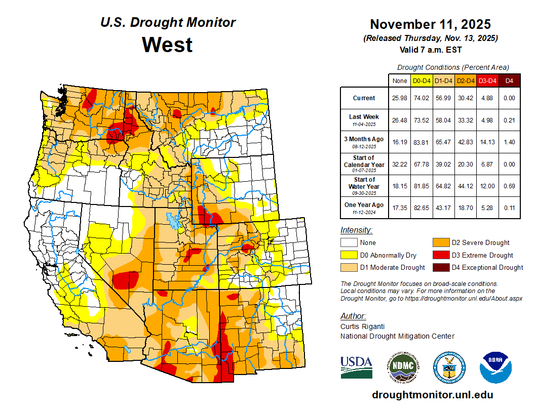
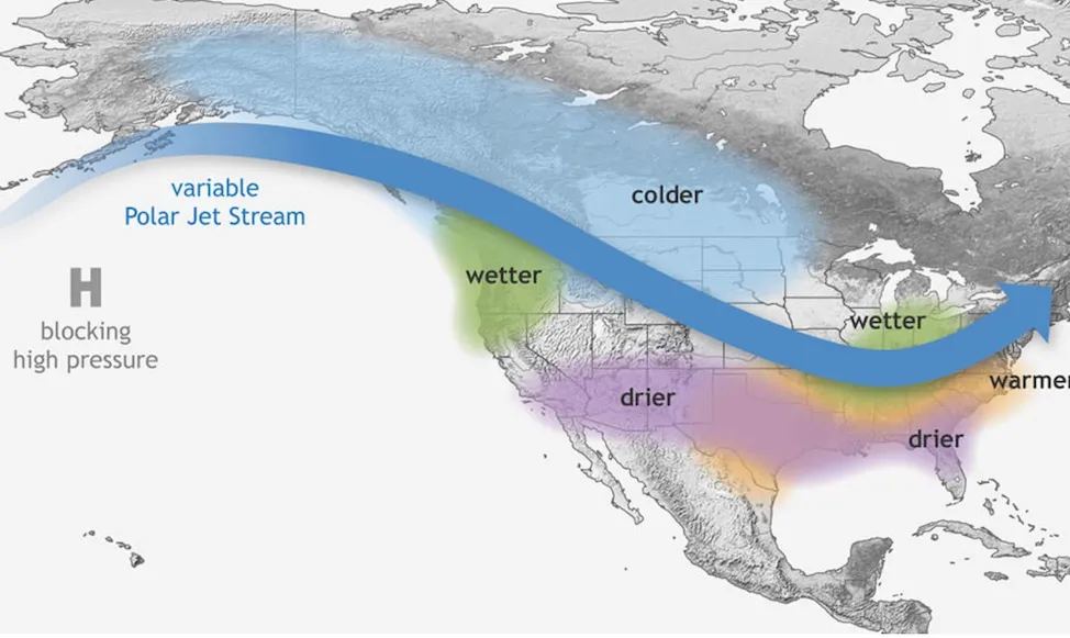
Synopsis: La Niña is favored to continue into the Northern Hemisphere winter, with atransition to ENSO-neutral most likely in January-March 2026 (61% chance).
La Niña continued over the past month, as indicated by the strengthening of below-average sea surface temperatures (SSTs) across the central and eastern equatorial Pacific Ocean. The latest weekly Niño indices were between -0.5°C and -0.7°C, with the exception of the easternmost Niño-1+2 index at -0.2°C. Negative subsurface temperature anomalies persisted (averaged from 180°-100°W; Fig. 3), with below-average temperatures prevailing from the surface to 200m depth in the eastern half of the equatorial Pacific. The atmosphere continued to reflect La Niña, with low-level easterly wind anomalies and upper-level westerly wind anomalies observed across most of the equatorial Pacific Ocean. Enhanced convection persisted over Indonesia and was weakly suppressed near the Date Line. Both the traditional and equatorial Southern Oscillation indices were positive. Collectively, the coupled ocean-atmosphere system reflected La Niña.
The IRI multi-model predictions favor La Niña to continue through December-February (DJF) 2025-26. While also considering predictions from the North American Multi-Model Ensemble, the ENSO team believes uncertainty for the DJF season is high with La Niña (51% chance) slightly favored over ENSO-neutral (48% chance). La Niña is expected to remain weak (3-month average Niño-3.4 index value at or between -0.5°C and -0.9°C). A weak La Niña would be less likely to result in conventional winter impacts, though predictable signals could still influence the forecast guidance (e.g., CPC’s seasonal outlooks). In summary, La Niña is favored to continue into the Northern Hemisphere winter, with a transition to ENSO-neutral most likely in January-March 2026 (61% chance).
There’s still no plan for how the seven states that use water from the Colorado River will allocate the scarce resource after 2026. Tuesday, November 11, marked a deadline set by the federal government for the states to share a framework for new operating guidelines—another deadline that’s come and gone with no agreement. The river’s supply has drastically decreased since the original Colorado River Compactwas signed in 1922, due to climate change and overallocation of water. In 2007, the states agreed to interim operating guidelines, but those expire in 2026. Because Lake Powell and Lake Mead, the basin’s two biggest reservoirs, are federal projects managed by federal agencies, those agencies will need to do an environmental review and public comment period, as required by law. The federal government needs input from the states in a timely fashion to complete the review and public comment process, in order to have new rules in place by October 2026. On Tuesday night, the seven states, along with the Department of Interior and Bureau of Reclamation, issued a statement on the negotiations…
“A supply-based proposal is the only way to move forward,” [Becky Mitchell] told attendees at the Colorado River District’s Across Divides conference on October 3. “We all have to be responding to supply.”
That means that the new guidelines should be based on actual streamflows, rather than demand from water users.
“We need to set aside building an operations plan that meets the needs as they are currently,” she said. “We need to let go of that dream and be able to figure out how to respond, and I think that’s been a bit of a struggle.”
Udall/Overpeck 4-panel Figure Colorado River temperature/precipitation/natural flows with trend. Lake Mead and Lake Powell storage. Updated through Water Year 2025. Note the tiny points on the annual data so that you can flyspeck the individual years. Credit: Brad Udall
an Alamosa County Commissioners meeting on Wednesday.
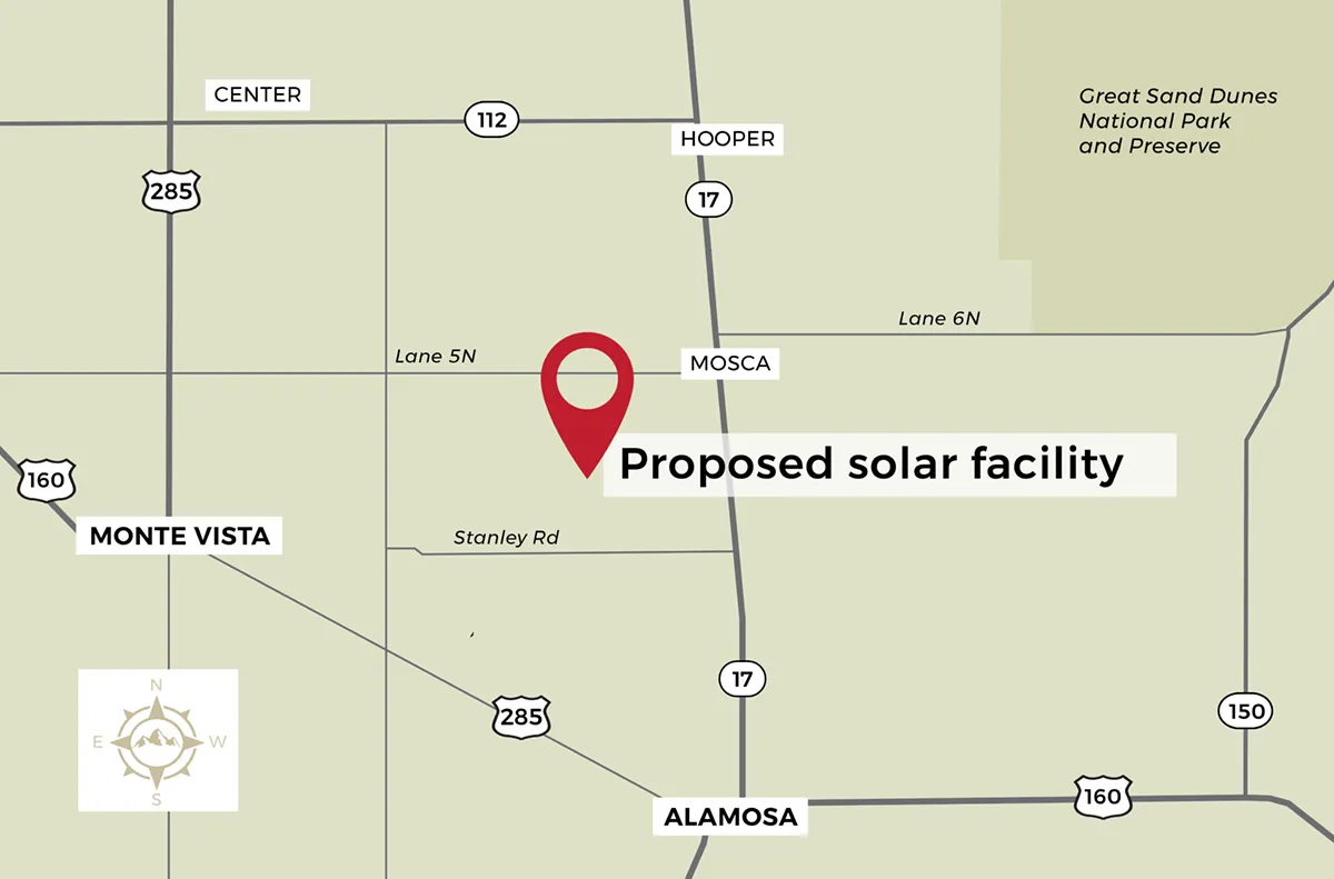
NextEra Energy is planning a maximum 600 megawatt solar plant and 600 megawatts of solar storage off Lane 2N between County Road 104 and County Road 108 in the central part of unincorporated Alamosa County.
So massive is the project that Alamosa County Commissioners are hoping it will help to convince state officials about the importance of increasing transmission capacity to move power in and out of the Valley.
As it stands, Colorado’s power grid currently isn’t equipped to support this size of the proposed new plant, which NextEra Energy is calling its “Spud Valley” solar project. The company plans to connect its Alamosa County project to the existing Public Service Co. and Xcel Energy substation that is adjacent to the site.
A single megawatt can power around 160 homes, so 600 megawatts has the equivalent power for tens of thousands of homes. Plus, Spud Valley includes just as much solar storage.
The Spud Valley project would be located on four square miles with 10 different land owners either selling or leasing property to NextEra Energy. The project is located in Subdistrict 1 of the Rio Grande Water Conservation District and a section of Alamosa County that has been rapidly reducing its agricultural output due to water constraints from the declining unconfined aquifer.
NextEra Energy is hoping to begin construction by the middle of 2027 and have the plant operational in 2028, according to company officials as they gained approval from Alamosa County on waivers to certain regulations within the required 1041 permit that didn’t apply to the project. Final steps with Alamosa County will be taken in 2026 and notice given for a public hearing.
“This is substantially larger than anything now,” Alamosa County Land Use Director Richard Hubler told the county commissioners. He said he hopes the project positively impacts the discussion around increasing the San Luis Valley’s transmission capacity.
Xcel Energy actively manages the power grid. When demand for power is high across the state, power generated in the Valley is transmitted out to meet the state’s demand. Given the size of the Spud Valley project, the power grid would have to be further developed to be able to handle the amount of solar from the new Alamosa County operation.
“This is a massive project and so it changes the balance of power more or less,” Hubler said.
The Colorado State Land Board gave final approval Thursday to the three-way transfer of 45,950 acres that make up the La Jara Basin, which includes La Jara Reservoir in Conejos County.
The decision came with plenty of apprehension around the federal government and whether the Trump Administration is a reliable partner in the deal. In the end, state land board commissioners agreed to “roll the dice” and hope for the best.
In the end, Commissioner Josie Heath was the lone no vote.
The La Jara Basin land transfer will net the state land board $49.6 million, or $1,000 per acre for the land transferred to the U.S. Forest Service and BLM, and $2,500 per acre for the La Jara Reservoir area which will be managed by Colorado Parks & Wildlife.
The deal includes $43.5 million from the coveted Land and Water Conservation Fund, which sits with the U.S. Department of Interior and is used to “safeguard natural areas, water resources and cultural heritage.”
Pressure mounted on the state land board to approve the transfer as U.S. Sens. Michael Bennet and John Hickenlooper urged final approval. Former U.S. Secretary of the Interior Ken Salazar compared the transfer to the establishment of the Great Sand Dunes National Park.
“This is the project of the 21st Century for the San Luis Valley,” Salazar said.
State land board commissioners acknowledged their apprehension for giving final approval centered around mistrust for the Trump Administration and whether the current federal administration would abide by the deal. The commissioners hoped that even though the funds were appropriated that they would actually “materialize” in the future.
When Alamosa Citizen published this story on the state land board’s hesitation on a final deal, the state agency found itself under pressure to give final approval. The state land board spent more than three hours hearing support for the deal from San Luis Valley local officials and the federal agencies that will assume management of the public lands once the land transfer is completed.
The state land board had three options – approve the land transfer to the federal agencies and CPW; keep the property with the state land board; or approve the La Jara Reservoir transfer to Colorado Parks & Wildlife and keep the portion of the property that the U.S. Forest Service and BLM sought.
A trove of local officials and residents spoke in-person and over Zoom of their support for the approval of the land transfer. Alongside ranchers, farmers and recreationists, local officials provided their input, including Conejos County Commissioner Mitchel Jarvies and district manager for the San Luis Valley Water Conservation District Heather Dutton.
Representatives of the two federal agencies told state land board members that it was doubtful they could muster support in Congress to approve money for the acquisition again if the current deal wasn’t accepted.
With the deal finalized, the U.S. Forest Service will take over 21,821 acres and BLM will manage 21,704 acres of the La Jara Basin. Colorado Parks & Wildlife will take management of La Jara Reservoir.
The federal Office of Budget and Management still has to free up the money for the Bureau of Land Management’s portion of the sale, according to BLM officials.
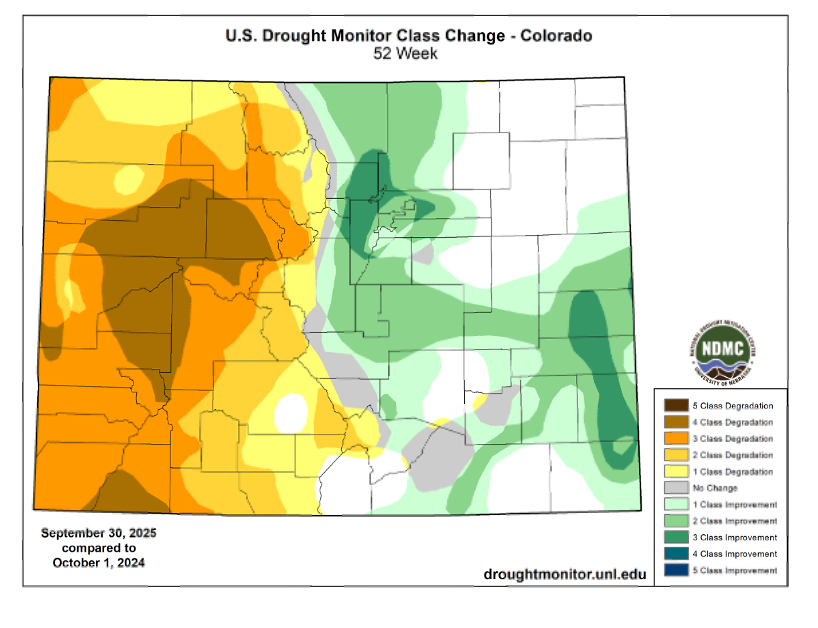
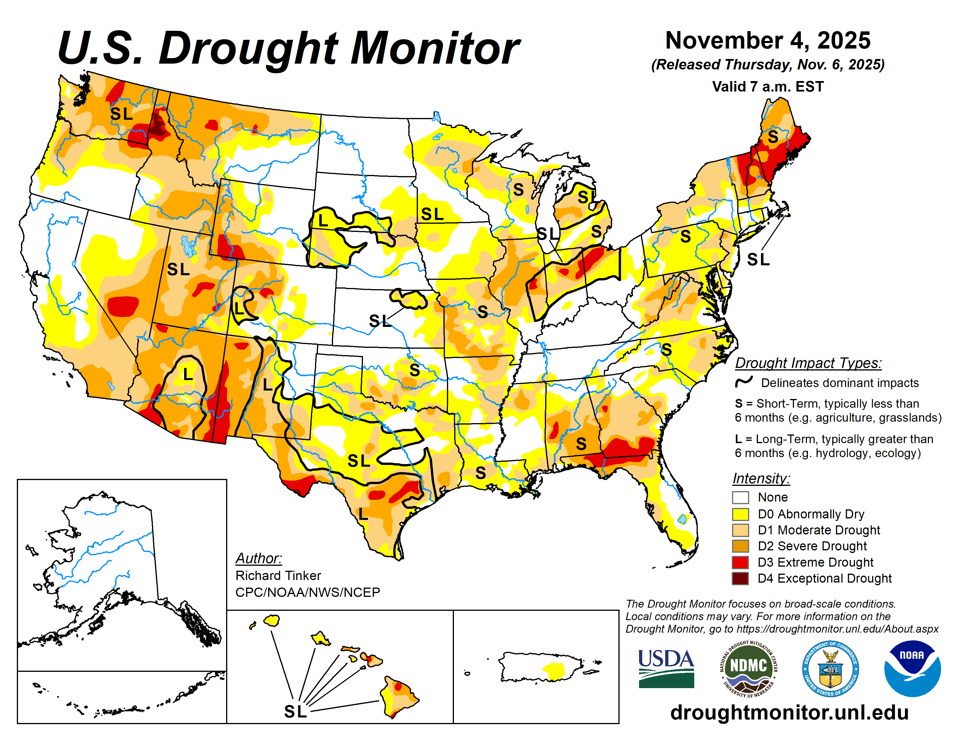
Mostly dry weather occurred this week across the Great Plains, Minnesota and Wisconsin, the south-central U.S. and the Southwest. The northern half of California, western Oregon, western Washington, the northern Idaho Panhandle and northwest Montana received moderate to heavy precipitation amounts. From northern California northward into the Pacific Northwest, amounts this week were locally over 3 inches. Locally higher precipitation amounts fell in the Northeast and in portions of the Great Lakes region. This included heavy lake-effect snow in north-central and northwest Indiana. Spotty rainfall amounts of over half an inch fell across the Southeast, but most of the region experienced a dry week. Drier weather in parts of the Great Plains and south-central U.S. led to widespread degradations, especially in Texas, Oklahoma and Louisiana. Heavy precipitation in Oregon and Idaho led to improvements in both states. Montana was split with improvement in the west and degradation in north-central areas, which continued a recent dry spell. Mostly drier weather in the Southeast led to degradations in Florida and southern Georgia and portions of Virginia. In northeast Illinois, northwest Indiana, Ohio, West Virginia and much of New England, improvements occurred after recent precipitation…
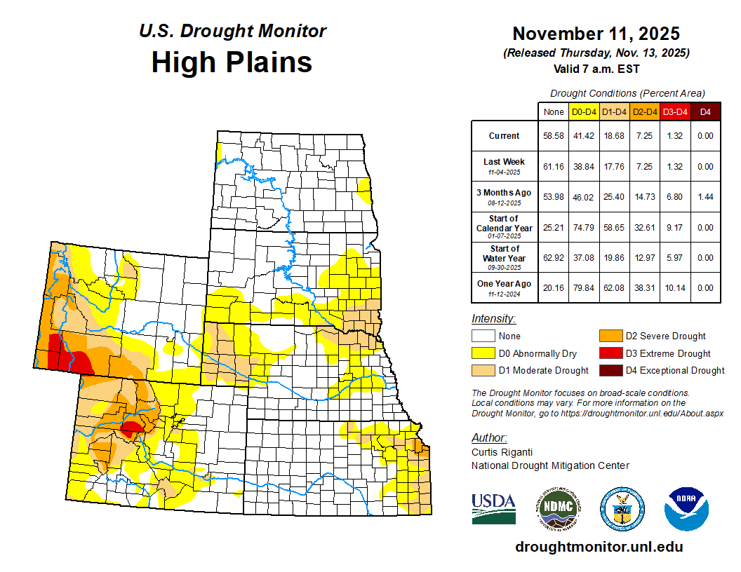
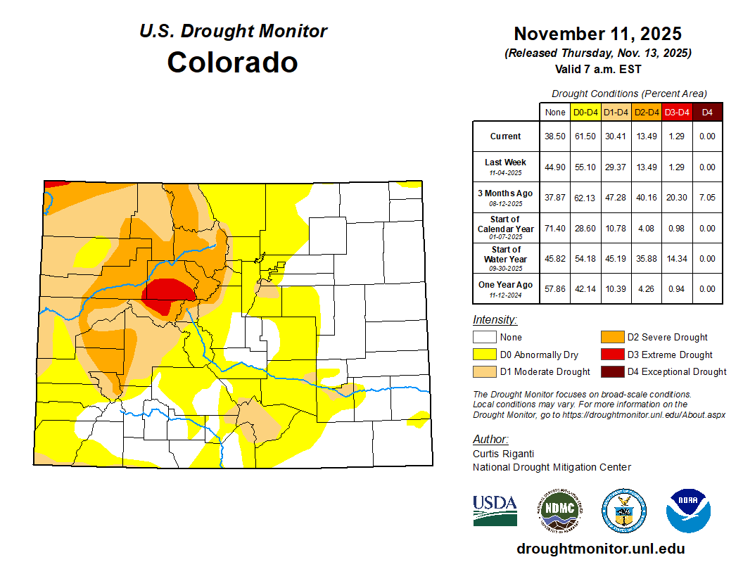
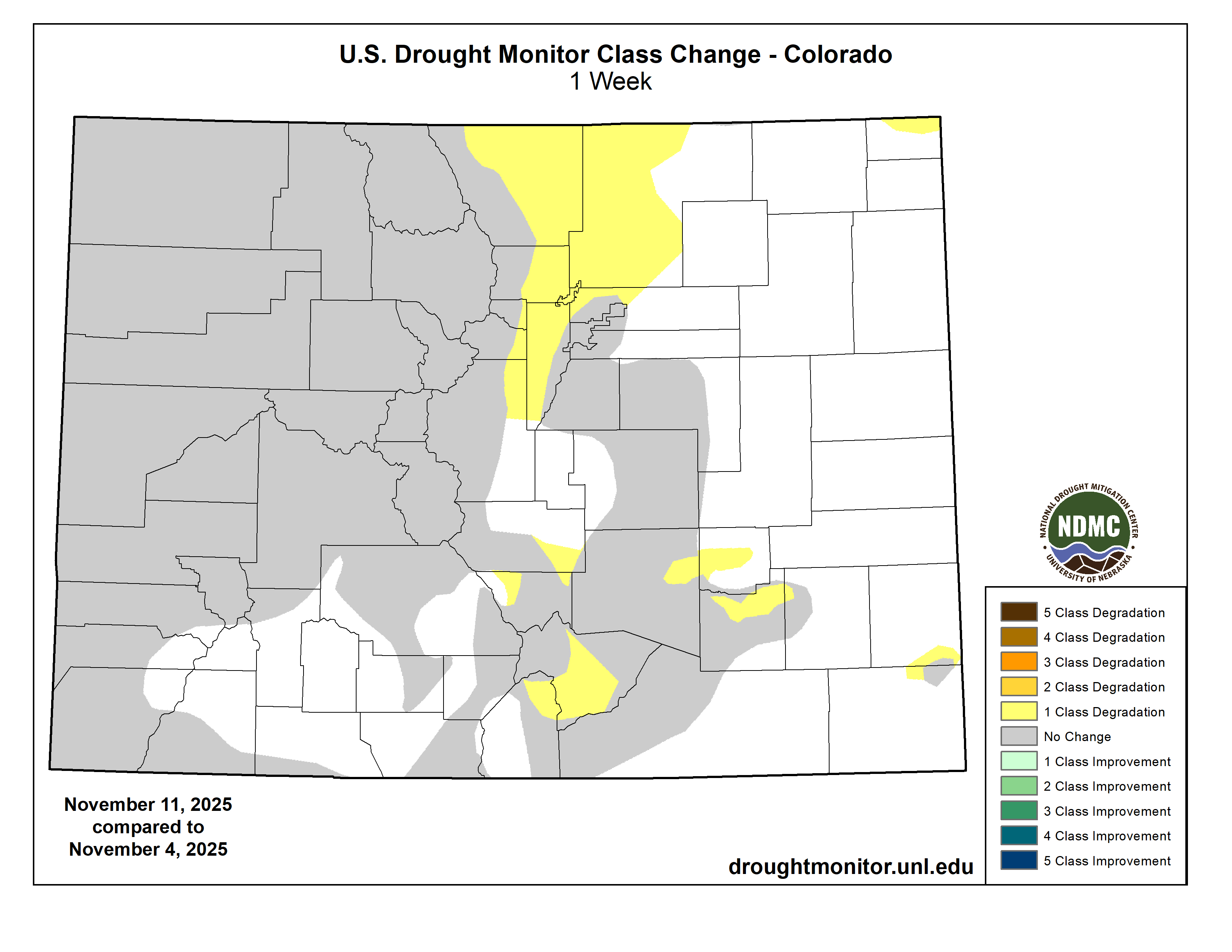
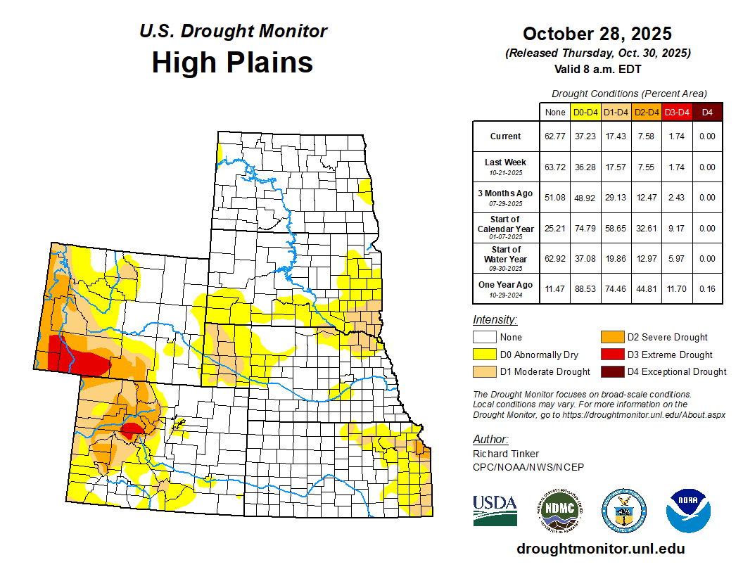
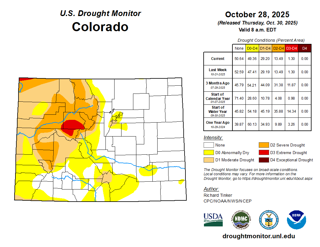
Temperatures in the eastern edge of the High Plains area remained mostly within a couple degrees of normal, as a strong cold front moved into the central U.S. near the end of the period. Otherwise, most of the region was warmer than normal, especially western Nebraska and central and western portions of Colorado and Wyoming, where temperatures from 4-8 degrees above normal were common this week. Some precipitation, generally under a half inch liquid equivalent, fell from central South Dakota to northeast Nebraska. Precipitation exceeding a half inch also fell in northwest Wyoming in the vicinity of Yellowstone National Park and in a section of the Black Hills of South Dakota. Elsewhere, mostly dry weather was the rule across the region. Short-term precipitation deficits grew in parts of eastern Nebraska, where abnormal dryness expanded in coverage north and northwest of Lincoln. Portions of western Nebraska and adjacent southeast Wyoming and Colorado continued to dry as well, and abnormal dryness and some moderate drought grew in these areas. In south-central Colorado, localized degradations were also due in part to effects from longer-term precipitation deficits…
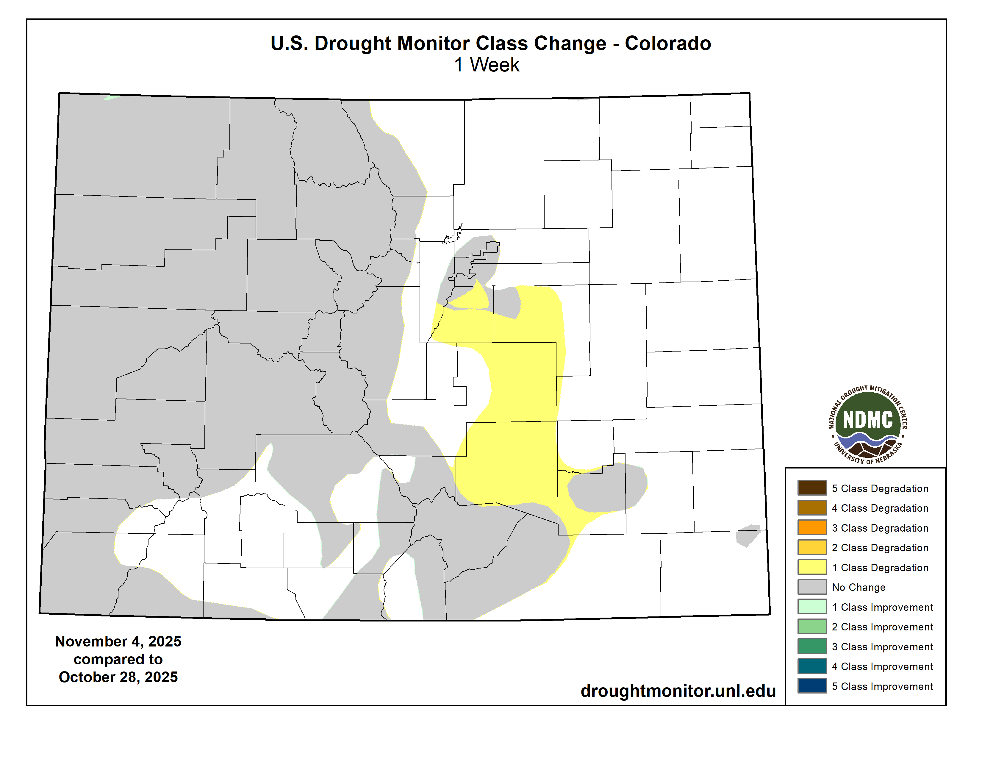
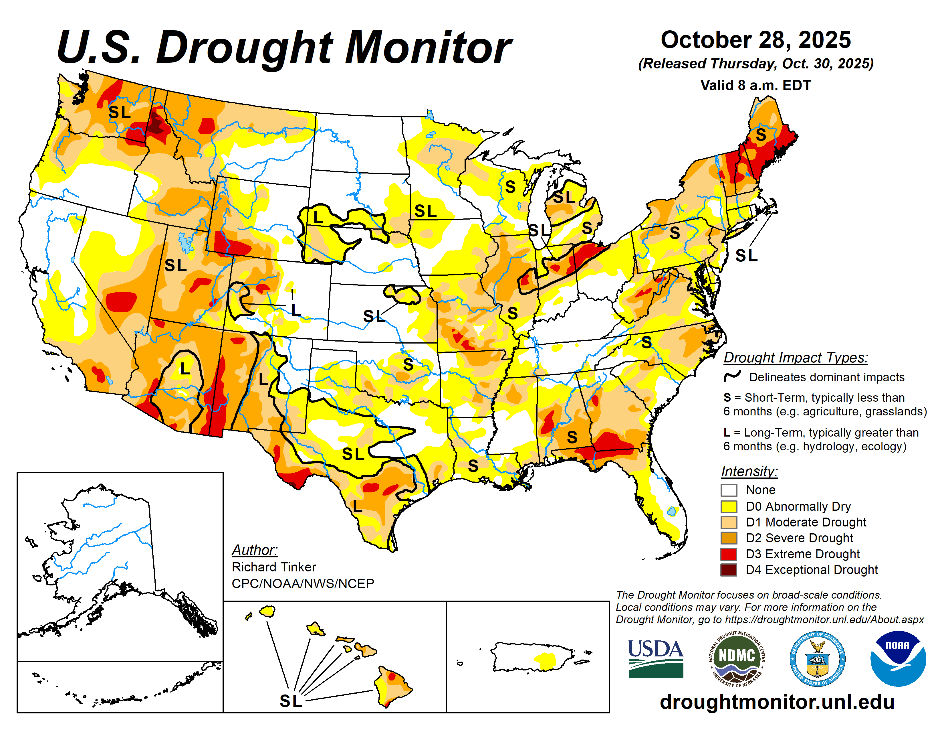
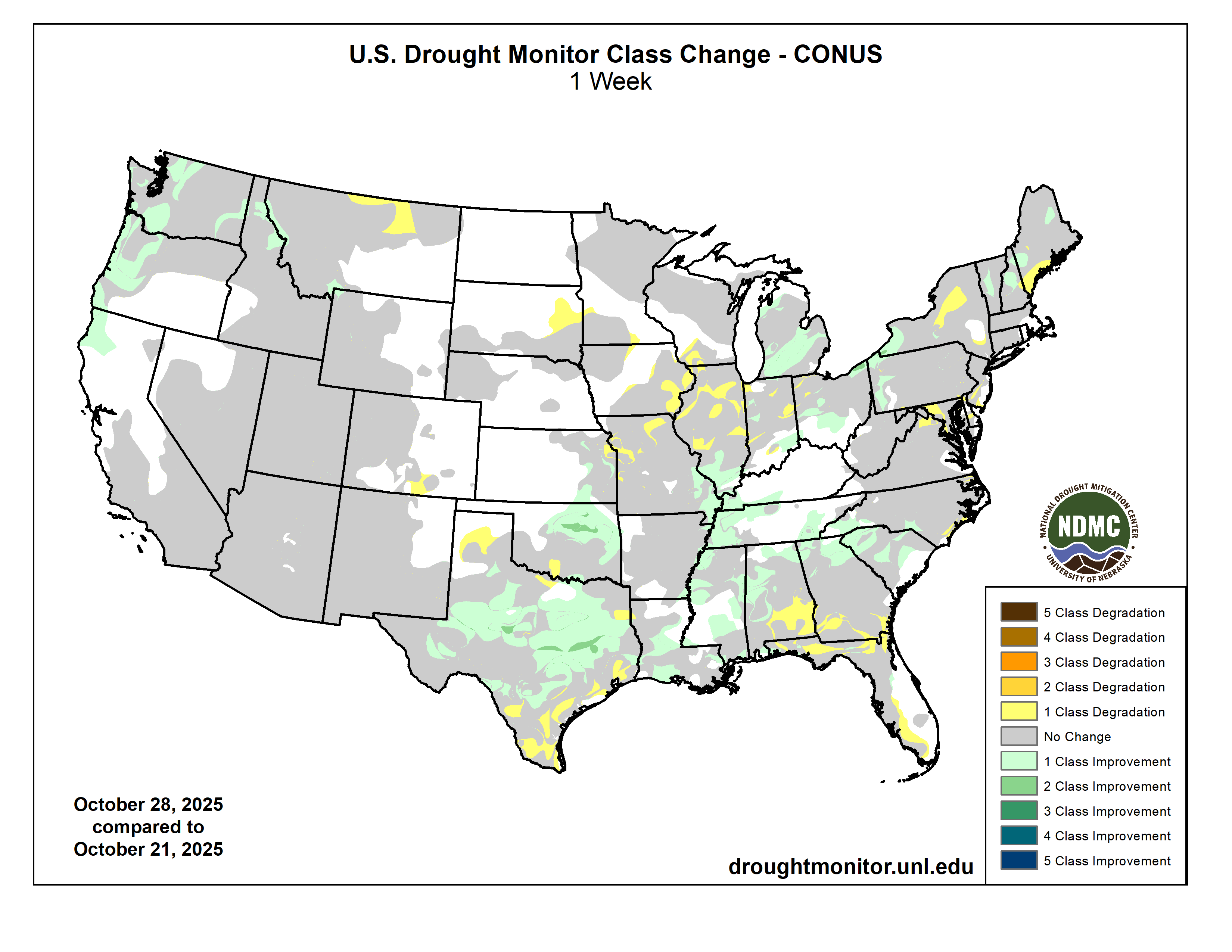
Drought Monitor one week change map ending November 11, 2025.
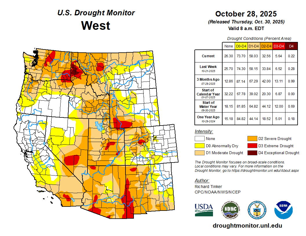
Temperatures were above normal across the region. Southeast California, Nevada, Utah and southern New Mexico were generally the warmest compared to normal, with many spots in these areas finishing the week 6-10 degrees above normal. Parts of the northwest U.S. saw moderate to heavy precipitation amounts this week, while most areas from central California southward and eastward were dry. Many parts of northwest Montana and northern Idaho received half an inch to 2 inches of precipitation this week. Eastern Washington mostly received over a half inch of precipitation, while western Washington, western Oregon and north-central and northwest California received heavier amounts ranging from 2 to locally over 5 inches of precipitation. Recent precipitation helped to improve streamflow and precipitation deficits across much of Idaho, leading to widespread improvements in drought conditions. Severe also improved across much of western Montana as a result of recent precipitation events. Severe drought was also removed in northwest Oregon after recent heavy precipitation improved streamflow levels and lessened short- and long-term precipitation deficits. In north-central Montana, drought conditions worsened as weather stayed mostly dry, leading to larger short-term precipitation deficits and low streamflow levels…
Warmer-than-normal temperatures occurred across most of the South this week. Temperatures in Texas and Oklahoma were especially warm, with many areas in these states finishing the week 4-8 degrees above normal. Parts of southwest Texas were even warmer, with some sites finishing the week more than 10 degrees above normal. Most of the South remained dry this week, though a few parts of central and eastern Tennessee received over a half inch of precipitation. Degradations to abnormal dryness and drought were widespread from the southern half of Oklahoma to southwest Arkansas, and from central and eastern Texas into parts of Louisiana. Short-term drought impacts were the big story in southern Oklahoma, where short-term precipitation deficits grew and soil moisture and pond levels dropped and vegetation struggled. Streamflow levels struggled in portions of central and southern Texas, while soil moisture levels also dropped in south Texas amid unusually high evaporative demand for the time of year. Short-term precipitation deficits also drove some degradation in areas of abnormal dryness and moderate and severe drought in Louisiana…
Looking Ahead
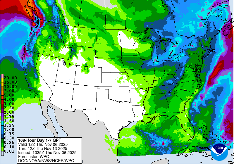
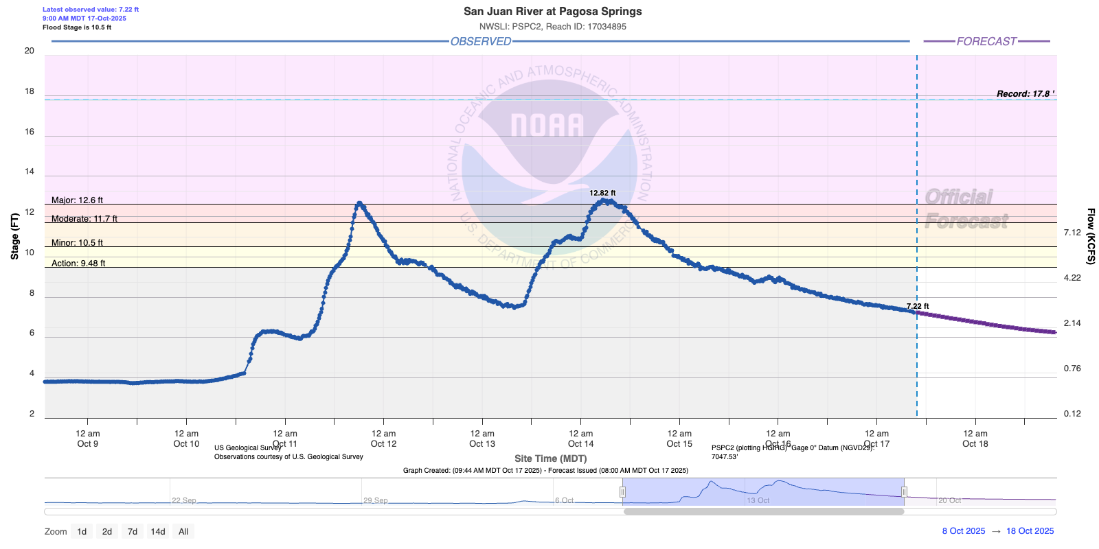
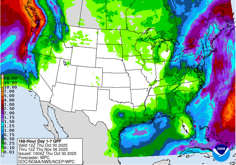
From the evening of Nov. 12 through Nov. 17, the National Weather Service (NWS) Weather Prediction Center is forecasting heavy precipitation to fall across parts of the western U.S. Precipitation amounts from 3-5 inches (locally higher) may fall across large portions of California, especially the southwest coastal areas and portions of the Sierra Nevada. Heavy precipitation amounts from 2-5 inches (locally higher) are also anticipated in parts of northwest Washington and the Olympic Peninsula. Over 0.75 inches of precipitation is also forecast in southeast California, southern Nevada, portions of western and central Arizona and southwest Utah. A few other locales may receive an inch or more of precipitation, including the San Juan Mountains in southwest Colorado and parts of the northern Idaho Panhandle and northwest Montana. Much drier weather is forecast across most of the rest of the Contiguous U.S. for this period, though some parts of New York and New England may receive over a half inch of precipitation.
For the period from Nov. 18-22, the NWS Climate Prediction Center forecast favors above-normal precipitation across much of the Contiguous U.S., especially from the Southwest northeastward to the Lower Ohio River Valley. Drier-than-normal weather is slightly favored in northeast parts of Maine, while near-normal precipitation amounts are most likely in the Florida Peninsula. Near-normal temperatures are favored for New England, while elsewhere, colder-than-normal temperatures are likelier west of the Continental Divide, while warmer-than-normal temperatures are favored to the east of the Continental Divide. Forecaster confidence in warmer-than-normal weather is highest from the Gulf Coast north to the Lower Midwest and southern Great Plains, and near and west of Lake Superior. Above-normal precipitation and temperatures are favored in Hawaii. In Alaska, above-normal precipitation is also favored, with the strongest chances being in the southwest part of the state. Above-normal temperatures are favored in most areas of Alaska, except for the far northwest, where near-normal temperatures are expected.
US Drought Monitor one week change map ending November 11, 2025.
Water managers from the seven states that share the Colorado River have blown a deadline given to them by the federal government to come up with a rough plan on how the drought-stricken river will be shared in the future.
The Upper Basin (Colorado, New Mexico, Utah and Wyoming) still cannot find agreement with the Lower Basin (California, Arizona and Nevada) about how the nation’s two largest reservoirs — Lake Powell and Lake Mead — will be operated and how cuts will be shared in dry years.
In June, Scott Cameron, the U.S. Bureau of Reclamation’s acting assistant secretary for water and science, said federal officials would need to know the broad outlines of a plan from the states by Nov. 11. Despite frequent meetings in recent months, negotiators were unable to hammer out a deal by Tuesday, leaving future management for the water supply for 40 million people in the Southwest cloaked in uncertainty.
Instead, the states, the Interior Department and the federal Bureau of Reclamation released a short joint statement Tuesday afternoon, noting that serious and ongoing challenges face the Colorado River.
“While more work needs to be done, collective progress has been made that warrants continued efforts to define and approve details for a finalized agreement,” the statement reads. “Through continued cooperation and coordinated action, there is a shared commitment to ensuring the long-term sustainability and resilience of the Colorado River system.”
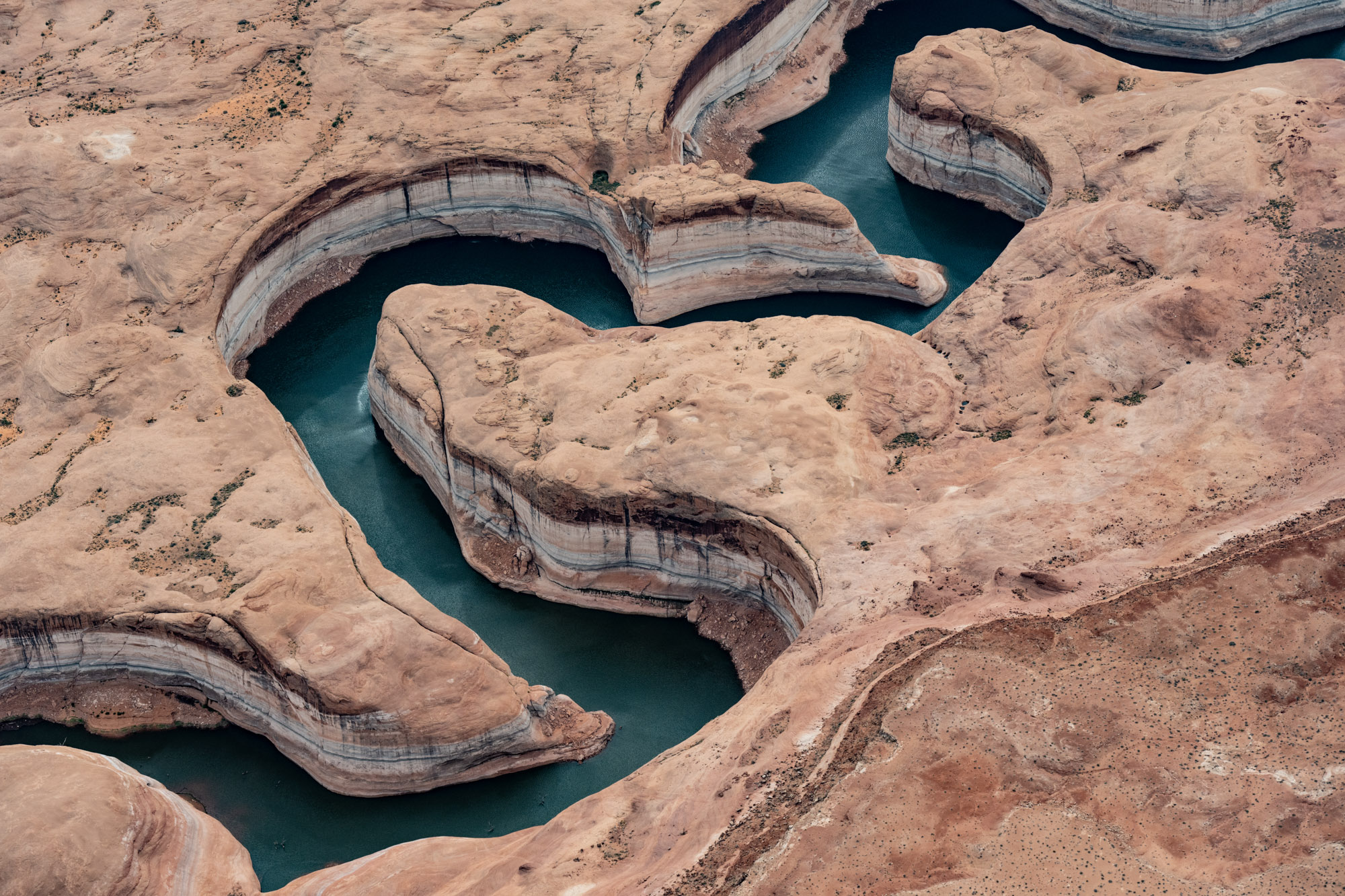
Wahweap Marina at Lake Powell when water levels were at near-historic lows in 2021. The seven states and the federal government must figure out how to share the Colorado River after the current guidelines expire in 2026. CREDIT: HEATHER SACKETT/ASPEN JOURNALISM
Environmental groups disappointed
The failure to come up with a plan by the deadline has sparked criticism from the basin’s environmental groups.
“I’m really disappointed with how yesterday played out; the states did not have anything to meet the Nov. 11 deadline,” said John Berggren, a regional policy manager with Western Resource Advocates. “The fact that they didn’t have a basic framework for how to manage the system after 2026 is really unfortunate, and I think they missed a good chance to put forward something that we can all consider and examine as a basin.”
Representatives from the seven states have been in talks for two years about how to manage the river after the current guidelines expire. After a long standoff without much progress throughout 2024, state representatives in June offered a glimmer of hope for a way forward, floating a concept for sharing the river based on natural flows at Lee Ferry, the dividing line between the Upper and Lower basins, instead of water demand. But that hope evaporated like water off Lake Mead, with negotiators reportedly deadlocked again by the end of the summer.
A statement from environmental groups Great Basin Water Network and Living Rivers called the Nov. 11 deadline arbitrary and ineffectual, and said the inaction symbolizes the overall dysfunction on the river and in government. They chastised the states and federal government for the lack of transparency and lack of public participation surrounding negotiations.
“The states don’t deserve the kid-glove treatment any longer,” Kyle Roerink, executive director of the Great Basin Water Network, said in a prepared statement. “They have a behavioral problem as much as they do a hydrology problem. Any entity that wants to increase use is unfit to manage our most precious resource.”
A group of influential environmental organizations, including American Rivers, National Audubon Society, Environmental Defense Fund, The Nature Conservancy, Theodore Roosevelt Conservation Partnership, Trout Unlimited and Western Resource Advocates, released a joint statement Wednesday saying that they were deeply disappointed the states did not find consensus and that federal leadership will be essential.
The statement called for solutions that ground management decisions in the best available science, expand conservation programs, modernize infrastructure and ensure that Native American tribes — which have underutilized rights to a large share of the river’s water — play a meaningful role in shaping the river’s future.
“We understand the extraordinary complexity of this challenge and the difficult tradeoffs the states are working hard to navigate — but the river isn’t going to wait for process or for politics,” the statement said. “Drought, intensified by increasingly extreme conditions, is reshaping the basin, and the window to secure the river’s future and move beyond crisis-driven policymaking is closing fast.”
Udall/Overpeck 4-panel Figure Colorado River temperature/precipitation/natural flows with trend. Lake Mead and Lake Powell storage. Updated through Water Year 2025. Note the tiny points on the annual data so that you can flyspeck the individual years. Credit: Brad Udall
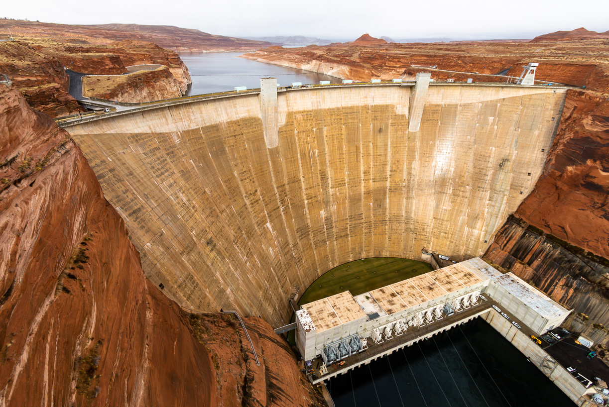
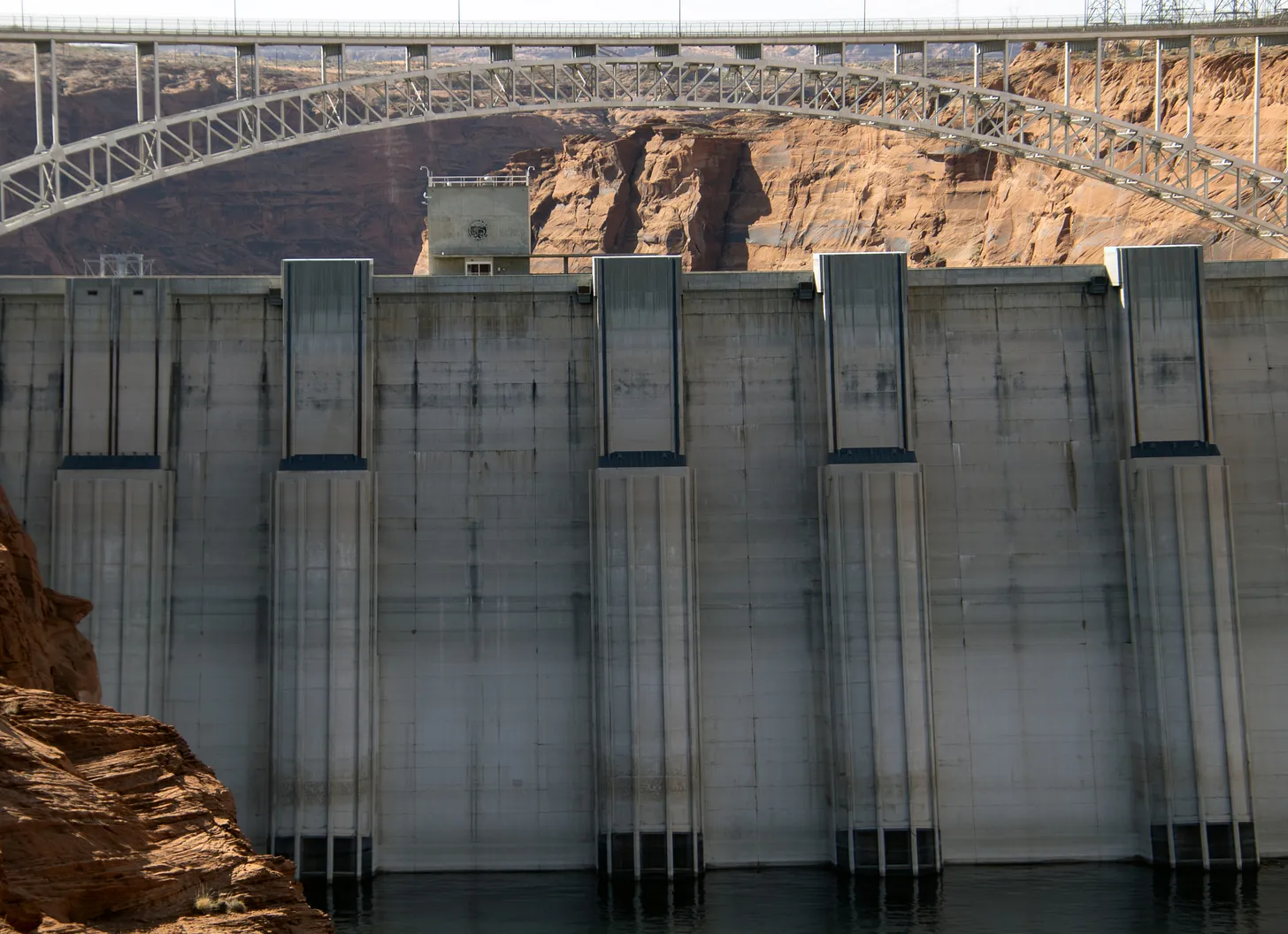
Since the turn of the century, the Colorado River basin has been locked in the grip of a megadrought. Climate change has robbed Western rivers of their flows, with the basin seeing a 20% decline from the 20th century average, according to scientists. Those factors, as well as unrelenting water demands, have pushed Lake Powell and Lake Mead to record-low levels in recent years and thrown river management into crisis mode.
The current negotiations between the seven states are aimed at replacing the 2007 Interim Guidelines, which lay out how the reservoirs will be operated and shortages shared, and which expire at the end of 2026. New guidelines would need to be in place by the beginning of the next water year, Oct. 1, 2026, leaving little time to complete the required National Environmental Policy Act (NEPA) review process.
The 2007 guidelines set annual Powell and Mead releases based on reservoir levels and do not go far enough to prevent them from being drawn down during consecutive dry years. In 2022, Lake Powell flirted with falling below a critical elevation to make hydropower, and may be headed there again next year if conditions don’t improve.
(Left to right) John McClow, Rebecca Mitchell, Gene Shawcroft, Tom Bucshatzke at the Colorado Water Congress 2022 Annual Summer Conference. Colorado representative Becky Mitchell, second from left, and Arizona representative Tom Buschatzke, farthest right, speak on a panel at Colorado Water Congress in 2022. The positions of the two states have emerged as one of the main sources of disagreement between the Upper Basin and Lower Basin. CREDIT: HEATHER SACKETT/ASPEN JOURNALISM
Sticking points
Over the past few months, the positions of two of the states — Colorado and Arizona — have emerged as one of the main sources of disagreement. Water from the Colorado River has fueled the exponential growth in recent decades of Arizona’s cities, which are the economic and political powerhouse of the state, along with some of the most productive farmland in the basin. But Arizona’s reliance on the junior water rights of the Central Arizona Project means it is first on the chopping block for cuts.
Arizona representatives have said that the deepest cuts should be shared basinwide, including by the Upper Basin. Gov. Katie Hobbs and other state lawmakers said in a Nov. 11 letter to Interior Secretary Doug Burgum that Arizona’s Colorado River allocation is important to the nation’s growth and independence and that Colorado River reliability is a matter of national security. The letter highlighted how the state plays a critical role in manufacturing semiconductors and information-technology products.
“With such high stakes for Arizona and the nation, we find it alarming that the Upper Basin states have repeatedly refused to implement any volume of binding, verifiable water supply reductions,” the letter reads. “This extreme negotiating posture — four of the seven basin states refusing to participate in any sharing of water shortages — has led to a fundamental impasse that is preventing the successful development of a seven-state consensus plan for the management of the Colorado River.”
This shows that Colorado’s Western Slope is the biggest supplier of water to the Colorado River. Source: David F. Gold et al, Exploring the Spatially Compounding Multi‐Sectoral Drought Vulnerabilities in Colorado’s West Slope River Basins, Earth’s Future (2024). DOI: 10.1029/2024EF004841
Water managers from Colorado — which is the de facto leader of the Upper Basin with a 51.75% share of the water allocated to the four Upper Basin states — have pushed back on the notion that their states should contribute to cutbacks in water use since their water users already suffer shortages in dry years and the four states have never used their entire allocation of the river, while the Lower Basin overuses its share. Colorado representative Becky Mitchell has repeatedly said that any cuts the state makes must be voluntary, not mandatory.
However, the Upper Basin states have been experimenting for years with conservation programs that pay water users to cut back, most recently in 2023 and 2024 with the federally funded System Conservation Pilot Program. In a proposal submitted in March 2024, the Upper Basin states offered up a potential conservation pool in Lake Powell of up to 200,000 acre-feet a year, and most water users accept that some type of future conservation program for the Upper Basin is inevitable.
What happens now?
Federal officials had previously set a second deadline of Feb. 14, 2026, for the states to present details of a plan. They have repeatedly said that if the seven states fail to come up with an agreement, Reclamation will exercise its authority to protect critical reservoir levels. That could include releases from upstream reservoirs to prop up Powell and Mead, including releasing water from Colorado’s Blue Mesa Reservoir on the Gunnison River.
Reclamation is moving forward with its NEPA process and said in early October that it plans to have a draft environmental impact statement by the end of the year. Representatives from the bureau were not available for comment Wednesday due to the government shutdown. Cameron has said that the alternatives analyzed in the EIS will be broad enough that they would capture any seven-state agreement, which they could then plug in as the preferred alternative — assuming the states come up with something.
“The basin states remain committed to collaboration grounded in the best available science and respect for all Colorado River water users,” Mitchell said in a prepared statement. “We are taking a meaningful step toward long-term sustainability and demonstrating a shared determination to find supply-driven solutions.”
Map of the Colorado River drainage basin, created using USGS data. By Shannon1 Creative Commons Attribution-Share Alike 4.0
Udall/Overpeck 4-panel Figure Colorado River temperature/precipitation/natural flows with trend. Lake Mead and Lake Powell storage. Updated through Water Year 2025. Note the tiny points on the annual data so that you can flyspeck the individual years. Credit: Brad Udall
Utah and six other states along the Colorado River blew past their deadline Tuesday to reach a new deal on managing the dwindling river, but negotiations aren’t over.
“We will continue to engage with our partners across the Basin to develop a framework that protects water users and the system as a whole,” Utah Gov. Spencer Cox said Tuesday afternoon on the social media site X.
The river contributes 27% of Utah’s water supply, and provides water to 40 million people across the U.S. and Mexico. Drought, overuse and hotter temperatures tied to climate change have all combined to shrink its flow.
The federal government had said it would step in and make its own plan if states failed to reach broad consensus by Tuesday, but the states agree they don’t want that to happen, Cox said.
“While the Basin States did not finalize an agreement today on post-2026 Colorado River operations, our commitment to a state-led path remains,” the governor said.
The U.S. Department of the Interior did not respond to questions from Utah News Dispatch Tuesday evening about the timeline and whether it would intervene. The current agreement runs through late 2026.
The federal agency and Utah’s negotiator Gene Shawcroft issued the same prepared statement, saying the talks yielded “collective progress.” They did not give any details on sticking points.
The seven states, the Department of the Interior and the U.S. Bureau of Reclamation, which manages water in the West, all “recognize the serious and ongoing challenges facing the Colorado River,” their statement says. “Prolonged drought and low reservoir conditions have placed extraordinary pressure on this critical water resource that supports 40 million people, tribal nations, agriculture, and industry.”
They said the states and federal agencies share a commitment to ensuring the river’s long-term sustainability.
“While more work needs to be done, collective progress has been made that warrants continued efforts to define and approve details for a finalized agreement,” the statement says.
The four Upper Basin states — Utah, Colorado, New Mexico and Wyoming — and the Lower Basin states of Nevada, Arizona and California presented competing plans to the federal government last year.
The Upper Basin states have sought to fend off mandatory cuts in dry years, saying they generally use much less than they’re allocated. The Lower Basin states have insisted that all seven absorb cuts in dry years.
In part to prepare for the possibility of mandatory cuts, Utah has been investing in measuring and monitoring water use in recent years.
In 2023, the Legislature set aside $1 million for a Colorado River measurement infrastructure project and $650,000 in ongoing yearly funding, according to the Utah Division of Water Rights.
Map of the Colorado River drainage basin, created using USGS data. By Shannon1 Creative Commons Attribution-Share Alike 4.0
Metropolitan General Manager Deven Upadhyay issues the following statement regarding the seven Colorado River Basin states continued efforts to reach consensus on post-2026 rules governing operation of the Colorado River:
“The only path to developing a sustainable Colorado River is through collaboration and consensus. We are grateful that the seven states that rely on the river remain at the table, along with the federal Department of Interior, but more work needs to be done, and quickly.
“The work ahead will require every state and water user to look beyond just their own needs and work toward the greater good of the Southwest. If reductions in water use are shared equitably across the Basin, no one state or sector will bear the burden alone.
“Metropolitan remains committed to forging such a consensus, and we look forward to the opportunity to participate in the ongoing discussions in a meaningful way. An agreement that includes tools allowing for smart water management, like flexible storage in Lake Mead and opportunities for shared investments across states, will minimize the pain of living with the new, lower flows of the Colorado River. If we focus on building solutions – rather than legal arguments – we can develop new guidelines that allow water users to have access to the water they need, when they need it most.”
“Metropolitan is preparing to live with less imported water in urban Southern California, building on decades of lower water use. But we cannot solve the problem alone. We cannot lose our access to the Colorado River entirely. Our region – home to half of the people and half of the economic activity in the Basin – relies on the river. And we are committed to its success.”
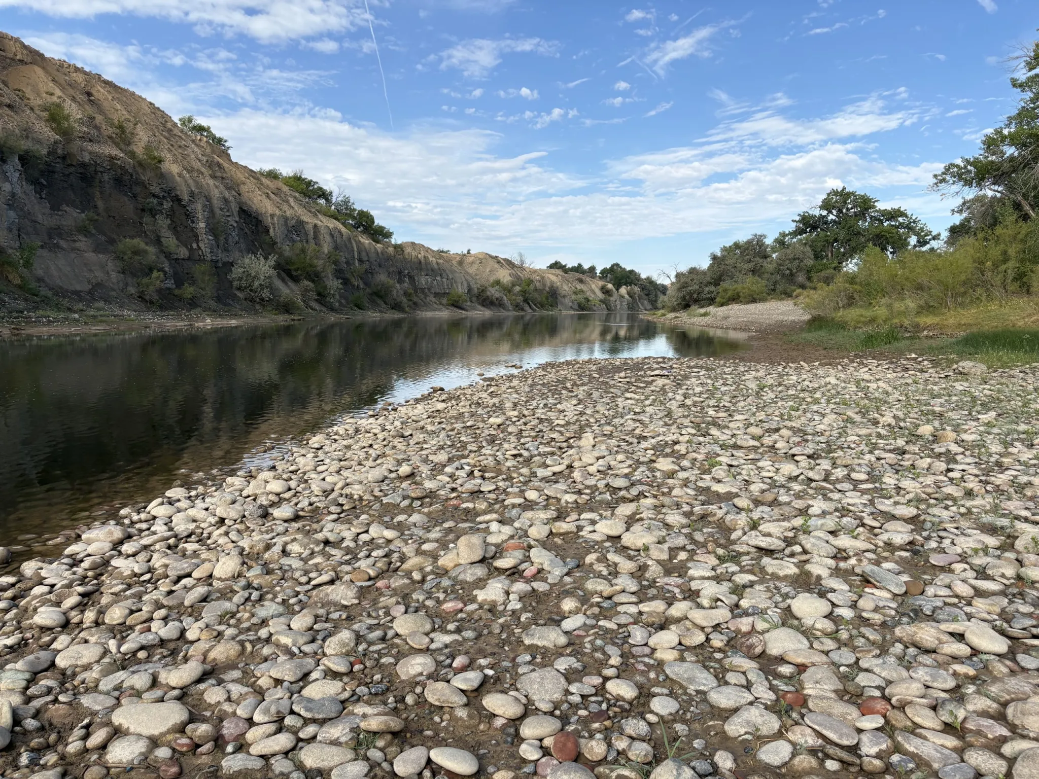
This section of the Colorado River at the boat launch near Corn Lake dipped to around 150 cfs in lake August 2025. Known as the 15-mile reach, this stretch of river should have at least 810 cfs to meet the needs of endangered fish. CREDIT: HEATHER SACKETT/ASPEN JOURNALISM
By Bob Berwyn
November 12, 2025
This article originally appeared on Inside Climate News, a nonprofit, non-partisan news organization that covers climate, energy and the environment. Sign up for their newsletter here.
Frustration about slow progress at the United Nations climate talks boiled over this week. After hours under the equatorial sun at COP30 in Belém, Brazil, scores of protesters pushed past security guards Tuesday evening and briefly occupied parts of the negotiating area, calling for an end to mining and logging in the Amazon, among other demands.
The clash symbolized a deeper tension at the heart of the U.N. climate summits. The people demanding change are often outside the gates while those with power inside are bound by rules that slow progress to a crawl.
UNFCCC officials said two people suffered minor injuries and that parts of the venue were temporarily closed for cleanup and security checks. The U.N. and local police are investigating the protests and the talks resumed on schedule Wednesday morning.
On Instagram, a group calling itself Juventude Kokama OJIK posted a video of the Blue Zone occupation and called it an act against exclusion.
“They created an ‘exclusive’ space within a territory that has ALWAYS been Indigenous, and this violates our dignity,” the group wrote. “The demonstration is to say that we will not accept being separated, limited, or prevented from circulating in our own land. The territory is ancestral, and the right to occupy this space is non-negotiable.”
The Tuesday tumult was a stark contrast to normal proceedings at the annual conference, where delegates with swinging lanyards and beeping phones usually file meekly through the metal detectors and past the espresso kiosks as if they’re heading to an office supply expo rather than negotiations to avert catastrophic climate collapse.
Somehow, that urgency rarely crept inside, partly because the United Nations Framework Convention on Climate Change runs the annual meetings like a corporate conference, said Danielle Falzon, a sociologist at Rutgers University whose research on the climate talks draws on dozens of interviews with negotiators and other participants from both developed and developing countries at most COPs since 2016.
In the UNFCCC setting, she said, success is measured by how long you stay in the room, how polished your presentation is, how fluent you are in bureaucratic English—and how well you can pretend that the world isn’t burning outside.
“I’d like to go to the negotiations and see people taking seriously the urgency and the undeniability of the massive changes we’re seeing,” she said. “I’d like to see them break through the sterilized, shallow, diplomatic language and talk about climate change for what it actually is.”
For all its talk of unity, the climate summit has struggled to deliver because the talks mirror the global inequalities they are meant to fix, Falzon said. Based on her research, COP hasn’t made much progress because it still fails to serve the countries that have contributed least to the problem but are suffering the most from it.
The negotiations, she said, are dominated by well-staffed teams from wealthy, developed nations that can afford to be everywhere at once. Smaller delegations from less-developed countries often can’t even attend the dozens of overlapping meetings.
“Everyone is exhausted but people from smaller delegations are just trying to keep up,” she said. That exhaustion, she added, shapes the talks themselves: those with the most capacity set the pace and define the terms, while the rest simply try not to fall behind.
“You can’t just pretend that all countries are equal in the negotiating space,” she said.
The imbalance is built into the institution, she said. The U.N. climate process was designed to keep everyone at the table, not to shake it. That makes it resilient, but also resistant to change, and she said her multiyear study of the talks shows the system values consensus and procedure over outcomes and the appearance of progress over actual results.
“Much of what’s called success at COP now is the creation of new texts, new work programs, rather than real climate action,” she said. After 30 years of meetings, the pattern delivers new agendas, new acronyms and new promises that keep the gears grinding but rarely move the needle on emissions, she added.
Most people involved in the climate talks see the need for change, but Falzon said that institutions are built to preserve themselves.
How (Not) to Talk About Climate
Part of the paralysis Falzon describes stems from a reluctance to speak plainly about the emergency it exists to address, said Max Boykoff, a climate communications researcher at the University of Colorado Boulder.
“The problems associated with climate change were first framed as scientific issues all the way back in the 1980s, and that has become the dominant way we understand a changing climate,” Boykoff said. “But that has crowded out other ways of knowing; emotional, experiential, aesthetic, or even just visceral ways of understanding that something’s not right.”
The experts at COP “tend to focus on what can be measured and reported, on outputs and deliverables, which shapes the negotiations themselves,” he said. “The cadence of those encounters becomes ritualized to their detriment.”
A quick look at some of the daily notifications from COP30 displays what Boykoff describes, with invitations to a “High-Level Ministerial on Multilevel Governance” or “The Launch of the Plan to Accelerate Multilevel Governance and the Operationalization of the Coalition for High Ambition Multilevel Partnerships.”
Such language, he said, reflects a culture that prizes precision and hierarchy over connection and clarity. It’s a diplomatic shorthand that signals professionalism while numbing urgency, and it narrows the space for creativity, emotion, or reflection, he added.
Boykoff said the only way to move beyond the rituals of repetition may be to break them.
“What we really need,” he said, “is to shake it up, to create spaces that let people reflect, feel, and engage in new ways. Because if we keep doing the same thing year after year, we shouldn’t expect different results.”
Falzon said the technocratic UNFCCC language reflects the dominance at the talks of an “old world hierarchy in which rich countries set the agenda, poor countries fight to be heard, and the system keeps reproducing the conditions it’s supposed to fix.
“It’s not just the negotiations that are unequal,” she said. “The whole thing mirrors the inequalities of the world it’s meant to change.”
Click the link to read the article on the AZCentral website (Debra Utacia Krol). Here’s an excerpt:
November 10, 2025
The Colorado River Indian Tribes have formally accorded personhood status to the Colorado River, creating a powerful new mechanism to protect the eponymous river that makes life possible in their arid homelands. The resolution was approved by the CRIT Tribal Council on Nov. 6 in Parker. The nearly 4,300-member tribe has long been alarmed at the state of its life-giving waterway, CRIT Chairwoman Amelia Flores wrote in a statement shared with The Arizona Republic.
“The Colorado River is in jeopardy,” she said. The tribe, which holds the largest quantity of senior water rights in the state, regards the river as a living being, so the resolution codifies that belief and the tribe’s commitment to protecting its needs and ability to provide water for future generations.
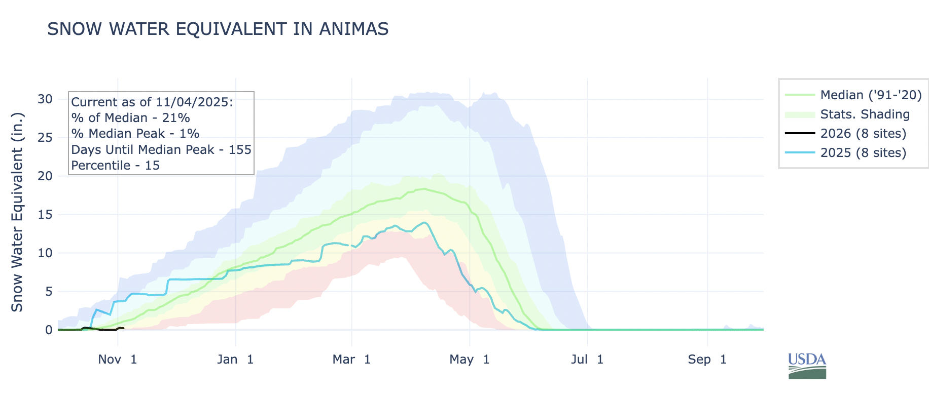
See an update on the West’s snowpack and an explanation of how Milankovitch cycles shape the Earth’s climate from journalist @mitchtobin.bsky.social (co-director of WaterDesk.org at CU Boulder) at http://www.snow.news/p/early-seas…
sUdall/Overpeck 4-panel Figure Colorado River temperature/precipitation/natural flows with trend. Lake Mead and Lake Powell storage. Updated through Water Year 2025. Note the tiny points on the annual data so that you can flyspeck the individual years. Credit: Brad Udall
This story was originally published by CalMatters. Sign up for their newsletters.
The clock is ticking down to a federal deadline Tuesday for California and six other Western states to reach the broad strokes of a deal portioning out supplies from the parched Colorado River.
Officials at the U.S. Bureau of Reclamation, the federal stewards for the river under the Department of the Interior, have threatened to impose their own plan if the states can’t agree how to manage the river after 2026, when the river’s current rulebook expires.
Dire projections that another dry year could send the basin’s major reservoirs plummeting to alarmingly low levels have ramped up the urgency, and the tensions.
But, after two years of fraught negotiations, the states remain at an impasse. Those in the river’s lower basin — California, Arizona, and Nevada — are clashing with Colorado, Wyoming, Utah and New Mexico upstream. A key point of contention is how much each basin must scale back their use of the overtapped river as climate change further squeezes supplies.
“We’ve been in a holding pattern, and we need to land this plane by Tuesday,” J.B. Hamby, California’s chief negotiator as chairman of the Colorado River Board of California, told CalMatters.
California’s dependence on the Colorado River raises the stakes. The state takes more than half of the power generated at Lake Mead’s Hoover Dam, and more water from the main stem than any other in the basin. Half a million acres of alfalfa, winter vegetables and other crops in the Imperial Valley all rely on the Colorado River, which also supplies urban Southern California via the Metropolitan Water District.
But California has also been relatively impervious to shortages on the river, with senior water rights long seen as bulletproof. Now, the questions hanging over the last days of negotiations are — how real is the threat of missing the deadline? And what exactly would the consequences be for California?
Blown deadlines on the Colorado River
For decades, federal officials have threatened to intervene if states in the Colorado River basin fail to reach agreement. The threat — and the inevitable lawsuits water suppliers fear would follow — have motivated major deals that now govern the river’s operations.
Actual federal intervention is far rarer — though the U.S. government has stepped in in the past, on a smaller scale.
In the early 2000s, Southern California was forced to stop using surplus Colorado River water when other states began clamoring for their fair share. The Interior Department set a deadline of December 31st, 2002 for California’s water agencies to cut a deal weaning themselves off the surplus water, or face immediate cutbacks.
The Imperial Irrigation District — by far the biggest user of Colorado River water in California — balked. So the Interior Secretary cut California’s supplies, leading to court battles and, ten months later, a deal.
But deadlines and threats seem to have lost their teeth in recent years, when states in the Colorado River basin have blown deadline after deadline, with little federal response.
Last week, Arizona Governor Katie Hobbs urged the Trump administration to be more assertive. “As we approach critical deadlines, we need the Trump administration to step in, exert leadership and broker a deal,” she said in remarks prepared for a water conference.
Elizabeth Koebele, a political science professor at the University of Nevada, Reno, said negotiations may have become too contentious for deadlines to matter. She attributed it to fracturing relationships between the basin states as devastatingly dry conditions on the river ratchet up the stakes.
“We have less water, and it’s caused more rippling problems,” Koebele said. “You’re cutting a smaller pie, for more people.”
A strike against storage
The Veteran’s Day deadline isn’t the final deadline; it’s an interim milestone as federal officials race to lock in a plan before the current rulebook expires.
Scott Cameron, now acting head of the Bureau of Reclamation, said at a conference in June that in the absence of a deal, Interior Secretary Doug Burgum was prepared to take charge as water master. The position gives him the power to declare the river in shortage and call for cutbacks in the lower basin.
But the Trump administration declined to specify what exactly it might do. “At this stage, all parties should remain focused on the difficult but necessary work required to reach a seven-state agreement,” an unidentified Interior Department spokesperson said, in an emailed statement.
If there is still no plan by late 2026, the rulebook could revert to one from the 1970s, according to an analysis by Arizona State University’s Kyl Center for Water Policy.
That worries Metropolitan Water District’s Bill Hasencamp, because it would upend Metropolitan’s ability to continue banking water in the Colorado River basin’s Lake Mead, the largest reservoir in the country, for dry spells.
The water giant imports water from Northern California and from the Colorado River to supply 19 million people in six Southern California counties.
Right now, Hasencamp, manager of Colorado River resources at Metropolitan, says that the district has socked away about 1.5 million acre-feet of water in the reservoir over the last 20 years. It’s enough to supply 4.5 million households for a year.
Metropolitan saves Colorado River water in Lake Mead when water from Northern California reservoirs is abundant, and draws on these stores when state supplies dry up. But, under the 1970s-era rules, suppliers would no longer be able to add water to this savings account. Metropolitan would need to use its banked stores over the next ten years, or risk losing the water.
Hasencamp estimates that banked water could disappear more quickly if California faces greater cuts.
“Under a new regime, the feds — if things get dry enough — could cut us back,” Hasencamp said. “We could access that storage, but we might need it to offset cuts on the river that could come to us. So it’s a very undesirable situation.”
Ultimately, experts agree that the most undesirable situations, and the greatest risks to the basin states, will likely come from nature itself.
The Colorado River is in the grips of a megadrought; Brad Udall, a senior water and climate research scientist at Colorado State University’s Colorado Water Institute, called August’s projections for reservoirs Lake Powell and Mead “beyond awful.”
Udall said the latest projections for the reservoirs remain dire. One scenario shows “both Powell and Mead entering uncharted territory by (the) end of Water Year 2026,” Udall said in an email.
“That’s the new reality,” Cameron, the acting head of Reclamation, said at a meeting in Arizona over the summer. “There are real risks to both the lower basin states and the upper basin states if we don’t collectively do something differently than we’ve done in the past.”
People at Lake Powell May 25, 2022. Photo credit: Allen Best/Big Pivots
Click the link to read the article on the Big Pivots website (James Eklund):
November 11, 2025
If the seven basin states can’t lead, Washington and the courts will. The West deserves better than to surrender its future out of inertia and pride.
The River at a Crossroads
Today, November 11, the seven states that share the Colorado River face a deadline they’re unlikely to meet. The Department of the Interior has asked them to agree on the bones of a post-2026 management plan — the rules that will decide who gets cut, when, and by how much as the river keeps shrinking.
If they fail, Washington will write the rules for them. And if Washington falters, unelected judges will. Either way, the West loses control of its own destiny. That’s not leadership; that’s abdication.
The Lower Basin is braced for federal action. The Upper Basin is bracing for blame. Both are right to be worried — and both are missing the point. The river doesn’t care about politics or priority dates. It only responds to snow, sun, and science.
Udall/Overpeck 4-panel Figure Colorado River temperature/precipitation/natural flows with trend. Lake Mead and Lake Powell storage. Updated through Water Year 2025. Note the tiny points on the annual data so that you can flyspeck the individual years. Credit: Brad Udall
Hydrology Has Changed; Leadership Hasn’t
We built the Colorado River system for a climate that no longer exists. Reservoirs that once promised endless growth now sit half-empty — Lake Powell at roughly 29%, Lake Mead near 31%. The math is unforgiving: less water is coming in than going out.
Yet our governance still pretends otherwise. The Law of the River — that tangled mix of compacts, decrees, and deals — assumes a river of at least 16.5 million acre-feet. Nature is now giving us perhaps 12, maybe less. We’re overdrawn every year, and the overdraft is accelerating.
This isn’t a failure of hydrology; it’s a failure of adaptation. The West has always been proud of its self-reliance, but we’re behaving like a bureaucracy waiting for someone else to make the hard call. We need leaders, not hall monitors.
And if you want to know what failure of adaptation looks like, glance halfway around the world. Tehran, Iran, a city of more than eight million, is on the brink of evacuation. Its reservoirs are nearly dry, some below 10% capacity. Rainfall has fallen 40% below average. Iran’s president recently warned that if the skies don’t open, the capital may have to be moved. Moved. Imagine Washington, D.C. abandoned because the Potomac went dry. That’s not science fiction — that’s what happens when water governance waits too long to face reality. The Colorado River isn’t there yet, but the trajectory rhymes. Tehran is a mirror we should study before it shows our reflection.
The Blame Game vs. Shared Responsibility
At Arizona State University’s recent Law of the Colorado River: The View from the Lower Basin conference, one thing was clear: the Lower Basin has its legal arguments loaded and ready. So does the Upper Basin. Both are preparing for a fight neither side can win.
Arizona’s governor calls the Upper Basin’s stance extreme; the Upper Basin counters that it can’t conserve water that isn’t there. California points to its billions in saved water and asks why others won’t match it. Colorado replies that it’s already living within its snowpack. Every argument is technically correct — and collectively disastrous.
Finger-pointing won’t refill a reservoir. The real crisis isn’t between the basins; it’s between the past and the future. The river is shrinking faster than our imagination.
The Case for State-Led Solutions
We know how to do this. We’ve done it before. In 2019, when both Lakes Mead and Powell were circling the drain, the Basin States pulled together the Drought Contingency Plan. It wasn’t perfect, but it kept the system alive long enough for the recent recovery years to matter. That’s proof we can still ride together when it counts.
Utah and Wyoming are finally taking first steps toward real demand-management programs — voluntary, compensated conservation that could bank water in Powell. They’re six years too late, but they’re at least facing forward. The Lower Basin, to its credit, has cut deeply — usage there is down to about 5.9 million acre-feet, the lowest since 1983. The economies of Phoenix, Las Vegas, and Los Angeles didn’t collapse. They adapted. That’s the model.
A state-led deal is the only way to keep Western hands on the reins. Federal control would be blunt; court control, brutal. Every day we delay, we invite both. The West should never outsource its destiny to Washington or to a judge in black robes who’s never stood in an irrigation ditch with a shovel.
The Call of the Saddle
This river built the modern West. It carved our canyons, powered our farms and ranches, lit our cities, and defined our sense of possibility. But it can’t survive our paralysis.
The next agreement — whatever we call it — won’t be about dividing abundance. It will be about managing scarcity with grace and intelligence. That means each state giving up a little sovereignty to save the system that sustains us all. It means governors and commissioners finding the courage to sign something imperfect but real.
Our basin remembers how to ride — hell, we practically invented it. The horse is saddled. The trail is narrow. And the storm is moving in fast.
Either we climb back on together, or we’ll watch someone else take the reins.
L to R, Anne Castle, Don Coram, James Eklund, and Jim Pokrandt
James Eklund is a Colorado water lawyer, rancher, former director of the Colorado Water Conservation Board, and formerly Colorado’s Colorado River principal. He advises public and private clients across the West on water, land, and natural-resources issues at Taft/ Sherman & Howard.
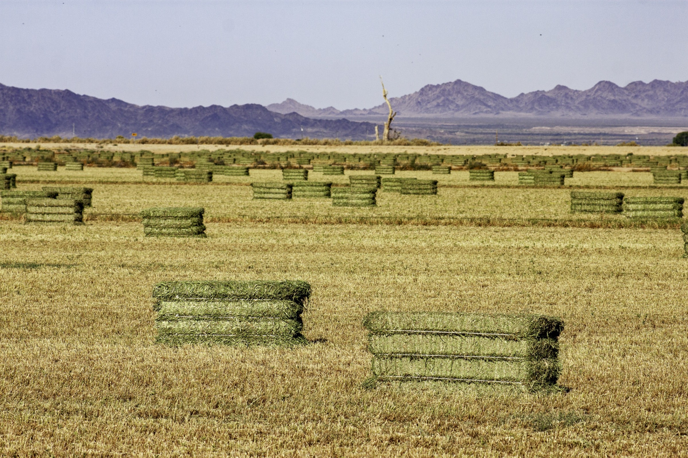
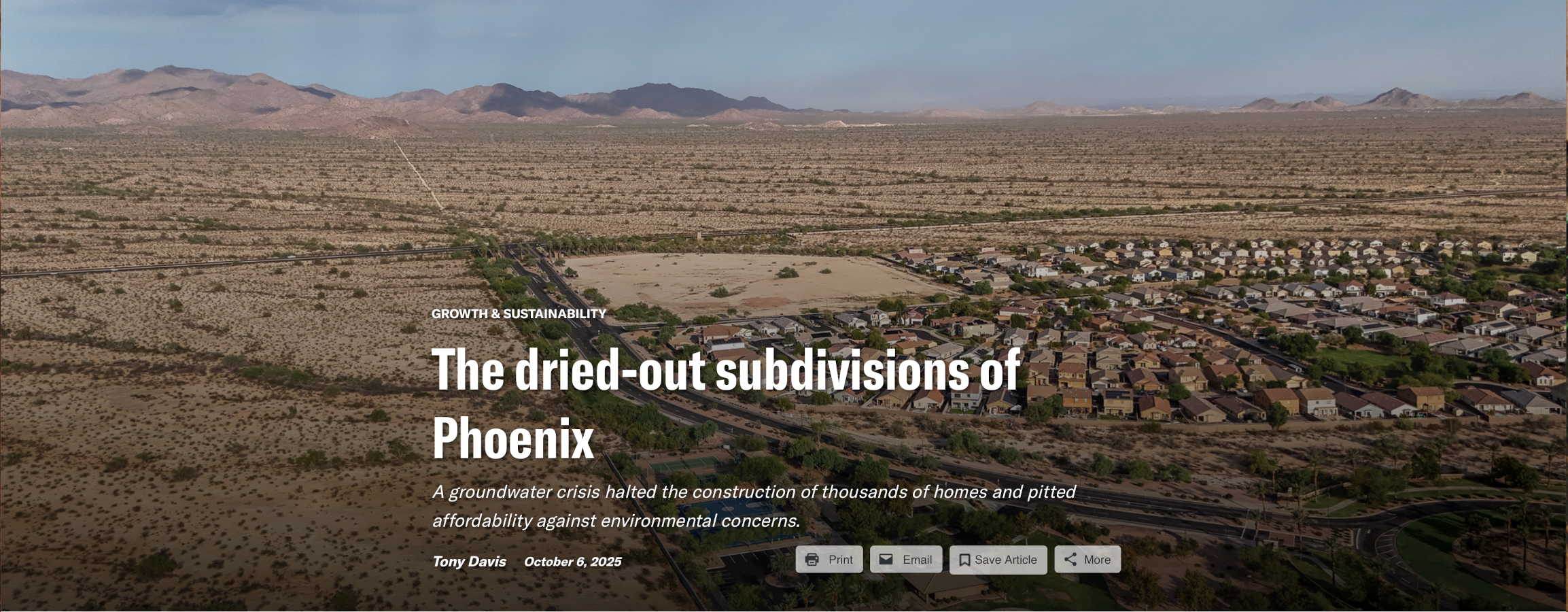
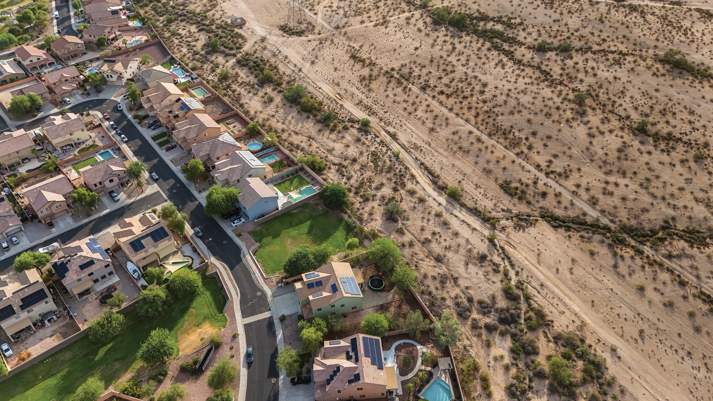
On the far edge of suburban Phoenix, a giant concrete arch spans the Central Arizona Project, dubbed a “Bridge to Nowhere” by developers and neighborhood activists alike. Nobody can use it; even pedestrians are barred by a chain-link fence sporting a huge “Road Closed” sign. To the bridge’s north, the desert sits as raw as ever.
The bridge was built in recent years to connect an existing subdivision to the planned North Star Ranch and its proposed 9,600 homes. North Star was to be the latest of many new master-planned communities in Buckeye, one of the fastest-growing cities in one of the nation’s fastest-growing metro areas.
But now, this development is on hold over concerns that there’s not enough groundwater to supply the community. And it’s not the only project: High Country News found that almost half a million homes, including thousands in North Star, are currently on pause, far more than developers or local elected officials have acknowledged publicly.
Developments like North Star have long represented the future of housing for local developers and prospective homebuyers. Phoenix has sprawled endlessly in every direction since World War II, a beacon of the Sun Belt. The city’s rampant growth has transformed former agricultural fields and open desert into homes and tested the bounds of the water supply in Maricopa County, which usually ranks as one of the nation’s fastest-growing counties. The proposed new developments would stretch past the White Tank Mountains, a low-slung collection of peaks that has long served as Phoenix’s unofficial western boundary, making them the most remote developments yet.
But then, in June 2023, state modeling studies concluded that Phoenix and the surrounding areas had “reached the anticipated limits of growth on groundwater supplies,” and the Arizona Department of Water Resources (ADWR) made the stunning decision to stop issuing new water supply certificates to developments served by groundwater in the city’s outer ring of suburbs. Nowhere on Phoenix’s edges did this moratorium hit harder than in Buckeye, where many of the halted projects were slated to be built.
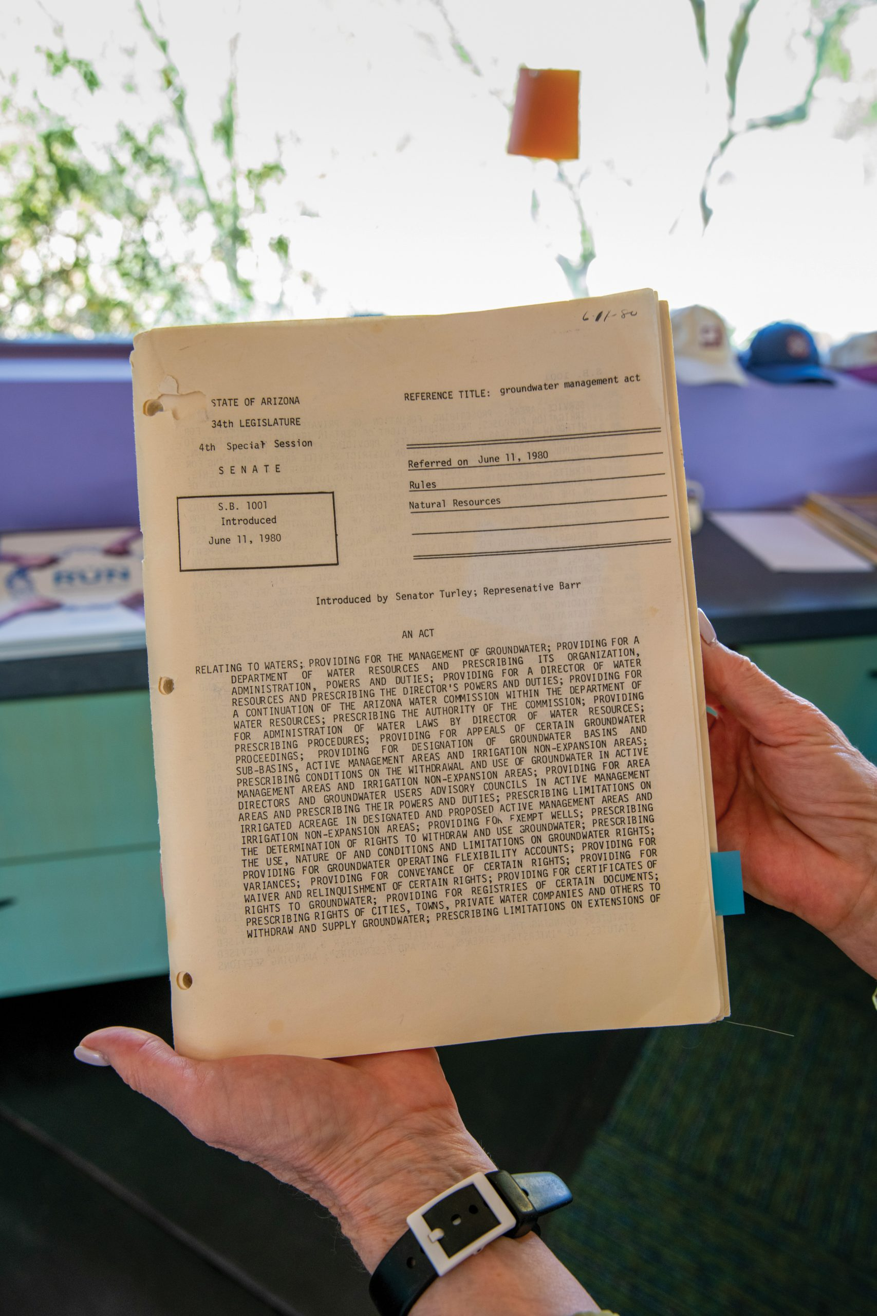
The decision stemmed from a provision in the state’s pioneering 1980 Arizona Groundwater Management Act that required metro areas and developers to prove that new subdivisions have enough water to last 100 years.
A slew of sensational headlines followed. The New York Times said it likely signaled the “beginning of the end to the explosive development that has made the Phoenix area the fastest growing metropolitan region in the country,” a prediction echoed by other outlets. The number of homes halted due to unsustainable reliance on groundwater is a striking indication of how widespread the practice has become — and of the state’s determination to rein it in.
The moratorium’s impacts heightened a political crisis that had been building in Phoenix for years as the demand for cheap housing and the limits on its water supply collided. Not only did the moratorium come during the worst drought to hit the Southwest in at least 1,200 years, it also hit in the midst of a nationwide housing crisis that has impacted even the Phoenix area, once a bastion of affordability. Developers and their supporters argue that it has caused real economic harm to homebuyers, because they say growth has stopped where the housing is most affordable. But the moratorium could also encourage denser growth in the city — something urban planners say would be healthy for Phoenix and also preserve desert habitat, conserve water and bolster the sense of community.
In the two years since the moratorium began, the housing and water pressures on the area have only increased. Phoenix has become trapped between a demand for affordable homes that meet people’s expectations for a good middle-class life and what government officials say is the dwindling amount of water available to supply those homes. And decision-makers have splintered along partisan lines, seemingly intractably, divided over the best way forward. Republican legislators have pushed hard for bills that would ease or lift the moratorium, while Democratic Gov. Katie Hobbs, whose administration introduced it, and most Democratic legislators have continued to stand by it.
Phoenix is at an inflection point, Tom Buschatzke, Arizona’s water chief, said at a June 2023 press briefing announcing the new restrictions. The question remains: In which direction will Phoenix tip?
Locals call this bridge over the Central Arizona Project canal in Buckeye, Arizona, the “Bridge to Nowhere.” Caitlin O’Hara/High Country News
ONCE A QUIET FARMING COMMUNITY, Buckeye has rapidly mushroomed; town officials say about 125,000 people live here today, making it about 19 times larger than it was in 2000. That’s nothing, though, compared to the future growth already approved by the Buckeye City Council — enough new development to push the city’s population to more than 1 million.
State officials and local governments like Buckeye’s have routinely enabled this kind of growth through zoning and planning policies that treat sprawl as a way of life. Homes built within the urban core typically use less land, consume less water and require less infrastructure. Although they’re more expensive to build due to land costs, their urban location preserves desert habitat. But development on the edges has long been seen as the quickest, simplest way to meet people’s housing needs.
“In Phoenix, land development has always been as natural as breathing,” Andrew Ross observed in his 2011 book Bird on Fire, one of the few works that has ever taken a critical look at the region’s growth practices. “Any corner of the landscape is a parcel, begging for a contract; each building is a renovation opportunity, every open space a ‘vacant lot,’ awaiting its approver, and, with a little backing, it could be you.”
Efforts to rein in sprawl have run into economic — and political — walls. Growth-related industries such as construction and real estate account for a substantially larger share of the area’s economic base than they do in the U.S. as a whole — nearly 19% compared with 14.3% nationally. In 2000, the Sierra Club led a high-profile ballot initiative to compel Arizona cities to form growth management plans and impose urban growth boundaries on all cities with more than 2,500 people. A sizable majority of voters favored it initially, but the effort ultimately crashed at the polls, crushed by the real estate industry’s over $4 million opposition campaign.
Kathleen Ferris, a former state water director who is now a senior researcher studying water supply issues at Arizona State University, takes a particularly cynical view of the local attitude toward development — the “god of growth,” as she calls it.
An architect of the 1980 law that, years later, would halt North Star Ranch and the hundreds of thousands of other new suburban homes, she sees the restrictions as a protection against the worst of Arizona’s past excesses. “We are not going to have growth without water,” she said. “We will have water in hand before growth is allowed.”
Today, Ferris, at 76, is a key player in the ongoing struggle over the city’s water issues — one part water lawyer, one part researcher and one part crusader. She regularly talks with legislators and gives ADWR a piece of her mind about pending bills and regulations. As a water expert and a prominent voice speaking against groundwater-based development, her presence has become almost obligatory in discussions of Arizona’s water troubles.
Kathleen Ferris has spent her career working toward water security in Arizona as the state’s population doubled. Caitlin O’Hara/High Country News
In 1980, her presence loomed even larger: She was at the center of Arizona’s seemingly intractable groundwater wars. Back then, when lawmakers were drafting the bill that would ultimately spawn the current moratorium, the state’s groundwater levels were already nearing a crisis point: There were essentially no limits on groundwater pumping in any sector of the state’s economy, which was booming with the same intensity as it is today. Cities, farms and mines were at one point pulling at least 1.9 million more acre-feet a year out of the state’s aquifers than rainfall and snowmelt could replenish. In some areas, the aquifers were so depleted that they were collapsing, causing the land to sink and subside.
Around 200 miles of earth fissures caused by this subsidence have been mapped across Arizona. In both rural and suburban areas, earth fissures have undermined and closed roads, power lines, irrigation canals and sewer systems. In 2007, a horse fell into a 10-foot-deep, 15-foot-wide fissure in suburban Phoenix and died before it could be rescued.
Arizona already had a well-earned national reputation as a haven for land fraud. Legendary swindlers like Nathan Waxman, the self-proclaimed godfather of land fraud, were behind the sale of lots without any water supplies, roads or a clear understanding of who even owned the land. In the 1960s and 1970s, Waxman, working secretly with some of Arizona’s most prominent businessmen, “had scammed millions of dollars from Easterners who thought they were buying a retirement home rather than a chunk of barren desert,” reporters for the Arizona Project wrote.
“It just seemed horrible to me,” Ferris recently recalled. “Growth was really starting to happen big-time in Arizona. We were using way too much groundwater.”
In late 1979 and into 1980, then-Gov. Bruce Babbitt and more than a dozen lobbyists and legislators gathered in a downtown Phoenix law office for a closed-door meeting to hammer out details of what would become the state’s Groundwater Management Act. Ferris, one of the state’s preeminent groundwater authorities, and one of her staff members were the only women in the room.
Ferris was a few months shy of 31, but she was already regarded as an authority on groundwater. She had been intimately involved in day-to-day negotiations and politicking over the groundwater law. She spent countless mornings and evenings with Babbitt, the law’s prime architect, sifting through the bill’s fine points and hashing out the details.
As director of the Arizona Groundwater Management Study Commission, she spent nearly two years during the late 1970s traversing the state, seeking public comments on how to cobble together a new law regulating groundwater pumping. The committee’s recommendations would form the basis of the negotiations over the 1980 law.
Congress authorized construction of the $4 billion Central Arizona Project (CAP) in 1968, hoping to ease the groundwater deficit and deliver Colorado River water to Phoenix and Tucson. It was still under construction in the late 1970s, but a report commissioned by then-State Water Engineer Wes Steiner predicted that CAP would only bring in enough river water to fill two-thirds of central Arizona’s total overdraft — even if substantial farmland was retired.
Ferris agreed. She worked with Babbitt to orchestrate a quiet, successful effort to induce then-Interior Secretary Cecil Andrus to threaten to cut off federal funding for finishing CAP’s construction unless Arizona enacted a groundwater law.
But at one spring 1980 meeting, Bill Stephens, an attorney for the Arizona Municipal Water Users Association, made it clear that his group had strong objections to the assured water supply rule. And his association, which represented water utilities in Phoenix and its largest suburbs, had plenty of influence. Many of its members were already formalizing contracts to buy very expensive CAP water, and Stephens felt the rule was unfair.
“We were late in the negotiations, and I just remember Babbitt saying something like ‘I guess we’re going to have to put the issue aside. We’re not going to resolve this one,’” Ferris said.
“I just lost it,” Ferris recalled. “Tears were starting to flow down my face. I gathered up my books and my papers, and I walked out of the room. I was demoralized; I was so sad. I just had to get out of the room. I left while all those men were sitting around the table watching me.”
Within days, though, cooler heads prevailed. Ferris’ supporters among the negotiators convinced her to stay. If she walked out, it would permanently sink the bill. Some crafty negotiating got the cities back on board with the assured supply provision.
After the law was passed, Ferris became the first chief counsel of the Arizona Department of Water Resources, which the law created, then the director. These days, she sits on a water policy council that Gov. Katie Hobbs appointed shortly after taking office.
Kathleen Ferris holds a copy of the 1980 Arizona Groundwater Management Act at her office in Paradise Valley, Arizona.
Caitlin O’Hara/High Country News
WHEN NEWS BROKE OF THE STATE’S 2023 BAN on new groundwater-based subdivisions, sparking apocalyptic national coverage, local and state officials switched into defense mode.
“It seems in some ways like there’s criticism for us for doing planning and smart development,” Phoenix Mayor Kate Gallego told the Arizona Republic after the ADWR moratorium was announced. “It is a strength, not a weakness. We are planning ahead. We have a very simple principle: Water first, then development.”
While the moratorium is unlikely to stop the area’s runaway growth — 80,000 lots had already been approved — the initial response far downplayed the number of homes on hold, according to a High Country News review of state records.
Developers had filed for confirmation that they had enough water to move ahead on roughly 300,000 home lots when the state decision came down. Another 162,000 home lots on state-owned land from Phoenix west to Buckeye also remain undeveloped due to water shortfalls, ADWR records show. Arizona’s Constitution mandates that such lands be sold or leased to help fund public schools, meaning it’s usually developed with housing. But the application process for the assured water supply certificates started in the 2000s and never came through. The development plans were halted.
Among the biggest developments currently on hold are Teravalis and Belmont. Both have been in the works more than two decades. The aftereffects of the 2008 real estate crash delayed them, but they had recently been revived.
Teravalis, at 100,000 homes on nearly 37,000 acres, heralds itself as “the community of your future” and “the nation’s next premier master planned community.” Its website is packed with photos of sunset-drenched saguaros and chollas, and it promises to reduce water use by promoting native landscaping and to set aside 7,000 acres as natural open space, parks and trails. To its west runs Sun Valley Parkway, a seldom-traveled, 30-mile-long four-lane road, itself long known as the Road to Nowhere. Belmont would be only a little less grandiose, building 80,000 homes on 24,000 acres in unincorporated Maricopa County, along with data centers and autonomous vehicles, according to a 2017 press release.
In 2022, developers began construction on 8,000 homes in Teravalis that already had a guaranteed water source. Some are now listed for sale; model homes are already up and the first homes could be occupied by early 2026. But since none of the other planned homes were certified prior to the ruling, the rest of the project is on hold.
THE MORATORIUM CAME AS A COLLECTIVE SHOCK to the Phoenix-area homebuilding industry. But it shouldn’t have: For more than two decades, Arizona water officials had been sending out warnings, echoed by Ferris’ high-profile criticism. Time after time, they concluded that far less groundwater was available for proposed subdivisions than the developers claimed.
Belmont’s original developers, for example, wanted permission to use 39,000 acre-feet of groundwater per year. But back in 2003, ADWR determined that barely half that amount was physically available. Around the same time, Tartesso’s developer asserted that 26,000 acre-feet was available, while ADWR said it was actually only about 19,000 acre-feet. Similar discrepancies arose around proposed developments across the West Valley.
Then, in 2021 and 2022, ADWR told the developers of several subdivisions, including Festival Ranch and North Star Ranch, that it was finalizing a computer model for the West Valley area that showed the subdivisions’ groundwater demands likely exceeded known supplies.
But then-Gov. Doug Ducey’s Republican administration was said to have prevented the model’s public release. The day after Gov. Hobbs took office in January 2023, Ferris urged the new governor to release the study in an opinion piece for the Arizona Republic. Hobbs did so six days later. Alarm bells began to go off for developers and builders.
The moratorium that ADWR declared five months later “had pretty devastating impacts to housing,” homebuilder lobbyist Spencer Kamps told an ADWR advisory committee meeting a few weeks after its release. “We are the only land use that does meet the 100-year requirements,” since apartment, commercial and industrial development were not covered by the 1980 law.
Emilie Myth and her dog, Piper, at home in September. Caitlin O’Hara/High Country News
He estimated that developers and homebuilders were sitting on at least $2 billion worth of investments in infrastructure in the Buckeye area, including roads and sewer and water lines, along with the Bridge to Nowhere. His estimate rose to $4 billion as the moratorium continued. Kamps also said it contributed to rising housing costs as well, adding to the existing 45,000-unit housing shortage in the metro area.
The moratorium has also intensified the isolation of suburban areas where new development had been planned. Emilie Myth moved to Tartesso, a subdivision of Buckeye, well over three years ago. She had been living in Torrance, south of Los Angeles, but found herself stressed by the cost and concerned about the safety of her neighborhood. Late one night, for example, she found a woman sleeping in her garage and was barely able to wake her and get her to leave.
So she moved to Tartesso, where the mortgage for a four-bedroom house costs the same as the rent for her one-bedroom apartment back in California: about $1,600 a month.
The downside is being marooned on a service-less island. Tartesso, with its 3,400 homes housing 10,000 residents, is about 10 miles east of the nearest gas station and 20 miles west of the nearest place to buy groceries. A convenience store is expected to open a few miles away at the end of this year. The only food service available comes from the handful of food trucks that spend evenings in one of Tartesso’s many parks. Similarly, North Star Ranch would lie an hour’s drive north of downtown Buckeye. Just south at one of Festival Ranch’s subdivisions, there’s a lone restaurant attached to a golf course, and a single Subway outlet and convenience market at the development’s entrance. The nearest grocery store is a Safeway 20 miles east.
The Festival Ranch housing development in Buckeye, Arizona. Caitlin O’Hara/High Country News
Yet, in some ways, Myth enjoys the isolation. “I like the quiet,” she said. “The only things you hear are cars going by, people talking and dogs barking, whereas in cities it was traffic, 24-7.
“I never felt at peace.”
But it’s been an adjustment, too. She grew up in South Sacramento, where she could take the bus to the movies or walk to the convenience store to get a candy bar. “What do kids do around here? What do teenagers do around here?” she wondered. “I just feel like as a kid I could be more independent than a child is here.”
The very thing she struggles with now contributes to her new neighborhood’s low cost: Since World War II, homebuilders have hopped over the urban fringe and alfalfa and cotton fields to develop the vast swaths of cheap desert land beyond them. This made the housing more affordable; denser construction would have cost more per unit, as would including commercial services.
Buckeye, for example, is among the handful of areas in the Phoenix area where homeowners can find a new home for under $400,000, a study by longtime Phoenix economic consulting firm Elliott D. Pollack and Co. found. Between June 2019 and June 2025, the median home price in Maricopa County jumped 65% to nearly $474,000, according to one real estate company, putting home ownership out of reach for much of the working class. In a 12-month stretch, though, more than a quarter of the 2,700 homes that sold for less than $400,000 were in Buckeye. According to Pollack, “There are few suitable alternatives for affordable homes in the region if Buckeye cannot continue to develop homes.” Pollack’s study was commissioned by the Home Builders Association of Central Arizona.
Other reports, though, suggest that the moratorium may have had less of an impact than developers claim. There are dozens of homes listed in Tartesso, Festival Ranch and Buckeye in general for under $400,000. And a variety of other factors affect housing prices, according to a recent study from ASU’s Kyl Center for Water Policy: federal interest rates, inflation, supply chain interruptions, migration patterns, remote work, labor markets, inventory and local, state and federal government policies and regulations.
For example, the single-family, low-density zoning that covers most of the metro area can discourage lower-cost housing development and increases the cost of infrastructure such as roads and utilities. Macroeconomic influences account for much of the housing costs and availability, the study found. “In the absence of economic studies, it is difficult to say whether or how the (ADWR) moratorium might impact housing affordability.”
But it does mean that residents like Myth will likely continue to live in suburban isolation. “In a lot of ways, it sucks,” said Myth. “I understand why the governor wants to do that. We don’t want to turn off water for some people and have other people have it. But at the same time, when I moved here, I was told there is going to be more housing soon and eventually there will be a grocery store. That looks like it’s not going to happen for decades now.”
Some Tartesso homeowners told HCN they were leaving, or at least considering it, due to the long bus rides for schoolchildren and the onerous drives to get basic groceries. Not Myth, though. “I’ll probably stay here,” she said, since anywhere else, her mortgage bill could easily double.
Clouds catch the last light of the day behind a sign for the Tartesso development in Buckeye, Arizona. Caitlin O’Hara/High Country News
WITH TIME, THE FIGHT OVER THE MORATORIUM has hardened along familiar lines. Republican legislators have essentially accused ADWR of waging war against affordable housing, while ADWR and its backers say they’re standing firm on behalf of the state’s 45-year-old tradition of responsible groundwater management. A complicated history and a challenging present, distilled into a simple fight: affordability versus environment.
Duane Schooley Jr. bought two houses in Tartesso to rent out at first back in 2018 and 2019 because “we figured that Arizona was going to be a hot spot.” But Schooley, a local Republican party activist, is now openly disdainful of the state’s decision to stop allowing new homes to be built on groundwater supplies. He even doubts the state’s talk of a water shortage.
“When I moved here, it was all farmland, all of it,” Schooley recalled “Now, you have the Walmarts, the Boeings, the distribution centers. You displaced 1.3 million square feet of farmland for a concrete warehouse. Where did the water rights go? How much water were they using?” ADWR’s model found, however, that even those kinds of reductions in water use — moving away from farming, cutting back water use — hadn’t been enough.
Arizona officials are “playing with fire” and are “kind of short-sighted” by stopping so much development simply because of water, he added. “It seems kind of heavy-handed.”
Homebuilders began looking for a way around the moratorium just weeks after it was implemented. Industry representatives argued that developments that had been in process should be allowed to move forward, but state legislation on that got nowhere. After that and other efforts to overturn the moratorium failed, they pushed for a bill to allow new subdivisions to be built on retired farmland, since homes generally guzzle less water than cotton fields. The Legislature passed it in 2024, but Hobbs vetoed it after ADWR officials claimed it could actually lead to more water use in those areas. Developers have also challenged the accuracy of the forecasts made by ADWR’s groundwater model, saying its forecasts make faulty assumptions about where wells would be placed, overestimate future demands and underestimate supplies. Their consultant prepared an alternative model that projected groundwater supplies would more than suffice for 100 years. ADWR, however, pushed back on its findings.
For now, the department has focused instead on extending the responsibility to restrict groundwater use to some cities as well, by requiring them to cut groundwater use once renewable supplies arrive. While the rule’s backers say this provision is essential for reducing dependence on native groundwater, homebuilders and Republican legislative leaders have claimed it is an illegal “tax.” (ADWR has denied this, saying that it isn’t a tax.)
In early 2025, the Home Builders Association of Central Arizona joined two lawsuits against ADWR. One was filed on their behalf by the Goldwater Institute, a conservative think tank. This complaint challenged ADWR’s decision to stop issuing certificates for development, while the other, which was filed along with the Arizona Senate and House of Representatives, went after the requirement that cities importing renewable water cut groundwater use by 25%.
The Goldwater Institute lawsuit alleges that ADWR lacked the authority under state law to impose its moratorium in the first place, arguing that ADWR’s rules have become “insurmountable obstacles” to obtaining state certification of a 100-year supply.
In response, ADWR filed to have that lawsuit dismissed. “What is at stake in this lawsuit is the ability of the state to protect the Arizonans that are here today, by ensuring that their water supplies don’t run out or water levels fall to alarming depths of 1,000 feet due to new groundwater pumping,” Buschatzke, a defendant in the Goldwater lawsuit, wrote in an op-ed. “The Goldwater lawsuit would create a policy directive to rubber-stamp new developments if water was available beneath them, while forcing ADWR to ignore any potential impacts to neighboring homeowners or communities.”
The various factions have found one area of compromise, however: Legislation was passed this summer that could allow several hundred thousand new homes to be built on farmland. New subdivisions can only be built if they use as much as 1.5 acre-feet of groundwater per acre of developed land — enough water to serve three Phoenix-area homes for a year but far less than the farms themselves would have used.
But the new law won’t help the hundreds of thousands of planned homes in Buckeye and other suburbs in the desert. Instead, it focuses on developments that are less likely to move quickly.
Developers of master-planned communities want to build in lush desert mountain landscapes because they are selling atmosphere, said Sarah Porter, director of ASU’s Kyl Center. “They are designed from top to bottom, and everything is beautifully designed for a look, to work well together. It’s very hard to do that in an old farming town.”
A roofer works on a home in a housing development in Buckeye, Arizona, in September. Caitlin O’Hara/High Country News
WHATEVER THE OUTCOME of the various debates and lawsuits, Phoenix’s future growth ultimately depends on the public’s willingness to pay. “For enough money, people can dig a trench between Phoenix and the ocean to bring water. It might cost a trillion dollars, but it can be done,” said Brett Fleck, a water resources manager for the city of Peoria, northwest of Phoenix. “It’s not about running out. It’s about: Are you willing to pay for what it costs?”
Even relatively straightforward solutions are expensive and quickly run into problems. The city of Buckeye, for instance, agreed in early 2023 to pay $80 million to buy rights to 5,926 acre-feet of groundwater a year — enough to serve more than 17,000 homes annually — from a company that represents farms west of Phoenix. The town of Queen Creek spent $30 million for about 5,000 acre-feet from farms in the same area a year earlier.
In July, ADWR allowed the cities to take the water. But they still need the Central Arizona Project’s permission to put the water into the canal to bring it about 60 miles to the Phoenix area. That won’t be easy, since the water will require costly treatment: Much of it is contaminated with unsafe levels of naturally occurring arsenic and nitrates from crop fertilizers. If it’s put in the canal untreated, it would make water flowing to other houses and farms unusable.
And the CAP canal itself may very well be carrying less water soon. It has delivered renewable Colorado River water supplies to the state’s hot, dry interior since 1985, but with officials of the seven river basin states locked in tense negotiations over how to apportion the water supply from the oversubscribed river, the prospect of cuts looms large. Water officials of five Phoenix-area suburbs that get Colorado River water told HCN that they may have to scale back their future growth plans if the region sustains a significant cut to CAP deliveries.
Another proposal is to raise the Bartlett Dam on the Lower Verde River northeast of Phoenix so it can store an additional 323,000 acre-feet of water for metro-area cities in central Arizona. But one projection estimated it will cost about $1 billion, needs congressional authorization and wouldn’t go online until the late 2030s. The city of Phoenix is considering a facility that would treat upward of 80 million gallons of wastewater per day to make it drinkable — projected to cost $4 billion to build, and that’s a decade away.
Former Gov. Ducey proposed spending more than $1 billion for seawater desalinization plants on the Gulf of California and a pipeline to ship the treated seawater 200 miles north to the CAP canal. Ducey proposed this billion-dollar allocation toward the cost of such a project to the Arizona Legislature in 2022, but major state revenue shortfalls in 2024 led to a more than $400 million cut to the funding, leaving the prospect for water imports uncertain at best.
Myth would like to see some of these options considered more seriously. Why not, she asks, if the question is having enough water for people to drink and to bathe and to live?
“I would say that we are not being as imaginative about water as we could be,” she said. “If we could pipe oil from Canada to the Gulf of Mexico, why can’t we pipe water from the Great Lakes here, or bring water up from the Sea of Cortez and treat it up here?”
Tom Berry at home in the Festival Ranch housing development in Buckeye, Arizona in September. Caitlin O’Hara/High Country News
But for some residents the moratorium has offered unexpected benefits. They have come to love their subdivisions marooned in the desert and dread the revival of the growth machine. Tom Berry began thinking of moving to Arizona more than a decade ago but dismissed Phoenix’s rural suburbs as an option. “I thought, ‘Who in their right mind would ever live out there?’ It was so remote.” But after years living in a booming neighborhood of northern Peoria west of Phoenix, he grew concerned about all the development he could see coming. “It was really going to impact our lifestyle.” So he drove to Festival Ranch “on a whim,” and bought a new home there in September 2021. Like many Festival Ranch residents, he was delighted that the state had blocked North Star Ranch.
“(The city is) enamored with the high growth rate of Buckeye,” he said. “It is growth at any cost, and too bad if you already live here.”
Just across the Sun Valley Parkway from his neighborhood lies the huge White Tank Mountains Regional Park, he noted. The parkway drive passes through open desert where cattle that graze on neighboring state land occasionally break through fences and stroll onto the road. Authorities have posted signs between Festival Ranch and Surprise warning drivers to “Watch for cattle.”
“So one of my friends said, ‘How about we put signs on the fenceline facing the desert that says ‘Watch for cars?’” Berry said.
A few streets over, Billy Ryan, a 39-year-old paramedic and Phoenix-area native whose four-bedroom house lies a block away from the bridge, was also cautiously celebrating the halt on new homes.
“I don’t want any development up there. It’s more traffic, more people, more everything,” said Ryan. “The whole reason I moved out here was to get away from that.
“You go five miles down the road and you’re in open desert. You see snakes and bugs. There’s nothing to the north of us, to the east or to the west. We’re kind of like an island,” he added. “If you like being outside, in nature, it’s ideal.”
Still, he tempers his relief at the indefinite delay imposed on the North Star Ranch project with the intuitive awareness of someone born in the state that “you can’t stop progress.
“It will happen,” he said. “The developers always get their way. At the same time … if people want to develop here, they need to find a better way to get the water.
“I don’t know where they are going to get the water, it is a finite resource, to be sure. But at the end of the day, developers are the ones with cash. If not this election cycle, not now, four years later, five years later, 15 years later, it will get done.”
Development meets the desert in suburban Phoenix, Arizona. Caitlin O’Hara/High Country News
Temperatures were well above average in Water Year 2025. Out of 130 years of data, the 2025 Water Year ranked as the 10th-warmest on record, with statewide average temperatures falling about 1.0°F above the 1991-2020 average of 46.2°F.
Conditions were also abnormally dry across Colorado during the water year, though the dryness was not as anomalous as the warmth. Water Year 2025 ranked as the 51st-driest on record, though conditions varied substantially across the state (more on that below).
Quadrant plot comparing the 2025 Water Year (black star) to previous water years. Gray dashed lines represent the 1991-2020 statewide average temperature and precipitation.
Temperatures & Precipitation
Only two months, November 2024 and January 2025, ranked as below-normal for monthly-averaged statewide temperatures during Water Year 2025 (they were the 48th-coldest and 24th-coldest on record, respectively). Every other month was near or above average. Most notably, October 2024 was ranked as the warmest October on record (out of 130 years of data). December 2024 and March 2025 were also exceptionally warm, ranking as the 3rd-warmest and 10th-warmest on record for those months. Including 2025, 7 of Colorado’s 10-warmest water years on record have occurred since Water Year 2012.
As mentioned above, Colorado’s 2025 Water Year was slightly abnormally dry on the state scale, but precipitation differences were very different on each side of the Continental Divide. West of the Divide, nearly all locations saw an abnormally dry water year, and some locations on the West Slope and in northwest Colorado had a top-10 dry water year. East of the Divide, conditions were near-normal to abnormally wet. For a few spots on the Eastern Plains, Water Year 2025 was among the top-10 wettest water years on record.
Left: Water Year 2025 average temperature rank across Colorado. Right: Water Year 2025 average precipitation rank across Colorado.
Major Events
Water Year 2025 featured plenty of interesting weather events across Colorado! Here’s a handful of our favorites:
An early-February heat wave shattered daily temperature records by more than 10°F in places like Grand Junction, Alamosa, and Walsh.
A mid-March bomb cyclone ushered in blowing dust and featured noteworthy low pressure readings in southeastern Colorado.
May and June storms produced widespread severe wind gusts and a few tornadoes across the Eastern Plains.
Unusual early-morning significant severe hail impacted parts of northeast Colorado, including Wellington and Johnstown.
Several large wildfires broke out and intensified throughout July and August. One of those fires was the Lee Fire (west of Meeker), which grew to more than 138,000 acres and became Colorado’s 4th-largest wildfire on record.
In late August and September, monsoon thunderstorms brought heavy rainfall, flooding, debris flows, and even a couple of tornadoes to western Colorado.
Left: November 4-9, 2024 snowfall totals. Right: A 2.5 inch hailstone reported by a Wellington, Colorado CoCoRaHS observer at 2:30am on June 17.
A smoke plume from the Lee Fire in early August (photo by Kristie Davis).
Drought
The drought landscape changed substantially across Colorado during the 2025 Water Year. At the start of the water year, drought conditions were almost exclusively confined to eastern Colorado, where widespread moderate (D1) drought and pockets of severe (D2) drought were present. Areas west of the Continental Divide were nearly drought-free.
Left: US Drought Monitor for Colorado at the start of Water Year 2025 (October 1, 2024). Right: US Drought Monitor for at the end of Water Year 2025 (September 30, 2025).
Early November featured a record-setting snowstorm, which brought widespread snow to most state and provided drought relief across the Eastern Plains. The system also supplied a surplus of moisture to western Colorado, preventing drought development there. Soon after that big snowstorm, however, snow for the remainder of winter was much less abundant. Moisture deficits began to settle into the West Slope and San Juans, intensifying drought in those regions. The remainder of winter and early spring brought little relief, featuring below-normal snowpack and early melt-off.
By mid-May, most of western Colorado was experiencing drought, including D3 (extreme) drought on the West Slope. Areas east of the Divide saw consistent shower and thunderstorm activity in late spring and throughout the summer, which brought drought relief to that area. But West of the Divide, the situation couldn’t be more different. By August several large wildfires were burning in western Colorado, and exceptional drought–the most severe category of drought–developed in the western part of the state.
The end of the water year finally brought some relief to the most drought-stricken areas, as the North American Monsoon finally became active and brought showers and thunderstorms to western Colorado. Although that precipitation put a dent in the drought, most areas in the western half of the state were still experiencing drought by the end of the water year.
Change map for the US Drought Monitor showing changes to the US Drought Monitor between the start and end of Water Year 2025.
Snowpack and Streamflow
Statewide snowpack was below-average in Water Year 2025. The season started on a positive note thanks to the early-November snowstorm, and in early December 2024, the water-year-to-date snowpack in the state’s southern basins was ~150% of normal (the state’s northern basins were near-normal). That abnormally wet November was followed by an abnormally-dry December and January, and notable snowpack deficits began to emerge across southern Colorado. By late February, the Upper Rio Grande and San Miguel-Dolores-Animas-San Juan basins had only ~2/3 of their normal snowpack.
Time series of Colorado’s statewide snow water equivalent (SWE) for Water Year 2025 (black line) compared to historical SWE. The green line represents the 1991-2020 statewide median SWE.
While a snowy February helped fend off snowpack deficits in the river basins across the northern half of the state, all of the mountains saw relatively little snow throughout the spring. Several SNOTEL stations across southern Colorado saw near-total to total melt-off near the end of April (which was 20-30 days earlier than average in some cases). By mid-May, snowpack levels in the Upper Colorado and Yampa-White-Little Snake basins was only about 50% of normal, and conditions only worsened further south (for example, the Upper Rio Grande basin only had ~12% of their normal snowpack at that time).
Below-normal snowpack led to low streamflow conditions for many locations in western Colorado. For one location along the Colorado River (Cameo, shown below), peak streamflow was only between the 10th to 20th percentile of the historical record (which is 92 years). Below-normal streamflow persisted across most of western Colorado throughout the summer, though some some rivers did see a boost in streamflow after noteworthy precipitation finally returned to that part of the state in late August through September (such as along the White River near Meeker, shown below).
Left: Time series of Water Year 2025 observed 7-day average discharge (i.e., streamflow) for the Colorado River at Cameo. Right: Time series of Water Year 2025 observed 7-day average discharge for the White River at Meeker.
But really, go check out the full Water Year 2025 summary…
The Trump administration has nominated Steve Pearce, a hard-right Republican and former congressman from New Mexico, to lead the Bureau of Land Management. Pearce’s political career was infused with hostility toward public lands and the BLM, so, as one would expect for these guys, Trump chose him to oversee those lands and head up the same agency.
Pearce has opposed new national monument designations, is a fan of drilling public lands, has tried to weaken or eliminate the Endangered Species Act, lied about wolves in an effort to defund the Mexican wolf recovery program, received a 4% score from the League of Conservation Voters. … the list goes on.
A hat button expresses a sentiment common in parts of the rural West — and among the folks the Trump administration picks to run the Bureau of Land Management. Jonathan P. Thompson photo.
You may remember that Trump’s first pick to helm the BLM didn’t work out so well. Soon after his inauguration, he nominated oil and gas lobbyist Kathleen Sgamma to fill the post and carry out his “energy dominance” agenda on public lands. But Sgamma pulled out after it was revealed that in the days following the Jan. 6, 2021, riots and invasion of the U.S. Capitol, Sgamma wrote that she was “disgusted by the violence” and “President Trump’s role in spreading misinformation that incited it.”
Meanwhile, Trump’s first-term pick, William Perry Pendley, was never confirmed due to his checkered past, and was found to unlawfully be serving as acting director.
If confirmed, Pearce would probably be involved in determining whether the Trump administration will revoke a ban on new oil and gas leasing within 10 miles of Chaco Culture National Historical Park’s boundary. The Biden administration implemented the ban on the urging of Pueblo leaders to keep drilling away from the park and Chacoan-era Great Houses that surround it, but to which the national park protections do not extend.
The Navajo Nation initially supported the leasing moratorium, as well, but under the Buu Nygren administration reversed itself after allotment owners within the buffer zone protested, saying the ban would indirectly hamper drilling on their allotments and cut into their royalty income.
Project 2025, the extreme right-wing’s playbook for the Trump administration, called for revoking the leasing moratorium, and doing so certainly fits with Trump’s “energy dominance” and “drill, baby, drill” agenda. Late last month the Interior Department informed tribal leaders it was moving forward with and sought their input on possibly re-opening the land to the oil and gas industry.
Meanwhile, the BLM is busy auctioning off oil and gas leases on public land in the Greater Chaco Region just outside the buffer zone around the park.
This week (yes, during the government shutdown), the agency leased about 3,100 acres of land to oil and gas companies in the San Juan Basin. This was regardless of multiple formal and informal protests opposing the lease sale, including ones from environmental groups, the Torreon/Star Lake Chapter of the Navajo Nation, and Sovereign Energy, a Pueblo women-led organization committed to advancing tribal energy sovereignty and protecting sacred landscapes.
“The BLM’s continued approval of lease sales in and around the Ojo Encino, Torreon/Star Lake, and Counselor Chapters not only perpetuates harm to frontline communities,” Sovereign Energy wrote, “but also demonstrates a systemic failure to uphold federal trust and treaty responsibilities. These lands are not vacant or disposable — they are the living homelands of Indigenous peoples with profound cultural and ceremonial importance.”
One parcel received no bids, while the bidders on five others will pay just $10 to $12 per acre for the exclusive right to drill them. A seventh parcel, in Rio Arriba County, received a high bid of $501 per acre.
The agency is planning a June auction to lease a 160-acre parcel and a 671-acre parcel in the Greater Chaco Region. The larger tract is a few miles northeast of Lybrook and the other one is about seven miles southeast of Lybrook in piñon-juniper-strewn hills.
***
The federal government shutdown may be depriving thousands of workers of paychecks, imperiling food stamps and other benefits, and leading to delayed and cancelled flights nationwide, but it isn’t stopping the Trump administration from implementing its “drill, baby, drill” agenda.
The BLM has issued 628 drilling permits for federal lands since the shutdown began, according to the Center for Western Priorities’ oil and gas tracker, including 530 in New Mexico, of which seven were issued by the Farmington Field Office for drilling in the San Juan Basin (the rest were for the much busier Permian Basin).
Rig counts remain relatively low, which indicates that oil and gas companies are snatching up as many drilling permits as they can while the getting is good, but may not use them anytime soon.
A Delta County hayfield (freshly cut in early November(!!!!), with the Garnet Mesa Solar Project in the background.
🔋 Notes from the Energy Transition 🔌
Parts of the agriculture-heavy Delta County in western Colorado could certainly be described as pastoral or idyllic, with the rows of vineyards and fruit orchards beautifully framing the West Elk and Ragged Mountains in the background. In summer (and even in November, this year), hay bales sit in freshly cut green fields and sparkling yellow and flame-orange cottonwoods rise up along stream and ditch banks.
So when I heard a couple years back that the Delta County commissioners had put the kibosh on a proposed utility-scale solar project, in part because it would defile prime agricultural land and views, I was somewhat sympathetic. It would, indeed, be atrocious to wipe out a viable orchard to make way for a sea of solar panels. That said, I was a bit flabbergasted, too, since Delta County is normally pro-private property rights to a fault (I doubt they’d deny an industrial-scale feedlot or chicken farm or, for that matter, a coal mine), and because the region needs new, clean energy sources to replace and displace natural gas and coal generation.
Eventually the county relented — in part because the proponents agreed to design the project to allow for sheep grazing — and approved the project. Now the Garnet Mesa solar project is complete. I went and checked it out last week, and it wasn’t until I actually saw it that I understood where, exactly, it is — and how my concerns about it wrecking idyllic farmland were misplaced.
Don’t get me wrong: Garnet Mesa has a distinct, spare sort of beauty to it. Its wide-open spaces afford lovely views of Grand Mesa and the other mountains in the distance, and there is an occasional irrigated hayfield here and there (along with patches of the aforementioned cottonwoods). But the ash-gray soil has very high levels of selenium, making growing things difficult, and the whole area has long been a sort of sacrifice zone and dumping place for dilapidated single-wides, old cars, and various other detritus.
It is the kind of place, in other words, that a developer might expect to be able to put up a solar project — even a really big one — without much resistance, especially on private land that hadn’t been in agriculture for years, if ever. But these days it seems that there’s a sort of knee-jerk opposition to almost any solar development, large or small, on relatively undisturbed public lands or long-abused private lands. And that’s really too bad.
Certainly developers, even of “clean energy,” should not be given carte blanche to build wherever they see fit. And they absolutely should look to brownfields, industrial rooftops, parking lots, and other already-developed areas to put their energy installations, first. But the fact is, we’re never going to be able to generate enough clean energy to displace coal and natural gas without some utility-scale installations on land that isn’t a rooftop or a parking lot.
Admittedly, the Garnet Mesa project is striking looking, and I have to agree with a friend’s description of it as “totally industrial.” But it’s also got its own aesthetic appeal to it, it doesn’t mar the long-distance vistas, and the fact that those panels are generating enough power to electrify some 18,000 homes without burning or emitting anything is super cool, if you ask me.
Garnet Mesa solar project. Photo credit: Jonathan P. Thompson
📖 Reading (and watching) Room 🧐
Krista Langlois has a nice and heartbreaking piece in High Country News reflecting on the ICE raids in Durango, the subsequent protests, and the violent response to the protesters.
Jerry Redfern continues his strong reporting for Capital & Main on oil and gas industry misdeeds in New Mexico’s San Juan Basin with a story about the Hodgson ranching family that is butting heads with Hilcorp Energy. The Hodgsons used to have a decent working relationship with the oil companies, but when Hilcorp moved in and acquired ConocoPhillips’ assets, things went downhill. Now, the Hodgsons — along with their neighbors Don and Jane Schreiber — are pushing back and trying to get Hilcorp to clean up their act. It isn’t an easy row to hoe by any means.
NM LAWS coalition is hosting a screening of Annie Ersinghaus’s new documentary, The Land of Sacrifice: The Burden of New Mexico’s Oil and Gas Extraction on Nov. 22, from 5 p.m. to 6:30 p.m. at the Totah Theater in Farmington. After the film, there will be a Q&A with a panel of local experts and advocates. Check out the trailer below.
I just finished watching The Lowdown, Sterlin Harjo’s new tv series, and I gotta say: It’s really damned good. I highly recommend it.
⛏️ Mining Monitor ⛏️
I recently joined Kate Groetzinger and Aaron Weiss of Center for Western Priorities to talk uranium mining and the so-called nuclear renaissance. You can listen to our discussion here or, if you don’t mind looking at my made-for-radio mug, you can watch it by clicking on the image below.
📸 Parting Shot 🎞️
A climber enjoys an unusually warm late-October day in Unaweep Canyon. Jonathan P. Thompson photo.
The unofficial results of Tuesday’s election are in, with Town of Pagosa Springs voters voting in favor of a 1 percent sales tax rate increase for sewerage and wastewater reuse facilities beginning Jan. 1, 2026. The following vote totals were accurate as of late Wednesday morning, Nov. 5. Election results will remain unofficial until Nov. 26, which is the deadline for county canvass boards to complete the canvass and submit the official election abstract to the Colorado Secretary of State’s Office.
“The voters confirmed loud and clear that we need to fix our ailing sewer collection and forced main system and to provide a long-term solution,” Pagosa Springs Town Manager David Harris wrote in a statement to The SUN. “We appreciate those who understand the necessity of this system and how it relates to the economic vitality of our community and region.”
According to the ballot issue, the increase is to “construct, reconstruct, improve, repair, better, extend, operate and maintain sewerage and wastewater reuse facilities to serve the town, including facilities of the Pagosa Springs Sanitation General Improvement District.
An image of the ruins of Chetro Ketl in Chaco Canyon (New Mexico, United States); shown is the complex’s great kiva. By National Park Service (United States) – Chaco Canyon National Historical Park: Photo Gallery, Public Domain, https://commons.wikimedia.org/w/index.php?curid=1536637
The Bureau of Land Management informed Navajo President Buu Nygren that it intends to revoke a ban on new mining claims and mineral leases on more than 300,000 acres surrounding Chaco Canyon.
Then-President Joe Biden withdrew the land from mining and mineral activity in 2023, a move meant to protect land and cultural resources in the region.
The ban on new activity upset many people who live near the canyon and who rely on mineral leases or mining claims for income. The issue has also divided tribal leaders in Arizona and New Mexico.
The Bureau of Land Management is moving to revoke a 2023 order that had prevented new mining claims and mineral leases for 20 years on more than 300,000 acres of public land surrounding Chaco Culture National Historical Park. In a letter to Navajo Nation President Buu Nygren, the BLM’s Farmington Field Office said it would initiate government-to-government consultation to fully revoke Public Land Order 7923, which was issued under former President Joe Biden. The order withdrew approximately 336,404 acres of public land in a 10-mile radius surrounding Chaco Culture National Historical Park in New Mexico from new mining claims and mineral leasing, while preserving valid existing rights. It has been controversial among many Navajo Nation members living near the area who rely heavily on gas and oil leasing of their property…That decision has also created tension between the Navajo Nation and Pueblo tribes that share deep cultural and ancestral connections to Chaco Canyon.
The San Juan Basin in northwestern New Mexico and southwestern Colorado is known for producing oodles of fossil fuels over the last century. But it is really so, so much more than that: An epicenter of cultures, lovely landscapes, and geological wonders. It is also a hotspot for fossils, some of which recently have yielded new information about the dinosaurs’ last days on earth.
While it’s generally accepted that non-avian dinosaurs were wiped out by an asteroid some 66 million years ago, researchers have long debated whether the big reptiles were doing well leading up to the cataclysmic event, or were already in decline and headed for extinction. A study published last month in Science, based on the fossil record of the San Juan Basin, finds that a diverse array of dinosaurs were actually flourishing at the end of the Cretaceous period. Had it not been for that asteroid, they might have stuck around for quite a bit longer.
And that’s not all for San Juan Basin dinosaur news! In September, a team of researchers announced they had identified a new species of duck-billed dinosaur in northwestern New Mexico. The Ahshiselsaurus, an herbivore, weighed up to nine tons and spanned up to 35 feet from bill to tail.
In a news release, the New Mexico Department of Cultural Affairs notes that the bones that led to the identification were unearthed in 1916 in what is now the Ah-shi-sle-pah Wilderness in San Juan County. “In 1935, the fossils were classified as belonging to another hadrosaurid called Kritosaurus navajovius. However, this new research identified distinctions between these fossils and all known hadrosaurids, including several key differences in the animal’s skull.”
Cottonwood trees in full autumn splendor in the Paradox Valley, Colorado. Jonathan P. Thompson photo.
🥵 Aridification Watch 🐫
This past weekend, my sister held the annual garlic-planting and apple cider-making ritual at her farm in the North Fork Valley in western Colorado. Folks from all around gather to help put thousands of garlic cloves into the ground. At the same time, a handful of us crank the handle and toss apples into the 125-year-old cider press that my ancestors brought to the Animas Valley from Pennsylvania in the early part of the century.
It was a lovely day, with an intensely blue, cloudless sky and high temperatures in the 60s. We felt lucky to have such conditions in early November, but they weren’t wildly abnormal. Though a few places in the region set daily high temperature records, at least as many also set daily low temperature records as the mercury dipped down to around 22° F, even in the lowlands, overnight.
More striking to me was when I stopped in Silverton on the trip back to Durango to take a bike ride on the new trails on Boulder Mountain. That mountain biking is even an option in Silverton in early November is a little odd. That the trails were bone dry at 10,600 feet in elevation is even odder. And that I was not just warm, but downright hot and sweaty in just short sleeves and shorts felt downright weird.
A cursory look at the data reveals that this has been one of the wettest — and least snowiest — starts to a water year on record, at least in southwestern Colorado. The huge, flood-spawning rains of October pushed the accumulated precipitation levels up into record high territory. But most of that liquid abundance fell as rain, not snow, even at high elevations. And the warm temperatures that followed has deteriorated what little snowpack existed. It’s striking to see only a thin layer of white painting its designs on north-facing slopes at 12,000 or 13,000 feet. And without a radical shift in weather (which is certainly possible), it’s hard to imagine ski areas opening by Thanksgiving.
Still, we’re only about one month into the 2026 Water Year, so it’s far too early to draw any conclusions from the data. Last year started out as one of the snowier seasons on record, before fading out into a pretty sparse snow year.
North-facing peaks in the San Juan Mountains, late October 2025. There’s snow, but a lot less than one would expect. Jonathan P. Thompson photo.
📖 Reading Room 🧐
Nick Bowlin and ProPublica just published an extensive investigation into oil and gas field “purges,” which is when injecting produced wastewater underground forces toxic water to spew out of old wells in mind-blowing volumes, killing vegetation and trees and contaminating the earth.| Bowlin’s investigation focuses on Oklahoma — where regulators are doing little to address it — but these purges occur anywhere that produced wastewater is injected into the ground as a way to dispose of it, which is to say every oil and gas field from Wyoming to New Mexico. Each barrel of oil pulled from the ground is accompanied by anywhere from three to 30 barrels of brackish wastewater that can be contaminated with an assorted soup of hazardous chemicals. This means that hundreds of billions of this stuff must be disposed of each year, usually by deep injection. As oil production continues, and as more and more wells are “orphaned” or abandoned without being plugged, the purge problem will only grow worse.
KUNC’s Alex Hagar has a nice, good-news piece on how beavers are returning to Glen Canyon and its tributary canyons as Lake Powell’s water levels recede. It’s yet more evidence that if — when — Lake Powell disappears, the canyons it and ecosystems it drowned will eventually recover, and may do so far more quickly than might be expected.
🔋Notes from the Energy Transition 🔌
Those of you who watch Denver television will certainly recognize longtime Denver 7 weather forecaster. He retired a little while back and has taken on a sort of second career advocating for a Super Grid — an integrated, nationwide, direct current, underground power grid designed to move power from where it’s generated to where it’s needed when it’s needed.
It’s a cool idea, but also a very, very ambitious one. Instead of rehashing all of the details, I’ll let you watch this video of his presentation, which gives a very informative overview of the whole energy situation.
A new paper proposes that devastating “day zero droughts” like the one that struck Cape Town, South Africa, in 2017–2018 will become more common. Credit: Daniel Case/Wikimedia Commons, CC BY-SA 3.0
The outlook for our planet’s water future is anything but reassuring. Across much of the world, communities are already confronting prolonged drought, shrinking reservoirs, and the growing struggle to secure reliable access. Now, a new study in Nature Communicationssuggests that so-called day zero droughts (DZDs)—moments when water levels in reservoirs fall so low that water may no longer reach homes—could become common as early as this decade and the 2030s. To find out where and when DZDs are most likely to occur, scientists at the Center for Climate Physics in Busan, South Korea, ran a series of large-scale climate simulations. They considered the imbalance between decreasing natural supply (such as years of below-average rainfall and depleted river flows) and increasing human demand (including surging economic and demographic growth)…
“Most studies tend to focus on supply alone, not on the interplay between supply and demand,” explained Christian L. E. Franzke, a climate scientist and coauthor of the study. “But even without global warming, if water demand continues to rise steadily, scarcity is inevitable.”
The team found that urban areas face the highest risk of DZDs. As cities expand, their thirst for water often exceeds what local systems can provide, leaving them exposed to shortages and instability. The near catastrophe in Cape Town in 2018, when water was rationed to avoid a complete shutdown, remains a stark warning for cities worldwide. “I remember the measures that had to be taken,” Franzke said. “There were severe restrictions—people had to limit their use to just a few liters a day.”
The human toll of DZDs goes beyond empty taps. It deepens existing inequalities, hitting low-income communities hardest because they are generally less able to endure rising costs of accessing clean water while also being more reliant on public utilities that are slower to secure alternate water sources. Urban DZDs also threaten public health by disrupting sanitation. Overall, a DZD weakens economies and undermines social stability—especially in developing regions where physical, economic, and institutional vulnerabilities overlap.
Central spatial maps (a) and (b) show the spatial distribution of the ensemble mean waiting time and duration of day zero drought (DZD) events, respectively, following the time of first emergence (TOFE) at each grid point of DZD-prone regions across the globe. Map (c) represents the spatial distribution of the frequency (%) of extreme DZD events, defined as those where the event duration exceeds the waiting time, indicating prolonged water scarcity impact and short recovery period. The accompanying inset circular diagram illustrates the distribution of these events, with the color scale indicating the proportion (percentages) of grid cells experiencing such conditions. The surrounding paired panels depict the probability density function (PDF) of waiting time and duration for DZD events across seven DZD-prone regions. The vertical dashed lines mark the ensemble mean (black), 90th percentile (blue), and 99th percentile (green) for each region. The red dashed line represents the monthly scale of the compound extreme event, which is 48 months. The period considered for each grid point starts from the month after each decade of their respective TOFEs and continues until 2100. Click image for larger version. Credit: Ravinandrasana and Franzke, 2025, https://doi.org/10.1038/s41467-025-63784-6, CC BY-NC-ND 4.0
Click the link to read the article on the KVNF website (List Young). Here’s an excerpt:
October 6, 2025
Black eyed peas could replace water thirsty crops on the Western Slope. That’s the hope of Srinivassa Pinnamaneni, Ph. D, at Colorado State University’s College of Agricultural Sciences in Fruita, Colorado. Pinnamaneni, said the project was initiated in his brain after seeing the decrease in pinto beans in the state. He said in the last three decades the crop has decreased from almost 300,000 acres to currently 25,000 acres in Colorado. He said most farmers have replaced pinto beans with corn, in part due, to more pests and diseases plaguing the bean crops.
“We want to introduce a new crop that saves water at the same time increases on farm returns and also take care of soil health. So the crop that came into my mind is black eyed peas. They have same duration, like 85 to 95 duration like pinto beans. And you farmers need not change any machinery for growing black eyed peas,” said Pinnamaneni.
Prior to the pilot program on the Western Slope, Pinnamaneni reached out to Trinidad Benham in Nebraska for a contract on the black eyed peas raised by Mike Ahlberg of Delta, Colorado.
“I went there to Gering, Nebraska to get the seeds and this spring I gave them to Mike Ahlberg, who planted them on Memorial Day and harvested on 13th of September.”
The researcher said Ahlberg’s pinto beans yielded around 30 hundred weight while the black eyed peas, they gave 25 hundred weight. He also noted that the current price of pinto beans nationally is $28 dollars to anywhere between $24 to $28 dollars per hundredweight. Trinidad Benham Corporation has made a contract with Ahlberg to buy the black eyed peas at $49 nine dollars per hundredweight.
“Luckily, they are trying to send the semi this week to ship these beautiful peas back to their processing plant at Sterling, Colorado,” Pinnamaneni said.
He said next year the Colorado Department of Agriculture will once again fund the project that could improve both soil health and save water.
Colorado River Basin in Colorado via the Colorado Geological Survey
The Colorado State Board of Land Commissioners (State Land Board) has approved the acquisition of the approximately 800-acre Lake Fork Ranch, located just west of Leadville in Lake County. The purchase represents a strategic reinvestment of trust land proceeds into a high-quality property with strong natural and agricultural values, diverse income potential, and long-term value-appreciation prospects. Through this acquisition, continued agricultural use and carefully planned recreation access will ensure that the ranch remains an active and productive part of the local economy.
“With this acquisition, we are protecting a special and amazing outdoor space in Lake County, expanding recreational opportunities, investing in Colorado students, and supporting economic success in our rural communities. Today’s announcement highlights our work to bolster local communities, protect Colorado’s natural resources and lands, and ensure long-term funding and preservation for the next generation and in Lake County,” said Governor Polis.
“I’m proud of the work the State Land Board is continuing to do to preserve agricultural use and to thoughtfully plan recreation activities,” said Dan Gibbs, Executive Director of the Colorado Department of Natural Resources.
“Lake Fork Ranch exemplifies how we’re building a more resilient and forward-looking land portfolio for Colorado’s public schools,” said Dr. Nicole Rosmarino, Director of the State Land Board. “It’s an investment in both the economic and ecological future of our trust lands—balancing water, recreation, and natural-capital assets that will generate returns for generations to come.”
A Strategic Investment
The acquisition aligns with the agency’s current strategic plan—to grow recurring, diversified revenue through entrepreneurial, non-extractive ventures.
Located three miles west of Leadville and framed by dramatic views of Mt. Elbert and Mt. Massive, Lake Fork Ranch includes irrigated meadows, creek bottomland, and forested uplands served by numerous water rights. The property is one of the last large, intact, non-eased ranches near Leadville and offers year-round access via state and county roads.
The purchase was funded through Non-Simultaneous Exchange (NSE) proceeds—funds generated from prior trust-land dispositions that must be reinvested into new properties within two years. If NSE proceeds are not invested in real property within this timeframe, the funds are transferred to the Permanent Fund—an inviolate fund invested in financial instruments.
Building a Modern Land-Use Portfolio
The State Land Board will implement a phased business plan for Lake Fork Ranch through 2028, designed to engage multiple lines of business and with the goal of achieving recurring annual yields of 2 percent or greater, with the potential for outsized one-time returns through ecosystem-services projects. “This acquisition reflects the significant collaboration and analysis by our dedicated team working group that looked closely at how Lake Fork Ranch could strengthen our portfolio as a long-term asset,” said Matt LaFontaine, Acquisition and Disposition Manager for the State Land Board. “Our staff will continue to meet and develop the business plan for this property. I’m particularly proud to add a property that not only fits our investment strategy, but will also generate future opportunities for the schoolchildren of Colorado—the ultimate beneficiaries of every decision we make.”
Potential future initiatives on the property include:
Mitigation Banking: Lake Fork Ranch has strong potential for ecosystem services projects and associated revenue. In particular, the west side of the property contains significant riparian area and wetland soils.
Soil Carbon Sequestration: Staff believes that implementing a soil management carbon protocol can provide a reasonable income stream.
Biodiversity Voluntary Market Project: The property has the potential to generate biodiversity credits and soil carbon credits, due in part to the property’s two fens and several areas of high priority wildlife habitat.
Agritourism-Ecotourism and Short-term Rentals: Agritourism/ecotourism is an increasingly desirable recreation opportunity. The existing residential structures can provide a nucleus, and select development of a few small cabins and a two-unit bathhouse would ideally position the property for this use.
Traditional Recreation: One of the property’s greatest natural resources is Lake Fork Creek. A rod-fee based fishing lease on the creek to outfitters would be easy to implement in the Board’s first year of ownership. In addition, Staff believes that a small campground could be ideally located on the north side of the property.
Water Development: Lake Fork Ranch benefits from numerous water rights. There are potential leasing opportunities for the rights including for the irrigation of the property to produce hay.
Cultural Resource Preservation: The property’s historic ranch structures, including improvements dating to the 19th century, add cultural depth to its natural and financial value. Their restoration could support heritage tourism, interpretive programming, or similar offerings, complementing recreation and agritourism uses. Staff will assess the feasibility of these efforts.
Initial capital improvements—estimated at $2 to $3 million—could address infrastructure needs and position the property for these new revenue streams. Staff will return to the Board in the future to request expenditure authorization once project scopes are finalized.
A Smart Investment in Colorado’s Future
Through thoughtful management, Lake Fork Ranch will serve as an example of how working lands can produce income for Colorado’s public schools while simultaneously advancing the State’s broader goals for recreation, biodiversity, and water conservation.
“From wetland restoration to fishing access, Lake Fork Ranch gives us a living laboratory for nature-based enterprise,” said Eliot Hoyt, Assistant Director for Sustainability and Working Lands. “It’s part of our commitment to generate dependable revenue while protecting the landscapes that define Colorado.”
Future investments in habitat restoration and wetland protection will not only enhance the property’s long-term value, but also position the State Land Board for participation in emerging conservation markets that reward landowners for measurable ecological outcomes. Meanwhile, continued agricultural use and carefully planned recreation access will ensure that the ranch remains an active and productive part of the local economy.
Arkansas River Basin — Graphic via the Colorado Geological Survey
Heavy precipitation again doused the Pacific Northwest, especially across the northern half of the Cascades and along the Washington and northern Oregon Coast. Between 6 and 10 inches of precipitation fell on most of northwesternmost Washington, and 6 to 8 inches fell on most of the northern Washington Cascades and a few areas near the Washington/Oregon border and along the northwestern Oregon Coast. From central Oregon northward, over 3 inches fell on the Cascades and coastal areas while 1.5 to 3.0 inches fell on other locations there from the Cascade Foothills to the Pacific Ocean. Farther east, locally heavy precipitation (1 to locally approaching 4 inches) was observed in northwestern Montana and northern Idaho. Other locations from the Great Plains westward to the Pacific Ocean were much drier, with most locations recording no measurable precipitation. Across the eastern half of the country, moderate to heavy precipitation (1 to locally 4 inches) fell on most of the Northeast, with the heaviest amounts falling on northern New York and in a swath from southwestern New England and the New York City area northward through northeastern New York and adjacent Vermont. Areas around the Outer Banks of North Carolina and southeastern Virginia also recorded heavy precipitation (2 to 4 inches) while amounts ranged from 1 to 3 inches in most of central and eastern Maine, New Jersey, central and eastern Pennsylvania, parts of the Mid-Atlantic region, and across Kentucky, most of Tennessee, and the adjacent Ohio and Mississippi Valleys. The west side of the Middle and Lower Mississippi Valley recorded generally 0.5 to locally 2.0 inches of precipitation, similar to totals reported across the upper Southeast, the central Carolinas, the central Appalachians, and the Upper Ohio Valley. In contrast, little or no precipitation was also observed across most of the Lower Mississippi Valley, near the central and eastern Gulf Coast, over the South Atlantic region from South Carolina through southern Florida, and through the Great Lakes region and adjacent portions of the Midwest.
These conditions led to broad areas of improvement across the Northeast, the Mid-Atlantic region, most of the Carolinas, the central and southern Appalachians, the Ohio Valley, portions of the Middle Mississippi Valley and adjacent Lower Mississippi Valley, a few parts of the central and northern Rockies and southern California, and portions of the Pacific Northwest, where the heavy precipitation did not improve moisture shortages as much as might be expected due to quickly-increasing normal at this time of year. Meanwhile, after the prior week’s beneficial precipitation, low precipitation totals this past week allowed for broad areas of intensification or re-intensification of dryness and drought over most of Texas, southern Oklahoma, the northern Great Lakes, parts of the northern Great Plains, portions of the central High Plains, north-central Montana, and central Maui. A few areas of deterioration were also introduced from southern South Carolina through southern Florida and through parts of the Virginia Piedmont…
The High Plains Region is currently the Region least-affected by dryness and drought even though coverage in sum increased slightly this past week when most of the region reported a few tenths of an inch of precipitation at best. Measurable totals were restricted to eastern Kansas and southeastern Nebraska. The dry week induced a few areas of deterioration, but even so, less than 39 percent of the Region is experiencing some degree of dryness (D0+), and only 17.8 percent is enduring drought (D1+). Precipitation deficits on most time frames crept upward Region-wide, but areas of deterioration were relatively limited given the relatively low natural and human water demand this time of year…
Colorado Drought Monitor one week change map ending November 4, 2025.
Several inches of precipitation pelted central and northern sections of the Cascades and coastal Pacific Northwest, and 1 to 3 inch totals were common across northwestern Montana and northern Idaho, as well as the lower elevations in the Pacific Northwest between the coast and the Cascades. Several tenths of an inch of precipitation were reported farther south along the West Coast and in the lower elevations of the northern Intermountain West, but most of the West Region received no measurable precipitation for the week. This prompted areas of intensification in north-central Montana and southeastern New Mexico while the heavy precipitation led to areas of improvement in the Pacific Northwest. But given how early it is in the wet season and that normals are ramping upward fairly quickly there, improvement in dryness and drought was not as widespread as one might assume. Drought coverage (D1+) in Washington was unchanged from the prior week at 94.8 percent, and the extent of the more intense drought classifications (D2-D4) declined only slightly from 65.1 to 63.9 percent. There was even less change in Oregon, although dryness there is not as widespread as in Washington. Montana reported intensification in north-central parts of the state, but a little improvement farther west, as was the case in the fringes of the D3 and D4 areas in Idaho. According to the U.S. Geological Survey, flows along numerous rivers in the West remain very low. On the Missouri River at Great Falls, MT, in early November, streamflow was observed at 3,620 cubic feet per second, well below the mean for the date since the turn of the century (4,934 cubic feet per second, ranging from 3,880 in 2021 up to 6,470 in 2010). On the Firehole River, near West Yellowstone, MT, streamflow was 212 cubic feet per second in early November, below the 2002-2024 mean of 272 for similar dates, which ranged from 236 in 2022 to 318 in 2008. These amounts are up slightly since late summer. In late August, a field measurement of 193 cubic feet per second was bested only by 192 in early August 2016…
Moderate to heavy rain (1 to 3 inches) doused Tennessee, portions of Arkansas, and some adjacent areas last week. Dryness and drought over western Tennessee and much of Arkansas eased a bit as a result. Most other locations across Tennessee, Arkansas, eastern Oklahoma, and northern Mississippi reported several tenths of an inch of rain, and similar totals fell on isolated areas across southern Mississippi, Louisiana, and coastal Texas. The remainder of the Region, including most of Texas and Oklahoma, observed no measurable rain. After beneficial precipitation the prior week, the precipitation-free week allowed dryness and drought to re-intensify or expand over large parts of Texas and southern Oklahoma. After drought coverage (D1+) declined to about one-third of the state the prior week, coverage increased to over 45 percent this past week, which is the greatest extent since early May. Areas of late-season crop stress and some die-off has been reported across Oklahoma and Texas over the past few weeks…
Looking Ahead
Over the next 5 days (through November 10), the Pacific Northwest is expected to remain relatively wet. Between 3 and 6 inches are anticipated in parts of the Washington and northern Oregon Cascades and far northwestern Washington. Generally 2 to 3 inches are forecast through the rest of the central and northern Cascades, most of coastal Washington, and coastal areas in northwestern Oregon and northwestern California. Elsewhere, moderate to locally heavy precipitation (1 to 2 inches) is anticipated in the remaining areas from northern California to the Canadian Border. Over much of the northern Rockies, in southern Michigan, to the lee of Lake Erie, across northern New York, and over parts of New England. Totals ranging from a few tenths of an inch to about an inch are anticipated across the northern Intermountain West, higher elevations of western Wyoming, isolated parts of the northern Great Plains, portions of the Midwest, the east half of the Great Lakes, most of the Appalachians, the middle and upper Ohio Valley, the central Gulf Coast states, much of the Northeast, and southeastern Florida. Other locations are expected to receive a few tenths of an inch at best, with little or none anticipated in the South Atlantic Coastal Plain, most of interior Florida, the Lower Mississippi Valley, and from the central and southern Great Plains westward into California. Temperatures are forecast to average warmer than normal in the West and cooler than normal in the East. A shot of cold air – the coldest of the season so far – should push through the East early next week. It will not linger for long, but on one or two nights temperatures could approach freezing as far south as the central Gulf Coast, and readings in the 50’s deg. F may reach into the southern Florida Peninsula. For the 5 days overall, high temperatures are expected to average 5 to 8 deg. F below normal from the Great Lakes and Midwest southeastward into northern Florida. In contrast, daily highs from the High Plains to the Pacific Coast should average 5 to 12 deg. F above normal, with the largest departures expected in parts of the Great Basin, near the California/Oregon border, and over the northernmost Rockies.
The 6- to 10-day outlook from the Climate Prediction Center for November 11-15 favors subnormal precipitation for most areas from the Great Plains to the Atlantic Coast, except along the northern tier of the region. Odds for unusual dryness exceed 50 percent from the Lower Mississippi and Ohio Valleys eastward through the South Atlantic States outside southern Florida. Abnormally wet weather is favored from the High Plains to the Pacific Coast, with chances for unusually heavy precipitation exceeding 60 percent across central and southwestern California. Wet weather is also somewhat favored through Hawaii and over most of Alaska. Temperatures are expected to average below normal in the East from the lower Great Lakes, Middle Ohio Valley, and central Gulf Coast eastward to the Atlantic Coast. The likelihood for subnormal temperatures exceeds 70 percent from northern Florida northward along the Coastal Plain into southern New England. From roughly the Mississippi River to the Pacific Coast, warmer than normal weather is favored, with odds topping 70 percent across a broad area covering most of the central and southern Rockies and High Plains. Warm weather is also expected over most of Alaska and across Hawaii.
US Drought Monitor one week change map ending November 4, 2025.
Just for grins here’s a slideshow of early November US Drought Monitor maps for the past few years.
The Colorado River fills Glen Canyon, forming Lake Powell, the nation’s second-largest reservoir. The reservoir could drop to a new record low in 2026 if conditions remain dry in the Southwestern watershed. (Alexander Heilner/The Water Desk with aerial support from LightHawk)
This story is produced and distributed by The Water Desk at the University of Colorado Boulder’s Center for Environmental Journalism.
Heavy autumn rains brought relief to drought-plagued portions of the Southwest, but across the Colorado River basin ongoing water supply concerns still linger amid tense policy negotiations and near record-low reservoir storage.
Even after accounting for the heavy rain, 57% of the Colorado River watershed remains in severe drought, according to the U.S. Drought Monitor. More than 11% of the basin is in extreme drought.
A less than average upcoming snow season combined with a dry spring or early summer in 2026 could create conditions for another low runoff year. The Colorado River’s headwaters saw a weak snowpack last winter, which contributed to one of the worst spring runoff seasons on record in 2025. Drought conditions spread and worsened into summer throughout the southern Rocky Mountains.
Peter Goble, Colorado’s assistant state climatologist, explained that the recent rainfall “certainly recharged soils,” in some watersheds.
Streamflow in the Animas River and Rio Grande increased significantly following the October rains and flooding. Rain in southwest Colorado, particularly around Pagosa Springs, brought flooding that damaged homes and downtown businesses. Rain gauges near the San Juan Mountains recorded 7 to 10 inches of precipitation from October 9-15.
“We would love to see this rain come over a more steady incremental period,” Goble said. “But oftentimes it is these flooding events that kind of put the kibosh on a drought more locally.”
The flooding erased drought designations on the Drought Monitor map in those localized areas, but basinwide drought conditions tell a different story. Dry soils, depleted reservoirs and winter weather forecasts continue to cause water managers to worry.
Even with the recent rain, soils in many parts of the Colorado River basin remain dry. Soil absorbs moisture almost like a sponge. When the soil moisture is low, spring runoff soaks into the soil, saturating the ground first. Soils that are more saturated lead to more water filtering into streams and reservoirs when runoff occurs, making the process more efficient.
“We’re still going to need a good snowpack in order to be set up nicely, but this (rain) improves our outlook for the efficiency of that snowpack,” Goble said.
La Niña causes the jet stream to move northward and to weaken over the eastern Pacific. During La Niña winters, the Southwest tends to see warmer and drier conditions than usual. Since La Niña conditions are more common during the negative phase of the Pacific Decadal Oscillation, a negative PDO is likewise associated with warmer, drier conditions across the Southwest. (Image credit: NOAA)
Federal forecasts show the possibility of a mild La Niña through February. The climate pattern occurs when Pacific Ocean waters cool down and alter global weather conditions. La Niña patterns often impact the amount of snowpack accumulation in the coming year. The southern part of Colorado is often drier in a La Niña year while northern areas, around Steamboat Springs, typically see snowier conditions.
The stakes for an above average runoff next year are high. The two biggest reservoirs in the country, Lake Powell and Lake Mead have steadily declined over the last 25 years. Powell is currently at 29% of its capacity and Lake Mead is at 32%. A lessened runoff could push them dangerously low.
While the rain slightly alleviates local drought, it’s “only a drop in the bucket when it comes to refilling Lake Powell and Lake Mead,” Goble said. “We’re still going to see those regional water shortages persist.”
Glen Canyon Dam holds back the waters of Lake Powell, which has reached critically low levels in the last three years. The reservoir serves downstream water use in Arizona, California, Nevada and Mexico. (Mitch Tobin/The Water Desk)
If water levels continue to decline in these larger reservoirs, the dams’ infrastructure is threatened and the hydropower turbines can’t be used. Lake Powell, for example, has different outlets installed so water can be released in low conditions, however they are not designed to be the main outlet source. New federal projections show it’s possible Powell’s levels could drop low enough to cease hydropower production as early as October 2026, if conditions remain dry.
“They could reach levels they have never reached before and potentially reach catastrophic levels,” said John Berggren, regional policy manager for Western Resource Advocates.
In response to extremely low water conditions, it’s possible water from upstream reservoirs in Colorado, Wyoming and New Mexico could be released to support Powell’s hydropower turbines.
“We are seeing a new normal because of climate change, because of aridification,” Eric Kuhn said, former general manager of the Colorado River District, on the state’s Western Slope. In 2022, the basin saw similar drought conditions.
“We are back where we were just a few years later,” Kuhn said. “The system is slipping away.”
The basin states are also engaged in negotiations for new operating guidelines for the Colorado River, set to be in place by 2027. Given the ongoing drought conditions, water experts say the two reservoirs cannot wait for new guidelines.
“Don’t forget the short term problem while you are focused on a long-term agreement,” Kuhn said. A recent research paper, co-authored by Kuhn, highlights the need for urgent consumptive cuts basinwide. “We have got to figure out what’s going to happen next year if next year happens to be dry.”
Map of the Colorado River drainage basin, created using USGS data. By Shannon1 Creative Commons Attribution-Share Alike 4.0
Udall/Overpeck 4-panel Figure Colorado River temperature/precipitation/natural flows with trend. Lake Mead and Lake Powell storage. Updated through Water Year 2024. Credit: Brad Udall
Click the link to read the article on the Tucson.com website (Tony Davis). Here’s an excerpt:
November 5, 2025
Gov. Katie Hobbs blasted officials of the four Upper Colorado River Basin states for what she called their “extreme negotiating position” in refusing to offer curbs on their water use to help save the depleted river.
“This river is shared by seven states, and it benefits seven states. Therefore there must be water conservation efforts in all seven states within the Colorado River Basin,” Hobbs said Wednesday in Tucson at a gathering of the National Water Resources Association Meeting Leadership Forum.
Arizona Governor Katie Hobbs. Photo credit: Arizona Office of the Govenor
“Yet as I stand before you today, after years of negotiations and meeting after meeting after meeting, and time running short to cut a deal, we have yet to see any offer or real, verifiable plan to conserve water from the four Upper Basin States who rely upon this shrinking river,” Hobbs said in a talk at Loew’s Ventana Canyon resort on the northeast side…
The seven states this century have been using far more river water for farms, homes and businesses than is provided by Mother Nature, with the overuse now reaching 3.6 million acre-feet a year, or more than one-fourth of the river’s annual average flow. Those annual flows have declined at least 20% since the turn of the century due to drought and human-caused climate change, many scientists have said. The Upper Basin states have so far not retreated from their position that they see no reason to conserve any additional water because they say many of their farmers, in particular, have already suffered many shortages in recent years when flows in the river and its tributaries aren’t enough to satisfy demand. The Upper Basin states also note that they use significantly less water than they have rights to use under the 1922 Colorado River Compact, while the Lower Basin states typically use more than their allocated rights, particularly when evaporation of water in the Lower Basin’s stretch of river and its tributaries is considered…In a brief interview Wednesday, Hobbs noted that Arizona has one of the fastest growing economies in the US and that could be undercut by an unfavorable CAP allotment. Hobbs went on to say the state maintaining a leadership role in the chip manufacturing industry is not only an economic issue, but also one of national security because some of the most advanced computer chips in the U.S. are being manufactured here. In her speech Hobbs said, “We see time and time again, Arizona, California and Nevada coming to the table, offering significant water cutbacks, and seeing nothing from the Upper Basin.
Fig. 1. The Colorado River Basin covers parts of seven U.S. states as well as part of Mexico. Credit: U.S. Geological Survey
Craig station. Photo credit: Allen Best/Big Pivots
The funding represents Trump’s latest attempt at coal revitalization, but updating the nation’s aging facilities would cost billions, experts say.
By Anika Jane Beamer
November 3, 2025
This article originally appeared on Inside Climate News, a nonprofit, non-partisan news organization that covers climate, energy and the environment. Sign up for their newsletter here.
The U.S. Department of Energy has announced up to $100 million in federal funding for projects modernizing the nation’s remaining coal plants, nearly half of which were slated to close by 2030.
The investment, a fraction of what would be needed for a comprehensive upgrade, is unlikely to make coal power more affordable, energy experts and anti-coal advocates say.
On Friday, U.S. Secretary of Energy Chris Wright issued the Notice of Funding Opportunity, calling for applications to design, implement, or test refurbishments and retrofit systems that allow coal plants to “operate more efficiently, reliably, and affordably.”
The announcement outlined three key areas for development projects: advanced wastewater management systems, systems that enable plants to switch between coal and natural gas, and advanced “co-firing” systems that allow simultaneous combustion of both fuel types.
The funding comes just a month after the department announced $625 million to “expand and reinvigorate” America’s coal industry.
That investment already included $350 million to recommission closed coal power plants or modernize plants and $100 million for the three development areas outlined in Friday’s announcement. The DOE did not respond to questions about why additional funds were announced just a month later.
Trump’s investments in coal are a drop in the bucket of what would realistically be needed to revamp the plants, said Michelle Solomon, a manager in the electricity program at Energy Innovation, a nonpartisan energy and climate policy research firm based in San Francisco.
“Those types of retrofits for a single plant can cost hundreds of millions of dollars,” said Solomon. “To do that for every plant in the coal fleet, you’re looking at billions of dollars. And you’d be putting those billions of dollars into clunkers. Literally burning that money.”
In April, following Trump’s “Beautiful Clean Coal” executive order, the Department of Energy rolled out a series of actions intended to reinvigorate American coal production. The department reinstated the National Coal Council as a federal advisory committee, offered long-term financing for coal infrastructure, designated coal as a critical material and mineral and ended a moratorium prohibiting new coal mining leases on federal land.
“You’d be putting those billions of dollars into clunkers. Literally burning that money.”— Michelle Solomon, Energy Innovation
Last week’s funding announcement advances Trump’s commitment to restore U.S. energy dominance, the official press release read.
“For years, the Biden and Obama administrations relentlessly targeted America’s coal industry and workers, resulting in the closure of reliable power plants and higher electricity costs,” U.S. Secretary of Energy Chris Wright said in the report. “Thankfully, President Trump has ended the war on American coal and is restoring common sense energy policies that put Americans first.”
Yet Trump’s attempt to save coal from the brink is unlikely to succeed.
In 2001, coal made up half of the electricity generated by utility-scale facilities in the United States. Today, it accounts for less than a fifth of generated power; the decline reflects the changing energy landscape.
The decline of coal energy is due to rising coal prices and the proven cost-effectiveness of alternative energy sources, including solar, wind and natural gas, said Solomon.
Analysis by Energy Innovation found that coal prices increased 28 percent between 2021 and 2024, while inflation rose only 16 percent in that time.
At 99 percent of U.S. coal plants—209 out of 210—it would be cheaper to replace energy with new wind and solar than to keep them operating, a 2023 Energy Innovation analysis found.
The Sierra Club has led the charge to close power plants in the U.S. through their decades-long “Beyond Coal” campaign. The new coal funding is “just the latest Trump administration action that harms people and the planet,” Sierra Club climate policy director Patrick Drupp wrote in a statement to Inside Climate News.
“Their pro fossil fuel agenda is intent on keeping deadly and expensive coal plants alive while Americans foot the bill and suffer the public health damage,” Drupp added.
Trump’s emergency orders to keep operating multiple coal plants slated for retirement have cost ratepayers tens of millions of dollars in the last year alone.
A 90-day emergency order requiring continued operation of Consumers Energy’s J.H. Campbell coal plant in Michigan has generated an additional $80 million in costs since May. The company has said that it will seek payment from ratepayers across the Midwest, in accordance with the cost-collection process set by the U.S. Department of Energy.
Trump has repeatedly argued that coal is critical to improving the reliability of the American energy grid amid surging power demand. But the reliability of coal plants may be overstated.
Between 2013 and 2024, forced-outage rates (excluding planned outages for maintenance) for coal exceeded those for other major sources of electricity, including gas, nuclear and hydroelectric power, according to a report by the North American Electric Reliability Corporation.
Most coal plants in the U.S. were built before 1990. Keeping those plants running as they age requires more and more money, leading utilities to schedule retirement dates for nearly half of all plants.
Solomon uses the analogy of car ownership to explain the decline of coal energy in the U.S. “If you have a car that has 250,000 miles on it, very little is going to bring that car back to new,” she said. “You can only do so much when the infrastructure is that old.”
Correction: This story was updated Nov. 4, 2025, to reflect that inflation rose 16%, not 6%, between 2021 and 2024, according to Energy Innovation’s analysis.
For decades, farmers have sought to conserve water in agriculture, with a focus on improving irrigation efficiency. That has included decreasing the practice of flood irrigation, in which water flows through trenches between rows of plants. Instead, many farmers are adopting more precise methods of delivering water to plants’ roots, such as sprinklers and drip systems.
In recent years, policymakers, researchers and consumers have come to look more closely at opportunities to conserve water throughout the entire process of growing, shipping, selling and eating food. Working with colleagues, we have identified several key ways to reduce water used in agriculture – some of which directly involve farmers, but two of which everyone can follow, to help reduce how much water is used to grow the food they eat.
The condition of the soil also matters. Many farmers have focused on short-term productivity, relying on fertilizers or frequent tillage to boost yields from one season to the next. But over time, those practices wear down the soil, making it less fertile and less able to hold water.
Adapting on-farm practices addresses only part of the water conservation effort. While crops are grown in fields, they move through a vast network of processors, distributors, supermarkets and households before being eaten, wasted or lost. At each link in this chain, consumers’ choices determine how much agricultural water is ultimately saved.
People’s dietary preferences, in particular, play a major role in agricultural water use. Producing meat requires significantly more water than growing plant-based foods.
While eliminating meat altogether is not everyone’s goal, even modest shifts in diet, whether reducing overall meat consumption or selecting proteins that use less water to produce, can ease the strain. Producing a pound of beef requires an estimated 1,800 gallons of water, compared with about 500 gallons for a pound of chicken.
Replacing all meat with the equivalent quantities of plant-based foods with comparable nutrition profiles could cut the average American’s food-related water use by nearly 30%. Even replacing a small amount of meat with plant-based foods or meats that require less water can make a difference.
While a single meal may seem inconsequential, if multiplied across millions of households these choices translate into meaningful water savings.
Perhaps the simplest and most powerful step people can take to save water used in agriculture is to cut back on food waste.
In the United States, 22% of total water use is tied to producing food that ultimately goes uneaten.
In developing countries, losses often result from limited storage and transportation, but in high-income nations like the United States, most waste happens at the retail and household level. In the U.S., households alone account for nearly 50% of all food discarded nationwide.
This creates a major opportunity for everyone to contribute to water conservation. Understanding the water embedded in different foods can make people more mindful about what ends up in the trash.
And on top of feeling good about helping the environment, there’s a financial reward: Wasting less food also means saving the money spent on food that would have gone to waste.
Editor’s note: Last week I had the pleasure of speaking at the San Juan Citizens’ Alliance celebration of 50 years of the Weminuche Wilderness, Colorado’s largest wilderness area at nearly 500,000 acres. Congress passed the legislation establishing the Weminuche in 1975, and it now covers some of the most spectacular landscape in the nation. This is an adapted version of the talk I gave (with a lot fewer umms and uhhs in it).
As I’m sure you all are aware, our public lands have been under attack for a while now, but especially in the last nine months, from both the Trump administration and from the Republican-dominated Congress.
This all out assault has given me many reasons to worry about the fate of some of my favorite places. I have worried about Sen. Mike Lee, the MAGA adherent from Utah, selling off Animas Mountain or Jumbo Mountain to the housing developers; I have fretted about Trump shrinking or eliminating Bears Ears, Grand Staircase-Escalante, or Ancestral Footprints of the Grand Canyon national monuments and opening them to the latest uranium mining rush; and I worry that regulatory rollbacks and the administration’s “energy dominance” agenda will make the San Juan Basin and the Greater Chaco Region more vulnerable to a potential new natural gas boom driven by data center demand for more and more power.
But one place I haven’t worried (as much) about being attacked by the GOP and Trump is the Weminuche Wilderness. That’s not because I think Trump or Lee are above messing with wilderness areas. They aren’t. In fact, just this week they opened the Arctic National Wildlife Refuge up to oil and gas leasing. Still, the Wilderness Act is one of the few major environmental laws these guys haven’t gone after directly — at least so far.
But more than that, the reason I feel the Weminuche is less vulnerable to MAGA attacks is because I am confident that even the most die-hard anti-environmentalist sorts understand that an attack on the Weminuche would be an attack on this region and its identity. The Weminuche has simply become ingrained in the collective psyche of southwest Colorado and beyond. If the feds were to try to open it to logging or drilling or mining or any other sort of development, there would be a widespread, deep revolt from this entire region, even from many a Trump voter.
In part, that’s because of how special the place is, with or without a wilderness designation. But it also has to do with the way the wilderness was established, and the widespread local support it ultimately garnered.
Not long after the Wilderness Act of 1964 was signed into law, federal and state agencies and residents of southwestern Colorado began talking about establishing a wilderness area in the remote San Juan Mountains. Areas such as the Silverton Caldera had been heavily mined, and no longer qualified for wilderness designation (even if the mining industry and local communities would have allowed it).
But the heart of the San Juans in and around the Needle and Grenadier ranges certainly fit the bill. In 1859, Macomb expedition geologist J.S. Newberry described the San Juans as a “thousand interlocking spurs and narrow valleys, [which] form a labyrinth whose extent and intricacy will at present defy all attempts at detailed topographical analysis. Among these are precipices, ornamented with imitations of columns, arches, and pilasters, which form some of the grandest specimens of nature’s Gothic architecture I have ever beheld. When viewed from some nearer point they must be even awful in their sublimity.”
“Awful” might be a bit harsh, but sublime? Indeed. That this should become a wilderness must have seemed like a no-brainer.
Nevertheless, the process to designate the Weminuche was no slam dunk. It took a half decade of wrangling and debate and boundary adjustments and congressional committee sausage-making. What to me is most remarkable, however, looking back on the process from our current, politically polarized era, is that the debates were not partisan. And even though there were differing opinions on where the boundaries should be drawn or even whether there should be any wilderness at all, the conversation was just that: a conversation, and a civil one at that.
Proposals were forwarded by the Forest Service and the Colorado Game & Fish Department. Meanwhile, the Citizens for the Weminuche Wilderness — made up of local advocates, ranchers, scientists, business people, and academics — came up with its own proposed boundaries.
My father chronicled some of the back and forth in an insert he put together and edited for the Durango Herald in 1969 called “The Wilderness Question.” It includes his editorials and news stories, but also opinion pieces from a variety of residents.
Looking back, it is a truly striking document. First off, there’s the fact that the Forest Service’s original proposal would have excluded Chicago Basin — now considered the heart of the wilderness area and a Mecca for backpackers and peak-baggers (and their attendant impacts) — and the City Reservoir trail and surrounding areas. They were left out, in part, because there were hundreds of mining claims in those areas, and the mining industry remained interested in them, despite their remoteness and difficult access.
The citizens group, however, was having none of that, and demanded that both areas be included in the wilderness area. Carving these areas out would be like cutting the soul from the place. Ranchers weighed in, as well. James Cole, who was described as a “prominent Basin rancher,” wrote this for the Herald supplement: “The La Plata County Cattlemen are in favor of the proposed Weminuche Wilderness Area … We would like to see Weminuche Creek and Chicago Basin, which the forest service would like to exclude, included in the Wilderness Area.”
It may seem odd, today, to see a livestock operators’ group advocating for morewilderness than even the feds wanted, but it makes a lot of sense. Not only are many ranchers conservation-minded, but their operations were unlikely to be affected by wilderness designation, since grazing is allowed in wilderness areas. It’s actually far stranger to see southeastern Utah ranchers become some of the most zealous opponents of Bears Ears National Monument, since its establishment didn’t ban or restrict current grazing allotments.
Fred Kroeger, a lifelong Republican1 and local water buffalo, who for years pushed for the construction of the Animas-La Plata water project, supported wilderness designation because it would protect the region’s water. (My grandparents, who were Animas Valley farmers and Republicans also supported the designation).
John Zink was a rancher, businessman, fisherman, and hunter and member of the citizens’ committee. In the Herald supplement he wrote that the proposed Weminuche Wilderness, “offers outdoor lovers an opportunity to support another sound conservation practice.”
He continued:
“For me it won’t be many years until slowed feet and dimmed eyes make the south 40 the logical place to hunt, and when the time comes, I expect to enjoy it. But a new and younger generation of outdoor lovers will then be climbing the peaks and wading the icy streams. I ask all outdoor enthusiasts to support the proposed Weminuche Wilderness Area, so each new generation may enjoy it much as it was when Chief Weminuche led his braves across this fabled land.”
That’s not to say everyone was in favor of the citizens’ proposal, but opposition was almost always on pragmatic, not political or ideological grounds. Probably the most strident opposing opinion piece in the Herald supplement came from an engineer at the Dixilyn Mine outside of Silverton, who didn’t want his industry shut out of any potentially mineralized areas, including Chicago Basin. Less than two decades later, the mining industry would be all but gone from the San Juans — and it had nothing to do with wilderness areas or other environmental protections.
John Zink’s son, Ed, who would go on to become a prominent businessman, pillar of the community, and the driving force establishing Durango as a cycling hub, asked that some areas, including the trail to City Reservoir, be excluded from the wilderness to accommodate the rights of “riders of machines.” He was talking about motorbikes back then, but would later focus more on mountain bikes. Zink, a staunch Republican, was undoubtedly bummed when the City Reservoir trail was included in the wilderness area, per the citizens’ proposal.
Nevertheless, a few years later, when I was about eight years old, I went on one of my earliest backpacking trips up the trail with Zink (who was my dad’s cousin), along with his sons Tim and Brian, nephew Johnny, and my dad and my brother. We hiked for hours without seeing anyone else — and without hearing the buzz of any motorized vehicles. Ed didn’t seem to miss his motorcycle one bit, nor did he or other motorized groups file lawsuits to try to block or shrink the wilderness, as is common practice today.
Ed would later be instrumental in establishing the Hermosa Creek wilderness area north of Durango, a compromise bill that left Hermosa Creek trail open to mountain bikes and motorbikes. Again, he worked from a pragmatic mindset: He wanted to protect the watershed from which his irrigation and drinking water came, and the forests that sustained game and wildlife, while also retaining recreational access.
When Congress finally passed the bill establishing the Weminuche, it went with the citizens’ group proposal and then some, designating 405,000 acres of federal land as a wilderness area and including Chicago Basin and City Reservoir. The Weminuche Wilderness was expanded in 1980 and again in 1993.
In the years since, public lands protection and conservation have become more and more politicized, along with just about everything else. The pragmatism of the 1970s has been abandoned in favor of ideology; public lands, somehow, have become a pawn in the culture wars. I’m sure both parties share some of the blame, but judging from their actions of late, the MAGA Republicans have become the staunchly anti-public lands conservation party — and bear absolutely no resemblance to the old school Republicans who fought for wilderness designation 50 years ago. Hell, for that matter, some Republican politicians don’t even resemble their selves from just a couple of decades ago.
Trump’s going to go away some day, and the attacks on public lands will probably ease off. But they won’t stop altogether. Humans’ hunger for more stuff and minerals and energy will undoubtedly put pressure on the places we hold dear, maybe even on the Weminuche. But polarization and political partisanship will only hamper our ability to save these places. Our only hope is to, somehow, recover some of the civility, the non-partisanship, and the pragmatism that fueled the designation of the Weminuche in 1975.
I have no idea how we’ll get there, but I do hold out hope. I really have no choice. I’ll leave you with some words written by my father, Ian Thompson, in the “Wilderness Question” insert in 1969:
“The Wilderness effort we are engaged in at the time is, in one respect, a pitifully futile struggle. Earth’s total atmosphere is human-changed beyond redemption, Earth’s waters would not be recognizable to the Pilgrims. Earth’s creatures will never again know what it is to be truly “wild.” The sonic thunder of man’s aircraft will increasingly descend in destructive shock waves upon any “wilderness area” no matter how remote or how large. No, there is no wilderness, and throughout the future of humanity, there will be no wilderness. We are attempting to save the battered remnants of the original work of a Creator. To engage in this effort is the last hope of religious people.
“The child seen here and there in “The Wilderness Question” would have loved Wilderness. There is tragedy in that knowledge. Hopefully we will leave him a reasonable facsimile of Wilderness. In the last, tattered works of Creation this child might find the source of strength necessary to love America and the works of man. If we care enough to act.”
*Nowhere in the several-page insert are political parties mentioned, most likely because people were less inclined to identify themselves according to political party, but also because environmental preservation was not at all partisan at the time. I mention their affiliations here to further demonstrate the way the discussion transcended party politics.
Speaking of the Weminuche: It looks like wolves may have made their way into the wilderness area. Colorado Parks and Wildlife’s most recent Collared Gray Wolf Activity map shows that the wolves have been detected in the San Juan, Rio Grande, Uncompahgre, and Gunnison River watersheds in the southwestern part of the state. Since the minimum mapping unit is the watershed, it’s not clear that the wolves have for sure ventured into the Weminuche. But it is certain that they have been recorded in the San Juan Mountains. It seems only a matter of time before they cross into New Mexico and maybe even Utah.
When Trump was elected for the second time, I figured there was no way he could make public lands grazing any less restrictive. After all, presidential administrations of all political persuasions have famously — or infamously — done very little to restrict grazing or to get it to pay for itself (the BLM’s grazing fee has remained at $1.35 per AUM, the mandated minimum) for decades. But, alas, the U.S. Agriculture Department recently announced its plan to “Fortify the American Beef Industry: Strengthening Ranches, Rebuilding Capacity, and Lowering Costs for Consumers.”
The plan, as you may imagine, looks to expand public lands grazing, among other things. And it was released at about the same time as Trump encouraged folks to eat Argentinian beef, since he seems to have developed a sort of crush on Argentina President Javier Milei.
I’ll get into the details of the USDA plan and offer some thoughts on it in the next dispatch. In the meantime, you can dive into my deep dive on public lands grazing here, though you have to be a paid subscriber (or sign up for a free trial) to get past the paywall.
A new University of California San Diego study uncovers a hidden driver of global crop vulnerability: the origin of rainfall itself.
Published in Nature Sustainability, the research traces atmospheric moisture back to its source—whether it evaporated from the ocean or from land surfaces such as soil, lakes and forests. When the sun heats these surfaces, water turns into vapor, rises into the atmosphere, and later falls again as rain.
Ocean-sourced moisture travels long distances on global winds, often through large-scale weather systems such as atmospheric rivers, monsoons, and tropical storms. In contrast, land-sourced moisture—often called recycled rainfall—comes from water that evaporates nearby soils and vegetation, feeding local storms. The study finds that this balance between oceanic and terrestrial (land) sources strongly influences a region’s drought risk and crop productivity.
“Our work reframes drought risk—it’s not just about how much it rains, but where that rain comes from,” said Yan Jiang, the study’s lead author and postdoctoral scholar at UC San Diego with a joint appointment at the School of Global Policy and Strategy and Scripps Institution of Oceanography. “Understanding the origin of rainfall and whether it comes from oceanic or land sources, gives policymakers and farmers a new tool to predict and mitigate drought stress before it happens.”
Yan Jiang, lead author of the Nature Sustainability study and postdoctoral scholar at UC San Diego with a joint appointment at the School of Global Policy and Strategy and Scripps Institution of Oceanography.
A New Way to Forecast Drought Risk
Using nearly two decades of satellite data, Jiang and co-author Jennifer Burney of Stanford University measured how much of the world’s rainfall comes from land-based evaporation. They discovered that when more than about one-third of rainfall originates from land, croplands are significantly more vulnerable to drought, soil moisture loss and yield declines – likely because ocean-sourced systems tend to deliver heavier rainfall, while land-sourced systems tend to deliver less reliable showers, increasing the chance of water deficits during critical crop growth stages.
This insight provides a new way for farmers and policymakers to identify which regions are most at risk — and to plan accordingly.
“For farmers in areas that rely heavily on land-originating moisture — like parts of the Midwest or eastern Africa — local water availability becomes the deciding factor for crop success,” Jiang explained. “Changes in soil moisture or deforestation can have immediate, cascading impacts on yields.”
Two Global Hotspots: The U.S. Midwest and East Africa
The study highlights two striking hotspots of vulnerability: the U.S. Midwest and tropical East Africa.
In the Midwest, Jiang notes, droughts have become more frequent and intense in recent years — even in one of the world’s most productive and technologically advanced farming regions.
“Our findings suggest that the Midwest’s high reliance on land-sourced moisture, from surrounding soil and vegetation, could amplify droughts through what we call ‘rainfall feedback loops,’” Jiang said. “When the land dries out, it reduces evaporation, which in turn reduces future rainfall—creating a self-reinforcing drought cycle.”
Because this region is also a major supplier to global grain markets, disruptions there have ripple effects far beyond U.S. borders. Jiang suggests that Midwestern producers may need to pay closer attention to soil moisture management, irrigation efficiency and timing of planting to avoid compounding drought stress.
In contrast, East Africa faces a more precarious but still reversible situation. Rapid cropland expansion and loss of surrounding rainforests threaten to undermine the very moisture sources that sustain rainfall in the region.
“This creates a dangerous conflict,” Jiang said. “Farmers are clearing forests to grow more crops, but those forests help generate the rainfall that the crops depend on. If that moisture source disappears, local food security will be at greater risk.”
However, Jiang sees opportunity as well as risk:
“Eastern Africa is on the front line of change, but there is still time to act. Smarter land management — like conserving forests and restoring vegetation — can protect rainfall and sustain agricultural growth.”
Forests as Rainmakers
The research underscores that forests and natural ecosystems are crucial allies in farming. Forests release vast amounts of water vapor into the atmosphere through evaporation and transpiration (when plants produce moisture), effectively seeding the clouds that bring rain to nearby croplands.
“Upland forests are like natural rainmakers,” Jiang said. “Protecting these ecosystems isn’t just about biodiversity—it’s about sustaining agriculture.”
A Tool for Smarter Land and Water Management
Jiang’s research provides a new scientific framework connecting land management, rainfall patterns and crop planning — a relationship that could become central to future drought resilience strategies.
The study’s novel satellite-based mapping technique could help governments and farmers identify where to invest in irrigation infrastructure, soil water storage and forest conservation to maintain reliable rainfall.
Lower Basin water use since 1964. 2025 data provisional, based on USBR projections Oct. 29, 2015.
Click the link to read the article on the InkStain website (John Fleck):
October 31, 2025
California’s projected use of Colorado River water this year, 3.76 million acre feet as of Reclamation’s Oct. 29 modeling runs, would be, as near as I can tell, the state’s lowest use since 1949.
Also notable:
Nevada’s 197,280 acre feet would be the lowest since 1992.
The two lowest years in Imperial Irrigation District’s history (my dataset goes back to 1941) were last year and this year.
This will be the third year in a row that Arizona’s main stem use has been below 2 million acre feet. The last time that happened (three consecutive years below 2maf) was in the 1980s.
Total take by the US Lower Basin states is projected to be 5.917 million acre feet, the lowest total US main stem use since 1983.
A few things to note.
First, the tenuous fabric of the Basin States negotiations is predicated right now, in part, on the Lower Basin cutting 1.5 million acre feet of annual use. They’ve already done that.
Second, the current cuts are enabled by significant federal payments to compensate the water agencies for their cuts. As my colleagues and I wrote back in September, counting on that money in the future would be unwise.
Third, the economies of Arizona, southern Nevada, and southern California are chugging along just fine right now. As I have written in the past, having less water does not mean scary doom. We can do this.
A note on the data:
The projection of total 2025 use by Lower Basin water users is based on model runs done by the Bureau of Reclamation every few days. It’s a rich source of data, with detailed accounting of the various conservation programs being run by the Lower Basin agencies. PDF here.
The comparison with prior years is based in part on the Lower Basin accounting reports, prepared each year since 1964. For prior years, I have a dataset I got years ago from the technical staff at the Metropolitan Water District of California, who had pieced together California numbers back to 1941. (Thanks, Met!)
Riparian ecologists David Cooper, left, and David Merritt take stock of the tree root crowns collected from the banks of the Crystal River the last week in October. They will take the trunks back to the lab in Fort Collins to study the tree rings, the first step in understanding how floods impact riparian vegetation. CREDIT: HEATHER SACKETT/ASPEN JOURNALISM
Over three sunny-but-cool October days, a team of scientists and volunteers dug up and hauled away the root crowns of trees along the Crystal River, a first step toward a potential strategy to protect flows on one of the last free-flowing rivers in Colorado.
David Cooper, a senior researcher on wetland and riparian ecology at Colorado State University, studies how spring floods affect riparian vegetation. His van was full of the tree samples that he would take back to the lab in Fort Collins to study their rings.
“We want to know the year the plant was established because once we know the year the plant was established, then we could relate that to the flow record that’s recorded by gauges,” Cooper said. “Then we can speak to the role of floods, which is important for the public to understand and for river managers to understand.”
The banks of the Crystal just upstream from Redstone are lined with narrowleaf cottonwood and blue spruce. Cottonwoods in particular need the rushing flows of spring runoff for their seeds to germinate and have evolved to disperse their seeds just after the high point of snowmelt each year. The seeds, carried along the wind by a bit of fluff, land in the bare, wet, mineral soil of streambanks where some of them take root.
Peter Brown with Rocky Mountain Tree Ring Research takes a core sample from a tree on the banks of the Crystal River. A type of instream flow water right that protects peak flows could help maintain spring floods, which are essential for growing new cottonwoods. CREDIT: HEATHER SACKETT/ASPEN JOURNALISM
Cooper’s work, which is estimated to cost $26,300, was commissioned by a subcommittee of the Crystal River Wild and Scenic and Other Alternatives Feasibility Steering Committee, which is looking at different tools that could be used to protect the river. The Crystal, which flows about 40 miles from its headwaters in the Maroon Bells-Snowmass Wilderness through the towns of Marble, Redstone and Carbondale before its confluence with the Roaring Fork, is one Colorado’s last undammed major rivers.
Environmental and recreation advocates and local municipalities, as well as many residents of the Crystal River Valley, have long sought to protect the river from future dams and diversions — infrastructure projects that have left many other Western Slope rivers depleted.
Those who want to protect the Crystal River have for the past few years been exploring the best ways to do that. Although proponents say a federal Wild and Scenic designation would do the best job of protecting the river, that has been met with resistance from some property owners, leading the steering committee to explore other options, in addition to pursuing Wild and Scenic.
Scientists dug up this root crown next to the Crystal River in order to study the tree rings and how they relate to flood years. The Crystal River Wild and Scenic Instream Flow Subcommittee is looking at how to protect spring peak flows in the river. CREDIT: HEATHER SACKETT/ASPEN JOURNALISM
Instream-flow subcommittee
After a year’s worth of meetings with a facilitator, the steering committee chose to pursue three potential ways forward: a “peaking” instream-flow water right; an intergovernmental agreement; and a federal Wild and Scenic designation. None of the methods would preclude the others; there could eventually be layers of protections for the Crystal.
The instream-flow subcommittee, which includes representatives from American Whitewater, and local governments and residents, is exploring how to keep water in the river by using the Colorado Water Conservation Board’s instream-flow program.
The CWCB is the only entity allowed to hold water rights that keep water in rivers and are designed to preserve the natural environment to a reasonable degree. A “peaking” instream-flow water right would keep in the stream all of the water not claimed by someone else during years with high spring runoff, thereby maintaining these periodic floods, which are essential for growing new cottonwoods.
The idea is that if these peak spring flows are already spoken for by the environment, they can’t be claimed by future reservoir projects, which also tend to capture water at the height of spring runoff and store it for use later in the year.
“If you want to be a little more objective about it, it’s an argument for or against floods and natural river processes,” said David Merritt, a riparian ecologist and former instream flow coordinator for the U.S. Forest Service who has worked on other instream-flow projects around the state. “The dam goes in, it’s going to interrupt that and you’ll end up with a different ecosystem.”
If there is less water available to develop, it could make a particular river less attractive for building a reservoir, said Laura Belanger, a senior policy adviser with Western Resource Advocates. The environmental nonprofit has worked on these types of peak instream-flow projects in the Gunnison River basin.
“Infrastructure is expensive, so you need to get a certain yield out of it,” Belanger said. “That could potentially make a project not be cost effective and not have sufficient yield to be pursued. … Around the state, so much water is already claimed, and so, for a lot of new reservoir projects, the peak is the only thing that’s available.”
So far, this tool for protecting the peak is little used, but there are three recent examples on streams that drain the Uncompahgre Plateau: Cottonwood Creek, Monitor Creek and Potter Creek. In 2024, these three creeks secured an instream-flow water right for their spring peak flows in years with high runoff. All three still allow for some amount of future water development.
“They don’t kick in every year; they’re definitely unique,” Belanger said. “It doesn’t kick in until you hit a certain high flow and then it protects the hydrograph all the way up and then back down to a certain value.”
Wetland and riparian ecologist David Cooper, left, and campaign director at Wilderness Workshop Michael Gorman look for the best place to cross the Crystal River. Scientists and volunteers collected tree root crowns from the riverbanks the last week of October, the first step in understanding how floods impact riparian vegetation. CREDIT: HEATHER SACKETT/ASPEN JOURNALISM
Subcommittee still looking at Wild and Scenic
The steering committee’s work, including the tree-ring study, is funded by Pitkin County Healthy Rivers, by the Mighty Arrow Family Foundation, and in-kind donations from Western Resource Advocates and American Whitewater. But the majority of the funding – $99,699 according to Hattie Johnson, southern Rockies restoration director with American Whitewater and member of the instream flow and Wild and Scenic subcommittees – is through the state’s Wild and Scenic Rivers Fund.
The CWCB generally advocates for using state mechanisms such as the instream-flow program to protect rivers because it would rather avoid a federal Wild and Scenic designation. With increasing competition for dwindling water supplies, the state has been reluctant to support Wild and Scenic designations, which could lock up water and prevent it from being developed in the future.
The U.S. Forest Service determined in the 1980s that portions of the Crystal River were eligible for designation under the Wild & Scenic River Act, which seeks to preserve, in a free-flowing condition, rivers with outstandingly remarkable scenic, recreational, geologic, fish and wildlife, historic, and cultural values. Wild and Scenic experts say the “teeth” of the designation comes from an outright prohibition on federal funding or licensing of any new Federal Energy Regulatory Commission-permitted dam. A designation would also require review of federally assisted water resource projects.
Any designation would take place upstream from the big agricultural diversions on the lower portion of the river near Carbondale.
The subcommittee that is still looking at a Wild and Scenic designation has hired a facilitator team from the Keystone Policy Center to help the group produce a report of its findings at a cost of about $45,000. And the instream-flow subcommittee has also hired Ecological Resource Consultants to do a sediment-impacts study, which is set to begin before winter and is estimated to cost about $30,000.
Wild and Scenic subcommittee chair Michael Gorman said members have taken a deep dive into policy and legislation, and have learned a lot from stakeholders along the river.
“We’ve got more work to do and we’re excited to have the skilled facilitators at Keystone to help us compile what we’ve learned about how Wild and Scenic legislation ties into our specific priorities on the Crystal River,” Gorman said in a prepared statement. “We look forward to having a report that we can share with our community and inform future discussions.”
Map from Northern Water via the Fort Collins Coloradan.
From email from Northern Water:
Northern Water and Chimney Hollow participants are committed to keeping our customers, stakeholders and end users, as well as the general public, informed as we gather additional information on the discovery of uranium at the Chimney Hollow Reservoir construction site. Collecting data and modeling are crucial steps in the development of mitigation strategies, and we are actively working to learn more by evaluating test results from field investigations and modeling scenarios.
Before making mitigation decisions, we want to make sure we have all the information to evaluate operational and treatment options. We are following a rigorous process, starting with geochemical characterization and scoping studies, to inform mitigation alternatives analyses and ultimately select a final approach. Following these steps allows us to make informed decisions, evaluate trade-offs and determine the best path forward.
Northern Water has been testing how the uranium minerals leach into water and what concentration to expect when the reservoir fills and its operation begins. To allow time for additional data collection and investigations to advance, we have elected not to fill the reservoir as quickly as initially planned. A small amount of water (less than 2 percent of total capacity) will be moved into Chimney Hollow Reservoir in November 2025. During this time, additional water quality data will be collected and used to evaluate the performance of model simulations, and required dam safety monitoring will begin. Even as the reservoir fills, no water will be released as further assessments are underway and mitigation options continue to be evaluated.
Because the mineralized uranium is coming from materials quarried at the site, excess (unused) rock from construction has been buried under a layer of water-sealing clay. The clay cap will effectively minimize uranium leaching from these materials.
We expect uranium leaching from the dam to decrease over time because there is a finite quantity of soluble uranium at the site. The duration of the leaching process is not yet fully understood and will depend on how the reservoir is operated over time. While the discovery of mineralized uranium has caused Northern Water and the Chimney Hollow participants to modify our plans, it is an issue that can be safely managed. The new reservoir remains an important part of securing water supply needs for Northern Colorado and its future. Please visit the Water Quality page on our website for more information and a list of Frequently Asked Questions.
“I suppose it is tempting, if the only tool you have is a hammer, to treat everything as if it were a nail.” Thus wrote the famous psychologist Abraham Maslow in 1966.
If Maslow were around today, I imagine he might endorse the corollary that if your only tool is technology, every problem appears to have a technofix. And that’s an apt characterization of the “tech bro”-centered thinking so prevalent today in public environmental discourse.
There is no better example than Bill Gates, who just this week redefined the concept of bad timing with the release of a 17-page memo intended to influence the proceedings at the upcoming COP30 international climate summit in Brazil. The memo dismissed the seriousness of the climate crisis just as (quite possibly) the most powerful Atlantic hurricane in human history—climate-fueled Melissa—struck Jamaica with catastrophic impact. The very next day a major new climate report (disclaimer: I was a co-author) entitled “a planet on the brink” was published. The report received far less press coverage than the Gates missive. The legacy media is apparently more interested in the climate musings of an erstwhile PC mogul than a sober assessment by the world’s leading climate scientists.
Gates became a household name in the 1990s as the Microsoft CEO who delivered the Windows operating system. (I must confess, I was a Mac guy). Microsoft was notorious for releasing software mired with security vulnerabilities. Critics argued that Gates was prioritizing the premature release of features and profit over security and reliability. His response to the latest worm or virus crashing your PC and compromising your personal data? “Hey, we’ve got a patch for that!”
That’s the very same approach Gates has taken with the climate crisis. His venture capital group, Breakthrough Energy Ventures, invests in fossil fuel-based infrastructure (like natural gas with carbon capture and enhanced oil recovery), while Gates downplays the role of clean energy and rapid decarbonization. Instead, he favors hypothetical new energy tech, including “modular nuclear reactors” that couldn’t possibly be scaled up over the time frame in which the world must transition off fossil fuels.
Most troublingly, Gates has peddled a planetary “patch” for the climate crisis. He has financed for-profit schemes to implement geoengineering interventions that involve spraying massive amounts of sulfur dioxide into the stratosphere to block out sunlight and cool the planet. What could possibly go wrong? And hey, if we screw up this planet, we’ll just geoengineer Mars. Right Elon?
Such technofixes for the climate, in fact, lead us down a dangerous road, both because they displace far safer and more reliable options—namely the clean energy transition—and because they provide an excuse for business-as-usual burning of fossil fuels. Why decarbonize, after all, if we can just solve the problem with a “patch” later?
Here’s the thing, Bill Gates: There is no “patch” for the climate crisis. And there is no way to reboot the planet if you crash it. The only safe and reliable way out when you find yourself in a climate hole is to stop digging—and burning—fossil fuels. [ed. emphasis mine]
It was arguably Gates who—at least in part—inspired the tech-bro villain Peter Isherwell in the Adam McKay film “Don’t Look Up.” The premise of the film is that a giant “comet” (a very thinly veiled metaphor for the climate crisis) is hurtling toward Earth as politicians fail to act. So they turn to Isherwell who insists he has proprietary tech (a metaphor for geoengineering, again thinly veiled) that can save the day: space drones developed by his corporation that will break the comet apart. Coincidentally, the drones are designed to then mine the comet fragments for trillions of dollars’ worth of rare metals, that all go to Isherwell and his corporation. If you haven’t seen the film (which I highly recommend), I’ll let you imagine how it all works out.
For those who have been following Gates on climate for some time, his so-called sudden “pivot” isn’t really a “pivot” at all. It’s a logical consequence of the misguided path he’s been headed down for well over a decade.
I became concerned about Gates’ framing of the climate crisis nearly a decade ago when a journalist reached out to me, asking me to comment on his supposed “discovery” of a formula for predicting carbon emissions. (The formula is really an “identity” that involves expressing carbon emissions as a product of terms related to population, economic growth, energy efficiency, and fossil fuel dependence). I noted, with some amusement, that the mathematical relationship Gates had “discovered” was so widely known it had a name, the “Kaya identity,” after the energy economist Yōichi Kaya who presented the relationship in a textbook nearly three decades ago. It’s familiar not just to climate scientists in the field but to college students taking an introductory course on climate change.
If this seems like a gratuitous critique, it is not. It speaks to a concerning degree of arrogance. Did Gates really think that something as conceptually basic as decomposing carbon emissions into a product of constituent terms had never been attempted before? That he’s so brilliant that anything he thinks up must be a novel discovery?
I reserved my criticism of Gates, at the time, not for his rediscovery of the Kaya identity (hey—if can help his readers understand it, that’s great) but for declaring that it somehow implies that “we need an energy miracle” to get to zero carbon emissions. It doesn’t. I explained that Gates “does an injustice to the very dramatic inroads that renewable energy and energy efficiency are making,” noting peer-reviewed studies by leading experts that provide “very credible outlines for how we could reach a 100 percent noncarbon energy generation by 2050.”
The so-called “miracle” he speaks of exists—it’s called the sun, and wind, and geothermal, and energy storage technology. Real world solutions exist now and are easily scalable with the right investments and priorities. The obstacles aren’t technological. They’re political.
Gates’ dismissiveness in this case wasn’t a one-off. It was part of a consistent pattern of downplaying clean energy while promoting dubious and potentially dangerous technofixes in which he is often personally invested. When I had the chance to question him about this directly (The Guardian asked me to contribute to a list of questions they were planning on asking him in an interview a few years ago), his response was evasive and misleading. He insisted that there is a “premium” paid for clean energy buildout when in fact it has a lower levelized cost than fossil fuels or nuclear and deflected the questions with ad hominem swipes. (“He [Mann] actually does very good work on climate change. So I don’t understand why he’s acting like he’s anti-innovation.”)
This all provides us some context for evaluating Gates’ latest missive, which plays like a game of climate change-diminishing bingo, drawing upon nearly every one of the tropes embraced by professional climate disinformers like self-styled “Skeptical Environmentalist” Bjorn Lomborg. (Incidentally, Lomborg’s center has received millions of dollars of funding from the Gates Foundation in recent years and Lomborg recently acknowledged serving as an adviser to Gates on climate issues.)
Among the classic Lomborgian myths promoted in Gates’ new screed, which I’ll paraphrase here, is the old standby that “clean energy is too expensive.” (Gates likes to emphasize a few difficult-to-decarbonize sectors like steel or air travel as a distraction from the fact that most of our energy infrastructure can readily be decarbonized now.) He also insists that “we can just adapt,” although in the absence of concerted action, warming could plausibly push us past the limit of our adaptive capacity as a species.
He argues that “efforts to fight climate change detract from efforts to address human health threats.” (A central point of my new book Science Under Siegewith public health scientist Peter Hotez is that climate and human health are inseparable, with climate change fueling the spread of deadly disease). Then there is his assertion that “the poor and downtrodden have more pressing concerns” when, actually, it is just the opposite; the poor and downtrodden are the most threatened by climate change because they have the least wealth and resilience.
What Gates is putting forward aren’t legitimate arguments that can be made in good faith. They are shopworn fossil fuel industry talking points. Being found parroting them is every bit as embarrassing as being caught—metaphorically speaking—with your pants down.
For years when I would criticize Gates for what I consider to be his misguided take on climate, colleagues would say, “you just don’t understand what Gates is saying!” Now, with Donald Trump and the right-wing Murdoch media machine (the Wall Street Journal editorial board and now an op-ed by none other than Lomborg himself in the New York Post) celebrating Gates’ new missive, I can confidently turn around and say, “No, you didn’t understand what he was saying.”
Maybe—just maybe—we’ve learned an important lesson here: The solution to the climate crisis isn’t going to come from the fairy-dust-sprinkled flying unicorns that are the “benevolent plutocrats.” They don’t exist. The solution is going to have to come from everyone else, using every tool at our disposal to push back against an ecocidal agenda driven by plutocrats, polluters, petrostates, propagandists, and too often now, the press. [ed. emphasis mine]
This graph shows the globally averaged monthly mean carbon dioxide abundance measured at the Global Monitoring Laboratory’s global network of air sampling sites since 1980. Data are still preliminary, pending recalibrations of reference gases and other quality control checks. Credit: NOAA GML
With a newly approved grant of over $30,000 from the Colorado Basin Roundtable, the Blue River Watershed Group will install cameras and measuring devices on the river to report on stream conditions.
A news release stated the group will use a technical consultant to create a webpage with a community-facing geographic information system map to share water quality data, as well as information about how the data affects the Summit County community.
The database will share locations, data types, collection purposes and data quality objectives from each of the Blue River watershed’s collecting entities.
The grant was part of the more than $180,000 of spending the Colorado Basin Roundtable approved in its September meeting. The rest of the money is funding projects around the state.
Click the link to read the article on the Grist website (Tik Root):
October 27, 2025
The city of Clyde sits about two hours west of Fort Worth on the plains of north Texas. It gets its water from a lake by the same name a few miles away. Starting in 2022, scorching weather caused its levels to drop farther and farther. Within a year, officials had declared a water conservation emergency, and on August 1 of last year, they raised the warning level again. That meant residents rationing their spigot use even more tightly, especially lawn irrigation. The restrictions weren’t, however, the worst news that day: The city also missed two debt payments.
Municipal bond defaults of any kind are extraordinarily rare, let alone those linked to a changing climate. But with about 4,000 residents and an annual budget of under $10 million, Clyde has never had room to absorb surprises. So when poor financial planning collided with the prolonged dry spell, the city found itself stretched beyond its limits.
The drought meant that Clyde sold millions of gallons less water, even as it imported more of it from neighboring Abilene, at about $1,200 per day. Worse, as the ground dried, it cracked, destroying a sewer main and bursting another quarter-million dollar hole in the town budget. Within days of Clyde missing its payments, rating agency Standard & Poor’s slashed the city’s bond ratings, which limited its ability to borrow more money. Within weeks, officials had hiked taxes and water rates to help staunch the financial bleeding.
“There’s more to a drought than just the cost of water,” said Rodger Brown, who was mayor at the time and is now interim city manager. “It tanks your credibility.”
Each episode underscores how climate shocks once seen as exceptional are now straining local budgets. But drought may be the most insidious of these threats. Compared to other types of disasters, it often hits everyone in a community, affects large areas, and can last months, if not years. There are also fewer defenses and relatively limited government assistance. Experts worry that drought could ultimately prove an enormous risk to the $4 trillion municipal bond market that underwrites everything from roads and schools to the water running through millions of taps.
“I personally think this is a dark horse in the conversation right now,” said Evan Kodra, the head of climate research for the financial data company Intercontinental Exchange, or ICE. “It should be a bigger deal.”
This year alone has seen droughts in at least 43 states, from Vermont to California, affecting 125 million people. And ICE projects that more of the currently outstanding municipal debt will be located in areas prone to drought by 2040 than hurricanes, floods, and wildfires combined. The financial effects of prolonged water woes can mount in ways not seen in one-off events, said Jeremy Porter, the chief economist at First Street Foundation, a nonprofit climate research firm.
“Drought is one of those things, if there is an impact, there’s a step-function impact,” he said. “You just don’t have the capacity to cover the risk.”
Projected severe drought in 2055
Average weeks per year in severe drought conditions
Average weeks per year in severe drought conditions. Source: First Street Foundation Clayton Aldern / Grist
30-year change in drought risk
Increase in severe drought weeks from current conditions to 2055
Increase in severe drought weeks from current conditions to 2055. Source: First Street Foundation
Clayton Aldern / Grist
Droughts are particularly difficult for cities to guard against. While building codes and insurance discounts can encourage homeowners to raise their houses, use wind-resistant shingles, or clear brush to slow fires, the options for making sure people have enough water are far more limited without curbing development.
Also unlike with its headline-grabbing cousins, drought has a much weaker federal safety net when something does go wrong. The Department of Agriculture offers some aid to farmers, but there’s little funding for individuals or municipalities. The Federal Emergency Management Agency hasn’t issued a drought-related emergency or disaster declaration in the United States since 1993, despite states requesting aid. “There is no adapting to drought,” said Porter. “The federal government is probably not going to come in.”
As the planet warms, the dry conditions that sent Clyde into the financial abyss are only set to become more frequent and more intense. Intercontinental Exchange researchers found that even in a “best-case” climate scenario, drought, heat stress, and water stress will place billions of dollars of municipal bonds at risk by 2040. Under a worst-case situation, that number could reach hundreds of billions. While Clyde’s default was relatively tiny, municipal debt is the bedrock of everything from hedge funds to retirement accounts, making a string of such events potentially catastrophic for the economy.
But well before dramatic rolling defaults, the financial pressures of drought will likely alter daily life in many regions. That’s already the reality for one community in Arizona, where the rush for water has turned into a years-long financial and political standoff.
Rio Verde Foothills lies on the outskirts of Scottsdale. Residents there have been trucking water in from its larger neighbor ever since the unincorporated, “wildcat” development was founded in the early 2000s. The arrangement worked well until 2021, when a severe drought gripped the area, and Scottsdale decided it could no longer spare the dwindling resource. Cut-off residents of Rio Verde scrambled and eventually signed a $12 million contract with the state’s largest private water company, Epcor Utilities, to build a permanent supply line.
Three years later, though, the feud continues. Scottsdale agreed to keep providing water through the end of this year while Epcor Utilities built new infrastructure. But construction is months behind schedule and Scottsdale is sticking to its deadline — leaving the foothills once again facing a cutoff. (Epcor remains confident this won’t happen.)
Even when the new line is connected, Rio Verde Foothills residents could see their water bills double or triple. Hikes like that are going to be a far wider concern across the West than outright disconnection, says Sara Fletcher, an environmental engineer at Stanford University who works on water scarcity issues. “Water prices are going up, and up, and up,” she said. “They are going to go up much faster than inflation for the past decade.”
Credit: City of Clyde, Texas
The irony of drought is that as people conserve water to combat it, there is less money for the utility, whose costs remain relatively fixed. That results in “drought surcharges,” or other fees, for customers. [ed. emphasis mine] It’s a cycle that was on full display in Clyde.
By August 2023, the wave of aridity that hit West Texas had stretched for months, and officials in Clyde declared a stage 2 water emergency, which targets a 20 percent decrease in demand. By the following year they raised it to stage 3, or a 30 percent decline — one step below mandatory rationing. The measures worked, but at a cost. “Water sales are one of the main things that a city, almost any city, has,” said Brown. “That’s big for a city’s revenue generation.”
According to Clyde’s financial statements, it sold 7 million gallons less in 2023 than the year prior. It also had to import water from nearby Abilene at a premium of around $3 per thousand gallons. While Brown didn’t know exactly how much Clyde bought, he said it wasn’t as much as in some previous droughts but still significant. The bigger blow came when the parched ground split, shifted, and ruptured a major sewer line. The roughly $250,000 repair bill turned the cracks in the town’s finances into crevasses.
“You can’t have people out here without the services. So we had to fix it,” he said. These new liabilities and dwindling income came on top of millions of dollars in debt that Clyde had amassed over the years, despite having kept taxes or utility prices relatively flat. It created what Brown called a “perfect storm.”
On August 1, 2024, the city missed two bond payments — one for $354,325, another for $308,400 — and filed a claim on its bond insurance to cover them. By the end of the year Clyde had failed to meet a total of $1.4 million in liabilities. Standard & Poor’s slashed the ratings of the bonds with missed payments from A- to D, and the city’s creditworthiness to B, moves that will raise future borrowing costs for the city.
Outstanding debt
Current municipal bond debt by 2040 climate risk category, billions of dollars
While drought wasn’t the whole story, Brown called it a “significant reason” for Clyde’s woes. Whatever the cause, the fallout rippled quickly. The city council raised property taxes by 10 percent and tacked a $35 surcharge onto monthly utility bills. “We have people in this very room who have to decide already, do I buy medicine [or] do I buy groceries?” pleaded one person at a city council hearing. “This is reality in Clyde. You can’t raise their typical water bills any further.”
So far residents have absorbed the added costs, which has allowed the city to continue to operate. But the spiral from expensive, inaccessible, or nonexistent water could have been much worse. High bills can lead to compromises in daily life, whether that be letting parks wither or skipping showers. Over time, those inconveniences could make a town a less desirable place to live, which, in turn, might result in lower property values, a dwindling tax base, and, consequently, more financial troubles.
“If you don’t have water, if you don’t have a functioning city, there is a vicious cycle dynamic that could come into play,” said Kodra at Intercontinental Exchange. “Once your property tax base is decently lower than it was, then it’s harder to borrow money to dig out of that hole.”
Just for grins here’s a slideshow of early November US Drought Monitor maps for the past few years.
A beaver in the Lamar River. (Neal Herbert/National Park Service)
Click the link to read the article on the WyoFile website (Christine Peterson):
October 29, 2025
My rubber boots squelched as I grabbed another 5-gallon bucket full of mud from a Wyoming Game and Fish Department herpetology technician. We performed an awkward handoff before I dumped the mud on the ground in front of my sinking boots. The squelching continued as I used my boots to mash the fresh mud up against willow branches woven among 4-inch-wide posts rammed in a streambed.
Our little team, the herpetology technician, a Trout Unlimited project manager and another volunteer like me, were finishing up the first in a series of nearly a dozen fake beaver dams on a creek on the west side of the Snowy Range Mountains in southeast Wyoming. They’re technically called beaver dam analogues — since with their complex patterns of sticks and mud, they’re supposed to imitate real beaver dams. Although I’m not sure my noisy rubber boots really compare to the efficacy of the beaver tail.
The dams’ purpose, as the name implies, is to slow streamflow, lightly flooding banks and providing the water more time to seep into the ground.
If we’re lucky, a family of beavers will come along and make this analogue their home, even tearing out our handiwork to construct something they like better that’s more permanent and sturdier. Beavers are, after all, professional furry engineers, who perfected their craft over millennia.
A Wyoming Game and Fish Department herpetology technician pushes willow branches through posts in the South Fork of Lake Creek in the Snowy Range. The willow branches help create a beaver dam analogue, meant to slow water flow and replenish the water table. (Christine Peterson)
Our fake beaver dams aren’t meant to last forever. They’ll be maintained annually for about five years (unless real beavers take over earlier), but the result when established in the right place can be remarkable, restoring and rejuvenating wetlands, replenishing the water table, keeping water higher up in systems longer in the year, and providing habitat for everything from insects, frogs and toads to elk and moose, and yes, even beavers.
Stream restoration experts like Steve Gale, the Wyoming Game and Fish Department’s aquatic habitat biologist, can and do extoll the benefits of beavers and beaver dams. And while the rest of us standing in the stream bed see their utility, we also agreed with Gale when he said: “Who doesn’t want to play in the water with mud and sticks?”
Bigger than just beavers
Before European settlers streamed onto this continent, bringing an insatiable demand for beaver pelts, the rodents lived in streams, creeks and rivers almost everywhere. They dammed any flowing water they could find and had a hand in shaping large swaths of the nation.
While beavers can be a nuisance, falling ancient cottonwoods in parched areas and flooding creeks and irrigation ditches, they’re also one of the best examples of ecosystem engineers, Gale said, and their services have been missed. Without beavers and beaver dams, rivers run faster and cut down into the soil, they wash away sediment and move water faster from headwater states like Wyoming to other states downstream.
So now watershed managers are turning to contraptions like the ones a team of nearly 20, including Game and Fish employees and volunteers from all over the state, helped build in mid-September.
Two specialists with the Wyoming Game and Fish Department weave willow branches between posts in one of 11 beaver dam analogues built in mid-September. (Christine Peterson)
We stood on the banks of the South Fork of Lake Creek in the Pennock Wildlife Habitat Management Area and listened to Gale walk us through the process. In the last few decades, the South Fork of Lake Creek had cut deeper and deeper into the earth, ultimately sinking lower than the floodplain and as a result offering little water to surrounding vegetation. When runoff hit each spring, the water rushed down as plants sat parched on the banks.
“We lost riparian habitat and riparian width, which is important for calving areas,” he said. “We’re doing this work primarily for the deer, elk and moose.”
Beavers had been reintroduced here before, but even the industrious rodents had a hard time building dams and ponds deep enough to keep them alive and safe through winter.
We were here to help, hopefully. We would spend the bulk of the day pounding posts made from trees across the width of the creek over a quarter-mile-long stretch and then weaving bendy willow branches through the posts. After building a wall of willows, we would use buckets of mud and sod to fill in the cracks. With any luck, water would begin backing up almost immediately, eventually filling and slowly trickling over the tops.
Life or death
As beaver dam analogues become increasingly popular, biologists with state agencies and nonprofits are teaming up to place them in streams across the landscape.
Austin Quynn, the Trout Unlimited project manager helping direct our team, worked with groups of youth corps members over the last couple summers building, maintaining and repairing hundreds of analogues on a stream called Muddy Creek southwest of Rawlinsto help habitat for four native fish species: flannelmouth and bluehead suckers, roundtail chubs and Colorado River cutthroat. Last summer, beavers came from miles downstream and tore out dozens of analogues in one stretch. He sounded amused that his work was destroyed, because in its place, they’d built a massive dam that must have been what the beavers wanted and needed.
A finished beaver dam analogue stretches across a section of the South Fork of Lake Creek in the west side of the Snowy Range. Mud and woven willow branches help slow water, keeping the creek from becoming too incised and restoring wetlands. (Christine Peterson)
Some of the dams blew out from spring runoff, scouring the creek bed of sediment and leaving behind gravel that cutthroat trout could use for spawning.
Deep pools created by the analogues — and eventually beavers themselves — also offer fish refuge from the heat on mid-summer days.
On the east side of the Snowy Range, Wendy Estes-Zumpf, Game and Fish’s herpetological coordinator, and others built eight analogues in a creek which contains one of the last boreal toad populations in southeast Wyoming. It had been a stronghold for the creatures, but in the absence of beavers, the creek became incised, leaving little wetland habitat for toads to breed and survive.
A few seasons after Estes-Zumpf’s team erected the fake beaver dams, boreal toad populations have started to come back. She counted as few as four toads on past spring surveys and found almost 30 this spring including multiple age classes.
Beaver dam analogues aren’t a silver bullet for a drought-stricken West, Gale said, but for some species and some creeks, they could be the difference between life and death.
The Colorado Basin Roundtable has awarded $20,000 to Rivers Edge West and the Desert Rivers Collaborative to support restoration planning and coordination in the Gunnison and Colorado river basins, according to a news release. De Beque received $50,000 for improvements it is making to its 24.4-acre River Park on the Colorado River. Rivers Edge West and the Desert Rivers Collaborative plan to use their money to help identify priority restoration sites, develop a geospatial database and story map, and contribute to regional initiatives including the Grand Valley River Corridor Initiative, supporting health riparian ecosystems in Mesa County, according to the release. De Beque received the $50,000 to support engineering and design work needed for riverbank stabilization. The park is going to include an amphitheater, pavilion, parking areas, boat ramp and arboretum…Other allocations approved by the roundtable are:
$15,000 for the Middle Colorado Watershed Council’s Grand Tunnel Ditch flume replacement project;
$30,600 for the Blue River Watershed Group’s Blue River water quality monitoring dashboard and GIS resources;
$30,000 for the Eagle River Coalition’s Homestake Valley stream crossings project;
$30,000 for the Center for Snow and Avalanche Studies, for dust-on-snow data collection and cosmic ray evaluation, with this funding being contingent on the project receiving similar support from the state’s eight other basin roundtables.
Click the link to read the article on the Pagosa Springs Sun website (Randi Pierce and Clayton Chaney). Here’s an excerpt:
October 30, 2025
Assessments of the damages caused by and the impacts of the historic floods on Oct. 11 and Oct. 14 continue, with estimates of public infrastructure damage now nearing the $26 million mark, up from a preliminary estimate of about $13 million. Pagosa Country experienced two historic floods in four days thanks to moisture from the remnants of a pair of tropical storms, Priscilla and Raymond. The flooding for the San Juan River at Pagosa Springs peaked at 8,270 cubic feet per second (cfs) and 12.66 feet at 6 p.m. on Oct. 11 and again at 8,560 cfs and 12.82 feet at 5:15 a.m. on Oct. 14, putting the two events as the fourth and third highest on record, behind floods in October 1911 and June 1927. Other area river levels were also significantly impacted, including the Piedra and Blanco rivers. During a work session held by the Archuleta County Board of County Commissioners on Tuesday, Oct. 28, Commissioner Veronica Medina provided an update on the damage assessments being conducted throughout the county and the potential total cost of damage.
Welcome to the Landline, a monthly newsletter from High Country News about land, water, wildlife, climate and conservation in the Western United States. Sign up to get it in your inbox. Screenshot from the High Country News website.
Amid all of Donald Trump’s haphazard policymaking and chaos-mongering, one part of his agenda has remained remarkably consistent throughout both terms: the quest for something he calls “energy dominance.” While Trump probably thinks he coined the concept, only the name is new; it’s really merely a macho rebranding of what was traditionally known as “energy independence,” the desire to produce the nation’s energy domestically rather than import it from potential adversaries. The yearning for energy independence became a focus back during the Nixon era, when geopolitical tensions sparked overlapping energy crises. Ever since, it’s been pursued by every administration, both Democratic and Republican.
So, yes, even cardigan-wearing, thermostat-adjusting Jimmy Carter was an energy dominance guy, maybe even the most successful one. Same goes for Presidents Obama and Biden. What distinguishes Trump — despite all of his regulatory rollbacks, his “Drill, Baby, Drill” and “Mine, Baby, Mine” and “Beautiful Clean Coal” rhetoric and various “emergency” orders — is that his push for dominance has not only been ineffective, it has actually served to weaken the domestic energy industry and has even diminished its ability to produce the power needed to keep modern society running.
If Trump really cared about energy dominance, independence or abundance, he would use all of the tools at his disposal to “win” this war. Even an energy warrior who didn’t give a hoot about pollution or the climate would insist on keeping the fastest-growing energy sources — wind and solar with battery backup — in the nation’s arsenal, along with nuclear, geothermal, hydropower and natural gas, simply for practical reasons, relying on what previous administrations have called an “all-of-the-above” approach.
Instead, Trump has essentially discarded the most promising and effective energy technologies by eliminating federal tax credits for wind power and both rooftop and utility-scale solar, shuttering new wind projects on federal land and in federal waters, subjecting proposed utility-scale solar on federal land to additional scrutiny and red tape, and canceling the Solar for All program that aimed to bring clean energy and energy self-reliance to lower-income families. More recently, the administration clawed back over $7 billion in Biden-era funding for clean energy and grid-reliability projects, many of which were in Western states and all of which came from states that favored Kamala Harris over Trump in the 2024 election.
Meanwhile, Trump’s administration is trying to prop up the decrepit and rusty weapons of old, i.e. fossil fuels, and putting them on the front lines in the apparent hope that they don’t crumble away before his term ends.
The administration plans to fork out about $625 million in subsidies in hopes of revitalizing the flagging coal industry and has rolled back myriad regulations (also a form of subsidy) on coal-fired power plants. It has also opened 13 million acres of public land across the West to new coal leasing and overturned Biden-era bans on new leasing in the Powder River Basin in Wyoming and Montana. At the same time, it has inexplicably canceled funding for carbon capture projects aimed at prolonging nearby coal plants’ lives.
Trump is clearly not looking to achieve energy dominance, but rather to exercise his countless grievances and realize some historical fantasy — while, of course, helping fossil fuel executives rake in a few more bucks while they still can. It’s a sort of qualified bid for coal and oil dominance, so long as it benefits red-leaning states.
But so far, even that’s not going too well.
Earlier this month, the Bureau of Land Management held its first coal lease sale in over a decade on public land in the Powder River Basin. There was only one would-be buyer, the Navajo Transitional Energy Company, which bid just $186,000 for a tract containing about 167 million tons of coal — meaning about one-tenth of one cent per ton. That’s in contrast to sales in 2012 that brought in over $1 per ton. The feds rejected the bid on the grounds that it didn’t comply with the Mineral Leasing Act since it didn’t fetch fair market value. The Interior Department promptly canceled another sale in the Powder River Basin for 441 million tons of coal just days before it was scheduled to take place. And a third sale, this one on public lands in southwestern Utah, attracted only one low bid as well; and it, too, was rejected.
One of the generating units at the power plant at Kemmerer, Wyo., is being shut down this year [2017] to reduce emissions that are causing regional haze. 2009 photo/Allen Best
And just days after the administration announced its plans to pour taxpayers’ cash into the coal industry, PacifiCorp, the largest grid operator in the Western U.S., doubled down on its plans to convert its Naughton coal plant in Wyoming to run on natural gas. Idaho Power actually proposed a rate decrease for its customers after it cut costs by shutting down a unit at a Nevada coal plant. Meanwhile, no utility anywhere has seriously proposed building any new coal plants, mainly because it is simply an obsolete, expensive and dirty technology.
The president’s continual desire to “Drill, Baby, Drill” is experiencing a failure to launch, as well. The BLM has handed out drilling permits like Shriners throwing candy to the crowd at a parade, continuing to do so at an alarming rate despite the government shutdown. During the first six months of Trump’s term, the administration issued 2,660 permits to drill on public lands — about 524 per month. That eclipses Biden’s biggest year of 2023, when he issued 317 per month and garnered the disdain of climate activists.
And yet, drill rig counts, the most accurate indicator of the industry’s enthusiasm and a good barometer of future crude oil and natural gas production levels, have remained stagnant during Trump’s term. In fact, they’re significantly lower than they were a year ago, shortly before Trump was elected. That’s due in part to low oil prices, which is something Trump has pushed for (and maybe prodded Saudi Arabia and other OPEC members to encourage by increasing their own oilfield pumping), but also because Trump’s disorderly trade wars are sowing confusion, while his tariffs on steel and aluminum are raising costs for drillers.
The most recent Federal Reserve Bank of Dallas survey of oil and gas executives revealed how poorly Trump’s policies are playing out in the oilfields. Most of the executives surveyed said that Trump’s regulatory rollbacks and federal royalty reductions would bring down their “break-even” costs only slightly, and that they would not appreciably increase production.
Generally speaking, optimism is in short supply in the oilpatch these days.
“It’s going to be a bleak three-plus years for the oilpatch,” one executive said, in a survey that was designed to be anonymous to encourage a candid response. Another noted: “After Liberation Day, we cut our drilling budget in half from 10 wells to five wells.”
And yet another declared, “We have begun the twilight of shale. Several multibillion-dollar firms that have previously been U.S.-onshore-only are making investments in foreign countries and riskier (waterborne) geologies.” They went on to question what will happen to the hundreds of thousands of abandoned and orphaned wells when the drilling boom ends, noting, “Society will not treat us kindly unless we do our part to clean up after we are gone.”
Area of the Arctic National Wildlife Refuge coastal plain, looking south toward the Brooks Range. By U.S. Fish and Wildlife Service – images.fws.gov (image description page), Public Domain, https://commons.wikimedia.org/w/index.php?curid=5787251
Last week, the Trump administration moved to reopen 1.56 million acres on the Arctic National Wildlife Refuge’s coastal plain to oil and gas leasing, just as he did in 2017 at the outset of his first term. The first lease sale in the refuge was held in 2021, just days before Biden was inaugurated, but it attracted only low bids — none from major oil companies — with most of the leases going to an Alaska state agency. Another auction in January 2025 drew no bids at all. The industry simply isn’t all that interested.
Just as Biden’s heightened regulations on oil and gas drilling didn’t slow drilling or production, Trump’s determined deregulation is unlikely to speed it up. Nor will his hostility toward solar and wind kill their momentum: Firms are bringing utility-scale projects online at a rapid rate and financing new proposals despite the lack of federal incentives. Federal policies can serve to mitigate energy development’s impacts or perhaps bolster the companies’ profits somewhat, but they are only one of many factors that influence how much and at what rate development occurs. All the political rhetoric in the world won’t help; so-called energy dominance simply cannot be willed — or forced — into existence.
The Colorado River is pictured where if flows near Hite, just beyond the upper reaches of Lake Powell, on Friday, Sept. 19, 2025. (Photo by Spenser Heaps for Utah News Dispatch)
Utah and six other states along the Colorado River are pushing up against a deadline to figure out as a group how to manage the river and its reservoirs.
If they can’t reach an agreement by Nov. 11, the federal government is set to intervene and make its own plan. The existing agreement expires at the end of next year.
“There’s still hope,” Marc Stilson, principal engineer for the Colorado River Authority of Utah, said Thursday. “They’re working hard, and they’re close.”
The upstream Upper Basin states — Utah, Colorado, New Mexico, and Wyoming — and the Lower Basin states of Nevada, Arizona and California pitched competing plans to the federal government last year.
Now, in the home stretch of negotiations, the seven states are working through questions including which reservoirs would be managed under the new agreement, how they’ll measure water use and whether the plan will include mandatory cuts to water allocations, Stilson said.
The Upper Basin states have resisted the idea of mandatory cuts in dry years, saying they typically use much less than their yearly allocation.
Lower Basin states have said all seven should share water cuts during dry years under the new plan, warning if they don’t, downstream states could face cuts that aren’t feasible for them to absorb, the Nevada Current reported.
The river provides water to 40 million people across the U.S. and Mexico, and contributes 27 percent of Utah’s water supply. Hotter temperatures tied to climate change have mixed with drought and overuse to reduce its flow.
Utah isn’t waiting to prepare for potentially significant changes to how it manages water, said Michael Drake, deputy state engineer with the Utah Division of Water rights.
It’s been investing in expanding its use of tools to better measure and monitor water use since 2023, Drake told reporters Thursday.
That year, the Legislature poured $1 million into a Colorado River measurement infrastructure project and approved $650,000 in annual funding to monitor water use, according to the division.
Whether the state ends up facing cuts as part of the new plan or just working toward new targets, Drake said, it sees a need “to be able to manage water better, and you can’t regulate what you can’t measure.”
“As we get close here, I think reality is starting to hit and so we want to put out the messaging, you know, we can do this,” Drake told Utah News Dispatch.
He noted the possibility of forced cuts is troubling to many of the state’s farmers.
“What we’re going to be asking people to do is to see water running in a stream, and to not take it, to leave it there,” Drake said. “It’s a hard pill to swallow.”
Scott Thayn, who farms alfalfa and the grain sorghum in unincorporated Carbon County, agreed.
“If something happens with this new treaty and they drop it 10, 15, 20%,” Thayn said, “most of the years we’re going to be hurting.”
With new agreements and programs and decades of responsible management, theUpper Basin is preparing for future Colorado River operations
The Upper Colorado River Commission (UCRC) is highlighting the real and measurable actions being taken by the Upper Division States — Colorado, New Mexico, Utah and Wyoming — to live within the means of the Colorado River and secure a sustainable future. The Upper Basin is adapting to a drier, more variable river system.
The Upper Basin exemplifies responsible, supply-based water management through an innovative provisional accounting agreement with the Bureau of Reclamation, coupled with decades of intensive water management and uncompensated mandatory reductions. These actions lay a transparent foundation for post-2026 Colorado River operating rules.
For more than 20 years, the Upper Division States have taken real actions, including fulfilling Drought Contingency Plan commitments, modernizing measurement systems, accounting for and reporting of all consumptive uses, implementing aggressive conservation programs, supporting advancements in irrigation efficiency and enforcing mandatory reductions through strict water rights administration. These actions go beyond the obligations in the 1922 Colorado River Compact, reflecting a shared commitment to the long-term stability of the Colorado River.
The new provisional accounting framework, now underway across the Upper Basin, will enable transparent, real-time documentation of voluntary reductions. Moving forward, this technical backbone will ensure future river operations continue to be grounded in facts.
“The Upper Basin is developing solutions that work not only for the Upper Basin but for the entire Colorado River system,” said Chuck Cullom, UCRC Executive Director. “The Upper Basin states and water users are already taking verifiable, on-the-ground actions to live within the river’s means.”
State Leadership in Action
Colorado: Strategic Reductions and Long-Term Investments
Colorado is leading with deep, uncompensated reductions and forward-looking investments to continue to adapt its water systems to a drier future. Farmers and municipalities adjust operations to match real supply, while the state funds millions in watershed health and data-driven conservation programs. Highlights include:
Investing $22 million in headwaters and watershed restoration.
Launching a diversion measurement installation program, which will provide no-cost structures to increase accuracy and transparency in water use and management on the Western Slope.
Committing $25 million in new CWCB conservation and resiliency grants and $110 million in Water Plan grants.
Implementing strict water rights administration, with the Dolores Project operating at just 30% of normal supply, the Ute Mountain Ute Farm and Ranch Enterprise receiving only half its typical allocation and senior water rights dating to the 1800s being curtailed.
Exploring temporary, voluntary, compensated conservation and strategic upstream releases.
Reducing municipal demands through turf removal, water recycling, rate restructures, public education and aggressive conservation. Denver Water has seen more than a 40% reduction in residential per capita use and a 16% reduction in total deliveries despite growing more than 29% since 2000. Colorado Springs has seen a 41% reduction in residential per capita water use and about a 20% drop in total water deliveries despite growing 39% since 2000.
“Colorado water users are taking deeper cuts than required under the Compact. This is not because they’re being paid to, but because they must,” said Commissioner Becky Mitchell. “These are real impacts happening right now, and we’re coupling them with smart investments to prepare for the future.”
New Mexico: Innovative Partnerships and Data-Driven Leadership
New Mexico has long been at the forefront of adaptive management, integrating advanced measurement networks and modeling tools to support efficient operations and now provisional accounting projects. Highlights include:
Jicarilla Apache Nation’s 20,000-acre-foot lease and strategic Navajo Reservoir releases (2024–2026) to balance flexibility and supply.
Implementing the 2023 Water Security Planning Act for regional scarcity planning and funding prioritization.
Establishing the Strategic Water Reserve statute to balance Compact deliveries and environmental needs.
Installing a river measurement network and implementing Active Water Resource Management initiatives.
Developing the San Juan RiverWare model to enable precise tracking of diversions, return flows and conservation gains.
Municipal partners, including Albuquerque and Santa Fe, are leading the nation’s urban conservation by achieving significant per-capita use reductions under a joint conservation MOU. Albuquerque has cut residential per-capita use by 32% and total deliveries by 17%, despite 40% population growth since 2000.
“New Mexico has built the partnerships and tools that make transparent management possible,” said Commissioner Estevan Lopez. “We’ve been planning for a drier river for decades, and now we’re implementing those tools to lead by example.”
Utah: Operational Adaptation and Demand Reduction
Utah is aligning operations and policy to hydrologic conditions, applying provisional accounting principles to on-the-ground management. Highlights include:
Launching a $5 million, two-year Demand Management Pilot Program in 2025-2026 to compensate agricultural producers for temporarily and voluntarily reducing consumptive use in the Colorado River system in Utah (estimated total conservation of ~20,000-30,000 acre-feet).
Leveraging $1 billion state conservation appropriations to expand statewide turf conversion and municipal conservation programs: More than 7 million sq. ft. already converted, saving 200+ million gallons annually.
Developing an operational accounting and forecasting model of the Colorado River and its subbasins in the state to serve as a planning tool to evaluate impacts of drought mitigation measures, including demand management based on actual supply.
Employing state-of-the-art satellite-based, remote sensed Open ET data to measure consumptive water use from field to basin scale
Pioneering the first Airborne Snow Observatories (ASO) flights in Utah in the Uintah Mountain headwaters to inform reliable water supply forecasting.
Implementing a farm-scale subsurface drip irrigation (SDI) pilot program to compare water consumption of a study alfalfa field using SDI against a sprinkler irrigated field.
Partnering with Utah State University and agricultural producers to develop irrigation management plans that identify suitable water conservation methods and programs for individual producers.
“Even our most senior users are taking deep cuts,” said Commissioner Gene Shawcroft. “We’re integrating provisional accounting into operations and moving toward rules rooted in reality, not history.”
Wyoming: Conservation and Transparency at Scale
Wyoming is demonstrating what large-scale, uncompensated reductions look like in practice while developing the technical foundation for provisional accounting and long-term conservation.
Highlights include:
In 2025, regulating off water rights to 164,000 acres, which were mandatory and uncompensated reductions.
Enforcing necessary reductions even though Wyoming has only developed about 30% of what it was promised under the Compact.
Securing $15 million in state and federal funding for consumptive use research and drought resilience.
Coordinating releases from Fontenelle Reservoir in August 2025 to study transit losses in the Green River and to advance accurate water accounting.
Promoting irrigation efficiency and long-term conservation across the Green River Basin.
Pursuing legislation to implement a voluntary, compensated conservation program.
Developing operational models for tracking and optimization of uses on the Upper Green River and tributaries.
“Wyoming’s regulation of water rights is real, mandatory and necessary when faced with dry hydrology,” said Commissioner Brandon Gebhart. “Wyoming has, and continues to investigate and implement, meaningful tools to help our water users and the entire system to deal with the hydrologic circumstances we are facing.”
About the Upper Colorado River Commission (UCRC)
The UCRC is an interstate administrative agency made up of duly appointed representatives from the four Upper Division States — Colorado, New Mexico, Utah and Wyoming.
Map of the Colorado River drainage basin, created using USGS data. By Shannon1 Creative Commons Attribution-Share Alike 4.0
Seven states in the Colorado River Basin are days away from a Nov. 11 deadline to hash out a rough idea of how the water supply for 40 million people will be managed starting in fall 2026. And they’re still at loggerheads over what to do.
The rules that govern how key reservoirs store and release water supplies expire Dec. 31. They’ll guide reservoir operations until fall 2026, and federal and state officials plan to use the winter months to nail down a new set of replacement rules. But negotiating those new rules raises questions about everything from when the new agreement will expire to who has to cut back on water use in the basin’s driest years.
And those questions have stymied the seven state negotiators for months. In March 2024, four Upper Basin states — Colorado, New Mexico, Utah and Wyoming — shared their vision for what future management should look like. Three Lower Basin states — Arizona, California and Nevada — released a competing vision at the same time. The negotiators have suggested and shot down ideas in the time since, but they have made no firm decisions.
This shows that Colorado’s Western Slope is the biggest supplier of water to the Colorado River. Source: David F. Gold et al, Exploring the Spatially Compounding Multi‐Sectoral Drought Vulnerabilities in Colorado’s West Slope River Basins, Earth’s Future (2024). DOI: 10.1029/2024EF004841
As the clock ticks down, onlookers have been increasingly frustrated and critical of the lack of progress in the closed-door negotiations.
“They seem to have been stuck basically on the same stuff for the last two-plus years,” said Jim Lochhead, former CEO/manager for Denver Water, the state’s largest water provider. “Part of why it’s so frustrating is they keep circling around to the same conversations over and over again.”
The Department of the Interior is managing the process to replace the set of rules, established in 2007, that guide how key reservoirs — lakes Mead and Powell — store and release water.
The federal agency plans to release a draft of its plans in December and have a final decision signed by May or June. If the seven states can come to agreement by March, the Department of the Interior can parachute it into its planning process, said Scott Cameron, acting head of the Bureau of Reclamation, during a meeting in Arizona in June.
Colorado River Storage Project map. Credit: Reclmation
If they cannot agree, the feds will decide how the basin’s water is managed. The federal government already has significant authority in the Lower Basin. But federal officials have also said they could leverage their authority over federal water projects in the Upper Basin, like Blue Mesa and the Colorado River Storage Project, to manage water in coming years.
The states could also take the matter to court, which could take decades to resolve and would put water management in the hands of judges instead of Colorado River communities, experts say.
“I think, if the definition of failure is that they don’t come to an agreement, we’ll know on Nov. 11,” said Sarah Porter, director of the Kyl Center for Water Policy at Arizona State University. “My sense is that they’ve all tried really hard.”
So what exactly is holding up progress? [Shannon Mullane] reached out to nine water professionals, from state negotiators to water experts, to break down the sticking points.
Water cuts in the Upper Basin (yes, that includes Colorado)
One of the top sticking points in the negotiations is whether the four Upper Basin states will commit to making firm water cuts or conservation goals during the basin’s driest years, experts said.
Colorado, New Mexico, Utah and Wyoming officials say the states regularly do not use their full legal allocation of Colorado River water, about 7.5 million acre-feet per year. The four states’ usage usually hovers closer to 4.5 million acre-feet per year and can fall to 3 million acre-feet in drier years, according to Upper Basin accounting.
They’re already cutting off junior water users early in dry years, like 2022. Water sharing is based on “first in time, first in right,” which means more recent, or junior, water rights are cut off before older, senior rights.
The officials argue that they’re already cutting back, and using less than their share, so why commit to cutting more? Conserving more water is also dependent on how much water is flowing through rivers and streams in any given year, Commissioner Becky Mitchell, Colorado’s governor-appointed negotiator, said.
Rebecca Mitchell, John Entsminger, Estevan Lopez, Gene Shawcroft, JB Hamby, Tom Buschatzke at the Getches-Wilkinson Center/Water and Tribes Initiative Conference June 6, 2024. Photo credit: Rebecca Mitchell
“We cannot conserve water that is not there,” she said.
In March 2024, the states proposed voluntary, temporary cuts, but that doesn’t work for the Lower Basin officials.
The downstream states proposed in March 2024 that they could take the first cuts — up to 1.5 million of their 7.5 million-acre-foot legal allocation — if reservoir storage is 38% to 69% of its capacity. After that, the Upper Basin and Lower Basin could evenly split additional cuts, according to the Lower Basin proposal.
That was a nonstarter for the Upper Basin officials, who balked when the Lower Basin asked them to cut up to 1.2 million acre-feet, or about a quarter to a third of the typical water use in the upstream states. Some of the Upper Basin states also say they do not currently have the legal authority to impose mandatory water cuts within their states when it comes to interstate water sharing agreements. [ed. emphasis mine]
This is one of two major disagreements in the negotiations, according to California Commissioner JB Hamby. The other is how and when water is released from the Upper Basin at Glen Canyon Dam to the Lower Basin, he said.
“There’s been lots of proposals bandied about back and forth between the basins and the feds,” Hamby said. “We’re not any closer at this point in time because those are the two most critical sticking points.”
Arizona officials declined to comment for the story. Nevada’s representative did not respond to requests for comment.
The political sticking point
Each of the seven negotiators is accountable to their home state. They have to be able to sell a deal to their water users and state lawmakers in a way that feels like a win, Porter of Arizona State University said.
In Arizona, Commissioner Tom Buschatzke must strike a deal that water users and the state legislature can get behind.
“There may be a situation where no deal is better than trying to sell a deal to your water users that you know they will utterly hate,” Porter said.
There are certain nonstarters for Arizona: Everyone expects to see water cuts for communities, like Phoenix, that rely on the Central Arizona Project, a 336-mile federal system that supplies Colorado River water to the most populated regions in Arizona. But it’s hard to see a benefit for Arizona in a deal with no water, or not enough water, for the project, Porter said.
And water users can sue if they don’t like the seven-state deal or if senior water users are asked to cut back on water to help junior water users. That would run counter to how the legal priority system has worked for over a century. Such lawsuits would tie up Colorado River water management in court for years, Porter said. [ed. emphasis mine]
Udall/Overpeck 4-panel Figure Colorado River temperature/precipitation/natural flows with trend. Lake Mead and Lake Powell storage. Updated through Water Year 2024. Credit: Brad Udall
“We’re really on the precipice of significant new, bigger shortages, and so the likelihood of a water user bringing legal action because of cuts outside of the priority system … is much higher than it was in 2019,” Porter said.
In past meetings, Cameron of the Bureau of Reclamation has called on water users to be more flexible so their state commissioners have room to negotiate.
“I urge you to continue to work with Tom (Buschatzke), embrace his leadership and give him the freedom to maneuver to strike an appropriate deal with his six colleagues in the other states,” Cameron said during an Arizona Reconsultation Committee meeting in June.
In Colorado, Mitchell said she is still working closely with water users within the state.
“We have firmly sat in the negotiating room with the principles we have always had,” she said. “That is something I have promised Coloradans: The principles that we developed are still the principles that I am taking into the room with me. Those are factored in as we are negotiating.”
What experts want to see
Water experts and professionals have been stuck on the outside of the closed-door negotiations, waiting on updates with greater frustration as the deadline draws near.
Now the states have less than two weeks to agree, at a high-level, on how to manage the water supply for millions of people, two countries, 30 Native American tribes, key food supplies and multibillion-dollar industries.
“They have the most thankless task that anyone in the Colorado basin could have,” Porter said.
Lochhead, formerly of Denver Water, said it seems impossible to reach any kind of comprehensive agreement before Nov. 11. They might be able to reach a conceptual outline, he said. They might be able to find a way forward if they were less entrenched in the Upper Basin versus Lower Basin dynamic, he added.
Jennifer Pitt and Brad Udall at the Getches-Wilkinson Center/Water and Tribes Initiative conference June 5, 2025. Photo credit: Allen Best/Big Pivots
Jennifer Pitt, Colorado River Program Director for the National Audubon Society, suggested that states work toward making the most out of water supplies instead of legal questions that are tough to resolve.
“Once the rules of the game become clear, people are going to lean hard into those solutions,” she said. “And there are many of them.”
John Berggren, regional policy manager for Western Resource Advocates, said the basin needs to see compromise as a win, not a loss. Officials need to educate their constituents that compromising empowers people to choose their destiny, instead of having courts or the federal government dictate it for the basin.
“A compromise is not a bad thing,” Berggren said. “Coming to agreement, coming to the table is actually a good thing for us.”
10 sticking points
The Colorado River water experts and negotiators highlighted 10 key sticking points:
The term of the agreement: The negotiators have weighed different options for how long the new agreement should last and whether there should be a short-term period for states to ramp up conservation programs and water use reductions. This is a lower-level sticking point where states might be able to find consensus more easily.
Reservoir management: The states have also debated which reservoirs will be managed under the new agreement. The Lower Basin wants to include upstream reservoirs, including Blue Mesa Reservoir in Colorado. The Upper Basin only wants Lake Mead and Lake Powell involved and worries that including upstream reservoirs will change how water flows through the basin or encourage Lower Basin overuse.
Rebuilding reservoir storage: Commissioner Mitchell of Colorado was adamant that the new plan needs to prioritize rebuilding reservoir storage, since key reservoirs — Lake Mead and Lake Powell — are falling closer to critical levels. Commissioner Hamby of California said the states can figure out how to handle reservoir storage, and other issues, like water cuts, pose a greater challenge.
Operating Lake Mead and Lake Powell: The current operational rules are mainly based on reservoir levels and river forecasts. When Lake Mead reaches a certain water level, it triggers adjustments in Lake Powell. The state officials agree these rules did not work. Colorado wants to prioritize the health of Lake Powell and base operations on real water levels — not forecasts. The states almost came to an agreement on how to do this earlier in the summer, but the idea was re-shelved.
Cutting back on water: This is a particularly thorny issue. Would the Upper Basin commit to firm water conservation goals or mandatory cuts? Is the Lower Basin doing enough to address the Upper Basin’s concerns about overuse in the three downstream states? Officials in both basins say large cutbacks to their water supply would be an existential threat to their communities now and in the future.
Basic accounting: The states disagree on key numbers. How does each state count its water use, shortages and conservation efforts? How much water is the Upper Basin supposed to send down to Mexico, or is that the Lower Basin’s job? How do downstream states count water use from tributaries, like the Gila River?
100-year-old issues: The states are also bolstering their legal arguments when it comes to unclear language in the Colorado River Compact of 1922, which laid out how the two basins were supposed to share water. Does it say the four upstream states are required to deliver a certain amount of water to the three downstream states? Or does it say the upstream states aren’t supposed to cause the water deliveries to go below a certain level? Some Upper Basin lawyers say they can argue that climate change, not the states’ water use, is the cause.
Distrust: The basin states have thrown plenty of barbs at each other during the negotiations. Each has accused the other of gaming the system in some way. Lower Basin and Upper Basin officials have said other states could time reservoir releases from lakes Mead or Powell to benefit their state. The Lower Basin has questioned whether the Upper Basin has inflated shortage calculations. The Upper Basin has long complained about Arizona’s practice of taking Colorado River water out of Lake Mead and storing it underground.
Group dynamics: The basin has split into Team Lower Basin and Team Upper Basin. Could states make more progress if they operated more independently, threw out ideas, formed coalitions and convinced others to join?
In-state politics: Even if the state officials can work out the details of an agreement, they still have to take it home and convince their states it’s a good idea. That can be complicated. In Colorado alone, there are decades-old conflicts over water between the Western Slope and Front Range, farmers and cities, tribal and non-tribal water users.
The snow season in Colorado’s high country is off to a slow start, but snowmaking at the ski resorts? That’s going gangbusters.
As October draws to a close, ski resorts are cranking out the snow due to a combination of the resorts’ annual race to opening day, this year’s unusually compressed window for the right meteorological conditions, and long-standing water supply agreements with Denver Water.
Snowmaking underway on the slopes at Breckenridge Ski Resort, one of six ski resorts in Denver Water’s watershed with agreements in place to use some of the utility’s water to make snow in the winter. Photo credit: Denver Water.
This year’s race to be the first ski resort to open ended over the weekend, when Keystone opened Saturday for three hours of afternoon skiing, followed by Arapahoe Basin, which opened for a full day of skiing on Sunday.
Denver Water collects water from across 4,000 square miles of mountain watershed, an area that’s also home to six major ski resorts: Arapahoe Basin, Breckenridge, Copper Mountain, Frisco Adventure Park, Keystone and Winter Park.
And stream gauges operated by Denver Water act as a proxy measure for snowmaking activity.
For example, the gauges monitoring streams affected by snowmaking at Winter Park and Keystone showed big overnight dips in recent days, as the resorts diverted water from the streams to their snowmaking equipment to get a head start on the ski season.
“The snow guns are blasting — and we can really see it reflected in those stream gauges,” said Nathan Elder, manager of water supply for Denver Water. “This appears to be one of the bigger starts to snow-making at the resorts as they gear up for opening day.”
The series of big drops in the amount of water flowing through the Moffat Tunnel last week indicates water being diverted to make snow at Winter Park Resort. Image credit: Colorado Water Conservation Board, Division of Water Resources.
It’s a reference to the impact of evaporative cooling in the dry Colorado air. In essence, the low humidity of the cold and dry air allows resorts to make snow even if the actual air temperature is above freezing.
“These ‘wet bulb’ conditions that are ideal for snowmaking have come later in the year than usual, so the resorts have had less time to make snow and are going strong now,” Elder said.
Water managers can see the activity in places like gauges on the Snake River, where overnight on Oct. 21, the stream that was flowing at 21 cubic feet of water per second plunged down to 6 cubic feet per second for several hours, then jumped back up to 32 cfs when the snowmaking at Keystone stopped the next day.
Importantly, the snowmaking machines couldn’t work their magic without the water the ski resorts are able to divert from high country streams. And the resorts can do that thanks to agreements with Denver Water that get the most use out of every drop of water.
Denver Water has very senior water rights in Grand and Summit counties, dating back to the 1920s and 1940s, before the ski resorts were open or made snow.
Agreements between Denver Water and the six ski resorts — Arapahoe Basin, Breckenridge, Cooper Mountain, Frisco Adventure Park, Keystone and Winter Park —allow the resorts to capture and use water for snowmaking, helping get the ski season off to an earlier start than they likely would be able to do otherwise.
The resorts use water that would otherwise get collected and stored in Denver Water reservoirs.
But it all evens out in the end. When the machine-made snow melts, it will flow downstream and wind up in the utility’s reservoirs on its way to customer taps next spring and summer.
Providing water for snowmaking is just one way Denver Water helps improve recreation in our collection system.
And those agreements are crucial this year, due to a late start to the snowfall season.
The average amount of snow measured at mountain tracking sites (called SNOTELs) as of Oct. 23 was 0 inches. There have only been seven other years, in the 46 years since SNOTELs began tracking data in 1979, when the average measurement was zero that late in October.
However, says Elder, do not despair.
A slow October roll-out does not automatically translate to a bad snow year overall.
“A slow start does not mean the peak snowpack in April will be low,” he said. “In some of those years the peak was well above average.”
And forecasts indicate that ‘wet-bulb’ temperatures are looking good for the remainder of this week, meaning more snowmaking will be underway.
So, if you haven’t already, get ready to break out those skis.
Denver Water relies on a network of reservoirs to collect and store water. The large collection area provides flexibility for collecting water as some areas receive different amounts of precipitation throughout the year. Image credit: Denver Water.
Drones have become integrated into everyday life over the past decade – in sectors as diverse as entertainment, health care and construction. They have also begun to transform the way people grow food.
In a new study published in the journal Science, we show that use of agricultural drones has spread extremely rapidly around the world. In ourresearch as social scientists studying agriculture and rural development, we set out to document where agricultural drones have taken off around the world, what they are doing, and why they have traveled so far so fast. We also explored what these changes mean for farmers, the environment, the public and governments.
From toys to farm tools
Just a few years ago, agricultural drones were expensive, small and difficult to use, limiting their appeal to farmers. In contrast, today’s models can be flown immediately after purchase and carry loads weighing up to 220 pounds (100 kg) – the weight of two sacks of fertilizer.
Their prices vary from country to country due to taxes, tariffs and shipping costs. In the U.S., a drone owner can expect to spend US$20,000 to $30,000 for the same equipment that a farmer in China could buy for less than $10,000. However, most farmers hire service providers, small businesses that supply drones and pilots for a fee, making them easy and relatively affordable to use. https://www.youtube.com/embed/1_XkHEUIi5Q?wmode=transparent&start=0 A promotional video for the DJI Agras T100 agricultural drone, which can carry a maximum load of 220 pounds (100 kg).
Agricultural drones are now akin to flying tractors – multifunctional machines that can perform numerous tasks using different hardware attachments. Common uses for drones on farms include spraying crops, spreading fertilizer, sowing seeds, transporting produce, dispensing fish feeds, painting greenhouses, monitoring livestock locations and well-being, mapping field topography and drainage, and measuring crop health. This versatility makes drones valuable for growing numerous crops, on farms of all sizes.
Technological leapfrogging
We estimated the number of agricultural drones operating in some of the world’s leading agricultural countries by scouring online news and trade publications in many different languages. This effort revealed where agricultural drones have already taken off around the world.
Historically, most agricultural technology – tractors, for example – has spread from high-income countries to middle- and then lower-income ones over the course of many decades. Drones partially reversed and dramatically accelerated this pattern, diffusing first from East Asia to Southeast Asia, then to Latin America, and finally to North America and Europe. Their use in higher-income regions is more limited but is accelerating rapidly in the U.S.
China leads the world in agricultural drone manufacturing and adoption. In 2016, a Chinese company introduced the first agriculture-specific quadcopter model. There are now more than 250,000 agricultural drones reported to be in use there. Other middle-income countries have also been enthusiastic adopters. For instance, drones were used on 30% of Thailand’s farmland in 2023, up from almost none in 2019, mainly by spraying pesticides and spreading fertilizers.
In the U.S., the number of agricultural drones registered with the Federal Aviation Administration leaped from about 1,000 in January 2024 to around 5,500 in mid-2025. Industry reports suggest those numbers substantially underreport U.S. drone use because some owners seek to avoid the complex registration process. Agricultural drones in the U.S. are used mainly for spraying crops such as corn and soy, especially in areas that are difficult to reach with tractors or crop-dusting aircraft.
Safer, but not risk-free
In countries such as China, Thailand and Vietnam, millions of smallholder farmers have upgraded from the dangerous and tiring job of applying agrochemicals by hand with backpack sprayers to using some of the most cutting-edge technology in the world, often using the same models that are popular in the U.S.
Drones save farmers time and money. They reduce the need for smallholders – people who farm less than 5 acres (2 hectares), which account for 85% of farms globally – to do dangerous and tiring manual spraying and spreading work on their own farms. They also remove the need to hire workers to do the same.
By eliminating some of the last remaining physically demanding work in farming, drones may also help make agriculture more attractive to rural youth, who are often disillusioned with the drudgery of traditional farming. In addition, drones create new skilled employment opportunities in rural areas for pilots, many of whom are young people.
On the downside, using drones could displace workers who currently earn a living from crop spraying. For instance, according to one estimate from China, drones can cover between 10 and 25 acres (4 to 10 hectares) of farmland per hour when spraying pesticides. That is equivalent to the effort of between 30 and 100 workers spraying manually. Governments may need to find ways to help displaced workers find new jobs.
In combination, these factors may increase the amount of food that can be produced on each acre of land, while reducing the amount of resources needed to do so. This outcome is a holy grail for agricultural scientists, who refer to it as “sustainable intensification.”
However, much of the evidence so far on yield gains from drone-assisted farming is anecdotal, or based on small studies or industry reports.
The drone revolution is reshaping farming faster than almost any technology before it. In just five years, millions of farmers around the world have embraced drones. Early signs point to big benefits: greater efficiency, safer working conditions and improved rural livelihoods. But the full picture isn’t clear yet.
Heavy precipitation (over 3 inches) was observed last week over many of the higher elevations and coastal areas from northern California to the Canadian Border. Farther east, similar amounts doused numerous locations from Oklahoma southward to central Texas, a few areas across the lower Mississippi Valley, portions of the southern Appalachians, parts of the central Gulf Coast, the east-central Florida Peninsula, and some areas just downwind of Lake Erie. Between 5 and 10 inches of precipitation fell on a few areas in the coastal and higher elevations of Washington and Oregon, north-central through east-central Oklahoma, northeastern Texas, south-central Mississippi, and east-central Florida. Moderate to heavy precipitation (between 1 and 3 inches with isolated higher amounts) was reported across the rest of the Pacific Northwest, parts of the higher elevations in the northern Intermountain West, part of the northern Great Plains, most of central and western Michigan, a few patches across New England, and many areas from the central Carolinas to the central Great Plains, plus much of northern and central Texas, the southern Lower Mississippi Valley, and a few patches across northwestern and central Florida. Other locations across the Conterminous U.S. (“Lower-48”) received only a few tenths of an inch at best.
This resulted in significant areas of improvement in the Pacific Northwest, northern Intermountain West, the Great Plains from eastern Kansas through central Texas, the interior Deep South, the Ohio Valley, the eastern Great Lakes, the Carolinas, the southern Appalachians, and a few patches in New England. In some of the drier areas, dryness and drought conditions deteriorated in a few parts of the central and northern High Plains, the Texas Panhandle, Deep South and Coastal Texas, southern Alabama and Georgia, and small areas in the mid-Atlantic, and the Northeast from New York to coastal Maine. Deteriorating conditions also affected small parts of Hawaii (Upcountry Maui, northeastern Maui, and the southeastern Big Island). Conditions in Puerto Rico were unchanged with abnormal dryness persisting in parts of southeastern Puerto Rico, and Alaska remained free of any dryness or drought.
Overall, coverage of D0 or drier conditions across the Lower-48 declined slightly from 72 to 69 percent, remaining well above the average coverage since 2000 (49.2 percent). Drought (D1 or worse) extent also declined slightly from 46.1 to 43.6 percent of the Lower-48, also above the average since 2000 (31.1 percent)…
The High Plains Region is currently the Region least-affected by dryness and drought. Only 37.2 percent of the Region is affected by dryness (D0) or drought (D1-D4). Colorado and Wyoming are the most drought-impacted states, with almost 55% of those states combined covered by D0 conditions or worse, and about one-third experiencing some degree of drought (D1-D4), primarily in the higher elevations. In the Great Plains states, there is no drought in North Dakota and D0 covers less than 3 percent of the state. Dry conditions are a little more common farther south, with D0 or worse covering 39 percent of South Dakota, 35 percent of Nebraska, and 25 percent of Kansas. In all 3 states, drought (D1 or worse) coverage is less than 13 percent. Last week, moderate to locally heavy rain induced areas of improvement in eastern Kansas and far northwestern Wyoming while patches of deterioration were introduced in eastern South Dakota and small parts of south-central Colorado and far northeastern Kansas…
Colorado Drought Monitor one week change map ending October 28, 2025.
Following substantial changes across the West Region last week, conditions generally persisted across all but the northern tier of the West Region, with no changes made relative to last week across New Mexico, Arizona, Utah, Nevada, and most of California. Across the northern tier of the West Region, heavy precipitation engendered improvement in a few areas, mostly across northern California, Oregon, and Washington from the Cascades to the Pacific Coast. Many locations in the higher elevations of Washington and near the Washington and northern Oregon coastline measured over 3 inches of precipitation, with scattered amounts of 4 to locally over 8 inches recorded, particularly in northwestern and north-central Washington. Farther east, recent precipitation led to some improvement across western Montana and northern Idaho while, to the east, recent deficient precipitation totals led to deterioration across north-central Montana…
Heavy rains in many regions engendered broad areas of improvement across most of Texas, Oklahoma, Louisiana, Mississippi, and Tennessee. Some areas of deterioration were observed in areas that missed the heavy rains, specifically southern and coastal Texas, part of the Texas Panhandle, and a few patches of the Red River (South) Valley. Several inches of rain resulted in a few swaths of 2-category improvement across central and east-central Texas as well as central Oklahoma, where upwards of 4 to 8 inches of precipitation were observed. Overall, coverage of dryness and drought dropped from 80.6 to 68.6 percent of the Region while drought coverage (D1 or worse) was reduced from 37.1 to 27.6 percent. D3-D4 extent inched down slightly from 10.7 to 9.6 percent. But despite the wet week, 90-day rainfall amounts ranged from 3 to 6 inches below normal across much of the Red River (South) Valley, and from 4 to locally over 10 inches from central Texas eastward along and near the Gulf Coast…
Looking Ahead
Over the next 5 days (October 30 – November 3), a large part of the Lower-48 is expecting little or no precipitation, specifically most areas from the Appalachians to the Pacific Coast. Light to moderate amounts are forecast for most of interior New England, the central and southern Appalachians, the Oregon Cascades and Coast, the higher elevations of the Intermountain West, much of Peninsular Florida, and portions of the South Atlantic Coastal Plain. Heavier amounts exceeding 1.5 inches are anticipated across the Washington Cascades and Coast, isolated spots near the central and western Gulf Coast, much of the middle and upper Ohio Valley, most of a broad swath from Maryland through New York, and the Florida Keys. Daily high temperatures are forecast to average 2 to 4 deg. F below normal across the Southeast, and near normal over the Northeast and the Lower Mississippi Valley. Unusual warmth featuring daily Highs 4 deg. F or more above normal is expected across the northern Great Plains and most locations from the High Plains to the Pacific Coast, outside the Pacific Northwest. Average daily highs could reach 10 to 14 deg. F above-normal across the eastern Great Basin and the central and northern Rockies.
During November 4 – 8, wetter than normal weather is again expected in the Pacific Northwest, expanding to cover the northern Intermountain West, western Great Basin, and central through northern California. Odds for wetness exceed 50 percent from northwestern California through central and western parts of Washington and Oregon. Elsewhere, wet weather is marginally favored in much of the South Atlantic, south-central and southeastern Alaska, and portions of northern Alaska. Meanwhile, most of a large swath from the Rockies to the Appalachians have enhanced odds for drier-than-normal conditions, with chances topping 50 percent across New Mexico and the western half of Texas. Subnormal precipitation is also marginally favored across all but the eastern fringe of the Big Island in Hawaii. Warmer than normal conditions are favored from the Great Lakes and lower Ohio Valley through most areas from the Mississippi Valley to the Pacific Coast. Enhanced chances for warmer-than-normal weather also cover southern Florida, south-central and eastern Alaska, and Hawaii. Most areas over and near the central Rockies have chances for warmth exceeding 80 percent. Subnormal temperatures are only favored in New England and adjacent New York. In other areas, near normal temperatures are most likely.
US Drought Monitor one week change map ending October 28, 2025.
A major question looms over Colorado’s energy future: why does geothermal energy — a natural renewable resource — remain virtually untapped?
Professor Bri-Mathias Hodge. Photo credit: University of Colorado Boulder
Professor Bri-Mathias Hodge, based in the Department of Electrical, Computer & Energy Engineering, along with Assistant Teaching Professor Shae Frydenlund from the Center for Asian Studies, will examine the technological and social barriers that have held back geothermal development in Colorado.
Geothermal energy comes from the natural heat stored beneath the Earth’s surface. It’s harnessed by tapping underground reservoirs of steam or hot water to produce electricity or provide direct heating.
Colorado is home to significant geothermal areas including the areas of Mount Princeton Hot Springs, Waunita Hot Springs and the San Luis Valley — yet no geothermal power plants currently operate in the state. That could soon change, thanks to growing collaboration among researchers, energy companies and policymakers.
Assistant Teaching Professor Shae Frydenlund. Photo credit: University of Colorado Boulder
“We know there is an abundant amount of geothermal energy potential in our state,” said Hodge, who brings two decades of experience in renewable energy integration and power systems simulation. “What we need is a better understanding of the social, economic and regulatory factors that influence its development.”
Bridging technology and community
Frydenlund’s work with Indigenous communities in Indonesia, some of whom oppose geothermal projects due to environmental justice concerns, sparked an interdisciplinary collaboration with Hodge.
“I became very interested in bringing together physical science and social science perspectives,” Frydenlund said, “and to understand why a place as geothermal-rich as Colorado hasn’t tapped into this natural resource.”
Her research, together with Geography Professor Emily Yeh, revealed that struggles over geothermal projects emerge in and through the politics of indigeneity, land tenure and uneven development.
“There are concerns over land rights, sacred territories, livelihoods and environmental justice,” she said. “We need to bring those perspectives as we think about using geothermal here.”
To capture both the human and technical sides of geothermal development, the CU Boulder team will combine tools, such as power systems modeling, spatial statistics and GIS mapping along with community forums, surveys and interviews. Gaining community input will be integral for this project.
One of their main goals is to create an interactive map tool of Colorado showing potential geothermal sites, layered with data on social and technological factors.
“Just because an area has strong potential doesn’t mean it’s a good place to develop geothermal energy,” Frydenlund said. “If it’s not culturally appropriate or desired by the community, resources can be wasted and projects can fail.”
The issue isn’t unique to Colorado.
“We’ve seen this already in the U.S.,” Hodge said. “Hawaii has been a leader in decarbonization goals and has great geothermal resources. Yet, there’s very little being developed there because you have to be mindful of the traditions in Hawaiian culture.”
The planning phase for the project includes three major steps: campus-wide town halls to connect with geothermal experts, identifying industry and community partners across the state and gathering preliminary data through stakeholder engagement. Between January and March 2026, Frydenlund will conduct fieldwork at six sites across Colorado, including Steamboat Springs, Buena Vista and Sterling Ranch in the South Metro area.
Building toward carbon neutrality
Geothermal exploration speaks directly to CU Boulder’s goal of carbon neutrality by 2050 and the Western Governors Association’s Heat Beneath Our Feet initiative, which announced $7.7 million in funding in May 2024 to advance geothermal technology in Colorado.
Geothermal technologies can operate at multiple scales from single buildings to community thermal networks to large-scale power generation.
“What’s really interesting from a power systems standpoint is that geothermal affects not only electricity supply, but also demand,” Hodge said. “If ground-source heat pumps became widespread, Colorado’s power grid could shift from a summer to a winter peak system.”
However, these technological advances alone can’t drive an increased transition to geothermal.
“Understanding the intimate relationships that people have with land and with energy and with each other will make for a much richer picture of what kind of future geothermal energy has in this state,” Frydenlund said.
Data construction at 49th & Race, Denver. Photo credit: Allen Best
Click the link to read the article on the Big Pivots website (Allen Best):
October 23, 2025
Data centers in Colorado have been almost exclusively located along the Front Range, more narrowly yet between Colorado Springs and Boulder County.
In other words, they have arrived at exactly those places within the state that have prosperous economies, jurisdictions even struggling with the challenges imposed by growth.
Might data centers make their way to rural areas of Colorado?
Leaders of several electrical cooperatives offer mixed responses. Some report getting interest already, others not.
Tri-State Generation and Transmission Association, Colorado’s second largest electrical provider, hopes to prime the pump. It has filed a proposal with the Federal Energy Regulatory Commission for a tariff that it believes will interest developers. It’s called HILT, which stands for high-impact load tariff. It is designed for demands of 45 megawatts or more.
Meanwhile, several state legislators continue to hone bills they expect to introduce into the next legislative session. In the last legislative session, one bill proposed incentives for data center development in some locations. Others thought that the state needed guardrails to ensure that other customers — as well as land and especially water resources — are not imperiled. (Look for a deeper story on that in coming days in Big Pivots).
“Absolutely,” said Duane Highley, the chief executive of Tri-State, in an interview with Big Pivots on Oct. 7 when asked about potential for data centers in places like Craig or Fort Morgan. “Our members have actually had quite a bit of interest across our entire footprint. So definitely not just the urban areas.”
The Westminster-based cooperative provides wholesale power to 40 electrical cooperatives and public power districts in Colorado and three adjoining states.
“Some of our high-elevation members get a lot of interest because of the cool air and less need for cooling a data center,” he said. This, he added, is particularly true in Wyoming, where Tri-State has 10 member cooperatives. It supplies electricity to 16 cooperatives in Colorado.
Tri-State does not deliver electricity to Craig and Hayden, although it does operate three coal-burning units at Craig. It plans a gas-fired power plant there after the coal units get retired. The first unit is scheduled to retire later this year and the final two before the end of 2028.
At 6,200 feet in elevation, Craig is consistently cooler than the Front Range. It is often below zero during winter nights, sometimes far below.
“I guess Craig would be an excellent spot,” said Highley. He cited the existence of a “really big substation” as well as transmission.
“So if anybody wants to start a conversation around Craig, we will have the tariff in place to allow that to happen. ”
Highley reported that Tri-State has had four gigawatts of requests on its system from data centers. Tri-State has a generating capacity of 2.5 gigawatts from Wyoming to Arizona. Not all that demand will materialize, Highley hastened to add. “A lot of them are just shopping, but I have to think that some part of that is real.”
A spot check by Big Pivots of electrical cooperatives in Colorado reveals little of substance — yet.
“We really haven’t had any inquiries about data centers in the Mountain Parks service territory to date,” said Virginia Harman, the chief executive of Granby-based Mountain Parks Electric. “That doesn’t mean they won’t happen.”
In Buena Vista, Jon Beyer, the general manager of Sangre de Cristo Electric, has the same report. “We are not getting any inquiries anywhere in the Arkansas Valley. Land prices are pretty expensive, and electrical infrastructure is probably not robust enough for stuff of that size. Finding employees is a challenge as well,” he said.
“Coops along the Front Range — Poudre Valley, United Power, Mountain View, maybe even San Isabel, I would guess they have all received inquiries, folks kicking the tires.”
In western Colorado, Delta-Montrose Association has at least heard a little bit of interest via upstream electrical providers but “nothing to take to the bank,” said Kent Blackwell, the chief administrative officer. “The fact that we have even heard any out there is shocking to me, this far removed from urban centers.”
Different sizes
Data centers do come in different sizes and flavors. Micro data centers generally are those in places of 5,000 square feet or less. Small comes in at 20,000 square feet. Hyper-scale data centers are classified as those with over 100,000 square feet and consuming 100 megawatts.
QTS, Colorado’s most high-profile data center, seems not to have divulged its square footage but has a 67-acre campus in Aurora, near the intersection of I-70 and E-470, and a demand of 177 megawatts. However, it still ramping up, with a 10-year expansion.
The QTS hypescale data center in Aurora occupies a campus of 67 acres and is still ramping up. Photo credit: Allen Best/Big Pivots
Many data centers are even larger. Meta (Facebook) has a data center in Oregon that covers 4.6 million square feet. A data center in Inner Mongolia covers 10.7 million square feet.
These definitions and other information, by the way, come in part from Google AI reports (which makes those of us who are actual providers of diminished relevance — or at least uncompensated.) They could be wrong — as AI often is. Of course, newspapers were never wrong, were they?
Tri-State’s Highley said he has talked with developers covered by non-disclosure agreements. “I can’t share who they are, but I’ll just say I’m inspired by them,” he said. “They have a lot of money, and they do have the ability to execute. I also believe they’re shopping multiple locations at once, and so it’s a little bit of competition.”
Will this new HILT tariff from Tri-State — assuming it is approved by FERC — become a model for others? Highley said he got a call from a White House office in late September. The individual had lots of questions about Tri-State’s FERC filing. The individual had read Tri-State’s FERC filing in detail.
“Why do you care so much? Why are you calling me?” Highley asked. ” And he said, ‘Because I think this tariff that you filed could set a precedent for the industry nation-wide.”
Highley said he has not noticed another large-load tariff approved at FERC, although he has seen two that were rejected. “I don’t think we have it perfect, but we think we’re moving down a good path. We had input from developers and from our own co-op members to design this.”
Stranded assets?
Will this interfere with Tri-State’s plans to decarbonize? It expects to be at 50% carbon free electricity by year’s end and 70% by 2030. No, said Highley. Tri-State can meet new demand with solar, wind and battery storage. It also plans another natural gas plant near Craig, pending approval by the Colorado Public Utilities Commission.
Tri-State and its members would also allow data center developers to produce part of their own generation. That tariff is called bring-your-own-resource, or BYOR. A developer might have better access to supply chains, Highley said. “Again, some of these hyper-scalers have such a big checkbook they can buy their way to the front of the line. ”
HIghley said the Tri-State’s tariff will ensure that it has the capacity to back up the data center developer while getting properly compensated, so no other members subsidize the project.
A September presentation by Matt Fitzgibbon, Tri-State’s vice president of planning and analytics, tells a slightly nuanced story. A slide deck reported “limited potential” for stranded assets resulting in financial risk to Tri-State and its members while enabling “economic development across our members’ systems at an unprecedented level and pace.”
This gets at the heart of one concern about data centers, as illustrated in the Xcel filing with the Colorado Public Utilities Commission last year. How much of the prospective demand from data centers is real? And if it is not real, who will be left holding the bag if a utility spends gobs of money building new generating capacity? How much risk will be put on ratepayers, in the case of Xcel, or in the case of cooperatives, members?
In Durango, Chris Hansen, the chief executive of La Plata Electric since November, foresees data centers arriving in more rural parts of Colorado.
“We have had significant discussions with three different data center operators who are interested in southwest Colorado,” he reported. “We are making sure that we are open for business and communicating our opportunities in the near term, in the next 24 months, and those requiring more lead time of three, four or five years.”
Data centers, he said, “are most focused on low cost of power and availability of water for cooling. Those are very high on their list.”
And Colorado’s sales tax policy will not make it a higher cost for developers when they are buying hundreds of millions of dollars for chips. “That is something that is relevant for them as they make their decisions.”
Hansen said he believes that data center demand can be met in ways that are highly beneficial to existing customers and the electrical system more broadly.
Some rural places could be limited by lack of sufficient fiber connectivity to more urban areas. Hansen acknowledges that but points out that data centers can have different needs. As for southwest Colorado, it is well connected.
Delta-Montrose’s Blackwell sees his cooperative being in a good position to interest data center developers. It has fiber connectivity to Denver, Salt Lake City and Albuquerque. “A Facebook, an Amazon — the big data centers will want direct fiber connectivity.”
A map published last week by the Wall Street Journal using Department of Energy information showed data centers across the United States. Texas has, well, Texas-sized dots and maybe bigger. Virginia, with its data center alley, is well represented. But you see almost no dots of any size in the Rocky Mountain states beyond the urban areas with the exception of Cheyenne.
Hansen said he believes electrical cooperatives are positioned to meet demand that investor-owned utilities in urban areas cannot.
“Larger investor-owned utilities around the country are not in great position to meet demand. That is the trend I am seeing. Rural co-ops can move fast, as they don’t have to necessarily go through PUCs. Those things help make rural areas more attractive.”
Lots of shopping, little commitment
In Southwest Colorado, the data developers have been looking to get started at 50 to 100 megawatts. If things go well, they might want to grow to data centers of a gigawatt or more.
Data centers come in different flavors, said Hansen. Some data centers do have flexibility in their need for electricity, while others must respond immediately to needs of their consumers.
“Tech companies in the AI race need power, and lots of it. They aren’t waiting around for the archaic U.S. power grid to catch up,” reports Jennifer Hlller.
Data centers long took power for granted, a consultant told the Journal. “But that’s no longer possible given the city-sized amounts of electricity needed to train AI models. One data center can devour as much electricity as 1,000 Walmart stores, and an AI search can use 10 times the amount of energy as a Google search,” Hiller said.
Hence, they have taken to building their own power generating sources, often gas plants.
The downside to that, as Hansen pointed out, is that the data center developers could still need the reliability of the broader grid. “It’s a balancing act,” he said.
While Hansen in Durango has just started getting inquiries from data center developers, Mark Gabriel, chief executive of Brighton-based United Power, has been fielding inquires for two or three years.
The electrical cooperative covers 900-plus square miles from the foothills of the Rockies to the oil and gas territory of the Wattenberg Field. But it also serves land near DIA as well as along the fast-developing I-76 and I-25 corridors.
As such, United has been getting lots of “tire kickers.” Now, says Gabriel, United actually expects something to come of the talk. Two operators with large load demands have committed to the $650,000 up-front fees, two more are in active negotiations, and several others are talking with United.
“We anticipate at least one to come to fruition,” said Gabriel.
Figure 1. Time series of climate-related human activities. In panel (f),tree cover loss does not account for forest gain and includes loss due to any cause. For panel (h),statistics are based on total energy supply (Energy Institute 2025). Sources and additional details about each variable are provided in supplemental file S1. Credit: The 2025 state of the climate report
Click the link to access the report on the Oxford website. From the report:
August 10, 2025
We are hurtling toward climate chaos.The planet’s vital signs are flashing red. The consequences of human-driven alterations of the climate are no longer future threats but are here now. This unfolding emergency stems from failed foresight, political inaction, unsustainable economic systems, and misinformation. Almost every corner of the biosphere is reeling from intensifying heat, storms, floods, droughts, or fires.The window to prevent the worst outcomes is rapidly closing. In early 2025, the World Meteorological Organization reported that 2024 was the hottest year on record (WMO 2025a). This was likely hotter than the peak of, the last interglacial, roughly 125,000 years ago (Gulev et al. 2021, Kaufman and McKay 2022). Rising levels of greenhouse gases remain the driving force behind this escalation. These recent developments emphasize the extreme insufficiency of global efforts to reduce greenhouse gas emissions and mark the beginning of a grim new chapter for life on Earth.
In this report, we seek to speak candidly to fellow scientists, policymakers, and humanity at large. Given our roles in research and higher education,we share an ethical responsibility to sound the alarm about escalating global risks and to take collective action in confronting them with clarity and resolve. We show evidence of accelerated warming and document changes in Earth’s vital signs. These indicators build on the framework introduced by Ripple and colleagues (2020), who issued a declaration of a climate emergency that has garnered support from approximately 15,800 scientist signatories worldwide. We also examine recent extreme weather disasters and discuss physical and social risks. The final sections of the report include suggested climate mitigation strategies and the broader societal transformations needed to secure a livable future.A summary of key findings is given in box 1.
The intake structure for the Snowmass Water and Sanitation District sits about 20 feet downstream of the Maroon Bells-Snowmass Wilderness Area boundary along East Snowmass Creek. The proximity to the wilderness area is beneficial for water quality but complicates wildfire planning efforts. Photo credit: Aspen Journalism
If Snowmass Village ran an ad for its tap water, it might feature snow-covered, pristine high peaks above the town. Winter snowflakes gather on Baldy and Willoughby mountains and trickle through alpine tundra and conifer forests into East Snowmass Creek, where icy clear water tumbles past the U.S. Forest Service Wilderness Area sign. Snow to the river to the village’s faucets. In real life, after the water is diverted from East Snowmass Creek — just about 20 feet downstream from the boundary of the Maroon Bells-Snowmass Wilderness area — it makes a quick detour through the town of Snowmass Village’s filtration systems at the water-treatment facility on Fanny Hill. (The ad might as well include smiling skiers.)
“We get our water basically from a super-pristine source, so we’re literally drinking out of the mountain stream,” said Darrell Smith, water resources manager for Snowmass Water and Sanitation.
There are clear benefits to having a water supply come directly from wilderness, especially in terms of water quality. But it also means that the town is limited in how it can mitigate risks arising in a protected landscape from natural disasters such as wildfire and postfire flooding, debris flows and erosion.
The Roaring Fork Valley Wildfire Collaborative is leading work on a Wildfire Ready Action Plan (WRAP) for the Roaring Fork watershed that can help local communities identify the risks of and prepare for these postfire hazards.
With a goal to make the Roaring Fork Valley more wildfire resilient, the collaborative is also undertaking several large-scale wildfire mitigation projects that aim to reduce the risk of wildfire near communities and critical infrastructure. The nonprofit recently secured a grant for $850,000 from the Colorado Division of Homeland Security and Emergency Management to complete wildfire-mitigation work in Snowmass Village.
The town of Snowmass Village and the wildfire collaborative hired Hussam Mahmoud, a wildfire risk expert, to complete advanced modeling work that will identify the homes and areas that are most at risk, how a fire might spread in the village and the most effective mitigation strategies.
The recent grant will enable work to begin on key projects as soon as the modeling work is completed, as soon as this spring, according to Angie Davlin, executive director of the Roaring Fork Valley Wildfire Collaborative.
Alongside such mitigation work aimed at preventing wildfire from reaching communities, the collaborative is working to ensure that if a fire occurs, there’s a proactive plan for recovery and reducing damage to infrastructure. That’s the focus of WRAP.
During a September tour of key sites in the watershed, engineers with Wright Water Engineers heard from local stakeholders about infrastructure systems and provided updates on data collection and highlighted some key areas — such as in Snowmass Village — that might be susceptible to postfire hazards.
“There are some quite vulnerable systems in the Roaring Fork Valley — Snowmass being at the very top of that list — that really need some advance planning,” said Natalie Collar, senior hydrologist with Wright Water Engineers and who is heading up the report.
Collar and engineer Madison Witterschein presented initial mapping results that illustrate postfire risks and hazards, and the message for Snowmass Water was clear.
“You need a plan prefire,” Witterschein told a group gathered at the Snowmass Water and Sanitation District’s office in Snowmass Village. “Especially with the wilderness area, if there was a fire, there’s not much you can do after. You have to have a plan before it starts.”
Darrell Smith, water resources manager for Snowmass Water and Sanitation, discusses Snowmass Village’s water infrastructure and vulnerabilities as part of the Roaring Fork Valley Wildfire Collaborative’s work to create a Wildfire Ready Action Plan for the valley. CREDIT: ELIZABETH STEWART-SEVERY/ASPEN JOURNALISM
One-source water supply in Snowmass
Kit Hamby, director of Snowmass Water and Sanitation, said about 96% of Snowmass Village’s water is gravity-fed from the roughly 6-square-mile watershed of East Snowmass Creek, which is nestled in the Maroon Bells-Snowmass Wilderness Area.
Such designated wilderness areas receive the highest protection under federal law, the 1964 Wilderness Act, which requires that land is managed for preservation, such that it “generally appears to have been affected primarily by the forces of nature, with the imprint of man’s work substantially unnoticeable.”
The water that comes from East Snowmass Creek is also primarily untouched by contaminants; the 2024 annual water-quality report shows contaminant levels far below limits set by the Environmental Protection Agency across the board.
“There’s not much above us other than elk and marmot, some bear,” Smith told the group assembled to discuss WRAP. “It doesn’t mean you want to drink out of the stream, for obvious reasons, but from an industrial or commercial standpoint, there’s nothing happening upstream from us.”
There is both a bubbling spring and a mountain stream in the East Snowmass Creek valley, and each contributes to turbidity — or suspended material — in the water supply. Much of the turbidity is caused by high oxygen content in the water and can be a challenge for the filtration system.
“In the summertime, during runoff, our filters are needing to be backwashed a lot, just because of entrained air in the water. Those bubbles become barriers to filtration in our water-treatment plant,” Smith said. “We have to take the water, reverse the flow, send it back through the filter, get the filters to kind of burp, essentially, and then it all settles back and we run again.”
A second intake system brings water from Snowmass Creek, which is below the confluence of East Snowmass Creek and the mainstem near the base of the Campground chairlift on Snowmass Ski Area. Because that diversion is downstream of the confluence of the streams, any pollutants from East Snowmass would also be present there, though somewhat diluted by the addition of Snowmass Creek.
That water is pumped up over a hill into Ziegler Reservoir, which holds about 82 million gallons of water and is primarily used for irrigation and snowmaking purposes.
Snowmass Water and Sanitation has three possible sources to provide water to Snowmass Village, but about 96 percent of the water comes from the East Snowmass Creek watershed, marked in blue. Water from Brush Creek, marked in purple, is high in turbidity and rarely used. Water pulled from Snowmass Creek can be pumped to either Ziegler Reservoir or to the water treatment facility on Fanny Hill. CREDIT: COURTESY OF DARRELL SMITH
There is an additional intake on Snowmass Ski Area; Snowmass Water and Sanitation can divert from the west fork of Brush Creek, but it isn’t often used because of poor quality due to the geography of the area. That stream comes down from the Cirque zone on the ski area and has high levels of sediment from the clay soils, according to Hamby.
Hamby, Smith and others at Snowmass Water have long known there are vulnerabilities for the system that relies so heavily on one drainage for its water. A wildfire in the East Snowmass Creek valley could raise myriad issues, some of which are reflected in challenges the utility has seen through other natural disasters and weather events.
Avalanches, including a large one that came down Garrett Peak in 2019, have left downed trees and lots of debris that has the potential to cause issues.
“I was concerned that it would change the water quality, though it didn’t,” Hamby said. “As some of the timber degrades and decomposes, it releases the heavy metals that are contained in the timber.”
This can also happen to downed timber after a wildfire.
Even large rain events can cause turbidity that is difficult for the system’s filtration systems to manage.
“That alone can deliver a slug of turbidity down the water course that means we have to turn off a particular intake and just draw from one of the others,” Smith said.
In these types of instances, Snowmass Water and Sanitation can turn to the storage in Ziegler Reservoir. Smith noted that it is rare that the water authority draws entirely from the reservoir because of taste and odor issues that can arise from algae growth in the hot summer months.
“We’re very fortunate to have Ziegler, and I personally believe it needs to be expanded,” Hamby said. “Ziegler is one of our strengths. Very few communities have 80 million gallons stored above the water treatment plan that could be gravity-fed to supply the town and also used to fight wildfire.”
The aftermath of a significant wildfire in the Snowmass area would present major challenges. The same filters that struggle to manage turbidity from sediment or oxygen bubbles after a heavy rain could be overcome by ash, runoff, pollutants or debris after a fire or rain following the burn.
“We don’t have a lot that we can do to prevent it,” Smith said.
If the utility were unable to use native streams, Smith said, Ziegler Reservoir could provide between three and six weeks of water to the town, a number that could probably be extended with water restrictions.
But still, Smith said, “It’s a short term tool, and a partial tool. I don’t think it’s really designed as an exclusive source. That’s not the goal.”
East Snowmass Creek runs through the Maroon Bells-Snowmass Wilderness Area; the creek provides the vast majority of Snowmass Village’s water supply. CREDIT: COURTESY OF DARRELL SMITH
Postfire debris-flow danger compounded by wilderness area
Although WRAP is still in the data-gathering phase, Wright Water Engineers has completed drafts of maps that show the likelihood of a postfire debris flow and the volume of debris that those might produce.
There are several drainages around the Roaring Fork watershed that show a high likelihood of postwildfire debris flows, given a hard rain that would happen, on average, every two years. That includes the lower basin of East Snowmass Creek, where Snowmass Water’s headgate sits.
“A debris flow from a side drainage could come in and impact your headgate, could destroy it,” Witterschein said. “If there was enough material, it could be completely demolished, or it could be blocked with material.”
Wright Water Engineers, which expects to complete the analysis work by the end of this year, recommends actions for predisaster planning and mitigation this spring. But it’s already clear to Collar that some best-practices to mitigate risk might be off the table for Snowmass Village.
“There is, at least for Snowmass, very little we can prescribe because they are so high up in the watershed,” Collar said, and because so much of the drainage area is wilderness.
The Colorado Water Conservation Board, which provides funding for Wildfire Ready Action Plans, lists several possible measures to help protect water infrastructure in the aftermath of a wildfire, such as setback levees, debris nets and planned overflow channels. Those interventions are typically spread out upstream from critical infrastructure, but in the case of Snowmass Water and Sanitation, everything upstream of the intake structure is in a wilderness area.
Such postfire projects would need to go through the Forest Service’s minimum requirements analysis to ensure that there are no other less-impactful actions that could be taken, according to former White River National Forest Supervisor Scott Fitzwilliams. He said temporary actions, like nets that stabilize a hillside for a few years until vegetation regrows, have a better chance of approval than permanent structures.
In planning for postfire impacts, Collar said the community may need to rely on steps to take outside the wilderness area.
“They might be stuck to installing a debris basin right before their intake, versus having more distributed best-management practices,” Collar said.
Past assessments of Snowmass Water’s infrastructure have yielded a recommendation that the utility upgrade its filter system, Hamby said. Such work would be costly, and Hamby estimated Snowmass Water might revisit the issue in five to 10 years.
Because of the location of Snowmass Village — up so high in the watershed, with one primary source — Collar said it’s particularly important to plan ahead.
“It’s not uncommon to have a population that is vulnerable to destruction of the water supply after a wildfire,” Collar said. “But it’s a bit unique to have someone positioned so high up in the watershed where it’s a long straw that you’d have to install to get to another source of water.”
In the event of an emergency, Snowmass Water and Sanitation does have some existing water rights on the Roaring Fork River, but no infrastructure in place to utilize that water, which would need to be pumped about 1,400 vertical feet and about 5 miles up the valley to reach the treatment facility.
Any kind of protective project would take time, from a filtration system to a debris catchment basin or a new water-supply line.
“Truly just from a time perspective,” Collar said, “thinking through these things and installing some of these projects before a wildfire occurs is the best way to get a project that’s designed well, that’s not installed in an emergency rush and that has adequate funding.”