FromThe Grand Junction Daily Sentinel (Charles Ashby):
After nearly six years on the job, Mike King is leaving the Colorado Department of Natural Resources.
The Montrose native who has headed the department since Gov. John Hickenlooper came into office in 2010 announced Thursday that he was trading in that job for one some Western Slope folks might find, well, somewhat interesting.
He’s to be the new director of planning at Denver Water.
In his new job, King is to oversee Denver Water’s long-range planning for treated and raw water supplies, demand and supply management, water rights, environmental compliance, watershed management and climate change preparations.
“As the son of a West Slope water lawyer and a Wayne Aspinall Democrat, this is a new time and Denver Water is a different organization than back in the day,” King said. “They’ve been moving in the right direction, and I look forward to helping them get there. They’re about as progressive as any agency I can imagine, so it’s all good.”
King added, however, that people should watch what he does and hold him accountable for it.
Hickenlooper, who said he’s still looking for a replacement, praised King for all the work he’s done during his administration, including helping to devise a statewide water plan and working on compromises on oil and gas drilling practices.
During his time on the job, King also helped Hickenlooper merge the department’s parks and wildlife divisions, and helped devise Colorado’s roadless rule with the U.S. Forest Service.
“Mike brokered the oil and gas task force, helped create the state’s first-ever water plan and recently launched Colorado Beautiful, the most ambitious trails and recreation expansion in a decade,” Hickenlooper said. “His ability to balance industry and conservation concerns is unparalleled.”
Several groups have praised King for the job he’s done leading the department.
“During that time, he oversaw important natural resource projects,” said Pete Maysmith, executive director of Conservation Colorado. “We have appreciated Mike’s sophisticated understanding of these very complex issues and support on environmental priorities, such as protection of the Roan Plateau, negotiation of a strong sage grouse plan and advocacy on behalf of the in-stream flow program.”
King, who has worked at the department for about a decade under several executive directors before becoming one himself, said he was pleased with what he’s accomplished, but that it was time to move on.
“I put my heart and soul into it and moved the ball,” he said. “We’ve done incredible things with the water plan, the Rio Grande cooperative agreement, and watched Denver Water reach agreement with the Colorado River cooperative, so we’ve made some incredible progress on water.”
Here’s the release from Denver Water (Stacy Chesney):
Mike King, executive director of the Colorado Department of Natural Resources, has been selected as the new director of Planning for Denver Water.
King will oversee Denver Water’s long-range planning for treated and raw water supply systems, demand and supply management, water rights, environmental compliance, watershed management, and climate change preparations. He will be a member of the executive team, reporting to the chief executive officer and the Denver Board of Water Commissioners.
“We are very excited that Mike has accepted the position of director of Planning for Denver Water,” said Jim Lochhead, CEO. “Colorado remains a highly desirable place to live. Growth and the uncertainties of climate change will continue to challenge not only Denver Water but also the entire state. Mike’s knowledge of water, his statewide leadership on environmental issues and his proven strategic skills are a perfect combination for this position.”
As director of Planning, King will be responsible for helping guide Denver Water’s integrated resource planning (IRP) process. The IRP uses scenario analysis to inform Denver Water’s long-range capital replacement and expansion programs, including water collection, storage, treatment, distribution and recycling. The IRP further incorporates Denver Water’s commitment to conservation and water-use efficiency.
His responsibilities also will include ensuring Denver Water continues to operate in an environmentally sustainable manner. He will be responsible for policy and regulatory issues, including developing watershed management plans and addressing endangered species issues.
“I am very excited to join Denver Water at this time in the organization’s history,” said King. “Denver Water is a leader in resource management and is recognized as one of the most progressive water utilities in the nation. Denver Water’s mission to be a responsible steward of our natural resources aligns with my experience and skills, and perhaps most importantly with my core values. I will bring to Denver Water the same energy and commitment to public service that I have for the past 23 years to the State of Colorado.”
Denver Water’s collection system via the USACE EIS
Blue River From the Summit Daily News (Kevin Fixler):
“Seeing what California is going through, it’s much better to plan ahead than having to react to an emergency,” said Karn Stiegelmeier, one of Summit County’s commissioners, and vice chair of the Colorado Basin Roundtable, a council tasked with management and assessment of the Western Slope’s water supply. “That’s why we’re focused on conservation, which is obviously the most cost-effective way to ‘get more water,’ or share more water.”
Many, including a wide array of environmental and conservation groups endorse the new plan, citing a balanced safeguarding of the state’s $9 billion outdoors and recreation economy with its robust agricultural industries as well as the wildlife that call Colorado’s waterways home. They say it helps lay out Colorado’s environmental and outdoor values, and the timing is key.
“It’s very crucial in this moment, because it’s the best narrative of what is going on,” said Jim Pokrandt of the Colorado River District, a public water policy agency in charge of protecting the Colorado River Basin. “Water is something people take so for granted until you go to your spigot and it doesn’t come out.
Pokrandt, also the chair of the Colorado Basin Roundtable and f0rmer Summit Daily editor, used the swelling weekend traffic of the I-70 mountain corridor as an analogy for this story of the West and how, similarly, increased measures will be necessary to help counterbalance an already stressed system. The state’s water network, he said, needs the liquid equivalent of traffic metering, a toll road and extra lanes bored through Veterans Memorial Tunnels, to negate the effects of earlier decisions like water-centric Kentucky bluegrass across the state’s suburban neighborhoods.
“The offshoot of that is the water equation,” said Pokrandt. “Those people are already coming. They’re already here. How are we going to build water infrastructure for the next increments of residential development? Are we going to put more importance on urban, grassy landscapes, or are we going to moderate that and keep an eye on a better future for the Colorado River and agriculture?”[…]
The mountain communities have consistency voiced concern over additional trans-mountain diversions, taking more of that melted snowpack downstream to the state’s largest population zones, such as Denver, Aurora and Colorado Springs, that demand and require it. Before the final water plan was announced, a community group calling themselves the Citizens for Western Slope Water submitted a petition to Gov. Hickerlooper with almost 15,000 signatures against any new diversions from the headwaters. Fears of doing so consist of more negative environmental impact due to the rivers being tapped further, which could affect the rafting and fishing industries, in addition to producing more strain on local farmers and ranchers.
Colorado was one of the last Western states to adopt a water plan. Arizona, New Mexico, Utah, Texas and California all have one. Because Colorado’s individual municipalities are the ones that make decisions as to who gets water and how much, rather than the state itself, there is some question as to whether Colorado even needed one.
Proponents call the water plan historic in its deployment, even if at this stage, it provides no big solutions and produces little more than a suggested course of action that requires prolonged implementation of its guidelines. Few argue with the intent of the policy, however, in its attempts to solidify local awareness as well extend the conversation about Western water for decades to come — a move which even the plan’s harshest critics can agree upon.
“I think we’ve made some major improvements and reached a better understanding throughout the state. But we still have a long way to go,” Summit County commissioner Karn Stiegelmeier said of the water plan.
The final draft of the plan will go to Hickenlooper on or before Dec. 10. In the meantime, each individual basin has drafted a set of local initiatives, as well statewide goals to help address the growing water supply gap that Colorado faces…
“Prioritizing the environment in that planning process, it’s exciting,” Theresa Conley, a water advocate for Conservation Colorado said. “The governor has repeatedly said since the executive order, every conversation about water needs to start with conservation. I think the plan advances that.”[…]
Colorado River Basin in Colorado via the Colorado Geological Survey
STREAM MANAGEMENT
The Colorado Basin, consisting of Summit, Eagle, Mesa, Grand, Routt and Garfield counties, has set its own implementation plan to be carried out under the Colorado Water Plan.
“For us in this part of the state, our economy is absolutely integrated with our water,” Stiegelmeier said. “That is also the economy of the whole state. The Front Range is very much tied to our economy.”
She noted that on the Western Slope alone, the water recreation industry brings in $9 billion.
To promote recreation and healthier rivers, the Colorado Basin has led state discussions on stream management, with a plan to assess streams that are crucial to the basin and are in need of improvement. The first step of the plan is to assess water flows and predict the impact of current usage as well as unused water rights on fish, the surrounding riparian habitat, water flows and several other factors.
“We don’t know what the real on-the-ground, in-the-stream impact is until we do a really complete stream management plan,” Stiegelmeier said.
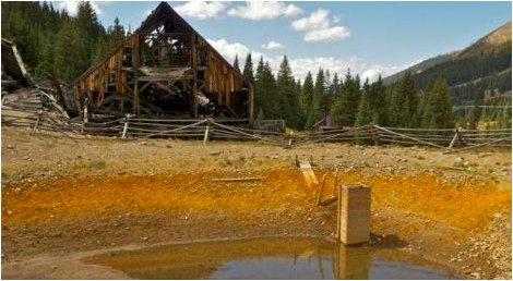
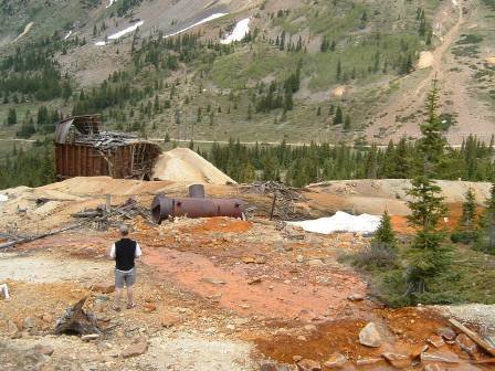
Pennsylvania Mine Upper Peru Creek Basin
Take the example of Peru Creek — a stream that runs through the former Pennsylvania Mine, picking up waste from toxic metals unearthed during the mining era. Summit County is working on a collaborative effort to redirect the water away from the toxic metals, to allow more aquatic life in the Snake River downstream.
“We think it will take at least a year to see what that does to the stream by moving clean water out of the mines,” Stiegelmeier added.
This concept trickles up to the state level, where $1 million will be allocated per year for stream management planning, according to the current draft of Colorado’s Water Plan…
BRIDGING THE GAP
A key feature of the plan is to set a statewide conservation goal, to be implemented at the discretion of local water departments…
“We have stated over and over and over that there needs to be better land-use connection,” Stiegelmeier said. “You have your Kentucky bluegrass with every house, and that doesn’t make sense in a desert.”
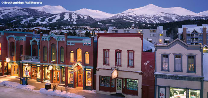
A few proposed solutions are to leave native vegetation as open space and cluster buildings together. She pointed to Breckenridge as an example, with a tiered water-rate system encouraging conservation.
The state is also looking to improve water efficiency for agricultural uses. In the Kremmling area, part of the effort is to work on hay fields, where more efficient irrigation could benefit both farms and streams to an extent…
“When you have two years of low snowpack, you don’t have the luxury of having a conversation about conservation,” [Jim Pokrandt] said. “If things went to hell in a hand basket here in Colorado, you’d see the conversation getting sharper.”[…]
Colorado transmountain diversions via the State Engineer’s office
A DIVISIVE ISSUE
The most contentious piece of the water plan concerns the creation of new trans-mountain diversions, such as Lake Dillon Reservoir, that direct flows across the Continental Divide. The framework does not take a stance so much as create a series of requirements a new project must reach before getting started…
“Is it a radical shift? No. But it gets people on the same page,” Conley said. “In terms of guiding our water future, it’s a big step forward.”
From the Glenwood Springs Post Independent (Brent Gardner-Smith):
Letters sent to the Colorado Water Conservation Board in September about the draft Colorado Water Plan reveal a range of opinions about potential new transmountain diversions and the merits of using a “conceptual framework” to evaluate them.
Various Front Range water providers and interest groups told the CWCB that the conceptual framework should not be included in the water plan, should not be a regulatory requirement, and should not apply to transmountain diversion projects already in the planning and approval stage.
“Even with wording changes, the basin roundtables recommend that the CWCB not adopt the framework as it is a work in progress that may be modified as dialogue continues,” wrote the S. Platte and Metro basin roundtables, two of nine regional water-supply groups that meet under the auspices of the CWCB, in a combined Sept. 17 comment letter.
But a number of organizations based on the Western Slope or that focus on the Colorado River basin say the framework is a good step forward.
Officials at the Getches-Wilkinson Center for Natural Resources, Energy and the Environment at the University of Colorado Boulder, for example, gave an enthusiastic endorsement of the framework.
“This is a revolutionary document and a quantum leap forward in Colorado water history,” Lawerence MacDonnell and Anne Castle, both of the Getches-Wilkinson Center, wrote in a Sept. 17 letter to the CWCB. “The conceptual framework is a critically important part of the Colorado Water Plan and should be formally adopted in the plan and by the CWCB, not just monitored.”
The final water plan is expected to be approved by the CWCB board of directors at their meeting on Nov. 19 at the History Colorado Center in Denver.
The conceptual framework includes seven principles “to guide future negotiations between proponents of a new TMD and those communities who may be affected were it built.”
The concepts covered include a recognition that there may not be water to divert in dry years, that new diversions should not increase the likelihood of a compact call from California, that municipal conservation should also be pursued and that environmental needs must be addressed.
Brent Newman, a program manager in the water supply planning section of CWCB, said Friday that the framework is going to be included in the final water plan and will be called “Colorado’s Conceptual Framework.”
“Folks may not agree with every single principle, or even with discussing the concepts of a transmountain diversion out loud, but it represents a historic milestone in Colorado water policy that’s a long way from ‘Not One More Drop’ or ‘We’ll See You in Court,’” Newman said, citing the long-held positions of the Western Slope and the Front Range, respectively.
RANGE OF VIEWS
Comments on the second draft of the water plan were due Sept. 17 and water-focused organizations filed more than 50 substantive letters.
It’s not hard to pick up on the differing views in the letters about the framework, which was developed over the last two years by members of the Interbasin Compact Committee, which serves as an executive committee for the CWCB’s nine basin roundtables.
Those who don’t think new transmountain diversions are a good idea tend to support the framework. But those who see new diversions as necessary diminish the framework’s authority and reject its potential restrictions.
Castle and MacDonnell of the Getches-Wilkinson Center clearly support the framework, but they see big problems with taking more water from the upper Colorado River basin.
The pair told the CWCB that “development of significant new Colorado River supplies increases the risk of future curtailment to all existing, post-1922 Colorado River water users, reduces the production of renewable hydropower at Colorado River Storage Project reservoirs, and could ratchet up unwelcome and counterproductive political dynamics among the Colorado River basin states.”
But officials at Colorado Springs Utilities, while aware of potential issues with downstream water users in other states, see new TMDs as a likely necessity.
M. Patrick Wells, the managing engineer for water resource planning for CSU, told the CWCB in a Sept. 17 letter that the draft water plan “consistently overlooks the fact that one or more new TMDs will ultimately need to be constructed to address Colorado’s water supply gap.”
As such, Wells said the final water plan “should contain a definitive statement that a new TMD will be constructed, even if no formal concept has been proposed.”
Wells also said CSU has “a significant concern” that adhering to the framework will become a regulatory requirement of new water projects.
The utility “strongly requests” that language be added to the water plan to “make it abundantly clear that the conceptual framework is not a statement of state policy, and is not in any way to be interpreted or construed as a basis for any conditions or requirements in any water court case, state or federal permitting process, or contract negotiation.”
The members of the Front Range Water Council agree with Colorado Springs Utilities on this point.
In its Sept. 15 letter, the council pointed to recent remarks about the framework made by John McClow, a CWCB board member from the Gunnison River basin.
“As board member McClow stated in his remarks at the summer Colorado Water Congress convention, the framework has no regulatory force or effect. Rather, it is guidance, the implementation and use of which will depend on the positions taken by the parties who engage in good faith negotiations on the construction of future specific proposed projects.”
The council includes Denver Water, Aurora Water, Colorado Springs Utilities, Northern Water, the Southeastern Colorado Water Conservancy District, the Twin Lakes Reservoir and Canal Co., and the Board of Water Works of Pueblo.
MORE WATER EAST
A few organizations have told the CWCB that the framework should apply to both potential new transmountain diversions and the “firming” of existing transmountain water supplies.
Today, about 600,000 acre-feet of water a year is sent east under the Continental Divide and over 500,000 acre feet of that is diverted from headwaters in Grand, Summit, Eagle and Pitkin counties.
And another 120,000 to 140,000 acre-feet of water could be sent east after changes are made to existing transmountain diversion systems, according to the Colorado River basin roundtable.
Included in that 140,000 acre-feet figure is 20,000 acre-feet more from the Windy Gap project in Grand County, 18,000 acre-feet more from the Moffat Collection System above Winter Park, and 20,000 from the Eagle River MOU project, which potentially includes an expansion of Eagle Park Reservoir at the Climax Mine and a new dam and reservoir on lower Homestake Creek.
In addition to those, the water quality and quantity committee of the Northwest Colorado Council of Governments told the CWCB that there are other projects in the works that could send more water east, including “future Dillon Reservoir diversions, firming in the upper Roaring Fork and Fryingpan rivers, and Colorado Springs Utilities expanded diversions from the upper Blue River.”
In the language of the Colorado Water Plan, these projects already on the books are called IPPs, for “identified projects and processes.”
The Pitkin County commissioners, in a Sept. 15 letter, told the CWCB that the county “wholeheartedly endorses” the framework but “strongly believes” the framework’s core principles need to be “expanded in scope to apply equally to the various IPPs that involve trans-basin diversions.”
The Pitkin County Healthy Rivers and Streams Board, a tax-funded organization dedicated to leaving more water in the Roaring Fork River and its tributaries, feels the same way.
“The IPPs are the result of simple community canvassing to obtain information as to any potential plans or processes that are being contemplated around the state,” the board wrote in a Sept. 17 letter. “The IPPs have not been vetted and vary widely in size, impact and feasibility. “
SOME PLAIN LANGUAGE
Trout Unlimited, which has been paying close attention to the development of the water plan, said it supports the framework.
But it also gave the CWCB some plain-language criteria it thinks should be used to judge new TMDs.
“These transmountain diversions of water can cause severe economic and environmental damage to the areas of origin,” wrote Richard Van Gytenbeek, the Colorado River Basin outreach coordinator for Trout Unlimited, in a Sept. 17 letter to the CWCB.
As such, Gytenbeek told the CWCB it “should reject all new TMDs” unless the project proponent is already “employing high levels of conservation,” can show “that water is available for the project,” and “makes commitments that guarantee against environmental or economic harm to the basin of origin.”
The Colorado River District, which has board members from 15 Western Slope counties, said it supports the framework.
The river district’s general manager, Eric Kuhn, has been instrumental as a member of the IBCC in developing many of the framework’s key concepts.
“Admittedly, there are elements of the framework that we would prefer to edit but recognize there are others who would address those same edits in an opposite fashion,” the River District told the CWCB in a Sept. 17 memo.
However, the River District said the framework “represents a ‘way forward’ for constructive discussion about possible development of Colorado River basin water resources for out-of-basin use.”
Aspen Journalism is collaborating with the Post Independent and The Aspen Times and on coverage of statewide water issues. More at http://www.aspenjournalism.org…
SEVEN PRINCIPLES
1. East Slope water providers are not looking for firm yield from a new TMD and the project proponent would accept hydrologic risk for that project.
2. A new TMD would be used conjunctively with East Slope supplies, such as interruptible supply agreements, Denver Basin Aquifer resources, carry-over storage, terminal storage, drought restriction savings and other non-West Slope water sources.
3. In order to manage when a new TMD would be able to divert, triggers are needed. Triggers are operating parameters that determine when and how much water a potential new TMD could divert, based upon predetermined conditions within the Colorado River System.
4. A collaborative program that protects against involuntary curtailment is needed for existing uses and some reasonable increment of future development in the Colorado River System, but it will not cover a new TMD.
5. Future West Slope needs should be accommodated as part of a new TMD project.
6. Colorado will continue its commitment to improve conservation and reuse.
7: Environmental resiliency and recreational needs must be addressed both before and conjunctively with a new TMD.
Colorado transmountain diversions via the University of Colorado
Mining, logging and railroad and highway construction in generations past dumped sediment in the Tenmile Creek near Copper Mountain.
“It was just sort of 100 years of abuse,” said Jim Shaw, board treasurer for the nonprofit Blue River Watershed Group, which led the restoration effort.
Climax Molybdenum was the biggest offender. The mine’s dams, built to contain toxic drainage from waste rock, failed, and blowouts caused tons of sediment to rush down the steeper parts of the creek and settle in the flatter parts, destroying habitat and wiping out native flora and fauna.
The 1970 Clean Water Act forced Climax to improve its water treatment process, and the mine was no longer an issue, but the damage remained, Shaw said.
In 2013, a multi-year $800,000 effort began to restore the roughly 2,800 feet of stream impacted. Contributing partners included Climax, Copper Mountain Resort, the Forest Service, Colorado Parks and Wildlife, the Colorado Water Conservation Board, CDOT, Friends of the Dillon Ranger District, the National Forest Foundation and the town of Frisco.
Now Shaw said the project is essentially done except for three days of re-vegetation work next week and some planting of shrubs and willows in June. The wetlands have been created, and the oxbows — or U-shaped river bends — have been completed…
PREVENTING ORANGE RIVERS
As the Tenmile closes on completion, so does another watershed improvement project across the county.
The U.S. Environmental Protection Agency (EPA) and the Colorado Department of Reclamation and Mining Safety (DRMS, pronounced dreams) have been leading a collaborative cleanup effort of the Pennsylvania Mine for the last few years.
In early September, the partners installed a second bulkhead deep inside the mine above Peru Creek east of Keystone. The two bulkheads, or giant concrete plugs, will greatly reduce or eliminate negative impacts from the mine’s acid drainage to water quality and fish habitat.
About eight years ago, the Penn Mine experienced a blowout and sent orange water down into the Snake River and Dillon Reservoir. It’s not the latest mine in Summit County to do so.
The Illinois Gulch Mine above the Stephen C. West Ice Arena blew out a couple years later, and the Blue River ran orange and red through Breckenridge and again into Dillon Reservoir.
Now the EPA and DRMS are doing preliminary investigative work in Illinois Gulch, in partnership with the private property owner who owns the land where the mine pollution is coming from, in hopes of starting a cleanup.
“That issue everybody understands, but there hasn’t been a group to take it on yet,” Shaw said. “The state has made it clear that they’ll find money to help.”
ONTO THE SWAN
For now, the water quality restoration focus in Summit is shifting to the Swan River.
The Colorado Water Conservation Board and Colorado Basin Roundtable together awarded a $975,000 grant to the county to support a large-scale restoration project on the Swan in March.
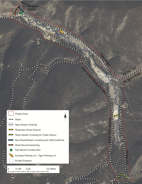
The restoration area includes about 3,500 feet of river along Tiger Road, 11 miles northeast of Breckenridge, on public land jointly managed by the county and the town of Breckenridge where dredge mining turned the riverbed upside down.
Over the last month or two, the same contractors who did the Tenmile project studied the first quarter of the Swan River project. Work on that section will start in 2016 and finish in 2017, said Brian Lorch, director of the county Open Space and Trails Department.
The county is leading the project with many of the same partners as the Tenmile stakeholders as well as the town of Breckenridge, Trout Unlimited and two private landowners. The $2 million project is also supported in part by a tax increase voters passed in 2014.
The plan for the rest of the Swan River restoration is less certain as the upper three-quarters is covered by rocks about 40 feet high.
Shaw said the project partners could tackle restoration over perhaps 15 years as an excavation company removes and sells the rock. The other option is to pursue larger grant funds and private donations that would expedite the effort but mean maybe 10 times higher costs and more complicated logistics…
Another restoration project in the works lies on the Blue River north of Breckenridge.
The town plans to start a restoration project in the coming years through a 128-acre town parcel known as the McCain property, which borders Highway 9 to the west, north of Coyne Valley Road.
Lorch said the collectives that have made local restoration projects possible deserve credit as do the various stakeholders, which include nearly every government agency and nonprofit concerned about water quality or fisheries in Summit County.
Blue River
Frozen mists over the Blue River Valley turn the sun into a diamond — Bob Berwyn
Pennsylvania Mine Upper Peru Creek Basin
Moon set over the Tenmile Range via The Summit County Citizens Voice
Despite lingering problems at many places, the Pennsylvania Mine in Summit County seems to be one place where contaminated water from hard-rock mining a century ago is finally being abated. Photo courtesy of Jeff Graves, Colorado Division of Reclamation, Mining and Safety
Swiping at the EPA was easy enough, but context matters in river spills
It was the cheap story, and none less than the Economist ran with it this week in recapping the mine spill into the waterways of Southwestern Colorado. “Arsenic and lost face,” was the headline over a short story about the troubles stirred up after a contractor working for the Environmental Protection Agency breached a dam holding back the Kool-Aid-looking water in the Gold King Mine above Silverton.
Plenty of people piled on the EPA after the Aug. 5 spill. It seems lots of people hate the EPA—and this was before the Clean Power Plan. “To be accused of unconstitutional overreach is unfortunate,” concluded the Economist. “To give proof of incompetence when faced with such an accusation is unforgivable.”
But the Durango Herald may have been much closer to the truth of the situation when, only a day after the fouled waters reached Durango, it described the EPA as the one “left holding the hot potato.”
Silverton, Colo., lies an at elevation of 9,300 feet in San Juan County, and the Gold King Mine is more than 1,000 feet higher in the valley at the left side of the photo. Photo/Allen Best
Indeed, Silverton and San Juan County had resisted a Superfund designation, afraid of the bad publicity for the community. Instead, there had been what the Herald described as a “piecemeal cleanup effort. …It was a compromise and gamble,” the newspaper went on to say. “It failed, but there is a valuable lesson that must not be missed amid the finger-pointing and grieving over a river run foul.”
The lesson along the I-70 corridor in Colorado is that the EPA has managed to achieve cleanups where others have bumbled or done nothing. Consider the Eagle Mine, between Minturn and Red Cliff, just around the corner from Vail. Mining ended there in the late 1970s after a century. The mess was designated a Superfund site. But by the winter of 1989-90, the Eagle River looked much like the Animas River of a couple weeks ago. State officials had signed off on a low-cost gamble of their own, sealing the Eagle Mine. This lower-cost solution didn’t work. Water contaminated by heavy metals in the mine escaped into the river. At one point, snow at the Beaver Creek Resort, manufactured with water drawn from the Eagle River, had a faint orange hue. It wasn’t a year the Denver Broncos were going to the Super Bowl. Then the EPA was called in. Things got fixed—more or less.
That even a well-funded cleanup continues to have problems should be sobering. This week, Todd Fessenden, board president of the Eagle Mine Limited, a group charged with disseminating technical information in ways the layman can understand, sent an e-mail to elected officials in Eagle County assessing the river conditions there, in the wake of the Animals spill.
“What you may not know is that we’ve had more than a dozen spills of heavy metal-laden mine water, or partially treated mine water, in the last 6 years,” he wrote. “Those spills have ranged in magnitude from 0.5 gallons per minute to 428,000 gallons over a 23-hour period. I’ve personally seen the Eagle River run green and the same shade of orange the Animas turned in the last 6 years.”
Still, the river is much better now. Vail seems to have survived just fine, despite the presence of the EPA.
In Summit County, the Pennsylvania Mine was a long-time mess. It’s in Peru Gulch, not far from the A-Basin ski area, and upstream from Keystone. The original miners had been gone many decades. A couple had purchased the property for back taxes but, realizing the problems, couldn’t unload it. Nobody else would touch it either, because of the liability if something went wrong.
But progress has been made in recent years. The mine less than a decade ago was running red downstream to Keystone and into Dillon Reservoir. It was, as the Summit Daily News noted in a story last week, long one of the most toxic abandoned mines in the state.
Again, the EPA’s involvement was crucial for making progress. By stepping in, explained Paul Peronard, the EPA’s on-site coordinator at the Pennsylvania Mine, the EPA takes on liability. With the EPA involved, the state will step in and do work, too. “When bad things happen, it becomes the EPA’s fault,” he explained.
And things can go wrong. “It’s like working on the bomb squad. You have a set of techniques, but, every now and then, the bomb goes off,” he said.
Jeff Graves, the senior project manager for the Colorado Division of Reclamation, Mining and Safety, said the potential for a “catastrophic release, surge event, whatever you want to call it, will be significantly reduced if not eliminated” by late September.
Portal of the Pennsylvania Mine in Summit County, upstream from Keystone Resort. Photo courtesy of Jeff Graves, Colorado Division of Reclamation, Mining and Safety
The Pennsylvania Mine currently puts 12,000 pounds annually of zinc into Peru Creek. No fish can be found in the creek nor in the Snake River downstream as far as Keystone, where the pollution is diluted. But if not as bad as the Pennsylvania Mine, more than 100 abandoned mines remains in the Snake and Blue River watersheds.
Reviewing the Animas pollution, Wyatt laments the “finger-pointing without putting what happened (at Silverton) into context.” The mining history above Silverton was difficult, with the mines interconnected and covering a broad area.
Lynn Padgett, a geologist, has been studying abandoned mines in the San Juan Mountains since 1990. Elected a Ouray County commissioner in 2009, but has kept after her interest, most recently appearing before a committee of Club 20 meeting in Lake City in support of Good Samaritan legislation.
Good Samaritan legislation would allow third parties to step in and clean up a mine site without incurring liability if something goes wrong, such as occurred at the Gold King Mine, as specified by the Clean Water Act. By Padgett’s rough count, there have been 15 different pieces of legislation have been introduced into Congress over the years—and all have foundered.
“The Clean Water Act is ironically a barrier to having clean water,” she says.
Padgett remembers going to the Gold King Mine in 2012 with then-U.S. Sen. Mark Udall, who had worked to move Good Samaritan legislation. As had several other congressional representatives. The problem always ends up being a concern about potentially responsible individuals being allowed to get duck their responsibilities.
The current proposal is being pushed by U.S. Sen. Michael Bennet and U.S. Rep. Scott Tipton. The legislation would create pilot projects. Other counties have been asked to lend support, and a letter from Pitkin County Commissioner Rachael Richards asks that the pilot be broadened to include the hard-rock mineral belt of Colorado, specifically including Eagle, Gunnison, Pitkin and Summit counties.
Padgett says the Gold King Mine doesn’t provide a good argument against mining. It and most of the other old mines pre-date modern laws that govern mining. “Our problem is these very old, historic mines,” she says.
Did the EPA truly mess up, as critics say, or was it, as the Durango Herald said, the party left holding the hot potato? Padgett says she’s waiting to get more information.
But like Wyatt and many others, she’s worried that too many will draw the wrong less from Gold King and the Animas, calling for reduced funding of the EPA by Congress. “That would be the wrong answer,” she says.
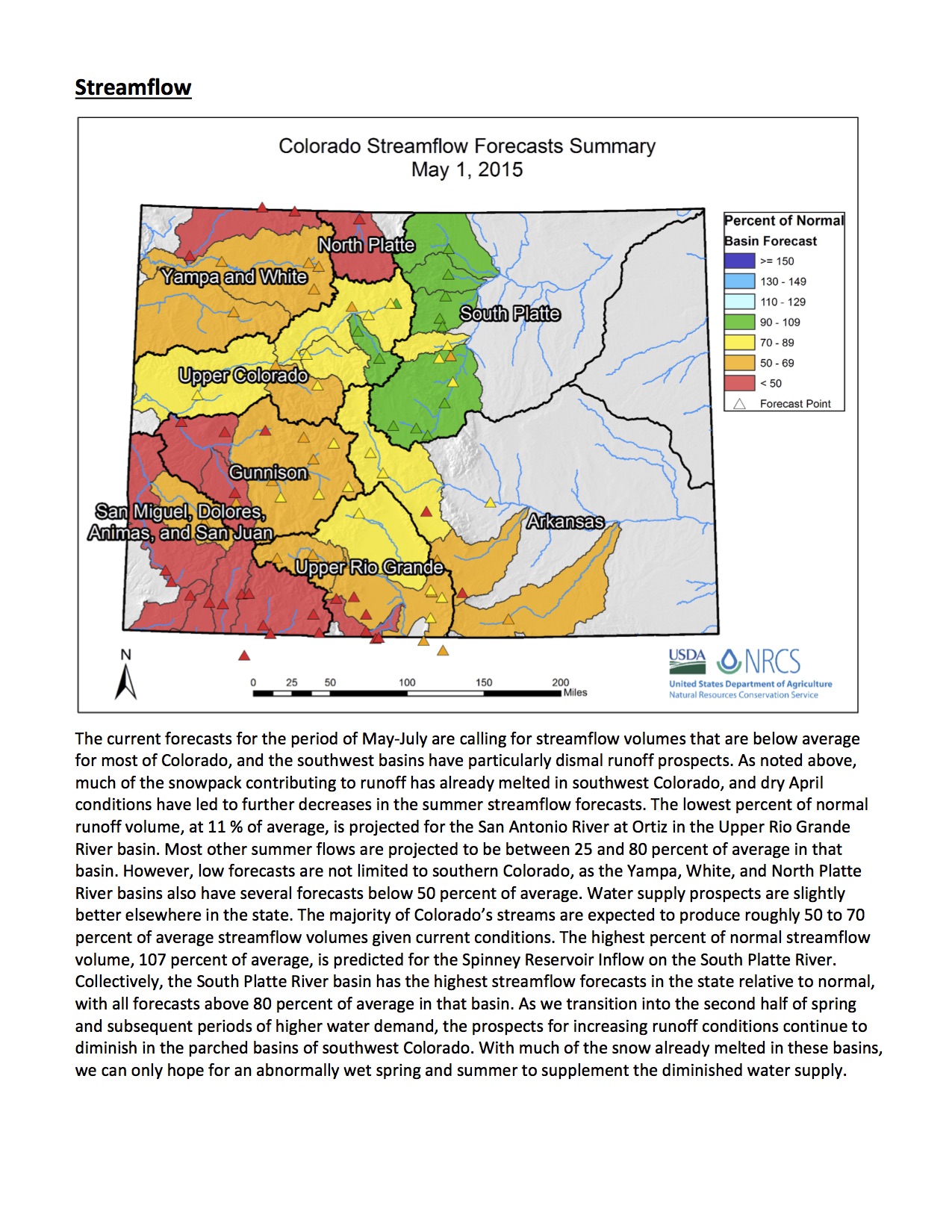
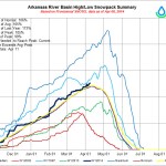
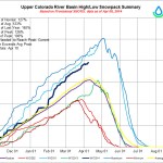
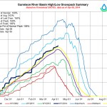
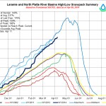
May 1, 2015 Colorado streamflow forecast map via the NRCS
FromThe Mountain Town News (Allen Best) via the Summit Daily News:
In Colorado, snowpack this winter was about average in the Blue River Basin, which is where Breckenridge, Keystone, and several other ski areas are located. “Everybody has Blue River envy,” said Eric Kuhn, general manager of the Colorado River Water Conservation District, at a recent meeting covered by the Summit Daily News.
Blue River’s snowpack will soon fill Dillon Reservoir, one of the main reservoirs for metropolitan Denver. However, endangered fish in the Colorado River downstream near the Utah border won’t fare so well, because of less snowpack in the other tributary basins. Peak flows must be at least 12,900 cubic feet per second; they’re expected to peak at 9,600 cfs.
Taking a broader view, Kuhn sees this time in the 21st century as one of transition. “After 100 years of develop more, develop more, develop more, we’re going to have to cut back our uses.”
Kuhn pointed to the declining water levels in both Lake Powell and Lake Mead, the two giant “buckets” on the Colorado River. “Bad things happen when Lake Mead and Lake Powell get drained,” he said, a distinct possibility in the next few years, particularly at Lake Mead.
What about building a pipeline to the Mississippi River or some other water-rich location? “To expect that we can export our problems to somebody else, I just don’t see that somebody else will willingly accept them,” he said.
Denver Water employees Rick Geise and Nate Hurlbut assisted in setting the plug, which helps prevent chunks of ice and snow from falling into the spillway. Photo credit: Denver Water
Summit’s Blue River Basin recorded snowpack near the 30-year average, and the six speakers at the 22nd annual State of the River meeting on Tuesday, May 5, stressed that local residents should feel fortunate that the headwaters community was spared the immediate water supply problems others are facing around the West.
“Everybody has Blue River envy,” said Eric Kuhn, general manager of the Colorado River District. “You’re the sweet spot this summer.”
However, the event’s speakers also emphasized the coming impacts of long-term drought and overconsumption on Summit and other communities that supply the majority of the West’s water.
Kuhn said major water players including Denver Water, which owns and operates Dillon Reservoir, are for the first time loudly prioritizing certainty of water supplies over development because they are worried about their future abilities to deliver water to their current customers…
County Open Space director Brian Lorch and Blue River Watershed Group board treasurer Jim Shaw said restoration projects on the Swan River northeast of Breckenridge and the Tenmile Creek east of Copper Mountain are moving forward with success.
Summit County water commissioner Troy Wineland said Summit’s snowpack didn’t quite reach average this winter, according to data from the Blue River Basin’s four SNOTEL measuring sites. Half of the snowpack arrived in November and December, and it was gone at lower and middle elevations by the end of March, which was unusually dry and warm.
Runoff started sooner this year, and Tenmile Creek flows in early April were five times greater than average, Wineland said. He predicted peak runoff will occur in early June depending on the weather.
On Monday, May 4, Wineland said Old Dillon Reservoir achieved its first complete fill of 303 acre feet. The reservoir is jointly operated by the county and the towns of Silverthorne and Dillon, and it was stocked with golden trout from California that Wineland said should mean good fishing in the next year or two.
Wineland stressed the role that Summit residents can play in shaping the state’s first-ever water plan, which will outline Colorado’s water policy priorities for the next 50 years and will be handed to the governor in December…
Bob Steger, water resources engineer with Denver Water, said his calculations of Summit snowpack included data from Fremont Pass, which is why he measured Summit’s snowpack as above average but “nowhere near the snowpack that we had last year.”
The Blue River Basin may be the only basin in the state that peaks above average, and Denver Water’s No. 1 priority of filling Dillon Reservoir “should be no problem,” he said. “We’re only two feet from full right now.”
It should be a great summer for boating as well as rafting and kayaking below the dam, Steger said. “The fishing will eventually be good, but if you don’t like high water you probably better stay out until sometime in July.”
He answered a question about Antero Reservoir in Park County, which Denver Water will empty this summer ahead of repairs to the 100-year-old dam. The phase that requires draining the reservoir should be done by the end of 2015 with refilling beginning next spring. Steger also said Denver Water is still working on a permit to enlarge Gross Reservoir in Boulder County.
Ron Thomasson, a hydrologist with the U.S. Bureau of Reclamation who oversees Green Mountain Reservoir operations, said runoff flows won’t be high enough this year to allow coordinated reservoir operations that would protect endangered fish on the Colorado River.
Peak flows must be between 12,900 cfs and 23,000 cfs to do that, and the current forecast is for 9,600 cfs, he said…
Kuhn presented last and detailed continued threats facing Lake Powell and Lake Mead operations.
“We’re going to have to cut back our uses,” he said, “after 100 years of develop more, develop more, develop more.”
Lake Mead could likely see its first shortage next year or in 2017, he said, and “bad things happen when Lake Mead and Lake Powell get drained.”
Allowing Lake Powell’s water level to fall below the amount needed to generate electricity would lead to dramatically higher utility bills costs, the elimination of funding for the important environmental programs funded by the hydropower revenue noted above that protect current and future water use in Colorado.
If Colorado and the other Upper Basin states violate the 1922 Colorado River Compact and fail to provide enough water to Lower Basin states, the West could be fighting over water in lengthy court battles and Colorado could be forced to prohibit some water uses.
Western states could lose control of water to the federal government, Kuhn said, and Colorado would likely lose power in management of the Colorado River and water in the state.
When asked about building an interstate water pipeline to solve some shortages, Kuhn said water managers have discussed pipelines of absurd lengths and he doesn’t think that method will work.
“To expect that we can export our problems to somebody else, I just don’t see that somebody else will willingly accept them,” he said.
Colorado Springs circa 1910 via GhostDepot.com FromRe:Sources Blog (Patrice):
Living in the West offers many advantages. Wide open spaces, majestic mountains and amazing recreational opportunities, to name a few. Still, there are challenges and water is certainly one them.
If you’ve seen the recent news, extreme drought is taking its toll in California. In light of this, we caught up with our own water planners – Abby Ortega and Leon Basdekas – to learn if what’s taking place with our neighbors could affect our community and why we need to stay involved in what’s happening around the region.
Some of our customers many ask, could what’s taking place in California happen in Colorado?
Extreme drought can happen anywhere, and we are certainly not immune. We continuously monitor our water supply situation and maintain a storage reserve in our reservoirs to meet customer demand for at least one year.
Why should we take an interest in or follow what’s happening with drought in the West?
In Colorado Springs and across the Front Range, we are heavily reliant on the Colorado River for our water supply. The Colorado River starts in Colorado, but we only keep a portion of the flow for use in the state per the Colorado River Compact. The Colorado River also serves Arizona, Utah, Nevada, Wyoming, New Mexico and California (see below for a breakdown). There is also an obligation to Mexico. When any of the states or Mexico are in an extreme drought, their reliance on the Colorado River water may increase, possibly resulting in ripple effects that could negatively impact us. At any given time, the Colorado River supplies about 70 percent of our community’s water. Drought can also affect the levels in Lake Powell and Lake Mead, which part of the western United States relies on for power production.
Will Colorado Springs experience any impact from the situation in California?
The California drought will not have direct impacts to our community’s water supply yet. We are working closely with the Upper Basin States to create a proactive contingency plan in the event that storage levels in Lake Mead and Lake Powell drop to critical levels.
What is Colorado Springs Utilities doing to help protect our community from this type of situation?
Maintaining a dependable water supply for Colorado Springs residents and businesses is one of our community’s greatest challenges. Continuous long-term water planning is the reason we have a reliable water system today that supports our economy and quality of life. For us, planning is part of our daily responsibilities and includes factors such as water sources, demand, water rights, infrastructure, storage and much more. In addition, we are currently updating our Integrated Water Resource Plan, which provides the roadmap for sustainably addressing water supply and demand issues, while reflecting our community values.
What can customers do to help?
The intelligent use of water will always be a priority for our community, which has done a great job of adapting to our semi-arid climate. Our customers continue to find ways to use water wisely and we can help. A good place to start is our website, which has free xeriscape class schedules, efficiency ideas, DIY videos, and more. Folks should also join in the conversations we’re having through the Integrated Water Resource Plan process. There are opportunities for input, whether online or at upcoming meetings.
If all goes as planned, the Swan River between Frisco and Breckenridge will once again run like it did more than a century ago.
That’s because the Colorado Water Conservation Board and Colorado Basin Roundtable have given Summit County a $975,000 grant to restore 19 miles of the river that was drastically changed by mining activity…
The overall plan is restore the part of the river that’s separated by the huge dredge piles – and hopefully bringing back fish and wildlife in the area – returning it to how it was more than a hundred years ago.
From the Town of Breckenridge via the Summit Daily News:
For the first time in recent memory, the town of Breckenridge will raise water usage rates by 5 percent for residential and commercial customers across town.
In an effort to both encourage conservation and kick-start funding for a proposed new water plant, the town council last year approved a higher water utility rate for 2015. Historically, water fees have increased at a low pace of 1 percent annually. Beginning this March, the town’s water usage rates will increase by 5 percent and plant investment fees (PIFs) will jump by 10 percent, the steepest hike since 2007, according to town records.
“Rapidly increasing demands, especially in the drought-prone West, are placing an immense strain on this limited, precious resource,” Mayor John Warner said. “It is our duty to address this critical issue for our community.”
The 5 percent rate increase for residential and commercial users will raise the base residential usage charge from $31.26 to $32.81 over a two-month billing cycle, an increase of $1.55. That translates to a $9.30 increase annually per customer.
For customers beyond town limits, such as homes in the Blue River neighborhood, the two-month rate is 50 percent higher, according to the town’s 2011 water plant feasibility study. Those customers will pay $18.60 more per year.
Excess usage rates will also increase in turn. The base rate for maximum usage will drop from 12,000 gallons to 10,000 gallons per two-month billing cycle. Rates for excess usage will increase from $3.11 per 1,000 gallons to $5.00 per 1,000 gallons. These measures were put in place to encourage conservation efforts, according to a town release.
To assist customers with conservation efforts, the town will send individual water usage history reports shortly after the rate increase. These reports will detail two-year usage history for each customer. Town officials hope the reports can help guide and track conservation efforts, and they come paired with a link to water conservation tips on the town website.
Over the past 10 years, water has factored heavily into council discussions about the town’s future. After noting that water is essential to the community’s economy, natural environment and quality of life, the council made water-related issues a priority and in 2014 completed a comprehensive study on the town’s water system, which strongly recommends the addition of a second water plant.
The PIF increase of 10 percent for 2015 is double the historical annual increase rate of 5 percent. This rate hike is the first step for financing a new plant. Only new customers connecting to the municipal system pay PIFs.
The 2014 water study indicated that the town’s sole water treatment plant, a 41-year-old facility, will not be able to meet future demand. As a result, the town has started the process of planning for a new facility that will help the town meet future water demand as the town continues to grow.
While the town has made strides in conserving water and management efficiency, the current water plant is nearing 80 percent capacity. The current plant will not be able to support new customers outside the current service area, which is supplied by private wells with a high likelihood of failure.
Another benefit of a new plant is emergency readiness. In the event of a wildfire, natural disaster or mechanical malfunction at the current plant, a second water plant would provide a critical back-up system.
The study also found that the Breckenridge system supplies high-quality drinking water at a low cost to customers in comparison to other communities in Colorado. Funding currently comes from user fees, tap fees and water system maintenance fees. The upcoming usage rate and PIF increases are the first such increases. The town council and utility department have not yet decided on any future increases.
“The town is working with water system consultants, engineers and water rights attorneys to secure our community’s water future,” Warner said. “Increased water rates are just one part of taking steps to improve our water utility system. The council and staff are aware that increased rates are rarely welcome news, but we believe that our citizens will understand the critical needs for water conservation and system improvements.”
The Breckenridge Water System study and an informational Q&A on the rate increase are available on the town website at http://www.townofbreckenridge.com.
On Friday, Oct. 17, Stiegelmeier was one of several federal, state and local officials marking a milestone for the centerpiece of the county’s current mining cleanup efforts — plugging the Pennsylvania Mine.
About 8 miles east of Keystone, the abandoned mine is Summit County’s biggest mess. The mine, considered the worst in the state, spews toxic heavy metal concentrates and acidifies water flowing into the Peru Creek, a tributary of the Snake River, which feeds Dillon Reservoir. Peru Creek is without fish, insects or other aquatic life. The Snake River has life, but it’s sparse and found only in the lower reaches. In 2007, a burp of acidic water from the abandoned mine killed fish all the way to Keystone, county officials said.
This past week, the Colorado Division of Reclamation, Mining and Safety finished installing one of two bulkheads, massive plugs of concrete and steel built about 500 feet inside the mine.
According to project manager Jeff Graves, once both bulkheads are installed, toxic burps and blowouts will be a thing of the past.
“That won’t happen again — it can’t,” he said.
The bulkheads prevent water from flowing through the mine. Water will back up inside, reducing the amount of oxygen the metals and sulfides are exposed to, which should improve water quality.
POSITIVE IMPACTS
Though the more than $3 million project still has far to go, reclamation efforts seem to have had positive impacts already. Last year, the Peru Creek turned reddish-orange seven or eight times. That hasn’t happened once this year.
In addition to the bulkheads, new drainage ditches channel water away from waste-rock piles. Those piles have been capped. Eventually, they’ll be revegetated. Limestone has also been strategically added to raise the pH of the water, which could help filter out metals into settlement ponds.
Organizations involved in the project include: the Colorado Division of Reclamation, Mining and Safety, the U.S. Environmental Protection Agency, the Colorado Department of Public Health and Safety, the U.S. Geological Survey, the U.S. Forest Service, Summit County Open Space and Trails, Northwest Council of Governments, the Snake River Watershed Task Force, the Blue River Watershed Group and the Keystone Center.
In the summer of 2013, the group of partners put heavy machinery in the creek and began the project, which is expected to take four summers and cost about $800,000.
Due to a lack of initial funding, the project was broken into two parts and shortened from a goal of 3,200 feet of creek restoration to about 2,750 feet.
Project partners completed phase one of the project last week. So far, they’ve restored about 1,600 feet of stream channel and 3.15 acres of riparian, wetland and floodplain habitat.
On Sept. 12 the partners received a $275,000 grant from the Colorado Water Conservation Board for phase two.
Thanks to that grant funding, Anderson said, the project has almost reached its fundraising goal and work will continue.
The state water conservation board has provided most of the money for the project. Climax contributed $80,000 to the first phase and $50,000 to the second, Copper Mountain paid for the Forest Service environmental assessment and some materials, and the National Forest Foundation and CDOT are pitching in.
This summer, the group planted around 3,000 shrubs, Anderson said. The town of Frisco provided 2,200 willow clippings from a site near Whole Foods, which a Forest Service crew clipped in the early spring and volunteers with the Friends of the Dillon Ranger District planted in June. Then another 800 shrubs came from a nursery.
The revegetation has seen an 80 percent success rate so far with the willow transplants, said Jim Shaw, board treasurer of the Blue River Watershed Group, which he credits to “a wonderfully wet summer.”
That wet summer created some hurdles though. Runoff season lasted longer than usual, and high flows eroded the creek for two weeks, damaging the revegetated area in two places.
The heavy runoff gave some insight into how the creek will flood in future years, Shaw said, so last week the partners fixed up some of the damaged spots but they will probably keep one part the way it is now.
Next summer, the partners will start phase two and work toward restoring another 1,200 feet of the creek downstream toward the Conoco gas station.
When the project is finished, the creek will have improved habitat for fish, birds and other creatures. For the humans spending time in and around the Tenmile, that means better wildlife watching, fishing and kayaking.
“Having natural ecosystems that function at their potential, be they streams or lakes or forests,” Anderson said, “all these things, they’re important to the quality of life in Summit County.”
Here’s the release from the United States Geological Service (Nancy J. Bauch, Lisa D. Miller, and Sharon Yacob):
Water quality of streams, reservoirs, and groundwater in the Blue River watershed in the central Rocky Mountains of Colorado has been affected by local geologic conditions, historical hard-rock metal mining, and recent urban development. With these considerations, the U.S. Geological Survey, in cooperation with the Summit Water Quality Committee, conducted a study to compile historical water-quality data and assess water-quality conditions in the watershed. To assess water-quality conditions, stream data were primarily analyzed from October 1995 through December 2006, groundwater data from May 1996 through September 2004, and reservoir data from May 1984 through November 2007. Stream data for the Snake River, upper Blue River, and Tenmile Creek subwatersheds upstream from Dillon Reservoir and the lower Blue River watershed downstream from Dillon Reservoir were analyzed separately. (The complete abstract is provided in the report)
Snake River From the Summit Daily News (Alli Langley/Joe Moylan) via the Glenwood Springs Post Independent:
During the silver mining boom of the 1870s, with a population of just 71, Sts. John was for a short time Summit County’s largest town.
The Summit County Open Space and Trails Department recently bought the abandoned townsite and nearby mining claims for $425,000 from the Tolen family, which owned land in the area since the 1950s.
The purchase, finalized July 28, conserves about 90 acres in the Snake River Basin above the town of Montezuma as public open space. The 18 separate parcels have significant wildlife value, according to the Colorado Natural Heritage Program, the U.S. Forest Service and the Snake River Master Plan.
“We are incredibly grateful to the Tolen family for working closely with the Summit County Open Space program to preserve the heritage of Sts. John and this exquisite landscape for the enjoyment of Summit County citizens and visitors alike,” said Brian Lorch, the program’s director. “This is one of the most important and significant acquisitions the program has made in recent years.”
The county acquired the properties using the Summit County Open Space fund, approved by voters in 2008. Breckenridge Ski Resort contributed $25,000 toward the purchase as part of a deal with environmental groups worried about the impacts of the recent Peak 6 development.
With the acquisition, the county will protect a large portion of the Snake River Basin backcountry and preserve a piece of Summit County history. Lorch said the Sts. John properties are highly valued for their intact historic resources, popularity for outdoor recreation and high-quality wetlands and wildlife habitat…
The Summit County Open Space program acquires lands to protect the scenic beauty, natural habitat, backcountry character and recreational opportunities in Summit County. Funded through property tax mill levies approved by Wvoters in 1993, 1999, 2003 and 2008, the program has protected more than 14,000 acres of open space.
Many locals were among the 500 guests who toured the new $200 million Climax Molybdenum Water Treatment Plant during its grand opening on Thursday, Aug. 7. The new plant is located in Summit County and is visible from Colorado 91 on the left heading toward Copper Mountain from Leadville.
Prior to the tours, a number of local and state officials made comments, beginning with Fred Menzer, vice president of Colorado Operations for Climax Molybdenum, who called the water treatment plant another milestone for the company. He outlined how the Climax Mine had gone from 30 people up to the 360 employed today with a target number of 4000.
Since January 2012, Freeport-McMoRan has spent $550 million on the mine, and $300 million of this was spent in Colorado, he said. He also noted Climax has paid $145.5 million in taxes in both Lake and Summit counties.
Dave Thornton, president of Climax, added that since 2008, $1 billion has been spent at the Climax Mine site and more than $75 million has been spent in reclamation at both the Henderson and Climax sites.
U.S. Rep. Scott Tipton noted that the mine was both providing jobs and taking care of the environment.
“We all are environmentalists in Colorado,” Tipton said.
State Rep. Millie Hamner echoed those thoughts saying Climax is a model on how to do things right. She read a tribute to the mining company from the Colorado General Assembly.
Other speakers included Lake County Commissioner Bruce Hix who read a letter from U.S. Sen. Michael Bennet. His also expressed regret that the water treatment plant was not built in Lake County.
The Climax Mine started producing molybdenum in 2012, but the feasibility design for the water treatment plant began in March 2011. Climax has treated water since 1983, initially using the Tenmile and Mayflower ponds with lime addition, according to information distributed at the grand opening. The system received an upgrade in 1998; at that time the pH was increased in the Tenmile Pond, which began Stage 1 metals removal (removing iron, aluminum and copper). Stage 2 metals removal took place at the Mayflower Pond (removing manganese with traces of zinc and lead). An additional treatment plant was added in 2007.
Now the new treatment plant replaces the Mayflower pond as Stage 2 metals removal. Treated water is discharged into Tenmile Creek. The treatment plant has an Events Pond on-site to capture overflows and prevent unwanted discharges into Tenmile Creek.
About 8 miles east of Keystone and a couple of miles south of the 14,000-foot-plus Grays and Torreys peaks, the abandoned Pennsylvania Mine is considered the worst mine in the state. The mine adds toxic heavy metal concentrations and acidifies water flowing into the Peru Creek, a tributary of the Snake River, which feeds Dillon Reservoir.
A three-year, $3 million cleanup project aims to stop that pollution. The project could serve as a model for future mine reclamation efforts around the state, said Paul Peronard, on-scene coordinator for the U.S. Environmental Protection Agency. The collaborative effort is currently under budget and ahead of schedule, he said, even with the added cost of helping Summit County fix the part of Montezuma Road that washed away in early June.
“This is very much a huge partnership,” said Jeff Graves, senior project manager with the Colorado Division of Reclamation, Mining and Safety.
For decades, government agencies and other interested parties faced issues of liability and funding when trying to tackle the mine’s cleanup.
“It’s quite a conundrum,” said Lane Wyatt, a water-quality expert with the Northwest Colorado Council of Governments. “The problem is you don’t really have anybody to point your finger to in places like this to say, ‘You’re responsible. You got to go clean this up.’ ”
This year the state is working to place one of two bulkheads, or giant concrete plugs, about 500 feet inside the mine. The bulkheads will block water from leaving through one large entry and stop water from flowing freely through the mine, Graves said.
The Colorado River System Conservation program is an effort to address a long-term imbalance on the Colorado River caused by years of drought and water demands that exceed supply.
Denver Water, Central Arizona Project, the Metropolitan Water District of Southern California and Southern Nevada Water Authority each contributed $2 million and the U.S. Bureau of Reclamation pitched in $3 million to create an $11 million fund for Colorado River water conservation pilot projects.
The projects will demonstrate the viability of cooperative, voluntary compensated measures for reducing water demand in agricultural, municipal, industrial and other areas. [ed. emphasis mine]
“Summit County has a huge stake in this with Denver Water,” said Jim Lochhead, Denver Water CEO.
The county is a headwaters community for the Colorado River, and Lochhead said Summit shares a common interest with the utility in water conservation and in meeting collective obligations to the people and ecosystems down river.
One of the biggest causes for concern, he said, is the dangerously low water level at Lake Powell…
That has a host of consequences for communities up river from the lake, including increased energy bills due to less productive hydroelectric power plants, reduced agricultural output, diminished snowmaking capabilities at ski resorts, water quality issues and loss of funding for protections under the federal Endangered Species Act of 1973.
Plus, he said, “we might have to be cut off from our water supply in order to meet our obligations to the lower basin.”
Summit County especially would see the effects in Dillon Reservoir, which Denver Water constructed in 1963 to supply its customers in the Denver metro area.
“Dillon could be literally drained in that scenario,” he said…
“This situation is becoming increasingly critical. We are already dealing with unprecedented pressure on the southern California region’s water system,” said Jeffrey Kightlinger, general manager for The Metropolitan Water District of Southern California. “This innovative program is aimed at expanding conservation efforts from a local level to a collaborative system-wide program.”[…]
“I applaud the far sighted municipal water providers for beginning to address the imbalance in supply and demand on the Colorado River that could seriously affect the economy and the people who rely upon the river,” said U.S. Deputy Secretary of the Interior Mike Connor in a press release. “There is still much work to be done, and the Interior Department is committed to supporting the efforts of the Colorado River Basin states and other stakeholders as partners in improving water management and operations, particularly during this historic drought.”
The program’s pilot projects will include residential and industrial water conservation programs and in the agricultural sector, something called “temporary compensated borrowing,” which Lochhead said would pay farmers not to irrigate or to irrigate less than they were.
The pilot projects are in the planning stages but should start next year, he said, and the two-year program will fund them into 2016. Successful ideas could then be expanded or extended.
To ensure that local concerns are addressed and that there is equity and fairness among all parties, the Bureau of Reclamation will manage the conservation actions in the Lower Colorado River Basin states of Arizona, California and Nevada in a manner consistent with past programs. In the Upper Basin, the states of Colorado, New Mexico, Utah and Wyoming and the Upper Colorado River Commission will have a direct role in program efforts.
Denver Water plans to do a broad outreach program and partner with agricultural and environmental groups, Lochhead said.
“I think it’s important that we engage all of those groups in this effort,” he said. “We just set up the funds. Now we got to figure out how to make it work.”
Denver Water employees Rick Geise and Nate Hurlbut assisted in setting the plug, which helps prevent chunks of ice and snow from falling into the spillway. Photo credit: Denver Water
Here’s the release from Denver Water (Stacy Chesney/Travis Thompson):
Beginning July 7, and ending in early 2015, Denver Water will be upgrading Dillon Dam’s outlet works facility, which houses the system that controls the flow of water from Dillon Reservoir into the Blue River. The facility’s gates are more than 50 years old and need maintenance due to normal wear and tear. The focus of the work is to restore the gates to near original condition.
“We don’t expect this project to have much of an impact on traffic in the area, or on recreational users of the reservoir and the river,” said Jeff Archer, project engineer. “We’re working closely with county officials, as well as Colorado Parks and Wildlife. Fishing on the reservoir and the Blue River will remain available during the project.”
A Denver Water contractor will carry out the work. The majority of the construction will take place inside the fenced-in area near the Morning Glory spillway toward the Frisco side of the dam road. During construction, the contractor will occasionally be moving heavy equipment — such as cranes, loaders, excavators and trucks — around the dam area. Daily construction traffic should not impact traffic around Dillon Reservoir; however, there may be limited traffic impacts when the contractor transports large equipment at the beginning and end of construction.
In order to work on the gates, the contractor will reroute the normal flow of water around the construction in the outlet works using a bypass system that will redirect water into the Blue River while the gates are out of service. While construction activities are slated to begin in July, the bypass system likely will operate from August through December. The flows in the Blue River are expected to correspond with average flows for that time of year. In addition, a barge with a crane will be placed on the reservoir within the buoy lines near the spillway as part of the bypass system for a week in the fall. The barge will not interfere with normal activities on the reservoir.
This $3.4 million project was previously announced in 2012, but was postponed due to drought conditions, which made the project not feasible because of the bypass system needed to carry out the work.
Flooding along the Cache La Poudre River damaged nearly two dozen homes and businesses in Greeley last week, and according to officials at the Northern Colorado Water Conservancy District, the Poudre River does not have any dams or reservoirs specifically for flood control. But there is an effort underway to change that.
The Poudre River is full of melted snow — so much so right now that levels are well above average in Larimer and Weld counties, spilling over banks, and flooding homes and businesses.
“We could fill a reservoir in a year like this,” Brian Werner with the Northern Colorado’s Water Conservancy District said.
He points out farmers’ irrigation dams inside the Poudre Canyon, but says water cannot be diverted to those to prevent flooding. He says there is no reservoir along the river because the idea was unpopular in the past.
“I think the general public is more aware when they see these flows and saying, ‘Boy, couldn’t we just store a little bit of that?’ Which is what this proposal does,” Werner said.
Northern Water wants to build two reservoirs off stream that could store water during high flow times. Planners estimate the project would cost $500 million, including $40 million to re-route Highway 287 to make room for Glade Reservoir, and build a smaller one north of Greeley…
But the federal approval process is moving slowly.
“We’ve been working on this in some form for over 20 years, taking some of the flood flows here on the Poudre and storing it,” Werner said.
They do expect to get some news on the status of studies being conducted on the project by the end of this year. It’s unlikely building would start before 2018.
From the Fort Collins Coloradoan (Ryan Maye Handy):
Several of the reservoirs that feed Northern Colorado are full, or approaching overfull, said Brian Werner, a spokesman for the Northern Colorado Water Conservancy District, which helps manage the reservoirs. Carter Lake, southwest of Loveland, is full, and Lake Granby near Rocky Mountain National Park is about to overflow, Werner added.
“We wouldn’t have guessed that in a million years a year ago,” Werner said Tuesday. Only a month ago, it was fifty-fifty if the reservoir would spill. “Now it looks like it will spill.”
Horsetooth is just 2 feet shy of being full, the highest the reservoir has been in late May and early June in the past six years.
The reservoir can hold enough to submerge 156,735 football fields in a foot of water. As of June 3, Horsetooth was holding 154,480 acre-feet of water, putting it around 98.5 percent full, said Zach Allen, a spokesman for Northern Water.
But what happens if Horsetooth does get full? The answer, Werner said, is basically “nothing.”
“We can control all the inflows to Horsetooth,” he said. Flatiron Reservoir and the Big Thompson River feed Horsetooth, and Northern Water controls all the outflows and inflows to the reservoir; Horsetooth’s water level can’t get higher than Northern Water wants it to, Werner said…
Lake Granby, on the other hand, is fed with snowmelt straight from the mountains. It’s levels are uncontrollable, and it could spill over any day now, Werner said.
“You can’t control what nature is going to do” with Granby, he added…
Northern Water for years has pursued an expansion of its water storage capacity to take advantage of plentiful water years. The Northern Integrated Supply Project would build a reservoir larger than Horsetooth northwest of Fort Collins. The proposal has drawn opposition from environmental groups and is in a yearslong federal review of its potential environmental impacts expected to be released late this year…
Much of Northern Colorado’s snowpack, around 200 percent of normal levels after an early May snow, has yet to melt, which brings the potential for much more water to come down from the mountains in the coming weeks.
From email from Reclamation (Kara Lamb):
We have seen the water level at Green Mountain Reservoir rise to the spillway gates as snow melt runoff inflows continue to come into the reservoir. As a result, we were able to increase the release from the dam to the Lower Blue River by 300 cfs today [June 9], using the spillway.
We are now releasing 1800 cfs to the Lower Blue.
From email from Reclamation (Kara Lamb):
The weekend went pretty smoothly for runoff here on the east slope of the Colorado-Big Thompson Project. Thunderstorms boosted runoff to the Big Thompson River slightly with inflow into Lake Estes peaking early this morning around 721 cfs. But this is still a downward trend.
As a result, outflow through Olympus Dam to the Big Thompson Canyon dropped today down to about 125 cfs. As we move into the rest of the week, visitors to and residents of the canyon will continue to see nightly flows rise with snow runoff, enhanced some by rain runoff, just as they have seen for the past week.
Deliveries to the canal that feeds Horsetooth Reservoir have brought Horsetooth back up to full. Its water level elevation has been fluctuating within the top foot of its storage between 5429 and 5430 feet. With it back up near 5430, we have curtailed the canal to Horsetooth and increased the return of Big Thompson River water to the canyon at the canyon mouth using the concrete chute. By 5 p.m. this evening the chute should be running around 300 cfs.
The drop off in snowmelt runoff inflows will allow us to begin bringing some Colorado-Big Thompson Project West Slope water over again using the Alva B. Adams Tunnel. We anticipate the tunnel coming on mid-week and importing somewhere between 200-250 cfs.
Once the tunnel comes back on, we will also turn the pump to Carter Lake back on, probably on Wednesday of this week. Carter’s water level elevation dropped slightly during runoff operations. It is around 95% full. Now that Horsetooth is basically full, Carter will receive the C-BT water. Turning the pump back on to Carter means residents around and visitors to the reservoir will see it fill for a second time this season.
Pinewood Reservoir, between Lake Estes and Carter Lake, is seeing a more typical start to its summer season. It continues to draft and refill with power generation as it usually does this time of year. This is also true for Flatiron Reservoir, just below Carter Lake and the Flatiron Powerplant. Both are expected to continue operating this way through June.
That is the plan we anticipate the East Slope of the C-BT to follow the rest of this week, June 9-13. We will post information if there is a major change; but as it stands now, I do not plan on sending an update again until next Monday. The state’s gage page is always available for those wishing to continue watching the water on a daily basis.
Word on the street this spring was that Blue Mesa Reservoir would be bursting at its banks this summer. Predictions were based on official and unofficial reports of above-normal river flows. However, a 2012 Environmental Impact Statement (EIS) has changed how local dams are operated in wet years, in deference to endangered fish species downstream. This new operational protocol will preclude the reservoir from filling this year.
“The reservoir is now only scheduled to reach a maximum storage of around 80 percent capacity in 2014,” said Upper Gunnison River District manager Frank Kugel. The U.S. Bureau of Reclamation (BOR) began blasting water through Blue Mesa Dam last week, with simultaneous releases happening at Morrow Point and Crystal Reservoirs, a trifecta of water storage and management that makes up what’s known as the Aspinall Unit.
The Record of Decision (ROD) states, “The EIS modifies the operations of the Aspinall Unit to provide sufficient releases of water at times, quantities, and duration necessary to avoid jeopardy to endangered fish species and adverse modification of their designated critical habitat while maintaining and continuing to meet authorized purposes of the Aspinall Unit.”
Given this new norm of operations adapted by the bureau during wet years, will Blue Mesa ever fill again?
“That’s a valid question, since the reservoir often does not fill in dry years due to lack of supply, and now with the Aspinall EIS, it will have trouble filling in wet years,” said Kugel.
“We all signed onto this because we agreed it’s important to save these fish,” said Colorado Fish and Wildlife Aquatic Species coordinator Harry Crocket.
According to the BOR’s website, an update written by hydraulic engineer Paul Davidson, unregulated inflow to Blue Mesa is 126 percent of normal this year, April through July. That’s 850,000 acre-feet of water entering the lake during the runoff months. “This sets the senior Black Canyon Water Right call for a one-day spring peak flow of 6,400 cfs, the Aspinall 2012 ROD target at a 10-day peak flow of 14,350 cfs… Reclamation plans to operate the Aspinall Unit to meet both the water right and ROD recommendations,” said Davidson.
The Colorado pike minnow, bonytail chub, humpback chub and razorback sucker are the fish that stand to benefit. The big flows are expected to improve the fishes’ critical habitat, at a time when the fish will be looking to spawn. Water will inundate otherwise shallow or dry riverbank areas, creating calm, sheltered spots for hatchlings, and heavy flows will wash the larvae into those areas.
The Gunnison River, said Crocket, was “mostly omitted” from the EIS as critical habitat. However, he said, “Historically, it was home to at least a couple of these species.”
“It’s a highly migratory fish,” Crocket said of the Colorado pike minnow. “It’s adapted to this big river system.”
It’s a system irrefutably changed by humans. Critical habitat for the Colorado pike minnow includes 1,123.6 miles of river, to include stretches of the Green, Yampa and White rivers, from Rifle to Glen Canyon, and the Yampa River to its confluence with the Colorado River.
“They [US Fish and Wildlife] did designate critical habitat [from the mouth of the Gunnison] to the Uncompahgre confluence [at Delta],” Crocket said.
The Colorado pike minnow called the Gunnison River home through the 1960s. “After that,” said Crocket, “it blinked out. It’s not been possible for it to be re-colonized.” A new fish passage at the Redlands structure, two miles upriver from the Gunnison-Colorado River confluence at Grand Junction, allows fish to make their way around the barrier and upstream, marking the first time in more than 100 years for those downstream fish to gain passage to the Gunnison.
Meanwhile, upstream, a form of collateral damage resulting from the big water releases at Blue Mesa worries Fish and Wildlife personnel. The number of fish sucked into and blown out through the dam is staggering. The technical term for this is entrainment.
“Bigger water years mean more water through the dam, and more fish entrained,” said Gunnison area Colorado Fish and Wildlife aquatic biologist Dan Brauch. “Certainly, loss of kokanee with those releases is a concern.”
Water levels and snowpack are 121 percent of normal, with as much as 40 percent yet to melt at some higher elevation areas, according to Snotel data…
Snow water equivalent at the Fremont Pass Snotel site, the headwaters of the Eagle River, had 15.1 inches of snow water equivalent on Friday morning still to melt and run into the river. It hit 17 inches on March 18 and kept piling up until May 17 when it peaked at 25.6 inches. It usually doesn’t melt out until June 18, Johnson said.
Streamflow on the Eagle River in Avon may have peaked on May 30, when the daily mean discharge was 4,110 cubic feet per second, which was 249 percent of median for that date. Thursday’s daily mean discharge was 3,650 cfs, 197 percent of normal for Wednesday.
Gore Creek in Lionshead may have peaked June 4.
“Having 20 to 40 percent of the total snowpack remaining in higher elevations in the Colorado Basin is good overall. It should help sustain streamflows through the month,” [Diane Johnson] said…
Copper Mountain still has 4.1 inches of snow water equivalent. That would normally be melted out by now, Johnson said…
Reservoir storage in the state is running 95 percent of normal and 62 percent of capacity. That, however, depends on where you are.
Denver Water employees Rick Geise and Nate Hurlbut assisted in setting the plug, which helps prevent chunks of ice and snow from falling into the spillway. Photo credit: Denver Water
The Colorado Division of Water Resources recently signed off on a first-of-its-kind proposal that could significantly reduce the risk of catastrophic flooding events in Summit County.
The plan, proposed by Bob Steger, manager of Raw Water Supply for Denver Water, would allow the state’s largest water utility to divert excess flows from Lake Dillon to the Front Range by way of the Roberts Tunnel in order to prevent a destructive water event in Summit County, most notably in Silverthorne.
Summit County Emergency Management director Joel Cochran said earlier this month during a Summit County Commission workshop that record snowpack combined with unseasonably warm spring and early summer temperatures could cause flooding on a magnitude not seen in two decades in the Blue River Watershed.
According to data Cochran presented during the commission’s first meeting in May, this season’s total snowpack consists of the equivalent of 17 to 20 inches of rainwater. It’s the highest concentration of snowpack in Summit County since 1995, the last year there was significant flooding in Summit County, Cochran said.
In addition to record snowpack, Cochran said spring and early summer temperatures are hovering between 6 and 10 degrees above normal throughout the state. Although Summit County last week caught a break from unseasonably warm temperatures, the return of spring has local officials concerned that the runoff could be triggered earlier than usual.
Historically, runoff in Summit County begins the first week of June, peaks about the middle of the month and ends before early July, Cochran said.
However, floods aren’t triggered by mountain runoff or even an accelerated runoff, Cochran said.
“A lot of people remember 2011 when we lost Coyne Valley (Road), but you can’t have (extreme) flooding due solely to spring runoff,” Cochran said. “We lost Coyne Valley because we had a major rain event when the Blue River was at peak water.”
With this season’s snowpack, it’s almost a certainty the Blue River will reach its capacity of 1,800 cubic feet per second of water at some point in the coming weeks, said Summit County assistant manager Thad Noll. If Summit County receives a significant rain event while the Blue is peaking, the damage could be extensive all over the county, but particularly in Silverthorne.
“Silverthorne got by relatively unscathed once in the past when the Blue reached 2,100 cfs, but anything higher than that and we’re trying to keep Silverthorne from getting washed down to the Sea of Cortez,” Noll said. “Denver Water’s proposal would relieve that pressure on the Blue by sending excess water to Denver in the event of a flood.”
That water would be transported by way of an underground aqueduct known as the Roberts Tunnel, which was constructed to carry water more than 23 miles from Lake Dillon to the North Fork of the South Platte River, where it is then distributed to several other reservoirs in and around Denver. Each year, water from the Blue River and Lake Dillon accounts for about 40 percent of the water annually collected and stored on the Front Range.
The South Platte’s capacity is about 680 cfs, according to a letter by Steger, which means up to that much water could be sent through the tunnel to the Front Range. Depending on South Platte flows, the water diverted downtown could relieve a significant amount of strain on the Blue River should it reach critical mass.
However, prior to receiving approval, Noll said the idea sparked an interesting debate among West Slope water advocates who opposed the proposal. Although Lake Dillon is owned and operated by Denver Water, it was previously prohibited from sending water to the South Platte if Front Range reservoirs were full.
Opponents were particularly critical of the idea to divert water to Denver considering Front Range reservoirs are expected to reach capacity this year.
“It raises an interesting question because the Blue River’s natural flow is toward the Colorado River,” Noll said. “The debate was whether saving the tiny town of Silverthorne, Colorado supersedes the rights of stakeholders down the line.”
The Colorado Office of the State Engineer thinks that it does, so long as Denver Water doesn’t cause flooding on the Front Range in trying to prevent the same in Summit County.
Southern Delivery System route map — Graphic / Reclamation
Here’s part one of an in-depth look at the Southern Delivery System from John Hazlehurst writing for the Colorado Springs Business Journal. Click through and read the whole article. Here’s an excerpt:
Contending that the denial [of Homestake II] had been arbitrary and capricious, the two cities [Aurora and Colorado Springs] appealed the decision to the courts. In a comprehensive description of the city’s water system and possible future sources of supply given to City Council in 1991, CSU managers said that “extensive litigation is expected to continue.”
Denied by the Colorado Court of Appeals and the Colorado Supreme Court, the cities appealed to the U.S. Supreme Court, which declined to hear the case.
City officials were stunned. They couldn’t believe that a coalition of Western Slope “enviros” and ski towns had prevented them from developing water to which the city had an undisputed right. They had believed the Environmental Protection Agency’s 1990 decision to scuttle Denver’s proposed Two Forks Dam near Deckers on the South Platte River was an outlier, not a sign of things to come…
Slow to recognize that mountain communities now had the power to kill their water development plans, Utilities officials looked at another alternative. Instead of taking water directly from the wilderness area, the city proposed to build a dam on the mainstem of the Arkansas at Elephant Rock, a few miles upstream of Buena Vista.
A grassroots rebellion against the project was soon evident, as hand-lettered signs appeared along U.S. Highway 24, which parallels the Arkansas. The signs carried a simple message: “Don’t Let Colorado Springs Dam this River!”
It soon became clear that Chaffee County commissioners would not issue a construction permit for any such project, dooming it before the first planning documents were created…
If trans-mountain diversions or dams on the Arkansas were no longer feasible, that left a single alternative for developing the city’s water rights. CSU would have to let its water flow down to Pueblo Reservoir, construct a diversion structure on the dam, and pump it uphill to Colorado Springs.
It would be, water managers believed, the easiest project to build and permit.
“It was just a pipeline,” said CSU water resources manager Gary Bostrom, who has worked 35 years for Utilities. “What could go wrong?”[…]
“We didn’t really understand the importance of partnering with and involving the public in decision-making,” said [Gary Bostrom], “until the Southern Water Project.”[…]
The plan for the Southern Delivery System was presented to City Council in 1992. Among the material submitted to councilmembers was a comprehensive description of the city’s existing water system. Water managers made sure Council was aware of the importance of the task before them.
“The massive scope of this project,” CSU staff noted, “requires a very long lead time to allow for complexities of numerous permitting processes, land acquisition, litigation, design, financing and construction.”
Of all the variables, CSU managers and elected officials gave the least weight to those that may have been the most significant…
“We weren’t worried about hydrology,” said Bostrom. “The years between 1980 and 2000 were some of the wettest years on record. The water was there for the taking. Shortages on the Colorado weren’t part of the discussion.
“We knew about the Colorado River Water Compact of 1922 (which allocated Colorado River water between Mexico and the upper and lower basin states), but it wasn’t something we worried about.”
Then as now, 70 percent of the city’s water supply came from the Colorado River. SDS would tap the city’s rights on the Arkansas, diversifying the portfolio.
“We have to plan for growth,” said Bostrom. “That’s what history tells us. We know that it will be expensive, but the cost of not building a system well in advance of need would be much greater. People complained about the cost of the Blue River (trans-mountain diversion) project in the 1950s, but we wouldn’t have a city without it — we wouldn’t have the Air Force Academy.”
But even as the project moved slowly forward, the comfortable assumptions of a wet, prosperous future began to unravel.
“Exactly 15 years ago today (April 29, 1999),” said Bostrom, “we were in the middle of a flood — remember? We didn’t know it, but that was the day the drought began.”
More Southern Delivery System coverage here and here.
Domestic and irrigation well pumping both come with augmentation requirements under Colorado Water law. Here’s a story about augmentation education and enforcement in the Blue River watershed from Alli Langley writing for the Summit Daily News. Here’s an excerpt:
As water commissioner for District 36 of the state Division of Water Resources, [Troy Wineland] manages water rights in the Blue River basin. This runoff season, he will focus on getting residents using “exempt wells” illegally to change their ways.
“I’m just continually optimistic,” he said, that “if given the information people will make better choices, the right choices.”
Of the county’s 2,500 wells, three-quarters are exempt, meaning the prior appropriation system that governs Colorado water rights doesn’t apply to them…
Exempt wells aren’t shut off during shortages because they require special sewage systems that return used water to the ground. If done properly, the water loss is about 5 percent, which the law says isn’t enough to impact those with senior water rights.
Permits for exempt wells say water must be used only inside the walls of a single-family housing unit and restrict the amount used per year. Owners can pay to use water in ways that violate their permit as long as they augment the water, or ensure that the used water won’t affect the surrounding watershed and senior water rights.
Summit well owners can buy augmented water through the county or Vidler Water Co.
In the next six weeks, Wineland will knock on hundreds of doors where people without the right permits are irrigating, filling hot tubs or using water in other illegal ways. If the well owners are home, he’ll talk with them about the rules and why they’re important.
“You have to back out from the micro level. ‘Oh, this is my own little fiefdom, and what I do here is not going to affect anyone else,’” he said. Remember the long-term drought and projected shortages, he said. Think about the hundreds of nearby wells and cumulative impact on local streams and rivers. They feed the Colorado River, which supplies seven states.
He’ll explain the options: Stop the illegal use or get an augmentation contract. Most people are responsive, he said. They just didn’t know or didn’t think it was important.
In a couple of weeks, if well owners haven’t done anything, he’ll issue a courtesy warning and deadline. After that deadline, violators will receive an injunction and be fined for unpermitted uses: $500 a day.
People who contact Wineland by July 1 with the necessary information will have until June 1, 2015, to get into compliance.
“I’m going to put it in their hands and say, ‘Hey, you can do this on your own time line,’” he said, “‘or if I come and knock on your door, you can adhere to my time line,’ which is much tighter, more than likely 30 days.”
Meanwhile groundwater sub-district 1 implementation rolls on, with state approval of their augmentation plan, in the San Luis Valley. Here’s a report from Ruth Heide writing for the Valley Courier:
Colorado Division of Water Resources State Engineer Dick Wolfe approved the 2014 Annual Replacement Plan for Subdistrict No. 1 on Monday. The state decision will be submitted to the Division No. 3 Water Court today, April 29. Wolfe determined the plan adequately identified sources and amounts of replacement water and remedies the subdistrict would use to make up for injurious stream depletions this year.
The sub-district plans to use up to 2,806 acre feet of transbasin water; up to 5,608 acre feet of Santa Maria Reservoir water; up to 2,500 acre feet of Closed Basin Project water; and up to 4,300 acre feet of forbearance water to meet its obligations this year.
The forbearance agreements are with the Rio Grande Canal Water Users Association (up to 2,000 acre feet); San Luis Valley Irrigation District (up to 1,000 acre feet); San Luis Valley Canal Company (up to 400 acre feet); Prairie Ditch Company (up to 100 acre feet); Monte Vista Water Users Association (up to 300 acre feet); and Commonwealth Irrigation Company-Empire Canal (up to 500 acre feet.) Water currently in storage will be released from the Rio Grande, Santa Maria and Continental Reservoirs at the direction of the division engineer to replace injurious stream depletions in time, location and amounts that they occur, beginning May 1.
Wolfe approved the annual replacement plan with about a dozen terms and conditions including daily replacement water accounting every month to the local division office and replacement water deliveries in a manner acceptable to the division engineer.
The terms also excluded the use of “Big Ruby” water, water purchased from Navajo Development Company (John Parker II) in the last two years and held in Rio Grande Reservoir but previously stored in Big Ruby Reservoir. Wolfe stated his office had not yet received all of the information it required to approve a Substitute Water Supply Plan application so he was denying the use of Big Ruby water in the Annual Replace Plan.
“The approval of this ARP is made with the understanding that if the ARP proves insufficient to remedy injurious stream depletions, the State Engineer has the authority to invoke the retained jurisdiction of the Division No. 3 Water Court,” Wolfe stated.
Wolfe’s approval followed approval locally by the subdistrict board of managers and the board for the subdistrict’s sponsoring district, the Rio Grande Water Conservation District. The plan is required each year to show how the water management sub-district will replace injurious stream depletions caused by well pumping in the sub-district area. The sub-district encompasses more than 3,400 wells pumping about 230,000 acre feet annually on about 163,500 irrigated acres. The amount of pumping in the sub-district has decreased from nearly 308,000 acre feet in 2010 and nearly 325,000 acre feet in 2011 to about 259,000 acre feet in 2012 and approximately 228,500 acre feet last year.
The Annual Replacement Plan anticipates well pumping this year to be about what it was last year.
A groundwater model is used to calculate depletions the sub-district must remedy each year. The only river for which the groundwater model predicts depletions from Sub-district No. 1 is the Rio Grande. This year the estimated total depletions affecting the Rio Grande due to past and projected pumping is 3,971 acre feet. The total lag stream depletions from prior and projected pumping total more than 30,000 acre feet. The sub-district is required to make up those depletions over time in addition to the ongoing depletions.
The state is holding the sponsoring water district financially responsible to make up those lag depletions if Sub-district No. 1 goes under. In previous years Subdistrict No. 1 has offered fallowing programs, with more than 8,200 irrigated acres fallowed to some extent last year. This year the sub-district is not offering that program but is relying on other measures such as the federal Conservation Reserve Enhancement Program (CREP) re-authorized in the new Farm Bill and administered through USDA Farm Service Agency offices. FSA offices have informed the sub-district that sign-up for the Rio Grande CREP would resume sometime in May.
The town council is considering legislation that would cap outdoor use at three days a week. It’s part of an effort to put a new emphasis on water conservation and efficiency, says Tim Gagen, the town manager.
“We have to walk the talk,” says Gagen. “We can’t just sit up here and say we have all the water, now we’ll use it.”
Breckenridge is not alone. Other mountains towns in Colorado are devoting more attention to water conservation and efficiency. A coalition in the Roaring Fork Valley is assembling plans for public outreach to elevate water efficiency. The Vail-based Eagle River Water and Sanitation District began crimping water use in 2003. Aspen’s water-efficiency measures go back even further, to the 1990s…
Colorado’s Front Range cities, where 85 percent of state residents live, have become more efficient with existing supplies. But they have also expanded supplies in recent decades by buying farms in the South Platte and Arkansas River valleys for their water rights, and allowing the farms to then dry up. They have also purchased mountain ranches in such buy-and-dry transactions.
Front Range water providers also want to retain the option of going to the Colorado River and its tributaries for one final, big diversion. Western Slope water leaders urge caution. But to have credibility, leaders in the mountain valleys realize they first must put their own houses in order.
“The Western Slope needs to be goosed,” says Chris Treese, director of external affairs for the Colorado River Water Conservation District. “Frankly, the Front Range has led most of the water-conservation efforts in Colorado to date.”[…]
Gagen says that Breckenridge has been nibbling at water conservation efforts for several years. Leaking segments of existing pipes, which can cause loss of 8 to 15 percent of all the municipal water supply, are being replaced. Sprinklers in parks are being changed out in favor of more efficient devices. And the town is now looking at narrowing irrigation at its golf course to avoid watering of the roughs.
Breckenridge, in its municipal operation, has also adopted more xeriscaping, using plants that don’t require irrigation, reducing irrigation of remaining turf, and, in some cases, installing artificial turf.
Still on the agenda is elevating rates for high-consumption users. The average water bill in Breckenridge is just $35 every two months, not much more than dinner at one of the town’s higher-end restaurants. As such, most people probably pay little, if any attention, to the idea of conserving water in order to reduce their costs. They just write the check, says Gagen.
While Breckenridge has broad goals of improved sustainability, Gagen says the plan to reduce outdoor lawn irrigation to three days a week was pushed by two council members who have been persuaded by books they’ve read: “Blue Revolution,” by Cynthia Barnett (2011), “Cadillac Desert,” by Marc Reisner (1986), and “Getting Green Done,” by Auden Schendler (2011)…
Eagle River Water and Sanitation District has achieved a 20 percent per capita reduction in use, according to Diane Johnson, communications director. That’s in line with the reduction in water use since 2000 by Denver Water’s 1.3 million direct and indirect customers.
However, Eagle River has not pushed indoor water savings. Because 95 percent of indoor water is treated and released into the Eagle River, explains Johnson, the impact is small on the valley’s creeks and rivers. This compares with just 15 to 40 percent of water returned to streams after outdoor irrigation. Given limited resources for messaging, the better return is to hammer home the message of reduced outdoor use.
“What we really try to work with local people to understand is that their outdoor use affects how much water is in the rivers,” says Johnson. “If you are using water indoors, save yourself some money and be efficient, but most of that water comes back to the treatment plant and returns to the river.”[…]
In adopting its regulations on outdoor lawn watering, Eagle River Water was motivated by the searing drought of 2002. But laws also provide incentives. When seeking permits for new or expanded reservoirs, county regulations ask about “efficient use” of existing resources. State and federal regulations approach it with different wording, but essentially the same intent. “Efficient use of resource is going to be a consideration in any of those permitting processes,” says Johnson.
Eagle River Water has also adopted tiered rates, charging higher rates per 1,000 gallons as consumers step up consumption. But what do you do about those pockets of consumers for whom money is no deterrent?
That’s an issue in the Vail Valley that water officials are starting to wrestle with. Aspen recognized years ago that price was no object to some homeowners—and charges nosebleed rates.
Aspen’s municipal utility, which delivers both electricity and water, uses the income from high-use water customers to pay for front-end renewable energy programs and demand-side energy efficiency, says Phil Overeynder, the former utilities director and now the utilities engineer for special projects.
Aspen in the early 1990s approached the forked paths of water use. But instead of continuing to build capacity for existing water demands, the city instead reined in use. Last year, Aspen used the same amount of water as it did in 1966, despite having three times as many residents. (See more detailed story).
Now, an effort has been launched to frame a broad water efficiency strategy for the Roaring Fork Valley. The seed was planted in 2010 by the Community Office for Resource Efficiency, or CORE, a non-profit founded in the mid-1990s. The effort has several motives—including energy.
Formation of the group was at least partly influenced by the writings of Amory Lovins, a resident of the area, who for decades talked about “negawatts”—the idea that efficiency in energy was as good as new supply. The group he co-founded, Rocky Mountain Institute, further applied this idea of a soft path to water efficiency.
CORE’s Jason Haber explains that saving water also saves energy in several ways. Developing water resources requires energy, but it also takes energy to pump water. Energy is also embedded in treatment of sewage, he points out. Typically, water and sewage are the largest components of any municipality’s energy budget…
Whether Colorado truly has any water to develop on the Western Slope is debatable—and has been debated frequently in state-wide water forums. The Colorado River Water Conservation District has suggested that major new diversions would be risky, simply because of the lack of certainty of legally entitled water in future years. Colorado’s use of the river that bears its name is tightly capped by two inter-state water compacts and one international treaty.
Streamflow data from the Colorado Division of Water Resources showed the Río Grande was flowing at 1,330 cubic-feet per second (cfs) when it came out of the mountains near Del Norte, Colo Wednesday (April 30).
But by the time it was just about to cross the New Mexico border, it was at just 209 cfs.
The 84 percent drop is due almost entirely to irrigation in the San Luís Valley, which begins in earnest around this time of year.
Rio Grande River near Cerro May 6, 2014
A hydrograph of the Río Grande near Cerro showed the river was hovering at nearly 700 cfs between the end of February and the end of March. But starting at April 1, the streamflow at Cerro begin to plummet. At one point in mid-April, the river in New Mexico was at just 100 cfs.
The amount of water in the river as it crosses state lines is dictated by the Río Grande Compact — a deal hashed out between New Mexico, Colorado and Texas in the 1930s…
Water officials in New Mexico and Colorado say Colorado has met its legal obligation in recent years. The total water delivery from Colorado is calculated on an annual basis, meaning water that runs unimpeded in the fall and winter makes up for big diversions in the spring and early summer.
Taos County residents — especially some rafting guides — have been vocal critics of the arrangement, which they say does harm to their business and affects the ecology of the river.
Farmers and water managers in the San Luís Valley, meanwhile, point out that they too are suffering from the effects of drought and are operating within the limits of the compact.
From Reclamation via the Loveland Reporter-Herald:
With runoff starting to increase in the Big Thompson Basin, the Bureau of Reclamation bumped up outflow from Olympus Dam, at the east side of Estes Park, into the river Monday morning.
Kara Lamb, public information officer for the agency, said the flow was gradually increased through the day from 40 cubic feet per second to about 140 cfs.
“The heat over the next few days will likely increase nightly runoff inflows to Lake Estes, which will pass on through Olympus Dam to the canyon,” she said in a press release, adding, “So far, runoff inflows have been typical for this time of year.”
Warm weather has started melting mountain snowpack, leading to the increase in river flow.
On Friday Lamb had reported runoff inflow reaching up to 200 cfs at night. Runoff typically reaches its peak at night as water from snow that melted during the day heads downstream.
Lamb said it’s possible there could be more increases in outflow into the Big Thompson on Tuesday.
Last week, the bureau diverted some of the runoff inflow to the Colorado-Big Thompson Projects reservoirs, including Carter Lake and Horsetooth Reservoir.
By Friday, Carter Lake was at 98 percent of capacity, and more water was being diverted to Horsetooth. By Sunday it was reported at 88 percent full.
From email from Reclamation (Kara Lamb):
We’re still making space for the upcoming runoff on the Blue River. As a result, about an hour ago, we bumped up releases from Green Mountain Dam to the lower Blue by 50 cfs. We are now sending about 950 cfs on downstream.
The town council amended a law during a meeting Tuesday, April 22, to extend water conservation efforts during drought that limited outdoor use to three times a week.
The restrictions were last put in place in 2003 and 2012, and the new rules will take effect June 1.
“We’re a headwaters community, and we want to take a leadership role,” said Peter Grosshuesch, the town’s community development director.
Properties east of Main Street or Highway 9 may water only on Sundays, Wednesdays and Fridays, while properties west of those roads may water only on Tuesdays, Thursdays and Saturdays. On those days, watering is restricted to between 5 p.m. and 9 a.m. the next day.
People can still keep their landscaping alive under those restrictions, Grosshuesch said, calling unlimited water use unwise, especially in a semiarid climate.
According to the Western Regional Climate Center, Breckenridge received an average of 163 inches of snow a year between 1948 and 2005. But that number translates to just 19 inches of water per year.
“Water is a valuable commodity,” Grosshuesch said. “It’s expensive to produce and deliver.”
When the town asked for public comment on how the change would affect pressure-cleaning driveways and parking lots, officials received hearty support.
“The vast majority of people said, ‘No, you shouldn’t be using water to do that. You should just sweep them,’” Grosshuesch said.
But the town exempted using water for cleaning those surfaces anyway, as long as people use hoses with shut-off nozzles.
Some businesses in the food industry expressed concern about the permanent restrictions. Due to health codes, they must clean pollen off their outdoor tables, and they like to do that with water. Grossheusch said that specific case also will be exempt.
First-time violators will be warned, but a second-time offender will be fined $250. A third-time offense warrants a $500 fine, and any offenses after that will cost $750. Out-of-town violators will be charged 1.5 times the fine for residents.
The new north outlet works at Pueblo Dam — Photo/MWH Global
From the Colorado Springs Business Journal (Marija B. Vader):
Wayne Vanderschuere, general manager of the Colorado Springs Utilities water services division, said the Southern Delivery System will be completed on schedule and $150 million under the original budgeted amount.
More Southern Delivery System coverage here and here.
Colorado River Basin in Colorado via the Colorado Geological Survey
From email from Reclamation (Kara Lamb):
Work at Green Mountain Dam has wrapped up and it is time to start increasing releases again. Here is the schedule for bumping up over the weekend and Monday. By Monday afternoon, we should be releasing about 900 cfs to the Lower Blue River.
Saturday, April 26, 2014
5:00 p.m. – Increase the reservoir release from 550 cfs to 600 cfs.
10:00 p.m. – Increase the reservoir release from 600 cfs to 650 cfs.
Sunday, April 27, 2014
5:00 p.m – Increase the reservoir release from 650 cfs to 700 cfs.
10:00 p.m. – Increase the reservoir release from 700 cfs to 750 cfs.
Monday, April 28, 2014
7:00 a.m. – Increase the reservoir release from 750 cfs to 800 cfs.
11:00 .m. – Increase the reservoir release from 800 cfs to 850 cfs.
4:00 p.m. – Increase the reservoir release from 850 cfs to 900 cfs.
Denver Water’s collection system via the USACE EIS
Another independent journalist covering water issues is Allen Best purveyor of The Mountain Town News. Here’s an analysis of the recent agreement between Denver Water, Trout Unlimited, and Grand County for operating the Colorado River Cooperative agreement. Here’s an excerpt:
Located at the headwaters of the Colorado River, the waterways of Grand County have become the poster child for aquatic death by a thousand cuts…
Called the Mitigation and Enhancement Coordination Plan, the agreement between Denver Water, Grand County, and Trout Unlimited proposes to govern Denver’s incremental diversions through the Continental Divide known as the Moffat firming project. However, according to the architects of the deal, it should also serve as a model in the ongoing dialogue as Colorado’s growing metropolitan areas look to squeeze out the final drops of the state’s entitlements to the Colorado River, as defined by the Colorado River compact of 1922 and other compacts.
“It is a demonstration of a new way of doing business that should be a model as Colorado talks about meeting its water gaps (between demands and supplies),” says Jim Lochhead, chief executive of Denver Water.
“Instead of platitudes or politics or parochialism, you need to do it by sitting down and working together and dealing with the issues,” he adds…
There are skeptics, unable to explain this strange alchemy in which a river can in any way benefit from having less water, as the agreement insists can be the case.
Among those withholding enthusiasm is Matt Rice, the Colorado coordinator for American Rivers. He points out that the agreement covers just 4 of the 32 creeks and streams trapped by Denver Water in the Fraser Valley and the adjoining Williams Fork. Too, like too many other similar programs, the data collection begins after permits are awarded, not before, which he thinks is backward.
In short, while Denver is careful to talk about “enhancements,” he thinks it falls short of addressing full, cumulative impacts.
Cumulative impacts are likely to be a focal point of federal permitting. While the Environmental Protection Agency is likely to have a voice, the vital 404 permit must come from the U.S. Army Corps of Engineers. The parties to the new agreement have asked that their agreement be incorporated into the permit…
A far greater financial cost to Denver specified by the agreement is the agency’s commitment to forfeit up to 2,500 acre-feet annually of the city’s added 18,700 acre-foot take.
Based on the firm yield of the water and Denver’s rate for outside-city raw water to customers, this commitment is valued at $55 million.
Denver will make this water available for release into the creeks and rivers, to keep water temperatures colder and hence more hospitable to insects and fish. The water can also be used for flushing, to mimic what happens naturally during spring runoff, scouring river bottoms, to clear out the silt that clogs the spaces between rocks where mayflies and other insects live – and upon which fish feed…
A final environmental impact statement from the U.S. Army Corps of Engineers is expected in late April. The federal agency can also impose conditions of its own making. They would be included in a record-of-decision, which is expected to be issued in late 2015.
A permit from the Colorado Department of Health and Environment is also needed. Boulder County insists it also has say-so over enlargement of Gross Reservoir, an assertion contested by Denver Water.
In addition, the Federal Energy Regulatory Commission must award a permit for revised hydroelectric generation at Gross.
At earliest, expansion of Gross could start in 2018 and be ready to capture spring runoff in 2022…
The agreement represents a new wave of thinking about impacts of water diversions. The older way of thinking was demonstrated in the Colorado Big-Thompson project. Financed by the federal government, it gave the Western Slope a one-time package, Green Mountain Reservoir, between Kremmling and Silverthorne, to serve Western Slope needs, particularly the farmers near Grand Junction who need water for late-summer fruits and produce. The agreement did not cover a more recent problem seemingly caused by the diversion, algae that obscure the clarity of Grand Lake.
The most recent of of the new agreements since the 1990s provides more living, breathing elasticity. The foundation for the new agreement was announced in 2011 but not finalized until recently. Called the Colorado River Cooperative Agreement, it sharply restricts Denver’s ability to develop new water sources on the Western Slope and also calls for Denver to provide both water and money to address problems in the Vail, Breckenridge and Winter Park areas.
Then, in 2012, came agreements addressing the ambitions by five cities along the northern Front Range to increase the take of spring flows at Windy Gap, similar to what Denver wants to do at the Moffat Tunnel.
The Windy Gap settlement introduced adaptive management, an idea gaining favor in management of rivers of the West for several decades. The essential idea of Learning by Doing, the program embraced for both Windy Gap and the Moffat projects, is that it’s impossible to know exactly what to do in advance…
“In the past, you’d build a project, do the required mitigation and move on. That’s no longer the case. Denver Water is committed to a new way of doing business – one that approaches water management in a way that is collaborative and as beneficial to West Slope interests as possible. The partnership we’ve created through Learning by Doing is permanent. Our commitment is t o work with Grand County, Trout Unlimited and all the partners in Learning by Doing in an ongoing manner permanently into the future.”
We’ll be scaling back releases from Green Mountain over the weekend and then plan to maintain the lower release rate through next week. By Monday, April 21, we should be releasing about 550 cfs to the Lower Blue. The reduction in releases is due to some regularly scheduled maintenance. Property owners downstream of the dam have planned some channel work to correspond with the maintenance.
Releases will begin stepping back tomorrow, Saturday. We will go from 750 to 700 cfs around 8 p.m tomorrow evening. On Sunday, we will do two changes: the first at 4 p.m. from 700 to 650 cfs. The second around 10 p.m. from 650 to 600 cfs. On Monday, we will drop down one more time around 6 a.m. from 600 to 550 cfs.
Releases will go back up the following weekend of April 26.
Breckenridge could start construction on a new water plant along the Blue River in as soon as three years. But first, the town wants your input.
The public is invited to attend four forums to learn about the construction of the town’s second water plant and give comments. The forums will be April 23 and 28, at 2 p.m. and 6 p.m. both days, at the Breckenridge Police Station.
“This is the master plan for the next 25 to 30 years,” said town manager Tim Gagen.
At the forums, town officials will explain the projected cost of the plant and upgrades to the water system.
The first phase of the project includes building the plant, pumps and plumbing to get the water integrated with the current system, he said, which should cost about $25 million to $30 million dollars. The plant itself should cost about $10 million, which Gagen called reasonable. The expensive part, he said, will be pumping water a couple miles into town, against gravity.
Phase two includes extending lines into areas outside the town limits not currently serviced, which Gagen said could cost more than $40 million but would only be built if and when people want that service.
Customers living outside the town limits use private wells that have a high likelihood of failure and need equipment replacements after 15 or 20 years. And before this project, he said, if those people wanted water service, the town had to annex their land.
People in those areas have called about extending service to their neighborhoods, Gagen said, not to feed their homes, but to feed water hydrants on the street. That would help with wildfire protection and lower their insurance rates.
“They would have to pay for it,” he said about the phase two extensions. “It wouldn’t be built by the current customers.”
Gagen said he expects questions at the forums about the plant’s locations and the impact on the Blue River.
As far as where the new plant will go, officials know the water will be drawn from the river just north of Swan Mountain Road.
The town hasn’t decided yet on the plant’s exact location, but it will be north of town for several reasons.
Putting it north of town, closer to Dillon Reservoir, means the plant would leave water in the Breckenridge part of the Blue River in town, which he said is better for the health of the river and doesn’t counteract the restoration work done there in the last few decades.
A site north of town also is better for water rights issues, as the Upper Blue Sanitation District has some rights in town.
And the water quantity and quality is better closer to the lake, Gagen said, with lower concentrations of heavy metals leftover from mining.
Gagen said the town looked at putting the plant closer to the original one, south of town, but that wouldn’t solve the problem of insecurity in the system in case of mechanical failure.
Unlike the water systems in Silverthorne and Dillon, which are interconnected in case one of the towns has an emergency, “We’re a standalone system,” Gagen said. “We don’t have a backup.”
“And” he added, “our biggest fear quite honestly is fire.”
Erosion from fire affects the cost to treat water. A second plant would give the utility time for repairs and cleanup.
So although the whole project will cost more because of the location farther north, he said, the town will “trade additional costs for other positives we think will be beneficial to the community in the long-run.”
The Water System Study
A task force established in 2011 to consider issues surrounding the town’s water system found that the supply to the existing Gary Roberts Water Treatment Plant would be very low in an extreme drought, leading to shortages. And though the town has made improvements in water conservation and management efficiency, the current water plant (which was constructed beginning in 1972) is nearing 80 percent capacity.
A study of the town’s water system by Sarah C. Clark, an engineer in Denver, was completed and presented to the town council in January.
The study strongly recommends the construction of a three-MGD (million gallons per day) plant to meet future population demands and provide more service to the homes and lots near the existing water system’s boundaries.
In the event of a wildfire or another environmental disaster or a mechanical malfunction of the current plant, a second water plant would provide a critical back-up system.
The study also noted that the current Breckenridge system supplies high-quality drinking water at a low cost to customers compared to other Colorado communities. The new plant will require increases in the user fees which will be shared by current and future customers.
Besides increasing water rates and fees, Gagen said the town is looking at a list of potential revenue streams, including about $8 million the utility has saved for improvements, grants and funding from partners like the county.
Debt will be the most important element of the financing, he said, helping to spread the cost over about 30 years “so no one generation of people is suffering the cost of paying for the whole thing.”
For now, the town is in the process of gathering public input and meeting with Summit County government and Upper Blue Sanitation District officials.
Then the town will start modifying water rates to fit the new plant, and after three or four years of the design and approval process, it will start construction.
The study is available online at http://www.townofbreckenridge.com, and the town council urges the public to review it before the public forums.
Currently, we are releasing about 710 cfs from the dam to the Lower Blue River. The reservoir is at a water level elevation of about 7890 feet–that’s roughly 60 feet below full, or roughly 38% of its total content.
You will see the reservoir water elevation continue to drop for about another month. The current snowpack above the Blue River Basin is around 140% of average for this time of year. I’ve been asked how this compares to snowpack numbers for the 2011 season on the Blue River. In 2011 in April we were closer to 150%. We continue to keep an eye on the snowpack conditions, fluctuating inflows, and the water level elevation and adjusting releases as necessary. It is likely the 710 cfs release rate will remain in place well into next week.
“You’ve had a great snow year,” said Nolan Doesken, the state climatologist at Colorado State University, “and it doesn’t take a crazy scientist to tell you that.”
The Summit Ranch measurement site recorded 30 percent above the 30-year median Friday. The Fremont Pass, Hoosier Pass and Grizzly Peak sites recorded between 126 and 139 percent of that median Friday.
“February was huge, March was plentiful and April so far has had just a storm or two,” he said, “but there’s another one coming for the weekend.”
The sites at lower altitudes, like the Copper Mountain site, have already started showing some snow melt, he said. The county is almost assured an excellent run-off season with full reservoirs.
Notwithstanding dry weather in the spring, the county should avoid drought conditions through the summer, said Troy Wineland, Summit’s water commissioner…
And snowpack has treated other parts of the state well. The South Platte Basin has recorded the most above-average snowpack, he said, which means the East Slope should take less water from across the Continental Divide, leaving more for the mountain region…
The settled base at Breckenridge Ski Resort is about 10 inches above normal for this time of year, said spokeswoman Kristen Petitt Stewart, and snowfall for the season so far is about 70 inches above average.
At Arapahoe Basin Ski Area, spokeswoman Adrienne Saia Isaac said, “year-to-date snowfall is just over 360 inches, and any season with that much snow is going to bode well for our business.”[…]
The Blue River water levels were too low for rafting for the last two years, said Campy Campton, co-owner of Kodi Rafting in Frisco, who has been rafting locally for almost 30 years. In 2013, he said, the weather was shaping up to repeat the drought conditions of 2012.
“It was little stressful going into April,” he said, “but Mother Nature came through and saved us.”[…]
This year’s above-average snowpack was likely caused by climate patterns around the country. With the “bone-chilling relentless cold” in the Northern Plains and Great Lakes region and the warm dry winter in California and the Pacific Northwest, Doesken said, Colorado was “sort of in a squeeze zone between the two.”
Summit County especially was hit with jet stream air blowing from the northwest, “popping it right up the Blue River Valley” and concentrating snow in an ideal and consistent way.
“Does that mean anything for the future?” he asked. “No. That’s just how it happened this year.”
Denver Water’s collection system via the USACE EIS
Here’s the release from the US Army Corps of Engineers:
The U.S. Army Corps of Engineers, Omaha District, has announced April 25, 2014 for the release of its Final Environmental Impact Statement (EIS) for Denver Water’s Moffat Collection System Project. At this time the public will have an opportunity to review and comment on the Final EIS, which will in turn be considered prior to final decision-making by the U. S. Army Corps of Engineers.
The Final EIS and public comments, will serve as a basis for the Corps’ decision on whether to issue or deny a Section 404 Permit for the enlargement of Gross Reservoir, located in Boulder County, Colo. The Corps is charged with the responsibility of impartially reviewing Denver Water’s proposal in light of environmental and other Federal laws.
A year ago, the Corps had tentatively predicted that the Final EIS would be released in February 2014, however, due to further agency coordination, and a request from Denver Water to work with stakeholders to further refine a mitigation plan to present in the EIS, the schedule was extended.
Background:
Through the Moffat Collection System Project, Denver Water proposes to meet its water supply obligations and provide a more reliable supply infrastructure, while advancing its environmental stewardship. The project intends to enlarge the existing 41,811-acre foot Gross Reservoir to 113,811 AF, which equates to an expanded water surface area from 418 acres to 842 acres. Using existing collection infrastructure, water from the Fraser River, Williams Fork River, Blue River and South Platte River would be diverted and delivered to Denver’s existing water treatment system during average and wet years.
In June 2012, Colorado Gov. John Hickenlooper sent a letter to President Obama requesting that the president use his authority to coordinate federal agencies to work together more effectively and expeditiously to release a Final EIS. Cooperating agencies involved in the EIS include the Army Corps of Engineers, Environmental Protection Agency, Federal Energy Regulatory Commission, Colorado Department of Public Health and Environment Water Quality Division, Colorado Department of Natural Resources, and Grand County.
Moffat Collection System Project/Windy Gap Firming Project via the Boulder Daily Camera
From the Glenwood Springs Post Independent (Hannah Holm):
Denver can take a little more water from the Colorado River’s headwaters to increase the reliability of its system, but won’t develop any new transmountain diversions without West Slope agreement and will help repair damage from past diversions.
Those are some of the key provisions in the Colorado Cooperative Agreement between Denver Water and 42 West Slope water providers and local governments from the Grand Valley to Grand County.
The Colorado Cooperative Agreement covers a whole suite of issues related to Denver’s diversion of water from the Fraser and Blue River drainages, tributaries to the Colorado River. In October, with little fanfare, this historic agreement received its final signatures and was fully executed. It took five years of mediation and nearly two years of ironing out the details with state and federal agencies, against a backdrop of decades of litigation, to get to this point.
According to material from the Colorado River District’s latest quarterly meeting, the agreement, “is the direct result of Denver Water’s desire to expand its Moffat Tunnel transmountain water supply from the Fraser River in Grand County and to enlarge Gross Reservoir in Boulder County.” This project is expected to divert, on average, approximately 18,000 acre feet/year of water beyond the average of 58,000 acre feet/year it already diverts, which amounts to about 60% of the natural flow in the Fraser River at Winter Park.
Under the agreement, the West Slope parties agreed not to oppose the increased Moffat Collection System diversions, and Denver Water agreed not to expand its service area and not to develop new water projects on the West Slope without the agreement of the resident counties and the Colorado River District. The agreement also includes dozens of other provisions designed to limit water demands in Denver and address water quality and flow conditions in the Colorado River and its tributaries. Here’s a sampling:
Denver will contribute both water releases and several million dollars for a “learning by doing” project to improve aquatic habitat in Grand County. The project will be managed by representatives from Denver Water, Grand County, Colorado Parks and Wildlife, Trout Unlimited and other water users.
Denver will not exercise its rights to reduce bypass flows from Dillon Reservoir and its collection system in Grand County during droughts unless it has banned residential lawn watering in its service area.
Diversions and reservoirs operated by both Denver Water and West Slope parties will be operated as if the Shoshone hydroelectric power plant in Glenwood Canyon were calling for its (very senior) water right, even at times when the plant is down. This is important for recreational and environmental flows in the river, as well as for junior water users downstream from plant.
Denver Water will pay $1.5 million for water supply, water quality or water infrastructure projects benefiting the Grand Valley, and $500,000 to offset additional costs for water treatment in Garfield County when the Shoshone call is relaxed due to drought conditions.
A similar agreement is under development between West Slope entities and Northern Water, which currently diverts about 220,000 acre feet/year of water from the Upper Colorado River to the Front Range through the Colorado Big Thompson Project. Like the Colorado Cooperative Agreement, the Windy Gap Firming Project Intergovernmental Agreement trades West Slope non-opposition to increased transmountain diversions for mitigations to address the impacts of both past and future stream depletions.
Both the Colorado Cooperative Agreement and the Windy Gap Firming Project Intergovernmental Agreement have been hailed as models of cooperation. Meanwhile, East Slope – West Slope tensions continue to mount over how the Colorado Water Plan, currently under development, should address the possibility of additional diversions of water from the West Slope to meet growing urban demands on the Front Range. These agreements demonstrate that such tensions can be overcome, but also that it could take more time than allowed by the 2015 deadline Gov. Hickenlooper has set for completion of the Colorado Water Plan.
Full details on the Colorado Cooperative Agreement can be found on the River District’s website, under “features” at http://www.crwcd.org/. More information on the Colorado Water Plan can be found at http://coloradowaterplan.com/.
More Colorado River Cooperative Agreement coverage here.
New supply development concepts via the Front Range roundtables
Here’s the text from the recently approved draft of the white paper:
Introduction
The Colorado River Basin is the “heart” of Colorado. The basin holds the headwaters of the Colorado River that form the mainstem of the river, some of the state’s most significant agriculture, the largest West Slope city and a large, expanding energy industry. The Colorado Basin is home to the most-visited national forest and much of Colorado’s recreation-based economy, including significant river-based recreation.
Colorado’s population is projected by the State Demographer’s Office to nearly double by 2050, from the five million people we have today to nearly ten million. Most of the growth is expected to be along the Front Range urban corridor; however the fastest growth is expected to occur along the I-70 corridor within the Colorado Basin.
Colorado transmountain diversions via the State Engineer’s office
Here’s an article about the white paper approved last week by the Colorado Basin Roundtable, from Brent Gardner-Smith writing for Aspen Journalism. Click through and read the whole article. Here’s an excerpt:
“Don’t goddamn come here any more,” was the way Lurline Curran, county manager of Grand County, summed up the roundtable’s position just before the group voted to approve a white paper it has been working on for months.
“We’re trying to tell you, Front Range: Don’t count on us,” Curran said. “Don’t be counting on us to make up all the shortages.”
The actual paper crafted by the Colorado roundtable states its case in a more diplomatic fashion, but it is still blunt.
“The notion that increasing demands on the Front Range can always be met with a new supply from the Colorado River, or any other river, (is) no longer valid,” the position paper states…
“There is going to have to be a discussion and plan for developing a new West Slope water supply,” the South Platte roundtable stated in a June memo directed to Committee.
Together, the South Platte, Metro and Arkansas roundtables are pushing that discussion. They’re asking the state to preserve the option to build “several” 100,000 to 250,000 acre-foot projects on the Green River at Flaming Gorge Reservoir, the lower Yampa River, and/or the Gunnison River at Blue Mesa Reservoir…
On Nov. 25, the members of the Colorado River roundtable clearly wanted to inform the Committee that they don’t support the idea of new Western Slope projects.
Jim Pokrandt, a communications executive at the Colorado River District who chairs the Colorado roundtable, said the group’s paper, directed to the Committee, was “an answer to position statements put out by other basin roundtables.”
The Committee’s eventual analysis is expected to shape a draft statewide Colorado Water Plan, which is supposed to be on the governor’s desk via the Committee and the Colorado Water Conservation Board in 12 months.
And while there has been a decades-long discussion in Colorado about the merits of moving water from the Western Slope to the Front Range, the language in the position papers, and the roundtable meetings, is getting sharper as the state water plan now takes shape.
“It’s not ‘don’t take one more drop,’ but it is as close as we can get,” said Ken Neubecker, the environmental representative on the Colorado roundtable, about the group’s current position.
The paper itself advises, “the scenic nature and recreational uses of our rivers are as important to the West Slope as suburban development and service industry businesses are to the Front Range. They are not and should not be seen as second-class water rights, which Colorado can preserve the option of removing at the behest of Front Range indulgences.”
That’s certainly in contrast to the vision of the South Platte, Metro and Arkansas basin roundtables, which in a draft joint statement in July said that the way to meet the “east slope municipal supply gap” is to develop “state water projects using Colorado River water for municipal uses on the East and West slopes.”[…]
The white paper from the Colorado roundtable states that “new supply” is a euphemism for “a new transmountain diversion from the Colorado River system.”
“This option must be the last option,” the paper notes.
Instead of new expensive Western Slope water projects, the paper calls for more water conservation and “intelligent land use” on the Front Range.
It goes on to note that Front Range interests are actively pursuing the expansion of existing transmountain diversions — many of which are likely to be blessed by the Committee because they are already in the works.
It says the Western Slope has its own water gap, as the growing demands of agriculture, energy development, population growth and river ecosystems are coming together in the face of climate change.
It calls for reform to the state’s water laws, so it is easier to leave water in Western Slope rivers for environmental reasons, and it rejects the Front Range’s call to streamline the review process for new water projects.
“Streamlining as a means of forcing West Slope acquiescence to any new supply project ‘for the good of the state’ is unacceptable,” the paper states.
Finally, the document advises the state not to endorse or get behind a Western Slope water project unless it “has been agreed to by the impacted counties, conservancy districts and conservation districts from which water would be diverted.”
More IBCC — basin roundtables coverage here. More Colorado Water Plan coverage here.
On Tuesday, Jim Lochhead, CEO and manager of Denver Water, met with the Summit Board of County Commissioners during a workshop in Frisco. Lochhead provided the commissioners with an update on Denver Water’s service system following September’s historic flooding on the Front Range.
Although Lochhead said the system worked “perfectly” in the sense that service to customers was not interrupted and no dams were breached during the flood, Denver Water sustained $15 million to $20 million in damage to roads, exposed conduits and one of its gravel pits located near the South Platte River.
Despite the damage, and Denver Water’s commitment to assist its partner communities in recovering from flood damage, Lochhead said there is a silver lining to take away from the event. According to the most recent reports, Denver Water’s reserves, which consist of 15 fully or partially owned reservoirs across more than 4,000 square miles of watershed in eight counties, is at 96 percent capacity.
Update: Stacy Chesney sent a correction via email:
The story states: “Gross Reservoir near Boulder, for example, increased in capacity by 26 acre-feet as a result of the flooding, Lochhead said.” As a result of the storms, Gross Reservoir gained 7,600 acre-feet of water and went up in elevation by 19.6 feet. This equates to an increase in storage of about 26 percent.
Gross Reservoir near Boulder, for example, increased in capacity by 26 acre-feet as a result of the flooding, Lochhead said. Gross Reservoir’s capacity is 41,811 acre-feet, according to Denver Water’s website.
Lake Dillon, Denver Water’s largest reservoir at 257,304 acre-feet, also is reporting some of its highest seasonal levels in history, Lochhead said.
But the increased water capacity presents a handful of short-term challenges, Lochhead said, including spring water management should the High Country receive dense snowpack this winter. All of its water comes from mountain snowmelt, according to the Denver Water website.
More important, however, is the fact that the recent increase in capacity does little to ease future water shortage concerns as Denver, the Front Range and the rest of Colorado continue to grow in population…
Lochhead’s idea is fairly simple — encourage upward, rather than outward growth along the Front Range and the challenges surrounding water conservation will begin to remedy themselves.
For example, a single-family home with a garden in Denver uses the same amount of water as a four-unit building constructed on a similar-sized lot, he said. However, much of the growth on the Front Range is sprawling away from urban centers; meeting growing water needs is only exacerbated by the current trend of purchasing or building single-family homes on quarter-acre lots.
It’s a type of growth that is unsustainable not only in terms of water use, Lochhead said, but also in terms of providing services, such as transportation and energy delivery, because property tax revenue cannot meet the needs that come with a sprawling population.
Throughout August, [Martin McComb], the Environmental Protection Agency’s on-scene coordinator, and his team have been diverting the main flow of heavy-metal-laden water coming from the mine away from the poisonous tailings piles. Environmental protection workers also set up a treatment system that raises the PH of the water in an effort to force some of the metals to drop out of it into a settlement pond before heading downstream. “It’s all about reducing the amount of pollution that flows into the creek,” McComb said. “We are dealing comprehensively with what’s on top of the ground as well as what’s below the ground.”[…]
McComb’s EPA team is embarking on phase one of a six-phase cleanup project at the site. In addition to water treatment efforts, the group has spent the past month improving road conditions to allow dump trucks and other heavy machinery access to the site. The cleanup is expected to take three years and will involve numerous agencies, including the Colorado Division of Reclamation Mining and Safety, Summit County, the U.S. Forest Service, the Blue River and Snake River watershed groups and Northwest Colorado Council of Governments. “It’s nice to see there are so many people involved in this project and in this watershed. I think it’s because it’s such a beautiful area, and near where so many people are living,” McComb said. “I hope we can make an impact — and think we already have.”
Cleanup efforts taken under the project plan will be phased over the next several years and will address threats from acidic discharge that is draining from the mine and tailings along with other mine waste found on the surface.
The bulk of the underground mine work will be conducted under the supervision of the Colorado Division of Reclamation, Mining & Safety. This summer, contractors under the supervision of senior project manager Jeff Graves are digging out a collapsed portion of earth that flooded the culvert in the mine’s portal F, and are working to gain easier access into the underground portions of the mine. “They are really knowledgeable about underground work and have a lot of experience,” McComb said. “For us, it’s a good way to partner with people who are specialized and really know what they’re doing.”