Following months of discussion the town of Frisco finally pulled the trigger on a new water rate structure, along with increased tap fees, in hopes of incentivizing water conservation while keeping a well-maintained fund balance for future capital improvements.
The ordinance passed in a split 6-1 vote, with Councilman Dan Fallon as the lone dissenter. The ordinance should see a second reading during the council’s next meeting in early June.
Prior to this year, the last time Frisco completed a water rates study was in 2006 and the scheduled rate increases were in effect until 2016, meaning the town hasn’t increased its water rates in more than two years. In November last year, the council asked staff to complete an in-house five-year study on the rates, resulting in the new ordinance.
The town landed on a base water rate of $45 a quarter, on top of an escalating fee structure wherein the more water a consumer uses, the more they’ll have to pay. The structure is organized so that on top of the base rate, customers will pay $1.12 per 1,000 gallons for those using up to 8,000 gallons; $2.24 per 1,000 gallons for those using between 8,000 and 16,000 gallons; $4 per 1,000 gallons for those using between 16,000 and 50,000 gallons; and $5 per 1,000 gallons for those using more than 50,000 gallons a quarter.
While the new rate structure was easily accepted within the council, other language within the ordinance was more heavily scrutinized, with council members going back and forth on proposed annual increases in service fees and usage rates…
Ultimately the council voted to move forward with an annual 5% rate increase over the next five years, which would allow the town to maintain an estimated $2.38 million fund balance through 2024, as opposed to a $2 million balance under a 3% annual increase. Town officials said they would look into potential programs to help subsidize capital costs for businesses looking to improve their water fixtures on Fallon’s suggestion.
The town then turned the discussion to increases in tap fees, hoping to create fees more competitive with the surrounding communities, without undermining developers who already have projects in the works in town. Frisco currently charges a tap fee of $4,300, while Breckenridge, Silverthorne and Dillon all currently have tap fees in excess of $7,500.
“In fairness to people that have done their due diligence, I don’t want to see a big increase right away,” said Councilwoman Melissa Sherburne. “It’s on us that we kept it so low for so long. We need to be fair to the people who do business with us. I certainly support the increase, but we need something incremental over the years to get up to that goal of market standard.”
The council finally settled on an increase to $5,000 per tap starting on Jan. 1, 2020, followed by a 10% annual increase every October. If the council chooses to pass the ordinance on second reading, the new water rate structure will go into effect on Oct. 1.
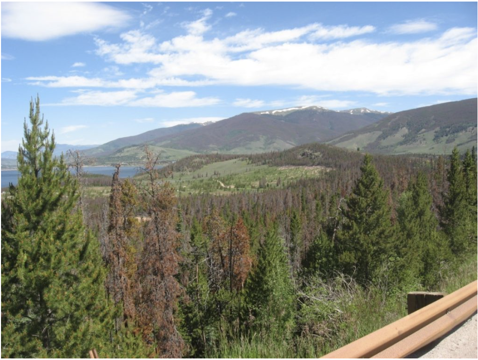
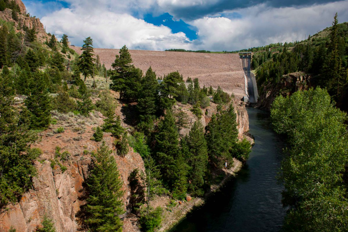
Several towns and counties in Colorado are preparing for flooding after a snowy winter and several spring snowstorms have led to the state’s best snowpack in eight years, which is now on the verge of melting into runoff…
Take the above-average snowpack, add in historic avalanches that deposited debris in Tenmile Creek, and the town of Frisco wants to be ready for potential spring flooding. That’s why they’re taking extra steps this year to prepare.
“Are we sounding the alarm at this point? No, but we’re preparing,” said Frisco’s communications director Vanessa Agee.
Aerial shots of the avalanche areas show full trees, branches, large rocks, sediment, and snow still covering the recreation path that runs along I-70 and partially in the creek. That waterway eventually flows right through downtown Frisco.
The Frisco Public Works Department is inspecting the creek’s street crossings twice a day to look out for and remove any debris built up in the creek, and the town has staged a construction backhoe along Main Street near Tenmile Creek in case any backups happen. Sandbags are also being offered to residents, as they are every year…
Summit County says they are prepared to respond to flooding if it happens. A statement from a spokesperson read in part: “In the case of a significant flooding event anywhere in Summit County, we will establish a fire-rescue and law-enforcement incident command to respond to and manage the event.”
[…]
Frisco residents can pick up sandbags at the Public Works building (102 School Road) Monday through Friday from 8 a.m. to 4 p.m. The first 100 bags per lot are free, and are 25 cents apiece beyond that.
But residents are asked to fill their own sandbags at three piles set up throughout the town: 6th Ave./Galena Street; Madison Ave./Sunset Dr. or the Public Works shop on School Road. Once residents are done using the bags, the town is asking people to return to the sand back to the piles…
Hinsdale County, in central Colorado, held community meetings earlier this week to discuss evacuation plans, with flooding expected to hit the county seat of Lake City in coming weeks.
Avalanches this winter and spring sent large amounts of trees, rocks and earth into Henson Creek and the Lake Fork River, which runs through town.
When [the log and ice jams] release it could cause extensive damage to the town and the local infrastructure,” the Mineral County Sheriff’s Office wrote on its Facebook page.
Combined with typical runoff that happens each year, the county says it expects flooding to occur as the waterways become backed up with water. Henson Creek Road and Lake Road are closed at certain points until further notice, the county said.
During recent testing mandated by the Colorado Department of Public Health and Environment at 20 different sites earlier this year, the town discovered that seven had lead levels in excess of the state’s maximum allowable limit of 15 parts per billion. The finding comes just months after Frisco discovered a similar issue in their sampling pool.
Dillon officials stress that the town has good, clean surface water.
“We don’t have lead in our source water,” said Scott O’Brien, Dillon’s public works director. “We’ve monitored for that, and it’s not the issue. … The issue is the materials that were used prior to 1987 for constructing homes, copper pipe with leaded solder. In addition to that, a lot of fixtures like faucets were constructed with either brass or bronze — metal alloys that contain lead.”
O’Brien said that because the source water is so “aggressive,” it’s leeching the lead out of older pipes and fixtures at testing sites, resulting in the elevated rates. In determining aggressiveness, the town looks at four main factors: pH levels, alkalinity, temperature and hardness.
The pH level in the water measures how acidic or basic the water is on a scale of 0 to 14 — anything below 7 is considered acidic, and anything higher is considered basic. In general, high acidity means the water is more corrosive, and more likely to leech metal ions like lead and copper. Dillon’s source water is naturally about 7.3, or slightly leaning towards the basic side.
Alkalinity is a measure of the buffering ability of the water, essentially the ratio of hydrogen ions versus hydroxide ions that determines the water’s ability to neutralize acid. O’Brien noted that Dillon’s water has low alkalinity. Temperature is self-explanatory, literally describing how hot or cold the water is — wherein hotter water is more reactive and aggressive than cold water. Hardness measures the mineral concentration in the water, or what it’s naturally picking up as it flows along. Because Dillon uses its source water so quickly, it is relatively soft.
“We’re the first in line to pick it up, and it doesn’t have the chance to pick up these other minerals and other things that help reduce the aggressiveness of the water,” said O’Brien.
This is a problem that Dillon has dealt with in the past. The town’s testing also returned high lead levels in both 2012 and 2014, and officials have been working with the state since to address the issue. In 2014, the town attempted to adjust the pH levels up to about 8.5 on the scale, which appeared to have worked over the last five years. Though, due to recent changes in regulations from the state level — which essentially requires towns to zero in on high-risk testing sites to determine the worst-case scenarios for water quality issues — new issues are being discovered.
“To get a representative sample pool they don’t want us to go over the distribution system geographically, and sample it spread out,” said Mark Helman, chief water plant operator. “They want us to sample these particular sites built from 1983 to 1987 (before the Lead Contamination Control Act in 1988) they know are going to give us the worst results. … This is a process of us learning where the worst sites are that we have, testing those sites, seeing how our water is doing at those sites, and if we have a problem we want to address the worst case scenario.”
Both O’Brien and Helman noted that they already have a plan to try and address the issue of overly aggressive water. The plan is to add soda ash — sodium carbonate or baking soda — during the water treatment process to increase pH levels, alkalinity and hardness to the water to reduce aggressiveness. However, because it includes changes to the plant, the new process must first be signed off on by the state.
O’Brien said that once the state approves the town’s new water treatment methods they’ll be able to implement the new process quickly, though the review process could take between 30 and 60 days.
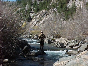
Fish kills in the North Fork of the South Platte River are occurring during low water flow periods that fail to dilute the toxicity of heavy metals such as iron, copper and aluminum. Contaminants in the form of heavy metals move downstream, originating primarily from Hall Valley and Geneva Creek mining operations.
When water flow is adequate, there is enough oxygen to negate the impact of the toxins. When water levels are inadequate, fish develop coatings on their gills as a natural self-defense mechanism to the toxins. That protective coating ultimately renders their gills inoperable.
When and why do water levels get too low?
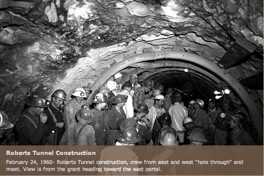
Water flow in the river is dependent upon how much water is released from Dillon Reservoir through Roberts Tunnel, and those decisions are made almost exclusively by Denver Water.
When more water is needed within Denver Water service areas, the rate of the water passing through Roberts Tunnel is set to flow more freely. When water is not needed to serve the Denver Water service area, the flow from Roberts Tunnel is restricted, much to the detriment of the people, and the fish, in Park County.
Water flows can be naturally low in the river during certain seasons. This year, in mid-March, for example, snowmelt had not yet occurred and the river was in its customary state of low flow prior to the fast-approaching late-spring thaw.
An abundance of area-wide spring moisture, however, created a situation where Denver Water service areas enjoyed a surplus of water. Therefore, the flow from Roberts Tunnel and Dillon Reservoir was ceased on March 11 and remained so at least until this writing.
The predictable result was the most recent fish kill, which occurred March 11-15, because flows were simply not sufficient to combat ever-present toxic heavy metals related to mining. No information has been provided by Denver Water as to when the tunnel will be reopened.
Denver Water states its position
When The Flume recently requested a statement from Denver Water regarding flows in the river and operations of Roberts Tunnel, a response was received in timely fashion.
In direct response to whether or not Denver Water felt a moral obligation to residents in Park County related to ecological systems they have long controlled, and whether Denver Water should accept responsibility for maintaining minimal flow in the South Platte River for the environmental and economical benefit of the entire North Fork region, the following statement was submitted:
“We (Denver Water) understand the potential for impacts to the fishery when flows from the Roberts Tunnel are shut down, and certainly recognize and appreciate the effect on the angling community and local businesses and outfitters. Unfortunately, operation of the Roberts Tunnel is directed by legal obligations and decrees tied to Colorado water law and binding agreements with West Slope communities where the water from the tunnel originates.
“As you know, the flows from the Roberts Tunnel originate in water diverted from West Slope rivers and streams into Dillon Reservoir. Denver Water depends on this supply when snow pack within the Upper South Platte watershed is insufficient. However, since early March, portions of the Upper South Platte watershed have received more than four feet of snow and spring precipitation continues to be strong.
“Legally, water supplied through the Roberts Tunnel can only be accessed when water is needed in Denver Water’s service area. Further, any other uses for the water, including augmenting stream flows for aquatic life or recreation uses, are not allowed as a primary purpose for operating the tunnel.
“While we provide projections about how long Denver Water will deliver water through the tunnel, those are only estimates based on snow pack, reservoir storage and other system elements. Those projections can change as conditions change; as they did in late winter and early spring this year.”
Colorado transmountain diversions via the State Engineer’s office
The Blue River turned orange in Breckenridge on Saturday afternoon. The river’s water went from its natural blue-green hue to a bright, burnt orange within a few hours, with emergency officials believing the discoloration to be runoff from an area above Illinois Gulch known to cause similar discoloration in the past.
After investigating, fire officials determined that the runoff came from a mine located on private property at the corner of Boreas Pass Road and Bright Hope Circle. The water runoff at the source appeared as a thick, muddy orange stream with no obvious unique odor or taste. Fire officials said that the location has been the source of orange mine runoffs in the past…
Red, White and Blue Fire District issued a press release Saturday evening stating that first responders were alerted about discolored water in the Blue River at 3:15 p.m. Multiple fire companies and a specialty HAZMAT unit responded. The fire district determined that the source of the orange water was a known release point on Boreas Pass Road. Initial testing done by fire district personnel found the water to not be an immediate danger to human health. The fire district also said there is no immediate corrective action possible from first responders. Typically, this kind of orange mine runoff lasts about 24 hours.
“Given the rainfall that occurred last night, it is not surprising that we are seeing this type of activity today,” said RWB batallion chief and incident commander Drew Hoehn. “We realize the optics of the run-off are in stark contrast to what folks are normally used to seeing in the Blue River, but we are confident in the assessment and assurance of the public’s welfare in this particular situation.”
Summit County’s director of environmental health, Dan Hendershott, also sought to downplay concerns about the health impact of the orange water.
“Based on previous similar releases that have occurred, we don’t have reason to believe this event poses a risk to the public’s health,” Hendershott said. “However, out of an abundance of caution, we recommend that people and pets avoid contact with this water. Untreated surface water should never be consumed, and that would certainly be the case here, too.”
Authorities are still investigating the incident and all local water districts have been notified. The Blue River is one of the primary sources for the Dillon Reservoir, which provides drinking water for hundreds of thousands of people on the Front Range.
Prior to mining, snowmelt and rain seep into natural cracks and fractures, eventually emerging as a freshwater spring (usually). Graphic credit: Jonathan Thompson
CU Boulder researchers harness 35 years of data to uncover responses of a high-elevation reservoir to a warming world
The surface waters of Lake Dillon, a mountain reservoir that supplies water to the the Denver area, have warmed by nearly 5 degrees Fahrenheit (2.5 degrees Celsius) in the last 35 years, which is twice the average warming rate for global lakes. Yet surprisingly, Dillon does not show adverse environmental changes, such as nuisance algal blooms, often associated with warming of lakes. Researchers at the CIRES Center for Limnology, who have just published a multi-decadal study of Lake Dillon, conclude that the lake’s rapid warming and its lack of ecological response to warming are explained by the high elevation of the lake.
“The warming of Lake Dillon is a result of climate change but, in contrast with warm lakes, which respond in undesirable ways to warming, Lake Dillon shows no environmental response to warming, said William Lewis, Director of the CIRES Center for Limnology and lead author of the new paper published today in AGU’s Water Resources Research. “The explanation for the lake’s ecological stability lies in its low temperature, which serves as a buffer against ecological effects of warming.”
Since 1981, Lewis and colleagues in the CIRES Center for Limnology have collected detailed information not only on Lake Dillon’s temperature, but also on its water quality and aquatic life. Full vertical profiles of water temperature document changes in vertical distribution of heat over time. The record shows that warming of tributary water contributes to warming of the lake’s deepest waters.
“The 35-year data set allows us to see the complete warming pattern of the lake,” said James McCutchan, associate director of the Center. Natural events, including droughts and floods, create interannual variation that obscures the effects of climate change over short intervals, whereas multidecadal data sets can show more clearly the effects of climatic warming.
Dillon is the highest lake yet studied for full water column warming, as Lewis and his colleagues note in their paper. The study also is the first to analyze warming in a reservoir, rather than a natural lake.
“Reservoirs can differ fundamentally from other lakes in their response to warming because they often release water from the bottom as well as the top of the water column,” said Lewis. “They can warm not only from the top, in response to solar radiation reaching the surface, but also from the bottom, as tributaries subject to climatic warming replace cold bottom water with progressively warmer tributary water.”
The Lake Dillon study program is sponsored by Denver Water, which uses the water for treatment and delivery to Denver residents, and by the Summit Water Quality Committee, which represents the interests of local residents in preservation of Lake Dillon’s water quality.
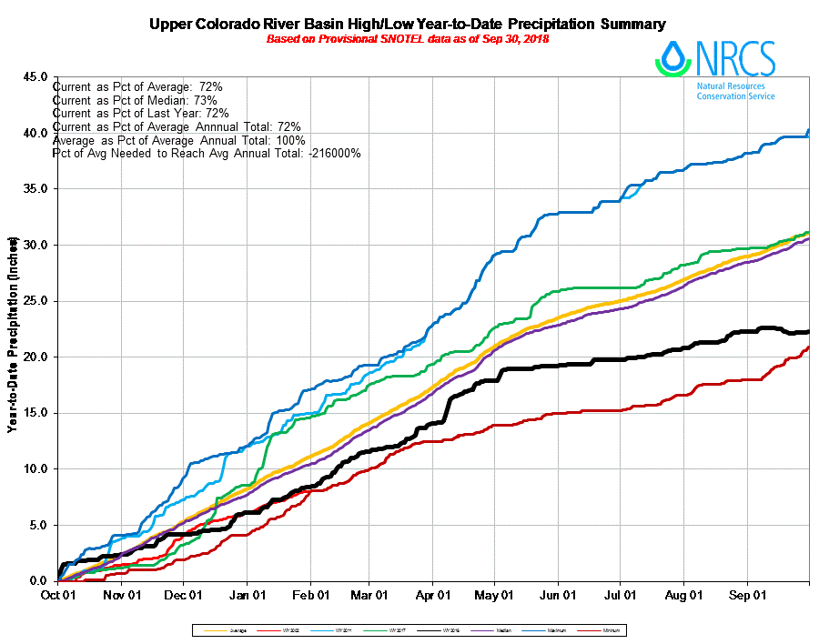
Colorado water managers are saying good riddance to water year 2018. It enters the history books alongside 2002 and 1977 as one of the driest on record for the Upper Colorado River Basin.
According to preliminary numbers from the Bureau of Reclamation, water year 2018, which ended Sept. 30, had the third-lowest unregulated inflow into Lake Powell at 4.62 million acre-feet. That’s just 43 percent of average.
Only 1977 and 2002 saw less water flow into Lake Powell from the upper basin, at 3.53 million acre-feet and 2.64 million acre-feet, respectively.
The average yearly inflow is 10.8 million acre-feet.
The months of August and September 2018 were the third- and fourth-worst months for unregulated inflows into Lake Powell behind only July and August of 2002.
The unregulated flow in August was just 2 percent of average. Lake Powell is currently 46 percent full.
“We know if we have another drought, the risk of draining Lake Powell is real,” said Jim Pokrandt, director of community affairs for the Colorado River Water Conservation District and chairman of the Colorado Basin Roundtable. “If we have another year as bad as this one, you’re going to see lots of discussions about who’s going to take reductions. We really need three, four, several years of average or above-average snow years to get us out of this pickle.”
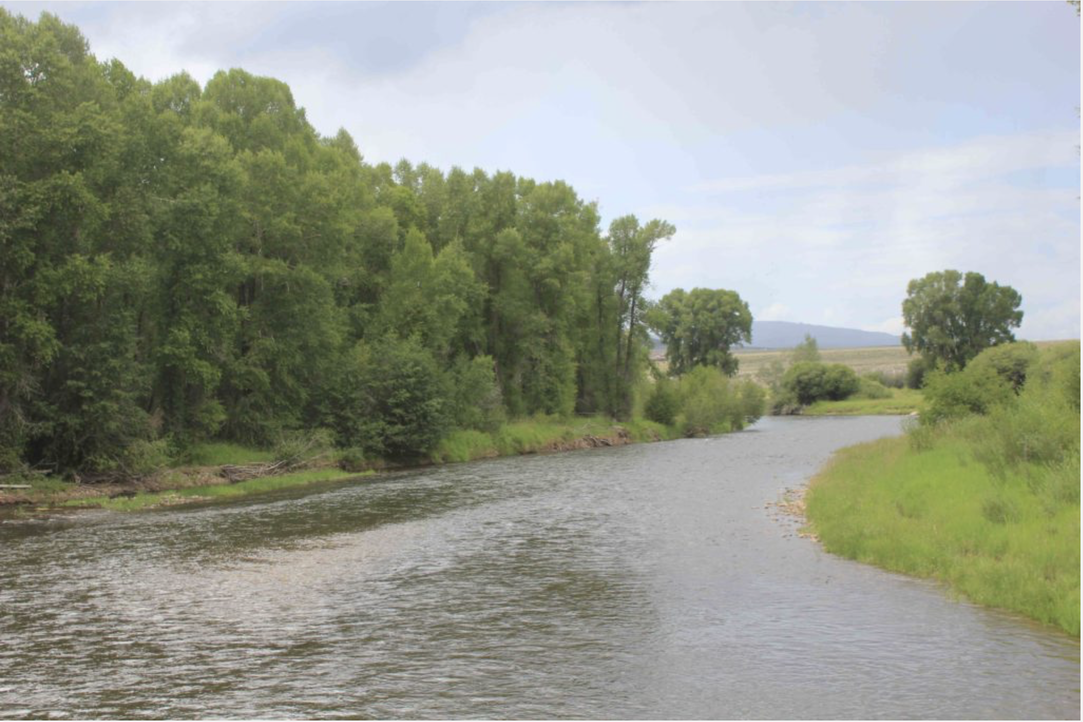
Low flows in the Roaring Fork River just above Rio Grande Park, in July 2012. Water year 2018 surpassed 2012 as third driest in terms of inflow into Lake Powell from the Upper Colorado River Basin. Photo credit: Aspen Journalism/Brent Gardner-Smith
Roaring Fork conditions
Locally, the Roaring Fork watershed was extremely dry this water year. The region was plagued by record-low snowpack — the lowest snow-water equivalent ever recorded for some dates at the McClure Pass and Independence Pass SNOTEL sites — sparse runoff, record-low streamflows and a hot, dry summer.
Low flows were prevalent across Colorado during the last two weeks of the water year, which runs from October through September. According to the National Oceanic and Atmospheric Administration’s drought information system, 30 percent of U.S. Geological Survey stream gauges in the intermountain West reported record-low seven-day-average stream flows for the last two weeks of September, including some in the Roaring Fork watershed.
On Sunday, the last day of the water year, the USGS river gauge on the Roaring Fork at Stillwater Road just east of Aspen showed the river flowing at 19 cubic feet per second, beating the previous minimum flow of 21 cfs in 1977.
Flows on the Crystal River were similarly low. Above Avalanche Creek and above a series of diversion structures, the river was running at nearly 46 cfs, lower than the previous record low of 48 cfs in 1977.
At the river gauge near the state fish hatchery and downstream from several diversion structures just outside of Carbondale, flows dribbled down at just under 7 cfs Sunday.
Colorado Department of Water Resources Engineer for Division 5 Alan Martellaro said the summer’s weak monsoons exacerbated conditions caused by little snowfall.
“We had a bad snowpack,” Martellaro said. “It was not the worst, but then we have had an incredibly dry summer, a total lack of rain. I think when we start analyzing it, we are going to find the flows in late summer are unprecedented. We have done some things we have never done before.”
Martellaro is referring to curtailment on the lower Crystal in late July. Amid rapidly dropping flows, the district 38 water commissioner turned down the headgate of the Lowline Ditch, which he determined was diverting too much water. The ditch diversion did not exceed its legally decreed amount; the problem was that it was violating new state guidelines regarding wasting water.
According to data from the Natural Resources Conservation Service, many sites around western Colorado rank as the driest since recording began for water-year precipitation, including McClure Pass, Schofield Pass and Independence Pass.
Statewide, the water year precipitation average at all SNOTEL sites measured just 21.4 inches, which is 64 percent of average — the second-lowest on record behind only 2002.
“It was pretty consistently dry throughout the entire year,” said Karl Wetlaufer, a hydrologist with the NRCS Colorado Snow Survey. “February may have been the only month where we had near-normal precipitation across the state.”
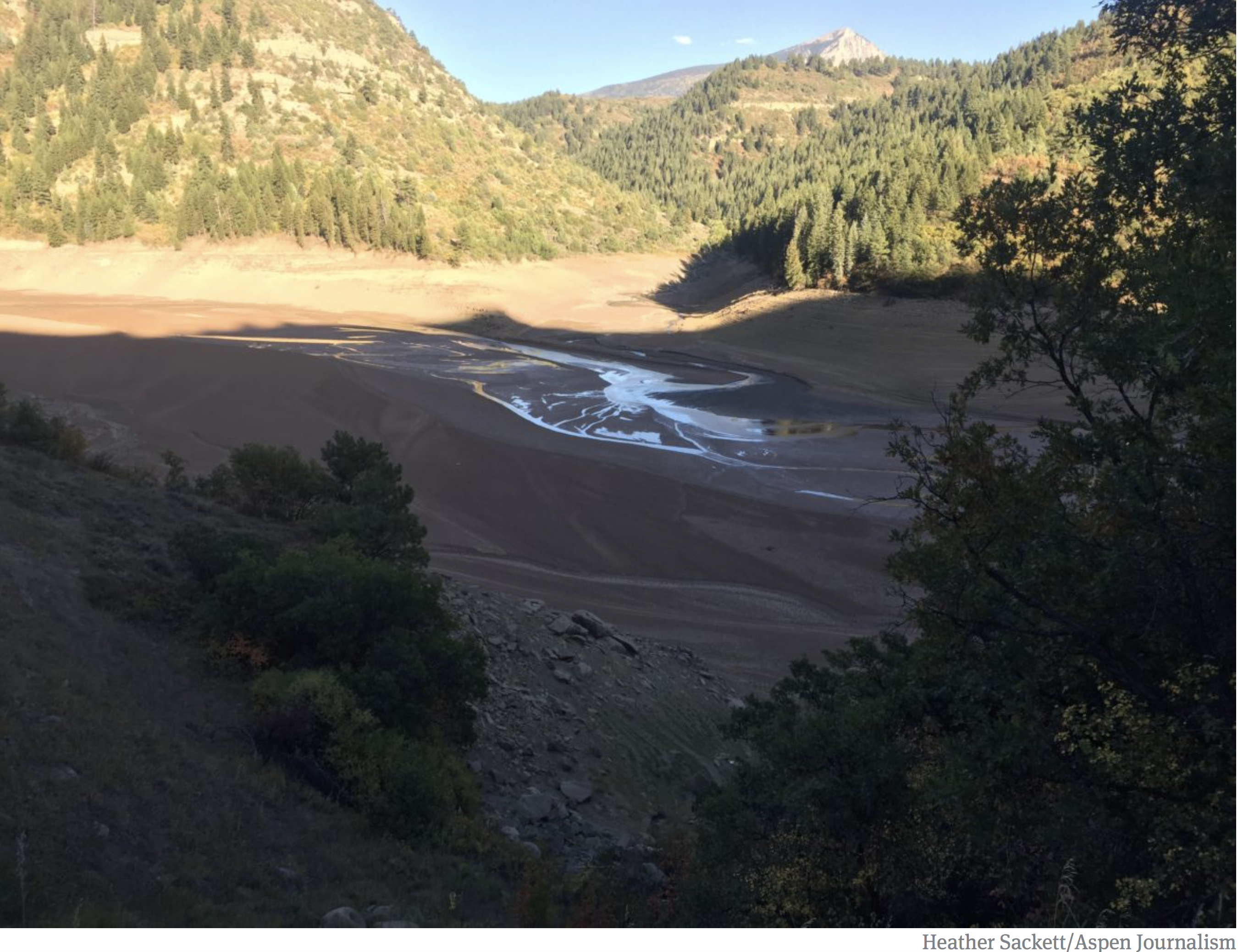
Paonia Reservoir was at 7 percent full at the end of September. Water year 2018 ranked as the third driest in the Colorado River Basin. Photo credit: Heather Sackett/Aspen Journalism
Reservoirs low
In some instances, reservoir releases have come to the rescue of downstream anglers, fish and ecosystems.
Releases from Ruedi Reservoir will continue through October to bolster flows for endangered fish in what’s known as the 15-mile reach, a notoriously dry section of the Colorado River between the Palisade area and the confluence with the Gunnison River in Grand Junction.
[Reclamation has been releasing water from] Ruedi Reservoir.
Periodic releases from Green Mountain Reservoir near Kremmling also boosted summer flows in the Colorado River. But that water will need to be replaced this winter by snowfall, Martellaro said. Ruedi Reservoir is currently 63 percent full while Green Mountain Reservoir is nearly 46 percent full.
“Where we have large reservoirs that can supplement the flows, yeah, we’ve gotten by,” Martellaro said. “But even that is coming to an end. We are running out. It remains to be seen what the snowpack is like to refill these large holes we’ve put in these reservoirs.”
Water year 2018 Upper Colorado River Basin precipitation accumulation via the NRCS.
This evening, 17 September, 2018, we at Reclamation adjusted releases from Green Mountain Reservoir to the Blue River from 525 to 475 cubic feet per second (cfs). Releases will remain at 475 cfs until further notice.
Feel free to contact me with any questions at jbishop@usbr.gov or by phone at 970-962-4326.
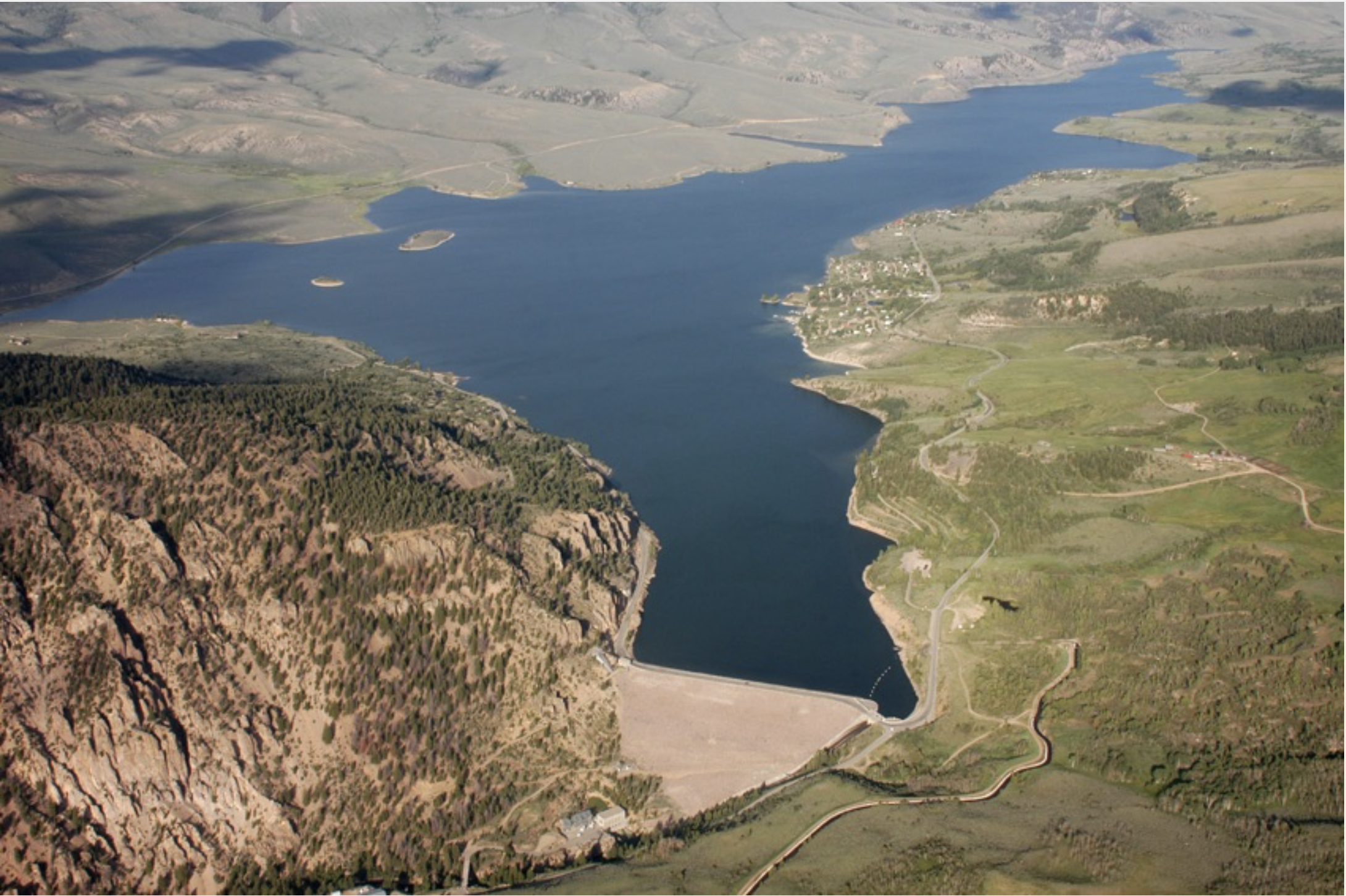
Staff at Frisco Bay Marina are trying to keep up with water levels that are dropping about one inch per day.
“And so an inch a day going down means the water line is moving 10 feet out every day, so we have to keep chasing it and moving the docks, which is definitely a lot of work,” said Tom Hogeman, the marina’s general manager…
Hogeman said he hasn’t seen the water this low since 2012 and it will only continue to go down as we head into the fall. The marina is typically open for rentals through mid-October but this year the season could end early.
Colorado River Basin in Colorado via the Colorado Geological Survey
FromThe Grand Junction Daily Sentinel (Dennis Webb):
The Colorado River District has agreed to boost water levels to help fish in the Roaring Fork River watershed while also conserving water for use by local irrigators later in the season and improving the chances for boosting flows this fall for endangered fish.
The action also could help protect water quality in the case of anticipated ash in waterways due to expected flooding and debris flows resulting from the Lake Christine Fire near Basalt.
The river district is releasing water from Ruedi Reservoir above Basalt to boost flows in the Fryingpan River and Roaring Fork River to help reduce water temperatures to benefit trout. Low flows and warm temperatures in western Colorado have led to Colorado Parks and Wildlife urging anglers to avoid fishing later in the day on numerous western Colorado waterways due to the stress trout currently are facing.
The U.S. Bureau of Reclamation approved the river district releases last week. They are expected to range between 50 and 100 cubic feet per second.
River district spokesman Zane Kessler said the water to be released is owned and managed by the river district’s enterprise…
The water technically is being delivered downstream for Grand Valley irrigation needs but is creating environmental benefits on its way there. The water otherwise would have been delivered from Green Mountain Reservoir south of Kremmling.
Kessler said the Ruedi releases will allow for conserving a part of what’s called the historic users pool at Green Mountain Reservoir for use later in the season, which would benefit Grand Valley irrigators. The releases also increase the chances that, despite it being a dry year, that pool can be declared to have a surplus. That surplus could then be delivered in September and October to what’s known as the 15-Mile Reach, a stretch of the Colorado River in the Grand Valley where the flows would benefit endangered fish.
“This has never been done before,” Kessler said of the flow agreement. “But we’ve rarely seen river levels like this before either.”
The potential for easing the impacts of ash flow also could be felt in the Grand Valley. There is concern that ash flows could force the Clifton Water District to suspend use of Colorado River water. Area water providers have an agreement to help each other in meeting short-term water needs should that kind of emergency situation arise, but doing so this year would further deplete drought-stressed supplies.
Kessler said retaining some Green Mountain Reservoir water for release later in the year also could benefit recreational uses of the Upper Colorado River.
Meanwhile, the river district is taking another step aimed at helping ensure that benefiting fish in the Roaring Fork Valley doesn’t harm fish on the Colorado River upstream of the Roaring Fork confluence. The district is currently delivering what Kessler called “fish water” from Wolford Reservoir north of Kremmling into the upper Colorado River because it is having to lower the reservoir’s water level in preparation for doing some work on the dam there.
Eric Kuhn has retired as manager of the Colorado River Water Conservation District, but he believes he has an important message about the Colorado River. Photo credit: Allen Best/The Mountain Town News
A time of big pivots for Colorado water — with yet another reckoning to come
Eric Kuhn is now retired as general manager of the Colorado River Water Conservation District, but he may be working on the most important project of his career, a book.
In that book, working with John Fleck of Albuquerque, he’s trying to make the case that science should not be ignored in figuring out how to manage the Colorado River during the 21st century—as it was when Congress approved the 1922 compact governing allocations among the seven states, Indian tribes, and, somewhat more fuzzily, Mexico.
Kuhn was honored recently in Glenwood Springs by his staff and others from around Colorado for his 37 years of work.
Trained as an electrical engineer, Kuhn had been a naval office on a nuclear-powered submarine before pursuing a career in nuclear power plants. But even in 1981, he could see that nuclear power wasn’t going in the right direction. When he noticed an advertisement in the Wall Street Journal for a position at the Glenwood Springs-based water district, he applied.
Obviously, he got the job, moving from energy to water, from California to Colorado.
It was sharp pivot in Kuhn’s life. And Colorado since 1981 has also pivoted hard in very fundamental ways in its conversations about water.
Tom Alvey, who grows fruit and operates a packing shed in Hotchkiss, credited Kuhn with providing transparency and “getting the facts right” during his time as general manager of the Colorado River Water Conservation District, beginning in 1996.
Bill Trampe, who owns a ranch that sprawls between Crested Butte and Gunnison, lauded Kuhn for having “the foresight to see where we were headed and what we needed to do to be effective in protecting water for the Western Slope.”
Peter Fleming, the river district’s general counsel, testified to Kuhn’s “highly intellectual approach to negotiations.” As arguments and counterarguments were waged at one session, said Fleming, he observed Kuhn scribbling into a notepad. Peering over his boss’s shoulder, he said, he saw numbers. What did they represent? “He was calculating complex integers,” Fleming discovered. In that scribbling could be seen a larger lesson.
“He wasn’t disinterested in what was going on,” said Fleming. “He just knew that the timing wasn’t right for him to offer what would inevitably be a good solution.”
Denver Water’s Jim Lochhead was also at the gathering in Glenwood, just a few blocks from where he had for many years staffed the “Aspen office” of one of the state’s leading law firms. Lochhead drew attention to Kuhn’s influence beyond Colorado’s traditional Eastern Slope versus Western Slope schisms to the broader seven-state Colorado River Basin. There, Kuhn’s voice about preparing for a warming climate has become influential.
“He is collaborative. He is innovative. He thinks about different solutions. He listens. He tries to find the common ground,” said Lochhead, now chief executive of Denver Water, an agency that provides water to 25 percent of all Colorado residents.
A time of pivots
Nobody, however, spoke directly to the giant pivots in water politics, policies and problems in the 37 years since Kuhn arrived in Colorado.
One of the largest pivots had already begun in 1981. The federal government had spent most of the 20th century building the giant dams, canals and other hydraulic infrastructure in the West. In Colorado, the greatest ambition was evident in the gigantic transfer of water from the Colorado River headwaters near Grand Lake to the benefit of farmers in northeastern Colorado. It’s called the Colorado-Big Thompson Project.
The transfer—some would call it a heist — was opposed on the Western Slope, of course. One result of the compromise was a 1937 state law that created the river district and charged it with “conservation, use and development of water in the Colorado River and its principal tributaries in Colorado.” It covers 15 counties, including Pitkin, Garfield and Eagle. Southwestern Colorado has a similar district.
Another outcome was federal construction of Green Mountain Reservoir, on the Blue River north of Silverthorne. The dam had immediate benefits to the Western Slope, helping regulate flows to the benefit of farmers around Grand Junction. Much later, the regulated flows were crucial to providing water for endangered fish species in the Colorado River.
Green Mountain Reservoir, on the Blue River between Kremmling and and Silverthorne, was built for Western Slope interests. Photo/Northern Colorado Water Conservancy District via The Mountain Town News.
A later enterprise, the Fryingpan-Arkansas Project, hewed to the same template: It diverts water from the Roaring Fork drainage to farmers in southeast Colorado. For this, the Western Slope got Ruedi Reservoir. It was completed 50 years ago.
More projects were proposed, but in 1977 President Jimmy Carter announced they wouldn’t get funded. Westerners bristled and ridiculed Carter as a peanut-farmer in rain-drenched Georgia who didn’t understand the West. Ronald Reagan, arriving at the White House in 1981, was heralded as a Westerner who would right things. He only went half-way: Locals would have to come up with half the money for their dams and diversions. For most projects, it wasn’t nearly enough.
The Colorado River originates in Rocky Mountain Natonal Park and soon descends into the bucolic loveliness of Middle Park. Photo/Allen Best
Kuhn noted that during his time, two of the five projects on Carter’s hit list in Colorado were eventually built, if not to the sizes originally envisioned. One of them, Ridgway Reservoir (originally called Dallas Divide), provides hydroelectricity that is part of Aspen Electric’s 100 percent renewable portfolio.
Altogether, however, the river district during Kuhn’s time had a hand in building five smaller-size reservoirs. Wolford Mountain Reservoir near Kremmling, by far the largest, is two-thirds the size of Ruedi. It was built in co-operation with Denver Water.
The River District under Kuhn also worked with Denver Water on other projects. But when Kuhn started work in Glenwood Springs, the relations were rocky. Denver wanted to build a giant dam in the foothills southwest of the city. Two-thirds of the water behind the Two Forks Dam was to have come from the Western Slope, primarily Summit County. Water was to go to Denver’s fast-growing suburbs.
Kuhn had been assigned to represent the river district on a task force appointed by then-Gov. Dick Lamm, to help sort through the controversy. The Western Slope task force aligned with the environmental community and together they conceded need for a small Two Forks as well as expanded diversions from Winter Park area for an enlarged Gross Reservoir west of Boulder. In exchange, the task force said, Denver needed to commit to greater water conservation. Denver Water’s leaders, confident of their rightness to the point of cockiness, refused.
The drama was cut short in 1991 when the administration of President George H.W. Bush vetoed the project, which was to be on federal land, based on environmental impacts.
Kuhn points out that the levels of conservation the Western Slope and environmentalists asked of Denver were much less than what has actually occurred. Denver Water now uses the same water for roughly double the number of people it did in 1990. The default expectation of ever-more water supplies has been shattered.
“You have this decoupling of municipal growth and water use, and we really didn’t see that coming in the early 1980s,” Kuhn said in an interview last week.
Denver, Aspen and other communities have been part of a national trend of declining per-capita use of water that may be far from over. It’s a simple matter of economics. Wringing the sponge of water conservation is cheaper. More expensive is buying water from farms on the Great Plains, but it’s still cheaper than developing new supplies.
The Colorado River wends its way through southern Utah and, at Glen Canyon, is impounded into Lake Powell. Photo/Allen Best
Still being debated is how much water Colorado has to develop out of its entitlement, under compacts governing the Colorado River. As with Two Forks, a notion that the solution to water shortages is to build more dams and divert more still lingers. It assumes water remains available. A state report issued several years ago concluded that Colorado had as much as 1.5 million acre-feet of water in the Colorado River to develop.
Kuhn scoffed at that estimate. He said then that no more than 150,000 acre-feet remained—and, quite possibly, not even that. Even allocations for existing water uses are questionable because of the dangling uncertainty of the warming climate.
After rummaging around climate change science beginning in about 2000, Kuhn became increasingly vocal through published papers and other work about the need to recognize the profound implications of a warming climate on water supplies in the Colorado River and the demands.
“I was just reading some of the work that was coming out in the early 2000s, and it’s largely proven to be generally correct,” he said last week. “I am surprised how quickly it has come on, because there is so much noise in the system,” he added, referring to the inherent variability of weather, both temperature and precipitation. “Even from one year to the next there can be a lot of noise.”
A cloudy crystal ball
What this means exactly for Colorado is still hard to say. There’s still too much uncertainty about impacts to justify significant infrastructure investments at this time, according to even Denver Water. Kuhn agrees.
“It will take a long time to see how that pattern (of change) sets up,” he said.
Climate modeling suggests—but with low confidence—less snow and precipitation for southern Colorado and more for northern Colorado. The Elk Range between Aspen and Crested butte can be seen as a divide between that wetter and drier future.
“If I were in the southwest, in Durango, I would be a heck of a lot more concerned than if I were in Steamboat Springs, based on what we know now—but it’s still a guess,” he said.
Just inside the Mexican border, at San Luis Rio Colorado, nothing remains of the Colorado River except for its sandy bed. Photo/Allen Best
For the broader Colorado River Basin, though, Kuhn expects less water in the Colorado River as it flows into the Grand Canyon past Lees Ferry. In this, last winter was a harbinger of the future. There are profound implications for how the seven states of the Colorado River Basin – plus Mexico—move forward.
And that is the big idea for the book now being written. In it, he and Fleck point to a report issued before the Colorado River Compact was formally adopted by Congress in 1928. The framers of the compact had assumed 16.4 million acre-feet average flows in allocating the waters among the seven basin states — with more yet due Mexico. In fact, flows during 20th century proved to be somewhat less, about 15 million acre-feet. The report provided accurate evidence of lesser flows beginning in 1875 and, more circumstantially, to 1850.
In other words, it was wishful thinking to assume so much water — and based on what is known about global warming, it’s fair to assume even less water in the 21st century. Through the first 14 years of the century, according to the research of Brad Udall and Jonathan Overpeck, flows have declined 19 percent.
“It’s a story about ignoring inconvenient science,” Kuhn said of the book. “If you had accepted the science, it would have made the political job [of apportioning the waters] much more difficult.”
It’s a story from a century ago, he said — but one fully relevant going forward.
For more of Kuhn’s thinking about the future of the Colorado River, see brief white paper: “Tne Upper Basin is Watching.”
The Colorado River District is working with state and federal water managers to increase flows in the Fryingpan River by as much as 100 cubic feet per second (cfs), helping trout in the watershed survive warm temperatures while supplying water for downstream irrigation needs in the Grand Valley.
Anticipated releases are expected to range between 50 cfs and 100 cfs and will be coordinated between the River District, the U.S. Bureau of Reclamation and the U.S. Fish and Wildlife Service to increase flows in the Fryingpan and Roaring Fork rivers downstream from Ruedi Reservoir.
“This should significantly benefit flows below Ruedi Reservoir,” said John Currier, chief engineer for the district. “We expect that the supplement flows may also help to mitigate water-quality problems anticipated from fire-related ash and debris flows stemming from the Lake Christine Fire on Basalt Mountain.”
Technically, the water will be delivered downstream for Grand Valley irrigation needs while creating environmental benefits as it flows downstream. Green Mountain Reservoir releases will be reduced by an equal amount in order to conserve storage for late-season releases, which in turn will be needed to help endangered fish near Grand Junction.
The coordinated approach was given final approval by the Bureau of Reclamation on Monday. In order to boost Fryingpan levels while the plan awaited approval, the U.S. Fish and Wildlife Service implemented a 50 cfs release from its dedicated endangered fish pool in Ruedi on Friday. Those flows were supplemented by 30 additional cfs Monday, bringing the flow in the Fryingpan to 200 cfs.
Both Ruedi and Green Mountain reservoirs contribute water to the Upper Colorado River Endangered Fish Recovery Program. In this case, the changed water release plan will benefit trout below Ruedi while endangered fish still receive water from upstream Colorado River reservoirs.
Increased flows of cold water out of Ruedi should also help to alleviate some stress on trout fisheries in the watershed brought on by higher-than-normal water temperatures. Colorado Parks and Wildlife announced voluntary fishing closures earlier this month on sections of the Colorado and Roaring Fork rivers.
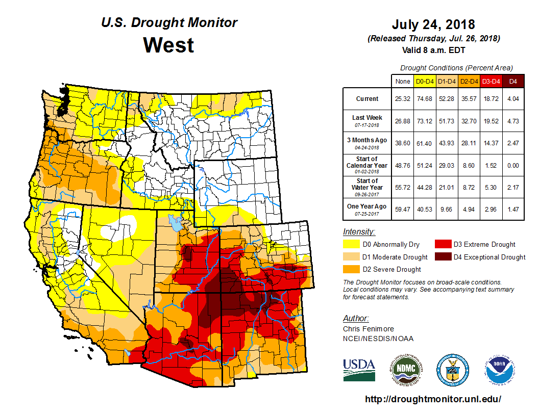
Despite promises of a wet monsoon season, Colorado’s arid reality has spread into Summit, which is now part of the 60 percent of the state experiencing “severe drought.”
Nathan Elder, manager of raw water supply for Denver Water, said low water levels at the South Platte reservoir in Littleton created a need for a big draw from Dillon. Even though human consumption is Denver Water’s primary use, Elder said they do keep the marinas in mind.
“We are very concerned with how that affects the recreation industry and keeping marinas in the reservoir,” Elder said. “We plan to keep marinas operating from June to Labor Day, but this has been an exceptional year. The water levels won’t go back to normal this year, and what happens next year depends on the snowpack we get this winter.”
The U.S. Drought Monitor, which tracks drought across the country and assigns drought severity based on conditions, assigns dryness levels from D0 to D4. D0 is considered “abnormally dry” but not severe enough to be considered a drought, while D4 is considered an “exceptional drought” that means there is a serious water emergency that causes “exceptional and widespread” crop and pasture losses.
Summit County’s “severe drought” is at level D2. At that stage, crop and pasture losses are likely, water shortages are common and water restrictions are imposed.
Victor Lee is a hydrologist and civil engineer for the Bureau of Reclamation, which manages the Green Mountain Reservoir in Heeney. Lee said that the monsoon is kicking in late due to less-than-ideal weather patterns.
“One of the reasons the monsoon has been slow to start is the high pressure system that normally forms over the southwest needs to be closer to Texas than the four corners region,” Lee said. “The high pressure system we’ve been experiencing is more to the west, and that’s bringing in warmer air but not more of the moist air from the Gulf of Mexico.”
Combined with an early spring, that makes for a long period without significant precipitation. Lee said that there is no threat to water supplies for human consumption, yet. A few years of healthy precipitation has meant that reservoirs across the state have managed to keep healthy levels in reserve and have been steadily releasing water to keep rivers and streams flowing.
“Without the reservoirs in the system, the stream flows we would be seeing throughout the upper Colorado would be much more dire,” Lee said.
If this drought persists into yet another year, the reasons for worry will multiply and tough decisions will be made.
“These are critical times in Colorado and the southwest,” Lee said. “If the drought goes into another year, there won’t be the same amount of carry-over storage, and it will become a much more complicated issue.”
I wanted to let you know that a request has been made to the BOCC by staff and the permit applicant to continue the Mascot Placer hearing to a date certain of July 24, 2018, to allow staff time to further analyze the cumulative traffic impacts this applicant presents for the use of Tiger Road. This request would be granted at the discretion of the BOCC at the meeting on Tuesday the 10th. The opportunity for public comment on Tuesday would also be at the BOCC’s Discretion.
BRWG appreciates your support and we hope, instead of the meeting on the 10th, you can join us at the meeting on July 24th. It is at the same time and place, 1:30pm in the Commissioners’ Hearing Room in Breckenridge.
Please let me know if you have any questions.
Thanks,
Jennifer
Blue River Watershed Group
From email from the Blue River Watershed Group (Jennifer Hopkins):
The Blue River Watershed Group (BRWG) is reaching out to supporters and stakeholders of the Swan River Restoration Project to notify you of an upcoming Board of County Commissioners (BOCC) hearing that will have a significant impact on the project. As you know, the Swan River Restoration is a collaborative, multi-year effort to restore sections of the Swan River affected by historical dredge mining. The first section of the river has been restored on Summit County/Town of Breckenridge property. In order for restoration work to continue on additional reaches of the river, dredge rock tailings must be processed and removed from the sites.
The Board of County Commissioners is holding a hearing on July 10th to decide on a Conditional Use Permit that would allow Peak Materials to add a rock crushing operation at the Mascot Placer, located along the Swan River on privately owned land (comprising the third phase of the four-phase restoration project). Peak Materials has been operating a rock screening and sales operation at the site since 2003. BRWG supports the approval of the Conditional Use Permit as it will confer a number of public benefits and allow the Swan River Restoration Project to continue.
BRWG is asking supporters to attend the BOCC meeting on July 10th in support of the Swan River Restoration and approval of the Conditional Use Permit. Peak Materials is offering in-kind donations of significant crushed rock materials and other work at the site needed for the restoration (valued at approximately $1.5 million). Milling these materials on-site will decrease the amount of material taken off-site and reduce the need to import material for the restoration. The 5-year permit will expedite the removal of the dredge rock and preparation of the site for restoration activities. In addition, the private landowner has agreed to grant a public access easement covering a future stream and riparian corridor to perpetually ensure that the corridor remains undeveloped and available for public use. Without the permit, the restoration project would not receive these benefits and would likely not continue to move forward on this section of the river. At best, the restoration effort would need to find an additional $1.5M and at worst the project could be stopped entirely if the owner refuses to grant the easement if the crushing permit is denied.
It is crucial that we show community support for this permit. I would love the opportunity to discuss this issue with you further and to answer any questions you might have. Please let me know if there is a time we can chat before July 10th and I will be happy to call you. And please join us at the BOCC meeting. Here are the details:
Date: July 10th, 2018
Time: 1:30pm
Location: Commissioners’ Hearing Room, 208 E. Lincoln Ave., 3rd Floor, Breckenridge, CO 80424
Thank you for your continued support of this important project.
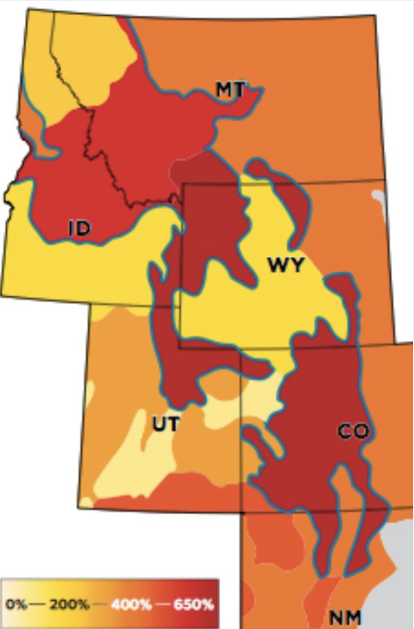
Highlighting the event was newly hired state climatologist Russ Schumacher. He gave a presentation offering some explanations about the extremely dry season we experienced this past winter. Schumacher confirmed that Colorado experienced one of the driest winters on record, after experiencing the 30th wettest year in 2017. The state experienced a bump after a heavy snowstorm in early April pushed precipitation numbers a bit closer to average.
Schumacher also confirmed that snowpack was terrible this past season. While Summit and most of the northeast portions of the state did OK, the southern part of the state did not. In the southwest, for example, snowpack levels averaged out between 30 and 40 percent of normal.
“There’s a clear dividing line between north and south,” Schumacher said. “Summit County is kind of at the middle of that. North of Summit, snowpack and precipitation are pretty OK, even above average. But in the south, they really struggled.”
Schumacher said warmer temperatures was a big factor for why the southern part of the state has been suffering.
“Everywhere in the southwest was extraordinarily warm,” Schumacher said. “Pretty much everywhere west of the divide was record warm, everywhere else that wasn’t was close to that.”
Schumacher attributed the warmer temperatures, especially in the southern part of the state, to the La Niña weather pattern that pushes the jetstream north and creates dry, warm conditions in the south and western parts of the state.
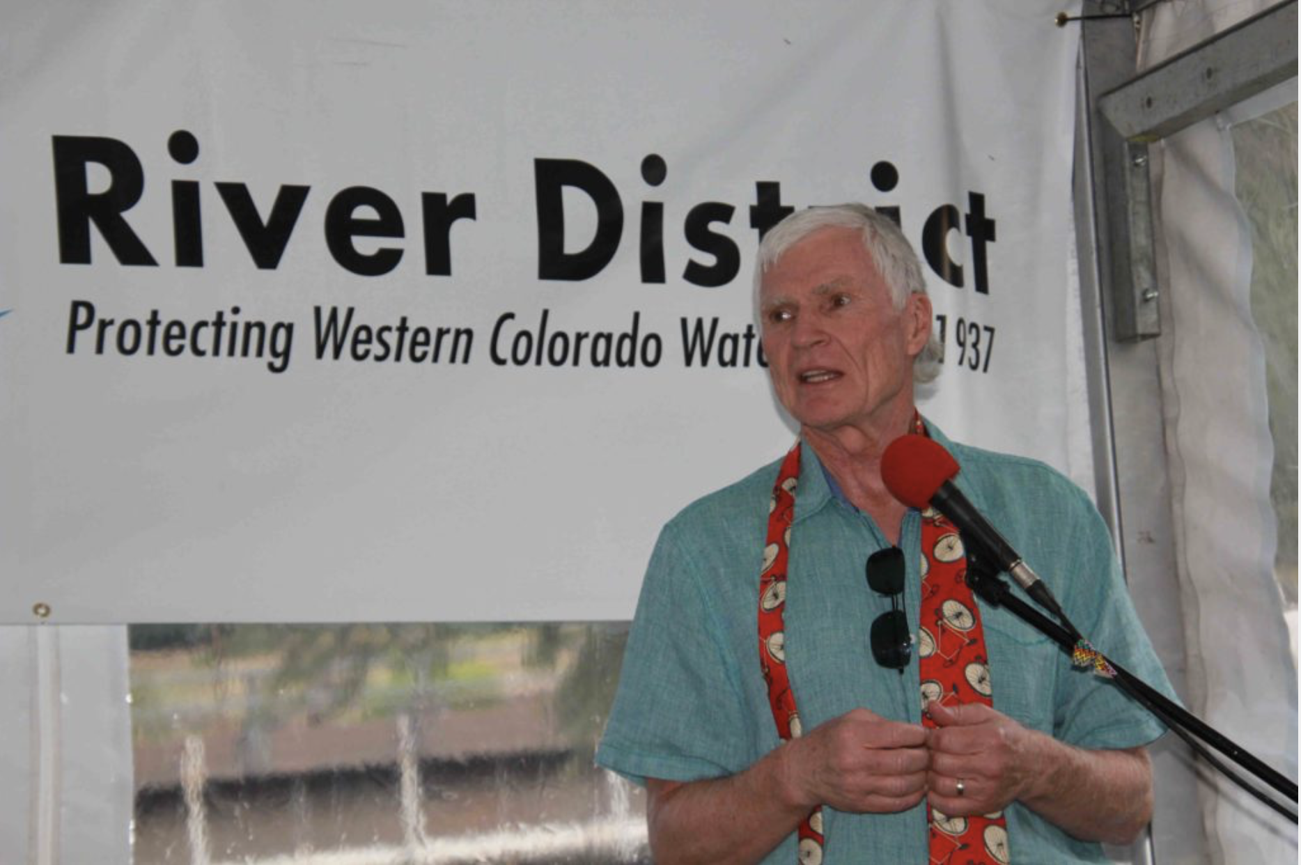
The long-term problem for Colorado’s waterways is how long these patterns can continue before it becomes a crisis. That’s where Andy Mueller, the new general manager for the Colorado River District and the night’s other featured speaker, came in.
Mueller pointed out that the current U.S. drought monitor has over 80 percent of Colorado’s population experiencing some form of drought, with the southwest experiencing extreme drought. But the problem extends beyond Colorado’s boundaries. However, Mueller said the biggest concern going forward are water flows going west to Lake Powell, one of the most important water reservoirs in the country.
Mueller called Lake Powell the state’s “water savings account.” Under the Colorado River Compact signed in 1922, the Upper Basin states — Colorado, Utah, Wyoming, and New Mexico — are required to keep an annual flow of 7.5 million acre-feet per year flowing from Lake Powell to Lake Mead and the Lower Basin states — Arizona, Nevada and California. At the moment, flow into Lake Powell is forecasted to be at around 3.1 million acre-feet, or around 43 percent of average, because of the lack of snow melt…
If Lake Mead — which is currently at 1,084 feet above mean sea level and has been less than half full for well over a decade — drops to 1,075 feet, [the 2007 Shortage Sharing Agreement] will activate and force cuts to water users downstream. That will have a domino effect that may lead to water cuts for Upper Basin states as well. There may be severe water rationing, shutdowns of hydroelectric dams and a whole other set of emergency measures that have never before been instituted by the Department of the Interior. That means economic uncertainty for a wide variety of industries including ranching, skiing and electricity.
“To avoid that, Lake Powell is expected to pump out and drop 20 feet this summer,” Mueller said. “It’s currently at 54 percent of capacity.”
Mueller added that while catastrophe will probably be avoided this summer, it might not be next year or the year after that. Because of this complex water dance, Mueller said it was important for agricultural water users with senior claims in the Western Slope to maintain those claims, because if they’re abandoned they are abandoned forever.
“It keeps the water in our streams for our recreational users and for our quality of life here on the Western Slope,” Mueller said. “It keeps that water flowing to the West. Because they have those senior rights, they are able to pull that water downstream and not let it get diverted away.”
Mueller attributed the dangerously low water levels to overusage from lower basin states, but also in large part to climate change…
That means the overdevelopment in Colorado — which includes water-hungry lawns and outdoor irrigation — is not sustainable. Mueller ended his presentation with a dire warning and plea for the land-use people to start listening to water-use people.
“From the Colorado River District’s perspective, this has to stop,” Mueller said, pointing to a slide of a cookie-cutter subdivision near Denver. “We need the folks across the state putting these massive subdivisions in to realize that this is not OK. This is putting all of us in danger of significant chaos and the possibility of a compact curtailment.”
From the Colorado River District via The Summit Daily:
Russ Schumacher, Colorado’s newly named state climatologist, will deliver the keynote address at the Summit State of the River meeting set for Wednesday, May 2, at the Silverthorne Pavilion.
Bureau of Reclamation and Denver Water officials will also discuss reservoir operations at Green Mountain and Dillon, and new Colorado River District general manager Andy Mueller will address Western Slope water priorities.
Western Colorado had a difficult snow year this past winter, although Summit County did well with roughly 95 percent of the annual average snow level through April. Parts of southern Colorado, however, saw snowpack percentages as low as the 30s and 40s.
As a result, Colorado River Basin inflow into Lake Powell is projected to be 41 percent of average. Colorado’s new state climatologist, Russ Schumacher, will address these weather trends and more at the Wednesday, May 2, Summit State of the River free public meeting at the Silverthorne Pavilion. Light food will be available at 5:30 p.m. The program begins at 6 p.m.
The Colorado River District’s new general manager, Andy Mueller, will also be a featured speaker. The River District board hired Mueller this past December to take over for longtime water leader Eric Kuhn, who retired. Mueller will talk about how protecting irrigated agriculture in western Colorado is tied to recreational use of water, environmental values and Lake Powell.
Summit County water commissioner Troy Wineland will discuss local water supply and streamflow predictions. Also, officials from the Bureau of Reclamation and Denver Water will be on hand to detail operations this year at Green Mountain and Dillon reservoirs, two key water bodies in Summit County.
This is the 25th edition of the Summit State of the River water education meetings. Sponsors are the Blue River Watershed Group and the Colorado River District.
Should the non-native quaggas infest the [Green Mountain Reservoir], millions in taxpayer money will be spent to ensure they do not clog or damage water infrastructure, as well as to prevent destruction of the aquatic ecosystem and the associated recreational fishing industry.
The danger posed by this critter is so high that Colorado Parks and Wildlife, the U.S. Forest Service, the Bureau of Reclamation, Summit County and other agencies are combining efforts to make sure the quagga does not wind up ruining the reservoir as it has other water bodies in Colorado.
Legislatively, a bill called the “Mussel-Free Colorado Act” dedicated to eradicating quagga and zebra mussels is well on its way to becoming state law. The bill requires boat owners to purchase an aquatic invasive species sticker on top of their regular boat registration to fund mussel prevention measures.
County Commissioner Karn Stiegelmeier has been following developments at the reservoir intently since last August, when the Bureau of Reclamation discovered quagga veliger, or larvae, in the reservoir. At the time, Stiegelmeier said she was furious with the lack of federal funding to pay for boat inspections preventing mussel infestation in the first place.
“Other reservoirs like Dillon Dam and Wolford are taken care of by the responsible dam owners,” Stiegelmeier said. “They pay for regular boat inspections before they get in the water, as they should. But the federal government reservoirs always contract out recreation and claim it’s not their job to making sure boats aren’t contaminated before they launch.”
DECONTAMINATION
Federal authorities were put on high alert and finally turned their attention to Green Mountain once mussel larvae was detected. Stiegelmeier said that it will be a much more expensive endeavor to try to ward off infestation after it starts.
“Once a reservoir is infested, the feds wind up having to pay many times as much to deal with the infestation,” she said. “Once the adult mussels get in there you can’t get rid of them. We have a huge number of reservoirs, like Lake Powell, that are infested. It costs an enormous amount of money to get mussels off the dam infrastructure, and it absolutely destroys the aquatic ecosystem.”
While samples at Green Mountain have come back clean since the initial detection, Bill Jackson, head of the U.S. Forest Service’s Dillon Ranger District, said that concern over quagga is far from over…
Jackson said that to prevent the infestation, the Forest Service and other agencies will monitor water at Green Mountain for at least three years — the maximum amount of time quagga need to fully develop. The agencies are also working to divert all incoming boat traffic to a single launch point at Heeney Marina, where they can be centrally inspected and decontaminated before reaching the water. Jackson said that one major risk factor for contamination was how many boats were previously launched from unauthorized areas along the shoreline.
“We had a lot of motorboat launches into the reservoir without proper inspection and decontamination,” Jackson said. “We’ve really been trying to make sure that we got on that right away to prevent folks from doing that.”
Jackson said that the Northern Colorado Water Conservancy District, which gets some of the water from the reservoir, helped in providing rocks, boulders and other implements to block off the known boat entry points. He also said that signage will be put around the reservoir directing boat owners to proper launch points where they will be inspected and decontaminated before hitting the water.
In the months leading to boating season, Jackson said that a major collaborative project will be taking place to improve the inspection and decontamination process at Green Mountain.
The Bureau of Reclamation and other partners will help Heeney Marina to improve its boat launch facilities and parking to accommodate the large amount of boat traffic being funneled there. The Forest Service will do its part by allowing modifications to the marina’s permit for construction there, as it operates on Forest Service land.
The project will also require Summit County to help by closing down and improving the county roads leading into and out of the reservoir, as well as introducing more signage. Details of the project have yet to be released in full to the public, but Jackson said a press release is forthcoming.
Jackson added that they needed the public’s help in preventing contamination.
“If folks are not getting their boats inspected, that doesn’t help anyone, and we wind up dealing with the aftermath of cleanup efforts. Prevention is where we want to be.”
Jackson said that boat owners can help by following a three part procedure: Clean, drain and dry.
Click here to view the list of the West’s worst invasive species according to the Western Governors’ Association.
Warmer temps have left Dillon Reservoir for the most part unfrozen, typically the large body of water freezes over by the end of December. Not this year, though.
More dry weather and above average temperatures are predicted for the next few days. That leaves open the possibility of breaking the record this year.
Officials from CDPHE and the Environmental Protection Agency decided to move a hearing on the proposal from December 12 to November 2019, citing the need for further study of the proposed limit increase on humans and the environment.
Summit County officials, while welcoming the public health’s delay in making a decision, are standing together against the proposal to allow more molybdenum in Summit’s waterways.
A group of local stakeholders issued a joint statement opposing the increase before Wednesday’s hearing. Representatives from the Town of Frisco, Copper Mountain Consolidated Metropolitan District, Northwest Colorado Council of Governments, and several other local government bodies stated that Climax’s proposal carried “unacceptable levels of uncertainty and risk” to human and animal health.
Lane Wyatt, co-director of the NCCG’s Water Quality/Quantity Committee, has been advising local leaders on the molybdenum issue. Wyatt believes the state is prudent in delaying its decision and welcomes Climax’s attempts to be transparent.
However, Wyatt says the initial research done by independent experts have already shown that high concentrations of molybdenum pose increased risks to human health, and that is enough to consider the molybdenum increase a non-starter.
Additionally, he sees Climax’s effort to get the state’s approval on increased molybdenum levels as a small foothold for its bigger ambitions to export molybdenum to other places, such as the European Union with its stricter environmental standards.
“Climax has been a good neighbor to Summit County,” Wyatt says, “but the community does not want to be a guinea pig for fooling around with how much molybdenum is in the water before it becomes a problem.”
Before the November 2019 hearing, the department of public heath’s water quality commission will hold other limited-scope hearings. One such hearing will take place on January 8 on whether to extend a site-specific temporary modification. The NCCG says it welcomes comments regarding molybdenum, and the public may do so by email at cdphe.wqcc@state.co.us. The commission is requesting all public input by Wednesday, Dec. 27.
Chronic ingestion of molybdenum can cause diarrhea, stunted growth, infertility, low birth weights and gout
Colorado health officials on Wednesday ignored state scientists and delayed for two years a decision on a mining giant’s push to weaken statewide limits on molybdenum pollution of streams, including a creek flowing into Dillon Reservoir, Denver’s drinking water supply.
Denver Water contends that Climax Molybdenum’s campaign to jack up molybdenum pollution limits 43 times higher than at present could cost ratepayers up to $600 million for expansion of a water treatment plant. Trace amounts of molybdenum — below a health advisory level — already flow out of Denver taps.
But Colorado Department of Public Health and Environment officials and federal Environmental Protection Agency officials on Wednesday rescheduled a Dec. 12 molybdenum rule hearing for November 2019.
A CDPHE hearing officer said the delay will allow time for industry-financed studies to move through a peer-review process and for the Agency for Toxic Substances and Disease Registry to make decisions on molybdenum toxicity. A “temporary modification” that currently allows elevated molybdenum pollution from the Climax Mine was extended this year through 2018, and CDPHE officials at Wednesday’s meeting opened the possibility it could be extended again.
CDPHE scientists opposed the delay. The scientists, Denver Water and a coalition of mountain towns have opposed the push by Climax to allow more molybdenum pollution of Tenmile Creek, which flows down from the Climax Mine above Leadville into Dillon Reservoir, where water flows out through a tunnel to Denver and the upper Colorado River Basin. CDPHE water-quality scientists have determined that molybdenum pollution at the proposed new limits would kill fish and could hurt people…
Denver Water treatment plants cannot remove molybdenum, and expanding one plant to do that would cost from $480 million to $600 million, utility officials said in documents filed to the CDPHE.
Those costs ultimately would hit ratepayers, the 1.4 million people who rely on Denver Water for their domestic water supply. The molybdenum pollution from Tenmile Creek that reaches Denver facilities today is “below the human health advisory levels,” Denver Water spokeswoman Stacy Chesney said.
“We’d likely exceed the human health advisory standard if that (new limit) were to become the statewide water quality standard. … Currently, the concentrations in Tenmile Creek have not been at a high enough concentration that would result in an exceedance of the human health advisory level, so an extension of the ‘temporary modification’ for molybdenum is acceptable,” Chesney said.
A subsidiary of the $46 billion mining giant Freeport-McMoRan, Climax Molybdenum runs the Climax Mine, which was closed for 25 years and reopened in 2012. This led to elevated molybdenum pollution at levels up to 2,500 ppb, 10 times higher than the current statewide limit. The “temporary modification” granted by CDPHE water commissioners, and extended this year, allows this elevated pollution through December 2018…
EPA officials recently said a molybdenum pollution limit as high as 10,000 ppb could be sufficient. But EPA scientists previously have advised lower limits.
“Denver Water’s current position is that the molybdenum limit should be based on scientific evidence. While Climax Molybdenum Company has presented scientific studies in support of its proposed standard, the studies fail to account for the effect high molybdenum concentrations will have on individuals with a copper deficiency,” Chesney said. “Because we do not know how high molybdenum concentrations will affect people with copper deficiencies, and EPA has not modified the Human Health Advisory for molybdenum to correspond with Climax’s proposed standard, the (state water quality control) commission should decline to increase the molybdenum standard to the level proposed by Climax.”
A coalition of mountain towns also is fighting the proposed higher limits for molybdenum pollution of waterways.
“Because of scientific uncertainty regarding the effects of varying molybdenum concentrations on human health, the commission should decline to make the changes that Climax Molybdenum Company has proposed in the statewide molybdenum standards,” Frisco attorney Jennifer DiLalla said. “The town’s primary goal is ensuring that any action the commission may take with respect to molydenum standards is protective of the health of those who live and work and play in Frisco.”
The Swan hasn’t flowed freely since the dredges chewed up its banks, kept the gold and spat the rocks back out. All of the sand and silt that kept the water out of the ground washed downstream, so the river has quietly gurgled under the rocks for the century since.
“One way to think of it is like a bathtub full of marbles, and the water is just sort of flowing through those,” Lederer said. “Sometimes you see it on the surface and sometimes you don’t.”
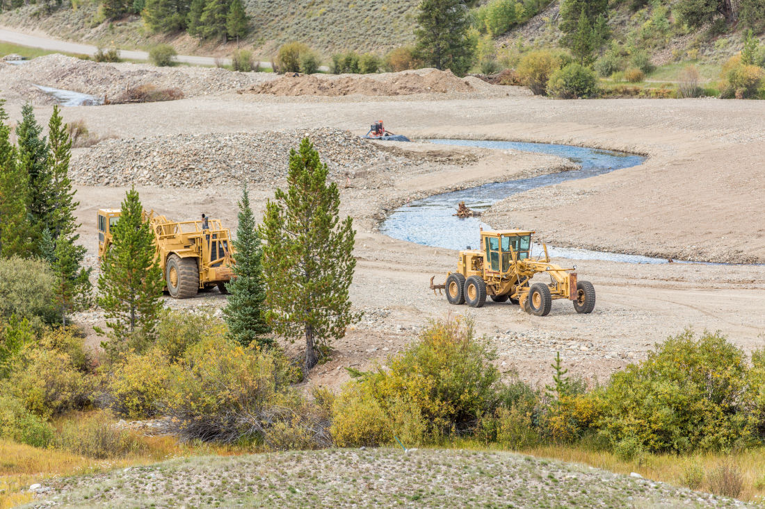
The Open Space and Trail Department has teamed up with Breckenridge and at least a half-dozen other partners to breathe life back into the Swan. Clearing out all of the marbles is the first step.
For the past two years, workers have been collecting and milling hundreds of thousands of cubic yards of the gravel and rocks that have been suffocating the river.
On Wednesday, Nov. 22, crews are set to wrap up another season of work, pulling out more than 43,000 tons of material since July. Over that time, roughly $122,000 in royalties from the sale of that processed material have gone to help offset the cost of the project.
A big load of the rock from last season was used for the Iron Springs bypass project, an ambitious re-routing of Highway 9 between Breckenridge and Frisco that was finished just weeks ago…
Last summer, the project liberated one of four sections of the Swan, digging out a channel that now meanders across a wide floodplain.
“We look at the geometry of the valley as a whole: how wide it is, how steep it is, how big the floodplain is,” Lederer explained. “And looking at these different parameters, we can make an inference into what the channel should look like.”
This summer, workers planted thousands of willows along the new banks of the Swan to help anchor the river while it stretches it legs for the first time in years. But it’s not stuck in place just yet.
“We’ve given the stream a lot of flexibility to move across the floodplain,” Lederer said. “It’s able to move a little bit over time, and that’s OK — that’s kind of what we want up there.”
After a dry start to the season, the area greened up nicely before the first snowfall, a stark contrast to the moonlike surface from just two years ago.
The stretch that’s flowing, dubbed Reach A, is one of four sections identified for de-dredging. That phase cost around $2.3 million total, provided by a combination of state and local government grants.
Gravel milling work this summer has taken place upriver on Reach B, and that’s set to continue next summer. Workers need to clear at least 195,000 cubic yards of material before restoration can begin.
The final two sections, however, are being actively quarried on private land and could take some time to free up for restoration.
“Everyone in the valley is sort of supportive of this work, but I don’t have a good idea of the timing on anything on private property,” Lederer said. “But ideally, we’ll continue to move upstream as the opportunity allows.”
Today’s excavator work represents the latest step in a landmark project undertaken by local, state, and federal government agencies, as well as a group of private organizations that share a commitment to undoing the environmental damage inflicted by Summit County’s pioneers.
“It’s just basically a big mess. There is no real stream, to be honest. There’s no life,” Jason Lederer, an open space and trails resource specialist for Summit County, says while observing the scene last summer. “Our goal is to reintroduce the natural channel to the valley and restore the ecological and environmental value.”
Lederer watches as the earth mover pulls another few hundred pounds of melted chocolate from its expanding hole. When the restoration effort began, no one had a clue where the river was supposed to go—or where it ran before the dredges turned it upside down in the early 1900s. “We don’t have any pictures, but we can imagine,” Lederer says. Which seems a tad crazy, no? How could you not know where the river flowed as recently as a century ago?
Such is the legacy of dredge mining—not just in the Swan, but also French Gulch, one drainage south, and anywhere else a dredge ever operated.
Soon, though, this valley will be transformed, once again through a human touch. As part of a decades-long plan to restore three miles of the Swan, last summer’s work was a major step toward realizing the river’s potential once more. The envisioned final product evokes a page torn from a Colorado scenic calendar: a meandering stream with aspen and juniper on its banks, 10-inch brook trout snapping at your fly, native cutthroat trout flourishing just upstream (for the time being), and more than 130,000 cubic yards of dredge rock crushed and removed from the valley forever.
As Lederer says, “If we do our job right, nobody will ever know we—or the miners—were here.”
[…]
The first two dredges began churning up the river bottom in 1898, and two more followed in 1899. The four boats dug as deep as 70 feet, depositing their debris in giant piles next to the disappearing river channel. Before long, the Swan’s three forks—North, Middle, and South—no longer shared a visible confluence, having been driven underground by the mining. All that mattered was the gold. And if no one was making the mining companies clean up their mess, they weren’t about to do it of their own accord.
Just up the hill and south from where the boats were “flipping the river upside down,” as dredge mining’s impacts are described, the Cashier Mine pumped out ore in Browns Gulch (it remains one of the largest abandoned mines in the county). Workers loaded its waste into carts and scattered it about the valley, alongside the tens of thousands of smooth, round river rocks discarded by the dredge boats. This, of course, only made a bad problem worse.
What had once been a verdant river became a wasteland. People who have worked on the Swan restoration refer to the river they inherited as a “bathtub of marbles”—essentially a waterway that had been so churned up it no longer had a bottom … or any structure at all. Think of trying to contain water with a screen. That’s what the Swan had become: an underground trickle, dispersed to the brink of dissolution.
Even as work began last summer, questions remained: Was the river still there? If so, could it be channeled once more? What would it take to bring the ecosystem back to life?
There weren’t many precedents akin to the Swan, but one local project provided inspiration, and hope. From 2004 to 2006, Summit County government led an effort to restore the Blue River just north of Tiger Road along Highway 9. The 23-acre Four Mile Bridge Open Space, as it became known, turned out beautifully and served as a vital blueprint for the Swan, in that the remediated site was zoned strictly as open space with no concessions for development.
It took 10 years from when the county and town of Breckenridge began preliminary work on the Swan until the heavy equipment arrived last summer, but by the time operations ceased in mid-November, the progress was striking. They’d rebuilt nearly a mile of stream, including relocating a half mile of channel that had become a muddy ditch along Tiger Road. The reconstructed section of river—“Reach A” as it’s known in the broader plan—includes 22 riffles (minor rapids), glides (calm water stretches), and pools 3 to 6 feet deep, which combine to form optimal fish habitat. The river channel is 25 feet wide to accommodate high flows during spring runoff, anchoring a 65-foot-wide riparian corridor that will be populated this summer with native flora.
Best of all, the county did not have to line the riverbed to prevent water from seeping into the ground and disappearing. That’s because the Swan River, they discovered, is a “gaining stream” instead of a “losing stream”—that is, groundwater actually rises from the bed and into the river, increasing its flow. You could see this happening just upstream from the excavator last July; clear water spurted out of the gravel like a spring, then gradually coalesced as it moved downhill.
An uncommon range of backers has funded the restoration, with the largest financial contribution—$975,000—coming from the Colorado Water Conservation Board. Summit County added $500,000, the town of Breck gave $300,000, Colorado Parks and Wildlife anted in $184,000, and the US Forest Service and US Fish and Wildlife Service combined to donate $250,000. Also part of the mix: the Blue River Watershed Group and Trout Unlimited’s Gore Range Anglers Chapter, which works to protect, preserve, and restore coldwater fisheries. “This project hits every aspect of our mission,” says chapter president Greg Hardy.
Several tributaries of the Colorado River get their start in the crags of the Central Colorado mountains. Storied rivers: Blue, Eagle, Roaring Fork and the powerhouse Gunnison. They’ve all faced the footstep of humankind. The mines dotting the slopes, hay fields, ranching, orchards and cornfields bear witness and are now part of the allure of the high country. Folks cast a line, shoot rapids and enjoy the scenery of those waterways.
On September 27, 2017, the International Boundary and Water Commission, United States and Mexico inked Minute 323, the amendment to the 1944 United States-Mexico Treaty for Utilization of Water covering operations on the Colorado, Rio Grande and Tijuana rivers. (The Rio Grande is another of Central Colorado’s contributions to the Western U.S. economy.)
An important part of Minute 323 are environmental flows for the Colorado River Delta. Most everyone knows the river doesn’t reach the sea any longer. Environmental streamflow was initiated under Minute 319 signed by then Secretary of Interior Ken Salazar.
Young girl enjoying the river restored temporarily by the pulse flow March 2014 via National Geographic
In March 2016 a diverse group of conservationists, biologists, irrigators and government officials effected a release of 100,000 acre-feet of water from Morelos Dam into the dry Colorado River Delta. There was a line of vehicles racing point to point along the river to witness the river’s front. At San Luis Rio Colorado, most of the residents went down to the river to celebrate the return of the river although many had no memory of running water in the sandy channel.
There was a great deal of success from channeling some of the streamflow to restoration sites in the Delta. Within weeks, new growth sprouted – cottonwoods and willows. Much of the diverted water served to replenish groundwater supplies. Wildlife immediately started using the habitat.
There probably won’t be a repeat of the Colorado River once again reaching the sea. The environmental flows in Minute 323 are planned to be set to work in the restoration of the Delta. It was great to see the river reach the sea but the conservationists want to concentrate flows like irrigators do for maximum yield.
Another feature of the deal allows Mexico to store water in Lake Mead to better manage their diversions for agriculture. The U.S. is also helping to rebuild and upgrade Mexican infrastructure. Under Minute 319, Mexico was allowed to continue storing water, and that water was used for the pulse flow. The idea is that greater efficiency in Mexico will lead to more storage in Lake Mead.
Currently, Arizona, California and Nevada are working on a drought contingency plan to stave off a shortage declaration in Lake Mead. Arizona’s Colorado River allocation takes a big hit under a declaration. Mexico’s water in Lake Mead will help. Negotiations about the drought contingency plan will now move forward with greater certainty with the signing of Minute 323.
The final signatures for the Minute came from Roberto Salmón (Mexico) and Edward Drusina (U.S.). There were several officials from President Obama’s administration in attendance, including Jennifer Gimbel and Mike O’Connor. The negotiations started before last year’s election but did not conclude before the inauguration.
Minute 323 is an important piece of the puzzle for administering the Colorado River.
Central Colorado is joined at the economic hip with the Colorado River. A lot of transbasin water flows down the Arkansas River from the Twin Lakes and Fryingpan-Arkansas projects. Some is pumped over to South Park by Colorado Springs and Aurora but most of it goes down to Lake Pueblo and the Fry-Ark partners. Colorado Springs, Fountain and Security pump some back north in the Fountain Valley. Cities along the river divert and treat the water for their populations. The water also is used to grow the famous crops in the Arkansas Valley: Rocky Ford melons, Pueblo chile, corn and others. Timing the releases from Twin Lakes and Turquoise Reservoir also contributes to the rafting economy. 100 miles of the Arkansas River are designated as gold medal fisheries. Transbasin flows help the riparian habitat.
SHORT TAKES
• Comments about managing the Arkansas Headwaters Recreation Area are due by November 10, 2017. Check out the AHRA Plan Revision page on the Colorado Parks & Wildlife website.
• Congratulations to Wet Mountain Valley ranchers Randy and Claricy Rusk for winning the Dodge Award for a lifetime of conservation from the Palmer Land Trust.
• Congratulations to the Colorado Parks & Wildlife folks at the Roaring Judy Hatchery for successfully spawning the line of Cutthroat trout rescued from Hayden Creek during the Hayden Pass Fire.
• James Eklund has moved on from the Colorado Water Conservation Board and Becky Mitchell is the new director.
• Coloradans cam now legally collect rain off their roofs. Governor John Hickenlooper signed House Bill 1005 in May.
• R.I.P. Gary Bostrom. He was one of the driving forces behind Colorado Springs’ $825 million Southern Delivery System.
John Orr works for a Front Range water utility where he keeps one eye on the sky to monitor Colorado snowpack. He covers Colorado water issues at Coyote Gulch (www.coyotegulch.blog) and on Twitter @CoyoteGulch.
Martha Gomez-Sapiens, a monitoring team member and postdoctoral research associate in the UA Department of Geosciences, stands on a riverbank next to willows and cottonwoods that germinated as a result of the pulse flow. (Photo: Karl W. Flessa/UA Department of Geosciences)
CDPHE scientists warn Climax Mine molybdenum may pose health risk, oppose company push to raise statewide pollution limit
The Colorado Department of Public Health and Environment water-quality scientists said, in a recommendation to state commissioners, that Climax Molybdenum’s proposed hike “would be acutely lethal to aquatic life” and probably not protective of people.
A Climax report on molybdenum exposures in Colorado “demonstrates that current levels of molybdenum in drinking water may pose a public health risk to communities downstream” of the mine, CDPHE scientists said in filings reviewed by The Denver Post.
State data show molybdenum discharges from the Climax Mine above Leadville in recent years increased to levels 10 times higher than the current statewide limit of 210 parts per billion. CDPHE water-quality control commissioners granted Climax a “temporary modification.” When it expired, the commissioners extended the modification to provide more time to complete a study of molybdenum.
CDPHE officials Tuesday declined to discuss this issue.
Federal Environmental Protection Agency officials, who oversee Colorado’s compliance with the Clean Water Act, informed state commissioners last week that the EPA would allow a limit higher than what Climax Molybdenum is proposing, according to a document filed Friday.
A regional EPA spokesman issued a prepared statement saying the EPA’s filing is “preliminary,” confirming that “our initial review indicates that the proposed standard would protect water supply uses,” but declined to further discuss this issue
State commissioners often follow EPA guidance in setting pollution limits sufficient to protect people while accounting for variability and uncertainty…
Climax officials cited three rat studies the company helped fund in asking CDPHE to relax the statewide water quality limit for molybdenum in streams used for domestic water to 9,000 ppb billion from 210 ppb. Climax also wants limits for waterways used for agricultural irrigation raised to 1,000 ppb from 160 ppb.
EPA recommendations submitted to the CDPHE said a molybdenum limit for streams tapped for drinking water of 10,000 ppb “would be protective … and consistent with Clean Water Act requirements.” However, EPA regional officials said in the document filed Friday that they would not object if Colorado’s commission “chooses to be more conservative and adopts a more stringent table value standard of 9,000 ug/L (ppb) as proposed by Climax Molybdenum Company.”
The EPA “must review and act upon any revised standards once they are adopted by the commission for them to be in effect under the Clean Water Act,” the agency’s statement said. “If the commission chooses to retain current standards, EPA will not have an approval or disapproval role.”
[…]
The CDPHE scientists submitted their recommendation Friday to state commissioners, who are scheduled to deal with the matter in December.
Denver Water is opposing the push for a looser statewide limit, along with downstream communities including Frisco, the Copper Mountain resort and people to the west along the Eagle River…
Denver Water treatment plants lack the capacity to remove molybdenum, which in trace amounts can be healthy. While data on human toxicity is limited, chronic ingestion of molybdenum can cause diarrhea, stunted growth, infertility, low birth weights and gout, and can also affect the lungs, kidneys and liver.
Climax officials have told state water quality commissioners their proposal “is not based on any intent or need to increase molybdenum in Climax discharges, and, in particular, Climax does not intend to change its mining or water treatment process in a manner that would cause an increase in the historical discharge of molybdenum into Tenmile Creek.”
Bags were packed, but then the wind shifted. Emergency over—for this time
Breckenridge was full of people the day last summer that fire erupted in the nearby Tenmile Range. “It was scary. It was so close,” says Peter Grosshuesch, the town’s director of planning.
July 5 was a warm day, even at 9,600 feet in elevation. The three feet of wet, spring snow that had doused Summit County six weeks before had vanished. More important than daytime heat was uncommon overnight warmth: temperatures dropped only to about 60, instead of the normal 40s.
Grosshuesch watched the smoke billow into the sky from his office in Breckenridge, about four miles away. “Everybody got real serious, real fast,” he remembers.
Flames pushed 150 feet above the top of the trees as the fire roared through stands of lodgepole pine, both live and dead, then invaded the band of spruce-fir.
High wind can easily send firebrands aloft for a mile and onto roofs and into front yards. Residents in the most vulnerable neighborhood near Breckenridge, a rural subdivision called Peak 7, were evacuated. But some had begun wondering if this fast-moving fire would reach Breckenridge itself.
Then the winds shifted again, turning the blaze back on itself. The fire was contained and then extinguished. The emergency was over—this time.
All bets were off as the fire billowed smoke above the Tenmile range, then the wind shifted, turning the blaze back on itself. Photos/Summit County via Allen Best.
“We were very lucky,” says Scott Fitzwilliams, supervisor of the White River National Forest, on whose lands the fire occurred. The winds, had they not changed, might well have pushed the fire through the rural subdivision and to the Breckenridge ski resort. Beyond was Breckenridge, the town. “It looked like there was nothing to stop it.”
The question posed by the Breckenridge fire is whether enough has been done to abate the risk. It’s a question worth pondering far beyond Colorado’s Summit County as fire season lengthens and intensifies even as construction of homes continues into what is called the wildland-urban interface.
Mountain towns this summer had many reasons to be reminded of their own risks. Smoke in Whistler from fires in the interior of British Columbia was “ungodly,” in the words Grosshuesch, who was there for a visit. Fires also raged in Montana and Idaho while the beetles killing spruce trees in southern Colorado continued northward toward Crested Butte.
This autumn, wildfire has killed 42 people in the wine country north of San Francisco and destroyed 5,700 homes and other structures. The Napa Valley has a different climate, drier and more Mediterranean, than ski towns.
But there’s also this: high mountain towns are warming, perhaps more rapidly than lower elevations. It’s possible the fire risk is also escalating more rapidly. That’s one of the possible take-aways that came within a strong wind during July of incinerating Breckenridge.
Asbestos forests
Large-scale wildfires have always occurred in high mountain valleys, if perhaps not very often. For example, paleoecological research has shown evidence of a large-scale fire in the early 1600s that burned much of the forest in the Fraser Valley, home to Winter Park.
Fires, however, were virtually unknown as resort communities were built around ski areas during the 1960s and 1970s. It was a cooler, wetter time, and many forests had been logged heavily in the century before. The trees were still relatively young, and those fires that did occur were quickly suppressed.
Breckenridge and Summit County—and many other mountain communities—continued to believe they were different, their forests more like asbestos, yet still lovely. Who among the oldest residents—and to be clear, there weren’t that many older residents in the young ski towns—could remember anything else?
That same sense of exceptionalism continued even as fires raged most of the summer of 1988 in Yellowstone National Park and then, in the 1990s, in the foothills along Colorado’s Front Range southwest of Denver.
Then came 2002, hot winds in April eviscerating the thin snowpack and producing a peak runoff six weeks early that was almost too feeble to be noticed. In the first weekend of June, major forest fires erupted near Durango, in Glenwood Springs, and west of Colorado Springs, the latter going on to burn 138,000 acres.
This rendering projects a 650 percent increase (red) in acreage burned as the result of a 1.8 degree F increase in temperature. Source: Union of Concerned Scientists and the Rocky Mountain Climate Organization via Allen Best.
Summit County heeded those visual cues. In 2006, the county adopted a community wildfire protection plan. A wildlife council continues to meet regularly. In 2008, voters approved property tax assessments that yield $500,000 a year for grants to assist neighborhoods and homeowners’ associations. The money can also be used to create water cisterns, to assist firefighters. A portable wood-chipper was purchased with the money, and it is taken to every street in the county at least twice a year.
Insurance companies have also pushed for efforts to provide what is called defensible space, by removing vegetation around homes. In some instances insurance companies are asking homeowners to have their properties inspected by the local fire districts.
“We used to require people to preserve trees and use them to screen development as much as possible,” says Jim Curnutte, the county planning director. “We would not let you cut down a tree. Now, we might require you to cut down a tree, because of the defensible space ordinance of the building code. If you come in for a new permit or a substantial remodel, you have to meet your defensible space requirements.”
Vegetation must be at least 30 feet from a structure and in some cases 100 feet. But under Colorado law, statutory-rule town and county governments cannot impose defensive space requirements retroactively; only home-rule governments such as Breckenridge and Pitkin County can.
Social license to cut trees
Summit County Commissioner Dan Gibbs, who is also a wildland firefighter, says that all planning now assumes fires will occur. “It’s not a matter of if but rather of when we have more fires in our community,” he says.
As a firefighter, he has worked in California and elsewhere. “I have seen homes with defensible space that were saved, and I have seen homes where vegetation is connected to houses, and those homes have been destroyed,” he says. It’s not an absolute, he adds, but he also knows that firefighters will spend more time trying to save a home with defensible space for a simple reason: they have improved chances of success.
Area above Dillon Reservoir, seen in the upper left, before thinning and then after. Photos/Denver Water
Educating homeowners about wildfire risk is important, but Gibbs say there’s often a difference in attitudes between locals and those who are second-home owners. The non-residents more generally resist efforts to impose defensible space around buildings.
In Summit County, the beetle epidemic gave the Forest Service social license to cut trees from 12,000 to 15,000 acres.
“What chance do you think there was of doing that before the bark beetle?” Fitzwilliams asks.
A scene in Summit County, between Farmers’ Corner and Summit Cove, overlooking Dillon Reservoir, both pre-treatment and afterward.
The Forest Service has spent $18 million in the last 10 to 12 years in forest thinning, clearing roads and trails and other work related to removing vegetation in Summit County. Some has been sold to sawmills, but there’s little revenue from that. “We have low value trees,” explains Fitzwilliams of lodgepole pine.
Denver Water has been a major partner in this new work. It collects water for diversion to the Denver metropolitan area from a tunnel at Dillon Reservoir; the agency provides water for 1.4 million people, a quarter of all Colorado residents. The water agency has found forest fires expensive. Two hot-burning fires, in 1996 and then in 2002, caused heavy erosion into Denver’s reservoirs in the foothills southwest of the city. The soils there are highly erosive and granitic by nature. The reservoirs had to be dredged, with incomplete success.
Better and less expensive than remediation, the agency decided, would be prevention.
In a program called Forest to Faucets, Denver in 2010 partnered with state and federal forestry agencies to thin forests in Summit County and the Winter Park area. The city draws water from both areas.
Fires sop up Forest Service budget
Denver Water in February announced a five-year renewal of the partnership, putting in $16.5 million to match like amounts from the state and federal agencies for continuing thinning of forests. The first phase also saw 750,000 trees being planted.
In announcing the commitment, Denver Water’s CEO Jim Lochhead said Congress should take heed of what Denver and other water providers, including Aurora and Colorado Springs are doing.Instead of allocating massive amounts of money
for putting out fires, he said, Congress should provide more money to the Forest Service for forest management in critical areas.
That same point was made by Fitzwilliams, the White River supervisor, in an August meeting with officials from Colorado ski towns. He said fire suppression used to account for 15 percent of the Forest Service budget nationally, but has grown to 55 percent. This year it will probably push 60 percent. “So much of our money is in managing these large, expensive wildfires,“ he says.
Ironically, fire suppression in the past is partly to blame for the growing threat. In recent decades, foresters have taken a more measured approach about when to let fires burn and when to put them out.
But if cutting trees is one obvious solution to the threat of fires, ecologists warn it cannot be the only answer: There are simply too many trees.
“Treatments in and of themselves are not going to save the day in terms of changing patterns of fire,” says Ray Rasker of Headwaters Economics in Bozeman, Mont. Treatments do make sense in targeted areas, such as what Denver Water is doing, he adds. But like Fitzwilliams, he stresses that fire altogether cannot be contained. It’s part of the ecosystem. Instead, communities need to adapt themselves to living within a fire ecosystem, he says. His consultancy, working with two others, helped Summit County create its community plan.
Speaking with members of the Colorado Association of Ski Towns in August, Fitzwilliams emphasized the words “conversations” and “responsibilities” among communities, land managers, and local governments. He thinks many tools— including prescribed fire and thinning—must be employed. He hopes to see greater age diversity in trees stands and some deliberate manipulation of forests in the wildland-urban interface to promote species such as aspen, which are somewhat less fire prone.
This rendering projects a 650 percent increase (red) in acreage burned as the result of a 1.8 degree F increase in temperature. Source: Union of Concerned Scientists and the Rocky Mountain Climate Organization from their report, Rocky Mountain Forests at Risk`.
And warming temperatures
All this will be needed, if a trend noticed by Brad Piehl at the Peak 2 fire becomes more prevalent. He’s a watershed planner whose company, JW Associates, works with Denver, Colorado Springs, and other cities that draw water from high mountain valleys. Piehl himself lives near Breckenridge and watched the Peak 2 fire from his home with this important characteristic: It started in lodgepole pine and, after continuing to warm up on the downed logs, then invaded spruce-fir. This is a changed dynamic, previously observed last year in Colorado’s North Park. It also puts high-mountain resorts at greater risk.
Piehl, in speaking with Colorado Association of Ski Town members in August, also showed a slide (above) that represents the changing species that may result from warmer temperatures predicted as a result of accumulating greenhouse gas emissions.
Fire season is lengthening, some say by 75 days. That seems too much for Summit County, says Piehl. But even if it’s just 30 days more each year, “we’re still in trouble,” he adds. “That’s still a significant change.”
About Allen Best
Allen Best is a Colorado-based journalist. He publishes a subscription-based e-zine called Mountain Town News, portions of which are published on the website of the same name, and also writes for a variety of newspapers and magazines.
Freeport-McMoRan subsidiary Climax Molybdenum has asked the Colorado Department of Public Health and Environment to relax the water quality limit for molybdenum in streams used for domestic water statewide to 9,000 parts per million from 210 ppm. It also wants the limits for waterways tapped for agricultural irrigation raised to 1,000 ppm from 160 ppm.
The change could cut water-treatment costs at the company’s open-pit Climax Mine above Leadville, where the company produced about 16 million pounds of molybdenum in 2016, down from 23 million pounds in 2015…
“The standard proposed by Climax based on studies it completed on laboratory animals do not appear to adequately extrapolate to human health impacts,” said Tom Roode, the utility’s chief of operations and maintenance. “While the increased discharge may save costs at the mine, it has the potential to increase treatment costs at Denver Water’s treatment plants.”
Denver’s water treatment plants lack the capacity to remove molybdenum, which in trace amounts can be healthy. While data on human toxicity is limited, chronic ingestion of molybdenum can cause diarrhea, stunted growth, infertility, low birth weights and gout, and can also affect the lungs, kidneys and liver.
“Our position is that the molybdenum standard should be based on sound science quantifying human health impacts,” Roode said.
At the mine atop Fremont Pass, Climax discharges molybdenum into Tenmile Creek, which flows into Dillon Reservoir.
County Water Quality Specialist Katherine Morris and Assistant County Manager Ed Moyer delved into a proposal the county received from Climax Molybdenum, a subsidiary of Freeport-McMoRan and operators of the Henderson Mill and Mine complex, to change state regulations regarding allowable molybdenum concentrations in water. The decision to change the standard is under the purview of the state’s Water Quality Control Commission, not Grand County.
According to information provided by Morris and Moyer, the state commission is set to decide on the issue at a hearing on Dec. 12.
The standards for allowable molybdenum are set by the state and changes to those standards can impact both drinking water and agricultural water uses. Climax is proposing increasing the allowable standard for molybdenum concentrations in domestic drinking water from 210 micrograms per liter to 9,000 micrograms per liter. They are also seeking an increase in allowable molybdenum levels in agriculture water, from 160 micrograms to 1,000 micrograms.
County Commissioner Rich Cimino indicated he was not supportive of Climax’s proposed increases.
“The standard is the standard, and safety is safety, why would we relax it?” Cimino asked rhetorically.
County Commissioner Merrit Linke echoed Cimino’s comments.
“These are factors of what, 20, to change the standard?” Linke asked. “I don’t think we are going there. If it was a little bit, if it was going from say 210 to 300 maybe that is justifiable, but factors of 40, I don’t think so. No, would be the answer for me.”
No reason for the proposed increase was discussed during the meeting.
WINDY GAP RESERVIOR BYPASS PROJECT COST SET AT OVER $15 MILLION
A review of the Windy Gap Reservoir modification and connectivity channel was also on the agenda Tuesday.
Moyer highlighted that the application for an amended decree and bypass water rights has been submitted to the appropriate water court by Northern Water and the Colorado River District.
Value engineering has been performed on the project, which helped lower the anticipated infrastructure costs of the bypass by roughly $1 million. After adding in approximately $1.4 million for NEPA permitting, monitoring and administration, the total cost of the bypass project is set at $15.6 million.
Moyer informed commissioners that funding for the project is still about $5 million short.
“We have ongoing efforts for fundraising,” Moyer said, highlighting several tours conducted in the last month with prospective foundations, such as the Walton Family Foundation, which toured the project site in late September. Moyer will attend a funding meeting for the project at Denver Water facilities this week and has more follow-up meetings next week.
Moyer also provided a brief update on the ongoing Learning By Doing adaptive management process of which Grand County is a party.
Denver Water’s collection system via the USACE EIS
Jumbo Mine Cabin in-front of Adit September 25, 2017. Photo credit Environmental Protection Agency.
From the Environmental Protection Agency via Summit County (Brian Lorch):
The U.S. Environmental Protection Agency (EPA) is taking immediate action to perform mine cleanup activities at the Jumbo Mine in Summit County’s Peru Creek Basin, approximately seven miles east of Keystone Resort.
The Jumbo Mine, which produced gold, copper, lead and silver, operated from 1915 to 1918. Historic mine operations also generated significant volumes of waste rock and tailings piles. Inactive and abandoned for a century, the mine site was identified in the early 1990s by EPA and the Colorado Department of Public Health & Environment (CDPHE), as well as in the Snake River Watershed Plan, as a significant point-source contributor of metal-contaminated flows into Peru Creek and the downstream Snake River.
Historic hard-rock mining in the Peru Creek Basin left a legacy of contaminated and abandoned mine sites, whose acid mine drainage significantly degrades water quality. Much has been done to study the problems in the Snake River watershed, beginning in the early 1970s. Most studies have focused on the Peru Creek drainage, which is home to the Pennsylvania Mine, the largest, longest-operating mine in the watershed. In coordination with Summit County and the Colorado Division of Reclamation, Mining and Safety (DRMS), EPA completed cleanup actions at the Pennsylvania Mine in 2016.
The Jumbo Mine is another high-priority abandoned mine site in the Peru Creek Basin identified by the Snake River Watershed Coalition as a remediation project site capable of significantly improving water quality in the Snake River watershed.
Summit County purchased the land surrounding the abandoned Jumbo Mine in early 2016 for public open space. A restrictive covenant placed on the adjacent property containing the abandoned mine site allows for EPA’s cleanup actions to occur, but also limits the County’s liability for the existing environmental issues and associated cleanup actions.
“We had been looking to acquire this piece of property for a long time, recognizing that it has many open space values,” said Brian Lorch, Summit County Open Space and Trails director. “But before we could take steps to purchase the property, we needed to ensure that it could be cleaned up in an economical manner.”
EPA is implementing the cleanup work as a time-critical removal action under the Comprehensive Environmental Response, Compensation and Liability Act (CERCLA). Last week, the agency began the work, which it plans to complete in about three weeks.
Cleanup activities involve diverting water draining from a mine adit around or over adjacent tailings piles in a limestone and membrane-lined ditch. According to EPA studies, water quality of the adit drainage degrades as it crosses the mine tailings, contributing high levels of suspended and dissolved lead, zinc and other metals into the stream. Diverting drainage around the tailings into a lined ditch should greatly improve water quality.
“The overall approach will help reduce the discharge of metals into Peru Creek,” Lorch said. “A passive treatment approach at the Jumbo Mine site is quite similar to numerous mine cleanups performed elsewhere by the County.”
Since 2001, Summit County has worked with EPA to identify and prioritize mine sites in need of cleanup in the Peru Creek Basin. The County’s proactive coordination with EPA facilitated recent cleanup efforts at the Pennsylvania Mine and numerous other sites in the area.
“We are really happy and grateful to see EPA continue its mine cleanup efforts in the Peru Creek Basin,” Summit County Commissioner Karn Stiegelmeier said. “The Summit County community is very supportive of our efforts to clean up abandoned mine sites on County property, voting in 2015 for a mill levy that provides funding for cleaning up mine-impacted sites.”
Jumbo Mine looking up at channel liner installation from lower middle section of waste rock pile. Photo credit Environmental Protection Agency.
Nearly every member of Colorado’s congressional delegation has signed a letter to the Trump administration asking for help with the emerging crisis of tiny invasive mussel larvae found in Green Mountain Reservoir…
“We urge you to respond rapidly, deploy available resources and work with the state and local communities to prevent this initial detection from growing into a full infestation,” the delegation wrote to Interior Secretary Ryan Zinke. “A rapid response is critical during the window of opportunity immediately after the detection of invasive species.”
The letter, dated Thursday, was signed by Sens. Cory Gardner and Michael Bennet, as well as Reps. Diana DeGette, Scott Tipton, Doug Lamborn, Jared Polis, Ed Perlmutter and Mike Coffman.
Rep. Ken Buck, a Weld County Republican, did not sign the letter.
“As a headwater state that is currently free of adult invasive mussels, the detection of invasive mussel larva poses a tangible threat to our economy,” the letter said. “The Department of Interior has recognized the importance of preventing invasive mussel infestations in western headwater states, such as Montana where larva was identified in late 2016 and resources were deployed to the Columbia River Basin.”
Zinke is from Montana.
Colorado Parks and Wildlife spokesman Mike Porras said his agency has drawn more than 100 samples from Green Mountain Reservoir since the larvae were detected. “All of these samples have come back negative for all aquatic nuisance species including quagga mussels.”
[…]
Tiny mussel larvae, known as veligers, have been found in Colorado before. Lake Pueblo, for instance, tested positive for them in 2007, 2008, 2009 and 2011.
Biologists, however, have never found an adult zebra or quagga mussel in any Colorado lake or reservoir.
Lake Powell, which straddles Utah and Arizona, has been ravaged by a mussel infestation since veligers were detected in late 2012 and four adult mussels were found on a boat that had been pulled for service in March 2013.
Boats and other watercraft can quickly spread the invasive species. Colorado wildlife officials have said the veligers found in Green Mountain Reservoir likely hitched in on a boat that had been in water outside the state.
State lawmakers during the past legislative session cited the threat of invasive mussels as one reason why they voted down a proposal to allow sea planes on Colorado’s bodies of water, saying they could act as long-range vehicles for the species.
Here’s the release from Colorado Parks and Wildlife (Lauren Truitt):
Monitoring finds Evidence of Quagga Mussel Larvae in Green Mountain Reservoir
State and federal officials have confirmed the presence of invasive quagga mussel larvae, known as veligers, in Green Mountain Reservoir located in Summit County along Hwy 9 between Silverthorne and Kremmling.
On Aug. 18, as part of a state and federal initiative to monitor aquatic nuisance species in the state, specialists with the Bureau of Reclamation first confirmed the presence of the veligers, initially through microscopic analysis followed by DNA testing. An independent laboratory contracted by Colorado Parks and Wildlife confirmed Reclamation’s findings. It is unknown if the veligers were dead or alive at the time of detection.
CPW immediately increased monitoring of the reservoir for all life stages of quagga mussels. Through a partnership with the Denver Aquarium, CPW’s volunteer ANS scientific scuba dive team surveyed the reservoir last Friday and did not find any evidence of invasive mussels. No adult zebra or quagga mussels have ever been found in Green Mountain Reservoir or anywhere in the state of Colorado, although eight different reservoirs in Colorado have been temporarily suspect or positive for mussel veligers since 2008.
“Although this is very troubling, it’s important to keep in mind that the reservoir is not considered infested, a designation given only to bodies of water that have extensive and reproducing adult populations,” said Elizabeth Brown, invasive species coordinator for CPW. “At this point, Green Mountain Reservoir is only considered ‘suspect,’ not positive. A body of water can be considered ‘positive’ only after a second independent specimen collection is obtained and the genetics confirmed by two independent laboratories, which has not yet occurred.”
Officials are most concerned about the possibility that the presence of veligers could eventually lead to a major infestation. This would put the reservoir’s hydroelectric power generation, water quality, drinking water delivery and recreation at risk.
“This is an unfortunate discovery, and something we have been working very hard to prevent,” said CPW Director Bob Broscheid. “It shows why we need a robust inspection program. As more and more people move to or visit Colorado and use our water resources for boating, we must continue to work hard to prevent the spread of these harmful invasive species. We cannot overstate how serious this is.”
All ballast boats, inboard and inboard/outboard engines must have a green seal in between launches or decontamination may take place prior to launching. Boaters are encouraged to inspect their own boat between every use and make sure it is clean, drained, and dry.
The State of Colorado requires boats to be professionally inspected if:
a boat has been in any body of water that is positive, or suspect for ANS
a boat has been in any body of water outside of Colorado
a boat will be entering any water body where inspections are required
Officials are unsure how the veligers entered the water but suspect a boat that visited an infested body of water in another state may have become contaminated, then launching illegally into Green Mountain Reservoir.
“This situation demonstrates the importance of following the law and going through the required inspection and decontamination process upon entering and exiting bodies of water,” said Reid DeWalt, Assistant Director Wildlife and Natural Resources with CPW. “We could face the possibility of a very harmful infestation that could cause severe damage to the reservoir and its infrastructure.”
The watercraft inspection and decontamination station at Green Mountain Reservoir is operated by the Heeney Marina and funded by a partnership between CPW and the U.S.Forest Service. The station has now begun implementing containment protocols which means that every boat has to be inspected when exiting the reservoir and will be issued a seal and blue receipt. If a boater leaving Green Mountain Reservoir intends to launch in a different water body, their boat must be decontaminated before launching by a certified professional.
Cooperation with Colorado’s mandatory inspection and decontamination program has proven successful to stop the movement of harmful invasive species, such as quagga mussels, into new waters. Public awareness and participation is the best weapon in the prevention of invasive species. Invasive mussels severely endanger our water supply for drinking water, hydropower, agriculture, recreation and natural resources.
“It is everyone’s responsibility to take care of our natural resources,” said Karn Stiegelmeier, Summit County Commissioner. “This news is certainly difficult to hear with the amount of effort and diligence we have put into the ANS program on the reservoir. We will continue working alongside our partners to make sure we educate residents and visitors of the importance of decontamination of boats before and after they are on a body of water. This can be prevented, but we need everyone’s participation.”
Boaters are reminded to take the simple precaution of making sure that they clean, drain, and dry their boat every time they go boating. Due to financial constraints the state does not have additional inspectors that can be sent to assist with boat inspections at Green Mountain. Going into a holiday weekend state and federal officials are asking for the public’s help to prevent invasive species.
“We know this is an extra step for those who have come out to enjoy recreating on the lake, but staying vigilant has proven to be effective throughout Colorado,” said JT Romatzke, NW Region Manager with CPW. “We need to make sure we are balancing our recreation with the integrity of our water resources.”
It’s lower down the gushing waterway’s span, however, on a 19-mile stretch north of Silverthorne toward Green Mountain Reservoir, that state officials said the gold medal tag had to be pulled this past March. While perhaps no shock to those who best know the area’s waters — many already avoid that segment for lack of comparative success — the local emphasis has been on exploring if regaining that billing as one of the state’s top fishing destinations is even possible.
“When we removed that gold medal designation, it got the attention of a lot of people, which was part of my intention,” said Jon Ewert, aquatic biologist for Colorado Parks and Wildlife. “Part of it is truth in advertising, and the other effect is that it would draw some attention to that stretch of the river.”
To possess a gold medal, a waterbody needs to offer 60 pounds of trout per acre and a dozen fish at least 14 inches or longer in that same space. But through some mix of unnatural streamflows, insufficient bug populations for fish to eat and temperature variability, those 19 miles have produced no better than half those quantity requirements since as far back as 2001.
A regional stakeholder group has been meeting quarterly to trade data and hypothesize what may have ultimately turned the tide on the classification. So far it’s still uncertain.
“It’s a great mystery,” said County Commissioner Karn Stiegelmeier, who is a member of the quarterly Blue River meetings. “There are a lot of possibilities and one is that it’s a water quality issue, but no one has identified that, and there’s been some effort to see if there’s something in the water that we’re not aware of that’s bad.”
What is clear is that the number of rainbow and brown trout that used to populate the segment are no longer there, and those that remain are underweight.
“Fish, they just don’t thrive there,” added Stiegelmeier. “And they get pretty beat up, because they’re caught and released, caught and released.”
Water quantity, meaning outflows from Denver Water-managed Dillon Reservoir, are almost certainly a factor in all of this, but how to overhaul that is even trickier. Based on annual snowpack and peak periods of melt, the agency pushes water out into the Blue River to avoid overflow, but is also unable to lend more than present totals so it can still meet the demands of Front Range water needs.
In a related quality issue, what is funneled out is often colder than ideal temperatures for fish because it originates from lower in the reservoir, rather than at various depths as with more modern dam designs. Trout thrive at between 54 and 64 degrees Fahrenheit, and what comes out of Dillon Reservoir is typically closer to about 46.
Discussions persist about possibly retrofitting Dillon Dam, which opened at the end of 1963, with an updated, staged-release structure like that of Grand County’s Wolford Reservoir. That project, completed in 1995, includes a tiered system that can combine water from three different depths to better manage temperature downstream.
The primary obstacle, though, is that such a renovation could cost up to $10 million, and no one knows yet from what source the funding might arise.
That’s if it would even help address the challenges in the Blue River at all.
“It’s definitely an idea that has merit, but the problem is it’s millions of dollars in an infrastructure project that nobody’s stepping up and volunteering to pay for,” Ewert explained. “And number two, it’s essentially an experiment because we don’t know for sure if that would be the fix. We’re certain that it wouldn’t hurt it, but … it’s a pretty expensive experiment.”
Eventually restoring the gold medal fishing label for the entirety of the Blue River is the group’s goal. Doing so by artificially stocking the deficient stretch is another alternative, but officials note that does nothing more than simply reinstating a name — and at unsustainable costs — rather than straightening out what’s really going on.
“We could do it by just dumping a bunch of fish in there, but that’s really not economically responsible,” said Ewert. “What we want it to do is be a more productive fishery and improve the potential of it, and in the course of accomplishing that it should meet gold medal standards. We have to pool all of our information and figure out what information we’ve got, and is it pointing us in any certain directions before we can figure out what we can do to help this stretch of river … and it’s going to take time.”
Upper Colorado River Endangered Fish Recovery Program
Wolford Mountain Reservoir. An aerial view of Wolford Reservoir, formed by Ritschard Dam. The Colorado Water Plan outlines many different types of projects, including reservoirs and dams, that need funding.
Ruedi Reservoir. Photo credit Greg Hobbs
Green Mountain Dam via USBR.
Grays and Torreys, Dillon Reservoir May 2017. Photo credit Greg Hobbs.
Williams Fork spill.
Willow Creek Reservoir.
From the U.S. Fish and Wildlife Service via The Los Alamos Daily Post:
Coordinated releases from a series of Upper Colorado River Basin reservoirs began Saturday, June 3, and are anticipated to continue through this week as part of the Coordinated Reservoirs Operations Program.
The US Bureau of Reclamation, the Colorado River District, Denver Water and Northern Colorado Water Conservancy District as owners and operators of upper Colorado River reservoirs have mutually agreed to modify their operations to benefit the endangered fish of the Upper Colorado River Basin.
The Coordinated Reservoir Operations (CROS) program was established in 1995 as part of the Upper Colorado River Endangered Fish Recovery Program. The purpose of the Coordinated Operations is to enhance spring peak flows in a section of the Colorado River upstream of Grand Junction, Colo. Determined to be critical to the survival of four endangered fish species: the Humpback Chub, Razorback Sucker, Bonytail and the Colorado Pikeminnow. The higher peak flows remove more fine sediment from cobble bars that serve as spawning habitat for the endangered fish. In years with sufficient snowpack, surplus inflows to the reservoirs can be passed downstream to benefit these fish without impacting reservoir yields or future beneficial water uses.
Coordinated Reservoir Operations were most recently conducted in 2016, 2015 and 2010. In 2011 and 2014, wet conditions caused streamflows in certain areas of the basin to approach or exceed levels associated with minor flooding, so CROS was not performed. In 2012 and 2013, reservoirs did not have surplus inflow to contribute due to extremely dry conditions.
Managers of the reservoirs completed a conference call June 2, agreeing to voluntarily run the program this year. Planned reservoir operations as of June 2 are described below. Release and flow amounts are approximate. Most reservoirs will step up releases over the next several days, hold at a constant rate for 3-7 days, and then wind down releases.
Green Mountain Reservoir, operated by the Bureau of Reclamation, will increase releases from 418 cubic feet per second (cfs) to powerplant capacity of around 1400 cfs. Releases from Green Mountain include inflows bypassed by Dillon Reservoir, operated by Denver Water, that will be increased by approximately 100 cfs during CROS.
Denver Water also operates Williams Fork Reservoir, which is releasing 200 cfs. Releases will likely increase to approximately 600 cfs over the coming week to bypass increasing inflows.
Willow Creek Reservoir, operated by the Bureau of Reclamation and Northern Colorado Water Conservancy District, is releasing 90 cfs. Releases will increase this week to roughly 600 cfs by curtailing pumping operations to Granby Reservoir and bypassing those inflows instead.
Wolford Mountain Reservoir, operated by the Colorado River District, is passing inflows of 350 cfs. Outflows will be increased to around 600 cfs for approximately five days.
Ruedi Reservoir, operated by the Bureau of Reclamation, is releasing 182 cfs and will increase releases to approximately 600 cfs over the next few days.
The Colorado Basin River Forecast Center (CBRFC) will incorporate these planned reservoir operations into their streamflow forecasts. Based on weather forecasts and planned reservoir operations, flows in the Colorado River near Cameo (upriver of Palisade, Colo.) are anticipated to be approximately 14,000 – 17,500 cfs, June 7 through June 12, with the highest flows Thursday or Friday June 8 or 9. Flows in the forecasted range are still below defined “bankfull” and flood stages for the area.
More detailed information about forecasted streamflows in the Colorado River basin are available from the CBRFC website at http://www.cbrfc.noaa.gov. A map-based interface allows viewing of hydrographs detailing recent, current and anticipated flows.
For more information, contact Don Anderson, U.S. Fish & Wildlife Service, at 303.236.9883, donald_anderson@usfws.gov, Michelle Garrison, Colorado Water Conservation Board, at 303.866.3441, ext. 3213, michelle.garrison@state.co.us or James Bishop, Bureau of Reclamation, at 970.962.4326, jbishop@usbr.gov.
The Upper Colorado River Endangered Fish Recovery Program is a cooperative partnership of local, state and federal agencies, water developers, power customers and environmental groups established in 1988 to recover the endangered fishes while water development proceeds in accordance with federal and state laws and interstate compacts.
Through both natural and man-made activities, the area’s waterbodies will ramp back up to seasonal heights this week. The National Oceanic and Atmospheric Administration anticipates the Colorado River and its primary Summit County tributaries will reach their highest 2017 levels this Wednesday, June 7.
The volume-based flow rates, measured as cubic feet per second, on North Tenmile Creek, for example, will rise from about 600 to 900 cfs and the Blue River north of Dillon should grow in the next two days by another couple hundred cfs from its present 600. To offset forthcoming supply, Denver Water, which owns and oversees Dillon Reservoir, stated that it plans to up flows from Dillon Dam into the Lower Blue River from its Monday total of 380 cfs to 600 no later than Tuesday morning, and between 1,400 and 1,800 cfs by the end of the week.
“The snowpack up on the mountain, it’s now warmed up and is starting to come off,” said Jim Pokrandt, spokesman for the Colorado River District, a public policy agency that closely monitors the region’s major waterway. “It’s fast water, but shouldn’t flood anybody out. All streams will be quicker-paced than people are used to, but the flooding is not the danger.”
[…]
North of Silverthorne, additional releases at Green Mountain Reservoir also allow the Bureau of Reclamation to increase power plant capacity and generate more electricity. Those levels could reach approaching 1,400 cfs from the current 418.
Estimating that 40 percent of the winter’s snowpack still remains above Dillon, Denver Water is comfortable increasing the flows from Dillon Reservoir into the Lower Blue River that ultimately head to northern Arizona’s Lake Powell. That result is threefold, preventing wasteful overflow of the reservoir, maintaining ideal recreational heights on the lake, as well as fulfilling the demands of Lower Basin states based on senior water rights.
“Our experts are monitoring conditions carefully with the goal of ending runoff season with a full reservoir,” Matt Wittern, Denver Water Summit County liaison, wrote by email. “That way, we’re able to meet our customers’ needs while providing locals and tourists alike with valued summer recreation activities that have a positive impact on the local economy.”
A standup surfer in the Arkansas River at Salida during Fibark, the river celebration held in late June. Photo/Allen Best
Where spring runoff has been something like average—and where it hasn’t
Spring runoff of the Yampa River likely peaked on May 14 this year as it flowed through northwestern Colorado. That makes it an anomaly in the precipitation-dripping mountains of the West.
In most other locations, the peak runoff—the time when the largest volume of water in rivers occurs as winter’s snow melts—more normally occurs in early June after temperatures finally warmed. This year looks to be more or less normal, despite a trend to earlier runoff in many locations during the last several decades.
“The Yampa did have an early runoff, and that was the result of the warm temperatures and below-average snowpack,” said Ashley Nielson, senior hydrologist with the Colorado Basin River Forecast Center in Salt Lake City, when interviewed last week by Mountain Town News. The Yampa, she noted, will probably rise again in the next week or so, if not to the same high mark.
But elsewhere, the show is now, not a month ago. Peak runoff of the Green River was expected this week or next. It originates in the Wind River Range of west-central Wyoming. Unlike the Yampa, that basin still has a significant snowpack. That was also reported to be the case in Jackson Hole, at the headwaters of the Snake River. The snowpack there was 181 percent of average in late May, not a record but “up there,” in the words of one water official cited by the Jackson Hole News&Guide.
Peak runoff in the upper Colorado River at its headwaters along the Continental Divide in Colorado was also expected to occur in early June.
Winter had wild swings: barren until late fall, then torrents of snow in December and January. Temperatures were unseasonably warm in February and almost hot in March. It looked like an early runoff everywhere. Then May turned cold and snowy.
What explains the Yampa’s aberrant behavior? Karl Wetlaufer, a hydrologist with the Natural Resources Conservation Service in Denver, said the peak snowpack in northwestern Colorado arrived about a month earlier than usual. That snowpack around Steamboat Springs occurred on March 12, compared a more typical April 10.
Instead of mid-May for the Yampa, he says that rafters floating through Dinosaur National Monument more often experience the highest water flows of the year in early June.
The Dolores River in southwestern Colorado on Memorial Day in 2009. Photo/Allen Best
Flows in the Animas River through Silverton and Durango have had some “pretty wild swings,” Wetlaufer says. The Arkansas River has been slow to get started with runoff.
The Snake River of Wyoming and Idaho has a very different story than the Yampa, with around 200 percent of snowpack this year. The Snake originates in Jackson Hole and picks up water from the Big Wood River, which originates in the Sawtooth Mountains above Ketchum and Sun Valley, before joining the Columbia at the Idaho-Washington border.
“My takeaway is that this year is pretty normal” in terms of timing, says Bruce Anderson, the senior hydrologist at the Northwest River Forecast Center, in Portland, Ore. It was cooler and wetter in spring, but the big story was the amount of precipitation that fell during winter. “We are hugely above normal for precipitation.”
In the Tahoe-Truckee area of California’s Sierra Nevada, the snowpack was among the deeper ones on record after three bad drought years and then a so-so winter in 2015-16. Snowfall this winter was not a record, but it was a record for total precipitation. Being somewhat lower and closer to the coast than Colorado, the Sierra Nevada gets more rain during winter. This year it got a lot of rain.
Colorado, too, had rain on snow, which is not unprecedented. But it happened frequently this winter. The result was telling for travelers on I-70 who crossing Vail Pass.
“In general, there was less snow than you would expect,” says Klaus Wolter, a research scientist at the National Oceanic and Atmospheric Administration in Boulder.
Were those rain on snow storms of this past winter a result of accumulating greenhouse gas emissions? Wolter told Mountain Town News that thinks this is “probably partially climate change.”
Wolter, whose focus is empirical climate research, using statistical methods to solve climate problems, is reluctant to pin climate change on much of what we have seen this year. True, he says, one storm during May left 42 inches of fresh snow in the foothills above Boulder, a storm unprecedented since the 1920s. As extreme as that storm was, proving causality is difficult, he says.
A scientist in Oregon also shared the difficulty of proving causality. John Stevenson of Oregon State University told the Idaho Mountain Express in Ketchum that it’s “really difficult to judge any one year” to be a result of rising global temperatures.
“That’s one of the challenges we run into in the science world where people say, ‘Oh, it’s climate change.’ We’re not at the point where we can take any one random event and say it’s climate change.”
That said, his 2015 study concluded that the point each spring when half of the water year’s streamflow had run off was occurring an average 1.9 days earlier per decade.
But more extreme events are happening with greater frequency, said Mark Davidson, director of conservation initiatives with The Nature Conservancy. He pointed out that the Big Wood River has had two 100-year floods in the last 15 years.
Warm temperatures in the Ketchum and Sun Valley area were 6 to 13 degrees warmer than normal for early May, producing a flood in the Big Wood River that peaked on May 8. It was regarded as the largest in 101 years of recorded history, reports the Idaho Mountain Express.
But more warm weather was producing another surge in early June that threatened to surpass that peak of a month before, the newspaper reported last week.
“We’re definitely looking at high water this year,” said Dennis Wied, the owner of Raft Masters.
Wied said he has high expectations for this season.
“This is going to be one of those epic kind of years where the real high water enthusiasts will be out in numbers,” Wied said.
Water flows are about 1,200 cubic feet per second in the Arkansas River right now, but rafting officials say they’re expecting that to grow three times as the snow continues to melt.
Arkansas River Basin High/Low graph May 22, 2017 via the NRCS.
Northern Pike graphic via The Hook and Hackle Company.
Here’s the release from Colorado Parks and Wildlife:
A cash-based incentive offered by Colorado Parks and Wildlife and the Colorado Water Conservation Board encouraging anglers to catch northern pike at Green Mountain Reservoir resumes this year on May 25. Initiated in 2016, the reward program encourages anglers to participate directly in ongoing efforts to remove the illegally introduced predators from the reservoir.
CPW biologists say the presence of the predatory fish in Green Mountain is a significant concern. In addition to the potential impacts to fish in the reservoir, if they escape and take up residency downstream in Gold Medal sections of the Blue and Colorado rivers, sportfishing opportunities for trout could see negative consequences. If the predatory fish eventually reach federally listed critical habitat in the Colorado River, they would prey upon the state’s endangered native fishes – the Colorado pikeminnow, humpback chub, razorback sucker and bonytail.
“Northern pike are aggressive predators with big appetites and if their population continues to grow in Green Mountain Reservoir, that will likely have profound impacts to local fisheries in the future,” said CPW’s Jon Ewert, aquatic biologist from Hot Sulphur Springs. “This is beneficial in several ways. Anglers can catch a predatory fish and earn some money, it helps us protect fishing here, and helps with our native fish recovery efforts as well.
According to the Upper Colorado River Endangered Fish Recovery Program, the presence of predators like northern pike and smallmouth bass in native fish critical habitat significantly increases the difficulty of delisting the endangered fishes.
“We all have an interest in making sure our waters are managed appropriately and we encourage the angling public to stay involved,” said Ewert. “We had excellent response last year, and we expect anglers will be eager to take advantage of this opportunity again this year.”
To participate, anglers must bring their northern pike to the Heeney Marina along with their driver’s license and fishing license.
CPW will keep fish heads for analysis, returning the body of the fish to the anglers. Anglers not wishing to keep northern pike can donate their catch to the Marina for later distribution.
Anglers are encouraged to catch and keep as many smallmouth bass and northern pike as they desire, unless special regulations are in effect on specific waters.
For more information, contact CPW’s Hot Sulphur Springs office at 970-725-6200, or Heeney Marina at 970-724-9441
To report illicit stocking or any other illegal wildlife activity anonymously, anglers can call Operation Game Thief at 877-265-6648.
Brad Udall via CSU Water Institute FromThe Summit Daily News (Kevin Fixler):
[Brad] Udall, a distinguished climate researcher, was on hand as the keynote speaker for the 24th annual Summit County State of the River meeting hosted by the Blue River Watershed Group and Colorado River District. The yearly gathering to discuss the season’s snowpack, local reservoir operations and health of the headwater region’s water bodies was highlighted by Udall’s research on how rising temperatures are a contributing factor to significant reductions in river flows.
The study, conducted with Jonathan Overpeck, a renowned hydrology expert and the director of the University of Arizona’s Institute of the Environment, points to climate change today producing below-average flows out of the Colorado River. From 2000 to 2014, it resulted in 19 percent less water than the 100-year average, despite relatively consistent precipitation levels, as also ultimately occurred during the most recent winter after some slow beginnings.
“As many of you know, we started out the year in a very poor way and all of a sudden it went like gangbusters in almost the whole Rocky Mountain region in December into January,” said the Colorado River District’s Jim Pokrandt. “Then the spigot turned off.”
Those massive snowfalls in December and January created hope of an especially strong water year, but an abrupt drop-off thereafter soon resulted in below-average totals approaching April. As of May 1, snowpack in the Upper Colorado River Basin was only just ahead of a typical year following disappointing precipitation in the months of March and April. The late-April snowstorms rescued what would have otherwise been a below-average snowpack.
Across the state, totals are now in line with average years, but it’s a matter of arguing over what could have been. Udall thinks his research definitively shows the culprit.
“It doesn’t take a lot to figure this out,” he said. “It’s due to higher temperatures. This does not bode well for the future.”
Colorado recorded its hottest March on record based on 123 years of data, at almost 9 degrees Fahrenheit higher than normal. Whether you believe it comes down to the unseasonable heat — or what may be causing it — the fact is the snow rarely arrived to Summit County during that month.
The science is more complex than warmer temperatures simply preventing precipitation from transforming into snow, though conditions also need to be right for that to happen. The hydrologic cycle dictates that the atmosphere holds on to 20 percent more water for every 5 degree increase in temperature. Evaporation, where liquid is turned into vapor, is taking place as the thermometer rises as well. A similar process happens with plant life that prevents water molecules from ever touching the ground, and — also combined with a lengthening growing season due to climate change — eventually less water is forming in our major waterways.
That all said, these types of water levels on the Colorado River are not unprecedented, with the 15-year drought between 1953-67 as a similar period. Those lower flows were based on a lack of precipitation, though, not heightened temperatures as they are presently. Add in growing demands on the river in what several speakers last week called “a pretty good water year,” with precipitation historically flat as well as swelling populations, and suddenly we’re staring down the subsequent depletion of a stock used in Colorado for drinking, recreation, crop irrigation and export to several other western states rooted in federal law.
“We’re in a long-term situation where demand on the resource exceeds the supply,” said Eric Kuhn, general manager of the Colorado River District.
Udall remains optimistic we can still dig our way out of this hole, to put water levels on crucial western rivers like the Colorado back where they should and need to be. It will require a concerted effort, he said, to reduce greenhouse gases through a paradigm shift away from past methods that are outdated, and by way of current technologies. The longer we wait, he added, the bleaker our water future will be.
“It’s warming,” Udall said of the climate in his closing remarks. “We’re the cause. It’s serious. We’re sure, and we can fix it.”
Brown & Caldwell, a construction consulting firm, reviewed the estimate the town received from Moltz Construction in 2016. The estimated cost of $53 million for the new water plant was a surprise to the council during their October budget retreat, causing them to table a final decision. Staff from Brown & Caldwell stated at the January council meeting that the Moltz estimate was thorough and only had slight variances from their own.
“Without water, without sewer, without fire, police, etc., without infrastructure, this community stops. This is, I think, the fundamental purpose of government, is to provide this type of infrastructure,” said Tim Casey, a member of the town’s water task force.
In order to pay for the plant, Breckenridge is working with the Colorado Water Resources and Power Development Authority. The organization is giving the town a 20-year loan with an estimated interest rate of less than 2 percent, said Brian Waldes, the director of finance for the town. Water rent for the town will continue to rise at the previously scheduled rate of 5 percent per year. Waldes said that the town is not anticipating any additional increases. The money from water rent funds will be used to pay the water plant loan.
The plant, which will be located north of the town off of Highway 9, will have a restroom that is accessible from the recreation path located in the area. There will also be a station to fill water bottles.
James Phelps, the interim director of public works, said that the delay in final approval from the council set back the construction timeline for the new plant. Right now the town is working on getting the required permits, a process that could take six months. Phelps said that preparation for the water plant should start around June. The plant will likely be finished in 2020…
Planning for the new plant was largely about getting ahead of water demand for the town. Breckenridge’s current facility, the Gary Roberts Water Treatment Plant, was built in 1971. With only one source of water, the town is vulnerable to drought or other natural disasters. If the plant breaks down, the town would be without an alternative water source.
“We’re discreet. In other words, we’re not hooked into any other town’s … water system,” Waldes said. “If our water system goes down for whatever reason, be it a natural disaster or mechanical failure, there’s no other water plant that can help us.”
Phelps said that once the new water plant is complete, it will enable the town to shut down the Gary Roberts plant temporarily for repairs and general maintenance.
As the demand for water grows with the population, Kim Dykstra, the director of communications for Breckenridge, said that water conservation is still one of the town’s main goals. Phelps added that the new plant could allow the town to expand its service areas to homes that have been getting water from wells, potentially taking dependency away from a water source that may eventually run dry.
Casey also mentioned that because the plant takes water from a diversion of the Blue River, it leaves water in the river, which is another environmental benefit.
The plant comes from years of planning from both the task force as well as the from the feasibility study. But the town was able to build the plant due to past council members obtaining water rights as far back as 1883, Phelps said. It helped to keep the town steps ahead.
It may still be peak ski season, but the time for boating is right around the corner and local officials are at a loss for how to keep up an invasive species prevention program at Green Mountain Reservoir with funding reserves currently bone dry…
Green Mountain, located on the northern end of the county along the Blue River, is considered a relatively high-priority site because of its proximity to the Front Range, and, as a result, large volumes of boaters. It’s why Summit County administrators are ramping up efforts to find financial resources and maintain area boat inspections on the U.S. Bureau of Reclamation-owned reservoir and curb these critters’ arrival…
Green Mountain is much smaller scale, with annual inspection costs that run upwards of $80,000. From 2009-14, the U.S. Forest Service fully funded these watercraft review and decontamination measures based out of the Heeney Marina, but the federal agency was forced to eliminate the program in 2015 due to slashed budgets. Colorado Parks and Wildlife stepped up and paid for the aquatic nuisance species prevention efforts in 2015 and 2016, but recently ran into diminished allocations as well and had to pull out of Summit and focus reserves on only extremely high-risk CPW waters this upcoming summer…
For its part, the Bureau of Reclamation acknowledges awareness of this growing problem, but does not itself conduct or organize recreation or related facilities on the bodies of water it possesses. Instead, it merely authorizes approved activities as managed by partner agencies, such as Larimer County at both Horsetooth Reservoir and Carter Lake in Northern Colorado, and therefore expects those entities to cover these associated costs.
CPW still intends to provide training to staff at Green Mountain’s Heeney Marina in 2017, and do its best to assist with monitoring at a reduced rate. The state agency is also presently in discussions with the Forest Service, as well as other organizations, to see what amount of collaboration might be possible to continue the nuisance species prevention programming in future years.
Meanwhile, at a governmental level, the idea of a bill this legislative cycle requiring a permit in the form of a vessel sticker, say, at a cost of $5 per kayak and $25 per larger boat, has been floated. But as of yet, no one in the General Assembly has stepped up to sponsor such a proposal, even as summer fast approaches.
Colorado transmountain diversions via the State Engineer’s office
Here’s the release from Colorado Trout Unlimited (Drew Peternell, Matt Rice, Paul Bruchez):
The U.S. Department of Agriculture’s Natural Resources Conservation Service (NRCS) today announced $7.75 million in funding for an ambitious slate of projects to address the impacts on the Colorado River of trans-mountain diversions of water from the West Slope to the Front Range. Fisheries conservation group Trout Unlimited is the lead partner on the grant application.
The Colorado River Headwaters Project received $7,758,830 from the NRCS’s Regional Conservation Partnership Program (RCPP) to improve irrigation systems and reverse the decline in water quality and fish habitat in the headwaters of the Colorado River.
Led by an array of partners representing conservation interests, agriculture, local government, water providers, state agencies, and landowners, the Headwaters Project will create a bypass channel to reconnect the Colorado River at Windy Gap Reservoir, make channel and habitat improvements downstream of the bypass near Kremmling, Colorado, and improve irrigation systems as well as soil and water quality.
When fully implemented, the Headwaters Project will directly benefit more than 30 miles of the Colorado River and 4,500 acres of irrigated lands that provide sage grouse habitat and make available up to 11,000 acre-feet of water to improve the river during low-flow conditions.
“This is a huge win for the Colorado River,” said Drew Peternell, director of Trout Unlimited’s Colorado Water Project. “We’re seeing an exciting and ambitious conservation vision for the upper Colorado become reality. With this funding, we’ll be able to put the ecosystem pieces of the upper Colorado River back together and restore the river and its trout fishery to health.”
“The Colorado River Headwaters Project is a great example of how municipal water providers, ranchers, conservation organizations and others can work together to restore an important reach the Colorado River for both the environment and agricultural operations with benefits downstream,” said Matt Rice, director of American River’s Colorado River Basin Program. “A collaboration like this would have been unheard of 10 years ago. It’s a win for everyone in Colorado.”
At present, transmountain diversions divert over 60 percent of the upper Colorado River’s native flows across the Continental Divide for use in the Front Range and northern Colorado. The resulting low flows in the river have seriously undermined the operations of irrigation systems and the health of the Colorado River in the project area. Low flows make it difficult for irrigators to divert water, especially during drought, and also raise water temperatures and hamper the river’s ability to transport sediment, leading to sediment buildup on the riverbed that degrades aquatic habitat.
Local ranchers wanted to address these irrigation problems as well as river health, said Paul Bruchez, a Kremmling-area rancher who organized his neighboring landowners into the Irrigators of Land in Vicinity of Kremmling (ILVK) group, a key project partner. The project will install several innovative instream structures designed to provide adequate water levels for irrigation while also improving critical fish habitat. This will be the first project in the country to demonstrate these stream engineering practices on a significant scale.
“This news is life-changing for the headwaters of the Colorado River and those who rely on it,” said Bruchez. “Years ago, water stakeholders in this region were at battle. Now, it is a collaboration that will create resiliency and sustainability for the health of the river and its agricultural producers. Healthy ranches need healthy rivers, and the RCPP funding will help sustain both.”
The Windy Gap Reservoir bypass and the Kremmling area river improvements address several pieces of the puzzle in a long-term, regional effort to restore the upper Colorado River. Other pieces include agreements that TU helped negotiate with Denver Water and the Northern Colorado Water District that contained significant river protections as well as an innovative, long-term monitoring and adaptive management process (called “Learning by Doing”) that requires stakeholders to work together to ensure the future health of the river.
That progress and collaboration is all the more remarkable coming after years of conflict between West Slope interests and conservation groups concerned about the health of the river, and Front Range water providers seeking to divert more water across the Divide.
“What’s happening on the upper Colorado shows that water users can work together to ensure river health while meeting diverse uses,” said TU’s Peternell. “This project is a model of what cooperation and collaboration can achieve in meeting our water challenges in Colorado and the Colorado River Basin.”
Other Headwaters Project partners who will provide assistance include the ILVK, Northern Water Conservation District, Denver Water, Colorado River Conservation District, Middle Park Soil Conservation District, Colorado Water Conservation Board, Grand County, and Colorado Parks and Wildlife.
Colorado’s economy depends on water: where it is, where the people who need it live and work, who has rights to it. Fights over those needs are a core part of the state’s history, and they tend to follow a pattern. So in some ways, the fight over the Fraser River in Colorado’s Grand County is familiar.
Denver Water holds unused water rights on the river, which starts in the shadow of Berthoud Pass and courses down the western side of the Continental Divide past Winter Park, Fraser and Tabernash to join the Colorado River outside of Granby.
Workers pose for a photo in the Moffat Water Tunnel in this 1930 photo.
The agency, looking at the booming population and economy in Denver, now wants to exercise those rights. That means taking more water from the river, piping it under the Indian Peaks and sending it into Gross Reservoir near Boulder.
Some conservationists and environmental groups are crying foul, saying that the river has already been overtaxed (about 60 percent of its existing flow is already diverted to slake Denver’s growing thirst) and it’s time to let the river alone.
But the fight’s pattern is taking some unfamiliar twists and turns. Influential groups like Trout Unlimited and American Rivers, who’ve historically fought diversion projects, support this one. In exchange, Denver Water says it will will help protect and enhance what’s left of the Fraser River.
That compromise has fractured traditional lines in Colorado’s conservation and environmental advocacy community, and fostered new alliances. While these organizations more or less agree on their ultimate goal — to protect and restore the environment — the strategies they use are very different. The big question that divides them: When to compromise?
Denver Water Extends An Olive Branch
Decades ago, environmentalists were not at the top of list of Denver Water’s concerns when it would try to build dams and add capacity. In the 1980s, environmental groups pushed back on a huge proposed dam called Two Forks.
“[Denver Water] told us in so many words: ‘We’re the experts. You’re little environmentalists. Get out of the way,’ ” Dan Luecke, then head of Environmental Defense Fund’s Rocky Mountain office, told High Country News in 2000.
Then, in 1990, an EPA veto torpedoed the project at the last minute.
“That was really a turning point for our organization,” said Kevin Urie, a scientist who’s worked for Denver Water for nearly 30 years. “I think we realized with the veto of Two Forks that we needed to think about things differently.”
He believes that while Denver Water has long taken environmental impacts into consideration with its plans, it didn’t engage with local stakeholders — like conservation and environmental groups and Western Slope governments — until after the Two Forks project died.
There’s a demographic change underway as well: Many of the Denver metro area’s new residents also want to play in Western Slope rivers on the weekends. That has pushed Denver Water leadership to put a larger emphasis on environmental stewardship, Urie said.
But all those new residents still need water. Denver Water delivers water to about 1.4 million people across the metro, about double what it did some 60 years ago. Conservation efforts have kept overall demand relatively low in recent years. But with more people moving to Denver every day, Denver Water expects its demand to rise 37 percent by 2032 from 2002 levels.
The Fraser River is key to Denver Water’s plan to head off a shortfall in the relatively near future. The agency wants to divert half of the remaining flows from the Fraser and its tributaries through the Moffat Tunnel to Gross Reservoir near Boulder. (The proposed expansion of Gross has started its own fight, which CPR News’ Grace Hood chronicled last month.) It would be treated at the agency’s plant in Lakewood, and eventually delivered to customers across the metro.
The agency expects to have all of its necessary permits by 2018 and construction could begin in 2019 or 2020. But to get those permits, Denver Water has agreed to be part of a group that includes Grand County officials and environmentalists called “Learning by Doing.” These different players are often at odds when it comes to water issues.
Urie said Denver Water’s participation shows its desire to do right by the environment and local stakeholders. They’ve helped fund an ambitious project that will engineer the Fraser River’s flow on a nearly mile-long stretch between Fraser and Tabernash, squeezing it to make it narrower, deeper and colder — and thus healthier.
But is that what’s best for the river?
Urie thought about that question for a minute, and then chose his words carefully:
“Clearly the system would be better if we weren’t using the water resources for other uses. But that’s not the scenario we are dealing with,” Urie said.
Trout Unlimited Sees Opportunity
The Fraser River project’s biggest booster is Kirk Klancke, president of the Colorado River Headwaters Chapter of Trout Unlimited. For him personally, it’s a way to help a river that he’s lived near and played in for 45 years.
“I can’t talk about it without getting all emotional. My life’s been spent on this river,” he said.
He sees it as a chance to restore a part of the river popular with anglers called the Fraser Flats. Here, the brush-lined river levels out after tumbling through the pine forests of Berthoud Pass.
His playground is popular with others, too. Grand County is a short one- to two-hour drive from Denver. From fly fishing to alpine and nordic skiing to snowmobiling, it’s a tourist-based economy. And in Klancke’s eyes, all of that rests on the health of its water.
He’s watched the river dwindle and get warmer as more water has been pulled out of it. And that’s changed how his family has used it. When his children were young, they could stay in the river for only a minute or two.
“They’d come out and their lips would be purple and they’d be squealing,” Klancke said. “Now I throw my grandchildren in the river and they’re not in a hurry to get out. We spend up to an hour in a pool in the river.”
He’s watched this river that means so much to him get sicker and sicker; warm, shallow channels aren’t suitable for native fish and bugs. For years, he blamed the deteriorating environment on the Front Range and its water managers.
“I was a little radical because I urinated in diversion ditches. It’s about all I knew to do. I’ve matured quite a bit since then,” he said.
His turning point came when he got involved with Trout Unlimited.
“I loved their approach,” he said. “They were able to look at it in someone else’s shoes, which is what all mature people do. And then, move forward with opening up conversation.”
Such conversations are what led to the Fraser Flats project, Klancke said. When flows are low, like they were this fall, the river is shallow as it stretches across its native bed. The new channel will allow the river to recede and stay deeper — and cooler.
Essentially, that stretch of river will be turned into a creek. On its face, downsizing a river doesn’t sound like a big victory for environmentalists. But that’s not how Klancke looks at it. During peak flows in the spring, Klancke points out, the river will be nearly just as wild as it is now.
And moreover, Denver Water has to stay involved in the Learning by Doing group. So if environmental issues arise down the road, Klancke said the agency will be there to help solve them.
Is it a compromise? Yes, Klancke admits. But water managers own water rights in the upper Colorado Basin that they’ll use — with or without his blessing. The right to divert water for “beneficial uses” is enshrined in the Colorado Constitution.
“We have to face reality here,” Klancke said. “There is no more mighty Upper Colorado. There’s only keeping what’s left healthy.” [ed. emphasis mine]
WildEarth Guardians Stakes Out Moral High Ground
Like Klancke, Jen Pelz, wild river program director for WildEarth Guardians, has had her own evolution in thought toward environmental causes. Earlier in her career, she was a water lawyer in Denver who represented clients like the city of Pueblo that were taking water from Western Slope rivers.
But eventually she felt a pull toward environmental advocacy. Pelz credits that with childhood days spent on the banks of a tributary to the Rio Grande in New Mexico.
“It was kind of the place that I could go just be myself,” she said. “I developed a really strong connection to the river there.”
She was drawn to the confrontational, no-holds-barred approach used by WildEarth Guardians. The group is known for its headline-grabbing lawsuits. Most recently they sued the federal government over haze in Western Colorado and leases to coal mines.
The approach seems to be working, at least by WildEarth Guardian’s measure. The haze lawsuit ended in an agreement where a coal mine and coal-fired power plant in Nucla, south of Grand Junction, will shut down in the next six years. A power plant in Craig, Colorado will shut down one of its units too.
“We’re willing to not be liked by the general public, or by particular industries,” Pelz said. “And I think it takes that kind of moral integrity and just knowing where you stand on the issues, to really push the envelope.” [ed. emphasis mine]
Pelz is not interested in compromise on the Fraser River. She faults Trout Unlimited for starting negotiations at the wrong place. In her view, the baseline shouldn’t be where the river is now with about 60 percent of it being diverted. The conversation needs to start with the river at its natural flows, she said.
“The harm has already been done,” Pelz said.
If the Fraser River is going to be saved, she says, it’ll happen by letting more water back into the river — not by taking more out. As the climate warms, she says the river will need all the help it can get.
“Let’s start dealing with it now. Let’s have that hard conversation now, not 50 years from now when there’s no water left to have a conversation about,” she says.
Pelz says her organization, and another group called Save the Colorado, are considering litigation once final permits are approved. That could happen in 2018.
Such tactics doesn’t make Pelz a lot of friends. She said she’s been ostracized from her former clique of water lawyers. It’s hard for her to get meetings with government regulators.
WildEarth Guardians’ relationship with the greater environmental community is similarly strained. She said Denver Water is more willing to meet with environmentalists now because they’ve softened. And she’s upset with what Trout Unlimited has become in the eyes of regulators.
“Trout Unlimited has been deemed by Denver Water and the state of Colorado as being the environmental voice,” Pelz said. “They get invited to the table because they have this role in communities, which I don’t think is a bad thing, but they don’t necessarily represent all of the different interests in the environmental community.”
As a result, she said, groups like hers are being left out of the conversation.
“They don’t talk to us. They don’t ask us what we think. And I’ve called them. And I’ve had meetings with them. I’ve asked them what they think. And they’ve told me they don’t like our approach. And I understand that. But I think that it works both ways.”
Pelz said it can be hard to be out “towing the left line.” Everybody likes to be liked, she said. But she’s decided that over the long run, her methods are what will make a difference. To do anything else would be surrender.
“I don’t want to have to explain to my kids that I gave up the fight for this river that is the namesake of our state, the state they were born in, because I was willing to compromise,” she said. “We may not win, but damn we are going to try.”
American Rivers Finds Room To Maneuver
When Matt Rice, Colorado River basin director for American Rivers took the job a few years ago, he made the decision to put aside his dreams for what he really wanted. Instead, he focuses on what he thinks he can actually pull off.
“In a perfect world, I’d like to see all the wild rivers in this country and in this state flowing freely and filled with fish, doing what rivers should do,” Rice said. “It’s not realistic.”
But he acknowledges that groups like WildEarth Guardians can make his job easier at times. When Guardians files a lawsuit and makes a bunch of people mad, a group like his can step in and talk with state regulators and businesses. Guardians essentially provides cover for groups closer to the political center, he said.
“Their advocacy pushes everybody, not just conservation organizations, kind of further to the left. And I think that’s good,” Rice said.
But there’s a downside. Lawsuits and sharply worded press releases can sting, and are not easily forgotten. And Rice worries that aggressive tactics from far-left groups lead to skeptical parties like ranchers or Front Range water managers lumping all environmentalists together.
“That has the potential to undermine the progress we’re making,” he said.
Looking To The Future
A screenshot from the website for Colorado’s Water Plan.
With the publication of last year’s Colorado Water Plan, a first for the state, officials are trying to turn the page on Colorado’s long fight over water. The plan, which officials describe as a roadmap to sustainability, stresses collaboration between competing interests and conservation of the increasingly precious resource.
“Now is the time to rethink how we can be more efficient,” Gov. John Hickenlooper said at the water plan’s introduction in November 2015.
Diverting more water should be the last-possible solution, Hickenlooper said. That’s welcome news to environmentalists like Matt Rice of American Rivers.
Rice said they are supportive of the Fraser River diversion plan for the same reasons Trout Unlimited is, though they aren’t part of the Learning by Doing group. But he hopes the Fraser diversion, and another major project in the works called Windy Gap, are the last trans-mountain diversion projects.
There just isn’t enough water on the Western Slope, he said. And if another one comes up, Rice said they’ll fight it with everything they have.
“We’re kind of at the cliff right now in the Colorado River Basin,” he said.
Collaboration and compromise will certainly be part of environmentalism’s future in Colorado. But as groups like WildEarth Guardians continue to find success in the courts, the advocacy ecosystem has room for other strategies too.
During the budget retreat meeting on Oct. 25, the [Breckenridge Town Council] decided to postpone construction on what would be Breck’s second water plant, in favor of getting more information. Bids originally came in for the plant at around $30 million, but increased to $52 million for the official 2017 budget.
“Everybody was fairly shocked at the bid,” said the town’s mayor, Eric Mamula.
Breck’s town manager, Rick Holman, said that cost of construction has been going up continually year after year, which contributed to the increased cost for the project. Until the town gets the new breakdown in mid-January, Holman said the town is in “wait-and-see mode.” He added that it’s difficult to wait on construction projects because predicting costs can be a roll of the dice.
“When you’re spending that kind of money I think that a second opinion is a smart thing for the government to have,” Holman said.
While the water plant is something the town needs to continue providing for ever-increasing local population and tourist demand, Holman said that the town must find a balance between need and cost.
Mamula said that the council is at a standstill, since they can’t make any decisions on how to move forward until they’ve seen the new plan…
Should the town council decide to move forward with the plant after seeing the new plan in January, Holman said that the 2017 budget would have to be amended. The town is looking at ways to fund the plant, but Holman added that there could be a rise in water rates if the town decided to go ahead with construction.
The Gary Roberts Water Treatment Plant, the town’s current water source, does not have the space for expansion, Holman said. The town will still invest in repairing the 50-year-old plant.
Kim Dykstra, the director of communications for the town, said that the age of plant makes it more likely that it could break down.
The Gary Roberts plant was originally constructed in 1971 and receives its water from snow melt from above the Goose Pasture Tarn Reservoir that flows into the Blue River. After expansions in the late ’80s, the plant had the capacity to run 5 million gallons of water daily.
Dykstra said that the idea for a second water plant was first floated after the Hayman Fire in 2002…
A water task force was created in 2011, but it wasn’t until 2013 that the town did an official feasibility study to try to find the best way to address water use. Dykstra said that the town already possesses the water rights that would enable it to build a second plant because of progressive town council decisions that started as early as the 1950s.
The Gary Roberts plant services around 13,000 single-family-home equivalents in Breckenridge. The new plant would add availability for another 2,000, Dykstra said. While permanent residents are the biggest users of water in the town, she said that tourists make up for a big portion of usage as well. An increasing amount of tourists coming to the town, whether it’s for a day trip or longer, means more demand for water.
Dykstra stressed that part of the reason to add the plant now is to get ahead of water demand.
The feasibility study, released in early 2014, recommended that the second plant operate at 3 million gallons a day to meet the projected demand, with the water intake coming from the Blue River near Lake Dillon.
Breckenridge looked at five different properties for construction of the plant and ultimately decided on the McCain property located north of the town along Highway 9. Since it was land the town already owned, and it was close to an established pipeline, it meant fewer initial costs for taxpayers according to Dykstra.
Efforts continue throughout Colorado with implementation of the one-year-old state water plan, and Summit County is trying to do its part.
A countywide push led by the town of Frisco and the High County Conservation Center (HC3) recently garnered a $94,000 grant from the Colorado Water Conservation Board (CWCB) to move forward with a comprehensive Blue River watershed efficiency-planning project. The regional venture, scheduled to start in January 2017, has a total budget of $162,500, and matching cash and in-kind labor contributions from each of the county’s major municipal water providers make up the difference…
The Blue River itself acts as a source for drinking water and agricultural irrigation to Summit’s 29,000 year-round population, not to mention the countless visitors who spend time on the water body each year for recreation. Projections suggest the local population will increase by at least 5 percent over the next decade, meaning the need to conserve and discover additional efficiencies is one of the more painless ways to get ready for the additional ask.
“Water doesn’t recognize geopolitical boundaries, so it’s important we work as a watershed to accomplish some really good water conservation goals,” said Frisco Councilwoman Jessica Burley, who is also HC3’s community programs manager. “The state has set some interesting water goals, and it’s our job to go forth and conquer from a regional perspective. With these initiatives and this plan, hopefully we will make an impact on the Colorado River basin.”
[…]
The statewide plan calls for 400,000 acre-feet of new storage and that same total in conservation from urban areas. An acre-foot is the U.S. standard measurement for water bodies and equates to about 326,000 gallons. Sharing 50,000 acre-feet of water possessed by agriculture based on senior rights through alternative methods is another facet of the state plan.
Thus far, the execution of much of the lofty benchmarks has been sluggish, in part due to a lack of funding. It’s why obtaining dollars from the state for such municipal projects is so important. Not only does it provide capital at present while the research is done, but the initial approval also offers eligibility for future grants and loans. Without an CWCB-endorsed efficiency plan in place, funds are otherwise not available.
Mimicking a model previously created by the Roaring Fork Valley, Summit’s Blue River planning enterprise is backed by Breckenridge, Frisco, Copper Mountain Metro, Dillon, Silverthorne, as well as Summit County government — “So we all have a little skin in the game, so to speak,” said Burley — with the primary objective of reducing water consumption by a measurable amount in the next few years. The consortium anticipates a 14-month investigation and review process, followed by some potential actionable items, such as leak detection and repairs, education and outdoor watering mandates, as soon as a year after that.
“This is the first step into bringing the Colorado Water Plan to fruition,” explained Jim Pokrandt of the Colorado River District, a public policy agency in charge of protecting the named basin. “Part of being more water efficient is finding those leaks and stopping them. That’s efficiency at a systematic level, then it drills down to the retail level with things like lawn irrigation, efficient appliances and efficient spigots and showerheads.”
If it’s to be successful, putting the ambitious state plan into practice will ultimately fall more on the shoulders of each local community and watershed, he added, rather than through commands dictated at the state level. And that’s a summons Summit County leadership recognizes and is attempting to embrace one year later.
Green Mountain Reservoir continues to release 700 cfs to the Blue River to meet water delivery obligations. It is expected to continue for at least the next couple of weeks. Green Mountain Reservoir release includes storage water to support the Colorado River Endangered Fish Recovery Program, contract obligations and replacement water for the Colorado River Collection System.
Local developer Gary Miller donated a total of 1.833 cubic-feet-per-second (cfs) in water rights to the town, the rough equivalent of 13.71 gallons per second, or 1,185,000 gallons per day.
Sawmill Gulch is diverted from Willow Creek, within the Eagles Nest Wilderness, Linfield said. The diversion, appropriated in 1918, was originally intended for irrigation.
“I’ve owned this water for a long time,” Miller said. “I think the town of Silverthorne has done such a great job. I thought, ‘I’ve got the water; they’ve got a lot of people moving into the town.’ I thought the best thing for me to do was to give it to them.”
[…]
Though the town has not assessed the value of the water rights, the fact that they are dated before the Colorado River Compact adds inherent value. An agreement formed in 1922 among seven U.S. states in the Colorado River Basin, the Colorado River Compact allocates water rights between the states.
“Water with earlier dates is not subject to that compact and the rules related to water use within the Colorado River Basin, including the Blue River Basin,” Linfield said.
Since the water remains untapped, the town would put in the necessary infrastructure once an appropriate use is determined.
“The town of Silverthorne has millions of dollars invested in our water rights portfolio and we work diligently to manage and maintain those rights,” Linfield said. “While we feel our water portfolio is strong, we are always looking for ways to improve and protect this valuable resource.”
The dam that forms Gross Reservoir, located in the mountains west of Boulder. Photo: Brent Gardner-Smith/Aspen Journalism
Here’s the release from Denver Water (Stacy Chesney/Travis Thompson):
Colorado Gov. John Hickenlooper has officially endorsed Denver Water’s proposed Gross Reservoir Expansion Project as a model for achieving a balanced approach to environmental protection and water supply development through an inclusive and collaborative public process.
The endorsement follows the Colorado Department of Public Health and Environment’s issuance of a Section 401 Water Quality Certification on June 23, 2016, which ensures compliance with state water quality standards. The certification confirms that Denver Water’s commitment to extensive mitigation and enhancement measures for the project will result in a net environmental benefit.
“The state’s responsibility is to ensure we do the right thing for Colorado’s future, and this project is vital infrastructure for our economy and the environment,” said Colorado Gov. John Hickenlooper. “The partnerships and collaboration between Denver Water, the West Slope and conservation organizations associated with this project are just what the Colorado Water Plan is all about.”
The Gross Reservoir Expansion Project — also known as the Moffat Collection System Project — will strengthen Denver Water’s system against drought and climate change by nearly tripling the capacity of Gross Reservoir, located in Boulder County.
“Colorado is a growing and dynamic state,” said Denver Water CEO Jim Lochhead. “Denver Water has the critical responsibility to sustain over 25 percent of the state’s population and the majority of our economy for decades to come.”
Since 2003, Denver Water has been involved in federal, state and local permitting processes to evaluate the proposed project and develop ways to not only mitigate identified impacts, but also to enhance the aquatic environment and the economy of Colorado. The 401 certification — one of the major regulatory requirements — recognizes and builds upon other existing Denver Water agreements such as the landmark Colorado River Cooperative Agreement, Learning by Doing cooperative effort and the Grand County Mitigation and Enhancement Coordination Plan.
“The Denver metropolitan area is tied to the economic and environmental health of the rest of the state, and Denver Water is committed to undertake this project in a way that enhances Colorado’s values,” said Lochhead.
Denver Water expects to secure all of the major permits for the project by the end of 2017. The estimated cost of the project is about $380 million, which includes design, management, permitting, mitigation and construction.
Visit http://grossreservoir.org to read more about the project and http://denverwaterblog.org for videos with voices from a few of the many project supporters including, Gov. Hickenlooper, Western Resource Advocates, Trout Unlimited, Colorado Water Conservation Board and Colorado Parks and Wildlife.
Green Mountain Reservoir is planned to reach maximum fill on July 5. On June 29, Green Mountain Reservoir had 1.4 ft of remaining capacity. Releases to the Blue River are forecasted to stay between 800 and 900 cfs. The current weather forecast has extensive precipitation in the region. If Green Mountain Reservoir was to fill early due to the precipitation, releases from Green Mountain could change rapidly. Once full Green Mountain Reservoir will need to pass all inflow to maintain a safe water surface elevation.
The team is injecting fluorescent, non-toxic, green dye into water that flows into the collapsed mine shaft on Illinois Gulch Road above Breckenridge. They’re then observing and sampling the water downstream to see how much of the water filters through the mine and emerges on the other side. The hill has been mined all the way through and is rife with tailings and collapsed mine shafts. Contaminated water — a toxic tangerine from heavy iron — trickles out of the mine openings and along the ground, staining the dirt and rocks in its path.
“Basically, the study is to figure out how the water is draining from the mine sites,” said Katherine Jenkins of the Environmental Protection Agency (EPA).
A group of partner agencies is managing this several dayslong water tracer study at the Puzzle Willard Mine. The Illinois Gulch Tracer Study — led by Colorado Department of Natural Resources Division of Reclamation Mining and Safety and assisted by the Colorado Environmental Protection Agency, the Colorado Department of Public Health and Environment, the U.S. Fish and Wildlife Service, Trout Unlimited, the U.S. Geological Survey and the U.S. Forest Service — is being conducted to trace the path of water flowing in creeks down Boreas Pass through the mine and out three adits, or openings.
At each of the adits downstream, there is an automated sampler that tests for traces of the dye every few hours. After the injection of the dye into the mine site on Monday morning, the team will spend the next 7-10 days testing the water on the other side of the mine for traces of the dye, to see whether the contaminated water was making its way into the surface water in the Illinois Gulch drainage.
Peter Stevenson, of the EPA, explained that the mine runoff presents no danger to the drinking water of Breckenridge residents. He said the water sources for the town are located in other drainages, and everyone who lives up near Illinois Gulch Road uses Breckenridge water. However, a small amount of this water could make its way to Lake Dillon. The stream that runs through the mine is the headwaters of Iron Springs, which feeds into Blue River and then the lake.
At this point in the process, the investigation is intended to establish a baseline of the water quality at the site and then use the data to determine what further steps must be taken.
“After we figure out where the water goes, then we’re going to come together with all of our partners and try to figure out what the next step is,” said Jean Wyatt of the EPA. “We’ve done fish studies, we’ve done macro-invertebrate studies and we’re still compiling all that data,”
When the amount of water that is actually running through the mine is found, the group can assess the situation and determine whether steps need to be taken and, if so, what the best method is for preventing the water from reaching the metals in the mine.
“We have a lot of sampling data from over the years. We need to compile it and review it and look at it. This is a piece of a multi-year assessment,” said Stevenson.
The research team is leaving all its options for mitigation open until this assessment is complete, but they do have an expectation of what may happen to the mine tailings in the area that are not sitting in the drainage water.
“Ultimately, I would expect this to get shaped and capped somewhere nearby,” said Stevenson
The major water bodies around Summit County and throughout most of the state are in strong shape after a slightly above-average winter season. However, the region is far from out of the woods on the matter of water in the West.
That was the thrust of speakers at Summit’s 23rd annual State of the River meeting on Wednesday evening, May 4 at the Silverthorne Pavilion — the first of six such meetings along the Colorado River Basin. With the Western Slope encompassing an average of 28 percent of the state’s water and spanning 15 counties, including Summit, this meeting of water wonks often sets the tone on consumption strategy and planning for rest of the year.
“There are no passengers on Spaceship Earth,” Troy Wineland, Summit County’s water commissioner, told the congested room, “there are only crewmembers. We’re all in this together.”
Wineland stressed that despite snowpack totals currently at about 115 percent of average above Dillon Reservoir — and with peak flows still to come around the first or second week of June once meltoff takes hold — circumstances are not as favorable. Other states in the country that also primarily rely on the Colorado River remain at near-critical shortages.
“While things are nice and rosy and wet and looking great here in the county,” he said, “you look throughout the entire Colorado river basin … not quite as rosy. The Lower Basin states right now are facing some very serious problems with access to water and need.”
[…]
WATER WAYS
Both Wineland and Denver Water’s Bob Steger were sure to discuss the present levels at Lake Powell during their respective presentations. Each noted how vital the resource is to every state along the Colorado Basin, even though water has already passed by many of them to arrive to Powell.
Aside from Powell functioning as the chief water supply for drinking, crop irrigation and recreation for 30-to-40 million residents in the region, the Glen Canyon Dam there also provides hydroelectric power. Besides contractual obligations of an annual average of 7.5 million acre-feet at Powell through that basin compact, of course, when water there gets below necessary levels, that has an impact back up to the Upper Basin states with increased electrical bills…
“(Lake Powell) is our bank account against accounts payable to the Lower Basin states,” re-iterated Wineland. “We’re probably within 20 feet of the critical threshold, at which point, Arizona and Nevada are going to have to make some hard decisions and really cut back on their water use.”
CHAMPIONING CONSERVATION
Despite the challenges even in what seems a healthy water year locally, all hope is not lost. The overall tenor of the meeting was mostly positive, with emphasis on how collaborative efforts across Colorado, as well as through such multi-state interdependence and agreements, proper attention on this limited resource is increasing.
Steger, Denver Water’s manager of raw water supply, brought encouraging news that the water from snowpack averages just a couple days ago are not only well above both the 20-year average on Dillon Reservoir (14.6 inches), but also ahead of 2015 (16.5 inches) as well. Current measures are 19.5 inches from this winter’s snowfalls.
On top of that, snowpacks on the South Platte River are also above normal for this time of year. That means Denver Water can most likely avoid pulling much water from Dillon Reservoir through one of its primary transmountain water diversion, Roberts Tunnel, this season for the South Platte and Denver’s consumption needs.
In fact, if that happens, that will continue a beneficial trend where 2014 and 2015 were actually the two lowest years within a 50-plus-year span for how much water has had to be removed from Dillon Reservoir through Roberts for the Platte and North Fork rivers.
“I attribute that partly to Mother Nature,” explained Steger to the audience, “because we’ve had good water supplies on the South Platte, but also our customers are doing a better and better job every year I think of conserving water. When our Eastern Slope supplies are good, that means we don’t have to take as much water from the Western Slope to the other side of the divide. That indirectly helps Lake Powell.”
Wineland also discussed how momentous the unveiling of Colorado’s statewide water plan — years in the making — in November is for the general conservation movement. To boot, regional endeavors like the recent $32,000 Colorado Water Conservation Board grant awarded to the Frisco-based High Country Conservation Center (HC3) for development and execution of a countywide water efficiency program are additional steps in the right direction. His parting words were of encouragement and optimism for the Colorado River Basin’s future.
“I just want to bring it back to the bigger picture,” he said. “We have leaders who are putting forth all this legislation and these cooperative efforts. But what we’re lacking are champions, and those champions, really, are you and I — everyone in this room. We need to take this legislation and work to the next level and implement these changes.”