From email from the Upper Gunnison River Water Conservancy District (Sue Uerling):
Please see the attached notice for the May Upper Gunnison River Water Conservancy District and Lake San Cristobal Water Activity Enterprise Meetings in Lake City, Colorado on Tuesday, May 20th, 2025 with lunch beginning at noon. If you would like to join the meeting via Zoom, please use the following link to pre-register for the meeting:
The fickle “children of the Pacific Ocean,” El Niño and La Niña, have again dealt the Gunnison River Basin a bad hand. A weak La Niña winter sent the storm-bearing jet streams over the northwestern United States and southern Canada, leaving the Southwest, and southern half of Colorado, relatively dry for 2025, according to Bob Hurford, Colorado’s Division 4 (Gunnison Basin) Engineer. Hurford visited Gunnison on April 17 for an annual “State of the River” program, along with Andy Mueller, general manager of the Colorado River Water Conservation District, known as the “River District,” the program’s sponsor. Sonja Chavez, manager of the Upper Gunnison River Water Conservancy District, and Jesse Kruthaupt, Gunnison agent for Trout Unlimited’s Colorado Restoration Program spoke on the state of the Upper Gunnison River.
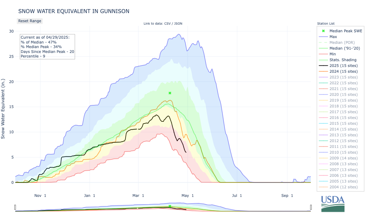
Hurford led with a discussion of what is unfolding locally in water year 2025 (Oct. 1, 2024 through Sept. 30, 2025). The Upper Gunnison Basin’s April 1 snowpack (usually at or near the maximum depth for the winter) contains only 59% of the 30-year average water content. It is projected at this point to yield through July about 540,000 acre-feet of runoff or less for the river — probably not enough to fill Blue Mesa Reservoir after downstream water rights are filled. An acre-foot of water is the amount it would take to cover the playing area of a football field to the depth of one foot. As the changing climate warms the planet, March is becoming the “new April.” This year’s snowpack peaked in mid-March. With the big melt usually beginning sooner nowadays, spring-like weather is causing trees and other plants to also begin “drinking” sooner…Increasing evaporation and plant transpiration also come with the changing climate. According to Mueller, for every additional degree Fahrenheit in the ambient temperatures, another 3-5% of water on the surface and in plants disappears as water vapor. These are changes to be anticipated for as long as we continue to warm the planet’s climate. Hurford concluded his presentation with a chart indicating that the decade beginning with 2020 is on track at this point to be the driest decade on record, including the droughts of the 1930s and 2000s.
From email from the Upper Gunnison Water Conservancy District (Sue Uerling):
The Colorado River District and the Upper Gunnison River Water Conservancy District are sponsoring the State of the Upper Gunnison River dinner and presentation. This event will be held on April 17, 2025, beginning at 6:00 p.m. at the Fred Field Center. The Colorado River District requires that you pre-register for the event using this link https://form.jotform.com/250417068418154. Hope to see you there.
Milkweed, sweet peas, and a plethora of other flora billow from Farmer’s Ditch in the North Fork Valley of western Colorado. Jonathan P. Thompson photo.
“I was standing there looking at a trickle running down a very large ditch thinking, ‘Man, it’s going to be hard to irrigate with that,’” said Jesse Kruthaupt of Trout Unlimited. “It was the summer of 2012, and I was visiting with a ranch manager about options to improve his irrigation system and water delivery, while also improving flows in Ohio Creek. As many remember, the snowpack that winter was pretty lean, and by the middle of June, there wasn’t much water left in many streams or ditches in western Colorado.”
It is situations like the one above that are at the core of the Upper Gunnison River Water Conservancy District’s grant program. Since 2009, the program has provided funds to address many of the issues facing basin water users, including drought resiliency. The district’s board of directors initiated the program in 2009 with a budget of $100,000. That year, only two grant applications were awarded for a total of $45,000. Since it was brand new and many of our constituents didn’t have a good grasp of what the program was all about, we were pretty excited to see the two applications then and happy to fund a pond lining project and ditch rehabilitation project. Since then, thanks to the success of many projects we have funded, the great outreach efforts of Jesse Kruthaupt and other consultants and the district’s education efforts, triple the amount of funding is available. The grant program continues to be hugely supportive of a variety of water projects. I am pleased to see that a number of projects have been dipping into available technology to achieve the best possible results and better water management. The number of applications and the requested funding amounts have grown steadily over the past 15 years. In 2025, we received 14 applications with a whopping $470,420 in requests, and $1.94 million in total project costs (applicants are required to contribute matching funds).
The Board of Directors of the Upper Gunnison River Water Conservancy District (UGRWCD) will conduct its annual meeting on Monday, June 24, 2024 at 4:00 PM at the UGRWCD Offices, 210 W. Spencer Ave., Suite A, Gunnison, CO 81230 and via Zoom video/teleconferencing.
Although the Upper Gunnison has proven the value of ASO flights, the agency — as well as many other water districts in Colorado — cannot pay for the costly technology alone. This year, the district created an Upper Gunnison Basin ASO funding partnership, a growing collective of local agencies that will divide the cost of running flights.
“For the Western Slope, it’s incredibly important to be able to predict annual hydrology so that we can live within our means on the river,” said District General Manager Sonja Chavez.
The annual cost of conducting snow surveys for the East and the Taylor River watersheds exceeds $300,000. These basins, which encompass roughly 570 square miles, are prioritized because they typically hold the most snow and generate the largest amount of water in the spring…After a $50,000 investment from the water district, the Gunnison County Electric Association, the Lawrence Berkeley National Laboratory, the Upper Colorado River Commission and the Colorado Water Conservation Board (CWCB) helped cover the rest. Chavez said she plans to expand the partnership next winter.
President Biden’s Bipartisan Infrastructure Law investing in environmental projects to increase water availability
11/15/2023WASHINGTON — The Department of the Interior today announced $51 million from President Biden’s Investing in America agenda for 30 new Environmental Water Resource Projects in 11 states through the Bureau of Reclamation. The collaborative projects focus on water conservation, water management and restoration efforts that will result in significant benefits to ecosystem or watershed health.
“Adequate, resilient and safe water supplies are fundamental to the health, economy and security of every community in our nation,” said Secretary Deb Haaland. “The Interior Department is focused on ensuring that funding through President Biden’s Investing in America agenda is going to collaborative projects throughout the West that will benefit the American people.”
As part of the Biden-Harris administration’s commemoration of the two-year anniversary of the Bipartisan Infrastructure Law, Principal Deputy Assistant Secretary for Water and Science Michael Brain announced the selections during a visit to Grand Junction, Colorado, where eight of the selected projects are located.
“These locally led initiatives utilize the investments from President Biden’s Bipartisan Infrastructure Law to demonstrate quantifiable and sustained water savings, all while providing a direct benefit to the surrounding ecosystems,” said Principal Deputy Assistant Secretary MichaelBrain. “These types of projects and robust cooperation with stakeholders are helping to improve watershed health and increase water reliability and access for families, farmers, and Tribes.”
President Biden’s Investing in America agenda represents the largest investment in climate resilience in the nation’s history and is providing much-needed resources to enhance Western communities’ resilience to drought and climate change. Through the Bipartisan Infrastructure Law, Reclamation is investing a total of $8.3 billion over five years for water infrastructure projects, including rural water, water storage, conservation and conveyance, nature-based solutions, dam safety, water purification and reuse, and desalination. Over the first two years of its implementation, Reclamation selected 372 projects to receive almost $2.8 billion.
The WaterSMART program also advances the Justice40 Initiative, part of the Biden-Harris administration’s historic commitment to environmental justice, which aims to ensure 40 percent of the overall benefits of certain climate, clean energy and other federal investments flow to disadvantaged communities that have been marginalized by underinvestment and overburdened by pollution.
Arizona
Altar Valley Conservation Alliance, Surface Water Conservation for Drought and Climate Resilience in the Altar Valley Watershed
Reclamation Funding: $1,213,809
The Altar Valley Conservation Alliance, in partnership with the Pima County Regional Flood Control District, will use a series of nature-based features in the Altar Wash watershed, southwest of Tucson, Arizona, to slow flows, improve groundwater infiltration, and create surface water habitat for wildlife. The Alliance will install low-tech natural infrastructure in dryland streams facilities across 8,985 acres of the wash, which will slow the runoff, reducing erosion and retaining water in the wash for longer periods. The project will enhance drought and climate change resilience, reduce downstream flood impacts and increase the sustainability of agricultural operations.
California
San Bernardino Valley Municipal Water District, Hidden Valley Creek Aquatic and Riparian Habitat Restoration Project
Reclamation Funding: $3,000,000
San Bernardino Valley Municipal Water District will implement the Hidden Valley Creek Aquatic and Riparian Habitat Restoration Project within the Upper Santa Ana River Watershed, a tributary of the Santa Ana River, in southern California. The project will restore and improve the condition of 21.7 acres of degraded aquatic and riparian habitat, including habitat for the threatened Santa Ana Sucker. The district will construct new and restored stream channel, establish a buffer of native riparian vegetation on each side of the stream, and enhance a 1.2 acre floodplain bench. The project will include non-native plant removal and site revegetation efforts. This restoration will improve water quality, increase habitat connectivity, and provide crucial support for recovering endangered and sensitive species.
Uncompahgre River
Colorado
American Rivers, Inc, Uncompahgre River Multi-Benefit Project
Reclamation Funding: $ 1,198,376
American Rivers, in partnership with the Ward Water Group and local landowners, will upgrade irrigation infrastructure and enhance aquatic and riparian habitats along one mile of the Uncompahgre River in western, Colorado. The current push-up diversion dam structure has caused channel widening, reduction of aquatic habitat diversity, and a decrease in floodplain connectivity. American Rivers will improve the Ward Irrigation Ditch infrastructure by constructing 2 cross-vane weirs, installing a new concrete stoplog bypass at the headgate, and piping 5,600 linear feet of open irrigation ditches. The project will improve aquatic and riparian habitat within the channel by constructing cross-vane weirs, J-hook vanes, rock vanes, and boulder clusters; revegetating the banks and meanders using willow pole clusters and riparian plant species plugs; and removing invasive vegetation.
Rio Grande through the eastern edge of Alamosa July 5, 2022. Photo credit: Chris Lopez/Alamosa Citizen
Colorado Rio Grande Restoration Foundation, Farmers Union Multi-Benefit Diversion Infrastructure Improvement Project
Reclamation Funding: $1,274,625
The Colorado Rio Grande Restoration Foundation, in partnership with the San Luis Valley Irrigation District, will upgrade the diversion infrastructure for the Farmers Union Canal and Rio Grande #1 Ditch, in southwestern Colorado, to meet agricultural, ecological, recreational, and community needs. The current diversion infrastructure creates a barrier to fish passage, is hazardous for boaters, and requires frequent maintenance. The partners will construct a new diversion structure, incorporating fish passage that will allow fish to access an additional 1.42 river miles of habitat. The project also includes restoration of streambank through the installation of rock and root wad structures and streambed and aquatic habitat through improved sediment transport at the diversion structure. The diversion upgrade will provide safe boat passage and more efficiently deliver water to the Farmers Union Canal and Rio Grande #1 Ditch.
Mancos River in Montezuma County
Mancos Conservation District, Riparian Restoration and Infrastructure Improvements to Better the Ecological Processes of the Mancos Watershed
Reclamation Funding: $2,482,686
The Mancos Conservation District, in partnership with the Town of Mancos, will implement a multi-benefit project consisting of a suite of infrastructure improvements and nature-based solutions along the Mancos River, a tributary of the San Juan River, in southwestern, Colorado. The partners will upgrade three agricultural diversion structures, install remote metering and telemetry equipment on 10 agricultural pipeline headgates, complete fire mitigation work on 650 upland acres and replace invasive riparian plants with native species adjacent to the Mancos River. The project is downstream of Reclamation’s Jackson Gulch Reservoir and will mitigate wildfire risk to the reservoir and water supplies in the Mancos River Watershed.
Roan Cliffs Aerial via Rocky Mountain Wild
Middle Colorado Watershed Council, Roan Creek Fish Barrier and Diversion Infrastructure Upgrade
Reclamation Funding: $746,423
The Middle Colorado Watershed Council, working in partnership with Garfield County, will install a fish barrier to prevent non-native fish migration, and upgrade a diversion structure on Roan Creek, in western Colorado. The upper portion of Roan Creek, a tributary of the Colorado River, contains a unique native fish assemblage comprised of Colorado River cutthroat trout, bluehead sucker, Paiute sculpin, and speckled dace. Non-native fish in the Roan Creek watershed harm the river system’s ecology by predating on or hybridizing with the unique native species. Construction of a fish barrier will effectively eliminate the upstream movement of non-native fish to improve Roan Creek’s aquatic and riparian habitat and protect the native fish.
Purgatoire Watershed Partnership, Purgatoire River Fish Passage
Reclamation Funding: $2,403,748
The Purgatoire Watershed Partnership will improve fish passage at the Baca-Picketwire diversion dam on the Purgatoire River in downtown Trinidad, Colorado. The Purgatoire River supports a robust assemblage of fish species and is of local and regional interest for conservation. Currently, ecological function is impaired because the existing concrete diversion dam is not passable to fish. This project will restore fish habitat connectivity and enhance recreation opportunities by adding a low-gradient engineered riffle feature that mimics a natural channel. The upgrade will allow fish access to 3.3 miles of main river, wetlands, 20 miles of Raton Creek, and many stream miles within ephemeral drainages, including approximately 4 miles of Moore’s Canyon and 9 miles of Colorado Canyon. The project is also expected to have flood mitigation, sediment transport, and bank stabilization co-benefits.
Los Pinos River
Southern Ute Tribe, Nannice Canal Diversion and Fish Passage Project
Reclamation Funding: $651,920
The Southern Ute Tribe, in partnership with the Bureau of Indian Affairs (BIA) and The Nature Conservancy, will implement the Nannice Canal Diversion and Fish Passage project on the Southern Ute Indian Reservation in southwestern, Colorado. Part of the BIA-owned and operated Pine River Indian Irrigation project that receives water from Reclamation’s Vallecito Dam, the Nannice Canal Diversion is a low-head dam that sweeps across the Los Pinos River and creates a significant fish barrier. Fish get entrained in the Nannice Canal during low flows and during irrigation season. The Southern Ute Water Resources Division will upgrade the diversion structure and install a fish screen and fish ladder. The project will restore river connectivity, improve fish passage, and eliminate fish entrainment during low flows, while continuing to allow the diversion of Nannice Canal’s decreed water.
August, in the Elk Creek valley. Photo: Brent Gardner-Smith/Aspen Journalism
Trout Unlimited, Inc, Middle Colorado River Agriculture Collaborative: 4 Fish Passage/ Irrigation Diversion Upgrade Projects on Elk Creek-a tributary to the Colorado River
Reclamation Funding: $2,999,595
Trout Unlimited and the Middle Colorado Agriculture Collaborative will upgrade, relocate, or combine six diversion structures to remove instream barriers to fish passage in the Elk Creek west of Glenwood Springs, Colorado. These upgrades will open approximately five miles of aquatic habitat in Elk Creek to fish passage. The project is anticipated to improve stream morphology, increase instream flows, and benefit irrigators by increasing the operational capabilities of the diversions and reducing transmission losses of vital irrigation water.
Agriculture in the U.S. Southwest is at high risk from the impacts of climate change. EcoFlight photo of the North Fork Valley by the Western Slope Conservation Center.
Western Slope Conservation Center, Farmer’s Ditch Improvement Project
Reclamation Funding: $ 1,594,799
The Western Slope Conservation Center, in partnership with North Fork Farmer’s Ditch Association, located in west-central Colorado, will modernize the Farmers ditch diversion and headgate structures to improve upstream fish passage, increase diversion efficiency, and improve safety for boaters. The project will upgrade the existing concrete headgate structure with a long-lasting alternative headgate that is equipped with remote automation technology, enabling more efficient water deliveries to irrigators while maximizing water that remains in the river. In addition, the Center will install graded riffle and small pools and drops to mimic the natural morphology of the river for approximately 200 feet below the diversion to promote upstream fish passage and allow for safe recreational boating.
Hawaii
Hawaii Department of Land and Natural Resources, Protecting Forests for Water Supply Sustainability in Molokai, Hawai’i
Reclamation Funding: $936,892
The state of Hawai’i Department of Land and Natural Resources, Division of Forestry and Wildlife, will expand protection of native landscapes in the north-eastern portion of Molokai, one of the five Hawaiian Islands. Invasive hooved animals, including feral pigs, deer, and goats, are the main threat to Hawai’i’s original forests, negatively impacting water supply, increasing flood risk and land erosion, and threatening several listed species. The project will reduce populations and associated damage to the forest due to these invasive animals through animal control and installation of fencing to exclude them from 3,340 acres within the Pelekunu Valley. The project will also remove hooved animals from an additional 12,000 acres along the north shore of Molokai in an area with steep terrain that is not possible to fence. The island of Molokai relies on ground water for all fresh water needs and is designated as a groundwater management area by Hawai’i’s Commission of Water Resources Management. The forest provides increased water infiltration into the aquifer and reduces soil erosion and associated water quality issues.
Idaho
City of Pocatello, Rainey Park Stream Restoration and Wetland Creation
Reclamation Funding: $1,635,276
The city of Pocatello, Idaho, will implement a river restoration project on the Portneuf River in downtown Pocatello. The health of the Portneuf River has been severely compromised by flood protection levees and the construction of a concrete channel, which removed hundreds of acres of wetlands when installed. Restoration will be accomplished by moving the river’s existing riprapped levee to an area of city-owned property. A wetland and side channel will be installed adjacent to the levee, along with accessible river access for anglers and floaters. Additionally, a stormwater pond will be installed to capture the first flush of sediment-laden waters from city streets. This project builds on the concepts developed in the 2016 Portneuf River Vision Study and addresses a wide range of environmental goals, including improving hydrologic functions by increasing floodplain, wetland, and riparian habitat areas, and improving water quality.
The Nature Conservancy, Loving Creek Tributaries Restoration and Water Conservation Project
Reclamation Funding: $1,900,217
The Nature Conservancy, in partnership with Idaho Department of Fish and Game and landowners, will complete a suite of nature-based features on four reaches of Loving Creek, located in Blaine County in south central Idaho. The four project locations span the full extent of Loving Creek from its headwaters to the outlet at Silver Creek. Through a combination of in-stream restoration work, sediment removal, and riparian habitat creation, the project will restore 2.75 miles of active stream channel, regenerate riparian and wetland habitat, and remove one fish passage barrier to holistically restore connectivity to 5.72 miles of upstream habitat. The project also will revive upland and agricultural buffer habitat and pipe 1,200 linear feet of open water delivery canal to conserve 9 acre-feet of water, which will remain in Loving Creek as instream flow. Despite improvements in agricultural management and land use practices over the past several decades, water quality and habitat conditions in Silver Creek and its tributaries remain degraded. This project will restore more natural channel morphology, increase habitat complexity, and improve water quality in Loving Creek.
Nez Perce Soil and Water Conservation District, White Road Passage Project
Reclamation Funding: $367,091
The Nez Perce Soil and Water Conservation District will improve anadromous fish habitat for Federally listed Steelhead Trout in the Tom Beall Creek watershed, a tributary to Lapwai Creek, located in northern Idaho. The project will improve watershed health within the boundaries of the Reclamation’s Lewiston Orchard Project. The district will replace an existing culvert with a fish passable structure to support the migration of the Steelhead Trout and additional species including Coho and Chinook Salmon. When completed, the project will provide access to approximately two miles of habitat and reduce area flood risk. The project also will improve water quality to downstream recreational and agricultural water users. The project is supported by the Lapwai Creek Ecological Restoration Strategy developed collaboratively with the Nez Perce Tribe, National Marine Fisheries Service, Idaho Department of Transportation, Nez Perce County, city of Lapwai, city of Culdesac, Lewiston Orchards Irrigation District, a landowner advisory group, and several Idaho state government divisions.
Nez Perce Soil and Water Conservation District, Lower Clearwater Snake Rivers Phase I
Reclamation Funding: $451,889
The Nez Perce Soil and Water Conservation District will undertake the Lower Clearwater Snake Rivers Phase I Project in Culdesac, Nez Perce, and Lewis Counties, in northwest Idaho. The project will improve watershed health within the boundaries of the Reclamation’s Lewiston Orchard Project. The district will enhance anadromous fish habitat for Federally listed Steelhead Trout and improve overall water quality in the Lower Clearwater River Basin. The district will upgrade a culvert for aquatic organism passage, thin approximately 129 acres of forest to mitigate wildfire risk and install over 100 instream wood structures to enhance over 10,000 feet of stream for juvenile steelhead habitat. The project will yield ecological benefits including improved habitat function, optimized flow timing, increased groundwater recharge, and reduced sedimentation.
Trout Unlimited, Inc, Completion of the Alta Harris Creek Boise River Side Channel and Fish Passage Project Along the Boise River
Reclamation Funding: $734,103
Trout Unlimited, together with the city of Boise, Idaho, will improve aquatic ecology in the Boise River by restoring spawning and rearing habitat for salmonid fishes, and providing fish passage connection between the lower Boise River and Barber Pool, downstream of Reclamation’s Arrowrock Dam. The project will enhance 3,800 feet of existing side channel and include construction of 1,600 feet of new side channel, complete riparian revegetation with native plants, and construct of a fish passage facility at Barber Dam. The fishway design will better accommodate fluctuating river flows and variable water surface elevation. Completion of this project will reconnect 2.5 miles of the main-channel Boise River with 5 acres of adjacent riparian habitat and over a mile of side channel for spawning and rearing of juvenile fish. The project also will allow fish to bypass a half mile of the Boise River with a risk for fish entrainment in water delivery canals.
Wood River Land Trust, Warm Springs Preserve Stream Restoration and Irrigation Improvement Project
Reclamation Funding: $1,733,154
Wood River Land Trust, in partnership with the city of Ketchum, Idaho, will enhance and improve the ecological function of the 65 acre Warm Spring Preserve along the Warms Springs Creek in Blaine County, in central Idaho. Warm Springs Creek in the project area has been artificially confined, concentrating flow, and creating incision and floodplain abandonment. There is virtually no floodplain connectivity within the northern half of the project reach. The project will restore 1.3 miles of Warm Springs Creek through instream earthwork to create pools, point bars, and constructed riffles, and installation of woody debris structures to promote in-channel complexity. The project will also create nine acres of adjacent floodplain habitat by lowering the floodplain. The floodplain restoration will be complemented by revegetation with low-water native plant species along the riparian zones and throughout the preserve, which will collectively aid in improvement of water quality and temperature of Warm Springs Creek.
New Mexico
Chama Peak Land Alliance, Increasing Resiliency in the San Juan-Chama Project Headwaters
Reclamation Funding: $3,000,000
The Chama Peak Land Alliance will conduct ecological forest thinning on approximately 2,150 acres to protect source watersheds for Reclamation’s San Juan-Chama Project, the Rio Chama headwaters, and the Rio Brazos headwaters from the impacts of future wildfires. Forests in these headwaters are unnaturally dense and homogenous, putting them at risk of severe wildfires and deterioration of watershed function. These watersheds supply crucial drinking water to the cities of Albuquerque and Santa Fe, and numerous tribes, Pueblos, and rural communities throughout New Mexico. In addition to threatening water supply infrastructure, a severe wildfire could cause water quality impairments, flooding erosion and significant degradation of habitat for fish and wildlife.
Pueblo of Isleta, Restoring Watershed Function and Protecting Sacred Ancestral Sites on the lower Rio Puerco, a tributary of the Rio Grande
Reclamation Funding: $2,487,942
The Pueblo of Isleta will build resilience in the lower Rio Puerco watershed by implementing nature-based watershed restoration techniques to restore natural watershed function on an approximately 30,000 acre parcel of the Comanche Ranch and neighboring lands, in central New Mexico. Forming a part of the Pueblo of Isleta lands, the Comanche Ranch comprises over 90,000 acres of public and private lands and is home to upwards of one hundred sacred ancestral sites, including an important cultural site, the Pottery Mound. The ranch forms an integral part of the Rio Puerco lower watershed, the primary source of sediment to the middle Rio Grande and Reclamation’s Elephant Butte Reservoir. The Pueblo and stakeholders have identified that loss of vegetation and increasingly higher energy monsoonal storms that have resulted in erosion and soil loss throughout the uplands in this region and threaten the cultural sites downstream. The Pueblo will utilize a series of watershed restoration practices that spread and slow runoff flows, increase groundwater infiltration, and reduce erosion, including contour plowing with native seed imprinting, contour stone line and brush weir installation to protect plantings and slow runoff, and riparian restoration and revegetation on a section of the Rio Puerco adjacent to Pottery Mound, including the planting of wild medicinal and traditionally gathered edible plants.
Nevada
Southern Nevada Water Authority, Muddy River Riparian Corridor Improvements at Warm Springs Natural Area
Reclamation Funding: $743,329
The Southern Nevada Water Authority will protect the Warm Springs Natural Area, a 1,250 acre property located in southern Nevada, and downstream habitat from drought impacts. The property is regionally significant as it contains more than 20 perennial springs that form the headwaters of the Muddy River and numerous habitat types. These resources provide habitat for several protected and sensitive species, including the endangered Moapa dace, endangered southwestern willow flycatcher, and threatened yellow-billed cuckoo. The project will widen the riparian corridors along 0.3 miles of the mainstem of the Muddy River and establish mesquite bosques along the corridor, resulting in the creation of 12 acres of new habitat. These actions will increase habitat for listed species, improve hydrologic conditions, lessen wildfire risk, and reduce erosion and sedimentation during flood events. Non-native vegetation will be removed and replaced with native vegetation to restore the area to the natural habitat that existed before the area was converted for agricultural purposes.
Oregon
Crooked River Watershed Council, Lower Crooked River Riparian, Floodplain, and Habitat Restoration Project
Reclamation Funding: $1,400,000
The Crooked River Watershed Council, working in partnership with the Ochoco Irrigation District, will restore habitat and enhance ecological features on two project sites just downstream from Prineville, Oregon. Hydrology in the Crooked River watershed is impacted by upstream Dams, including Reclamation’s Bowman Dam, leading to loss of floodplain continuity, degraded channel structures, and water quality impairments, impacting native Spring Chinook Salmon and Columbia River Steelhead populations that inhabit the watershed. To address these impairments, the Council will strategically place approximately 130 large wood structures to promote habitat complexity, stabilize eroding streambanks on 3,285 linear feet of stream channel, restore approximately 19 acres of floodplain and upland habitat, improve 0.22 acres of alcove habitat, and create 0.42 acres of wetland.
Deschutes Land Trust, Ochoco Preserve Restoration – Phases 2 and 3
Reclamation Funding: $3,000,000
The Deschutes Land Trust, with support from the Oregon Department of Fish and Wildlife, will restore aquatic, floodplain, and upland habitat across 124 acres on the Ochoco Preserve, located in Crook County, Oregon, adjacent to the city of Prineville. The Crooked River and Ochoco Creek support reintroduced spring Chinook salmon and summer steelhead, as well as a host of other native aquatic species. The waterways frequently experience low flows, elevated summer stream temperatures, and poor water quality. These issues are compounded by a lack of suitable habitats for both fish and terrestrial wildlife, and the impacts to river ecology of Reclamation’s Crooked River Project, including Bowman and Ochoco Dams. The Deschutes Land Trust will lead efforts to create over 2 miles of new main baseflow stream channels, 1.5 miles of side channels, over 11 acres of wetland, and restore 37 acres of floodplain and 75 acres of upland habitat, significantly increasing available habitat for native species.
Texas
Menard County Water Control and Improvement District #1, Pipe a 2.5 mile section of the Menard Canal and dedicate 1,100 acre-feet instream
Reclamation Funding: $1,891,500
Menard County Control and Improvements District #1, in central Texas, will upgrade the Menard Canal irrigation water conveyance system to reduce losses so that more water is kept in the San Saba River for fish and wildlife benefit. A water loss study conducted by U.S. Geological Survey in the summer of 2014 showed that the 6-mile long canal experiences an approximately 50% loss over the first 2.5 miles. The project involves replacing the first 4,000 feet of the unlined Menard Canal with pipe, and re-sloping, reshaping and partially filling the next mile of unlined canal to create a narrower channel profile. Following that narrowed span of canal, the district will pipe an additional 2,000 feet of the canal and install gates to control flow. The district has committed to leaving the majority of the conserved water, 1,100 acre-feet per year instream for a 30 year term. The additional instream flows will contribute significantly to baseflow of the San Saba River and create a more reliable supply of water for downstream aquatic habitat. Sections of the San Saba River downstream from the project that will benefit from the increased flows include critical habitat for the Texas fatmucket and Texas pimpleback mussel species.
Washington
The Confederated Tribes and Bands of the Yakama Nation, Lower Yakima River: Anadromous Fish Survival
Reclamation Funding: $2,248,677
The Yakama Nation, in partnership with the Benton County Conservation District, will improve conditions for anadromous fish species in the Prosser, Snively, and Confluence reaches of the lower Yakima River, in central Washington. The project will address two key elements of the Yakima Basin Integrated Plan: fish passage and habitat protection and enhancement. The Yakima Nation will complete instream restoration work to expand a cold-water refuge within the Yakima River mainstem at the confluence of Amon Creek, including construction of 1,400 linear feet of cool water channel habitat and restoration of 20 acres of riparian zone through invasive vegetation removal and revegetation with native species. The Yakima Nation will also complete electrofishing and install a fish trap on the Wanawish Dam to remove and prevent reintroduction of invasive predatory fish species that impede the migration of endangered fish species. These improvements will benefit the federally threatened Middle Columbia River steelhead; spring and fall/summer run Chinook, Coho, and Sockeye salmon; and the Yakima population of Pacific lamprey. The project area is downstream of Reclamation’s Yakima Project, which impacts river flows, temperatures, and habitat conditions in this area.
The Confederated Tribes and Bands of the Yakama Nation, Yakima River Mile 89.5 Side Channel and Floodplain Restoration
Reclamation Funding: $600,000
The Confederated Tribes and Bands of the Yakama Nation will reconnect approximately 9 miles of side channel along the Yakima River within the Yakama Reservation, in south central Washington. Upstream flow regulations tied to Reclamation’s Yakima Project have constricted historical floodplain processes and cut-off side channel access for native fish species, leading to degradation of riparian and wetland habitat areas. The Yakama Nation will excavate five historic side channel sections connecting to the mainstem of the Yakima River, install two constructed logjam inlet structures to ensure fish access to the mainstem of the river, and install three stream ford crossings to access the project site. The excavation of side channels will increase winter and spring off-channel habitat utilized by Middle Columbia River Steelhead and restore hydrologic connectivity to a total of 135 acres of floodplain and wetland habitat. The project is supported by the Yakima Basin Integrated 10-Year Action Plan developed by water and land management stakeholders.
The County of Chelan, Camas Meadows Streamflow and Ecosystem Restoration Project
Reclamation Funding: $468,903
The Chelan County Natural Resource Department, in coordination with the Washington Department of Natural Resources, will restore wet meadow hydrology in Camas Meadows, a unique meadow ecosystem within the steep canyon drainages of north-central Cascade Mountains in Washington. The 1,300 acre meadow flows into Camas Creek, a tributary of Peshastin Creek, in the Wenatchee Watershed. Due to widespread floodplain disconnection and irrigation withdrawals, the Peshastin sub-basin is among the top three flow-limited sub- basins in the Wenatchee Watershed, with chronic low flows and high stream temperatures limiting recovery of ESA-listed steelhead and spring Chinook that reside throughout Peshastin Creek and in the lower reaches of Camas creek. Historic land use practices have resulted in Camas Meadows being confined into ditch-like channels with incision ranging from 4 feet to 8 feet, causing rapid and early drying of the meadow. This projectwill restore the natural hydrology of the meadow by replacing the meadow outlet culvert, re-grading the channel and meadow elevations, installing channel-spanning habitat log structures, and re-planting with native shrubs and plants. The project will restore floodplain connectivity and wet meadow hydrology for a modeled additional water storage of 180 acre-feet and an anticipated year-round baseflow contribution of 0.2 cfs.
Kittitas Conservation Trust will implement an in-stream restoration project on river mile 2-3 of Gold Creek, in Kittitas County, Washington. Located just east of Snoqualmie Pass in Kittitas County, Washington, Gold Creek is the headwaters of the upper Yakima River and flows for approximately 8 miles from the Alpine Lakes Wilderness into Keechelus Reservoir in the Central Cascade Mountains. Upstream fish passage is blocked at Reclamation’s Keechelus Dam on the downstream end of the reservoir. Prolonged dewatering conditions and a century’s worth of anthropogenic channel widening have dramatically impacted the habitat and health of the creek’s Federally threatened Bull Trout. The Trust will install a total of 28 large woody debris structures along the river mile. The instream wood replenishment will create habitat complexity, including deeper pools with shaded cover, provide relief from high velocity flood flows, and ensure optimal habitat for both the successful rearing of juvenile Bull Trout and migration of mature fish. The project also will provide floodplain reconnection, which will improve groundwater recharge from flood flows, and reduce the likelihood of future flood events further harming the channel morphology.
Kittitas Reclamation District, Kittitas Reclamation District – South Branch Piping
Reclamation Funding: $3,000,000
The Kittitas Reclamation District, located in central Washington, will restore in-stream flows and provide benefits to fish and wildlife in Mantash Creek, an over-appropriated tributary of the Yakima River. The project will involve the piping of a 2,656 linear feet section of the currently unlined South Branch Canal, which is part of Reclamation’s Yakima Project. Once piped, the district anticipates conserving approximately 385 acre-feet per year currently lost to seepage. The district will designate this otherwise lost water through an allocation, management, and protection agreement, that involves careful monitoring of stream flow on Mantash Creek to maintain optimal conditions for Yakima Basin fish species, including Coho and Chinook Salmon, Mid-Columbia Steelhead, and Bull Trout. The Washington State Department of Ecology is responsible for water protection and enforcement and will ensure that conserved water stays instream.
Wyoming
City of Casper, North Platte River Restoration — Izaak Walton Reach
Reclamation Funding: $3,000,000
The city of Casper, in collaboration with members of the Platte River Revival Committee, will complete a river and riparian restoration project on the Izaak Walton reach of the North Platte River in Natrona County, Wyoming. The North Platte River is a Blue Ribbon trout fishery, but this reach suffers from significant bank erosion, tight riverbend geometry, a lack of riffle-pool complex development, poor bedform complexity, meager floodplain connectivity, and is characterized by a low quality riparian vegetation community. These conditions have resulted in degraded habitat for trout as well as native aquatic and terrestrial species. These characteristics have also contributed to reduced ecological function, adversely affected the regional municipal water supply, degraded aesthetic values, and impaired river recreation. The city of Casper will restore over 5,150 linear feet of the North Platte River that will involve regrading of the riverbed, banks, and floodplain to create appropriate geometry and bedform complexity, reduce riverbank degradation, and improve instream and riparian habitats.
Trout Unlimited, Inc, Sage Creek Watershed Restoration for Drought Resilience and Sediment Control
Reclamation Funding: $1,513,538
Trout Unlimited, working in partnership with Wyoming Game and Fish, will complete a multi-part restoration project, including nature-based features, in the Sage Creek Watershed, located in southwestern Wyoming. The project will involve the installation of 50 beaver dam analogs, 160 aggradation structures, and an aquatic invasive species barrier along a 5.6 mile stretch of Sage Creek. These installations will be complemented by a robust invasive plant removal and native riparian reseeding along 7.6 miles of both the Sage and Trout Creeks. Together, these actions are estimated to restore 453 acres of valley floor habitat and protect 79.5 linear miles of aquatic habitat from invasive trout that inhabit Reclamation’s Flaming Gorge Reservoir just downstream of the project site. The project is additionally expected to reduce channel incision and erosion to reduce sediment and nutrient delivery to Flaming Gorge Reservoir, protect native trout from hybridization, and increase groundwater recharge and surface water availability.
Click the link to read the article on The Crested Butte News website (Katherine Nettles). Here’s an excerpt:
UGRWCD senior water resource specialist Beverly Richards reported that the Gunnison River at the Gunnison Whitewater Park was flowing at 3,210 cubic feet per second (CFS) last weekend, and is very close to peaking. Richards said there is currently only one small portion of Gunnison County to the west that is facing drought, and the three month outlook shows drought conditions not recurring with the exception of a few areas to the north. Richards reported that precipitation has generally been within the historic normal range in the past 30 days, while snow water equivalent (SWE) maps show 193% of normal for the entire Gunnison Basin and 153% of normal for the upper basin. SNOTEL sites where SWE is measured are melting out. “But that was for May 19,” she said, which reflects that in May there isn’t usually much snow left.
The entire Gunnison Basin water storage is at 75% of average; reservoir storage for the Upper Gunnison Basin is 61%; and projected unregulated inflow for Blue Mesa Reservoir is at 131% of average. Richards said Blue Mesa is projected to be 97% full with a max fill amount of 102,869 acre feet. There is no indication from the Bureau of Reclamation (BOR) as of yet about how much water might be called downstream.
“Reservoir storage across the Upper Colorado River is going up, but Lake Powell is expected to only be about 37% full,” said Richards, due to the volume that will come out. For perspective, she offered an estimate that Lake Powell could be filled in three years if the region had the same kind of snowy year as 2023, and if no one took water out. With the reality of outflows, however, she said it would take 6 to 8 years with winters like this one to refill Lake Powell.
2023 GRANT FUNDS SUPPORT NUMEROUS PROJECTS THROUGHOUT UPPER GUNNISON BASIN
The Board of Directors of the Upper Gunnison River Water Conservancy District (UGRWCD) voted at the March 27th Board meeting to award $297,170 to organizations and individuals in the Upper Gunnison River Basin. These grant funds will be used for projects that will enhance water supply, improve stream and irrigation conditions, conserve water, provide water education benefits and restore wetlands. There was a diverse group of project applications from all over the Upper Gunnison River. Examples include a City of Gunnison native plant xeriscape project at 11th & Quartz Street intersection with educational signage, Coal Creek Dam Construction (Lake Irwin), and irrigation demonstration projects – one utilizing a combined plastic irrigation pipe, headwall, and turnout gate for improved irrigation water management and another utilizing an IntelliDitch HDPE Liner to prevent seepage loss.
All applicants were required to provide a 50 percent cost match and their projects had to be consistent with the District’s purpose, mission, and objectives.
UGRWCD General Manager Sonja Chavez noted during this year’s funding cycle, the District received requests for funding that totaled $370,613.
“It was a very competitive cycle and I strongly encourage those who were not funded to reach out to us to discuss their project and how they can make it stronger for the next cycle,” said Sonja.
Sonja also pointed out the District Grant Funding Program is a prime example of the District’s responsible allocation of tax revenues to directly benefit diverse water improvement projects in the basin. “I am delighted to report that during this cycle, our District grant funds were leveraged at a ratio of 1:3 with outside funding sources which just amplifies returns on District investment.
The UGRWCD Grant Program follows an annual cycle with applications due in February each year. General Manager Chavez urges potential applicants or individuals, even those just wondering about a water project, to reach out to the District now so that the District can help with infrastructure assessment or engineering that can assist in ensuring that the project can be funded. If you have a water project in mind, please call the District at (970) 641-6065 to schedule a consultation.
Bridge 40 Diversion. Photo credit: Upper Gunnison River Water Conservancy District
Chittendon Diversion Improvement. Photo credit: Upper Gunnison River Water Conservancy District
The Upper Gunnison Basin Cloud Seeding Program started in the 2002/2003 winter season, following a feasibility study the year prior funded by Gunnison County in response to significant drought in 2002. After the program’s first year, the UGRWCD took over and in the time since it has grown to 15 generators, on both public and private land. The UGRWCD wants to add more generators in other qualified locations, starting with one on private land on Black Mesa. According to the UGRWCD, cloud seeding is one of the cheapest forms of augmentation water for the river basin at an estimated $0.53 per acre-foot annually. And it can provide critical water to support Gunnison River basin flows, Blue Mesa Reservoir and the local economy.
“Typically, what we plan for is that in the last five years or so the programs run at about $114,000 to $118,000 per year,” says Sonja Chavez, general manager for the UGRWCD.
The Colorado Water Conservation Board gives anywhere between $67,000 and $94,000 and the UGRWCD covers the remaining $20,000 to $45,000. Chavez says that program costs are increasing, however. “We are adding a new generation site, and we are going to be looking for new funding partners,” she says…
Cloud seeding cannot create a snowstorm, but it can increase the precipitation from a storm that already exists. Cole Osborne, project meteorologist for NAWC, explains how the process works using manual and remote-controlled generators and propane tanks to blast a mix of silver iodide and sodium iodide into the atmosphere.
“The solution attracts liquid particles in a cloud, and the water molecules develop into ice crystals…so you can speed up the process and make a cloud more efficient at producing precipitation,” he says…
The UGRWCD and NAWC believe a remote generator placed at Black Mesa between Crested Butte and Gunnison will do more than any other program enhancement, in terms of water augmentation in the Gunnison Range and to Blue Mesa Reservoir. The UGRWCD, with financial assistance from the Colorado Water Conservation Board, has decided to fund the initial set-up and infrastructure costs for the remote generator for approximately $67,600. Osborne says there’s a huge area they are trying to target to lead to increased spring runoff and rises in reservoir levels. According to a memo from the UGRWCD earlier this month to potential funding partners, “NAWC analysis indicates that the generator will have significant direct benefits to northern and southern tributaries to Blue Mesa Reservoir and to eastern tributaries due to positive downwind cloud seeding impacts. The remote generator would permit cloud seeding during almost all storm periods that impact the Upper Gunnison River watershed. Seeding could occur during periods with winds ranging from northerly to southerly.
Two Gunnison River water districts in the headwaters of the Colorado River system are embarking on a $700,000 drought planning effort, aided by hundreds of thousands of dollars in new funding from the U.S. Bureau of Reclamation.
The Montrose-based Uncompahgre Valley Water Users Association, one of the largest suppliers of agricultural water in the Upper Colorado River Basin, will spend $400,000 to develop an action plan for dealing with the ongoing and future droughts, with $200,000 in federal funds, and matching funds from local sources.
The Gunnison-based Upper Gunnison River Water Conservancy District will spend $300,000 for a similar program, with $140,000 in federal funds, and another $166,000 from local partners, according to its application. The Upper Gunnison district is responsible for delivering agriculture water, but also serves the city of Gunnison and the town of Crested Butte as well as the ski area.
Reclamation granted this funding through its WaterSMART program. On Aug. 2 the agency awarded more than $865,000 in drought planning funds to water districts and agencies in five states, including California, Arizona, New Mexico and Oregon, as well as Colorado.
The seven-state Colorado River Basin is facing severe water shortages and is operating under a basin-wide set of state-level drought contingency plans. Those plans include water cutbacks for users in Arizona and Nevada, and possibly California in the Lower Basin, as well as emergency releases of water from reservoirs in the Upper Basin, including Flaming Gorge and Blue Mesa. The Upper Basin includes Colorado, New Mexico, Utah and Wyoming.
Compared to the multi-million dollar state and federal efforts, the local WaterSmart grants are fairly small, but officials say they provide critical help in important areas and create opportunities to win matching funds from other agencies.
“This really helps because there is so much that has to be done,” said Sonia Chavez, general manager of the Upper Gunnison district. “And anything we can get will help us leverage funding to get more done. A couple of hundred thousand dollars really helps.”
Steve Pope, manager of the Uncompahgre association, said the money will go toward developing contingency plans and designing improvements to the association’s aging federal infrastructure on which it relies.
“Our infrastructure is extremely old,” Pope said. “Even though this grant is for planning purposes it will have a big impact on our system in the sense that it will allow us to best manage our water without having to make big infrastructure changes.”
Pope is responsible for delivering 500,000 to 700,000 acre-feet of water, through more than 700 miles of canals, laterals and drains, to farmers and some small towns in the Gunnison Valley.
Both districts occupy key territory in the Upper Colorado River Basin, with the Gunnison district lying just above Blue Mesa Reservoir, and the Uncompahgre district lying below.
Blue Mesa Reservoir, Colorado’s largest water storage reservoir operated by the U.S. Bureau of Reclamation, has been hard hit by drought and by emergency releases of water to help stabilize Lake Powell.
Chavez said her small, largely rural district has never implemented a drought plan, in part because one has never been needed until now.
The new grant funds will allow it to better monitor and analyze its water supplies, develop ways to conserve water, and determine equitable ways for farmers and cities to use whatever water is available.
“If we get into a drought, how is my little community here going to get through that drought?” Chavez said, “and how could we better share the water we do have available?”
Jerd Smith is editor of Fresh Water News. She can be reached at 720-398-6474, via email at jerd@wateredco.org or @jerd_smith.
On Aug. 16, the Bureau of Reclamation (BOR) issued a press release restating the urgency of the situation and laying out actions it will take in coming months to protect water levels in Lake Mead and Lake Powell.
“Every sector in every state has a responsibility to ensure that water is used with maximum efficiency. In order to avoid a catastrophic collapse of the Colorado River System and a future of uncertainty and conflict, water use in the Basin must be reduced,” Assistant Secretary for Water and Science Tanya Trujillo said. “The Interior Department is employing prompt and responsive actions and investments to ensure the entire Colorado River Basin can function and support all who rely on it. We are grateful for the hardworking public servants who have dedicated their lives to this work, and who are passionate about the long-term sustainability of Basin states, Tribes, and communities.”
“They said, ‘Well, we appreciate all of the efforts, and here’s what the August 24-month study shows, and here’s what we’re going to do for the next year, which is basically consistent with the 2007 guidelines with a modification,’” Upper Gunnison River Water Conservancy District General Counsel John McClow said.
That modification from the already existing agreement, McClow said, was to hold 480,000 acre feet of water back in Lake Powell to protect the critical elevation of 3,525 feet, but to treat it as if it went to Lake Mead for the purpose of water accounting.
“So, nothing new,” McClow said. “But they said they were still looking to the states to come up with an answer. Basically, I think it was unrealistic to expect the states to deliver a plan to cut the river use by 2 to 4 million acre feet in 60 days. It just wasn’t feasible.”
Brad Udall: Here’s the latest version of my 4-Panel plot thru Water Year (Oct-Sep) of 2021 of the Colorado River big reservoirs, natural flows, precipitation, and temperature. Data (PRISM) goes back or 1906 (or 1935 for reservoirs.) This updates previous work with @GreatLakesPeck. https://twitter.com/bradudall/status/1449828004230664195
The problem remains that aridification in the West has meant significantly less available water in the system over the past 20 years. That is compounded by what some have called a “structural imbalance” in how the water is used between the upper and lower basins. In 2021, for instance, the Lower Basin states consumed over 10 million acre-feet of water from the Colorado River, while the Upper Basin states combined consumed 3.5 million acre-feet.
Better than expected monsoonal rains this summer have not led Gunnison County out of the region’s persistent drought — but the moisture has gone a long way to lessen its severity. Beverly Richards, water resource specialist for the Upper Gunnison River Water Conservancy District, shared the message with the Gunnison County Commissioners on Tuesday. As of last week, over 96% of Gunnison County was listed in the National Integrated Drought Information System as falling in the category of “moderate drought,” one step above the least severe rating of “abnormally dry.” The 30-day outlook calls for continued improvement, as forecasts predict at least a 33% chance of above normal precipitation in the next month.
Richards said the wetter-than-forecasted summer has done little to improve the water storage outlook at Blue Mesa Reservoir, however. Current forecasts call for the lake to drop to 33% of capacity heading into winter, up only slightly from the 29% estimate in early summer. The water level in the reservoir peaked at 48% in July and sits at 44% of capacity.
Speaking before the Senate Committee on Energy and Natural Resources on June 14, Bureau of Reclamation Commissioner Camille Calimlim Touton warned that water users along the Colorado River must slash their usage by as much as one-fourth by the end of next year to “help preserve and protect power pool” at Glen Canyon and Hoover dams — both of which produce hydropower for millions across the region. Touton said Reclamation has seen similar patterns across every major basin in the West — hydrologic variability, hotter temperatures, dry soil — leading to earlier snowmelt and low runoff. Coupled with the lowest reservoir levels on record, “there is so much to this that is unprecedented,” she said.
“But unprecedented is now the reality,” Touton said…
“It is in our authority to act unilaterally to protect the system, and we will protect the system,” she said.
When looking to reduce usage by 4 million acre-feet, John McClow, general counsel for the Upper Gunnison River Water Conservancy District, said the answer is obvious. The Upper Basin states, situated at the headwaters of the Colorado River, have continued to take involuntary shortages each year, dependent on ebb and flow of rain and snowmelt.
“We haven’t got anything to give,” he said. “They’ve had perfect control of their supply ever since Hoover Dam was built. Their system is a lot easier to operate, you just turn on the tap … We don’t have those resources in the Upper Basin.”
[…]
UCRC Executive Director Chuck Cullom said he believes both the Upper and Lower basins need to contribute to a solution.
“I think the Upper Basin has taken significant efforts and suffered significant pain,” Cullom said. “There is more that can be done. Most of the work going forward should come from the area where there’s significant water use. And that’s, again, downstream.”
Cullom said although he is optimistic water users, tribes and the federal government can negotiate a plan within the 60-day window, emergency releases in 2021 and Touton’s call for more water reflects that the existing rules have been exhausted.
“Now that we’ve depleted the storage, the only choice is to adapt,” he said.
The UGRWCD presents the 1st Annual UPPER GUNNISON RIVER BASIN WATER ROUNDUP! Join us at the I Bar Ranch Thursday, June 9, 2022 from Noon to 9 PM. Register today at: https://t.co/0khTkr6rjJ or call the District at (970)641-6065. Hope to see you there! pic.twitter.com/gYEB7yB71i
he Gunnison Basin is facing a climate emergency, putting our farm and food systems at severe risk. This map shows the warming that has already occurred in this Gunnison watershed since 1895. Graphic credit: The Washington Post via the Colorado Farm & Food Alliance
The Upper Gunnison River Water Conservancy District continues to change, grow and adapt its public outreach efforts, directing the public to the main focus of their mission — managing the basin’s limited water supply.
Upper Gunnison is an active leader in all issues affecting the water resources of the Upper Gunnison River Basin. Their role in the valley has grown in importance as the basin continues to experience worsening drought conditions. In response, the district has continued to try and raise awareness of the community’s water use.
Sonja Chavez via Gunnison Basin Roundtable.
Upper Gunnison General Manager Sonja Chavez said that, after the drought year the basin experienced, it’s about getting a message out to the community.
“Water is a finite resource,” Chavez said. “I think most people don’t realize or understand that the whole Colorado River Basin is over allocated, we’re using more water than we actually have. As temperatures increase and stream flows decrease, it’s just going to become a greater challenge.”
The district’s education and outreach budget increased from $34,000 in 2021 to almost $42,000 for 2022. Although part of it is driven by the rising cost of promotional products and an increased sponsorship to the Gunnison River Festival, Chavez said overall, public outreach is “central and important” to the district’s mission…
Within their education action plan, staff began to break the public down into age groups, from elementary through high school as well as growing their relationship with Western Colorado University. The district’s goal was to try and be intentional about where they put the funding, who they reach out to and making sure it’s age appropriate.
Historically the Upper Gunnison helped fund the Water Workshop, which was renamed and reorganized into the Western Water Future Games. The Water Workshop, based at Western, has a 45-year history.
It was created to give more of a voice to the people of the Western Slope because at that time it was perceived that the Front Range was the dominant voice in water issues in the state, said Jeff Sellen, who oversees the program…
With a small staff of five, the Upper Gunnison has limited manpower. To make their outreach efforts more effective and far-reaching, their strategy has been “figuring out where they can add value” to existing events or programs, Chavez said.
Where there is an access to water the Upper Gunnison tries to build upon that opportunity for education. The Upper Gunnison has its hands in the River Festival, the 4-H Program and the Taylor Challenge. It also has an established mini-grant program designed to support educational projects intended to expand the awareness of water-related issues.
Name recognition is another important aspect of increasing the visibility and effectiveness of the Upper Gunnison’s water messaging in the valley. The district has used a newsletter, radio advertisements, yard signs and promotional items to spread the word that “water doesn’t grow on trees.”
Chavez said she thinks “a lot of people within the community don’t know exactly who we are or what we do.” But this is something that even larger districts still struggle with…
Upper Gunnison has started taking a harder look at its education and outreach in terms of who it’s reaching, and how successful it’s been, Chavez said. When people have an issue or question about water “I would want them to first think of the Upper Gunnison District.”
George Sibley as the Water Buffalo in “Sonofagunn.” Photo courtesy of the Gunnison Arts Center via the Upper Gunnison River Water Conservancy District
Click here to read the newsletter. Here’s an excerpt:
George Sibley was appointed to the UGRWCD Board of Directors in June 2006 representing Division 8, the City of Gunnison, and most recently served as Secretary for the District. After nearly 13 years of service, George submitted his resignation to the UGRWCD earlier this year. George is well-known and well-respected on the Western slope and throughout the state for his commitment to and many years of valuable service on water issues and protecting water users in the Upper Gunnison Basin. Because of his knowledge, time and effort committed to all things water, George affectionately earned the honorary title of Gunnison’s own “Water Buffalo,” a role he portrayed in many of the annual Sonofagunn productions at the Gunnison Arts Center.
“George will be dearly missed within the water community for the knowledge he brings to the table and for spurring much needed conversations around the water resource challenges we face,” said UGRWCD General Manager Sonja Chavez. “We wish him the very best!”
Here’s to calm waters, George, as you embark on the next phase of life!
“My name is George, and I’m a recovering writer.” Credit: George Sibley via his Facebook page.
From the Upper Gunnison Water Conservancy District (Sonja Chavez) via The Gunnison Country Times:
Board loses esteemed water leader
After 14 years of service at the Upper Gunnison River Water Conservancy District, George Sibley stepped down from the district’s board earlier this month.
Sibley, 79, cited his health and age as the reasons for his decision. Upper Gunnison General Manager Sonja Chaves and Board President Michelle Piece received a letter from Sibley on Feb. 9 notifying them that his resignation was effective immediately.
“I’ve got some stress-related health issues, nothing very serious, but I’m also almost 80; it was just time to cut back on some of my involvements, and make sure I get some other personal things done I’m working on,” Sibley said Tuesday.
Chavez said Sibley and his persistence in asking difficult questions will be missed at the Upper Gunnison.
“George has so much historical and institutional knowledge of water issues on the Westerm Slope,” Chavez said. “I didn’t always agree with George, but I appreciate that he pushed those difficult conversations!’
Sibley was the Upper Gunnison’s board secretary and served on a handful of committees at the time of his resignation.
The Upper Gunnison’s Board of Directors formally thanked Sibley by passing a resolution acknowledging his service. The resolution notes Sibley’s decades of writing about water, including “Water Wranglers,” which was published in 2012 to mark the 75th anniversary of the Colorado River District, as well as his role in organizing the Colorado Water Workshop, one of the premiere meetings of water policymakers in the Western U.S.
“We will miss him dearly,” said Upper Gunnison board Vice President Stacy McPhail during the board’s meeting Tuesday.
Board member John Perusek fills Sibley’s role as secretary. The Upper Gunnison will advertise the vacancy for 45 days ahead of the Upper Gunnison’s June 28 annual meeting. Applicants will need to be residents of the City of Gunnison since Sibley represented the city’s district on the board. Applicant letters will be forwarded to Seventh Judicial District Judge Steven Patrick. In accordance with the Upper Gunnison’s founding statute, Patrick will make the appointment decision.
Colorado River “Beginnings”. Photo: Brent Gardner-Smith/Aspen Journalism
Click here to read Ian James’ fantastic article about the current state of the Colorado River from stem to stern that’s running up at AZCentral.com. Click through and read the whole article. Here’s an excerpt:
The warming climate is intensifying drought, contributing to fires and drying out the river’s headwaters, sending consequences cascading downstream.
ROCKY MOUNTAIN NATIONAL PARK, Colorado — Beside a river that winds through a mountain valley, the charred trunks of pine trees lie toppled on the blackened ground, covered in a thin layer of fresh snow.
Weeks after flames ripped through this alpine forest, a smoky odor still lingers in the air.
The fire, called the East Troublesome, burned later into the fall than what once was normal. It cut across Rocky Mountain National Park, racing up and over the Continental Divide. It raged in the headwaters of the Colorado River, reducing thick forests to ashes and scorching the ground along the river’s banks.
The fires in Colorado spread ferociously through the summer and fall of 2020 after months of extreme heat that worsened the severe drought.
As smoke billowed over the headwaters, the wildfires raised warning signs of how profoundly climate change is altering the watershed, and how the symptoms of heat-driven drying are cascading down the heavily used river — with stark implications for the entire region, from Colorado’s ranchland pastures to the suburbs of Phoenix…
Over the past year, the relentless hot, dry months from the spring to the first snows left the soil parched. The amount of runoff into streams and the river dropped far below average. With reservoirs sinking toward new lows, the risks of shortages are growing.
Much of the river’s flow begins as snow and rainfall in the territory of the Colorado River Water Conservation District, which includes 15 counties on Colorado’s West Slope. Andy Mueller, the district’s general manager, said the extreme conditions over the past year offer a preview of what the region should prepare for in the future.
“Climate change is drying out the headwaters,” Mueller said. “And everybody in the Colorado River Basin needs to be concerned.”
Mueller saw the effects while backpacking in Colorado’s Holy Cross Wilderness in the summer with his 19-year-old daughter. Above the tree line, at an elevation of 12,000 feet, they expected to see mushy green tundra. Instead, they found the ground was bone dry…
People who focus on the river have widely acknowledged the need to adjust to a shrinking system with less water to go around.
Many suggest solutions can be achieved through collaborative efforts — often with money changing hands in exchange for water — while working within the existing rules. Others say solutions shouldn’t fall on the backs of farming communities by taking away water that fuels their economies. Some people argue the river seems headed for a crash and its rules need to be fundamentally reimagined…
The deals between the seven states are designed to temporarily lower the odds of Lake Mead and Lake Powell dropping to critical lows over the next five years. The states’ representatives have yet to wade into the details of negotiations on what shortage-sharing rules will look like after 2026, when the current agreements expire.
Still unresolved are difficult questions about how to deal with the shortfall over the long term.
What’s increasingly clear is that the status-quo methods of managing the river are on a collision course with worsening scarcity, and that eventually something will have to give…
Watershed ‘thirstier’ with heat
Last winter, after a dry year, the Rocky Mountains were blanketed with a snowpack that was slightly above average. Then came extremely hot and dry conditions, which shrank the amount of runoff and flows into tributaries and again baked the soils dry.
[Andy] Mueller said the change occurred abruptly at the end of the snow season in the spring…
With the heat, some of the snow didn’t melt but instead evaporated directly into the air, which scientists call sublimation — something that has been happening more over the past two decades. The flows in streams dropped over the next few months, and then August brought record heat, which dried out the headwaters and fueled the fires through the fall…
In a 2018 study, scientists found that about half the trend of decreasing runoff in the Upper Colorado River Basin since 2000 was the result of unprecedented warming. In other research, scientists estimated the river is so sensitive to warming that it could lose roughly one-fourth of its flow by 2050 as temperatures continue to rise…
“A warmer atmosphere is a thirstier atmosphere, and we’re seeing less runoff bang for our precipitation buck,” said Jeff Lukas, an independent climate researcher in Colorado. “We’ll still have wetter and drier years, but the baseline is very likely to be shifting downward, as it has in the last 20 years.”
And when extreme heat comes, it leaves less water running in tributaries and also translates into drier forests, leading to increased fire risk.
The soils were so dry over the past year that they soaked up moisture, contributing to below-average stream flows, said Megan Holcomb, a senior climate change specialist with the Colorado Water Conservation Board.
“You can think of it as like the dry sponge that you haven’t wetted in forever,” Holcomb said. “That kind of soil moisture deficit is not something that you rebound from immediately.”
Lake Powell, behind Glen Canyon Dam, shows the effects of persistent drought in the Colorado River Basin. (Source: U.S. Bureau of Reclamation)
After the hot spring came a dry summer. The lack of monsoon rains compounded the drought. And then came August, Holcomb said, when a map of record-hot temperatures hugged the Colorado River Basin like a “massive red handprint.”
In areas of western Colorado that drain into the river, it was the hottest and driest August on record, breaking the previous temperature record by 2 degrees F, said Russ Schumacher, Colorado’s state climatologist and director of the Colorado Climate Center.
The state usually gets its largest wildfires in June and July. But with the severe drought, the fires burned through August, and then exploded in October with unprecedented speed and intensity. The ultradry conditions, together with high winds, contributed to the three largest wildfires in Colorado history, which together devoured more than half a million acres.
In the future, rising temperatures will lead to more of these scorching summers.
Firefighters on the march: The Pine Gulch Fire, smoke of which shown here, was started by a lighting strike on July 31, 2020, approximately 18 miles north of Grand Junction, Colorado. According to InciWeb, as of August 27 2020, the Pine Gulch Fire became the largest wildfire in Colorado State history, surpassing Hayman Fire that burned near Colorado Springs in the summer of 2002. Photo credit: Bureau of Land Mangement-Colorado, via InciWeb and National Interagency Fire Center.
The Cameron Peak fire soon after it started on Aug. 13, 2020. By Sept. 11, the fire had grown to more than 102,000 acres (now >200,000 acres) and was not expected to be considered out until Oct. 31. Photo credit: InciWeb via The Colorado Sun
East Troublesome Fire October 21, 2020 via Wildfire Today.
Scenes of the CalWood Oct. 17, 2020 (Jivan West/CU Independent)
Abby Burk of the conservation group Audubon Rockies noticed how low the river was in the summer when she went paddling in her kayak. In parts where the river was full and muddy a year earlier, she found bars of gravel. Where there once were channels to paddle through, she encountered dead-end lagoons.
In November, when Burk drove through the headwaters near the smoldering fires, she snapped photos of the hills and mountains, still golden-brown beneath a dusting of snow.
When the soil is so parched, it will always “take the first drink” before water reaches the streams, Burk said. “We need a lot more snow for many years to come to really replenish the soil moisture deficits that we’re seeing now.”
The fire scars will also bring challenges come spring, she said, when melting snow will send runoff carrying ash, debris and sediment into streams, potentially creating complications for water systems.
Burk said she’s hoping there will be a slow melt so the runoff comes gradually, without “bringing down the mountain into the river.”
Rancher and fly-fishing guide Paul Bruchez raises cattle on 6,000 acres near Kremmling. Bruchez has taken an active role in Colorado River issues ever since his family suffered from a critical water shortage during the 2002 drought. Photo credit: Russ Schnitzer via Aspen Journalism
A rancher looks to adapt
Paul Bruchez raises cattle on his family’s ranch in the headwaters near the town of Kremmling, where the Colorado River winds through pastures…
Bruchez has been involved in discussions about the river as a member of the Colorado Basin Roundtable. And while he’s heard many people voice alarm about the watershed lately, Bruchez said he and other neighboring ranchers have been talking about the need to adapt to a river with less water since 2002, when severe drought came.
The flows dropped so low then that even ranchers with the longest-standing water rights, known as senior rights, couldn’t get it to their fields.
“Within this river basin, we have seen a change over time of the quantity and volume of water that is available. And in that same time, we’ve seen a growth of population that relies on it,” Bruchez said. “We knew this in 2002 when we hit that drought, that if we didn’t change how we operated, we weren’t going to survive.”
Since then, Bruchez and other ranchers have been talking about ideas for adapting…
The closer the region gets to a scenario of curtailing water allotments, Bruchez said, the more investors and representatives of cities and towns are going to be contemplating ways of securing water from elsewhere.
For people in agriculture, he said, “we need to be at the table or we’re going to be on the menu.”
[…]
Blue Mesa Reservoir, Curecanti National Recreation Area. Photo credit: Victoria Stauffenberg via Wikimedian Commons
‘It affects everybody’
One of the main tributaries that feeds the Colorado is the Gunnison River, which like the mainstem has shrunk during the heat-amplified drought. Along the Gunnison, cattle ranchers got less water last year and their pastures produced less hay.
The river’s low flows also forced an early end to the river rafting season on Labor Day weekend. After that, releases from a dam had to be cut back and the Gunnison was left much shallower than usual, with rocks protruding in stretches where boats would normally be drifting until the end of September.
Sonja Chavez via Gunnison Basin Roundtable.
The river has dropped to some of its lowest levels in years, said Sonja Chavez, general manager of the Upper Gunnison River Water Conservancy District.
The effects are visible at Blue Mesa Reservoir, one of the state’s largest, which has declined to less than half its full capacity.
Visiting the lake, Chavez walked on sandy ground that used to sit underwater.
Looking across the inlet where the river pours into the lake, she pointed to a gray line on the rock showing the high-water mark. During spring runoff, she said, the river in this channel can reach about 20 feet higher. But with the soil so parched, its level dropped.
“When we are dry in the Upper Gunnison Basin, it affects everybody downstream of us,” Chavez said. And the swings between high and low flows, she said, have made it difficult to plan how to operate the reservoirs…
Iron Fen. Photo credit from report “A Preliminary Evaluation of Seasonal Water Levels Necessary to Sustain Mount Emmons Fen: Grand Mesa, Uncompahgre and Gunnison National Forests,” David J. Cooper, Ph.D, December 2003.
Gunnison River in Colorado. Source: Bureau of Reclamation via the Water Education Foundation
Upper Gunnison watershed May 2019. Photo credit: Greg Hobbs
In the Gunnison Valley, a local climate action group meets to talk about potential solutions. Some conversations have focused on how to manage forests that have grown thick with vegetation over the past century as federal agencies have focused mostly on putting out fires.
While the forests have grown thicker, warmer temperatures have enabled beetles to flourish, littering the mountains with dead trees.
Chavez and others want to prioritize efforts to make the forests healthier and more fire-resilient by thinning the trees through logging, mechanical treatments or controlled burns, which they say would make the whole watershed healthier. She said the federal government needs to be more involved and the region needs funding for these projects.
“Our big push this year is to do some watershed management planning and work with the Forest Service to identify zones of concern, or areas that we can treat,” Chavez said. “We’re worried if we had a big fire what would happen.”
Alongside those efforts, water managers are discussing ways of dialing down water usage…
Ranchers, farmers consider using less
One lifelong rancher who had a smaller-than-usual hay crop was Bill Trampe, who has worked on water issues for years as a board member of the Colorado River District.
His cattle graze on meadows near Gunnison where the grasses survive year after year. He was short of water to irrigate after mid-June, which left the pastures parched.
Palisade is just east of Grand Junction and lies in a fertile valley between the Colorado River and Mt. Garfield which is the formation in the picture. They’ve grown wonderful peaches here for many years and have recently added grape vineyards such as the one in the picture. By inkknife_2000 (7.5 million views +) – https://www.flickr.com/photos/23155134@N06/15301560980/, CC BY-SA 2.0,
Over the past two decades, only a few years brought good snowpack, he said, and ranchers have repeatedly had to weather the financial hits of years when they must buy hay for their cattle…
‘We need to set the terms’
In other parts of the river basin, some representatives of agricultural water agencies are worried about the potential consequences of paying farmers to leave land dry.
One such voice is J.B. Hamby, a newly elected board member of California’s Imperial Irrigation District, who said he’s concerned that while cities and sprawling suburbs continue to grow rapidly, agricultural communities are increasingly at risk. He said people in cities need to realize there is a priority system that shouldn’t be changed…
Arizona gets nearly 40% of its water from the Colorado River. Much of it flows in the Central Arizona Project Canal, which cuts across the desert from Lake Havasu to Phoenix and Tucson.
In 2020, Arizona and Nevada took less water from the river under the drought agreement among Lower Basin states, and in 2021 they will again leave some of their water in Lake Mead. The latest projections show Mead could fall below a key threshold by summer, which would trigger a shortage declaration and larger cutbacks in 2022…
Now, with less water flowing to farms, the amount of runoff into the Salton Sea has shrunk, leaving growing stretches of exposed lakebed that spew dust into the air. The dust is contributing to some of the worst air pollution in the country, and many children suffer from asthma.
Hamby said the Imperial Valley would have been better off without the water transfer deal. Looking at the proposed approach in Colorado, Hamby said, it seems to replicate what occurred in Imperial.
“When you tie money to water, you get users who become addicted to the money and don’t actually in the end start to want to farm anymore,” Hamby said. “That is really corrosive to the long-term survival, much less thriving, of rural communities when people get more hooked on money rather than the way of life and putting the water on the land.”
He argued that such an approach would be “subverting the whole priority system” and enabling cities to avoid taking cuts themselves…
‘Are we doing enough?’
At his ranch by the river, Bruchez said he wants to be on “the preventative side,” getting ahead of the looming problems instead of reacting. And that includes studying and promoting conservation, he said, because the bottom line is “we just all have to figure out how to use less water.”
In early 2019, Bruchez began talking with Perry Cabot, a researcher from Colorado State University, about a project that would help provide data on crop water use, impacts of reduced irrigation and strategies for conserving water.
Cabot gave a presentation to the Colorado Basin Roundtable, and members supported the idea of a study. The project began in 2020 with about $900,000 in funding, including support from the Colorado Water Conservation Board and groups including Trout Unlimited and American Rivers.
A group of nine ranchers participated and were paid for leaving some fields dry or partially dry, Bruchez said. More than 900 acres weren’t irrigated for the entire year, and about 200 acres were “deficit irrigated,” meaning they received less water.
Bruchez’s ranch totals about 6,000 acres. He participated on about 41 acres, where he stopped irrigating on June 15 and didn’t water the rest of the year.
“My end goal is to understand the impacts of water conservation for agriculture so that if and when there are programs to participate, agriculture is doing it based on science,” Bruchez said…
Paul Bruchez said he’s seen that when people talk about solutions, they often seem to draw boxes around different approaches like demand management, water conservation, climate change and forest management, but he thinks they’re all quite connected.
“It’s all the same conversation,” Bruchez said. “To me, the question just comes down to, are we doing enough, quick enough?”
[…]
“It’s that water that is provided by the Colorado River that ties us all together,” Mueller said. “And truly, when we recognize the importance of the Colorado River and how it ties us together, that’s when we succeed as a society.”
Ian James is a reporter with The Arizona Republic who focuses on water, climate change and the environment in the Southwest. Send him story tips, comments and questions at ian.james@arizonarepublic.com and follow him on Twitter at @ByIanJames.
Click here to read the newsletter. Here’s an excerpt:
Chavez to Take the Lead at UGRWCD
Sonja Chavez has been selected to serve as the General Manager of the Upper Gunnison River Water Conservancy District. When asked about her new role, Ms. Chavez said, “I look forward to working with my local community and our Upper Gunnison Board of Directors and staff to continue to ensure that all water needs within the Upper Gunnison basin are being addressed, with other regional water users to speak with one voice on water resource issues affecting west slope communities, and with other state and federal entities to make informed decisions and have respectful dialogue around our current and future water use.”
As a native Coloradan, Sonja’s passion for water and agriculture is deeply rooted in her family’s ranching heritage. She grew up in a small community in southwestern Colorado along the banks of the Purgatoire River.
Ms. Chavez received a BA in Environmental Biology and an MA in Limnology (study of freshwater systems) from the University of Colorado. Her areas of expertise are in water quality, water resources management, funding acquisition, environmental and natural resource sciences, and policy and planning.
Early in her career Sonja worked in both the private and public sectors in Colorado (Water Quality Control Division, Department of Transportation and Summit County Government). In 2002, she moved to the Gunnison community and started her own consulting firm, assisting west slope water providers and water users planning and implementation of over $38 million dollars of water-quality and agricultural efficiency improvement and hydro-electric projects.
In 2015, she left the consulting world to join the Colorado River Water Conservation District as a Water Resource Specialist where her responsibilities included the management of off- and on-farm agricultural efficiency, system optimization and water-quality improvement projects, environmental compliance, funding acquisition, and grant management, and drought contingency planning and demand management including the evaluation of water banking.
The Tomichi Water Conservation Program involves regional coordination between six water users on lower Tomichi Creek to reduce consumptive use on irrigated meadows as a watershed drought management tool. The project will use water supply as a trigger for water conservation measures during one year in the three-year period. During implementation, participating water users would cease irrigation during dry months. Water not diverted will improve environmental and recreational flows through the Tomichi State Wildlife Area and be available to water users below the project area. Photo credit: Business for Water.
A representative with a “recreational” background will replace the former manager of the Upper Gunnison River Water Conservancy District (UGRWCD), who had been a board member for the last five years. Joellen Fonken will take the seat of Kathleen Curry as the Tomichi Drainage District representative.
Board members are appointed by the Gunnison District Court and judge Steven Patrick made four appointments to the board on June 20. In his order of appointment Patrick said all the applicants to the board were well qualified.
Patrick, along with 12th Judicial District judge Patti Swift, conferred and agreed on the appointments. The incumbents with no competing applicants were all reappointed and included Michelle Pierce, Rebie Hazard and Rosemary Carroll.
Curry is a rancher and was the incumbent in the Tomichi Drainage District, and was a previous manager of the UGRWCD, a former Colorado state representative and a local businesswoman.
Fonken is also a local businesswoman, as well as the director of the Gunnison River Festival and has served on several recreational boards including the Gunnison County Trails Commission.
Snowpack across the Gunnison River Basin is below normal, particularly in the East River Basin where the predicted streamflow for the April through July runoff season is 78 percent of normal.
Spring runoff for the East River is likely to peak within the next few days. “The long-term average peak occurs on June 11, so this year’s peak seems to be on track or a few days earlier than normal,” Kugel said.
Reservoir conditions look to be quite different from last year. Last June, both the Taylor Park and Blue Mesa Reservoirs came within inches of spilling over. This coming summer, Taylor Park Reservoir is projected to reach somewhere between 90 percent and 95 percent of full and Blue Mesa is projected to reach 83 percent of capacity.
Kugel attributes the difference to a slightly better snowpack in the Taylor Park area and a recent 10-day peak flow release from Blue Mesa in accordance with a record of decision for the Aspinall Environmental Impact Study. Water was released for the lower Gunnison River for endangered fish habitat.
“Blue Mesa should start filling again but dropped several thousand acre-feet during the release and is currently at 69 percent of capacity,” Kugel said.
The Taylor Park Reservoir is currently at 72 percent of capacity and is in the midst of its peak release of 450 cubic feet per second (cfs), which started Tuesday, May 31 and runs through Saturday, June 4.
“We do that both to satisfy privately held instream flow rights on the Taylor River and to help flush sediments from the streambed and improve the fishery on the Taylor River. Once the release is complete, it will be stepped back down to 300 cfs over the course of a few days and it should remain at that for the month of June,” Kugel said.
That will make for good flows for several June events featuring local waterways. This year’s Gunnison River Festival, which features the annual river float and fish fry as well as events at the Whitewater Park, will take place just after the 41st annual Colorado Water Workshop.
Originally started by local historian Duane Vandenbusche and Gunnison water lawyer Richard Bratton, this year’s workshop features several authors, including Western Slope writer Craig Childs.
The Colorado Foundation for Water Education will also host a two-day tour of the Gunnison River Basin, providing an in-depth look at everything from Blue Mesa Reservoir to local irrigation practices and infrastructure to an organic farm and the Gunnison Whitewater Park.
The tour runs June 21-22; the Colorado Water Workshop runs June 22-24; and the Gunnison River Festival runs June 24-26.
The Upper Gunnison River Water Conservancy District has been busy developing a plan for future water use in the Gunnison Valley and, at the same time, watching other basins in the state to see where they expect their water to come from.
However, as the process of developing a statewide water plan starts to unfold, UGRWCD manager Frank Kugel said the conversation seems to be steering clear of the dreaded talk about trans-mountain diversion.
“Everyone acknowledged the 800-pound gorilla in the room—trans-mountain diversions,” Kugel said.
“For now everyone kind of decided to work around that.”
Basin representatives from around the state got together for a meeting hosted by the Colorado Water Congress in Denver on December 12. It was the first meeting of many to come related to the Colorado Water Plan and, more specifically, the Basin Implementation plans, which will be incorporated into the state plan over the next year.
“Once the plans are developed into a final draft form next July, we’ll present them to state water board for consideration,” Kugel said. “Then those plans will begin to be assimilated into a state plan, with an initial draft due by end of 2014.”
Kugel, who is also the chairman for the implementation planning committee for the Gunnison Basin Roundtable, says his goal for the process is to maintain water in our basin to be used, as it historically has been, for recreation, conservation and agriculture. And one of the best reasons to be close to the process, Kugel says, is to “make sure other plans do not put our plan at risk.”[…]
With a projected decrease in the amount of water that will fall in the state over the next 35 years and an increase in the state’s population, the plan is hastily being developed and battle lines are quietly being drawn, most noticeably along the Continental Divide…
“A key goal [of the plan] is to protect historic agricultural use and part of that is to minimize any future transfer of agricultural rights to municipal,” Kugel said. “So we’re very focused on keeping water on the land as it’s been done since 1875 in this basin.”
To help in developing its own Basin Implementation Plan (BIP), Kugel said, the UGRWCD hired Wilson Water Group as a consultant and has Greg Johnson helping them. He worked with the Colorado Water Conservation Board until July of this year.
“We feel very confident they bring a lot of expertise to this project,” Kugel said, adding the
Wilson Water Group is also the consultant for the North Platte Basin Roundtable. “At the same time they recognize the basin wants a bottom-up approach that is developed by our basin roundtable with help from all of the stakeholders.”
Having a plan that is written with an awareness of what other basins are doing could also help keep lines of communication open between the UGWRCD and other basins throughout the development of the Colorado Water Plan.
“[The state will] need to meld the basin implementation plans together to provide a basis for the state water plan and we will need to have clear conversations about how trans-mountain diversion might play into that plan,” Kugel said, making it clear that the UGRWCD would “strongly oppose” any attempts to divert water from the Western Slope. “Diversions from other basins could put ours in jeopardy … It could put us at risk of exceeding our compact allotment. So we have to be vigilant about how that process goes.”
Basin Implementation Plans will be presented to the Colorado Water Conservation Board on July 14.
The Colorado Water Quality Control Commission voted September 11 to impose the stricter standards despite an argument from U.S. Energy that nearby domestic wells were pumping water from the Slate River instead of Coal Creek. “Frankly, I don’t even recognize my town in the diagrams presented to you from U.S. Energy,” said High Country Citizen’s Alliance (HCCA) water director Jennifer Bock in reference to the claim that the wells were pumping water from the Slate River. The portion of the creek affected by the decision starts at just below the town’s water supply intake to the confluence with the Slate River. By voting to put stricter regulations on that portion of Coal Creek, the commission voted in agreement with positions advocated by HCCA, Gunnison County, the Upper Gunnison River Water Conservancy District, and the Gunnison County Stockgrowers.
The segment of Coal Creek is out of compliance with state water quality standards, and has been since temporary modifications were first put in place in the early 1990s. Bock explained that temporary modifications are put in place when a discharger releasing pollutants into a water body cannot meet quality standards and needs more time to assess the situation. “The legal word in the regulations is uncertainty, so if there’s uncertainty about why there’s a pollution problem, it does give the discharger time to resolve it,” Bock said. In this case, U.S. Energy Corp. was requesting an extension of the temporary modifications and more lenient standards on cadmium, zinc and copper.
Initially, U.S. Energy proposed loosening the temporary modifications in addition to extending them. Yet the current temporary standards are already significantly above state standards: of 2.3 micrograms per liter for cadmium as opposed to the more typical range of .15 to 1.2 depending on water hardness, and 667 micrograms per liter for zinc. State standards for zinc are typically between 34 and 428 micrograms per liter, again depending on the hardness of the water. After some back and forth, U.S. Energy instead proposed a slight tightening of the temporary modifications to 2.1 micrograms per liter for cadmium and 440 for zinc. In HCCA’s eyes, that amounts to the status quo, but that’s acceptable for the time being if steps are taken to understand where that pollution is coming from.
In addition to standards for drinking water, the commission granted U.S. Energy’s request for temporary modifications on standards for copper, cadmium and zinc. As part of the decision the Water Quality Control Commission is asking U.S. Energy to develop a comprehensive study on metal loading from Mt. Emmons, which will be the subject of another hearing on December 10 in Denver.
Here’s a profile of Rancher and water wonk, Bill Trampe, written by Jennifer Bock running in the Grand Junction Free Press. From the article:
Although water is probably more essential to his livelihood than many of us in the Gunnison Basin, Trampe admits that his philosophy on keeping water in the Gunnison Basin has changed over the years.
When Arapahoe County proposed the Union Park project, Trampe recalls that the local sentiment was “not one drop” and no one dared stray from that strict line in the sand.
Today, Trampe thinks that Western Slope interests are “better off at the table than on the menu” when it comes to talking to the Front Range and others about West Slope water. Trampe’s philosophy is tied to real life experience: He has spent the last seven years negotiating with the Front Range to develop the Colorado River Water Cooperative Agreement.
Perhaps characteristic of a rancher’s outlook, Trampe is both hopeful and frustrated when it comes to resolving Colorado’s water disputes.
He believes, as many do, that big, transmountain water projects simply won’t be able to provide enough firm yield to satisfy Front Range interests. In statewide water planning discussions, Trampe has been a proponent of addressing this problem through risk management — the idea that the state must have a comprehensive way to evaluate and guard against the potential consequences of failing to meet water delivery obligations to downstream states as it considers new diversions out of the Colorado River Basin.
Here’s the latest installment of the Valley Courier’s Colorado Water 2012 series. Frank Kugel details water operations and facilities in the Gunnison Basin. Here’s an excerpt:
The Gunnison Basin is home to the largest body of water entirely within the state of Colorado, Blue Mesa Reservoir, which has a capacity of 940,000 acre-feet (830,000 acre-feet active capacity). It is the primary storage component of the three reservoirs comprising the Aspinall Unit. Morrow Point Dam is the middle structure and its primary purpose is production of hydropower. Crystal Dam creates a stabilizing reservoir for the variable flows produced by Morrow Point Dam releases. Below Crystal lies the Black Canyon of the Gunnison River National Park…
The Bureau of Reclamation has a number of other storage projects in the basin, in addition to the Aspinall Unit reservoirs, including Taylor Park on the Taylor River, Ridgway on the Uncompahgre River, Silver Jack on the Cimarron River, Crawford on the Smith Fork of the Gunnison, fruit growers on Current Creek and Paonia on Muddy Creek, tributary to the North Fork of the Gunnison River.
One of the first projects developed by the Bureau of Reclamation was the Uncompahgre Project, which provides irrigation water for a variety of crops in the Uncompahgre Valley between Colona and Delta. A key component of the project is the Gunnison Tunnel, a 5.7 mile long tunnel that diverts water from the Black Canyon of the Gunnison and discharges it into a series of canals in the Uncompahgre Valley. The tunnel has a 1913 water right for 1300 cfs and supplies some 60% of the irrigation water for the 76,000 acres under the project.
Taylor Park Dam was constructed in 1937 to provide supplemental irrigation for the Uncompahgre Valley. Taylor Park Reservoir has a capacity of 106,230 acre feet. The 1975 Taylor Park Exchange Agreement allows for transfer of storage downstream to Blue Mesa Reservoir to provide the Gunnison Tunnel with a more readily available source of irrigation water. An additional benefit of this exchange was the flexibility to make releases in time and amount that would benefit recreational and agricultural users in the Upper Gunnison basin.
In spite of early concerns that funding for cloud seeding might dry up, Gunnison County entered into an operational agreement with North American Weather Consultants for the 2011-2012 winter season on November 15. With the total bill projected at $95,000, a 3.26 percent increase over last year, the Upper Gunnison River Water Conservancy District came through with a $26,500 contribution. The county will contribute $10,000 and Mt. Crested Butte budgeted $3,000. The Colorado Water Conservation Board will cover $47,500 in matching funds, and the remaining moneys will be collected from a variety of local contributors.
As the runoff continues to subside, Reclamation believes it is necessary to further reduce flows in the Gunnison River below the Aspinall Unit. The Colorado Basin River Forecast Center is showing inflow to Blue Mesa continuing to drop from the current level of around 5,000 cfs to 2,100 cfs by mid July. The Uncompahgre Valley Water Users, who had reduced diversions through the Gunnison Tunnel a week ago because the Uncompahgre River was filling their needs, are now in need of filling the Tunnel. To facilitate the filling of Blue Mesa Reservoir, Reclamation will not be matching their increased diversions, which will take place starting on Thursday, June 30th, with increased releases from the Aspinall Unit. This will result in a flow reduction in the Gunnison River of approximately 200 cfs bringing flows in the Canyon and Gorge to around 1,100 cfs as measured at the gage below the Gunnison Tunnel. We know this is inconsistent with information previously provided, but hydrologic conditions are constantly changing and we must react to current circumstances and forecasts.
In his ruling, Patrick said the court had received numerous letters of recommendation to reappoint Steckel. It was pointed out that he had served as a “mentor” to many new board members and this was a positive attribute he brought to the board. Patrick said Sibley too brought knowledge, familiarity and experience to the board. Patrick lauded Spencer as being qualified to sit on the UGRWCD but chose to go with tenure. He has also reappointed directors Brett Redden and Steve Schechter to the board.
Here’s a retrospective looking back on the 50th anniversary of the creation of the UGRWCD, from Evan Dawson writing for The Crested Butte News. From the article:
The Upper Gunnison River Water Conservancy District (UGRWCD) was created in June 1959 to work along with the federal government in creating a series of water storage projects throughout Gunnison County.
The Upper Gunnison Storage Project, as it came to be known, was never entirely feasible or cost effective. The idea was finally abandoned altogether in 2008…
Gunnison area resident Richard Bratton served as the District’s attorney from 1959 to 1999. Bratton says he was in the office when the district was first created in 1959. Note, however, the “office” at that time consisted of Bratton and board members like Bill Trampe and Lee Spann, talking on the phone at 7 a.m. Bratton says the true beginning of the district happened in 1956 when the Colorado River Storage Project was authorized by Congress and construction began on a number of large reservoirs across the southwest, such as the Navajo, Flaming Gorge and Blue Mesa reservoirs. Alongside the big reservoirs, the government agreed to provide financing for “participating” water storage projects, Bratton says. The state water court formed the UGRWCD in 1959 to act as a liaison between the local participating project and the federal government. “Gunnison had a project called the Upper Gunnison Project. They had reservoirs and ditches all across the basin,” Bratton says. But in order to get the funding, there had to be an equal cost benefit ratio on each project—the cost of constructing the water storage project had to be equal to the benefits water users would receive. “We searched for years to find a project that met that demand. We did engineering and feasibility studies. We scaled it way down. To make a long story short, we never could find a project,” Bratton says.