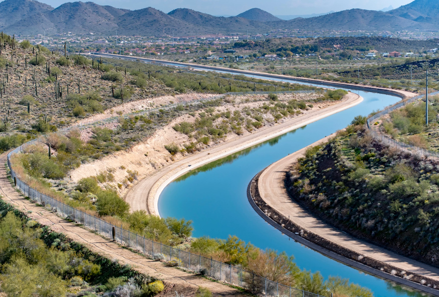
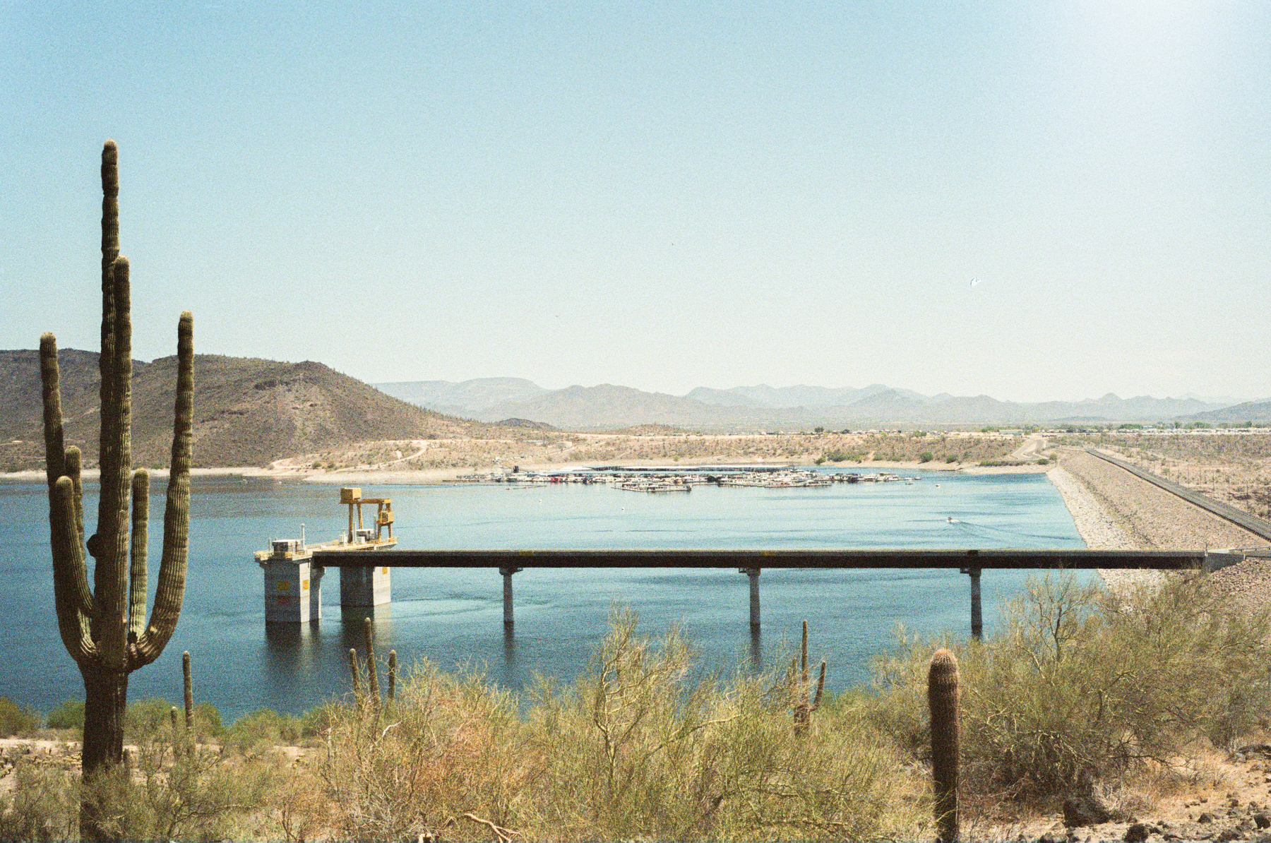
The Central Arizona Project canal carries water through Phoenix in 2019. The project’s former general manager, Ted Cooke, was recently nominated to run the top federal agency for the Colorado River. Those who have worked with Cooke described him as a qualified expert. Ted Wood/The Water Desk
Click the link to read the article on the KUNC website (Alex Hager):
June 17, 2025
This story is part of ongoing coverage of the Colorado River, produced by KUNC and supported by the Walton Family Foundation.
President Donald Trump has tapped longtime water manager Ted Cooke to be the next commissioner of the U.S. Bureau of Reclamation. The nomination, submitted Mondayto the Senate Committee on Energy and Natural Resources, attempts to fill a pivotal role at the top federal agency for Western rivers, reservoirs and dams.
If confirmed, Cooke will become the main federal official overseeing Colorado River matters. His nomination comes at a tense time for the river. The seven states that use its water appear deadlocked in closed-door negotiations about sharing the shrinking water supply in the future.
Cooke will likely try to push those state negotiators toward agreement about who should feel the pain of water cutbacks and when. If they can’t reach a deal ahead of a 2026 deadline, the federal government can step in and make those decisions itself.
Cooke has spent most of his lengthy career with the Central Arizona Project, which brings Colorado River water to the Phoenix area. He first joined the agency in 2003, according to his LinkedIn page. He climbed the ranks and served as CAP’s general manager from 2015 to 2023.
Ted Cooke and Tom Buschatzke: Photo credit: Arizona Department of Water Resources
Water experts across the Colorado River basin, including some who have worked with him in the past, told KUNC they regard Cooke as a qualified technical expert. Sharon Megdal, whose tenure on CAP’s board of directors overlapped with Cooke’s time as general manager, said she had “great admiration” for Cooke.
“He’s thorough, he’s deliberative, he looks for solutions, and boy, we need to find solutions right now,” said Megdal, who now directs the Water Resources Research Center at the University of Arizona. “My observation of seeing him in action in tough situations shows that he’ll keep working until a resolution is reached or a solution is achieved, and I think that’s what we need now.”
John Entsminger, Nevada’s top water negotiator, called Cooke’s appointment a “great choice,” and cited his work in shaping the 2019 Drought Contingency Plan. If confirmed, Cooke will likely be in the same negotiating rooms as Entsminger.
“There are times when [the Bureau of Reclamation Commissioner] has to level pretty realistic threats at everybody,” Entsminger said. There’s also times when they have to be the mediator… I think Ted has both of those skills. I’ve seen him be pretty pointed, and I’ve seen him drive compromise.”
The seven states working on the next set of rules for managing the Colorado River are currently split into two caucuses – the Upper Basin states of Colorado, Wyoming, Utah and New Mexico and the Lower Basin states of California, Arizona and Nevada.
The appointment of Cooke, a longtime Arizonan, could upset some on the other side of that divide. The Central Arizona Project, his former employer, is generally among the first entities to lose water under any plan for cutbacks.
Eric Kuhn is the former general manager of the Colorado River District. The taxpayer-funded agency was founded to keep water flowing to the cities and farms of Western Colorado. He said Cooke is qualified, but added “the nomination of someone from Arizona is interesting at a time when the Lower Division and the Upper Division states are far off.”
“I assume that he would recuse himself from decisions that could affect the CAP – which is just about any decision in the basin,” Kuhn wrote to KUNC. “None the less, his nomination is a plus for Arizona and the Lower Division States.”
Negotiators from Colorado and New Mexico declined to comment, and negotiators from Wyoming and Utah did not get back to KUNC in time for publication. Chuck Cullom, executive director of the Upper Colorado River Commission and a former colleague of Cooke’s, also declined to comment.
Click the link to read the article on the InkStain website (John Fleck):
June 18, 2025
Arizona yesterday finally moved the super-secret idea at the heart of current Colorado River negotiations out of the shadows.
The idea is deceptively simple: base Lake Powell releases on a percentage of the three-year rolling average of the Colorado River’s estimated “natural flow” at Lee Ferry. Allocate water based not on a century-old hydrologic mistake, but rather based on what the river actually has to offer. It presents an attractive alternative to the increasingly baroque and unproductive shitshow that had taken over interstate negotiations.
It has the great virtue of each basin getting out of the other basin’s business – one clean, simple number. But establishing the right percentage remains the hard part. Make the percentage too high and the Upper Basin will have to cut users with pre-Compact water rights. Make the percentage too low and Lake Powell fills up while Central Arizona goes dry.
But some of the early modeling suggests that there may be a sweet spot where a combination of Lower Basin cuts along the lines of what the Lower Basin has already been willing to offer, combined with modest Upper Basin system conservation programs, might thread a needle that could allow the crafting of a compromise. This is very good news if the negotiators and the folks back home who have been egging them on can seize this opportunity to set aside parochial smallness and think at the basin scale.
The possibility of a new approach was hinted at a CU Boulder’s Colorado River conference two weeks ago (I spent most of the conference hidden away watching and listening on Zoom through a covid haze, so it might have just been a fever dream, but I thought I heard the hints), and I’m told was a topic of some of the hallway conversations. But Tom Buschatzke’s reveal at yesterday’s meeting of the Arizona Reconsultation Committee (the closest thing we have to the much-needed C-SPAN for the Colorado River Basin) was the first public discussion of the hush-hush stuff that shouldn’t be quite so hush-hush given, y’know, 40 million of us stakeholders.
The full slide deck from the Colorado River C-SPAN Arizona Reconsultation Committee is useful. Reclamation’s Dan Bunk, for example, shared a slide slowing the latest “min probable” forecast (hilarious typo – “min problem” now corrected) showing the system tanking – dropping below minimum power pool at Powell – in winter 2026. The min probable forecast has been a useful guide lately, frankly, and the latest version is horrifying. (On any other day this would be the lead, and probably deserves its own post, but I try not to work on Wednesdays.)
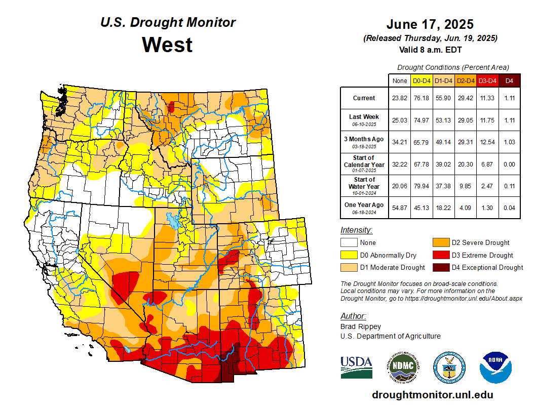
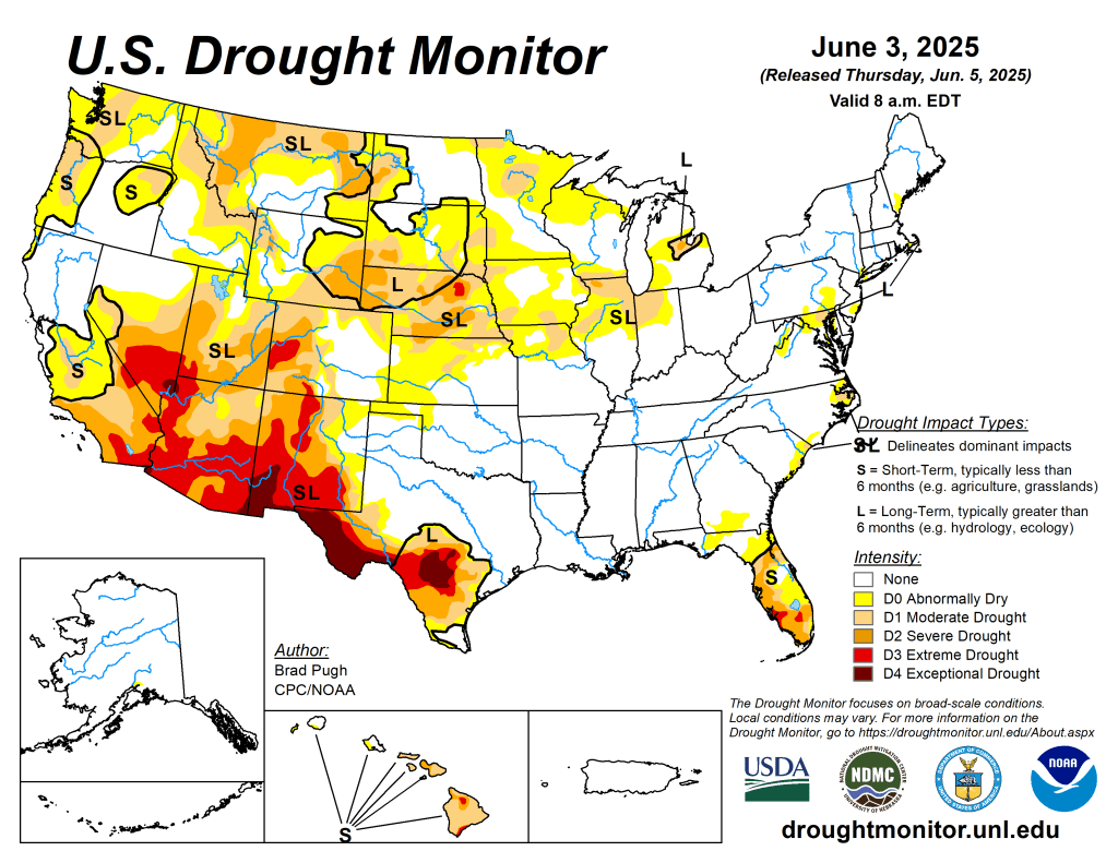
Active weather east of the Rockies led to significant reductions in drought coverage, especially in Florida, Texas, the northern and central Plains, and the upper Midwest. Amid early-summer showers, drought-free conditions largely continued from the southern Plains to the Atlantic Coast, excluding parts of Florida. Meanwhile, a Western hot spell—accompanied by short-term dryness across roughly the northern half of the region—was manifested in rapidly developing soil moisture shortages, declining prospects for summer water supplies, an elevated wildfire threat, a boost in irrigation demands, and increased stress on rain-fed crops…
Rain-related drought improvement dominated the High Plains, although some significant drought-related agricultural problems persisted. By June 15, statewide topsoil moisture ratings on the High Plains ranged from 19% very short to short in Kansas to 50% in Wyoming, according to the U.S. Department of Agriculture. Wyoming led the region on that date with 36% of its rangeland and pastures rated in very poor to poor condition, followed by Nebraska at 30%. Elsewhere, significant rain bypassed a few areas, including northeastern North Dakota, where moderate drought (D1) expanded…
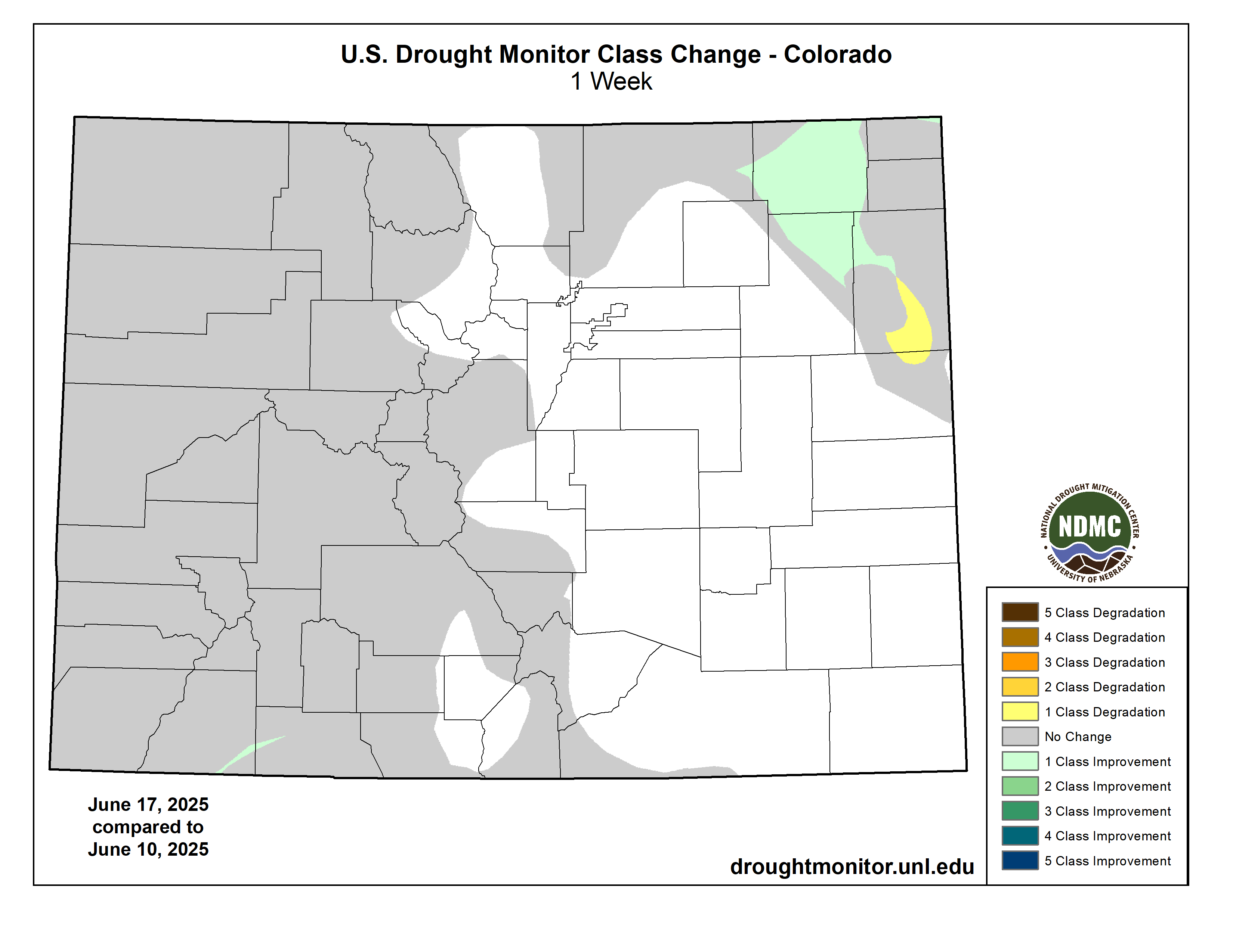
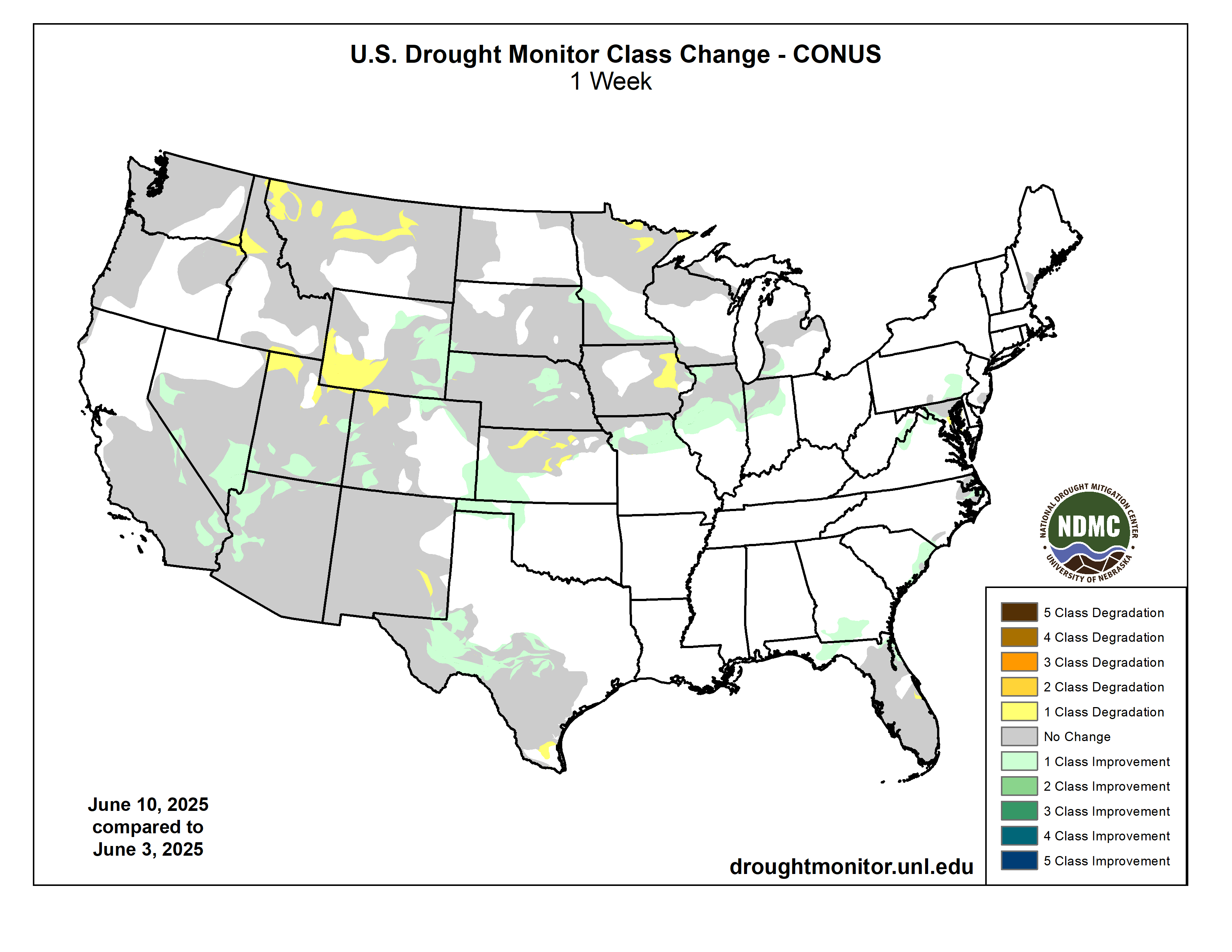
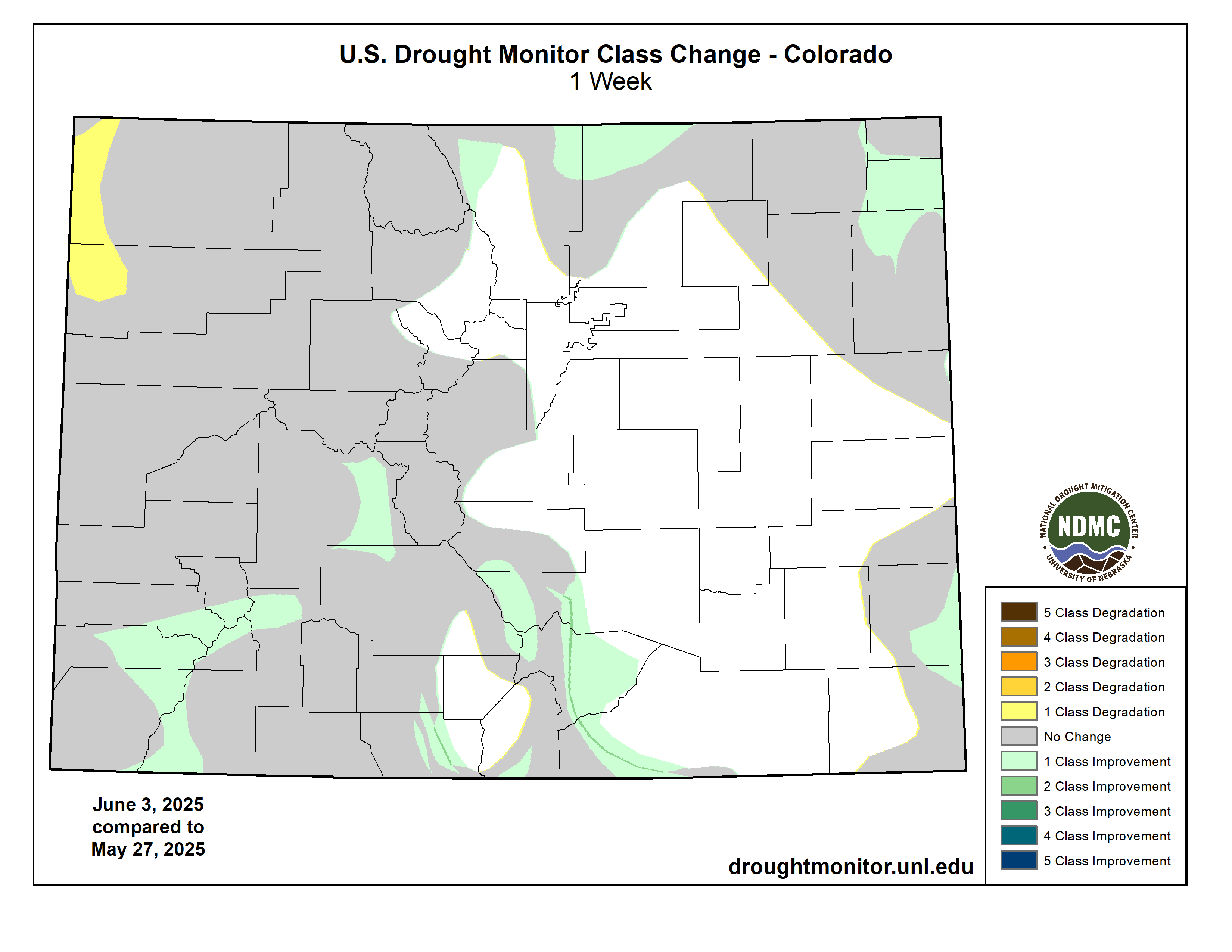
Colorado Drought Monitor one week change map ending June 17, 2025.
In contrast to areas east of the Rockies, mostly dry weather dominated the West during the drought-monitoring period. Rapid surface drying and prematurely melting (or melted) snowpack had led to a variety of agricultural and water-supply issues and concerns. The Northwest has been especially dry in recent weeks, with topsoil moisture—as reported by the U.S. Department of Agriculture on June 15—rated 65% very short to short in Montana, along with 56% in Oregon and 45% in Washington. Unlike Oregon and Washington, Montana received some much-needed precipitation in mid-June—but continued to experience agricultural drought impacts. For example, Montana’s rangeland and pastures were rated 46% in very poor to poor condition on June 15. Among major production states, Montana led the nation on that date in very poor to poor ratings for spring wheat (28% of the crop) and barley (25%). Meanwhile, among several early-season Northwestern wildfires was the 3,600-acre Rowena Fire near The Dalles, Oregon, which has destroyed more than 150 structures, including several dozen homes…
Downpours in parts of Texas, the only state in the region still experiencing drought, delivered significant relief but also sparked flooding. In fact, deadly flash flooding struck the San Antonio area on June 12, when the official airport observation site received 6.11 inches—the second-wettest June day on record in that location, behind only 6.18 inches on June 3, 1951. San Antonio also set a one-hour station rainfall record for any time of year, with 3.98 inches falling from 3 to 4 am CDT. In drought-affected areas where heavier rain fell, some of the water was lost due to runoff, rather than absorption into parched soils. Additionally, groundwater and aquifer depletion in south-central Texas and neighboring areas has developed over many years—and will require much more than a singular heavy-rainfall event for replenishment…
Looking Ahead
Active weather will shift eastward during the next couple of days, as a hotter, drier pattern envelops the nation’s mid-section and quickly expands. Additional rainfall could total 1 to 3 inches across the eastern one-third of the United States, with some of the highest amounts expected from the lower Great Lakes States into northern New England. However, by the end of the week, any significant precipitation should be limited to parts of the North, with hot, dry weather dominating the remainder of the country. During the weekend, high temperatures should top 100°F in the western Corn Belt as far north as South Dakota, while readings will reach 95°F in nearly all areas of the Midwest. By Sunday, however, cooler air should spread as far east as the northern High Plains. During the transition to cooler weather, showers will develop from the Pacific Northwest to Montana. In the East, the first major heat wave of the season will persist into the first half of next week, with high temperatures near 100°F expected at lower elevations of the Atlantic Coast States from Georgia to southern New England. There are some indications that, by early next week, remnant tropical moisture once associated with Eastern Pacific Hurricane Erick could be entrained by a cold front, leading to an increase in shower activity from the southern Rockies into the upper Midwest.
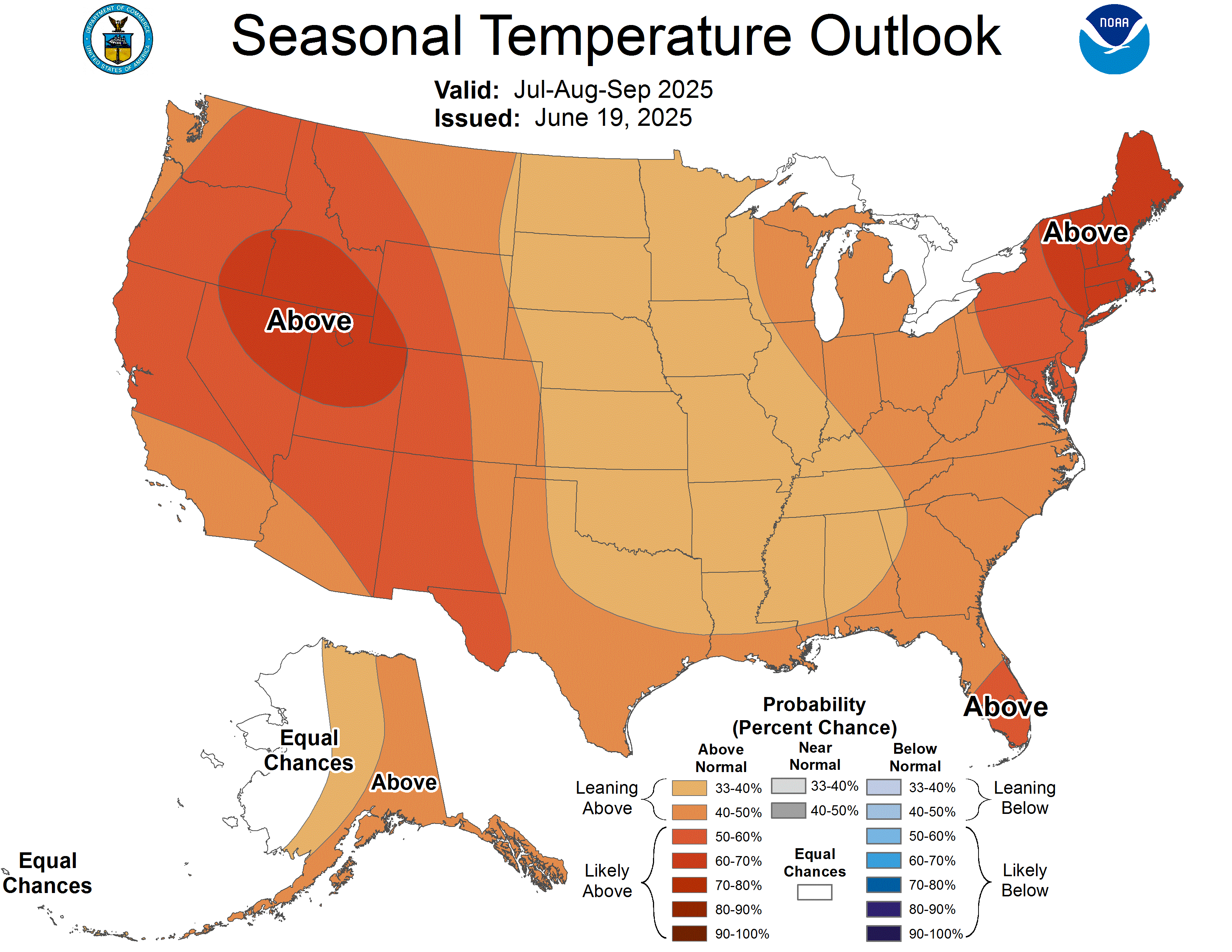
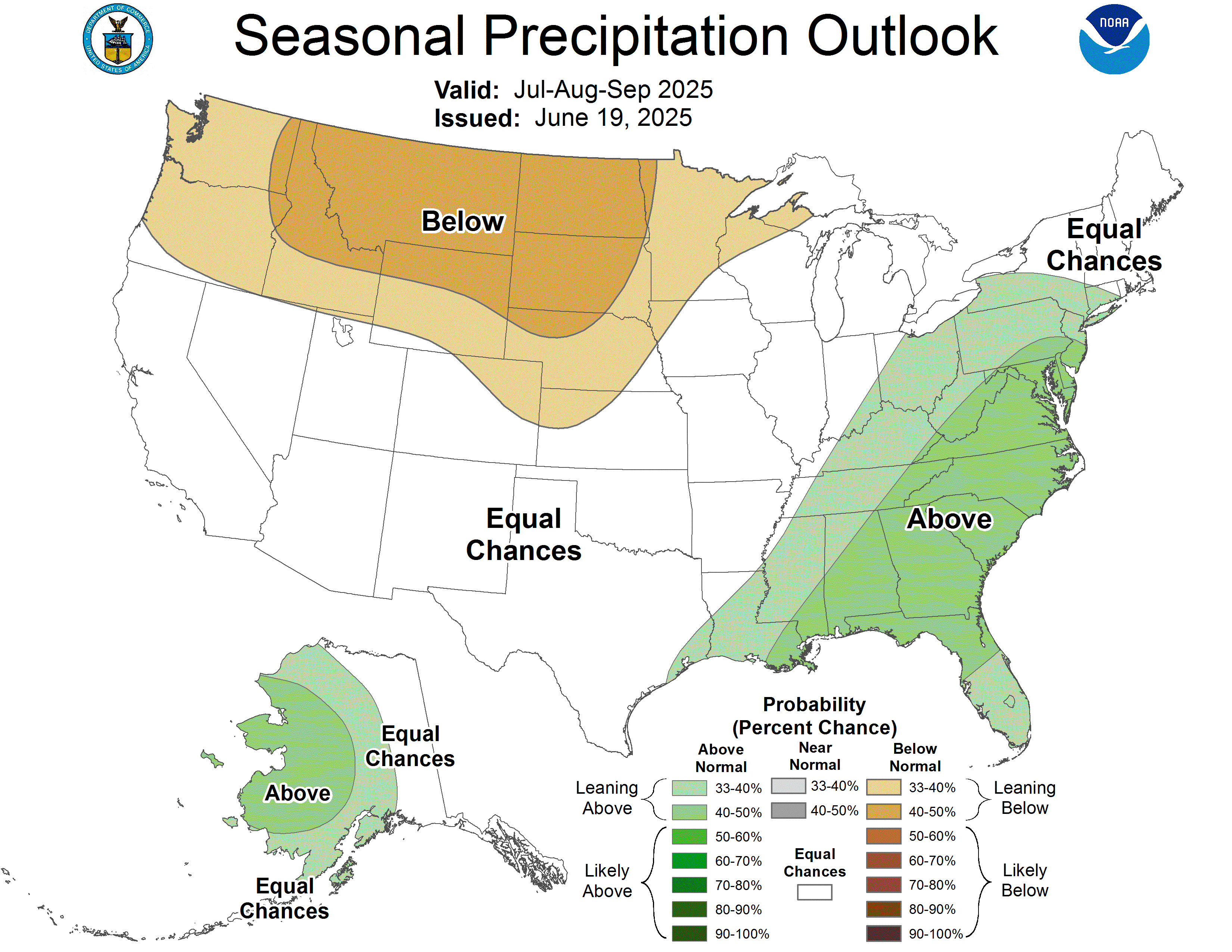
The NWS 6- to 10-day outlook for June 24-28 calls for the likelihood of above-normal temperatures across much of the eastern half of the country, as well as the northern Rockies and environs, while cooler-than-normal conditions will be mostly limited to the Southwest. Meanwhile, near- or above-normal rainfall can be expected nationwide, with an area stretching from the Southwest into the Great Lakes States having the greatest likelihood of experiencing wet weather.
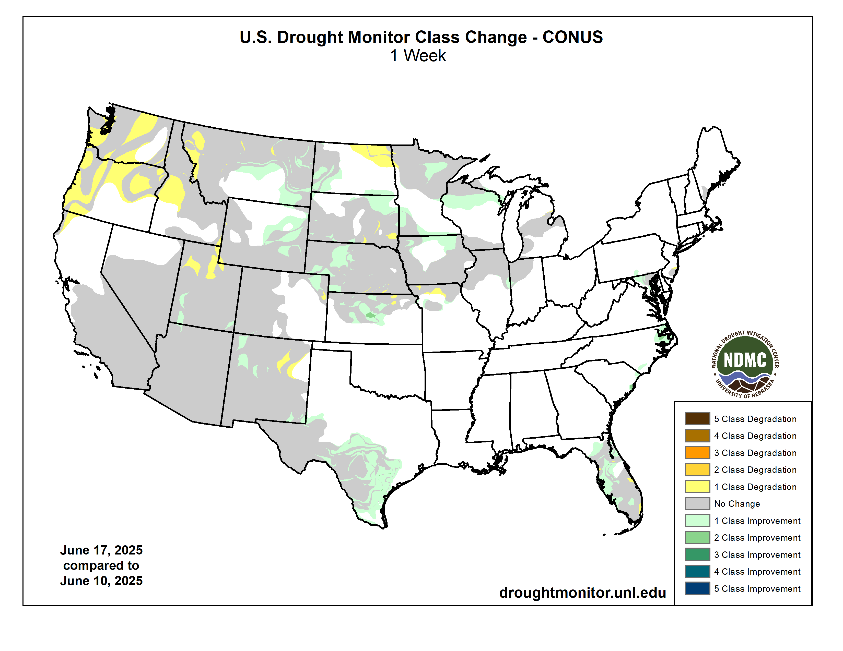
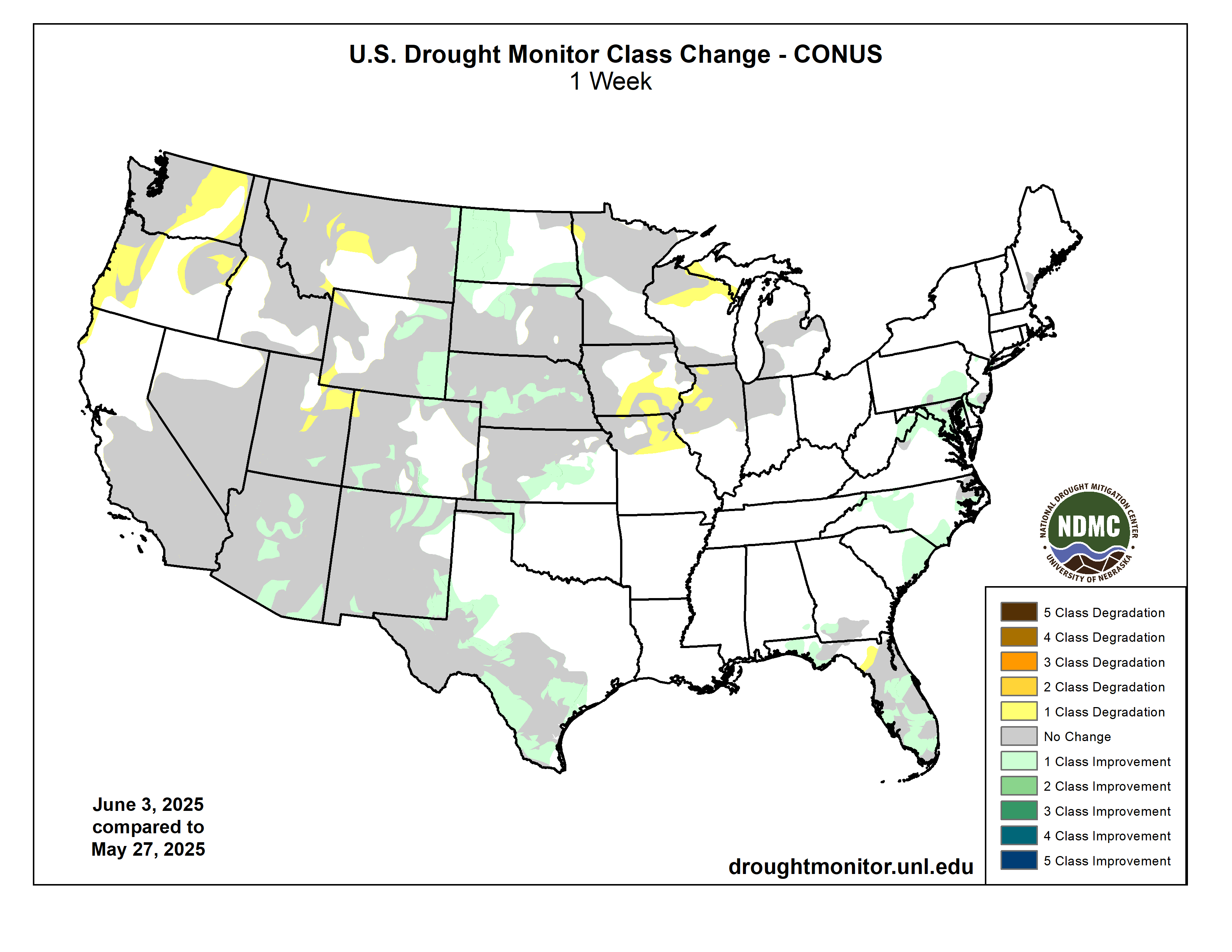
US Drought Monitor one week change map ending June 17, 2025.
In his brief slot on the panel, Udall was first a cheerleader for Colorado River problem solving but reminding listeners that climate change was the elephant in the room, as several speakers later in the conference acknowledged.
Following are his remarks, lightly edited:
Given the policy expertise on this panel, I’m going to constrain my remarks to what’s going on in the climate space. I want to make the following two points and end with a heartfelt plea.
Within this basin, we can and have worked together to deal with a really sticky, difficult issue like climate change, to inform decision-making given the right partners, including the federal government at the table. Point two is our current climate trajectory is beyond awful, and that makes our challenge even worse.
So let me get to point one. We can, in fact, work together on a really difficult issue. In late 2006 Terry Fulp (then regional director of the Lower Colorado Basin Region for the U.S. Bureau of Reclamation), pulled together six different sciences to consider how a changing climate would impact runoff, to inform the 2007 Interim Guidelines EIS. That effort became Appendix U.
Interestingly, it was the first time climate science was incorporated into a major EIS. It was not particularly controversial, and it was done during a Republican administration. It set the stage for future (Bureau of) Reclamation climate change efforts, efforts that have continued to this day.
But put an asterisk next to that.
The next year (2008), the Water Utility Climate Alliance was formed by eight major national water providers, and four of those were actually in our basin: the San Diego County Water Authority, Denver Water, Metropolitan Water District of Southern California, and Southern Nevada Water Authority.
Members have led the way in figuring out how to adapt to climate change, including hiring certain staff to deal with this. And a hat tip for this to both Jim (Lochhead, former CEO of Denver Water) and Bill Hasencamp (Colorado River resources manager for Metropolitan).
Let me mention Reclamation again, because in 2009 Mike Connor, as a congressional staffer, wrote the SECURE Water Act, which made Reclamation perform a series of continuing climate change studies that are important to this day.
The lesson here is that when faced with such a daunting and unknown challenge, we actually can come together to discover scientific truths, but we need both federal and basic leadership to make this happen. Unfortunately, right now, one leg of this is seriously threatened, hence my asterisk.
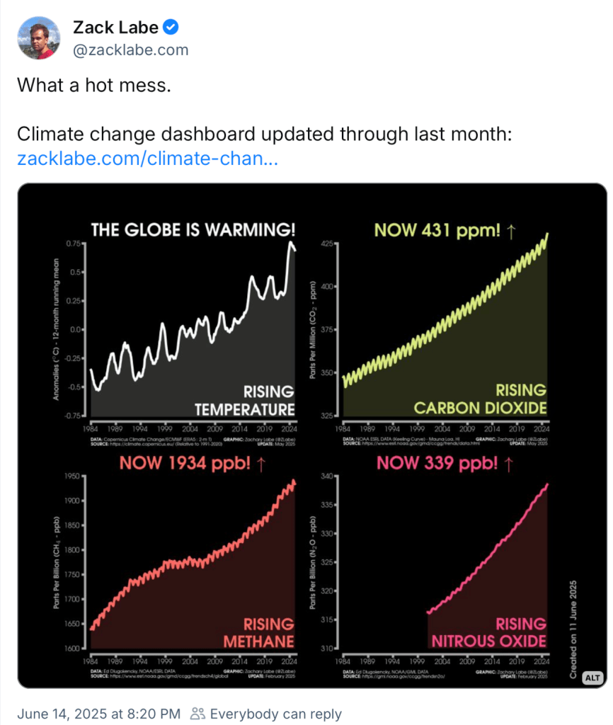
My second point is about our awful moment, our global climate change trajectory. Hold on to your seats, because I’m going to make you uncomfortable. The world is on track for 3 degrees Celsius warming by 2100. This far exceeds anything agreed to by the 2015 Paris Climate Accords. And frankly, terrifies scientists. Three Celsius is a projected average global warming, but over land, that’s 5 Celsius. Converted into Fahrenheit, it’s nine Fahrenheit. Imagine every day, 9 Fahrenheit warmer. Highs, 9 Fahrenheit warmer. Lows, 9 Fahrenheit warmer. That’s a world unlike anything we currently know, and it’s going to challenge us all on every front.
And what’s worse about this, and not particularly appreciated, is that to get to 3 Celsius, we need large global greenhouse emissions to continue through this century to 2100. So, it will continue to warm significantly beyond 2100. Nine Fahrenheit is not where we end up. It’s kind of where we start.
This 3 Celsius outcome has been has been obvious for at least five years, as climate policy progress has stalled and even gone backwards. You know, post-Paris in 2015 there were all kinds of great net-zero by 2050 pledges by government and industry, including the fossil fuel industry.
But since then, the fossil fuel industry is trying to have it both ways. They love to tout these goals while at the same time talking to the shareholders about how they’re going to expand production in ways that are completely incompatible with 2 Celsius. And there are about 25 large, mostly national oil companies that are living this lie. Each one thinks they’re going to be the last one standing, selling a product that’s fundamentally incompatible with a stable climate. [ed. emphasis mine]
If you think we’ve got plenty of time to solve this, like 75 years, normally, I’d agree with you. But think about what’s happened over the past 35 years. Emissions have gone up 60% and continue to rise. With these bad actors and with banks willing to finance this and governments willing to subsidize it, what we’re witnessing is a monumental failure of both capitalism and governance.
Now, if this weren’t all bad enough for you, we now have an anti-knowledge president and his vile enablers systematically attacking all forms of knowledge using illegal and unconstitutional tactics. Nowhere has this been more true than in this climate science space, where they’re going after anything and everything that has the word climate on it, every federal agency.
I’ll mention three here in our basin that are really critical: NOAA, the USGS and Reclamation. All of that climate work is in the sights of these vile enablers and the administration. Hence that nasty asterisk again. This administration aims to stop all work at preventing future greenhouse gas emissions as well as our ability to adapt to coming changes.
And 95% of what I can say on this panel about this is not suitable for this room, but let’s call it what it is: it’s insanity what they’re doing.
There are also recent, strong signs that climate warming is speeding up. So 2023 and 2024 were 1.5 Celsius above a pre-Industrial average. And there, those two years have a trend line that’s twice what we’re used to seeing, and it has climate scientists flummoxed about the reasons behind it.
So why talk about global climate issues in a conference about the Colorado River? Well, it should be obvious. There is no way this makes for a better world in which we live, a better world in which the Colorado River flows, and if you live in that world, tell me how to join in la-la land, because I’d love to be there.
I’m now convinced that we need to plan for the worst possible climate future, and that’s somewhere around 10 million acre-feet runoff. But what it also means is taking a hard look at every existing agreement in the river. It either breaks them or substantially modifies them.
Let me get to my plea. These facts should be a call to action to everybody. Not only are we in a really deep climate hole, we’re continuing to dig. Absolutely the last thing we need is the federal government undercutting our efforts to meet the water supply challenges in this basin. There’s a term called the pessimism aversion trap. I’m going to urge you not to fall on that. And it’s the tendency to look the other way when confronted with dark realities. We still control our destiny, even if the solutions seem daunting.
So I’m going to ask for two things. One, obviously, fight back against all these harmful cutbacks to all aspects of our national climate effort, including the abandonment of science and scientists. Our federal allies are critical partners in this fight, and lasting damage has been done.
Second, some of you think that your job description doesn’t include worrying about reducing greenhouse gas emissions or what might happen at 2100 or beyond. I disagree. I plead with you to get serious about figuring out how to reduce the emissions of your organization and even your own personal emissions. I agree that individual actions aren’t going to solve this, but they send a really strong signal to everyone around us.
Finally, I need to apologize to and beg forgiveness our next speaker who deserves to follow someone far nicer than I am.
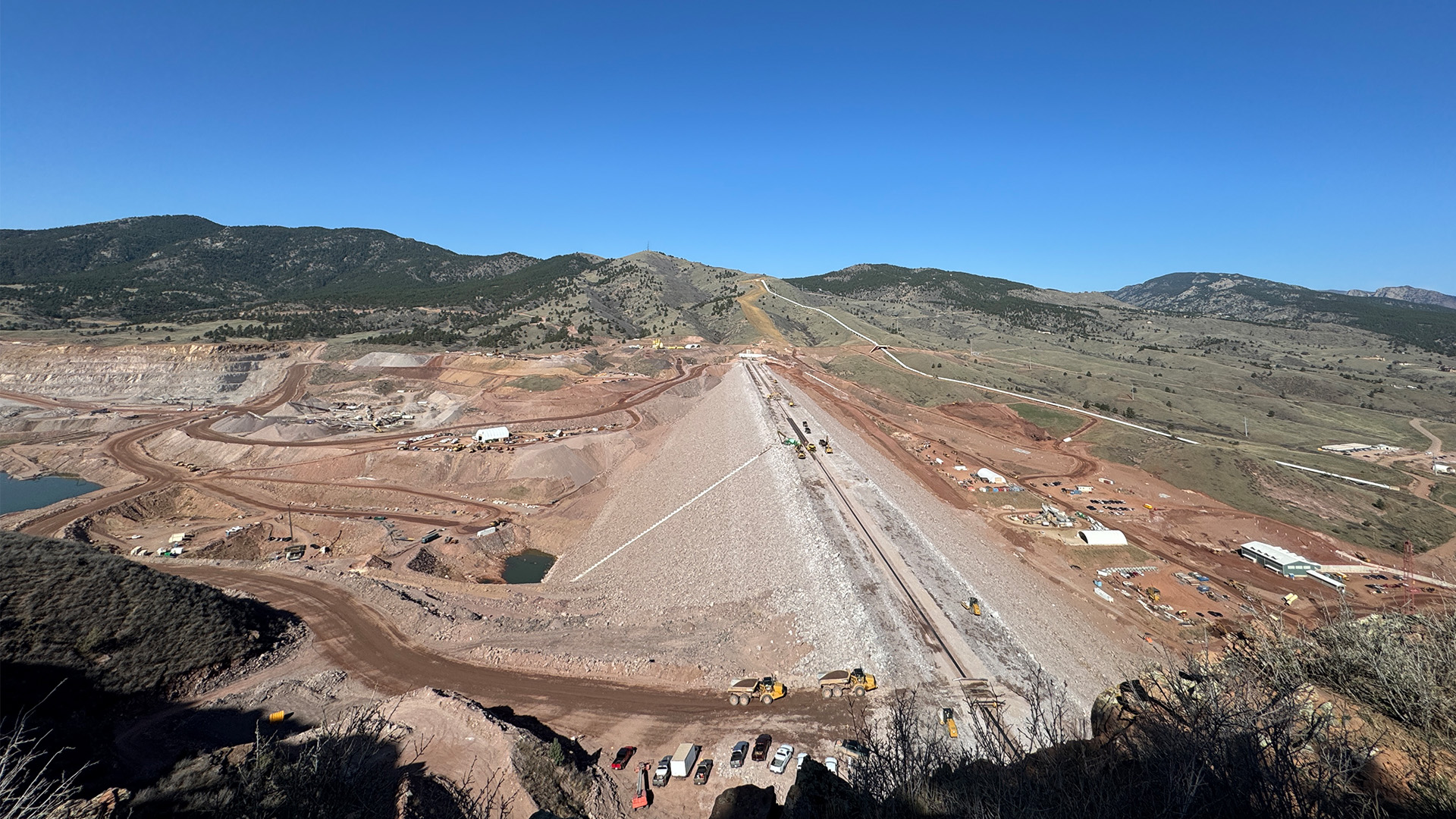
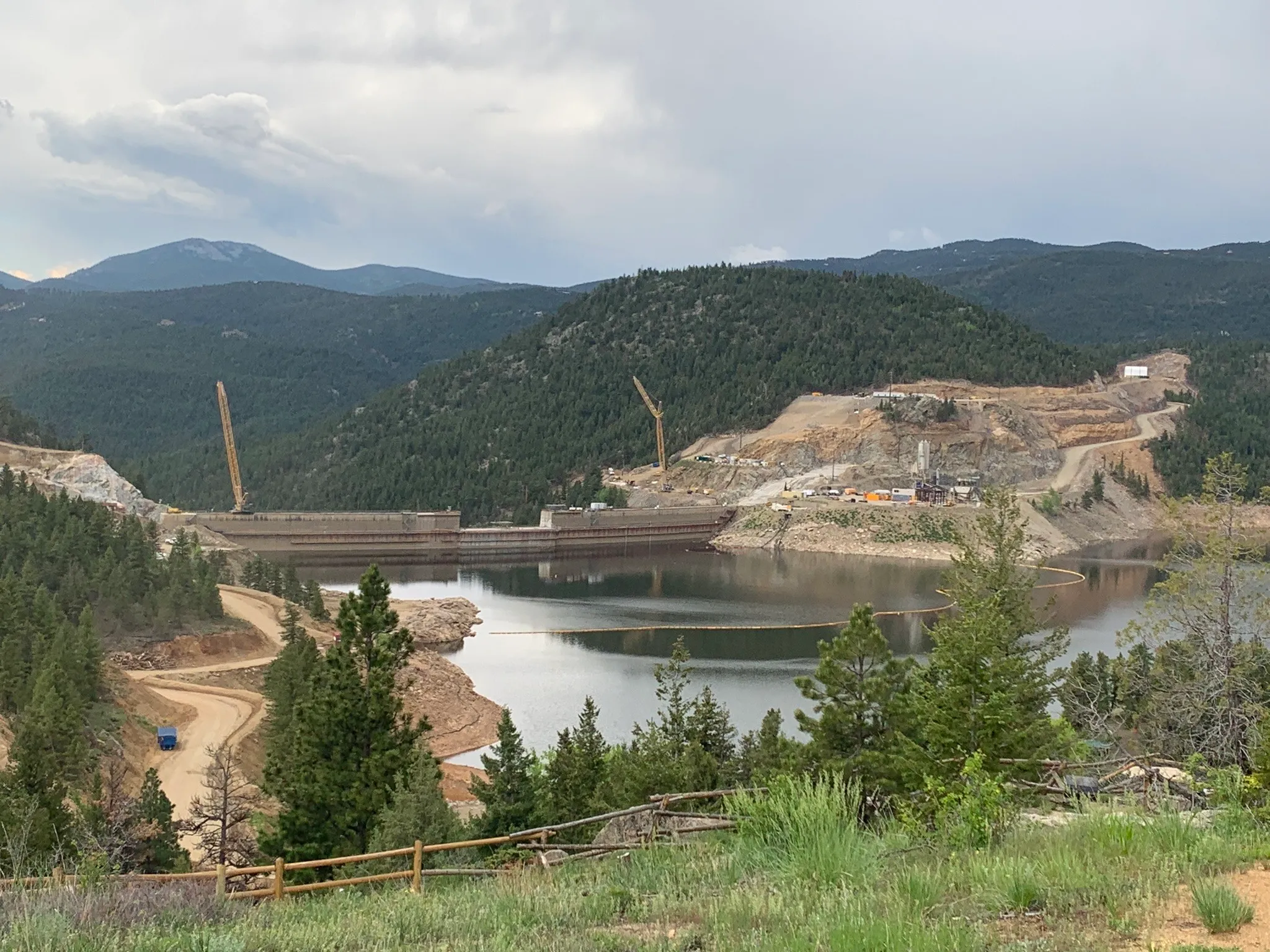
Chimney Hollow Reservoir Project managers are investigating strategies to mitigate the presence of mineralized uranium that is anticipated to be present in the first fill of the reservoir.
Mineralized uranium was detected in water samples taken from behind the cofferdam at the site following a series of major precipitation events in summer 2023. Further testing through 2024 identified the source of the minerals as being the granitic rock being quarried on the west side of the reservoir for placement in the rockfill shell of the asphalt-core dam. The low-level uranium minerals detected were not anticipated to be the result of leached material at the site.
During dam testing and first fill of the reservoir starting later this summer and continuing through 2027, no releases of water from Chimney Hollow Reservoir are expected. Ongoing monitoring of water quality at the reservoir will help managers develop a mitigation strategy that could include treatment and dilution with the significant sources of other water present in the infrastructure nearby.
As more information becomes available, Northern Water will share it with project participants, partner agencies and the public.
Hidden Valley on National Forest land near Durango, Colorado. This is the type of parcel that could be on the auction block if Sen. Mike Lee gets his way. Photo credit: The Land Desk
It is not hyperbole to say we are living in dark times.
The U.S. President is about to hold a multi-million-dollar, taxpayer-funded, dictator-style military parade — for his frigging birthday. He activated the national guard and the marines to violently quell non-violent protests in Los Angeles. A U.S. senator was tackled, thrown to the ground, and handcuffed for deigning to ask a question of Homeland Security Secretary Kristi Noem during a press conference in which she admitted that federal troops were in Los Angeles not to stop rioting, but to “liberate the city from the socialists and the burdensome leadership that this governor and that this mayor have placed on this country.” Oh …
American democracy, morality, empathy, civil liberties, and the rule of law are all under attack, and the assailants are none other than the President, his administration, and a vast majority of congressional Republicans.
So when Sen. Mike Lee, the Jello-slurping Utah MAGA-ite, proposed selling off a mere one half of one percent of the nation’s public land, it might not seem worth squandering whatever remains of one’s outrage on. But we — as in the American people — stand to lose a lot from this latest push to take public lands out of the public’s hands.
Lee installed his amendment into the Energy and Natural Resources section of the so-called “Big, Beautiful Bill,” which proposes to rescind environmental protections on millions of acres in Alaska, slash royalty rates for oil and gas, and revive noncompetitive leasing, among other mining- and drilling-friendly provisions.
Lee’s provision would require the Interior Secretary to “select for disposal not less than .50% and not more than .75% of Bureau of Management land, and shall dispose of all right, title, and interest of the United States in and to those tracts” and the Agriculture Secretary shall select for disposal .50% to .75% of National Forest System.” Lands in national parks, monuments, or conservation areas, wilderness, wildlife refuges, and other protected areas would not be eligible for disposal.
While that’s a tiny fraction of the nation’s public lands, it adds up to between 2 million and 3.2 million acres, which on the upper end is about equivalent to Bears Ears and Grand Staircase-Escalante national monuments combined. The amendment would apply to every Western state except Montana, which was probably exempted in the hopes of winning Rep. Ryan Zinke’s support.
While the amendment is purportedly to free up more land for affordable housing, there is nothing in the text restricting the end use of the land after it’s sold or transferred. It only requires someone nominating a parcel to specify what they plan to use land for and the extent to which development of the tract would address local housing needs (including housing supply and affordability).
It would prioritize tracts for disposal that are:
nominated by states or local governments
adjacent to existing developed areas
have access to existing infrastructure
suitable for residential housing
would reduce checkerboard land patterns
inefficient to manage.
At first glance, this appears relatively harmless: It would merely consolidate private holdings on the urban fringe, and ease the management nightmares of checkerboard land-ownership. But this is where I urge you to think about your favorite public land-adjacent community and consider what might parcels might be prioritized for disposal.
I went through this exercise somewhat inadvertently recently as I rode my bike on a trail through a place known as Hidden Valley on National Forest land north of town. The valley floor is nearly perfectly level, having been carved by a glacier many millennia ago, and bounded on two sides by bone-white sandstone cliffs. Up until the fifth century A.D., Pueblo people inhabited and farmed the valley, and the area continues to hold cultural and archaeological significance. Grass — green during this time of year — covers much of the valley. Cattails, nourished by the waters of Falls Creek, jut from the northern end.
Durango folks come up here to walk and seek solace from the din of humanity. They walk and bike and in the winter even ski and snowshoe here and coexist — sometimes uneasily — with bears and mountain lions and deer and elk and even rattlesnakes.
That this tract of public land would be sold off for development is almost unthinkable. And yet, it fits all of the criteria: It is just a few miles from town, is sandwiched between existing residential areas, is easily accessible and quite buildable, and infrastructure is already in place. Durango is grappling with a severe housing affordability crisis and Hidden Valley could theoretically support hundreds of housing units, alleviating some pressure on the real estate market. Unthinkable to you and I, yes. But keep in mind that it would be the Trump administration calling the shots on this one.
There are hundreds of other Hidden Valley-like tracts of land across the West, pieces of public land near communities that provide all kinds of benefits to wildlife and humans and the ecosystem and solitude. And if Mike Lee has his way, 3 million acres of these special places would go on the auction block, ultimately to be covered with homes, affordable or otherwise, and other development.
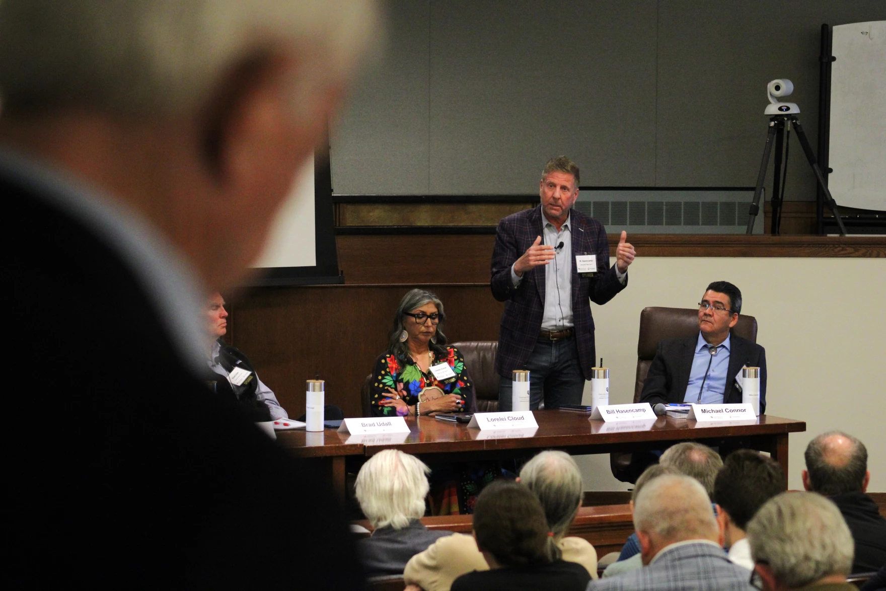
Fascinating observation from Jim Lochhead this morning at the Getches-Wilkinson Center Colorado River Conference about the nature of the current negotiations and the role of the federal government. It came during a panel moderated by Anne Castle focused on what we learned from the expiring 2007 river management guidelines, which are the subject of intense renegotiation among the seven basin states.
From the perspective of the panel’s charge – what have we learned since the 2007 agreements – the way I phrased that, the the way the current process is going, should seem weird to us: “intense negotiation among the seven basin states.”
According to Lochhead, a Coloradan who was in the room for the ’07 negotiations, the current cloistered seven-state process is very different from what happened leading up to the ’07 agreement. In 2007, Lochhead explained, the states weren’t the decision maker, the federal government was the decision maker, playing a much more active role as facilitator compared to the current process, which has deferred to the states to come up with a deal.
This is not going well. At least I think it’s not going well. Who knows? Lochhead likened it to the selection of a pope, as we all await the puff of smoke. “The current process seems to me to be like the conclave.”
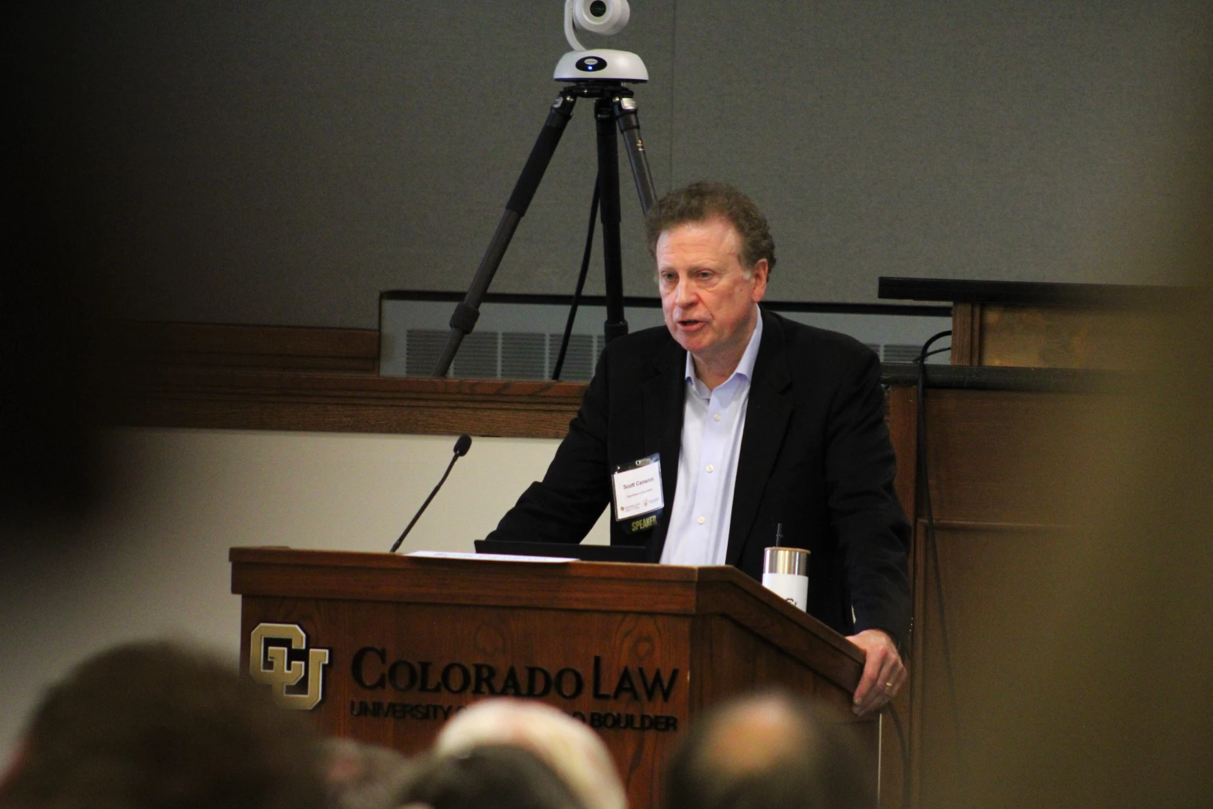
In my gossip network, I’ve heard good things about the current role being played by Scott Cameron, the Trump Administration’s point person on this stuff. We will hear from him tomorrow. I look forward to that.
Other stuff from the morning sessions
Weirdly, after driving all the way to Colorado for the meeting, I spent the morning in my hotel room on Zoom – a bit under the weather, not feeling up to the social battery drain of all those people, saving energy for tomorrow when I’m moderating the closing panel. But what I lost in social capital construction and maintenance, I made up for in being able to focus on the talks. Among them.
Brad Udall, our modern-day E.C. LaRue, was pretty frank about the climate change trajectory, arguing that we need to prepare for a 10 million acre foot river. For those not steeped in the numbers, that’s not very much water. The current climate trajectory, Brad said, is “beyond awful.”
Gov. Stephen Roe Lewis from the Gila River Indian Community argued that enduring solutions to the Colorado River’s problems will require federal financial help.
A couple of useful nuggets from my Bill Hasencamp of the Metropolitan Water District of Southern California. One: Bill talked about a really interesting analysis his team has done of the Intentionally Created Surplus Program, which concludes that there is a lot more water in the reservoirs right now, including in Lake Powell, than would otherwise be the case. They’ve briefed me on their analysis and shared the report with me, I just haven’t had the time to write about it yet, it’s super interesting.
Bill also talked about the weird state of the current state negotiations. One on one, people say they’re interested in compromise, in finding an agreement. In the negotiating room, they stick to hard line positions. This circles back nicely to Lochhead’s point that last time around, this was a federal process, not a state-run process.
Anne Castle made an incredibly important point about the challenges face by the state’s negotiators. They are sent into the room to advocate for their state’s water supplies. They need permission from their constituents to compromise, to be able and willing to give up some water in order in the interests of the good of the basin.
The Getches-Wilkinson Center is pleased to announce the publication of a thought-provoking article, “Facilitating a Green Future? Permitting Reforms and Renewables on Public Lands,” co-authored by Chris Winter, Executive Director of the Getches-Wilkinson Center, and Obie Johnson, a Colorado Law student and Wyss Scholar.
The piece was featured as the lead article in the spring 2025 issue of the American Bar Association’s Natural Resources & Environment journal and explores recent federal permitting reforms aimed at expanding renewable energy development on federal public lands. In recent years, the United States has accelerated its transition to a clean energy future, increasing the demand for new wind, solar, and transmission infrastructure. The article discusses many of the legal and policy initiatives spearheaded by the Biden Administration to facilitate the development of clean energy infrastructure on public lands.
Winter and Johnson highlight the tension between the development of clean energy infrastructure and the need to protect wildlife habitat and other natural resource values. They evaluate recent permitting reforms implemented under the National Environmental Policy Act, the Endangered Species Act, and the Federal Land Policy and Management Act and highlight how these new policies attempt to balance these important objectives across federal public lands.
Since the article was written, a new Administration that is less supportive of clean energy and conservation has taken office, prompting rapid changes to the legal and policy landscape. Despite these political dynamics, the long-term market trends still favor clean energy, though the full impacts of the Administration’s new policy agenda remain uncertain.
This publication reflects the GWC’s ongoing commitment to supporting scholarship and policy work that addresses the most pressing challenges in natural resources, energy, and environmental law. We are especially proud to highlight the contributions of student co-author Obie Johnson, whose work as a Wyss Scholar exemplifies the next generation of leadership in land conservation. The Wyss Scholars Program at Colorado Law School is made possible by the generous support and partnership of the Wyss Foundation.
The Middle Colorado Watershed Council presented to Rifle City Council during the June 4 meeting for their plans on the restoration of Rifle Creek. The watershed is facing multiple challenges, including overallocation, ecological stress, aging irrigation infrastructure, salinity and natural contaminants, and growing pressure from climate-related threats like prolonged drought and wildfire risk.
“We’ve got some invasive species issues…the creek is creating a deeper channel because there’s no meandering and there’s nothing stopping it from racing towards the Colorado River,” said Wes Collins, director of restoration services at EcoPoint. “With some love, with some care, it can be a centerpiece for a lot of folks to enjoy, as well as create educational opportunities for our kids here in town.”
Kate Collins, executive director of the Middle Colorado Watershed Council, described the group’s Rifle Creek Master Plan for Resilience, which covers a 6.5-mile stretch from Rifle Gap Reservoir to the Colorado River confluence…The Middle Colorado Watershed Council is focusing on infrastructure upgrades, habitat restoration and monitoring water quality and flows to get the Rifle Creek watershed back to being healthy. This Resilience Plan aligns with Colorado’s Water Plan, supporting robust agriculture, thriving watersheds and the environment and fish passage among many other alignments, while also supporting Rifle community values through recreation, environment, agriculture and more…nitial projects include the Middle Colorado Watershed Council will be at Centennial Park, Deerfield Park, the Re-2 School District property, Government Creek, Grand Tunnel Ditch, the golf course and the Wisdom Ditch Outtake. Proposed improvements range from step pools and invasive species removal to flume replacement. These projects will hopefully lead to better instream flow, water quality, healthy vegetation, vibrant agriculture and crop production, public access and wildlife and fish migration.
Click the link to read the article on the NOAA website (Emily Becker):
June 12, 2025
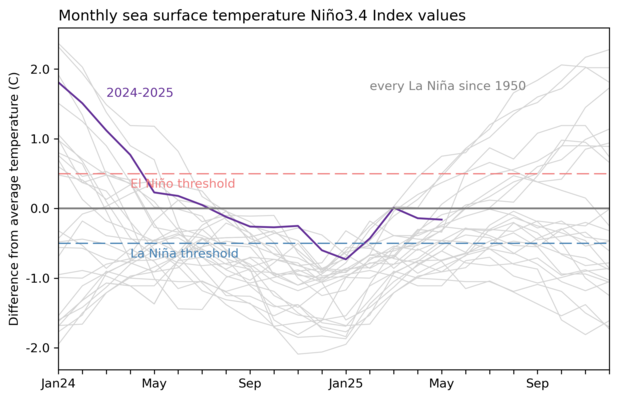
The Pacific Ocean has hit pause and settled into ENSO-neutral conditions, which are expected to continue through the Northern Hemisphere summer. This makes seasonal forecasting for upcoming global rain, temperature, and other patterns a bit trickier.
The odds of La Niña increase through the fall but remain lower than the odds of neutral. By the November–January period, there’s a 48% chance of neutral and a 41% chance of La Niña, with El Niño a distant third. Grab your towel, today we’re touring the galaxy of ENSO-neutral and what it means for seasonal prediction.
The story so far: what ENSO is, and why it matters
El Niño and La Niña, known collectively as the El Niño/Southern Oscillation (ENSO), are a system of changes in the tropical Pacific Ocean and atmosphere. El Niño and La Niña alter global atmospheric circulation and the jet streams, affecting weather patterns around the world. El Niño and La Niña can often be predicted many months in advance, giving us an early heads-up for their impacts. ENSO-neutral conditions are in place when neither El Niño nor La Niña are present, and the tropical Pacific Ocean and atmosphere are close to the long-term average temperature and circulation.
El Niño and La Niña have expected impacts on global seasonal weather and climate, but what about neutral? ENSO-neutral doesn’t mean we expect upcoming seasonal rain, snow, and temperature to be close to average. Rather, during neutral, we don’t have the same predictive information that El Niño and La Niña’s atmospheric changes provide, making upcoming patterns harder to predict very far in advance.
The restaurant at the end of the universe: what’s happening in the Pacific right now
Our primary ENSO measurement, the temperature of the Pacific Ocean surface in the central tropical Niño-3.4 region, has been near average for the past few months, following last winter’s dip below the La Niña horizon. According to our most reliable sea surface temperature dataset, the Niño-3.4 region was 0.2°C (about 0.4°F) cooler than the long-term average in May.
The atmospheric circulation over the tropical Pacific also has looked mostly neutral. This overturning pattern, called the Walker circulation, is characterized by rising air over the far western Pacific and Indonesia, west-to-east winds aloft, sinking air over the eastern Pacific, and the east-to-west trade winds near the surface. During La Niña, the Walker circulation strengthens, while El Niño weakens it. A few La Niña-ish characteristics are still hanging around, including more rising air and more rainfall than average over Indonesia with some regions of stronger easterly trade winds over the tropical Pacific. Despite those fading, localized signs of La Niña, the ocean-atmosphere system across the Pacific as a whole is neutral.
We demand rigidly defined areas of doubt and uncertainty! What the models say about months ahead
It’s very likely that ENSO-neutral conditions will remain through the summer. By the fall, chances of La Niña do increase, but they are still lower than the chance for neutral. El Niño is the least likely, with odds of less than 1-in-8.
Out of the three climate possibilities—La Niña, El Niño, and neutral—forecasts say that ENSO-neutral conditions (gray bars) are most likely for the Northern Hemisphere spring and summer. Looking out to the fall, neutral is still the most likely, but chances for either La Niña (blue bars) or El Niño (red bars) are increasing. NOAA Climate Prediction Center image.
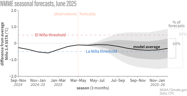
This forecast is informed by computer climate models, including those from the North American Multi-Model Ensemble. We consider lots of climate models, which gives us a range of potential outcomes. Most of these model runs fall into the neutral category through the end of 2025, with some in La Niña, and a few in El Niño, informing our forecast probabilities.
Line graph showing observed and predicted temperatures (black line) in the key ENSO-monitoring region of the tropical Pacific from spring 2025 through the fall. The gray shading shows the range of temperatures predicted by individual models that are part of the North American Multi-Model Ensemble (NMME, for short). By late summer, the shading spans from El Niño to La Niña, showing the range of potential ENSO states. However, the majority of model forecasts are concentrated in the neutral range, meaning the highest chance is that the temperature in the Niño-3.4 region of the tropical Pacific will be near average. NOAA Climate.gov image, based on data from the IRI.
In addition to the climate models, we study current conditions in the ocean and atmosphere. One valuable source of information is the pattern of water temperature under the surface of the Pacific Ocean. Our colleague, Caihong Wen of NOAA’s Climate Prediction Center, has been studying ENSO oceanic signals for years. She pointed out that there is a very narrow band of slightly warmer-than-average subsurface water near the thermocline along the equator, with large regions of cooler subsurface water to the north and south.
This map shows the temperature pattern under the surface of the tropical Pacific Ocean. The colors show how much deeper (red) or shallower (blue) than average the 20-degree temperature line lies. More warm subsurface water is present where the 20-degree isotherm is deeper than average (red), while cooler water is indicated when the 20-degree line is closer to the surface (blue). There is a narrow strip of warmer subsurface along the equator in the western and central Pacific, flanked by large areas of cooler subsurface to the north and south. In the past, this pattern has preceded second-year La Niña events. Figure by climate.gov based on original from Caihong Wen.
Caihong led some interesting research a few years ago showing that this off-equator subsurface water can provide a source for a developing El Niño or La Niña event. For example, a pattern of cooler subsurface water like we’re seeing now preceded second-year La Niña events in 2008, 2011, and 2017. It’s not a strong enough relationship for a confident prediction of La Niña, but it may help explain why some of the model forecasts are tilting in a La Niña-ish direction.
Infinite improbability drive
Let me leave you today with a reading selection from our past 11 years of ENSO blogs, since we didn’t get around to it on our birthday last month. Curious about how ENSO helps with predicting tornadoes? Check out these posts from 2017, 2021, and just last month. ENSO influences the hurricane season—find out more in these articles from 2014, 2017, and 2024. Weather and climate extremes—including drought, heatwaves, atmospheric rivers, coastal flooding, and the range of daily temperature—are affected by El Niño and La Niña. Our runaway most popular post was about how ENSO changes snow patterns (read the La Niña follow up post here). We chronicled the strong El Niño events of 2015–16 and 2023–24, the endless La Niña of 2020–23, and had some funalongthe way. Our smart, inquisitive audience, and the relationships we’ve formed along the way, make this the best place to be on the internet. Thanks for reading!
I’m calling it! Spring runoff appears to have peaked on most Western streams — and almost definitely has done so on the streams in this year’s Land Desk Super Predict the Peak Contest.
The good news is, the runoff was later and bigger than a lot of folks — including myself — predicted it would be. The bad news is that the flows were still downright pathetic compared to other years, even though in most cases the peak snowmelt was supplemented by heavy rain, meaning the runoff numbers don’t necessarily reflect a healthy snow year. Which is to say: The megadrought persists across much of the Western United States, with extreme conditions in the Southwest.
Unfortunately, we had very few entries this year, possibly because these things are really hard to predict. That said, it looks like Andrew High has a winning formula, at least on a few of these stream segments. Here are the winners and their predictions:
Animas: Andrew High, 2,710 cfs on May 21.
North Fork: Andrew High, 1,260 cfs on June 7.
Rio Grande: Jim O’Donnell, 1,150 cfs on May 15.
San Miguel: B Frank, 692 cfs on May 15.
Colorado: Andrew High, 13,160 cfs on June 13.
Congratulations, winners! Andrew, B, and Jim, please send me your mailing address and t-shirt size at landdesk@substack.com and I’ll get your prizes in the mail ASAP.
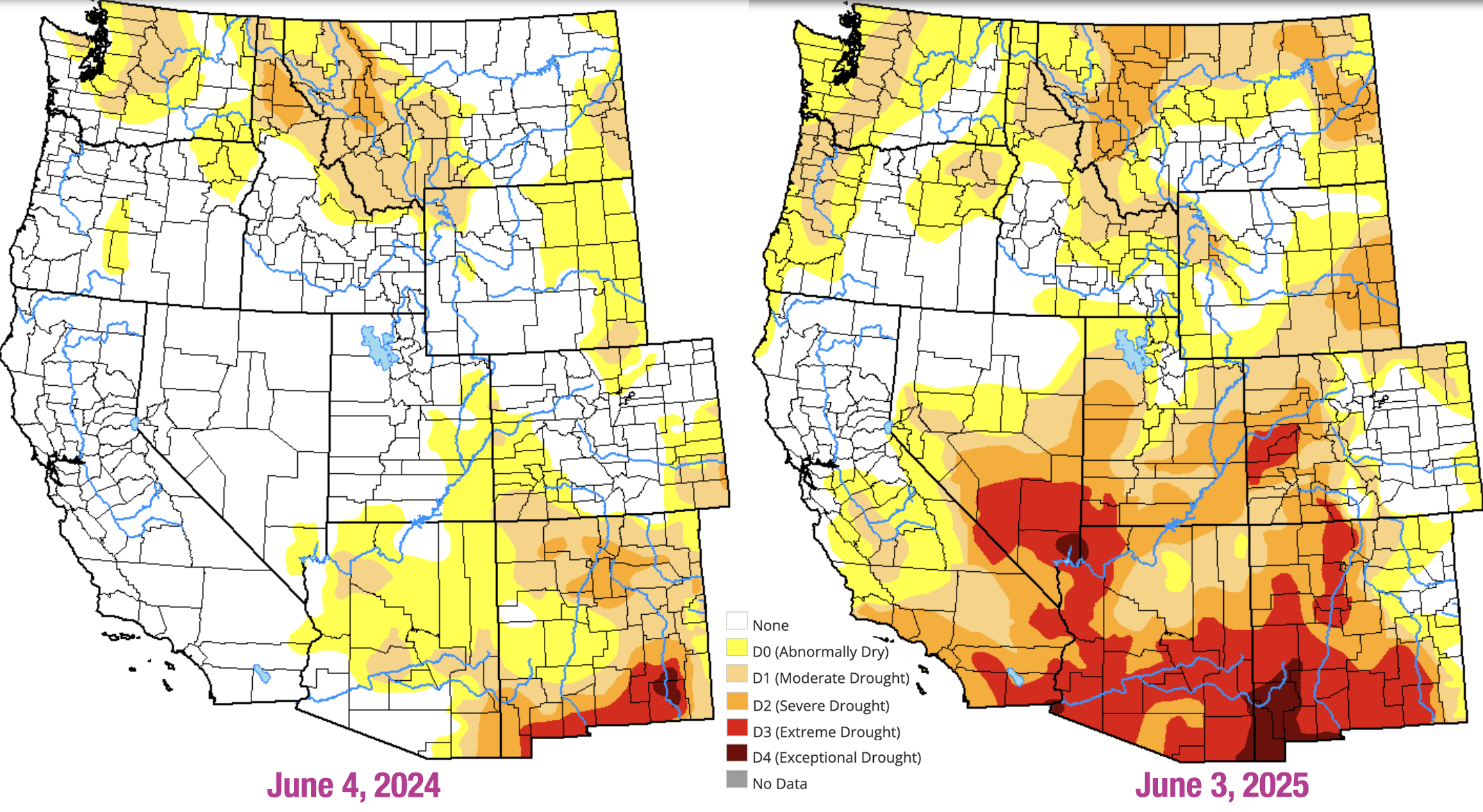
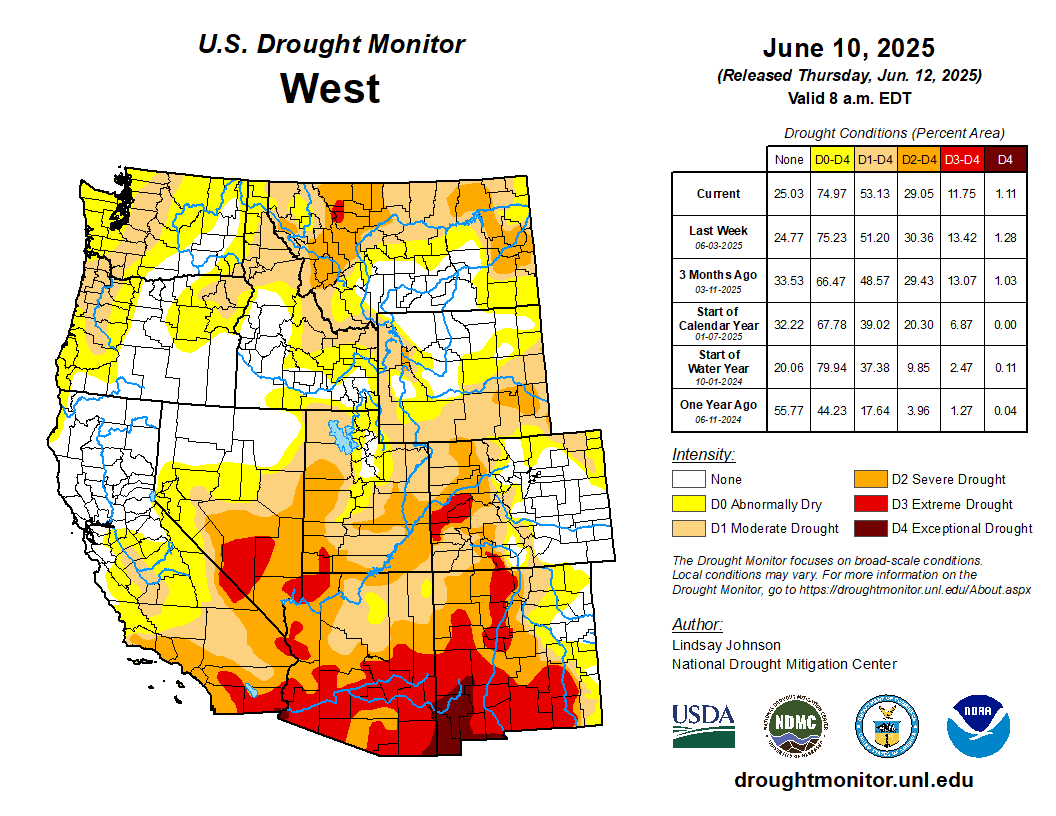
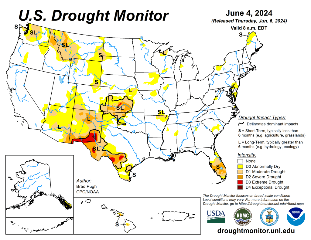
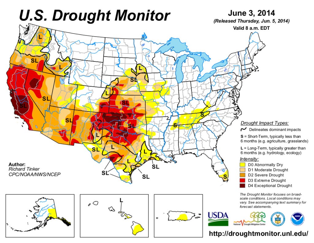
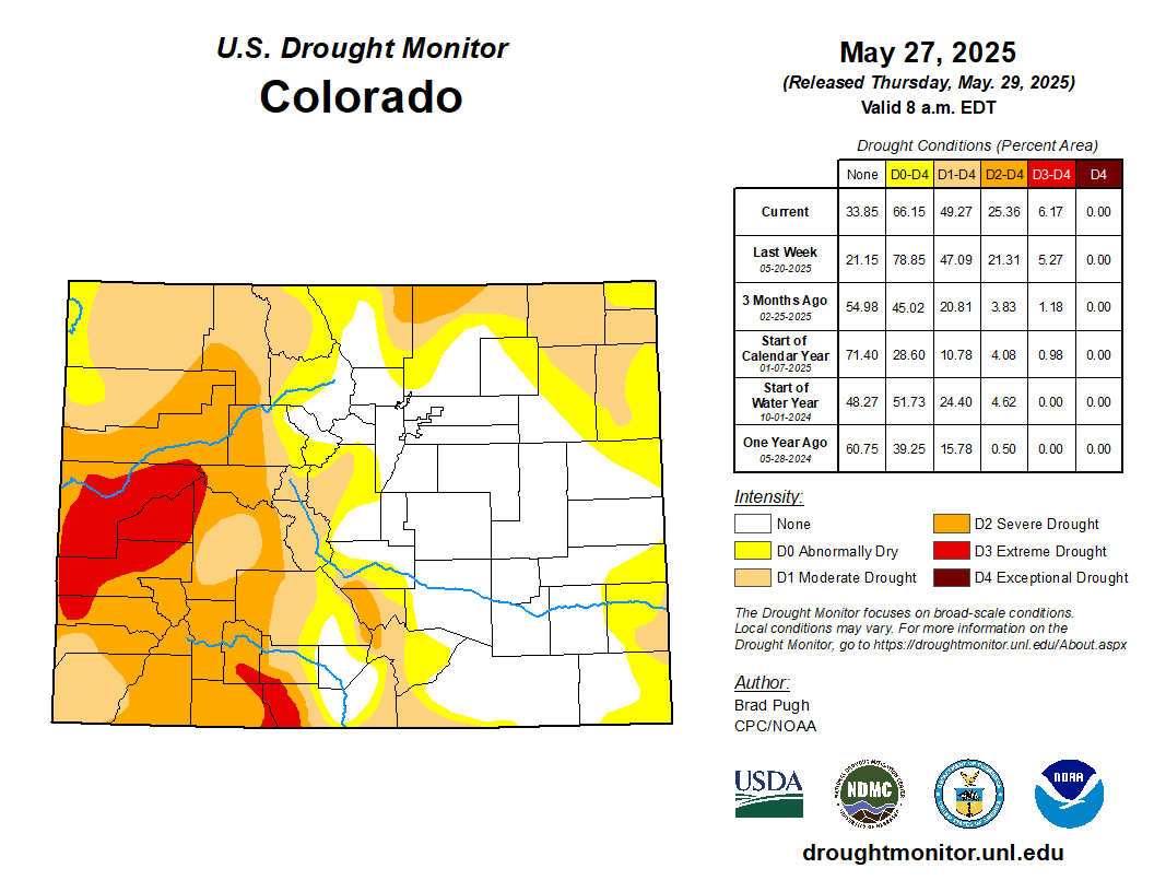
Now, on to the not so happy news. What a difference a year can make. Last year at this time, the West seemed to be on its way to being drought-free, with the exception of New Mexico. Now? Not so much. It’s looking downright grim for New Mexico, Arizona, and southern Nevada, even though the Las Vegas area received a healthy dose of rain in May.
Source: National Drought Monitor.
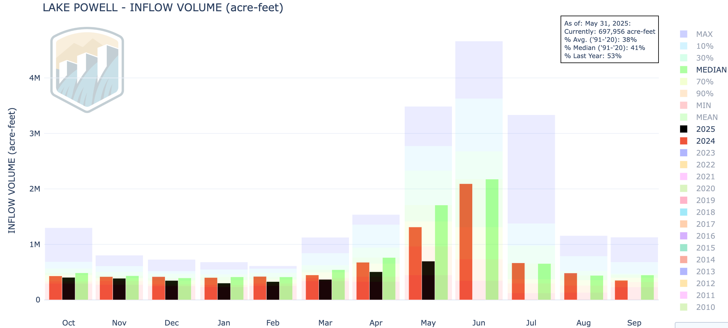
And, after a couple years of respite, it’s time once again to start worrying about Lake Powell — the barometer of the Colorado River’s health. Thus far this year, the volume of water flowing into the reservoir has been far lower than last year, which already was below normal. Judging by the runoff patterns so far, it appears as if June’s inflows may be even lower than May’s. If the rest of June is hot and dry, prompting greater evaporation from the reservoir, it could actually draw reservoir levels down this month during a time when water levels normally would rise.
The black bars show inflow volumes for the 2025 water year compared to the red bars for 2024. Source: USBR.
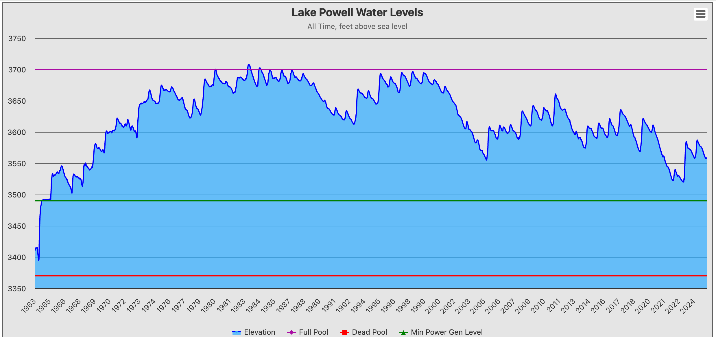
Normally Lake Powell’s surface level would jump substantially over the next month or so before dropping later in the summer after all of the mountain snowpack has completely melted. While reservoir levels are currently rising, it likely won’t continue for long. Source: Lake Powell Water-Data
But one of those truths about the West, is that aridification provides no buffer against flooding — especially flash-flooding. Some hikers found that out the hard way last week when a flash flood ripped down Big Horn Canyon in Utah, stranding them on the opposite side of the arroyo from their vehicle. They called for help and Bureau of Land Management rangers and Garfield County deputies responded and rescued the folks, according to the BLM’s Utah office. The Escalante River nearby jumped from 0 cfs to 1,200 cfs in just minutes around the same time. You can see some video of the flash flooding here: http://www.facebook.com/watch/?v=1036784068519285
📈 Data Dump 📊
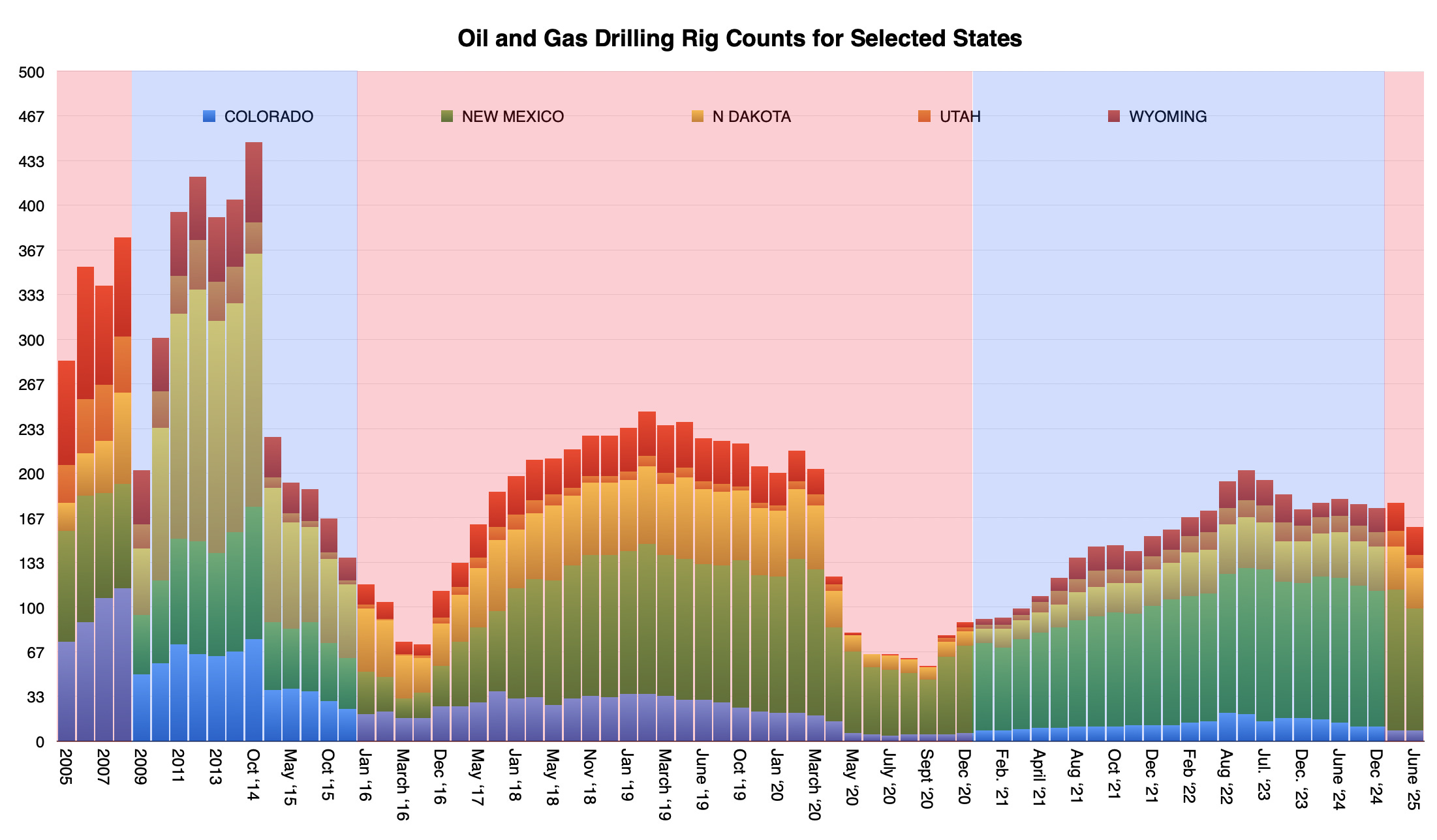
As long as we’re doing the graphs and charts thing, we might as well check in on that ol’ Trumpian “energy dominance” thing. The rig count — which is a snapshot of the number of rigs actively drilling at any given time — is the most accurate indicator of the oil and gas industry’s enthusiasm to extract the fossil fuels. And that verve appears to be waning under Trump. The number of rigs operating in the West has dropped since Trump took office, and is down significantly from the most recent peak in 2023 when, yes, Joe Biden was president and was supposedly waging a “war” on fossil fuels.
The red and blue shades indicate Republican and Democratic administrations, respectively. Source: Baker Hughes.
Click the link to read the article on the NOAA website:
June 12, 2025
Persistent Snow Drought and Rapid Spring Snowmelt Will Decrease Western Water Supplies and Increase Wildfire Risk
Key Points
Snow drought developed and persisted this winter in pockets of the western U.S., largely driven by lack of precipitation with a lesser role from above-normal temperatures. The most severe conditions have persisted across Arizona and New Mexico into southern Utah and Colorado.
Snowpack has nearly disappeared from monitoring stations across the West as dry and warm conditions accelerated snowmelt and early snowpack loss. Snow disappeared early even in areas without widespread snow drought conditions and with above-normal peak snow water equivalent (SWE).
Summer streamflow volume forecasts are lower than normal across the West. The impacts of early season snow drought in some regions and the widespread rapid melt out across the West will challenge water supplies, agriculture, outdoor recreation, and tourism, as well as increase wildfire potential (see recent Southwestand Great Plains Drought and Wildfire Outlook webinars for more information).
Widespread snow drought conditions were not apparent in peak snow water equivalent (SWE) values across much of the northern Rocky Mountains. The region had near- to above-median peak SWE, although some SNOTEL stations peaked at 70-89% of median SWE. Most of the areas with below-median peak SWE were along the border of western Montana and eastern Idaho. Despite these conditions, the snowmelt season (April-May) was dry and warm across most of the region, which led to accelerated melt rates and early loss of snowpack. In Montana, snow at 84% of SNOTEL stations (62 locations) melted earlier than the median date. In Idaho, snow at 84% of stations (64 locations) melted early, and in Wyoming, snow at 84% of stations (57 locations) melted early. Snow is still present at some high-elevation stations in the region (about 20% of all stations).
Water Supply Outlook
The USDA Natural Resources Conservation Service’s June-July water supply forecasts indicate below-median runoff for the entire northern Rocky Mountain region, with most large river basins expected to receive less than 80% of median flows. Forecasts for the Marias, Salmon, and Upper Snake Basins are among the lowest in the region at 45%, 65%, and 67% of median, respectively. Moderate and Severe Drought (D1–D2) are present throughout the region, according to the U.S. Drought Monitor. Based on the late onset snow drought conditions, near- to below-median October-May observed runoff, and below-median June-July forecasted runoff, NOAA’s Climate Prediction Center forecasts that drought will persist and develop this summer.
Central and Southern Rocky Mountains
Snow Drought
The central Rocky Mountains (northern Utah and northern Colorado) had near-normal snow accumulation with peak snow water equivalent (SWE) of 85-105% of median at many SNOTEL stations. Snowpack in southern Utah and southern Colorado was much lower. Many locations reported peak SWE of less than 50% of median, and two stations in Utah reported record low peak SWE.
The primary driver of the low snowpack in the southern Rocky Mountains was an extremely dry winter (December-February) with record low precipitation in some areas. Across most of the central and southern Rocky Mountains, snowpack peaked early (1-2 weeks early in many locations) and then melted more quickly than normal (also 1-2 weeks early, or more) in April and May. In Utah, snow at 93% of SNOTEL stations melted earlier than the median date, and in Colorado, snow melted early at 82% of stations.
Water Supply Outlook
Water supply forecasts for central and northern Utah and Colorado indicate below-median June-July flows in three major sub-basins in the Upper Colorado: the Upper Green, Lower Green, and White-Yampa Basins are expected to receive 78%, 63%, and 59% of median runoff, respectively. In southern Utah and Colorado, the outlook is worse, with well-below-median runoff predicted for the Upper San Juan (63% of median), Lower San Juan (38% of median), and Upper Colorado-Dirty Devil (48% of median) Basins.
Low observed and forecast river flows are expected to lead to much-below-normal unregulated inflows into Lake Powell. May observed inflows were 41% of normal. The Colorado Basin River Forecast Center is forecasting 45% of normal (average) seasonal inflows. As of early June, Lake Powell was at 34% of capacity. Moderate to Extreme Drought (D1-D3) is currently widespread throughout western Colorado and most of Utah. Drought conditions are expected to persist and likely intensify throughout summer due to low snowpack and seasonal runoff.
New Mexico and Arizona Water Year Snow Drought Summary
Snow Drought
Arizona and New Mexico, along with southern Utah and Colorado, faced severe snow drought conditions this year with peak snow water equivalent (SWE) of less than 50% of median at most SNOTEL stations. Four stations in Arizona and four stations in New Mexico reported record low peak SWE. Peak SWE at some locations in central Arizona and northern New Mexico was 50-89% of median, but no station reported above 89% of median peak SWE.
Winter was extremely dry. Record low precipitation in many locations, likely influenced by a weak La Niña event, led to little snow accumulation and persistent snow drought conditions throughout the season. March storms brought the greatest snow accumulation of the season and some relief to part of Arizona. The March storms led to snow melting later than normal; however, these same locations had little to no snow on the ground for most of winter. In New Mexico, all but one SNOTEL station with at least 20 years of recorded observations were snow free at least two weeks earlier than the median date. This is due to the combined impacts of a dry winter, early peak SWE, and rapid spring snowmelt.
Water Supply Outlook
Observed October-May flows in eastern New Mexico in the Upper Pecos and Upper Canadian Basins were 144% and 95% of median, respectively. Water year flows in the Upper Rio Grande and Rio Grande-Elephant Butte Basins in western New Mexico were much lower, at 59% and 42% of median, respectively. Seasonal water supply forecasts indicate much-below-normal seasonal volumes for all of New Mexico, with many locations forecast to receive less than 25% of median flows. In Arizona, observed October-May flows were extremely low in the Little Colorado (12% of median), Salt (15% of median), and Verde (40% of median) Basins.
The USDA Natural Resources Conservation Service (NRCS) June-July runoff forecast for the Lower Colorado-Lake Mead Basin is just 48% of median. Lake Mead is currently at 31% of capacity. The lake level is lower than this time last year, but not at the record low levels set in 2022. On May 22, New Mexico Governor Michelle Lujan Grisham, signed an executive order declaring a state of emergency due to persistent and severe drought and escalating fire risk across the state. In late May, the Navajo Nation issued a Declaration of a Drought Emergency across tribal lands in Arizona, New Mexico, and Utah. The U.S. Drought Monitor indicates that drought is currently widespread in both Arizona and New Mexico, with several areas of Extreme and Exceptional Drought (D3-D4). Drought conditions are expected to persist and intensify throughout summer.
Oregon and Washington Water Year Snow Drought Summary
Snow Drought
Snow drought developed early in the season and persisted throughout the year, especially along the west slope of the Washington Cascade Range, where many SNOTEL stations reported peak snow water equivalent (SWE) of 50-69% of median. A handful of sites there reported less than 50% of median peak SWE.
Low precipitation was the main driver of the low snowpack in Washington, with some stations in the Washington Cascades reporting water year precipitation below the 15th percentile of historical conditions. Some isolated, lower-elevation locations on the west slope of the northern Oregon Cascade Range also experienced snow drought conditions this year, mainly due to warmer-than-normal spring temperatures. The southern Oregon Cascade Range and the Blue and Steens Mountains in Oregon were in a narrow wet corridor that received much-above-median water year precipitation and peak SWE greater than 150% of median. Snow melted more than two weeks earlier than the median date at 19 stations in Washington and 10 stations in Oregon.
Water Supply Outlook
Below normal June-July runoff is forecast for all basins in Washington, from 63% of median in the Lower Snake to 87% of median in the Lower Columbia. Washington issued a drought emergency in April for the Yakima Basin watersheds due to low snowpack, low runoff, and persistent drought over the past several years. This drought emergency was expanded in early June to 19 other watersheds in the Puget Sound and Central Washington regions.
Water supply forecasts are more optimistic in Oregon, with several central and southern Oregon basins expected to receive above-median runoff. Some basins in northern Oregon are forecast to receive below-median runoff during June and July, including the Middle Columbia (75% of median), Willamette (78% of median), and John Day (85%) Basins. The Washington and northern Oregon Cascade Range is currently in Moderate Drought (D1), and the Climate Prediction Center’s seasonal drought outlook indicates further drought development throughout summer is likely in other parts of northern and western Oregon.
California and Nevada Water Year Snow Drought Summary
Snow Drought
In California and far western Nevada (Lake Tahoe Basin), snowpack generally peaked above median in the north (Trinity Alps, Cascade Range, and Sierra Nevada), near median in the central Sierra Nevada, and near- to below-median in the southern Sierra Nevada. A few lower-elevation stations in the central Sierra Nevada and along the west slope of the southern Sierra Nevada reported peak snow water equivalent (SWE) of less than 70% of median, but snow drought concerns were fairly limited in California this winter. Similar to other regions across the West, April-May in California and Nevada was generally dry and warm, which led to rapid snowmelt and snow disappearing early even in locations that received above-normal peak SWE.
In northeast Nevada, peak SWE was generally above normal, with most stations reporting 110% to greater than 150% of median SWE. Peak SWE was closer to normal in central Nevada and below-normal in east-central Nevada near the Utah border. The Spring Mountains in southern Nevada received very little snow during most of the winter. Though some snow fell in the Spring Mountains in late February into March, overall snowpack was much-below-normal in that mountain range.
Water Supply Outlook
USDA Natural Resources Conservation Service (NRCS) June-July forecasts indicate runoff in the eastern Sierra Nevada is expected to be 119%, 82%, and 79% of median in the Truckee, Walker, and Carson River Basins, respectively. The California-Nevada River Forecast Center seasonal water supply forecasts indicate above-normal runoff elsewhere in California, except in parts of the central Sierra Nevada, where 80-90% of median runoff is forecast.
Nearly all of the major reservoirs in California are currently above the historical average water levels, which should help limit major surface water supply concerns this summer despite below-normal runoff forecast for parts of the Sierra Nevada. NRCS runoff forecasts for the three large basins in Nevada—Central Nevada Desert, Humboldt, and Black Rock Desert—are 90%, 75%, and 75% of median, respectively.
Currently, drought persists in southern California and central and southern Nevada. Extreme and Exceptional Drought (D3-D4) conditions are present only in large desert areas of southern California and Nevada that are largely disconnected from the seasonal snowpacks in the Sierra Nevada and northeast Nevada. The Climate Prediction Center’s seasonal drought outlook indicates that further drought development is likely throughout summer in parts of central California and far northwest Nevada.
Alaska Water Year Snow Drought Summary
Snow Drought
In South Central Alaska, peak snow water equivalent (SWE) was variable and highly dependent on elevation, especially in the coastal mountain ranges. Winter precipitation was above normal for the region, but winter mean temperatures were very warm (5-7 °F above normal), which led to more rainfall and less snow at lower elevations. Higher-elevation SNOTEL stations in South Central Alaska had peak SWE around 90-120% of median. Most of the lower-elevation stations had peak SWE around 60% of median.
Port Graham, on the southwest tip of the Kenai Peninsula, sits at 270 feet in elevation and reported peak SWE of just 19% of median despite above-normal winter precipitation. Snow melted about one to two weeks early at lower elevations in South Central Alaska. SNOTEL stations in the Fairbanks region reported peak SWE of 99-167% of median. Winter temperatures were well above normal, but the interior climate in the Fairbanks region is much colder than in coastal regions, which supported abundant snowfall at all elevations. The U.S. Drought Monitor currently shows a small area of Abnormally Dry (D0) conditions in South Central Alaska.
Low Water Year Precipitation Totals Drove Western Snow Drought
Water year to date (June 8, 2025) precipitation percentiles based on the period of record for each station. Only stations with at least 20 years of data are included in the station percentiles. Red indicates precipitation below the 15th percentile, orange/yellow between the 15th to 42nd percentiles, green/light blue the 43rd to 84th percentiles, and dark blue at or above the 85th percentile. For an interactive version of this map, please visit the USDA Natural Resources Conservation Service (NRCS). Source: USDA NRCS.
Earlier than Normal Snowmelt Across the West
Snow Telemetry (SNOTEL) snow water equivalent (SWE) date of water year melt out for Water Year 2025, compared to the median melt out date. Only stations with at least 20 years of data are included. Blue indicates later than normal melt out, whereas yellow, orange, and red indicate earlier than normal melt out. For an interactive version of this map, please visit the USDA Natural Resources Conservation Service (NRCS). Source: USDA NRCS.
Low June–July Streamflow Volume Forecasts Across the West
June–July streamflow forecast volume (50% exceedance probability; equivalent to the median value) for watersheds in the western U.S. Streamflow forecast volume is shown as a percentage of the USDA Natural Resources Conservation Service (NRCS) 1991–2020 median. This map is valid as of June 1, 2025. For an interactive version of this map, please visit NRCS.
The Yampa River Environmental Release Program is a collaboration between several local and state entities to ensure the Yampa River remains at a healthy flow and water temperature. Three of the main partners are the Colorado Water Trust, the city of Steamboat Springs and Friends of the Yampa. Friends of the Yampa is essentially the managing body for the finances of the Yampa River Fund, which provides necessary money for ideal water flow into the Yampa. Mike Robertson, the Yampa River Fund manager, explained the fund is a committee made up of groups throughout the Yampa Valley that help allocate and provide a sustainable funding source for flow releases. The money is held with Yampa Valley Community Foundation, which doles out the grants, while Friends of the Yampa acts as the managing entity. Each year, the Yampa River Fund provides about half of the money Colorado Water Trust needs to lease water from Stagecoach and Elkhead reservoirs. According to Blake Mamich, programs director at the Colorado Water Trust, the other half of the funding comes from the Colorado Water Conservation Board. The financial support of these two groups is crucial to the success of the release program in keeping the Yampa River at a safe temperature and flow rate for its ecosystem…
The Colorado Water Trust is set to release 5,100 acre feet from Stagecoach Reservoir in addition to 2,000 acre feet from Elkhead Reservoir over the course of this summer. This water will be released during times when the river is considered to be at a low flow…This water is not released all at once but must be stretched out and conserved to ensure that there is enough to sustain the Yampa during its critical period in late summer and early fall. Mamich noted that during this time, about half the water that runs through downtown Steamboat originates from Stagecoach. Factors that determine low-flow status are measured by the city. These criteria are primarily water temperature and water flow. According to city municipal code, recreational activity is closed if any or all of these conditions are met: the Yampa River flow drops below 85 cubic feet per second, the dissolved oxygen level average is less than 6 milligrams per liter and/or the water exceeds 75 degrees Fahrenheit for two or more consecutive days.
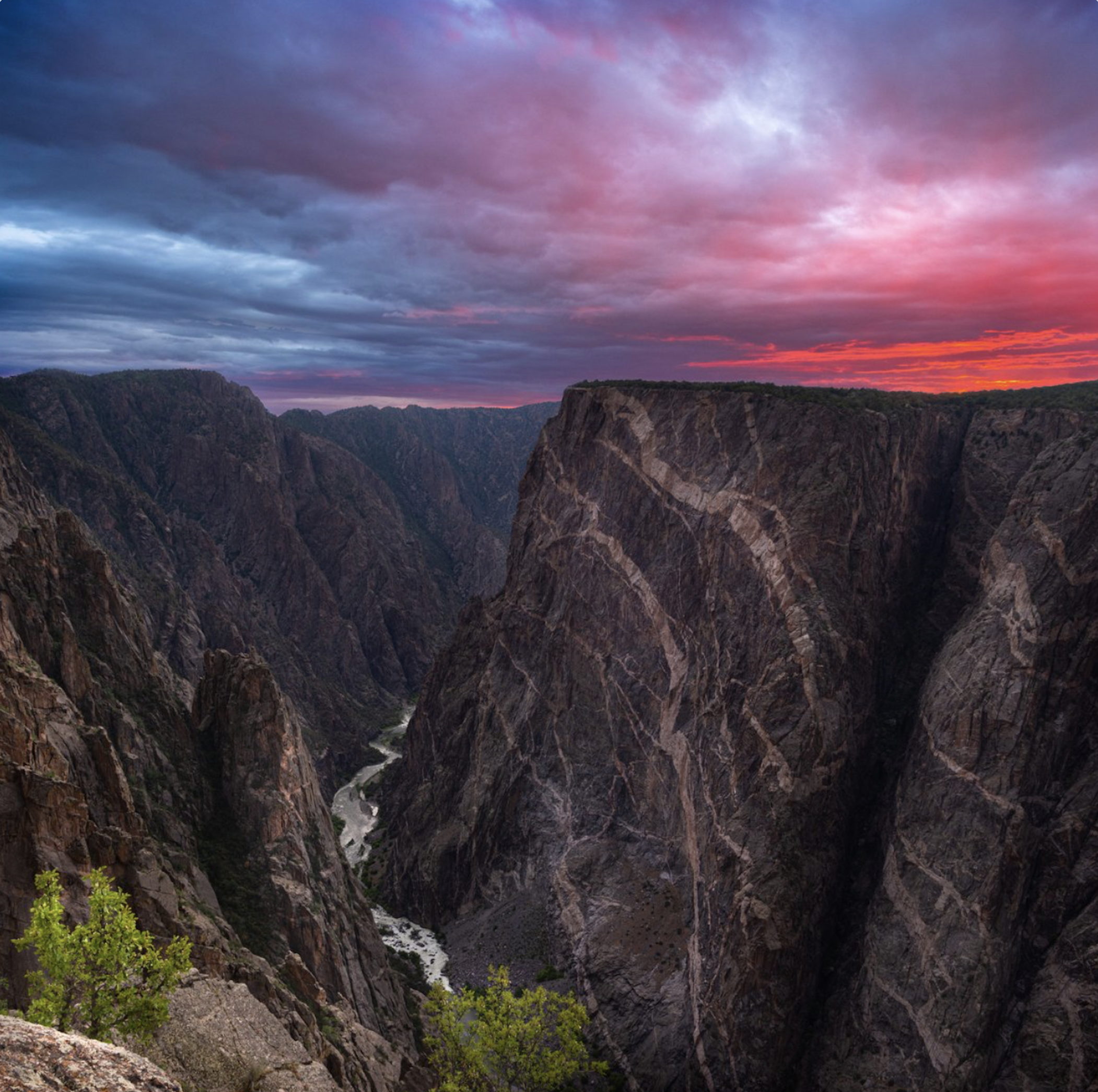
Black Canyon National Park July 2020. Photo credit: Claire Codling/The Department of Interior
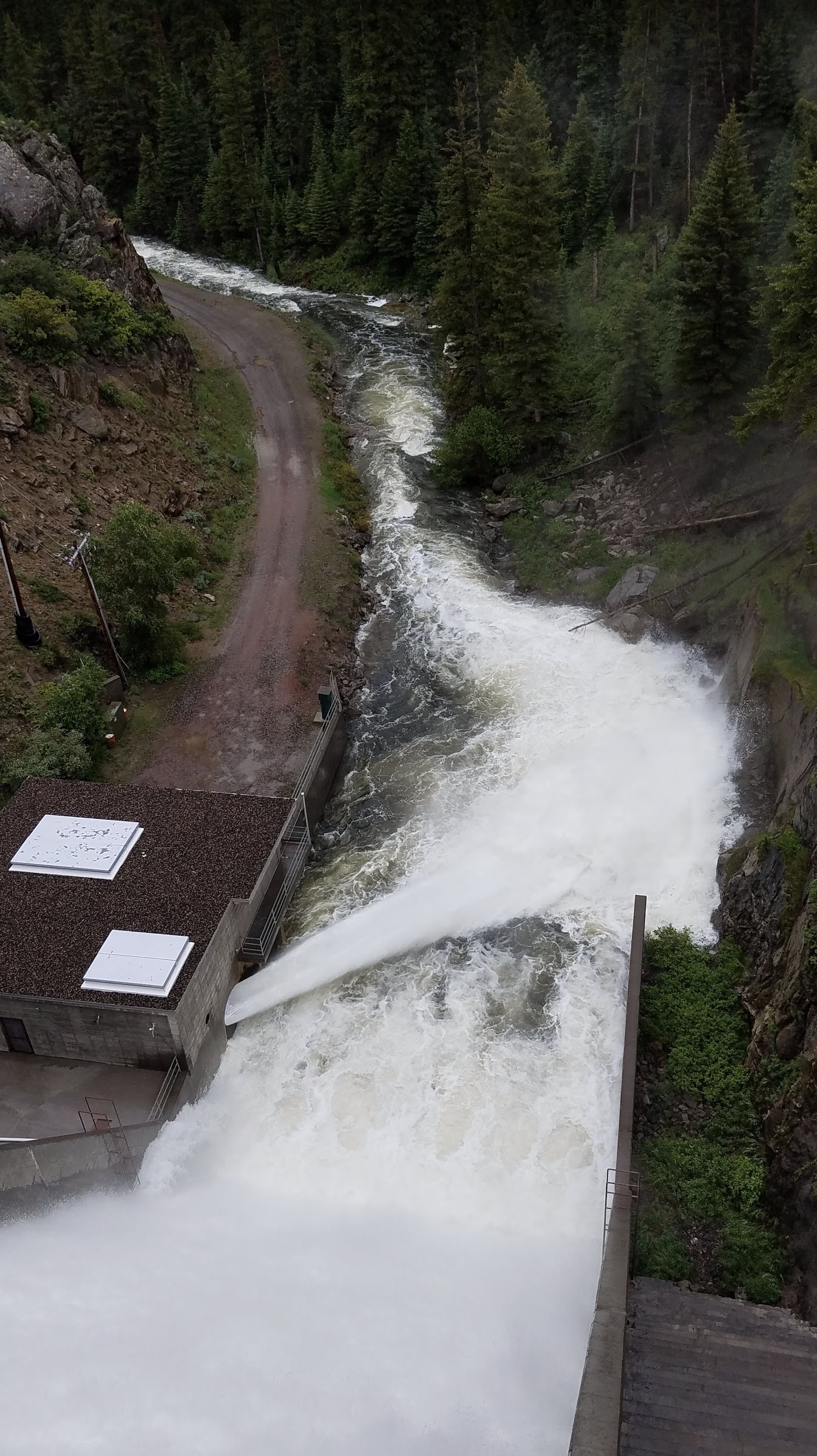
From email from Reclamation (Conor Felletter):
On Monday, June 16th, the scheduled releases from Crystal Dam will decrease to 1,400 cfs. This release change is intended to conserve water amidst the increasingly hot & dry conditions in the Gunnison basin while downstream tributaries are still providing enough water to keep the lower Gunnison River above the baseflow target.
Gunnison River flows (Black Canyon/Gunnison Gorge) are currently 520 cfs and will decrease to ~420 cfs.
Releases are made for the authorized purposes of the Aspinall Unit, and to attempt to maintain a target base flow through the endangered fish critical habitat reach of the Gunnison (near Whitewater). Future release changes are subject to changes in river flows and weather conditions.
Colorado River Basin reservoir storage. Credit: InkStain.net
Click the link to read the article on the InkStain.net website (Jack Schmidt and John Fleck):
June 1, 2025
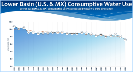
We now begin June, when the Colorado River’s two largest reservoirs, Lake Mead and Lake Powell, should be swelling with melting snow for use later this year and beyond, but that is not happening. Although Lake Powell is our reservoir and Lake Mead is theirs (or vice versa), the two reservoirs are effectively one very large facility located downstream from Upper Basin consumptive users and upstream from Lower Basin users. At least 60% of the total storage in 46 reservoirs tracked by Reclamation is in Lake Powell and Lake Mead. The total contents of the two reservoirs have been steadily declining since early July 2024 and continued to decline through at least 31 May 2025. Never in the past 15 years has the decline in total storage of Powell and Mead extended so late into spring. Current reservoir storage data are showing us, in real time, an ominous pattern familiar from past dry years: upstream use of water before it has a chance to get to Lake Powell combined with releases from Lake Mead to users further downstream is outpacing the melting snowpack’s ability to replenish the two reservoirs.
While the normal tools we use for measuring and managing use of Colorado River water – the Consumptive Uses and Losses Reports and the Lower Basin decree accounting reports – lag by weeks or even years, reservoir storage, which is the net difference between stream flow into reservoirs and what is released downstream or is lost to evaporation, provides the closest thing we have to an accurate, real-time measure of the Colorado River basin’s water budget. Right now, we are not doing well.
The duration of time this year during which total storage in Lake Powell and Lake Mead has declined is unprecedented in the past 15 years. In a typical year, the steady decrease in the combined contents of Powell and Mead that begins the preceding summer ends in early May when Rocky Mountain snowmelt becomes significant. However, inflows to Lake Powell this year have yet to exceed releases from Lake Mead , and the total contents continue to decline, suggesting that this year’s recovery in storage will be minimal.
Data from other years also suggests that reservoir recovery this year will be relatively small. This year, total unregulated inflow to Lake Powell is predicted to be 55% of normal. Based on past trends, net increase in total reservoir storage of the 46 reservoirs tracked by Reclamation will be ~1.2 million acre feet (af). By July, we are likely to resume draw down the basin’s reservoirs until the 2026 snowmelt season begins.
Presently, storage in the watershed’s reservoirs is comparable to conditions in late summer and fall 2021 when water managers expressed significant concern. The very wet conditions of 2023 averted a major crisis, but the system remains depleted. In 2024, total basin reservoir storage climbed by 2.5 million af, but subsequent drawdown of those reservoirs was 3.6 million af during the following 10 months. Although the net difference between reservoir gain and subsequent drawdown of 1.1 million af might be considered “balanced” in the context of the last 15 years, there is no question that we have begun to mine the bounty of 2023, and we are likely to continue to do so until at least spring 2026 unless we greatly reduce consumptive uses.
For too long, we have hoped that big wet years will occur with sufficient frequency to avert true crisis, but there have been too few of those wet years during the 21st century. Only three of the last 15 years have been sufficiently wet to result in a significant increase in reservoir storage given the magnitude of the basin’s consumptive uses. We can’t continue with a water management policy that hopes for another wet year. The basin’s water managers have no choice but to further reduce consumptive uses to sustainably manage the dwindling water supply.
In response to a previously posted mini-white paper on reservoir storage, a supportive friend commented, “Nobody cares.” Another friend said, “I don’t see how we can get agreement about recovering storage. Let’s hope for more wet years.” We should care, and we need to try harder.
These mini-white papers seek to demonstrate that reservoir storage data, analyzed in aggregate, provide timely and accurate data relevant to understanding the reliability and security of the Colorado River’s water supply. These data are more precise, accurate, and timely than estimates of natural runoff, reservoir inflow, consumptive uses, or evaporation. Reservoir storage data provided by Reclamation are a significant contribution to transparency in water management. However, these data are under-utilized and under-analyzed and are typically reported without long-term context. We can do better.
These data can be used to develop an excellent correlation between April-July unregulated inflow to Lake Powell, forecast by the Colorado Basin River Forecast Center, and anticipated increase in basin-wide storage. Such an analysis strongly indicates that the 2025 snowmelt runoff will yield only a small increase in basin storage and necessitate greater reductions in consumptive use so as to better position the basin’s water users should next year also be dry.
In May 2022, a couple paused at once had been the bottom of the boat put-in ramp in Antelope Canyon to lok down on the receding waters of Lake Powell. The reservoir at that point was 22% full. Photo/Allen Best
Almost 300 water wonks converged on Boulder Thursday [June 3, 2025] for two days of sobering conversations about the river’s future punctuated by frustration, pleas for creative solutions and references to everything from the musician Lizzo to the kids movie “Frozen.”
Udall/Overpeck 4-panel Figure Colorado River temperature/precipitation/natural flows with trend. Lake Mead and Lake Powell storage. Updated through Water Year 2024. Credit: Brad Udall
The Colorado River Basin is in dire straits: The water supply for 40 million people has been dwindling, and climatologists say the climate future is bleak. State officials have spent months mired in thorny negotiations over things like how to split painful water cuts in the driest conditions — with scant progress to report publicly. The lack of progress and insight into the talks had some conference-goers feeling frustrated. Concerned. Uncertain.
High-ranking federal officials joined the Boulder event to reassert the federal government’s frequent role in talks over the Colorado River’s future: The parent ready to stop the car if the kids can’t stop fighting.
In the event that the states can’t agree on how to manage the river’s reservoirs and water supply in a timely fashion, Department of Interior Secretary Doug Burgum is ready to wield his federal authority over reservoirs, water contracts and more in the basin.
“He’s not looking forward to that, but in the absence of a seven-state agreement, he will do it,” Scott Cameron, the Department of the Interior’s acting assistant secretary for water and science, said Friday at the 45th annual Conference on the Colorado River at the University of Colorado’s Getches-Wilkinson Center.
The basin’s task is to submit a joint management proposal to the federal government for analysis. For months, however, they’ve been stuck working on separate ideas for how to manage the river.
Upper Basin states — Colorado, New Mexico, Utah and Wyoming — are on one side, and Lower Basin states — Arizona, California and Nevada — on the other. The 30 tribal nations in the basin are advocating for their individual needs, as is Mexico.
Notably, the top state negotiators, except California’s, skipped the Boulder conference this year, unlike in the past.
The Interior Department will analyze a joint basin proposal as part of a larger process to select draft alternatives and then settle on a final plan.
The final plan could determine everything from how key reservoirs store and release water to who takes cuts in dry years and how environments, like the Grand Canyon, will be impacted for years to come. It will impact water supplies for cities, like Denver, Phoenix and Los Angeles, ecosystems, a multibillion-dollar agricultural industry, hydroelectric power and more.
“The time for action is now,” Cameron told the gathering in a speech. “We do not have a lot of time to waste, people.”
Mounting challenges and a bleak climate future
The Bureau of Reclamation plans to release a draft outlining management options by the end of 2025 with a final plan in place by early summer 2026, Cameron said.
But the negotiating challenges are significant. State officials face the political problem of bringing home a deal that includes water cuts. Policymakers distrust each other. Anxious water users are nixing ideas before they have time to grow into policy solutions.
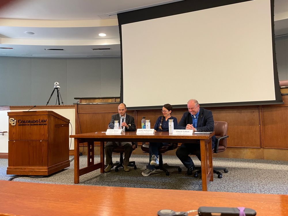
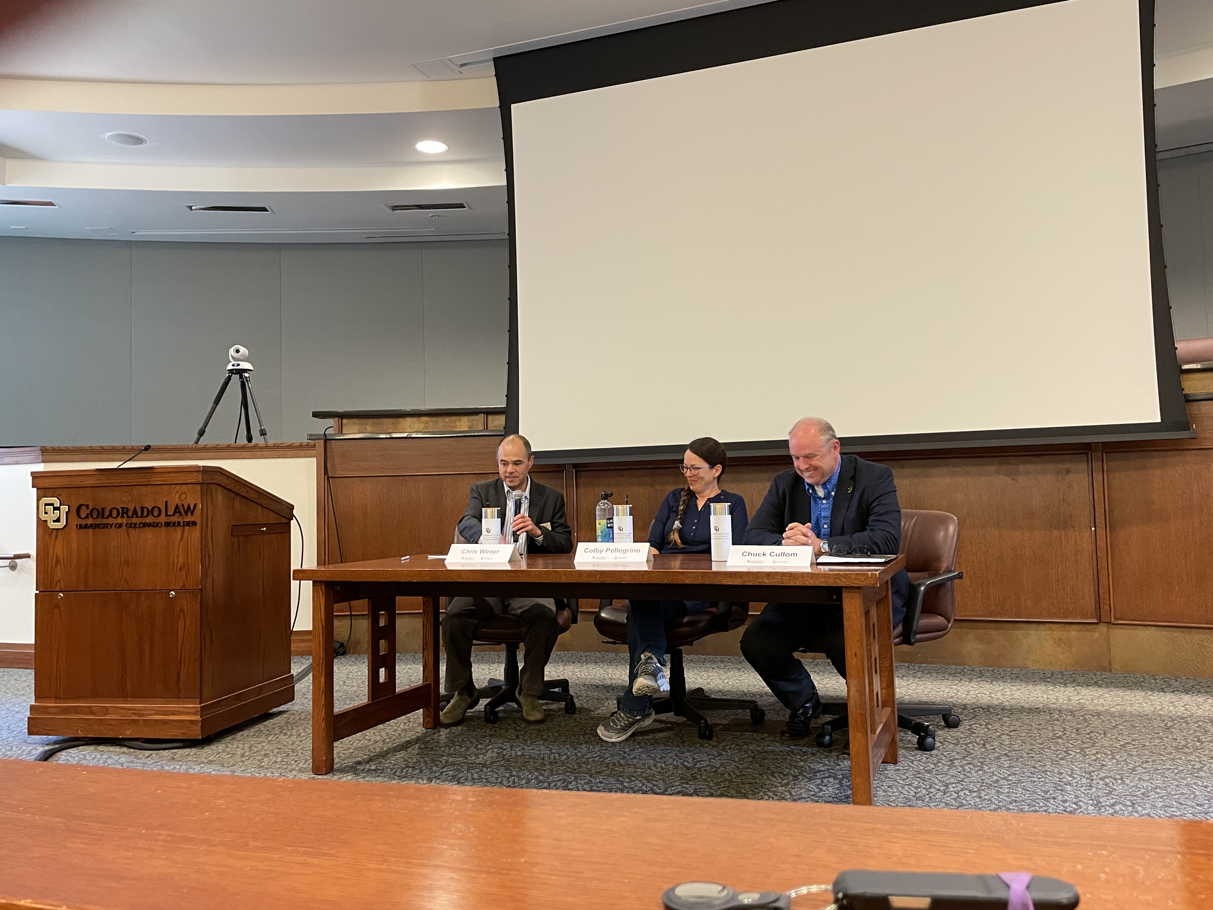
L. to R. Chris Winter, Colby Pelligrino, Chuck Cullom June 4, 2025 during the “Turning Hindsight into Foresight: The Colorado River at a Crossroads” the annual Getches Wilikinson Center/Water & Tribes Initiative shindig in Boulder.
We have to let people develop their ideas, said Colby Pellegrino with the Southern Nevada Water Authority and part of the Nevada negotiating team.
“We’ve done a really crappy job of that. Everyone in this room,” she said. “We need to do more to support the compromise.”
The basin states are already running behind schedule: In March, Upper Basin officials said the basin states had until May to submit their joint management proposal for federal analysis. But May passed, and nothing happened.
It’s like watching the Catholic Church’s secluded conclave to select the next pope, Jim Lochhead, former CEO of Denver Water and state negotiator, said.
“The smoke is all black right now,” he said. “I’m not hearing of any major breakthroughs.”
That’s not for lack of effort: The states are meeting twice a month, and they’re at the negotiating table together.
“We know that we get the best solutions when the states work together,” Colorado’s top negotiator Becky Mitchell said in a prepared statement. (She wasn’t at the conference.) “I am focused on building a broad consensus to address the risks facing the Basin States.”
One of those risks is a changing climate: The basin, along with the rest of the planet, is facing a “beyond awful” climate future, said Brad Udall, senior research scientist at Colorado State University.
The world is on track to warm by 9 degrees Fahrenheit by 2100, and continue warming from there. It’s a future with even less water to share among the U.S., Mexico and 30 tribal nations — and an outcome that, frankly, terrifies scientists, Udall said.
“That’s a world unlike anything we currently know, and it’s going to challenge us all on every front,” Udall told the gathering.
Searching for a unicorn
While some conference-goers were frustrated, speakers took the opportunity to pull lessons from past interstate negotiations and share their ideas for how to break the deadlock.
Tribal leaders called for continued and increased tribal involvement in the Colorado River talks.
“Honestly, I think if our state representatives are going to sit silent, then we have 30 tribal nations that are ready to take over and make a decision and save our river,” said Lorelei Cloud, a member of the Southern Ute Indian Tribe bordered by Colorado and chair of the Colorado Water Conservation Board. “We’ve been doing it since time immemorial.”
Some suggested solutions, like bringing in an external facilitator. Former negotiator and federal official Mike Connor said the states need to seize every olive branch and set aside personal agendas or political legacies. (This is where speakers turned to the “Frozen” mantra: “Let it go.”)
Jennifer Pitt of the National Audubon Society said building personal connections has been the key to progress in the past. Many people pushed for states to find creative solutions, like desalting seawater — a very expensive solution with a relatively small benefit (the equivalent of Lizzo’s tiny, Valentino purse, one water expert said).
“People are trying to turn this thing upside down and sideways to find a unicorn,” Chuck Cullom, executive director of the Upper Colorado River Commission, said.
Concerns abounded. Lochhead said the basin had a once-in-a-generation influx of federal funding — and blew it. Reclamation’s staff has been cut, something that Cameron said he was working to address. With shrinking water supplies, the basin’s communities are feeling the impacts of dry conditions more immediately than in the past.
Western Slope water leader Andy Mueller pushed for more information and faster action to help Colorado communities have more time to adapt and come up with water conservation plans.
“I think failure of our negotiators would be to fail to recognize that our hydrology could be just as bad as Brad Udall is predicting, or worse,” Mueller said.
This week brought sharp weather contrasts across the U.S. The central Plains were 5 to 10 degrees cooler than normal, while the Pacific Northwest was 5 to 10 degrees warmer than average. A broad stretch from Texas through the Midwest to the Northeast received well above-normal rainfall, helping to ease drought conditions, while much of the West, northern High Plains and Florida remained dry, with many areas receiving just 5 to 25 percent of normal precipitation. These patterns led to widespread drought improvements across the High Plains, Midwest, South, and Northeast, particularly from northern Texas to southern Illinois, where 1 to 3 inches of rain reduced short-term dryness. Kansas, Nebraska, and eastern Colorado saw significant gains, while drought worsened in north-central Kansas, northwestern Colorado, and western Wyoming. Southwestern South Dakota and eastern Wyoming also improved. In the Midwest, drought eased in Missouri, Illinois, Indiana, and Michigan, but degraded in northern Minnesota and eastern Iowa. The Southwest benefited from rare early June rainfall and an unusually wet spring, with Arizona, southern Utah, southern Nevada, and parts of California improving after receiving 4 to 8 times their typical rainfall. New Mexico saw minor improvements in the southeast but stayed dry elsewhere. In the West, drought continued to worsen in Montana, northern Utah, and southeastern Wyoming due to ongoing dryness and low snowpack. Conditions in the Northwest are quickly degrading with well below-normal precipitation. The Southeast had mixed results—southern Georgia, the Carolinas and northeast Florida, and the Panhandle improved, while southern Florida remained dry. The Northeast continued its gradual recovery with steady rain. Alaska saw no changes, Puerto Rico remained drought-free, and Hawaii experienced mostly minor degradations…
The High Plains experienced a mix of drought improvements and degradations over the past week, driven by rainfall. Kansas saw the most widespread improvements, especially in the southern and eastern regions, where many areas received over two inches of rain, leading to significant one-category upgrades. However, north-central Kansas received less precipitation, and drought conditions there either persisted or worsened. Nebraska also benefited from recent storms, with helpful rainfall improving conditions in the central and southeastern parts of the state, though some areas now show signs of short-term moisture surplus. Colorado had a similar split. While much of the central and eastern regions received beneficial rainfall and saw improvements, the northwestern and southwestern corners remained dry and experienced drought deterioration. Wyoming followed an east–west divide as well: rain improved conditions in the central and eastern areas, but the west remained dry, resulting in further degradation. Long-term moisture deficits and below-average snowmelt runoff continue to be a concern across western parts of both Colorado and Wyoming. In South Dakota, the southwest corner received 1 to 3 inches of rain, leading to localized improvement, while the rest of the state remained mostly unchanged. North Dakota saw little change overall, with limited but sufficient moisture keeping conditions stable…
Colorado Drought Monitor one week change map ending June 10, 2025.
The West saw a mix of drought relief and worsening conditions this past week, with the most notable improvements concentrated in the Southwest due to rare early June rainfall. Parts of western and central Arizona, southern Nevada, and southwestern California received between 1–2 inches of rain. Even light to moderate amounts made a big impact, leading to broad one-category improvements in drought severity. New Mexico’s southeastern areas saw some improvement from the same rainfall that led to improvements in Texas. Elsewhere in the West, conditions were less favorable. The Intermountain West, including northern Utah, largely missed recent storms and saw continued drought deterioration. Montana faced some of the worst conditions in the region. Dry weather and below-normal snowpack led to expanding drought across the northwest and central parts of the state, raising concerns as the region enters the warmest part of the year with limited water reserves. The Pacific Northwest—covering Washington, Oregon, and Idaho—remained relatively stable this week, with no major shifts. However, dryness is quickly appearing across the region, where conditions will need continued monitoring…
In the South, especially in Texas and Oklahoma, heavy rain led to drought improvements in many areas. Northern and central Texas saw improvements, while southern and western Texas only received enough precipitation to lead to one-category improvements along the border of the drought area. Oklahoma received a lot of rain and showed clear signs of recovery. Other southern states like Arkansas, Louisiana, Mississippi, and Tennessee, conditions continue to be stable…
Looking Ahead
Over the next five to seven days, heavy precipitation is expected across several regions. Eastern Texas, southeastern Oklahoma, and Arkansas will experience significant rainfall, which will continue through the Ohio River area and Pennsylvania. The northern Midwest and High Plains are also expected to receive moderate rainfall, with two to four inches expected in parts of northern Minnesota and northeastern Iowa. Nebraska is forecasted to see above-normal precipitation. Meanwhile, the West Coast will miss out on significant rain, with little to no precipitation expected from Washington down through eastern Colorado and New Mexico.
The six to 10 day outlook shows below-normal temperatures in the Pacific Northwest, while above-normal temperatures are expected across the rest of the lower 48 states, Alaska, and Hawaii. The greatest chances for above-normal temperatures are in Utah, Colorado, southern Wyoming, and across the southeast, from southern Louisiana to West Virginia. Above-normal precipitation is more likely in the Pacific Northwest, northern High Plains, upper Midwest, southern Texas, western Louisiana, and many of the Hawaiian Islands. There is a greater likelihood that southern Florida and much of the West is expected to have near- or below-normal precipitation, with the greatest likelihood of below-normal precipitation extending from southeastern Oregon to the Four Corners region.
US Drought Monitor one week change map ending June 10, 2025.
In May, hydrologists forecasted that spring runoff into Lake Powell would be the lowest in years. A month later, the projections have only gotten worse. The Colorado Basin River Forecast Center reported on June 1 that the amount of water expected to flow into Lake Powell between April and July this year will be 45% of average. “Average,” in forecasting, refers to the average runoff between 1991 and 2020. The June forecast follows a consistent decline since the start of winter. Hydrologists said in December that Lake Powell’s runoff would be 92% of average. In January, the forecast dropped to 81%, then to 67% in February. The prediction pushed up to 70% in March, but fell to 55% in May, before dropping to 45% in June.
Jack Schmidt, a watershed sciences professor at Utah State University and director of the Center for Colorado River Studies, and John Fleck, a water professor at the University of New Mexico, released a study about the state of the Colorado River’s largest reservoirs on June 1. They wrote that instead of increasing with spring runoff flows, the amount of water in Lake Powell and Lake Mead has decreased through the end of May.
“Never in the past 15 years has the decline in total storage of Powell and Mead extended so late into spring,” the study reads.
That decline is the result of chronic overuse, Schmidt and Fleck write, which is “outpacing the melting snowpack’s ability to replenish the two reservoirs.”
As the climate warms and the risk of drought grows, the Eagle River Water & Sanitation District is taking action to protect its most precious resource. In presentations at the 2025 Eagle River Valley State of the River on May 29 and to the Eagle River Water & Sanitation District board on May 22, David Norris, the district’s director of business operations and Allison Ebbets, the district’s water conservation manager, laid out the district’s plan for encouraging its most consumptive customers to lessen their use. The hard truth is that some homes in Eagle County are using way too much water. Nearly 600 individually metered residential accounts — single-family homes — used over 30,000 gallons of water for three or more months in 2024. One home used over 1 million gallons of water throughout the year, equivalent to the use of a large hotel.
“Water conservation is crucial,” Norris said at the State of the River. “We all need to be a part of this together.”
[…]
The Eagle River Water & Sanitation District has set a goal to reduce its customers’ overall water use by 400 acre feet by the end of 2026…Since the district began working on the project in 2023 through strategies that include a conservation-focused water rate redesign, an industry standard-focused rate redesign and increased public outreach, its total reduction has been 111 acre feet. That leaves 279 acre feet to reduce to reach the district’s goal.
Colorado River “Beginnings”. Photo: Brent Gardner-Smith/Aspen Journalism
Click the link to read the article on the AZCentral.com website (Austin Corona). Here’s an excerpt:
June 7, 2025
Key Points (AI assisted summary)
After months of little progress and public battles, negotiators from the seven Colorado River states may have regained their footing toward a shortage-sharing agreement.
Officials say the Trump administration has engaged in the work to complete an agreement, spurring the states to resume talks. Without a deal, the federal government would impose its own plan.
An official said a new agreement could require changes in the bedrock laws that govern the river, suggesting that even the “Law of the River,” a 100-year old management framework, could face scrutiny.
Metaphors about divorce and grief defined an emotional presentation about the Colorado River in Boulder, Colorado, on June 6. Those metaphors, however, did not represent strife or disaster in stalled water negotiations, but apparent progress and the willingness to let go of past ideas and move toward compromise.
“We’ve heard about the stages of grief … about denial and anger and the need to be at bargaining,” said Chuck Cullom, executive director of the Upper Colorado River Commission. “Well, I believe the basin states are there.”
Officials involved in tense negotiations over how to manage shortages on the Colorado River suggested that months of harsh talk and stalemates have ended and negotiators are exploring new options…Federal officials indicated that even parts of the “Law of the River,” a 100-year-old legal framework that governs Colorado River allocations, could change as a result of the negotiations.
“We’re trying to pivot to something else and be creative, and we have good engagement on that right now,” said Colby Pellegrino, deputy general manager of the Southern Nevada Water Authority…While most of the negotiators from the seven Colorado River basin states did not attend the conference at the University of Colorado in Boulder, the speakers who did attend were cautiously optimistic about their chances at making a deal.
Bill Hasencamp with the Metropolitan Water District of Southern California speaks at the University of Colorado, Boulder on June 5, 2025. More than 300 Colorado River experts attended, but the region’s top water policymakers skipped the event. Alex Hager/KUNC
Click the link to read the article on the KUNC website (Alex Hager):
June 6, 2025
This story is part of ongoing coverage of the Colorado River, produced by KUNC in Colorado and supported by the Walton Family Foundation. KUNC is solely responsible for its editorial coverage.
Closed-door negotiations about the future of the Colorado River are at a standstill. The news of the day is that there’s barely any news. So, when more than 300 water experts got together for an annual conference this week, they had little to do besides wring their hands, listen for crumbs of news, and talk about how they would do things differently if they were on the inside of those negotiations.
“The current process to me kind of feels like the conclave,” said Jim Lochhead, who formerly served as Colorado’s top water negotiator.
Top policymakers caused a stir when they decided to skip the meeting at the University of Colorado, Boulder, withdrawing further into the shadows as tense talks about sharing water appear to be making little progress. The people excluded from those meetings — scientists, academics, tribal leaders, environmental advocates and others with a stake in the river — have been left waiting like the masses gathered in St. Peter’s Square.
“We’re waiting for the black smoke or the white smoke to come out of the seven-state negotiating room,” said Lochhead, who once served as CEO of Denver Water and now works as an independent consultant.
On the other side of this Colorado River “conclave,” seven state-appointed negotiators are trying to come up with a new set of rules for sharing water after 2026. They’re under pressure to cut back on demand for water because the river’s supply is shrinking due to climate change. Until they emerge with a new set of rules, farmers, cities and everyone else will be wondering if they will feel the sting of those cuts.
Across the Colorado River basin, those who depend on the river’s water are making preparations however they can. Cities are spending big on technology that will help stretch out their water supplies if they’re given less in the future. Tribes are trying to get a more formal role in river negotiations, so future water-sharing policies don’t leave them behind like so many in the past.
Efforts like those have been underway for years now. But in Boulder, as top state negotiators keep their heels firmly planted in incompatible policy positions and an unpredictable federal government has yet to appoint a top official to oversee Colorado River matters, everyone else was left to marinate in the anxiety that will linger until a new set of rules is formed.
Looking to the past
With little information about the future, the talks in Boulder mainly focused on lessons from history.
Some of those lessons were relatively recent. For example, Lochhead pointed to talks ahead of a 2007 plan that saw more than seven people in the negotiating room, including federal government representatives who were able to push the states towards consensus. He said today’s negotiations would benefit from a similar approach.
Other lessons were more than a century old. Tribal leaders advocated for the presence of Indigenous interests in today’s talks. Were they included in previous discussions, said Lorelei Cloud, things might be different today.
September 21, 1923, 9:00 a.m. — Colorado River at Lees Ferry. From right bank on line with Klohr’s house and gage house. Old “Dugway” or inclined gage shows to left of gage house. Gage height 11.05′, discharge 27,000 cfs. Lens 16, time =1/25, camera supported. Photo by G.C. Stevens of the USGS. The Colorado River flows past a measuring device at Lee’s Ferry in Arizona on Sept. 21, 1923. Speakers at a recent conference on the Colorado River drew lessons from history to inform the next chapter of water management in the region.. Source: 1921-1937 Surface Water Records File, Colorado R. @ Lees Ferry, Laguna Niguel Federal Records Center, Accession No. 57-78-0006, Box 2 of 2 , Location No. MB053635.
“The past century has really shown that the exclusion of tribal voices has really led to this crisis that we’re dealing with now in the basin,” said Cloud, a member of the Southern Ute Tribe and the recently appointed chair of the Colorado Water Conservation Board. “If we had just honored tribal sovereignty from years back, even from the beginning, we probably would have had serious offers that provided solutions to what we’re dealing with now. We wouldn’t be sitting here talking about hindsight to foresight.”
Patty Limerick, a historian and author whose work focuses on the American West, also brought lessons from more than a century ago when she told the story of a man named E.C. LaRue.
LaRue was a federal engineer who studied the river in the early 1920s. He urged his higher-ups to be conservative in their estimates about the amount of water in the Colorado River. They largely ignored LaRue, instead signing legal agreements that promised more water than the river, in most years, is able to provide.
If policymakers had listened to LaRue more than a hundred years ago, some say, those who rely on the Colorado River today would not be in such a crisis.
Limerick finished describing LaRue’s tale and posed a question to the room.
“Is there a latter-day counterpart to E.C. LaRue to whom we should be paying attention?” she asked. “Is that person among us?”
Another speaker suggested that counterpart might be climate scientist Brad Udall. When he spoke shortly thereafter, his outlook was grim.
Udall/Overpeck 4-panel Figure Colorado River temperature/precipitation/natural flows with trend. Lake Mead and Lake Powell storage. Updated through Water Year 2024. Credit: Brad Udall
‘Beyond awful’ forecasts
Udall and other scientists have provided a rare, uncomfortable dose of certainty to Colorado River talks: The planet is getting warmer, the Colorado River is losing water, and cutbacks to water demand are unavoidably necessary.
He told the audience to “hold on to [their] seats” before describing the climate forecast as “beyond awful.”
While his predictions are rarely rosy, Udall struck a more pessimistic tone than previous years, calling out fossil fuel companies and an “anti-knowledge president and his vile enablers” for attacking science and efforts to gird the nation against the harms of climate change, including water shortages.
“Not only are we in a really deep climate hole,” he said, “We’re continuing to dig and absolutely the last thing we need is the federal government undercutting our efforts to meet the water supply challenges in this basin.”
What the feds said
Those in attendance looking for crumbs of information about negotiations from state leaders were left empty-handed. But one federal representative, perhaps surprisingly, dropped a few tiny ones.
The federal government has stayed relatively tight-lipped on Colorado River matters since Donald Trump returned to the White House. In the administration’s early days, it paused funding for water conservation and infrastructure projects. It has yet to appoint a new commissioner for the Bureau of Reclamation, the agency which manages dams and reservoirs across the West.
Scott Cameron, the Interior Department’s acting Assistant Secretary for Water and Science, speaks at a conference in Boulder, Colorado on June 6, 2025. He said federal officials are working closely with state negotiators to shape the next chapter of Colorado River management. Alex Hager/KUNC
With that role unfilled, the administration’s highest-ranking official focused on Colorado River matters is Scott Cameron, a longtime federal official who currently serves as the Department of the Interior’s acting Assistant Secretary for Water and Science.
Cameron said he’s been meeting with state negotiators roughly “every other week for the last eight weeks” after his boss, Interior Secretary Doug Burgum, said he wanted the department’s leadership to be “personally, intensely, and constantly” involved in discussions with the seven states. Cameron did, however, say he did not believe the states needed an external moderator to help break their deadlock.
“My impression is they really want a deal, they really want to find a path forward to working together, and I’m convinced that they’re all sincere in that regard,” he said.
Cameron also said he was “constantly” asking Reclamation’s senior leadership to bolster the agency’s staff on Colorado River matters as a way to “mitigate any unintended consequences of national level initiatives to reduce overall federal spending.”
Map of the Colorado River drainage basin, created using USGS data. By Shannon1 Creative Commons Attribution-Share Alike 4.0
This land in Woody Creek is owned by the city of Aspen and is a potential site for a reservoir. On May 30, the city reaffirmed its plans to build water storage with two water court filings. CREDIT: HEATHER SACKETT/ASPEN JOURNALISM
The city of Aspen is reaffirming its plans to build reservoirs to store water from Castle and Maroon creeks — but where they might be built has still not been decided.
On May 30, attorneys for the city filed two applications in water court: a diligence application detailing the actions Aspen has taken toward developing the rights over the past six years and an application to change the original locations of the reservoirs. After a water court process, which saw 10 groups oppose the reservoirs, Aspen in 2019 agreed to modify the rights and move the proposed reservoirs out of Castle and Maroon valleys.
The city has previously identified five potential locations for reservoirs: on land the city owns in Woody Creek; Vagneur Gravel Quarry; and three underground sites — the Aspen Golf Course, Cozy Point Ranch and Zoline Open Space.
“I think the city would try and prioritize sites that we own already, or those that have larger and contiguous areas and focus on those, but I think a lot of it will come down to the feasibility and constructability, and those sites that might have the least impact as well,” said Erin Loughlin Molliconi, Aspen’s utilities director.
Aspen has what’s known as conditional storage rights for up to 8,500 acre-feet of water from Castle and Maroon creeks, which it could store in one or more locations. Conditional water rights allow a water rights owner to save their place in line while they work toward developing the rights.
Since first claiming the rights in 1965, the city every six years filed little-noticed diligence applications to maintain them. But the city’s 2016 diligence filing brought statements of opposition from 10 parties: the U.S. Forest Service, Pitkin County, American Rivers, Western Resource Advocates, Trout Unlimited, Wilderness Workshop and four private-property owners — two who owned land in the Maroon Creek Valley and two who owned land in the Castle Creek Valley.
The location of the potential Maroon Creek Reservoir. Photo credit: Brent Gardner-Smith/Aspen Journalism
The Maroon Creek Reservoir would have had a dam 155 feet tall and would have held 4,567 acre-feet of water in a pristine location in view of the Maroon Bells. The reservoir would have flooded 85 acres of U.S. Forest Service land, including some in the Maroon Bells-Snowmass Wilderness.
The Castle Creek Reservoir would have had a dam 170 feet tall and would have held 9,062 acre-feet of water. The reservoir would have flooded 120 acres on both private and USFS lands, including a small area in the wilderness.
After settling with the opposing parties, Aspen’s total storage rights were winnowed to 8,500 acre-feet, and the city is now required to find a new site or sites to build storage buckets.
Conditional water storage rights that have not yet been developed — such as Aspen’s — are held by many cities, water conservancy districts and fossil fuel companies across the Western Slope.
Five new potential reservoir sites
Besides the five previously identified sites where the city might want to move its potential water storage, officials had been seeking to add five new reservoir sites to the change case, but ultimately they did not include them. In a March 28 letter to opposersin the 2016 case, the city requested approval to include Thomas Reservoir, Marolt Open Space, Snowmass Reservoir, Ziegler Reservoir and Wildcat Reservoir in the list of potential locations.
According to the settlements with opposers, the city needs written approval from the opposers to add any new potential reservoir locations, other than the previously identified five (Woody Creek, Vagneur Gravel Quarry, Aspen Golf Course, Cozy Point Ranch and Zoline Open Space). Aspen did not get that approval from all of the opposers for all of the locations before the May 30 water court filing deadline.
“We can say that some parties did approve of sites,” Molliconi said. “We just didn’t get all parties to approve of all sites.”
Molliconi said the city chose the five additional sites because they already have existing reservoirs or ponds.
“It would be better to get either a partnership with an existing site or enlarge an existing site,” Molliconi said.
It is unclear if the city will pursue adding any of the five new sites to a future proposal. In an emailed statement, officials said they would “continue to respect and honor the stipulations and conditions of other stakeholders in this process.”
“The city intends to maintain site flexibility because we can’t perfectly predict future demands,” the statement said. “We feel it is our responsibility to continue analyses and stakeholder conversations for storage given the need for resource resiliency, storage and demand gaps, and other beneficial uses.”
Bill Hegberg is the association president of Wildcat Ranch, a residential subdivision outside of Snowmass Village. He said he had talked with city officials about including in their plans Wildcat Reservoir, a 1,100-acre-foot lake on Wildcat Creek, a tributary of Snowmass Creek.
“It doesn’t really work when we’ve got a lake that’s a recreation amenity,” Hegberg said. “We aren’t available for that.”
Aspen officials did not provide additional information on how reservoirs in the Brush Creek and Snowmass Creek drainages could be used to provide water to the city.
Environmental conservation organization American Rivers was one of the opposers Aspen settled with in 2019. Matt Rice, American Rivers’ southwest regional director, said the organization couldn’t sign off on the five additional new locations until Aspen provided more information.
“We can’t in good faith approve Aspen’s very vague plans,” Rice said. “But we are not trying to throw up unnecessary roadblocks. They just need to do a little bit more work on that and we can have this discussion in six years, especially if they provide us a longer timeline to get our approval.”
Every six years, holders of conditional water rights must file what’s known as a diligence application with the state’s water court, proving that they still have a need for the water, that they have taken substantial steps toward putting the water to use and that they “can and will” eventually use the water. They must essentially prove they are not speculating and hoarding water rights that they won’t soon use.
According to the water court filings, the city says the following things count as diligence over the past six years: It has spent about $310,000 to investigate the 10 potential reservoir locations; it has spent $300,000 on attorneys fees to “defend” its water rights; and it has continued to improve, operate and maintain its water systems that serve Aspen residents.
The Aspen municipal golf course, which sits between Castle and Maroon creeks. The golf course is one potential site the city of Aspen is considering for underground water storage. CREDIT: BRENT GARDNER-SMITH/ASPEN JOURNALISM
Storage is part of Aspen’s Integrated Water Resource Plan, which was completed in 2021and lays out options for meeting increasing water demands in a hotter and drier future. In addition to storage, the IWRP options include nonpotable reuse; groundwater wells; using Hunter Creek as a water source; enhanced water conservation; and drought restrictions.
“I think that [IWRP] is part of the reason why keeping these water rights alive was important, too, for the supply and demand,” Molliconi said.
According to the plan, which uses estimates of population growth and climate change to make projections 50 years into the future, the worst water shortages could occur in two consecutively dry years and be about 2,300 acre-feet total over the course of both years.
In recent years, Aspen has worked at reducing customers’ water use — especially outdoor water use — with increased public outreach, a landscape ordinance, automated metering and tiered water use rates. The city has also stepped up the monitoring of snowpack and streamflow by funding a new SNOTEL site at the headwaters of Castle Creek and Airborne Snow Observatory flights that measure snowpack from planes using light detection and ranging, or lidar.
Steve Hunter, Aspen’s utilities resource manager, said he plans to recommend to City Council on June 10 that the city move into a Stage 1 water shortage declaration, which aims to reduce water use by 10% through voluntary conservation.
Now that the applications are filed, anyone who might want to oppose the city’s plans has 60 days to file a statement of opposition. The 10 original opposers in the case agreed not to fight the city’s efforts to move the rights to the five alternative locations for 20 years.
If the city’s change case is approved, officials would still need land-use and permitting approval to build any eventual new water-storage reservoir and associated infrastructure.
Aspen Journalism is supported by a community nonprofit grant from the city of Aspen.
Aspen Journalism is a nonprofit, investigative news organization covering water, environment, social justice and more. Visit http://aspenjournalism.org.
Perry Cabot, left, and Manny DeLeon hold a 3D-printed Parshall flume that they created to make the water-measurement device more affordable and accessible. Photo credit: Colorado State University
At Colorado State University, innovation doesn’t always start in a state-of-the-art lab. It sometimes begins with a farmer in need, a researcher with a goal and a healthy dose of curiosity. That spirit drives work at the Colorado Water Center, where scientists and collaborators are rethinking how we manage and measure one of our most vital resources.
CSU Extension Professor Perry Cabot, who is jointly appointed through the Colorado Water Center and the Agricultural Experiment Station, is blending historic engineering with cutting-edge technology to make irrigation measurement more affordable and accessible. Cabot and a team of CSU researchers are harnessing the power of large-format 3D printing to revive and reimagine the Parshall flume – a century-old water measurement device first developed at CSU.
The project was made possible through funding from the Colorado Water Center’s grant program, which supports applied research projects that address urgent water issues across Colorado.
From legacy to low-cost innovation
The Parshall flume, invented by Ralph Parshall in 1921 at what was then called Colorado Agricultural College, remains one of the best methods for measuring water in open channels like irrigation ditches. Its distinctive shape slows and constricts the water as it flows through, making it possible to calculate the flow rate, or how much water is flowing through per second, by measuring the height of the water at a specific point in the flume. The flow rate is multiplied by the amount of time the water flows through the flume to calculate the amount of water. This information is essential for tracking and managing water used for irrigation, especially in regions where every drop counts.
“The genius of the flume is in the geometry,” Cabot said. “We can convert the height of the water in the flume into flow without needing fancy instruments, which is precisely why it has stood the test of time.”
Farmers can use flume data to schedule precise watering, reduce excess runoff and document their water use to meet regulatory requirements. By knowing the exact flow rate, a farmer can match irrigation timing and volume to crop needs more accurately. This minimizes the risk of overwatering, which wastes both water and energy, and reduces the risk of nutrient runoff. Over the course of a growing season, this kind of precision can lead to better harvests, lower costs and more sustainable use of limited water supplies.
However, traditional flumes are expensive, often ranging from hundreds to thousands of dollars, depending on size, and they are cumbersome to ship. For many farmers, researchers and conservation districts, the cost alone can be a barrier to access.
At left, a small 3D-printed Parshall flume inside the printer. At right, a larger version of a 3D-printed Parshall flume in action. Photo credit: Colorado State University
“We measure what we value, and we value water, but it’s a resource that’s increasingly difficult to put a clear, consistent price on,” said Cabot. “That lack of clarity makes it harder to justify costs associated with industrial tools like Parshall flumes.”
“Instead of buying an expensive, prefabricated flume, 3D printing allows us to create and sell Parshall flumes at a much more affordable rate,” Cabot said.
Manny DeLeon, a CSU researcher in the College of Agricultural Sciences and research technician on Cabot’s team, uses tools such as 3D printing to help develop low-cost technologies to make water measurement more accessible and efficient.
Using a durable, petroleum-based resin, Cabot and DeLeon have successfully printed the first large-scale Parshall flumes ever produced using additive manufacturing. Their 3D-printed version costs as little as 10%-20% of its traditional counterpart, with minimal compromise in durability or accuracy.
Printing the future of water management
Cabot sees this as a transformative step toward democratizing water measurement tools. His long-term vision is to decentralize flume manufacturing by equipping local conservation and river districts with the 3D printers needed to build and calibrate their own equipment.
“Imagine a farmer walking into their local conservation office, asking for a flume and walking out with one the next day,” Cabot explained. “This puts the tools of water management into the hands of the people using them.”
Rooted in service, driven by ingenuity
For Cabot, this project represents more than cost savings or tech adoption; it’s about service.
“My job is to help people,” he said. “Engineering, for me, is fun, but it’s also about solving problems that matter. That’s what engagement and extension are all about.”
Cabot said his work on the Western Slope is a great reminder for the future of research and innovation at CSU. “We don’t need to have the flashiest tools to build something transformative that can change the world. All it takes is a little ingenuity, a bit of resin and those willing to do the work.”
Learn more
To explore more about CSU’s legacy in water innovation and the Colorado Water Center’s work, visit the Colorado Water Center’s website.
Ralph Parshall squats next to the flume he designed at the Bellevue Hydrology Lab using water from the Cache la Poudre River. 1946. Photo Credit: Water Resource Archive, Colorado State University, via Legacy Water News.
Click the link to read the release on the NRCS website:
June 6, 2025
Snowmelt is nearly complete across Colorado. Most basins report early melt and below normal runoff forecasts. Early monsoonal precipitation has started and increased rainfall is expected to continue through the summer, particularly across southern regions.
Colorado’s snowpack is nearing its seasonal end. Melt-out is occurring ahead of schedule across most of the state. Statewide snowpack is at 54 percent of normal. Snow water equivalent (SWE) statewide declines rapidly and most high elevation sites are now melted out, with only isolated locations primarily in northern basins retaining measurable snowpack. Statewide snowmelt is tracking 10 days earlier than median based on historical trends. The San Juan Mountains and Sangre de Cristo Range show a more pronounced signal. Many sites record snowmelt onset dates 20 days or more ahead of median. Southern sites already hampered by a meager accumulation season experienced accelerated melt due to persistent warm temperatures through May. Sites in the Front Range and near the divide have held onto snow slightly longer and are closer to normal melt-out timing.
May brings a welcomed reprieve from dry patterns. Totals rank second highest for the water year to date (WYTD), behind only November. WYTD precipitation is at 86% of median statewide with May at 96% and outperforming traditionally stronger accumulation months like December, January and April. Despite lower climatological averages for May, precipitation was most favored in the San Juan Mountains, Sangre de Cristo Range and the Front Range.
Early June storms extend the trend from May, delivering over 2 inches of precipitation at SNOTEL sites in the southwest between June 2 and June 5. Precipitation patterns shift toward higher humidity, more persistent cloud cover and frequent showers. These early June rain events align with the onset of the North American Monsoon, which often delivers afternoon storms and elevated atmospheric moisture, a vital source of summer water supply in southern Colorado.
Historically, 7% of annual precipitation falls during May, while June through September account for nearly 30% of annual accumulation in basins like the San Miguel-Dolores-Animas-San Juan (SMDASJ) and Upper Rio Grande (URG). A strong early start to the monsoon improves soil moisture, support reservoir levels and reduces wildfire risk as runoff tapers. That said early monsoon activity also raises concerns about short-term risks. Flood watches have already issued for portions of the southwest.
Observed streamflows reflect a compressed runoff season, particularly across the Western Slope. “Early snowmelt combined with limited snowpack has resulted in lower runoff forecasts, particularly in southern basins,” notes Nagam Bell, NRCS hydrologist. “Early monsoon activity could improve moisture conditions but consistent summer rainfall will be critical moving forward.” Southern and western basins run at approximately 50% of average flows for early June. Northeastern regions, benefitting from slightly better snow retention, track closer to seasonal norms but remain below median.
Streamflow forecasts for the remainder of the runoff period reflect below normal runoff particularly west of the Continental Divide. Forecast departures from normal are concentrated across the Western Slope where the largest deficits are observed. At the Colorado River near Cameo the forecast volume is 391,000 acre-feet below normal. Upstream of the Colorado and Gunnison confluence the Gunnison River near Grand Junction forecasts a volume 351,000 acre-feet below normal. Statewide the average forecast percentile at the 50% exceedance probability is near the 22nd percentile based on 80 forecast points. The median forecast across the state is 67% for the 30-year median, with a majority of forecast points between 50% to 75% of median. Outlooks near major reservoirs including inflow into Pueblo Reservoir, Colorado River below Lake Granby and the Blue River below Dillon Reservoir are below median but generally near seasonal norms. By contrast, the Gunnison River inflow to Blue Mesa Reservoir is forecast at 64% of median and the Dolores River above and below McPhee are forecast near 60% of median. Forecasts point to continued low runoff volumes for rivers across the Western Slope, while flows in the Front Range and north central regions remain closer to median conditions.
Statewide reservoir storage holds at 89% of median as of June 1. This marks a modest decrease from 93% a year ago. The Arkansas, URG, Gunnison, Colorado Headwaters and South Platte maintain near to above median storage ranging from 92% to 107% of median. The SMDASJ continues to trail at 74% of median with McPhee Reservoir at 66% capacity and 70% of median. These storage levels become increasingly important as snowmelt contributions diminish and summer water demand increases.
Colorado is shifting from snowmelt to summer moisture. While early runoff and below normal snowpack limit streamflow the recent precipitation and early monsoonal activity provide cautious optimism. NOAA’s seasonal outlooks forecast above normal precipitation for Colorado through the 6-10 day and monthly periods, with the southwest showing the strongest signal for wetter conditions. Temperatures are forecast to trend above normal statewide.
Solar panels San Luis Valley. Photo credit: Allen Best/Big Pivots
Click the link to read the article on the Big Pivots website (Allen Best):
June 3, 2025
Not much to like in this bill. But then, it’s only half-time. How hard will key Republicans in Senate push back?
Higher electricity rates? In Colorado as elsewhere, that’s the given if the U.S. Senate adopts the recent budget reconciliation bill passed by the House of Representatives that would end a whole host of federal tax credits.
Tax credits shorn by the bill include those now available to consumer who purchase electric vehicles and plug-in hybrids
How exactly will that impact Glenwood Springs-based Holy Cross Energy? In the short term, the legislation adds uncertainty as the electric cooperative works to move from 80% emission-free energy in 2025 to its goal of 100% in the next five years. It serves the Aspen- and Vail-dominated resorts valleys.
Brighton-based United Power has a different problem posed by the sharp-elbowed bill if it remains intact after review by the U.S. Senate. An electrical cooperative also, United serves one of Colorado’s fastest growing areas for population growth, but the electrical demand from new homes is dwarfed by that from new industrial and commercial development.
By a one-vote margin, the House approved the sweeping tax and spending bill on May 22. In addition to other sweeping provisions, the bill largely guts incentives created by Congress in 2022 in the Inflation Reduction Act to advance clean energy and storage. The IRA is widely regarded as the most significant climate change legislation ever adopted in the United States.
Supporters of the controversial bill included two Republicans from swing districts in Colorado, Rep. Gabe Evans of Fort Lupton and Jeff Hurd of Grand Junction. Two Republicans and all 212 Democrats voted against the bill. Another two Republicans did not vote and one merely registered presence.
Evans and Hurd were among 21 House Republicans who signed a letter in March that calls for preserving energy tax credits as necessary to “increase domestic manufacturing, promote energy innovation and keep utility costs down.” Hurd, but not Evans, was among 26 who signed a May letter calling for preservation of tax credits necessary to accelerate deployment of next-generation nuclear power technologies.
After the vote, Evans posted a press release that said the bill “eliminates Green New Deal-style giveaways.”
Two days before the vote, President Donald Trump visited Capitol Hill to inform on-the-fence representatives that they could face primary opposition if they voted against what the president had called his “one big beautiful bill.” Big Pivots requested comment of both Evans and Hurd but without response.
he Senate, where Republicans hold a three-vote advantage, may act on the budget bill as early as July. However, the Washington Post on Monday noted that four Republicans senators in April sent a letter to Senate Majority Leader John Thune cautioning against “the full-scale repeal of current credits.”
“We just hit half-time. We’re still very much in the middle of this game,” said Harry Godfrey, who manages federal priorities for Advanced Energy United, a national industry association that monitors Colorado and 16 other states.
Differences would be negotiated by a conference committee before being returned to the two chambers for review.
“They really went after just about everything that they could in the realm of clean energy and electric vehicles,” said Will Toor, who directs the Colorado Energy Office.
“I would certainly hope that cooler and wiser heads will prevail in the Senate,” Toor added. “The benefits of the Inflation Reduction Act are widespread, not just for clean energy but for consumers and for jobs, especially in red states and districts. We’re hopeful that the Senate will reject this incredibly unwise bill that was adopted by the House of Representatives.”
Mike Johnson, speaker of the House, had described the bill as being “somewhere between a scalpel and a sledgehammer” approach to the IRA. Abigail Ross Hopper, head of the Solar Energy Industries Association, a trade group, called it a “sledgehammer masquerading as a scalpel.”
The IRA along with the earlier Bipartisan Infrastructure Law have produced a proliferation of announcements about expanding battery production and other business ventures along the Front Range.
For example, Louisville-based Solid Power is developing next-generation solid-state batteries and has agreements with EV manufacturers Ford and BMW. The company’s business model assumes continued rapid expansion of the market for EVs. See October 2024 story.
Wind turbines near Pawnee Buttes in northeastern Colorado. Photo/Allen Best
Employment at the Vestas factories in Brighton and Windsor may suffer if clean energy incentives get gutted. The manufacturer of blades and nacelles for wind turbines invested $40 million at its plants. In the last year it hired 700 people in anticipation of orders for 1,000 turbines during 2025. Orders for wind turbines would be impacted by loss of the manufacturing production tax credit, according to Advanced Energy United.
At Namaste Solar, chief executive Jason Sharpe said he is unsure whether to plan for expansion or constriction.
“As a business owner, how do you plan a business with this amount of uncertainty, trying to thread the needle between coping with political change and not creating panic among my employees? It’s challenging,” he said.
Namaste sees the bill having a target on residential solar because it would eliminate tax credits that homeowners can apply for directly.
The bill also has a provision that would disrupt the transfer of tax credits, harming existing renewable energy and storage projects and making funding more difficult for other, less proven technologies.
“If Xcel Energy, for example, builds a large solar project, they might not have enough tax obligation to fully utilize the tax credit. So, they could sell that, or transfer it, to other investors to monetize the tax credit.”
Advanced Energy United’s Godfrey says that a conventional big bank will be more risk adverse, but the transferrable tax credit enlarges the pool of potential investors. As such, this sweetener, as the Economist describes it, will also be lost for nuclear energy and carbon capture and storage, technologies currently absent in Colorado but which remain theoretically possible. The State Land Board has leased subterranean rights to several parcels for carbon capture.
As for Colorado’s solar sector Sharpe says Namaste will survive if the bill becomes law but with fewer employees. Now 20 years old, the company has 200 employees “We will have a smaller market but not a zero market,” he said.
U.S. Sen. Michael Bennet met last week with Sharpe as well as representatives of Vestas, electrical utilities, and others to hear how they saw the proposed shift in tax incentives impacting them.
“This casts a broad shadow on lots of the progress that the state has made in terms of power supply,” said Mark Gabriel, the CEO of United Power, in a later interview. The bill as written, if it becomes law, will impact “virtually all of our members and virtually all of Colorado.”
Project developers will find it more difficult to get financing, said Gabriel. Those projects that do go forward will cost more.
United serves 115,000 members across a 900-square mile service territory stretching from the oil-and-gas wells of the Wattenberg Field to the foothills west of Arvada. During the last four years demand in April, to cite just one month, has grown from 350 megawatts to 500 megawatts.
“I am a practical businessman. I don’t have dreadlocks. I don’t wear Birkenstocks. This is not a crusade,” said Gabriel.
Resource adequacy and reliability lie at the heart of Gabriel’s concerns. Colorado has plans to close all of its coal plants in the next six years. Coal has become expensive when compared to renewables. Most Colorado utilities plan major investments in natural gas plants, and United Power has one nearing completion about 40 miles northeast of Denver.
United also plans new renewable generation and battery storage in what Gabriel calls a hyper-localization strategy. Cheap renewables from other states and time zones could be part of the long-term strategy, but getting new transmission built remains a daunting, long-term challenge.
“Replacing base-load generation takes time,” said Gabriel. “The transmission is not coming over the hill to save us between now and 2030. What resources can we install in a relatively expeditious manner? They tend to be solar and storage and some gas.”
Perversely, the higher cost of electricity would also add to the cost of production of oil and gas in Colorado. Chevron, said Gabriel, has reported plans to drill 262 wells north of Denver in the Wattenberg Field, some of which is served by United.
“If you think about it, oil and gas is moving to electrify many of their fields. Certainly, the folks in the mid-stream arena are under certain requirements of the state,” Gabriel observed.
Xcel Energy CEO Robert Kenney was also at the meeting. He told Bennet that the existing tax credits will help Xcel reach its goals for emissions reduction while simultaneously reducing the cost of projects, all while keeping customers’ bills well below the national average.
In a filing with state regulators in October, Xcel said it needs 700 megawatts of new generating capacity, about two-thirds of it for a wave of new and large data centers.
Tri-State Generation and Transmission, Colorado’s second largest electrical wholesaler, said that the House version presents challenges to meeting its priorities of maintaining reliable and affordable energy for rural communities.
Residents of Castle Rock and other communities served by CORE Electrical Cooperative could also expect higher electricity prices. The utility, Colorado’s largest in terms of members, has entered into contracts for renewable and battery projects. Any reduction of the tax credits will result in increased costs to CORE’s members,” said the utility in a statement. “These tax credits are critical to keeping costs, and therefore rates, stable for our members.”
Holy Cross Energy has no large data centers on its horizon and serves only a few gas wells in the Western Colorado’s Piceance Basin. Growth in electrical demand from the Aspen and Vail-dominated resort valleys has been modest. It has a different challenge. It wants to erase all emissions from its electrical generation by 2030.
Bryan Hannegan, the chief executive, said six years ago that achieving 85% to 90% emissions-free energy would be the easier task. Holy Cross is close to complete. For 2025, the utility expects to surpass 80% emissions-free energy. That compares to 50% in 2022. Last October and again in April, it surpassed 90% emissions-free electricity.
Holy Cross did this while maintaining some of Colorado’s lower electrical rates.
Now, the utility has started work on that last 10% to 15%. After securing large amounts of wind and solar energy from Colorado’s eastern plains, Holy Cross now is focused on adding local resources with greater flexibility and in precise locations within its service territory or base-load generation that can be relied upon when the wind isn’t blowing and the sun isn’t shining. Geothermal is one of the options.
A program called Power+FLEX encourages Holy Cross members to install batteries that can benefit the homes and businesses where they are located but in a way that Holy Cross can draw upon them when needed to support the local power grid. Roughly 850 batteries have been installed as part of the program with a combined capacity for 4.25 megawatts.
The batteries are financed through a combination of upfront rebates, low-interest financing by the utility, the federal investment tax credit and the direct pay provisions in the current tax code. These provisions allow Holy Cross to subtract the value of the tax credit from the amount financed. Loss of the tax credit will make the batteries more expensive, dampening future demand.
Bryan Hannegan has been leading Holy Cross Energy in a quest to mostly end emissions in generation of electricity nad, possibly, become a model for larger utilities. Photo/Allen Best
On May 22, the same day the House passed its bill, Holy Cross issued a request for proposals for solar combined with battery storage and other technology that may allow it to produce 90% clean energy consistently in coming years.
“These resources are different from what they were in the past: much more flexibility, much more localized, even specific locations. That reflects the success of the energy transition so far. To go further, we will need different things than what we have had in the past,” said Hannegan.
How might the bids — which are due by the end of June — impact Holy Cross’s plans? The uncertainty about federal law will introduce a large amount of uncertainty, said Hannegan.
“These tax changes will be far reaching throughout the entire energy system, and without some clarity, it is hard to say what those impacts will be,” he said. “But if you increase the cost of something, people tend to reduce their consumption of it.”
In other words, if solar and energy storage become more expensive because tax credits go away, the costs to utilities will increase.
Wouldn’t it be fair for the renewable sector to stand on its own now? Prices for first wind and then solar have dropped with jaw-dropping speed during the last decades with energy storage now echoing their successes.
Namaste’s Sharpe says that time is approaching but has not yet arrived.
“I think we are getting close, and I do look forward to that day,” he said, while noting that the fossil fuel industries had what he called a 200-year head start in their subsidies.
Solar, he said, has become the lowest cost resource and the fastest dispatching. But it does have a vulnerability, as does wind: variability.
“The problem with high-penetration renewables is that variability,” said Sharpe. “That is the last hurdle.”
Colorado — and the world, actually — are on the “cusp of what we need to get over that hurdle,” said Sharpe, as we work on new storage technologies such as the Form Energy iron-air project in Pueblo. For that, innovation — which has started coming in great spurts, particularly by companies along the Front Range — must continue, and that innovation has been driven by the favorable tax credits.
“It’s wrong to abruptly end incentives at a time when we are on the cusp of innovation that will solve this problem,” he said.
Public lands in Bears Ears National Monument. The Trump administration has indicated it may attempt to shrink the monument’s boundaries once again, potentially removing this area near White Canyon from heightened protections. Jonathan P. Thompson photo.
Even before public lands lovers were still celebrating one small victory — i.e. killing a budget bill amendment that would have sold off a half-million acres of federal holdings in Nevada and Utah — the MAGA/Trump/GOP launched a multi-pronged assault on the places Americans hold dear.
The blows come from all three branches of the federal government and seem to be designed to unravel the nation’s framework of environmental protections that have been developed over the last 50 years and more. Meanwhile, the Trump administration’s proposed 2026 budget would gut the agencies that oversee public lands and the programs aimed at stewarding them. Here’s a breakdown of just some of the attacks:
Oak Flat, Arizona features groves of Emory oak trees, canyons, and springs. This is sacred land for the San Carlos Apache tribe. Resolution Copper (Rio Tinto subsidiary) lobbied politicians to deliver this National Forest land to the company with the intent to build a destructive copper mine. By SinaguaWiki – Own work, CC BY-SA 4.0, https://commons.wikimedia.org/w/index.php?curid=98967960
The Supreme Court rejected Apache Stronghold’s bid to block a land swap at Chi’chil Biłdagoteel, aka Oak Flat, in central Arizona, clearing the way for Resolution Copper’s massive mine on sacred ground.
SCOTUS also overturned a lower court’s decision to block federal approval of a proposed Utah railway that would ship Uinta Basin oil alongside the Colorado River and across multiple states to larger markets. More significantly, the ruling also limited the scope of federal environmental reviews to the direct impacts of a proposed project. This means the relevant federal agency need not consider effects of upstream oil and gas drilling facilitated by the railway, or those of processing and burning the oil downstream. The ruling will make it easier for corporations to build pipelines, highways, major oil and gas projects, and so forth.
Excerpt from the Supreme Court’s decision on SEVEN COUNTY INFRASTRUCTURE COALITION ET AL. v. EAGLE COUNTY, COLORADO, ET AL.
The U.S. Interior Department egregiously fast-tracked its approval of the Velvet-Wood Mine in Utah’s Lisbon Valley and promised to do the same for similar projects on federal lands to address a purported “energy emergency.”
Interior also expedited permitting for geothermal energy developments on federal lands, beginning with three projects in Nevada.
Interior Secretary Doug Burgum — whose original appointment was endorsed by none other than outdoor retailer REI (remorsefully, it turns out) — moved to roll back protections on 13 million acres of wilderness-quality lands on Alaska’s North Slope, reopening it to oil and gas drilling, mining, and other development.
Sen. Mike Lee, the Utah Republican who apparently still holds Jell-O socials in his office every Wednesday, said he plans to revive the public land sell-off provision in the budget bill. So much for dodging that bullet!
The Trump administration has granted FAST-41 status to Laramide Resources’ proposed La Jara Mesa and Crownpoint-Churchrock uranium mines in New Mexico. The designation is aimed at streamlining permitting for the contested projects in the Grants area. However, the FAST-41 program does not compress the environmental review or licensing process as radically as the BLM did for the Velvet-Wood mine. The Environmental Impact Statement likely won’t be completed until next November.
And then there’s the Trump administration’s proposed 2026 budget. A while back I gave a more general overview of the budget and the deep, deep cuts to almost everything except for defense, border security and Trump’s golf trips. Now we have more detail in the form of the Technical Supplement to the 2026 budget.
Just like the overview, it would would tear apart the nation’s social safety net, set back science, destroy America’s global standing, erode education, eviscerate the federal workforce, rob communities and low-income households of vital funding, gut dozens of federal agencies, generally weaken regulatory oversight, and even transfer some national park units to states. You can read my take on that one here.
Yet the budget still increases the federal deficit — even Elon Musk calls it an “abomination” (harsh words coming from the guy who brought us the vehicular abomination known as the cybertruck) — because it would hike spending to more than $1 trillion for the military industrial complex and the Department of Homeland Security. It would slash funding for nuclear energy research, but spend an additional $11 billion annually to build more nuclear weapons.
This time, I’ll focus on public lands (and related bureaus under the Interior Department and the USFS) because we only have so much space in these emails, and I only have enough self-medication to handle so much outrage and anxiety. Comparisons are between the 2024 actual expenditures and proposed spending for 2026. This is merely a sampling of some items that really stood out.
Cuts for the Bureau of Land Management:
1,157 full-time-equivalent staff positions (or about 20% of the entire full-time workforce)
– $216 million for personnel compensation
– $45 million for recreation management
– $17 million for energy and minerals
– $65 million for workforce and organizational support
– $30 million for aquatic resources management
– $114 million for wildlife habitat management
– $45 million for national monuments and national conservation areas
National Park Service
-$980 million (yes, you read that right: The agency that oversees America’s “Best Idea” is having its budget slashed by nearly a billion buckaroos …).
– 5,518 full-time-equivalent employees (… and the agency is losing over 40% of its full-time workforce).
U.S. Geological Survey
$563 million budget cut for the agency
– $281 million from ecosystems programs
– $46 million from natural hazards programs
– $74 million from water resources programs
– 2,067 full-time-equivalent employees (44% of the permanent workforce)
U.S. Fish and Wildlife Service
$149 million from the National Wildlife Refuge System
– $50 million from conservation and enforcement programs
– $16 million from habitat conservation
– $9 million from science support
– $33 million from state and tribal wildlife grants
– 1,785 full-time-equivalent employees (27% of the workforce
Bureau of Indian Affairs
$120 million from public safety and justice
– $625 million from gross outlays
– 282 full-time-equivalent employees
Bureau of Reclamation:
$253 million from water and energy management and development
– $51 million from fish and wildlife management and development
National Forest System
4,636 full-time-equivalent employees (or 33% of the workforce)
Other notes
The Bureau of Ocean Energy Management would have its renewable energy program zeroed out, along with $51 million in cuts for its environmental programs. The Bureau would slash about 10% of its workforce.
The Bureau of Safety and Environmental Enforcement (which regulates offshore oil and gas operations on the Outer Continental Shelf) would see its budget cut by $150 million.
The Office of Surface Mining Reclamation and Enforcement’s budget would be reduced by $15 million.
The strikes are coming so rapidly, and from so many different directions, that it has become difficult to keep track, let alone to fight back. That is by design, of course. Advocates can take to the courts to block some regulatory rollbacks, but they have little recourse against Supreme Court decisions. Citizens may be able to convince their congressional representatives to block public land sell-offs, but that draws attention away from lawmakers’ efforts to make it easier to drill and develop public lands.
The attacks will only intensify. The resistance must meet it with equal, opposing force.
📸 Parting Shot 🎞️
Sacred Datura in Utah. Jonathan P. Thompson photo.
Sacred Datura in Utah. Jonathan P. Thompson photo.
A new U.S. Geological Survey study identifies Wyoming’s western border as part of a massive geothermal reserve. Geologists say it could be tapped to generate electricity equal to 10% of America’s current power supply.
A new federal assessment identified Wyoming as part of a massive underground geothermal energy resource that could generate electricity equal to 10% of America’s current power supply…A May U.S. Geological Survey’s report on geothermal systems in the Great Basin found that the arid lands of Nevada and adjoining parts of California, Oregon, Idaho, Utah and a sliver of Wyoming’s western border with Idaho contain enough geothermal energy to generate 135 gigawatts of electricity from the upper 6 kilometers of the Earth’s crust. The assessment spotlights the potential for a dramatic increase in geothermal electricity production, which now provides less than 1% of the nation’s power supply. However, realizing this potential depends on widespread deployment of enhanced geothermal systems technology.
“USGS assessments of energy resources are about the future,” said Sarah Ryker, acting director of the USGS. “We focus on undiscovered resources that have yet to be fully explored, let alone developed.”
Enhanced geothermal systems involve engineers creating open fractures in impermeable rock, allowing water to circulate and extract heat to generate electricity…With the recent findings from the USGS, the current focus is on enhanced geothermal systems, which makes geothermal electricity generation possible in more places…That’s where fracking technology from the oil and gas industry comes in, which Wyoming knows well.
“We call it hydraulic stimulation. And oil and gas, they call it fracking. It’s the same physics, but it’s a different process,” Podgorney said.
Workers from Denver Water and contractor Kiewit Barnard stand in front of Gross Dam in May 2024 to mark the start of the dam raise process. Photo credit: Denver Water.
Click the link to read the article on the Colorado Politics website (Michael Karik). Here’s an excerpt:
Although she stood by her prior determination that the project permit was unlawful, a federal judge last week decided construction on a major Denver Water infrastructure project should continue for safety reasons…Earlier this spring, U.S. District Court Senior Judge Christine M. Arguello found that, as a result of federal law violations, the expansion of Gross Reservoir and Dam should cease permanently and any further construction on the ongoing project would stop temporarily. The pause on construction, Arguello explained, would give her time to hear from engineers and determine what work would need to occur to make the dam safe…
However, on May 29, Arguello retreated from her prior bellicose tone.
“There is a risk of environmental injury and loss of human life if dam construction is halted for another two years while Denver Water re-designs the structure of the dam,” she wrote in her latest order. “Furthermore, the evidence shows that enjoining dam construction would harm Denver Water and the general public by requiring Denver Water to lay off much of its specialized workforce (which also harms those workers), as well as interfere with Denver Water’s contracts with contractors supplying materials and labor for the Project, which in turn, would significantly increase the costs.”
Getting federal approval for permits to build bridges, wind farms, highways and other major infrastructure projects has long been a complicated and time-consuming process. Despite growing calls from both parties for Congress and federal agencies to reform that process, there had been few significant revisions – until now. In one fell swoop, the U.S. Supreme Court has changed a big part of the game. Whether the effects are good or bad depends on the viewer’s perspective. Either way, there is a new interpretation in place for the law that is the centerpiece of the debate about permitting: the National Environmental Policy Act of 1969, known as NEPA…
Decades of litigation about the scope of indirect effects have widened the required evaluation. As I explain it to my students, that logical and legal progression is reminiscent of the popular children’s book If You Give a Mouse a Cookie, in which granting a request for a cookie triggers a seemingly endless series of further requests – for a glass of milk, a napkin and so on. For the highway example, the arguments went, even if the agency properly assessed the pollution from the cars, it also had to consider the new subdivisions, malls and jobs the new highway foreseeably could induce. The challenge for federal agencies was knowing how much of that potentially limitless series of indirect effects the courts would require them to evaluate.
The Uinta Basin is shown on this map, along with existing rail terminals in Carbon County, Utah, where limited amounts of the basin’s waxy crude is loaded into train cars. A proposal to create a direct rail link to the basin would provide shippers with enough transportation capacity to quadruple output.
L. to R. Chris Winter, Colby Pelligrino, Chuck Cullom.
I was at the Getches-Wilkinson Center & Water and Tribes Initiative shindig this week live-posting on BlueSky (Click the “Latest” tab). The question of whether the negotiators from the seven states were being candid about their proceedings came up. Colby Pelligrino described her frustration with folks jumping all over every proposal as unfair or damaging to their rights. They can’t make any progress towards building a solution if every proposal is prevented from going forward. Chuck Cullom let everyone know that the data the negotiators are working with is available.
Also, Eric Kuhn, maintained that since the Colorado River Compact was written for a river that doesn’t exist any longer parts need to be reworked. He emphasized living with the river we have.
With a deep sigh, he acknowledged that managing the vital river system “is a huge burden” for those mere mortals charged with that task.
Atlas bearing the weight of the current Post-2026 negotiations. Credit: ADWR
The Director included in his presentation to the conference audience an image he often uses when describing the on-going negotiations over new guidelines for river management: a depiction of the mythical Greek god Atlas holding up the world.
Buschatzke told the WRRC attendees that “one thing that Atlas had going for him that we don’t have is that Atlas was a god, and we are not gods, so it is a huge burden for us to try to deal with this river.”
Divided into Upper and Lower Basins, comprised of seven U.S. states, the Colorado River system is operated by the Bureau of Reclamation under the terms of agreements that are scheduled to run out at the end of 2026. For well over a year, representatives of those seven states have been locked into often-intense negotiations over what the new operating guidelines should look like. Director Buschatzke is Arizona’s representative to those negotiations.
Image credit: ADWR
The Director described Lower Basin conservation efforts in recent years. Among those efforts, the Lower Basin and the Republic of Mexico having combined to reduce consumptive use of river water by 20 percent since 2000. He also noted that Lower Basin states and Mexico have left enough water in Lake Mead, especially since 2014, to raise surface levels by more than 100 feet.
“Without this, we’d be in a heap of trouble,” he said. “We’ve shown that we can take proactive measures and we’ve been successful in doing it.”
That 100 feet of elevation in Lake Mead, he said, represents a little over 8 million acre-feet of conserved water.
“And Arizona itself has done 4.6 million acre-feet of that 8 million,” said Director Buschatzke.
The Director emphasized his primary message as it relates to the river-management negotiations: Everyone who benefits from the river needs to contribute to conservation efforts on the river. His Upper Basin counterparts have rejected proposals to share any Colorado River water conservation efforts, he noted.
Image credit: ADWR
In a luncheon address preceding the Director’s keynote, Arizona Governor Katie Hobbs observed the importance of cooperation and collaboration in reaching agreement.
“Collaboration is the foundation of water policy and management discussions in which Arizona is on the cutting edge,” Governor Hobbs told conference attendees.
Collaboration proved a key element in two of the most important water-rights settlements in recent Arizona history.
Under Governor Hobbs, the State in 2024 concluded two tribal water settlements including four Native American tribes – settlements that concluded Arizona’s involvement in water-rights negotiations that in some cases had lasted decades.
Created by Imgur user Fejetlenfej , a geographer and GIS analyst with a ‘lifelong passion for beautiful maps.’ It highlights the massive expanse of river basins across the country – in particular, those which feed the Mississippi River, in pink.
L. to R. Chris Winter, Colby Pelligrino, Chuck Cullom.
I was at the Getches-Wilkinson Center & Water and Tribes Initiative shindig this week live-posting on BlueSky (Click the “Latest” tab). The question of whether the negotiators from the seven states were being candid about their proceedings came up. Colby Pelligrino described her frustration with folks jumping all over every proposal as unfair or damaging to their rights. They can’t make any progress towards building a solution if every proposal is prevented from going forward.
Also, Eric Kuhn, maintained that since the Colorado River Compact was written for a river that doesn’t exist any longer parts need to be reworked. He emphasized living with the river we have.
Chuck Cullom let everyone know that the data the negotiators are working with is available.
Drought coverage and intensity continued its overall decreasing trend this spring across the Great Plains. To the east across southern Iowa, northern Illinois, and northern Missouri, drought expanded with little to no precipitation from May 27 to June 2. The Desert Southwest had an unusual wet start to June as a low pressure system, interacting with enhanced moisture from Tropical Storm Alvin in the East Pacific, resulted in locally heavy rainfall and a 1-category improvement to parts of Arizona. A wetter-than-normal May brought an end to drought throughout much of the Northeast. The rainy season is well underway across Florida and heavy rainfall this past week led to improvements across the central to southern Florida Peninsula. 7-day temperatures (May 27-June 2) averaged below-normal across most of the eastern and central U.S., while above-normal temperatures prevailed for the West. Alaska and Puerto Rico are drought-free, while drought of varying intensity continues for parts of Hawaii…
From May 20 to June 2, two-week precipitation amounts ranged from 2 to 4 inches, locally more, across much of Kansas, Nebraska, and northeastern Colorado. This precipitation accompanied by cooler-than-normal temperature during the latter half of May led to improving drought for the Central Great Plains. The southern half of Kansas is now drought-free. On June 2, precipitation (more than 0.5 inch) overspread southern Colorado where a 1-category improvement was made. Additional precipitation this past week along with consideration of SPIs dating back 6 to 12 months and the NDMC drought blends supported the removal of severe (D2) to extreme (D3) drought across southeastern Wyoming. Despite only light precipitation this past week, a 1-category improvement was made to much of the Dakotas to be more consistent with SPIs at various time scales, soil moisture, and the NDMC drought blends. For the Northern Great Plains, the drought impact was changed to long-term only given the recent wetness and the drought signal is strongest at 9 to 12 months…
Colorado Drought Monitor one week change map ending June 3, 2025.
The Desert Southwest had a rare wet start to June as a mid-level low pressure system interacted with enhanced moisture from former Tropical Storm Alvin in the East Pacific. Central Pima, northern Maricopa, and southern Yavapai counties of Arizona received 0.75” inches of precipitation with isolated amounts exceeding 2 inches, supporting a 1-category improvement. Although amounts were lower in southeastern Arizona, there was enough precipitation to warrant shifting the exceptional drought category (D4) to extreme drought (D3). A lack of springtime precipitation led to an expanding area of abnormal dryness (D0) and short-term drought (D1) across the Pacific Northwest. Based on worsening soil moisture and low 28-day average streamflows, a 1-category degradation was warranted for parts of central and southwestern Montana. A 1-category degradation was also made to parts of central and northeastern Utah. Elsewhere, across the West, little to no changes were made as California and Nevada enter their drier time of year.
For the second consecutive week, heavy rainfall (more than 1 inch) prompted a 1-category improvement to central and southern Texas. Despite this recent heavy rainfall, levels in the long-term monitoring wells of Bexar and Medina Counties remain near or at all-time lows. In addition, many of the 28-day average USGS streamflows across south-central Texas are below the 5th percentile, supporting the D3-D4 depiction. Since the SPIs dating back 6 months are mostly neutral to positive, the drought impact is designated as long-term only for central and southern Texas. Recent precipitation and the NDMC drought blends supported 1-category improvements to northern and eastern New Mexico. Additional rainfall this past week ended drought across Oklahoma and the Sooner State became drought-free for the first time since July 2019. The Lower Mississippi Valley and Tennessee Valley are also drought-free with 30 to 90-day precipitation averaging above normal…
Looking Ahead
From June 5 to 7, a slow-moving cold front coupled with a low pressure system near the East Coast is forecast to bring scattered showers and thundershowers to the East with the heaviest precipitation for eastern North Carolina. Multiple rounds of thunderstorms with locally heavy precipitation are forecast from the Central and Southern Great Plains east to the Tennessee Valley through June 7. In the wake of a cold front, mostly dry weather will prevail for the Northern Great Plains and western Corn Belt. A warming trend is forecast across the Pacific Northwest and northern California with potential record highs on June 8 and 9.
The Climate Prediction Center’s 6-10 day outlook (valid June 10-14, 2025) favors above-normal precipitation for the Rocky Mountains, Great Plains, Lower Mississippi Valley, and Southeast. The outlook leans towards below-normal precipitation for the eastern Corn Belt. Below-normal precipitation is also favored for southern Alaska, while elevated above-normal precipitation probabilities are forecast across Hawaii. Above-normal temperatures are favored throughout much of the West, Northern Great Plains, Upper Mississippi Valley, and East Coast with increased chances for below-normal temperatures forecast for the Southern Great Plains and Middle Mississippi Valley. Cooler-than-normal temperatures are also more likely for much of Alaska.
US Drought Monitor one week change map ending June 3, 2025.
Just for grins here’s a slideshow of US Drought Monitor maps for early June for the past few years.
The U.S. Supreme Court has ruled in favor of a controversial Utah railway project that critics say erodes the National Environmental Policy Act (NEPA), a bedrock of environmental law for the past half century.
The case centered on a proposed 88-mile railway that would connect the oil fields of northeastern Utah to a national rail network that runs along the Colorado River and on to refineries on the Gulf Coast.
The waxy crude oil is currently transported by truck over narrow mountain passes. Project proponents said shipping the fossil fuel by rail — as many as 10 trains daily — would be quicker and revitalize the local economy by quadrupling the Uinta Basin’s oil production, ICN previously reported,
In 2020, the Seven County Infrastructure Coalition applied to the U.S. Surface Transportation Board for approval of the railroad’s construction. Under NEPA, the board was required to conduct an Environmental Impact Statement (EIS) to evaluate possible harms from the project and consider how they could be mitigated.
Environmental groups and Eagle County, Colorado, opposed the railway project. They cited the potential for derailments and spills into the Colorado River, the drinking water supply for 40 million people. Opponents were also concerned about increased air pollution in the Uinta Basin, where oil fields emit high levels of methane, a potent planet-warming greenhouse gas, as well as volatile organic compounds, some of which have been linked to increased risks of cancer.
Gulf Coast communities would also be harmed by air pollution when the crude oil was refined, opponents argued. The increased oil production and associated emissions would also drive climate change and its disastrous global effects: hurricanes, floods, droughts and extreme heat.
The Center for Biological Diversity, among the groups that had sued the Surface Transportation Board, said in a prepared statement that the ruling “relieves federal agencies of the obligation to review all foreseeable environmental harms and grants them more leeway to decide what potential environmental harms to analyze, despite what communities may think is important. It tells agencies that they can ignore certain foreseeable impacts just because they are too remote in time or space.”
In 2021, the board issued a 3,600-page EIS, which identified numerous “significant and adverse impacts that could occur as a result of the railroad line’s construction and operation— including disruptions to local wetlands, land use, and recreation,” according to court documents.
The board nonetheless approved the railroad construction, concluding that the project’s transportation and economic benefits outweighed its environmental impacts.
Opponents, including EarthJustice and Utah Physicians for a Healthy Environment petitioned the U.S. Court of Appeals for the District Columbia. They argued the board’s environmental review excluded impacts of the project on people living near the oil fields, as well as Gulf Coast residents.
The appellate court agreed. It ruled that the board’s EIS impermissibly limited the analysis of upstream and downstream projects.
“The appeals court had ruled that the federal agency that approved the railway failed in its obligations to consider the regional consequences of massively increased oil extraction on the Uinta Basin, the increased air pollution for the communities in Texas and Louisiana where the oil would be refined and the global climate consequences,” said Dr. Brian Moench, president of Utah Physicians for a Healthy Environment.
The Seven County Coalition and the railroad company then appealed to the Supreme Court.
“The Supreme Court’s ruling will allow all these consequences to unfold without meaningful restraint,” Moench said. “This court has made a name for itself making rulings that mock science and common sense and fail to protect the common good. This unfortunate ruling fits that same pattern.”
The Uinta Basin lies in the northeast corner of Utah and has seen oil and gas development since 1925. The proposed railway could take one of three potential routes – the favored of which would run through 390 acres of state lands and 401 acres of roadless U.S. Forest Service lands.
James St. John/CC via Flickr
NEPA has been federal law since 1970. It doesn’t prescribe specific environmental decisions, but it does establish a process to ensure federal agencies follow proper procedure in permitting. It can be a laborious, time-consuming process, but requires an agency to be thorough in assessing potential environmental impacts while giving the public adequate opportunity to comment.
NEPA doesn’t necessarily halt projects but it can force project developers to pursue alternatives that protect environmentally sensitive areas and communities.
In his first term, Trump rolled back some aspects of NEPA, including weakening requirements to consider cumulative impacts of a project and the effects of climate change. Shortly after taking office this year, Trump signaled he plans to further streamline NEPA to expedite its approval process, especially for energy projects.
Justice Brett Kavanaugh, who was appointed by President Trump in his first term, wrote the opinion on behalf of four other members of the court. “NEPA has transformed from a modest procedural requirement into a blunt and haphazard tool employed by project opponents (who may not always be entirely motivated by concern for the environment) to try to stop or at least slow down new infrastructure and construction projects,” Kavanaugh wrote.
Courts should “afford substantial deference and should not micromanage those agency choices so long as they fall within a broad zone of reasonableness,” Kavanaugh wrote. “NEPA does not allow courts, under the guise of judicial review of agency compliance with NEPA, to delay or block agency projects based on the environmental effects of other projects separate from the project at hand.”
The 8-0 decision excluded Justice Neil Gorsuch, who recused himself because of his close connection to billionaire Philip F. Anschutz, who would economically benefit from the project.
In a concurring opinion, Justice Sonia Sotomayor differed with Kavanaugh on his rationale for the ruling, but agreed on the outcome. She wrote that NEPA didn’t require the board to consider the effects of oil drilling and refining because those activities were outside its authority. “Even a foreseeable environmental effect is outside of NEPA’s scope if the agency could not lawfully decide to modify or reject the proposed action on account of it.”
Justices Elena Kagan and Ketanji Brown Jackson joined Sotomayor in the concurrence.
The coalition was represented by Jay Johnson of Venable LLP, who said the ruling “restores much-needed balance to the federal environmental review process.”
Keith Heaton, director of the Seven County Infrastructure Coalition, the project’s public partner, said the decision affirms the years of work and collaboration that have gone into making the Uinta Basin Railway a reality. “It represents a turning point for rural Utah—bringing safer, sustainable, more efficient transportation options and opening new doors for investment and economic stability.”
Wendy Park, a senior attorney at the Center for Biological Diversity, said despite the court’s ruling, “we’ll keep fighting to make sure this railway is never built.”
Click the link to read the article on the Big Pivots website (Allen Bestl):
June 4, 2025
Car buyers took the bait when Colorado dangled tax credits of $5,000 on top of federal tax credits of up to $7,500 for electric vehicles and plug-in hybrids. Sales took off. EVs alone constituted 24.7% .of all new car sales in the final months of 2025. T
Even in early 2025, when Colorado’s tax incentives ramped down to $3,500, EVs were still responsible for about 21.1% of all sales.
What if federal tax credits go away as proposed in the budget reconciliation bill now before the U.S. Senate?
Repeat, (Rapid Energy Policy Evaluation and Analysis Toolkit), a project housed within the University of Princeton, predicts 40% fewer sales nationally by 2024. Sales will still increase, just not as fast.
Travis Madsen, who oversees the transportation program for the Southwest Energy Efficiency Project, an advocacy group, said EV sales will continue to grow in Colorado. EVs save people money in lesser fuel and maintenance costs over the lifetime of a car.
Research by the Southwest Energy Efficiency Project found that drivers in Colorado and other Southwestern states can save on the order of $10,000 over 200,000 miles by choosing an electric sedan. For battery-electric pickups, the savings can exceed $30,000.
The front-end costs can be discouraging, though.
“We will have to develop new tools to help people understand that they can save money,” said Madsen. “We will still be making progress. It just won’t be as fast.”
Will Toor, who directs the Colorado Energy Office, described the bill’s effects more broadly if the Senate were to go along with what the House passed.
“They would be, I think, ceding the future of auto manufacturing to China and essentially knee-capping American auto manufacturers from their ability to compete into the future,” he said.
“We’d started to see a bit of manufacturing renaissance in this county for clean energy supported by the Inflation Reduction Act. If this moves forward, I think it will be really negative for that clean energy manufacturing across the nation.”
The net effect of the sweeping 1,000-page bill would be to “drive up the cost of electricity, drive up the cost of vehicles and essentially drive up the costs of all the things that Coloradans depend on in their daily lives,” he added.
New York Times columnist Thomas Friedman, a frequent visitor to Colorado over the years, made the same point several days later. In a column, “Trump’s Gilded Gut Instinct,” he wrote this:
“As I have been arguing since Trump came to office, his ridiculous right-wing woke obsession with destroying the U.S. electric vehicle industry that President Joe Biden was trying to build up undermines U.S. efforts to compete with China in electric batteries. Batteries are the new oil; they will power the new industrial ecosystem of A.I.-infused self-driving cars, robots, drones and clean tech.”
Friedman then introduced the thoughts of an economist, Noah Smith, who observed the consequences of the new budget bill in light of last weekend’s attack of Russian’s airplanes by Ukrainian drones. The essay is extended but entirely germane to U.S. defense but also EV adoption in Colorado.
“Electric vehicles are crucial for battery manufacturing capacity, because in peacetime, they’re the main source of demand for batteries. Pump up the EV industry, and you pump up the battery industry too — just as the chart above shows Biden doing. Kill the EV industry and you kill the battery industry too, just as Republicans now want to do. Harming the solar industry will also harm the battery industry, because some types of batteries are used to store solar energy for when the sun isn’t shining.”
As for Colorado’s goal of having 940,000 EVs on its roads by 2030, it remains on track to get there. The incentives have jump-started sales. Another component was to ensure sufficient charging infrastructure exists.
This has several components.
To assuage worries about running out of fuel without a way to quickly charge when traveling, Colorado set out to get high-speed charging stations around the state. Some of this has been done with federal aid.
Gaps remain in Colorado, though. Most every wide spot in the road has a gas station. Fast charging EV stations are not so omnipresent. Colorado has worked to provide that reliability.
Leaf charging in Rifle September 30, 2021. Colorado now has a more than 1,100 fast-charging and 4,400 level-two ports,
Colorado has been helped by but has not been solely dependent upon federal aid to seed the charging stations needed to make drivers comfortable when considering purchase of an EV. The state has investment programs, and utilities have invested, too.
“Unlike many other states, we haven’t been dependent just on federal investment,” said Toor.
The federal government has cut off funds for continued fast-charging through the National Electric Vehicle Infrastructure Fund. Colorado Attorney General Phil Weiser joined with California and other states in a lawsuit that seeks to force the Trump administration to thaw those funds.
“They are important, and we’ve been relying on them and we need to get access to them,” said Toor. “But there’s a lot of EV charging that’s been deployed and will continue to be deployed in the state.”
EV adoption in Colorado also depends upon having ample fast-charging stations in other states, too, said Toor. Coloradans don’t always stay in Colorado, so they want assurances of being able to charge when driving across the vast expanses of Wyoming and Montana, too.
Another difference is that you can fill up a car with gas before you finish washing your windows. With an EV it can take 10 or 20 minutes. Best to find a charger coupled with a coffee shop and plan your trips accordingly. You can get charged up with caffeine while your car gets charged with electricity.
In May, after the Legislature convened, Toor, who directs the Colorado Energy Office, set out from the Front Range in his Chevy Blazer EV for a backpacking trip in Canyonlands National Park. It worked well, he reported. The car has a listed range of 285 miles. He reports that in temperate weather, he can get 330 miles. “And I’m sort of the opposite of a lead-footed driver,” he explained.
The first stop was a fast-charging station coupled with a coffee shop in Fruita. In Utah, at Monticello, they had a similar pre-scheduled stop.
“We stopped a few times in nice places,” said Toor. “The only problem was I drank too much coffee. Couldn’t sleep that night.”
Roller-compacted concrete will be placed on top of the existing dam to raise it to a new height of 471 feet. A total of 118 new steps will make up the new dam. Image credit: Denver Water.
Afederal judge will allow Denver Water to continue work on a $531 million project to raise a dam in Boulder County, dealing a blow to environmentalists who had hoped to stop the construction.
However, Senior U.S. District Judge Christine Arguello in her ruling May 29 prohibited Denver Water from filling Gross Reservoir until federal environmental permits can be rewritten by the Army Corps of Engineers.
“There is no evidence that there would be additional environmental injury resulting from completion of the dam construction. In fact, the opposite is true,” Arguello wrote. “There is a risk of environmental injury and loss of human life if dam construction is halted for another two years while Denver Water redesigns the structure of the dam and gets that re-design approved by” the Federal Energy Regulatory Commission.
FERC is involved because of the hydroelectric plant at the base of the dam.
Denver Water’s general counsel, Jessica Brody, said Friday her agency was pleased the judge recognized the safety issues in leaving the dam half-built.
“We’re relieved that the judge understood and appreciated the safety issues. We are relieved as well that she understood the impact to Denver Water’s customers,” Brody said.
The construction is expected to be completed this year, she said. In the meantime, she said, her agency will move forward in asking a federal appeals panel to rule on whether key environmental permits need to be rewritten, as Arguello has ordered.
If the permits are redone, it could mean that the U.S. Army Corps of Engineers will determine that the metro Denver water provider, which serves 1.5 million people, needs less water from the Fraser River to fill an expanded Gross Reservoir than the original permit authorized.
Save The Colorado, one of the plaintiffs in the case, said Friday morning that it will defend the portion of the Thursday ruling that could prevent or reduce additional diversions from the Fraser River, a key tributary in the Upper Colorado River system.
“Importantly,” said Save The Colorado’s Gary Wockner, “her original 86-page ruling still stands … so they can’t cut trees and they can’t put water in it until it is all resolved.”
Denver Water is helping ensure its future water security with the Gross Reservoir Expansion Project. When the project is complete, it will nearly triple the Boulder County reservoir’s capacity to 119,000 acre-feet. CREDIT: HEATHER SACKETT/ASPEN JOURNALISM
How the case progressed
In her April 3 ruling, Arguello said Denver Water had acted recklessly in proceeding with construction in 2022, knowing that important legal questions were being challenged by Save The Colorado, the Sierra Club and others.
The massive construction project to raise the dam 131 feet and triple the capacity of Gross Reservoir has sparked fierce opposition in Boulder County and prompted several legal challenges from Save The Colorado, a group that advocates on behalf of rivers. Though its early lawsuits failed, the group in 2022 won an appeal that put the legal battle back in play. Despite months of settlement talks, no agreement was reached.
Denver Water first moved to raise Gross Dam more than 20 years ago when the water provider began designing the expansion and seeking the necessary federal and state permits. Denver Water has said raising the dam and increasing capacity of the reservoir is necessary to ensure it has enough water throughout its delivery system and to help with future water supplies as climate change continues to reduce streamflows.
After years of engineering, environmental studies and federal and state analyses, Denver received a permit from the U.S. Army Corps of Engineers, and construction began in 2022.
Arguello’s April 3 ruling said, in part, that the Army Corps should have considered whether ongoing climate change and drought would leave the Colorado River and Western Slope waterways too depleted to safely allow transfer of Denver Water’s rights into a larger Gross Reservoir for Front Range water users.
At the same time, she ordered a permanent injunction prohibiting enlargement of the reservoir, including tree removal and water diversion, and impacts to wildlife.
Almost immediately, Denver Water filed for temporary relief from the order, saying, in part, that it would be unsafe to stop work as the incomplete concrete walls towered above Gross Reservoir.
Arguello granted that request, too, allowing Denver to continue work on the dam considered necessary for safety.
State health officials will face tighter deadlines and more scrutiny of a water quality permitting program that has been plagued by massive backlogs and criticized by some small communities who say they can’t afford their state-mandated water treatment systems.
The changes will come under a new bipartisan law Senate Bill 305 approved last month. Gov. Jared Polis is expected to sign the bill this week, according to state Sen. Jeff Bridges, a Democrat from Greenwood Village who is one of the bill’s sponsors and chairs the Joint Budget Committee.
“This bill is a reset in the relationship between the Colorado Department of Public Health and Environment (CDPHE) and local governments that both sides believe will result in better communication, collaboration and ultimately better water quality,” Bridges said this week.
The permits are required under the federal Clean Water Act and are designed to protect Colorado’s rivers and streams from contaminants contained in wastewater. The state is required to enforce the federal law.
The measure is designed to help the CDPHE battle a permitting backlog that has left dozens of communities without a current wastewater discharge permit. Those communities can still discharge under a special administrative rule, but the backlog means the communities aren’t complying with the most current wastewater treatment standards that seek to reduce the various contaminants, such as ammonia and nitrates, being discharged into streams.
Earlier this year, as the state sought to fast-track permit approvals, small towns revolted, saying the new permits that were issued were too tough and that it was too expensive to upgrade treatment systems to comply.
The controversy comes as climate change and drought reduce stream flows and cause water temperatures to rise, and as population growth increases the amount of wastewater being discharged to Colorado’s rivers.
In response to the towns’ concerns, the CDPHE water quality control division took the unusual step in March of holding off on taking enforcement action against at least some of the towns that say they can’t comply with the new regulations.
Senate Bill 305 will allow communities to hire outside engineers and consultants to help speed permit processing times and it also requires the CDPHE to develop new rules establishing clear timeframes for granting or denying different types of permits by Dec. 31, 2027.
In addition, according to Nicole Rowan, director of the Water Quality Control Division, they will set a schedule by Dec. 31, 2026, for reducing the backlog.
The changes aren’t likely to help Ault, a community of 2,350 people on the Eastern Plains that finally received a new permit in March. The permit, however, contains standards the town’s 9-year-old wastewater treatment plant can’t meet. The CDPHE has agreed to suspend any enforcement action against the community until it can do additional analysis to see if it can comply with the new rules simply by upgrading its treatment plant, according to Grant Ruff, who oversees the town’s treatment system.
The town still owes $1.2 million on the existing plant. Building a new one would likely cost more than $20 million, Ruff said.
“We hope it is feasible [to comply] by making minor upgrades,” he said. “Otherwise we will have to spend $20 million to $30 million.”
That won’t be the case for towns seeking new permits in the years ahead.
“The new standards will be tremendously helpful in the future because the state will have to take into consideration the community’s ability to pay,” he said.
The Airborne Snow Observatories plane prepares for takeoff at the Eagle County Regional Airport in April 2023. Photo credit: Mark Schwab, Airborne Snow Observatories Inc.
If you want to know about the snow, the sky is the limit when it comes to collecting data about the mountain snowpack.
That’s why Denver Water, the Colorado Water Conservation Board and other water providers across the state are investing in a high-tech program to measure snowpack using lasers from a plane.
And in mid-May, Colorado Gov. Jared Polis signed a bill to formally incorporate the program into the Colorado Water Conservation Board. The board’s mission is to conserve, develop, protect and manage Colorado’s water for present and future generations.
Monitoring the mountain snowpack is critical for Denver Water because once the snow melts, it becomes the water supply for the 1.5 million people the utility serves in Denver and surrounding suburbs.
Traditionally, Denver Water has tracked the snowpack by sending crews to collect and measure snow samples on the ground and monitoring data from automated backcountry weather stations called SNOTELs.
In 2019, to help improve water supply forecasts, Denver Water began working with Airborne Snow Observatories Inc., or ASO for short, to gain a fuller picture of the snowpack. The company uses advanced technology developed at NASA to measure the snowpack that’s built up across entire watersheds.
“Getting this high-tech information about the snowpack from ASO before the snow starts to melt improves the accuracy of our spring runoff and water supply forecasts for the coming year,” said Nathan Elder, Denver Water’s manager of water supply.
“Having the ASO information in the spring helps us manage our water resources and gives us a better idea of if we’ll need to have watering restrictions for our customers in the summer. The data also gives us a very good idea of how the spring runoff in the rivers could impact aquatic habitat and recreation.”
Space age tech
ASO planes fly with two key pieces of technology and equipment onboard: a lidar and an imaging spectrometer.
The ASO plane uses lidar (the front laser beam under the wings) to measure the depth of the snow. The spectrometer (the rear beam near the tail) measures the amount of solar energy that is reflected by the snowpack. Image credit: Airborne Snow Observatories.
The spectrometer measures how much solar energy is reflected by the snow. This information is used to help determine how fast the snowpack will melt.
Lidar, which stands for light detection and ranging, uses beams of light to measure distance. To determine snow depth, the plane flies over a watershed in the summer and uses lidar to scan the earth’s surface when it’s free of snow.
Then in the spring, when the landscape is covered with snow, the ASO team flies over the same territory again and measures the distance from the plane to the snow surface below. By comparing the differences in elevation, the ASO team can accurately calculate the depth of the snow.
Digging it old school
To supplement the data collected from the plane, ASO also incorporates three “old-school” sources of data. It uses information collected by automated weather stations called SNOTELs, from snow samples collected and measured by crews at predetermined locations in watersheds, and data from samples collected by the ASO team or partners from snow pits dug in the same watersheds the plane flies over.
Denver Water crews use a special tube [Federal Sampler] to gather snow samples near Winter Park as part of pre-set snow courses. ASO uses these ground measurements to supplement data collected from the planes to determine how much water is in a watershed. Photo credit: Denver Water.
This ground-based data helps to verify the airborne snow-depth measurements. The ground data also provides snow density information, which is used to calculate the volume of water in the snowpack, called the snow water equivalent, or SWE.
“We’re able to use the traditional methods in combination with our next generation technology to measure the mountain snowpack to an accuracy that has never before been possible,” said Jeffrey Deems, ASO’s co-founder.
Cara Piske, an ASO operations scientist, collects a sample of snow from a pit dug in Mayflower Gulch near Copper Mountain in Summit County. The sample is weighed to determine its density, which is used to calculate the amount of water frozen in the snow, called the snow water equivalent. Photo credit: Denver Water.
Deems said the data from the ASO flights is incredibly valuable because the plane can accurately measure the snow across an entire watershed and at high elevations that don’t have automated weather stations and are inaccessible to people.
ASO snow depth measurements in the Blue River Basin above Dillon Reservoir in April 2021. Photo credit: Jeffrey Deems, Airborne Snow Observatories.
In 2023, ASO flew over eight regions in Colorado (including Denver Water’s watersheds in the Upper South Platte, Blue, Fraser and South Boulder Creek river basins.)
During the first set of flights in April, which aimed to capture the peak snowpack, the ASO team calculated that there was 108,000 acre-feet of water packed into the snow in the Upper South Platte Basin, 175,000 acre-feet of water in the Blue River Basin which feeds into Dillon Reservoir, and 104,000 acre-feet of water in Denver Water’s Moffat Collection System located in the Fraser River Basin.
A second round of flights were conducted in late May and early June to capture any new snow and to see how fast the snow melted.
Elder said the ASO snowpack estimates in 2023 turned out to be a very strong prediction of the actual streamflow during that year’s spring runoff.
The ASO plane flew over the Blue River Basin in Summit County in early May. Scanning the entire watershed takes three to six hours. Photo credit: Kat McNeal, Airborne Snow Observatories.
“Having ASO really helps reduce uncertainty and improve decision making for our water planning, and each flight uncovers new insight into the snowpack that is otherwise unmeasurable,” Elder said. “Our first charge is to ensure we have an adequate water supply for our customers, and the sooner we can make that determination the better.”
Having the additional data helps water planners because traditional snowmelt forecasts can have significant errors or wide ranges, which makes it more challenging to manage water supplies.
Building a statewide program
Recognizing the value of building a statewide ASO effort, in 2021, Denver Water helped coordinate and develop the Colorado Airborne Snow Measurement program or CASM.
The CASM program includes agricultural and municipal water providers such as Denver Water, as well as environmental groups and nonprofits with support from the Colorado Water Conservation Board and federal agencies.
In 2025, Colorado Gov. Jared Polis signed H.B. 1115 into law, which formally integrated the CASM program into the Colorado Water Conservation Board. The bill created a dedicated staff member to administer the program to help coordinate ASO flights, distribute data and manage funding statewide.
ASO flew over eight regions in 2023 as part of the Colorado Airborne Snow Measurement, or CASM, program. Two rounds of flights were conducted in April, May and June. Image credit: CASM.
“Having accurate water supply data helps all water users,” said Taylor Winchell, climate adaptation specialist at Denver Water. “Our goal with CASM has always been to create a sustainable statewide program, and this new legislation is a major step in making that goal a reality.”
The Colorado Water Conservation Board will formally coordinate CASM’s planning team, which includes Denver Water, Colorado River District, San Luis Valley Water Conservancy District, Northern Water, St. Vrain & Left Hand Water Conservancy District, Upper Gunnison Water Conservancy District, and the Dolores Water Conservancy District, along with ASO and LRE Water.
Benefits today and tomorrow
Winchell said one of the big benefits of the ASO flights is that the data is available within a few days of collecting it, so water managers have a better estimate of how much water supply they’ll have for the coming year — and when to expect the water to end up in mountain streams.
The other benefit is having a wealth of high-quality data covering thousands of square miles to monitor the effects of climate change.
“As our snowpack changes with the changing climate, being better able to measure that snowpack becomes more important as more snow falls as rain, as the timing of the spring melt changes and as snow falls at ever-higher elevations because of warming,” Winchell said.
“We can’t rely as much on historical snowpack datasets to understand the new snowpack reality.”
ASO, which also conducts data collection flights in California, Wyoming, Oregon and internationally, also continues to develop its technology and modeling to help water providers get the information they need.
“We’re really proud of what we’re doing,” Deems said. “We love the snow and feel like we’re making a difference in helping our society better understand our mountain snowpack reservoir.”
Members of the ASO team, (left to right) Jeffrey Deems, Kate Burchenal and Cara Piske, teamed up with Denver Water’s Taylor Winchell (in the black jacket) to dig a snow pit in Summit County. Photo credit: Denver Water.
In a 36-page ruling, Supreme Court justices said the Surface Transportation Board, a federal agency that oversees rail transit, had sufficiently considered the proposal’s environmental impacts when it approved the plan in 2021. Justice Brett Kavanaugh, writing the opinion for the other justices, said the board “identified and analyzed numerous ‘significant and adverse impacts that could occur as a result’ of the railroad line’s construction and operation — including disruptions to local wetlands, land use, and recreation.”
[…]
The plan had been on hold after a lower appeals court in 2023 ruled in favor of a lawsuit brought by Eagle County and five environmental groups that claimed the transportation board’s review had underestimated the railway’s environmental impact. The lawsuit garnered support from a coalition of local governments, including Pitkin, Routt, Grand and Boulder counties, the cities of Basalt, Avon, Minturn, Red Cliff, Crested Butte, Glenwood Springs and Grand Junction, and the Northwest Colorado Council of Governments…
At the heart of the lawsuit and the question before the Supreme Court was whether the transportation board had sufficiently followed the National Environmental Policy Act, or NEPA, when it approved the railway…The 55-year-old law requires federal agencies to consider the environmental impacts of their decisions, and the transportation board issued a 3,600-page environmental analysis as part of that review.
Pockets of Colorado remain in drought as federal forecasters expect an unusually hot and dry summer, which could lead to an uptick in fire activity, according to data from the National Integrated Drought Information System. The data, released May 20, show that drought conditions across Colorado, Utah, New Mexico, Arizona and Wyoming have worsened over the last two months, driven by a warm dry spring. Nearly all of Arizona is experiencing some form of drought; Utah declared a drought emergency in late April for over a dozen counties. In Colorado, high temperatures in April and May rapidly melted snow in the mountains, pushing the state’s snowpack levels to well below normal, compared to past years. Coupled with below-average precipitation in April, summer water supplies in the Colorado River basin are expected to decline, according to data from NOAA stations. Water supply forecasts are also declining through June for the Rio Grande basin.
Colorado Drought Monitor map May 27, 2025.
Federal forecasts indicate that hotter-than-normal temperatures will likely continue through the summer in Colorado. That means that drought conditions, particularly on the Western Slope, will likely get worse. There may be some relief – federal data indicate that there may be an above-average monsoon season from July – September in the Southwest. If that forecast pans out, those summer rainstorms could ease the state’s drought and tamp down wildfire risk.
A long-awaited restoration project along the Roaring Fork River in Glenwood Springs is officially complete. City officials, project partners and community members gathered [May 21, 2025] to mark the opening of a newly rehabilitated stretch of parkland near the Atkinson Trail — a site once plagued by erosion, invasive plants and deteriorating irrigation infrastructure.
“This project shores up a resource that was starting to wash away,” Glenwood Springs City Manager Steve Boyd said. “It’s a very valuable little park. It’s been years in the making, but we’re super glad it’s finally finished.”
Planning for the project began in 2019, with input and support from the city’s River Commission and several environmental groups. Years of grant writing, design changes and budgeting followed before construction could begin. City Engineer Ryan Gordon said the goal was to preserve the riverfront area’s natural look while solving multiple safety and environmental problems…Behind the fence where officials gathered Wednesday, the Atkinson Ditch has been filled in and replanted. Once a half-full water channel that bred mosquitoes and collected trash, the ditch was also home to an old head gate with sharp metal remnants from deteriorated culverts…Further upstream, crews removed invasive Russian olive trees, stabilized approximately 700 linear feet of riverbank and reinforced eroding areas that had begun to threaten the trail. In doing so, they protected both the public recreation area and the surrounding habitat. Long Range Principal Planner and River Commission liaison Jim Hardcastle said the project addressed persistent seepage and standing water issues that turned the area into “a festering mosquito log.”
The sun shines on homes in Phoenix, Arizona on October 19, 2024. A significant portion of the Colorado River basin’s groundwater losses came from Arizona, but the new study says those losses might have been worse without state regulations. Experts are now calling for more regulations around groundwater pumping to stem further depletion. Alex Hager/KUNC
Click the link to read the article on the KUNC website (Alex Hager):
June 2, 2025
This story is part of ongoing coverage of water in the West, produced by KUNC in Colorado and supported by the Walton Family Foundation. KUNC is solely responsible for its editorial coverage.
The Colorado River basin has lost huge volumes of groundwater over the past two decades according to a new report from researchers at Arizona State University.Researchers used data from NASA satellites to map the rapidly-depleting resource.
The region, which includes seven Western states, has lost 27.8 million acre-feet of groundwater since 2003. That’s roughly the volume of Lake Mead, the nation’s largest reservoir.
Udall/Overpeck 4-panel Figure Colorado River temperature/precipitation/natural flows with trend. Lake Mead and Lake Powell storage. Updated through Water Year 2024. Credit: Brad Udall
The findings add a layer of complication for the already-stressed Colorado River. As demand for its water outpaces supply, more users may be turning to groundwater instead, which is often less regulated than water from above-ground rivers and streams.
The majority of water conservation work throughout the Colorado River basin has been focused on cutbacks to surface water use. Some river experts say the focus should be broader.
Brian Richter analyzes water policy and science as president of Sustainable Waters. He was not an author of the study but says its findings show the need for a “holistic perspective” on water management from the region’s leaders.
“It suggests that we have to become more aggressive and more urgent in our reduction of our overall consumption of water,” he said.
Creating a balance of water that’s taken from aquifers and water that replenishes aquifers is an important aspect of making sure water will be available when it’s needed. Image from “Getting down to facts: A Visual Guide to Water in the Pinal Active Management Area,” courtesy of Ashley Hullinger and the University of Arizona Water Resources Research Center
The study found that groundwater losses in the Colorado River basin were 2.4 times greater than the amount of water lost from the surfaces of Lake Powell, Lake Mead, and a number of other smaller reservoirs that store Colorado River water. The study highlights agriculture’s outsized water use in the Colorado River basin, and said that industry could suffer some of the greatest consequences if the region keeps sapping limited water supplies.
Most of the losses happened in the river’s Lower Basin states of Arizona, California and Nevada. The study says Arizona’s “Active Management Areas,” which the state set up to regulate groundwater withdrawal, may have helped slow depletion.
Kathleen Ferris, an architect of Arizona’s groundwater laws, said much more work is needed to protect groundwater.
“We are not on track,” said Ferris, who was not involved in the study. “We are way behind the eight ball, and I’m really sad that nothing seems to get done. We should have been thinking about this issue 25 years ago.”
Ferris is now a senior research fellow at Arizona State University’s Kyl Center for Water Policy.
As experts call for more robust groundwater management policies, Richter said this study presents a small silver lining: scientists are producing better data than ever before, giving policymakers a better sense of the region’s water problems.
“From a public policy standpoint, this is bad news,” he said. “This tells us that it’s worse than we thought, because now we understand what’s going on underground as well. From a science perspective, this kind of study is good news, because it says that we are now much more capable of accurately describing a water problem like what we’re experiencing in the Colorado River system.”
Map of the Colorado River drainage basin, created using USGS data. By Shannon1 Creative Commons Attribution-Share Alike 4.0
Utah has some of the best infrastructure in the country when compared to other states, although its canals and levees are in need of repair.
That’s according to the American Society of Civil Engineers’ report card, released Thursday, which gives the Beehive State an overall C+ grade. That’s tied with Georgia and Wisconsin for the highest score of all U.S. states and territories.
“A C+ means our infrastructure is meeting the needs of Utahns, but there’s still room for improvement,” said Craig Friant, a civil engineer who worked on the report. “This is a sign that we’re doing things well here in Utah.”
While the state has one of the highest grades, the rest of the country is not far behind. The national grade is C, and most states and territories received a C or C- grade — South Carolina and Louisiana each received a D+, West Virginia received a D and Puerto Rico received a D-, the lowest grade.
According to the American Society of Civil Engineers, or ASCE, an A grade is defined as exceptional and fit for the future; B is good and adequate for now; C is mediocre, requiring attention; D is poor and at risk; and F is failing, requiring critical attention and unfit for purpose.
The report lists 12 separate areas of infrastructure for each state. Consider Utah’s report:
Aviation: C+
Bridges: B
Canals: D+
Dams: C+
Drinking water: B-
Hazardous waste: C+
Levees: D-
Roads: B+
Solid waste: B-
Stormwater: C
Transportation: B-
Wastewater: C
The 28-mile Jordan & Salt Lake City Canal conveyed up to 150 cfs of Utah Lake water to Salt Lake City in 1882. Credit: slcdocs.com
The majority of the state’s levees and canals are old, according to the report — most levees are more than 60 years old, and many of the state’s canals were built in the 19th century for irrigation purposes.
The report also noted that data isn’t readily available for levees and canals, which poses another risk.
“These are systems that protect households and businesses from flooding, yet we don’t know their condition in many cases, which is a major public safety hazard,” said Friant, who pointed to outdated levees in Salt Lake County that protect residential areas from flooding during runoff or storms.
These levees don’t currently meet the Army Corps of Engineers standards, putting them at risk of being delisted — if that happens, the Federal Emergency Management Agency, or FEMA, could eventually reclassify the land surrounding the Salt Lake City International and Provo City airports as flood plains, according to the report. That could “drastically” alter how the land is assessed and insured, engineers say.
Recommendations for improving Utah’s infrastructure
What can the state do to boost its grade? The report gives several recommendations, including more analysis and better funding when it comes to infrastructure.
“Specifically, detailed written plans are critical for the areas of water resources, canals, transportation, transit, and waste management,” the report reads. “The state should be providing consistent financial support for project improvements, maintenance, resiliency, and risk reduction through reliable funding streams year after year that facilitate this planning.”
Prioritizing funding for bridges is another recommendation. Even though Utah received a B, engineers say many of the state’s bridges are nearing the end of their “service lives.”
The state should also increase funding for its Dam Safety Program. Utah currently has hundreds of dams considered “high hazard,” which means if they fail, it would cause severe damage and loss of life.
That includes the Panguitch Lake Dam, which showed signs of seepage last year after cracks appeared near the top, likely the result of ice pushing up against the concrete. The roughly 1,700 residents of Panguitch were put on notice to prepare for evacuation, but crews were able to break the ice away and stabilize the dam.
To avoid a repeat scenario, the report recommends the state dump at least $10 million each year into the Dam Safety Program and try to rehabilitate all dams within 50 years. “An increase to $20 million per year would allow faster repairs but could still require 25 years for all required repairs,” the report reads.
Bolstering “multi-modal” transportation options — like expanding bus or train networks —is another recommendation as the state deals with rapid population growth.
And lastly, Utah should make sure the Great Salt Lake reaches and remains at healthy levels — replacing canals with pipelines will help reduce evaporation, and could ultimately result in more water flowing to the lake, according to the report.
Click the link to read the article on The Denver Post website (Elise Schmelzer). Here’s an excerpt:
May 31, 2025
Concerningly low amounts of water are flowing from Rocky Mountain snowpack this spring, a summer of drought looms across swaths of the West, and the negotiators tasked with devising a sustainable long-term water plan for the 40 million people who rely on the Colorado River are running out of time. Commissioners from the seven states in the Colorado River Basin — Colorado, New Mexico, Wyoming, Utah, Arizona, California and Nevada — must create a plan that will govern how those states divvy up the river’s water after the current guidelines expire at the end of 2026. As the river shrinks due to drought and climate change, the negotiators must decide who will take less water — and they need to do so in the next few months.
“The way the law of the river is set up, this is a decision that takes the seven states, and there are so many stakeholders and users who depend on that,” said Jennifer Pitt, Colorado River program director at the National Audubon Society. “We are really at their mercy and we are just about out of time.”
Udall/Overpeck 4-panel Figure Colorado River temperature/precipitation/natural flows with trend. Lake Mead and Lake Powell storage. Updated through Water Year 2024. Credit: Brad Udall
Those who depend on the river are already dealing with uncertainty: this season’s mountain snowpack is expected to deliver about half the median amount of water to the system’s two major reservoirs, which are already two-thirds empty. Years of drought not balanced by decreases in water consumption have drained Lake Mead and Lake Powell, and aridification fueled by climate change is expected to continue to reduce the flow of the river that makes modern life possible across the Southwest. The Colorado River irrigates more than 5 million acres of farmland — including water supplies for much of the nation’s winter vegetables — and comprises large portions of many Western cities’ water portfolio, said Brad Udall, senior water and climate research scholar at Colorado State University’s Colorado Water Institute.
On its surface, floating solar appears to conserve water while generating carbon-free electricity. River managers are cautious, but some say the West can’t afford to wait.
GILA RIVER INDIAN RESERVATION, Ariz.—About 33 miles south of Phoenix, Interstate 10 bisects a line of solar panels traversing the desert like an iridescent snake. The solar farm’s shape follows the path of a canal, with panels serving as awnings to shade the gently flowing water from the unforgiving heat and wind of the Sonoran Desert.
The panels began generating power last November for the Akimel O’otham and Pee Posh tribes—known together as the Gila River Indian Community, or GRIC—on their reservation in south-central Arizona, and they are the first of their kind in the U.S. The community is studying the effects of these panels on the water in the canal, hopeful that they will protect a precious resource from the desert’s unflinching sun and wind.
In September, GRIC is planning to break ground on another experimental effort to conserve water while generating electricity: floating solar. Between its canal canopies and the new project that would float photovoltaic panels on a reservoir it is building, GRIC hopes to one day power all of its canal and irrigation operations with solar electricity, transforming itself into one of the most innovative and closely-watched water users in the West in the process.
The community’s investments come at a critical time for the Colorado River, which supplies water to about 40 million people across seven Western states, Mexico and 30 tribes, including GRIC. Annual consumption from the river regularly exceeds its supply, and a decades-long drought, fueled in part by climate change, continues to leave water levels at Lake Powell and Lake Mead dangerously low.
Covering water with solar panels is not a new idea. But for some it represents an elegant mitigation of water shortages in the West. Doing so could reduce evaporation, generate more carbon-free electricity and require dams to run less frequently to produce power.
But, so far, the technology has not been included in the ongoing Colorado River negotiations between the Upper Basin states of Colorado, New Mexico, Utah and Wyoming, the Lower Basin states of Arizona, California and Nevada, tribes and Mexico. All are expected to eventually agree on cuts to the system’s water allocations to maintain the river’s ability to provide water and electricity for residents and farms, and keep its ecosystem alive.
“People in the U.S. don’t know about [floating solar] yet,” said Scott Young, a former policy analyst in the Nevada state legislature’s counsel bureau. “They’re not willing to look at it and try and factor it” into the negotiations.
Several Western water managers Inside Climate News contacted for this story said they were open to learning more about floating solar—Colorado has even studied the technology through pilot projects. But, outside of GRIC’s project, none knew of any plans to deploy floating solar anywhere in the basin. Some listed costly and unusual construction methods and potentially modest water savings as the primary obstacles to floating solar maturing in the U.S.
A Tantalizing Technology With Tradeoffs
A winery in Napa County, California, deployed the first floating solar panels in the U.S. on an irrigation pond in 2007. The country was still years away from passing federal legislation to combat the climate crisis, and the technology matured here haltingly. As recently as 2022, according to a Bloomberg analysis, most of the world’s 13 gigawatts of floating solar capacity had been built in Asia.
Unlike many Asian countries, the U.S. has an abundance of undeveloped land where solar could be constructed, said Prateek Joshi, a research engineer at the National Renewable Energy Laboratory (NREL) who has studied floating solar, among other forms of energy. “Even though [floating solar] may play a smaller role, I think it’s a critical role in just diversifying our energy mix and also reducing the burden of land use,” he said.
This February, NREL published a study that found floating solar on the reservoirs behind federally owned dams could provide enough electricity to power 100 million U.S. homes annually, but only if all the developable space on each reservoir were used.
Lake Powell could host almost 15 gigawatts of floating solar using about 23 percent of its surface area, and Lake Mead could generate over 17 gigawatts of power on 28 percent of its surface. Such large-scale development is “probably not going to be the case,” Joshi said, but even if a project used only a fraction of the developable area, “there’s a lot of power you could get from a relatively small percentage of these Colorado Basin reservoirs.”
The study did not measure how much water evaporation floating solar would prevent, but previous NREL research has shown that photovoltaic panels—sometimes called “floatovoltaics” when they are deployed on reservoirs—could also save water by changing the way hydropower is deployed.
Some of a dam’s energy could come from solar panels floating on its reservoir to prevent water from being released solely to generate electricity. As late as December, when a typical Western dam would be running low, lakes with floating solar could still have enough water to produce hydropower, reducing reliance on more expensive backup energy from gas-fired power plants.
Joshi has spoken with developers and water managers about floating solar before, and said there is “an eagerness to get this [technology] going.” The technology, however, is not flawless.
Hoover Dam with Lake Mead in the background December 3, 2024.
Paddling Powell. Photo by Jonathan P. Thompson.
Solar arrays can be around 20 percent more expensive to install on water than land, largely because of the added cost of buoys that keep the panels afloat, according to a 2021 NREL report. The water’s cooling effect can boost panel efficiency, but floating solar panels may produce slightly less energy than a similarly sized array on land because they can’t be tilted as directly toward the sun as land-based panels.
And while the panels likely reduce water loss from reservoirs, they may also increase a water body’s emissions of greenhouse gases, which in turn warm the climate and increase evaporation. This January, researchers at Cornell University found that floating solar covering more than 70 percent of a pond’s surface area increased the water’s CO2 and methane emissions. These kinds of impacts “should be considered not only for the waterbody in which [floating solar] is deployed but also in the broader context of trade-offs of shifting energy production from land to water,” the study’s authors wrote.
“Any energy technology has its tradeoffs,” Joshi said, and in the case of floating solar, some of its benefits—reduced evaporation and land use—may not be easy to express in dollars and cents.
Silver Buckshot
There is perhaps no bigger champion for floating solar in the West than Scott Young. Before he retired in 2016, he spent much of his 18 years working for the Nevada Legislature researching the effects of proposed legislation, especially in the energy sector.
On an overcast, blustery May day in southwest Wyoming near his home, Young said that in the past two years he has promoted the technology to Colorado River negotiators, members of Congress, environmental groups and other water managers from the seven basin states, all of whom he has implored to consider the virtues of floating solar arrays on Lake Powell and Lake Mead.
Young grew up in the San Francisco Bay area, about 40 miles, he estimated, from the pioneering floating solar panels in Napa. He stressed that he does not have any ties to industry; he is just a concerned Westerner who wants to diversify the region’s energy mix and save as much water as possible.
But so far, when he has been able to get someone’s attention, Young said his pitch has been met with tepid interest. “Usually the response is: ‘Eh, that’s kind of interesting,’” said Young, dressed in a black jacket, a maroon button-down shirt and a matching ball cap that framed his round, open face. “But there’s no follow-up.”
The Bureau of Reclamation “has not received any formal proposals for floating solar on its reservoirs,” said an agency spokesperson, who added that the bureau has been monitoring the technology.
In a 2021 paper published with NREL, Reclamation estimated that floating solar on its reservoirs could generate approximately 1.5 terawatts of electricity, enough to power about 100 million homes. But, in addition to potentially interfering with recreation, aquatic life and water safety, floating solar’s effect on evaporation proved difficult to model broadly.
So many environmental factors determine how water is lost or consumed in a reservoir—solar intensity, wind, humidity, lake circulation, water depth and temperature—that the study’s authors concluded Reclamation “should be wary of contractors’ claims of evaporation savings” without site-specific studies. Those same factors affect the panels’ efficiency, and in turn, how much hydropower would need to be generated from the reservoir they cover.
The report also showed the Colorado River was ripe with floating solar potential—more than any other basin in the West. That’s particularly true in the Upper Basin, where Young has been heartened by Colorado’s approach to the technology.
In 2023, the state passed a law requiring several agencies to study the use of floating solar. Last December, the Colorado Water Conservation Board published its findings, and estimated that the state could save up to 407,000 acre feet of water by deploying floating solar on certain reservoirs. An acre foot covers one acre with a foot of water, or 325,851 gallons, just about three year’s worth of water for a family of four.
When Young saw the Colorado study quantifying savings from floating solar, he felt hopeful. “407,000 acre feet from one state,” he said. “I was hoping that would catch people’s attention.”
Saving that much water would require using over 100,000 acres of surface water, said Cole Bedford, the Colorado Water Conservation Board’s chief operating officer, in an email. “On some of these reservoirs a [floating solar] system would diminish the recreational value such that it would not be appropriate,” he said. “On others, recreation, power generation, and water savings could be balanced.”
Colorado is not planning to develop another project in the wake of this study, and Bedford said that the technology is not a silver bullet solution for Colorado River negotiations.
“While floating solar is one tool in the toolkit for water conservation, the only true solution to the challenges facing the Colorado River Basin is a shift to supply-driven, sustainable uses and operations,” he said.
Denver Water’s sustainability operations include generating energy from solar power panels installed on the roof of its Administration Building, parking garage and over its visitor’s parking lot at its Operations Complex near downtown. Photo credit: Denver Water.
Some of the West’s largest and driest cities, like Phoenix and Denver, ferry Colorado River water to residents hundreds of miles away from the basin using a web of infrastructure that must reliably operate in unforgiving terrain. Like their counterparts at the state level, water managers in these cities have heard floatovoltaics floated before, but they say the technology is currently too immature and costly to be deployed in the U.S.
Lake Pleasant, which holds some of the Central Arizona Project’s Colorado River Water, is also a popular recreation space, complicating its floating solar potential. Credit: Jake Bolster/Inside Climate News
In Arizona, the Central Arizona Project (CAP) delivers much of the Colorado River water used by Phoenix, Tucson, tribes and other southern Arizona communities with a 336-mile canal running through the desert, and Lake Pleasant, the company’s 811,784-acre-foot reservoir.
Though CAP is following GRIC’s deployment of solar over canals, it has no immediate plans to build solar over its canal, or Lake Pleasant, according to Darrin Francom, CAP’s assistant general manager for operations, power, engineering and maintenance, in part because the city of Peoria technically owns the surface water.
Covering the whole canal with solar to save the 4,000 acre feet that evaporates from it could be prohibitively expensive for CAP. “The dollar cost per that acre foot [saved] is going to be in the tens of, you know, maybe even hundreds of thousands of dollars,” Francom said, mainly due to working with novel equipment and construction methods. “Ultimately,” he continued, “those costs are going to be borne by our ratepayers,” which gives CAP reason to pursue other lower-cost ways to save water, like conservation programs, or to seek new sources.
An intake tower moves water into and out of the dam at Lake Pleasant. Credit: Jake Bolster/Inside Climate News
The increased costs associated with building solar panels on water instead of on land has made such projects unpalatable to Denver Water, Colorado’s largest water utility, which moves water out of the Colorado River Basin and through the Rocky Mountains to customers on the Front Range. “Floating solar doesn’t pencil out for us for many reasons,” said Todd Hartman, a company spokesperson. “Were we to add more solar resources—which we are considering—we have abundant land-based options.”
GRIC spent about $5.6 million, financed with Inflation Reduction Act grants, to construct 3,000 feet of solar over a canal, according to David DeJong, project director for the community’s irrigation district.
Young is aware there is no single solution to the problems plaguing the Colorado River Basin, and he knows floating solar is not a perfect technology. Instead, he thinks of it as a “silver buckshot,” he said, borrowing a term from John Entsminger, general manager for the Southern Nevada Water Authority—a technology that can be deployed alongside a constellation of behavioral changes to help keep the Colorado River alive.
Given the duration and intensity of the drought in the West and the growing demand for water and clean energy, Young believes the U.S. needs to act now to embed this technology into the fabric of Western water management going forward.
As drought in the West intensifies, “I think more lawmakers are going to look at this,” he said. “If you can save water in two ways—why not?”
If all goes according to plan, GRIC’s West Side Reservoir will be finished and ready to store Colorado River water by the end of July. The community wants to cover just under 60 percent of the lake’s surface area with floating solar.
“Do we know for a fact that this is going to be 100 percent effective and foolproof? No,” said DeJong, GRIC’s project director for its irrigation district. “But we’re not going to know until we try.”
The Gila River Indian Community spent about $5.6 million, with the help of Inflation Reduction Act grants, to cover a canal with solar. Credit Jake Bolster/Inside Climate News
GRIC’s panels will have a few things going for them that projects on lakes Mead or Powell probably wouldn’t. West Side Reservoir will not be open to recreation, limiting the panels’ impacts on people. And the community already has the funds—Inflation Reduction Act grants and some of its own money—to pay for the project.
But GRIC’s solar ambitions may be threatened by the hostile posture toward solar and wind energy from the White House and congressional Republicans, and the project is vulnerable to an increasingly volatile economy. Since retaking office, President Donald Trump, aided by billionaire Elon Musk, has made deep cuts inrenewableenergy grants at the Environmental Protection Agency. It is unclear whether or to what extent the Bureau of Reclamation has slashed its grant programs.
“Under President Donald J. Trump’s leadership, the Department is working to cut bureaucratic waste and ensure taxpayer dollars are spent efficiently,” said a spokesperson for the Department of the Interior, which oversees Reclamation. “This includes ensuring Bureau of Reclamation projects that use funds from the Infrastructure Investments and Jobs Act and the Inflation Reduction Act align with administration priorities. Projects are being individually assessed by period of performance, criticality, and other criteria. Projects have been approved for obligation under this process so that critical work can continue.”
And Trump’s tariffs could cause costs to balloon beyond the community’s budget, which could either reduce the size of the array or cause delays in soliciting proposals, DeJong said.
While the community will study the panels over canals to understand the water’s effects on solar panel efficiency, it won’t do similar research on the panels on West Side Reservoir, though DeJong said they have been in touch with NREL about studying them. The enterprise will be part of the system that may one day offset all the electrical demand and carbon footprint of GRIC’s irrigation system.
“The community, they love these types of innovative projects. I love these innovative projects,” said GRIC Governor Stephen Roe Lewis, standing in front of the canals in April. Lewis had his dark hair pulled back in a long ponytail and wore a blue button down that matched the color of the sky.
“I know for a fact this is inspiring a whole new generation of water protectors—those that want to come back and they want to go into this cutting-edge technology,” he said. “I couldn’t be more proud of our team for getting this done.”
DeJong feels plenty of other water managers across the West could learn from what is happening at GRIC. In fact, the West Side Reservoir was intentionally constructed near Interstate 10 so that people driving by on the highway could one day see the floating solar the community intends to build there, DeJong said.
“It could be a paradigm shift in the Western United States,” he said. “We recognize all of the projects we’re doing are pilot projects. None of them are large scale. But it’s the beginning.”