Dancing with Deadpool on #NewMexico’s Middle #RioGrande — John Fleck (InkStain.net)

Dancing with Deadpool.

Click the link to read the article on the InkStain website (John Fleck):

April 4, 2025

We are heading into a remarkable year on New Mexico’s Middle Rio Grande. Here are some critical factors:

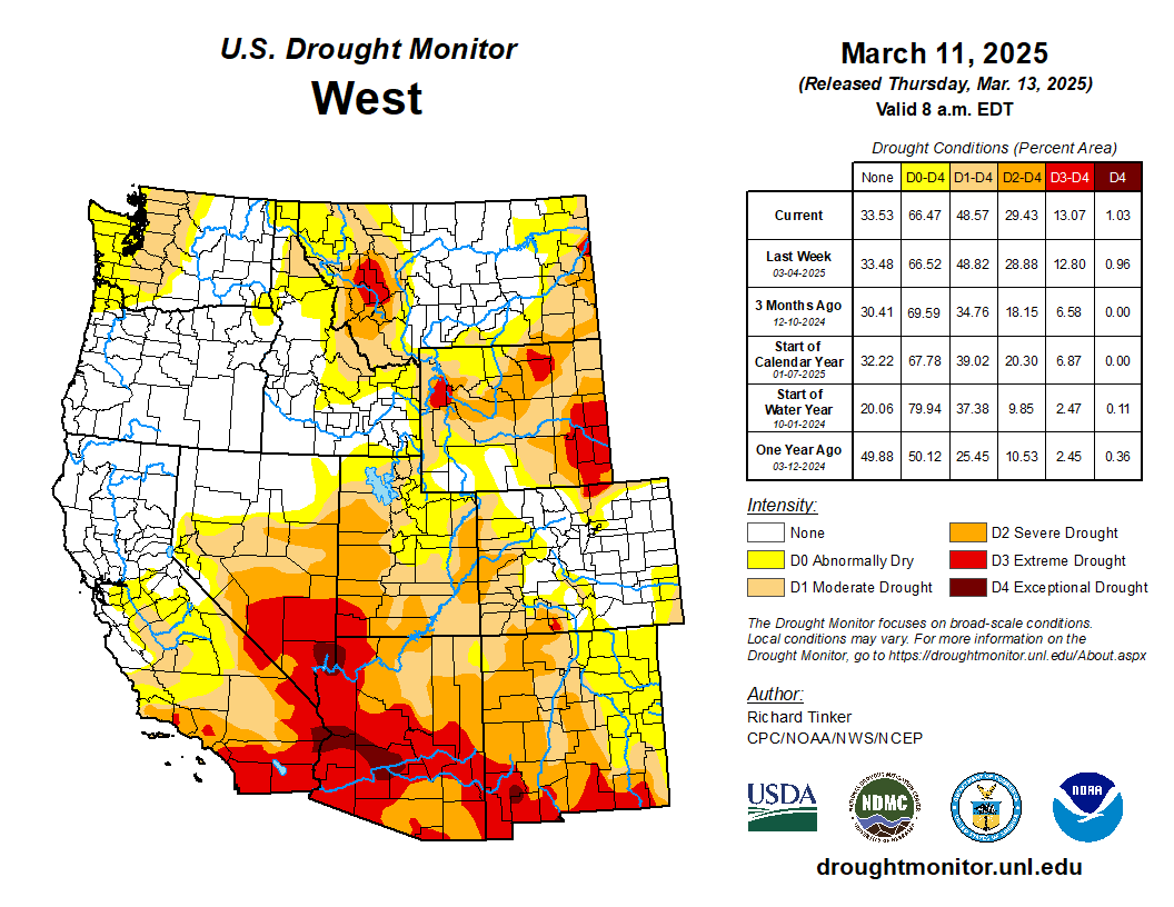
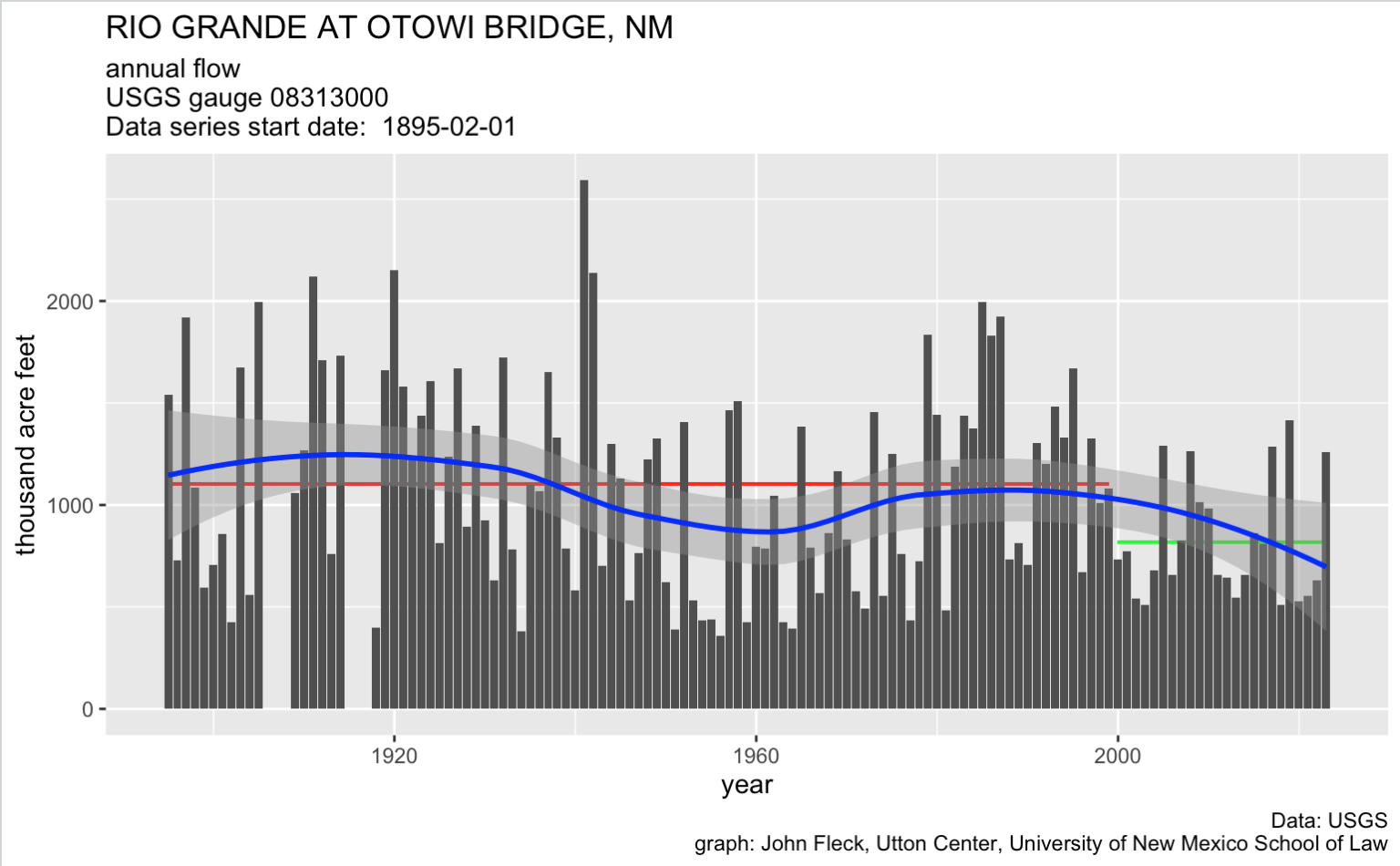
  1. The preliminary April 1 forecast from the NRCS is for 27 percent of median April – July runoff at Otowi, the key measurement gage for New Mexico’s Middle Rio Grande.
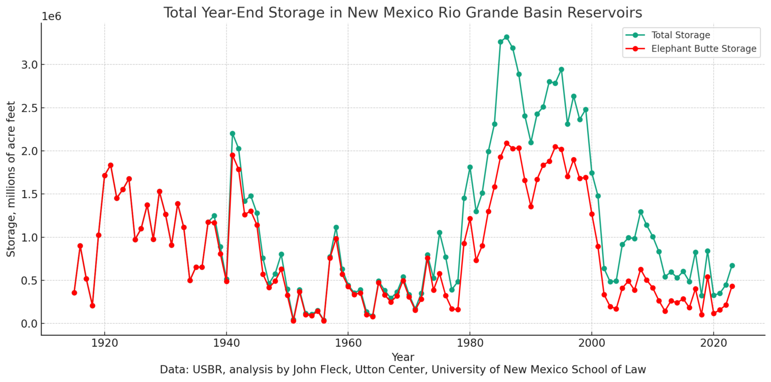
  2. Current reservoir storage above us is basically nothing.
  3. Reclamation’s most recent forecast model runs suggest flow through Albuquerque peaked in February. It usually peaks in May.

We will learn a great deal this year.

What I’m Watching

New Mexico water projects map via Reclamation

City Water

At last night’s meeting of the Albuquerque Bernalillo County Water Utility Authority’s Technical Customer Advisory Committee, water rights manager Diane Agnew said the utility is planning to shut down its river diversions, shifting system operations to groundwater, by the end of April. Albuquerque invested ~half a billion dollars in its river diversion system, in order to make direct use of our San Juan-Chama Project water, to relieve pressure on the aquifer. This will be the fifth year in a row that Rio Grande flows have been so low that we can’t use the new system for a substantial part of the year.

(For the nerds, Diane’s incredibly useful slides from last night’s TCAC meeting are here, the 4/3/2025 agenda packet.)

We have groundwater. My taps will still run, and I’ll be able to water my yard. But we’ll once again be putting stress on the aquifer that we’ve been trying to rest, to set aside as a safety reserve for the future. Is that future already here?

Reclamation operates pumps to move water from the Low Flow Conveyance Channel into the Rio Grande. The LFCC acts as a drain for the lower part of the Middle Rio Grande.

Irrigation

Middle Rio Grande Conservancy District irrigators who depend on ditch water are going to have a tough year, with supplies running short very early. The impacts here are a little weird.

Most of the relatively small number of the non-Indian full-on commercial farmers have supplemental wells. Smaller operators, who farm as a second income, will have to rely on their first income, whatever that is, and hope for some monsoon rains to get more cuttings of hay. Lots of hobby farmers will just run their domestic wells, or buy hay for their horses from out of state.

Native American farming is a more complicated story that I don’t fully understand. State and federal law recognize the fact that they were here first – we really do kinda comply with the doctrine of prior appropriation here. Their priority rights – “prior and paramount” – were enshrined in federal law in the 1928 act of Congress that kicked in federal money through the predecessor of the Bureau of Indian Affairs – crucial money to get construction of the Middle Rio Grande Conservancy District started when no one else – neither the rest of the federal government, nor the bond market – was willing to pony up the money. (Buy our new book Ribbons of Green, as soon as UNM Press publishes it! It includes a deep dive into the critical role of the Pueblos in supporting the formation and early funding of the MRGCD, without which there likely would be no MRGCD.)

Is there a way to set aside some prior and paramount water for Pueblo farmers this year to keep their fields green?
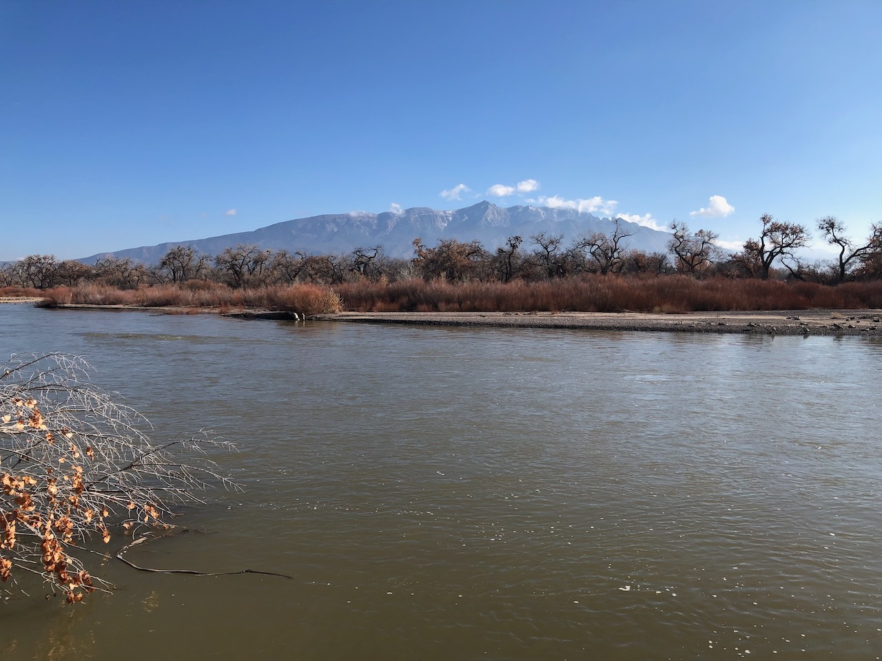
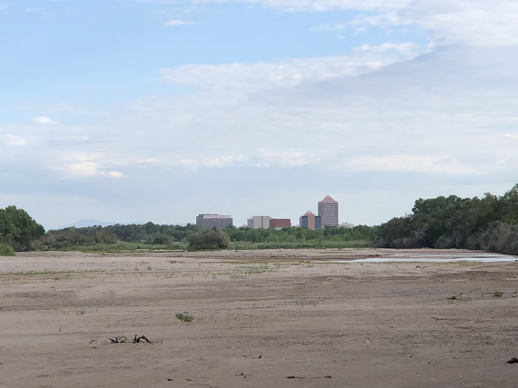
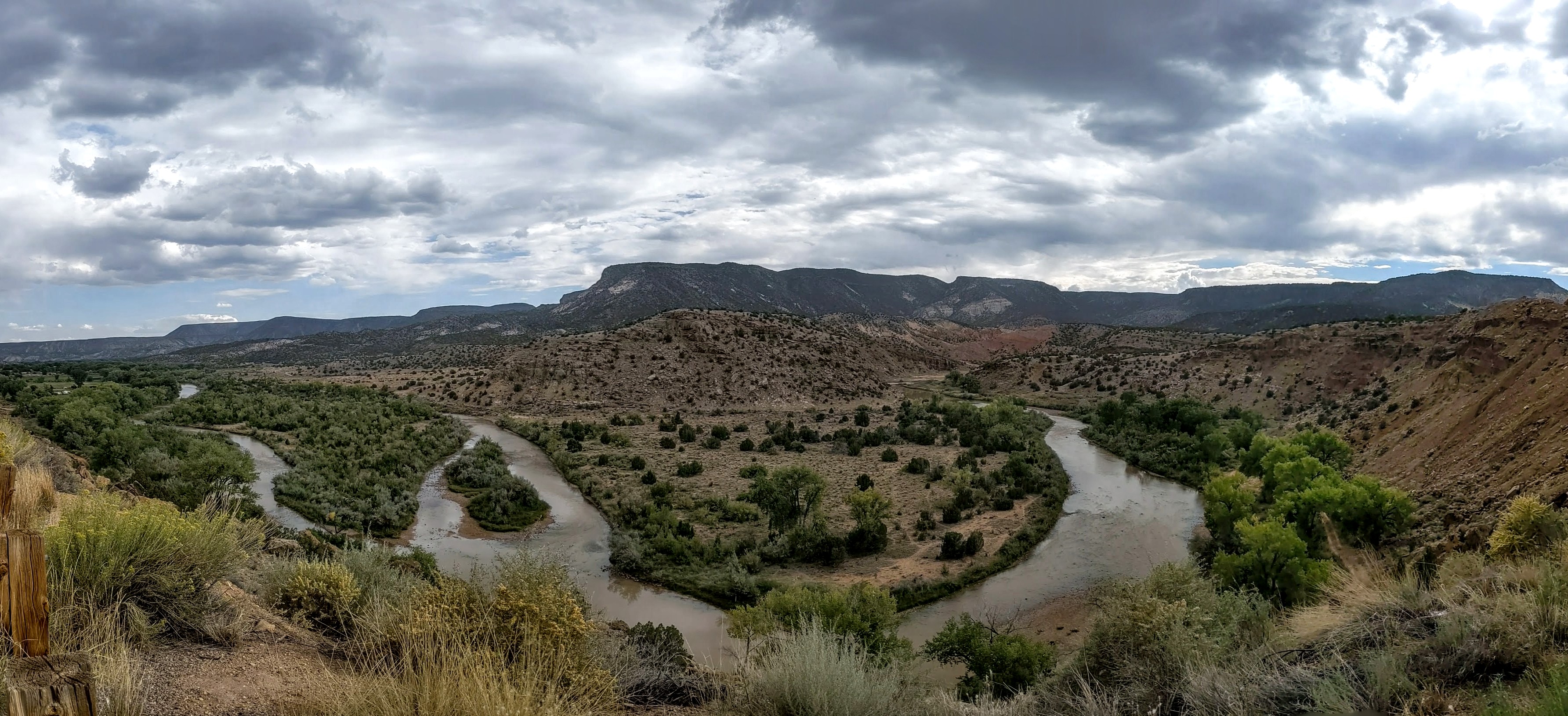
Side channels were excavated by the Bureau of Reclamation along the Rio Grande where it passes through the Rhodes’ property to provide habitat for the endangered silvery minnow. (Dustin Armstrong/U.S. Bureau Of Reclamation)

River Drying

The Rio Grande through Albuquerque will go dry, or nearly so, in a way we haven’t seen since the early 1980s. That means a very tough year for the endangered Rio Grande silvery minnow. We’re testing the boundaries of the definition of “extinction”. (To understand the minnow story, I again commend you to my Utton Center colleague Rin Tara’s terrific look at the minnow past and future.)

Do people care, either about the minnow or the river itself? We’ll find out!

Birds and water at Bosque de Apache New Mexico November 9, 2022. Photo credit: Abby Burk

Bosque

Our riverside woods, a ribbon of cottonwood gallery forest that took root in the mid-20th century between the levees built by the Bureau of Reclamation, will likely stay relatively green. The trees dip their roots into the shallow aquifer. As we’ve seen with the more routine river drying that happens every year to the south, the bosque muddles through.

New Mexico Lakes, Rivers and Water Resources via Geology.com.

We see the climate change in #NewMexico — Laura Paskus (WritersOnTheRange.org) #ActOnClimate

Click the link to read the article on the Writers on the Range website (Laura Paskus):

March 10, 2025

Here in New Mexico, our growing season has lengthened since the 1970s, even as stream flows have decreased. Fire season starts earlier, lasts longer, and in some years, ignites the forests into record-breaking blazes, like the gargantuan Hermits Peak-Calf Canyon and Black fires in 2022.

If you look at the last century in New Mexico, stretches of higher temperatures have lengthened; heat waves are hotter and nights, consistently warmer.

Rising heat and expanding aridity harm ecosystems and wildlife and hotter days are dangerous for anyone outside, especially people without housing or access to cool spaces. Extreme heat even interacts with certain medications people need for their physical and mental health. 

It should be no surprise that we’re facing another crackly-dry spring, summer, and fall. Fans watching the March 2 Oscars on Albuquerque TV saw flashing red-flag fire warnings. The next day, high winds and dust storms blasted the state; near Deming, a haboob of fast-moving dust shut down highways.

West Drought Monitor map March 11, 2025.

As of early March, 92 percent of New Mexico was experiencing drought, with almost 30 percent of the state in severe to extreme drought, according to the U.S. Drought Monitor.

Arizona is in even worse shape: 100 percent of the state is in drought, with 87 percent in severe to exceptional drought. And the interior West’s three-month outlook is for warm, dry conditions — especially in Arizona and New Mexico.

Here in New Mexico, the Middle Rio Grande Conservancy District—which supplies water for farms—is warning runoff season will be short and river flows, low. The district’s leaders are urging farmers to plan for extended periods between irrigation deliveries and say that without summertime monsoons, they will not meet everyone’s needs this year.

During the 1900s—including during the infamous 1950s drought and earlier in this century—armers could often still expect full water allocations in a dry year.

Now, when farmers don’t receive water—and the Rio Grande dries for long stretches—it’s not only because there isn’t enough snow melting off the mountains.  It’s also because consistently dry soils suck up any moisture, making both forests and croplands thirstier.

Not only that, but decades of persistent drought and warming temperatures have desiccated reservoirs along the Rio Grande and its tributary, the Chama River.

On the Chama River, Heron Reservoir is 14 percent full; its neighbors, El Vado and Abiquiu, are at 14 percent and 51 percent respectively. Further down the watershed, on the Rio Grande in southern New Mexico, Elephant Butte Reservoir is only 13 percent full, and its neighbor, Caballo, nine percent full. 

In New Mexico, some water users, including the irrigation district, rely on water piped from the Colorado River watershed into the Chama and then the Rio Grande. This year, most of that supplemental water won’t be there.

The view upstream on both watersheds is also troubling, especially in Arizona, New Mexico and southern Utah where the snowpack is “below to well-below median.” Last month, the Colorado River’s two largest reservoirs, Lake Powell and Lake Mead, were 34 percent full, the lowest they’d been in early February for the last 30 years of records.

I’m alarmed by many things happening right now, including the disappearance of climate data from federal websites and the gutting of federal workforces and budgets. We need wildland firefighters, scientists, and the staffers who kept our parks and public lands functioning.

But as a reporter who has covered climate change and its impacts in my state for more than two decades, I take the long view along with a local view.

We have known for decades that the planet is steadily warming and that the impacts of climate change would intensify. And we must resist focusing solely on the current chaos of the federal government. [ed. emphasis mine]

Laura Paskus. Photo credit: Writers on the Range

There’s never been a better time to become immersed in local politics or organizing, and to hold state and local leaders accountable for action on climate.

We can collaborate on local solutions and work together to better deal with the crises we face. Really, we have no choice.

Laura Paskus is a contributor to Writers on the Range, writersontherange.org, an independent nonprofit dedicated to spurring lively conversation about Western issues She is longtime reporter based in Albuquerque and the author of At the Precipice: New Mexico’s Changing Climate and Water Bodies.

Messing w/ Maps: #ColoradoRiver Plumbing edition — Jonathan P. Thompson #COriver #aridification

The Central Arizona Project canal passes alfalfa fields and feedlots in La Paz County, Arizona. The fields are irrigated with pumped groundwater, not CAP water. Source: Google Earth.

Click the link to read the article on The Land Desk website (Jonathan P. Thompson):

August 16, 2024

🗺️ Messing with Maps 🧭

Imagine that you’ve set off for a hike in the desert of western Arizona, hoping to get up high so you can get a view of the juxtaposition of alfalfa fields against the sere, rocky earth. But you somehow get disoriented, the sun reaches its apex and beats down on you, the temperature climbing into the triple digits. The ground temperature becomes so hot you can feel it through the soles of your Hoka running shoes. Your water bottle is empty. Feeling certain you are going to die you pick a direction and stagger in as straight a line as you can manage, rasping for help. And then, just when you’re about to curl up under a rock and surrender, you see, coming straight out of a hillside, a virtual river. It must be a mirage, you think, or a hallucination, you run toward it, climb the fence, and dive into the cool, deep water. 

This is not a fantasy scenario. There is, in fact, a place in the western Arizona desert where a lost traveler could stumble upon a giant canal emerging from the earth.

The Central Arizona Project’s Mark Wilmer pumping plant at Lake Havasu. The 14 plants on the CAP system push water across more than 300 miles with a vertical gain of 3,000 feet. Moving water requires enormous amounts of power, making the CAP the state’s largest single electricity user, with annual power bills totaling $60 million to $80 million. Source: Google Earth.
Central Arizona Project canal daylighting at the Buckskin Mountain Tunnel. Source: Google Earth
The outlet of the San Juan Chama Project runs into Willow Creek west of Los Ojos before running into Heron Lake. Source: Google Earth
The Rio Blanco intake for the San Juan-Chama Project, which takes water from three upper San Juan River tributaries and ships it across the Continental Divide to the Chama River watershed and, ultimately, the Rio Grande. Source: Google Earth

It’s just one of the crazy plumbing projects along the Colorado River and its tributaries. And they can look pretty weird when you stumble upon them in remote places. That’s what happened to me the other day — virtually. I was using Google Earth to chart the 1776 Escalante-Dominguez expedition’s path when, near Chama, I came across a large volume of water emanating from an arid meadow. After some thought I realized it was the outlet for the San Juan-Chama Project that diverts about 90,000 acre-feet of water annually from three tributaries of the San Juan River, sends it through the Continental Divide via a tunnel, and delivers it to Willow Creek and Heron Reservoir. From there it can be released into the Chama River, which runs into the Rio Grande, which is used by Albuquerque and Santa Fe to supplement groundwater and the shrinking Rio Grande.

The Big Thompson Project sucks water out of the Colorado River near its headwaters and siphons it through the mountains via the Alva Adams Tunnel. The water feeds reservoirs that feed Front Range cities and is used to generate hydropower. Adams tunnel inlet at Grand Lake. Source: Google Earth
The Big Thompson Project sucks water out of the Colorado River near its headwaters and siphons it through the mountains via the Alva Adams Tunnel. The water feeds reservoirs that feed Front Range cities and is used to generate hydropower. Penstocks and powerplant at Flatiron reservoir on the right. Source: Google Earth

These things aren’t only unsettling in a visual way, but in a conceptual way as well. One would expect cities and agricultural zones to rise up around where the water is and to grow according to how much water is locally available. Instead, cities rise up in places of limited water and grow as if there were no limits, importing water (and power and other resources) from far away. 

The Julian Hinds pumping station, near Desert Center, California, lifts water from the Colorado River Aqueduct 441 feet as it makes its way toward Los Angeles. Source: Google Earth
The Southern Nevada Water Authority was forced to build a third water intake from Lake Mead that was able to draw water as the reservoir continued to shrink. The pumping plant is pictured. Source: Google Earth

Six tribal water rights settlements for #NewMexico heard on Capitol Hill — Source NM

An aerial view of the Jemez Watershed on June 28, 2024. (Photo by Danielle Prokop / Source NM)

Click the link to read the article on the SourceNM.com website (Danielle Prokop):

July 29, 2024

If approved, the settlements would bring in more than $3.7 billion in federal funds and end decades of water rights litigation

The Navajo Nation president and leaders from Acoma, Ohkay Owingeh and Zuni Pueblos joined tribal leadership from across the nation on Capitol Hill, offering testimony about the benefits of $3.7 billion federal dollars in six proposed water rights settlements across New Mexico.

The deals would settle tribes and Pueblos’ water rights in four New Mexico rivers: the Rio San José, the Rio Jemez, Rio Chama and the Zuni River. 

Another bill would also correct technical errors in two previously ratified water rights settlements: Taos Pueblo and the Aamodt settlement Pueblos of Nambé, Pojoaque, Tesuque and San Ildefonso. Finally, a sixth bill would add time and money for the Navajo-Gallup water project to construct drinking water services.

New Mexico representatives presented a record six settlements for Pueblos and tribes at a subcommittee hearing Tuesday, the first step in getting needed Congressional approval to end decades of litigation. Companion proposals from the Senate were heard Friday in the Senate Indian Affairs Committee. Mescalero Apache Tribe President Thora Padilla was introduced to senators with support for the settlements. 

As climate change reshapes the Southwest into something hotter and drier, with more strain on its water resources, approaching water collaboratively means communities have a chance to stay, and tribes can exercise their sovereignty.

In front of House members on Tuesday, Ohkay Owingeh Gov. Larry Phillips Jr. said the settlement of the Ohkay Owingeh’s rights on the Rio Chama will offer a means of long-awaited restoration. 

“The U.S. bulldozed our river, it destroyed our rivers and bosque,” he said. “This needs to be fixed, the settlement gives us the tools to do that.”

Rep. Teresa Leger Fernández (D-N.M.) said tribes and Pueblos gave up certain acreage that they are entitled to, and worked out drought-sharing agreements to benefit everybody in the region.

Leger Fernández sponsored five of the bills, and Rep. Gabe Vazquez (D-N.M.) sponsored a sixth that was heard on Tuesday.

Additionally, she said the funds will enable more infrastructure, bosque restoration and ensuring water rights protections for neighboring acequias. 

Acoma Pueblo Gov. Randall Vicente told the committee that making concessions in the settlement was crucial to preserving water for future generations.

“It is better to have adequate wet water, than paper rights without a water supply,” he said.

Even if the Pueblo enforced having the oldest water right, Vicente said the Rio San José’s system is so damaged, it would take decades for water to reach Acoma.

The settlements can help redress the federal government’s injustices towards Ohkay Owingeh Pueblo, Phillips said. He pointed to the U.S. Army Corps of Engineers and U.S. Bureau of Reclamation’s channelizing of the Rio Chama and the building of Abiquiu Reservoir in the 1950s, which moved water away from the Pueblo. 

“Both of these actions resulted in depriving us of our bosque and waters necessary for a proper river,” he said. “We entered into the settlement in order to protect, preserve our water resources and the bosque.”

The loss of water not only impacts the health of Pueblo communities, Phillips said, but it splits people from their lands and means the loss of sacred bodies of water and ceremonies to celebrate them.

Water offers a lifeline to traditional ways and offers prosperity, said Zuni Pueblo Gov. Arden Kucate.

Zuni Pueblo will work to build new drinking water treatment systems and restore waffle garden irrigation practices, a technique used for generations until the turn of the 19th century, when settlers diverted water and clearcut the Zuni River watersheds.

“It will usher in, what I sincerely believe, will be a new chapter for our tribe, allowing us to protect and sustainably develop our limited water resources, to restore traditional agriculture and facilitate much-needed economic development,” Kucate said about the settlement.

Navajo Nation President Buu Nygren also spoke, celebrating water rights settlements with both New Mexico and Arizona.

Some of the settlement agreements are already two years old.The administration supports all of the New Mexico settlements, said Bryan Newland (Ojibwe), the assistant secretary for Indian Affairs at the U.S. Department of the Interior.

“Any delay in bringing clean, drinkable water to communities is going to harm the people who live in those communities,” Newland said. “We also know from our experience that these settlements only get more expensive, and implementation only gets more expensive the longer we wait.” 

Tribal water rights are not entirely settled in New Mexico, most notably on the Rio Grande, where a federal assessment team started addressing water claims issues in 2022. Leger Fernández said she hopes the six water rights settlements in other watersheds will provide a model for collaborative management of water rights on New Mexico’s largest river.

An aerial view of the Jemez Watershed on June 28, 2024. (Photo by Danielle Prokop / Source NM)

“These water rights settlements provide the framework for future water rights settlements, which include those involved in Rio Grande,” Leger Fernández said.

Leger Fernández said the moment was still momentous, even if it’s only the first step.

“There’s never been this many settlements at one time,” she said. “There has never been a hearing that was this big.”

What’s the process?

The House Committee on Natural Resources held a legislative hearing on 12 water rights settlements across the U.S. with a projected cost of $12 billion. 

The hearing consisted of testimony from federal agencies and heads of tribal governments. 

The settlements can now head into a process called mark-up and means they can be added to legislative packages moving forward. Both of New Mexico’s senators sponsored companionate bills.

It’s just the first step in the process, but Leger Fernández said she’s looking to face the biggest hurdle of cost head-on. She and members of the Department of the interior testified that continuing to fight court battles will cost the federal government more money, and that waiting isn’t an option.

“The longer we wait, the more expensive it will be,” she said.

New Mexico Lakes, Rivers and Water Resources via Geology.com.

To’Hajiilee water line groundbreaking: “an impossible project” — John Fleck (InkStain.net)

An impossibility. Photo credit: John Fleck/InkStain.net

Click the link to read the article on the InkStain.net website (John Fleck):

May 15, 2024

With the obligatory shovels in pre-softened dirt, a group of political leaders from the Navajo Nation, New Mexico state and local government, and water agencies this morning (Wed. 5/15/2024) formally inaugurated a new pipeline being built to connect the Navajo community of To’Hajiilee to the 3.5 million gallon reservoir in the picture – clean, piped water to a community that now has one working well and water so bad no one drinks it.

One of the oldtimers who’d been working on it for more than two decades walked up to me and said, “This is an impossible project.”

What he meant was that the project had overcome seemingly insurmountable hurdles in the interactions between a welter of government agencies with overlapping jurisdictions and sometimes incompatible responsibilities.

I went to the event wearing two hats – as a member of the Albuquerque Bernalillo County Water Utility Authority’s Technical Customer Advisory Committee, and on behalf of the Utton Center, which has a long history of working on Native American water stuff. (I was literally wearing my ABCWUA gimme cap, I don’t have an Utton one.)

To’Hajiilee, 35-ish miles west of Albuquerque, has six water wells. Five have already failed. The sixth is regularly off line. When it’s down, they have to shut down school and the clinic. When it’s working, the water is awful.

The vision statement from the Universal Access to Clean Water For Tribal Communities project is simple: “Every Native American has the right to clean, safe, affordable water in the home ensuring a minimum quality of life.”

In this 1999 book Development as Freedom, the Nobel laureate economist and moral philosopher Amartya Sen explains freedoms as “the capabilities that a person has, that is, the substantive freedoms he or she enjoys to lead the kind of life he or she has reason to value.”

“Rights” are tricky political terrain, because they’re often framed in negative terms – the absence of coercion or interference from others, particularly the state. But Sen’s making an affirmative argument here. It is not enough for the collective to simply get out of the individual’s way. The collective has an affirmative moral obligation to create the conditions under which the individual can flourish – to pursue that which they “have reason to value,” to repeat Sen. That’s sorta what my friends at the Universal Access project are saying with their vision statement.

At the urging of a colleague, I’ve been reading Sen lately in an effort to make sense of the moral underpinnings of the collective choices we face as we cope with the reality of less water. (For those familiar with Sen, know that I am not reading the mathy parts – they’re impenetrable!)

THE PLUMBING – PHYSICAL AND FINANCIAL

The Albuquerque Bernalillo County Water Utility’s 7W reservoir, the tan thing in the picture, sits on high ground midway between Albuquerque and To’Hajiilee, a perfect water source for the community. In eighteen months under the current construction schedule, we’ll have a 7 mile pipe from here to there.

If the tally in my notes is correct (don’t hold me to this, I’m not a real journalist any more), it’s a ~$20 million project, with a mix of federal, state, and Navajo Nation funding.

The actual water in the pipes is the result of a fascinating agreement between the Navajo Nation and the Jicarilla Apache Nation in norther New Mexico. The Navajo Nation will lease Jicarailla water, which will be wheeled down the San Juan River, into the Rio Grande, and then diverted by the Albuquerque Bernalillo County Water Utility Authority, treated, and pumped up to 7W.

THE STRUGGLES TO GET THIS DONE

Former Bernalillo County Commissioner Debbie O’Malley, speaking at the groundbreaking, told the story of the bare-knuckle politics it took to overcome the intransigence of a landowner that stood in the way of the project – Western Albuquerque Land Holdings. And for sure, O’Malley and the group she worked with deserve a ton of credit for the use of their knuckles at a critical point in the struggle to get the pipeline built.

But more important is the community of To’Hajiilee itself, people like Mark Begay, my colleague on the Albuquerque water utility’s Technical Customer Advisory Committee. For decades, Begay and the other leaders in To’Hajiilee acted on behalf of their community to pursue “that which they had reason to value” – water!

This is about the community’s own collective agency, “the result of collective processes and collective actions in which people’s interactions shape their common destiny.” (Oscar Garza-Vázquez)

It was a joy to share the celebration of their success. I’ll be back in 18 months when they open the taps.

#NewMexico’s Middle #RioGrande 2023 Review — John Fleck (InkStain.net)

Click the link to read the article on the InkStain website (John Fleck):

This was a big flow year on New Mexico’s Middle Rio Grande, but weird, in ways that highlight the challenges we face.

FLOW IN THE RIVER

Total flow into New Mexico’s Middle Rio Grande Valley (measured at Otowi) sits at 1.26 million acre feet with two more days’ flow to go, so round it off to 1.3maf.

Rio Grande flow at Otowi, with Brad Udall-style plots of 20th and 21st century means. Credit: John Fleck/InkStain

So a big year! Yay!  Look at all that water in the picture above, a bank-full Rio Grande flowing past Rio Rancho, New Mexico, in December. And yet there I was in August watching dogs gamboling on the sand bed of a nearly dry Rio Grande. What’s up with that?

The answer involves the interaction between a climate change-driven megadrought, the use of the river by human communities, and the tangle of rules that govern management of the 21st century Rio Grande.

The short term tangle involves El Vado Dam, currently being renovated and therefore unusable for storage. That meant that by August the declining inflow of late summer with a lousy monsoon left the river nearly dry, regardless of the winter snowpack.

This problem, which will go on for several more years, means that irrigators will depend on run-of-the-river operations for late summer irrigation for a while yet. Given that irrigation water also supports environmental flows on its way to the irrigation diversions, this is also bad for things like the endangered Rio Grande silvery minnow and the river flowing through my city.

The longer term tangle involves competing community values among the various ways we use water, combined with a lack of tools to reduce that use.

Because, with climate change there is less water.

Albuquerque’s Rio Grande, drying September 3, 2023. Photo credit: John Fleck/InkStain

INKSTAIN IS READER SUPPORTED

Inkstain has been a Nazi-free zone for more than 20 years, mostly because it’s just my blog and I’m not a Nazi. (If you don’t know what I’m talking about, bless you. Google “Substack” and “Nazis”, it’s the latest digerati kerfuffle.)

But, like all your favorite Substackers, it is reader supported! Thanks as always to our readers. (And if you don’t know what Substackers are, again, bless you.)

THE TANGLE: MOVING WATER IN TIME

First let’s pin some data to our bulletin board:

Total storage on New Mexico’s Rio Grande and the Rio Chama, its main tributary. Credit: John Fleck/InkStain

There’s an old water management adage: Canals move water in space, reservoirs move water in time. We built them to store water in wet years, effectively moving it in time to dry years. So how much did we so move this year?

Inspired by Jack Schmidt’s monthly Colorado River posts, I spent my Saturday coffee wakeup this morning totaling up sorta year-end storage in the reservoirs I care about (from top to bottom Heron, El Vado, Abiquiu, Cochiti, Elephant Butte, and Caballo). It took longer than I expected because I was so distracted by all the amazing history embedded in this graph. 1986-87, yowza, what’s up with that?

Flow this year was ~440k acre feet above the 21st century average. Total end of year storage is up ~220k acre feet. There’s so much mixing of apples, oranges, durian, and pawpaw here that it’s not a straight up comparison, but it should give you a feel for the challenge: we only saved a part of the bonus water. We used a lot of it.

The Management Levers

Let’s imagine for a moment that we wanted to pull some water management levers to change that balance by reducing consumptive use (by “use” I mean evapotransporation, human and non-human) in the Middle Rio Grande Valley. We’ve basically got four different categories of use:

  • The cities, especially Albuquerque
  • The Middle Rio Grande Conservancy District, which manages irrigation water for some commercial farms and a lot of custom and culture/lifestyle stuff
  • Domestic wells
  • The river – evaporation and riparian consumption by our beloved bosque

Let’s take these in order of smallest to largest water use.

THE CITIES

We’ve already cranked down pretty hard on this lever. With a combination of water use reductions and a shift from groundwater pumping to imported Colorado River water, we’ve already cranked down extremely hard on this lever. This is the one area of the system that is already aggressively regulated.

If you want to crank down harder on this lever, the two points of entry in the legal/political/policy system are the Office of State Engineer/Interstate Stream Commission, which do the regulating, and the Albuquerque Bernalillo County Water Utility Authority Board, which is made up of elected city councilors and county commissioners.

THE DISTRICT

Consumptive use by the Conservancy District’s irrigators is several times larger than the cities. The District took voluntary action this year to reduce use, delaying the start of irrigation season and cutting diversions once they started by 20 percent to try to get more water to Elephant Butte Reservoir.

With federal money, the District paid folks irrigating a relatively small portion of the valley’s acreage to fallow this year, and the acreage is going up in 2024. But the numbers remain small relative to the size of the problem.

If you want to crank down harder on this lever, it’s not clear to me what the state’s legal authority might be. There may be some, but it’s not been tested. But the District is governed by an elected board. That’s a lever, though it’s worth pointing out that the board got a lot of crap this year from irrigators about they steps they did take. Incentives in all of this are weird, it’s tricky to figure out how to work this lever.

DOMESTIC WELLS

We don’t regulate these at all. We have no idea how much water they use, but it sure looks to use like there’s a lot.  We don’t really even know how many there are, there seem to be a lot drilled illegally. (If you’re a UNM Water Resources Student, hit me up on this! We have some ideas for a really impactful masters degree research project.) We probably need to think about building a lever here, but we currently don’t have one. The state legislature might be a place to start? Maybe some un-exercised legal authority at the Office of State Engineer? (See NMAC 19.27.5.14, my day job, such as it is, is at a law school, though IANAL it sure looks like that could only apply to new wells, so horse out of barn etc.)

Birds and water at Bosque de Apache New Mexico November 9, 2022. Photo credit: Abby Burk

THE BOSQUE

The biggest water user, likely larger than irrigation, is the riparian corridor itself. It’s largely unnatural, vegetation exploiting a niche created when we built levees and constrained the river’s flow, but whatever. It feels like “nature”, and we love it. And even if we didn’t it’s not clear what a lever to reduce that use might look like.

VALUES

Each one of these uses is valued by some segment of our community, and we seem to lack the tools to reconcile these competing values, which is why I’m pretty excited about the 2023 Water Security Planning Act.

A NOTE ON SOURCES AND METHODS

The reservoir data is from the USBR’s reservoir data archive. The latest 2023 data is from Dec. 18, so I matched up this year’s with Dec. 18 in previous years. My quick sensitivity check led me to conclude “Meh, good enough for a blog post.” For the early years, the USBR just reports a single year-end number for El Vado. My quick sensitivity check led me to conclude “Meh, good enough for a blog post.”

Flow data is from the USGS Otowi gage.

It is, in fact, spelled “gage“, just ask Bob, he’ll tell you.

I currently have 26 browser tabs open, including one with an amazing list of obscure fruit, did you know that Mark Twain called cherimoya “the most delicious fruit known to men.”? I had a bunch more I wanted to say, but that’s enough, it’s time to hit “publish”. Thanks for reading.

Rio Grande and Pecos River basins. Map credit: By Kmusser – Own work, Elevation data from SRTM, drainage basin from GTOPO [1], U.S. stream from the National Atlas [2], all other features from Vector Map., CC BY-SA 3.0, https://commons.wikimedia.org/w/index.php?curid=11218868

Forests to Faucets (and Headgates!) — John Fleck (InkStain) #SanJuanRiver #RioGrande

Informal collaborative governance in action. Photo credit: John Fleck/InkStain

Click the link to read the article on the InkStain website (John Fleck):

I spent a couple of days last week out of Pagosa Springs in southern Colorado, touring forest restoration work in the headwaters of the San Juan-Chama Project, which produces critical water supplies for central New Mexico. In others words, water for my neighhbors and me.

We’ve learned over and over in the last couple of decades the risk to city water from wildfire in our headwaters, and the benefits of forest restoration. But the institutional path to restoration is challenging – because of cost, because of the complicated mix of land ownership, and because of the distance (both physically and also conceptually) between the mountain watersheds and the people who depend on the water they supply.

I came away optimistic about the creative problem solving I saw. This stuff’s hard, especially to do at the scale needed, but the efforts are impressive.

FOREST TO FAUCETS (AND HEADGATES)

A few years back, my University of New Mexico collaborator Bob Berrens helped guide a research project intended to flesh out the relationship between Albuquerque and the distant headwaters (a ~200 mile drive away) that provide a critical piece of our water supply.

That’s from the resulting paper, Adhikari, Dadhi, et al. “Linking forest to faucets in a distant municipal area: Public support for forest restoration and water security in Albuquerque, New Mexico.” Water Economics and Policy 3.01 (2017): 1650019. Using a contingent valuation survey (a technique Bob’s used for many years to help us get our heads around non-market values of stuff related to water resources, see for example here on the endangered Rio Grande Silvery minnow), the research group found:

  • a mean willingness to pay of $64 per household, which equates to $7 million a year flowing out of Albuquerque to help support forest restoration in the watershed on which we depend, and
  • even households far away from watersheds support shelling out cash to pay for the work – not just communities like Santa Fe that can look up from their back porch to see their watershed (more on this later – in addition to its back porch watershed, Santa Fe also gets water from the San Juan-Chama headwaters)

COLLABORATIONS AT THE WATERSHED SCALE

While in Pagosa Springs and the surrounding watersheds, we got to see and learn about an amazing set of collaborations involving the Forest Stewards Guild, the Chama Peak Land Alliance, and The Nature Conservancy’s Rio Grande Water Fund, which provides a crucial conduit for the “payment for ecosystems” model Bob’s work talks about.

Bobcat® Compact Track Loader with Masticating Attachment. Photo credit: Wilderness Forestry, Inc.

One of the keys to making this work is a business model – the money supports folks in communities like Pagosa Springs who actually drive the masticators (big machines that grind up overgrown forest stuff). It’s part of the rural-urban social contract Bob and I talk about in the UNM Water Resources Program class we’re teaching this fall.

COLLABORATIONS AT THE REGIONAL WATER MANAGEMENT SCALE

Bob’s called this stuff “forests to faucets”, but what we’re seeing this year on the Rio Grande through central New Mexico is a reminder that the Middle Rio Grande Conservancy District, and the river channel itself, also depend on the importation of San Juan-Chama Project water across the continental divide. Absent the SJC water over the last couple of months, the MRGCD’s ditches would have gone dry sooner, as would the river channel. (Both ditches and river channel are starting to go dry as we speak, after MRGCD’s San Juan-Chama water ran out, but that’s a topic for another blog post.)

The organizer of last week’s tours was the San Juan-Chama Contractor’s Association, a group formed several years ago to try to create a framework for collective action among the New Mexico water agencies that use this imported water. Other states have umbrella agencies to organize big parts of their Colorado River water management – the Central Arizona Water Conservation District (“CAP”) in Arizona, the Metropolitan Water District of Southern California, and the Southern Nevada Water Agency (Las Vegas NV). In New Mexico, we have a bunch of separate San Juan-Chama Project water users, each with their own contract with the Bureau of Reclamation. The SJC Contractors Association has created a framework for thinking about collective action on things like physical infrastructure costs and maintenance – and forest restoration!

Key Rio Grande Valley players in attendance were leadership from Albuquerque, Santa Fe (which in addition to San Juan-Chama water, gets supplies from its own local Sangre de Cristo watersheds, which have forest health challenges too) and the Middle Rio Grande Conservancy District.

SOCIAL CAPITAL

In addition to spending time in drop-dead gorgeous mountain watersheds, last week’s tours and meetings also created a great framework for sitting out on the back patio at Motel SOCO in Pagosa Springs eating delicious bar food and drinking our choice of beverages and building social capital. Bonus points for the tours organizers for getting the forest nerds and the water nerds talking.

Great fun was had by me.

Near Pagosa Springs. Photo credit: Greg Hobbs

#NewMexico seeks approval to store #RioGrande water at Abiquiú — The Albuquerque Journal

El Vado Dam and Reservoir. Photo credit: USBR

Click the link to read the article on the Albuquerque Journal website (Theresa Davis). Here’s an excerpt:

New Mexico water agencies are slowly piecing together a regulatory puzzle in order to store Rio Grande water in Abiquiú Reservoir for middle valley irrigation this summer as El Vado Dam is repaired. But an objection from Texas water managers could interfere with the reservoir’s use for non-pueblo irrigators. The U.S. Army Corps of Engineers operates the northern New Mexico reservoir on the Rio Chama. Nabil Shafike, the Army Corps Albuquerque District’s water management chief, said Abiquiu was once authorized only to store Colorado River Basin water that is diverted into the Rio Grande Basin with a series of tunnels and dams for the San Juan-Chama Project.

“All the Corps reservoirs – Abiquiú, Cochiti, Galisteo and Jemez Canyon – work as one unit to protect the middle valley from flood,” Shafike said. “Any storing of native (Rio Grande) water would require a deviation from the current operation.”

The agency is weighing two potential changes at Abiquiu:

• A request from the New Mexico Interstate Stream Commission to store up to 45,000 acre-feet, or 14.6 billion gallons, of Rio Grande water in Abiquiú each year for release later in the season to meet middle Rio Grande irrigation demand.

• A request from the U.S. Bureau of Reclamation to store up to 20,000 acre-feet, or 6.5 billion gallons, of Rio Grande water in Abiquiú each year to meet direct flow right for the six middle Rio Grande pueblos of Isleta, Sandia, Santa Ana, San Felipe, Santo Domingo and Cochiti.

The Army Corps could approve both storage plans or may choose only one.

Rio De Chama Acequia Association Seeks Fair Treatment, Opportunity To Store Water In Abiquiu Lake — The #LosAlamos Reporter #RioGrande #ColoradoRiver #COriver #aridification

From The Los Alamos Reporter (Maire O’Neill):

Members of the Rio de Chama Acequia Association (RCAA) are adamant about continuing the repartimento – the traditional way of sharing water in New Mexico. They want their acequia parciantes to be treated like all the other contractors in the San Juan-Chama River Project and they want to be able to store water in Abiquiu Lake.

New Mexico water projects map via Reclamation

The Los Alamos Reporter recently sat down with the officers of the association to discuss the issues they are facing and the solutions they propose. RCAA chair Darel Madrid explained how in the 1960s, water was diverted from the Little Navajo river in Colorado to build up water in the Rio Grande through the San Juan-Chama River Project. He said most of that water streamed through a tunnel under the mountains and into Heron Reservoir.

“Ours is the only river system in the area that has foreign water running through it. Our water rights are tied to the native water rights of the Rio Chama basin. With climate change, we’re getting less and less snowpack. We’re getting warmer springs and all the melt-off is running through our acequia system before we are ready to use it,” Madrid said. “In our climate down here, the growing season usually starts the latter part of May or in June and continues into October. This water is melting off earlier and it’s passing through our system in March and early April. It leaves us in a bind.”

Madrid explained that because the RCAA water rights are tied to the Rio Chama water, only a sliver of the water that you see running through their system is actually their water.

“When people see all this water flowing through the system, they don’t realize that only a portion of that water is our water. We have approximately 22 acequias from below the dam that run from the Trujillo-Abeyta ditch, which is the northern-most, to the Salazar Ditch, which is the last one to receive water,” he said.

The foreign water that’s running through the system is owned mostly by contractors of the original San Juan–Chama River Project including the Middle Rio Grande Conservancy District which takes care of everybody from Cochiti all the way down to Socorro, and the Albuquerque-Bernalillo County Water Utility Authority. There are also minor contractors like the County of Los Alamos, the City of Espanola, the Village of Taos, and the City of Santa Fe – all of whom bought into the project in the 60s…

For many years there was less of a drought situation in the region so there was plenty of water for everybody, he said…

“When the Rio Grande Compact was established in the late 20s or 30s, none of the RCAA acequias were invited to the table. They didn’t have a voice in those discussions at all. The parciantes were busy being farmers and were not organized. The same thing happened during the San Juan-Chama River Project. For all that we can tell, we weren’t invited to the table and all these decisions were made without our participation. When all was said and done we were left with all these rules and regulations that we have to abide by so it’s almost like taxation without representation,” Madrid said.

He noted that regulations for the acequias are all set through court orders with the State Engineer’s Office having the most authority…

The 22 RCAA ditches have the oldest priority dates for rights to the water with some of them going back to the 1600s. Madrid believes those are probably the oldest water rights in the entire nation, second only to Native Americans. The ditch behind his home has been in continual use for more than 400 years. Families of others on the board have been irrigating for hundreds of years in the area.

Abiquiu Dam, impounding Abiquiu Lake on the Rio Chama in Rio Arriba County, New Mexico, USA. The U.S. Army Corps of Engineers constructed the dam in 1963 for flood control, water storage, and recreation. By U.S. Army Corps of Engineers, photographer not specified or unknown – U.S. Army Corps of Engineers Digital Visual LibraryImage pageImage description pageDigital Visual Library home page, Public Domain, https://commons.wikimedia.org/w/index.php?curid=2044112

RCAA Treasurer Carlos Salazar said RCAA wants to find a way to store its water so that it doesn’t have to buy water and believes this would require federal legislation because the dams were constructed with federal funds. The Association hopes that the congressional delegation will help them to find a way to store their native water because it comes from their ancestral lands. Because the water can’t be stored, half of any water that flows past the Otowi Bridge near the Pueblo of San Ildefonso in the spring goes to Texas.

All the RCAA acequias are metered by the state engineer. Their diversion is measured, but one of the big debates RCAA has with the state engineer is that not all of it is consumed and the state charges them for all of the diversion and doesn’t credit them for any return flow. Another burden the RCAA has to bear is that its member acequias are saddled with all the costs for the operation and maintenance…

The RCAA believes all diversion levels should be increased by 30 percent but they would need to invest in return flow measurement to accomplish that and it would take $1,000 per ditch, a total of about $54,000 to accomplish that.

Seaman noted that the RCAA is simply trying to continue the tradition of the acequias.

“To me, the Treaty of Guadalupe Hidalgo guaranteed every citizen all these rights and we don’t see it happening now with this adjudication of water to the Rio Grande and the City of Albuquerque and our neighbors there on Heron Reservoir. All that imported water – where were the acequias?” Salazar said. “I think we should be treated fairly. Our rights pre-date all of them and we should be given an opportunity to store water even if we have to pay for the storage.”

The Rio Chama viewed from US highway 84 between Abiquiú, New Mexico, and Abiquiu Dam. By Dicklyon – Own work, CC BY-SA 4.0, https://commons.wikimedia.org/w/index.php?curid=110189310

Drought tests centuries-old water traditions in New Mexico — The Associated Press

The Rio Chama viewed from US highway 84 between Abiquiú, New Mexico, and Abiquiu Dam. By Dicklyon – Own work, CC BY-SA 4.0, https://commons.wikimedia.org/w/index.php?curid=110189310

From The Associated Press (Susan Montoya Bryan):

Once an acequia commissioner and now a U.S. congresswoman, Leger Fernández knows how hard it is to tell farmers they won’t get all the water they need — or maybe none at all.

She talks about the annual limpia, or cleaning of acequias in preparation for planting season.

“There was always a sense of accomplishment but now what we’re witnessing is we can’t do it all the time anymore because we don’t have the water,” she said during a tour with acequia officials. “And what you all are facing is not of your making, right? But you are having to work through the struggle of making whatever water is available work for everybody in the community.”

Some earthen canals didn’t get a drop of water this year, another example of parched Western conditions. Like many parts of the world, the region has become warmer and drier over the last 30 years, mainly due to rising levels of carbon dioxide and other greenhouse gases resulting from the burning of coal, oil and natural gas development and transportation.

Boat docks are high and dry at reservoirs around New Mexico, and Lake Powell along the Utah-Arizona line has hit a record low this year. A key Northern California reservoir that helps water a quarter of U.S. crops is shrinking.

For mayordomos — those who oversee acequias and ensure equitable water distribution — it has become a scramble.

Less snow falls, and warmer temperatures melt it sooner. Dry soil soaks up runoff before it reaches streams and rivers that feed acequias.

Paula Garcia, New Mexico Acequia Association executive director, shuns the phrase “new normal” because she said that implies stability in weather patterns the community’s ditches rely on…

Federal water management policies have complicated matters as needs of cities and other users overshadow these Hispanic and Indigenous communities.

Their traditions are rooted in Moorish ingenuity first brought to Europe and then to North America via Spanish settlers. Those water-sharing ideas were blended with already sophisticated irrigation culture developed by Indigenous communities in what is now the southwestern U.S.

What developed were little slices of paradise, with gardens and orchards that have sustained communities for generations.

Roughly 640 New Mexico acequias still provide water to thousands of acres of farmland.

Darel Madrid, Rio Chama Acequia Association president, didn’t grow a garden this year. He wanted to lead by example…

West Drought Monitor map September 7, 2021.

After back-to-back record dry summer rainy seasons, some Southwest areas enjoyed above average rain this year. But maps are still bleak, with nearly 99% of the West dealing with some form of drought…

When water-sharing compacts involving some of New Mexico’s largest cities were first negotiated decades ago, Madrid said communities along Rio Chama were left out. Now, as supplies are scarce, acequias around Abiquiu have been forced to seek state funding to buy water from downstream users. If none is available, they go without.

As long as Rio Chama flows above 140 cubic feet per second, water can be diverted by acequias. The flow usually nosedives in May, and rationing starts when it drops below 50 cfs. Aside from isolated spikes from storm runoff, the flow is now less than half that.

Madrid said acequias would benefit from permanent water storage in an upstream reservoir, which would need federal approval…

Part of that means reimagining acequias without giving up the sense of community they command.

At Santa Cruz Farm, owner Don Bustos is growing crops in greenhouses in fall and winter when less water is needed and evaporation is reduced, he said.

In Taos, acequia leaders have bumped up annual cleaning to the fall so they don’t miss out on early runoff…

Acequias have overcome periodic environmental crises, rivalries among water users and profound historical changes, Spanish historian and anthropologist Luis Pablo Martínez Sanmartín noted in a 2020 research report. He said survival has hinged on a common-good design based on cooperation, respect, equity, transparency and negotiation.