Ralph Parshall squats next to the flume he designed at the Bellevue Hydrology Lab using water from the Cache la Poudre River. 1946. Photo Credit: Water Resource Archive, Colorado State University, via Legacy Water News.
The Colorado Division of Water Resources (CDWR) met Wednesday, Aug. 9, to go over and develop water measurement rules for Division 7. According to its water administration Web page, the Division of Water Resources (DWR) “has focused on measurement rules in recognition of the importance of measuring both surface water and groundwater diversions. DWR is now beginning a formal effort to develop measurement rules in Division 7 by conducting stakeholder meetings in Southwestern Colorado in late July and early August.”
The rules are based off of the rules appointed in Division 6. The CDWR is “in charge by law to make sure the people that divert water off the river according to their water rights, or pump water out of the ground do it according to their water right and … don’t injure other people” said Kevin Ryan, state engineer for the CDWR, at the Aug. 9 stakeholder meeting. Injury is used to describe when someone’s water flow is negatively impacted by an upstream user.
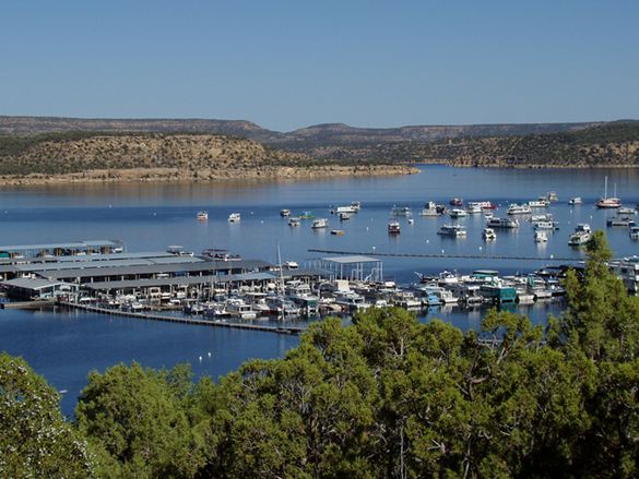
Pine River Marina at Navajo Reservoir. Photo credit: Reclamation
From email from Reclamation (Susan Novak Behery):
September 1, 2023
The upcoming forecast is warmer and drier than average, and forecast flows in the critical habitat reach are steadily decreasing. For this reason, the Bureau of Reclamation has scheduled an increase in the release from Navajo Dam to 800 cubic feet per second (cfs) for tomorrow, September 2nd, at 4:00 AM.
Releases are made for the authorized purposes of the Navajo Unit, and to attempt to maintain a target base flow through the endangered fish critical habitat reach of the San Juan River (Farmington to Lake Powell). The San Juan River Basin Recovery Implementation Program recommends a target base flow of between 500 cfs and 1,000 cfs through the critical habitat area. The target base flow is calculated as the weekly average of gaged flows throughout the critical habitat area from Farmington to Lake Powell.
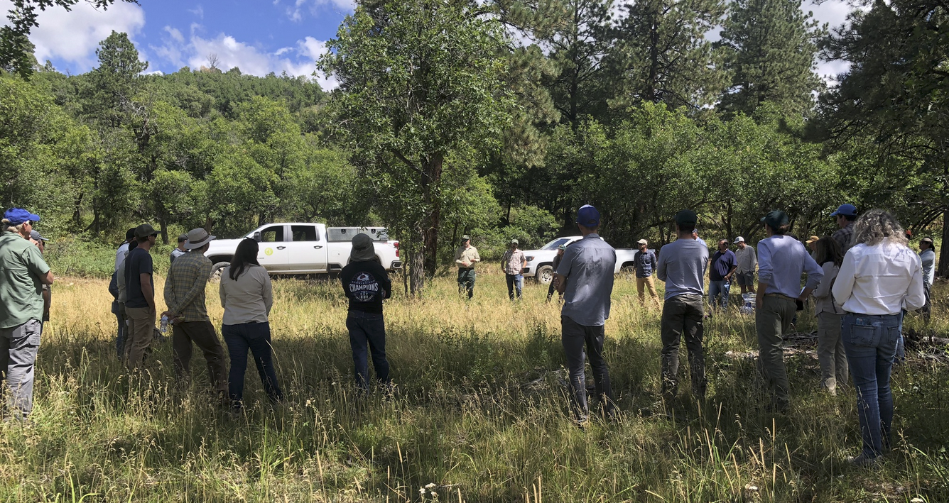
Informal collaborative governance in action. Photo credit: John Fleck/InkStain
Click the link to read the article on the InkStain website (John Fleck):
I spent a couple of days last week out of Pagosa Springs in southern Colorado, touring forest restoration work in the headwaters of the San Juan-Chama Project, which produces critical water supplies for central New Mexico. In others words, water for my neighhbors and me.
We’ve learned over and over in the last couple of decades the risk to city water from wildfire in our headwaters, and the benefits of forest restoration. But the institutional path to restoration is challenging – because of cost, because of the complicated mix of land ownership, and because of the distance (both physically and also conceptually) between the mountain watersheds and the people who depend on the water they supply.
I came away optimistic about the creative problem solving I saw. This stuff’s hard, especially to do at the scale needed, but the efforts are impressive.
FOREST TO FAUCETS (AND HEADGATES)
A few years back, my University of New Mexico collaborator Bob Berrens helped guide a research project intended to flesh out the relationship between Albuquerque and the distant headwaters (a ~200 mile drive away) that provide a critical piece of our water supply.
a mean willingness to pay of $64 per household, which equates to $7 million a year flowing out of Albuquerque to help support forest restoration in the watershed on which we depend, and
even households far away from watersheds support shelling out cash to pay for the work – not just communities like Santa Fe that can look up from their back porch to see their watershed (more on this later – in addition to its back porch watershed, Santa Fe also gets water from the San Juan-Chama headwaters)
COLLABORATIONS AT THE WATERSHED SCALE
While in Pagosa Springs and the surrounding watersheds, we got to see and learn about an amazing set of collaborations involving the Forest Stewards Guild, the Chama Peak Land Alliance, and The Nature Conservancy’s Rio Grande Water Fund, which provides a crucial conduit for the “payment for ecosystems” model Bob’s work talks about.
Bobcat® Compact Track Loader with Masticating Attachment. Photo credit: Wilderness Forestry, Inc.
One of the keys to making this work is a business model – the money supports folks in communities like Pagosa Springs who actually drive the masticators (big machines that grind up overgrown forest stuff). It’s part of the rural-urban social contract Bob and I talk about in the UNM Water Resources Program class we’re teaching this fall.
COLLABORATIONS AT THE REGIONAL WATER MANAGEMENT SCALE
Bob’s called this stuff “forests to faucets”, but what we’re seeing this year on the Rio Grande through central New Mexico is a reminder that the Middle Rio Grande Conservancy District, and the river channel itself, also depend on the importation of San Juan-Chama Project water across the continental divide. Absent the SJC water over the last couple of months, the MRGCD’s ditches would have gone dry sooner, as would the river channel. (Both ditches and river channel are starting to go dry as we speak, after MRGCD’s San Juan-Chama water ran out, but that’s a topic for another blog post.)
The organizer of last week’s tours was the San Juan-Chama Contractor’s Association, a group formed several years ago to try to create a framework for collective action among the New Mexico water agencies that use this imported water. Other states have umbrella agencies to organize big parts of their Colorado River water management – the Central Arizona Water Conservation District (“CAP”) in Arizona, the Metropolitan Water District of Southern California, and the Southern Nevada Water Agency (Las Vegas NV). In New Mexico, we have a bunch of separate San Juan-Chama Project water users, each with their own contract with the Bureau of Reclamation. The SJC Contractors Association has created a framework for thinking about collective action on things like physical infrastructure costs and maintenance – and forest restoration!
Key Rio Grande Valley players in attendance were leadership from Albuquerque, Santa Fe (which in addition to San Juan-Chama water, gets supplies from its own local Sangre de Cristo watersheds, which have forest health challenges too) and the Middle Rio Grande Conservancy District.
SOCIAL CAPITAL
In addition to spending time in drop-dead gorgeous mountain watersheds, last week’s tours and meetings also created a great framework for sitting out on the back patio at Motel SOCO in Pagosa Springs eating delicious bar food and drinking our choice of beverages and building social capital. Bonus points for the tours organizers for getting the forest nerds and the water nerds talking.
The San Juan River near Navajo Dam, New Mexico, Aug. 23, 2015. Photo credit: Phil Slattery Wikimedia Commons
From email from Reclamation (Susan Novak Behery):
August 17, 2023
In response to the precipitation forecast and increased observed flows in the San Juan River Basin and its tributaries, the Bureau of Reclamation has scheduled a decrease in the release from Navajo Dam from 700 cubic feet per second (cfs) to 600 cfs for tomorrow, August 18th, at 4:00 AM.
Releases are made for the authorized purposes of the Navajo Unit, and to attempt to maintain a target base flow through the endangered fish critical habitat reach of the San Juan River (Farmington to Lake Powell). The San Juan River Basin Recovery Implementation Program recommends a target base flow of between 500 cfs and 1,000 cfs through the critical habitat area. The target base flow is calculated as the weekly average of gaged flows throughout the critical habitat area from Farmington to Lake Powell.
…among the most significant issues, is the impact of historic gravel mining on the 6-mile stretch from Bakers Bridge to Trimble Lane, north of Durango. Over the years, gravel mining has completely altered the function of the river and turned it into what looks like the surface of the moon…the damage left by gravel mining between Bakers Bridge and Trimble has gone largely unnoticed and unaddressed – in part, because that stretch, hemmed in by private property, is relatively unused for recreational purposes such as river running or fishing.
But that all might soon change. Recently, a number of stakeholders invested in the Animas River began the process of forming a stream management plan (SMP) for the waterway, which will likely address lasting impacts caused by historic gravel mining.
“It’ll be in there,” Warren Rider, coordinator of the Animas Watershed Partnership, which is leading the SMP process, said. “Too many people are justifiably concerned about how the river is behaving in that area and the consequences of it. It was eye-opening when I first saw what the impacts have been.”
The San Juan Water Conservancy District (SJWCD) Board of Directors approved moving forward with a contract with Rick Ehat for engineering consultation on the district’s reservoir project and discussed a lease agreement for river access on a 20-acre parcel ing that governmental immunity jointly owned by SJWCD and the ing that governmental immunity jointly owned by SJWCD and the Pagosa Area Water and Sanitation District.
Aerial view of Navajo Dam and Reservoir. Photo credit: USBR
From email from the Reclamation Western Colorado Area Office:
BUREAU OF RECLAMATION
NAVAJO DAM RELEASES
SENT VIA E-MAIL
July 28th, 2023
In response to falling flows in the critical habitat reach, and an updated USGS gage shift that shows flows are lower than previously gaged, the Bureau of Reclamation has scheduled an increase in the release from Navajo Dam from 500 cubic feet per second (cfs) to 700 cfs for tomorrow, July 29th, at 4:00 AM.
Releases are made for the authorized purposes of the Navajo Unit, and to attempt to maintain a target base flow through the endangered fish critical habitat reach of the San Juan River (Farmington to Lake Powell). The San Juan River Basin Recovery Implementation Program recommends a target base flow of between 500 cfs and 1,000 cfs through the critical habitat area. The target base flow is calculated as the weekly average of gaged flows throughout the critical habitat area from Farmington to Lake Powell.
This scheduled release change is subject to changes in river flows and weather conditions. If you have any questions, please contact Susan Behery (sbehery@usbr.gov or 970-385-6560), or visit Reclamation’s Navajo Dam website at https://www.usbr.gov/uc/water/crsp/cs/nvd.html
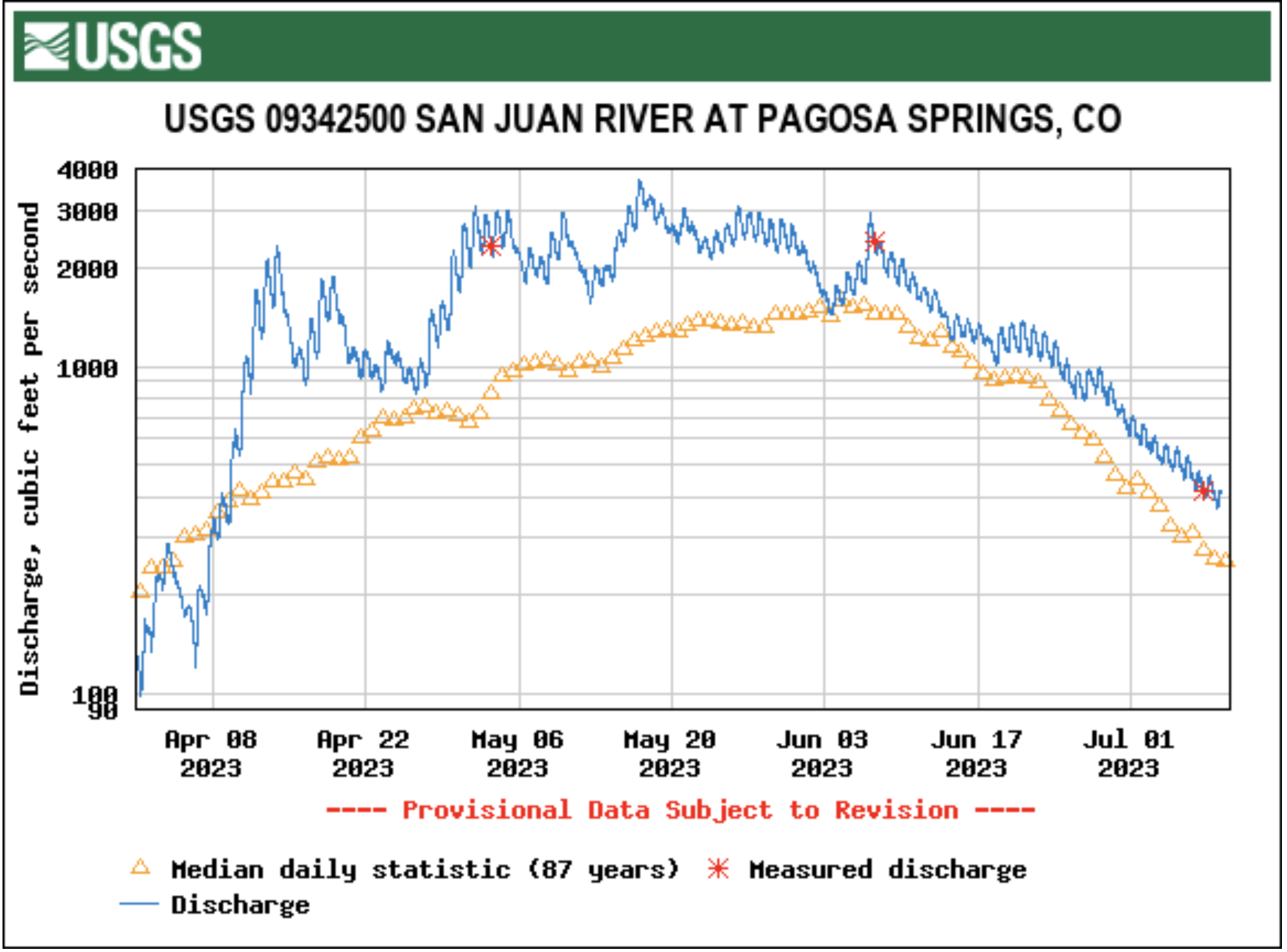
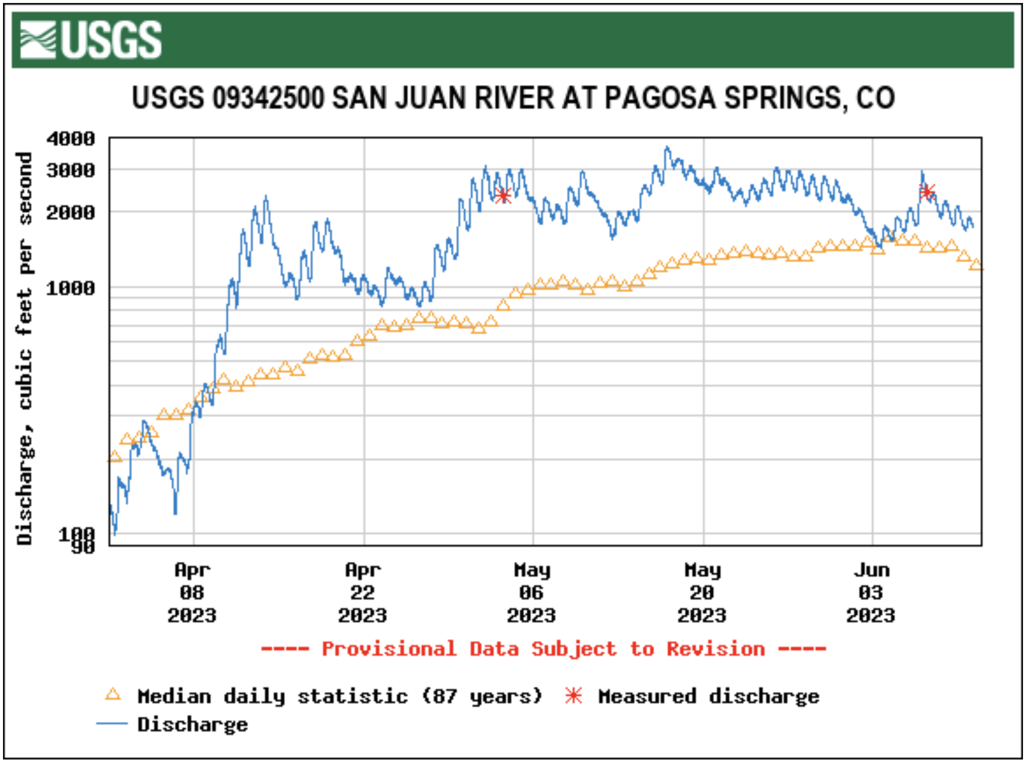
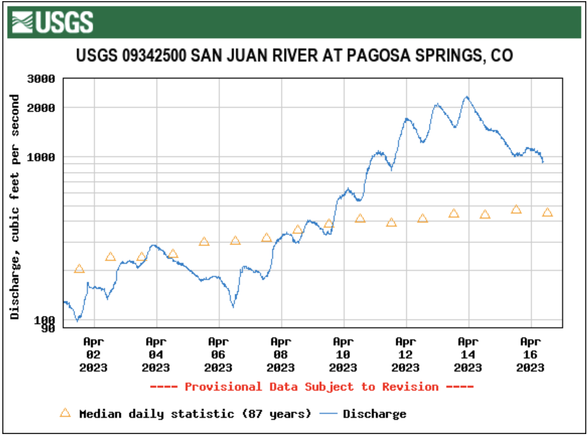
Flow levels in the San Juan River continued to drop this week, though they remain above median. The San Juan River in Pagosa Springs was running at 513 cubic feet per second (cfs) at 9 a.m. on July 5, down from a nighttime peak of 565 cfs at 3:15 a.m., according to data from the U.S. Geological Survey (USGS). The median flows for July 5, based on 87 years of data, are 301 cfs, according to the USGS. These flows are down from June 28 when, according to USGS, the river was flowing at 863 cfs at 9 a.m., down from a nighttime peak of 986 cfs at 1:15 a.m. The San Juan River has remained consistently above the median flow for the last 30 days, only briefly dipping below the median on June 4…
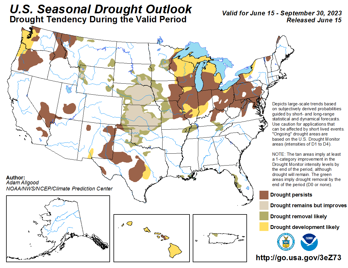
Drought Forecast
NIDIS…indicates that, over the next 90 days, most of the county will experience normal conditions with some areas seeing abnormally wet conditions and a small area seeing abnormally dry conditions.
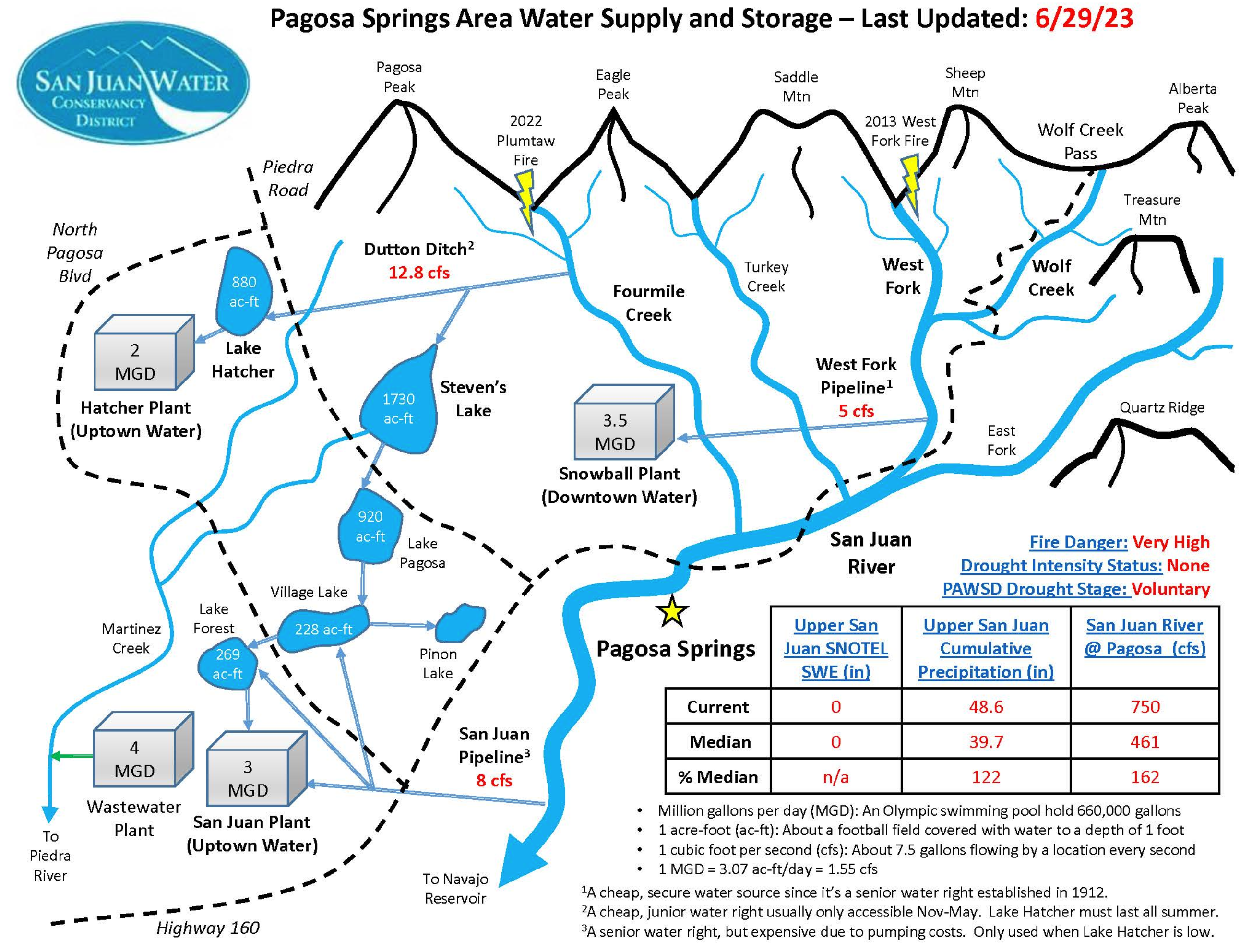
Water Report
Pagosa Area Water and Sanitation District (PAWSD) District Engineer/Manager Justin Ramsey stated that most PAWSD reservoirs, including Lake Pagosa, Lake Forest, Lake Hatcher and Village Lake are full, but Stevens Lake is down about a foot. He added that there has not yet been a call on water in the Fourmile Creek drainage and that water is continuing to flow into Lake Hatcher.
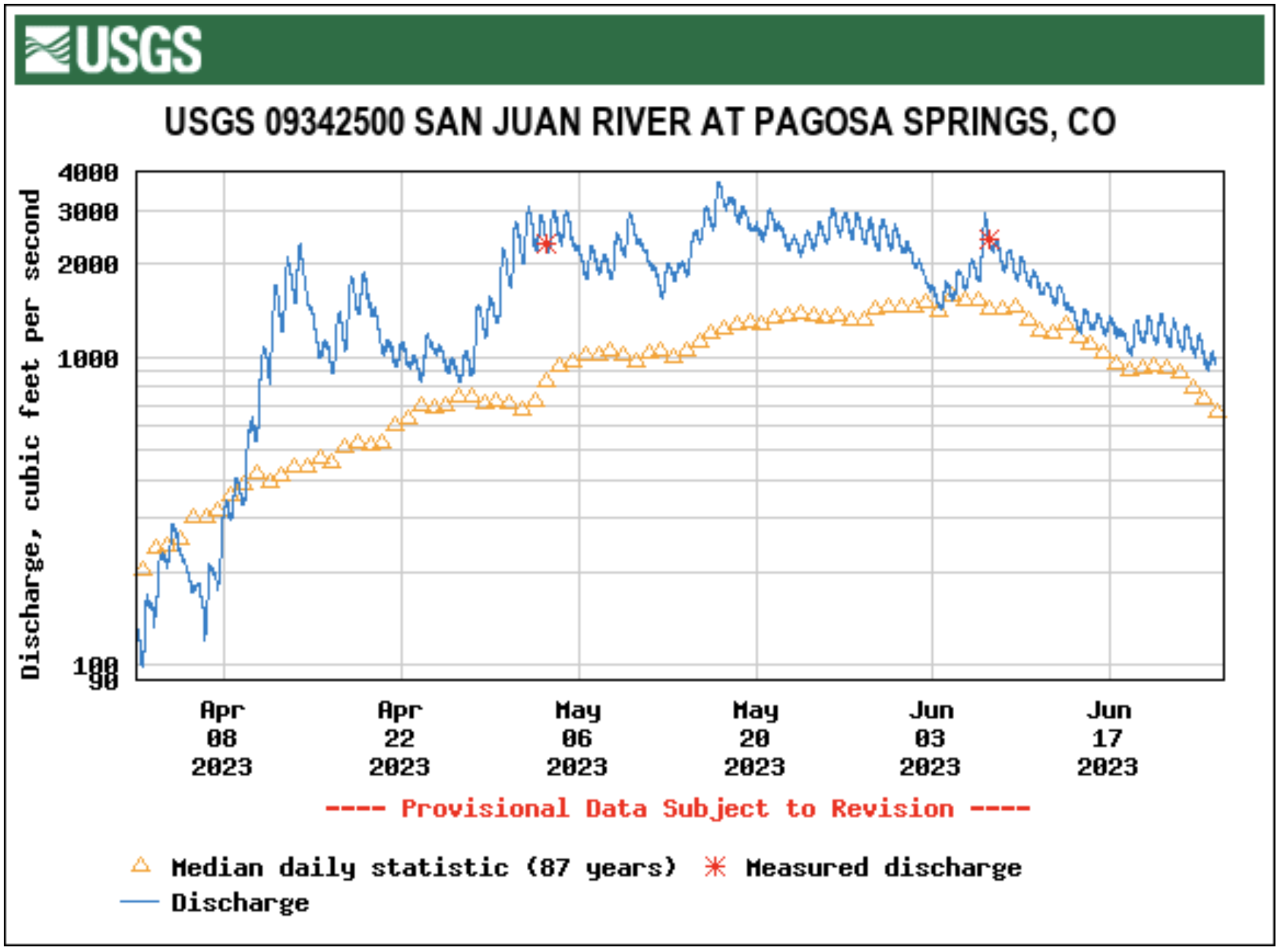
Flow levels in the San Juan River have dropped over the last several weeks, though they remain above median and drought conditions are not forecast for the near future. The San Juan River in Pagosa Springs was running at 1,170 cubic feet per second (cfs) at 11 a.m. on June 21, down from a nighttime peak of 1,380 cfs at 1 a.m., according to data from the U.S. Geological Survey (USGS).
The San Juan River, below Navajo Reservoir. Photo: Brent Gardner-Smith/Aspen Journalism
From email from Reclamation (Susan Novak Behery):
The Bureau of Reclamation is continuing the ramp-down from the 2023 Spring Peak Release. The current release is 1,200 cfs. The next release changes are shown in the table below.
Date
Day
Time
Release (cfs)
6/23/2023
Fri
4:00 AM
900
6/24/2023
Sat
4:00 AM
700
6/25/2023
Sun
no change
700
6/26/2023
Mon
4:00 AM
500
6/27/2023
Tue
no change
500
Areas in the immediate vicinity of the river channel may continue to be unstable and dangerous. Please use extra caution near the river channel and protect or remove any valuable property in these areas.
Following ramp-down, summer releases will be made for the authorized purposes of the Navajo Unit, and to attempt to maintain a target base flow through the endangered fish critical habitat reach of the San Juan River (Farmington to Lake Powell). The San Juan River Basin Recovery Implementation Program recommends a target base flow of between 500 cfs and 1,000 cfs through the critical habitat area. The target base flow is calculated as the weekly average of gaged flows throughout the critical habitat area from Farmington to Lake Powell.
For more information, please see the following resources below:
Bureau of Reclamation:
• Susan Behery, Hydrologic Engineer, Reclamation WCAO (sbehery@usbr.gov or 970-385-6560).
Representatives from more than a dozen Indigenous tribes spoke at a CU Boulder law conference last week about their interests in the Colorado River from each of their perspectives. Many of the prominent state and federal officials who manage the water attended the conference. But as they and other water authorities prepare to negotiate the river’s future, it’s unclear how tribes will participate, to what degree tribes will be treated as equal sovereigns, and how their desire to use all the water they legally have rights to will be considered. It’s also unclear whether negotiators will aim for a way to make the long-term reductions in water usage that a decades-long megadrought has made necessary or whether they will propose more short-term changes.
The gathering happened at a critical time: Collectively, Colorado River users have to figure out how to live with significantly less water going forward, and the federal government is forcing states to come to an agreement…
The group of tribal representatives and state water officials, along with academics who study the river, used the two-day conference for discussions about how to make their collective use of the river more sustainable over the long term…The tribes have a shared history of using the river and its tributaries over thousands of years and migrating based on water availability. In the century since the river has been dammed and diverted across seven states, each tribe has a different story about how their water rights have been denied and what they seek to change in the river’s management going forward…
Some river scholars and even people with roles in the negotiations are unclear about what’s possible as they determine longer-term allocations of the water…A lot is at stake for tribes, and each circumstance is unique…For example, Hopi Tribe council member Dale Sinquah said his people still need to have their water rights settled. Southern Ute Tribal Council Vice Chair Lorelei Cloud said the tribe wants to use water they have legal rights to in southwestern Colorado, but they don’t have the infrastructure. She said about 1,000 tribal members still have to manually haul water to their homes, and the tribe hasn’t been able to develop farmland…Crystal Tulley-Cordova from the Navajo Nation said her tribe couldn’t rely on groundwater because of abandoned uranium mines on their land. Dwight Lomayesva, vice chairman of the Colorado River Indian Tribes on the border of California and Arizona, said his people would like to upgrade their farming and water infrastructure to make it more efficient, but the federal government still owns it. “The last major change in our irrigation infrastructure was made in 1942, when the United States government built some canals for the Japanese who were interned on our reservation,” he said. Each needs to negotiate for themselves individually.
“To think that there’s an ‘Indian solution,’ really dishonors that individuality and the uniqueness of each one of those tribes,” said Daryl Vigil, a Jicarilla Apache water leader who used to direct a tribal partnership in the Colorado River basin.
From the 2018 Tribal Water Study, this graphic shows the location of the 29 federally-recognized tribes in the Colorado River Basin. Map credit: USBR
The Bureau of Reclamation will reduce the release from 4,300 cfs to 4,000 cfs today at 12:00 PM. The release will be further ramped down beginning Thursday, June 15th, at 12:00 PM. The updated schedule is in the following table and posted to the website at the link below.
Areas in the immediate vicinity of the river channel may continue to be unstable and dangerous. Please use extra caution near the river channel and protect or remove any valuable property in these areas.
For more information, please see the following resources below:
Bureau of Reclamation:
• Susan Behery, Hydrologic Engineer, Reclamation WCAO (sbehery@usbr.gov or 970-385-6560).
Click the link to read the article on the Pagosa Springs Sun website (Josh Pike). Here’s an excerpt:
River levels across the region remain above average while the snowpack on Wolf Creek Pass was 79 percent of median as of June 7, according to the U.S. Department of Agriculture (USDA) National Water and Climate Center’s snowpack report. The USDA report indicates that the pass had 10.9 inches of snow water equivalent on Wednesday, June 7, below the median of 13.8 inches.
Area rivers also remain high, with the San Juan River in Pagosa Springs running at 2,470 cubic feet per second (cfs) at 9 a.m. on June 7, down from a nighttime peak of 2,930 cfs at 2 a.m., according to data from the U.S. Geological Survey (USGS). The mean flow for June 7 is 1,550 cfs, while last year’s flow on the date was 1,100 cfs, according to the USGS. The San Juan River has remained consistently above the median flow for the last 30 days, only briefly dipping below the median on June 4.
Other regional rivers are also high, with the Animas River in Durango flowing at 4,410 cfs at 9 a.m. on June 7, well above the mean flow of 3,100 cfs for that date based on USGS data. The Piedra River near Arboles was flowing at 1,980 cfs at 9 a.m. on June 7, according to the USGS, compared to a mean flow of 1,170. The Los Pinos River above Vallecito Reservoir near Bayfield was flowing at 1,090 cfs at 9 a.m. on June 7, according to the USGS, above the mean flow of 670 cfs. The Animas, San Juan, Los Pinos and Piedra rivers all saw sharp increases in flow levels on Wednes- day morning due to recent pre- cipitation, but, even before that, remained at or near median flows.
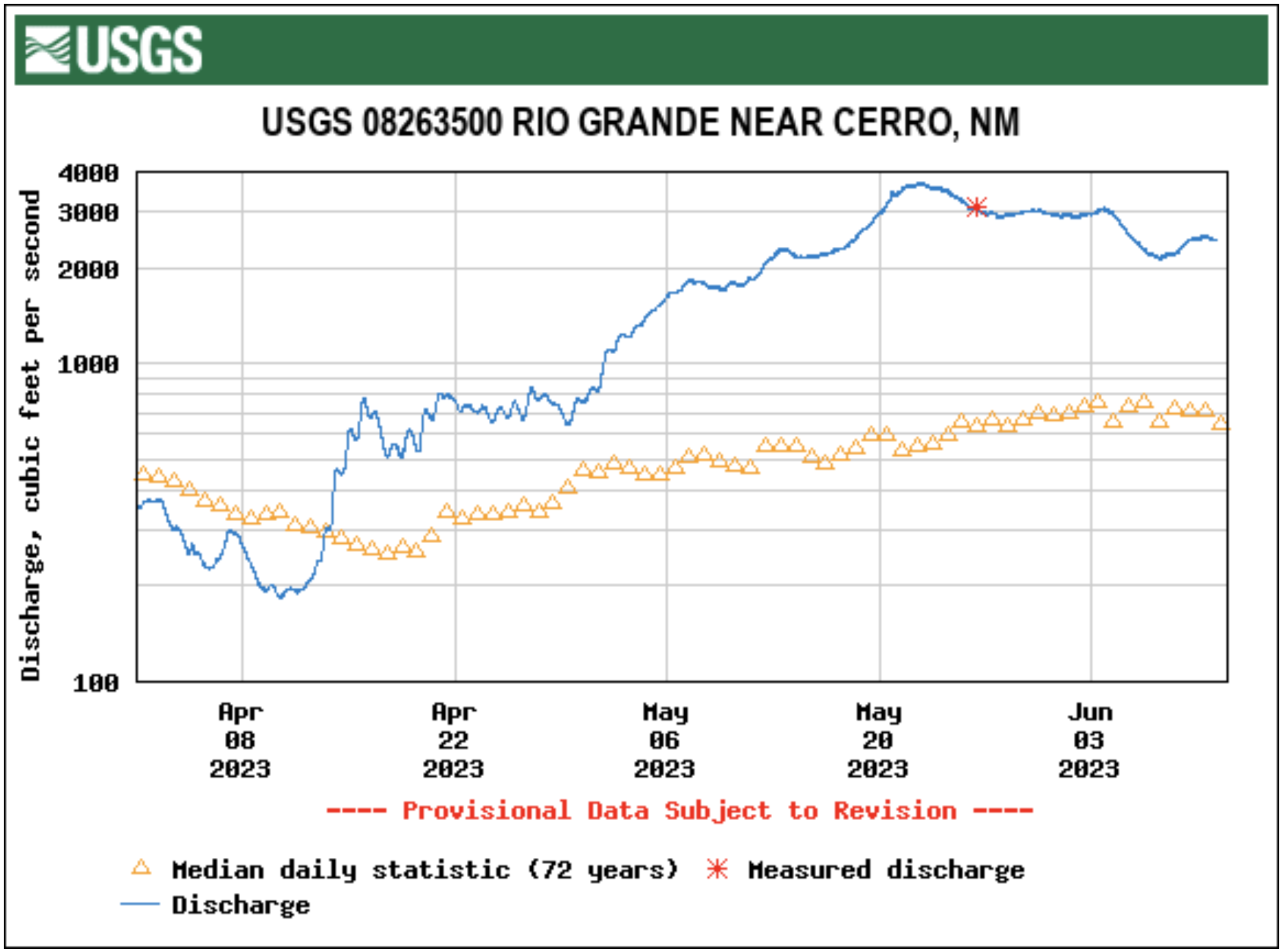
The Rio Grande River near Cerro, N.M., was flowing at 2,150 cfs at 9 a.m. on June 7, according to the USGS. This is considerably above the mean flow of 1,050 for the date. Cerro is the closest USGS monitoring station to the Rio Grande headwaters that provides cfs data. It is located to the north of Taos, N.M.
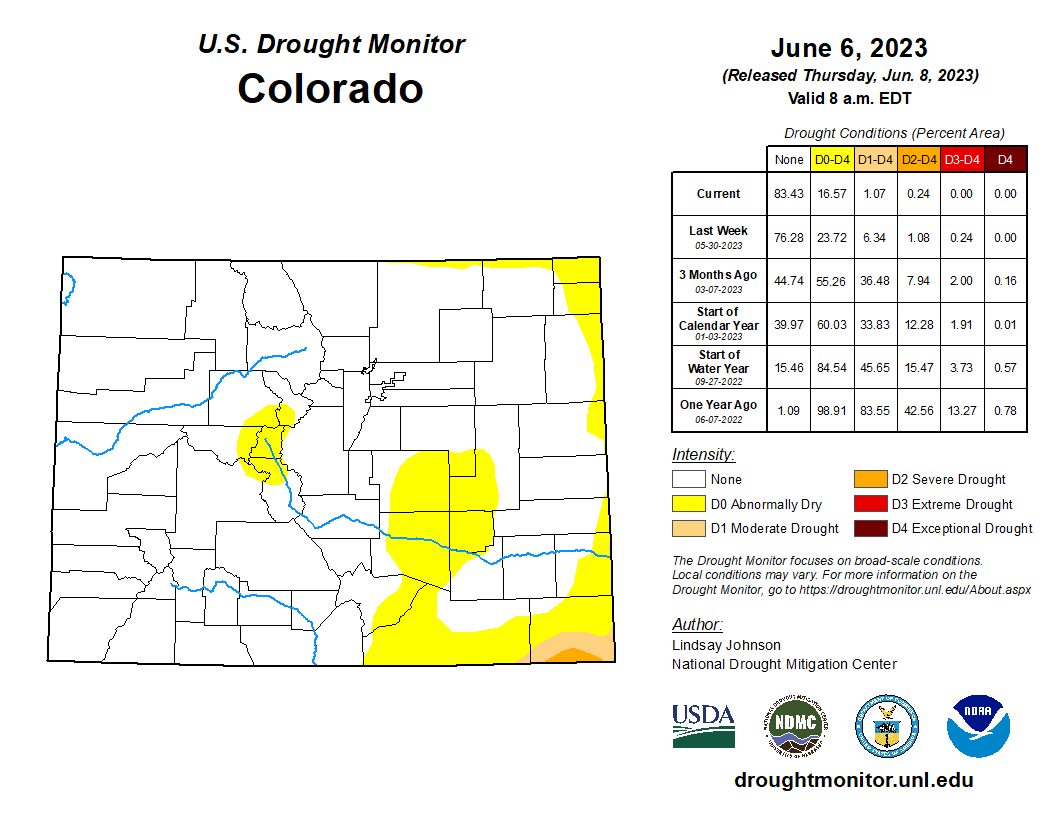
Colorado Drought Monitor map June 6, 2023.
The National Oceanic and Atmospheric Administration (NOAA) National Integrated Drought Information System (NIDIS) pro- vides another view on current climate conditions, indicating that Archuleta County is not currently experiencing drought. The NIDIS indicates that April was the eighth driest in 129 years, with 1.3 less inches of precipitation than normal, but that January to April of 2023 has been the 26th wettest in the past 129 years with 2.25 more inches of precipitation than normal…
Pagosa Area Water and Sanitation District (PAWSD) District Engineer/Manager Justin Ramsey also noted the wet conditions and stated that all PAWSD reservoirs are full. He added that there has not yet been a call on water in the Fourmile Creek drainage, meaning that water is continuing to flow into Lake Hatcher. Ramsey stated he does not expect a call before early July given current conditions, which he noted would be significantly later than the median call date of approximately June 4. He added that last year the call of Fourmile was made in the middle of May.
Click the link to read the article on the Pagosa Springs website (Josh Pike). Here’s an excerpt:
On May 16, the Archuleta County Board of County Commissioners (BoCC) approved a budget amendment allocating $225,331 in Local Assistance and Tribal Contingency Fund (LATCF) monies received from the federal government to the Development Services Division and $137,428 in LATCF monies to the Public Health Department to support transition to a county health department. The money allocated to Development Services is intended to support the county’s water quality program, including permitting for on- site wastewater treatment systems (OWTS), as well as other environmental health programs that will be the responsibility of the department, according to Finance Director Chad Eaton…
At the request of [Derek] Woodman, [Pamela] Flowers also discussed process changes in the issuing of OWTS permits and the interactions between SJBPH and the county that had slowed the process of construction for new builds. She also mentioned that the county would need to purchase a permit processing system, although she had not chosen one yet…She noted she is working on regu- lations for OWTS that will need to be approved by the county and the state and will provide the basis for permitting in the county.
At a May 25 special meeting, the Pagosa Area Water and Sanitation District (PAWSD) Board of Directors approved contracts with PCL Construction and Veolia Water Technologies and Solutions for construction of and equipment for the Snowball Water Treatment Plant project. According to the contract with PCL, the guaranteed maximum price (GMP) for the project is $40,565,680…The meeting opened with District Engineer/Manager Justin Ramsey explaining that the con- tract with PCL is for the construction work on the plant…He added that PCL’s contract costs also include the costs associated with the Veolia and Pall contracts…
[Director Ramsey] also clarified the reasons why PAWSD is undertaking the project, explaining that the main reason is the regulatory requirements of the Colorado Department of Public Health and Environment (CDPHE).
Aerial image of entrenched meanders of the San Juan River within Goosenecks State Park. Located in San Juan County, southeastern Utah (U.S.). Credits Constructed from county topographic map DRG mosaic for San Juan County from USDA/NRCS – National Cartography & Geospatial Center using Global Mapper 12.0 and Adobe Illustrator. Latitude 33° 31′ 49.52″ N., Longitude 111° 37′ 48.02″ W. USDA/FSA, Public domain, via Wikimedia Commons
From email from Reclamation Western Colorado Area Office:
The Bureau of Reclamation has reduced the release from 4,600 cfs to 4,300 cfs this morning at 8:30 AM to allow local emergency management entities to assess and respond to conditions on the ground downstream of Navajo Dam. Reclamation will continue working closely with emergency management during this managed release and a notice will be sent out prior to the next release change.
Areas in the immediate vicinity of the river channel may be unstable and dangerous. River crossing may change and be impassable as flows increase. Please use extra caution near the river channel and protect or remove any valuable property in these areas.
Please stay tuned as a notice with an updated schedule will be sent out daily during the release. Notices will also be posted to our website along with the latest release schedule. http://www.usbr.gov/uc/wcao/water/rsvrs/notice/nav_rel.html
For more information, please see the following resources below:
Bureau of Reclamation:
• Susan Behery, Hydrologic Engineer, Reclamation WCAO (sbehery@usbr.gov or 970-385-6560).
Navajo Reservoir, New Mexico, back in the day.. View looking north toward marina. The Navajo Dam can be seen on the left of the image. By Timthefinn at English Wikipedia – Transferred from en.wikipedia to Commons., Public Domain, https://commons.wikimedia.org/w/index.php?curid=4040102
From email from Reclamation (Susan Novak Behery):
The Bureau of Reclamation is continuing to schedule release changes for the spring peak release from Navajo Reservoir.
The current release is 4,000 cfs. The next release changes are scheduled to occur as follows:
Date
Time
Release
Tuesday, May 30th
10:00 AM
4,300 cfs
Wednesday, May 31st
10:00 AM
4,600 cfs
Thursday, June 1st
10:00 AM
5,000 cfs
Release changes are made based on river conditions and coordination with federal, state, and local agencies.
The shape and timing of the hydrograph have been coordinated with the San Juan River Basin Recovery Implementation Program to balance Recovery Program benefits with flood control and operational safety. During spring operations, releases from the Navajo Unit will be made in an attempt to remain at or below the U.S. Army Corps of Engineers safe channel capacity of 5,000 cfs between Navajo Reservoir and the confluence with the Animas River in Farmington, and 12,000 cfs downstream of Farmington. The release may be changed or reduced if the precipitation forecast shows a risk of exceeding safe channel capacity in the San Juan River.
Areas in the immediate vicinity of the river channel may be unstable and dangerous. River crossing may change and be impassable as flows increase. Please use extra caution near the river channel and protect or remove any valuable property in these areas.
We’re in a bit of a holding pattern along the Colorado River today, at least in the Upper Basin: on the one hand, waiting for the Bureau of Reclamation to weigh the options for big cuts in Lower Basin use; and on the other hand, seeing the Lower Basin states trying to come up with a less painful set of big cuts to impose on themselves over three years, taking advantage of the big snow year that relieves a little (but just a little!) of the immediate pressure.
At any rate, it’s an opportunity for me to step back a step and try to restore something of the perspective with which I started these posts – ‘learning to live in the Anthropocene.’ I’ve been calling the posts ‘Romancing the River,’ wanting to work in the spirit of Frederick Dellenbaugh in his book The Romance of the Colorado River: making the story of the First River of the Anthropocene something to engage in rather than deny. But the stories keep getting lost in the avalanches of mostly dispiriting details coming down these days….
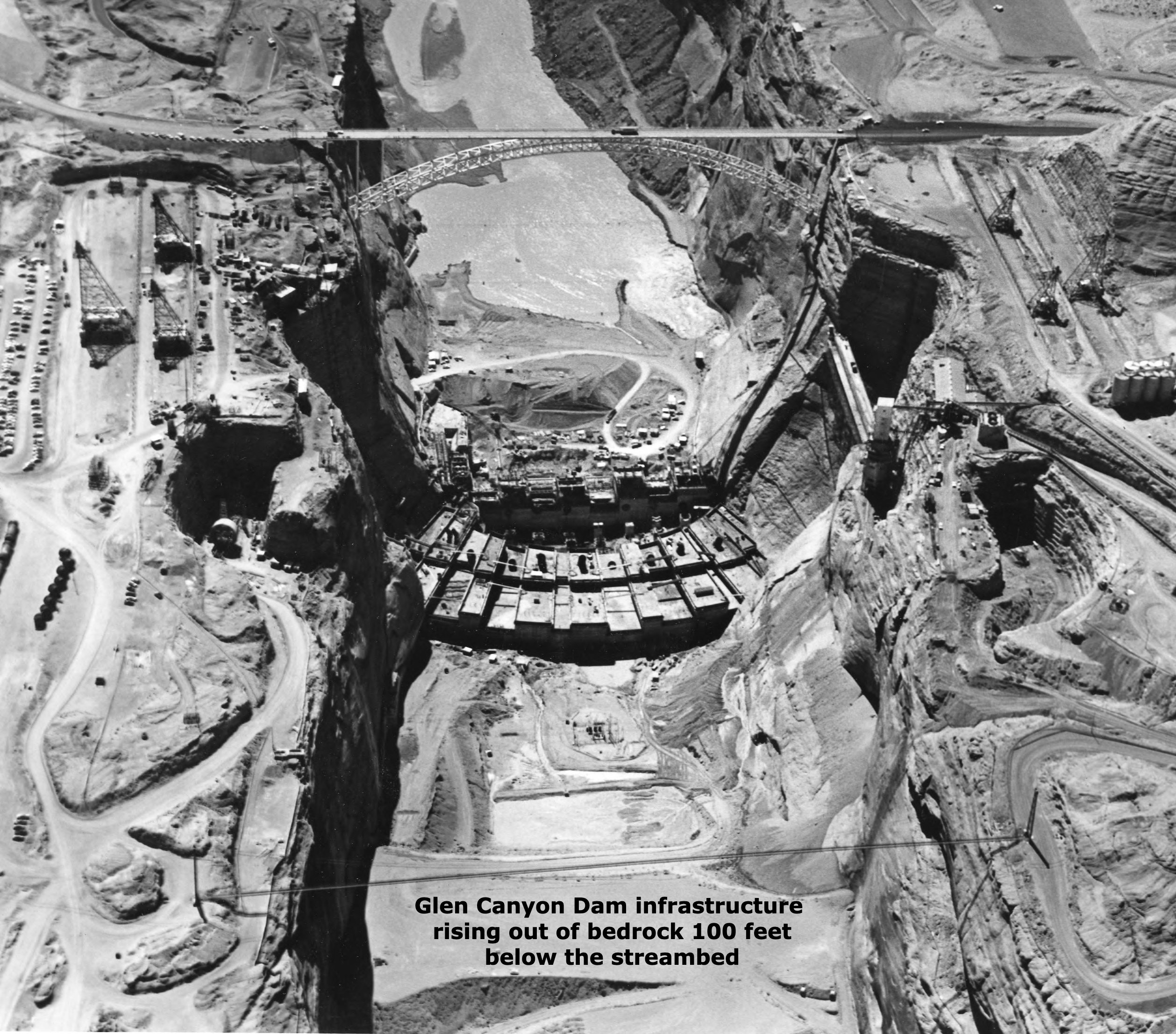
So anyway, today – an unremembered part of the story of Glen Canyon Dam. Last post, we explored the structure of the dam itself, a good solid Early Anthropocene structure. But today I want to explore the infrastructure of the dam. As with most dams, what you can see is not the whole thing, even physically. To get a firm foundation on bedrock for ten million tons of concrete, the builders had to dig out more than a hundred feet of rock, rubble and sand from the natural streambed. That hundred feet of dam below the streambed is the physical infrastructure of the dam.
But even before that digging-down could begin, a political, economic, legal and philosophical infrastructure had be cobbled together on which to erect the physical structure. Recent articles about the river and its troubles that try to offer any river history at all tend to give credit (or blame) for the dam to a large mass of ego and bluster, Floyd Dominy, but he was just the Reclamation Commissioner when the dam was legislated, a guy who wanted to build dams as big as his ego. He built the structure, but he didn’t assemble the legal and political infrastructure that enabled it.
The larger story of Glen Canyon Dam’s infrastructure is mostly, but not entirely, a story of the Old West – a story of the most serious attempt to achieve a working truce between the Old West and the New West. And for those with my tendency toward an iconoclastic interpretation of history, it was one of the final episodes (thus far anyway) in America’s semi-civil westward war between the advance of the well-defined and well-funded Industrial Revolution and the retreat of a vaguely defined agrarian counter-revolution. For a review of that semi-civil war, go to ‘Westward the Curse of Empire,’ April 4, 2022.
When we talk about the Old West and the New West, we are talking about two very different cultures. Most (over)simply, we can say that the Old West is the west to which people went to live and make a living developing and marketing the natural resources of the West; and the New West is the west where people who live in the urban-industrial realm go to play, to ‘recreate’ themselves among the natural wonders and magnificent scale of the West.
It is useful to make a further distinction about the Old West: it was populated by ‘settlers’ and ‘unsettlers’: the unsettlers usually arrived first, the human equivalent of a plague of locusts with a mining mentality (mining gold and silver, other metals, old-growth timber and grass) – a drive to get there first, get the goods, and get rich. The settlers, on the other hand, came to farm or ranch with the intention of staying and making a life, settling down, homesteading. Some of the farmers tended to be soil miners, but the ones who stayed were true agrarians, the counterrevolutionaries to the industrial revolutionaries.
People of course do come to live in the New West too, not just to visit: they are usually either relatively well-off people retiring, or professionals working remotely with incomes from elsewhere, or they are mendicant people like I was sixty years ago (relatively poor, mostly by choice) who work for the recreation industries set up for the people who come to play, in exchange for getting to live and play themselves among the natural wonders of the West.
The story of Glen Canyon Dam, and the counterrevolutionary effort to co-opt it, began in the years immediately following World War II. The Lower Colorado River Basin had already been transformed into a desert empire through the 1928 Boulder Canyon Project, completed just in time for Southern California to grow explosively through the war effort. The four Upper Basin states figured that they would get their day after World War II. And in 1946 the Bureau – eager to follow the creation of Hoover Dam and the desert empire with more river miracles – came out with a pamphlet: ‘The Colorado River: A Natural Menace Becomes a National Resource.’ In it the engineers presented a smogasbord of 88 possible projects, large and small, all in the four states of the Upper Colorado Basin. They cautioned that there would not be enough water for all 88, so there must be some choosing.
Palisade peach orchard
The principal architect for the legal, political and economic infrastructure underlying what came to be the Colorado River Storage Project was no larger-than-life figure like Dominy, but an unprepossessing Congressman, Wayne Aspinall, from Colorado’s West Slope and the river’s largest headwaters catchments. Aspinall did not stand out in a crowd, but he was savvy, and absolutely committed to the Old West as an economy of working people engaged in the production of resources needed in the larger society – and with a deep love for irrigated agriculture, having grown up with his father’s peach orchard in the Grand Valley after the Bureau’s highline canal brought them water.
He was a Democrat, an unlikely representative from one of Colorado’s most conservative districts, but he began his political career in the late 1920s as a common sense alternative to the mess the Ku Klux Klan had made everywhere in Colorado, and he kept getting re-elected to state, then national offices because he got things done.
When the West Slope sent him to Washington in 1948, he got appointed to the House Committee on Interior and Insular Affairs, mastered the arcane procedures of the House, and as the district kept returning him to office, he gradually ascended to the chair of that committee, which gave him a lot of power over the budget and operations of the Interior Department and its Bureau of Reclamation. He exercised that power so vigorously and, in the opinion of many of his colleagues, so arbitrarily, that House committee rules were changed after he left, to diminish the power of chairs who took the time to learn the rules well enough to manipulate them.
A bust of Wayne Aspinall, in Palisade, facing the Colorado River. Photo: Brent Gardner-Smith/Aspen Journalism
He also knew which way the tide was running in America. The 1920 census for the first time showed more people living in the cities than in the rural areas, and by the end of World War II, that imbalance was accelerating. (‘How ya gonna keep’em down on the farm, after they’ve seen Paree?’) His Old West constituency was being diluted by newcomers aghast at learning a few eggs had been broken in making the omelet they took for granted. The cities they came from were also needing more water, and Aspinall was often caught between constituents angry about yet another transmountain diversion, and east-slope movers and shakers angry about what he could not deny but could often delay.
Nonetheless, his Old West constituents knew where his heart lay, and returned him to Congress 12 times. That might have continued indefinitely, but his own Democrat party outgrew its working-class roots, became a big city party, and gerrymandered him into a mostly urban district where he could not win; he was ‘primaried out’ in 1972. It was probably time; he had become a lightning rod for the early naive-environmentalist movement, and being aligned with that movement myself, I felt naively righteous in voting against him. I still think it was the right thing to do then; he had become increasingly reactionary and defensive, at least as he was being reported in the newspapers. But given what I’ve learned about him since, and my ambiguous feelings about the New West that has replaced the Old West, and about the staggering march of American history in general – I wish I had cast that vote a little more humbly.
In the 1950s, however, Aspinall was just hitting his stride when the Bureau was ready to finish remaking the First River of the Anthropocene, and he jumped on the opportunity to do something big and (he hoped) enduring for the West he and his constituents believed in. More than any other single person, he laid the infrastructure for the Colorado River Storage Project. For better or worse.
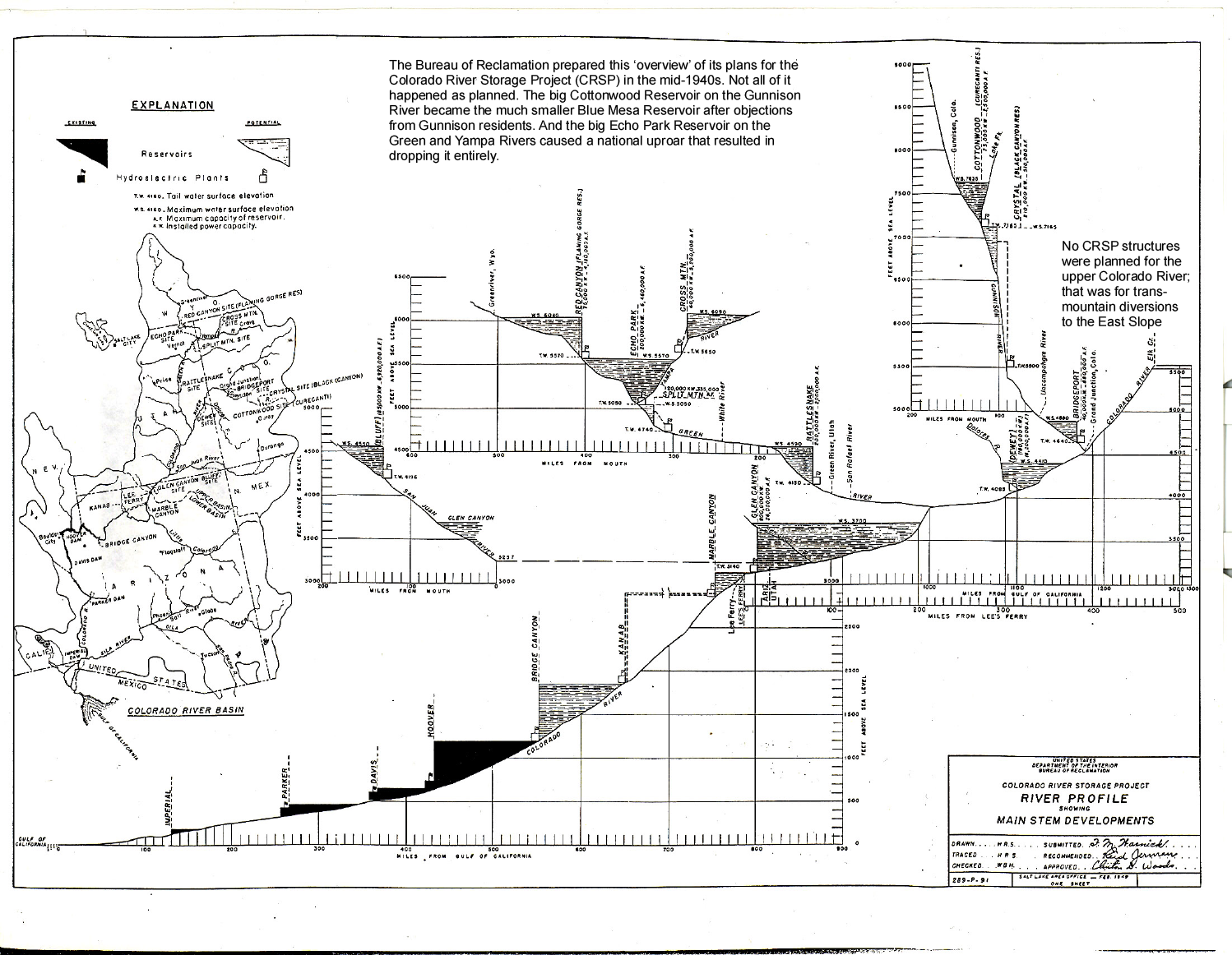
The Bureau of Reclamation prepared this ‘overview’ of its Colorado River Storage Project (CRSP) in the mid-1940s. Not all of it happened as planned. The big Cottonwood Reservoir on the Gunnison River became the much smaller Blue Mesa Reservoir after objections from Gunnison residents. And the big Echo Park Reservoir on the Green and Yampa Rivers caused a national uproar that resulted in dropping it entirely. Credit: USBR (Click to enlarge)
The Colorado River Storage Project had to first be a really serious storage project, to assuage Upper Basin water users’ fears of a Compact call, which they thought would come even if nature, not human overuse, caused a shortfall in Lower Basin deliveries. Another time we will take a look at the Upper Basin Compact created in 1948, and the knots the four states tied themselves into, due to their Caliphobia. So the first charge to the Bureau was to build some big ‘holdover’ reservoirs on the scale of Mead Reservoir – dams capable of storing at least two years of inflow.
But the Bureau and Aspinall also wanted big hydropower units in those dams – ‘humming the tunes of endless wealth,’ as a bit of precious Bureau prosody put it. ‘Cash register dams’ was a more prosaic nickname for the big power-generating dams: they wanted the wealth so generated to be applied not only to paying off the big dams, but also to pay for a lot of smaller dams in the higher country.
The biggest problem farmers and ranchers in the arid lands had in irrigating from a desert river fed primarily by snowmelt was the erratic flows – snowmelt floods early in the irrigating season and then almost no water in the late summer when it was most needed. Storage to even out the flows was the key, and storage was expensive. Every community of farmers could go out after harvest with shovels, black powder and mule scrapers, and dig canals to move water, but water storage required materials and equipment they couldn’t afford. Every irrigation district had sketch plans for dams and reservoirs, but for small communities, the Bureau’s cost-benefit analyses for dam repayment were impossible.
But – if a general fund for a big multi-unit project could be created, with power revenues pouring into it, and some small storage projects drawing on it, with cost-benefit analysis calculated for the whole multi-unit project, then the big dams could carry the otherwise unaffordable little dams…. Glen Canyon Dam would (‘twas hoped) assure that the industrial revolution’s desert empire got its water – but it would also provide storage for the counterrevolutionaries’ ‘headwaters republics.’ Win-win.
And that was essentially the Colorado River Storage Project Aspinall and his collaborators in the Upper Basin put together. They started in 1950 with a bill calling for nine big holdover dams and reservoirs, and a couple dozen ‘participating projects’ (the smaller storage dams for the local communities). By the time they finally got the project through Congress in 1956, they were down to three actual holdover dams (Glen Canyon Dam on the Colorado mainstem and Flaming Gorge on the Green River, both with full power generating units, and Navajo Dam on the San Juan with no power unit), the Curecanti unit of three dams on the Gunnison that was primarily for power production, and eleven ‘participating projects’ to be partially paid for from the power revenues – and another two dozen potential participating projects for further study.
And because Aspinall knew the New West was coming, like it or not, the Act included a requirement that every unit would include recreational facilities.
Did it work out as planned? Yes and no. The ‘cash register’ dams were all built, and facilitated the building of around a dozen of the small ‘participating projects.’ My great-grandparents would have been glad for the dam built on the North Fork of the Gunnison River above Paonia, the erratic river whose spring floods had forced them to move their house to higher ground. But they had sold the homestead by the time the dam was built because none of their offspring wanted to contend with the erratic water supply.
Animas-La Plata Project map via USBR
By the late 1960s, however, the nation had grown tired of building (and paying for) western water projects, and NEPA and the advent of the Environmental Impact Study after 1970 made even small water projects problematic. The last project done under CRSP auspices was an Animas-LaPlata project originally intended to help the Ute Indians develop agricultural lands, but it got so scaled down that it was not much use to anyone.
By the turn of the century, ‘reclamation’ was more likely to be interpreted as work to reclaim and restore land and waterways damaged by the collateral debris that the Old West’s heavier industrial unsettlement left behind. Then in the 1980s a large portion of the power revenue from the big holdover dams was diverted from further CRSP counterrevolutionary structures, to an all-out effort to restore four endangered fish species that, back in the 1970s, the U.S. Fish and Wildlife Service tried to kill off by poisoning the Green River. Mistakes have been made, and visions and dreams got carried out with the debris.
The recreation industries, and the accompanying real estate and construction industries, have pretty much overrun and occupied Aspinall’s would-be agrarian republic; but there are, nonetheless, still places in the West where small farms and ranches hang on, some of them ‘heritage cultures’ passed on through families predating CRSP, some of them new and serious about growing local food – and many of them served by CRSP facilities generated by Glen Canyon Dam. But the agrarian philosophy and vision they represent is largely unarticulated in the mainstream culture; I believe, however, that a careful and potentially difficult interrogation of a large number of rural MAGA supporters would reveal that a virulent form of the agrarian counterrevolution still lives, mute but mad, in a twisted variant of unarticulated hope.
Just call it all another story in the romance of the Colorado River – the story of how Glen Canyon Dam was, for a time, put in service to another America.
A high desert thunderstorm lights up the sky behind Glen Canyon Dam — Photo USBR
The Bureau of Reclamation is continuing to schedule release changes for the spring peak release from Navajo Reservoir.
The scheduled increase to 4,600 cfs for today will be postponed. The release will remain at its current level (4,000 cfs) until tomorrow. At that point, the river conditions will be re-evaluated for the scheduled ramp-up.
Release changes are made based on river conditions and coordination with federal, state, and local agencies.
The shape and timing of the hydrograph have been coordinated with the San Juan River Basin Recovery Implementation Program to balance Recovery Program benefits with flood control and operational safety. During spring operations, releases from the Navajo Unit will be made in an attempt to remain at or below the U.S. Army Corps of Engineers safe channel capacity of 5,000 cfs between Navajo Reservoir and the confluence with the Animas River in Farmington, and 12,000 cfs downstream of Farmington. The release may be changed or reduced if the precipitation forecast shows a risk of exceeding safe channel capacity in the San Juan River.
Areas in the immediate vicinity of the river channel may be unstable and dangerous. River crossing may change and be impassable as flows increase. Please use extra caution near the river channel and protect or remove any valuable property in these areas.
Please stay tuned as a notice with an updated schedule will be sent out daily during the release. Notices will also be posted to our website along with the latest release schedule. http://www.usbr.gov/uc/wcao/water/rsvrs/notice/nav_rel.html
Click the link to read the article on the Pagosa Springs Website (Monica Nigon). Here’s an excerpt:
As of 2 a.m. on May 10, the San Juan River at Pagosa Springs was flowing at 238 percent of normal at 2,940 cubic feet per second (cfs), measured at 9 feet at the gage, according to the San Juan River Basin SNOTEL site, which measures snowpack and river flows and is operated by the Natural Resources Conservation Service (NRCS).
A graph from the U.S. Department of Agriculture (USDA) clocks the snow water equivalent (SWE) on Wolf Creek Pass at 135.5 percent of normal as of May 10.
The inflow of water into [Navajo Lake] was 5,791 cfs, as opposed to May 9, 2022, when the inflow was 2,575 cfs…Furthermore, the Navajo River near Chromo sits much higher than average, running at 239 percent of normal as of May 10.
“The reservoirs are full,” said District Manager Justin Ramsey of the Pagosa AreaWater and Sanitation District (PAWSD), “and there’s still a lot of snow up there. I think it will probably be a good year.”
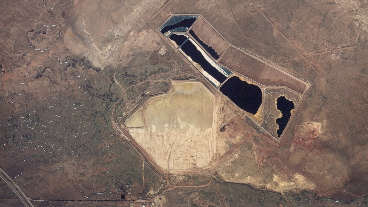
This image was taken during the peak outflow from the Gold King Mine spill at 10:57 a.m. Aug. 5, 2015. The waste-rock dump can be seen eroding on the right. Federal investigators placed blame for the blowout squarely on engineering errors made by the Environmental Protection Agency’s-contracted company in a 132-page report released Thursday [October 22, 2015]
May 11, 2023 (DENVER) — The Colorado Natural Resources Trustees today approved a $5 million settlement with the federal government to resolve natural resource damages claims at the Bonita Peak Mining District Superfund Site, including damages from the 2015 Gold King Mine blowout.
The United States’ alleged liability stems from two different sources. The U.S. Forest Service and the U.S. Bureau of Land Management manage federal lands within the Bonita Peak Mining District where mining activity historically occurred. Federal law imposes liability for natural resources injuries on owners of sites where they occur. In addition, the trustees alleged the U.S. Environmental Protection Agency was partly liable for the Gold King Mine release.
The Colorado Division of Reclamation, Mining and Safety began reclamation efforts at the Gold King Mine in 2008. Beginning in 2014, EPA initiated Superfund response activities focused on assessing a blockage in an adit at the Gold King Mine. On August 5, 2015, while EPA contractors were scraping away material from above the blockage, acidic pressurized water began leaking from the mine. The flow quickly increased in volume and released three million gallons of acid mine-impacted water that had been impounded behind the blockage. The contamination then released into downstream waters including the Animas and San Juan Rivers. EPA immediately conducted an emergency response to address the discharging Gold King mine with an interim water treatment plant.
The EPA listed the Bonita Peak Mining District Superfund Site encompassing several dozen abandoned mines on the National Priorities List in September of 2016 and is currently taking response actions to assess and respond to releases of hazardous substances into surface water from historic mining activities within the site. To date, the EPA has spent over $75 million on response efforts at the site.
The $5 million settlement with the federal government announced today will enable the trustees to fund projects to restore damaged natural resources from the spill and other releases of hazardous substances within the Bonita Peak Mining District Superfund Site. The trustees will consult with regional stakeholders—including local governments, not-for-profit groups, and community members—to solicit proposals, and allocate the money for environmental restoration projects.
“The damage to Southwestern Colorado natural resources remains a matter of great concern. In this action, we are securing valuable funds to address these damages and invest in the restoration of natural resources in this part of our state,” stated Attorney General Phil Weiser, chair of the Colorado Natural Resources Trustees. “We have vigilantly pursued claims for natural resource damages and will work hard to invest the funds we have recovered to best serve the affected communities.”
“Inactive and abandoned mines that operated before Colorado had mining laws continue to have unfortunate and ongoing impacts to Colorado’s waters and landscape. The issues surrounding Bonita Peak Mining District Superfund site remain challenging and I appreciate the cooperation among the trustees and the federal government in settling our State’s natural resource damage claims,” said Dan Gibbs, a trustee and the executive director of the Colorado Department of Natural Resources. “The Department of Natural Resources and our Division of Reclamation Mining and Safety will continue to work with our federal partners and other entities to reduce the impacts of legacy mining in our state.”
“Preserving our natural resources so we can protect the environmental and public health of Colorado communities is a top priority for our department,” said Jill Hunsaker Ryan, a trustee and the executive director of the Colorado Department of Public Health & Environment. “These funds will support the restoration of natural resources impacted by these damages, help Southwestern Colorado recover, and help us build a healthier state for all. We will continue to take necessary action to protect Colorado’s rivers, lakes, and groundwater from harmful pollutants.”
Colorado’s Natural Resources Trustees have recovered natural resources damages for the site several times in the past.
In December of 2021, the trustees approved a $1.6 million settlement agreement with Sunnyside Gold Corporation (SGC) to resolve claims that the company caused or contributed to releases of acidic, metals-laden mine wastewater into the Upper Animas River watershed. SGC operated the Sunnyside Mine from 1986 until 1991.
The trustees received approximately $230,000 in natural resource damages from a 2011 claim against the Standard Metals company regarding its operations at the mining district.
The State settled with the Blue Tee Corporation in 2018 for $468,000, which can go toward the Superfund cleanup within the mining district or to restoring injured natural resources.
These damages will likely be pooled with the recent settlement money as the trustees solicit proposals for projects from local stakeholders.
The San Juan River, below Navajo Reservoir. Photo: Brent Gardner-Smith/Aspen Journalism
From email from Reclamation (Susan Novak Behery):
May 10th, 2023
In order to begin moving sediment in advance of the spring peak release, and to slow the reservoir rise, the Bureau of Reclamation has scheduled in the release from Navajo Dam from 500 cubic feet per second (cfs) to 1200 cfs for the evening of Friday, May 12th , and from 1200 cfs to 2000 cfs on Monday, May 15th, where it will remain for much of the week. The release changes will occur as per the following schedule:5/12 (Friday)
10:00 PM: Increase from 500 to 700 cfs
5/13 (Saturday)
12:00 AM: Increase from 700 to 900 cfs
2:00 AM: Increase from 900 to 1100 cfs
4:00 AM: Increase from 1100 to 1200 cfs
5/15 (Monday)
8:00 AM: 1200 to 1400 cfs
10:00 AM: 1400 to 1600 cfs
12:00 PM: 1600 to 1800 cfs
2:00 PM: 1800 to 2000 cfs
This increase is being made in advance of the ramp up to the spring peak release, which is still scheduled to begin at the end of next week. PLEASE STAY TUNED FOR UPDATES AS THIS OPERATION IS DEPENDANT ON ON-THE-GROUND CONDITIONS AND WEATHER.If you have any questions, please contact Susan Behery (sbehery@usbr.gov or 970-385-6560), or visit Reclamation’s Navajo Dam website at https://www.usbr.gov/uc/water/crsp/cs/nvd.html
The outflow at the bottom of Navajo Dam in New Mexico. Photo: Brent Gardner-Smith/Aspen Journalism
From email from Reclamation (Susan Novak Behery):
BUREAU OF RECLAMATION
NAVAJO UNIT FORECAST FOR
SPRING OPERATIONS
May 9, 2023
High snowpack in the San Juan River Basin this year has led to an above-average inflow forecast into the Navajo Reservoir. The latest most probable inflow forecast from the Colorado Basin River Forecast Center has increased to 160% of average inflows due to snowmelt runoff from April through July.
The forecast now allows for a spring peak release as recommended by the San Juan River Basin Recovery Implementation Program (SJRIP). The release will ramp up slowly, peaking at 5,000 cfs for 21 days before ramping back down. The currently planned schedule is below. As this operation is entirely dependent on weather, inflows, and on-the-ground conditions, please stay tuned for updates and changes.
The current schedule for planned changes is below. A notice will be sent out prior to each release change.
Date
Day
End of Day Release (cfs)
Notes
5/9/2023
Tue
500
5/13/2023
Sat
800
5/15/2023
Mon
1200
5/18/2023
Thu
2000
Begin ramp up
5/19/2023
Fri
3000
5/22/2023
Mon
4000
5/23/2023
Tue
4600
5/24/2023
Wed
4800
5/25/2023
Thu
5000
Hold at 5,000 cfs for 21 days
6/14/2023
Wed
4800
Begin ramp down
6/15/2023
Thu
4500
6/16/2023
Fri
4000
6/17/2023
Sat
3000
6/18/2023
Sun
2800
6/19/2023
Mon
2500
6/20/2023
Tue
2000
6/21/2023
Wed
1500
6/22/2023
Thu
1200
6/23/2023
Fri
1000
6/24/2023
Sat
800
6/25/2023
Sun
500
This operation is subject to changes in river flows and weather conditions and will be coordinated daily with local, state, and federal agencies to ensure objectives are met in a safe manner.
Areas in the immediate vicinity of the river channel may be unstable and dangerous. Please use extra caution near the river channel and protect or remove any valuable property in these areas.
For more information, please see the following resources below:
Bureau of Reclamation:
Susan Behery, Hydrologic Engineer, Reclamation Western Colorado Area Office: sbehery@usbr.gov or 970-385-6560
High snowpack in the San Juan River Basin this year has led to an above-average inflow forecast into the reservoir. The latest most probable inflow forecast from the Colorado River Basin Forecast Center is for 150% of average inflows from snowmelt runoff.
While most of the releases will be made to recover reservoir storage, Reclamation is planning to conduct a channel maintenance release from Navajo Dam. The release will ramp up slowly, peaking at 5,000 cfs for at least 11 days before ramping back down. This operation is expected to begin the last week of May and last through the third week of June. The exact schedule dates are to be determined as they will be timed to coincide with the peak on the Animas River. A notice with the final start date will be sent out approximately one week prior to beginning this release. Please stay tuned for updates…
For more information, please see the following resources below:
Bureau of Reclamation:
Susan Behery, Hydrologic Engineer, Reclamation Western Colorado Area Office: sbehery@usbr.gov or 970-385-6560
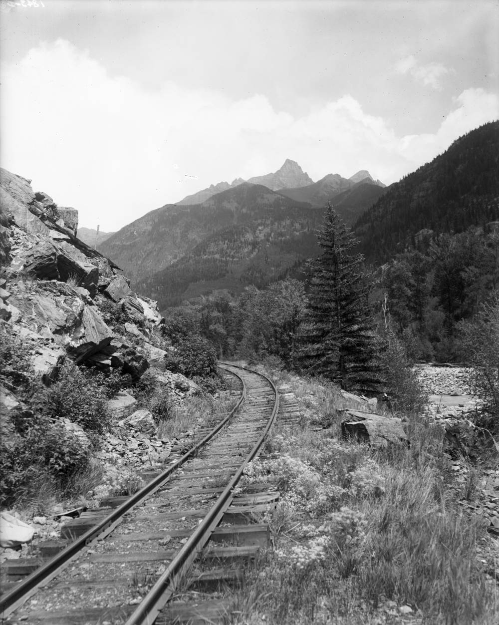
View of Denver and Rio Grande (Silverton Branch) Railroad tracks and the Animas River in San Juan County, Colorado; shows the Needle Mountains. Summer, 1911. Denver Public Library Special Collections
Density concerns, soundscapes and dark skies, wildlife impacts, preservation of the Animas River Corridor, and water and sanitation demands are only half of the issues Animas Valley residents face if a proposed luxury RV park is approved by La Plata County. Residents of the Animas Valley have also questioned the legality of the proposed RV park in terms of zoning. A preliminary sketch plan of the development targeting 876 Trimble Lane (County Road 252) was approved by the La Plata County Planning Commission in January and is now moving through a minor land-use permit process. Arizona-based developer Scott Roberts wants to build a 306-stall luxury RV park, which includes 49 tiny homes the proposal calls “adventure cabins.” But some residents fear the scope of the potential development would impede on the rural lifestyle they enjoy.
The Animas Valley Action Coalition, a community group organized to protect the Animas Valley from developments that pose major impacts to the area, hosted a meeting Saturday at the Durango Public Library to discuss impacts and continue the conversation about Roberts’ RV park. About 58 residents and friends of the Animas Valley gathered to hear two presentations about the history of the valley and an opportunity to protect the Animas River Corridor. Tom Penn said AVAC community members have different expectations of the RV park proposal. Some people don’t want an RV park to be built at all and others would prefer a smaller development.
The county Department of Public Works says in a news release that the threat of flooding in the county from rapid snowmelt primarily poses a flood threat on the Colorado and Gunnison rivers, but several creeks and washes also can be at significant risk of flooding.
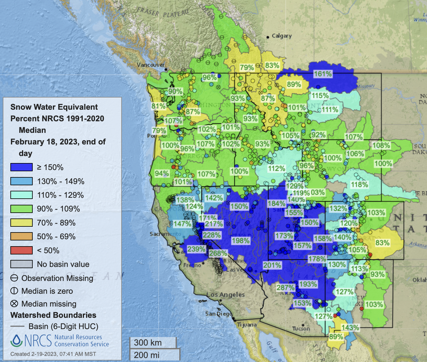
Colorado’s snowpack on Friday was at 133% of median for that date, according to the Natural Resources Conservation Service. Snowpack is at 143% of normal in the Yampa/White river basins, 123% in the upper Colorado River Basin in Colorado, 159% in the Gunnison River Basin and 184% in the combined San Juan/Dolores/San Miguel/Animas basins…Snowpack at three measurement sites on Grand Mesa ranges from 137% to 238% of normal. The Columbine Pass site on the Uncompahgre Plateau is holding four times the normal amount of snow for this time in April.
Flooding already has occurred in places such as Dolores, Montrose County and Hayden in Routt County. Delta County and the city of Delta have been making preparations for high waters on waterways including the Gunnison and Uncompahgre rivers, through measures ranging from checking and cleaning culverts and storm drains…Gudorf said anywhere from Palisade to Fruita along the Colorado River has potential for flooding in lower-lying areas…Among other areas she is concerned about are Plateau Creek, and the Dolores River in Gateway. She said drainages in the Redlands area also may be susceptible to high waters from snow melting at higher elevations…
Gudorf said that when temperatures started warming up quickly a while back she got nervous about rapidly increasing runoff, but the cooldown that followed gave her some hope for a slow but steady runoff season. But she said a lot of snowmelt needs to come off Grand Mesa. Another concerning factor is a recent windstorm that deposited dust on a lot of Colorado’s mountains, which can accelerate snowmelt as the dark dust absorbs heat from the sun.
The Bureau of Reclamation has scheduled an increase in the release from Navajo Dam from 300 cubic feet per second (cfs) to 500 cfs for Friday, April 21st, at 4:00 AM.
The San Juan River’s Navajo Dam and reservoir. Photo credit: U.S. Bureau of Reclamation
From email from Reclamation (Susan Novak Behery):
At 9:00 AM on April 20th (Thursday), the release at Navajo Dam will be transferred to the 4×4 Auxiliary outlet for a period of 2 hours to allow for SCADA testing. During this time, the release volume will not change. The release will be transferred back to the power plant after the 2-hour test has concluded. You may expect some silt and discoloration downstream in the river during this time due to the location of the 4×4.
The San Juan River peaked at 1,700 cubic feet per second (cfs) at midnight and 12:45 a.m. on April 12 — above the medians for those times that are near 400 cfs.
Click the link to read the article on The Denver Post website (Bruce Finley). Here’s an excerpt:
Mountain snow-melting intensified this week with an unusually abrupt “flick of the switch” from cold to hot, leading to flooding that on Thursday cut off northwestern Colorado’s main transportation route and forced a shutdown of schools. The statewide heat that brought Denver temperatures to 85 degrees, breaking two records, combined with mountain snowpack more than a third above the norm, also has boosted the potential for early replenishment of water supply reservoirs, including those along the Colorado River…
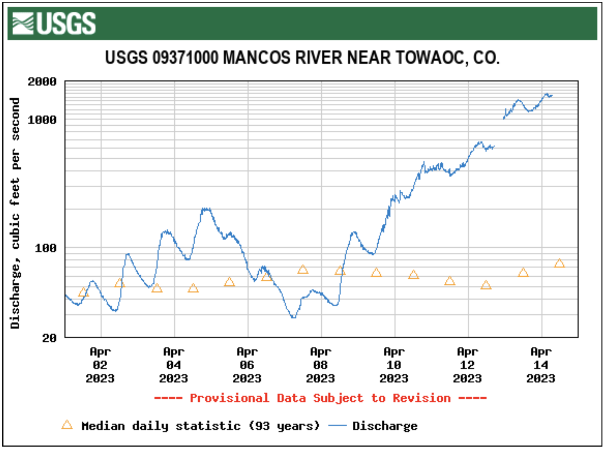
But rapid melting here and around the Southwest this week has brought higher-than-expected flows in rivers, such as the Mancos River in southwestern Colorado, along U.S. 160, and in the Yampa River in northwestern Colorado, along U.S. 40…Water in the Yampa and tributaries on Thursday gushed over banks and submerged a bridge near Hayden, forcing state transportation officials to close U.S. 40, the main transportation route in northwestern Colorado, between Steamboat Springs and Craig…
As the Mancos River swelled near Cortez, Montezuma County officials who had anticipated possible flooding in May or June suddenly faced those perils a month early.
Reservoir manager Ken Beck says wryly that he has lots of water coming his way, “and I need a hole to put it in.”
In southern Colorado, Beck is the superintendent of Pine River Irrigation District and Vallecito Reservoir, which catches water from the 13,000 and 14,000-foot-high peaks of the Weminuche Wilderness. It’s a place so wild and beautiful that Teddy Roosevelt protected it in 1905 by creating the 1.8-million-acre San Juan National Forest.
Vallecito Lake via Vallecito Chamber
The name Vallecito means “little valley” in Spanish, and the reservoir stores water for the town of Bayfield, population 2,838, as well as providing supplemental irrigation for 65,000 acres of Tribal and non-tribal land to the south.
This winter, Beck has been faced with a near-record snowpack, now expected to turn into some 320,000 acre-feet of water. His 82-year-old reservoir, however, can only hold 125,000 acre-feet. What’s more, snow was still falling in early April.
In late March, Beck saw moisture going up dramatically. Any reservoir manager has to deal with uncertainty, but Beck’s job, which he has held for seven years, has an Achilles heel.
“I was told by the Bureau (of Reclamation) to manage my reservoir so I don’t use my spillway,” he says. “We’re restricted because of the needed repairs.”
Spillways are critical elements of any dam. When oncoming water overwhelms the intakes for hydroelectric and outlet works, excess water flows into the river below. Beck has few options without the safety valve of a dependable spillway, yet he may be forced to use it.
Lawn Lake Flood
Beck is well aware that dams can fail. Six major dams have failed in Colorado since 1950, with the biggest disaster occurring in Larimer County, in 1981. When its Lawn Lake Dam failed, three people died and property damage amounted to $31 million.
Beck says Vallecito’s management challenges came to the fore after “the big wakeup call of 2017, when Lake Oroville fell apart in California.” California’s tallest dam, Oroville, resembles Vallecito in being earthen built. It nearly failed when its spillways began eroding during high runoff.
Soon after, Vallecito’s dam was closely inspected, revealing leaks and erosion in its spillway. The Bureau of Reclamation, which built the dam, patched up the spillway but also put the dam “under review.”
By the end of March, Beck had released 15 times more water daily than during the previous month. By late April, Beck estimates, the formerly half-empty Vallecito Reservoir be just 20% full, better prepared for what could be an epic snowmelt.
In the arid West, this makes Beck a reservoir apostate. Spring is when reservoir managers follow a creed that’s been honed during periodic drought: Store as much water as possible as early as possible.
For Beck, that’s not wise. “But don’t mistake my being meek as weak,” he says. “I’ve got an Abe Lincoln style: Wrap good people around you and encourage them to say things you might not want to hear.”
Beck has surrounded himself with a team of straight shooters, though he relies most on Susan Behery, a Bureau of Reclamation hydrologic engineer, based in Durango. With Behery’s advice, Beck decided that Vallecito’s reservoir needed to be dramatically drawn down.
Evidence for doing that was obvious this winter as roofs sagged, driveways became mini-canyons, and snow at the nearby Purgatory ski area outside Durango reached 20 feet high in places. USDA SNOTEL sites above Vallecito Reservoir measured snowpacks at 170% and 180% of normal.
With so much big water ready to head their way, a reservoir manager might have decided to operate quietly and hope for the best. Instead, Behery says, Beck has been transparent with the public and collaborative. She admires Beck for it.
“I’m an engineer and nobody gets into engineering because they’re super good with people. I don’t do the fluffy stuff.”
Beck makes a lot of information available. He holds open meetings and emails a weekly newsletter to anyone interested. “A lot of people are asking why we’re turning out more water,” he says, “but I just met with farmers that say I haven’t brought it down enough.”
What does Beck predict will happen to his reservoir as snowmelt barrels toward Vallecito Reservoir?
“If spring rains come it will add to the pucker factor. But the spillway will hold.” Meanwhile, he’s a little bit on edge.
Dave Marston is the publisher of Writers on the Range, writersontherange.org, an independent nonprofit dedicated to spurring lively conversation about the West. He lives in Durango, Colorado.
The Navajo Dam on the San Juan River.Photo credit Mike Robinson via the University of Washington.
From email from Reclamation (Susan Novak Behery):
BUREAU OF RECLAMATION NAVAJO UNIT COORDINATION MEETING
Sent via Email on April 10th, 2023
The next coordination meeting for the operation of the Navajo Unit is scheduled for Tuesday, April 18th, 2023, at 1:00 pm. This meeting is open to the public and will be held in an in-person/virtual hybrid format.
*Please note that due to the rapid increase in snowpack this spring, Reclamation projects it is likely that sufficient water will be available to conduct a spring release to 5,000 cfs. The current forecast and plans will be discussed at this meeting. Updates will be sent to this email list as the plan evolves. *
The following attendance options are available:
• In-Person: The physical location of the meeting will be at the Farmington Civic Center, 200 W. Arrington, Farmington, New Mexico.
• Virtual Video attendance: Microsoft Teams video option at this link. This link should open in any smartphone, tablet, or computer browser, and does not require a Microsoft account. You will be able to view and hear the presentation as it is presented, ask questions and have your comments heard by the group.
• Phone line: Alternatively, you can call-in from any phone using the following information: (202) 640-1187, Phone Conference ID 125 691 028#. You will not be able to see the presentation with this option. A copy of the presentation will be distributed to this email list and posted to our website prior to the meeting for those who wish to listen by phone. You will be able to ask questions and have your comments heard by the group.
We hope the options provided make it possible for all interested parties to participate as they are able and comfortable. Please try to log on at least 10 minutes before the meeting start time to address any technical issues. Feel free to call or email me with any questions regarding attendance, or to test your connection prior to the meeting (contact information below).
A copy of the presentation and meeting summary will be distributed to this email list and posted to our website following the meeting. If you are unable to connect to the meeting, feel free to contact me following the meeting for any comments or questions.
The meeting agenda will include a review of operations and hydrology since January, current soil and snowpack conditions, a discussion of hydrologic forecasts and planned operations for remainder of this water year, updates on maintenance activities, drought operations, and the Recovery Program on the San Juan River.
If you have any suggestions for the agenda or have questions about the meeting, please call Susan Behery at 970-385-6560, or email sbehery@usbr.gov. Visit the Navajo Dam website at https://www.usbr.gov/uc/water/crsp/cs/nvd.html for operational updates.
The Southwestern Water Conservation District held its 39th annual seminar Friday [March 31, 2023] in Ignacio to address the topic of “seeking common ground in crisis.”
About 300 people were in attendance, including both chairmen of the Southern Ute and Ute Mountain Ute Indian tribes, ranchers, farmers and officials from agencies involved in water conservation at the federal level all the way down to local districts. U.S. Rep. Lauren Boebert was a surprise guest…The event’s schedule included panels on reusing treated wastewater, seeking common ground in the distribution of the river’s resources, and the connection been food and water for agricultural producers on the Western Slope, Front Range, and the upper and lower Colorado River Basin…From the Front Range farmers, like panelist Robert Sakata, the owner of a 2,400-acre farm nestled in the expanding urban boundaries of Brighton, to lower basin users such as panelist Bart Fisher, a farmer and former chairman of the Colorado River Board of California, the impacts of the historic drought are top of mind. The need to reduce water use has affected what they grow as well as the quantity…
“Buy-and-dry” programs have become a tense topic of conversation among farmers. The concept is to reduce water consumption by paying farmers annually for water to which they have a right but do not use. Although this can be done in any number of ways, the program’s epithet refers to the common method of fallowing – or intentionally not cultivating – land. Despite protections that ensure unused water rights will not be forfeited, as is historically the case, farmers are skeptical. From a financial perspective, the incentive is small. The upper basin program offers only $150 to farmers per acre-foot of water saved (an acre-foot is the amount needed to submerge an acre of land in 1 foot of water), while farmers can typically harness far more in profits from that water if they use it for irrigation.
“When you diminish agriculture significantly by fallowing, you diminish the economic engine of the community that supports agriculture,” Fisher said…
Simon Martinez, the general manager of Ute Mountain Ute Farm and Ranch, said he is more interested in testing out water-efficient crops…Like many farmers looking to save water, the Ute Mountain Ute Farm and Ranch is experimenting with Kernza. The wheatgrass variant can significantly reduce water consumption compared to a crop such as alfalfa…Martinez hopes to test the new grain as potential cattle feed and intends on sowing 46 acres with the seed, likely this spring. Although the concept is experimental – Martinez said the crop has not been grown in the region and its exact efficacy as a cattle feed is unclear – success could mean a significant water savings for the farm. In addition to reducing the amount of water needed to irrigate, which Martinez estimated could near 50% compared to alfalfa, grazing the farm’s herd on Kernza would increase profits by enabling the farm to sell more of the alfalfa that it does produce. The perennial grain has grown in popularity as its viability as an alternative crop becomes increasingly intriguing to farmers. The outdoor brand Patagonia adopted it into the company’s line of sustainable foods and now produces pasta and beer with the grain. Martinez said he is unsure of how the experiment will go. But to test out the grain on 46 acres of the 7,700-acre farm is a small sacrifice…
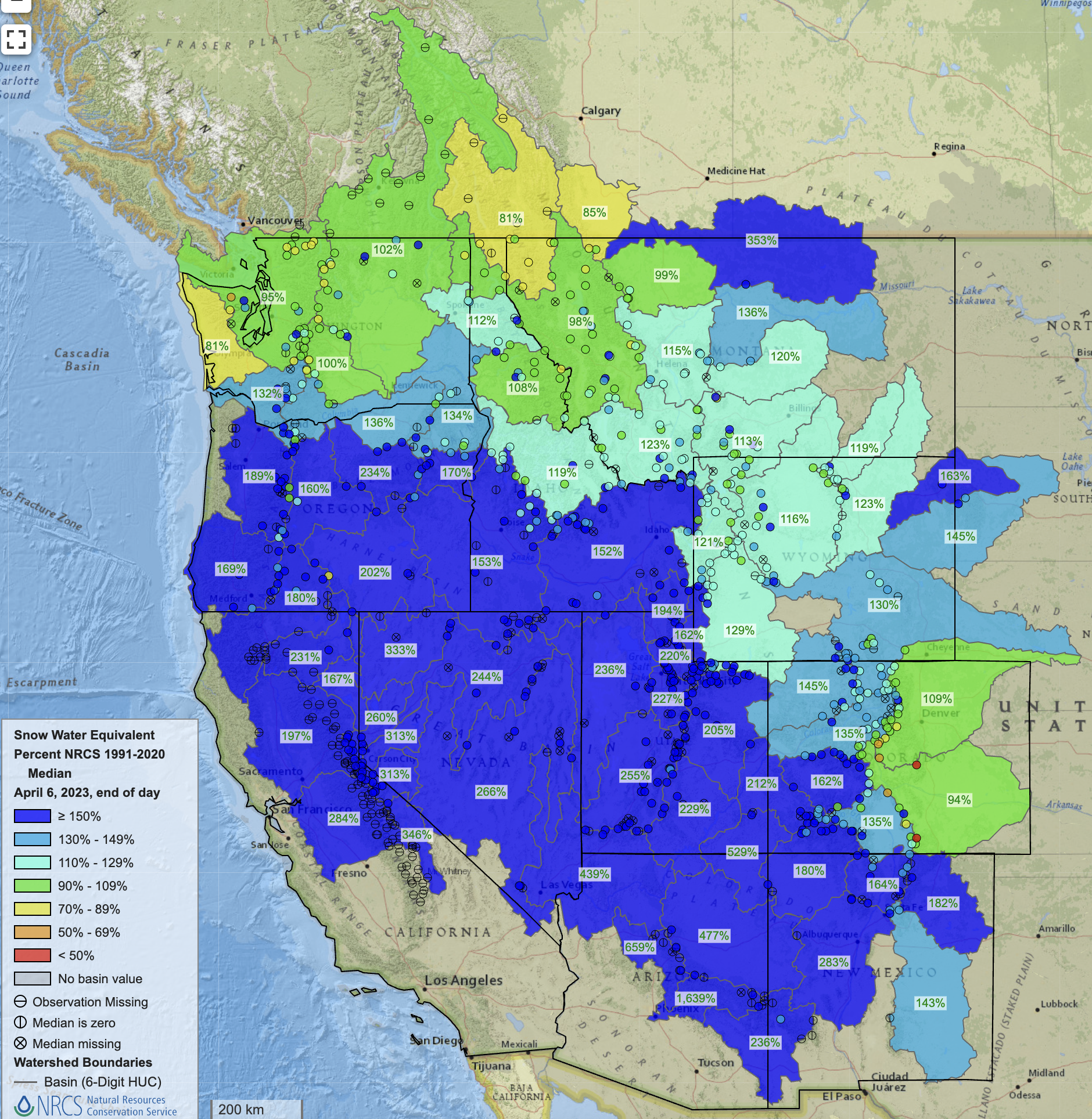
West snowpack basin-filled map April 6, 2023 via the NRCS.
With future weather predictions becoming increasingly unpredictable, farmers are endorsing an array of solutions. Although this year’s ample snowfall does little to reverse the long-term impacts of the historic drought, water aficionados in the Four Corners are nonetheless grateful for the supply.
At its March 9 meeting, the Pagosa Area Water and Sanitation District (PAWSD) Board of Directors ap- proved a 20-year capital investment plan for the district. At the meeting, board president Jim Smith highlighted the amount of work that had gone into the plan and the document’s effectiveness in showing the elements of PAWSD’s system and its mission. The plan details the improvements and replacements that will be needed to maintain and keep the PAWSD system operational over the next 20 years.
Among the largest items are an expected $50,760,382 in upgrades to the Vista wastewater treatment plant to upgrade equipment and maintain compliance with state regulations, an expected $45,982,570 for the construction of the new and expanded Snowball Water Treatment Plant, and an expected $10,969,000 in distribution system costs, much of which will be spent on replacing aging water mains and fire hydrants as well as the addition of a new pump station and the repainting of water storage tanks.
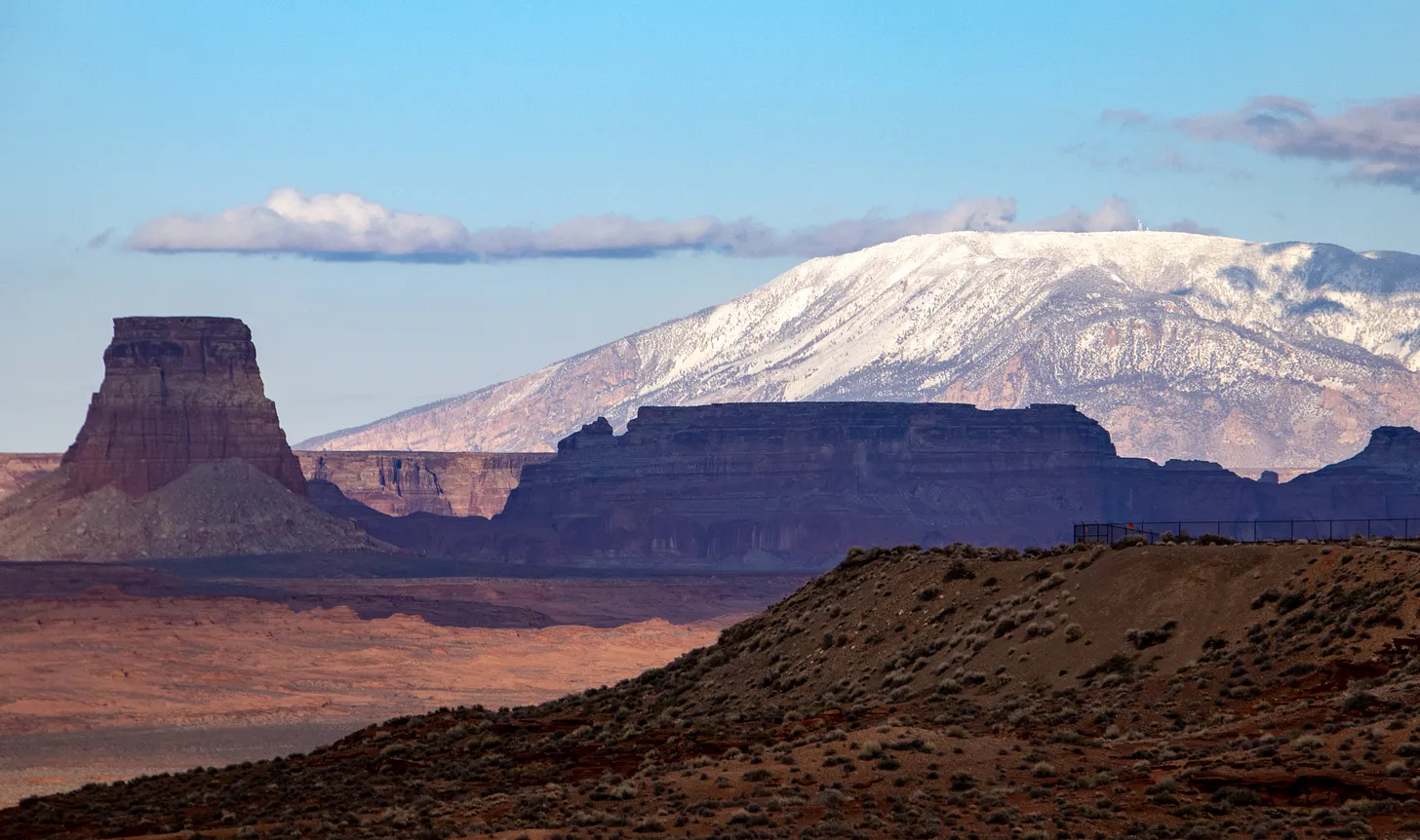
Navajo Mountain March 2023. Jonathan P. Thompson photo.
Click the link to read the article on the Land Desk website (Jonathan P. Thompson):
The rain was relentless, falling steadily and cold from the soggy frogbelly sky all night and all day and all night again. It turned snowy fields into swampy mud bogs and somehow rendered more grisly the decaying elk carcass behind the house — slowly being dismantled by a bobcat, coyotes, neighboring dogs, bacteria and a flock of chattering magpies. In much the same way, the gray-chill drizzle turned a lingering heartache into a throbbing void.
I had to get out. So I did what people do. I got in the Silver Bullet and drove west.
It quickly became clear that the snow line had been only a few hundred feet above Durango, sparing high country folks from some of the rain-induced misery. The La Plata Mountains sparkled under the fresh icing and a post-storm mist softened all the edges as the sun finally burned through low clouds. Skiers lined up to get first tracks at Hesperus. The road was wet with slushy shoulders and it clearly had been a treacherous mess only hours earlier. I shuddered and slowed as I passed the carnage of a previous night’s crash: On one side of the highway a pickup truck’s bed was gnarled beyond recognition while on the other a crumpled semi truck’s cab had lodged itself between two ponderosa pines.
San Juan River Basin. Graphic credit Wikipedia.
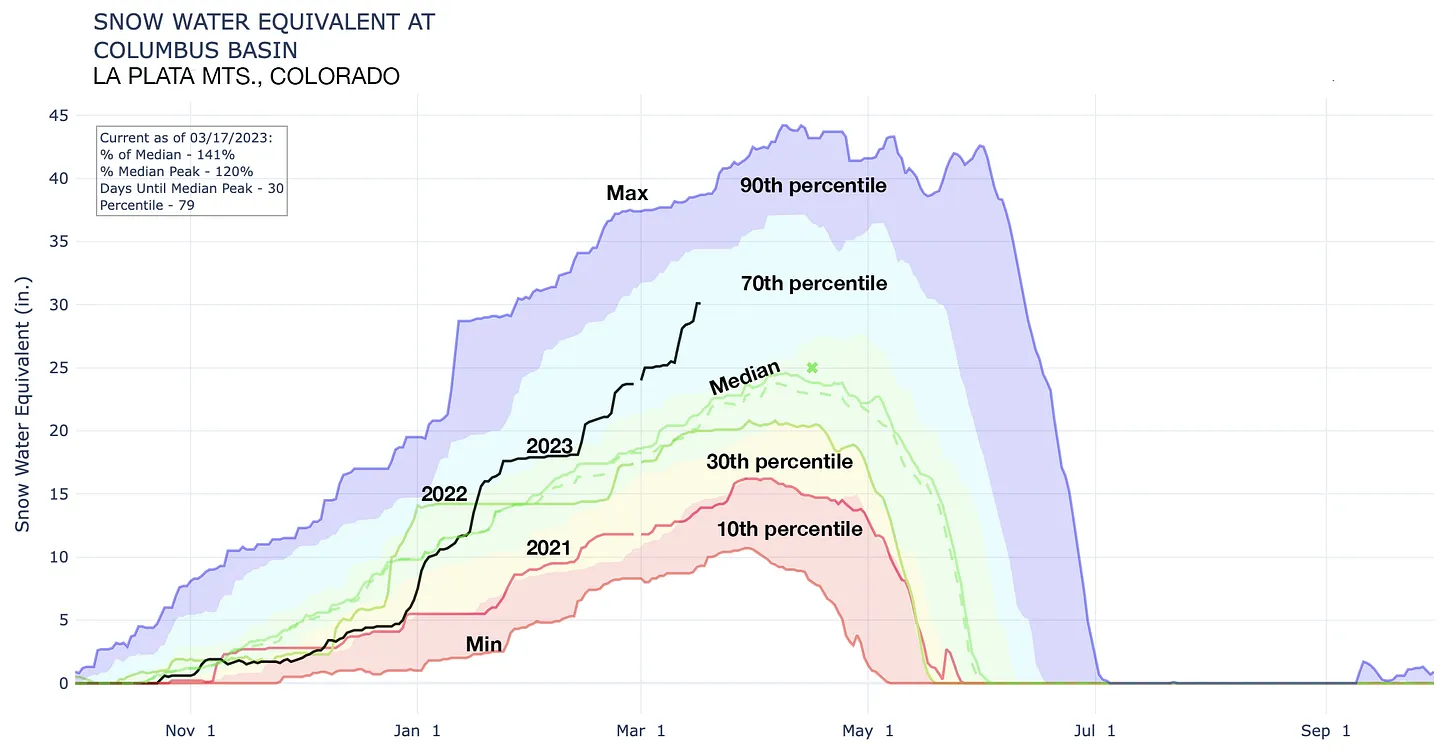
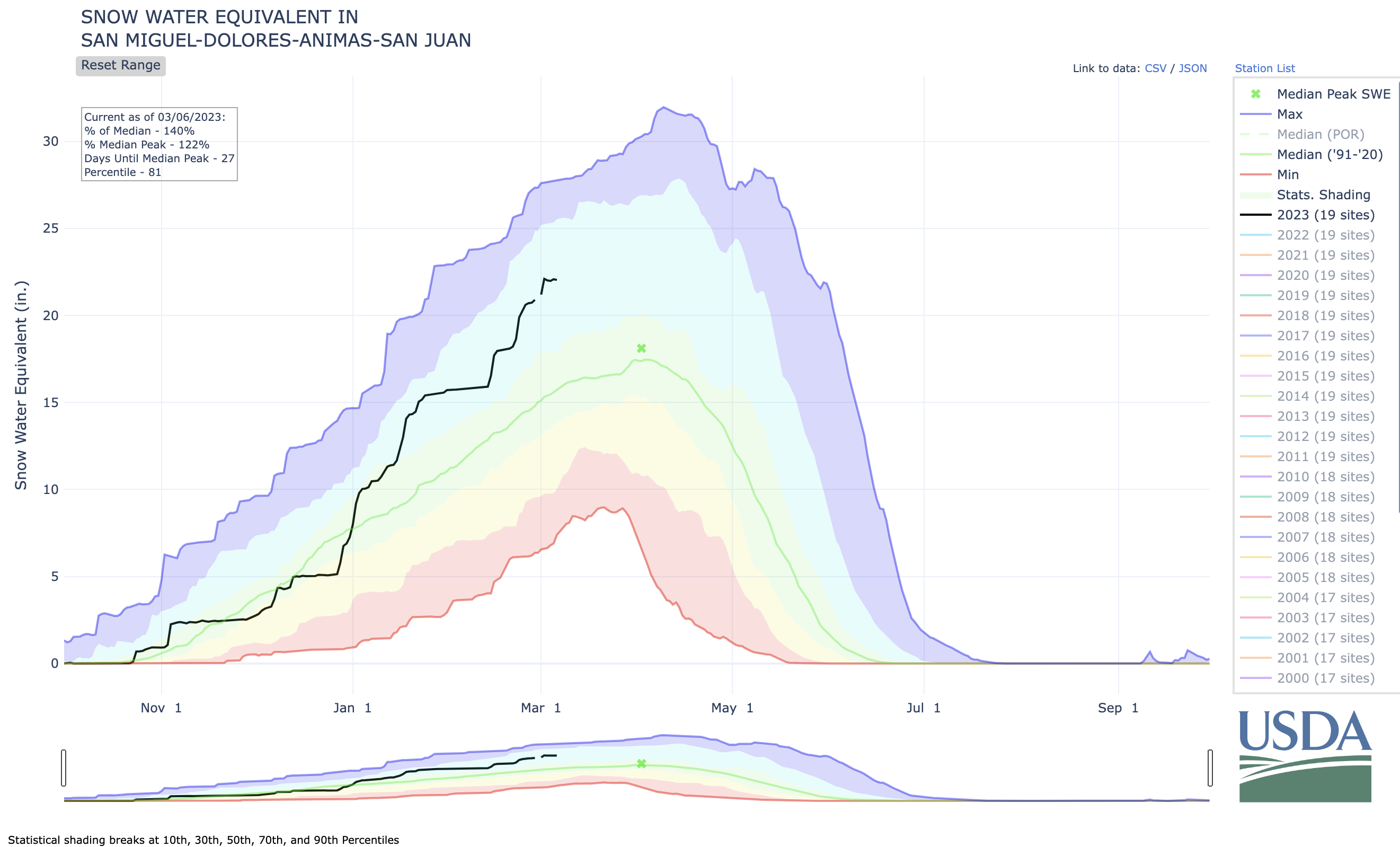
The aridification of the last couple decades has hit the La Platas especially hard. Even when the southwest Colorado range gets good snow, it tends to melt out more quickly than in the higher mountains to the north, leaving little more than trickles in the La Plata and Mancos River beds come mid-summer. But this year the range has been a major beneficiary of the abundance: The Columbus Basin SNOTEL station is now recording snow water equivalents far above the median peak, which usually happens in mid-April.
Light fog enveloped Mancos Hill and I worried for a moment that I would never escape its depressive hold. But then, just outside Mancos, blue sky and the snow-covered form of Ute Mountain, veiled with clouds.
Just west of Cortez a warning of sorts to not leave the pavement without assessing the solidity of the road: Not one, but two trucks up to their axles in red, goopy, shoe-stealing mud in someone’s driveway. I later read that those folks were relatively lucky. The night before a giant sinkhole had formed on a county road north of Cortez and a motorist drove into it. Another highway in the county was closed due to flooding.
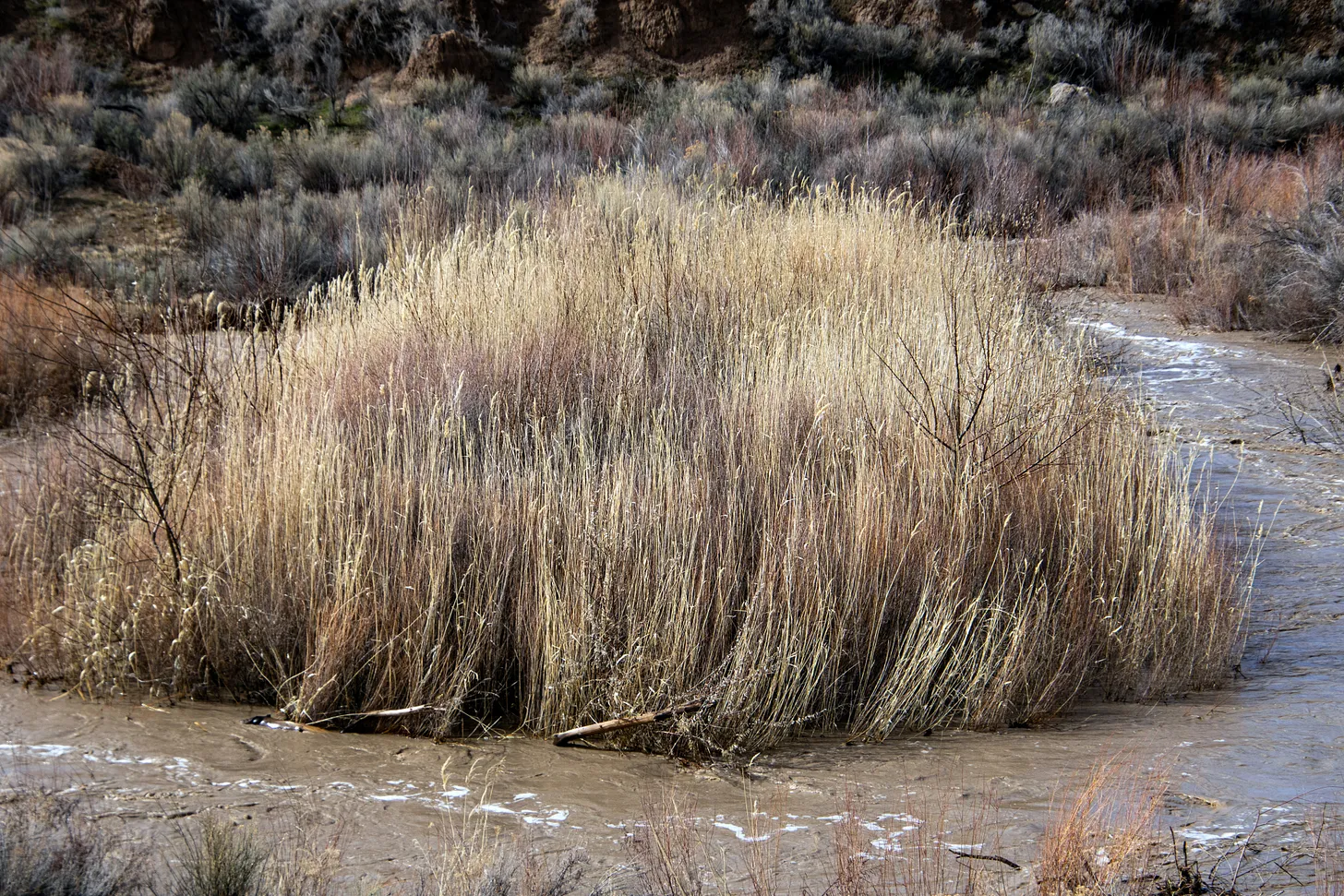
Grass and McElmo Creek, March 16, 2023. Jonathan P. Thompson photo.
I half-expected the apricot trees to be blooming in McElmo Canyon, but the only sign that spring was imminent was the pinot noir-hue the willows take on this time of year, when the earth thaws and the days grow longer. Soon it will all be carpeted with green contrasting with the pink sandstone.
McElmo Creek raged as it wound its way through beige fields and cottonwood groves, past beat-up single-wides and million-dollar spreads, among willows and the rare un-grazed patch of tall grass. I pulled over tentatively, praying that the graveled pullout wouldn’t turn to liquid under the wheels. It held, but when I tried to walk up a little trail to a Puebloan site, my shoes caked up with wet, sticky clay. I took a picture of the creek, instead, which peaked at 534 cubic feet per second during this storm, higher even than during last summer’s monsoon. San Juan River spring break rafters will get a nice boost from the elevated flows, though rowing through the storm must have been a nightmare.
Comb Ridge and the Abajos under a cloudless blue sky. Jonathan P. Thompson photo.
The landscape looked drier as I progressed westward, but it wasn’t. Every pothole on every stretch of slickrock held a liquid mirror reflecting the cloud-dappled blue sky. I gazed with wonder at a group of cowpokes driving a herd of healthy-looking black cattle through the sagebrush near Butler Wash. How did they keep from sinking up to the horses’ bellies?
Comb Wash was a roiling red river. Any designs I may have had on camping in Valley of the Gods were foiled by a stream crossing the road. Camping anywhere off the asphalt was out of the question, really; I’d have to find a hotel room in Page, instead. The good news is that the moisture kept the blistering winds from lifting up the desert dust and depositing on all that snow.
The Bears Ears were covered in white; the Abajos snowier than I’ve ever seen; Navajo Mountain rose up glistening from the burnished red earth.
The outflow at the bottom of Navajo Dam in New Mexico. Photo: Brent Gardner-Smith/Aspen Journalism
From email from Reclamation (Susan Novak Behery):
At 8:00 AM, March 20th, 2023 (Monday), the release at Navajo Dam will be transferred to the 4×4 Auxiliary outlet, where the release will be reduced to the minimum of 250 cfs. The outage at the main outlet works and minimum release will accommodate maintenance work at the City of Farmington’s hydroelectric plant and instream work for the Turley Manzanares Ditch Company Diversion Dam Rehabilitation Project. The release will be transferred back to the power plant and increased back to its current level at 11:00 AM on March 24th, 2023 (Friday). You may expect some silt and discoloration downstream in the river during this time due to the location of the 4×4.
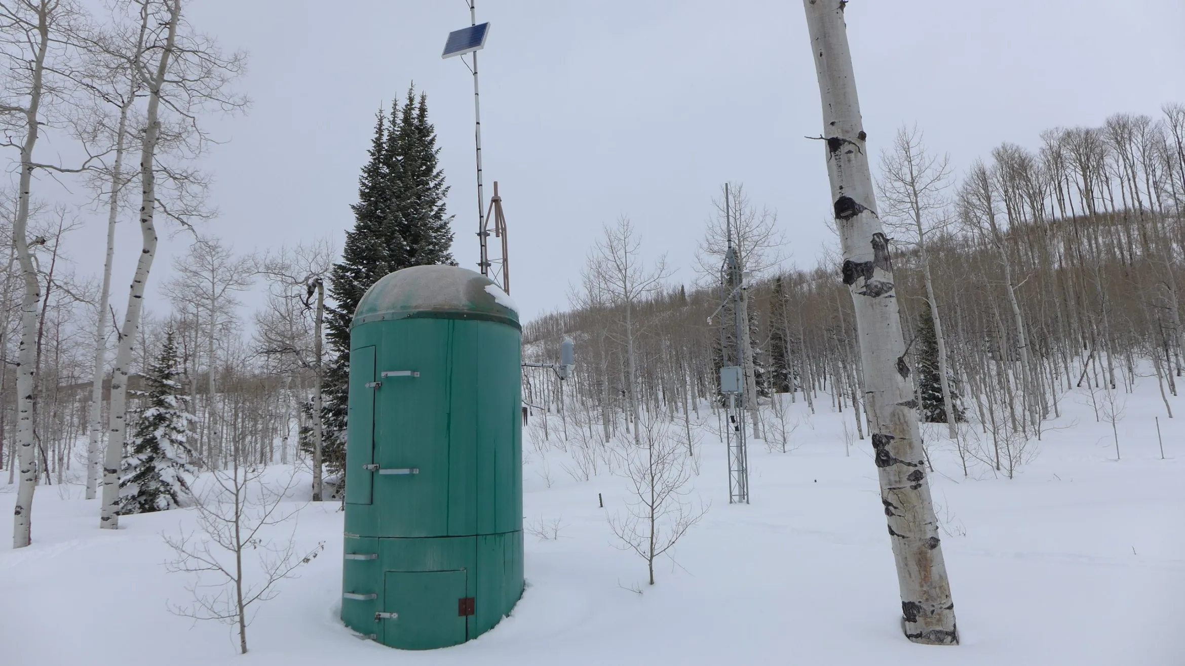
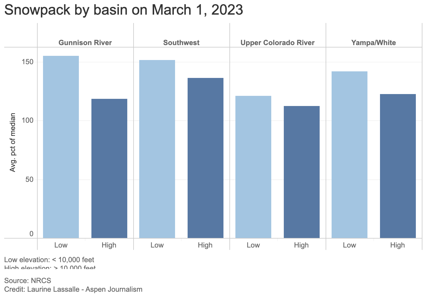
This SNOTEL site at about 8,774 feet at the top of McClure Pass was measuring 154% of median snowpack on March 1, 2023. Lower elevation SNOTEL sites across the West Slope are showing a higher percentage of median snowpack than those at a higher elevation (above 10,000 feet). CREDIT: HEATHER SACKETT/ASPEN JOURNALISM
Snowpack on the Western Slope is tracking above average for this time of year, which has some forecasters feeling optimistic about spring runoff. But there is also an interesting phenomenon that they don’t yet know what to make of.
The snow-water equivalent — a measure of how much water is contained in the snowpack — for the headwaters of the Colorado River stands at 116% of average. That number is measured by snow telemetry (SNOTEL) sites, which are remote sensing stations throughout the West’s mountainous watersheds that collect weather and snowpack data.
Most of the lower-elevation SNOTEL sites (10,000 feet and below) have a higher percentage of median snowpack than high-elevation sites (above 10,000 feet). For example, in the Colorado basin, low-elevation SNOTELs are at a combined 121% of average while high-elevation ones are at 112% of average.
This trend holds true across the Western Slope with the Gunnison, Southwest and Yampa/White/Green river basins at 155%, 152% and 142% of average, respectively, for low-elevation sites and 119%, 136% and 122% for high-elevation sites. In the Roaring Fork basin, snowpack is at 110% for the four high-elevation sites and 134% for the four low-elevation sites.
“I can pretty confidently say sites below 10,000 feet have that trend pretty clearly exhibited,” said Karl Wetlaufer, a hydrologist and assistant supervisor at the National Resources Conservation Service’s Colorado Snow Survey. “It’s certainly an interesting observation.”
Why this counterintuitive trend is occurring is unclear. This winter’s storm patterns may be favoring lower elevations. Or colder-than-average temperatures and overcast days in February may have allowed the snowpack at lower elevations to continue accumulating. The February temperatures for western Colorado were on average about 2 degrees below normal, according to the NRCS.
“We’ve been cloudier, colder, and that has probably helped prevent some melting at lower elevations that might typically take place,” said assistant state climatologist Becky Bolinger. “We will definitely want to look into why the lower elevations are performing so much better than the higher elevations.”
Snowpack above average
Snowpack overall on the Western Slope is above average, with some basins — the southwest, which includes the San Miguel, Dolores, Animas and San Juan rivers and the northwest, which includes the Yampa, White and Little Snake rivers — already surpassing the average seasonal peak. Snowpack typically peaks the first week or two in April.
What more snow at lower elevations means for the timing of this spring’s runoff is also unclear, but forecasters say runoff volume should be above average.
“Big picture, this year is looking very, very favorable for all of western Colorado, and it’s a really big turnaround from the last couple of years,” Wetlaufer said. “It’s kind of tough to parse out the impact of this lower-elevation snow being at a higher percent of median than higher-elevation snow, but, in a general sense, I would certainly say it’s quite encouraging for ample snowmelt runoff this season.”
This is partly because lower elevations encompass more surface area than higher ones; there is simply more land below 10,000 feet than above, and if it is covered in an above-average snowpack, that is a good thing for streams and soils.
“Having that lower-elevation snowpack is going to help keep soil-moisture levels high, which can help the efficiency of the higher-elevation snow when it does melt at a later date,” Wetlaufer said. “Substantial low-elevation snow is going to wet up the soil conditions and allow most of that snowmelt to actually transition to the stream channel.”
In recent dry years, thirsty soils have sucked up runoff before it made it to streams. For example, 2021 was historically bad, with an upper basin snowpack that peaked about 90% of average but translated to only 36% of average runoff into Lake Powell, according to the U.S. Bureau of Reclamation. It was the second-worst runoff on record after 2002.
Although water managers are feeling confident that this year will be better and give a boost to depleted reservoirs in Colorado, they caution that one good year is not enough to pull the entire system out of a crisis. Lake Powell, which is the storage bucket for the upper basin states of Colorado, Utah, New Mexico and Wyoming, is at about elevation 3,521 feet, or about 23% full, the lowest since filling.
“Is this going to solve the Lake Powell and Lake Mead crisis? Not even close,” Bolinger said. “But the forecasted inflows into Powell are above average right now. There’s a silver lining there.”
Aspen Journalism covers water and rivers in collaboration with The Aspen Times.
Click the link to read the article on the Pagosa Sun website (Randi Pierce and Josh Pike). Here’s an excerpt:
A snow report from Wolf Creek Ski Area dated approximately 6 a.m. on March 1 indicates that Wolf Creek has received 9 inches of snow in the prior 24 hours and 11 inches in the prior 48 hours. According to the report, this brings the midway snow depth to 119 inches and the year-to-date snowfall total to 339 inches. According to the U.S. Department of Agriculture National Water and Climate Center’s snowpack report, the Wolf Creek summit, at 11,000 feet of elevation, had 32.6 inches of snow water equivalent as of 10 a.m. on March 1. TheWolf Creek summit was at 134 percent of the March 1 snowpack median.
The San Miguel, Dolores, Animas and San Juan river basins were at 140 percent of the March 1 median in terms of snowpack.
The Navajo Dam on the San Juan River.Photo credit Mike Robinson via the University of Washington.
From email from Reclamation (Susan Novak Behery):
On the morning of March 20th, 2023 (Monday), the release at Navajo Dam will be transferred to the 4×4 Auxiliary outlet, where the release will be reduced to the minimum of 250 cfs. The outage at the main outlet works and minimum release will accommodate maintenance work at the City of Farmington’s hydroelectric plant and instream work for the Turley Manzanares Ditch Company Diversion Dam Rehabilitation Project. The release will be transferred back to the power plant and increased back to its current level on the morning of March 24th, 2023 (Friday). The exact times are to be determined, and will be announced the week prior to the operation. You may expect some silt and discoloration downstream in the river during this time due to the location of the 4×4.
Another heavy winter storm hit Pagosa Country this week, bringing the closure of schools and other facilities, U.S. 160 over Wolf Creek Pass and Wolf Creek Ski Area on Feb. 22. According to the Community Collaborative Rain Hail and Snow Network website, snowfall ranged widely, with 1.5 to 7 inches of snow falling across Archuleta County be- tween Feb. 21 and 1 p.m. on Feb. 22. A 6 a.m. snow report from Wolf Creek Ski Area indicates that the slopes would be closed on Wednesday [ due to high winds, low visibil- ity and blowing snow, although it stated that Wolf Creek is expected to reopen on Thursday, Feb. 23. The report also notes that Wolf Creek had received 10 inches of snow in the storm so far, bring- ing the midway snow depth to 98 inches and the year-to-date snowfall total to 289 inches.
According to the U.S. Department of Agriculture National Water and Climate Center’s snowpack report, the Wolf Creek summit, at 11,000 feet of elevation, had 27.9 inches of snow water equivalent as of 1 p.m. on Wednesday, Feb. 22. The Wolf Creek summit was at 121 percent of the Feb. 22 snowpack median.
The San Miguel, Dolores, Animas and San Juan river basins were at 132 percent of the Feb. 22 median in terms of snowpack.
The Pagosa Area Water and Sanitation District (PAWSD) Board of Di- rectors discussed the San Juan Water Conservancy District’s (SJWCD’s) recently set target reservoir size of 11,000 acre-feet and the future of the Running Iron Ranch property at its Feb. 9 meeting. PAWSD secretary Bill Hudson opened the discussion, highlight- ing that SJWCD commissioned a water demand study by Wilson Water Group and that he had distributed his criticism of this study to the board. He added that SJWCD adopted the goal of an 11,000 acre-foot reservoir and that PAWSD estimates of growth for the district are lower than those indicated in the Wilson Water Group study, with PAWSD’s drought management plan expect- ing approximately 2 percent annual population growth.
Hudson commented that the Growing Water Smart group, which was largely funded by SJWCD, had estimated approximately 1.7 or 1.6 percent annual growth.
“So, I don’t see any real justification for coming to a conclusion that the Dry Gulch reservoir should be 11,000 acre-feet and that … we should guess at 5 percent growth — three times what the Growing Water Smart group advised us,” Hudson said.
PAWSD vice president Glenn Walsh commented that 5 percent growth is “literally impossible.”
West snowpack basin-filled map February 18, 2023 via the NRCS
Click the link to read the article on the Pagosa Springs Sun website (Josh Pike). Here’s an excerpt:
Heavy snows have come again to Pagosa Country, with sites in Archuleta County receiving be- tween 6.1 and 13.1 inches of snow in the storms between Tuesday, Feb. 14, and 11 a.m. on Feb. 15, according to the Community Col- laborative Rain Hail and Snow Network website. Higher snowfall totals were concentrated in the northern and southern portions of the county, with the highest reported precipitation amount reported north of Pagosa Springs near Piedra Road.
A 6 a.m. Feb. 15 report from Wolf Creek Ski Area indicates that Wolf Creek had received 22 inches of snow in the previous 24 hours and 25 inches in the last week, bringing the midway snow depth to 101 inches and the year-to-date snow- fall total to 275 inches. According to the U.S. Department of Agriculture National Water and Climate Center’s snowpack report, the Wolf Creek summit, at 11,000 feet of elevation, had 26.3 inches of snow water equivalent as of 11 a.m. on Wednesday, Feb. 15. The Wolf Creek summit was at 121 percent of the Feb. 15 snow- pack median.
The San Miguel, Dolores, Animas and San Juan River basins were at 134 percent of the Feb. 15 median in terms of snowpack.
River Report
Stream flow for the San Juan River at approximately 11 a.m. on Feb. 15 was 66.3 cubic feet per second (cfs), according to the U.S. Geological Service National Water Dashboard. This reading is up slightly from last week’s reading of 55.9 cfs at 11 a.m. on Feb. 8. According to a Feb. 13 press release from Pagosa Area Water and Sanitation District (PAWSD) Manager Justin Ramsey, Lake For- est and Village Lake are full.
At its Jan. 30 meeting, the Pagosa Area Water and Sanitation Dis- trict (PAWSD) Board of Directors discussed state-mandated modi- fications to the Vista Wastewater Treatment Plant that come with a potential cost of $15 million during a public hearing on a potential State Revolving Fund (SRF) loan for the project. The modifications are intended to improve nutrient removal and allow the plant to comply with new state nutrient standards. Nutrient removal involves the removal of nutrients such as phosphorus or nitrogen, which can be damaging to drinking water and aquatic environments in high quan- tities, from wastewater.
According to the Colorado De- partment of Public Health and Environment (CDPHE), such nutrients from the Vista plant could impact both nearby drinking water wells and the Piedra River, claims disputed by PAWSD.
The hearing opened with PAWSD District Manager Justin Ramsey ex- plaining, in response to a question from board member Gene Tautges, that PAWSD is currently pursuing a “political route” in its efforts to delay the modifications and that it had some initial communication with Colorado Sen. Cleave Simpson.
According to PAWSD District Manager Justin Ramsey, the rate changes took effect immediately upon approval. According to the board packet for the meeting and as explained by PAWSD Director of Business Services Aaron Burns, the rate increases include a 6 percent increase in water rates and a 2.5 percent increase in wastewater rates.
With these changes, according to agenda documentation, the monthly service charge for water will rise from $29.66 to $31.44 per equivalent unit (EU). The volume charge per 1,000 gallons for between 2,001 and 8,000 gallons of usage will rise from $5.32 to $5.64, while the volume charge per 1,000 gallons for between 8,001 and 20,000 gallons of usage will increase from $10.65 to $11.29. The volume charge per 1,000 gallons for more than 20,001 gal- lons of usage will increase from $13.37 to $14.17. The water fill station charge per 1,000 gallons will increase from $11.49 to $12.18, while the water availability of service and waste- water availability of service fees remain the same at $14.30 and $12.50 respectively. According to the documenta- tion, the wastewater monthly service charge will rise from $32 to $32.80.
Prior to unanimously approving the rate changes, the board held a public hearing on the issue where it received no public comments concerning the altered rates.
Sign in the Lisbon Valley of southeastern Utah. Jonathan P. Thompson photo.
Click the link to read the article on the ProPublica website, by Mark Olalde, Mollie Simon and Alex Mierjeski, video by Gerardo del Valle, Liz Moughon and Mauricio Rodríguez Pons
ProPublica is a Pulitzer Prize-winning investigative newsroom. Sign up for The Big Story newsletter to receive stories like this one in your inbox.
In America’s rush to build the nuclear arsenal that won the Cold War, safety was sacrificed for speed.
Uranium mills that helped fuel the weapons also dumped radioactive and toxic waste into rivers like the Cheyenne in South Dakota and the Animas in Colorado. Thousands of sheep turned blue and died after foraging on land tainted by processing sites in North Dakota. And cancer wards across the West swelled with sick uranium workers.
The U.S. government bankrolled the industry, and mining companies rushed to profit, building more than 50 mills and processing sites to refine uranium ore.
But the government didn’t have a plan for the toxic byproducts of this nuclear assembly line. Some of the more than 250 million tons of toxic and radioactive detritus, known as tailings, scattered into nearby communities, some spilled into streams and some leaked into aquifers.
Congress finally created the agency that now oversees uranium mill waste cleanup in 1974 and enacted the law governing that process in 1978, but the industry would soon collapse due to falling uranium prices and rising safety concerns. Most mills closed by the mid-1980s.
When cleanup began, federal regulators first focused on the most immediate public health threat, radiation exposure. Agencies or companies completely covered waste at most mills to halt leaks of the carcinogenic gas radon and moved some waste by truck and train to impoundments specially designed to encapsulate it.
But the government has fallen down in addressing another lingering threat from the industry’s byproducts: widespread water pollution.
Moab tailings site with Spanish Valley to the south
Regulators haven’t made a full accounting of whether they properly addressed groundwater contamination. So, for the first time, ProPublica cataloged cleanup efforts at the country’s 48 uranium mills, seven related processing sites and numerous tailings piles.
At least 84% of the sites have polluted groundwater. And nearly 75% still have either no liner or only a partial liner between mill waste and the ground, leaving them susceptible to leaking pollution into groundwater. In the arid West, where most of the sites are located, climate change is drying up surface water, making underground reserves increasingly important.
ProPublica’s review of thousands of pages of government and corporate documents, accompanied by interviews with 100 people, also found that cleanup has been hampered by infighting among regulatory agencies and the frequency with which regulators grant exemptions to their own water quality standards.
The result: a long history of water pollution and sickness.
Reports by government agencies found high concentrations of cancer near a mill in Utah and elevated cancer risks from mill waste in New Mexico that can persist until cleanup is complete. Residents near those sites and others have seen so many cases of cancer and thyroid disease that they believe the mills and waste piles are to blame, although epidemiological studies to prove such a link have rarely been done.
“The government didn’t pay attention up front and make sure it was done right. They just said, ‘Go get uranium,’” said Bill Dixon, who spent decades cleaning up uranium and nuclear sites with the state of Oregon and in the private sector.
Tom Hanrahan grew up near uranium mills in Colorado and New Mexico and watched three of his three brothers contract cancer. He believes his siblings were “casualties” of the war effort.
“Somebody knew that this was a ticking atomic bomb,” Hanrahan said. “But, in military terms, this was the cost of fighting a war.”
A Flawed System
When a uranium mill shuts down, here is what’s supposed to happen: The company demolishes the buildings, decontaminates the surrounding soil and water, and encases the waste to stop it from leaking cancer-causing pollution. The company then asks the Nuclear Regulatory Commission, the lead agency monitoring America’s radioactive infrastructure, to approve the handoff of the property and its associated liability to the Department of Energy’s Office of Legacy Management for monitoring and maintenance.
ProPublica’s analysis found that half of the country’s former mills haven’t made it through this process and even many that did have never fully addressed pollution concerns. This is despite the federal government spending billions of dollars on cleanup, in addition to the several hundred million dollars that have been spent by companies.
Often, companies or agencies tasked with cleanup are unable to meet water quality standards, so they request exemptions to bypass them. The NRC or state agencies almost always approve these requests, allowing contaminants like uranium and selenium to be left in the groundwater. When ingested in high quantities, those elements can cause cancer and damage the nervous system, respectively.
Bill Dam, who spent decades regulating and researching uranium mill cleanup with the NRC, at the DOE and in the private sector, said water pollution won’t be controlled until all the waste and contaminated material is moved. “The federal government’s taken a Band-Aid approach to groundwater contamination,” he said.
The pollution has disproportionately harmed Indian Country.
Six of the mills were built on reservations, and another eight mills are within 5 miles of one, some polluting aquifers used by tribes. And the country’s last conventional uranium mill still in operation — the White Mesa Mill in Utah — sits adjacent to a Ute Mountain Ute community.
So many uranium mines, mills and waste piles pockmark the Navajo Nation that the Environmental Protection Agency created a comic book superhero, Gamma Goat, to warn Diné children away from the sites.
NRC staff acknowledged that the process of cleaning up America’s uranium mills can be slow but said that the agency prioritizes thoroughness over speed, that each site’s groundwater conditions are complex and unique, and that cleanup exemptions are granted only after gathering input from regulators and the public.
“The NRC’s actions provide reasonable assurance of adequate protection of public health and safety and the environment,” David McIntyre, an NRC spokesperson, said in a statement to ProPublica.
“Cleanup Standards Might Suddenly Change”
For all the government’s success in demolishing mills and isolating waste aboveground, regulators failed to protect groundwater.
Between 1958 and 1962, a mill near Gunnison, Colorado, churned through 540,000 tons of ore. The process, one step in concentrating the ore into weapons-grade uranium, leaked uranium and manganese into groundwater, and in 1990, regulators found that residents had been drawing that contaminated water from 22 wells.
The DOE moved the waste and connected residents to clean water. But pollution lingered in the aquifer beneath the growing town where some residents still get their water from private wells. The DOE finally devised a plan in 2000, which the NRC later approved, settling on a strategy called “natural flushing,” essentially waiting for groundwater to dilute the contamination until it reached safe levels.
In 2015, the agency acknowledged that the plan had failed. Sediments absorb and release uranium, so waiting for contamination to be diluted doesn’t solve the problem, said Dam, the former NRC and DOE regulator.
In Wyoming, state regulators wrote to the NRC in 2006 to lambast the agency’s “inadequate” analysis of natural flushing compared to other cleanup options. “Unfortunately, the citizens of Wyoming may likely have to deal with both the consequences and the indirect costs of the NRC’s decisions for generations to come,” the state’s letter said.
ProPublica identified mills in six states — including eight former mill sites in Colorado — where regulators greenlit the strategy as part of a cleanup plan.
When neither water treatment nor nature solves the problem, federal and state regulators can simply relax their water quality standards, allowing harmful levels of pollutants to be left in aquifers.
County officials made a small area near the Gunnison mill off-limits to new wells, and the DOE suggested changing water quality standards to allow uranium concentrations as much as 475 times what naturally occurred in the area. It wouldn’t endanger human health, the agency said, because people wouldn’t come into contact with the water.
ProPublica found that regulators granted groundwater cleanup exemptions at 18 of the 28 sites where cleanup has been deemed complete and liability has been handed over to the DOE’s Office of Legacy Management. Across all former uranium mills, the NRC or state agencies granted at least 34 requests for water quality exemptions while denying as few as three.
“They’re cutting standards, so we’re getting weak cleanup that future generations may not find acceptable,” said Paul Robinson, who spent four decades researching the cleanup of the uranium industry with the Southwest Research and Information Center, an Albuquerque-based nonprofit. “These great mining companies of the world, they got away cheap.”
NRC staffers examine studies that are submitted by companies’ consultants and other agencies to show how cleanup plans will adequately address water contamination. Some companies change their approach in response to feedback from regulators, and the public can view parts of the process in open meetings. Still, the data and groundwater modeling that underpin these requests for water cleanup exemptions are often wrong.
One reason: When mining companies built the mills, they rarely sampled groundwater to determine how much contamination occurred naturally, leaving it open to debate how clean groundwater should be when the companies leave, according to Roberta Hoy, a former uranium program specialist with the Wyoming Department of Environmental Quality. She said federal regulators also haven’t done enough to understand certain contaminants at uranium mills.
In one recent case, the NRC fined a mining company $14,500 for incomplete and inaccurate groundwater modeling data. Companies use such data to prove that pollution won’t spread in the future. Freeport-McMoRan, the corporation that owns the fined mining company, did not respond to a request for comment.
At a 2013 conference co-hosted by the NRC and a mining trade group, a presentation from two consultants compared groundwater modeling to a sorcerer peering at a crystal ball.
ProPublica identified at least seven sites where regulators granted cleanup exemptions based on incorrect groundwater modeling. At these sites, uranium, lead, nitrates, radium and other substances were found at levels higher than models had predicted and regulators had allowed.
McIntyre, the NRC spokesperson, said that groundwater models “inherently include uncertainty,” and the government typically requires sites to be monitored. “The NRC requires conservatism in the review process and groundwater monitoring to verify a model’s accuracy,” he said.
Water quality standards impose specific limits on the allowable concentration of contaminants — for example, the number of micrograms of uranium per liter of water. But ProPublica found that the NRC granted exemptions in at least five states that were so vague they didn’t even include numbers and were instead labeled as “narrative.” The agency justified this by saying the groundwater was not near towns or was naturally unfit for human consumption.
Lincoln Park/Cotter Mill superfund site via the Environmental Protection Agency
This system worries residents of Cañon City, Colorado. Emily Tracy, who serves on the City Council, has lived a few miles from the area’s now-demolished uranium mill since the late 1970s and remembers floods and winds carrying mill waste into neighborhoods from the 15.3-million-ton pile, which is now partially covered.
Uranium and other contaminants had for decades tainted private wells that some residents used for drinking water and agriculture, according to the Department of Health and Human Services. The company that operated the mill, Cotter Corp., finally connected residents to clean water by the early 1990s and completed cleanup work such as decontaminating soil after the EPA got involved. But the site remains without a final cleanup plan — which the company that now owns the site is drafting — and the state has eased water quality standards for molybdenum, a metal that uranium mining and milling releases into the environment.
“We have great concerns about what it might look like or whether cleanup standards might suddenly change before our eyes,” Tracy said.
Jim Harrington, managing director of the site’s current owner, Colorado Legacy Land, said that a final cleanup strategy has not been selected and that any proposal would need to be approved by both the EPA and the state.
Layers of Regulation
It typically takes 35 years from the day a mill shuts down until the NRC approves or estimates it will approve cleanup as being complete, ProPublica found. Two former mills aren’t expected to finish this process until 2047.
Chad Smith, a DOE spokesperson, said mills that were previously transferred to the government have polluted groundwater more than expected, so regulators are more cautious now.
The involvement of so many regulators can also slow cleanup.
Five sites were so contaminated that the EPA stepped in via its Superfund program, which aims to clean up the most polluted places in the country.
At the Homestake mill in New Mexico, where cleanup is jointly overseen by the NRC and the EPA, Larry Camper, a now-retired NRC division director, acknowledged in a 2011 meeting “that having multiple regulators for the site is not good government” and had complicated the cleanup, according to meeting minutes.
Homestake Mining Company of California did not comment on Camper’s view of the process.
Only one site where the EPA is involved in cleanup has been successfully handed off to the DOE, and even there, uranium may still persist above regulatory limits in groundwater and surface water, according to the agency. An EPA spokesperson said the agency has requested additional safety studies at that site.
“A lot of people make money in the bureaucratic system just pontificating over these things,” said William Turner, a geologist who at different times has worked for mining companies, for the U.S. Geological Survey and as the New Mexico Natural Resources Trustee.
If the waste is on tribal land, it adds another layer of government.
The federal government and the Navajo Nation have long argued over the source of some groundwater contamination at the former Navajo Mill built by Kerr-McGee Corp. in Shiprock, New Mexico, with the tribe pointing to the mill as the key source. Smith of the DOE said the department is guided by water monitoring results “to minimize opportunities for disagreement.”
Tronox, which acquired parts of Kerr-McGee, did not respond to requests for comment.
May 2022 wildfire smoke obscured the throat of an ancient volcano called Shiprock. Photo credit: Allen Best/Big Pivots
All the while, 2.5 million tons of waste sit adjacent to the San Juan River in the town of 8,000 people. Monitoring wells situated between the unlined waste pile and the river have shown nitrate levels as high as 80 times the limit set by regulators to protect human health, uranium levels 30 times the limit and selenium levels 20 times the limit.
“I can’t seem to get the federal agencies to acknowledge the positions of the Navajo Nation,” said Dariel Yazzie, who formerly managed the Navajo Nation Environmental Protection Agency’s Superfund Program.
At some sites, overlapping jurisdictions mean even less cleanup gets done.
Such was the case near Griffin, North Dakota, where six cows and 2,500 sheep died in 1973; their bodies emitted a blue glow in the morning light. The animals lay near kilns that once served as rudimentary uranium mills operated by Kerr-McGee. To isolate the element, piles of uranium-laden coal at the kilns were “covered with old tires, doused in diesel fuel, ignited, and left to smolder for a couple of months,” according to the North Dakota Geological Survey.
The flock is believed to have been poisoned by land contaminated with high levels of molybdenum. The danger extended beyond livestock. In a 1989 draft environmental assessment, the DOE found that “fatal cancer from exposure to residual radioactive materials” from the Griffin kilns and another site less than a mile from a town of 1,000 people called Belfield was eight times as high as it would have been if the sites had been decontaminated.
But after agreeing to work with the federal government, North Dakota did an about-face. State officials balked at a requirement to pay 10% of the cleanup cost — the federal government would cover the rest — and in 1995 asked that the sites no longer be regulated under the federal law. The DOE had already issued a report that said doing nothing “would not be consistent” with the law, but the department approved the state’s request and walked away, saying it could only clean a site if the state paid its share.
“North Dakota determined there was minimal risk to public health at that time and disturbing the grounds further would create a potential for increased public health risk,” said David Stradinger, manager of the Radiation Control Program in the North Dakota Department of Environmental Quality. Contaminated equipment was removed, and the state is reevaluating one of the sites, he said.
“A Problem for the Better Part of 50 Years”
While the process for cleaning up former mills is lengthy and laid out in regulations, regulators and corporations have made questionable and contradictory decisions in their handling of toxic waste and tainted water.
More than 40 million people rely on drinking water from the Colorado River, but the NRC and DOE allowed companies to leak contamination from mill waste directly into the river, arguing that the waterway quickly dilutes it.
Federal regulators relocated tailings at two former mills that processed uranium and vanadium, another heavy metal, on the banks of the Colorado River in Rifle, Colorado, because radiation levels there were deemed too high. Yet they left some waste at one former processing site in a shallow aquifer connected to the river and granted an exemption that allowed cleanup to end and uranium to continue leaking into the waterway.
The Bluewater disposal site was a uranium-ore-processing site addressed by Title II of the Uranium Mill Tailings Radiation Control Act (UMTRCA). The site transitioned to DOE in 1997 administered under the provisions of a general Nuclear Regulatory Commission (NRC) license.
For a former mill built by the Anaconda Copper Company in Bluewater, New Mexico, the NRC approved the company’s request to hand the site off to the DOE in 1997. About a decade later, the state raised concerns about uranium that had spread several miles in an aquifer that provides drinking water for more than 15,000 people.
The contamination hasn’t reached the wells used by nearby communities, and Smith, the DOE spokesperson, said the department has no plans to treat the uranium in the aquifer. It’s too late for much more cleanup, since the DOE’s Office of Legacy Management’s mission is to monitor and maintain decommissioned sites, not clean them. Flawed cleanup efforts caused problems at several former mills after they were handed off to the agency, according to a 2020 Government Accountability Office report.
“Uranium has been overplayed as a boom,” said Travis Stills, an environmental attorney in Colorado who has sued over the cleanup of old uranium infrastructure. “The boom was a firecracker, and it left a problem for the better part of 50 years now.”
“No Way in Hell We’re Going to Leave This Stuff Here”
Mining companies can’t remove every atom of uranium from groundwater, experts said, but they can do a better job of decommissioning uranium mills. With the federal government yet to take control of half the country’s former mills, regulators still have time to compel some companies to do more cleanup.
Between 1958 and 1961, the Lakeview Mining Company generated 736,000 tons of tailings at a uranium mill in southern Oregon. Like at most sites, uranium and other pollution leaked into an aquifer.
“There’s no way in hell we’re going to leave this stuff here,” Dixon, the nuclear cleanup specialist, remembered thinking. He represented the state of Oregon at the former mill, which was one of the first sites to relocate its waste to a specially engineered disposal cell.
A local advisory committee at the Lakeview site allowed residents and local politicians to offer input to federal regulators. By the end of the process, the government had paid to connect residents to a clean drinking water system and the waste was moved away from the town, where it was contained by a 2-foot-thick clay liner and covered with 3 feet of rocks, soil and vegetation. Local labor got priority for cleanup contracts, and a 170-acre solar farm now stands on the former mill site.
But relocation isn’t required. At some sites, companies and regulators saw a big price tag and either moved residents away or merely left the waste where it was.
“I recognize Lakeview is easy and it’s a drop in the bucket compared to New Mexico,” Dixon said, referring to the nation’s largest waste piles. “But it’s just so sad to see that this hasn’t been taken care of.”
We solicited feedback on our findings from 10 experts who worked or work at the NRC, the Environmental Protection Agency, the Wyoming Department of Environmental Quality, the Southwest Research and Information Center, the University of New Mexico and elsewhere. Additionally, we interviewed dozens of current and former regulators, residents of communities adjacent to mills, representatives of tribes, academics, politicians and activists to better understand the positive and negative impacts of the uranium industry and the bureaucracy that oversees uranium mill cleanup.
We also traveled to observe mill sites in New Mexico, Utah and Colorado.
Map of Abandoned Uranium Mines on the Navajo Nation. Credit: EPA
The reservoir would be a joint project between SJWCD and the PAWSD called the San Juan River Headwaters Project. In 2008, SJWCD and PAWSD collaborated on the purchase of the property, also known as Running Iron Ranch, with the goal to even- tually build a water storage facility on the parcel of land, which is more than 600 acres. The proposed reservoir would be an “off-channel” water storage facility being fed by a pre-existing agricultural ditch, Park Ditch…
According to the district’s strategic plan, “In 2004, the District and PAWSD applied for a junior water right for a larger reservoir in Dry Gulch, a refill right, and specific filling sources and rates for it. Trout Unlimited opposed those claims, leading to protracted litigation and new standards from the Colorado Supreme Court for evaluating conditional water rights owned by municipal providers. The District, PAWSD, and Trout Unlimited eventually stipulated to a decree providing for a maximum storage capacity of 11,000 acre-feet for Dry Gulch Reservoir and other limitations on its use.”
More recently, SJWCD sought more accurate information on projections for future water needs, hiring the Lakewood-based water consultant company Wilson Water Group to conduct the analysis. The resulting study was a 24- page “analysis of current and future water supply and demand through 2050 in the Upper San Juan River basin.”
Heavy snows came to Pagosa Country this week, causing Archuleta School District to call snow days on Jan. 17 and 18, among other disruptions. Sites in Archuleta County received between 22.4 and 35.6 inches of snow in the storms be- tween Saturday Jan. 11 and Jan. 18, according to the Community Collaborative Rain Hail and Snow Network website. Snowfall totals varied throughout the county, with the highest amount reported near Village Lake. A report from Wolf Creek Ski Area indicates that Wolf Creek had received 16 inches of snow in the previous 24 hours and 52 inches from the latest storm as of approxi- mately 6 a.m. Jan. 18, bringing the midway snow depth to 106 inches and the year-to-date snowfall total to 219 inches.
According to the U.S. Depart- ment of Agriculture National Water and Climate Center’s snowpack report, the Wolf Creek summit, at 11,000 feet of elevation, had 22.2 inches of snow water equivalent as of 11 a.m. on Wednesday, Jan. 18.
The Wolf Creek summit was at 131 percent of the Jan. 18 snowpack median.
The San Miguel, Dolores, Animas and San Juan river basins were at 152 percent of the Jan. 18 median in terms of snowpack.
U.S. Sens. John Hickenlooper and Mitt Romney, along with Colorado Rep. Joe Neguse, have teamed up to ensure the continuation of conservation programs aimed at protecting native and endangered fish species through the Upper Colorado and San Juan Basins Recovery Act. The recovery act has been included with the Fiscal Year 2023 Omnibus Government Funding Bill that has already been passed by the U.S. House of Representatives and is awaiting approval from President Joe Biden…
The Upper Colorado and San Juan River Recovery Programs are set to expire on Sept. 30. The recovery act would extend any programs that currently study, monitor and stock four endangered fish species of the Upper Colorado and San Juan rivers through the end of 2024…
{Senator] Romney also showed interest in the impact of human activity and climate change on the Colorado River and its native species in 2021, when he went on a rafting trip with Sen. Michael Bennett and the Colorado River Commissioner and director of the Colorado Water Conservation Board, Becky Mitchell.
Sites in Archuleta County received between 6.3 and 17.8 inches of snow in the storms be- tween Saturday, Dec. 31, 2022, and Jan. 4, according to the Community Collaborative Rain Hail and Snow Network (CoCoRaHS) website. Higher snowfall totals were concentrated in the northern and southern portions of the county, with the highest reported precipitation amount located east of Chromo, according to CoCoRaHS. A Jan. 4 report from Wolf Creek Ski Area that was issued at approximately 6 a.m. indicated that Wolf Creek had received 11 inches of snow in the previous 24 hours and 59 inches in the last week, bringing the midway snow depth to 83 inches and the season-to-date snowfall total to 154 inches.
According to the U.S. Department of Agriculture National Water and Climate Center’s snowpack report, the Wolf Creek summit, at 11,000 feet of elevation, had 15.9 inches of snow water equivalent as of noon on Wednesday, Jan. 4. The Wolf Creek summit was at 106 percent of the Jan. 4 snowpack median. The San Miguel, Dolores, Animas and San Juan river basins were at 125 percent of the Jan. 4 median in terms of snowpack…
River report
Stream flow for the San Juan River at approximately 10 a.m. on Jan. 4 was 73.8 cubic feet per second (cfs), according to the U.S. Geological Service National Water Dashboard. This reading is up slightly from last week’s reading of 72.5 cfs at 10 a.m. on Dec. 28, 2022.