The latest briefing is hot off the presses from Western Water Assessment

Click the link to read the briefing on the Western Water Assessment website:

November 13, 2024 – CO, UT, WY

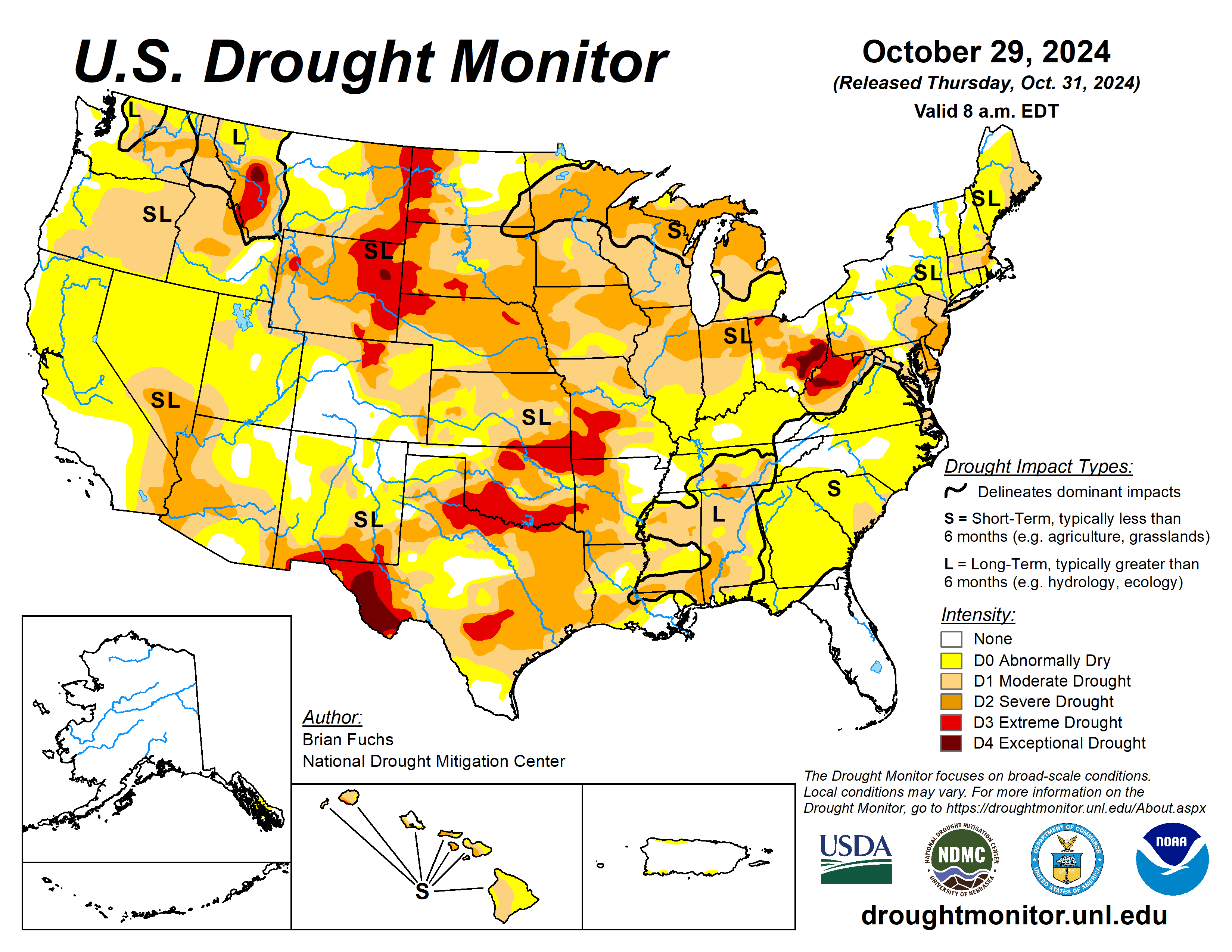
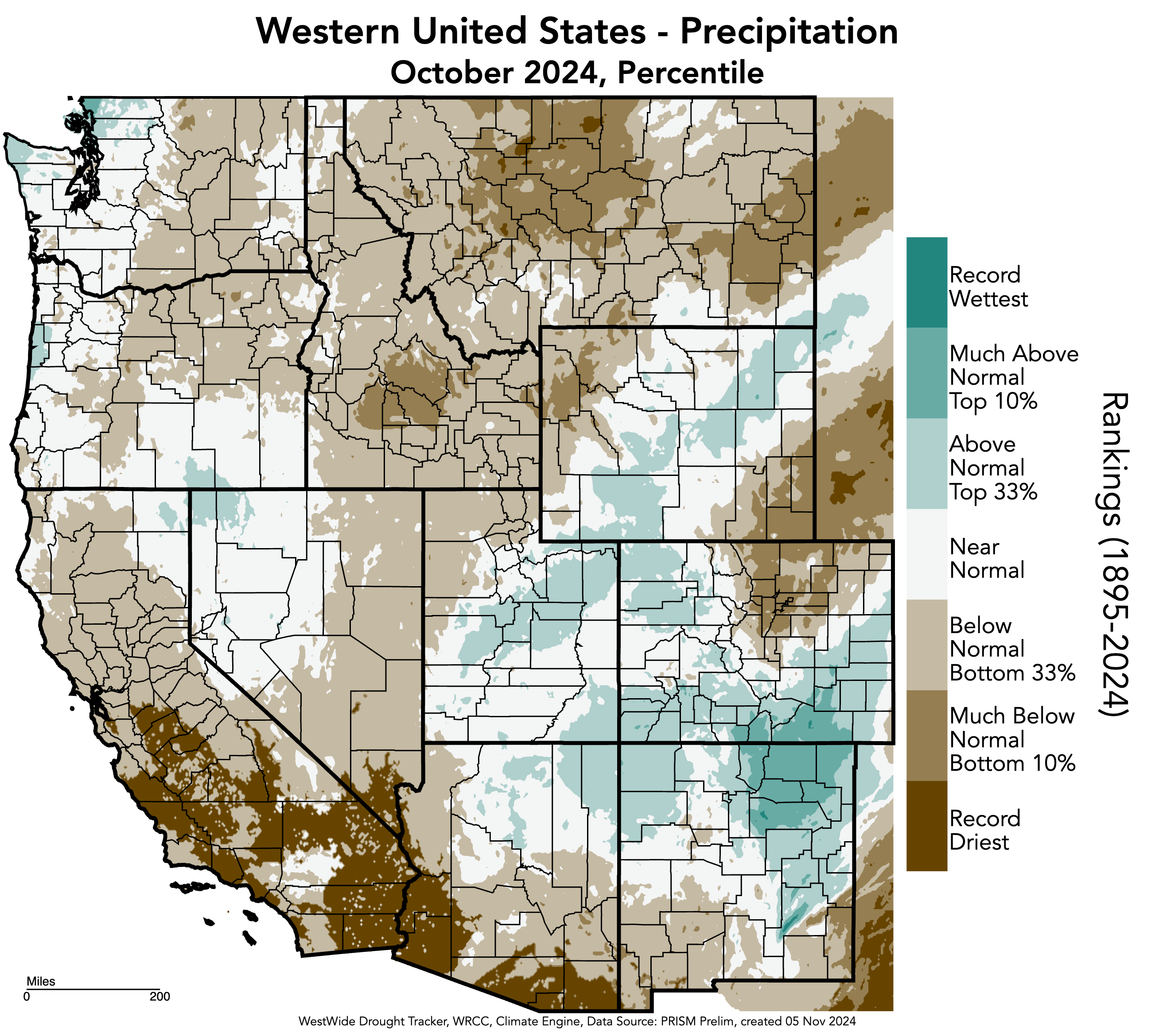
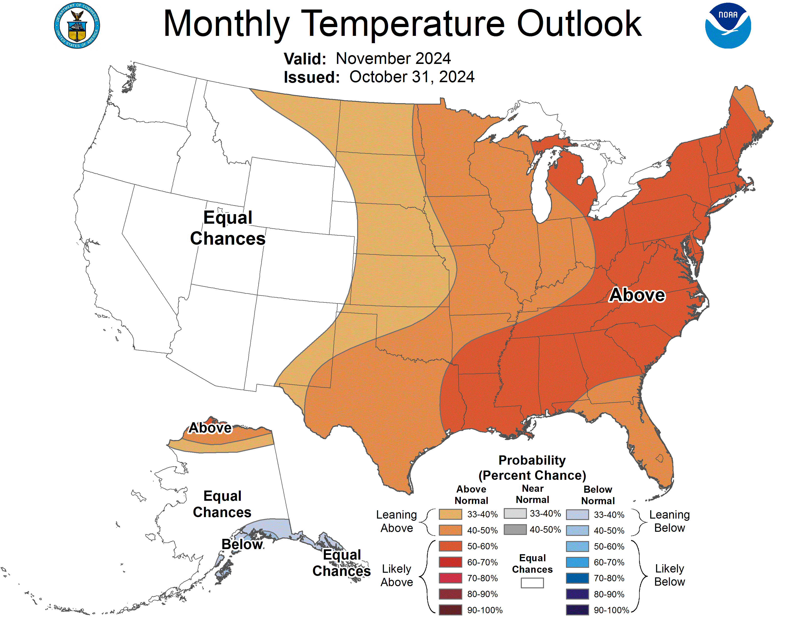
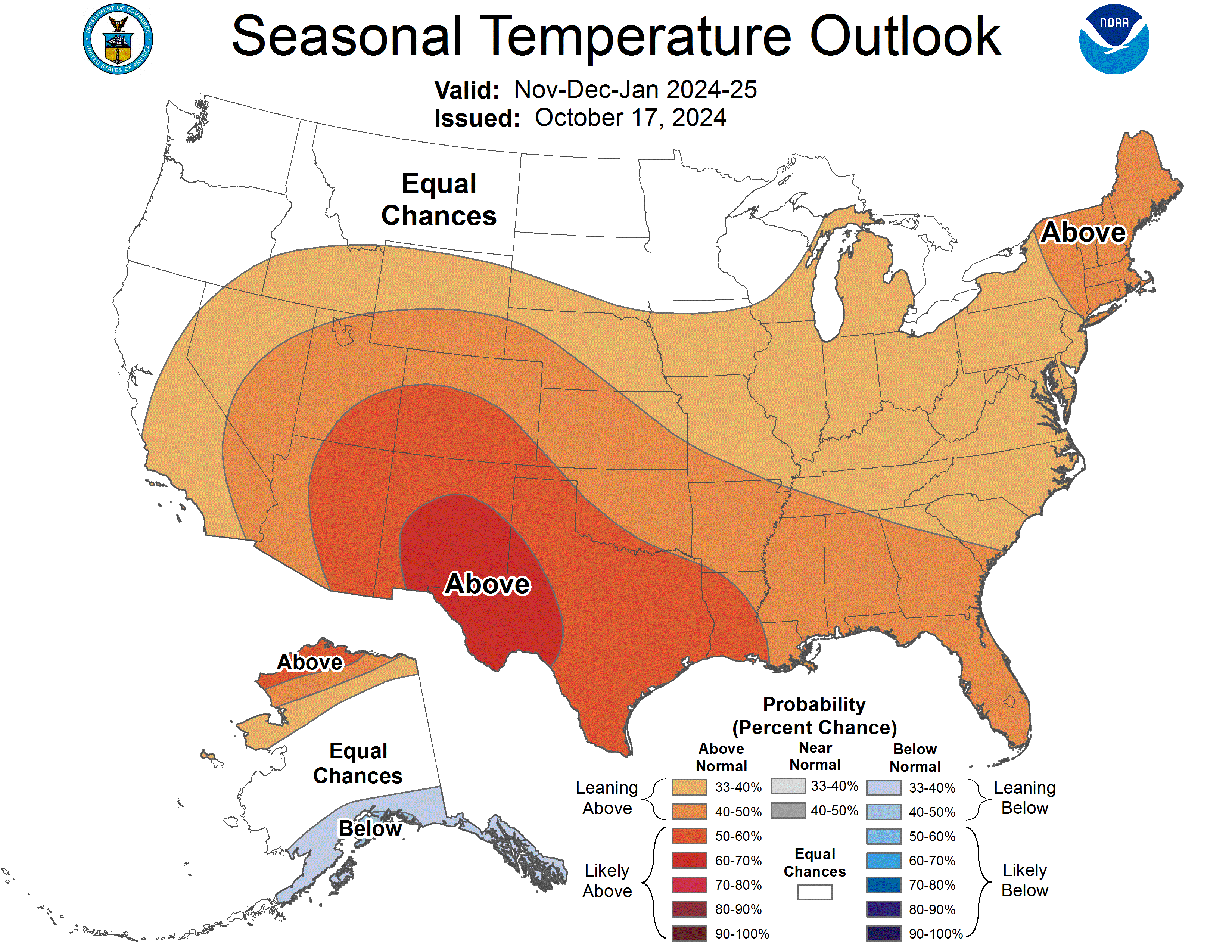
October precipitation varied widely across the region, particularly in Colorado with southern Colorado seeing above normal conditions and northern Colorado generally seeing below normal conditions. October temperatures were above to much above normal throughout the region, with Utah experiencing its warmest October on record and Colorado and Wyoming their second warmest. Regional snow-water equivalent (SWE) was variable, with the majority of Utah and southern Colorado observing above normal SWE and northern Colorado and Wyoming observing below normal SWE. By the end of October, drought conditions expanded since September, now covering 53% of the region. ENSO-neutral conditions continued in October and there is a 53% chance of La Niรฑa conditions developing by early winter. The NOAA seasonal outlook for November-January suggests an increased probability of below normal precipitation for much of Colorado and southern Utah and above normal temperatures for the whole region.

Regional precipitation was variable in October, ranging from above to below normal conditions in each state. Colorado experienced the widest variance of conditions, from as low as 5-25% of normal precipitation along the Front Range and in northeastern Colorado, to 200-300% of normal precipitation in southern Colorado. A small area in Las Animas County, Colorado experienced greater than 300% of normal precipitation. October precipitation was 5-25% of normal in southeastern Wyoming. October precipitation was in the bottom 10% of the period of record in northwestern and southeastern Wyoming as well as northern Colorado, while precipitation was in the top 10% of all years in southern Colorado.
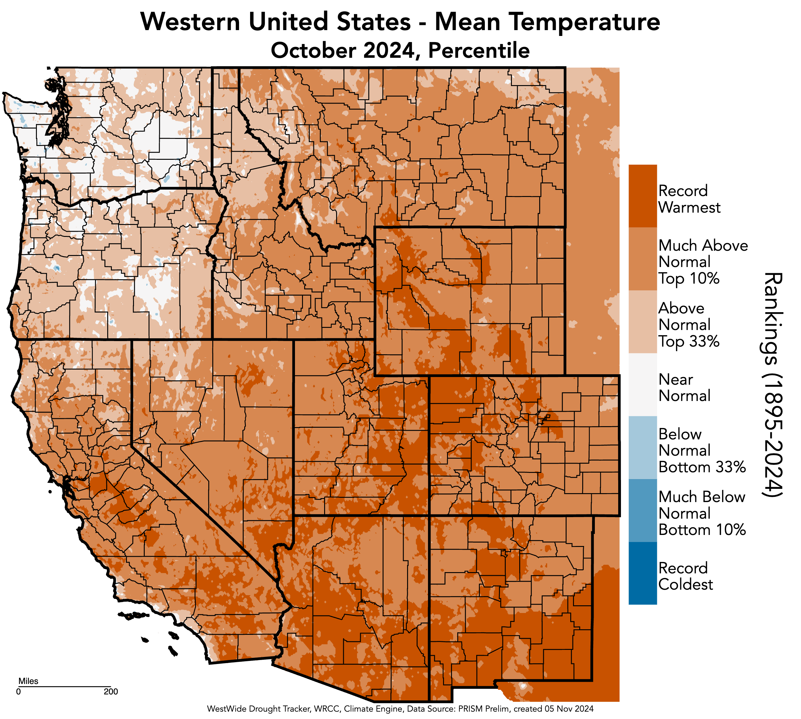
October temperatures were 4-8ยบF above normal throughout the region. Pockets of 8-10ยฐF above normal temperatures were observed in northern and eastern Utah, northern Colorado, and southern Wyoming. A few pockets of 2-4ยฐF above normal temperatures occurred in each state, and one small pocket of near normal (0-2ยฐF) temperatures occurred in Mineral County, Colorado. Large areas throughout the region experienced record-warm temperatures for October. Regionally, Utah experienced its warmest October on record, while Colorado and Wyoming had their second warmest. Additionally, many other states in the West experienced their warmest or second warmest Octobers on record, including Arizona, New Mexico, and Texas, and California and Montana, respectively.

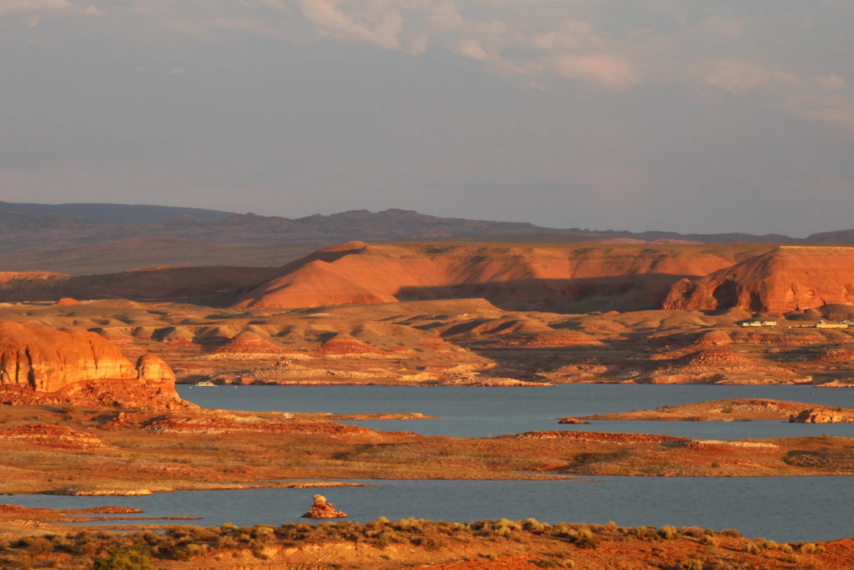
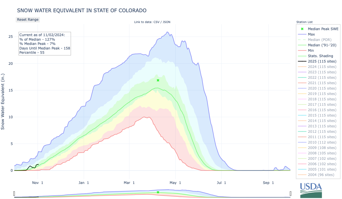
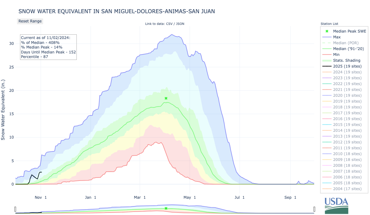
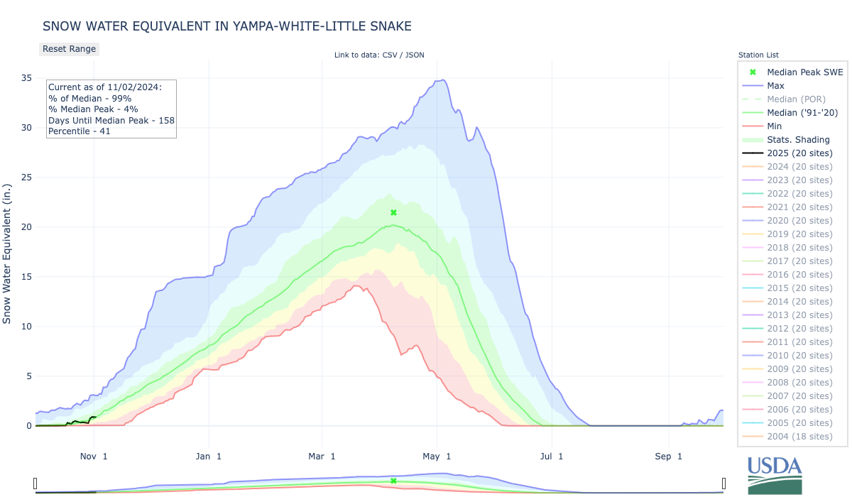
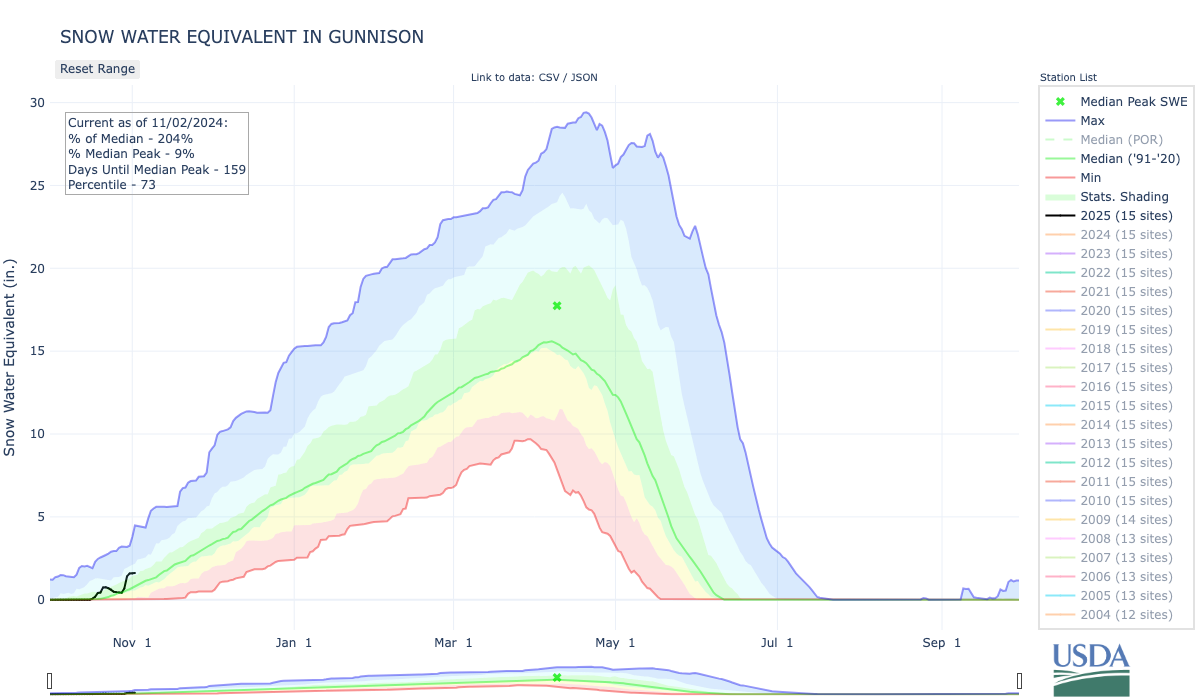
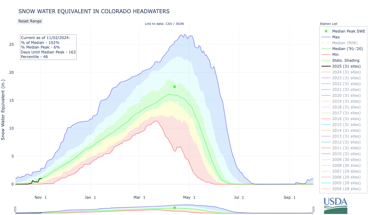
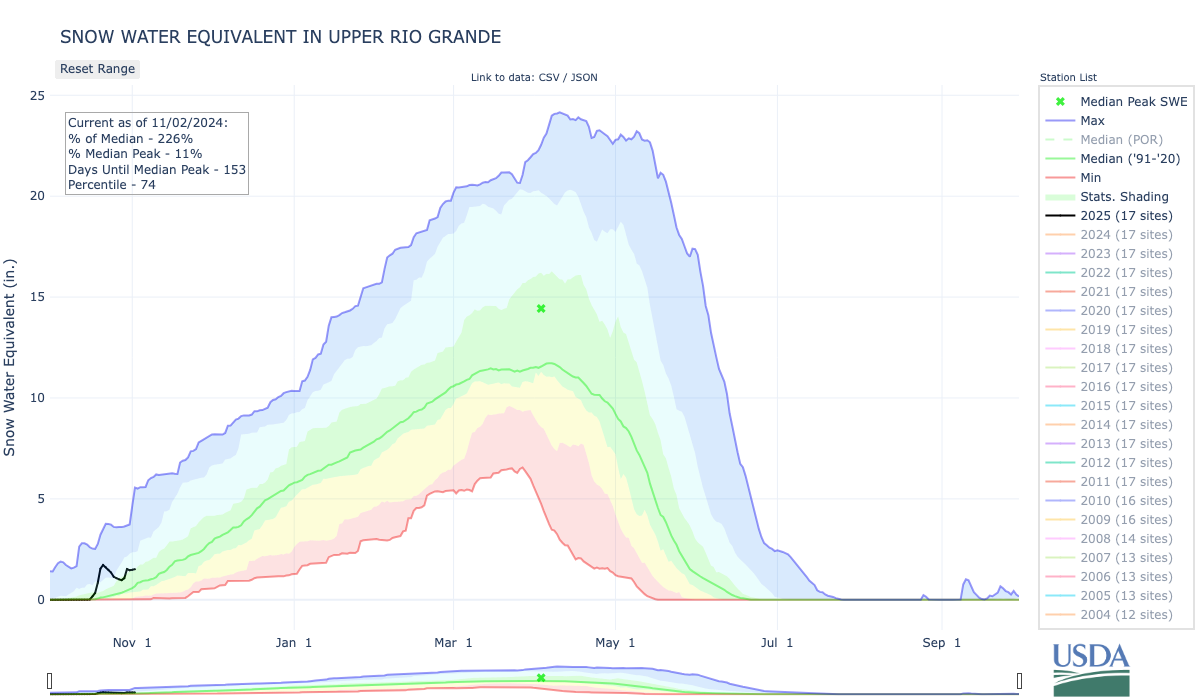
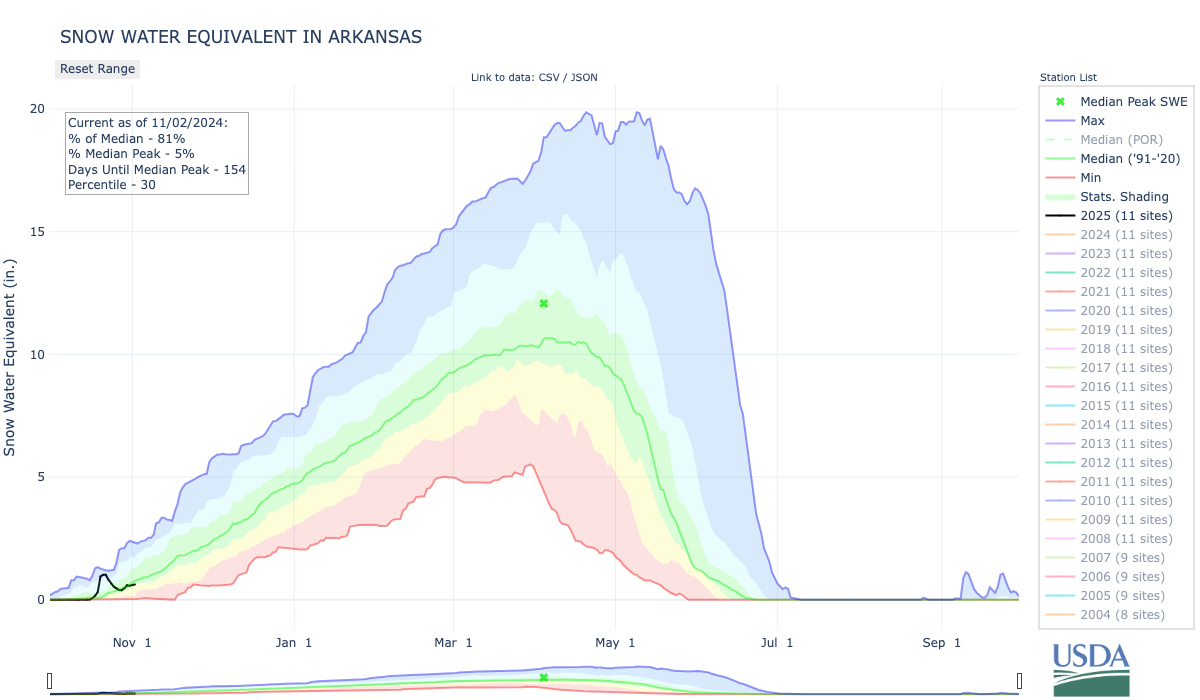
As of November 1, snow-water equivalent (SWE) was variable across the region. SWE was above normal for the majority of Utah, with much above normal conditions in the Upper Colorado-Dolores River (592%), Great Salt Lake (588%), and Jordan River Basins (204%). Much above normal SWE also was observed in southwestern Colorado and northeastern Wyoming basins. Below normal SWE was observed in the majority of Wyoming, with much below normal SWE in the Upper Yellowstone (41%) and Snake Headwaters Basins (41%). The South Platte Basin in Colorado also experienced much below normal SWE at 37% of normal. In Colorado, most SNOTEL sites reported 0-2″ of SWE with a high of 6โ€ at Beartown near Telluride. In Utah, most SNOTEL sites reported 0-1″ of SWE with a high of 2.4โ€ at Steel Creek Park in the Uinta Mountains. Lastly, in Wyoming, most SNOTEL sites reported 0-1″ of SWE with a high of 2.3โ€ at Bald Mountain in the Bighorn Mountains. 

Note: Current SWE as a percent of normal maps are often skewed at this time of year due to the very low average SWE this early in the season.

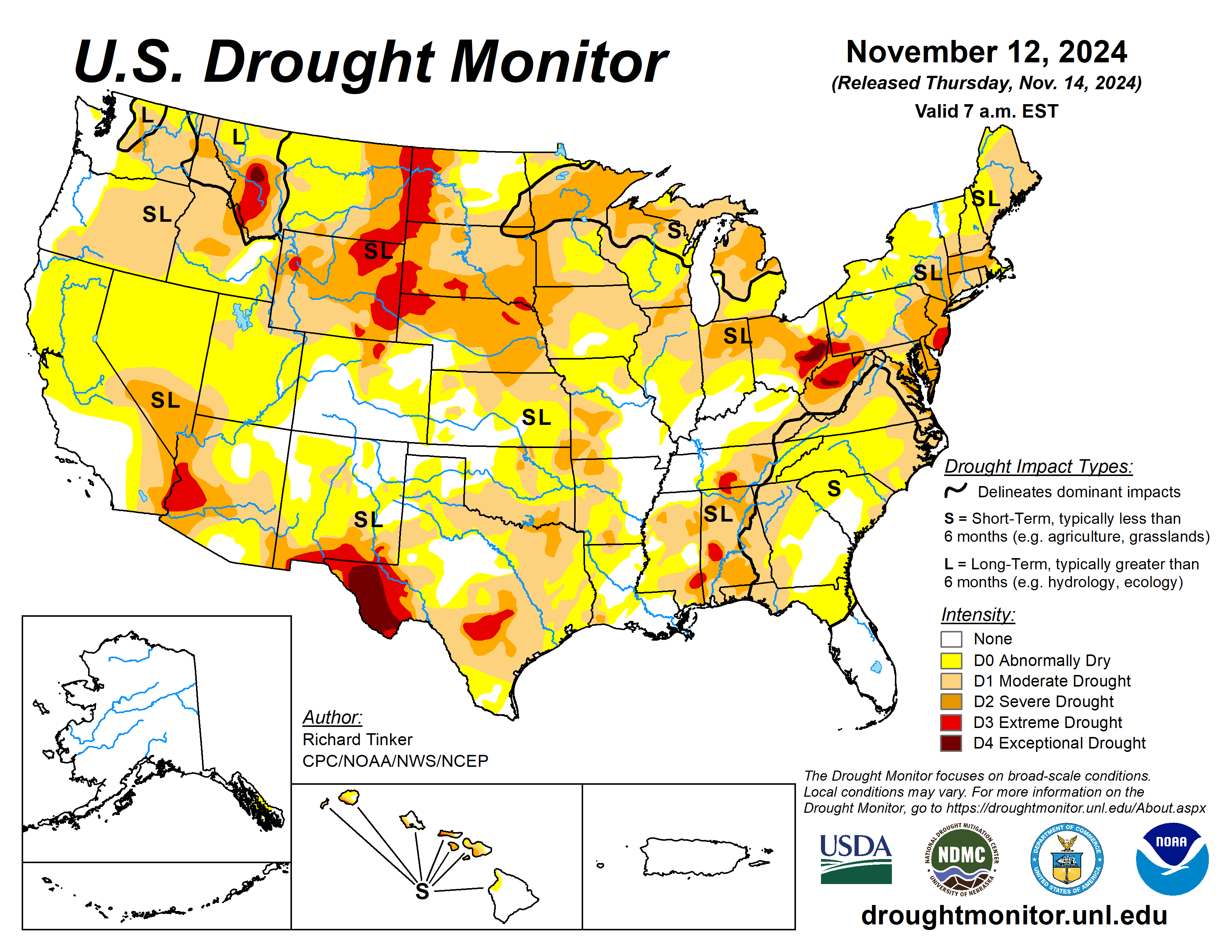
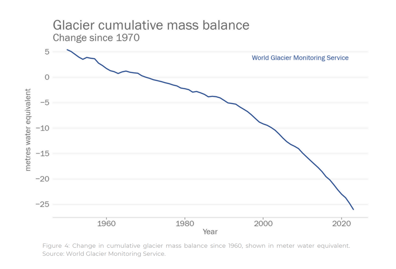
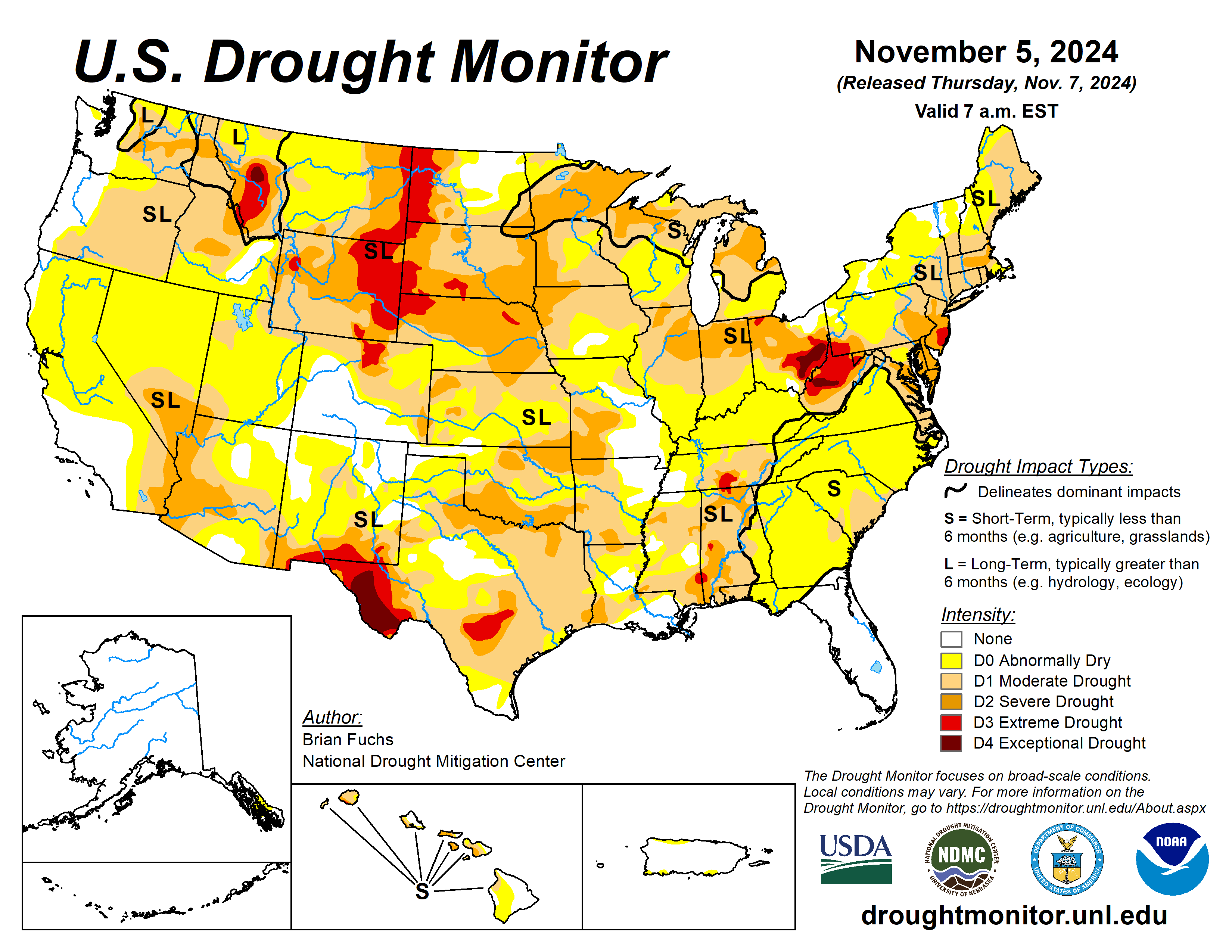
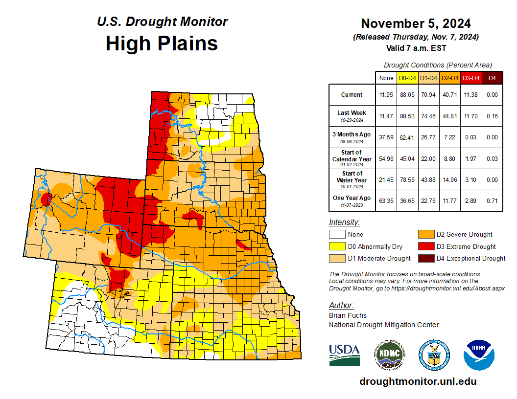
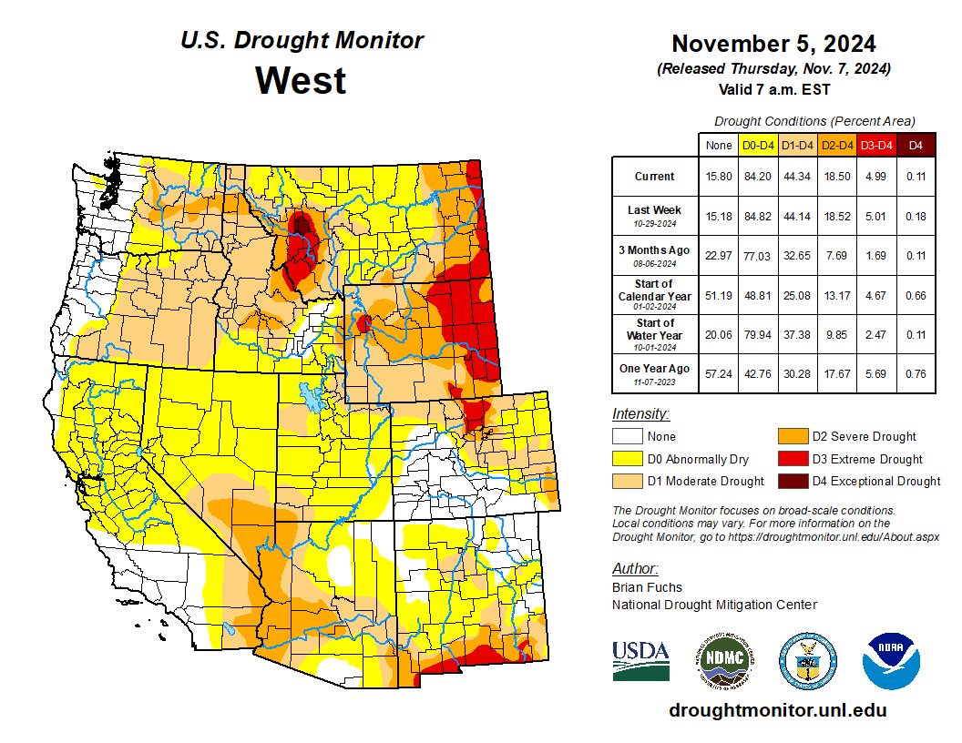
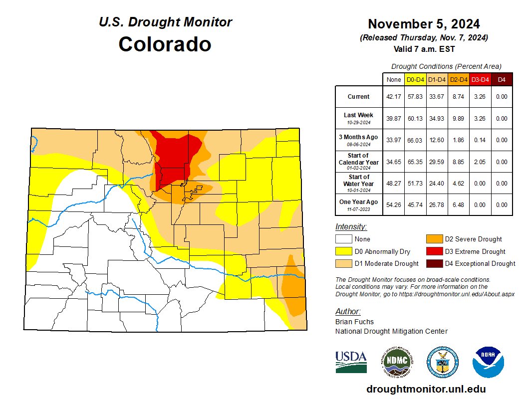
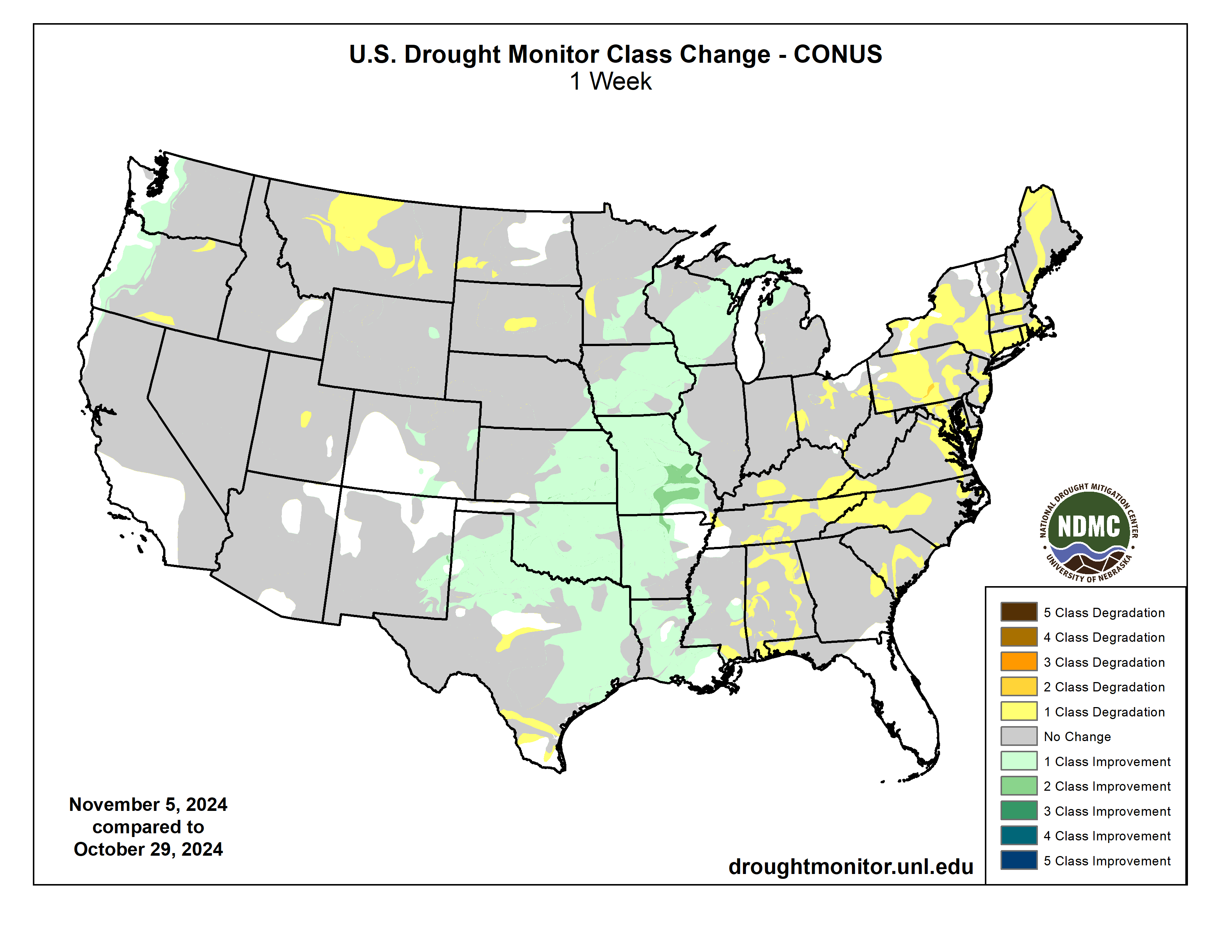
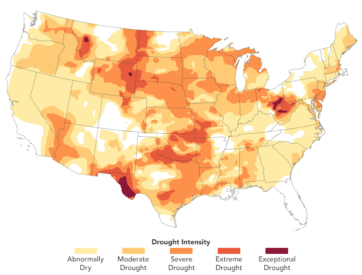
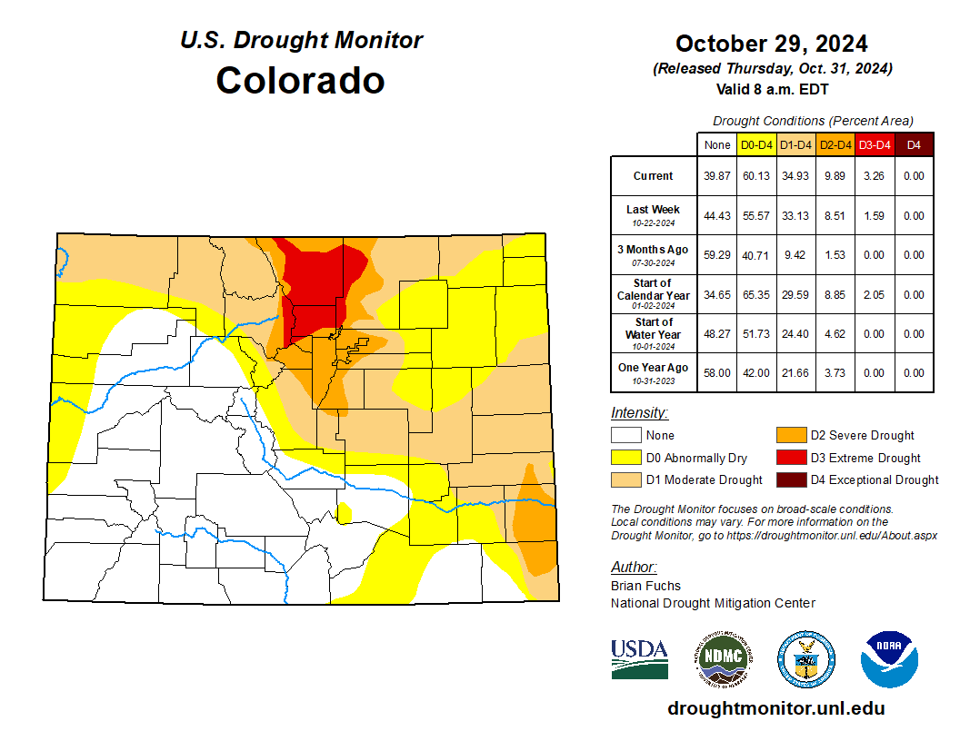
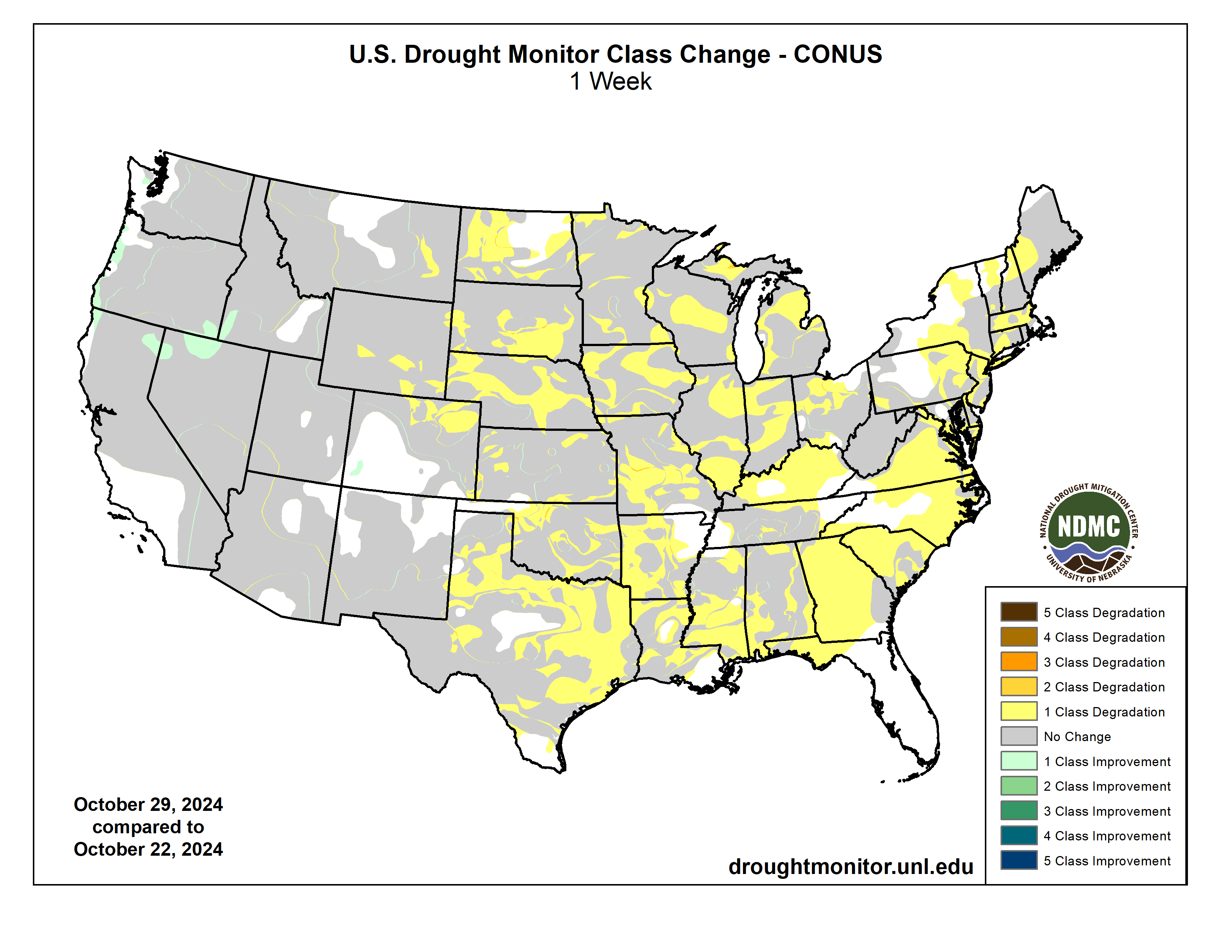
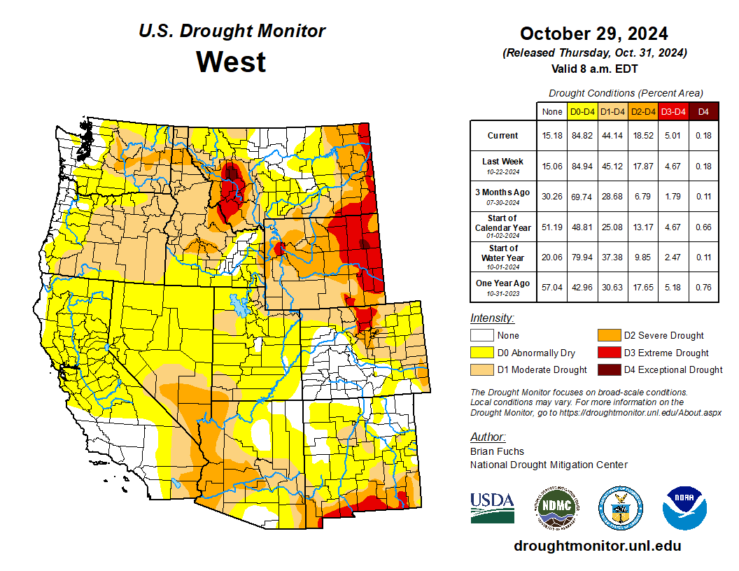
At the end of October, drought covered 53% of the region, up from 31% drought coverage in September. As of mid-October, drought conditions covered the entire state of Wyoming. Severe (D2) drought coverage more than doubled and extreme (D3) drought coverage tripled in Wyoming, and a small pocket of exceptional (D4) drought emerged in northeastern Wyoming. In Colorado, D1 drought coverage nearly doubled, D2 drought nearly tripled, and D3 drought emerged along the northern Front Range. Lastly, in Utah, D1 drought coverage doubled and D2 drought emerged in Washington County.

West Drought Monitor map October 29, 2024.

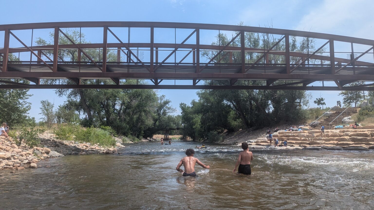
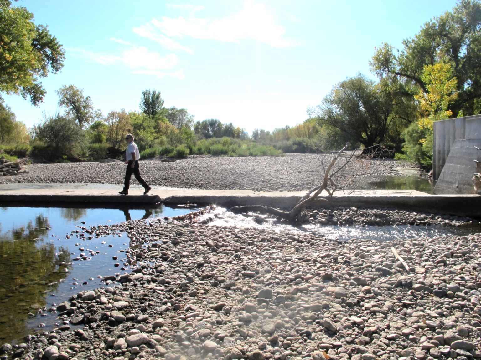
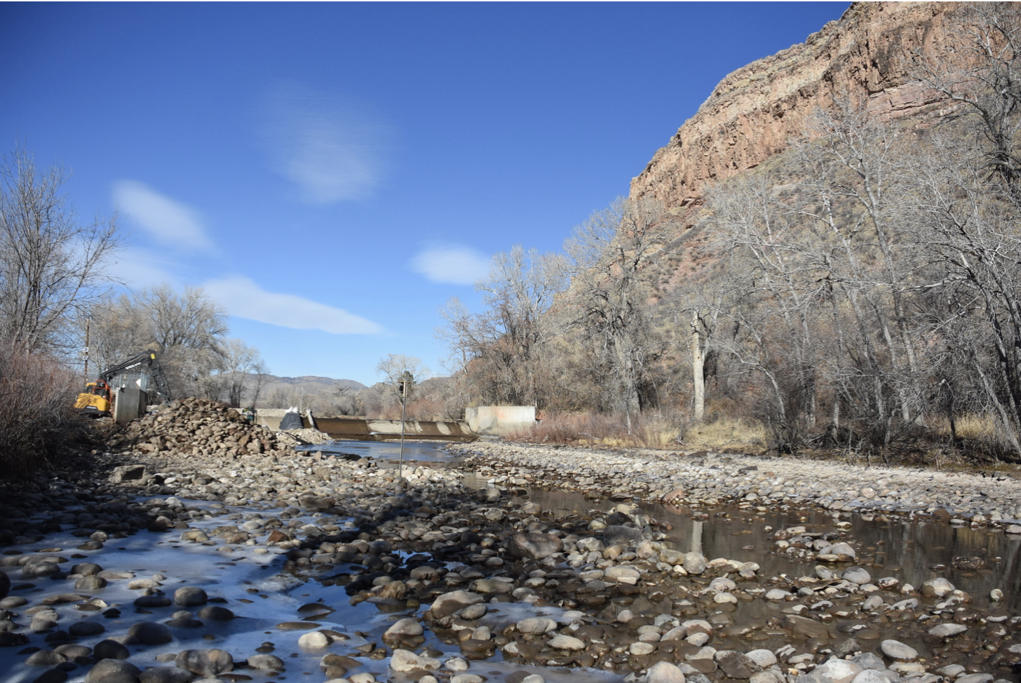
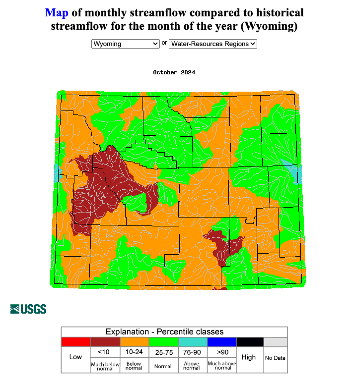
Regional streamflow conditions were near to below normal during October. Below normal streamflow conditions were observed in multiple river basins of each state with much below normal conditions in parts of the Gunnison, North Platte, South Platte, Republican, and Arkansas River Basins in Colorado; the Lower Green and Lower Colorado River Basins in Utah; and the Big Horn, Upper Green, and North Platte River Basins in Wyoming. Much above normal conditions were observed in the East Fork Sevier River Basin in Utah.

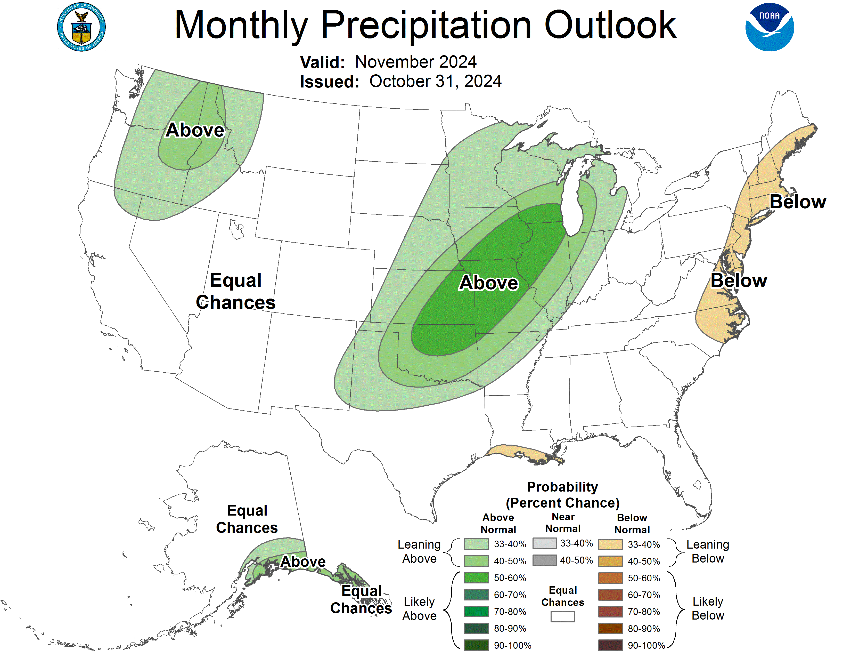
ENSO-neutral conditions continued during October with near to below average sea surface temperatures in the Pacific Ocean, which triggered a La Niรฑa Watch from the NOAA Climate Prediction Center. There is a 53% chance of La Niรฑa emerging by December and a 53% chance of it persisting through December-February. There is a 55% chance of ENSO-neutral conditions returning by January-March, according to the IRI Model-Based Probabilistic ENSO Forecast. Note, there is a discrepancy between the NOAA and IRI ENSO forecasts at this time. The NOAA seasonal outlook for November-January suggests an increased probability of below normal precipitation for southern Colorado and southeastern Utah, and above normal precipitation for northwestern Wyoming. There is an increased probability of above normal temperatures for the entire region, particularly in southern Colorado and southeastern Utah.

Significant climate event: Record October heat.ย Salt Lake City experienced its warmest October on record in 2024, with the first 16 days reaching 80ยฐF or above. The average temperature for the month was 62.4ยฐF, surpassing the previous record of 60.5ยฐF set in 2015. Other Utah cities also saw record-breaking average temperatures: St. George at 69.9ยฐF, Provo at 61ยฐF, Fillmore at 60.7ยฐF, Escalante at 60.6ยฐF, Price at 58.6ยฐF, Lehi at 57.9ยฐF, Manti at 56.6ยฐF, Park City at 52.9ยฐF, and Alta at 47.1ยฐF. Northern Colorado experienced very dry weather and significantly above normal temperatures as well, with only two days of measurable precipitation and 26 days of above normal temperatures. Colorado was on track to have its warmest October on record, but a cold front in the last two days caused the average monthly temperature to slip to the second warmest on record. In Denver, the mean October temperature was 59.1ยฐF, which was 8.0ยฐF above normal, making it the second warmest October on record. Precipitation was much below average at 0.11 inches, which is 0.88 inches below normal. No snow was observed, which is 3.9 inches below the average October snowfall.

#Colorado Ag Water Alliance: #Drought resilency program request for proposals

Water officials expect steady transition to President 47 for #ColoradoRiver negotiations — Fresh Water News #COriver #aridification

The Hoover Dam is a powerhouse! With an impressive output of about 3 billion kilowatt-hours of electricity annually, it provides enough energy to light up about 1 million households in Nevada, Arizona, and California, ensuring the lights stay on un the Southwest. Photo credit: USBR

Click the link to read the article on the Water Education Colorado website (Shannon Mullane):

November 14, 2024

Western states are mired in negotiations over future Colorado River cutbacks, but state officials agree on one point: A presidential changeover wonโ€™t derail the process.

Colorado River Basin officials have to stick to a tight, federally regulated timeline to replace water management rules that were created in 2007 and will expire in 2026. Negotiations over the new rules will overlap with leadership changes in Washington, D.C., when President-elect Donald Trump steps back into office. But new administrations have not disrupted basin negotiations in the past, and state officials donโ€™t expect big issues this time around either.

โ€œThe deadlineโ€™s the deadline, regardless of whoโ€™s at Interior, whoโ€™s at Reclamation and frankly whoโ€™s representing the states,โ€ said John Entsminger, Nevadaโ€™s top negotiator and general manager for the Southern Nevada Water Authority.

The 2007 rules were created in response to several years of drought โ€” the beginning of a two-decade megadrought that elevated concerns about the future water supplies for 40 million people, including Coloradans from the Western Slope to the Front Range.

The Bureau of Reclamation is analyzing several alternatives for the new, post-2026 rules. Reclamation declined to comment on questions about the upcoming transition, saying it plans to keep working with basin stakeholders.

But replacing the 2007 guidelines comes with a strict timeline: Reclamation needs time to draft the new rules, hold public comment, handle revisions, comply with required waiting periods and more before 2026, said Anne Castle, who formerly oversaw water and science policy for the Department of the Interior.

โ€œIf you back up all those timelines, thereโ€™s not that much time left,โ€ Castle, the federal representative on the Upper Colorado River Commission, said.

If the basin states want Reclamation to consider a seven-state agreement in its analysis, they have until spring 2025 to submit it, she said.

State negotiators, including Colorado River Commissioner Becky Mitchell of Colorado, said they are committed to continuing the negotiations. 

โ€œI donโ€™t think thereโ€™s any doubt that if we come up with something that we โ€” the seven states โ€” can live with, that it would be satisfactory to Reclamation,โ€ said Gene Shawcroft, Utahโ€™s top negotiator and chair of Colorado River Authority of Utah. โ€œThe onus is still on us as states to come up with a solution.โ€

But the talks are at an impasse, said JB Hamby, Californiaโ€™s top negotiator. In recent years, federal involvement has helped push the states to consensus, and that involvement is vital going forward, he said. 

However, over the next year, that federal involvement could be hampered by leadership transitions. Historically, presidents install new officials in top leadership positions, and it can take up to a year to install new leaders, like the Secretary of the Interior and Bureau of Reclamation commissioner.

โ€œWhatever the background the next commissioner will have, no matter where in the West they may come from โ€ฆ itโ€™s critical to have that direct federal involvement in that particular role as promptly as possible,โ€ said Hamby, chairman and Colorado River commissioner for the Colorado River Board of California.

This isnโ€™t the first time basin officials are debating weighty river issues during an administration change, several state negotiators said. Party politics donโ€™t typically cause seismic shifts in Colorado River policy โ€” the basin splits more along geographic lines or by type of water use.

For example, the transition from former President Barack Obamaโ€™s administration to the first Trump administration did not interrupt the basinโ€™s negotiations over additional drought-response plans, which were finalized under Trump in 2019.

Tom Buschatske, who is the director of the Arizona Department of Water Resources and the stateโ€™s top negotiator, said he is not expecting delays this time either.

โ€œIโ€™m going to somewhat hang my hat on the fact that, over the last almost 25 years now, when you see past administrations change, weโ€™ve not really seen that impacting the path forward, or the pinch points and deadlines, at least for the Colorado River,โ€ Buschatzke said.

More by Shannon Mullane

The latest El Niรฑo/Southern Oscillation (#ENSO) Diagnostic Discussion is hot off the presses from the #Climate Prediction Center

Click the link to read the discussion on the Climate Prediction Center website:

November 14, 2024

Synopsis: La Niรฑa is most likely to emerge in October-December 2024 (57% chance) and is expected to persist through January-March 2025.

Over the past month, ENSO-neutral continued, as evidenced by overall near-average sea surface temperatures (SSTs) observed across the central and eastern equatorial Pacific Ocean. Similar to last month, the latest weekly Niรฑo indices ranged from +0.2ยฐC (Niรฑo-4) to -0.3ยฐC (Niรฑo-3.4. Below-average subsurface temperatures persisted across the east-central and eastern equatorial Pacific Ocean. For the monthly average, low-level wind anomalies were easterly over a small region of the east-central equatorial Pacific, and upper-level wind anomalies were near average. Convection was suppressed over the Date Line and was weakly enhanced over eastern Indonesia. The traditional and equatorial Southern Oscillation indices were positive. Collectively, the coupled ocean-atmosphere system reflected ENSO-neutral.

The IRI plume predicts a weak and a short duration La Niรฑa, as indicated by the Niรฑo-3.4 index values less than -0.5ยฐC. The latest North American Multi-Model Ensemble (NMME) forecasts are cooler than the IRI plume and predict a weak La Niรฑa. Due to this guidance and La Niรฑa-like atmospheric circulation anomalies over the tropics, the team still favors onset of La Niรฑa, but it is likely to remain weak and have shorter duration than other historical episodes. A weak La Niรฑa would be less likely to result in conventional winter impacts, though predictable signals could still influence the forecast guidance (e.g., CPC’s seasonal outlooks). In summary, La Niรฑa is most likely to emerge in October-December 2024 (57% chance) and is expected to persist through January-March 2025.

#Drought news November 14, 2024: In some of the higher elevations of #Colorado, precipitation fell as heavy snow, with a few locations reporting snow piling up 3 to 4.5 feet deep (50 to 54 inches buried #FortGarland while 44 to 47 inches were reported near #LaVeta, #Elbert, and #Trinidad)

Click on a thumbnail graphic to view a gallery of drought data from the US Drought Monitor website:

Click the link to go to the US Drought Monitor website. Here’s an excerpt:

This Week’s Drought Summary

Storm systems brought significant precipitation and drought relief to broad areas in the central Rockies, central and southern Plains, Lower and Middle Mississippi Valley, Lower and Middle Ohio Valley, and the South Atlantic Region. Meanwhile, subnormal precipitation and some unseasonable warmth led to deterioration in dryness and drought conditions in portions of the Southwest, southern and western Texas, the interior Southeast, the northeastern Gulf Coast, the central and southern Appalachians, the mid-Atlantic region, the Northeast. Excessive precipitation totals fell on some areas. From central South Carolina through much of southeastern Georgia, amounts of 4 inches to locally a foot of rain were reported. Similar totals fell on central Louisiana, a band through central and north-central Texas, small parts of the Lower Ohio Valley, and orographically-favored areas in the Northwest. In addition, a broad area covering the eastern half of Colorado and adjacent areas in New Mexico and the central High Plains recorded 2 to 4 inches of precipitation, much of which fell as snow in the middle and higher elevations. A few scattered sites reported 3 to 4.5 feet of snow, mainly in the higher elevations of Colorado…

High Plains

A potent 500-hPa low triggered widespread heavy precipitation over southern half of the Region, except along the eastern fringe, while amounts were limited to several tenths of an inch at most farther north. Between 2 and 4 inches of precipitation fell on a large swath covering the eastern half of Colorado, most of central and western Kansas, and adjacent Nebraska. In nearby areas, amounts ranging from a few tenths of an inch to a couple of inches were observed over the western half of Colorado amounts of 0.5 inch to approaching 2 inches in spots was observed across southeastern Wyoming, most other areas in Nebraska, and eastern Kansas. Moderate amounts fell on a swath across the central and southwestern Dakotas the remainder of this region reported little or no precipitation, as well as most of Wyoming. In some of the higher elevations of Colorado, this precipitation fell as heavy snow, with a few locations reporting snow piling up 3 to 4.5 feet deep (50 to 54 inches buried Fort Garland CO while 44 to 47 inches were reported near La Veta, Elbert, and Trinidad CO). All of this resulted in a large area of improvement depicted over southern and western Kansas, most of northern and eastern Colorado, part of southwestern Nebraska, and a few spots in eastern Wyoming. There were a few areas of 2-class improvement in southeastern Colorado, northwestern Kansas, and the fringes of south-central and southeastern Kansas. Elsewhere, due to relatively cool weather, the dry week didnโ€™t engender much deterioration, with most of these locations remaining unchanged from last week. One exception was in a small patch of northeastern Nebraska and adjacent South Dakota, where a new patch of extreme drought (D3) was identified…

Colorado Drought Monitor one week change map ending November 12, 2024.

West

Heavy precipitation In northeastern New Mexico, with snow reported in some of the higher elevations, produced areas of improvement to dryness and drought. A few high spots in New Mexico reported near 3 feet of snow, including locations near Las Vegas NM and Folsom NM. The only other area of improvement in the West Region was in eastern Washington. Not much precipitation fell last week…

South

Like the Southeastern Region, the South Region experienced highly variable rainfall this past week. Heavy precipitation โ€“ in some areas for the second consecutive week โ€“ soaked a swath from Louisiana and eastern Texas northward through much of the Lower and Middle Mississippi Valley and the Tennessee Valley. A broad swath reaching as far west as central Arkansas recorded at least 1.5 inches in most places, with some areas recording much higher amounts (3 to 8 inches in part of western Tennessee, and over a foot in parts of central Louisiana). This resulted in reductions in dryness and drought severity across affected areas of the Lower Mississippi Valley and eastern Texas, with some 2-class improvements imposed in a small part of both southwestern Louisiana and an area straddling southwesternmost Mississippi and adjacent southeastern Louisiana. To the north, the heavy rains also removed abnormal dryness from across western Tennessee. Farther west, another area of heavy precipitation accompanied a frontal passage in a swath from central Texas into the central Red River (south) Valley, where totals reached 4 to 8 inches along the axis of heaviest amounts. To the north, heavy precipitation associated with a pair of potent upper-level low pressure systems dropped over 2 inches on a large part of central and western Oklahoma and much of the Texas Panhandle, with localized totals exceeding 4 inches in the eastern Texas Panhandle northward to the Oklahoma/Kansas border. There was also a patch of heavy rainfall to the east across portions of eastern Oklahoma, where isolated amounts peaked at around 3 inches. Dryness and drought affecting these areas were significantly eased, with a couple patches of 2-class improvements in north-central and northeastern Oklahoma. In stark contrast, little or no precipitation was observed from parts of southeastern Oklahoma southward through Deep South Texas, and across western Texas as well. Dryness and drought worsened in some of the areas, with the most widespread deterioration noted in western Texas. The broad area of exceptional drought (D4, the most intense category) expanded there to cover most or all of eastern Hudspeth, Culberson, western Reeves, Jeff Davis, Presidio, and Brewster Counties. Also, D3 (extreme drought) also expanded to cover most of the remainder of the Big Bend of Texas…

Looking Ahead

During the next five days (November 14-18), moderate to heavy precipitation is again expected from the Cascades westward to the Pacific Coast, with totals expected to exceed 5 inches expected in some of the higher elevations and orographically-favored sites. One or more inches are also anticipated in the Sierra Nevada, with several tenths of an inch possible along most of the California Coast down to the Mexican border. Parts of the northern Intermountain West are expected to receive over an inch of precipitation, with 2 to locally 4 inches forecast across the Idaho Panhandle. A low pressure system and trailing front should trigger another round of heavy precipitation in the central and southern Great Plains from central Texas northward into southeastern Nebraska and the Middle Mississippi Valley, with 1.5 to locally 4.0 inches anticipated from central and east-central Kansas southward through the Red River (south) Valley and adjacent northern Texas. At least an inch is also anticipated east of the Lower and Middle Mississippi River through the interior Southeast, Lower Ohio Valley, central and southern Appalachians, and the mid-Atlantic region. Over 2 inches may fall on parts of the central Appalachians and adjacent Piedmont. Meanwhile, moderate amounts should fall on the southern Rockies and adjacent High Plains and across the Great Lakes region and the northern Ohio Valley. In contrast, little or no precipitation is expected across much of the Northeast, Florida and the adjacent South Atlantic region, southern Texas, the northern Plains, the central and southern Rockies, and the Southwest.

The Climate Prediction Centerโ€™s 6-10 day outlook (valid November 19-23) features enhanced chances for both above-normal precipitation and temperatures across the Upper Midwest and across most areas east of the Mississippi River, with odds for significantly above-normal rainfall reaching 50 to near 70 percent on the Florida Peninsula. Wetter than normal weather is also slightly favored across Hawaii. Meanwhile, subnormal precipitation seems more likely across Texas and adjacent locations as well as the western Rockies, most of the Intermountain West, and the Sierra Nevada. Below normal temperatures are favored across the central and southern Plains and adjacent Mississippi Valley, the Rockies, and the Intermountain West. Southeastern Alaska should also average colder than normal while in Hawaii, neither extreme of temperature is favored.

US Drought Monitor one week change map ending November 12, 2024.

Romancing the River: Forging on in the Era of Fear and Loathing — George Sibley (SibleysRivers.com) #ColoradoRiver #COriver

Credit: George Sibley/NOAA

Click the link to read the article on the Sibley’s Rivers website (George Sibley):

November 12, 2024

Hunter Thompson put the term โ€˜fear and loathingโ€™ into our cultural dialogue in the early 1970s: first in 1971 with โ€˜Fear and Loathing in Las Vegas,โ€™ then with โ€˜Fear and Loathing on the Campaign Trailโ€™ in 1973, a long rambling essay into Americaโ€™s political character based on his coverage for Rolling Stone of the 1972 election of Richard Nixon over George McGovern.

โ€˜Fear and loathingโ€™ is a pretty accurate description of the campaign that Donald Trump ran: fear of a tidal wave of immigrants, mostly criminals; fear of a tidal wave of crime; fear of Promethian women unbound; fear of โ€“ well, fear of the future in general, along with a massive denial of things that most Americans apparently donโ€™t want to think about, as discussed in my last post. That those tidal waves of fear were devoid of any factual reality, and the denials chin-deep in ignored factual realities โ€“ all that was immaterial; fear and anger work their dark magic best in darkness.

As for โ€˜loathingโ€™: he and his minions worked hard, with considerable success, to make the gullible loath liberals, progressives, enviros, believers in the rule of law, people wanting to make their own decisions about their own bodies, anyone who still harbors the vision that we can save the planet from ourselves and that life can be made decent for everyone. He and his minions have said, will continue saying, things about people like me that are vicious fictions โ€“ I am the evil spawn of the devil just because Iโ€™d like to see more equity in our society, and have a commitment to the now-receding hope that we can pass a still-livable planet on to the next generations?

And he won with that campaign. The vote by a majority of my fellow Americans indicate that the Untied States (sic) is no longer going to even be trying to be Thompsonโ€™s โ€˜monument to all the best instincts of the human race this country might have been.โ€™ Not now, anyways. Might we hope that we will recover our more positive vision after four more years with Trump and his dark xenophobic vision? Thereโ€™s really nothing but hope, but like the guy in the lifeboat said, โ€˜Pull for the horizon, boys. Itโ€™s better than nothing.โ€™

So โ€“ back to the river: โ€˜Let us gather by the river, the beautiful, the beautiful riverโ€ฆ.โ€™

This map shows the Colorado River Basin and surrounding areas that use Colorado River Water, with four regions delineated, based on the degree to which flow is regulated and the channel physically manipulated. The dividing line for the upper and lower basin is Lee Ferry near Glen Canyon Dam. CREDIT: CENTER FOR COLORADO RIVER STUDIES

What were we doing when so rudely interrupted by the election? We were taking advantage of these โ€˜interim monthsโ€™ in the Colorado River Basin to engage in a little thinking โ€˜outside the boxโ€™ about the Colorado River, while the seven basin states remain stalemated in the โ€˜Colorado River Compact Box.โ€™ The Compactโ€™s division into Upper and Lower Basins has devolved at this point to a situation that can legitimately be compared to the 1860 division of states into North and South with a downward spiral toward conflict and chaos. Only in the rich imagination of Paolo Bacigalupi does it descend to open uncivil warfare physically in the Colorado River region (read his worst-case book,ย The Water Knife,ย if you havenโ€™t already). But the biggest action step recently in the stalemate was when Arizonaโ€™s state director of Water Resources, Tom Buschatzke, asked his governor and legislature to โ€˜set asideโ€™ a million dollars in the event that going to court becomes unavoidable.

So in our ongoing โ€˜romanceโ€™ with the river, we could either hover and dither over that stalemate, like the rest of the media, trapped in the โ€˜Compact Boxโ€™ โ€“ or just take advantage of the ominous quiet to heist ourselves up on the edge of the box, to look over and out at possible alternative futures.

Weโ€™ve been exploring the anomaly of a river in a desert โ€“ a river created through natural atmospheric processes in a mountainous region of sufficient elevation to force precipitation onto land steep enough so that a large portion of the water created runs off its slopes rather than sinking in โ€“ a water-producing region. Whose produced water then runs off into desert lands, where the water produced in the highlands is gradually consumed by the same natural processes โ€“ evaporation, transpiration from riparian vegetation, and replenishment of low groundwater tables, and also by human cultures that learn how to use the river to grow things โ€“ mainly food crops and cities. The river is not significantly replenished for those losses by precipitation in the arid deserts, so it gradually diminishes, disappears on its way to sea level. The sun giveth the river, and the sun taketh the river away. The vaporized river water rides the wind, usually eastward in search of another condensing factor in the environment, to again become liquid precipitating on the increasingly thirsty earth as we relentlessly drive the planetโ€™s temperature upward.

For cultures trying to live in desert lands with a heavy dependence on a river in the desert, there are two kind of obvious fundamental principles for using the riverโ€™s water: 1) first, collaborate on an equitable and efficient division of the use of the riverโ€™s water among all its desert consumers, and make that use contingent on the application of best practices in avoiding waste. And 2) take care of the water-producing region in order to maintain or achieve its optimal flows into the deserts. Iโ€™ll say that again: it is the responsibility of all the desert water users to take care of the water-producing region for their water, as well as being careful with the water that reaches their desert. Another principle the Colorado River Compact not only ignored, but made worse with the assumption that management of the Headwaters for the river would be up to high-desert users in the Upper Basin, and none of the Lower Basinโ€™s business.

Despite the current disputatious stalemate between the seven states trying to share the river and their division into two camps of north states and south states (with the state boundaries themselves making no geographic or hydrological sense) โ€“ there are actually things going on internally within the states, mostly led by the huge metropolitan โ€˜city states,โ€™ that work toward that first principle of collaboration on the best use of the river and its water. There are water-sharing agreements between desert cities and desert farmers; there are expensive efforts by the cities to maximize efficiency in the use of their current shares of the river, as well as the usual striving for larger shares. Considering that the division of the use of the waters is still bound by the foundational โ€˜first come first servedโ€™ appropriation doctrine, it is all the more remarkable that cooperation and efforts toward maximal and equitable efficiency are beginning to break out here and there, transcending strict appropriation law enforcement.

There is not, however, much conscious and coordinated attention among river users in the desert region for the water-producing region of the river in the desert โ€“ the 15 percent of the Basin lands (largely uninhabited) that produces 90 percent of their water. Thatโ€™s what weโ€™ve been trying to explore in some recent posts โ€“ beginning with the riverโ€™s โ€˜mysteryโ€™: the fact that of the estimated 170 million acre-feet (maf) of precipitation that falls over the Basin, roughly half of it in the water-producing region, only around 10 percent of that actually shows up in the river.

In a previous post we looked at some of the reasons why so much of the riverโ€™s water disappears from the riverโ€™s water-producing region โ€“ all attributable to sun and wind:  sublimation (direct conversion of water from solid to vapor) diminishing the snowpack throughout the whole winter; evaporation as the snowpack melts and forms streams exposed to the desert sun; and transpiration through trees and other vegetation of groundwater that sinks into their root zone. Together these processes consume around three-fourths, at least two-thirds, of the water that falls on the Headwaters.

That is a Sibley guesstimate, by the way. We havenโ€™t devised really accurate measures for any of these naatural processes (although there is currently serious scientific work toward better measures). The Western Water Assessment study Iโ€™ve been citing is somewhat stuck in the Compact Box, breaking most of its analysis down into Upper and Lower Basin data, which does not work for the โ€˜water-producing and water-consumingโ€™ model, since most of the Upper Basin is part of the water-consuming desert region (ten inches or less annual precipitation). The WWA estimates the โ€˜runoff efficiencyโ€™ for the whole Upper Basin at 16 percent โ€“ anย estimatedย 14.8 maf at the Lee Ferry version of the Mason-Dixon Line from anย estimatedย 92 maf of precipitation โ€“ meaning that for every 6 acre-feet of precipitation, only one acre-foot makes it into the river for surface water users. (The WWA estimates Lower Basin runoff efficiency at three percent โ€“ one acre-foot dribbling into the river for every 33 acre-feet of precipitation โ€“ in areas with way less than 10 inches of annual precipitation.

While weโ€™re talking numbers, the 14.8 maf at Lee Ferry is not an actual measure of water flowing past the division point, but an estimate of what the flow there would have been if there were no human water consumers upstream. There are of course hundreds of farmers and ranchers upstream as well as some substantial cities and lots of towns in the three major tributaries of the Colorado River mainstem: the Green, the Colorado-Gunnison confluence, and the San Juan. Towns and cities can estimate their consumption fairly accurately (especially the half a million acre-feet that go through tunnels to the Front Range metropolis. But more than 80 percent of Upper Basin consumptive use is agriculture, and the largest portion of that is hay production in mountain valleys not easily adapted to modern large scale irrigation technology (even if the small ranches could afford it). Flood irrigation is the default process; and how much water gets used in that makes the ag consumption figures a really rough guesstimate.

September 21, 1923, 9:00 a.m. — Colorado River at Lees Ferry. From right bank on line with Klohr’s house and gage house. Old “Dugway” or inclined gage shows to left of gage house. Gage height 11.05′, discharge 27,000 cfs. Lens 16, time =1/25, camera supported. Photo by G.C. Stevens of the USGS. Source: 1921-1937 Surface Water Records File, Colorado R. @ Lees Ferry, Laguna Niguel Federal Records Center, Accession No. 57-78-0006, Box 2 of 2 , Location No. MB053635.

While weโ€™re talking numbers, the 14.8 maf at Lee Ferry is not an actual measure of water flowing past the division point, but an estimate of what the flow there would have been if there were no human water consumers upstream. There are of course hundreds of farmers and ranchers upstream as well as some substantial cities and lots of towns in the three major tributaries of the Colorado River mainstem: the Green, the Colorado-Gunnison confluence, and the San Juan. Towns and cities can estimate their consumption fairly accurately (especially the half a million acre-feet that go through tunnels to the Front Range metropolis. But more than 80 percent of Upper Basin consumptive use is agriculture, and the largest portion of that is hay production in mountain valleys not easily adapted to modern large scale irrigation technology (even if the small ranches could afford it). Flood irrigation is the default process; and how much water gets used in that makes the ag consumption figures a really rough guesstimate.

The question for the water-consuming region then โ€“ aware as we ought to be, that we are losing in our changing climate 5-6 percent of our riverโ€™s water for every one degree F increase in average temperature โ€“ is whether there might be better management strategies for the Headwaters that would improve that ratio even just a little, to help compensate for coming lossesโ€ฆ. And donโ€™t be thinking that maybe what we need is less management, not more (more wilderness!). If we are going to keep adding more people to this planet, we are going to need better management everywhere โ€“ maybe not more, definitely not less, but certainly better.

Colorado River “Beginnings”. Photo: Brent Gardner-Smith/Aspen Journalism

We can say, with some confidence, that about the only part of the Headwaters where we have significant management options is the broad band of forests and grasslands ringing the Southern Rockies above the 8,000-foot elevation where most of the river regionโ€™s precipitation falls. These forests and grasslands occupy most of the water-producing region below the alpine tundra where the sun and wind rule uncontested, and above where the high deserts begin below the 8,000-foot elevation. Those forests โ€“ the subalpine spruce-fir forest and the montane pine forest (splashes of aspen everywhere in both) โ€“ are almost all public lands, designated National Forests, managed by the U.S. Forest Service.

The 1897 โ€˜Organic Actโ€™ that turned existing โ€˜Forest Reservesโ€™ into National Forests, and created the Forest Service to โ€˜improve and protectโ€™ them, gave a broad overview of the National Forest mission:

โ€˜No public forest reservation shall be established, except to improve and protect the forest within the reservation, or for the purpose of securing favorable conditions of water flows, and to furnish a continuous supply of timber for the use and necessities of citizens of the United States.โ€™

The use of the conjunctions โ€˜orโ€™ and โ€˜andโ€™ there indicate that this law might have been written by a lawyer trying to hedge something by writing like a lawyer. Does the โ€˜orโ€™ indicate a choice had to be made between the two โ€˜useโ€™ clauses and โ€˜improving and protectingโ€™ the reserved forest? And why the negative-sounding start: โ€˜No public forest reservation shall be established, exceptโ€ฆโ€™?

We need to remember that 1897 was Very Early Anthropocene (1850s-1950s): we were simultaneously trying to do two things. On the one hand, we were developing increasingly effective and efficient fossil-fueled methods for vacuuming up the resources of the continent and turning them into production infrastructure and consumer goods. The assault on the forests for timber to turn to lumber to feed the insatiable call for more houses got seriously industrialized with steam-powered sawmills and railroads to haul the forest products quickly in great volume.

But on the other hand, we were becoming โ€˜wokeโ€™ to the consequences of these resource-mining activities. The 19th century equivalent to Rachel Carsonโ€™s Silent Spring in 1962 was Man and Nature, published in 1864 by the early conservationist George Perkins Marsh. Marsh laid out in plain language the consequences of timber-mining and grass-mining, as well as the more conventional mining of other valued resources. Clogging and gullying of the rivers and streams were the worst consequences of these practices, choked with soil and debris washed off the denuded slopes โ€“ which also diminished the ability of the forests and grasslands to grow again. The farmable floodplains were devastated by larger and more violent spring floods.

Itโ€™s easy but not very accurate to say the one hand did not know what the other hand knew; but anyone dependent on the rivers for water knew the unpaid cost of all their houses and barns. It was, however, knowledge for them like the knowledge of the climate crisis is for us today: knowledge to be acknowledged only through the five-step process of accepting what we donโ€™t want to accept: denial, anger, negotiation, depression and finally, acceptance.

This probably explains the negative beginning the Forest Service mission statement โ€“ โ€˜No public forest reservation shall be establishedโ€™ โ€“ except when we think we have to. Goddam right! This the peopleโ€™s land, not the governmentโ€™s! Ours to put to beneficial use! But โ€“ yeah. Weโ€™ve got to do something about the mess running of the mountains into the riversโ€ฆ. But canโ€™t it wait till weโ€™ve converted a little more of it into wealth?

Well, thatโ€™s a good place to stop for now. Denial and anger have a long history in American exceptionalism.

Next time โ€“ a closer look at the forests and water production.

โ€œWhen We Pray, We Always Pray About Waterโ€ — Walton Family Foundation #ColoradoRiver #COriver #aridification

Lorelei Cloud is Vice Chairman of the Southern Ute Indian Tribe in Colorado. Photo Credit: Hans Hollenbeck

Click the link to read the article on the Walton Family Foundation website (Jared Romero):

October 23, 2024

As a young girl growing up on the Southern Ute Indian Reservation, Lorelei Cloud learned the value of water in life lessons every week outside her uncleโ€™s home.

โ€œI lived with my grandparents in an old adobe home they had remodeled. We didn’t have any running water and so we always hauled water to our house,โ€ says Cloud, Vice Chairman of the Southern Ute Indian Tribe in southwest Colorado.

โ€œEvery Sunday, my uncle would come and pick up my sister and me. We would fill up our water jugs from the garden hose outside his house and take it back to our house. That was our water for the week.โ€

On the occasions when her familyโ€™s supply didnโ€™t last, Cloudโ€™s grandmother would collect water from a nearby ditch and boil it for safe use โ€“ tiding them over until the next trip to her uncleโ€™s.

Those early memories โ€“ of water scarcity, not abundance โ€“ have helped shape Cloudโ€™s work today as a state leader in water conservation, and as a champion for Tribal voices in water decision-making in Colorado.

Native America in the Colorado River Basin. Credit: USBR

Native American Tribes hold some of the most senior water rights in the Colorado River Basin and have thousands of years of knowledge about water management.

But they have been historically excluded from decisions around allocations and management of the river and water resources. And on many Reservations, including the Southern Ute, access to clean, safe drinking water is still far from universal.

โ€œWhen we pray, we always pray about water,โ€ Cloud says of her Tribeโ€™s traditions. โ€œWe pray itโ€™s always going to be there to take care of our people.โ€

Lorelei Cloud grew up without running water in her home. Every week, she and her sister would fill up water jugs from her uncle’s home for the family and haul them back to her family’s house. Photo Credit: Hans Hollenbeck

For Cloud, action follows prayer. In 2023, she was named to the Colorado Water Conservation Board, becoming its first Indigenous member. She also chairs the Indigenous Womenโ€™s Leadership Network, which aims to create a bigger platform for Indigenous women working on water and natural resource issues.

And she has served as chair of the Ten Tribes Partnership, a coalition of Tribes in the Upper and Lower Colorado River Basin seeking a greater voice for Indigenous communities in management of the river.

โ€œTraditionally, as a people, we value water. We know that water is sacred. We also know that water is alive. It has a spirit just like all living things have a spirit,โ€ Cloud says.

“As a people, we value water,” says Lorelei Cloud. “We know that water is sacred. We also know that water is alive. It has a spirit.” Photo Credit: Hans Hollenbeck

โ€œWe’ve never taken more than what we could use. What we couldn’t use, we always gave back. That belief in respecting nature is always at the center of my thought process and my decision-making.โ€

Bringing more voices to the table when making water management decisions leads to better solutions, Cloud says. Thatโ€™s critically important in the Colorado River Basin, which provides water to 40 million people in seven states, even as climate change and drought are ushering in an uncertain water future.

In 2023, Lorelei Cloud became the first Indigenous person named to the Colorado Water Conservation Board. Photo Credit: Hans Hollenbeck

โ€œBeing that first Indigenous person on the water conservation board, it really helped open my eyes on how other people make the decisions about water use within the state of Colorado,โ€ Cloud says.

โ€œI have a greater understanding and respect for all of the water users in Colorado because they are very conscious about how water is being used and how water is being allocated.โ€

In turn, Cloud says she hopes non-Tribal water users in Colorado are gaining a better understanding of the unique water challenges facing Indigenous people.

The Southern Ute Indian Tribe has its own water treatment facility. But dozens of families in more remote areas lack universal access to clean water. Water hauling services can cost hundreds of dollars.

โ€œTribal residents have to make the decisions if they can flush their toilets, if they have the water to wash their dishes, if they can take showers, on a daily basis,โ€ she says. โ€œOther people in the basin don’t have to make those decisions. They don’t consciously think about paying for the water before they use it.โ€

Cloud understands the significance of her status as the first Indigenous member of Coloradoโ€™s water board. Every meeting, every conversation she joins helps normalize Tribal involvement in water decision making.

โ€œBridging those gaps, highlighting inequities that exist โ€“ itโ€™s all part of changing how the world views Tribes and Tribal water rights,โ€ she says. โ€œHaving Tribes in all of those conversations is really, really important. We are the senior water right holders. We are the first inhabitants of this continent. We are the first conservationists.โ€

She believes Indigenous women bring a particularly unique, important โ€“ and overlooked โ€“ perspective to discussions in the future of water in the Colorado River Basin.

โ€œIndigenous women are naturally in leadership roles in conservation, because we tap into the generational knowledge and intuition and experience that can help solve complex environmental challenges,โ€ she says.

โ€œWomen have always been the caretakers. When they go out and gather water for their home, they need to know how much water is available. They need to know the quality of the water thatโ€™s available. So they understand the connection between water demand and water supply.โ€

Cloud cites her grandmother โ€“ Sunshine Cloud Smith โ€“ as the most influential and inspiring person in her own life. Cloud calls her grandmother โ€œa rebel for her timeโ€ who lied about her age to leave the reservation to go to school at 16. She also joined the Army and later became a member of the Southern Ute Tribal Council and led Head Start programs to benefit Tribal children.

Cloud remembers her grandmother taking her to a bridge crossing the Pine River, on the Reservation, for water ceremonies.

โ€œMy grandmother was the glue in my family,โ€ she says. โ€œShe would pray and make offerings to the spirit so that we would have rain for the season and have water. Since then, the Pine River has always been a place where I can go and pray and leave offerings for the spirits.โ€

Today, Cloud sees it as her โ€œpersonal dutyโ€ to help elevate Indigenous women to leadership roles on water issues.

โ€œI’m not a gatekeeper in my knowledge. I always want to share my knowledge with other women.โ€

#Durango seeks long-term funding for #stormwater management: Sediment unloading, flooding and failed infrastructure need attention — The Durango Herald

Durango flood of 1911 river scene. Photo credit Center of Southwest Studies, Fort Lewis College.

Click the link to read the article on The Durango Herald website (Christian Burney). Here’s an excerpt:

November 13, 2024

The city of Durangoโ€™s approach to stormwater management is largely reactionary: When storm drains become clogged, crews reshuffle their priorities to clean the drains. Infrastructure around the city is failing, and after heavy rains, debris is often swept across streets, parking lots and into riverways. The Public Works Department is in desperate need of dedicated staff to implement a proper preventive maintenance program, Bob Lowry, interim Public Works director, said. Besides two street sweeper operators in its streets division, Public Works lacks any staff dedicated to preventive maintenance to stormwater infrastructure, he said. And it lacks a dedicated funding source for managing its stormwater system. He said the system consists of nearly 55 miles of pipe and 2,392 storm drainage inlets in curbs and gutters, in addition to natural drainage channels.

Residents have expressed concerns about sediment unloading into the Animas River after heavy rain and snow melt, which threatens ecology and wildlife, and flood-prone zones and failing stormwater infrastructure around town imperiling private and public property.

Last week, Lowry pitched City Council the idea of establishing a stakeholder committee tasked with identifying a suitable long-term funding source. Councilors will consider a resolution establishing such a group at their next meeting in November. In a presentation with photos of problem areas around town, he highlighted pipes clogged by debris, flood zones and erosion…

A dedicated stormwater maintenance fund would facilitate a crew of four additional staff and a supervisor, street sweeping, inspecting pipes and infrastructure with camera feeds, and inlet and pipe cleaning operations, he said…And, he hopes such a committee and the Durango Financial Advisory Board would conclude stormwater management fees that would be charged through residentsโ€™ and businessesโ€™ utility accounts are the best funding option.

How will a second Trump presidency shape the #ColoradoRiver? — Alex Hager (KUNC) #COriver #aridification

The sun sets on Lake Powell near Bullfrog Marina in Utah on July 15, 2024. The Colorado River’s reservoirs have shrunk to record lows in recent years, and negotiators are tasked with decreasing demand on the shrinking river. Those negotiators say an upcoming Trump presidency is likely to alter the course of current talks. Photo credit: Alex Hager/KUNC

Click the link to read the article on the KUNC website (Alex Hager):

November 7, 2024

The people who will determine the future of the Colorado River said they do not anticipate major changes to their negotiation process as a result of former president Donald Trumpโ€™s return to the White House.

Multiple officials from states that use the Colorado River pointed to historical precedent and said that similar negotiations in the past were largely unaffected by turnover in presidential administrations. Historically, state leaders have written the particulars of river management rules, and the federal Bureau of Reclamation implements the statesโ€™ ideas.

โ€œI think if you’re using history as your guide, the election probably doesn’t mean a whole lot,โ€ said John Entsminger, Nevadaโ€™s top water negotiator. โ€œWe have seen both Democratic and Republican administrations over the last two and a half decades have pretty consistent Colorado River policy.โ€

The Colorado River is used by 40 million people from Wyoming to Mexico. Climate change is shrinking its supplies, and policymakers are trying to agree on ways to rein in demand. They are under pressure to come up with a new set of rules for sharing its water by 2026 when the current guidelines expire.

Those policymakers โ€“ a group of seven appointed officials from each of the states that use the Colorado River โ€“ are split into two factions. Those two groups released competing proposals for how to manage the river after 2026, and they do not appear close to an agreement.

Brenda Burman, who was appointed by then-President Donald Trump to run the Bureau of Reclamation, speaks at a conference in Las Vegas in December 2019. Western water leaders say previous administration changes have done little to alter the course of Colorado River negotiations. Photo credit: Luke Runyon/KUNC

The Biden Administration had urged those states to coalesce around one proposal before the presidential election to help ensure it could go through the necessary paperwork and be implemented smoothly, but state leaders failed to do that.

On the campaign trail, Trump suggested major shakeups to the federal government, suggesting that he would gut or dissolve some federal agencies entirely. Entsminger said he does not think those efforts will extend to the federal agencies that help manage water in the West.

โ€œI expect there to be a Department of the Interior,โ€ he said. โ€œI expect there to be a Bureau of Reclamation because someone has to actually operate the dams on the Colorado River.โ€

However, the Trump Administration may not be in a hurry to appoint new heads of those agencies. Entsminger pointed to past administrations that have prioritized other agencies, and Interior Department leaders havenโ€™t been appointed until eight or nine months after inauguration day.

โ€œThe basin states can’t afford to sit around and wait to hear who that’s going to be,โ€ Entsminger said. โ€œIt’s incumbent upon the basin states to keep working towards a solution in the interim, until we know who the new administration’s representatives are going to be.โ€

“New plot using the nClimGrid data, which is a better source than PRISM for long-term trends. Of course, the combined reservoir contents increase from last year, but the increase is less than 2011 and looks puny compared to the โ€˜holeโ€™ in the reservoirs. The blue Loess lines subtly change. Last year those lines ended pointing downwards. This year they end flat-ish. 2023 temps were still above the 20th century average, although close. Another interesting aspect is that the 20C Mean and 21C Mean lines on the individual plots really donโ€™t change much. Finally, the 2023 Natural Flows are almost exactly equal to 2019. (17.678 maf vs 17.672 maf). For all the hoopla about how this was record-setting year, the fact is that this year was significantly less than 2011 (20.159 maf) and no different than 2019” — Brad Udall

Scientists and policymakers broadly agree that climate change is driving the two-decade megadrought that is shrinking the Colorado River, but Trump has denied that climate change even exists. His administration appears poised to expand fossil fuel extraction, which would accelerate climate change. Western water leaders donโ€™t expect those attitudes to get in the way of finding ways to rein in water demand.

โ€œI don’t think that the debate over climate change is going to change the view of the federal administration about the need to deal with a smaller river, or how we’re going to get there,โ€ said Tom Buschatzke, Arizonaโ€™s top water negotiator. โ€œI just don’t see it happening.โ€

Even if Colorado River management at the federal level is stable, discord between the states could make things tricky. Currently, the Upper Basin states of Colorado, Utah, Wyoming and New Mexico are in disagreement with their Lower Basin neighbors โ€“ California, Arizona and Nevada. The two camps have a rivalry going back more than a century, and it still divides them today.

John Entsminger (left), JB Hamby, and Tom Buschatzke sit on a panel at the Colorado River Water Users Association annual meeting in Las Vegas on Dec. 14, 2023. The three men are top negotiators for the Colorado River’s lower basin states of Nevada, California and Arizona. They say they will press forward with river management talks even as the presidential administration changes. Photo credit: Alex Hager/KUNC

Elizabeth Koebele, who researches water policy at the University of Nevada, Reno, said that creates a risky level of instability.

โ€œI worry that when our house isn’t in order inside the [Colorado River] basin,โ€ she said, โ€œThen these bigger, national level, โ€˜big-P Politicalโ€™ changes are more likely to impact policy making, or more likely to add more stress to policy making.โ€

Koebele said federal leaders have often helped spur action and agreement among states by giving them โ€œultimatumsโ€ and deadlines to submit water management plans. The federal water officials appointed by Trump, she said, will face a tall order if they want to do that this time around.

โ€œThe stakes are probably higher than ever,โ€ Koebele said, โ€œAnd the Upper Basin and Lower Basin are facing major conflicts about who’s responsible for doing something about this. So I’m maybe not as optimistic as the state [negotiators] are.โ€

State water negotiators in both basins said they plan to keep pressing forward, and seemed optimistic about agreement, even amid shifting politics at the national level.

โ€œWe’re committed to coming up with a solution,โ€ said Gene Shawcroft, Utahโ€™s top negotiator. โ€œThis is a seven state solution, not an administration solution, if you will. And so there’s no waffling in our commitment to come up with a solution.โ€

Shawcroft said he believes any plan agreed upon by all seven states would be accepted by a future Trump administration.

This story is part of ongoing coverage of the Colorado River, produced by KUNC and supported by the Walton Family Foundation. KUNC is solely responsible for its editorial coverage.

Map credit: AGU

Upper #ColoradoRiver Basin MOU lays groundwork for saved-water accounting — Heather Sackett (@AspenJournalism) #COriver #aridification

The Gunnison River just south of Grand Junction. Heather Sackett/Aspen Journalism Credit: Heather Sackett/Aspen Journalism

Click the link to read the article on the Aspen Journalism website (Heather Sackett):

The Upper Basin continues to take baby steps toward a formal conserved consumptive program. On Oct. 28, the Upper Colorado River Commission signed a memorandum of understanding with the U.S. Bureau of Reclamation establishing a provisional accounting for water saved through approved Upper Basin conservation projects. The Upper Basin states โ€” Colorado, New Mexico, Utah and Wyoming โ€” want to โ€œget creditโ€ for water they save through programs like System Conservation and potentially others, which they call โ€œqualifying activities.โ€ That water, thus accounted for, could be stored in Upper Basin reservoirs and tapped in the event of a future compact call or other circumstances where it would be needed.

But the MOU is still a dry run until a formal program comes about either in whatever post-2026 reservoir operation framework is adopted or with the establishment of a demand management program. 

โ€œThe important thing to keep in mind is this provisional accounting exercise is not an operational exercise,โ€ said UCRC attorney Nathan Bracken. โ€œItโ€™s a paper exercise and as a result it will not change the operations of any reservoirs in the upper division states, nor will it provide actual credit itself.โ€

ten tribes
Graphic via Holly McClelland/High Country News.

Community Agriculture Alliance: Natural curtailment in the #ColoradoRiver Basin

“New plot using the nClimGrid data, which is a better source than PRISM for long-term trends. Of course, the combined reservoir contents increase from last year, but the increase is less than 2011 and looks puny compared to the โ€˜holeโ€™ in the reservoirs. The blue Loess lines subtly change. Last year those lines ended pointing downwards. This year they end flat-ish. 2023 temps were still above the 20th century average, although close. Another interesting aspect is that the 20C Mean and 21C Mean lines on the individual plots really donโ€™t change much. Finally, the 2023 Natural Flows are almost exactly equal to 2019. (17.678 maf vs 17.672 maf). For all the hoopla about how this was record-setting year, the fact is that this year was significantly less than 2011 (20.159 maf) and no different than 2019” — Brad Udall

From email from the Community Agriculture Alliance (Sally Cariiveau):

November 5, 2024

The Colorado River Basin is in the midst of a 23-year drought. Reduced precipitation, mostly in the form of snow in the western mountains, has caused water administrators at the federal, state and local level to seek ways to cut back usage. But many of us in the high country do not need water managers to tell us to reduce usage. Mother nature kindly, or unkindly, does that for us.

With limited storage at higher elevations, snowpack is the source for virtually all water on the West Slope. As the Basin experiences a steady decline in precipitation, West Slope water users, especially irrigators, find that in many years, they are subject to โ€œnatural curtailment.โ€ Less snowpack means less water.

Snowpack is a shared resource in the Mountain West. The water from snowmelt that feeds the West Slope also feeds the Colorado River. The Colorado serves Lake Powell and then Lake Mead, and ultimately consumers in the Lower Basin (Arizona, California and Nevada).

With minor exceptions, all Colorado River water used in those Lower Basin states is stored in the Powell/Mead reservoir system, which insulates them from the near-term impact of reduced hydrology upriver from Powell. This system has led to a common belief that the Upper Basin states (Colorado, New Mexico, Utah and Wyoming) can mitigate drought-induced problems in the Lower Basin simply by sending more water downstream.

Unfortunately, data indicates that during times of hydrological shortfall, the Upper Basin is already naturally experiencing reductions. Recent history provides a high-level example. In the five years from 2016 to 2020, usage averaged 4.6 million acre-feet in the Upper Basin. In 2021, a low-precipitation year, that figure fell to 3.5 MAF, clearly demonstrating the natural curtailment effect.

During the 2016 to 2020 period, Lower Basin usage averaged 10.7 MAF, an amount which actually climbed to over 11.0 MAF in 2021. As a benchmark, the 1922 Colorado River Compact optimistically allocates 7.5 MAF to each basin.

Yampa River Basin via Wikimedia.

In dry years, natural curtailment impacts nearly everyone on the West Slope. Ranchers on tributary creeks often have to choose which headgates and ditches to operate. Even irrigators on the mainstem of the Elk and Yampa have years when, in late summer, they are required to use far less than their adjudicated rights.

Fishing, rafting/tubing and other recreational uses on the Yampa are often restricted, while water districts experience cutbacks during late-season low flows.

Meanwhile, solutions to Colorado River shortages have been elusive, and discussions difficult to facilitate. Politics and public messaging have played a major role; Lower Basin organizations have used every major media outlet to build public sympathy for their argument that they should not be the only ones to โ€œsacrifice.โ€

Natural curtailment in the Upper Basin has been, until very recently, far outside of public perception. But it exists, and water users and organizations of the Lower Basin must acknowledge and understand it as a key component of future operating agreements.

We in the Upper Basin need to make natural curtailment a part of our story. Raising public awareness of this elemental fact can help us to defend our rights in the Colorado River.

Map credit: AGU

Ute Mountain Ute Tribe receives funding to plan water pipeline from #Cortez — The #Durango Herald

Manual Heart. Photo credit: Ute Mountain Ute Tribe

Click the link to read the article on The Durango Herald website (Maria Tedesco). Here’s an excerpt:

The Ute Mountain Ute Tribe received $7.5 million for a new design of a pipeline that delivers drinking water to Towaoc. The funding for the design is the first step toward the pipelineโ€™s replacement. The funding is focused on 18 miles of the 22-mile pipeline, which delivers water from the McPhee Reservoir before it is treated in Cortez and piped to Towaoc…This funding for the pipeline comes from an Inflation Reduction Act program. The funding is under IRA Section 50231, based on the Tribal Domestic Water Supply Program. Administered by the Bureau of Reclamation, the funding supports the planning and construction of domestic water infrastructure projects…

[Manuel] Heart said the soil was not tested before the part of the pipeline was originally installed, which has caused maintenance issues…Heart said the water leaks have cost between $80,000 and $300,000 to fix depending on where the water break is.

#Aspen to impose stricter requirements for lead in drinking water — The Aspen Times

Aspen

Click the link to read the article on the Aspen Times website (Westley Crouch). Here’s an excerpt:

Aspen City Council unanimously passed a first reading of an ordinance aimed at updating the cityโ€™s water service line requirements. Called Ordinance 19, it sets out to be in compliance with new federal and state lead and copper regulations…The primary goal of the ordinance is to align Aspenโ€™s water system with the U.S. Environmental Protection Agencyโ€™s Lead and Copper Rule Revisions and Lead and Copper Rule Improvements, which were finalized in December 2021…These rules, which Aspen utilities staff had to meet by Oct. 16, impose stricter requirements for lead in drinking water, including mandatory service line inventories and replacement plans for all public water systems. In that inventory, Aspenโ€™s Water Department showed that 98% of the cityโ€™s 4,121 accounts are free of lead, with the majority of pipes being copper or plastic.ย 

2024 is on track to be hottest year on record as warming temporarily hits 1.5ยฐC — World Meteorological Organization

Photo credit: World Meteorological Organization

Click the link to read the release on the WMO website:

November 11, 2024

Baku, Azerbaijan (WMO) – The year 2024 is on track to be the warmest year on record after an extended streak of exceptionally high monthly global mean temperatures, according to the World Meteorological Organization (WMO).

Key messages

  • Jan-Sept 2024 global average temperature 1.54 (ยฑ0.13) ยฐC above pre-industrial level
  • Long-term warming measured over decades remains below 1.5ยฐC
  • Past 10 years are warmest on record and ocean heat rises
  • Antarctic sea ice second lowest on record and glacier loss accelerates
  • Extreme weather and climate events lead to massive economic and human losses

The WMO State of the Climate 2024 Update once again issues a Red Alert at the sheer pace of climate change in a single generation, turbo-charged by ever-increasing greenhouse gas levels in the atmosphere. 2015-2024 will be the warmest ten years on record; the loss of ice from glaciers, sea-level rise and ocean heating are accelerating; and extreme weather is wreaking havoc on communities and economies across the world.

The January โ€“ September 2024 global mean surface air temperature was 1.54 ยฐC (with a margin of uncertainty of ยฑ0.13ยฐC) above the pre-industrial average, boosted by a warming El Niรฑo event, according to an analysis of six international datasets used by WMO.

โ€œClimate catastrophe is hammering health, widening inequalities, harming sustainable development, and rocking the foundations of peace. The vulnerable are hardest hit,โ€ said UN Secretary-General Antรณnio Guterres.

The report was issued on the first day of the UN Climate Change Conference, COP29, in Baku, Azerbaijan. It highlights that the ambitions of the Paris Agreement are in great peril.

โ€œAs monthly and annual warming temporarily surpass 1.5ยฐC, it is important to emphasize that this does NOT mean that we have failed to meet Paris Agreement goal to keep the long- term global average surface temperature increase to well below 2ยฐC above pre-industrial levels and pursue efforts to limit the warming to 1.5ยฐC,โ€ said WMO Secretary-General Celeste Saulo.

โ€œRecorded global temperature anomalies at daily, monthly and annual timescales are prone to large variations, partly because of natural phenomenon such as El Niรฑo and La Niรฑa. They should not be equated to the long-term temperature goal set in the Paris Agreement, which refers to global temperature levels sustained as an average over decades,โ€ she said.

โ€œHowever, it is essential to recognize that every fraction of a degree of warming matters. Whether it is at a level below or above 1.5ยฐC of warming, every additional increment of global warming increases climate extremes, impacts and risks,โ€ said Celeste Saulo.

โ€œThe record-breaking rainfall and flooding, rapidly intensifying tropical cyclones, deadly heat, relentless drought and raging wildfires that we have seen in different parts of the world this year are unfortunately our new reality and a foretaste of our future,โ€ said Celeste Saulo. โ€œWe urgently need to reduce greenhouse gas emissions and strengthen our monitoring and understanding of our changing climate. We need to step up support for climate change adaptation through climate information services and Early Warnings for All,โ€ she said.

Annual global mean temperature anomalies from January โ€“ September 2024 (relative to the 1850-1900 average) from six international datasets. Credit: WMO

Highlights

Temperature

The global mean temperature in 2024 is on track to outstrip the temperature even of 2023, the current warmest year. For 16 consecutive months (June 2023 to September 2024), the global mean temperature likely exceeded anything recorded before, and often by a wide margin, according to WMOโ€™s consolidated analysis of the datasets.

One or more individual years exceeding 1.5ยฐC does not necessarily mean that โ€œpursuing efforts to limit the temperature increase to 1.5ยฐC above pre-industrial levelsโ€ as stated in the Paris Agreement is out of reach. The exceedance of warming levels referred to in the Paris Agreement should be understood as an exceedance over an extended period, typically decades or longer, although the Agreement itself does not provide a specific definition.

As global warming continues, there is an urgent and unavoidable need for careful tracking, monitoring and communication with regard to where the warming is relative to the long-term temperature goal of the Paris Agreement, to help policymakers in their deliberations. To support this, WMO has established an international team of experts, and the initial indication is that long-term global warming is currently likely to be about 1.3ยฐC compared to the 1850-1900 baseline.

Greenhouse Gases

Greenhouse Gases reached record observed levels in 2023. Real time data indicate that they continued to rise in 2024. The atmospheric concentration of carbon dioxide (CO2) has increased from around 278 ppm in 1750 to 420 ppm in 2023, an increase of 51%. This traps heat and causes temperatures to rise.

Ocean 

Ocean heat content in 2023 was the highest on record and preliminary data show 2024 has continued at comparable levels. Ocean warming rates show a particularly strong increase in the past two decades. From 2005 to 2023, the ocean absorbed on average approximately 3.1 million terawatt-hours (TWh) of heat each year. This is more than 18 times the worldโ€™s energy consumption in 2023.

About 90% of the energy that has accumulated in the Earth system is stored in the ocean and it is therefore expected that ocean warming will continue โ€“ a change that is irreversible on centennial to millennial timescales.

Sea level rise

Sea level rise is accelerating because of thermal expansion of warmer waters and melting glaciers and ice sheets. From 2014-2023, global mean sea level rose at a rate of 4.77 mm per year, more than double the rate between 1993 and 2002. The El Niรฑo effect meant it grew even more rapidly in 2023.  Preliminary 2024 data shows that, with the decline of El Niรฑo, it has fallen back to levels consistent with the rising trend from 2014 to 2022. 

Glacier loss

Glacier loss is worsening. In 2023, glaciers lost a record 1.2-meter water equivalent of ice โ€“ about five times the amount of water in the Dead Sea. It was the largest loss since measurements began in 1953 and was due to extreme melting in North America and Europe. In Switzerland, glaciers lost about 10% of their remaining volume in 2021/2022 and 2022/2023.

Credit: World Glacier Monitoring Service

Sea ice extent

Antarctic sea-ice extent โ€“ both the annual minimum in February and the maximum in September – was the second lowest in the satellite record (1979-2024) after 2023. Arctic sea-ice minimum extent after the summer melt was the seventh lowest in the satellite record and the maximum was just below the long-term average of 1991-2020.

Weather and climate extremes

Weather and climate extremes undermined sustainable development across the board, worsening food insecurity and exacerbating displacement and migration. Dangerous heat afflicted many millions of people throughout the world.  Heavy precipitation, floods and tropical cyclones led to massive loss of life and damage. Persistent drought in some regions was worsened by El Niรฑo.

The section on climate impacts, provided by United Nations partners, will be expanded in the final report on the State of the Global Climate 2024, due to be published in March 2025.

Credit: GPCC

Climate services and early warnings

Climate services and early warnings have made progress in the past five years. There have been advances in Early Warnings for All (EW4All) to ensure that everyone is protected from hazardous weather, water, or climate events through life-saving early warning systems by the end of 2027. 108 countries report having a Multi-Hazard Early Warning System.

Understanding climate variability and change is crucial for optimizing renewable energy generation, ensuring energy system resilience, and analyzing energy demand patterns, especially for heating and cooling.

Trump 2.0: What to expect regarding public lands and the environment: Time to prepare for another four years of “drill, baby, drill” — Jonathan P. Thompson (LandDesk.org) #ActOnClimate

Just a nice picture of a spectacular place. Jonathan P. Thompson photo.

Click the link to read the article on The Land desk website (Jonathan P. Thompson):

November 8, 2024

On Nov. 5, more than 73 million Americans โ€” or just over half of those who voted โ€” chose to send Donald J. Trump to the White House for a second time. Trump garnered a smaller percentage of votes in my southwestern Colorado hometown. Still, four out of ten Durangatans opted for a candidate who stands diametrically opposed to the values I hold dear. And some of those folks are friends or people I admire. 

Surely many of them disapprove of Trumpโ€™s behavior and many of his policies, but voted for him anyway simply because heโ€™s a Republican, because heโ€™s not the status quo or Joe Biden or Kamala Harris or a Clinton, because theyโ€™re fed up with โ€œwokeness,โ€ because they believe heโ€™ll lower the price of eggs and gasoline, or because heโ€™s the only viable white male on the ballot. Others may have chosen him or not voted at all to protest Bidenโ€™s tacit support for the atrocities in Gaza, or his failure to end oil and gas drilling on federal land, or because they believe that Democrats and Republicans are all cut from the same power-hungry cloth. 

I suppose I should be reassured by this, and feel happy for these Trump voters since their side won โ€” as if it were a football game and the Cowboys had crushed the Broncos. But this isnโ€™t a sporting event. And as much as the media may treat elections as horse races, they are not. They have consequences, potentially huge ones, and regardless of why someone may have voted the way they did, the results are the same. This election was a referendum on civility and decency, on compassion and the rule of law, on human rights and equality; and all of those things lost. Corporate power, fear, vindictiveness, and the oligarchy won.

So no, itโ€™s not going to be โ€œokay.โ€ And no, Iโ€™m not going to feel happy for folks who voted for Trump, because even though their โ€œteamโ€ may have won, they will likely end up losers โ€” unless they are oil companies or billionaires, that is.ย 

Beauty will persevere, regardless of who is in the White House. Jonathan P. Thompson photo.

When Trump was elected in 2016, it was a shock, of course, but also a bit of a mystery: No one knew what kind of president heโ€™d be or what sort of policies heโ€™d push. Now we have a far clearer sense of what the next four years might look like. 

Iโ€™m not convinced Trump will carry out all the threats he made on the campaign trail. Call me a pollyanna, but I doubt heโ€™ll rule as an all-out fascist dictator, as some fear. He probably wonโ€™t try to prosecute Liz Cheney and Joe Biden, or sic the military on the โ€œenemies within,โ€ or overtly punish members of the media. His pledge to round up and deport 11 million human beings who came to the U.S. to escape persecution or pursue economic betterment will run up against reality: The nation canโ€™t afford to live without immigrants, whether they are here legally or not. 

But judging from Trumpโ€™s platform, promises, and his first-term record, we do know he and his minions will set out to dismantle the administrative state, which is to say gut federal agencies, replace experienced staffers with Trump loyalists, and remove government protections on human health, the environment, and worker safety. Elon Musk, who bought himself a cabinet-level position in the administration, will do his damnedest to slash $2 trillion in government spending, which will include unraveling the already frail social safety net. 

While that image might appeal to those of you with an anarchist or libertarian bent, I can assure you these guys arenโ€™t doing this in the name of Liberty or Freedom. The administrative state may be bloated, inefficient, sometimes ineffective, and often irritating, but its aim is to protect Americans and keep corporations in check. And when Trump and company look to destroy it, they are doing so to clear the way for the super-rich to become even wealthier, for the corporations to pull in more profit, and for Trump and his cronies to evade accountability for wrongdoings โ€” all at the expense of you and me. A Trump administration will be a government by the narcissistic oligarchs, for the narcissistic oligarchs.ย 

Shiprock and a moody sky. Jonathan P. Thompson photo.

Meanwhile, the MAGA movementโ€™s theocratic strain will decimate the liberties of women, people of color, and LGBTQ+ people. Conservative congress members will push for a federal abortion ban, and Trump may go along with it to pay back his christian-nationalist voters. Trump will give Netanyahu the green light to decimate Gaza and the people who live there, and will similarly step aside and let Putin have his way with Ukraine.

Then thereโ€™s the question of what another Trump administration will mean for public lands, the environment, energy development, and the Westโ€™s air and water. Again, we can determine a lot by what he did โ€” or attempted to do โ€” during his first administration, along with plans laid out in Trumpโ€™s own Agenda 47 and Project 2025. Trump tried to distance himself from the latter during the election, but it was crafted by dozens of his former staffers and associates and is generally seen as the playbook for a second Trump administration. Trumpโ€™s public lands agenda will become clearer as he starts to line up cabinet appointments in the coming months.ย But regardless, I fear our public lands and environment and climate โ€” and by extension all of us humans โ€” are going to suffer. [ed. And countless species will suffer]

First dusting of snow on the Abajos and a windmill. Jonathan P. Thompson photo.

The following is a list of potential Trump targets relating to public lands and the environment. Itโ€™s important to remember that a president doesnโ€™t have the power to kill just any rule and regulation with the stroke of a pen, but that didnโ€™t stop Trump from trying to do so during his first administration.ย 

  • Trump will work to implement his โ€œdrill baby drillโ€ and โ€œenergy dominanceโ€ policies by opening up more public land to oil and gas leasing and removing regulations on public land drilling. He is likely to roll back Bidenโ€™s leasing reforms, which included higher royalty rates โ€” to get a better deal for taxpayers โ€” and stricter reclamation bond requirements to help ensure companies would clean up their messes.ย 
  • Biden banned new oil and gas leasing on lands around Chaco Culture National Historical Park and on the Thompson Divide in western Colorado. Trump and whomever he appoints as Interior secretary will almost certainly try to reverse these bans. In the short-term, lifting the ban wouldnโ€™t be too harmful: There is little interest in drilling either of these places currently. But if oil and gas prices climb, all bets could be off for these special places.ย 
  • The Biden administrationโ€™s public lands rule, which aims to put conservation on a par with extractive uses, will probably go on the chopping block. If Trump doesnโ€™t kill it, Congress will.ย 
  • After being closed to drilling for decades, in 2017 Congress and Trump mandated oil and gas leasing in the Arctic National Wildlife Refuge. The Biden administration revoked the leases, then issued a new environmental review, offering the bare minimum of acreage required by law. Expect Trump to significantly expand the acreage available for drilling.ย 
  • The first Trump administration revoked or attempted to revoke the Obama administrationโ€™s methane emissions regulations. Theyโ€™ll probably try the same with Bidenโ€™s rules.
  • New EPA rules aimed at reducing coal plantsโ€™ greenhouse gas and mercury pollution are in Trumpโ€™s crosshairs. If they are revoked, it would allow the Colstrip power plant in Montana to continue spewing toxic and planet-warming emissions for years to come.ย 
  • Trump will end the Bureau of Land Managementโ€™s proposal to end new federal coal leasing in the Powder River Basin. The ban wouldnโ€™t come into play until current leases are depleted decades from now. Chances are the market for coal will dry up before then, making both the leasing ban and the rollback fairly irrelevant.ย 
  • Trump dramatically shrunk Grand Staircase-Escalante and Bears Ears National Monuments during his first term, in part to curry favor with the late Sen. Orrin Hatch, the Utah Republican who held a lot of sway in Washington. Sen. Mike Lee, the Utah Republican and Trump acolyte, may push for a repeat. It would be even more consequential now: high uranium prices have unleashed a flurry of new mining claims and exploratory drilling on all sides of Bears Ears National Monument.ย 
  • Trump is likely to shrink or revoke the Baaj Nwaavjo Iโ€™tah Kukveni-Ancestral Footprints of the Grand Canyon National Monument, thereby re-opening more than a half-million acres of uranium-rich lands to new mining claims. The Avi Kwa Ame National Monument in Nevada seems to be safer, simply because the only corporations interested in developing the land are solar and wind companies โ€” and Trumpโ€™s no fan of clean energy.ย 
  • Project 2025 calls for revoking the Antiquities Act, which has been used by presidents to protect natural and cultural sites as national monuments since 1906, with many going on to become national parks, theย listย includes: El Morro National Monument, Petrified Forest National Park, Muir Woods National Monument, Grand Canyon National Park โ€ฆ I could go on and on.ย 
  • You can forget about mining law reform under a Trump administration and GOP-controlled Senate. And global mining corporation Rio Tinto, which is behind the proposed Resolution copper mine at Oak Flat in Arizona, is already urging the incoming Trump administration to weaken environmental laws andย expedite permittingย for mines.ย 
  • Trump and the GOP dominated Congress will work to weaken the Endangered Species Act.ย 
  • The list, unfortunately, goes on โ€ฆ

During his first term, Trumpโ€™s mission was hampered by his own lack of preparation, his incompetence, and his chaotic approach. This time he and an army of professional ideologues are prepared to march into the White House with Project 2025 in hand to lay waste to government as we know it. And they will have the support of a GOP-dominated Congress and a conservative Supreme Court. 

Itโ€™s depressing and scary and discouraging. But it is not hopeless. The Biden administration prepared for this possibility by working to make regulations โ€” and national monuments โ€” more resilient to future challenges. Democratic leaders in Western states are already preparing to defend their environmental laws and climate programs against inevitable Trump administration attacks. And environmental groups such as the Center for Biological Diversity, Earthjustice, the Western Environmental Law Center, and many others are ready to challenge Trump at every turn. 

Meanwhile, the Land Desk vows to stay on top of it all, and keep its special community of readers informed. 

State of #Wyoming orders demolition of LaPrele dam to avoid โ€˜catastrophic failureโ€™: Structure that serves 100 irrigators will cost more than $118 million to replace. State will rush to demolish current structure before spring #runoff season — Dustin Bleizeffer (@WyoFile)

The Wyoming Water Development Commission organized a tour of the LaPrele dam Aug. 12, 2021. Constructed in 1909, the dam is now slated for emergency demolition. (Dustin Bleizeffer/WyoFile)

Click the link to read the article on the WyoFile website (Dustin Bleizeffer):

November 7, 2024

It is no longer safe to hold any amount of water behind the LaPrele dam, and the long deteriorating 115-year-old concrete structure located 20 miles west of Douglas must be demolished as soon as possible to avoid a โ€œcatastrophic failure,โ€ according to state officials.

State Engineer Brandon Gebhart issued a โ€œbreach orderโ€ earlier this month, noting the recent discovery of several new cracks compounding other structural problems identified years ago.

โ€œThis dam has significant structural deficiencies and has exceeded its useful life,โ€ Gebhart said in a prepared statement. 

In 2021, the Wyoming Water Development Office estimated that, at full storage, a catastrophic failure would send a torrent of water and debris through the Ayres Natural Bridge Park just two miles below the dam, overwhelm several roadway bridges and flood areas of Douglas along the North Platte River.

Fortunately, the state and local irrigation district had already taken measures to avoid such a scenario by draining the LaPrele reservoir earlier this fall.

The Ambursen-style LaPrele dam consists of a series of concrete walls โ€” or โ€œfinsโ€ โ€” to support an angled, flat slab on the reservoir side. The design is prone to catastrophic failure, according to engineers. (Dustin Bleizeffer/WyoFile)

โ€œI want to commend the State Engineer and his staff for recognizing the significant risks of a potential dam failure and proactively addressing them before a disaster occurred,โ€ Gov. Mark Gordon said in a prepared statement. โ€œThis decision was not made lightly, and we recognize the impact this will have on those who rely on that water for irrigation.โ€

Now that authorities have mitigated an immediate catastrophic failure of the LaPrele dam, the state is racing against the clock to demolish the structure before April when spring runoff begins.

โ€œThese [structural] threats need to be mitigated before the spring runoff, when flows are expected to exceed the damโ€™s ability to pass inflows,โ€ Gebhart said.

Runoff is also a potential concern this winter, state officials added, noting thereโ€™s always a possibility for unseasonable flows that might exceed the damโ€™s ability to allow water to freely pass through the outlet, which has a maximum output of up to 300 cubic feet per second.

Local and state officials, in consultation with engineering firms, came to terms with theย pending demise of the LaPrele dam several years agoย and initiated planning for how to eventually replace it. Cost estimates reach above $118 million. In addition to a $30 million appropriation from the Legislature, the state has secured $32 million via the federal Infrastructure Investment and Jobs Act and hopes to secure the rest of the necessary funds from the same federal program.

Members of the Wyoming Water Commission and a member of the LaPrele Irrigation District examine a diversion in LaPrele Creek in August 2021. (Dustin Bleizeffer/WyoFile)

โ€œThere will be uncertainty on costs until the design is complete and a price can be agreed upon through a construction contract,โ€ Wyoming Water Development Office Director Jason Mead told WyoFile. โ€œHowever, with the inflation seen over the last several years, it is expected additional funds may be needed to complete the project and everyone is working to identify potential sources for that funding.โ€

After demolition work is completed, construction on a replacement dam may begin in 2026 with a completion date of 2029, according to Mead. The dam served about 100 irrigators along LaPrele Creek, which flows out of the Laramie Range into the North Platte River.

LaPreleโ€™s history of problems

The dam, standing 130 feet high and stretching 325 feet over LaPrele Creek, serves late-season water to irrigators between the dam and the nearby North Platte River, according to the state. The Ambursen-style dam consists of a series of concrete buttresses โ€” or โ€œfinsโ€ โ€” supporting an angled, flat slab on the reservoir side, and is anchored into a fractured Madison limestone formation on both sides.

In 2016, a boulder fell from the west wall on the damโ€™s downstream side, barely missing the structure. The discovery of the boulderโ€™s near-miss led to investigations that revealed several migrating cracks in the dam, spawning further engineering investigations and a determination a few years later that the damโ€™s days were numbered.

The damโ€™s structural integrity, in fact, has been in question for decades.

A boulder in the limestone wall behind the LaPrele dam fell in 2016. (Dustin Bleizeffer/WyoFile)

Talk of LaPrele reaching the end of its useful life emerged in the 1970s due to leaks and the problematic nature of the Ambursen-buttress design. But the Panhandle Eastern Pipeline Co., eager at the time to access water for its coal-gasification ambitions, struck a deal with irrigators to repair the structure in return for a share of water.

The company paid to grout cracks and add new layers of concrete. Panhandle Eastern Pipelineโ€™s coal-gasification plans never came to fruition, but the companyโ€™s patching efforts restored confidence in the dam โ€” for a while. 

Challenges ahead

Irrigators reliant on the LaPrele dam have seen dwindling late-season water deliveries โ€” by about half โ€” since 2019, when the state ordered the reservoir be maintained at lower levels to avoid stress on the structure. Now those ranching operations rely completely on what Mother Nature delivers, without the benefit of measured releases for late-season crops or a functional dam to help avoid potential flooding.

โ€œThe farms and ranches will see significant production losses until the new dam is constructed,โ€ LaPrele Irrigation District Secretary Anna McClure said. โ€œStreambank integrity and infrastructure on the LaPrele Creek will be affected by the uncontrolled flow of water.โ€

State officials are assessing the flood risk, but so far thereโ€™s no particular mitigation plan. 

โ€œThere are areas downstream of LaPrele Dam that could be impacted by uncontrolled spring flows, including Ayres Natural Bridge,โ€ Gebhart said.

Ayres Natural Bridge over LaPrele Creek, Wyoming. By Haberstr – Own work, CC0, https://commons.wikimedia.org/w/index.php?curid=7499088

Trump Wins, Planet Loses — Grist #ActOnClimate

Leaf, Berthoud Pass Summit, August 21, 2017.

Click the link to read the article on the Grist website (Tik Root):

November 6, 2024

Donald J. Trump will once again be president of the United States. 

The Associated Press called the race for Trump early Wednesday morning, ending one of the costliest and most turbulent campaign cycles in the nationโ€™s history. The results promise to upend U.S. climate policy: In addition to returning a climate denier to the White House, voters also gave Republicans control of the Senate, laying the groundwork for attacks on everything from electric vehicles to clean energy funding and bolstering support for the fossil fuel industry.

โ€œWe have more liquid gold than any country in the world,โ€ Trump said during his victory speech, referring to domestic oil and gas potential. The CEO of the American Petroleum Institute issued a statement saying that โ€œenergy was on the ballot, and voters sent a clear signal that they want choices, not mandates.โ€

The election results rattled climate policy experts and environmental advocates. The president-elect has called climate change โ€œa hoaxโ€ and during his most recent campaign vowed to expand fossil fuel production, roll back environmental regulations, and eliminate federal support for clean energy. He has also said he would scuttle the Inflation Reduction Act, or IRA, which is the largest investment in climate action in U.S. history and a landmark legislative win for the Biden administration. Such steps would add billions of tons of additional greenhouse gases to the atmosphere and hasten the looming impacts of climate change.

โ€œThis is a dark day,โ€ Ben Jealous, the executive director of the Sierra Club, said in a statement. โ€œDonald Trump was a disaster for climate progress during his first term, and everything heโ€™s said and done since suggests heโ€™s eager to do even more damage this time.โ€

During his first stint in office, Trump withdrew from the Paris Agreement, the 2015 international climate accord that guides the actions of more than 195 countries; rolled back 100-plus environmental rules; and opened the Arctic National Wildlife Refuge to drilling. While President Joe Biden reversed many of those actions and made fighting climate change a centerpiece of his presidency, Trump has pledged to undo those efforts during his second term, with potentially enormous implications โ€” climate analysts at Carbon Brief predicted that another four years of Trump would lead to the nation emitting an additional 4 billion metric tons of carbon dioxide than it would under his opponent. Thatโ€™s on par with the combined annual emissions of the European Union and Japan. 

One of President-elect Trumpโ€™s primary targets will be rolling back the IRA, which is poised to direct more than a trillion dollars into climate-friendly initiatives. Two years into that decade-long effort, money is flowing into myriad initiatives, ranging from building out the nationโ€™s electric vehicle charging network to helping people go solar and weatherize their homes. In 2023 alone, some 3.4 million Americans claimed more $8 billion in tax credits the law provides for home energy improvements. But Trump could stymie, freeze, or even eliminate much of the law. 

โ€œWe will rescind all unspent funds,โ€ Trump assured the audience in a September speech at the Economic Club of New York. Last month, he said it would be โ€œan honorโ€ to โ€œimmediately terminateโ€ a law he called the โ€œGreen New Scam.โ€ 

Such a move would, however, require congressional support. While many House races remain too close to call, Republicans have taken control of the Senate. That said, any attempt to roll back the IRA may prove unpopular, because as much as $165 billion in the funding it provides is flowing to Republican districts

Still, Trump can take unilateral steps to slow spending, and use federal regulatory powers to further hamper the rollout process. As Axios noted, โ€œIf Trump wants to shut off the IRA spigot, heโ€™ll likely find ways to do it.โ€ Looking beyond that seminal climate law, Trump has plenty of other levers he can also pull that will adversely affect the environment  โ€” efforts that will be easier with a conservative Supreme Court that has already undermined federal climate action. 

Trump has also thrown his support behind expanded fossil fuel production. He has long pushed for the country to โ€œdrill, baby, drillโ€ and, in April, offered industry executives tax and regulatory favors in exchange for $1 billion in campaign support. Though that astronomical sum never materialized, The New York Times found that oil and gas interests donated an estimated $75 million to Trumpโ€™s campaign, the Republican National Committee, and affiliated committees. Fossil fuels were already booming under Biden, with domestic oil production higher than ever before, and Vice President Kamala Harris said she would continue producing them if she won. But Trump could give the industry a considerable boost by, for instance, reopening more of the Arctic to drilling

Any climate chaos that Trump sows is sure to extend beyond the United States. The president-elect could attempt to once again abandon the Paris Agreement, undermining global efforts to address the crisis. His threat to use tariffs to protect U.S. companies and restore American manufacturing could upend energy markets. The vast majority of solar panels and electric vehicle batteries, for example, are made overseas and the prices of those imports, as well as other clean-energy technology, could soar. U.S. liquefied natural gas producers worry that retaliatory tariffs could hamper their business

The Trump administration could also take quieter steps to shape climate policy, from further divorcing federal research functions from their rulemaking capacities to guiding how the Centers for Disease Control and Prevention studies and responds to health concerns. 

Trump is all but sure to wreak havoc on federal agencies central to understanding, and combating, climate change. During his first term, his administration gutted funding for research, appointed climate skeptics and industry insiders, and eliminated several scientific advisory committees. It also censored scientific data on government websites and tried to undermine the findings of the National Climate Assessment, the governmentโ€™s scientific report on the risks and impacts of climate change to the country. Project 2025, the sweeping blueprint developed by conservative groups and former Trump administration officials, advances a similar strategy, deprioritizing climate science and perhaps restructuring or eliminating federal agencies that advance it.

โ€œThe nation and world can expect the incoming Trump administration to take a wrecking ball to global climate diplomacy,โ€ Rachel Cleetus, the policy director and lead economist for the Climate and Energy Program at the Union for Concerned Scientists, said in a statement. โ€œThe science on climate change is unforgiving, with every year of delay locking in more costs and more irreversible changes, and everyday people paying the steepest price.โ€

The president-electโ€™s supporters seem eager to begin their work. 

Mandy Gunasekara, a former chief of staff of the Environmental Protection Agency during Trumpโ€™s first term, told CNN before the election that this second administration would be far more prepared to enact its agenda, and would act quickly. One likely early target will be Biden-era tailpipe emissions rules that Trump has derided as an electric vehicle โ€œmandate.โ€  

During his first term, Trump similarly tried to weaken Obama-era emissions regulations. But the auto industry made the point moot when it sidestepped the federal government and made a deal with states directly, a move thatโ€™s indicative of the approach that environmentalists might take during his second term. Even before the election, climate advocates had begun preparing for the possibility of a second Trump presidency and the nationโ€™s abandoning the global diplomatic stage on this issue. Bloomberg reported that officials and former diplomats have been convening secret conversations, crisis simulations, and โ€œpolitical war-gamingโ€ aimed at maximizing climate progress under Trump โ€” an effort that will surely start when COP29 kicks off next week in Baku, Azerbaijan.

โ€œThe result from this election will be seen as a major blow to global climate action,โ€ Christiana Figueres, the United Nations climate chief from 2010 to 2016, said in a statement. โ€œ[But] there is an antidote to doom and despair. Itโ€™s action on the ground, and itโ€™s happening in all corners of the Earth.โ€

New Research Finds Rising Heat Driving Western U.S. Droughts: Higher temperatures can cause droughts even with normal precipitation — NOAA #drought

Click the link to read the news on the NOAA website:

November 8, 2024

Higher temperatures caused by anthropogenic climate change made an ordinary drought into an exceptional drought that parched the American West from 2020-2022, according toย a newย study
ย by scientists from the University of California, Los Angeles (UCLA), NOAAโ€™s National Integrated Drought Information System (NIDIS), and theย Cooperative Institute for Research in Environmentalย Sciences.

The scientists found that evaporative demand, or the thirst of the atmosphere, has played a bigger role than reduced precipitation in droughts since 2000. During the 2020โ€“2022 drought, evaporation accounted for 61% of the droughtโ€™s severity, while reduced precipitation only accounted for only 39%. 

โ€œResearch has already shown that warmer temperatures contribute to drought, but this is, to our knowledge, the first study that actually shows that moisture loss due to demand is greater than the moisture loss due to lack of rainfall,โ€ said Rong Fu, a UCLA professor of atmospheric and oceanic sciences and the corresponding author of the study, which was published in the journal Science Advances.

They predict that droughts will last longer, cover wider areas, and become more severe as the climate warms.

The U.S. Drought Monitor depicted the extent of the severe drought affecting the western U.S. on July 20, 2021. New research finds that increasing temperatures will make droughts like this more frequent. Credit: National Drought Mitigation Center.

Historically, drought in the West has been caused by lack of precipitation, while evaporative demand played a smaller role. Climate change caused primarily by burning fossil fuels has resulted in higher average temperatures that complicate this picture. Now, droughts induced by natural fluctuations in rainfall still exist, but thereโ€™s more heat to suck moisture from bodies of water, plants, and soil. 

โ€œFor generations, drought has been associated with drier than normal weather,โ€ said Veva Deheza, Director of NOAAโ€™s National Integrated Drought Information System and study co-author. โ€œThis study further confirms weโ€™ve entered a new paradigm where rising temperatures are leading to intense droughts with precipitation as a secondary factor.โ€

A warmer atmosphere can hold more water vapor before the air mass becomes saturated, and precipitation can form. This creates a cycle in which the warmer the planet gets, the more water can evaporate from the landscape and remain stored in the atmosphere longer before it returns to earth as rain or snow. Droughts can form even if precipitation patterns remain within a normal range as higher temperatures and evaporation remove water from soils. They can last longer, cover wider areas, and be even drier with every little bit that the planet warms.

To tease out the effects of higher temperatures on drought, the researchers have separated โ€œnaturalโ€ droughts due to changing weather patterns from droughts due to human-caused climate change in the observational data over a 70-year period. Previous studies have used climate models forced by increasing greenhouse gases to conclude that rising temperatures contribute to drought. But without observational data about real weather patterns, they could not pinpoint the role played by evaporative demand due to naturally varying weather patterns. 

When these natural weather patterns were included, the researchers were shocked to find that climate change accounts for 80% of the increase in evaporative demand since 2000. During the drought periods, that figure increased to more than 90%, making it the single biggest driver of increasing drought severity and expansion of drought area since 2000. 

This photo shows Californiaโ€™s largest reservoir, Lake Oroville, nearly dry on August 19, 2014. Credit: California Department of Water Resources.

Compared to the period 1948โ€“1999, the average drought area increased 17% over the western United States from 2000โ€“2022 due to an increase in evaporative demand.  The new analysis showed that since 2000, in 66% of the historical and emerging drought-prone regions, high evaporative demand alone could cause drought, meaning drought can occur even without precipitation deficit. Before 2000, that was only true for 26% of the area.

โ€œDuring the drought of 2020โ€“2022, moisture demand really spiked,โ€ Fu said. โ€œThough the drought began through a natural reduction in precipitation, I would say its severity was increased from the equivalent of โ€˜moderateโ€™ to โ€˜exceptionalโ€™ on the drought severity scale due to climate change.โ€

The U.S. Drought Monitor classifies Moderate Drought (D1 on a scale of D0โ€“D4) as falling in the top 10%โ€“20%of historic droughts, while โ€˜Exceptionalโ€™ Droughts (D4) fall in the top 2%. Further climate model simulations corroborated these findings and projected that fossil fuel pollution will turn droughts like the 2020โ€“2022 from exceedingly rare events that once happened only every 1,000 years to events that happen every 60 years by the mid-21st century, and every six years by the late 21st century.

โ€œEven if precipitation looks normal, we can still have drought because moisture demand has increased so much, and there simply isnโ€™t enough water to keep up with that increased demand,โ€ said Fu. โ€œThis is not something you could build bigger reservoirs or something to prevent because when the atmosphere warms, it will just suck up more moisture everywhere. The only way to prevent this is to stop temperature increase, which means we have to stop emitting greenhouse gases.โ€ 

The study was supported by NOAAโ€™s National Integrated Drought Information System and the Climate Program Office, as well as the National Science Foundation. Learn more about NIDIS-supported research.

The Colorado killer tornadoes of November 4, 1922 — Russ Schumacher #Colorado #Climate Center (@rschumacher.cloud)

A cafe along Colorado Street in Sugar City. By Jeffrey Beall – Own work, CC BY 4.0, https://commons.wikimedia.org/w/index.php?curid=59695205

Click the link to read the blog post on the Colorado Climate Center website (Russ Schumacher). Click the link to read Russ’ article:

November 5, 2024

A couple years ago, before we had a blog, I put together an analysis of a truly remarkable severe weather event from Colorado history on its 100th anniversary: the killer tornadoes of November 4, 1922.

Thereโ€™s not much comparison for this storm: it was one of the deadliest tornado outbreaks in state history, and it happened in November (!) in the early morning (!!). I took a look back both at what happened, and tried to recreate what the storms might have looked like using a modern weather prediction model. I figured it was worth sharing the link here on the blog, in case it might be of interest on the 102nd anniversary: https://www.authorea.com/users/334136/articles/593038-the-colorado-killer-tornadoes-of-november-4-1922 . Itโ€™s an interesting and tragic piece of Colorado weather and climate history.

Article about the Mossman family that was killed by the tornado, from the Sugar City Gazette, November 10, 1922. Kindly provided by Annette Barber of the Crowley County Heritage Center.

Navajo Dam Release Change — November 6, 2024

Aerial image of entrenched meanders of the San Juan River within Goosenecks State Park. Located in San Juan County, southeastern Utah (U.S.). Credits Constructed from county topographic map DRG mosaic for San Juan County from USDA/NRCS – National Cartography & Geospatial Center using Global Mapper 12.0 and Adobe Illustrator. Latitude 33ยฐ 31′ 49.52″ N., Longitude 111ยฐ 37′ 48.02″ W. USDA/FSA, Public domain, via Wikimedia Commons

From email from Reclamation (Western Colorado Area Office):

Reclamation will be fulfilling a request to release the second block of the Jicarilla Apache Nation (JAN) subcontracted water that has been leased to the New Mexico Interstate Stream Commission (NMISC) and The Nature Conservancy (TNC) for calendar year 2024.

The subcontracted water released from the Navajo Unit will augment the current release of 350 cfs as requested by the NMISC and TNC. The table below shows the release schedule. Any changes to this schedule will be sent out in subsequent notices. The total volume of JAN subcontracted water for this release is 10,000 acre-feet over our current release.

Following this operation, the release will return to 350 cfs, or whatever is required to maintain the target baseflow through the endangered fish critical habitat reach of the San Juan River (Farmington to Lake Powell).  The San Juan River Basin Recovery Implementation Program recommends a target base flow of between 500 cfs and 1,000 cfs through the critical habitat area.  The target base flow is calculated as the weekly average of gaged flows throughout the critical habitat area from Farmington to Lake Powell. 

This scheduled release change is subject to changes in river flows and weather conditions.  If you have any questions, please contact Susan Behery (sbehery@usbr.gov or 970-385-6560), or visit Reclamationโ€™s Navajo Dam website at https://www.usbr.gov/uc/water/crsp/cs/nvd.html

#Drought news November 7, 2024: Some improvements were made to abnormally dry conditions over central to southern #Colorado and to moderate drought over northeast Colorado.

Click on a thumbnail graphic to view a gallery of drought data from the US Drought Monitor website.

Click the link to go to the US Drought Monitor website. Here’s an excerpt:

This Week’s Drought Summary

Over the last week, weather systems tracked over the southern Plains and into the Midwest, bringing much-needed precipitation. Some areas of Arkansas and Missouri reported over 10 inches of rain for the week. The active pattern also continued over the Pacific Northwest, with the coastal areas and inland recording 2-4 inches of rain that helped to alleviate dryness. Temperatures over the West were below-normal for the week, by as much as 6-9 degrees in parts of Nevada, Utah and Arizona. The rest of the country had warmer-than-normal temperatures, especially in Texas and into Louisiana, Mississippi, Arkansas and Alabama, where they were 9-12 degrees above normal. Many areas that received rain during the period had these rains come on the cusp of record-setting dryness in October, but many records were still set for areas that didnโ€™t receive rain at the end of October and early November…

High Plains

Significant rains fell over much of Kansas, into southeast Nebraska and southeast Colorado. Rain and snow fell from portions of eastern Colorado into Wyoming and into the Dakotas too, reversing the trend of very dry conditions. Not all areas were as fortunate, with northeast Colorado, western Nebraska, eastern and southwest South Dakota and northwest North Dakota remaining dry this week. The region was split, with temperatures in the western areas 3-6 degrees below normal, and temperatures 9-12 degrees above normal in much of eastern Nebraska and eastern Kansas. Much of eastern Kansas saw a full category of improvement this week, with extreme drought being removed from the southeast. Severe drought was removed from far southeast Nebraska. In western North Dakota and in eastern Montana, severe and extreme drought expanded slightly. Some improvements were made to abnormally dry conditions over central to southern Colorado and to moderate drought over northeast Colorado. Moderate drought expanded across central South Dakota this week…

Colorado Drought Monitor one week change map ending November 5, 2024.

West

Precipitation was scattered over much of the West, with the greatest rain over the Pacific Northwest, where 200% of normal rain was recorded for the week in much of Oregon and Washington. Cooler-than-normal temperatures dominated the region with many areas of Nevada, Utah, and Arizona and into western Wyoming 6-9 degrees below normal for the week. Dryness continued to dominate much of Montana with abnormally dry conditions expanding to fill the rest of the state and moderate and severe drought expanding in the west. Abnormally dry conditions spread to the rest of central Utah while moderate drought and abnormally dry conditions improved over much of western Oregon and Washington. Some improvements were made over eastern New Mexico this week as a result of the continued wetter conditions…

South

Temperatures were 12-15 degrees above normal over much of the South, with areas of the Texas Panhandle into Oklahoma 6-9 degrees above normal. Much of Oklahoma and north Texas and Arkansas received significant precipitation, with widespread reports of 800% of normal rain for the week. The dryness continued over much of Tennessee and into northern Mississippi as the active rain patterns brought some rains, but not the significant and widespread rains that were more common in the West. A full category improvement was made over much of Oklahoma and northern Texas and western Arkansas, with extreme drought removed from the region. Extreme drought emerged in southeast Mississippi. Severe drought improved in Louisiana with moderate drought and abnormally dry conditions also improving in southern Louisiana.

Looking Ahead

Over the next 5-7 days, it is anticipated that the wet pattern will continue over much of the southern Plains and into the South, Southeast, and Midwest. The active pattern along the coastal areas of the Pacific Northwest will also continue. Greatest precipitation is anticipated over the southern Plains, western Tennessee, western Kentucky, northern Mississippi, southern Georgia, western South Carolina and the Pacific Northwest coast, where 3 or more inches of rain is anticipated. Much of the West will remain dry. Temperatures will remain cooler than normal over much of the West with departures of 10-12 degrees below normal over northern New Mexico and southern Colorado. Much of the eastern half of the country will be warmer than normal, while areas of the Midwest and South are anticipated to be 10-12 degrees below normal for the week. Hurricane Rafael has formed in the Gulf of Mexico and is projected to track westward. It may not make landfall until the middle of next week but could impact the dryness over the South and southern Plains depending on its path.

The 6-10 day outlooks show that the probability of above-normal temperatures will be greatest over the eastern half of the United States, especially over the Midwest and into the Southeast. Chances of cooler-than-normal temperatures are greatest over the West, in particular over California and Nevada. Most of the country has a good chance of recording above-normal precipitation during the period, especially over the Pacific Northwest.

US Drought Monitor one week change map ending November 5, 2024.

Just for grins here’s a slideshow of early November US Drought Monitor maps for the past few years.

#ColoradoRiver District Board Approves Over $360,000 in Funding for Water Infrastructure and Restoration Projects #COriver #aridification

This photo shows the newly-installed headgate stem wall at the Sheriff Reservoir dam in Routt County. The town is moving forward with repairs to the dam’s spillway after the Colorado Division of Water Resources placed restrictions on the 68-year-old structure in 2021. Town of Oak Creek/Courtesy photo

Click the link to read the release on the Colorado River District website (Lindsay DeFrates):

On Tuesday, Oct. 15, the Colorado River District Board of Directors unanimously approved $366,655 in funding from the Community Funding Partnership program to support two critical water infrastructure and restoration projects. The Sheriff Reservoir Dam Rehabilitation Project and the Gunnison River Basin Drought Resiliency and Restoration Project aim to increase water security for agriculture, protect local drinking water supplies, and enhance environmental health on Coloradoโ€™s western slope. Including these recent approvals, the Community Funding Partnership has awarded a total of $3.3 million to 26 West Slope water projects in 2024.

โ€œThese projects are a perfect example of our mission in actionโ€”protecting critical drinking water supplies while also improving infrastructure and supporting productive agriculture,โ€ said Melissa Wills, Community Funding Partnership program manager at the Colorado River District. โ€œBy investing in these efforts, we are also leveraging significant federal and state funds and delivering long-term benefits to communities throughout the region.โ€

The Sheriff Reservoir Dam Rehabilitation Construction Project, spanning Routt and Rio Blanco counties, aims to restore the damโ€™s safety and functionality, protect downstream communities, secure water supplies for the Town of Oak [Creek], and improve flows in both Trout Creek and Oak Creek. Additionally, the Gunnison River Basin Drought Resiliency and Restoration Project will enhance irrigation efficiency and restore riparian habitats along Kiser, Tomichi, and Cochetopa creeks. Led by Trout Unlimited, this effort will work to reconnect floodplains, reduce streambank erosion, lower water temperatures, and boost late-season stream flows in Delta, Gunnison, and Saguache Counties.

Since its establishment in 2021, the Colorado River Districtโ€™s Community Funding Partnership has funded over 125 projects and leveraged more than $95 million in federal funding to benefit local communities across the West Slope. The program, supported by voters through ballot measure 7A in November 2020, focuses on five key areas: productive agriculture, infrastructure, healthy rivers, watershed health and water quality, and conservation and efficiency. By serving as a catalyst for securing matching funds from state, federal, and private sources, the program continues to play a vital role in advancing multi-purpose water projects in the region.

The two projects approved by the board on October 15th are listed below. Detailed project descriptions and staff recommendations are available in the public meeting packet HERE.

Sheriff Reservoir Dam Rehabilitation Construction Project

  • Applicant: Town of Oak Creek
  • Total Approved: up to $232,155.00
  • Location: Routt and Rio Blanco Counties

Gunnison River Basin Drought Resiliency and Restoration Project

  • Applicant: Trout Unlimited
  • Total Approved: $134,500
  • Location: Gunnison, Delta, and Saguache Counties

For more information on the Colorado River District and the Community Funding Partnership program, visit coloradoriverdistrict.org.

“Ay Yai Yai!” — The species of #Earth that now face extinction thanks to the Electoral College

#Drought Expands Across the U.S. — NASA

US drought October 29, 2024. Credit: NASA, data from the US Drought Monitor

Click the link to read the article on the NASA website (Emily Cassidy):

October 29, 2024

Unusually dry conditions gripped over half the contiguous United States in October 2024. On October 29, abnormal dryness and drought affected over 78 percent of the American populationโ€”the highest percentage in the U.S. Drought Monitorโ€™s 25-year-long record.

Drier- and warmer-than-normal weather dominated the country during much of October, caused by a strong ridge of high pressure that lingered high in the atmosphere for weeks. According to the Southeast Regional Climate Center, 100 weather stations across the U.S. recorded no rain in October, including the cities of Philadelphia, Atlanta, Birmingham, Dallas, Las Vegas, and Sacramento. Over 70 weather stations recorded the driest October on record.

The map above shows conditions in the contiguous U.S. on October 29, 2024, as reported by the U.S. Drought Monitor, a partnership of the U.S. Department of Agriculture, NOAA, and the University of Nebraska-Lincoln. The map depicts drought intensity in progressive shades of yellow to red. It is based on an analysis of climate, soil, crop, and water condition measurements from more than 350 federal, state, and local observers around the country. NASA contributes several measurements and models that aid the drought monitoring effort.

Drought had expanded from covering just 12 percent of the country in June to 54 percent as of October 29. The rapid development created what NOAA describes as a โ€œflash droughtโ€ in many parts of the country. Flash droughts are typically brought on by lower-than-normal rates of precipitation, accompanied by abnormally high temperatures, wind, or radiation.

โ€œAlthough droughts usually develop slowly over the course of months and years, a flash drought rapidly intensifies over the course of a few weeks to a couple of months,โ€ said Caily Schwartz, a scientist at the Global Water Security Center at the University of Alabama. Schwartz noted that in Nebraska, where the National Drought Mitigation Center is located, there has been little rain and higher-than-normal temperatures in October. Much of the state was in severe drought (represented as orange in the map) in late October.

Almost the entire country was warmer than normal the week of October 23-29, and drought was present in every state except Alaska and Kentucky. The High Plains and South were the warmest regions, with temperatures 10 to 12 degrees Fahrenheit (6 to 7 degrees Celsius) above normal.

Even in the Southeast where Hurricane Helene dropped significant precipitation in late September, many places dried out rapidly, with some recording zero precipitation since the hurricane.

โ€œThis fall has been a prime example of flash drought across parts of the U.S.,โ€ said Jason Otkin, a meteorologist at the University of Wisconsin-Madison. โ€œThese events can take people by surprise because you can quickly go from being drought-free to having severe drought conditions.โ€

Otkin co-authored research published in Science that showed that droughts have intensified more rapidly since the 1950s due to human-caused climate change. According to the research team, flash droughts have become more common over much of the world, making drought monitoring and forecasting more difficult.

NASA Earth Observatory image by Michala Garrison, using data from the United States Drought Monitor at the University of Nebraska-Lincoln. Story by Emily Cassidy.

These graphs compare the rise of atmospheric carbon dioxide (CO2) in Mauna Loa and global records.The decadal average rate of increase of CO2 in the graphs on the right are depicted by the black, horizontal lines. (Image credit: NOAA Global Monitoring Laboratory)

Svalbard Global Seed Vault evokes epic imagery and controversy because of the symbolic value ofย seeds

The entrance to the Svalbard Global Seed Vault. Martin Zwick/REDA&CO/Universal Images Group via Getty Images

Adriana Craciun, Boston University

Two-thirds of the worldโ€™s food comes today from just nine plants: sugar cane, maize (corn), rice, wheat, potatoes, soybeans, oil-palm fruit, sugar beet and cassava. In the past, farmers grew tens of thousands of crop varieties around the world. This biodiversity protected agriculture from crop losses caused by plant diseases and climate change.

Today, seed banks around the world are doing much of the work of saving crop varieties that could be essential resources under future growing conditions. The Svalbard Global Seed Vault in Norway supports them all. It is the worldโ€™s most famous backup site for seeds that are more precious than data.

Tens of thousands of new seeds from around the world arrived at the seed vault on Svalbard, a Norwegian archipelago in the Arctic Ocean, in mid-October 2024. This was one of the largest deposits in the vaultโ€™s 16-year history.

And on Oct. 31, crop scientists Cary Fowler and Geoffrey Hawtin, who played key roles in creating the Global Seed Vault, received the US$500,000 World Food Prize, which recognizes work that has helped increase the supply, quality or accessibility of food worldwide.

The Global Seed Vault has been politically controversial since it opened in 2008. It is the most visible site in a global agricultural research network associated with the United Nations and funders such as the World Bank.

These organizations supported the Green Revolution โ€“ a concerted effort to introduce high-yielding seeds to developing nations in the mid-20th century. This effort saved millions of people from starvation, but it shifted agriculture in a technology-intensive direction. The Global Seed Vault has become a lightning rod for critiques of that effort and its long-term impacts.

I have visited the vault and am completing a book about connections between scientific research on seeds and ideas about immortality over centuries. My research shows that the Global Seed Vaultโ€™s controversies are in part inspired by religious associations that predate it. But these cultural beliefs also remain essential for the vaultโ€™s support and influence and thus for its goal of protecting biodiversity. https://www.youtube.com/embed/luqHf5J-XLY?wmode=transparent&start=0 The Global Seed Vault gives scientists the tools they may need to breed crops that can cope with a changing climate.

Backup for a global network

Several hundred million seeds from thousands of species of agricultural plants live inside the Global Seed Vault. They come from 80 nations and are tucked away in special metallic pouches that keep them dry.

The vault is designed to prolong their dormancy at zero degrees Fahrenheit (-18 degrees Celsius) in three ice-covered caverns inside a sandstone mountain. The air is so cold inside that when I entered the vault, my eyelashes and the inside of my nose froze.

The Global Seed Vault is owned by Norway and run by the Nordic Genetic Resources Centre. It was created under a U.N. treaty governing over 1,700 seed banks, where seeds are stored away from farms, to serve as what the U.N. calls โ€œthe ultimate insurance policy for the worldโ€™s food supply.โ€

This network enables nations, nongovernmental organizations, scientists and farmers to save and exchange seeds for research, breeding and replanting. The vault is the backup collection for all of these seed banks, storing their duplicate seeds at no charge to them.

The seed vaultโ€™s cultural meaning

The vaultโ€™s Arctic location and striking appearance contribute to both its public appeal and its controversies.

Svalbard is often described as a remote, frozen wasteland. For conspiracy theorists, early visits to the Global Seed Vault by billionaires such as Bill Gates and George Soros, and representatives from Google and Monsanto, signaled that the vault had a secret purpose or benefited global elites.

In fact, however, the archipelago of Svalbard has daily flights to other Norwegian cities. Its cosmopolitan capital, Longyearbyen, is home to 2,700 people from 50 countries, drawn by ecotourism and scientific research โ€“ hardly a well-hidden site for covert activities.

The vaultโ€™s entrance features a striking installation by Norwegian artist Dyveke Sanne. An illuminated kaleidoscope of mirrors, this iconic artwork glows in the long Arctic night and draws many tourists.

Because of its mission to preserve seeds through potential disasters, media regularly describe the Global Seed Vault as the โ€œdoomsday vault,โ€ or a โ€œmodern Noahโ€™s Ark.โ€ Singled out based on its location, appearance and associations with Biblical myths such as the Flood, the Garden of Eden and the apocalypse, the vault has acquired a public meaning unlike that of any other seed bank.

The politics of seed conservation

One consequence is that the vault often serves as a lightning rod for critics who view seed conservation as the latest stage in a long history of Europeans removing natural resources from developing nations. But these critiques donโ€™t really reflect how the Global Seed Vault works.

The vault and its sister seed banks donโ€™t diminish cultivation of seeds grown by farmers in fields. The two methods complement one another, and seed depositors retain ownership of their seeds.

Another misleading criticism argues that storing seeds at Svalbard prevents these plants from adapting to climate change and could render them useless in a warmer future. But storing seeds in a dormant state actually mirrors plantsโ€™ own survival strategy.

Dormancy is the mysterious plant behavior that โ€œprotects against an unpredictable future,โ€ according to biologist Anthony Trewavas. Plants are experts in coping with climate unpredictability by essentially hibernating.

Seed dormancy allows plants to hedge their bets on the future; the Global Seed Vault extends this state for decades or longer. While varieties in the field may become extinct, their banked seeds live to fight another day.

Storing more than seeds

In 2017, a delegation of Quechua farmers from the Peruvian Andes traveled to Svalbard to deposit seeds of their sacred potato varieties in the vault. In songs and prayers, they said goodbye to the seeds as their โ€œloved onesโ€ and โ€œendangered children.โ€ โ€œWeโ€™re not just leaving genes, but also a family,โ€ one farmer told Svalbard officials.

The farmers said the vault would protect what they called their โ€œIndigenous biocultural heritageโ€ โ€“ an interweaving of scientific and cultural value, and of plants and people, that for the farmers evoked the sacred.

People from around the world have sought to attach their art to the Global Seed Vault for a similar reason. In 2018, the Svalbard Seed Cultures Ark began depositing artworks that attach stories to seeds in a nearby mine.

Pope Francis sent an envoy with a handmade copy of a book reflecting on the popeโ€™s message of hope to the world during the COVID-19 pandemic. Japanese sculptor Mitsuaki Tanabe created a 9-meter-long steel grain of rice for the vaultโ€™s opening and was permitted to place a miniature version inside.

Seeds sleeping in Svalbard are far from their home soil, but each one is enveloped in an invisible web of the microbes and fungi that traveled with it. These microbiomes are still interacting with each seed in ways scientists are just beginning to understand.

I see the Global Seed Vault as a lively and fragile place, powered not by money or technology but by the strange power of seeds. The World Food Prize once again highlights their vital promise.

Adriana Craciun, Professor of English and Emma MacLachlan Metcalf Chair of Humanities, Boston University

This article is republished from The Conversation under a Creative Commons license. Read the original article.

EVs near 28% of all sales in #Colorado: Big bag of incentives puts state slightly ahead of schedule in pursuit of goal of its 2030 goal of 940,000 EVs as some efforts moves to fleets — Allen Best (@BigPivots) #ActOnClimate

Coyote Gulch’s Leaf charging at the City of Vail Lionshead parking structure May 24, 2023.

Click the link to read the article on the Big Pivots website (Allen Best):

November 1, 2024

Electric vehicles and plug-in hybrids constituted 27.8% of all new car sales in Colorado during this yearโ€™s third quarter, according to sales figures compiled by the Colorado Automobile Dealers Association.

That puts Colorado second in the nation in proportion of sales, behind only California.

It also puts Colorado slightly ahead of the trajectory it identified as being necessary to have 940,000 EVs or hybrids on its roads by 2030. It had 151,000 as of October. It needs 157,000 by yearโ€™s end to stay on its pace, and Mike Salisbury, the Colorado Energy Officeโ€™s director of transportation, said the state will likely exceed that target by several thousand.

Clearly, the combination of tax credits offered by Colorado and the federal government have put wind into the sales of EVs and hybrids. New incentives that went into effect in January were particularly important in understanding Coloradoโ€™s climbing sales.

This latest milestone can be viewed against the backdrop of stories earlier this year by various national media about sluggish EV sales.

The flip side of that story of slowing sales is that lower-priced models are just now starting to arrive in significant numbers. Tesla, still the dominant brand, is getting more competition.

Notable is the expansion of General Motors in the market. As the New York Times noted this week, GM long had the Bolt compact, but it now has nine electric models that appeal to a wide range of consumers. And more are on the way, including a battery-powered version of its popular Cadillac Escalade SUV.

Bonnie Trowbridge, the executive director of Drive Clean Colorado, has been assisting in electrification of fleets. Itโ€™s easier, she explains, to make the argument for one fleet operator of 100 vehicles than 100 individual car owners. As such, electrifying fleets will have a much larger carbon impact.

Amazon has been electrifying its delivery vehicles. And Drive Clean Colorado has received an EPA grant to support the replacement of 21 old diesel trucks used for food delivery to restaurants with electric delivery vehicles. Of those, 15 will be the longer trucks and the remaining six the shorter snub-nosed trucks at the back doors of restaurants.

Colorado, the state government, also has been pushing ahead with EVs in its fleets, and some municipalities are doing the same.

What may be more surprising is how laggard even California and Colorado are in comparison with the EV adoption in China and other countries.

EVs in the United States altogether constitute about 11% of all new-car sales. The world average is about 25%. In China, EVs are on track to be 45% of all new car sales this year, according to Marc Peterson, a retired executive with General Electric who spoke recently at a Monday Zoom session organized by Phil Nelson.

That same point was made by Bloomberg Finance in a chart reproduced here.

โ€œThe Chinese market is driving the world automotive market,โ€ said Peterson, who is the co-coordinator in Utah for Citizens Climate Lobby.

Peterson reported that EVs now cost less in every U.S. state except West Virginia and Maine. In Utah, where he lives, the average cost of ownership of an EV across five years saves its owner $7,113.

Trowbridge, at Drive Clean Colorado, points out that China and some European countries have reached an inflection point in their adoption of EVs. Instead of driving the adoption with incentives, some places are using regulation to preclude use of internal-combustion engine vehicles in highly polluted places such as cities.

Could she imagine that happening in Colorado?

Trowbridge paused before answering.

A layer of smog covers the skyline of Denver. (Courtesy of EcoFlight)

โ€œWe havenโ€™t reached any of our attainment goals for NOX (nitrous oxide) and other pollutants, so we are going to have to contend with the federal government pretty soon. Itโ€™s really unhealthy for Coloradans, and a lot of that centers on transportation,โ€ she said.

โ€œI donโ€™t know that it would be necessary for passenger vehicles, but perhaps for trucks and other fleet-type vehicles,โ€ she added, referring to potential regulations in the near future.

Extended Shoshone hydro plant outages add urgency to water rights campaign: Outage protocol not as reliable as water rights permanency — Heather Sackett (@AspenJournalsim) #ColoradoRiver #COriver #aridification

The twin turbines of Xcel Energyโ€™s Shoshone hydroelectric power plant in Glenwood Canyon can generate 15 megawatts. The plant was down for about a year and a half, according to the Colorado Division of Water Resources. Credit: Heather Sackett/Aspen Journalism

Click the link to read the article on the Aspen Journalism website (Heather Sackett):

October 31, 2024

The Shoshone Hydropower Plant in Glenwood Canyon was not operating for nearly all of 2023 and more than half of 2024, adding urgency to a campaign seeking to secure the plantโ€™s water rights for the Western Slope.

According to records from the Colorado Division of Water Resources, the Shoshone Hydropower Plant was not operating from Feb. 28, 2023 until Aug. 8, 2024. According to Michelle Aguayo, a spokesperson from Xcel Energy, the company that owns the plant, there was a rockfall which forced an outage as well as maintenance which impacted operations during that time period.

The Grizzly Creek Fire burning along the Colorado River on August 14, 2020. By White River National ForestU.S. Forest Service – Public Domain

In 2024 the plant has been down for 221 days; in 2023 for 307 days; in 2022 for 91 days and in 2021 for 143 days. Water Resources Division 5 Engineer James Heath said he began tracking Shoshone outages in 2021 when they began to happen more frequently, starting with the post-Grizzly Creek fire mudslides in Glenwood Canyon.

โ€œIt was all these extended outages and just being able to have some sort of record of what was going on,โ€ Heath said. โ€œI kept getting questions from the parties on how many days we were operating ShOP and what the priorities were on those different days.โ€

The recent extended outages of the plant increase the urgency of the effort by the Colorado River Water Conservation District to acquire Shoshoneโ€™s water rights, which are some of the oldest and most powerful non-consumptive rights on the main stem of the Colorado River. If the plant were to shut down permanently, it would threaten the Western Slopeโ€™s water supply. The water rights could be at risk of being abandoned or acquired by a Front Range entity.

At a tour of the Shoshone plant in October, hosted by the Water for Colorado Coalition, River District Director of Strategic Partnerships Amy Moyer explained why the Shoshone water rights are important for improving water security and climate resilience on the Western Slope.

โ€œAs weโ€™re sitting here in the iconic Glenwood Canyon. โ€ฆ It is a beautiful place, but we have an active highway, a railroad, a hydro power plant, all nestled in this tiny canyon that has experienced its fair share of natural hazards and risks over the years,โ€ Moyer said. โ€œWhen weโ€™re looking at the level of risk, that is why we are looking for permanent protections for these water rights, and why we have a willing partner in Xcel Energy realizing that they had an incredible asset that was meaningful to Coloradoโ€™s Western Slope and the Colorado River itself.โ€

Water runs down a spillway at the Shoshone hydro plant in Glenwood Canyon. Rockfalls, fires and mudslides in recent years have caused frequent shutdowns of plant operations. Credit: Heather Sackett/Aspen Journalism

According to the terms of ShOP, when it is on during the summer, the plant can call 1,250 cfs. In the wintertime, that number falls to 900 cfs. The agreement is in place for 40 years (with 32 remaining), a relatively short period in water planning, after which it could be renegotiated. And ShOP doesnโ€™t have the stronger, more permanent backing of a water court decree.

โ€œShOP came about as a band aid to kind of maintain the river flow and the river regime when the plant was out,โ€ said Brendon Langenhuizen, River District director of technical advocacy. โ€œShOP wasnโ€™t meant to be for year after year after year of the plant being down.โ€

The Shoshone hydro plant in Glenwood Canyon. The River District has made a deal with Xcel Energy to buy the water rights associated with the plant to keep water flowing on the Western Slope. Credit: Heather Sackett/Aspen Journalism

The River Districtโ€™s campaign to acquire the Shoshone water rights has been gaining momentum over the last year, with about $55 million in committed funding so far from entities across the Western Slope, the River District and the state of Colorado. The River District plans to apply for $40 million in funding from the U.S. Bureau Reclamationโ€™s B2E funding. This money from the Inflation Reduction Act is earmarked for environmental drought mitigation.

The River Districtโ€™s plan is to add an instream flow use to the water rights in addition to their current use for hydropower. That requires working with the Colorado Water Conservation Board, which is the only entity in the state allowed to hold instream flow rights which preserve the environment, as well as getting a new water court decree to allow the change in use.

That way, when the Shoshone plant is offline, the instream flow right would be activated to continue pulling water downstream, making ShOP obsolete and solidifying a critical water right for the Western Slope.

Xcel would lease the water right for hydropower from the River District for as long as the plant is in operation.

“New plot using the nClimGrid data, which is a better source than PRISM for long-term trends. Of course, the combined reservoir contents increase from last year, but the increase is less than 2011 and looks puny compared to the โ€˜holeโ€™ in the reservoirs. The blue Loess lines subtly change. Last year those lines ended pointing downwards. This year they end flat-ish. 2023 temps were still above the 20th century average, although close. Another interesting aspect is that the 20C Mean and 21C Mean lines on the individual plots really donโ€™t change much. Finally, the 2023 Natural Flows are almost exactly equal to 2019. (17.678 maf vs 17.672 maf). For all the hoopla about how this was record-setting year, the fact is that this year was significantly less than 2011 (20.159 maf) and no different than 2019” — Brad Udall

โ€œColoradoโ€™s Western Slope is truly at an epicenter of increased temperatures and decreased streamflows that are exacerbating temperature issues, creating water quality issues,โ€ Moyer said. โ€œSo itโ€™s imperative that we look for these legacy level, permanent solutions to build resiliency in our basin.โ€

Map credit: AGU

Southwest #Colorado tribes seek federal funds for Animas-La Plata water delivery — The #Durango Herald

Lake Nighthorse and Durango March 2016 photo via Greg Hobbs.

Click the link to read the article on The Durango Herald website (Maria Tedesco). Here’s an excerpt:

November 1, 2024

The Ute Mountain Ute Tribe has tried to obtain compensation for water rights from the Inflation Reduction Act, but the Bureau of Reclamation has not acted. U.S. Sens. John Hickenlooper and Michael Bennet, as well as Colorado Gov. Jared Polis, wrote a letter to the Bureau of Reclamation on Oct. 22 urging the bureau to work with the Ute Mountain Ute and Southern Ute tribes for alternative routes of funding, after they were not able to be compensated from the IRA.

โ€œWe strongly encourage you to explore other avenues for Coloradoโ€™s Tribal Nations to pursue funding related to drought response, recognizing that they are currently forgoing their water use not by choice, but resulting from a history of inequity reflected in their long-term lack of infrastructure,โ€ the letter said.

Combined, the Ute Mountain Ute Tribe and Southern Ute Tribe hold about 33,000 acre-feet of water rights in Lake Nighthorse. Lawmakers provided funds only for the construction of the A-LP and not a delivery system in 2000. Without a pipeline out of Lake Nighthorse, water flows downstream. Since the tribes are not compensated for the water to which they are entitled, but do not use, lawmakers asked the Bureau of Reclamation to explore alternative routes of funding…Aside from receiving compensation for water rights, the Ute Mountain Ute Tribe also needs $500 million for a water delivery project for water from Lake Nighthorse, said Manuel Heart, chair of the Ute Mountain Ute Tribe.

Acidic mine drainage haunts Western rivers — David Marston (Writers on the Range)

Reid Christopher in font of textile bags, mining ruins in background, Gladstone Treatment Plant, San Miguel County, CO. Dave Marston

Click the link to read the article on the Writers on the Range website (David Marston):

October 28, 2024

It was the summer of 2015 when the Animas River in southern Colorado turned such a garish orange-gold that it made national news.

This image was taken during the peak outflow from the Gold King Mine spill at 10:57 a.m. Aug. 5, 2015. The waste-rock dump can be seen eroding on the right. Federal investigators placed blame for the blowout squarely on engineering errors made by the Environmental Protection Agencyโ€™s-contracted company in a 132-page report released Thursday [October 22, 2015]

The metallic color came from the Gold King Mine, near the town of Silverton in the San Juan Range. The abandoned mine had been plugged by an earthen and rock dam known as a bulkhead, behind which orange, highly acidic drainage water accumulated. But after a federal Environmental Protection Agency employee accidentally breached the plug during an unauthorized excavation, 3.5 million gallons of additional runoff rushed downstream.

The worker and the EPA came in for a slew of outrage and blame. Alarmed Tribal Nations and towns halted drinking water and irrigation operations; tourists fled the region during the height of tourist season.

The โ€œBonita Peak Mining Districtโ€ superfund site. Map via the Environmental Protection Agency

But hereโ€™s the surprising opinion of Ty Churchwell, the mining coordinator for Trout Unlimited: โ€œLooking back, this can be taken as a positive thing because of what happened afterward.โ€ He sits on a community advisory group for the Bonita Peak Mining District, a Superfund site that contains the Gold King mine.

โ€œWeโ€™ve got federal Superfund designation, and itโ€™s the only tool at our disposal to fix this problem,โ€ he said. The โ€œproblemโ€ is unregulated hard-rock mining that began 160 years ago.

โ€œI know this isnโ€™t conventional wisdom,โ€ Churchwell said, โ€œbut no fish were killed in Durango (30 miles downstream) because of the spill. It was ugly and shocking, but a lot of that orange was rust, and the acidic water was diluted by the time it hit Durango and downstream.โ€

Cement Creek aerial photo — Jonathan Thompson via Twitter

EPAโ€™s website points out that over 5.4 million gallons of acid mine runoff enters the Animas River daily.

The way Churchwell tells it, water quality and numbers of fish had been declining in the Upper Animas River since the early 2000s. Thatโ€™s when the last mining operation ended and closed its water treatment plant.

Six months after the news-making spill almost a decade ago, EPA geared up to make sure untreated mine waste would not head for the river again.

Reid Christopher, a 62-year-old former electrician and mountain guide, became the Gold King Mineโ€™s restoration whiz, taking over an old wastewater treatment plant in the area in 2019. Now, he said, only treated water leaves the 11,439-foot elevation mine. 

This July, Christopher took me on a tour of the wastewater plant. In a nutshell, cleanup begins when the constantly flowing wastewater gets shuttled into settling ponds.

Christopher then pumps hydrated lime into the water, boosting its pH to 9.25. The high pH unlocks the heavy metals from suspension, and an added flocculant causes the heavy metals to clump together inside football field-sized textile filtration bags.

Clearโ€”surprisingly cleanโ€”water streams from the bags into Cement Creek, Christopher said, and the process is so effective he said heโ€™d like to treat the drainage from other major mineshafts in Bonita Peak.

Meanwhile, the Environmental Protection Agency remains gun-shy about talking to the press. It was deluged with bad publicity following the 2015 blowout, though as Churchwell points out, โ€œit wasnโ€™t the EPA that mined the San Juan Mountains and left their mess behind.โ€

Bonita Mine acid mine drainage. Photo via the Animas River Stakeholders Group.

The messes from abandoned mines, at Gold King and around the entire West, have never received much attention from Congress. Until the Biden administration passed the Inflation Reduction Act, the EPA depended on annual appropriations. That meant for almost four decades, the agency never got enough money to thoroughly clean up the heavy-metal mine waste flowing out of hard rock mines like Gold King.

And because the mess was buried deep in the mountains at elevations from 10,500 feet to over 12,500 feet, the agency couldnโ€™t compete for federal dollars until it grabbed all the environmental disaster headlines of summer 2015.

Even now, said Churchill, and despite available funding, โ€œThe EPA has 48 mine-impacted locations in the Upper Animas River and only so many dollars to work with. They have to get the most bang for their buck.โ€

David Marston. Photo credit: Writers on the Range

Commercial use of metals in the sludge might possibly make some money for the EPA. The Colorado School of Mines has taken water samples to see whatโ€”if anythingโ€”can be retrieved from the mine waste.

But even if mine sludge is worthless, cleaning acidic water at the top of the watershed is worthwhile for every living thing downstream.  

For now, Christopher is always looking to hire locals for dirt work and hauling. He said the jobs could last a lifetime.

Dave Marston is publisher of Writers on the Range, Writersontherange.org, the independent nonprofit dedicated to spurring lively debate about Western issues. He lives in Durango.

Prior to mining, snowmelt and rain seep into natural cracks and fractures, eventually emerging as a freshwater spring (usually). Graphic credit: Jonathan Thompson

And what if Trump returns to the White House? — Allen Best (@BigPivots)

The White House and North Lawn during the Lincoln administration in the 1860s. Public Domain, Wikipedia

Click the link to read the article on the Big Pivots website (Allen Best):

October 31, 2024

Colorado aims to reduce its greenhouse gas emissions 50% by 2030 and achieve net-zero by 2050. Would a second Donald Trump presidency frustrate those ambitions?

Not entirely. The energy transition train has already left the station. Colorado has become a national leader in transforming our energy systems, beginning with how we produce electricity. No president can stop that. The economics of renewable energy are too compelling. Coal has become the high-priced fuel, and even natural gas is being crowded out to the margins.

Beyond 2028 coal will almost entirely be gone. Electricity in Colorado will be upwards of 70% emissions-free. Some utilities will aim higher. Holy Cross Energy already surpasses 80% and hopes to surpass 90% sometime next year.

The Inflation Reduction Act of 2022 has pledged more than $3 billion to Colorado electrical cooperatives to make the transition for their members in the stateโ€™s four corners More money is likely , and more is likely coming. The stateโ€™s 22 cooperatives together serve 20% of the stateโ€™s residents but about 70% of its geographic area.

In July, Coloradoโ€™s two senators were at the EPA headquarters near Denverโ€™s Union Station to announce a $200 million grant for work in the nine-county Denver-Boulder metro area to begin retrofitting houses to use less natural gas. The state government got $129 million at the same time for various efforts to reduce methane and carbon dioxide emissions.

Might Trump try to kill this landmark law, the most important climate legislation yet enacted if he ends up in the White House? Heโ€™s โ€œgoing to claw back every penny he can claw back from the Inflation Reduction Act,โ€ U.S. Senator John Hickenlooper told me when I asked his view. โ€œHe thinks climate change is a hoax.โ€

Trump made that statement about a hoax when he was running for president in 2016. At times, he has softened his stance, but even recently he called climate change โ€œone of the greatest scams of all times.โ€ More clearly, he has promised to dismantle the EPA and roll back regulations. He has solicited $1 billion in financial contributions from the oil and gas industry.

Whether Trump could succeed in curbing the renewable energy outlays is another matter. Remember, he vowed to bring back coal. He declared he would kill Obamacare. He almost succeeded with the latter but he makes no mention of it now. Itโ€™s too popular in too many places, including red states. The Inflation Reduction Act might have the same trajectory. As in Colorado, much of the money awarded for the energy transition has been earmarked for red states.

Too, Trump would need Republican majorities in both the House and the Senate. Thatโ€™s possible but unlikely.

Clearly, Colorado can go far on its own. It has among the nationโ€™s best wind, solar, and hydroelectric resources. It has strong leadership and political cohesion. It has an educated workforce. It has innovators and entrepreneurs.

But Colorado can move even more rapidly and cost-effectively in this energy transition with aid and in concert with the federal government, says Tanuj Deora, a director of the state energy office in the Hickenlooper administration. That includes crafting trade policies that aid, not slow, the energy transition.

A major concern for the Colorado Solar and Storage Association is the cost of solar panels. The industry in Colorado is poised for a gigantic boom through the end of this decade as Xcel Energy, Tri-State Generation and Transmission Association, and other utilities prepare to close their coal plants.

Mike Kruger, the executive director, warns that tariffs that Trump has promised to impose on all Chinese imports will hammer the solar sector, which has 9,000 employees in Colorado. The United States does not have the domestic production capacity to meet domestic demand. The result will be huge price increases.

โ€œYou would see massive hemorrhaging of solar jobs and solar companies going bankrupt. A tariff that produces a 70% rate hike on imported panels will result in total costs on solar installations going up 25% or more. I donโ€™t know of any product that goes up 25% in price or more without massive impacts.โ€

This has been the hottest year for the globe in recorded history. Colorado is far behind Phoenix, with its 113 consecutive days of 100-plus temperatures, but itโ€™s warming rapidly. Grand Junction, for example, had an average temperature of more than 80 degrees this summer, an all-time high.

The full and necessary energy transition will happen. In question is whether it can occur as rapidly as climate scientists say it must. Colorado can provide a national example. It already has. But can move faster with teamwork.

Denver Waterโ€™s sustainability operations include generating energy from solar power panels installed on the roof of its Administration Building, parking garage and over its visitorโ€™s parking lot at its Operations Complex near downtown. Photo credit: Denver Water.

October 2024 was one of the driest months in U.S. history (any month) — @Climatologist49

October 2024 was the 3rd driest October since 1895 according to (unofficial) Prism climate data. Extensive areas of record to near record dryness.

Despite warmer trends, #Coloradoโ€™s early-season snowpack is above normal: And more snow is headed for the High Country next week — Summit Daily #snowpack

Click on a thumbnail graphic to view a gallery of snowpack data from the NRCS.

Click the link to read the article on the Summit Daily website (Robert Tann). Here’s an excerpt:

Amid warmer-than-average fall temperatures, Coloradoโ€™s snowpack levels are pacing above normal…As of Friday, Nov. 1, the statewide snowpack was at 143% of the 30-year median, which is considered the historical normal, according toย data from the Natural Resources Conservation Service…Recent storms have delivered cooler weather to mountain and Western Slope areas that, in some places, were around 15 degrees above normal during the first half of October, Aleksa said. The bulk of the snowfall has been concentrated in the San Juans region,ย which netted between 1 to 2 feetย of fresh powder during the two most recent storms that hit in late October…Snowpack levels for river basins in that area sit well above 200% of normal, helping boost the stateโ€™s overall numbers. Yet in the eastern part of the state, persistent dry weather has stymied snowpack.ย  In the South Platte River Basin, which stretches along the Front Range from Fort Collins down to Castle Rock, snowpack stood at 43% of normal as of Friday. In the Arkansas River Basin, which spans the south central part of the state, levels stood at 84%…

โ€œThe benefit of the last (storm) systems is it helped bring our temperatures from well above normal down to near or even slightly below-normal,โ€ [Matthew] Aleksa said. โ€œNeedless to say, late this weekend and into next week it does look like weโ€™re going to see more mountain snow and cooler conditions โ€ฆ (and) these systems coming in help reinforce that cold air and keep these temperatures lower.โ€ย 

Groups continue working on #CrystalRiver protections: Three subcommittees exploring various methods; questions multiply on Wild & Scenic designation — Heather Sackett (@AspenJournalism)

Beaver Lake and the Crystal River in Marble seen from the air. Three subcommittees are continuing to work on exploring protections for the river. Credit: EcoFlight

Click the link to read the article on the Aspen Journalism website (Heather Sackett):

October 29, 2024

Three subcommittees exploring ways to protect the Crystal River met in Marble on Monday to share their status and findings after six months of work.

The Crystal River Collaborative Steering Committee split into three subcommittees in March, each focused on evaluating a different method of river protection: a peaking instream flow; an intergovernmental agreement; and a federal Wild & Scenic designation.

Some Crystal Valley residents, along with Pitkin County, have pushed for a Wild & Scenic designation for years as the best way to prevent future dams and diversions. Others, wary of any federal involvement, have balked at the idea, instead proposing different types of protections. But nearly everyone involved agrees that some type of protection is necessary to ensure that one of Coloradoโ€™s last free-flowing rivers stays that way.

A peaking instream-flow water right could protect about 25,000 acre-feet of river flows during peak runoff so that that water could not be claimed by a new transbasin diversion or dam project. Committee member Andrew Steininger said the group has hired environmental consultant Brad Johnson to study the issue and write a report on the feasibility of a peaking instream-flow water right on the Crystal. The water right is designed to protect special riparian ecosystems, including plants that need annual floodwaters to survive, and itโ€™s not clear how it would be adapted to the Crystal.

โ€œWe are anxiously awaiting Bradโ€™s work, and I think that will really help inform what an avenue might look like,โ€ Steininger said.

Gunnison County Commissioner Liz Smith gave an update on the intergovernmental agreement committee, or IGA. An IGA would include representatives from Gunnison County, Pitkin County, Marble, Colorado River Water Conservation District and West Divide Water Conservancy District. The IGA would have two main goals: Signatories would agree to not support any new reservoir or impoundment of water on the main stem of the Crystal and would agree to oppose in water court any water rights application that would remove water from the Crystal River basin.

Steering committee members agreed that Smith will work on a draft IGA with the local governments, which will be reviewed by the steering committee before the governments sign it.

The view looking upstream on the Crystal River below Avalanche Creek. Pitkin County and others wants to designate this section of the Crystal as Wild & Scenic. CREDIT: CURTIS WACKERLE/ASPEN JOURNALISM

Wild & Scenic

Members of the subcommittee dedicated to exploring a Wild & Scenic designation said the process is a lot more complicated than they initially thought it would be. The group provided 13 pages of information with many links to additional resources. Every white paper that the group reads and every expert that they talk to generates new questions, said committee member Hattie Johnson.

โ€œOne takeaway from this process is that we donโ€™t have a draft to share, we donโ€™t have a formal recommendation,โ€ said committee member Lea Linse. โ€œThere is a lot more to this act than a lot of us starting this process realized.โ€

The U.S. Forest Service first determined in the 1980s that the Crystal River was eligible for designation under the Wild & Scenic Rivers Act, which seeks to preserve rivers with outstandingly remarkable scenic, recreational, geologic, fish and wildlife, historic and cultural values in a free-flowing condition. There are three categories under a designation: wild, which are sections that are inaccessible by trail, with shorelines that are primitive; scenic, with shorelines that are largely undeveloped, but are accessible by roads in some places; and recreational, which are readily accessible by road or railroad and have development along the shoreline.

The Crystal could include all three types of designation: wild in the upper reaches of the riverโ€™s wilderness headwaters, scenic in the middle stretches and recreational from the town of Marble to the Sweet Jessup canal headgate.

Each river with a Wild & Scenic designation has unique legislation written for it that can be customized to address local stakeholdersโ€™ values and concerns.

The teeth of the designation comes from an outright prohibition on federal funding or licensing of any new Federal Energy Regulatory Commission-permitted dam, on the mainstem of the river or its tributaries. A designation would also require review of federally assisted water resource projects.

According to section 7 of the Wild & Scenic Rivers Act, a project requires review when it meets both of the following criteria: it is proposed in the bed or banks of a designated river and it is proposed by a federal agency or it requires some type of federal assistance such as a permit, license, grant or loan. Projects on the bed or banks of a tributary of a designated river stretch also trigger a review when they are proposed by a federal agency or if they require some type of federal assistance such as a permit, license, grant or loan; and are likely to affect a designated river.

Subcommittee members said better understanding how that would play out in the Crystal River basin will require more work.

โ€œThe process where the broad and easy questions to answer have been covered, and now we are starting to get into tricky territory where additional facilitated conversations would be important to this group,โ€ said committee member and Pitkin County Commissioner Kelly McNicholas-Kury. โ€œSection 7 is always the sticking point. Itโ€™s always the area of the law where the negotiation and the learning and the clear understanding needs to be very intentional.โ€

Crystal River Valley resident and Wild & Scenic proponent Bill Argeros speaks at a steering committee meeting Monday at the Marble firehouse. Argeros said itโ€™s time for the subcommittee to start drafting a proposal for legislation. Credit: HEATHER SACKETT/Aspen Journalism

There was some disagreement among the group about how fast they should move forward with a draft proposal for Wild & Scenic legislation. Crystal Valley resident Bill Argeros, who favors Wild & Scenic, said the committeeโ€™s task was very clear. The groupโ€™s charter says they are charged with creating a draft Wild & Scenic legislative proposal and map that protects the community-held values on the Crystal River, while addressing local concerns.

โ€œDraft a proposal โ€” thatโ€™s what we need to do, and I think thatโ€™s what everybody here is waiting for,โ€ he said. โ€œWe need to work on that really hard and as quickly as we can.โ€

But others cautioned that pushing too fast would be a mistake and that thereโ€™s still a lot to learn. Carbondale rancher Bill Fales is familiar with these sometimes-messy community processes; he helped advocate to protect public land from new oil and gas leases in the Thompson Divide. Earlier this year, the Biden administration announced the 20-year withdrawal of nearly 222,000 acres from oil and gas development. The effort eventually paid off, but it took decades of work by ranchers and environmentalists.

โ€œLook at Thompson Divide,โ€ Fales said. โ€œEight months is premature. Donโ€™t expect to do something this consequential in one year.โ€

All three subcommittees will continue working, and another meeting of the larger steering committee is scheduled for April.

#BearsEars final management plan drops as lawsuit drags on — Jonathan P. Thompson (LandDesk.org)

The Bears Ears. Jonathan P. Thompson photo.

Click the link to read the article on The Land Desk website (Jonathan P. Thompson):

October 8, 2024

๐ŸŒต Public Lands ๐ŸŒฒ

The BLM has released its final environmental review of the proposed Bears Ears National Monument management plan that will replace the existing, 2020 Trump-era plan. Like the draft plan, it places a strong emphasis on tribal co-management and incorporating traditional Indigenous knowledge into decision making, education, and interpretation. Tribal input will mostly come via the Bears Ears Commission, made up of representatives from each of the five tribal nations that initially proposed the national monument in 2015.

And, as with the draft plan, the preferred alternative is less restrictive than the preservation-focused one in most respects. Livestock grazing, for example, will continue on largely as it has in the past; firewood harvesting as well as gathering of ceremonial plants will be allowed; motorized travel will still be allowed on designated routes through much of the monument; and dispersed camping will continue, with some limits.  

The final plan drops even as the state of Utah and its co-plaintiffs press on with their lawsuit seeking to eviscerate or eliminate the national monument โ€” and diminish the Antiquities Act as a whole. The plaintiffs assert that Congress intended the Antiquities Act to apply only to specific objects, not landscapes or the context in which those โ€œobjectsโ€ exist. The lawyers who devised this argument apparently have not seen the Grand Canyon, one of the first national monuments established under the Antiquities Act, which is clearly a landscape, not a discrete โ€œobject.โ€ (I further refute their arguments here).

The landscape-scale designation allegedly imperils the plaintiffs โ€” a rancher, a miner, an off-road lobbying group, and a Ute Mountain Ute tribal member โ€” because the accompanying restrictions would โ€œupend traditions and existing ways of life across the areaโ€ by making it impossible to continue ranching, mining, off-road riding, and harvesting ceremonial plants across all 1.36 million acres. 

In fact, the proposed management plan allows all of those activities to continue, thereby further weakening the plaintiffsโ€™ already feeble argument. Even mining can occur on existing, active, valid claims, which Iโ€™ll get to in a moment. A judge tossed the lawsuit last August, and last week the plaintiffs gave it another try in a federal appeals court; a decision isnโ€™t expected for months. 

So far, environmental groups have tentatively supported the plan. Meanwhile, the strongest opposition has come from the NSSF, or the Firearm Industry Trade Association, which balked at the decision to ban recreational shooting throughout the monument. More on that below.  

Here are some of the key provisions in the final plan that stood out (in no particular order):

  • The national monument will be divided into four zones: Front Country (21,407 acres along paved highways where visitor infrastructure would be concentrated); Passage (26,000 acres along other travel routes and throughways); Outback (542,361 acres that would โ€œprovide an unsupported backcountry experienceโ€ with dispersed camping), and Remote (775,000 acres for a โ€œnatural and undeveloped experience for non-motorized and non-mechanized recreation with an emphasis on protecting the most fragile and least-accessible areasโ€ฆโ€)ย 
  • Dispersed camping would be allowed in much of the monumentย except around streams, developed recreation areas, and wherever else itโ€™s necessary to protect the national monumentsโ€™ resources. Agencies and the Bears Ears Commission would work to determine which areas would allow dispersed camping and which would be limited to designated sites. ย 
  • Under the draft plan, no commercial filming would be allowed. In the final plan the agencies backed off on that and changed it toย allow filming unless it โ€œcauses an appreciable disturbance to BENM resources or takes place in Tribal Nationsโ€™ sacred sites.โ€ย 
  • Pets would need to be leashed throughout the monumentย and would not be allowed in the Cedar Mesa Backpacking Sub-Area, Doll House, and potentially some other sites.
  • Climbing:ย Replacement of existing bolts/anchors/etc. would be allowed on existing routes as needed for safetyย and any new climbing or canyoneering routes that require fixed gear would need approval from agencies.ย 
  • Hunting would be allowed within the monument in accordance with state laws, butย recreational shooting would be banned. This will protect the soundscape, make it safer for other visitors, and protect rock art panels and other cultural sites. As disturbing as it may be, many if not most petroglyph panels in the Bears Ears area have been marred by gunshots. This ban is aimed at providing a further level of protection. The NSSF, a firearm industry lobbying group,ย balked at the ban, claiming that it amounts to blocking access to federal land and is therefore illegal. This is simply false, obviously. Recreational shooters can access the monument; they just canโ€™t shoot recreationally while theyโ€™re on it.
A petroglyph panel in Bears Ears National Monument irreparably damaged by recreational shooters. Jonathan P. Thompson photo.
  • While mechanical methods would be allowed for vegetation management,ย chaining would be banned.
  • Travel Management: Under the existing, Trump-era plan, about 436,000 acres of the national monument are closed to off-highway vehicles. The proposed plan would close 637,615 acres to OHVs.ย While itโ€™s an increase, it still leaves about 727,000 acres open to OHV travel on thousands of miles of designated routes. Thatโ€™s a heck of a lot of territory that remains open to the likes of the Blue Ribbon Coalition, one of the lawsuit plaintiffs. And while the draft plan would have banned all motorized travel in Arch Canyon, the final proposal backs off on that and would allow OHV travel along the sensitive canyon floor with a permit. The permit system has yet to be developed.ย 
  • Bicycles would be limited to routes where OHV use is allowed and to trails specifically designated for bikes.

Running cattle near Valley of the Gods in Bears Ears National Monument. Jonathan P. Thompson photo.
  • Livestock grazing will be prohibited on 162,217 acres, meaning that the remaining 1.2 million acres will be available to the likes of Zeb Dalton, a livestock operator, federal grazing allotment holder, and plaintiff in the stateโ€™s lawsuit seeking to revoke the monument. Dalton claims that if his efforts to rescind the monument designation were to fail, heโ€™d be forced to go out of business due to the โ€œtremendous regulatory burdens and compliance costs.โ€ Yet Dalton provides no evidence that the monumentโ€™s establishment or restoration of the original boundaries has in any way increased these burdens, nor does the proposed management plan increase restrictions on grazing. And under the current regime, while there are nearly 60,000 permitted animal unit months, or AUMs, on the monument, only about 34,000 of those have been billed, meaning ranchers are only using about 58% of the available spaces for cattle โ€” voluntarily, not because of any restrictions. The proposed plan wouldย increaseย the number of available AUMs, potentially allowing even more cattle on the national monument.
    • There is one major change that could affect livestock operations:ย If a rancher were toย voluntarilyย relinquish their federal grazing allotment within the national monument, that allotment would be retired permanently, meaning the BLM or USFS would not be able to lease it out to another operator. This may mean that grazing is phased out from the monument over the very long term. But it also opens the door forย conservation groups to purchase grazing allotments from willing sellersย so they can retire them. This can be very lucrative for the livestock operator who is looking to get out of the public lands grazing business.ย 
  • Another plaintiff in the lawsuit is Ute Mountain Ute tribal member Suzette Morris. According to the complaint, the national monument has restricted Morrisโ€™ ability to practice her traditions because she โ€œdepends on having ready access to these lands so that she can remove certain resources from them (e.g., cedar post, firewood, medicinal herbs).โ€ Under the proposed management plan, Morris wouldย continue to be able to harvest cedar posts, firewood, medicinal herbs, and other plants and trees for traditional or ceremonial purposes. Furthermore, the agencies would work with tribal nations to โ€œprovide for the monitoring, management, protection, and access to vegetation types import to Indigenous ceremonial or other traditional uses.โ€
A map showing some active mining claims within and adjacent to Bears Ears National Monument. The Kimmerle claims mentioned below are indicated by the A. A rundown on the other claims can be found here.

The national monument designationย withdrew all 1.36 million acres from new mining claims and oil and gas leases. However, it does not block development of existing, active, valid mining claims and leases. The trickย here is with the โ€œvalidโ€ part. A mining claim can be active so long as the claimant keeps up on their yearly maintenance fees. The validity of a claim, on the other hand, depends on the discovery of a valuable mineral deposit there, which must be demonstrated.ย Active claims within the monument donโ€™t go away, but they also canโ€™t get an operation permit unless they are also valid claims. Kyle Kimmerle, yet another plaintiff in the lawsuit, claims that the estimated $100,000 cost of demonstrating validity is blocking him from mining his uranium claims in the White Canyon area โ€” and earning $2 million to $3 million in profit. And thus, he has destroyed his own argument, for if he is so sure of that bonanza, then he should have no problem laying down $100,000 up front, since he would get a 2,000% to 3,000% return on his investment. Kimmerle holdsย hundreds of mining claimsย in southeastern Utah, most of them in uranium-rich areas such as the Lisbon Valley. And yet he chose one in a national monument to apply for an operating permit, shortly before joining up as a plaintiff in this lawsuit. Kinda makes you wonder about motives, doesnโ€™t it?

Iโ€™ve barely scratched the surface of thisย document and the plan it lays out. Iโ€™d strongly encourage yโ€™all to give it a gander yourself. It has interesting chapters on the tribal nationsโ€™ ties to the landscape, on the wildlife that lives there, and even on the economic effects of the plan. The planning process now enters its final phase and the agencies are expected to make a final decision and adopt the plan in coming months.ย Read it here.

Big win for Bears Ears, Grand Staircase-Escalante — Jonathan P. Thompson

ยทAugust 15, 2023

Big win for Bears Ears, Grand Staircase-Escalante

Sacred lands, public lands, tribal nations, and the Antiquities Act all scored a huge victory last week when a federal judge dismissed a lawsuit seeking to rescind President Bidenโ€™s 2021 restoration of Bears Ears and Grand Staircase-Escalante National Monuments.

Read full story


๐Ÿ“ธย Parting Shotย ๐ŸŽž๏ธ

Some very cool Puebloan architecture at Hovenweep National Monument. Jonathan P. Thompson photo.

Poudre Flows: Collaboration to Protect the Cache la #PoudreRiver — #Colorado Water Trust

Cache la Poudre River at Lions Park, Fort Collins. Photo credit: Colorado Water Trust

Click the link to read the blog post on the Colorado Water Trust website (Josh Boissevain):

October 29, 2024

On October 14th, the Poudre Flows Project, a collaboration of Colorado Water Trust, the Colorado Water Conservation Board, Cache la Poudre Water Users Association, the cities of Fort Collins, Greeley, and Thornton, Northern Colorado Water Conservancy District, and Colorado Parks and Wildlife, began increasing flows in the Cache la Poudre River. During the week of October 14, Thornton added flows between the mouth of the Poudre River and the confluence with the South Platte.

The Poudre Flows Project aims to reconnect the Cache la Poudre River past numerous frequent dry-up locations between the mouth of the Poudre Canyon and the confluence with the South Platte River while still allowing water rights owners to use their water. Under a temporary plan approved by the State, water provided by the cities of Thornton and/or Greeley can be used in a trial run of the innovative Poudre Flows Project. As conditions allow, the temporary plan allows water provided by Thornton to be used to increase flows by up to 20 cubic feet per second (โ€œcfsโ€) for up to two weeks this fall and again in the spring. As conditions allow, the plan will also allow water provided by Greeley to be used to increase flows between 3-5 cfs between the months of April to October.

โ€œThe Poudre Flows project has brought a cross section of water users and river advocates together to add and protect flows on the Poudre River,โ€ said Emily Hunt, Deputy Utilities Director for the City of Thornton. โ€œThornton is proud to contribute the first deliveries of water in a trial run of this project and is excited to continue its work with the  Colorado Water Trust and the Poudre Flows partners to achieve significant environmental benefits for the Poudre River.โ€

Fly fishing on the Poudre River west of Fort Collins. Photo credit: Colorado Water Trust

The Poudre Flows Project implements a new mechanism known as a Streamflow Augmentation Plan that was approved by the Colorado legislature to help restore depleted river flows. Generally, an augmentation plan is a tool used by water users to increase flexibility and maximize utilization of water supplies on a stream while still protecting other water users. While augmentation plans are typically used to replace water diverted from the river to meet water use needs, the Poudre Flows Project uses this same tool to meet environmental needs by releasing water to the river and protecting it from diversion by others as it flows downstream.

โ€œThe Colorado Water Conservation Board is proud to be a part of this critical effort to protect flows on the Cache La Poudre River,โ€ said Lauren Ris, CWCB Director. โ€œThrough our agencyโ€™s Instream Flow Program, we are able to ensure that the river maintains its vital flows, supporting both the environment and the communities that depend on it. This collaboration highlights the importance of innovative solutions to protect Coloradoโ€™s water for generations to come.โ€

Historically, environmentalists and recreationalists have been at odds with water users who take water out of the river. The Poudre Flows Project is bringing together those who have previously been in conflict, including municipalities, water conservancy districts, state agencies and agricultural producers. This group will strategically leverage water rights to preserve and improve river flows in times of low flow. The Poudre Flows Project has a pending water court case; but in the meantime, Greeley and Thornton have obtained temporary approvals in October from the Colorado Division of Water Resources, via substitute water supply plans, to use their water rights in the Streamflow Augmentation Plan for one year. This is the first Streamflow Augmentation Plan in the state and could be a model for streamflow improvement in other river basins.

Playing in the Poudre River at the Fort Collins whitewater park. Photo credit: Colorado Water Trust

โ€œGreeley is excited to see the Poudre Flows project going live after many years of regional collaboration, enabling legislation, and investment in this innovative water administration strategy,โ€ said Sean Chambers, Director of Water Utilities for the City of Greeley. โ€œThe project will physically enhance the Cache la Poudre river, its aquatic habitat, and the administration of water rights, and Greeley appreciates the Colorado Water Trustโ€™s leadership and project management.โ€

THE POUDRE FLOWS STORY:
For more than a decade, the water community of the Poudre River Basin has been working on an innovative plan to reconnect one of the hardest working rivers in Colorado, the Cache la Poudre River. Since the Colorado gold rush in the mid-1800s, people have diverted water from the Cache la Poudre River for beneficial uses that have helped northeastern Colorado grow into the agricultural and industrial powerhouse it is today.

While the Poudre River flows are high during the spring runoff, there are times throughout the year when the river dries out entirely in places below some water-diversion structures. To combat dry conditions and improve river health, local communities have worked hard over the past decade with the goal of improving and bringing vitality to the Cache la Poudre River. The Poudre Flows Project is a perfect example of those efforts.

The Poudre River during a dry-up period. Photo credit: Colorado Water Trust

Colorado Water Trust, a statewide nonprofit organization with a mission to restore water to Coloradoโ€™s rivers, has been one small part of this process. Over a decade ago, Colorado Water Trust had an unorthodox, pioneering idea to reconnect the Poudre River, and the water community of the Poudre River Basin said, โ€œLetโ€™s get it done.โ€ A broad collaboration of water providers, cities, state government, nonprofits, and a collective of farmers have worked tirelessly to make this novel idea a reality and rewater the Poudre River. Finally, this year, the Poudre Flows Project will be put into action through the generous contributions of water by the cities of Greeley and Thornton. This is the first step toward reconnecting the Poudre River both now and for future generations.

โ€The Poudre Flows Project is such a great example of collaboration and innovative thinking when it comes to water, and it shows a recognition of how important our streams are to us as Coloradans,โ€ said Kate Ryan, Executive Director of Colorado Water Trust. โ€œYou have all different types of water users on the Poudre River coming together to take responsibility for the health and vitality of this river and to find ways to protect it for future generations. The success of this project could serve as a blueprint across the state for communities of water users to protect their own rivers and streams in the face of a changing climate.โ€

Coloradoโ€™s water landscape is very complex and the legal structure for this project is innovative. The Poudre Flows Project will provide water right owners a flexible opportunity to add their water to the plan on a temporary or permanent basis. This groundbreaking project has the potential to be replicated in other basins throughout Colorado. Lastly, one of the unique aspects of this project is that it doesnโ€™t change the Poudre River from being the hardest-working river in Colorado. Instead, the Poudre Flows Project provides an avenue for optimal management of river water, to protect peopleโ€™s livelihoods AND the river itself. The Poudre Flows Project proves that if we work together, we can maintain all that we love about Colorado, from the beauty and thrills of a flowing river to the local food and beer that river water helps provide, and the flourishing neighborhoods that depend on the riverโ€™s water in their homes.

โ€œPartnerships are the key ingredient to the success of the Poudre Flows Project,โ€ said Katie Donahue, Director of the City of Fort Collins Natural Areas Department. โ€œTogether we are launching a new chapter of river resiliency for our community.โ€

FUNDERS FOR THIS PROJECT INCLUDE:
โ€ข Xcel Energy Foundation
โ€ข City of Fort Collins
โ€ข City of Greeley
โ€ข City of Thornton
โ€ข Northern Water
โ€ข Gates Family Foundation
โ€ข Eggleston Family Fund of the Community Foundation of Northern Colorado
โ€ข New Belgium Brewing Company
โ€ข Odell Brewing Company
โ€ข Alan Panebaker Memorial Endowment of the Yampa Valley Community Foundation
โ€ข Telluray Foundation
โ€ข Colorado Water Conservation Board

FOR MORE INFORMATION, CONTACT:

Josh Boissevain
Staff Attorney, Colorado Water Trust
(720) 579-2897 ext. 6
JBoissevain@coloradowatertrust.org

#Drought news October 31, 2024: For the Lower 48 states, there has not been this much drought shown on the U.S. Drought Monitor since December 2022

Click on a thumbnail graphic to view a gallery of drought data from the US Drought Monitor website.

Click the link to go to the US Drought Monitor website. Here’s an excerpt:

This Week’s Drought Summary

The dry pattern that has been impacting much of the country has continued into this current period. The wettest areas were along the coast in the Pacific Northwest, with some locations recording over 2 inches of rain for the week. Other areas receiving some precipitation were in the Four Corners region, the Midwest and parts of the South, but many of these totals were minimal and did little to impact the drought conditions. The Southern Plains and South were the warmest regions, with departures of 10-12 degrees above normal this week. Almost the entire country was warmer than normal, with only areas of the Northeast and Pacific Northwest having near to slightly below normal temperatures. As the month is ending, many locations will be at or near record dryness across the country. For the Lower 48 states, there has not been this much drought shown on the U.S. Drought Monitor since December 2022. Areas of the Southeast that were impacted by significant precipitation associated with landfalling hurricanes have dried out rapidly, with some locations recording zero precipitation since the hurricanes. Some precipitation development at the end of the current period could help ease conditions into the next week, but that will be determined on the next map…

High Plains

Dryness again dominated the region with only areas of far southeast Nebraska and northeast Kansas, northeast Wyoming and northwest South Dakota recording any significant precipitation. Coupled with the dryness, temperatures have been unseasonably warm for the region with most all areas 4-8 degrees above normal for the week. Drought expanded and intensified across the region this week with severe and extreme drought expanding over western North Dakota, and moderate drought and abnormally dry conditions expanding over the southeast. Severe and extreme drought expanded over much of western and southern South Dakota and also over western and northern Nebraska. Eastern Nebraska saw both moderate and severe drought expand. In Kansas, severe and extreme drought expanded over the southeast while severe drought expanded over the northeast and western portions of the state. Moderate drought also expanded in western Kansas. In northeast Colorado, moderate drought and abnormally dry conditions expanded, with both moderate and severe drought expanding in southeast Colorado. Southeast Wyoming saw expansion of moderate, severe, and extreme drought while eastern Montana had severe and extreme drought expand to the west…

Colorado Drought Monitor one week change map ending October 29, 2024.

West

The West was the one region that had substantial precipitation during the week, with rains in the areas of central to northeast Arizona, western Colorado, central to western Wyoming, central Utah, southern Oregon into Idaho and along the coastal areas of the Pacific Northwest. Minimal improvements were made to the abnormally dry conditions along the Oregon coast. Moderate drought improved in northern California and northern Nevada as well as into southern Oregon and Idaho. Abnormally dry conditions disappeared from the rest of southwest Colorado. Severe and extreme drought expanded in northern Colorado into southern Wyoming and severe drought expanded in western Wyoming…

South

Temperatures were well above normal over the region with areas of north Texas and much of eastern Oklahoma 12-16 degrees above normal for the week. Some very light rains were reported in central Arkansas, but much of the region was dry this week. With the fall warmth and dryness impacting the region, drought intensified and expanded. In Oklahoma, the north-central and eastern portions of the state saw severe and extreme drought expand, with some moderate drought expanding in the east. Widespread degradation took place over much of northern and eastern Texas and into the southern portions of the state, where almost every drought category intensified, most now in severe drought or worse. Moderate and severe drought expanded over portions of West Texas as well. In Arkansas, most of the western portions of the state had degradation this week, now in severe to extreme drought. Moderate drought expanded over southeast Arkansas. Severe drought emerged in northwest and southwest Louisiana, and moderate drought expanded over more of the east and southeastern areas. In Mississippi, moderate and severe drought expanded in the southern half of the state and in a small area of the northeast part of the state. In Tennessee, the short-term dryness allowed slight expansion of the severe and moderate drought in the southern portions of the state. Abnormally dry conditions filled in the rest of northern Tennessee…

Looking Ahead

Over the next 5-7 days, it is anticipated that the dry pattern will break over much of the Plains, Midwest and into the South, with widespread precipitation from north Texas to Wisconsin. The Western portions of the country will also be in a more active pattern, with the coastal areas, the Great Basin, and part of the Rocky Mountains seeing some precipitation. Temperatures will continue to be warmer than normal out in front of the precipitation, with the eastern Midwest, South, and East all anticipated to be warmer than normal, including departures of 13-15 degrees above normal in the Ohio River basin. Cooler- than-normal temperatures will settle in over the West, with departures of 10-13 degrees below normal over much of Nevada.

The 6-10 day outlooks show that the best chance for above-normal temperatures is over the East while much of the West has the best chance for below-normal temperatures centered on the Southwest. The greatest chance for above-normal precipitation is over the southern Rocky Mountains with above normal chances in the Plains and into the Midwest while the greatest chance for below-normal precipitation is over northern California and much of the West.

US Drought Monitor one week change map ending October 29, 2024.

Understanding the #GunnisonRiver — Gunnison Basin Roundtable

Map of the Gunnison River drainage basin in Colorado, USA. Made using public domain USGS data. By Shannon1 – Own work, CC BY-SA 4.0, https://commons.wikimedia.org/w/index.php?curid=69257550

From email from the Gunnison Basin Roudtable (Savannah Nelson):

October 29, 2024

As residents of the Gunnison River Basin, we are privileged to live alongside one of Coloradoโ€™s most remarkable natural treasures. The Gunnison River is more than just a waterwayโ€”itโ€™s a vital part of our history, our environment, and our daily lives.

The Gunnison River was named after U.S. Army officer and explorer John W. Gunnison, who surveyed the area in the mid-19th century. However, long before Gunnisonโ€™s expedition, Indigenous peoples, including the Ute tribes, called this area home. They relied on the river as a source of food, water, and transportation, establishing deep connections with the land and its resources.

The East River Valley, northwest of the historic town of Gothic, home to the Rocky Mountain Biological Laboratory. The mountain with the pointed peak in the distance is Mount Crested Butte. Photo credit: Mark Stone/University of Washington

Our river begins at the confluence of the East River and Taylor River near Almont and flows for about 180 miles until it merges with the Colorado River in Grand Junction. Other tributaries include the North Fork, the Uncompahgre, Cimarron, and Lake Fork. Along its course, the Gunnison carves through some of the most dramatic landscapes in the state, including the striking Black Canyon of the Gunnisonโ€”its sheer cliffs dropping over 2,000 feet.

Recreation opportunities are a major piece of local life and tourism; fishing, rafting, swimming, kayaking, and boating are part of the culture surrounding the water.

The Gunnison River is also a lifeline for our local ecosystem. Its waters support a variety of fish species, such as brown and rainbow trout, which are great for anglers, but also contribute to the rich biodiversity of our area.

Sweet corn near Olathe, CO photo via Mark Skalny, The Nature Conservancy.

In addition to the fact that all of us rely on the Gunnison river and its tributaries for drinking water, they play a crucial role in the diverse agricultural activities of the basin. The agricultural uses vary and include a range of cattle and crops, including fruit production and Olathe sweet corn.

Our river is many things: a heritage that we share and a resource we must protect for future generations. To learn more about water and ways to get involved, head toย gunnisonriverbasin.org.

Aspinall Unit operations update October 30, 2024: Ramping down Gunnison Tunnel diversions for the season #GunnisonRiver

Gunnison Tunnel via the National Park Service

From email from Reclamation (Erik Knight):

On Wednesday and Thursday, October 30 and 31, diversions to the Gunnison Tunnel will be ramped down for the season. Releases from the Aspinall Unit will be adjusted in coordination with the ramp down schedule for Gunnison Tunnel diversions in order to keep Gunnison River flows near the current level of 370 cfs. There could be fluctuations in the river throughout these days until the Gunnison Tunnel is completely shut down.

On Wednesday, October 30, releases from the Aspinall Unit and Gunnison Tunnel diversions will be reduced by 300 cfs. On Thursday, October 31, releases from the Aspinall Unit and Gunnison Tunnel diversions will be reduced by 650 cfs and Tunnel diversions will be ended until next year.

Flows in the lower Gunnison River are currently above the baseflow target of 1050 cfs. River flows are expected to stay above the baseflow target for the foreseeable future. 

Pursuant to the Aspinall Unit Operations Record of Decision (ROD), the baseflow target in the lower Gunnison River, as measured at the Whitewater gage, is 1050 cfs for October through December.

Currently, diversions into the Gunnison Tunnel are around 980 cfs and flows in the Gunnison River through the Black Canyon are around 370 cfs. After the shutdown of the Gunnison Tunnel, flows in the Gunnison River through the Black Canyon will still be near 370 cfs. Current flow information is obtained from provisional data that may undergo revision subsequent to review.

This scheduled release change is subject to changes in river flows and weather conditions. For questions or concerns regarding these operations contact Erik Knight at (970) 248-0629 or e-mail at eknight@usbr.gov

Fire speed, not size, drives threat to people, infrastructure: New CU Boulder study: โ€œFast firesโ€ are getting faster, more dangerous in the Western U.S. — CIRES #wildfire

East Troublesome Fire. Photo credit: Thomas Cooper

Click the link to read the article on the CIRES website:

October 24, 2024

Fast-growing fires were responsible for nearly 90 percent of fire-related damages despite being relatively rare in the United States between 2001-2020, according to a new CU Boulder-led study. โ€œFast fires,โ€ which thrust embers into the air ahead of rapidly advancing flames, can ignite homes before emergency responders are able to intervene. The work, published today in Science, shows these fires are getting faster in the Western U.S., increasing the risk for millions of people.

The research highlights a critical gap in hazard preparedness across the U.S. โ€” National-level fire risk assessments do not account for fire speed or provide insight into how people and communities can better prepare for rapid fire growth events.

โ€œWe hear a lot about megafires because of their size, but if we want to protect our homes and communities, we really need to appreciate and prepare for how fast fires move,” said Jennifer Balch, CIRES fellow, associate professor of Geography, and the lead author of the study. “Speed matters more for keeping people safe.โ€

Balch and her colleagues were inspired to look closer at fire speed after the Marshall Fire, which destroyed more than 1,000 homes in Boulder County, Colorado, in December 2021. The fire burned less than 6,100 acres (24.7 square kilometers) but grew quickly due to a combination of dry conditions and high winds. Less than an hour after the fire was reported, it had spread to a town 3 miles (4.8 kilometers) away, eventually prompting the evacuation of tens of thousands of people. In the aftermath, Balchโ€™s team was eager to understand how fire growth rates impact fire risk across the country.

The researchers used satellite data to analyze the growth rates of over 60,000 fires in the contiguous U.S. from 2001-2020. Using a cutting-edge algorithm, which involves applying a set of calculations to each satellite pixel, they identified and recorded the perimeter of each fire for each day it was active.

โ€œUntil now, we had scattered information about fire speed,โ€ said Virginia Iglesias, interim director of Earth Lab and co-author of the study. โ€œWe harnessed Earth observations and remote sensing data to learn about fire growth across the nation in a systematic manner.โ€

The team used the fire perimeter maps to calculate the growth rate of each fire as it progressed. They then zoomed in on the fastest fires, which grew more than 4,003 acres (16.2 square kilometers) in a single day, and probed how the highest growth rates changed over time. The analysis revealed a staggering 250 percent increase in the average maximum growth rate of the fastest fires over the last two decades in the Western U.S.

โ€œFires have gotten faster in the western U.S. in just a couple of decades,โ€ Balch said. โ€œWe need to focus on what we can do to prepare communities: hardening homes and making robust evacuation plans.โ€

To evaluate the impacts of fast fires on people and infrastructure, the researchers compared the growth rates of the fastest fires to information recorded in incident reports about the number of structures damaged or destroyed per fire event. They found that fast fires accounted for 88 percent of the homes destroyed between 2001 and 2020 despite only representing 2.7 percent of fires in the record. Fires that damaged or destroyed more than 100 structures exhibited peak fire growth rates of more than 21,000 acres (85 square kilometers) in a single day.

โ€œThese results change how we think about wildfire risk because they position growth rate as a key determinant of a fireโ€™s destructive potential,โ€ Iglesias said.

The work also highlights a critical risk assessment gap. At the national level, wildfire risk models include parameters for area burned, intensity, severity, and probability of occurrence, but they do not incorporate growth rate or other measures of fire speed. Government agencies and insurance companies that use these models are therefore missing vital information about how fires spread, which homeowners could use to better protect themselves and their communities. The authors believe this needs to change.

โ€œWhen it comes to safeguarding infrastructure and orchestrating efficient evacuations, the speed of a fire’s growth is arguably more critical than its sheer size,โ€ Iglesias said.

West Fork Fire June 20, 2013 photo the Pike Hot Shots Wildfire Today

My family lived the horrors of Native American boarding schools โ€“ why Bidenโ€™s apology doesnโ€™t go farย enough

A photograph archived at the Center for Southwest Research at the University of New Mexico in Albuquerque shows a group of Indigenous students who attended the Ramona Industrial School in Santa Fe. AP Photo/Susan Montoya Bryan

Rosalyn R. LaPier, University of Illinois at Urbana-Champaign

I am a direct descendant of family members that were forced as children to attend either a U.S. government-operated or church-run Indian boarding school. They include my mother, all four of my grandparents and the majority of my great-grandparents.

On Oct. 25, 2024, Joe Biden, the first U.S. president to formally apologize for the policy of sending Native American children to Indian boarding schools, called it one of the most โ€œhorrific chaptersโ€ in U.S. history and โ€œa mark of shame.โ€ But he did not call it a genocide.

Yet, over the past 10 years, many historians and Indigenous scholars have said that what happened at the Indian boarding schools โ€œmeets the definition of genocide.โ€

From the 19th to 20th century, children were physically removed from their homes and separated from their families and communities, often without the consent of their parents. The purpose of these schools was to strip Native American children of their Indigenous names, languages, religions and cultural practices.

The U.S. government operated the boarding schools directly or paid Christian churches to run them. Historians and scholars have written about the history of Indian boarding schools for decades. But, as Biden noted, โ€œmost Americans donโ€™t know about this history.โ€

As an Indigenous scholar who studies Indigenous history and the descendant of Indian boarding school survivors, I know about the โ€œhorrificโ€ history of Indian boarding schools from both survivors and scholars who contend they were places of genocide.

Was it genocide?

The United Nations defines โ€œgenocideโ€ as the โ€œintent to destroy, in whole or in part, a national, ethnical, racial or religious group.โ€ Scholars have researched different cases of genocide of Indigenous peoples in the United States.

Historian Jeffery Ostler, in his 2019 book โ€œSurviving Genocide,โ€ argues that the unlawful annexation of Indigenous lands, the deportation of Indigenous peoples and the numerous deaths of children and adults that occurred as they walked hundreds of miles from their homelands in the 19th century constitute genocide.

The mass killings of Indigenous peoples after gold was found in the 19th century in what is now California also constitutes genocide, writes historian Benjamin Madley in his 2017 book โ€œAn American Genocide.โ€ At the time, a large migration of new settlers to California to mine gold brought with it the killing and displacement of Indigenous peoples.

Other scholars have focused on the forced assimilation of children at Indian boarding schools. Sociologist Andrew Woolford argues that scholars need to start calling what happened at Indian boarding schools in the 19th and 20th century โ€œgenocideโ€ because of the โ€œsheer destructiveness of these institutions.โ€

Woolford, a former president of the International Association of Genocide Scholars, explains in his 2015 book โ€œThis Benevolent Experimentโ€ that the goal of Indian boarding schools was the โ€œforcible transformation of multiple Indigenous peoples so that they would no longer exist as an obstacle (real or perceived) to settler colonial domination on the continent.โ€

A black and white photo shows students seated in rows in a classroom, while the instructor is standing in front.
First- and second-grade students sit in a classroom at the former Genoa Indian Industrial School in Genoa, Neb. Researchers are now trying to locate the bodies of more than 80 Native American children buried near the school. National Archives/AP

Indigenous writers have explained how this transformation at Indian boarding schools occurred. โ€œFederal agents beat Native children in such schools for speaking Native languages, held them in unsanitary conditions, and forced them into manual and dangerous forms of labor,โ€ writes Indigenous law professor Maggie Blackhawk.

What my grandmother witnessed

Secretary of the Interior Debra Anne Haaland has stated that every Native American family has been impacted by the โ€œtrauma and terrorโ€ of Indian boarding schools. And my family is no different.

One of the more horrific stories that my maternal grandmother shared with her grandchildren was that she witnessed the death of another student. They were both under the age of 10. The student died of poisoning after lye soap was put in her mouth as a punishment for speaking her Indigenous language.

We know that similar punishments happened and children died at Indian boarding schools. The Department of Interior reported in 2024 that 973 children died at Indian boarding schools.

Tribes are increasingly seeking the return of the remains of children who died and are buried at Indian boarding schools.

A man seems to look intently as he digs with a shovel.
A worker digs for the suspected remains of children who once attended the Genoa Indian Industrial School, on July 11, 2023, in Genoa, Neb. AP Photo/Charlie Neibergall

Lasting legacy

The U.S. government is beginning to encourage survivors to tell their stories of their Indian boarding school experiences. The Department of the Interior is in the process of recording and documenting their stories on digital video, and they will be placed in a government repository.

At 84 years old, my mother is the only living Indian boarding school survivor in our family. She shared her story with the Department of the Interior this past summer, as did dozens of other survivors.

Haaland stated these โ€œfirst person narrativesโ€ can be used in the future to learn about the history of Indian boarding schools, and to โ€œensure that no one will ever forget.โ€

โ€œFor too long, this nation sought to silence the voices of generations of Native children,โ€ Biden added at the apology ceremony, โ€œbut now your voices are being heard.โ€

As a descendant of Indian boarding school survivors, I appreciate President Bidenโ€™s apology and his effort to break the silence. But, I am also convinced that what my mother, grandmother and other survivors experienced was genocide.

Rosalyn R. LaPier, Professor of History, University of Illinois at Urbana-Champaign

This article is republished from The Conversation under a Creative Commons license. Read the original article.

Navajo Dam operations update October 28, 2024: bumping down to 350 cfs

SAN JUAN RIVER The San Juan River at the hwy 64 bridge in Shiprock, NM. June 18, 2021. ยฉ Jason Houston

From email from Reclamation Western Colorado Area Office:

October 28, 2024

With cooler weather and forecast sufficient flows in the critical habitat reach, the Bureau of Reclamation has scheduled a decrease in the release from Navajo Dam from 450 cubic feet per second (cfs) to 350 cfs for Wednesday, October 30th, at 7:00 AM. Reclamation is still currently utilizing the 4×4 for the release point due to a maintenance project. This project will continue throughout October and November.

Releases are made for the authorized purposes of the Navajo Unit, and to attempt to maintain a target base flow through the endangered fish critical habitat reach of the San Juan River (Farmington to Lake Powell).  The San Juan River Basin Recovery Implementation Program recommends a target base flow of between 500 cfs and 1,000 cfs through the critical habitat area.  The target base flow is calculated as the weekly average of gaged flows throughout the critical habitat area from Farmington to Lake Powell.  

This scheduled release change is subject to changes in river flows and weather conditions.  If you have any questions, please reply to this message, call 970-385-6560, or visit Reclamationโ€™s Navajo Dam website at https://www.usbr.gov/uc/water/crsp/cs/nvd.html.

Colorado State University researchers studying hay crops that use less water, respond better to drought — The #GrandJunction Daily Sentinel #ActOnClimate

Sainfoin (Onobrychis viciifolia) has amazing properties and was largely ignored during the post war years of industrial agriculture. Not surprisingly, itโ€™s making a bit of a comeback. Photo credit: Soil Association

Click the link to read the article on The Grand Junction Daily Sentinel website (Dan West). Here’s an excerpt:

October 27, 2024

On Tuesday, The Water for Colorado Coalition hosted several tours along the Colorado River corridor looking at different water conservation projects. The last stop was at the CSU Western Colorado Research Center where Dr. Perry Cabot, a research scientist with CSU, is conducting trials on alternative forage or hay crops.

โ€œIf (growers are) trying to ride out a really rough cropping season or they know itโ€™s going to be rough for the foreseeable future, which we do,โ€ Cabot said, โ€œhow can they actually get something growing on that land that doesnโ€™t require the consumptive use demand of alfalfa?โ€

Hunter Doyle with The Land Institute is working with Cabot and several Colorado growers to help answer that question. They told the group they are looking at crops that produce good yield while potentially using less water or have the ability to bounce back better after experiencing drought. One crop in particular, Kernza, is of interest because it can produce both hay and grain, Doyle said…

โ€œMost of what we use the Colorado River Basin water for is agriculture, and most of that is to grow hay,โ€ [Hannah] Holm said. โ€œSo, the grand theory is if we can find alternatives, you can take some pressure off the system and off rivers. Thatโ€™s why American Rivers cares about this.โ€

#Wyoming backs #Utahโ€™s quest to seize BLM land, may want other federal property: Cheyenne says its support for Western states to take over federal land could extend to national parks, forests and wilderness areas — Angus M. Thuermer Jr. @WyoFile

An oil and gas drilling rig in Wyoming BLMโ€™s High Desert District. (Wyoming BLM/FlickrCC)

Click the link to read the article on the WyoFile website (Angus M. Thuermer Jr.):

October 25, 2024

Wyoming is backing an effort by Utah to wrest ownership of U.S. Bureau of Land Management land from the federal government, arguing that states could โ€œdevelop the land to attract prospective citizens.โ€

In an amicus brief filed Tuesday, Wyoming, Idaho, Alaska and the Arizona Legislature expressed support for Utahโ€™s quest to take its case straight to the U.S. Supreme Court. Utah wants to own BLM land thatโ€™s currently the property of all Americans, saying among other things that the federal holdings deprive the Beehive State of an equal footing with other states.

Gov. Mark Gordon announced the Wyoming plea this week. Wyomingโ€™s U.S. Rep. Harriet Hageman lent her name to a separate amicus brief supporting Utah, teaming with U.S. Sens. Mitt Romney, Mike Lee and other Western members of Congress.

Twenty-six Wyoming legislators also asked Tuesday to join the action if the Supreme Court agrees to take up the issue. Those 10 state senators and 16 representatives (see list below) say they might not stop after gaining state ownership of BLMโ€™s property which is largely sagebrush and desert prairie steppe.

Wyoming legislatorsโ€™ could extend their claims to โ€œall former federal territorial lands โ€ฆ now held by the United States โ€ฆ [including] parks, monuments, wilderness, etc.,โ€ their brief states.

Oregon Buttes near South Pass are in a BLM wilderness study area in Sweetwater County. (Ecoflight)

The federal government has until Nov. 21 to respond to what conservationists call a โ€œland grab.โ€

โ€œThis lawsuit is as frivolous as they come and a blatant power-grab by a handful of Utah politicians whose escalating aggression has become an attack on all public lands as we know them,โ€ Jocelyn Torres, an officer with the Conservation Lands Foundation, a Colorado nonprofit, said in a statement.

Unappropriated

Utah and its allies argue that BLM lands are โ€œunappropriatedโ€ and should be the property of Western States. Because of the federal governmentโ€™s โ€œindefinite retentionโ€ of 18.5 million BLM acres, โ€œUtah is deprived of basic and fundamental sovereign powers as to more than a third of its territory,โ€ its bill of complaint states.

Sagebrush rebellion efforts like Utahโ€™s legal gambit have popped up โ€” and fallen short โ€” repeatedly since the movement arose in the 1970s. Theyโ€™ve been countered in part by western states ceding โ€” in their constitutions at statehood โ€” ownership of federal property to the government and all Americans.

โ€œThe people inhabiting this state do agree and declare that they forever disclaim all right and title to the unappropriated public lands lying within the boundaries thereof,โ€ the Wyoming Constitution states. Further, Western states received federal property at statehood โ€” two square miles in many surveyed 36-square-mile townships in Wyoming โ€” to support schools and other institutions.

โ€œOnly Congress can transfer or dispose of federal lands,โ€ the Lands Foundation said.

Gov. Gordon sees it differently.

โ€œWyoming believes it is essential for the states to be recognized as the primary authority when it comes to unappropriated lands within our borders,โ€ he said in a statement Thursday.

The BLM manages 28% of the land in Wyoming, the brief states, most of it โ€œunappropriated.โ€

Leaving vexing legal complexities to Utah, Wyomingโ€™s brief focuses on โ€œharms that federal ownership of unappropriated lands uniquely imposes on western States on a daily basis,โ€ the amicus filing states. โ€œIn short, western Statesโ€™ sovereign authority to address issues of local concern is curtailed, and billions of dollars are diverted away from western States.โ€

A ruling in favor of Utah would โ€œbegin to level the playing field โ€ฆ and restore the proper balance of federalism between western States and the federal government,โ€ the brief states.

If Utah prevails, Western states โ€œwould then have a fair chance to develop the land to attract prospective citizens,โ€ Wyoming contends. Ownership of federal BLM land would let Wyoming and its allies โ€œuse and develop land โ€ฆ and reinvest more of the revenue generated.โ€

Wyomingโ€™s 29-page brief concludes with the assertion that โ€œ[g]ranting the relief requested in Utahโ€™s bill of complaint would make clear that western States are not second-class sovereigns.โ€

Legislators may want more

Wyoming lawmakers say that Wyoming expected at statehood that Congress would some day โ€œdisposeโ€ of the BLM lands in question as it had done with other states. Instead, lawmakers argue the federal government is exercising an unconstitutional police power in holding onto the property.

Turning the BLM land over to Wyoming would create a boom, lawmakers assert. โ€œDeveloping natural resources in Wyoming could create thousands of jobs, generate billions of dollars in economic activity, and significantly boost the Stateโ€™s economy,โ€ the 10-page brief states.

Hageman and her D.C. legal allies say the U.S. Supreme Court has no choice but to hear the case.

The federal government denies Utah โ€œbasic sovereign powers,โ€ Hageman and the other statesโ€™ congressional delegates say. 

โ€œ[W]hat the United States is doing to Utah is not directly analogous to one sovereign nationโ€™s physical invasion of another, the brief states.โ€ But existing federal control is just as serious as war, the brief contends, and needs to be addressed now.

The Supreme Court has never required states โ€œto make a showing that war is actually justified,โ€ when considering whether to immediately address a complaint like Utahโ€™s,โ€ Hagemanโ€™s brief states. โ€œInstead, the standard is whether the federal governmentโ€™s actions would amount to an invasion and conquest of that land if โ€ฆ Utah were a separate sovereign nation.โ€

Hereโ€™s a list of the Wyoming legislators who filed a brief in support of Utah.

Senators

Bo Biteman (R-Ranchester), Brian Boner (R-Douglas),

Tim French (R-Powell), Larry Hicks (R-Baggs), Bob Ide (R-Casper), John Kolb (R-Rock Springs), Dan Laursen (R-Powell), Troy McKeown (R-Gillette), Tim Salazar (R-Riverton), Cheri Steinmetz (R-Lingle).

Representatives

Bill Allemand (R-Midwest), John Bear (R-Gillette), Jeremy Haroldson (R-Wheatland), Scott Heiner (R-Green River), Ben Hornok (R-Cheyenne), Christopher Knapp (R-Gillette), Chip Neiman (R-Hulett), Pepper Ottman (R-Riverton), Sarah Penn (R-Lander), Rachel Rodriguez-Williams (R-Cody), Daniel Singh (R-Cheyenne), Allen Slagle (R-Newcastle), Scott Smith (R-Lingle), Tomi Strock (R-Douglas), Jeanette Ward (R-Casper), John Winter (R-Thermopolis).

Sagebrush has succesfully matured in one of Grand Teton National Parkโ€™s oldest reclamation sites, pictured. (Mike Koshmrl/WyoFile)

Part III: #ColoradoRiver Compact curtailment — Allen Best (@BigPivots) #COriver #aridfication

Lake Powell has been about a quarter-full. The snowpack looks strong now, but itโ€™s anybodyโ€™s guess whether there will be enough runoff come April and May to substantially augment the reservoir. May 2022 photo/Allen Best

Click the link to read the article on the Big Pivots website (Allen Best):

October 24, 2024

Colorado River Basin states have scaled back their demands on the river. But agreement about solutions proportionate to the challenge remains distant as the 2025 deadline nears.

The story so far: Andy Mueller, the manager of the Colorado River District, the lead water policy body for 15 counties on the Western Slope of Colorado, used his organizationโ€™s annual seminar this year to call for the state to begin planning for potential curtailments of diversions. The river has delivered far less water in the 21st century than was assumed by delegates of the seven basin states when they drew up the Colorado River Compact in 1922. Might higher flows resume? Very unlikely, given what we know about climate change. See Part I of the series and Part II.

In 2009, I wrote a story for a magazine  about the possible need for curtailment of water diversions in Colorado because of the Colorado River Compact. It may have been the first such story in the popular press, but even in 1951 a legal advisor delivered a memo to state officials on this topic. For a sorting through of the legal issues published in 2012, see: โ€œDoes the Upper Basin have a Delivery Obligation or an Obligation Not to Deplete the Flow of the Colorado River at Lee Ferry?โ€

โ€œHaving a state plan for compact curtailment has been on the table for what seems like forever, likely 2005 to 2007,โ€ said Ken Neubecker. Now semi-retired, he has been carefully watching Colorado River affairs for several decades and has represented several organizations at different times.

Why hasnโ€™t Colorado moved forward with this planning? When I called him to glean his insights, Neubecker shared that he believes itโ€™s because such planning encounters a legal and political minefield.

โ€œItโ€™s not as simple as pre-1922 rights are protected and post-1922 rights are going to be subject to curtailment based on the existing prior appropriation system.โ€

Denver Water’s Moffat Tunnel diversion from the Fraser River to Boulder Creek. Most of water diverted to Coloradoโ€™s Front Range cities from Western Slope rivers and creeks have legal rights junior to the Colorado River compact. Photo/Allen Best

Front Range municipal water providers and many of Coloradoโ€™s agriculture diversions are post-1922 compact. And so are some agricultural rights on the Western Slope.

โ€œI think everybody thinks that well, weโ€™re on the slow-moving train and the cliff is getting closer but itโ€™s not close enough โ€“ and there are other things that we can do to slow the train down.โ€

Taylor Hawes, Colorado River Program director for the Nature Conservancy via Water Education Colorado.

Taylor Hawes, who has been monitoring Colorado River affairs for 27 years, now on behalf of The Nature Conservancy, suspects that Colorado doesnโ€™t want to show its legal hand or even admit the potential need to curtail water use in Colorado. She contends that planning will ultimately provide far more value.

โ€œThe first rule you learn in working with water is that users want certainty. Planning is something we do in every aspect of our lives, and planning is typically considered smart. It need not be scary,โ€ she told Big Pivots. โ€œWe have all learned to plan for the worst and hope for the best.โ€

Colorado can start by creating a task force or some other extension of the state engineerโ€™s office to begin exploring the mechanisms and pathways that will deliver the certainty.

โ€œWe donโ€™t have to have all the answers now,โ€ Hawes said. โ€œAnd just because you start the process for exploring the mechanism to administer compact compliance rules doesnโ€™t mean you implement them. It will give people an understanding of what to expect, how the state is thinking about it.โ€

Rio Grande near Monte Vista. Meeting Coloradoโ€™s commitments that are specified in the compact governing the Rio Grande requires constant juggling of diversions. Photo/Allen Best

Compacts have forced Colorado to curtail diversions in three other river basins: the Arkansas, Republican and Rio Grande. The Rio Grande offers a graphic example of curtailment of water use as necessary to meet compact obligations on a week-by-week basis.

The Republican River case is a more drawn-out process with a longer timeline and a 2030 deadline. In both places, farmers are being paid to remove their land from irrigation. The Colorado General Assembly this year awarded $30 million each to the two basins to bolster funding for compensation.

A study commissioned by the Nature Conservancy that involved interviews with water managers and others in those river basins had this takeaway message: โ€œthe longer (that) actions are delayed to address compact compliance, the less ability local water users have to tailor compliance-related measures to local conditions and needs and reduce their adverse impacts.โ€

In the Arkansas Basin, Colorado had to pay $30 million and water available to irrigators was reduced by one third.

โ€œThatโ€™s the first lesson in how not to do compact compliance: do not wait to be sued because (then you lose) the flexibility to do stuff the right way,โ€ said one unidentified water manager along the Arkansas River.

Neubecker points to another basin, the South Platte. Even in 1967, Colorado legislation recognized a connection between water drawn from wells along the river and flows within the river. The 2002 drought forced the issue, causing Hal Simpson, then the state engineer, to curtail well pumping, creating much anguish.

Ken Neubecker via LinkedIn

Creating a curtailment plan wonโ€™t be easy, Neubecker warns. โ€œIt could easily take 10 years. โ€™Look how long it took to create the Colorado Water Plan. It took a couple years and then we had an update five years later. And that was easy compared to this.โ€

All available evidence suggests the Colorado River Basin states are nowhere near agreement.

In August, Tom Wilmoth provided a perspective from Arizona in a guest opinion published by The Hill under the title of โ€œTime is running out to solve the Colorado River crisis.โ€ As an attorney he has worked for both the Arizona water agency and the Bureau of Reclamation before helping form a law firm in 2008.

โ€œIt has taken 24 years for the problem to crystalize, but less than 24 months remain to develop a solution,โ€ he wrote. โ€œYet there appears to be little urgency in todayโ€™s discussion among the Colorado River Basinโ€™s key players.โ€

Wilmoth said โ€Deferring hard conversations today increases the risk of litigation later.โ€ He, like all others, sees a reasonable chance it would end up before the Supreme Court โ€“ with the risk of the justices appointing a special master to adjudicate the conflict. โ€œIts recent tendency has been to appoint individuals lacking in subject matter expertise, a troubling prospect given the complex issues at play.โ€

The area around Yuma, Ariz., and Californiaโ€™s Imperial Valley provide roughly 95% of the vegetables available at grocery stores in the United States during winter months. February 2017 photo/Allen Best

Monitoring the conversations from Southwest Colorado, Rod Proffitt sees Mueller trying to prepare people in the River District for the challenges ahead.

โ€œI think he has tried to scare people. He is trying to get them prepared to make some sacrifices, and limiting growth is a sacrifice.โ€

Proffitt is a director of the Pagosa Springs-based San Juan Water Conservancy District.

A semi-retired water attorney, Proffitt is also a director of Big Pivots, a 501-c-3 non-profit.

Make no mistake, says Proffitt, more cuts in use must be made โ€“ and they need to be shared, both in the lower basin and in the upper basin. What those cuts need to be, he isnโ€™t sure. Nor do they necessarily need to be the same.

For example, he can imagine cuts that are triggered by lowering reservoir levels. At a certain point, lower basins must reduce their use by X amount and upper basin states by Y amount.

The federal government has mostly offered carrots to the states to reduce consumption, a recognition of the riverโ€™s average 12.4 million acre-feet flows, far short of the flows assumed by the compact. It also has sticks, particularly regarding lower-basin use, but has mostly avoided using its authority. Instead, the lower-basin has reduced use voluntarily, if aided by the federal subsidies.

The Inflation Reduction Act and the Bipartisan Infrastructure Act, have yielded a river of money for projects in the West that broadly seek to improve resiliency in the face of drought and climate change. The seeds have been planted in many places. For example, a recent round of funding produced up to $233 million for the Gila River Indian Community in Arizona for water conservation efforts.

The federal government has also offered incentives to reduce consumption in the upper basin. The System Conservation Pilot Program ran from 2015 to 2018. The 2024 program was funded with $30 million through the Inflation Reduction Act and had hopes for conserving about 66,400 acre-feet.

The federal government, through the Bureau of Reclamation, has clear authority to declared water shortages in the lower basin. It has warned that three million acre-feet less water must be used. The lower-basin argues that the upper basin should share in some of this burden.

Grand Junction has a maze of irrigation canals but the municipal water utility gets water from a creek that flows from the Grand Mesa. Some diversions in Colordo are pre-compact, but many others occurred after 1922. This is a scene from Grand Junction.ย Photo/Allen Best

Should the federal government get out the stick?

โ€œNobody wants to apply vinegar this close to the November election,โ€ said James Eklund when we talked in late September about the stalemate on the river.

Eklund has had a long association with the Colorado River. His own family homesteaded on the Western Slope near Colbran in the 1880s and the ranch is still in the family. He lives in Denver, though, and was an assistant attorney in the state attorney generalโ€™s office in 2009, when I wrote my first story. He later directed the Colorado Water Conservation Board, the lead agency for state policy.

For the last few years Eklund has been on his own, more or less, a water attorney now working for Sherman and Howard, a leading Denver firm, while trying to represent clients with diverse agriculture water rights.

โ€œLitigation is a failure,โ€ he said when I asked him about Muellerโ€™s remarks in Grand Junction. He contends the upper basin must come to the table with more ideas about how to solve the structural imbalance between supplies and demands than it has so far. And this, he said, will involves some pain.

Creating compact curtailment will involve rule-making, though, and that will take time and effort. Echoing Denver Waterโ€™s position, he says it will divert Colorado from the more important and immediate work of helping negotiate solutions.

Eklund suspects an ulterior motive of the River District: to get the state to play its cards on what curtailment could look like so that it can begin jockeying for position.

On the other hand, he believes cutbacks should be premised on two bedrock principles: voluntary and compensated. But Eklund also says that if the situation becomes desperate enough, water will continue to find its way to cities. โ€œThe Front Range is not going to bend its knee to alfalfa plants. Itโ€™s not going to do it.โ€

And then, Coloradoโ€™s Constitution allows municipalities to take water. It requires compensation.

The Bureau of Reclamation has said the same thing in the lower basin. Las Vegas and other cities will not be allowed to dry up.

The Bureau of Reclamation has said that Las Vegas and other cities will not be cut off from water in the Colordo River. . Photo/Allen Best

But what if compact curtailment means making the hard decision about who doesnโ€™t get water and does not get compensated โ€“ people like the farmers near Fort Morgan who, in 2002, had to cease pumping water?

Neubecker characterizes the position of Colorado as one of conflict avoidance. Look at where it got Neville Chamberlain, the British prime minster, in his negotiations with Hitler.

What Colorado must do is prepare for the worst-case scenario. โ€œItโ€™s a doomsday plan,โ€ Neubecker says of compact curtailment. โ€œMake the plan, involve all the people who are going to be effected by the plan, and put it on the shelf โ€“ but not too far back on the shelf, just in case you need itโ€

For now, water levels in the two big reservoirs are holding more or less steady.

Another winter like 2002 could trigger renewed clanging of alarm bells.

John Fleck at Morelos Dam, at start of pulse flow, used 4/4/14 as my new twitter avatar

In New Mexico, Fleck, the author, who also monitors Colorado River matters at his Inkstain blog, rejects the metaphor of the Titanic or the idea that conflict is inevitable. In 2002, California was still using 5.1 million acre-feet from the Colorado River, both for agriculture and to supply the metropolitan areas of Southern California. This was well above the stateโ€™s apportionment of 4.4 million acre-feet. โ€œThe rhetoric was that it will be a disaster to Californiaโ€™s economyโ€ to return to the allocated flows.

California eventually did cut back and it has done just fine. โ€œEverybody would prefer not to do the adaptation, but they have done it just fine. We see that over and over again in community responses to drought in the Western United States,โ€ he said.

Lake Powell currently has filled to 40% of capacity, a marked improvement from February 2023, when the reservoir had fallen to 22% of capacity. Mead is at 36% of capacity. The situation is not as tense as it was two years ago. That could change in the blink of another hot, dry runoff like that in 2002.

Figure 2. Graph showing reservoir storage between 1 January 2023 and 15 October 2024, highlighting the amount of reservoir recovery during each snowmelt season and the amount of reservoir drawdown during intervening periods. Credit: Jack Schmidt/Center for Colorado River Studies

Investing $1.8 billion into our water supply: How @DenverWater is building a strong, resilient water system for the future — News on Tap

Click the link to read the article on the Denver Water website (Cathy Proctor and Jay Adams):

October 23, 2024

Preparing a water system to meet future challenges means investing in a flexible, resilient operation thatโ€™s ready for just about anything โ€” such as a warming climate, pandemics, population growth, periodic droughts, competition for water resources, security threats and changing regulatory environments.

From meeting day-to-day challenges to addressing long-range issues, Denver Water is building and maintaining just such a system, one that stretches from the mountains to homes and businesses across the Denver metro area.

The goal: Ensuring a clean, safe, reliable water supply for 1.5 million people, about 25% of Coloradoโ€™s population, now and in the future.

To continue meeting that goal, Denver Water expects to invest about $1.8 billion into its water system during the next 10 years, from large projects to regular inspection and maintenance programs designed to ensure the system is flexible, resilient and efficient.


Read how Denver Water customers are investing in their water system.


In addition to rates paid by customers, funding for Denver Waterโ€™s infrastructure projects, day-to-day operations and emergency expenses, like water main breaks, comes from bond sales, cash reserves, hydropower sales, grants, federal funding and fees paid when new homes and buildings are connected to the system. The utility does not make a profit or receive tax dollars. 

In addition, major credit rating agencies recently confirmed Denver Waterโ€™s triple-A credit rating, the highest possible, citing the utilityโ€™s track record of strong financial management.

Hereโ€™s an overview of some of Denver Waterโ€™s recently completed and ongoing work: 

Northwater Treatment Plant

Denver Water in 2024 celebrated the completion of the new, state-of-the-art Northwater Treatment Plant next to Ralston Reservoir north of Golden. The new treatment plant was completed on schedule and under budget.

The treatment plant can clean up to 75 million gallons of water per day and the plantโ€™s design left room for the plant to be expanded to clean up to 150 million gallons of water per day in the future as needed.

A major feature of the site visible from Highway 93 is the round, concrete tops of two giant water storage tanks. Most of the two tanks are buried underground; each tank is capable of holding 10 million gallons of clean, safe drinking water. 

The plant is a major part of Denver Waterโ€™s North System Renewal Project, a multi-year initiative that included building a new, 8.5-mile pipeline between the Northwater Treatment Plant and the Moffat Treatment Plant. The new pipe, completed in 2022, replaced one that dated from the 1930s. 

The Moffat Treatment Plant, which also started operations in the 1930s, is still used a few months during the year and will eventually transition to a water storage facility. 

Lead Reduction Program

The water Denver Water delivers to customers is lead-free, but lead can get into drinking water as the water passes through old lead service lines that carry water from the water main in the street into the home.

The Lead Reduction Program, which launched in January 2020, is the biggest public health campaign in the utilityโ€™s history and considered a leader in the effort to remove lead pipes from the nationโ€™s drinking water infrastructure. 

Denver Water crews dug up old lead service lines from customersโ€™ homes for years of study that led to the utilityโ€™s Lead Reduction Program. Denver Water has replaced more than 28,000 old, customer-owned lead service lines at no direct cost to the customer. Photo credit: Denver Water. Photo credit: Denver Water.

The program reduces the risk of lead getting into drinking water by raising the pH of the water delivered and replacing the estimated 60,000 to 64,000 old, customer-owned lead service lines at no direct cost to the customer. Households enrolled in the program are communicated with regularly and provided with water pitchers and filters certified to remove lead to use for cooking, drinking and preparing infant formula until six months after their lead service line is replaced.

To date, Denver Water has replaced more than 28,000 customer-owned lead service lines at no direct cost to the customers. The program received $76 million in federal funding in 2022 to help accelerate the pace of replacement work in underserved communities, resulting in thousands of additional lines being replaced during 2023 and 2024. 

Water storage

Work on the Gross Reservoir Expansion Project, the subject of more than 20 years of planning, got underway in April 2022. Expected to be complete in 2027, the project will raise the height of the existing dam by 131 feet. 

The higher dam will nearly triple the amount of water that can be stored in Gross Reservoir, providing Denver Water with more flexibility to manage its water supply in the face of increasingly variable weather and snowpack patterns. 

The additional storage capacity also will provide a greater balance between Denver Waterโ€™s separate north and south water collection areas. (Read Denver Waterโ€™s statement on a recent court ruling here.)

Check out the work done on Gross Dam during summer 2024: 

After two years of preparation and foundation work, Gross Damโ€™s new look began to take shape in 2024 when workers began placing new, roller-compacted concrete at the base of the Boulder County dam in early May. 

Raising the dam involves building 118 steps on the downstream side of the dam. Each step is 4 feet tall with a 2-foot setback.

At the height of construction, there will be as many as 400 workers on-site, and when complete the dam will be the tallest in Colorado. 

Ongoing investments for the future

As the metro area grows and changes, itโ€™s often an opportunity for Denver Water to upgrade older elements of its system. 

Denver Water is continuing its investment in replacing about 80,000 feet of water mains under streets every year while also installing new water delivery pipe where needed. The utility has more than 3,000 miles of pipe in its system, enough to stretch from Seattle to Orlando.

In early 2025, Denver Water will wrap up a major project: replacing 5 miles of 130-year-old water pipe under East Colfax Avenue, from Broadway to Yosemite Street. The pipe replacement work was done in advance of the East Colfax Bus Rapid Transit project. That effort, led by the Denver Department of Transportation and Infrastructure, broke ground in early October.

In addition to replacing the water mains under Colfax, Denver Water crews are replacing any lead service lines they encounter during the project. 

Changing our landscapes

In recognition of the drought in the Colorado River Basin, Denver Water and several large water providers across the basin in 2022 committed to substantially expanding existing efforts to conserve water. 

Among the goals outlined in the agreement is the replacement of 30% of the nonfunctional, water-intensive Kentucky bluegrass in our communities โ€” like the decorative expanses of turf grass in traffic medians โ€” with more natural ColoradoScapes that include water-wise plants and cooling shade trees that offer more benefits for our climate, wildlife and the environment.

Denver Water supported a new state law passed in 2024 designed to halt the expansion of nonfunctional, water-thirsty grass by prohibiting the planting or installation of high-water-using turf in commercial, institutional, or industrial property or a transportation corridor. The bill takes effect Jan. 1, 2026. The new law doesnโ€™t affect residential properties. 

To help customers remodel their landscapes to create diverse, climate-resilient ColoradoScapes, Denver Water offered two workshops this year and is planning additional workshops in 2025. Photo credit: Denver Water.

Denver Water also is working with partners โ€” including local governments, fellow water providers and experts in water use and landscapes โ€” to develop programs that will help transform our landscapes and expand our indoor and outdoor conservation efforts. 

The utility in 2024 held water-wise gardening workshops and offered a limited number of customer discounts on Resource Centralโ€™s popular Garden In A Box water-wise garden kits and turf removal services. 


Get tips and information about rebates available for conserving water indoors and out at denverwater.org/Conserve.


The utility also has started work transforming its own landscapes, including about 12,000 square feet around its Einfeldt pump station near the University of Denver. Itโ€™s Youth Education program has helped Denver-area students remodel landscapes at their schools. 

And itโ€™s supporting partners, such as Denverโ€™s Parks and Recreation Department, which is replacing 10 acres of water-intensive Kentucky bluegrass covering the traffic medians on Quebec Street south of Interstate 70. The project is replacing the homogenous expanse of turf with a closely managed, water-wise Colorado prairie meadow filled with grasses and wildflowers that provide habitat to pollinators.

These projects are examples of how Denver Water is planning for a warmer, drier future by partnering with our community. Together, we can build a system and a landscape that supports our customers and creates a thriving, vibrant community now and in the future. 

Denver Water’s collection system via the USACE EIS

Work to start on powerful new laser facility funded by public-private partnership — #Colorado State University

Artist rendering of the new laser research facility which will be located on Foothills Campus and is set to finish in 2026. A major topic of research in the facility will be laser-driven fusion as a viable clean energy source. Credit: Colorado State University

Click the link to read the article on the Colorado State University website (Josh Rhoten):

October 2024

Construction activity will start this month on a powerful new laser research facility located on Colorado State Universityโ€™s Foothills Campus. Set to come online in mid-2026, the facility is the combined result of 40 years of laser development research at CSU in partnership with the U.S. Department of Energyโ€™s Fusion Energy Sciences program in the Office of Science and a strategic $150 million public-private partnership with industry leader Marvel Fusion that launched in 2023.โ€ฏ

Geraldine Richmond, the DOE undersecretary for science and innovation, spoke at the groundbreaking event for the Advanced Technology Lasers for Applications and Science (ATLAS) Facility. Photo credit: Colorado State University

The new building will be known as the Advanced Technology Lasers for Applications and Science (ATLAS) Facility. A major topic of research there will be laser-driven fusion as a viable clean energy source. CSU President Amy Parsons hosted a groundbreaking ceremony for the facility on Wednesday that included comments from Geraldine Richmond, under secretary for science and innovation at the U.S. Department of Energy, U.S. Rep. Joe Neguse, and Marvel Fusion CEO Moritz von der Linden, among other CSU leaders.

Fusion energy is a form of power generation that aims to recreate the process that powers the sun by fusing atomic nuclei together. If successful, laser-driven fusion energy promises to safely generate practically unlimited, sustainable, carbon-free energy. When finished, the facility will feature an upgraded version of an existing ultrahigh power laser developed at CSU in combination with two new lasers provided by Marvel Fusion. The new structure will be located near existing laser research-focused buildings and will house related labs and offices. Taken together, the project is a major expansion of space and capabilities for the university.โ€ฏ

The ATLAS Facility will be a unique cluster of high-intensity, high-repetition rate lasers that can be configured to fire simultaneously at a single fusion target. That burst will deliver nearly 7 petawatts of power โ€“ over 5,000 times the electrical generation capacity of the U.S. โ€“ into a focal spot roughly the width of a human hair for approximately 100 quadrillionths of a second. The trio of ultra high-power lasers can also be used independently and in other combinations to study questions beyond fusion energy, including key topics in fundamental research.

Parsons said the university has been at the forefront of laser research for many years and the facility would support leadership in this space for many more to come.โ€ฏ

โ€œAs a top institution recognized both for research and for sustainability, CSU is a fitting home for this facility,โ€ she said. โ€œWe have been a leader in laser research for decades, and our faculty are advancing critical technologies. This new facility will house one of the most powerful lasers in the world and establishes CSU as a nexus for laser fusion research.โ€

Beyond fusion and basic science research, the ATLAS Facility will also support interdisciplinary work into topics like medicine, where lasers could be used to deposit energy in a very localized region for tumor treatment. Other potential research at the facility includes microchip lithography and design and detailed X-ray imaging of rapidly moving objects, such as airplane engine turbines in full motion. The facility will also broadly support fundamental science research.โ€ฏ

The combined existing and new facilities will now be known collectively as the Advanced Laser for Extreme Photonics (ALEPH) Center.

Undersecretary Richmond highlighted the DOEโ€™s extensive partnership with CSU around laser research in her comments at the event โ€“ particularly through the Fusion Energy Sciences program. The agency recently awarded the university $12.5 million through its LaserNetUS program in addition to another award of $16 million to start an Inertial Fusion Science and Technology hub. Those grants support research using the existing facilities on campus, including upgrades of the high-powered ALEPH laser. The DOE funding also enables outside researchers to access research facilities for free, whether they are working on fusion or any other topic โ€“ supporting activity across many key fields.

โ€œIโ€™m excited for the important research through this private-public partnership happening with Marvel Fusion at Colorado State University,โ€ said Richmond. โ€œWe are eager to leverage these opportunities. Laser development and experiments fit within our long-term goal of reaching fusion energy, but equally important is uncovering what we will learn in this process that will help us ultimately achieve that goal.โ€

Laser research facility will aid work in fusion, medicine and fundamental scienceโ€ฏ

Construction activity will start this month on a powerful new laser research facility located on Colorado State Universityโ€™s Foothills Campus. Credit: Colorado State University

CSUโ€™s leadership in laser research is primarily due to work by University Distinguished Professors Jorge Rocca and Carmen Menoni. Both are part of the Department of Electrical and Computer Engineering, while Rocca also holds a position in the Department of Physics, and Menoni has a position in the Department of Chemistry. The pair have been leading interdisciplinary research on this topic at the university for years. Their existing and fruitful research partnerships with Marvel Fusion was the key reason the company chose to further invest in the university with the project, said CSU Vice President for Research Cassandra Moseley.โ€ฏ

From left: CSU President Amy Parsons, DOE Under Secretary for Science & Innovation Geraldine Richmond, and CSU Vice President for Research Cassandra Moseley speak after the event Photo credit: Colorado State University

โ€œCSU is a leader in laser research and technology, which has led us to break ground on a building that will bring that impactful research to the next level,โ€ said Moseley, who also spoke at the groundbreaking. โ€œWe celebrate today with the scientists whose teams helped get us to this point, and with excitement for the research power and discovery that will take place in this facility.โ€โ€ฏ 

Allen Robinson, dean of the Walter Scott, Jr. College of Engineering, echoed those sentiments and said the new facility is a remarkable step forward for the university in terms of entrepreneurship.โ€ฏ

โ€œWe are incredibly proud of the decades of success of professors Rocca and Menoni that is culminating in the construction of this world-class facility,โ€ said Robinson. โ€œThis partnership with industry and CSU STRATA is a natural extension of the culture of entrepreneurship and technology transfer that is widespread in the college and at CSU.โ€โ€ฏ

Robinson added that the exponential growth of laser-based research around the world has resulted in a large and unmet need to prepare the next generation of scientists, technicians and suppliers within the fusion industry. He said the new facility will address that need by offering both undergraduate and graduate students at CSU a chance for hands-on experience with the latest technology โ€“ fulfilling the universityโ€™s commitment as a land-grant institution to support workforce development in crucial STEM fields.โ€ฏ

Heike Freund, the chief operating officer of Marvel Fusion, said the company was excited to continue to partner with CSU in this research space.โ€ฏ

โ€œThis groundbreaking marks an exciting new chapter in the partnership between Marvel Fusion and Colorado State University as we move forward with constructing a facility that will drive the future of fusion energy,โ€ Freund said. โ€œFusion energy has the potential to revolutionize the approach to sustainable power, providing a virtually limitless, clean energy source. This collaboration sets CSU and MF at the forefront of cutting-edge research, paving the way for transformative advancements that could redefine global energy solutions.โ€โ€ฏ

Construction on the project will be managed by Tetrad Corporation with McCarthy Building Companies, Inc. serving as the general contractor and SWBR leading design. The 71,000-square-foot facility will feature over 7,500 cubic yards of concrete โ€“ including 5-foot-thick shielding walls around the target bay and a three-foot-thick slab below the laser and target bays for vibration isolation. The lab spaces will feature clean rooms up to ISO 6 / Class 1,000, and the HVAC systems will maintain extremely tight temperature and humidity tolerances to keep the laser systems functioning properly. 

Proposition JJ: Water project funding important for farmers and fish — The #GrandJunction Daily Sentinel #2024election

The Grand River Diversion Dam, also known as the โ€œRoller Damโ€, was built in 1913 to divert water from the Colorado River to the Government Highline Canal, which farmers use to irrigate their lands in the Grand Valley. Photo credit: Bethany Blitz/Aspen Journalism

Click the link to read the article on the Grand Junction Daily Sentinel website (Tina Bergonzoni and Jackie Fisher). Here’s an excerpt:

In 2019, Coloradans voted to direct tax dollars generated from sports betting to projects that create a more secure water future for the state. More than 90% of this revenue now goes to fund the Colorado Water Plan. But a state-imposed cap limits the amount of revenue that can be used for water projects. As a result, the program is oversubscribed โ€” there are more critical water projects in need of support than current funding limits will allow. On the ballot this November, Prop JJ would rectify this problem by removing the current cap. Its passage would enable more revenue coming in from sports betting to go towards addressing the stateโ€™s water needs. This, coupled with increasing funding for drought resilience and other infrastructure needs from the federal government, can help us implement the long-term solutions necessary to manage a hotter and drier climate.

Recent efforts in the Grand Valley have shown the importance of investments in water projects for our community and our environment. The projects include building a new hydropower plant on the Orchard Mesa Irrigation District system, leasing water to help supply it and work underway to upgrade the iconic but aging Roller Dam in DeBeque Canyon. These infrastructure projects not only benefit farmers and generate clean energy, they also play a key role in delivering water to the 15-Mile Reach of the Colorado River between the major irrigation diversions and the confluence with the Gunnison River. Due to high demand, this stretch of the river can reach critically low levels. Increasing water flows in the reach supports critical habitat for native endangered fish and can also keep rafts from running aground on town floats when flows diminish after spring runoff. As managers of the Grand Valley Water Users Association (GVWUA), which runs the Roller Dam, and the Orchard Mesa Irrigation District (OMID), which works with GVWUA to run the power plant, we collaborate with numerous stakeholders and agencies. This includes working to enhance flows in the 15-Mile Reach to protect endangered species while fulfilling our responsibilities to deliver water to producers of hay, corn, wine grapes, produce and peaches.

R.I.P. Phil Lesh: “Lately it occurs to me. What a long, strange trip it’s been.”

Click the link to read the obituary on The New York Times website (Jim Farber). Here’s an excerpt:

Oct. 25, 2024

Phil Lesh, whose expansive approach to the bass as a charter member of the Grateful Dead made him one of the first performers on that instrument in a rock band to play a lead role rather than a supporting one, died on Friday. He was 84. His death was announced onย his Instagram account. No further information was provided. In addition to providing explorative bass work, Mr. Lesh sang high harmonies for the band and provided the occasional lead vocal. He also co-wrote some of the bandโ€™s most noteworthy songs, including ones that inspired adventurous jams, likeย โ€œSt. Stephenโ€ย andย โ€œDark Star,โ€ย as well as more conventional pieces, likeย โ€œCumberland Blues,โ€ย โ€œTruckinโ€™โ€ย andย โ€œBox of Rain.โ€

The Grateful Dead in 1970, in a rural setting โ€“ Bill Kreutzmann, Ron “Pigpen” McKernan, Jerry Garcia, Bob Weir, Mickey Hart, and Phil Lesh By Herb Greene – Billboard, page 9, 5 December 1970, Public Domain, https://commons.wikimedia.org/w/index.php?curid=27041998

Mr. Leshโ€™s bass work could be thundering or tender, focused or abstract. On the Grateful Deadโ€™s studio albums, his lines held so much melody that one could listen to a song for his playing alone. At the same time, he shared his bandmatesโ€™ love for unusual chord structures and uncommon time signatures. In constructing his bass parts, he drew from many sources, including free jazz, classical music and the avant-garde…He had formal training in those last two areas, having played both classical violin and trumpet, composed music for orchestras and studied with the avant-garde composerย Luciano Berio, all before taking up the bass and joining the Dead. His work with the band held such value for a significant portion of its massive following that devotees at concerts would position themselves in the โ€œPhil Zone,โ€ an area named for โ€œthe proximity to Leshโ€™s position onstage,โ€ according to the 1994 Grateful Dead guidebook โ€œSkeleton Key: A Dictionary for Deadheads.โ€

Grateful Dead โ€“ Truckin’ (Tivoli Concert Hall 4/17/72) | Meet Up At The Movies 2022. The sixth show on the Grateful Dead’s famous Europe ’72 tour was a return engagement to the Tivoli Concert Hall in Copenhagen, Denmark, on April 17, 1972.