A federal environmental rule regulating waterways is on hold after a US appeals court issued a nation-wide stay on Friday.
The controversial Waters Of The United States rule regulates things like streams and wetlands. It was put in place last year to clear up confusion over what is covered under the federal Clean Water Act. But industries like agriculture and energy as well as individual farmers and ranchers argued that the scope of the so-called WOTUS rule made doing business costly and confusing.
Mark Squillace, a law professor specializing in natural resources law at the University of Colorado said this latest development is a shame because many of our nations waters are in really bad shape.
“So I think the continued bickering over the scope of the governments authority under the Clean Water Act is really unfortunate and really disserves this important goal of protecting our nations waters,” Squillace said.
In August, a federal district court granted a preliminary injunction against the WOTUS rule in response to a lawsuit filed by 12 states, including ND, WY, and CO.
The accidental spill from a holding pond at the Standard Mine reclamation project west of Crested Butte is not expected to have any negative impact on the town’s drinking water. The spill occurred late Wednesday and is believed to have involved approximately 2,000 gallons of water and gray-colored sentiment.
The town issued a press release Thursday afternoon stating that the Environmental Protection Agency (EPA) notified them of the accident Wednesday evening. The town was told that a contractor had been dewatering the pond “containing un-mineralized sediment from drilling operations and water from the lower mine adit. The contents had been treated to a neutral PH of 7. The treated water from the pond was being discharged into Elk Creek as part of a planned maintenance activity. A vacuum truck siphoning clear water from the surface of the pond accidentally dipped into gray-colored sentiment leading to the accidental discharge of sediment and gray-colored water into Elk Creek. The discharged material contained a mixture of PH-neutral rock slurry and water from the mine.”
In a statement from the EPA headlined “Standard Mine Vacuum Truck Release”, the agency said local and state governments were notified right away. “EPA immediately notified the Town of Crested Butte water treatment plant and called the Colorado Department of Public Health and Environment spill hotline that an EPA contractor dewatering a sediment pond into Elk Creek at the Standard Mine Superfund Site released an estimated 2,000 gallons of water and sediment into nearby Elk Creek,” the statement relayed.
“Based on the neutral pH levels, the quantity of water released, and flow levels downstream in Coal Creek, the Town of Crested Butte did not close its water intakes. Subsequent investigation found no visible plume or signs of significant impacts in downstream locations. All work on the sediment pond is complete. The EPA continues to coordinate closely with Crested Butte officials on this matter.”
The town’s statement on the matter explained that based on the size and content of the spilled material, the flow levels downstream and the 10-million gallon storage reservoir at the Crested Butte treatment plant, “the Town Department of Public Works has determined that any impact to the town’s drinking water would be negligible.”
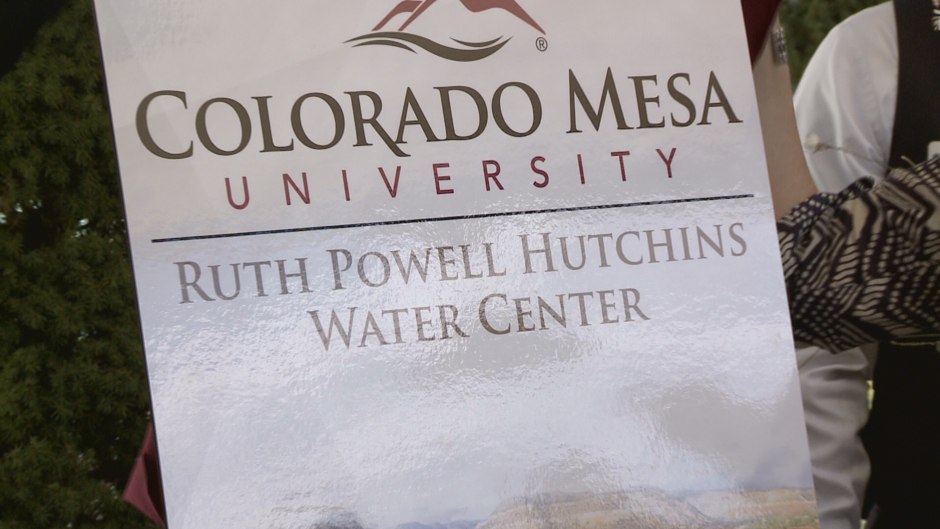
The Ruth Powell Hutchins Water Center at CMU is showing the Great Divide next weekend. Here’s an interview with Jim Havey from Laurena Mayne Davis writing in The Grand Junction Daily Sentinel:
“The Great Divide” is both a documentary and a companion coffee table-style book explaining the complexities of Colorado water issues in relatable narrative, while underscoring the urgency that all Coloradans become informed and involved in how their water is used and conserved.
Stephen Grace, of Boulder, wrote the book and served as screenwriter for the film, which was produced by Havey Productions, of Denver, which since 1979 has specialized in telling the stories of the American West. Jim Havey produced the film and provided images for the companion book.
Grand Junction on Saturday will host a free screening of “The Great Divide” as part of a 10-city film tour.
Laurena Mayne Davis: Who, or what, was the main driver behind the film and the companion book?
Jim Havey: Havey Productions specializes in historical documentaries on Colorado and the American West. We initially saw this as a compelling thread weaving through Colorado history and a new way to look at the state’s heritage.
Davis: Why did you feel it was important to be involved?
Havey: The urgency behind this film and book is the need for a more informed and inclusive public conversation concerning looming critical decisions on the management and allocation of water in Colorado. The Department of Natural Resources anticipates a gap in the demand for water, in the not too distant future, and the ability of our water providers to supply that water. Most Coloradans have very little knowledge of where their water comes from and what it takes to deliver it to their taps.
Davis: You had a KickStarter campaign, multiple sponsors and grants. What was your budget for this project, and how did the funding piece come together?
Havey: Our fundraising goal was $350,000. My associate producer, Blair Miller, led the effort, and we attended conferences and met water leaders throughout the state, learning about issues and attitudes while asking for sponsors to bring this film to the screen. After three years we successfully completed the funding with 55 sponsors and a $20,000 KickStarter campaign.
Davis: Talk about the photos in the book. They are a combination of your photos, contributed photos and historical photos. Did you oversee their collection?
Havey: The book includes a compilation of visual material from contemporary and archival photos to maps, paintings and illustrations. My film editor, Nathan Church, and I took most of the contemporary photos, which include some shot as stills and some pulled from video frames filmed for the movie. Nathan led the search for archival material, which came from the water archive at the Colorado State University library, the Western History collection at Denver Public Library, History Colorado, Denver Water, Library of Congress and many other sources.
Davis: How did the collaborative creative process work with book author and screenwriter Stephen Grace?
Havey: Steve Grace is an immensely talented and lyrical writer, and I was thrilled to have him on board for this project. We worked on the structure and drafts of the script for over a year before the book deal emerged from Steve’s contacts and reputation in the publishing world. But the publisher needed the book to be ready in about a six-week timeframe, and Steve worked round the clock researching, writing narrative, editing interviews, writing photo captions, and cataloging references to get it done. My team worked on the visuals. Then I edited the book narrative into the narrative script for the film and included lots of more recent interview material with some of the interviews in the book and worked with Steve to fine-tune everything.
Davis: I imagine the audience conversations at film presentations on the Western Slope (where most of the water naturally flows) are significantly different from those on the Front Range (where most of the state’s population grows). You’ve been on both sides of the divide now on your film tour. What are you expecting to hear in Grand Junction?
Havey: There are many points of view regarding water on both sides of the divide, and West Slope audiences are justifiably concerned about the growth projections for the Front Range and further depletions to their water supplies. The days of anyone getting something for nothing in water are long gone and we have entered a new era where negotiated agreements are far more desirable than court battles.
Davis: Agriculture, an important economic driver in the Grand Valley, accounts for some 85 percent of the water use in the state. What are the most realistic ways to make agriculture more water-efficient, and do you expect farmers and ranchers will be open to those changes?
Havey: Most farmers and ranchers are as concerned about conserving water as anyone and they are very aware that their water use is being carefully scrutinized as part of the solution for supplying the growing needs of Front Range and West Slope cities.
Agriculture has changed considerably in the last 50 years, and irrigation techniques are much more efficient today. As a state we all need to be concerned about threats to our rural communities in the face of buy-and-dry deals that turn hay meadows to shopping malls. Ag-urban transfers, rotational fallowing and more efficient irrigation technologies offer some solutions.
Davis: What do you want viewers and readers to do with their greater understanding of Colorado water issues? In other words, what’s your best hope for a more water-aware state populace?
Havey: My hope is that the film and book impress audiences with the urgency and complexity of western water issues, and the growing need to find collaborative solutions.
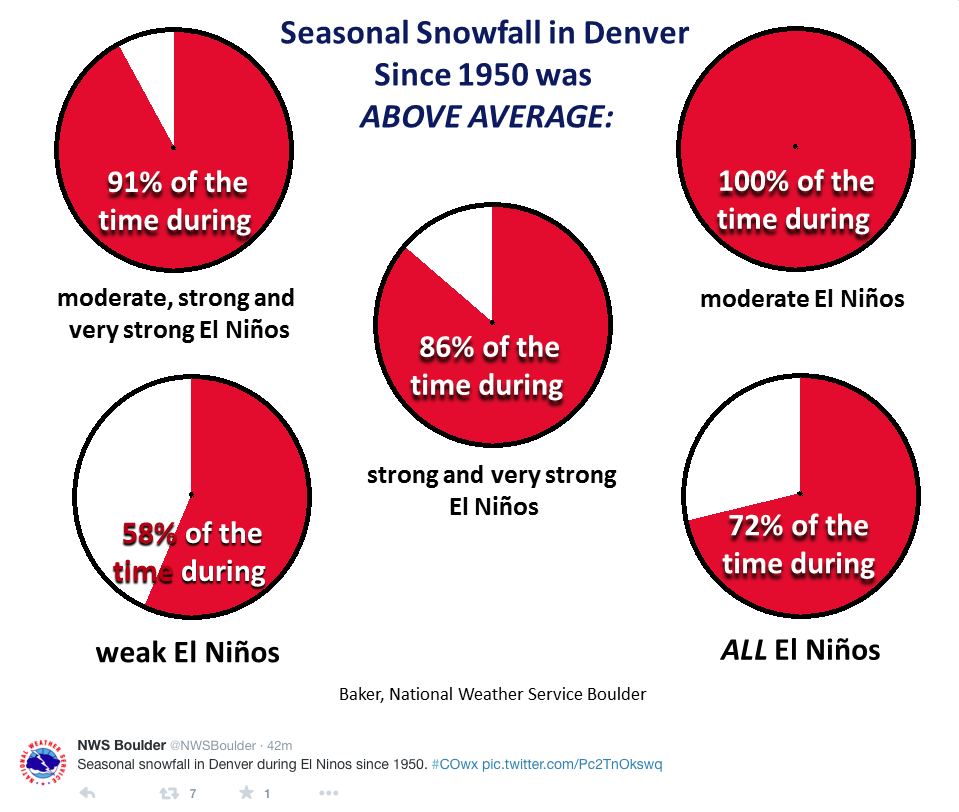
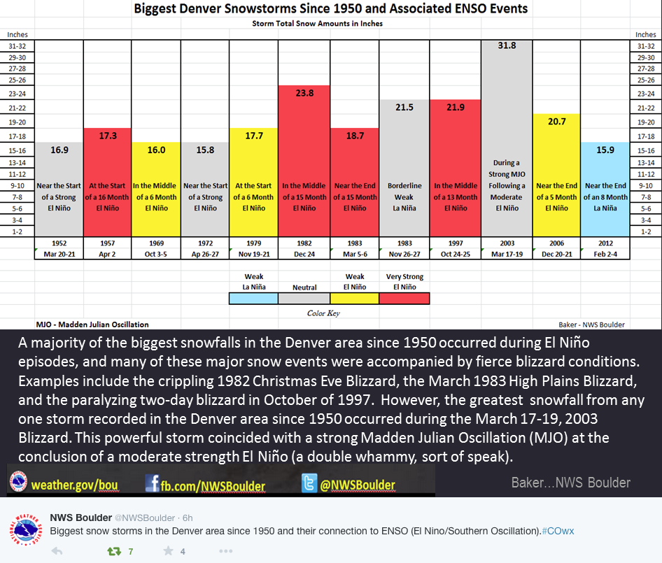
“It’s in the ‘Big Boy’ category,” said Klaus Wolter, a University of Colorado climatologist who studies the phenomenon whose translation is Little Boy.
Colorado could see a mixed bag of weather events from now through next spring — including a strong possibility of snow by the end of the month, Wolter added.
An El Niño of the current scope, measured by water temperature and wind direction, hasn’t been seen since 1997-98. Wolter figures this could be the third-strongest since 1900, after the events of ’97-98 and ’82-83.
“It’s behind 1997 at this time of year, but not far behind,” he said, adding that it won’t dissipate anytime soon. “But will it stick around for spring? That’s a crapshoot right now.”
Mid-September 2015 Plume of ENSO predictions via the Climate Prediction Center
From the Twin Lakes Reservoir & Canal Company via The Aspen Daily News:
The repairs were made under about 2 feet of water to minimize releases and control turbidity,” the TLRC statement says. “Over a period of about 24 hours beginning [Wednesday] afternoon … the stilling basin was [filtered] through the silt fence and straw wattles with very good results.
On September 23, the Huerfano County Water Conservancy District received approval from the Colorado Water Conservation Board for a grant totaling $250,000 to conduct a study of the storage needs for the Cucharas Basin. The current study is just one of 13 storage projects that are within the basin and are on the Arkansas Basin Improvement Project’s master needs list. Such projects are necessitated by the aged nature of existing storage infrastructure, 83 percent of which were built before the end of World War II. About 71 percent of all storage capacity has been lost due to abandonment or restriction. Funding for the grant has come from the basin and state-wide accounts, as well as from the Huerfano County Water Conservancy Board, the Huerfano County Board of County Commissioners, the Cucharas Water and Sanitation District Board, and the towns of La Veta, and Walsenburg. The water district has also applied for a second grant for gauging and administration modeling improvements along the Cucharas and Huerfano rivers. The purpose of the grant is to develop reliable infrastructure and technical data thatcan be used to provide help to arrive at difficult water administration decisions. The data can also be used to convey the reasons for decisions to water users impacted by those decisions in a clear, fact based manner. The district has not heard if the application has been approved. The two items in the gauging grant that will cost most are the stream gauge evaluation involving an inventory, assessment, and designing of gauge sites, and the construction of new gauges and improvements to gauges currently in use. Other costs include ground water monitoring, the development of administrative models, and project management. Following an executive session, the board approved signing a lease agreement with Sheep Mountain Ranch for an easement to possibly build an extra storage pond. The district’s attorney is still looking at the agreement at the time of the writing of this report. The Huerfano County Water Conservancy District adjourned after the executive session.
n 2013, the torrents of water that poured out of the mountains, ripping up roads and inundating Boulder, Lyons, Longmont and other Front Range communities, also resulted in a deluge of questions. Both the general public and local officials wondered just how unusual this rainfall and flooding had been. Had something like it happened before? Was anthropogenic (human-caused) climate change responsible?
“The intensity of the floods really caught a lot of us living in the region off guard,” said Lisa Dilling, director of the Western Water Assessment, which is part of the Cooperative Institute for Research in Environmental Sciences at the University of Colorado Boulder. Dilling is also a professor of environmental studies at CU-Boulder. “But because WWA has a long history of working with water managers and planners in Colorado’s Front Range, we could quickly assemble regional experts to assess the disaster.”
Within ten days of the floods, WWA researchers and their partners at the National Oceanic and Atmospheric Administration and Colorado State University synthesized information about the atmospheric conditions that produced the floods, the potential role of climate change, and how these floods compared to others in the past. They released a 4-page handout at a public briefing and panel discussion. This rapid-response effort spurred additional WWA research projects to better understand Front Range flood risk, some of which are still ongoing – which is why the group was thrilled to find out that NOAA will support them with about $4 million for another five years.
The money comes from NOAA’s Climate Program Office, which has funded WWA since 1999. WWA, which focuses on Colorado, Utah and Wyoming, is one of ten teams under NOAA’s Regional Integrated Sciences & Assessments (RISA) program. It’s intended to help expand the country’s ability to deal with climate change by having scientists work with local and regional stakeholders and engage them as research partners.
For WWA, the NOAA agreement is invaluable. “NOAA’s support is our foundation,” said Dilling. “We are grateful for the recognition that our work in this intersection of environmental change and decision-making is relevant, important and timely.” In the last five years, WWA has issued a report examining how climate change in Colorado affects water resources, as well as a study on the state’s vulnerabilities to climate change: in tourism, recreation, education, public health and many other sectors. It also helped Salt Lake City, Utah evaluate the impact of a changing climate on their water supply. And WWA collaborated with the National Integrated Drought Information System (NIDIS) to create a report on climate change and the Navajo Nation.
In all of these projects, the goal has been to provide land managers, water managers and other officials with the best information possible so they can develop and enact effective policies.
Under this new round of funding, WWA plans to pursue three big research areas. One of those is to examine how the science developed by WWA and other research entities can be made more useful to decision-making. “We’re interested in enhancing the usability of science,” said Jeff Lukas, Research Integration Specialist with WWA. “We want to involve stakeholders in everything we do. And we want to spread our model of two-way dialogue and collaboration between scientists and stakeholders.”
Another big area of research over the next five years will be vulnerability and adaptation. WWA plans to focus on how Utah, Colorado and Wyoming are vulnerable to climate change, as well as how to design more adaptive and resilient systems, looking specifically at water supply.. Lukas also points out that adaptation and resilience aren’t just about infrastructure, like roads, buildings, and bridges. They’re also about getting organizations to think differently when it comes to climate change.
And, finally, in an extension of their work on the 2013 floods, WWA wants to better understand extreme weather and climate events and help to use that understanding to inform future decisions. “We need to glean all the information we can from the rich historical record,” says Lukas. “And also tease out what the climate models can really tell us about changes in these events going forward.”
“Every day, communities and businesses in the U.S. and around world are grappling with environmental challenges due to changing climate conditions and extreme events,” said Wayne Higgins, director of the NOAA Climate Program Office, which announced funding for WWA and other programs today. “People want timely and relevant scientific information about where and why climate is changing, and what impacts that has on human and natural systems. CPO’s competitive grants play a vital role in advancing understanding of Earth’s climate system and in transitioning our data, tools, information, and operations to applications the public can use to improve decision making.”
CIRES is a partnership of NOAA and the University of Colorado Boulder.
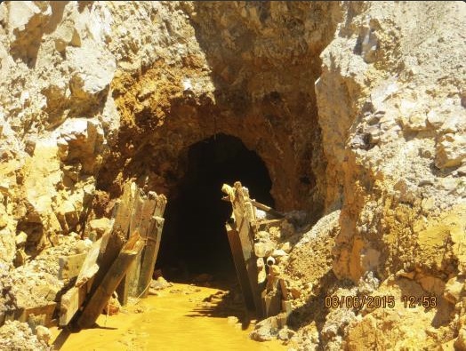
Only an estimated 2,000 gallons spilled Tuesday, amid efforts to open a collapsed portal. The impact on town water is expected to be minimal…
The Standard Mine, five miles west of Crested Butte and abandoned, has been designated an environmental disaster since 2005 and targeted for a superfund cleanup. It is one of an estimated 230 inactive mines in Colorado that state officials know to be leaking toxic heavy metals into headwaters of the nation’s rivers.
The spill happened at 1:30 p.m. Tuesday, and the EPA said it immediately informed public works officials. Residents weren’t notified. Crested Butte Mayor Aaron Huckstep said he wasn’t notified until Thursday.
EPA officials on Wednesday, responding to Denver Post queries about the mine, didn’t reveal the spill. On Thursday afternoon, the agency issued a prepared statement saying that, based on neutral acidity and creek flow levels, Crested Butte didn’t close its water intakes.
“Subsequent investigation found no visible plume or signs of significant impacts in downstream locations,” the EPA said.
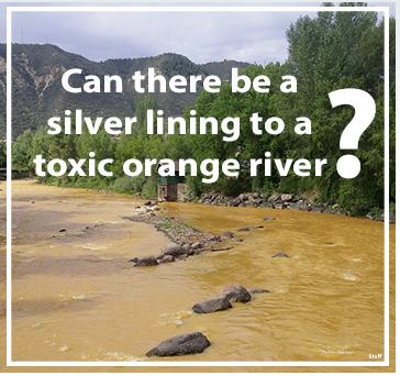
At the cleanup site, acidic wastewater laced with cancer-causing cadmium and other toxic heavy metals leaches out of the mine into Elk Creek, which flows into Coal Creek — a primary source of water for Crested Butte. The Colorado Department of Public Health and Environment has determined that the levels of arsenic, cadmium and zinc in Coal Creek exceed state standards.
Huckstep requested EPA help testing water in Elk Creek, Coal Creek and in town.
“I want to make sure that the EPA’s work is being done in a diligent manner and that their contractors are following the right procedures. We’d like to see these types of events not happen,” Huckstep said.
“Obviously, after Gold King, there’s a high level of public concern and attention — rightfully so. … The EPA is willing to come in and do the work. We support that. But we want to make sure that these types of circumstances don’t happen.”
The local Coal Creek Watershed Coalition began additional water sampling along the waterways “to determine what the impact of the spill was,” director Zach Vaughter said.
“While this event is unfortunate, we have a great cooperation and partnership with the EPA working on our watershed. … From what I understand, they’ve kept town staff and the coalition in the loop.”
The EPA has been working toward installation of a long-planned bulkhead plug inside the mine, an effort to reduce the flow of acidic wastewater leaching cadmium, arsenic, lead and manganese from tailings and tunnels.
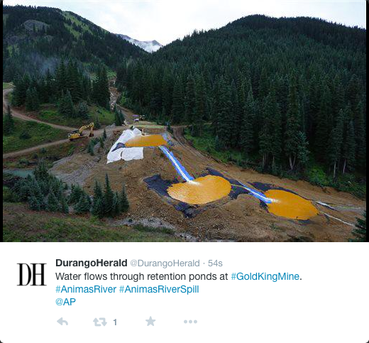
EPA crew members were drilling a new opening at the mine, parallel to a portal that is partially collapsed. They were using a vacuum truck to siphon water from a waste pond, but the truck “dipped too low,” the EPA’s statement said, causing grey-colored water from inside the mine and sediment to spill into Elk Creek.
The Town of Crested Butte has been notified by the Environmental Protection Agency (EPA) of a spill estimated at 2,000 gallons or less of water and gray-colored sediment from a holding pond at the Standard Mine.
According to the EPA, a contractor had been dewatering the pond containing un-mineralized sediment from drilling operations and water from the lower mine adit. The contents had been treated to a neutral PH of 7. The treated water from the sediment pond was being discharged into Elk Creek as part of a planned maintenance activity. A vacuum truck siphoning clear water from the surface of the pond accidentally dipped into gray-colored sediment leading to the accidental discharge of sediment and gray-colored water into Elk Creek. The discharged material contained a mixture of PH-neutral rock slurry and water from the mine.
Based upon the size and content of the spilled material as understood from the EPA, the flow levels downstream, and the 10 million gallon storage reservoir at the town’s treatment plant, the Town Department of Public Works has determined that any impact to the town’s drinking water would be negligible. The town has also hired an independent contractor to perform additional testing to ensure that there is no negative impact to the town watershed or drinking water.
Work on the holding pond is now complete.
The town is communicating and working closely with the EPA on this issue. The EPA has additionally contacted the Colorado Department of Public Health and Environment, Gunnison County and the Coal Creek Watershed Alliance. The town is also in contact with these agencies.
Colorado’s first-ever formal water plan needs to offer specific, actionable, measurable goals that the state’s leaders can use to fill a massive gap in the amount of water the state will have to support a growing population, business leaders were told Thursday.
And it needs to be a bold plan, said Kelly Brough, president and CEO of the Denver Metro Chamber of Commerce.
Brough spoke at the chamber’s “2015 State of Water” forum held Thursday at Hyatt Regency Denver at Colorado Convention Center. Speakers included Jim Lochhead, CEO of Denver Water, former Colorado Agriculture Commissioner Don Ament, Colorado River District General Manager Eric Kuhn and Robert Sakata, owner of Sakata Farms in Brighton…
…the chamber would like to see more attention to innovative and market-based solutions to filling the gap.
Brough referred to one idea as “buy and grow,” a twist on the “buy and dry” scenarios common across Colorado — in which cities and towns buy water used by farmers, shift it to the city, and let the field dry out due to lack of irrigation.
A buy and grow concept might make cities an outside investor for farmers who want to conserve their water but don’t have the financial means to buy expensive, new equipment to do so. The cities could provide the money, and the farmer could share the water that’s saved with the city, Brough said.
Such an arrangement also ensures that the water right, which is a property right in Colorado, remains in the hands of the farmer, she said.
“The current draft plan calls for 400,000 acre feet of new water through conservation, that’s nice but we don’t think it’s enough,” Brough told the business leaders assembled at the forum.
“Colorado needs to do so much more, and move to a future — beyond conservation — to maximum economic use of this precious resource,” she said.
Business leaders Thursday said they hope to replace the practice of “buy-and-dry” with “buy-and-grow,” a plan that would allow farmers to share their water rights with municipalities.
The idea was proposed at a meeting in Denver with state and local water officials, hosted by the Denver Metro Chamber of Commerce.
Kelly Brough, chief executive of the chamber, said “buy-and-grow” could usher in a new wave of water policy. The new plan could overshadow conversations about other controversial issues, such as transmountain diversion.
“By implementing measures that will streamline flexible water sharing between ag and urban areas, in ways that allow ag to continue to grow through using efficiencies, protect their water rights and reducing the transitional cost, while delivering water to an urban area,” Brough said of the plan…
“Buy-and-grow” would essentially boil down to sharing between urban and rural communities. Governments and private interests could help farmers with investments into water-conservation technology and other equipment, thereby helping farmers grow. The farmers would then turn around and share the water that they don’t need anymore because of the savings.
“They’re still growing, still producing, they’re more efficient and they don’t lose their water right,” Brough said.
Robert Sakata, owner of Sakata Farms in Weld County, who spoke at the meeting, acknowledged the reality of ag dry-up, pointing out that millions of acres stand to dry up by 2050.
“In order to feed the world, we’re going to need water,” Sakata said.
Colorado Water Plan website screen shot November 1, 2013
Mid-September 2015 Plume of ENSO predictions via the Climate Prediction Center Click here to read the discussion. Here’s an excerpt:
ENSO Alert System Status:El Niño Advisory
Synopsis: There is an approximately 95% chance that El Niño will continue through Northern Hemisphere winter 2015-16, gradually weakening through spring 2016.
During September, sea surface temperature (SST) anomalies were well above average across the central and eastern Pacific Ocean. The Niño indices generally increased, although the far western Niño-4 index was nearly unchanged. Also, relative to last month, the strength of the positive subsurface temperature anomalies decreased slightly in the central and eastern Pacific, but the largest departures remained above 6°C. The atmosphere was well coupled with the ocean, with significant low-level westerly wind anomalies and upper-level easterly wind anomalies persisting from the western to the east-central tropical Pacific. Also, the traditional and equatorial Southern Oscillation Index (SOI) values became more negative (stronger), consistent with enhanced convection over the central and eastern equatorial Pacific and suppressed convection over Indonesia. Collectively, these atmospheric and oceanic anomalies reflect a strong El Niño.
All models surveyed predict El Niño to continue into the Northern Hemisphere spring 2016, and all multi-model averages predict a peak in late fall/early winter. The forecaster consensus unanimously favors a strong El Niño, with peak 3-month SST departures in the Niño 3.4 region near or exceeding +2.0°C. Overall, there is an approximately 95% chance that El Niño will continue through Northern Hemisphere winter 2015-16, gradually weakening through spring2016 (click CPC/IRI consensus forecast for the chance of each outcome for each 3-month period).
Across the United States, temperature and precipitation impacts from El Niño are likely to be seen during the upcoming months (the 3-month seasonal outlook will be updated on Thursday October 15th). Outlooks generally favor below-average temperatures and above-median precipitation across the southern tier of the United States, and above-average temperatures and below-median precipitation over the northern tier of the United States.
Click here to go to the US Drought Monitor website. Here’s an excerpt:
Summary
Record rains and flooding inundated much of eastern and central South Carolina and extreme southeastern North Carolina as a very slow moving upper-air low over the Southeast funneled tropical moisture from Hurricane Joaquin (stalled over the central Bahamas) into the southern Atlantic Coast region for several days. More than 10 inches of rain fell on the eastern half of South Carolina, and well over 20 inches drenched east-central sections of the state. During the first 6 days of October, maximum Carolina storm amounts totaled 26.88 inches at Mt. Pleasant, SC, and 22.25 inches at Calabash, NC. Heavy rains (more than 2 inches) also fell across much of the eastern third of the Nation, easing or eliminating lingering short-term drought and dryness. An unsettled weather pattern in the West and High Plains also brought unseasonably heavy rains to parts of California, the Great Basin, Southwest, and northern third of the Rockies and Plains. Tropical moisture from former Pacific Hurricane Marty fueled heavy rains in New Mexico and west Texas. Wet weather continued across most of Alaska and Hawaii easing drought and dryness while light to moderate showers across southern Puerto Rico maintained conditions. In sharp contrast, mostly dry weather occurred throughout the Pacific Northwest, Great Plains, and Mississippi Valley. Ever since record wet May and June rains eliminated long-term drought in Texas and Oklahoma, very little precipitation has fallen in parts of the southern Great Plains and lower Mississippi Valley since early July, creating large short-term (at 2- and 3-months) deficits and extreme drought, especially from eastern Texas into central Mississippi…
California and Great Basin
With September and October normally one of the driest months in California, any significant rain (more than 0.5 inches) that falls during this time will usually produce large percentages. This was the case this week when a strong upper-air trough (low pressure) affected the West Coast, drawing in Pacific moisture to most of California and the Great Basin. Unseasonably heavy precipitation (0.5 to 1 inch, locally to 2 inches) was observed in extreme southwestern California (near San Diego vicinity), the Sierra Nevada, and most of northern and western Nevada including the Las Vegas area. Although the rains were welcome and aided in the suppression of wild fire conditions and increased topsoil moisture, it did little for the long-term drought and reservoir storages, thus no changes were made to the drought map. At the end of September, the water conservation efforts in California were noticeable when compared to last year. The amount of water saved came to about 705 KAF – so that this year’s major reservoir storage was only slightly below the storage from a year ago when there were no mandatory water restrictions…
Lower Mississippi Valley and Southern Plains
While the East Coast was getting soaked, a dry week throughout these two regions worsened short-term dryness and drought. The only exception was tropical moisture from remnants of Pacific Hurricane Marty that brought 0.5 to 2 inches of rain to extreme southwestern and western Texas and the Oklahoma Panhandle (which were mostly drought-free), although a small area of D0 and D1 in west-central Texas Panhandle (near Lubbock) was improved a category. Elsewhere, however, after much of Texas and Oklahoma endured record May and June rains and flooding that quickly erased the long-term (hydrological) drought, dry and warm weather since early July has rapidly brought back short-term (topsoil) drought. As a comparison, the Madill, OK Mesonet station measured 43.61 inches of rain from April 1-July 8, and only 1.16 inches in the 89 days since then. In Texas, Muenster (Cooke County) recorded 41.67 inches during April 1-June 30, 4.40 inches July 1-September 30, and only 1.91 inches since July 9. At the USHCN station Blanco (Blanco County), 8.55 inches fell on May 24, but only 0.48 inches since July 1 – so it seems likely that Blanco received as much rain in 14 minutes on May 24 as in the most recent 140,000 minutes (97 days). In Arkansas, several stations established new record lows (Minden 0.02”; Pine Bluff 0.03”; Shreveport 0.07”; and Little Rock 0.12”) for the driest September ever.
During the past 90-days, portions of central and northeastern Texas, southeastern Oklahoma, northern Louisiana, southern Arkansas, and west-central Mississippi have measured less than 2 inches, with several sites reporting under an inch. Normally, central Texas receives 6-8 inches, northeastern Texas and southeastern Oklahoma 8-10 inches, and northern Louisiana, southern Arkansas, and west-central Mississippi 10-15 inches during this 90-day period. This translates into a large area with less than 25% of normal precipitation, and deficiencies ranging from 4-6 inches (central Texas) to 8-12 inches in northern Louisiana and west-central Mississippi. Accordingly, widespread 1-category downgrades were made based upon the severity of the SPIs at 2- and 3-months, plus other products and indices. Fortunately, the record wet May and June in Texas has left statewide monitored reservoirs at 78.6% full as of October 7, although USGS average 28-day stream flows are generally below to much-below normal, as are river gauges in most of Louisiana, southern Arkansas, and Mississippi. According to USDA/NASS statewide statistics on Oct. 4, the percentage of topsoil/subsoil moisture short to very short was: Arkansas (81/74), Mississippi (80/76), Louisiana (69/60), Texas (67/64), and Oklahoma (50/54)…
Northern and Central Plains
A slow-moving frontal system, embedded with waves of low pressure and ample moisture to work with, produced unseasonably heavy precipitation from the Southwest northeastward into the northern Plains. The greatest amounts in the Plains included 1-2 inches in central Montana, western South Dakota, and north-central Nebraska. Most of this area, however, was drought free, except for D0 in eastern and central Montana and southwestern South Dakota where the abnormal dryness was reduced. In contrast, drier weather affected eastern sections, and D0 was expanded as short-term shortages increased (as mentioned in the Midwest summary for the eastern Dakotas and northeastern Kansas)…
Pacific Northwest and Northern Rockies
Little or no precipitation fell across the Northwest as temperatures averaged close to normal. With much of the region in D2 or D3 and the rainy season normally commencing later this month and into November, no changes were made this week. In the north-central Rockies, however, the continued wet weather in southeastern Idaho and northern Utah was enough to warrant a 1-category improvement there, matching the water reservoir storage conditions of the Snake River. Slight improvements were made in the Boise basin due to a wet July and September that significantly helped preserve the reservoir storage within the basin, and which now has the best reservoir conditions in Idaho outside of the Bear River basin in the southeast…
Southwest
The same slow-moving storm system in the Great Basin and Rockies also dropped light to moderate (0.5-2 inches) rain across parts of northern and central Arizona and southern Utah while tropical moisture from the remnants of Pacific Hurricane Marty generated 0.5 to 3 inches of rain in central and eastern New Mexico and west Texas. Most of the significant rains fell on non-drought areas, although the 1-2 inches in southeastern New Mexico was enough to reduce or eliminate short-term deficits (one D0 area shrunk, one erased). Since it had been dry in central and northern Arizona for a while, the rains came in time to prevent degradation…
Looking Ahead
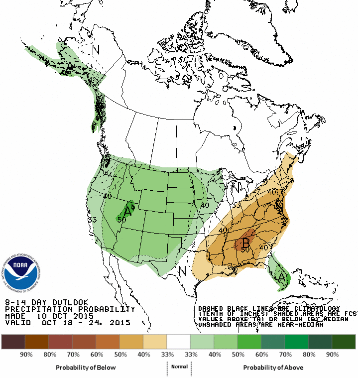
For the upcoming 5-day period (October 8-12), mostly light (0.25-0.75 inches) precipitation will occur in the eastern third of the Nation, with totals of up to 1-1.5 inches possible in the northern Rockies, Great Lakes region, central Appalachians, and eastern Florida. Farther west, heavy precipitation (1-3 inches) is expected in the southern High Plains and Rio Grande Valley, and 2-7 inches in western Washington. Elsewhere, little or no precipitation is expected. Temperatures across the lower 48 States will average above normal, especially in the West and Plains.
For the ensuing 5 days (October 13-17), the odds favor above-median precipitation from the Southwest northeastward into the central Corn Belt, and throughout the southern two-thirds of Alaska. In contrast, sub-median precipitation is favored in the Northwest and Southeast. A strong tilt toward above-normal temperatures is expected in the western half of the U.S., with lower but still above-normal odds in the eastern half of the nation. Alaska also favors above-normal temperature chances, especially in the south.
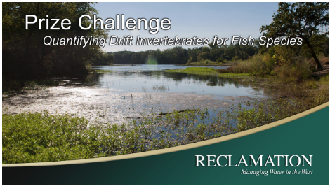
Here’s the release from the US Bureau of Reclamation (Lauren Meredith):
The Bureau of Reclamation is launching a $30,000 prize competition seeking improved methods to measure the food resources available for threatened and endangered fish. Advancing technology for monitoring how food is available for fish species can lower the cost and improve the effectiveness of fish recovery efforts.
“Protecting and restoring river systems are vital to ensuring that watersheds are healthy and can continue to meet the West’s water needs,” said Commissioner Estevan López. “Encouraging innovation and collaboration between the federal government and the private sector allows us all to do our jobs better.”
Millions of dollars are spent annually on restoration activities like changing flow regimes, reconstructing wetlands and adding natural structural elements. These efforts to improve and restore habitats are key to the recovery of salmon, trout and other critical fish species. A critical way to learn the effectiveness of habitat recovery is to measure the food resources available to fish species targeted for recovery and protection. Despite its importance, measuring food resources has proven difficult.
The top one to three submissions will receive $10,000 to $15,000 in prize money, totaling no more than $30,000. The winning solutions will help fish recovery managers evaluate the food available to impacted fish species under various habitat restoration strategies.
Reclamation is collaborating with National Oceanic and Atmospheric Administration Fisheries, U.S. Geological Survey, U.S. Fish and Wildlife Service and the U.S. Army Corps of Engineers to lead this competition.
On October 7 and 8, the Obama administration is celebrating the five-year anniversary of Challenge.gov, a historic effort by the federal government to collaborate with members of the public through incentive prizes to address our most pressing local, national, and global challenges. True to the spirit of the President’s charge from his first day in office, federal agencies have collaborated with more than 200,000 citizen solvers—entrepreneurs, citizen scientists, students, and more—in more than 440 challenges, on topics ranging from accelerating the deployment of solar energy, to combating breast cancer, to increasing resilience after Hurricane Sandy. Read more here.
Catastrophic wildfires in the Western U.S. are often discussed in superlatives these days, with blazes burning land more violently and more frequently in recent years than at any point on record. Those changes are considered partly driven by global warming, and a new University of Wyoming study shows that even the smallest increase in average temperature — 0.5°C (0.9°F) — could bring a dramatic increase in wildfire activity at higher elevations.
The study also suggests that global warming may be ushering in an era of high-elevation wildfires unlike any seen in more than 1,000 years…
The new study, published Monday in the Proceedings of the National Academy of Sciences, provides more evidence that even a small amount of warming has a huge effect on wildfire.
University of Wyoming researchers studied charcoal samples representing 2,000 years of wildfire that were taken from lake beds in a subalpine forest — above 8,000 feet — in northern Colorado’s Mount Zirkel Wilderness near Steamboat Springs. With them, they were able to measure the increased wildfire frequency during a period of global warming similar to today.
That period, called the Medieval Climate Anomaly, or MCA, was about 1,100 to 1,200 years ago, when average temperatures in Northern Colorado were 0.5°C warmer than they were the preceding century, but moisture levels were not dramatically different.
Before the warm period, about 50 percent of the sites the researchers studied burned per century, increasing to 83 percent during the warm period and declining to 33 percent afterward. Most sites burned roughly at a rate of every 360 years prior to the warm period, increasing to every 120 years during the warm period — a 260 percent increase. Fire frequency declined before temperatures cooled, however, and the researchers think that happened because there was little forest left to burn.
The study is the first to discover how much land across an entire mountain range burned over a period of 2,000 years and shows that large wildfires similar to those burning today only occurred when temperatures increased like they have in recent years, the study’s lead author, University of Wyoming Ph.D. candidate John Calder, said.
“When we look into the past for evidence of these large wildfires we only see them one time when temperatures rose about 1°F,” he said. “Our study then adds more evidence that the recent increase in large wildfires is related to climate change because the only time we see these types of large wildfires in the last 2,000 years is when we had a similar amount of warming.”
The study only applies to dense high elevation forests, not those that have burned at lower elevations elsewhere in Colorado.
West Fork Fire June 20, 2013 photo the Pike Hot Shots Wildfire Today
Hewlett Fire May 5, 2012
Black Forest Fire June 2013 via CBS Denver
Weber Fire near Mancos June 2012 via MNGInteractive.com
Four Mile Canyon Fire September 6, 2010
Waldo Canyon Fire. Photo credit The Pueblo chieftain.
“A statement implying that the efforts that cities and water suppliers have used to plan for water supply projects is based on ‘blind hope’ instead of careful analysis is misleading and unacceptable,” wrote Aurora Mayor Steve Hogan to Gov. John Hickenlooper in response to the second draft of the plan, released in September.
The plan — which says that the state will run out of water for a fast-growing population by 2050 — presents a dizzying array of solutions for more water that include improving the permitting process, funding more storage and reducing the state’s projected 2050 municipal water demands by 400,000 acre-feet through conservation. That equates to a nearly 1-percent annual reduction in water use for the state’s cities and towns, according to the advocacy groups Conservation Colorado and Western Resource Advocates.
Joe Stibrich, a water resources policy manager with the city, said the plan also discourages more water diversions, stating Colorado watersheds and ecosystems cannot handle any more of them.
“In fact, new diversions and storage will be needed to develop collaborative, regional projects,” Stibrich and other Aurora Water staff wrote in a response to Hickenlooper about the plan.
Stibrich said Aurora Water is also concerned about the 400,000 acre-feet stretch goal because the number could overly burden Front Range cities.
“The concept itself is good but it’s a number that hasn’t been verified,” he said, adding that the stretch goal will not likely be achievable under current policies and with existing technology. Stibrich said he would like to see experts work with legislators to come up with an achievable range rather than a specific number.
A hearing on the plan in its second draft drew mostly advocacy groups to the Aurora Municipal Center in September. Those who testified at the meeting had concerns similar to those expressed by city officials.
Barbara Biggs, chair of the metro basin roundtable, also questioned the 400,000 acre-feet goal put into the plan at the meeting.
“Applying it in a one-size-fits-all goal makes us nervous. We think the stretch goal needs to recognize what different communities are going to be able to accomplish different things in their water conservation efforts,” she said…
Anne Castle, an expert with the University of Colorado’s Getches-Wilkinson Center for Natural Resources, Energy, and the Environment, testified that the second draft of the water plan remained too vast in its goals and vague in its action plan.
“We’re recommending the hundreds of action items in the plan be prioritized,” she said. “We need to prioritize those actions in order to have a practical implementation strategy. We can’t do everything at once.”
Castle recommended that the state’s water conservation board come up with a criteria for funding water projects and programs. Right now, the plan says the state will need $20 billion to pay for necessary water projects in the coming decades without specifically describing what those water projects are.
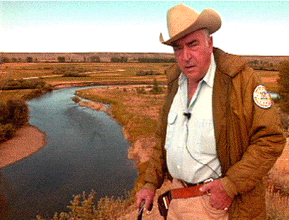
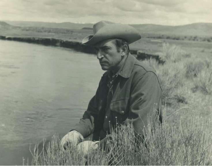
From the United States Geological Survey (Curt Meine):
Dr. Luna Leopold discusses the importance of bankfull discharge on the New Fork River near Boulder, Wyoming. Photo courtesy of U.S. Forest Service
No time seems more fitting than now – with the epic drought in California and major flooding from a nor’easter and Hurricane Joaquin – to pay tribute to Luna B. Leopold, the first chief hydrologist at the USGS. More so than any other scientist, he set the course for the USGS approach to understanding river flows, groundwater and surface water interactions and the value of long-term data collection. Today, the USGS is the world’s largest provider of hydrologic information with a mission to collect and disseminate reliable, impartial, and timely information that is needed to understand the Nation’s water resources.
Born on Oct. 8, 1915 in Albuquerque, Luna Leopold lived a rich life. From his renowned father, the biologist and author Aldo Leopold, he inherited a passion for outdoor life, a respect of craftsmanship, a highly disciplined curiosity, and an appreciation of the complex interactions of human society and natural systems. From his mother Estella, he inherited a deep connection to the semi-arid landscapes and watersheds of the American Southwest, a rich Hispanic cultural tradition, and a keen aesthetic sense. These qualities would meld and develop over time, across an extraordinary career in the earth sciences.
Luna Leopold via the USGS
According to the Virtual Luna Leopold Project, “He was trained as a civil engineer (B.S degree), meteorologist (M.S. degree) and geologist (Ph.D.) and his publications reflect that blending of fields. His first publication in 1937 was entitled Relation of Watershed Conditions to Flood Discharge: A Theoretical Analysis and his most recent publication in 2005 was Geomorphic Effects of Urbanization in Forty-one Years of Observations. Few have written papers spanning 68 years, and fewer still have had such an influence on a field or on society.”
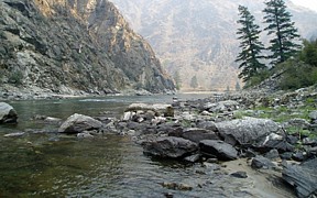
Middle fork of the Salmon River near Shoup, Idaho
Luna Leopold’s creative intellect compelled him to explore the territory where science, policy, ethics, and environmental stewardship come together. In discerning the complex physical processes of stream formation and development, climate, precipitation, erosion, sedimentation, and deposition, he made connections to our human capacity to alter, or adapt to, hydrological realities. He understood that water science could not be separated from the water management and stewardship, which could not be separated from water ethics. On this he has been widely quoted: “Water is the most critical resource issue of our lifetime and our children’s lifetime. The health of our waters is the principal measure of how we live on the land.”
“The stream has to have change”
What he was referring to, of course, was our dominant historic tendency to reduce the inherent flux in stream systems, to manage flowing waters by controlling their dynamic variability. It is a fundamental lesson that several generations now of river managers and stewards have taken to heart and employed in restoration practice.
I suspect I highlighted that line in my notes, in part, because of its rich metaphorical potential. Luna Leopold understood change. He saw the reality of change and the need for change. He was himself an agent of change. In his field work, in his policy work, in his teaching and writing and consulting, he came to a view of rivers, of water, and of our future, that called for change. Through Luna’s understanding of science, history, and aesthetics, he came to perceive a “harmony in natural systems,” and held that “the desire to preserve this harmony must… be incorporated into any philosophy of water management, and I will call this, as did Herodotus, a reverence for rivers. If this is environmental idealism, then let it be said that I am an idealist.”
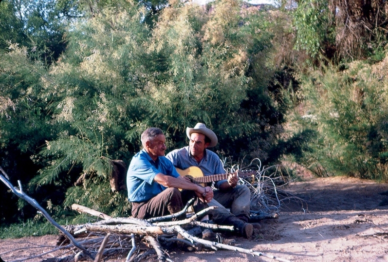
In the midst of a research expedition in Cataract Canyon, Utah, former USGS Chief Hydrologist Luna Leopold and eminent physicist Ralph Bagnold take a moment to rest
Wisdom from the past shapes the USGS today
Leopold was best known for work on the geomorphology of rivers, the study of land features and the processes that create and change them. He initiated a new era in the study of rivers, one that involved quantitative approaches that spread to the broader field of geomorphology. His research related meteorology and climatology to landscape process, a concept that has become a central feature of geomorphology. One of his better known papers, The Hydraulic Geometry of Stream Channels, published in 1953, initiated a new era in the quantitative study of rivers and stimulated quantitative approaches in geomorphology generally. Revealing an orderly framework of river behavior, the paper provided a basis for observing rivers worldwide through objective measurements and data collection.
Luna Leopold (3rd from left) visiting the USGS Wisconsin Water Science Center in 2002.
Leopold retired from the USGS in 1972, having had a distinguished 22-year career where his focus on research and interpretation of data made a profound impact on the earth sciences. His enthusiasm for rivers proved contagious, inspiring generations of colleagues and students to devote their talents to the pursuit of science and to its application for society. Following his USGS career, Leopold, became a professor in the Department of Geology and Geophysics and the Department of Landscape Architecture at the University of California, Berkeley. He passed away in 2006 at the age of 90.
Today, as our nation is faced with the challenge of balancing a finite freshwater supply among competing needs, including agriculture, drinking water, energy production, and ecosystem health, we can appreciate even more Luna Leopold’s combination of field knowledge, leadership, and wisdom. His reverence for rivers, his way of connecting head and heart, has continued to inform new generations of scientists, policy-makers, land stewards, and philosophers who are extending his insights, exploring new dimensions in water ethics, and putting that ethic into practice. The stream has to have change. The change that Leopold helped to initiate and inspire must come. It comes more predictably, perhaps, in natural systems than in human ones. But now, as we come to know how the human and natural inevitably flow together, we can perhaps allow reverence and knowledge to flow together as well—as they did through Luna’s life.
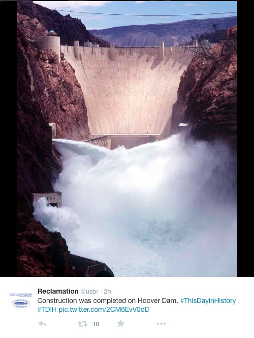
It’s one of those milestones that’s an entirely arbitrary result of the units we use to measure, but it’s probably nevertheless worth marking: for the first time since it was filled in the 1930s, Lake Mead ended the “water year” below 10 million acre feet of storage.
The finally elevation at midnight last Wednesday, Sept. 30, was 1,078.1 feet above sea level at the big Colorado River reservoir, which holds water for use in Nevada, Arizona, California, Sonora, and Baja. That translates to an estimated 9.854 million acre feet in storage, down from 10.121 maf a year ago. That is 38 percent of capacity.
Approving the 2016 budget, and electing officers for the Executive Committee are among the agenda items for the Republican River Water Conservation District Board of Directors’ regular quarterly meeting, Thursday, October 8, in Wray.
The meeting will be held at Cobblestone Inn & Suites on Highway 385 north of Wray beginning at 10 a.m. Public comment will be heard at 1 p.m.
A hearing will be held on the proposed 2016 budget, followed by consideration and approval of the budget.
It also is time for new terms for some of the 15-member board, as well as elect officers for the Executive Committee. New terms will begin for directors representing Washington, Sedgwick and Lincoln counties, as well as the W-Y, Central Yuma, and Plains ground water management districts.
The compact compliance pipeline will remain in the forefront. The board is scheduled to approve the application to the Central Yuma Ground Water Management District for the export of water from wells within the Central Yuma district for the pipeline. The board also is set to receive a a report from the State Engineer’s and Attorney General’s offices on negotiations with Kansas regarding the pipeline and the Bonny arbitrations. Some of that report might be in executive session if negotiation and litigation strategy is going to be discussed.
A special meeting is held each fall in Greeley. The board will be asked to approve a resolution to hold the special meeting.
Discussion of the 2016 Ogallala Aquifer Initiative will be held, as well as other matters. The board will hear reports from General Manager Deb Daniel, as well as from the district’s engineer and legal counsel.
Cobblestone Inn & Suites is located at 35952 Highway 385.
The District Engineer, U.S. Army Engineer District, Omaha, Nebraska is evaluating a Department of the Army Section 404 Permit application from Urban Drainage and Flood Control District, 2480 West 26th Avenue, Suite 156-B, Denver, CO 80211. Permits are issued under Section 404 of the Clean Water Act (Section 404) which regulates the placement of dredged or fill material in the nation’s waters. Urban Drainage and Flood Control District (District) is requesting authorization for river channel work along approximately 3,000 linear feet of the South Platte River. The channel improvements are proposed to improve aquatic, wetland, and riparian habitat; provide boat passage through this section of river; and maintain flood conveyance and grade control. This reach of the South Platte River is part of a Flood Risk Reduction Project implemented by the Corps in the 1970s following the devastating flood of 1965. The reach has been channelized because of encroachment by development.
Click here to read the newsletter. Here’s an excerpt:
Eagle River Watershed Council has teamed up with the U.S. Forest Service for the inaugural year of our Citizen Science program. This program aims to identify creeks and streams on Forest Service land that currently house populations of native cutthroat trout or could in the future. Participants were trained to collect Environmental DNA samples and assess the physical habitat of streams.
We are no longer accepting new volunteers for the Citizen Science program this year, but there will certainly be ways to get involved in 2016! Email burchenal@erwc.org to sign up for next year or simply to find out more.
Denver Water is hosting two Public Availability Sessions this week to encourage residents in the area of Gross Reservoir to come and meet with Denver Water staff to address questions about DW’s Gross Reservoir Expansion Project.
Location: Coal Creek Canyon Community Center
31528 CO-72, Golden, CO 80403
While not sponsored by Boulder County, the county has offered to spread the word about the meetings as a way for county residents to come have their questions and concerns addressed by Denver Water staff. As one Denver Water official has stated, “We’re very hopeful that this availability session format allows us to talk more directly with individuals about their concerns.”
Gross Dam enlargement concept graphic via Denver Water
Gross Dam
Workers pose for a photo in the Moffat Water Tunnel in this 1930 photo.
West portal Moffat Water Tunnel
The plan includes environmental enhancements and protections to ensure the Fraser River will be better off with the Moffat Project than without it.
Denver Water’s collection system via the USACE EIS
South Boulder Creek near the East Portal of the Moffat Tunnel via Jason Lee Davis
Moffat Collection System Project/Windy Gap Firming Project via the Boulder Daily Camera
Click here to listen to the podcast. Here’s an excerpt from the Water Values website:
Recently retired from the Colorado Supreme Court, Justice Greg Hobbs joins The Water Values Podcast to share his knowledge of western water law, specifically the doctrine of prior appropriation and its impact on how the West developed. Justice Hobbs uses his deep and broad knowledge of water law to explain how the doctrine of prior appropriation developed, stretching his explanation of water in the West all the way back to the reservoirs the inhabitants of Mesa Verde used and up through the Spanish and Mexican influences in the West. He provides an eye-opening analysis of water law and contrasts differing versions of prior appropriation (Colorado with California; court adjudicated rights versus administratively granted rights). Finally, Justice Hobbs discusses his involvement with the Colorado Foundation for Water Education and its many programs.
From the League of Women Voters of Larimer County (Sarah Pitts) via the Fort Collins Coloradoan:
As part of its long history of studying and participating in public discussion on water and other environmental issues, the League of Women Voters of Larimer County delivered comments to the Army Corps of Engineers on the second draft environmental impact statement (SDEIS) for the proposed NISP/Glade Reservoir project. The league recommended the Corps defer issuing a permit for the project until the Corps corrects data inadequacies and omissions, addresses compatibility with the draft state water plan, and better defines and quantifies short- and long-term costs related to environmental impacts.
Inadequate data cited by the league include:
•Population growth projections are overstated because they fail to use the reliable and objective data provided by the Colorado State Demography Office.
•Per capita water consumption projections are overstated because they fail to factor in already implemented conservation measures (e.g., Fort Collins reduced per capita consumption from 188 gallons/day in 2003 to 140 now) as well as new and developing conservation initiatives.
•Water supply projections underestimate the potential for acquiring water from annexed farm land, from alternative agricultural transfers, and from growing supplies of reuse water.
•The SDEIS omits essential water quality and temperature models.
The SDEIS fails to analyze the project’s compatibility with the draft Colorado state water plan. It is also at odds with the South Platte River Basin Implementation Plan statement that the costs of building and maintaining reservoirs are questionable: “The basin, in a typical year, has little unappropriated water available for new uses. Unappropriated flows . . . come in sporadic, high peaks during wetter years, making the economics of building a reservoir to capture these supplies questionable because of the large carryover storage requirements.”
Unsubstantiated assumptions about long-term, as well as short term environmental impacts, call into question the SDEIS’s already insufficient disclosure as to the allocation, sources of funding and impact of costs to build and mitigate the effects of the NISP project.
A U.S. Bureau of Land Management proposal to expand the Blanca Wetlands could be left in the lurch by the expiration of a congressional conservation fund. Congress failed to renew the authority for the Land and Water Conservation Fund on Wednesday, the end of the federal fiscal year.
The expansion of the wetlands, which is a temporary home for dozens of songbirds and shorebirds that migrate through the San Luis Valley, had been paired with a project by the agency on the Rio Grande Del Norte National Monument.
The White House’s 2016 budget called for $18 million in permanent funding for the project and another $22 million subject to future appropriations by Congress.
Secretary of the Interior Sally Jewell said in a statement that the fund, which draws off revenue from off-shore oil and gas drilling, faced a needlessly uncertain future.
“I’m extremely disappointed that, despite overwhelming bipartisan support, Congress has allowed this innovative and effective program to expire,” she said.
A spokeswoman for Jewell said Interior had given no instruction to the land-management agencies it oversees on whether to pursue other avenues of funding for their projects.
The BLM hoped to expand the wetlands through the purchase of 12,000 acres of private land from willing sellers.
The area targeted for expansion had included wetlands as recently as the 1940s but had dried up from drought or agricultural development.
The agency now maintains habitat at the 8,700-acre Blanca Wetlands by pumping groundwater into the marshes and ponds at the site.
The proposed funding for the national monument, which sits just south of the valley across the New Mexico state line, would have gone toward the protection of cultural and historic sites.
And while Jewell and a host of national conservation groups called for the reauthorization and full funding, many Republican congressmen from the Western U.S. called for reform of the program.
U.S. Rep. Scott Tipton, R-Colo., whose district includes the valley, said those reforms should move the fund away from purchasing more land for federal agencies, although he did not object to its use for land exchanges with willing private landowners.
The fund would be better served by helping federal agencies manage the land they have, Tipton said in a written statement.
“LWCF reauthorization provides an opportunity for reforms that support addressing the growing maintenance backlogs for national parks, roads, trails and facilities,” he said.
Mayor Suthers released his proposed 2016 budget Monday. The big focus will be on storm water. A problem that’s plagued Colorado Springs for years.
“Several years ago, we had a storm water enterprise,” Suthers said. “With the demise of that, defunding of the storm water enterprise, for the most part we’ve been spending minimal amounts [of money] over the last several years in terms of storm water.”
The city is setting aside $16 million, with an additional $3 million from Springs Utilities for a total of $19 million.
That plan had some tax payers wondering why isn’t that money going toward the roads.
“There were times I felt like I was going to get pulled over for swerving so much even though it was just because of the pot holes,” Mackenzie Tennison said.
The mayor said through all their surveys, roads were the top priority for voters so he expects them to pass the proposed tax increase of 0.62 percent in November. That will give the city the money it needs to fix our roads.
“I don’t agree with, you know, us getting taxed more,” Leafner Tan said. “I’m pretty sure there’s enough money there, and I’m pretty sure there’s also money going somewhere we don’t need to spend money on.”
“You cannot do storm water and roads,” Suthers said. “Storm water is within reach because it’s a relatively less amount of money.”
Suthers added, that unlike previous years, he’s been working with city council on this budget and that nothing about it should surprise them.
There will be a meeting at City Hall on October 20 from 5-7:30 p.m.
The $268.1 million general fund budget is up $9.4 million, or 3.6 percent, but Suthers said that when adjusted for inflation, the city today spends $86 a year less on each resident than it did in 2000…
Suthers’ priority remains the city’s infamously atrocious roads, most of which need overlays or complete reconstruction. But the mayor is banking on passage of a Nov. 3 ballot issue to provide $50 million a year for five years through a 0.62 percent sales tax increase.
The other overriding need is stormwater projects to ameliorate Fountain Creek flooding effects on downstream Pueblo. Past city stormwater funds have been eliminated, and a federal lawsuit has been threatened by the Lower Arkansas Valley Water Conservancy District.
If the issue isn’t addressed, it also could threaten the 1041 permit Colorado Springs Utilities got for its $829 million Southern Delivery System, soon to pump water from Pueblo Reservoir to Colorado Springs, Pueblo West, Fountain and Security.
So Suthers is squeezing $16 million out of the budget, which would be augmented by $3 million from Utilities, for stormwater projects…
In order to make ends meet, staffing requests, raises and capital projects were left unfunded, Suthers said.
Click here to read the Mayor’s news release and letter to City Council — via Pam Zubeck and the Colorado Springs Independent.
When State Engineer Dick Wolfe turned in a set of proposed groundwater rules and regulations to the division water court on Sept. 23, he channeled Yogi Berra.
“When you come to the fork in the road, take it,” he said, quoting the Hall of Fame Yankees catcher who passed away the day before.
But for nearly four decades, the San Luis Valley’s water users avoided any path that involved giving the state engineer the authority to shut down or limit pumping by the valley’s roughly 4,500 irrigation wells.
Two aquifers supply the water for those wells and help farmers irrigate valley staples such as potatoes, barley and alfalfa.
The shallower of the two, the unconfined aquifer, is fed by streams, seepage from irrigation canals and return flows from fields, and some upward leakage from a deeper aquifer.
The deeper aquifer, known as the confined aquifer, is fed by streams at the rim of the valley and is under artesian pressure.
Both aquifers are hydrologically connected to the valley’s surface streams to varying degrees, a fact that underlies complaints from surface-water users that their rights are injured by groundwater pumping.
Wolfe’s predecessor had proposed rules in 1975 only to see them shelved as the valley’s water users looked for another way to mitigate the impacts of well pumping on surfacewater users. And while this version still will have to gain approval from water court, enough had changed in the intervening decades to prompt a second stab at rules and regulations.
To begin, the federal Closed Basin Project, which pumps groundwater from the eastern edge of the valley for delivery to the Rio Grande, has been ineffective.
The valley’s water user groups signed an agreement in 1985 that divvied up how the project’s water would apply toward Colorado’s obligations to the Rio Grande Compact.
The move was regarded as an olive branch to surface-water users on the Conejos and Rio Grande rivers, since they alone carried the burden of complying with compact obligations.
Without the policing powers rules could give the state engineer, groundwater users faced no such burden.
The pact, commonly known as the 60-40 Agreement, also included a provision that kept valley surface-water users from going to court to shut down groundwater wells.
But since 2000, the amount of water produced by the project has never exceeded 20,000 acre-feet — far below envisioned amounts of up to 100,000 acre-feet when it was authorized by Congress in 1972.
Another change since the last rule proposals involved a pair of unsuccessful efforts in the 1990s to ship large amounts of the valley’s groundwater to the Front Range.
The proposals from American Water Development and later the Stockmen’s Water Company put all of the valley’s water users in the same boat, said Ralph Curtis, who managed the Rio Grande Water Conservation District for 25 years.
“We kind of just grew and grew together to realize we are neighbors,” he said.
Moreover, less was known in the 1970s about the two major groundwater bodies that sit beneath the valley floor. When the 1975 rules were proposed, a monitoring network that could measure levels in the unconfined aquifer in the north-central part of the valley still was a year away.
Exactly how much was pumped from the aquifers was not known either until 2006 when the engineer’s office implemented well-metering requirements.
Mac McFadden, who was the division engineer for the valley in 1975, and Steve Vandiver, who later would serve 24 years in the same post, both pointed to the development of the state’s groundwater computer model as an important advancement.
While that model could be a point of contention in court hearings for the current version of rules, it provides the basis for estimating how much instream losses are caused from well pumping Lastly, both Curtis and Vandiver point to the drought that began in 2002 as a pivotal point in the valley’s water politics and one that would pave the way to a new version of state rules.
“The drought of 2002 just tipped over the bucket of worms,” Vandiver said. “It was obvious then what the impacts of wells were on the (Rio Grande) — river just went away.”
The lowest flows ever recorded on the Conejos and the Rio Grande rivers where they enter the valley floor came in 2002.
And much of those meager flows were lost to aquifers that were being drawn on heavily by irrigators that had no surface supplies.
The division engineer’s annual report for that year estimated stream losses on the Rio Grande were as high as 40 percent at times, while on the Conejos they peaked as high as 60 percent.
“That provided the impetus for the surface-water users to say we’ve had enough,” Vandiver said.
Vandiver credited Manassa rancher Kelly Sowards and other surface-water users for creating the subsequent push to regulate wells.
Two years later, state lawmakers would pass a bill that created the framework for the current version of the rules and groundwater management subdistricts.
The first such subdistrict, which buys water to return to the Rio Grande and also pays ditch companies for losses caused by pumping, went into operation four years ago in the north-central part of the valley.
Kansas has concerns that the effects of a large dam on Fountain Creek are not adequately modeled in a study of flood control and water rights that is nearing completion.
But comments from Kevin Salter of the Kansas Division of Water Resources indicate the modeling done by the Fountain Creek Watershed Flood Control and Greenway District is “reasonable” when it comes to side-detention ponds.
Kansas is an important player because its 1985 federal lawsuit over the Arkansas River Compact raised storage issues along with wells. The Supreme Court ruled in Colorado’s favor on the storage questions, but new dams would be untested waters.
“The methodology in this draft report appears reasonable to protect water rights below the confluence of Fountain Creek and the Arkansas River for the scenario involving side-detention facilities,” Salter said.
“As for the scenario to construct a multipurpose reservoir on Fountain Creek; Kansas is concerned.”
In an email to a committee looking at engineer Duane Helton’s draft report, Salter said more study is needed to look at the full impact of a 52,700 acre-foot reservoir that would include a 25,700 acre-foot pool for recreation and water supply and 27,000 acre-feet for temporary flood storage.
“Should the actual implementation of detained flood flows on Fountain Creek impact compact conservation storage Kansas would fully expect that those flows be restored,” Salter said.
Larry Small, executive director of the Fountain Creek district, said a more complete evaluation would be made of water rights if a large reservoir is pursued.
“The district will complete a full evaluation of alternatives and a feasibility study of the preferred alternative in the future before any decision is made on flood control facilities, to include multipurpose facilities,” Small said in an email reply.
Helton’s study shows there would be little impacts on water rights if flood control structures allowed a flow of 10,000 cubic feet per second to flow through Pueblo during large floods. Water would be released as quickly as possible following the peak flow.
The study discounted extremely high flows, such as the 1999 or 1965 floods, saying there would be little damage to water rights because the high volume would fill John Martin Reservoir, creating a free river.
Division Engineer Steve Witte said Kansas concerns must be treated carefully, so a new round of litigation isn’t triggered.
Witte would like the 2015 flooding to be studied. Flows on Fountain Creek exceeded the 10,000 cfs mark on three occasions during six weeks of elevated flows. John Martin Reservoir did not fill, so it would be an ideal opportunity to explore how flood storage could be administered, he said.
“I think we need to be careful in any scenario to make sure there isn’t some material depletion,” Witte said.
After the 1999 flood, when Kansas and Colorado were in litigation over the Arkansas River Compact, Kansas raised questions about how such large flows should be divided. Those issues have not been resolved, Witte said.
Another downstream party, Tri-State Generation and Transmission Association which owns half of the Amity Canal in Prowers County, said more study is needed to determine the damage if water is detained at lower flows and how water would be allocated after a flood.
The committee looking at the report, which includes some downstream farmers, Kansas, Colorado Springs Utilities, Tri-State and others, will meet again at 10 a.m. Oct. 14 at the Southeastern Colorado Water Conservancy District offices.
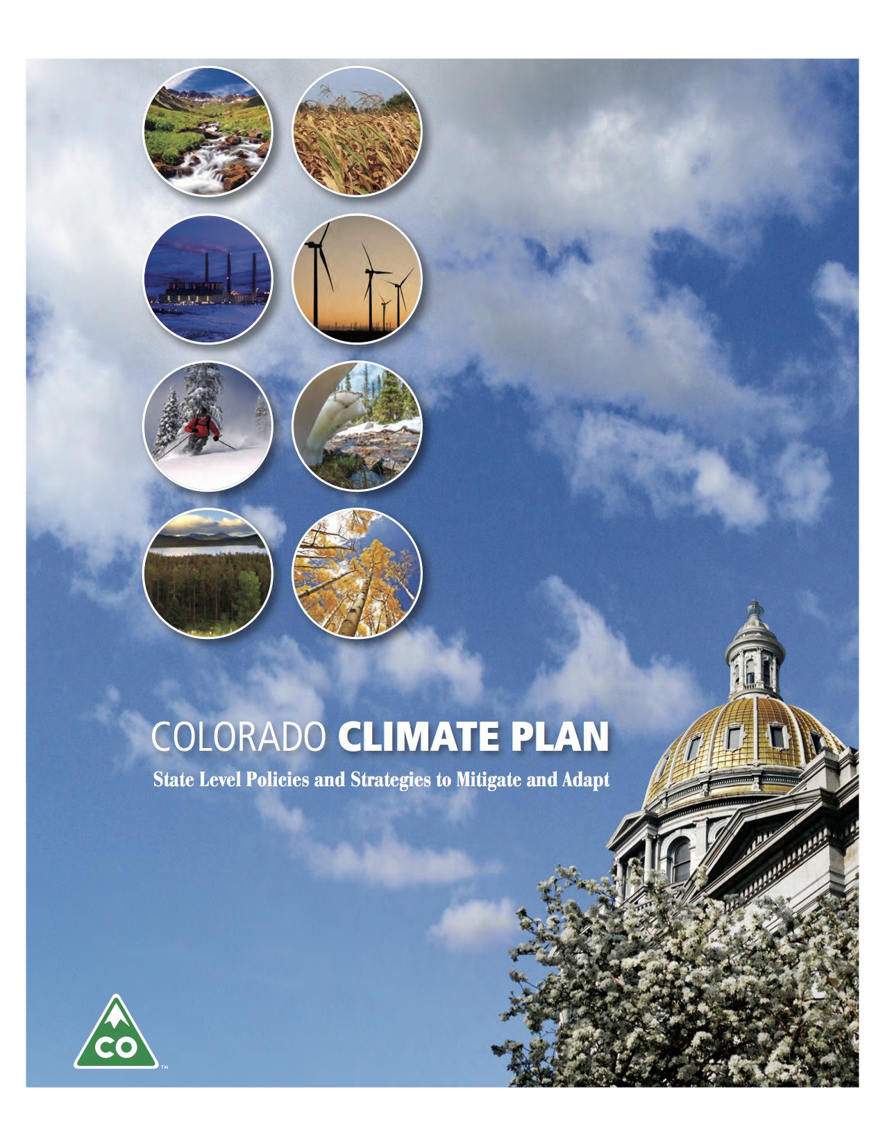
Colorado’s state government has produced an updated climate action plan, and it’s rich with detail about what Colorado has done in reducing greenhouse gas emissions as well as in addressing the challenges of rising temperatures.
But what value does this information provide? The document, “Colorado Climate Plan: State Level Policies and Strategies to Mitigate and Adapt,” neither sets goals nor does it makes a strong case for a specific agenda. Instead, among several dozen strategies and recommendations are these:
Promote and encourage water efficiency and/or conservation at the local and state agency level.
Assist all electric utilities in incorporating all feasible efficiency activities into resource planning and the EPA air quality compliance plans, and
Partner with federal and local agencies to preserve and protect forest health and wildlife habitat and to reduce wildfire risk. This latter is under the tourism and recreation heading.
Taryn Finnessey, lead author of the document, says many of the specifics of these recommendations remain to be worked out. The next step, beginning late this fall, will be to begin having conversations with various water, business, and other interest groups.
When possible, she says, that outreach will be accomplished using existing events, such as when the Colorado Association of Conservation Districts meets. Climate change adaptation will be on the agenda when the state’s Department of Local Affairs holds sessions on land-use planning.
“We recognize this is the beginning of the conversation, not the end, and there needs to be more dialogue with stakeholders going forward about where we need to go from here,” she says.
“But this is a really good first step, the first time when we have pulled together all we have done about climate change adaptation and mitigation and put it in one document. And it is not be understated. There are a lot of really good efforts underway, and we don’t want to slow those efforts down.
“There’s much more to be done. That’s clear not only in our strategies and recommendations, but also in our efforts to reach out to stakeholders and the public to see how they want to take the next steps of climate change and adaptation in Colorado.”
Other states and some local jurisdictions have proclaimed bold, even brash goals. Colorado officials aren’t persuaded that’s the way to go.
“When you drill down into the programs they have in place to achieve those goals, you find sometimes that the math doesn’t add up,” says Finnessey.
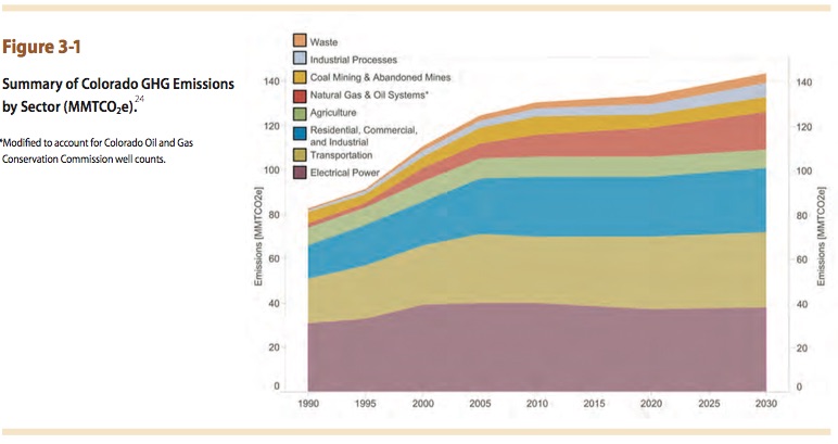
The document makes the case that Colorado has done much since the first climate plan was released during the administration of Gov. Bill Ritter in 2007. Much of that work has been in reduction of greenhouse gases.
State legislators have raised the bar of renewable portfolio standards for the investor-owned utilities and expanded the requirements to include the co-operatives and municipalities.
Already, the initiatives (including the first renewable mandate adopted by voters in 2004) have added up. Just 0.54 percent of electricity came from renewable sources in 2004 (excluding the big hydro sources); as of 2014, the percentage had grown to 14.36 percent.
Switching among fossil fuels has also reduced greenhouse gases. State legislation incentivized the replacement of coal by natural gas at power plants in Boulder and Denver. And, in 2014, Colorado became a national leader in instituting rules to limit emissions of methane, a powerful greenhouse gas, from drilling operations.
Gov. John Hickenlooper has said Colorado will go forward with efforts to meet standards of the Environmental Protection Agency’s Clean Power Plan for 2030. (Another statewide elected official, Cynthia Coffman, the attorney general, has a different idea. She has joined her counterparts from 22 other states in challenging legality of the Clean Power Plan).
And in its internal operations, the state government has completed measures to reduce petroleum use by fleets by 25 percent and, more broadly, cut energy use by 30 percent.
“We have taken an incredibly multi-pronged approach. We don’t just rely on legislative actions or just on administrative actions or actions we have taken in the past,” says Finnessey.
A chart of greenhouse gas emissions in the report shows a rapid increase in greenhouse gases from Colorado during the 1990s and until about a decade ago. Since then, the growth has moderated and, looking forward, the state report expects emissions to essentially flatline even as population and economic growth continue.
With Californians crossing their fingers in hopes of a super El Niño to help end the state’s historic drought, California’s water agency just delivered some startling news: for the first time in 120 years of record keeping, the winter average minimum temperature in the Sierra Nevada was above freezing. And across the state, the last 12 months were the warmest on record. This explains why the Sierra Nevada snow pack that provides nearly 30% of the state’s water stood at its lowest level in at least 500 years this last winter despite precipitation levels that, while low, still came in above recent record lows. The few winter storms of the past two years were warmer than average and tended to produce rain, not snow. And what snow fell melted away almost immediately.
Thresholds matter when it comes to climate change. A small increase in temperature can have a huge impact on natural systems and human infrastructure designed to cope with current weather patterns and extremes. Only a few inches of extra rain can top a levee protecting against flood. Only a degree of warming can be the difference between ice-up and navigable water, between snow pack and bare ground.
Climate change has intensified the California drought by fueling record-breaking temperatures that evaporate critically important snowpack, convert snowfall into rain, and dry out soils. This last winter in California was the warmest in 119 years of record keeping, smashing the prior record by an unprecedented margin. Weather records tend to be broken when a temporary trend driven by natural variability runs in the same direction as the long-term trend driven by climate change, in this case towards warmer temperatures. Drought in California has increased significantly over the past 100 years due to rising temperatures. A recent paleoclimate study found that the current drought stands out as the worst to hit the state in 1,200 years largely due the remarkable, record-high temperatures.
New settlement ponds at Gold King Mine August 2015 FromThe Durango Herald (Peter Marcus):
The $1.78-million portable treatment facility will be located in Gladstone, according to EPA officials. It will be operational by Oct. 14 and operate during the coming winter. The contract provides for 42 weeks of treatment, with the option to start or stop treatment as needed…
Water continues to flow from the mine at approximately 550 gallons per minute. Without the plant, officials have had to rely on a series of settling ponds to capture the dirty water before being discharged to Cement Creek.
Authorities constructed four ponds at the mine site, which are treating water to remove as much metal loading as possible. The treatment plant will replace the ponds.
EPA officials estimate the plant will cost $20,000 per week to operate, with another $53,200 for demobilization and bonding. EPA will use money from its Superfund coffers to pay for the project. Superfund money is used to clean up blighted areas that could be toxic to humans. Gold King still has not officially been listed as a Superfund site.
The bidding process for the plant was conducted by St. Louis-based Environmental Restoration, LLC, the contractor that was working with the EPA when the spill occurred. The treatment-system contract was awarded to subcontractor Alexco Environmental Group Inc., which has an office in Denver.
Officials said the transition to the plant is necessary as winter temperatures at high elevations can reach well below zero, making it unsafe to manually treat water at the mine site. The system is designed to handle up to 1,200 gallons per minute.
“The objective of the treatment system is to neutralize the mine discharge and remove solids and metals,” stated an EPA news release announcing the facility. “Although the Gold King Mine discharge is just one of many into Cement Creek, the treatment will remove a portion of the metal loading to Cement Creek.”
Though the system is temporary, long-term treatment will be decided after further evaluation of mine discharge, said an EPA spokeswoman.
Here’s a call to action from Environment America (Russell Bassett):
“Catastrophe!” read the local headlines after 3 million gallons of metal-laden muck spilled into Colorado’s Animas River earlier last month.
The spill forced the city of Durango to close its drinking water intake, and local business that depend on the river were shut down for weeks. The spill traveled through Colorado into New Mexico and Utah, creating concerns for drinking water, crops, and wildlife all along its path.
The orange river made international news, but it also helped highlight a problem that is long overdue for a solution. Hard rock metal mining is the most destructive industry in the world. According to the U.S. Environmental Protection Agency’s Toxics Release Inventory, metal mining is the nation’s top toxic water polluter.
Mining in the western United States has contaminated headwaters of more than 40 percent of the watersheds in the West. Remediation of the half-million abandoned mines in 32 states may cost up to $35 billion or more.
The main reason for this wide-scale degradation of our waterways is an antiquated law that still governs hard rock mining throughout the country. The 1872 Mining Law allows foreign and domestic companies to take valuable minerals from our public lands without paying any royalties, and it still allows public land to be purchased and spoiled for mining at the 1872 price of less than $5 an acre — that’s the price of one mocha for an acre of public land.
Gold King Mine entrance after blowout August 2015
This outdated law contains no environmental provisions, allowing the mining industry to wreak havoc on water supplies, wildlife and landscapes. For example, abandoned mines are still leaking 540 to 740 gallons a MINUTE of acid drainage into the Animas River headwaters, degrading miles of the watershed. This was the case before the Gold King Mine spill and is still the case after the spill, and there are many more examples throughout much of the West. In fact, it’s estimated that there are half a million abandoned mines throughout the nation.
While the Animas River spill was a tragedy of the first order — and some polluters friends in Congress want to turn it into a witch-hunt of the Environmental Protection Agency — the spill should be the much-needed motivation to enact a solution to clean up after mining’s toxic legacy.
The Hardrock Mining Reform and Reclamation Act of 2015 (HR 963) would fix the problem, but, unfortunately, due to the current political situation in both houses of Congress, this bill has basically zero chance of getting passed. And we need action now because several proposed mines throughout the country could be approved before a real solution to mining’s toxic legacy is passed by Congress.
The Pebble Mine in the headwaters of Alaska’s Bristol Bay, Upper Peninsula Mine near Lake Michigan, Black Butte Mine on Montana’s Smith River, and the Canyon Mine near the Grand Canyon are just a few examples of proposed mines that could wreak havoc on local ecosystems and potentially contaminate watersheds for generations to come.
People from across the country travel to raft and fish in these rivers and lakes. It’s time to protect them from toxic mining pollution. Tax payers are bearing the brunt of cleaning up after the mining industry through superfund designation and other federal funding programs. Using public funds to clean up after a toxic industry, while at the same time allowing that industry to continue to create new mines, is unacceptable. Since Congress won’t do what’s needed, our president should act quickly and decisively.
President Obama has the authority to put a moratorium on all new mines near our waters on public lands. The mining industry should not be allowed to use our public lands to build new mines in and around our cherished waterways until it cleans up from past mining operations. Please tell President Obama to reject all new mine proposals near our rivers until the mining industry cleans up its act. Let’s find the silver lining to the toxic orange river. Please add your voice now.
U.S. Rep. Scott Tipton on Thursday [October 1, 2015] expressed concerns with the prospect of federal officials moving forward with a Superfund listing for Silverton near the inactive Gold King Mine.
A divide has emerged over the Superfund question, with some residents and officials of Silverton worried the listing would be a stain on the community. Silverton and San Juan County officials in August clarified their perspective, suggesting that they are open to a listing but that they have not “foreclosed any options.”
In comments before the U.S. Senate Small Business and Entrepreneurship Committee, Tipton, a Cortez Republican, stated: “Designating Silverton a Superfund site … could severely damage the town’s reputation and prove costly to the local economy.”[…]
Andy Corra, owner of 4Corners Riversports in Durango, who spoke at the same hearing, pushed officials to pursue a Superfund listing.
“Right now, adding the Animas Basin’s offending mines to the EPA’s Superfund National Priorities List is really the only clear path forward,” Corra said.
Listening to the hearing was Colorado U.S. Sens. Cory Garner, a Republican, and Michael Bennet, a Democrat. They joined Tipton in pushing for good Samaritan legislation, which would allow private and state entities to restore inactive mines without the fear of liability. [ed. emphasis mine]
From the Associated Press via The Colorado Springs Gazette:
A rafting company owner, a county commissioner and a chamber of commerce official told the Senate Small Business and Entrepreneurship Committee that they don’t yet know the full economic impact of the spill, but it has been devastating so far, scaring away visitors and triggering layoffs at travel-related businesses…
La Plata County Commissioner Bradford Blake said outdoor recreation companies, farms, greenhouses and other businesses that rely on the river and its water suffered immediate losses ranging from $8,600 to $100,000 each. “Clearly, we do not know yet what the long-term impact of the Gold King spill, and the publicity generated by it, might be,” he said.
Navajo Nation leaders on Friday announced they are asking the federal government for a preliminary damage assessment in the wake of the August Gold King Mine spill upstream in Colorado.
Navajo President Russell Begaye on Thursday sent a letter to the Federal Emergency Management Agency seeking the estimation.
Begaye said it is the first step in the application process for public assistance for recovery from a disaster for eligible applicants.
“The spill caused damage to the water quality of the San Juan River to such a massive extent that a state of emergency was declared by the Navajo Nation,” Begaye in the letter. “All of the economic, health, cultural and other impacts to the Navajo people are not yet known.”
Colorado transmountain diversions via the State Engineer’s office
FromThe Grand Junction Daily Sentinel (Ken Neubecker):
It has been pointed out several times that the recent mine spill into the Animas River was, in one sense, a good thing. It re-awoke the public to Colorado’s checkered mining heritage, and the damage done to our rivers for more than a century. But Colorado’s mining legacy is more than old mines polluting mountain streams. It also gave us the fundamental laws and traditions that govern our rivers and the water they hold.
In 1859, David Wall dug a small ditch from Clear Creek to irrigate his two-acre garden, from which he sold produce to the miners up stream in Gregory Gulch. People back east objected to Wall’s diversion to land not directly adjacent to Clear Creek. But the miners from California who had come to Colorado brought with them a new idea of water allocation called prior appropriation. On November 7, 1859, the territorial legislature passed a law making Wall’s and any other agricultural diversion legal under the “rules of the diggings.”*
For the next 114 years dams and diversion projects were built with no concern for rivers or the health of the ecosystems they support. Water left in the stream was considered a waste and many rivers were severely degraded from altered flows and lack of water. That began to change in 1973, with the passage of Colorado’s in-stream flow water rights program. While not perfect, and not as protective as some might want to think, it recognized the natural environment as a beneficial user of water.
Now Colorado is developing a coordinated plan for the growing water needs of farms, ranches, communities, and — for the first time — the environment and the recreational economy that supports so much in Colorado. Rather than a simple endorsement for more projects that could further harm rivers, this water plan lays out all of the anticipated needs and myriad ideas for meeting them. Indeed, it lays out a path by which we may start saving our rivers.
The Colorado Water Plan has been in the making for more than 10 years, crafted by water stakeholders and the public from all across the state through the Basin Roundtables. Ranchers, farmers, municipal water providers and utilities have worked closely with many from the environmental and recreational communities to make sure that the plan incorporates serious consideration of the health of rivers, including bringing them back from the damage caused by past projects.
This has not been an easy task, and completion of the Colorado Water Plan does not guarantee success. A lot of time has been spent simply building trust after a long history of distrust between people with competing needs and values, and there are still stark differences between competing water uses that must be overcome. Colorado faces a daunting future — balancing the needs of agriculture, cities and rivers will not be easy. Growth, climate change, new economies and values, the need to fulfill downstream compact obligations and the simple reality of living in an arid region where water supply is shrinking, all make the transition from the Colorado of Dave Wall’s irrigation ditch to 21st century water management complex and challenging. Solving the puzzle of our water needs and restoring rivers will take all of us, working together, looking to the future, not the past.
As important as the Colorado Water Plan is to the future of our state and its hunting and angling heritage, we can’t lose sight of what is happening in Washington, D.C. Several pieces of legislation are working their way through Congress to respond to drought in California and throughout the West. Federal agencies are pumping millions of dollars into drought-relief efforts and scrambling to find ways to make our country more resilient to future droughts, too.
Lawmakers can help sportsmen by spurring and supporting state and local solutions that work for entire watersheds, making it less likely that we will reach a crisis point in future droughts. We can build in assurances by using federal water programs to create:
Flexibility. In an over-allocated system like the Colorado River, we need federal programs that allow the transfer of water voluntarily and temporarily to other users in times of need without jeopardizing property rights, sustainable farming and ranching, or healthy fish and wildlife populations.
Incentives. Watershed groups demonstrating successful drought solutions on the local level — where they work best — should be rewarded, and the federal government should encourage the development of similar groups in other watersheds.
Access. With dozens of programs available across multiple federal agencies to improve water resources, it is difficult for Coloradans to know where to turn for assistance or how to navigate the different bureaucracies. We can get more out of limited resources by making these programs more accessible and decreasing the transaction costs of working with the federal government.
Healthier watersheds, overall. It’s the most cost-effective means of increasing water supply, reducing wildfire threats, protecting against floods, and improving drought resilience, and improving watersheds is something we can start doing right now.
From the fisherman pulling trout out of a high mountain reservoir to the Front Range city responsible for providing drinking water to its residents, we are all in this together. Colorado’s representatives in Congress must advance widely-supported conservation and efficiency measures, along with creative financing mechanisms, to meet water demands while protecting and restoring healthy river flows. Sacrificing species or targeting agriculture are not lasting solutions.
The effort to repair the gate at Grizzly Reservoir that forced the lake to be drained, sending water laden with heavy metals into the Roaring Fork River in August, began Friday.
And there are now protocols in place so officials, residents and river users are not caught off guard, as they were when the river turned from its usual gin-clear shade to an ugly yellowish-brown on Aug. 11, if future reservoir work is expected to impact the Roaring Fork.
There could again be some discoloration in the Fork and Lincoln Creek from silt stirred up during the “dewatering” of the work site, according to a Roaring Fork Conservancy press release. The dewatering must occur so the gate can be fixed.
But crews with the Twin Lakes Reservoir and Canal Co., the owner and operator of the Independence Pass Transmountain Diversion System that has purview over Grizzly Reservoir, have set up a silt fence and straw bales and wattles (a formation involving stakes interlaced with slender tree branches) to trap sediment.
Grizzly Reservoir had to be drained because the nonfunctioning gate could have led to a much more serious incident in which the dam failed, said Scott Campbell, the reservoir company’s general manager, shortly after the drainage.
Tests of water and soil samples showed there were levels of iron and aluminum that exceeded state standards for aquatic life. But officials do not believe the material from the 19th-century Ruby Mine will have a long-term impact on the Roaring Fork ecosystem.
Still, the fact that the drainage and discoloration happened so soon after the Animas River pollution disaster alarmed many people, and Campbell has acknowledged that notification about the reservoir work should have been better.
More coverage from The Aspen Times (Jason Auslander):
Those who criticized Grizzly Reservoir officials for draining the lake in August and sending polluted water down the Roaring Fork River for days take note: You’ve been heard.
“I get it,” said Scott Campbell, general manager of the Twin Lakes Reservoir and Canal Co. “And I’m sorry I didn’t make those calls” in August warning downvalley communities of the impending drainage.
Now, as repair work is slated to begin on a broken reservoir gate — the reason for the drainage in the first place — officials from Twin Lakes and from downvalley governments and other organizations have established protocols designed to prevent similar surprises in the future.
The new protocols were laid out in a meeting Tuesday at Grizzly Reservoir. They call for government officials in Aspen and Pitkin County as well as those with the Roaring Fork Conservancy to be notified if any changes occur in the operation of Grizzly Reservoir that might affect the Roaring Fork Valley, said April Long, stormwater manager for the city of Aspen.
“They were apologetic and wanted to take the proper steps to make sure it doesn’t happen again,” Long said.
Long said she’s satisfied that the new protocols will prevent another surprise discharge from occurring.
More coverage from Jason Auslander writing for The Aspen Times:
Grizzly Reservoir is a “toxic waste pond,” and if it is ever drained again, people and governments downstream need to know in advance.
That was the word Thursday from Healthy Rivers and Streams Board Chairman Andre Wille, though his fellow board members seemed to agree with the sentiment.
“This is the single biggest water-quality disaster we’ve ever seen in the Roaring Fork River,” Wille said during the board’s meeting Thursday evening. “I just don’t think it was thought through.”
Officials with the Twin Lakes Reservoir and Canal Co., which runs Grizzly Reservoir, decided to drain the lake around Aug. 8 in order to fix an outlet gate that was jammed by a tree, according to a report that analyzed water samples taken from the discharge.
FromThe Grand Junction Daily Sentinel (Dennis Webb):
Outdoors advocates are lamenting the failure of Congress to extend the life of a program that has helped fund public-land projects for half a century, including many in western Colorado.
But some members of the U.S. House of Representatives, including U.S. Rep. Scott Tipton, R-Cortez, say the Land and Water Conservation Fund program is in need of reform.
Congress failed to reauthorize the program before it expired on Wednesday, despite hopes from some in Congress, including U.S. Sen. Michael Bennet, D-Colo., that reauthorization be included in a stopgap funding bill that was passed before that same deadline.
Bennet and U.S. Sen. Cory Gardner, R-Colo., also signed a bipartisan letter from dozens of senators calling for permanent reauthorization of the fund. The letter calls it “America’s most successful conservation and recreation program.”
The letter adds, “Investments in LWCF support public land conservation and ensure access to the outdoors for all Americans, in rural communities and cities alike.”
The program uses no taxpayer dollars, and instead is funded primarily by royalties paid to the government by companies doing off-shore oil and gas development.
According to Bennet’s office, the fund “supports the conservation of parks, open spaces, and wildlife habitat for the benefit of hunting, fishing, and outdoor recreation.”
Regionally, some of the program’s beneficiaries have included the Colorado and Dinosaur national monuments, Mesa Verde and Black Canyon of the Gunnison national parks, and White River and Uncompahgre national forests.
Will Roush, conservation director for the Carbondale-based Wilderness Workshop group, said that statewide the fund has paid for more than $250 million in conservation and recreation projects.
According to the Center for Western Priorities conservation group, more than half of members in the U.S. House of Representatives support the program. But it says U.S. Rep. Rob Bishop, R-Utah, chairman of the House Natural Resources Committee, “is holding LWCF hostage,” having vowed to block the program unless reforms are made, but not introducing a bill or allowing consideration of the program’s renewal.
In a statement released Sept. 25, Bishop countered that it’s special interests who “seek to hijack LWCF to continue to expand the federal estate and divert even more monies away from localities.”
He said any reauthorization of the fund will prioritize funding for local communities as originally intended under the program.
Bishop has been an advocate of transferring federal lands to state control.
In a statement, Tipton said that the Land and Water Conservation Fund “is a valuable tool for conservation, but after 50 years, some reforms are needed to ensure it is still achieving its original mission and that the federal government is properly managing the lands it already has.
“Managing nearly 640 million acres in the United States, the federal government is by far the largest landowner in most Western states. Rather than increasing LWCF funding in order to obtain more federal property, land management agencies should focus on managing the lands they already have. LWCF reauthorization provides an opportunity for reforms that support addressing the growing maintenance backlogs for national parks, roads, trails and facilities.”
Here’s the release from the High Line Canal Conservancy:
High Line Canal Conservancy launches a public outreach planning process to create future visions for the High Line Canal, preserving the recreational and environmental amenity for generations to come.
With the support of Denver Water, Arapahoe County and other governmental organizations along the High Line Canal (Canal), The High Line Canal Conservancy (Conservancy) is building a strong coalition of community leaders and stakeholders to support region wide, long-term planning for the future of the Canal. Over the past several years, these organizations have discussed a vision for the long-term care of the entire Canal corridor, comprising 71 miles long and 100 feet wide, focusing on its critical importance as a recreational and natural amenity to the Denver metro region. The Canal is at a turning point in its future that calls for reassessment and planning that will preserve and protect the Canal for all people forever.
“The 71 miles of the High Line Canal urban trail surpasses the scale and impact of any similar existing or proposed initiative in the U.S. today. The High Line Canal is a unique opportunity to create a significant enduring recreation and cultural greenway legacy – celebrating the rich and diverse physical and social mosaic that we call Denver.” – Tony Pickett, Conservancy Board Member, Vice President, Master Site Development The Urban Land Conservancy.
The Conservancy has commenced the planning initiative through the release of a request for qualifications for a visioning process consisting of extensive public outreach. This broad visioning process will collect the interests, attitudes and needs of citizens – resulting in an exciting future vision for preserving and enhancing the Canal along its entire reach. The Conservancy recognizes the role of the Canal as an invaluable recreational and environmental resource for the Denver metro region and is committed to:
enhancing its recreational opportunities;
preserving the vegetation and wildlife along the corridor; and,
providing practical solutions for the water channel.
“Through the generosity of Denver Water and the stewardship of the Conservancy and its partners, we see a tremendous opportunity to fully realize the potential of the Canal as an extraordinary amenity for the metropolitan community. Much like the national Rails to Trails program, a historic utility shall be repurposed as a regional recreational treasure.” – Nina Itin, Conservancy Board Chair, Community Leader.
For information on the RFQ process, please visit the Conservancy blog: http://www.highlinecanalconservancy.wordpress.com. The Conservancy seeks planning teams to submit qualifications for the upcoming High Line Canal Outreach and Visioning Phase of the greater master planning process by October 12, 2015. A group of teams will be selected for a follow-up request for proposals process.
About the High Line Canal Conservancy
The Conservancy was formed in 2014 by a passionate coalition of private citizens to provide leadership and harness the region’s commitment to protecting the future of the High Line Canal. With multijurisdictional support and in partnership with Denver Water, the Conservancy is connecting stakeholders in support of comprehensive planning to ensure that the High Line Canal is protected and enhanced for future generations.
High Line Canal Regional Context map via the High Line Canal Conservancy
Mining, logging and railroad and highway construction in generations past dumped sediment in the Tenmile Creek near Copper Mountain.
“It was just sort of 100 years of abuse,” said Jim Shaw, board treasurer for the nonprofit Blue River Watershed Group, which led the restoration effort.
Climax Molybdenum was the biggest offender. The mine’s dams, built to contain toxic drainage from waste rock, failed, and blowouts caused tons of sediment to rush down the steeper parts of the creek and settle in the flatter parts, destroying habitat and wiping out native flora and fauna.
The 1970 Clean Water Act forced Climax to improve its water treatment process, and the mine was no longer an issue, but the damage remained, Shaw said.
In 2013, a multi-year $800,000 effort began to restore the roughly 2,800 feet of stream impacted. Contributing partners included Climax, Copper Mountain Resort, the Forest Service, Colorado Parks and Wildlife, the Colorado Water Conservation Board, CDOT, Friends of the Dillon Ranger District, the National Forest Foundation and the town of Frisco.
Now Shaw said the project is essentially done except for three days of re-vegetation work next week and some planting of shrubs and willows in June. The wetlands have been created, and the oxbows — or U-shaped river bends — have been completed…
PREVENTING ORANGE RIVERS
As the Tenmile closes on completion, so does another watershed improvement project across the county.
The U.S. Environmental Protection Agency (EPA) and the Colorado Department of Reclamation and Mining Safety (DRMS, pronounced dreams) have been leading a collaborative cleanup effort of the Pennsylvania Mine for the last few years.
In early September, the partners installed a second bulkhead deep inside the mine above Peru Creek east of Keystone. The two bulkheads, or giant concrete plugs, will greatly reduce or eliminate negative impacts from the mine’s acid drainage to water quality and fish habitat.
About eight years ago, the Penn Mine experienced a blowout and sent orange water down into the Snake River and Dillon Reservoir. It’s not the latest mine in Summit County to do so.
The Illinois Gulch Mine above the Stephen C. West Ice Arena blew out a couple years later, and the Blue River ran orange and red through Breckenridge and again into Dillon Reservoir.
Now the EPA and DRMS are doing preliminary investigative work in Illinois Gulch, in partnership with the private property owner who owns the land where the mine pollution is coming from, in hopes of starting a cleanup.
“That issue everybody understands, but there hasn’t been a group to take it on yet,” Shaw said. “The state has made it clear that they’ll find money to help.”
ONTO THE SWAN
For now, the water quality restoration focus in Summit is shifting to the Swan River.
The Colorado Water Conservation Board and Colorado Basin Roundtable together awarded a $975,000 grant to the county to support a large-scale restoration project on the Swan in March.
The restoration area includes about 3,500 feet of river along Tiger Road, 11 miles northeast of Breckenridge, on public land jointly managed by the county and the town of Breckenridge where dredge mining turned the riverbed upside down.
Over the last month or two, the same contractors who did the Tenmile project studied the first quarter of the Swan River project. Work on that section will start in 2016 and finish in 2017, said Brian Lorch, director of the county Open Space and Trails Department.
The county is leading the project with many of the same partners as the Tenmile stakeholders as well as the town of Breckenridge, Trout Unlimited and two private landowners. The $2 million project is also supported in part by a tax increase voters passed in 2014.
The plan for the rest of the Swan River restoration is less certain as the upper three-quarters is covered by rocks about 40 feet high.
Shaw said the project partners could tackle restoration over perhaps 15 years as an excavation company removes and sells the rock. The other option is to pursue larger grant funds and private donations that would expedite the effort but mean maybe 10 times higher costs and more complicated logistics…
Another restoration project in the works lies on the Blue River north of Breckenridge.
The town plans to start a restoration project in the coming years through a 128-acre town parcel known as the McCain property, which borders Highway 9 to the west, north of Coyne Valley Road.
Lorch said the collectives that have made local restoration projects possible deserve credit as do the various stakeholders, which include nearly every government agency and nonprofit concerned about water quality or fisheries in Summit County.
Blue River
Frozen mists over the Blue River Valley turn the sun into a diamond — Bob Berwyn
Pennsylvania Mine Upper Peru Creek Basin
Moon set over the Tenmile Range via The Summit County Citizens Voice
Grand Mesa mudslide before and after via The Denver Post
Grand Mesa mudslide May 2014 via The Denver Post
Click here to download the report from the Colorado Geological Survey. From the website:
On May 25th, 2014 the longest landslide in Colorado’s historical record occurred in west-central Colorado, 6 mi southeast of the small town of Collbran in Mesa County. Three local men perished during the catastrophic event. The landslide was 2.8 miles long, covered almost a square mile of the West Salt Creek valley and the net volume displacement was 38 million yd3. The fast-moving (40-85 MPH), high-mobility landslide was caused by an initial rotational slide of a half-mile-wide block of Eocene Green River Formation. The resultant rock failures, rockmass disaggregation, and mostly valley-constrained rock avalanche, dropped approximately 2,100 ft in elevation as a rapid series of cascading surges of chaotic rubble composed of fragments of pulverized rock, vegetation, topsoil, and mud. Local seismometers recorded a magnitude 2.8 earthquake from the event with a seismic wave train duration of approximately 3 minutes. The toe of the landslide came within 200 ft of active gas-production wellheads and loss of irrigation ditches and water impacted local ranches and residents.
FromThe Grand Junction Daily Sentinel (Gary Harmon):
The West Salt Creek landslide changed over the summer, as a water course formed to drain much of a pond formed by the slide and as the slide itself compacted and settled into place, according to scientists who are studying the event.
“Continuing threats to nearby residents remain,” warns the Colorado Geological Survey in a new report on the landslide, which took the lives of three men on May 25, 2014.
Clancy and Dan Nichols — father and son — and Wes Hawkins died in the slide while they worked to clear an irrigation ditch. The Colorado Geological Survey report is dedicated to their memory.
Collbran, six miles below the slide, is in no danger, but ranchers and others in the area should be aware of the threat looming high above, especially in the spring, when the “sag pond” is most likely to refill, said Colorado State Geologist Karen Berry.
“The biggest unknown is what will happen when the sag pond fills and spills” into the West Salt Creek Valley, most likely with the spring thaw, Berry said.
The sag pond was formed when 35 million cubic yards of the Green River Formation faltered and slid down, the report said.
The slide covers nearly a square mile atop the West Salt Creek valley and in some cases is as much as 123 feet [deep], the report says.
The slide left a 65 million cubic-yard slump block tipped 15 degrees toward the mesa, creating a “V,” the bottom of which is the pond. according to the report.
The sag-pond water percolated through the slump block forming what geologists call a “pipe,” or conduit that lowered the level of the pond by about eight feet.
“At some point, the stream (West Salt Creek) is going to try to re-establish itself,” Berry said.
How that will work is still an unknown, said Jeff Coe, a U.S. Geological Survey geologist who has studied the slide.
“We don’t know where it will stop and we don’t know what the response will be” as snows melt and feed into the West Salt Creek drainage, Coe said. “That slump block continues to evolve. I’d like to get through a few more springs before I say we’re off the hook.”
Mesa County has built a sophisticated monitoring system intended to detect changes in the slide.
The most recent study cleared up a lingering question for Tim Hayashi, senior engineer for Mesa County, who has led the county’s monitoring of the landslide.
It wasn’t clear why the slide traveled three miles down West Salt Creek Valley, Hayashi said, until the study made it clear that more was going on than just a single slide.
“It wasn’t one enormous slide,” Hayashi said. “It was several large slides” that pulsed down the mountain, one after the other.
The Jet Propulsion Laboratory in Pasadena, California, also has been monitoring the north side of the Mesa with special radar, Coe said.
“Those data are still showing shifts, not real large ones,” Coe said. “The whole West Salt Creek slide is compacting and small areas on the slump block are changing.”
There is no evidence that a catastrophic change is imminent, Coe noted.
The USGS is preparing its own report on the landslide, he said.
The 2014 landslide took place at the same place as a slide that occurred in the Holocene period as it transitioned into the Eocene, at least 11,700 years ago, the report noted.
Studies of the slide could shed light on similar looming threats, Berry said.
“What we hope to do is, take what we’ve learned and look at landslide susceptibility for Grand Mesa and Mesa County in general,” Berry said.
The 55-page Colorado Geological Survey study says risks remain specifically because of water that has collected in a depression near the slide’s head, creating a “sag pond.”
“A failure of the sag pond or the remaining rock slide could create a similar event to what happened,” Karen Berry, the state geologist, told The Denver Post on Thursday…
The report also highlights how there are areas throughout the Grand Mesa and Colorado that are also at risk for breaking away.
“Mesa County, and especially Grand Mesa, contain hundreds of active and inactive landslides,” the report says. “Fortunately, many of these features are in remote or underdeveloped areas and have caused little damage.”
Colorado Parks and Wildlife set up a camp with more than 20 people working around the clock along the banks of the Herman Gultch in Clear Creek County. They are working to kill all the fish that live in the waterway currently, and then restock that waterway with the greenback cutthroat trout, Colorado’s state fish.
Presumed to be extinct by 1937, several wild populations of what were thought to be greenback cutthroat trout were discovered in the South Platte and Arkansas river basins starting in the late 1950s. According to the CPW, those discoveries launched an aggressive conservation campaign that replicated those populations across the landscape so that they could be down-listed from endangered to threatened under the Endangered Species Act.
Momentum for preserving the native jewels continued to build, and in 1996 the greenback was designated as Colorado’s state fish. Efforts to establish new populations were proceeding along a track that suggested the recovery plan benchmarks might soon be met, and the subspecies could be delisted entirely.
Currently, biologists estimate there are less than 5,000 wild greenback cutthroat in the state, but once this project is complete, they hope to double or triple that number.
“We choose this creek in particular because once we clear out the invasive fish species that live in these waters it will be impossible they will be able to get back into the creek to compete with the greenback cutthroat once we stock them here,” Ken Kehmeier, senior aquatic biologist, South Platte River basin, Colorado Parks and Wildlife, said.
Biologists are using a substance called rotenone to kill the fish that currently call the creek home. They add the liquid upstream of a temporary water treatment and testing center at the bottom of the stream. Once the substance does its job they then dilute and consternate the deadly substance. The process turns the water a purple color for a few hundred yards downstream of the treatment center, but water samples taken downstream from that location show the water quality is back to safe levels as it enters Clear Creek.
Right now, biologists are raising thousands of greenback cutthroats in fish hatcheries in Lake and Chaffee counties.
Several members of the community came together Thursday at Colorado Mesa University to celebrate the renaming of the school’s water center in honor of Ruth Powell Hutchins, a longtime proponent of the preservation of water rights on the Western Slope.
The newly named Ruth Powell Hutchins Water Center at CMU performs and facilitates interdisciplinary and collaborative research, education, outreach and dialogue to address water issues facing the Upper Colorado River Basin.
Hutchins, who died in 1997, worked to protect the water rights of small farmers and other water users, according to the university. She was one of the founders of the Mesa County Water Association, which evolved into the Water Center at CMU.
Hutchins’ children recently established an endowment for the center in honor of their mother.
The unveiling of the center’s new name was held on the third floor terrace of Dominguez Hall to a full crowd, including three generations of the Hutchins family, members of the Colorado Mesa University Board of Trustees and CMU President Tim Foster.
Her son, Will Hutchins, spoke at the event about his mother’s work.
“I want to thank CMU for honoring our mother,” Will Hutchins said. “With respect to my mother, there are two things to keep in mind — she was a straight-laced Vermonter and her dream.”
He said his mother grew up in a community where the traditional New England town meeting was a way for people to get involved in their town government.
“Public service meant exactly that — not a way for a person to financially better themselves at the public trough,” he said.
He said his mother and father, John, met at a dude ranch and had a dream to own a “farm to raise their family on.”
In 1955, the Hutchinses bought a farm in Fruita, he said. There, Ruth Hutchins began to get involved in the community through volunteer work.
“Any time you have money in the public sector, there are a lot of people trying to get their hands on (it),” Will Hutchins said, referring to water rights issues. And, he added, the result was not necessarily for the benefit of the public.
He said his mother studied water rights issues and eventually was able to “go to the water buffaloes — people like politicians, prestigious lawyers, lobbyists, engineers — and talk to them on her own terms” about these issues and her concerns.
Foster said the university “gets to name” a number of its facilities after people in the community, but “few as iconic as Ruth.”
“Ruth Hutchins was one of my very favorite people. She was a combination of Annie Oakley, Margaret Thatcher and Mary Poppins,” Foster said in a news release issued by the university. “She truly cared about water issues, not only in the Grand Valley but statewide and nationally. She was committed to making the system work better and to the importance of meeting agricultural water needs. We are honored to have the water center carry her name and are deeply appreciative of her family’s generosity.”
Hutchins’ son, Tad, said he was honored to be at the naming.
“(It shows) that the good deeds you do will outlive you as an issue,” he said.
“I’d like to think Mom would be proud of this (center)” that provides information to anyone interested in water issues.
CMU spokeswoman Dana Nunn said the renaming of the center was not a condition of the endowment.