Poncha Springs: Chance at stimulus dough for treatment plant drying up

A picture named wastewatertreatment.jpg

From The Mountain Mail (Ron Sering):

Poncha Springs Trustees announced during their meeting Monday that chances of funding expansion of the Salida sewage treatment plant under the American Recovery and Reinvestment Act have dwindled to almost nil. “It does not look good for the ARRA money,” town attorney William Alderton, said. During meeting in Denver that included Alderton, town attorney Brad Redmiles, Salida Administrator Jack Lewis and state representative Tom Massey, the Water Quality Control Commission upheld its decision refusing ARRA funding for the treatment plant expansion. Poncha Springs earlier received a category two ranking. In March, the two municipalities hoped to end a dispute by applying the Poncha Springs money to the Salida expansion project. State attorney general’s office personnel refused the request.

Flaming Gorge Pipeline: Green River and Rock Springs join opposition

A picture named flaminggorgepipelinemillion.jpg

From the Associated Press via the Aspen Times:

The two largest cities in Sweetwater County are organizing to fight two proposed projects that would divert water from the Green River Basin to the Colorado Front Range. They’ve agreed to form a coalition and possibly hire a public relations firm to challenge the proposals, which include construction of a 560-mile pipeline [Regional Watershed Supply Project] from Flaming Gorge Reservoir to Denver. The projects are a “big elephant facing us,” Green River Mayor Hank Castillon said in giving his support to the new coalition Wednesday. “This is a complex and unique struggle we’re in,” he said.

Rock Springs Mayor Tim Kaumo lent his support. “I don’t think we can wait any longer,” Kaumo said. “We need to stick together and see just how successful we can be.”[…]

Also in the works is a less-publicized proposal to divert water from Flaming Gorge Reservoir to the Parker Water and Sanitation District near Denver. [ed. actually the Colorado-Wyoming Coalition pipeline includes many South Metro water providers not just Parker Water and Sanitation.]

Bill Sniffin, head of the public relations and marketing firm Wyoming Inc., made a pitch to lead a marketing effort against the pipeline projects. The Lander-based company provides marketing, research and public relations services. Sniffin estimated it would cost between $75,000 and $150,000 for his firm to carry the coalition’s fight against the pipeline projects for the first year.

More Coyote Gulch coverage here and here.

Craig: Work to start on supply treatment plant

A picture named watertreatment.jpg

From the Craig Daily Press (Collin Smith):

On Monday, City Engineer Bill Earley notified Cortez-based Southwest Contracting that the company could start work at the plant to fix the problems with its raw water and backwash pumps whenever it’s ready. The go-ahead came two months after the City Council decided to follow recommendations given by Denver-based Tetra Tech, the engineering firm hired for an $8 million upgrade at the plant. The city plans to pay $70,380, which includes installing new computer control systems for each group of pumps, as well as $20,000 to rebuild two raw water pumps that have been damaged.

More Coyote Gulch coverage here.

Ridgeway: Primer on town’s wastewater treatment facility

A picture named wastewatertreatmentwtext.jpg

Here’s a primer of sorts about Ridgeway’s wastewater treatment plant, from the Telluride Watch.

Windsor: Detention pond ordinance would set up enforcement mechanism

A picture named detentionpond.jpg

From the Windsor Beacon (Ashley Keesis-Wood):

An ordinance regulating the Town of Windsor’s storm water maintenance facilities met with controversy on Monday, but still passed on first reading. “This ordinance is an effort to become proactive and partner with the homeowner’s associations (HOAs) to prevent problems,” said Mayor John Vazquez. The ordinance will make the town responsible for the proper conveyance of storm water through the town limits and will provide an enforcement tool for the town to use with other entities that may not maintain their detention ponds in the form of property liens. “The intent is not to use the liens for the first couple of years at all, as we educate people who are probably not even aware they have detention ponds to maintain,” said Director of Public Works Terry Walker.

More Coyote Gulch coverage here and here.

Long journey for pikeminnow

A picture named coloradopikeminnow.jpg

It didn’t take long for endangered Colorado pikeminnows to move upstream past the Price-Stubbs diversion on the Colorado River. Last week one was netted near DeBeque. The tagged fish had been netted in the past near Flaming Gorge dam in the Green River. That’s a pretty remarkable journey, down the Green and back up the Colorado. Administrators of the Upper Colorado River Endangered Fish Recovery Program have to feel good about what they’re seeing. Here’s a report from Gary Harmon writing for the Grand Junction Daily Sentinel. From the article:

The dam, built in 1911, has prevented the migration of the Colorado pikeminnow, known to early residents of the Grand Valley as “white salmon” for their travels, from visiting the highest part of their range. The range was reopened in April 2008 with the completion of a $10 million, 900-foot-long, fish passage just upstream from the mouth of De Beque Canyon. The capture of a 26-inch, two-pound adult male on April 22 showed the species, also once called the Colorado squawfish, had negotiated the fish passage and was moving upstream. The capture is significant “because it demonstrates fish have regained access to historic habitat that was blocked for almost a century,” U.S. Fish and Wildlife Service biologist Bob Burdick said. “This Colorado pikeminnow is the first of its kind that we’ve detected in that river reach” since biologists began sampling at the Grand Valley Project Diversion Dam for pikeminnow and the endangered razorback sucker.

The pikeminnow captured in April is “a fairly old fish” that is relatively well known to biologists after it was captured in the Green River near Ouray, Utah, on May 10, 1995. It has swum at least 447 miles during the ensuing years and was recaptured five more times in various sections of the Colorado River. The fish was 7 to 10 years old when it was first tagged, and biologists believe individuals live to about 40 years of age. Biologists also are celebrating the return of the razorback sucker to a section of the Yampa River, where the species hasn’t been seen for 30 years. Researchers captured a 17-inch, 1.7-pound, 7-year-old adult razorback sucker in the Yampa near Lily Park, about seven miles upstream of Dinosaur National Monument. Fish and Wildlife Service biologists stocked the hatchery-raised fish as a 2-year-old juvenile in the Green River near Green River, Utah, in 2004. During the next five years, it traveled 280 miles upstream and grew six inches.

More coverage from the Associated Press via the Grand Junction Free Press.

Update: More coverage from the Pueblo Chieftain (Chris Woodka):

In fact, the [Colorado pikeminnow] – along with razorback suckers, humpback chubs and bonytail chubs – were such good eating that they hardly exist today. They were fished nearly to extinction. Why is this important to the Arkansas River basin? Because if they don’t thrive, nobody gets to bring over water from the Colorado River basin. On average, about 130,000 acre-feet is moved from the Colorado River to the Arkansas River each year through the Fryingpan-Arkansas Project, Twin Lakes, Homestake and smaller diversions. That doesn’t happen unless water is made available for the four endangered species on the other side of the Continental Divide. “It’s water that’s beneficial for the fish,” Jim Broderick, executive director of the Southeastern Colorado Water Conservancy District, told the district board last week. “Anyone who diverts gets to play the game.” That includes water users on the Western Slope as well as the Front Range, in both the Arkansas and South Platte river basins. The load is shared equally by the diverters and annually puts back 30,000-90,000 acre feet of water – or the amount used by a city the size of Pueblo on the low end or Colorado Springs on the high end – into the Colorado River for the fish.

From 2000-08, 500,000 acre-feet of water was delivered to the critical 15-mile stretch of the Colorado River east of Grand Junction, according to Tom Pitts, who coordinates the fish recovery program. The deliveries were made through cooperative efforts of the Bureau of Reclamation, Colorado River Conservation District and Denver Water, with assistance from the Grand Valley Project. Right now, the Western Slope and Front Range are in agreement on a program that will provide a portion of that water, 10,825 acre-feet to be exact, to supplement flows from July to October. The stress to the fish in that reach of river is most commonly felt during late summer as diversions increase and rains taper off. Under an agreement reached 20 years ago, the water has been provided from various sources with costs shared by all diverters. On the Front Range, that includes the Northern and Southeastern conservancy districts, Denver Water, Aurora, Colorado Springs, Twin Lakes and the Pueblo Board of Water Works. Ruedi Reservoir, a compensatory storage vessel of the Fryingpan-Arkansas Project, has been the sole source of the 10,825 acre-feet of water since 2003, using water that has, so far, found no buyers on the Western Slope. Under a new agreement that water users hope will be in place by the end of the year, only half of the water will come from Ruedi in the Roaring Fork watershed, while the other half will come from Lake Granby, a reservoir located in the Eagle River watershed. The option was chosen from among several in the latest study.

More Coyote Gulch coverage here and here.

Greeley: Annual water festival

A picture named studentslesherjhsamples.jpg

From the Greeley Tribune (Jakob Rodgers):

The Water Festival on Wednesday helped to educate students about water use as about 1,100 children from across Weld and Adams counties converged on the University Center at the University of Northern Colorado to learn more about proper water conservation. The event, which was sponsored by the Central Colorado Water Conservancy District and the city of Greeley, operated under the theme of “Wild About Water” to educate children about how water use and the environment are connected while also instructing them how to save water in their own house.

After visiting several booths, Sydney Schultz, 10, of Eaton Elementary School, lamented that such conservation efforts are often viewed as a tough thing to do. “It’s kind of hard because America today is kind of lazy about what they are doing, and we’re careless,” Sydney said.

Update: More coverage from the Fort Collins Coloradoan:

Third-graders studied river and lake ecology, water-related hypothermia and using water to put out fires at the 18th annual Children’s Water Festival held at CSU’s Lory Student Center. “We want them to learn about water,” said Brian Werner, spokesman for the Northern Colorado Water Conservancy District, one of the sponsors of the event. “That can be anything from where your water comes from to conservation methods.” At one station, students put their hands in ice-cold water and learned how quickly hypothermia can set in. “It’s cold, and you’ve got to wear your life jacket in the lake,” said Zach Hupfer, 9, a third-grade student at Johnson Elementary School.

Aspinall Unit: Crystal Dam spill

A picture named blackcanyongunnison.jpg

From the Denver Post (Mark Jaffe):

Wednesday morning, the flow was about 7,500 cubic feet a second, or about 2 million gallons a minute. The stronger flow is intended to mimic natural spring runoff, removing sediment and algae and helping to break down riffles and whisk away vegetation encroaching on the riverbank, Dale said. “One year’s high flow won’t do it all, but now we can hope for a spring flow most years,” Dale said…

“This has been one of the longest, most complex water-right battles in Colorado,” said Drew Peternell, an attorney for the sportsmen’s group Trout Unlimited. To win that right, the concerns of hydropower agencies, ranchers and farmers — and downstream towns fearful of flooding — had to be addressed. “We were able to reach a consensus that everyone could support,” said Clayton Palmer, an environment specialist with the Western Area Power Authority, which markets electricity from the Aspinall Unit.

More coverage from the Colorado Springs Gazette (R. Scott Rappold):

The largest waterfall in Colorado was here Wednesday, a gushing torrent that plunged 227 feet, surpassing Niagara Falls, swelling the Gunnison River to levels unprecedented in the age of dams and diversions. The misty, rainbowed spectacle, with spray felt two football fields away, was seen by few in the gated recesses of Crystal Dam in the Black Canyon of the Gunnison…

Frank Kugel, manager of the Upper Gunnison River Water Conservancy District, who was in the canyon Wednesday, said he was thrilled to see the water flowing over the dam. “It’s a good thing WAPA (the Western Area Power Administration) isn’t here. They’d be in tears over this,” Kugel said…

After the flow ceases this weekend, [Michael Dale, natural resources manager for Black Canyon of the Gunnison National Park] plans to scout the river, gauge the effectiveness of the water purge, see how much debris and vegetation washed away. The agreement calls for the U.S. Bureau of Reclamation, which runs the dam and hydro plant, to release water each spring, in proportion to the availability from snowpack. It will be a long time before the river recovers, and it may never look like it did when Gunnison tried to cross it, but for a few days, at least, it looks more like the mighty river that thwarted Gunnison. “The impacts of the dams were just that, 40 years, and it will be 40 of these flows before it can reverse itself,” Dale said.

Check out the Gazette slide show.

More coverage from the Denver Post (Mark Jaffe):

This week’s release of 16 billion gallons of water through the Black Canyon — designed to mimic the scouring rush of spring runoff — will begin the process of flushing sediment, algae, debris and vegetation. Sediment, riffle pools and reedy box elders have built up in the park since the 1970s, when three dams known as the Aspinall Unit blocked the natural flow of the Gunnison River. “Ultimately, the goal is to restore the Gunnison to a wild, free-flowing river through the canyon,” said Ken Stahlnecker, chief of resource stewardship for the Black Canyon. “It will take time — years.”[…]

In December a decree was filed in Colorado water court outlining how much water would be released to the park each spring, based on snowpack levels. It also protected other users’ water rights. Ranchers who rely on the Gunnison to flood their hay fields in spring kept their water. “The United States recognized our right to ranch,” said Ken Spann, owner of the Y-Bar Ranch near Gunnison. “That was big. If they hadn’t, we’d be going to court.”[…]

The Park Service’s water-rights campaign was launched after a 1982 Colorado Supreme Court ruling that denied Dinosaur National Monument a water right on the Yampa River. The court ruled that because the monument’s mission was to preserve and display fossils, it didn’t need a right that would sustain kayaking. “The court ruled we’d only get enough water for dinosaurs — which isn’t much,” said Chuck Pettee, chief of the service’s water-rights branch. “That was a wake-up call for the Park Service.” While the Park Service already had sought rights for the Black Canyon and Devil’s Hole in Death Valley National Park, it then created a branch to pursue water rights. From Yellowstone in Wyoming to Crater Lake in Oregon, the Park Service has won or is in discussions for water rights. “In the West, and certainly for the nine parks along the Colorado River and its tributaries, water defines and shapes our national parks,” said David Nimkin, regional director of the National Parks Conservation Association, an advocacy group. “Without water, we will slowly lose those parks,” Nimkin said.

More Coyote Gulch coverage here and here.

Animas-La Plata Project: Recreation taking shape for Lake Nighthorse

A picture named ridgesbasindamconcept.jpg

From the Durango Herald (Dale Rodebaugh):

The Animas-La Plata Water Conservancy District board, which stepped up almost two months ago to fill a vacuum surrounding recreation at Lake Nighthorse, has put its other foot forward. Board members Tuesday voted to look for about $200,000 to hire someone to develop a recreation blueprint. Other entities that could do the job, including Colorado State Parks, have said they have no money for such an undertaking.

More Coyote Gulch coverage here and here.

Runoff (snowpack) news: Here today gone soon

A picture named albedoeffect.jpg

From the Grand Junction Daily Sentinel (Dave Buchanan):

This year’s runoff is affected by the layers of dust on the snowpack, something you’ll still see in the West Elks, South San Juans and other mountain ranges. Chris Landry of the Center for Snow and Avalanche Studies in Silverton said the conditions this winter and spring correlated closely with 2006, when at least eight dust layers were buried in the snowpack. A warm spring quickly uncovered those dust layers and hurried snow melt. “That spring, we calculated snow melt advanced a full four to five weeks in our study area” in the San Juan Mountains, Landry said. “This year so far, we have counted at least 12 dust events and three very major dust events, which are now coming into play in a really intense way.” For water managers, that means the runoff, which normally (if normal ever exists in natural sciences) comes heavy in the spring and continues at lower rates for much of the summer, may be gone by early summer. Dan Crabtree, lead hydrologist for the Bureau of Reclamation in Grand Junction, noted Thursday that the expected volume of water in the Gunnison Basin this year was about the same as historic average, but the timing and intensity of runoff is much different. “We went about two weeks ahead of what that the (National Weather Service) Forecast Center told us the first of April,” Crabtree said…

The Bureau Web site (www.usbr.gov/ uc/) Thursday showed Blue Mesa reservoir as 77 percent full, a level usually not seen until later in the runoff period and a level that’s 150 percent of average on this date. Not surprisingly, Crystal Reservoir was listed at 108 percent full, which is why there’s water pouring over the dam. That glut of water came as a bit of a surprise, one reason for the sudden jump in flows on the Gunnison. Seasonal high flows are part of the water right for the Black Canyon of the Gunnison National Park, but it’s supposed to be a gradual rise and gradual drop. “Yeah, Wednesday it happened quicker than we wanted,” said Crabtree, sounding a bit rueful. “We have these guidelines (from the Division of Wildlife) and we try to follow them, but it’s more complicated than turning on your faucet at home.” The Crystal Dam was forecast to stop spilling Saturday morning. You can watch the change in river flows statewide at http://www.dwr.state.co.us/SurfaceWater/Default.aspx.

From the GOAT (Jonathan Thompson):

In March, the Bureau of Reclamation forecast a high lake level [Lake Powell] for this year at 3,642 feet, which is about nine feet higher than last year (which was celebrated by Lake Powell lovers since it was the highest the lake’s been since 2002, but still 60 feet below its 1998 level). But given the snowpack levels above Lake Powell for this year, and their precipitous drop in recent weeks, such projections may be dashed. After all, there was a lot more snow at this time last year. Indeed, some don’t expect Powell to get above 3,630 feet, and the NOAA’s most recent water supply outlook calls for slightly above average flows going into the reservoir this month, but below average flows after that.

From the Cortez Journal (Steve Grazier):

Regional river rafters and canoe paddlers wanting to experience the rapids of the Lower Dolores River should ready their water crafts within the next week or so for the best riding opportunities. Ken Curtis, an engineer with the Dolores Water Conservancy District, said lower river flows until the weekend should range between 1,800 and 2,200 cubic-feet per second with a downward trend expected for Saturday and Sunday. One cfs is equivalent to a water flow of 449 gallons per minute. “Basically, we filled the reservoir up and started spilling (Tuesday),” Curtis said. “We could have a spill go as long as 20 days on the high end of things. But the week ahead looks like plenty of spill.” Wednesday’s outflow from McPhee into the Lower Dolores River was at about 2,200 cfs, according to Vern Harrell, operations manager for the local U.S. Bureau of Reclamation office. He said the river should provide “raftable” flows for some time, possibly through the end of May. “We’re going to try to provide higher releases of 1,000 to 1,200 cfs for as long as we can,” said Harrell, who noted that a flow of approximately 800 cfs is considered good enough for rafting. “After the next 10 days, it looks like the inflow (to McPhee) will be dropping.” Spill releases are managed by the bureau, which calculates downstream flows according to the reservoir level, river inflow, and user demand for irrigation and municipal contracts via the Dolores Project. McPhee’s water capacity was listed at 378,311 acre-feet on Wednesday, according to the conservancy’s Web site, http://www.doloreswater.com. When full, the reservoir sits at just over 381,000 acre-feet. An acre-foot is equal to 325,829 gallons of water, or enough to fill an entire football field at the depth of 1 foot. Curtis noted the Dolores River Basin’s snowpack level reached only 93 percent of average this year, causing a smaller river inflow and outflow.

From the Steamboat Pilot & Today:

Several seasonal closures of the Yampa River Core Trail are in effect because of the high-running waters of the Yampa River. The closed sections of the Core Trail are the 13th Street underpass, the railroad underpass upstream of Fetcher Pond and the U.S. Highway 40 under pass at Wal ton Creek. Addi tion al closures are likely as stream flows continue to fluctuate.

From the Crestone Eagle (Keno):

The Great Sand Dunes National Park, just south of Crestone, also saw heavy snow, but not anywhere as much as the 26.8” Crestone received. In Moffat, 15” was reported; the middle of the San Luis Valley saw about 6” fall on average, yet to the west in Saguache and north to Villa Grove, only a couple of inches were recorded. Over on the eastern side of the Sangres, Westcliff reported between 5” to 7” of snow. There was little wind with this storm, but the snow fell heavy for several hours, averaging 2” per hour over a twelve-hour period.

Later in the week, as most snow from this storm melted away in the April sun, a new and massive snowstorm rolled across Colorado on Friday, April 17. This pesky storm, when at its peak in the late morning, deposited 7” of snow in just a two hour period. When it finally moved out the next day, 18.9” had fallen in Crestone, with some locations around town reporting over 22”. Unlike the first storm, most of Colorado felt this storm’s punch. With these two storms, Crestone broke several records, including most snow in April, with 47.3” (as of April 18) and the all time record for most snow in a season, with 99.0”. The old record for a snow season was 93.7”, set back in 1997-98.

Cattle Feeders Hall of Fame: W.D. Farr honored as inaugural inductee

A picture named wdfarr.jpg

From the Greeley Tribune:

He was one of 12 people to be nominated by fellow cattle feeders to receive the honor, according to a news release issued Friday. Farr was a pioneer rancher, visionary, water expert, banker and was considered by many to be a true statesman, having served in several capacities under three presidents on the international level. Farr, who died in August 2007, also was president of the Greeley Water Board for 39 of its first 40 years and his water vision was legendary. He, along with Charles Hansen, publisher of the Greeley Tribune, and a handful of others, worked tirelessly to get the Colorado-Big Thompson built. That project brings a supplemental water supply to eight northeast Colorado counties from the Western Slope, a project Farr often called a second Poudre River for northern Colorado.

More Coyote Gulch coverage here.

Southern Delivery System: Corps of Engineers accepting comments for Clean Water Act permit until June 4

A picture named sdspreferredalternative.jpg

Colorado Springs Utilities has filed their application — with the U.S. Army Corps of Engineers — to build in federal watersheds. The Corps is accepting comments until June 4. Here’s a report from Chris Woodka writing for the Pueblo Chieftain. From the article:

The permit is required under Section 404 of the Clean Water Act of any project that affects waters of the United States. The permit is needed anytime there is work within the the flood plains of major rivers or their tributaries. In this case, Colorado Springs and its SDS partners – Security, Fountain and Pueblo West – are proposing to alter the river outlet at Pueblo Dam and to build new structures in Fountain Creek – two reservoirs on Williams Creek and a return pipeline from the lower reservoir. Less than an acre of land would be permanently disturbed and 14 acres would be temporarily affected, according to the initial review of SDS. “Our preliminary review indicates this project will not impact any threatened or endangered species or critical habitat,” said Lt. Col. Kimberly Colloton, commander of the Albuquerque district of the Corps. The Corps also has found no disturbance of historic or cultural resources and said the SDS partners are in compliance with state water quality regulations.

The Corps review can look at a wide range of impacts including stream conditions, safety, flood hazards, fish, wildlife, land use, property ownership and “in general, the needs and welfare of the people,” Colloton said.

More Coyote Gulch coverage here and here.

Little Thompson Water District: Excess levels of trihalomethanes and haloacetic acids

A picture named watertreatment.jpg

From the Berthoud Recorder (Sandy Barnes):

April samples taken at seven locations throughout the district also showed levels of chemical compounds higher than the maximum contaminants the EPA has set for stage two monitoring of drinking water. Hibbard explained that water is being assessed on the basis of EPA standards that go into effect in 2013. “In reality, we’re not out of compliance,” he said. Stage two monitoring requires measurements in parts per billion of disinfection byproducts resulting from the use of chlorine, which include trihalomethanes and haloacetic acids, according to information on the EPA’s Web site. Mike Cook, district engineer for the Little Thompson Water District, said the stage one sample, which allows an average calculation of samples taken at various sites, is the critical one for the present time. Stage two monitoring is site specific, requiring the reporting of measurements at each location. Cook also said that water sampling results can vary by as much as 25 percent at different labs used for the analysis. Adding to the challenge of complying with EPA standards is that the state requires water disinfection with chlorine, said Hibbard. In order to address the problem, it would be necessary to work with staff at the Carter Lake filter plant where the water is treated and with Weld County, he noted.

More Coyote Gulch coverage here.

Southern Delivery System: Corps of Engineers accepting comments until June 4

A picture named sdspreferredalternative.jpg

From the Colorado Springs Gazette:

Utilities needs a permit under the Clean Water Act to build the pipeline from Pueblo Reservoir because stream crossings and building construction would affect the waters of Fountain Creek, Pueblo Reservoir and smaller streams, a total of about 14 acres. Comments will be taken through June 4. They should be sent to Southern Colorado Regulatory Office, U.S. Army Corps of Engineers, Albuquerque District, 200 South Santa Fe Ave., Suite 301, Pueblo, CO 81003-4270.

More Coyote Gulch coverage here and here.

Arkansas Valley Conduit: Financing picture taking shape

A picture named arkansasriverbasin.jpg

Here’s an update on the state of financing for the proposed Arkansas Valley Conduit, From Chris Woodka writing for the Pueblo Chieftain. From the article:

A timeline for the $300 million conduit indicating that it could be up and running in 10 years was presented Thursday at a workshop of the Southeastern Colorado Water Conservancy District. The conduit would run from the Pueblo Dam serving communities all the way from St. Charles Mesa to Lamar and Eads. President Barack Obama signed legislation approving a plan to use revenues from Fryingpan-Arkansas Project contracts to help pay for the local share of the conduit as well as reimbursing other federal project costs. That cleared the way for appropriations. The district is asking Congress to appropriate $9 million in 2010, lobbyist Christine Arbogast told the Southeastern board. The district is asking for letters of support from Gov. Bill Ritter and the 42 communities that would benefit from the conduit, as well as continuing to seek the support of all Colorado members of Congress, she added…

Meanwhile, the district is using a $573,000 Environmental Protection Agency grant, matched with $473,000 in local funds to do engineering and financial studies related to the conduit, said Project Manager Phil Reynolds. Some of the work done in the studies by Black & Veatch engineering consultants will be applicable to later environmental studies. The studies will look at the route and land acquisition for the conduit. Of the local share, the Colorado Water Conservation Board has approved $200,000, Southeastern and the Lower Arkansas Valley Water Conservancy District have each put in $100,000 and the water providers $73,000. The CWCB also has approved a $60.6 million loan that is still in place, despite a state budget crisis that reduced water projects funding…

Reynolds presented a timeline that calls for completion of the environmental impact study by 2011; final design, permitting, land acquisition and contracts by 2014; and construction from 2015-19. The timeline could be moved up if more federal funding becomes available sooner than anticipated.

More Coyote Gulch coverage here and here.

Fountain Creek Flood Control and Greenway District: Kickoff event Monday

A picture named fountaincreekwatershed.jpg

From the Pueblo Chieftain (Chris Woodka):

The Fountain Creek Flood Control and Greenway District, signed into law last month by Gov. Bill Ritter, has no money yet, and in fact won’t officially come into existence until July 1. Ritter will attend an event to mark the formation of the new district at 5:30 p.m. Monday at Fountain City Hall. In the meantime a governing board created by the Fountain Creek Vision Task Force has been meeting. It will next meet at 10 a.m. May 29 at Fountain City Hall. The interim board has met to provide continuity and many of its members probably will sit on the district board in July. The nine-member board will have equal representation between the two counties. A joint appointment by the Pueblo County commissioners and City Council should be made in the next month. About a dozen people had applied before the deadline for applications closed Friday, [Pueblo County Commissioner Jeff Chostner] said.

The district will get $50 million over five years from Colorado Springs if the Southern Delivery System is completed from Pueblo Dam. Colorado Springs Utilities is now doing a business evaluation of the costs of their preferred route or an alternative through Fremont County.

More Coyote Gulch coverage here and here.

Runoff news: Rio Grande basin will peak early

A picture named riograndebasin.jpg

From the Pueblo Chieftain (Matt Hildner):

Division Engineer Craig Cotten said the early runoff may be the result of dust storms from the Colorado Plateau and Great Basin that have dirtied the snowpack in the San Juan Mountains, reducing the snow’s ability to reflect sunlight. While Cotton was sure to tell the Rio Grande basin roundtable this week that the scenario was a theory, he didn’t dispute that the San Juan’s snow has been dustier this season. “If you look up toward the mountains, you can really tell,” he said. “It’s not white.”

Gauges on the Rio Grande near Del Norte show the river had peaked at nearly 6,200 cubic feet per second on May 8. The historic average for the gauge, based on 111 years of records for that day, is nearly a third of that amount. Cotton said in normal years, the Rio Grande experiences two periods of peak flows, one in mid-May for the foothills and another in early June for higher elevations. The early runoff could pose a problem, Cotten said, noting that some potato farmers had yet to even get their crop in the ground. “That’s kind of the fear is that we’re seeing a lot of water right now,” he said. “But in a couple of weeks when we’re supposed to see our high runoff and when everyone counts on that high runoff our rivers might be dropping significantly at that time,” he said…

Larry Walrod, a senior meteorologist and hydrology program manager at the Pueblo office for the National Weather Service, agrees with the theory. “That’s got to be a part of the early melt out,” he said. But he also sites the sublimation of the snowpack, or its exposure to hot dry winds that lead it to vaporize into the air. Moreover, temperatures in the eastern San Juans were warmer than normal in March and April. Mean temperature for March in the San Juans was three to four degrees above the month’s normal mean, he said, while the mean temperatures in the area for April were two to three degrees above the normal mean.

Meanwhile, here’s the news from the Roaring Fork Watershed via the Aspen Times:

Releases from Ruedi, east of Basalt, will be increased in increments of 50 cubic feet per second over the next few days until the flow reaches 650 cfs on Monday, according to the U.S. Bureau of Reclamation, which manages the reservoir. The release rate is likely to remain at or near that level through Memorial Day, the agency said. The high flows severely limit the ability to fish in the Fryingpan River. The river is expected to be at about 350 cfs by Friday afternoon, then continue to rise through the weekend. The Bureau of Reclamation anticipates that Ruedi Reservoir will fill to capacity this summer despite the special releases for the imperiled fish.

South Platte, Metro, Arkansas Roundtables: Looking for solutions to the Front Range water supply gap

A picture named ibccroundtable.jpg

Here’s a recap of Wednesday’s combined meeting of the South Platte, Metro and Arkansas roundtables, from Chris Woodka writing for the Pueblo Chieftain. From the article:

“We’re looking at different scenarios, not just one water future for Colorado,” said Eric Hecox, Interbasin Compact Committee coordinator for the Colorado Water Conservation Board…

Comments to staff from Wednesday’s meeting will help shape the final plan, which will be discussed by the CWCB at a workshop Monday in Pueblo. The meeting will be from 1 to 3 p.m. at the Pueblo Convention Center. The CWCB will have its bi-monthly meeting at the Convention Center Tuesday and Wednesday…

Colorado now is looking at urban conservation strategies like turf replacement, rate structures, leak detection, landscape audits and appliance efficiency as a way to reduce per capita use. The CWCB also is looking at new ways of making agricultural water transfers less damaging to rural economies through grants to water lease-fallowing efforts such as the Super Ditch in the Arkansas Valley. The final leg of the program is to identify how much water Colorado could claim from the Colorado River. The state launched a basin-by-basin study on the Western Slope to determine how much water could be taken while still meeting Colorado’s obligation to downstream states under the 1922 Colorado River Compact. The state also is working to identify which project or projects should be built if the water is moved to the Front Range. There is no consensus among the state’s nine basin roundtables about which project would best fill the need.

Open University: Bottled Water

A picture named bottledwater.jpg

The bottled water industry is fairly new to the scene. They’re making a lot of dough but recently a lot of opposition has been bubbling up because of it’s non-sustainable aspects.

Here’s a link to a lecture from iTunes U on the subject. It’s targeted at the UK so you get to have some fun doing quick metric conversions.

I tried to find a YouTube or other video link but I was unsuccessful. It may only work on a Macintosh or possibly a Windows machine running iTunes.

Update: Here’s a link to the video from Thomas Wiradikusuma. He left it in the comments below.

More Coyote Gulch coverage here and here.

Arkansas, Metro and South Platte roundtables combined meeting: Conserved consumptive use?

A picture named ibccroundtable.jpg

At a recent combined roundtable meeting Jennifer Gimbel — Director of the Colorado Water Conservation Board — poured a little cold water on the idea of a pipeline from Flaming Gorge (either Aaron Million’s or the Colorado-Wyoming Coalition) as the “silver bullet” that would solve Front Range water needs without drying up agriculture. Here’s a report from Chris Woodka writing for the Pueblo Chieftain. From the article:

“I don’t believe a project from Flaming Gorge to bring in 250,000 acre-feet is going to cut it. It’s going to take a combination of proposals,” Jennifer Gimbel, director of the Colorado Water Conservation Board, told a meeting of Front Range water interests Wednesday. “There’s no silver bullet.”

The meeting combined state basin roundtables for the Arkansas River, South Platte River and Denver Metro areas. It was the second time the three groups have met jointly. In 2007, the roundtables learned about potential strategies. This time, the objective was to put “meat on the bones” of those plans, said Alex Davis of the Colorado Department of Natural Resources.

Gimbel’s statement drew immediate fire from Rod Kuharich, chairman of the Metro Roundtable. Kuharich is director of the South Metro Water Supply Authority, which is looking at a Flaming Gorge Project similar to an idea first proposed by Aaron Million. Up until 2007, he was the CWCB director as well. “I am real disappointed to see a large project dismissed carte blanche, regardless of who does it,” Kuharich said, adding that other projects like Blue Mesa pumpback should be examined as well. Kuharich said conservation and lease-fallowing options also discussed at Wednesday’s meeting are only partial strategies that do not give municipal water suppliers certainty. Conservation should not be relied on to provide water for future growth, because the sources of water will dry up, Kuharich said. He described the terms of lease-fallowing programs, such as Super Ditch in the Arkansas Valley, as “draconian.”

“How are you so sure it’s draconian when you twice failed to respond to an invitation to meet with Super Ditch?” said Peter Nichols, who is a Metro roundtable member and attorney for the Super Ditch…

“Conservation alone is not the answer,” [Keith Yahn, Sterling farmer and water manager who chairs the South Platte Roundtable] said. “It appears agriculture is going to bear the brunt of the state’s water gap. That water is reused six or seven times by the time it reaches the state line.” Don Shawcroft, president of the Colorado Agriculture Water Users Alliance, echoed that concern. “We’re concerned about the public’s perception of agriculture’s needs,” Shawcroft said. “What are the economic incentives to conserve water?”

The alliance is arguing for a new category of water in Colorado’s hierarchy, called conserved consumptive use, that would allow farmers to market water.

Lawsuit over Aurora long-term contract with Reclamation put on hold for two years

A picture named puebloreservoir.jpg

From the Pueblo Chieftain (Robert Boczkiewicz):

U.S. District Judge Philip Brimmer put on hold for two years a lawsuit challenging the contract. He said a landowners group opposed to it could ask him during the two years to reinstate his consideration of the group’s lawsuit. The judge’s decision was a victory for Aurora, the Lower Arkansas Water Conservancy District and the U.S. Bureau of Reclamation…

The two-year stay of Native’s challenge is to give time for Congress to consider approving legislation authorizing the contract. The legislation also would include a plan for funding the proposed Arkansas Valley Conduit municipal water supply project. “If it (the contract) is lawful, they don’t have to go get the legislation,” Native’s attorney, Sarah Klahn, told the judge…

Brimmer, at the end of an hourlong hearing, listed three reasons for granting the stay that the Lower Arkansas District, Aurora and Reclamation had asked for. He said the Native group “has not identified any concrete harm its members will likely suffer.” He also said the public interest is served because the legislation, if approved, would result in “various improvements” that would benefit water users in the valley. The judge’s third reason was that it is more likely Congress will pass the legislation because the district supports it. The district’s attorney, Peter Nichols, told Brimmer, “We believe it’s likely to have the support of (the state’s) entire congressional delegation.”

Native’s attorney, Sarah Klahn, challenged Nichols’ assertion. She told the judge there is no indication Rep. John Salazar, D-5th District, has changed his opposition to part of the legislation. Salazar, whose congressional district includes part of the valley, is a key figure in whether Congress will approve the legislation. Lower Arkansas’ attorney said Salazar, Rep. Betsy Markey, D-4th District, and Rep. Ed Perlmutter, D-7th District, will conduct a hearing in the valley about the proposed legislation. Markey’s congressional district includes the eastern part of the valley. Perlmutter’s district includes Aurora.

Somach, in answer to a question from the judge, said the contract does not result in more water being exported during the two years. He said the amount of water exported will be the same as it has been for the past 23 years under the authority of annual contracts between Aurora and Reclamation. Klahn challenged Somach’s assertion, citing Reclamation records that she said show there will be “a decrease in the amount of water in the river. There will be less water for my clients to divert.”[…]

Brimmer granted the district’s request to drop one of its claims, that the contract violates the federal Water Supply Act of 1958. Klahn said she and her clients “are evaluating our options.” She said they “are disappointed in the decision mostly because the stay will allow Aurora to continue stealing water from the Arkansas Valley.” When Klahn used the term “stealing” during the hearing, Somach objected, saying Aurora is importing valley water only as allowed by state water courts. Klahn, after the hearing, replied, “The contract is going to allow Aurora to take additional water from the valley and we believe the contract is illegal, so we think the term ‘stealing’ is appropriate.”

More Coyote Gulch coverage here and here.

Runoff (snowpack) news: Fry-Ark projections

A picture named fryingpanarkansasproject.jpg

From the Pueblo Chieftain (Chris Woodka):

The Southeastern Colorado Water Conservancy District Thursday scaled back its allocations for water after up-to-the-minute estimates of the water yield of the Fryingpan-Arkansas Project indicated more unwelcome meltdowns. The district allocated about 35,000 acre-feet of water Thursday, with about 55 percent going to cities and 45 percent to farms. It also allocated about 5,000 acre-feet of agricultural return flows, mainly to well augmentation groups. “It’s coming off hard,” said Roy Vaughan, Bureau of Reclamation manager for the Fry-Ark Project. “There’s still a lot of high snow, but it’s melted at the lower sites.”[…]

On the other side of the equation, high temperatures have plummeted snowpack in the Roaring Fork basin to about 60 percent of normal, and there are similar numbers for the Arkansas River basin. Earlier this week, the numbers were at nearly average levels. Vaughan revised his May 1 forecast of more than 60,000 acre-feet to the project’s historic average of 52,400 acre-feet. Only about 85 percent of that is available for allocation, however. On top of that, the first 5,000 acre-feet of allocations will go to the Pueblo Board of Water Works to repay last year’s loan for a shortfall in allocations. The board was determined to avoid a repeat of overestimating the project’s yield. The allocations committee already had shaved another 15 percent off the May 1 projection, but the board took it down another 5 percent. The board rejected an idea to only allocate half the water until the runoff picture clears up…

The move will mean about 3,500 acre-feet for Pueblo, which is using its allocation to fill its space in Pueblo Reservoir. The water board typically has not taken its allocation other than for drought recovery or to help well users meet obligations to Kansas under the Arkansas River Compact. “We’re gearing up for Comanche Power Plant to come online,” Executive Director Alan Hamel explained. Pueblo has contracts to supply water for the third unit at the Xcel electricity generation station. Pueblo West would get a little more than 100 acre-feet under a new category of water added last year. El Paso County water users will receive about 9,500 acre-feet, which includes repayment of a water debt to Colorado Springs, water for the Fountain Valley pipeline and a new allocation for Manitou Springs. The east of Pueblo allocations were complicated this year by a squabble between Ordway and Crowley County. Ordway’s population was subtracted from Crowley County’s in determining the amounts each received, said Bob Hamilton, engineering director. In all, users east of Pueblo will receive about 4,500 acre-feet, about 70 percent of what they requested. West of Pueblo, users will get about 85 percent of what they sought, about 1,500 acre-feet. Farmers will get about 16,000 acre-feet of water, about 15 percent of what they requested, based on a formula involving eligible irrigated acres.

Greeley: New headgate for No. 3 Ditch

A picture named measuringwithweir.gif

Here’s some background on No. 3 Ditch up in Greeley along with an aerial of it’s shiny new headgate, from Mike Peters writing for the Greeley Tribune. From the article:

Most people in Greeley really don’t know much about the water ditch that meanders through Greeley from the west to the east. They don’t know that it’s as old as Greeley (139 years) and essentially, it’s the reason Greeley survived in what was then called “the Great American Desert.” On Saturday, the owners of the ditch — the Greeley Irrigation Co. and the city of Greeley — will dedicate a new headgate for the ditch. Dug by huge, horse-drawn plows in 1870, the ditch has now progressed to the computer age.

Clifford Clift, with the Greeley Irrigation Co., said a computer now monitors the ditch’s water levels and opens and closes the gates depending upon the amount of water that’s needed. The new gates and diversion structure cost about $500,000, Clift said. “The irrigation company will pay five-eighths of the cost because it owns five-eighths of the ditch. The city owns three-eighths, so they’ll pay that share.”

When the first members of the Union Colony arrived here in April 1870, they were surprised to be able to look for miles without seeing a tree — they were more familiar with the huge forests of the eastern United States. But founder Nathan Meeker had a plan. He’d earlier visited the Mormon colony in Utah and saw how they dug long ditches from the rivers to bring water to their crops and towns. When Meeker talked with Ben Eaton, an earlier settler in this area, they began working together. Eaton, for whom the town of Eaton was named, would later become the governor of Colorado. But the pioneers knew the ditches would be difficult to dig, so they “volunteered” many workers. At the time — the spring of 1870 — the population of Greeley and the surrounding Union Colony was about 400 people. By order of the town government, all able-bodied men were required to work on the ditch. Peggy Ford of the Greeley Municipal Museums said the ditch diggers used large plow-like devices, pulled by horses, and they would repeatedly cut down through the ground, layer by layer until the ditch was the right depth. “But even then,” Ford said, “they had trouble with water backing up and the sides of the ditch eroding.” It took some time, but eventually, the ditch would bring water from the Cache la Poudre River through Greeley to water the home gardens, and into the Union Colony to water the crops. It’s 13 miles long and empties back into the Poudre River on the east end of Greeley. Natalie Stevens of the city’s water department said the original ditch irrigated 3,500 acres of land, and today — 139 years later — still irrigates about 1,500 acres…

The No. 3 Ditch Headgate Dedication will begin at 10 a.m. Saturday. City and county officials are expected to be there, and refreshments will be served. The headgate of No. 3 Ditch is located on the Cache la Poudre River between 71st and 83rd avenues. To reach the area, drive west to 71st Avenue, north on 71st and follow the road as it curves east and then north again. A sign will direct motorists to the parking area.

More Coyote Gulch coverage here.

Republican River Water Conservation District board meeting May 18

A picture named republicanriverbasin.jpg

From the Yuma Pioneer (Tony Rayl):

The Republican River Water Conservation District Board of Directors will hold a special meeting in Yuma, Monday, May 18. Discussion will include the status of the compact compliance pipeline, approval of the augmentation plan and related accounting procedures for the pipeline by the Republican River Compact Administration. Also on the list are the South Fork accounting issues and the sub-basin nonimpairment requirement, as well as the possibility of changing the use of surface water purchased by the RRWCD Water Activity Enterprise to assist the state of Colorado with compact compliance. There also will be an executive session to develop a strategy for negotiations for the purchase, acquisition, or lease of water rights. The meeting will be from 10 a.m. to 4 p.m. at the Church of the Nazarene, 505 E. Beatty Ave. Public comment is scheduled for 1 p.m.

More Coyote Gulch coverage here and here.

Brush: Stormwater rate increase?

A picture named stormwateroutlet.jpg

From the Brush News Tribune:

It is possible that storm water rates will be increasing in the near future. If done, the increase will help fund the current five storm water projects. These include improvements and fixes on basins located in the downtown area, Williams Street, Ray and Mill Streets, Sunset Park and Cambridge and Emerson Streets. To assist in the projects, the city is proposing to increase rates by three cents per linear foot and will prepare a resolution to adopt the increase at the next regular meeting, rescheduled to Tuesday, May 26, due to Memorial Day on May 25.

Montrose: Shavano Conservation District 17th annual fourth-grade water festival

A picture named studentslesherjhsamples.jpg

From the Montrose Daily Press (Matt Lindberg):

The 17th annual fourth-grade water festival was held by Shavano Conservation District, with the goal of educating Montrose and Olathe classes about water. “We do this because we want kids to be aware of the importance in having clean water and conserving it,” Cyndee Feske, Shavano Conservation District representative said. “Hopefully when they grow up, the knowledge will be second nature.” Fourth-graders from Pomona Elementary School make bubbles from soap and water to represent water surface tension during water festival activities at Baldridge Park Tuesday afternoon. Various businesses had representatives on hand giving 16-minute presentations at each site and Feske said they were happy to help.

Runoff news: Glenwood Canyon High water closed back path

A picture named glenwoodcanyon.jpg

From the Glenwood Springs Post Independent: “According to the Colorado Department of Transportation the bike path is closed between the Shoshone Power Plant and the Hanging Lake Rest Area.”

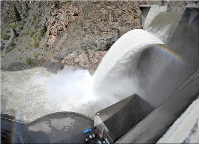
The Crystal Dam is spilling again this year and you can be there. From the Montrose Daily Press:

Limited access [May 15 and 16] to the spring releases is available between 8 a.m. and 6 p.m. both days; a $15 fee per car will be necessary to access the dam through the Black Canyon of the Gunnison National Park. On Friday, May 15, about 2,500 cubic feet per second, or 1,122,000 gallons per minute, of unregulated runoff will be cascading from the dam’s spillway, with an additional 4,000 cfs of water being released through the dam to the Gunnison River. Parking will be outside of the project gates and viewers will have to walk about half a mile to view the spill.

The road providing access to Crystal Dam and Power Plant is accessed by turning onto Highway 347, 8 miles east of Montrose. The beginning elevation on Highway 347 is 6,572 feet and at the point where one turns onto the East Portal Road to the power plant, the elevation will have increased to 8,266 feet.

The East Portal Road is 6 miles long. Once drivers begin to drop into the canyon, the elevation decreases by more than 1,800 feet within 3 miles. This section of road is one of the steepest in the state, with a 16-percent grade, and is one switchback after another; careful driving is recommended.

From email from Reclamation (Kara Lamb):

Today, Lake Estes is sitting at a water level elevation of 7472 feet–just a couple of feet below full. Snowmelt is coming down the Big Thompson River into Lake Estes. Because of river travel times, snow that melts during the day does not show up in downstream rivers until evening or night. That is why, this time of year, fluctuation in the Big T river can be daily. At night, inflows to Estes are currently jumping up into the 200 cfs area. During the day, they drop down to around 170 cfs. We are controlling that incoming water a little, using some for hydropower generation. As a result, we are maintaining a steady release of around 100 cfs from Olympus Dam to the Big Thompson River through the canyon.

Pinewood Reservoir has been sitting fairly consistently at an elevation of 6566. We are moving water through for power generation at the Flatiron Plant below.

Carter Lake is still sitting at an elevation of 5756–just three feet below full.

And, we are currently running just under 300 cfs to Horsetooth Reservoir. Earlier today, power generation at the Big Thompson Powerplant (near the Dam Store) came on, reducing the flow north by about 50 cfs. We saw a similar pattern last weekend, as well. Today, Horsetooth is at an elevation of 5415–a foot higher than it was this time last year. The water level at Horsetooth should continue to rise through the weekend.

From email from Reclamation (Kara Lamb):

What this means for Green Mountain Reservoir is that we will be bypassing the inflowing snowmelt to the reservoir on through the dam and down the Lower Blue. Because more is coming in than we are currently releasing, we will be bumping up releases in 100 cfs increments over the next several days, hitting a cfs of around 600 by Monday, May 18. After Monday, the CROS group will reconvene. But, there is a strong likelihood the 600 cfs will continue through Memorial Day. I’ll keep you posted on what changes are made. This afternoon, we bumped releases up from around 100 cfs to about 200 cfs. The change was made between 1 and 3 p.m. I’m anticipating the daily 100 cfs increase will be made in this same time frame through the weekend, hitting the 600 cfs mark Monday afternoon. For those keeping tabs on the reservoir, it is currently at a water elevation of 7913 feet–that’s still quite a bit down from full, but we’re anticipating enough water down the Blue this year to participate in this program and fill the reservoir.

From email from Reclamation (Kara Lamb):

What this means for Ruedi Reservoir is that we will be bypassing the inflowing snowmelt to the reservoir on through the dam and down the Fryingpan. Because more is coming in than we are currently releasing, we will be bumping up releases in 50 cfs increments, twice a day, over the next several days, hitting a cfs of around 650 by Monday, May 18. After Monday, the CROS group will reconvene. But, there is a strong likelihood the 650 cfs could continue through Memorial Day. I’ll keep you posted on what changes are made. Around 6:30 this evening, we will bump releases up the first 50 cfs, raising the cfs in the Fryingpan from 197 cfs to 247 cfs. Tomorrow morning, we will increase another 50 cfs, then again in the afternoon by another 50, with a resulting flow of 347. We will follow this same pattern until Monday afternoon when we will hit the 647 cfs. For those keeping tabs on the reservoir, it is currently at a water elevation of 7737 feet–that’s still quite a bit down from full, but we’re anticipating enough water down the ‘Pan this year to participate in this program and fill the reservoir.

From email from Reclamation (Dan Crabtree):

Yesterday, a combination of Morrow Point Releases and high side-inflows caused Crystal Reservoir to spill and flows in the Black Canyon and Gunnison Gorge to reach over 7,000 cfs by this morning. Flows at Delta are currently in the 12,000 cfs range. The May 1st forecast for the April through July runoff into Blue Mesa Reservoir is 690,000 ac-ft. consequently, the Black Canyon Water Right calls for a 24 hr peak flow of almost 6,000 cfs (5,864 cfs according to the decree). This flow was achieved starting at about 16:45 May 12th. To insure a 24 hour peak is obtained and to make efficient use of water, Reclamation will start to slowly ramp down releases today. As a result, the spill at Crystal will start to subside and probably be complete by Sunday May 17th. A more detailed schedule is being developed and additional information will be distributed as it becomes available.

CWCB: Meeting schedule May 18-20

A picture named glencanyonconst.jpg

From the Sterling Journal Advocate:

The CWCB will hold a water strategies workshop from 1 to 3 p.m. and a finance workshop from 3 to 5:30 p.m. at the Pueblo Convention Center on Monday, May 18.

The CWCB will also hold a Colorado River workshop from 8 a.m. to 10 a.m., Tuesday, May 19, at the Pueblo Convention Center.

A meeting of the Colorado Water Conservation Board (CWCB) will commence on May 19 at 10:15 a.m. and continue through Wednesday, May 20. This meeting will be held at the Pueblo Convention Center, 320 Central Main St., Pueblo, CO 81003. To view the agenda, visit http://cwcb.state.co.us/Board/MeetingDates/May2009.htm.

The CWCB Board and the Agriculture Commission Board will hold a joint meeting from 3 to 5 p.m. Wednesday, May 20, at the Pueblo Convention Center.

The CWCB posts notices of its meetings 30-days from the next regular meeting. Notices of special meetings are posted on the Web site within five business days and not less than 24-hours of such a meeting. Notices of regular and special meetings may also be received by e-mail. To receive notices by e-mail visit: http://cwcb.state.co.us/Home/CWCBInsider/.

More Coyote Gulch coverage here.

Ruedi Reservoir: Invasive mussels regulations

A picture named ruedidam.jpg

From the Aspen Times (Janet Urquhart):

Ruedi, located east of Basalt, will see periodic inspections via one of several roving inspection and decontamination stations the Colorado Division of Wildlife will employ this summer. When the station is not operating at the Ruedi Creek boat ramp, on the west end of the reservoir, boaters will be on the honor system to make sure they’re complying with new state regulations aimed at halting the spread of zebra and quagga mussels…

In addition, gates and barriers will be installed in the ramp area to funnel traffic when the inspection station is present, he said. “We’re kind of just promoting the theme that boaters should expect to be inspected this year,” said Jerry Neal, public information officer for the Division of Wildlife. How frequently the roving station will be at Ruedi is difficult to say, but busy weekends are likely to be targeted, Kenealy predicted. “They’re basically going to be moving to different locations almost daily, Neal said. “It kind of depends on where we see the need.” A reservoir experiencing heavy boater activity may see the station remain in place for several days, he said.

New regulations this year require all out-of-state boaters to have their boat and trailer inspected before launching into any lake or waterway in Colorado, Neal said. In-state boaters who leave Colorado and return must also seek out an inspection. Also, any boat that has been in any Colorado reservoir where mussels have been detected must be inspected before launching at a new location. The new regulations are aimed at trailored watercraft. Hand-launched crafts such as canoes and kayaks are not considered a high risk for spreading mussels and may launch without an inspection…

Mandatory inspections and limited launch hours will also be in place for the first time at Turquoise Lake near Leadville and at Twin Lakes, located east of Aspen over Independence Pass. The inspections will take place from Memorial Day to Labor Day, said Jon Morrissey, Forest Service district ranger in Leadville. In addition, one of two ramps at each of those reservoirs will be closed, he said.

More Coyote Gulch coverage here.

New Erie pipeline construction catching blame for flooding in Boulder County

A picture named pipeline.jpg

From the Boulder Daily Camera:

Last summer, as the snow began to melt and ditches began to flow with irrigation water, the people living along Valmont Road east of 75th Street noticed something strange. A large pool of standing water formed to the south of the road, where it stayed — an unwelcome mosquito breeding ground — until winter. At the same time, on the north side of the road, where groundwater had been plentiful, one neighbor’s well went dry and another’s pond evaporated, leaving a mess of dead fish. Now, Valmont’s “new swamp” has returned. Since no one can remember any of these things happening before, neighbors agree something has changed, and the obvious villain is the new Erie Pipeline, laid to the south of the road last spring…

Erie built the $15 million pipeline to bring a reliable supply of Colorado River water to town via the Boulder Reservoir, and town officials aren’t yet ready to take responsibility for the collage of groundwater problems on Valmont Road. Erie spokesman Fred Diehl said the town has met with Boulder County, which has jurisdiction over that area of Valmont Road, and both agree on four points: the water table in that area is quite high; the elevation is quite low; water comes to the surface when the nearby ditch begins to run in the spring; and the ditch is leaky. But as to whether the pipeline exasperated the already-high water table by creating an impermeable barrier — backing up the water on one side and drying out the soils on the other — Diehl would say only that “the town and our engineers are continuing to look into this matter.

Boulder County, while not actually saying Erie is at fault, points to a report on the standing water prepared by Centennial Engineering in Fort Collins, which concludes that “the installation of the water line altered the groundwater flow paths sufficiently that all the water leaking from Green Ditch could not pass the recently installed pipeline.”

Vail: Teva Mountain Games June 4-7

A picture named kayaker.jpg

From the Vail Insider:

The Teva Mountain Games, the nations largest mountain sporting event, returns to Vail June 4-7, 2009 for another four days of high-adrenline action and celebration of the outdoor lifestyle. The Games, acquired by the fine folks at the Vail Valley Foundation this winter, looks to be gearing up for its biggest year yet with a host of new cultural events and musical acts as well as the tried & true Teva traditions we’ve come to know and love. The event, arguably the biggest of the summer in Vail, can be a little daunting for the uninitiated, so here is Plum’s Teva Mountain Games 101 for making the most of the mountain sports events during your Teva experience…

Kayaking

The 2009 Teva Mountain Games will feature four kayaking events testing speed and agility, and competitors will need a healthy dose of both to secure a spot on the podium. The Steep Creek Championship will feature kayakers flying down a locals’ favorite, Homestake Creek, dropping 480 feet per mile while attempting to secure the fastest time. The 8 Ball Kayak Sprint is bumper cars meets Bullrun as kayakers power their way down Gore Creek and through fellow competitors. In addition to fellow sprinters, competitors will have to face 8 Ballers, fully-armored kayakers whose sole purpose in life is to impede the progress of the racers. If Teva Mountain Games has a full contact sport, this is it (read: American Gladiators). The Pro Kayak Freestyle is exactly what it sounds like – competitors will invade Vail Whitewater Park and throw their best and wildest tricks in an attempt to impress the judges, and crowd, and secure the most points possible. The Down River Sprint* will test competitors speed as they drop in (on practically anything that floats) in East Vail and race four miles to the International Bridge, with the top time taking the crown. The Pro Kayak Rodeo is far and away the most popular kayaking event, that routinely draws such kayaking luminaries as Eric Jackson as competitors. The crowds for this event will be thick, and if you want to view some of the best freestyle tricks make sure you show up to the Vail Whitewater Park early. The Steep Creek Championships are beyond thrilling, but are located outside of Vail at Homestake Creek, near Red Cliff. Trust us. They are well worth the short (and scenic!) trip up to Red Cliff. The 8 Ball Kayak Sprint and Down River Sprint are just downright entertaining. If you’re schedule is not too full up, you should make every attempt to view these events. As you may have been able to glean from this section, the kayaking events at Teva Mountain Games are fairly dominant. Be prepared for big excitement, and big crowds.

Rafting

Did you know that Mark Thatcher, the inventor of the Teva sandal, was a former rafting guide AND that the inspiration for the sandal came from the lack of quality amphibious footwear at the time? Whether intentional or not, each year the Teva Mountain Games does their inventor proud with a classic rafting event. The 2009 Teva Mountain Games will feature the Teva Raft Paddlecross, a two-person raft race down Gore Creek through Vail Village where competitors will face Class II & III whitewater conditions as well as fellow racers. In Teva Raft Paddlecross, ramming is allowed and, in fact, probably encouraged. Think 8 Ball Kayak Sprint…but with battleships on stormy waters.

Click through for descriptions of other featured sports and video from last year’s events.

Runoff news

A picture named crystaldamspill0508.jpg

The runoff is expected to peak in a couple of weeks or so, according to a report from David Frey writing for the Aspen Daily News. What a difference a year makes. Click on the thumbnail to the right to see a photo of last year’s spill at Crystal Reservoir (a rare occurence this century). Reclamation was releasing water in anticipation of a monster runoff in the Gunnison Basin. From the article:

This spring’s heavy runoff is due in part to late snows that pushed snowpack levels up above average in the Colorado River drainage and much of the state. It’s peaking early, said Dave Kanzer, senior water resources engineer for the Colorado River District, due partly to the dust storms that have coated the snow on area mountains, causing the snow to melt faster than usual. Officials have counted 12 different storms that have left area white-capped peaks with a distinctly reddish hue.

The Colorado River below Glenwood Springs was running at 10,700 cubic feet per second Wednesday afternoon, nearly double a week ago. The Roaring Fork River at Glenwood Springs was running at 3,940 cfs Wednesday afternoon, up from 2,000 cfs a week ago. Near Aspen it was running at 325 cfs.

Energy policy — oil and gas: Representative DeGette takes aim at fracing methods to protect groundwater

A picture named groundwater.jpg

From the Colorado Independent (David O. Williams):

DeGette, a Denver Democrat who unsuccessfully championed the cause on Capitol Hill last year, is poised to reintroduce legislation that would remove an exemption for hydraulic fracturing from the Safe Drinking Water Act that was granted in the 2005 Energy Policy Act.

“As this is an important issue for Congresswoman DeGette, she is expecting to introduce the bill soon,” DeGette spokesman Kristofer Eisenla said. “We are currently just finalizing language and talking to the chairman about the direction of the legislation,” he said, referring to U.S. Rep. Henry Waxman, the California Democrat who control’s the powerful Energy and Commerce Committee’s gavel. “While we are planning to introduce it, no decisions have been made yet on how it will move,” Eisenla said.

More Coyote Gulch coverage here and here.

Yampa River: Restoration projects

A picture named yampariverbasin.jpg

The Yampa River is a restoration success story, according to this report from Kent Ventrees writing for Steamboat Magazine. From the article:

There’s a lot more to this aquatic amenity than meets the eye. Beneath the surface is a slew of carefully orchestrated river restoration projects that have turned the river into the world-class waterway it is today.

Stepping knee deep into the Yampa from his riverside store, Backdoor Sports owner Peter Van de Carr points upstream at hundreds of well-placed boulders lining the streambed. “Most every rock you see has been placed there intentionally,” he says. “These are what create such great fish habitat and recreational opportunities here.” The same rocks that create waves for rafters, canoeists, kayakers and inner-tubers create prime trout territory as well. “All these efforts have created a sustainable, year-round trout population that offers something for every type of angler,” says Tim Kirkpatrick, co-owner of Steamboat Flyfisher, which recently moved to a riverside location in The Olympian. “Enhancing their habitat has created a reason for them to stay in the area.”

More Coyote Gulch coverage here, here and here.

Gunnison River: New flow regime in Black Canyon takes effect

A picture named gunnisonblackcanyon.jpg

From email from Reclamation (Dan Crabtree):

[May 12], a combination of Morrow Point Releases and high side-inflows caused Crystal Reservoir to spill and flows in the Black Canyon and Gunnison Gorge to reach over 7,000 cfs by this morning. Flows at Delta are currently in the 12,000 cfs range. The May 1st forecast for the April through July runoff into Blue Mesa Reservoir is 690,000 ac-ft. consequently, the Black Canyon Water Right calls for a 24 hr peak flow of almost 6,000 cfs (5,864 cfs according to the decree). This flow was achieved starting at about 16:45 May 12th. To insure a 24 hour peak is obtained and to make efficient use of water, Reclamation will start to slowly ramp down releases today. As a result, the spill at Crystal will start to subside and probably be complete by Sunday May 17th. A more detailed schedule is being developed and additional information will be distributed as it becomes available.

More coverage from the Denver Post (Mark Jaffe):

“This is the beginning of repairing and healing the park’s ecosystem,” said Michael Dale, a Park Service hydrologist. Before the federal Bureau of Reclamation began gradually building up the flow last week, the Gunnison River was flowing at about 1,000 cubic feet a second. This morning, the flow was at about 7,500 cubic feet a second. The stronger flow — which is trying to mimic natural spring runoff — will remove sediment and algae, help breakdown riffle pools and whisk away vegetation encroaching on the river bank, Dale said. “One year’s high flow won’t do it all, but now we can hope for a spring flow most years,” Dale said…

“This has been one of the longest, most complex water-right battles in Colorado,” said Drew Peternell, an attorney for the sportsmen’s group Trout Unlimited. To win that right, the concerns of hydropower agencies, ranchers and farmers, and downstream towns fearful of flooding had to be addressed…

The decree filed in January with the Colorado water court guarantees irrigation water, hydropower water and a spring flow to the park based on the size of the snowpack each each year. “No one got everything they wanted, but no one is out of business,” said the Park Service’s Dale.

More Coyote Gulch coverage here and here.

Glenwood Springs: U.S. Freestyle Kayaking Team Trials May 30-31

A picture named kayaker.jpg

From the Vail Daily:

The U.S. Freestyle Kayaking Team trials will take place in Glenwood Springs on May 30-31. The action runs from 9:00 a.m. to 6:00 p.m. on Saturday and 9:00 a.m. to 3:00 p.m. on Sunday. The top kayakers in the nation will compete at Glenwood Springs’ highly acclaimed $1,000,000 Whitewater Park on the Colorado River at the Midland Avenue Bridge. Spectators are urged to come out and watch the exciting whitewater action and cheer on the athletes.

About 100 competitors will show their skills at the event, competing for a spot on the team that will represent the United States at the World Freestyle Championship to be held in Thun, Switzerland in August 2009. Kayakers willing to show off their skills, but not competing for a spot on the U.S. team are also welcome.

In freestyle kayaking, the goal is to throw as many different moves as possible in a 60-second time frame. The higher the degree of difficulty, the better. Judges award points based on difficulty, variety, and amplitude. The more moves performed, the more points a competitor can accumulate. Tricks will be performed on a standing wave, known as the G-Wave, and flows the last weekend of May are anticipated to be 15,000 to 18,000 CFS (cubic feet per second) with the spring run-off. Some moves may also be performed in a “hole” on the river, depending on what the water flow is on event day. Many freestyle kayaking moves can launch athletes and their kayaks inverted and up to four feet in the air.

Utah’s Senator Bennet spearheading efforts to block Salazar’s number two at Interior

A picture named derrick.jpg

From Politico (Glenn Thrush):

Senate Republican are poised to shoot down the nomination of David Hayes, the man President Obama has picked to run the day-to-day operations of the Interior Department, according to Democratic aides. The GOP plans to vote as a bloc on Wednesday, keeping the Democrats just shy of the 60 votes needed to close debate on the nomination of Ken Salazar’s chosen number two at Interior.

Opposition to the nomination is being spearheaded by Utah Republican Robert Bennet, who is trying to pressure the administration to reconsider the cancellation of oil and gas leases in his home state.

Roaring Fork Watershed: State of the River

A picture named cotransmountaindiversions.jpg

Here’s a recap of the Colorado River District’s “State of the River” conference Tuesday dealing with the Roaring Fork Watershed, from Chris Woodka writing for the Pueblo Chieftain. From the article:

“Water is our greatest liquid asset,” said Dave Kanzer, an engineer with the Colorado River District, which is hosting meetings of watersheds along the Colorado River. “Our future is not controlled by the oil and gas as we feared last year. . . . Our economic assets are nothing without a reliable supply of water.” Through the Fryingpan-Arkansas Project and Twin Lakes Co., the Arkansas River basin brings over nearly 100,000 acre-feet of water each year from the Roaring Fork. While water managers on the eastern side of the Continental Divide fret about the ability of the Boustead Tunnel – which takes water from the Fryingpan River drainage into Turquoise Lake – to bring over trainloads of water every year, the Roaring Fork bemoans the loss of every drop. “The water that goes through the Boustead Tunnel is 100 percent consumptive,” Kanzer said. “That’s one drop we’ll never see again. . . . There is less water for use in the (Roaring Fork) basin.”[…]

The Roaring Fork is feeling pressure from other directions as well, Kanzer said in describing a new report that combines more than 50 studies of water quantity, quality and use in the basin. There are the diversions from the Roaring Fork mainly for use in Pueblo, Colorado Springs, Aurora and agriculture. But the Roaring Fork also supplies a large chunk of water for meeting Colorado’s obligations under the 1922 Colorado River Compact, water for endangered fish on a stretch of river closer to Grand Junction and for its own growing needs. Kanzer acknowledged there have been benefits from the Fry-Ark Project as well. The major storage in the Roaring Fork basin, [Ruedi] Reservoir, was a part of the project, and in flood years the water taken off the river reduces flooding for towns like Basalt. But the Western Slope gets concerned when Arkansas River water managers start talking about enlarging Lake Pueblo, the largest reservoir in the Fry-Ark Project, he added.

The residents of Pitkin County were so alarmed, in fact, that they passed a 0.1 percent sales tax last year to protect water, said County Manager John Ely. He said the new fund was popular with voters because of the past success of county land-preservation and trail initiatives that have grown to be one of the largest parts of the county budget. Commissioner Rachel Richards said the county is in the process of appointing a seven-member panel to figure out how to best spend the $700,000-$1 million the tax is expected to raise each year…

“We have to change the mindset we have in Colorado that water left in the river is a waste,” said Ken Neubecker, president of Colorado Trout Unlimited.

Arkansas River Basin: Proponents claim that Aurora long-term contract with Reclamation benefits everyone in the basin

A picture named arkansasriverbasin.jpg

From the Pueblo Chieftain (Robert Boczkeiwicz):

The Lower Arkansas Valley Water Conservancy District and Aurora made that argument Tuesday in a new filing in U.S. District Court in Denver. The argument is meant to persuade Judge Philip Brimmer to put on hold for two years a lawsuit that seeks to block the plan. The judge will hear arguments Thursday on a joint request of the district and Aurora to stay the case…

Arkansas Valley Native LLC, a group of four landowners who own water rights in the valley, has asked Brimmer to nullify the contract. The group contends the contract violates federal laws governing the Fry-Ark project and contends implementation of the contract would dry up large amounts of farmland east of Pueblo. Aurora and the district told the judge in Tuesday’s filing the landowners group seeks “to defeat a settlement that benefits virtually everyone in the Arkansas River basin . . . with the alleged exception of their four members and their limited water rights.” Partners in the landowners group are former Southeastern Water Conservancy District President Wally Stealey, former state Rep. Bob Shoemaker of Canon City, Pueblo Chieftain Publisher Bob Rawlings and Wiley banker Frederick Esgar. They oppose putting the case on hold, claiming they will be injured by implementation of the contract. Some other, but not all, proponents of protecting valley water for use in the basin also oppose the contract, but are not litigants in the case to nullify the contract.

The landowners’ group told Brimmer last week the settlement allows the contract to be in effect during the two-year stay and allows the exporting of more water from the Fry-Ark service area than is currently exported. “That will reduce the water supply for water users in the Arkansas Valley . . . and result in injury to vested rights,” including those of the Native group, the four landowners also told the judge in last week’s filing…

The city and district told Brimmer on Tuesday that even if he does not put the case on hold and ultimately decides the contract is null and void, Aurora and the district “will both have an incentive to seek legislation.” They said the district’s incentive will be to seek funding for Arkansas Valley Conduit, which was authorized by the Fry-Ark Act in 1962, but never built, to provide drinking water to municipalities from Pueblo to the Colorado-Kansas stateline. Aurora and the district, told Brimmer the city’s incentive to seek legislation will be “to secure its water supplies.”

Reclamation, in a separate new filing asking the judge to grant the stay, asserts that it “is not illegal, does not attempt to change existing law and is not barred by any existing case law related to approvals of settlement. “Contrary to Arkansas Native’s unsupported assertions . . . the contract is neither against public interests nor on its face” violates either Congress’ Fry-Ark authorizing legislation of the 1960s or the Water Supply Act of 1958, Reclamation contends.

More Coyote Gulch coverage here and here.

Bessemer Ditch shareholders amend bylaws, greasing the gears for sales to Pueblo Board of Water Works (and others)

A picture named arkbasinditchsystem.jpg

Here’s an article describing the mood at Monday’s Bessemer Ditch shareholders meeting, from Chris Woodka writing for the Pueblo Chieftain. From the article:

In the end, arguments in favor of future sales prevailed over the strong sentiment to preserve a rich agricultural history in Pueblo County. The final vote was, exactly, 12,047.592 shares in favor of selling to 6,471.554 against.

The meeting was tightly run, with former Judge Joe Ulibarri wielding a stern gavel and an outside accounting firm counting the votes. Ulibarri at one point shut down a speaker who had begun railing against sellers. A dozen people spoke, staying within the two-minute limits strictly enforced by Ulibarri. Some offered rebuttals, but there was little verbal animosity of the type that has occasionally flared on the mesa lately.

In order to close voting, accountants and lawyers had to offer assurances that the signed shares which were voted Monday would remain sealed and confidential unless there were a court order to do otherwise. Bessemer board members, some of whom are selling and some who opposed the rules to make the sale easier, were publicly silent. The board as a whole took no position for or against the change.

A policeman was standing watch…

Some facts about the pending sale of the Bessemer Ditch.

– The Pueblo Board of Water Works is buying about 5,000 of the 20,000 shares on the Bessemer Ditch at a price of $10,150 per share. It expects to spend more than $60 million to complete engineering, legal and revegetation work.

– The board has an agreement with the St. Charles Mesa Water District to use the shares it buys first in Bessemer Ditch, then in Pueblo County, as long as it can find users for the water.

– Many of the contracts have agreements to lease water back to farmers for 20 years. The water board does not expect to need the water until about 30 years from now.

– The changes in bylaws do not prohibit sales to others, anywhere in the state. Bessemer takes its water directly from Pueblo Dam, making it difficult for any out-of-basin user to benefit from the water. Aurora, the only out-of-basin user in the Arkansas Valley, cannot buy new shares under a 2003 agreement, but can buy water on a temporary basis through a lease. El Paso County users could use the Southern Delivery System – if it is built from Pueblo Dam – to move water, with proper permit approval, but no arrangements to do that now exist.

More Coyote Gulch coverage here and here.

Summit County: Bill’s Ranch augmentation

A picture named dilloncolorado.jpg

From the Summit Daily News (Bob Berwyn):

A neighborly collaboration could help Bill’s Ranch property owners in their quest for supplemental water. A Front Range water provider plans to donate some storage rights in a Frisco-area pond to help Bill’s Ranch residents compensate for well water they use to water outdoor plants and lawns. The deal is still in the works, but it looks like it could meet state requirements that limit residential well-water use. Under a complicated formula, well users have to show that they can replace water that doesn’t return to local streams and lakes. The storage rights in the pond would give them that ability. The plan emerged about five years ago, when the Mountainside Homeowners Association decided to sell the land under Bill’s Ranch pond — but not the water — for $10 to an entity called United States Water and Sanitation District.

The deal was facilitated by Denver-area attorney Bob Lembke, who owns a home near the pond. The Mountainside homeowners association was concerned about liability issues associated with public use of the pond. Lembke and the water district are involved in various water development and storage projects on the Front Range. “We just did it because I live on the lake,” Lembke said, citing his personal motive as well as altruistic community values as the reason for his involvement.

Fremont County: A look at a ditch rider

Here’s a look at Joe Lippis’ career as a farmer and ditch rider on the Fremont Ditch, from Charlotte Burrous writing for the Cañon City Daily Record. From the article:

In 1970, Fremont Ditch started the first improvement project between Brewster and McCumber lanes. Since then, the entire ditch has been concrete-lined or piped to save water loss and to keep the maintenance cost of cleaning a dirt ditch at a minimum for shareholders, Lippis said. It has not been smooth sailing for him either, encountering various problems as a ditch rider. “There are two kinds of irrigators,” he said. “There are people who irrigate, and there are people who just run water. There is a big difference…

Some farmers still irrigate the same way the pioneers did in 1862. This causes taking too much water and misusing water shares, he said. On one hand, Lippis enjoys being outside, he said though he is aggravated by problems associated with it. “I like being of service to the people,” Lippis said. “I just don’t like the frustrations it can bring on. I don’t like the phone calls I get from disgruntled people in Florence on the lower end of the ditch, who don’t have any water.” If the ditch company had an allocation system to measure water, there wouldn’t be these kinds of problems. He again cautioned residents to not take more than their fair share…

“Riding the ditch is a thankless job, but somebody has to do it,” he said. “If I quit riding the ditch a third time, it will be permanent.”

Mesa County water projects

A picture named watertreatment.jpg

From the Grand Junction Daily Sentinel (Le Roy Standish):

They approved funds to improve the wastewater treatment plant in Mack, accepted the completion report for the rebuilt Bruner water system in the Rosevale neighborhood and accepted an easement from Clifton Sanitation for part of the Riverfront Trail east of 32 Road near D Road.

The wastewater treatment pond in Mack is leaking into the groundwater, according to Julie Constan, a county engineer…

Growth had all but passed by the Rosevale neighborhood, situated south of Broadway and west of the Colorado River. The neighborhood of about 250 homes had an aging water system (built in the 1950s) and its water provider was going out of business. The situation hit a peak last year. Ute Water Conservation District stepped in and rebuilt the system with the help of Mesa County and $600,000 in federal funding through Community Development Block grants. On Monday, the commission approved Ute Water’s project completion report…

Residents are being charged $5,800 each for the new meters and lines. Those who chose not to pay the sum immediately are being charged $30 a month.

Runoff (snowpack) news

A picture named raftingarkriver.jpg

From the Pueblo Chieftain:

As temperatures climbed in the last week, more snow has melted off below 10,000 feet in elevation, and the Natural Resources Conservation Service was reporting statewide snowpack at 74 percent of average Monday. In the Arkansas River basin, snowpack moisture is at 92 percent of average, while the Rio Grande basin has dropped to 64 percent. The Colorado River basin, which provides water imported into the Arkansas River basin, is at 82 percent of normal…

“It started coming off about 10 days ago,” said Roy Vaughan, manager of the Fryingpan-Arkansas Project for the Bureau of Reclamation. “It’s what we’ve seen in the last five or six years. Everything above 10,000 feet is still packed, but the lower elevations lower the average.” Vaughan is projecting about 60,000 acre-feet coming through the Fry-Ark Project, which is above the long-term average of 52,400 acre-feet…

While the runoff is coming earlier than usual, there are still adequate water supplies in the state. Statewide reservoir levels are at 60 percent, which is above average. The U.S. Geological Survey is reporting average flows in the Arkansas River and throughout the state. Precipitation for the year has been average in Eastern Colorado, above average in the northern mountains and well below average in the Southwest and Rio Grande regions, according to the USGS.

Bessemer Ditch shareholders approve bylaw changes paving way for sales to Pueblo Board of Water Works

A picture named arkbasinditchsystem.jpg

Shareholders in the Bessemer ditch approved changes to the their bylaws which will grease the gears of potential sales — primarily to the Pueblo Board of Water Works. Pueblo is hoping to scale back their reliance on out of basin water. Here’s a report from Chris Woodka writing for the Pueblo Chieftain. From the article:

“Now we’ll start cleaning up and closing some contracts,” said Alan Hamel, executive director of the Pueblo water board. “We have some engineering to do, and we’ll be looking at the financing.”

The vote clears the way for the sale of the Columbine Ditch north of Leadville. Next week the water board will attempt to finalize the contract with Ginn Development, which has offered $30.48 million for the ditch for a new ski resort near Minturn. Aurora will have the opportunity to match the offer under a previous agreement.

The water board will spend more than $60 million on the purchase, including payments of $10,150 per share for 5,000 shares. More than 200 people showed up for Monday’s meeting at the Pueblo Convention Center, and about a dozen spoke passionately both in favor and against the bylaw changes.

“I didn’t think we’d get beaten this bad,” said Leonard DiTomaso, a Bessemer board member who organized a campaign to scuttle the rule changes. “I thought we’d win.” Other Bessemer board members at the meeting were also surprised at the wide margin of victory, although those who supported the sale were optimistic the rule changes would pass. The changes to the bylaws and articles of incorporation allow the shareholders of the Bessemer Ditch to use water outside the ditch boundaries for the first time since the ditch was incorporated in 1894. While the Pueblo water board intends to lease water back to farmers on Pueblo County’s largest ditch for at least 20 years, it is now assured it will be able to move water outside the ditch…

The purchase was undertaken partly as a defensive move against other water providers who have made offers on the ditch, and Pueblo may not need the water for 30 years, Hamel added. In response to one complaint, Hamel also said Pueblo water users have conserved water, reducing their per capita consumption by 15 percent since 2002.

More Coyote Gulch coverage here and here.

NestlĂ© Waters Chaffee County Project: Commissioner’s hearing recap

A picture named nestlehaffeepipelinec.jpg

Here’s a recap of last week’s Chaffee County Commissioner’s hearing on NestlĂ© Waters proposal to move water out of basin. From the post:

In what appeared to be a move aimed at countering last week’s testimony by Upper Arkansas Water Conservancy District Manager Terry Scanga, Nestle brought Colorado water law heavyweight Steve Sims to town.

Sims served as senior water counsel under former Colorado Attorney General Ken Salazar. Named one of the state’s 2009 Super Lawyers, late last year Sims was appointed by Gov. Bill Ritter to the Colorado Water Resources and Power Development Authority. Sims and Nestle lead counsel Holly Strablizky, both of whom hail from Denver-based Brownstein, Hyatt, Farber and Schreck. Last summer, an article in the New York Times named the firm “one of the most powerful legal firms in the West.”

Sims took direct aim at Scanga’s testimony that alleges that because of a prior existing intergovernmental agreement between UAWCD, Southeast Colorado Water Conservancy District and Aurora, Nestlé’s proposed water lease with Aurora could have a “deleterious effect” on water in the Upper Arkansas River Basin, particularly in the event of a severe Stage III drought. State water law requires Nestle to replace the spring water it hopes to harvest in Nathrop with a court-approved augmentation plan.

To that end, in late March, Aurora City Council approved leasing Nestle 200-acre-feet of water annually for approximately $200,000 per year. The lease has a renewal option for an additional 10 years, at Aurora’s discretion. Aurora also reserves the right to interrupt its supply to Nestle in the event of a severe Stage III drought. In such a scenario, Nestle would be obliged to stop pumping unless it has an additional augmentation source that is not subject to the same drought restrictions.

Sims said that while he appreciates Scanga for “always looking out for the Upper Ark,” he also said it was “very very doubtful” that the Nestle-Aurora lease would change any legal dynamic on the river. Sims said the 200-acre-feet per year Nestle-Aurora lease is a fraction of Aurora’s 52.000-acre-foot portfolio on the Upper Arkansas Basin. Translating what the Nestle-Aurora water lease means in terms of the standard unit of river flow, Sims said it’s “unlikely a half cfs (cubic feet per second) per day would change anything.”

Commenting on the worst case drought scenario Scanga painted for the county, Sims said “it’s just not going to happen,” especially in light of Aurora’s Prairie Waters project which Sims said will double or triple Aurora’s water portfolio, buffering it against enacting the type of Stage III drought triggers that Scanga warned the county about. Sims is also Aurora’s legal counsel for the $800 million Prairie Waters project.

More Coyote Gulch coverage here and here.

Energy policy — Oil and gas: Leases pulled near Dolores River

A picture named derrick.jpg

From the Telluride Daily Planet:

About 400 acres of high desert land will be removed from an upcoming oil and gas lease sale due to its proximity to the Dolores River. Stretches of the Dolores, which pours through the Big Gypsum Valley and has worn grooves through the red rock of the southwest, are up for wild and scenic river corridor designation, potentially affording the river lofty environmental protections. Part of the roughly 1,200 acres in San Miguel County in the Bureau of Land Management’s mineral rights auction on May 14 inched toward the Dolores, prompting a review from county officials. The BLM has deferred about 400 acres near the river.

More Coyote Gulch coverage here and here.

Boulder ditch history

Many Colorado cities grew outward from the early irrigation ditch systems. Boulder is no different. Here’s a report from Mike Ellis writing for the Boulder Daily Camera. From the article:

True, ditches are like my grandfather’s shovel — the handle’s been replaced seven times and the blade four times — but they’re still 150 years old. The ditches may have been re-dug and repaired many times, but they are the same ditches. The first shovel was turned on the oldest, Smith-Goss ditch, in 1859, the same year the city of Boulder was founded. Today, Smith-Goss still runs through Naropa University and waters the fields at Boulder High…

Local government has generally agreed that irrigation ditches are an asset to the community. The Boulder Valley Comprehensive Plan, a joint agreement between the city and county of Boulder, calls for preserving historical ditches, protecting ditches from adjacent development, and supporting the neighborhood-building aspect of ditches…

“The Ditch Project – 150 Years of Ditches: Boulder’s Constructed Landscape” will be featured at the Boulder Public Library, the Dairy Center, and Central Park through July 8, with presentations, films, story telling, sculpture, tours, and more. The opening reception is May 15, and an all-day Ditch Symposium will be held May 16. All exhibits and events are free and open to the public. For information see ditchproject.org.

Invasive mussels: North Sterling, Jumbo and Prewitt reservoirs

A picture named zebramussels.jpg

From the Sterling Journal Advocate (Judy Debus):

The North Sterling does not have any sign of the species at this time according Dara Garretson, Park Manager II at North Sterling State Park. And in order to keep it that way, there will be inspection stations set up at the Elks and the South Boat Ramp at the reservoir. There will be two types of inspections, a basic inspection and a high-risk inspection. The basic will be done on those boats that are smaller and dry. A high-risk inspection will be conducted on boats that are from out of state; have been in infected waters; have standing water; or are the bigger boats with crevices, ballasts, hidden areas or other areas that might be susceptible to carrying the aquatic nuisances to the area. If a boat is found to have any reason to suspect contamination, the boat will be sent through a decontamination process before being allowed to use the reservoir.

Quagga mussels were found in the Jumbo Reservoir last November. The Department of Wildlife will conduct boat inspections there and at the Prewitt Reservoir. A new discovery of the species was also found in Pueblo Reservoir last week.

Large instream flows help control didymo

A picture named didymo.jpg

It looks like streamflow helps control didymo algae. Here’s a report from the University of Colorado. From the article:

[University of Colorado at Boulder Professor Diane McKnight of the civil, environmental and architectural engineering department] and her colleagues, working with the Niwot Ridge Long-Term Ecological Research Site and Boulder Creek Critical Zone Observatory projects — both funded by the National Science Foundation — have discovered higher flow rates in Boulder Creek appear to cause a decrease in the amount of didymo clinging to the rocks. “When there is a high enough flow, there is some potential destabilization and the rocks move in the stream bed,” said McKnight, also a fellow at CU-Boulder’s Institute of Arctic and Alpine Research. “That’s enough to knock it back.” The findings suggest that controlled flow releases from reservoirs during the summer could be used to limit the impact of this nuisance species in streams in the Colorado Front Range. Flows below Barker Reservoir near Nederland that are above 200 cubic feet per second — similar to those experienced last year once the reservoir started to spill in late June — appear to be sufficient to control the didymo…

“We don’t know if it was the drought that caused the explosion of didymo or if it was the man-made changes in the nature of the flow of water after the drought,” said McKnight. “But this didymo growth is something that’s really changing the stream ecosystems.” McKnight said the findings show there may be a way to slow the didymo before it gets out of hand as it has halfway around the world in New Zealand. “In New Zealand it’s an extreme problem,” said McKnight. “It has taken over many of their streams and rivers.” Didymo is an invasive organism in New Zealand and was likely spread by visiting fishermen traveling from stream to stream. The cells of the algae can live for long periods of time without dying, clinging to the bottom of felt-soled waders worn by people while fishing. “You have to freeze the waders for two days or soak them in bleach to kill the cells,” said McKnight. In New Zealand it is illegal to move from one stream to another without cleaning one’s waders. No such regulations exist in the United States.

More Coyote Gulch coverage here.