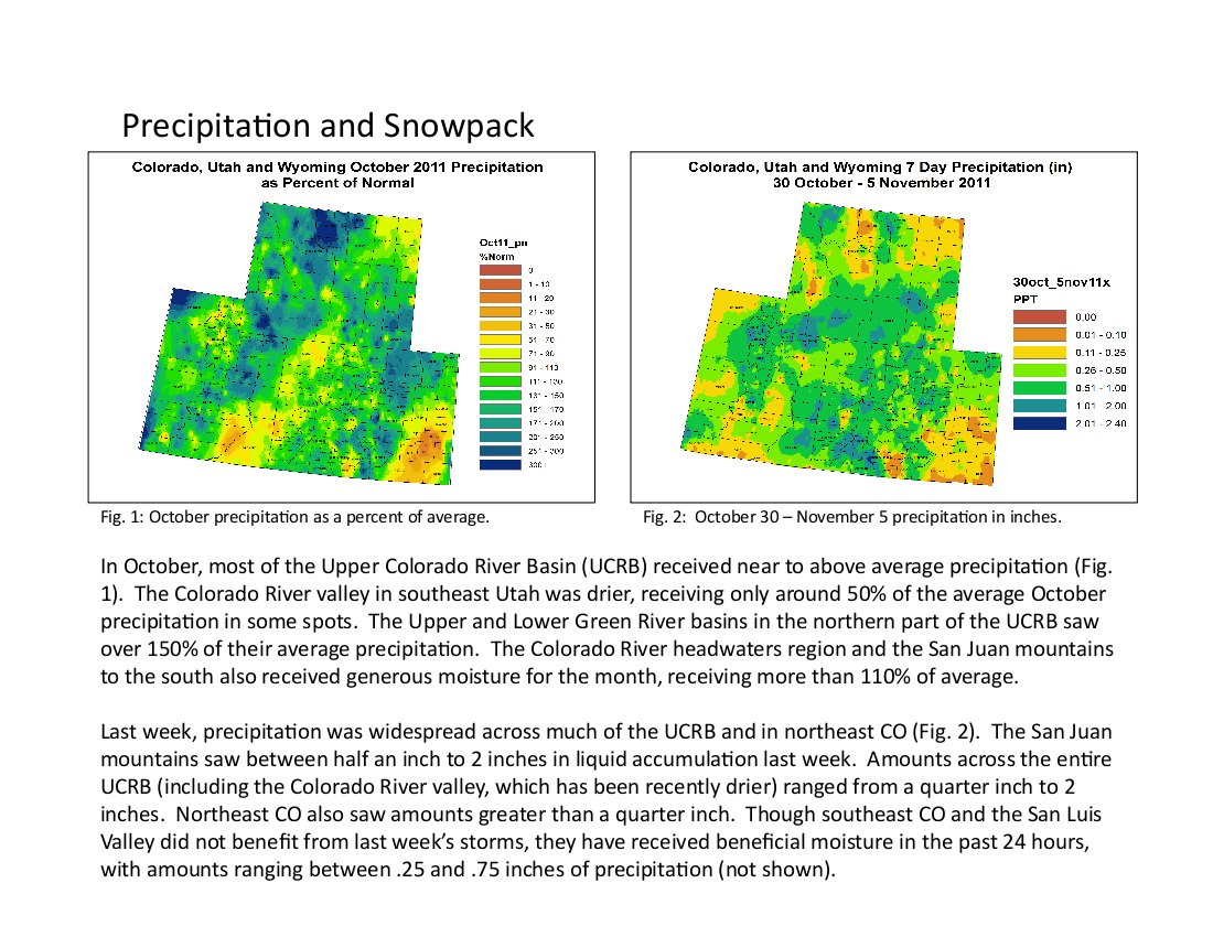
Here’s the link to the presentations from the Colorado Climate Center. Click on the thumbnail graphic to the right for the precipitation summary.

Here’s the link to the presentations from the Colorado Climate Center. Click on the thumbnail graphic to the right for the precipitation summary.

From The Denver Post (Bruce Finley):
The project reflects a quiet but substantial shift of control over a crucial resource as the federal government tries to turn a new page with tribes. Six recent water settlements have forced the government to commit $2.04 billion for dam, pipeline and reservoir projects — giving sovereign tribes from Montana to New Mexico control over 1.5 million acre-feet of new water each year. Tribes have used lawsuits and hard bargaining to assert water rights. Now, with many Western rivers already over-subscribed, tribes are in a position to play a greater role in development…
Since 1908, the U.S. Supreme Court has held that tribes relocated to reservations in the 19th century are entitled to enough water to live on those lands. Only 29 of the nation’s 565 tribes have had claims settled. Future settlements could exhaust much of the remaining unallocated water. “The reality of water in most rivers in America, including the Colorado and Rio Grande, which are so important to Colorado, is that there’s not enough water to do everything that people want to do. We’re not going to create any more water supply,” said Salazar, a lawyer whose prior work as a U.S. Senator, state attorney general and natural resources director drew him into the issue. “Until (tribal claims for water) get quantified, there’s no certainty” for how much water will be available, Salazar said…
The total population of the Southern Ute and Ute Mountain Ute tribes is less than 6,000. They’re now in a position to pursue economic development, including extraction of gas, and sell water to others around Colorado. “Yes, we’re in the driver’s seat,” said Pearl Casias, chairwoman of the Southern Ute Tribe, which has about 1,481 members. There are 4,500 Ute Mountain Utes. Together, the tribes own about 70 percent of the water in Nighthorse reservoir…
Over the past three years, federal negotiating teams led by Bureau of Reclamation commissioner Mike Connor settled six claims. The most recent Aamodt settlement, for about $176 million, involves four pueblos in the Pojoaque River basin of New Mexico — providing about 8,500 acre-feet of water. A separate $88 million settlement with the Taos Pueblo is meant to deliver 2,000 acre-feet a year. Earlier this year, federal negotiators settled for $460 million with the Crow in Montana, a deal obligating the government to supply 500,000 acre-feet of water. A 2009 settlement for $1 billion with the Navajo obligates the government to provide 606,000 acre-feet…
This winter, Colorado officials and residents of Durango are expected to work at lining up shares of the water. The reservoir holds enough to sustain hundreds of thousands of people — far more than the current population of the area, Durango resident and businessman Kent Ford pointed out. “I’m all for the tribes getting their water rights,” Ford said. But building such a big reservoir for the purposes of a legal settlement may not make sense in the long run, he said. Mountain water might better have been left flowing in rivers to ensure healthy riparian ecosystems, he said. “We may come to look at this as another example of our society gone awry.”

Here’s the release from the Colorado Geological Survey (Vince Matthews):
The Colorado Geological Survey has released three significant new reports on ground water in the Denver Basin. The reports, representing more than a decade of research, provide the most detailed information yet on the varied distribution of groundwater in the Denver Basin and show the most productive aquifers are concentrated near the mountain front and diminish to the east.
All three publications document in different ways that the strata from which many of the people living along the southern Front Range obtain their groundwater, are highly variable. Together, they present a science-based perspective of the complex geometry of the freshwater-bearing strata which resulted from a dynamic geologic history. This new perspective shows a non-uniform distribution of strata with favorable aquifer characteristics across the basin. Because of the way the strata formed, the thickest and most productive sandstones concentrate near the mountain front and diminish to the east.
The reports will help regulators, modelers, consultants, policymakers, and planners better understand the variability of water productivity in the Denver Basin, a major source of water supply for populous regions south of Denver. One of the publications is the result of a collaborative effort with the Denver Museum of Nature & Science (DMNS).
The first report; Geology of Upper Cretaceous, Paleocene and Eocene Strata in the Southwestern Denver Basin, Colorado; is a compilation of more than 1000 square miles of surface mapping of the aquifers where they are exposed along the mountain front. The mapping was originally carried out at a scale of 1:24,000 and is compiled into a 1:50,000 map consisting of two plates. This compilation also presents a simplified naming classification for the geologic strata of the Denver Basin.
The second report; Bedrock Geology, Structure, and Isopach [thickness] Maps of the Upper Cretaceous to Paleogene Strata between Greeley and Colorado Springs, Colorado; takes what was learned by mapping at the surface and extends it into the subsurface using data from nearly 3,000 wells. This report was a collaborative effort with DMNS, whose personnel also spent more than a decade independently working on the strata in the Denver Basin. The report contains seven maps that illustrate the thickness, depth, and distribution of the various freshwater-bearing strata in the Denver Basin. It also contains a depth map to the Niobrara formation, and a thickness map of the Pierre shale that separates the Niobrara from the freshwater aquifers. An additional three maps of ancient landscapes illustrate why the sandstone aquifers are concentrated near the mountain front. Included with this report is an illustrative poster that explains the various environments within which the strata were deposited. The poster is also sold separately.
The third publication; Cross Sections of the Freshwater Bearing Strata of the Denver Basin between Greeley and Colorado Springs, Colorado; contains four north-south, and eleven east-west, detailed cross-sections of the strata in the Denver Basin. These cross- sections integrate surface geologic mapping with subsurface well data to graphically illustrate variability in the types of strata across the entire basin. This report is oriented toward the professional community, rather than the general public.
All three publications come in hard copy and include DVDs with detailed PDFs of the plates and GIS shapefiles containing metadata. The publications can be ordered from the Colorado Geological Survey at 303-866-2611 or in the online bookstore at http://geosurveystore.state.co.us/.
More coverage from Chris Woodka writing for The Pueblo Chieftain. From the article:
A new study by the Colorado Geological Survey and U.S. Geological Survey shows the Denver aquifers are thinner and less tributary than previously thought. At the same time, energy exploration is skyrocketing in the Niobrara formation, which runs through the geologic heart of Colorado. The fastest-growing areas of the state are located over the Denver Basin aquifers and their water supplies tap into what was thought to be a vast supply that would last 100 years into the future.
“This study is alarming because what we believed about aquifers for the last 20, 30, 40 years has been shattered,” state Rep. Marsha Looper, R-Calhan, told the Arkansas Basin Roundtable Wednesday. “The study of the geology showed the reservoirs are not as thick and deep as we thought.”[…]
Looper plans to introduce legislation to study how much water is available in the Denver Basin aquifers, rather than relying on past estimates that now may be inaccurate. “I want to take the Colorado Geological Survey study a step further and study how much water there actually is in the Denver Basin,” Looper said. “I plan to introduce a bill, but I want to work with the roundtable to take a bottoms-up approach to the issue.”
More coverage from Bob Berwyn writing for the Summit County Citizens Voice. From the article:
The reports compile more than a decade of research and provide the most detailed information to-date on the the distribution of groundwater, representing crucial information for water managers and land-use planners in the semi-arid region. Together, they present a science-based perspective of the complex geometry of the freshwater-bearing strata which resulted from a dynamic geologic history.
This new perspective shows a non-uniform distribution of strata with favorable aquifer characteristics across the basin. Because of the way the strata formed, the thickest and most productive sandstones concentrate near the mountain front and diminish to the east.
The reports will help regulators, modelers, consultants, policymakers, and planners better understand the variability of water productivity in the Denver Basin, a major source of water supply for populous regions south of Denver. One of the publications is the result of a collaborative effort with the Denver Museum of Nature & Science.
From The Pueblo Chieftain (Chris Woodka):
“We’re trying to establish a baseline value for the use of ag water,” said Reeves Brown, a Beulah rancher and member of the Lower Arkansas Valley Water Conservancy District board. “We need to find public support for the value of water.” Brown chairs a roundtable committee that is seeking to build statewide support for securing future water supplies for agriculture.
James Pritchett, an economics professor at Colorado State University-Fort Collins, outlined several approaches a proposed study of the agricultural value of water could take. Several CSU studies already have looked at similar questions. A committee will refine its course of action and present it to the full roundtable in January. A survey of more than 6,250 households in 17 western states showed the public has an aversion to drying up farms to provide more water for cities, and that city dwellers are even willing to pay more to find other ways to water their lawns. Buying farm water placed dead last in short- and long-term solutions to urban water gaps in the survey. In the short term, water restrictions were preferred. In the long term, respondents picked reservoirs, reuse, conservation, growth limits and even pipelines as better solutions than drying up agriculture.
More IBCC — basin roundtables coverage here.

From the International Business Times (Pierre Bertrand):
The High Plains (or Ogallala) Aquifer spans 111 million acres totaling 173,000 square miles. It’s a veritable underground ocean and is used to irrigate crops and support livestock in eight states from South Dakota to Texas.
The crops produced in the region are shipped everywhere throughout the world. It is one of the globe’s major agricultural producing regions – and it’s drying up.
Since the 1950s, when advancements in well technology and water pumping meant agriculturalists could extract record amounts of water, the aquifer has dropped roughly 274 million acre feet, the bulk of the decline happening since the mid-1980s.
Such a drop means water levels have dipped by more than 150 feet in parts of Texas’ Panhandle and South West Kansas, according to a United States Geologic Survey 2011 report that compared water level declines in recent years with levels 60 years ago…
Brownie Wilson, Kansas Geologic Survey’s water level database administrator, said out of 8.6 million acres of Ogallala-irrigated land in Kansas, 1.2 million acres of farm land will be at minimum threshold, or the level at which water can no longer be pumped from the ground for irrigation, within less than 25 years. That will add to the already 2.2 million acres of that state already at minimum threshold…
In 2009, 13 percent of the aquifer had sustained more than a 25 percent drop in its saturated thickness – or the depth of the aquifer. Another 5 percent sustained 50 percent drops, according to the report…
Water recharging the aquifer flows West to East. Depending on how much rainfall the area receives, less than 2 millimeters at times flows back into the aquifer a year, McGuire said. That’s less than one tenth of an inch…
[Troy Dumler, an agricultural economist with Kansas State University] said he suspects the state’s hodgepodge watering issues makes it hard for large-scale farming reform in the area to gain traction. While he remains cautiously optimistic, he adds policies will have to eventually be drafted to help encourage even less water use.
“I don’t think we can just stick our head in the sand and say ‘Oh everything will be fine,'” Dumler said, who anticipates watering issues could prompt some movement within the agricultural industry away from the state.

From The Denver Post (Bruce Finley):
Cotter Corp. crews this week jack-hammered concrete foundations and ripped apart contaminated remaining buildings at their uranium mill, pushing to consolidate all waste in a massive impoundment pond by year’s end.
Next year, workers will dig out toxic soil 4 feet deep and bury that too, said John Hamrick, Cotter’s vice president for mill operations, outlining a dismantling project that he said has cost $3.5 million so far.
The project eventually will include construction of a new evaporative waste pond to store water pumped from a potentially contaminated creek that flows near Cotter’s property, Hamrick said…
Ten new groundwater-testing wells are to be built in a nearby urban neighborhood to monitor toxic plumes, along with additional wells west of the mill, where the latest underground plume of cancer-causing trichloroethylene was discovered last year…
State health department regulators have let Cotter deliberate on whether to reopen or embark on total cleanup and restoration of the site. But now Cotter’s operating license is about to expire. Cotter must decide by January whether to renew or to move toward reclamation and closure…
Federal authorities during the Cold War backed creation of the mill to process uranium for nuclear weapons. In 1984, the mill was deemed a Superfund environmental disaster. Toxic metal waste contaminated residential wells near Cañon City.
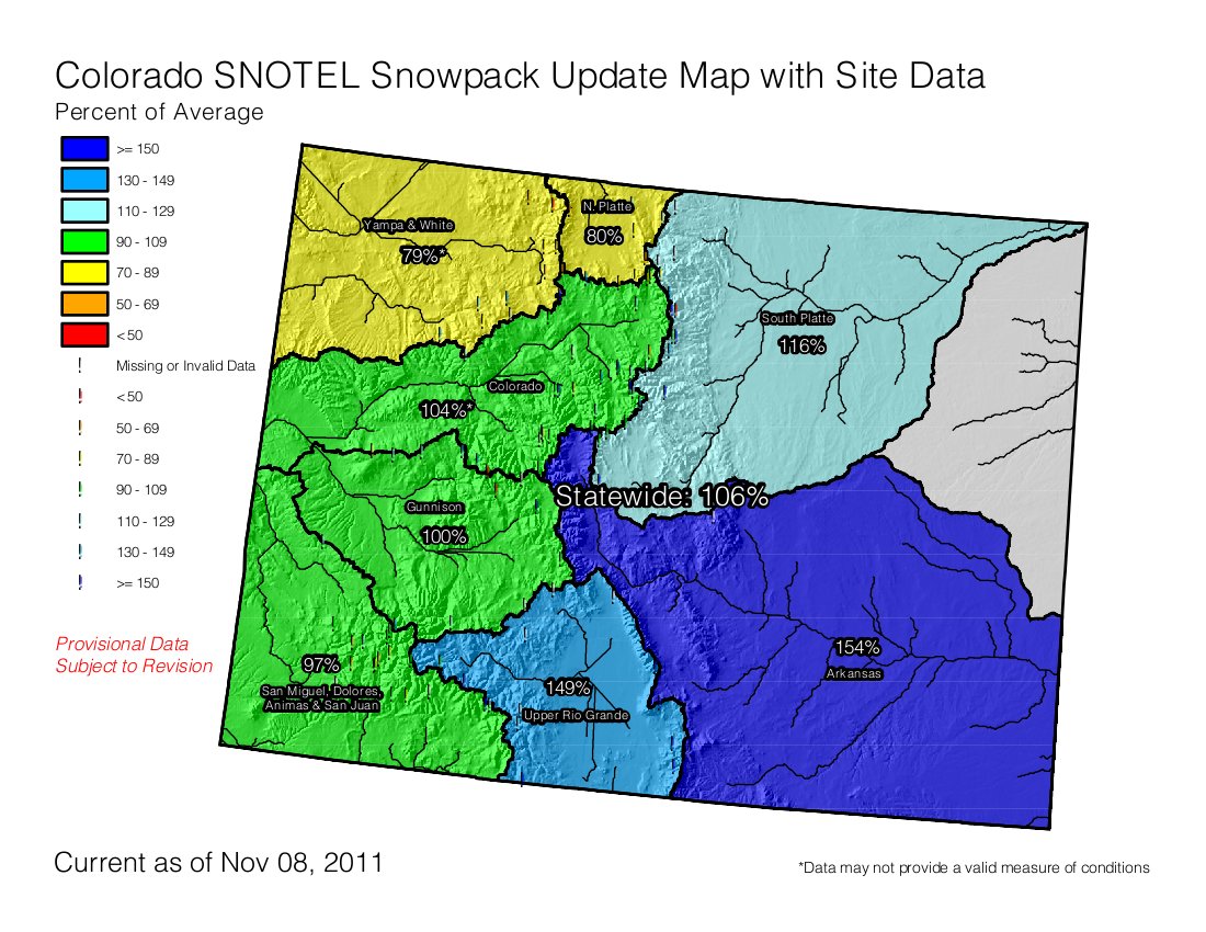
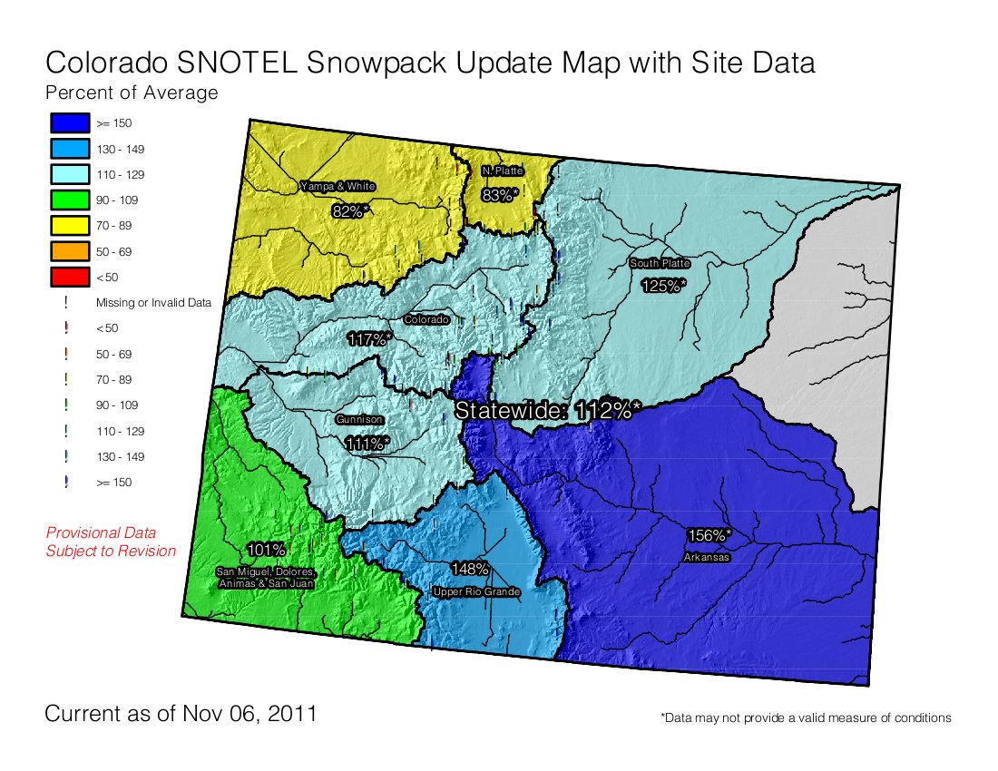
It’s very early in the season and a lot of snow still has to fall to get the state to an average year. Expectations are that La Niña will again bless the northern part of the state with snow like last year, although not in record amounts. Click on the thumbnail graphic to the right for this morning’s snowpack map.

Say hello to the Water Infrastructure Network website. The group hosted a conference Tuesday for around 150 providers in Denver to highlight funding needs and possible solutions. Here’s a report from Chris Woodka writing for The Pueblo Chieftain. From the article:
The WIN Colorado website gives detailed information on the funding needs for water delivery, sanitary sewer and storm sewer needs throughout the state. It is funded by numerous public and industry groups, including the Special Districts Association, Colorado Municipal League, American Water Works Association, Associated General Contractors of Colorado and Colorado Contractors Association.
State funds for water grants and loans also have been reduced as dedicated sources, such as the mineral severance tax, have been redirected to help balance the state budget. “The ability of the state to loan money for water infrastructure is pretty thin,” said Doug Kemper, executive director of the Colorado Water Congress.
Three-fourths of the state’s $7.1 billion budget is spent on K-12 education, public safety or health and human services, and those costs aren’t dropping, he explained…
Water loan funds from mineral severance taxes administered through the Colorado Water Conservation Board have been cut by more than $266 million since 2008, and lawmakers gave no indication that the situation will change anytime soon…
One panel dealt with public-private partnerships, but couldn’t reach consensus on how they should be structured. They agreed that regionalizing water districts would provide a better basis for funding because of economy of scale, but said it might not be possible in every case. They also emphasized the need for private involvement and discounted the public mistrust of the profit motive…
Brian Burnett, Peter Binney and Lowell Clary, all consulting engineers, offered examples of how private companies were able to reduce costs to water providers through operational efficiencies. Binney, former director of Aurora Water, cited the specific example of the need to quickly boost the city’s treatment capacity after the 2002 Hayman Fire degraded its water supply in the South Platte River basin. A private contractor was hired to resolve the issues and performed the task on time and under budget.
More infrastructure coverage here.
From The Pueblo Chieftain (Chris Woodka):
Denver metro users averaged 191 gallons per capita each day, and have already reduced that use to 155 gallons per day, according to a report that will be reviewed by the roundtable this week. The report recommends reducing water use to 129 gallons per person daily by 2050…
Alan Hamel, a member of the Colorado Water Conservation Board and Executive Director of the Pueblo Board of Water Works, said large water providers are working on urban conservation strategies and will do more in the future…
The Metro Roundtable used a portfolio tool developed by the IBCC and CWCB to estimate how far water conservation could go toward reducing demand in years to come. With mid-range population growth estimates, the 32 percent reduction in urban water use would shave total demand by Denver, Aurora and South Metro districts by 289,000 acre-feet per year…
The CWCB’s Statewide Water Supply Initiative last year projected a gap of 190,000-630,000 acre-feet, meaning that demand would have to be reduced that much, or new supplies found. The IBCC has suggested the portfolio tool to sort out how much water from projects, conservation and ag dry-up would be needed to meet demand. Reducing the demand through conservation could meet the low end of SWSI projections, but can’t do everything, Hamel said…
Pueblo, which bumped up against the limits of its Arkansas River supply in 2002, has reduced its water use by 17 percent per capita since the drought. The Pueblo water board is looking for ways to increase the savings…
Statewide, indoor water use is about 51 gallons per capita daily, while the Denver metro area’s indoor use is about 44 gallons per person daily. Still, the roundtable is looking at reducing that to 30-40 gallons daily through more efficient water fixtures and continued customer education.
More conservation coverage here.

From Science Daily:
The second century A.D. saw an extended dry period of more than 100 years characterized by a multi-decade drought lasting nearly 50 years, says a new study from scientists at the University of Arizona.
UA geoscientists Cody Routson, Connie Woodhouse and Jonathan Overpeck conducted a study of the southern San Juan Mountains in south-central Colorado. The region serves as a primary drainage site for the Rio Grande and San Juan rivers.
“These mountains are very important for both the San Juan River and the Rio Grande River,” said Routson, a doctoral candidate in the environmental studies laboratory of the UA’s department of geosciences and the primary author of the study, which is upcoming in Geophysical Research Letters…
To sample the trees without damaging them, the dendrochronologists used a tool like a metal screw that bores a tiny hole in the trunk of the tree and allows them to extract a sample, called a core. “We take a piece of wood about the size and shape of a pencil from the tree,” explained Routson.
“We also sampled dead wood that was lying about the land. We took our samples back to the lab where we used a visual, graphic technique to match where the annual growth patterns of the living trees overlap with the patterns in the dead wood. Once we have the pattern matched we measure the rings and average these values to generate a site chronology.”
“In our chronology for the south San Juan mountains we created a record that extends back 2,200 years,” said Routson. “It was pretty profound that we were able to get back that far.”[…]
“What we can see from our record is that it was a period of basically 50 consecutive years of below-average growth,” said Routson. “And that’s within a much broader period that extends from around 124 A.D. to 210 A.D. — about a 100-year-long period of dry conditions.”
“We’re showing that there are multiple extreme drought events that happened during our past in this region,” said Routson. “These megadroughts lasted for decades, which is much longer than our current drought. And the climatic events behind these previous dry periods are really similar to what we’re experiencing today.”
The prolonged drought in the 12th century and the newly discovered event in the second century A.D. may both have been influenced by warmer-than-average Northern Hemisphere temperatures, Routson said: “The limited records indicate there may have been similar La Nina-like background conditions in the tropical Pacific Ocean, which are known to influence modern drought, during the two periods.”
More coverage from the Associated Press via The Durango Herald. From the article:
The geoscientists said the San Juan River is a tributary for the Colorado River, meaning any climate changes that affect the San Juan drainage also likely would affect the Colorado River and its watershed.
Scientists say the prolonged drought in the 12th century and the newly discovered event in the second century may both have been influenced by warmer-than-average Northern Hemisphere temperatures. The researchers looked for indications of climate in the past in the growth rings of the oldest trees in the southern San Juan region to develop their chronology.
Click on the thumbnail graphic above and to the right for the current U.S. Drought Monitor graphic.
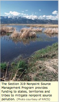
From email from the Colorado Watershed Assembly:
The Water Quality Control Division, Nonpoint Source Management Area (NPS program) and its state water quality partners, the Nonpoint Source Alliance (Alliance) are now accepting proposals for projects to be considered for funding under Section 319(h) of the Clean Water Act.
The 2012 NPS Funding Cycle Announcement, with application forms, instructions, budget spreadsheet and other information is available at http://npscolorado.com/.
PLEASE read all the information in the announcement and instructions before proceeding.
Mark your calendars! Proposals DUE January 13, 2012!
If you have any questions, contact a member of the CDPHE NPS Team by clicking here.
The NPS program staff will be available for consultation on proposal questions until November 30th. In the interest of fairness, pertinent questions will be posted in the Bulletin Board so that all proponents can access the information. After November 30th, staff will not answer proposal related questions and the consultation period will be finished. Proposals will be due on January 13th, 2012.
More water pollution coverage here.

A week or so ago the review of Colorado’s oil and gas production and exploration rules by the State Review of Oil & Natural Gas Environmental Regulations (STRONGER) was cited by the Colorado Oil and Gas Conservation Commission as part of their basis for a new rulemaking effort for hydraulic fracturing.
Here’s the release from Western Resource Advocates (Jason Bane):
Following the release of the Colorado Hydraulic Fracturing State Review, Western Resource Advocates is calling on Colorado Gov. John Hickenlooper to do more to protect Colorado’s citizens and water from the threat of fracking oil and gas wells.
A public-private committee dubbed STRONGER1 released an in-depth review2 of the Colorado hydraulic fracturing regulatory program on Friday, Oct. 28. The committee recognized several positive aspects of Colorado’s 2007 oil and gas rulemaking, but noted five specific areas of concern—most importantly the need to a) better protect groundwater quality, and b) to better understand where the industry will find the millions of gallons of water needed for fracking (and what that means for the environment and for other water users in Colorado).
The most significant piece of the STRONGER report is about what is not included. The report does not address Colorado’s draft disclosure rule for fracking chemicals; a proposal to allow the oil and gas industry to self-regulate on its FRAC-Focus website; or the need to increase residential setback requirements from the current minimum levels (150 feet for rural areas; 350 feet for urban areas). These issues are vital to ensure the safety of all Coloradans, regardless of where they live, and some need to be undertaken immediately.
“There is an urgent need to increase Colorado’s residential setbacks,” said Mike Chiropolos, Lands Program Director at Western Resource Advocates (WRA). “The single most important thing that Colorado can do to protect homeowners in the gas patch is to increase the distance between drilling rigs and our homes.”
There are currently 45,000 active oil and gas wells in Colorado, and more than 5,000 new permits were approved in 2010 alone. The STRONGER report will help set the stage for potential reforms and regulations of fracking in 2012.
More coverage from David O. Williams writing for the Colorado Independent. From the article:
Dubbed the Colorado Hydraulic Fracturing State Review (pdf), the independent private-public review had been cited by some observers as a possible impetus for Gov. John Hickenlooper somewhat reluctantly agreeing this summer that the state oil and gas regulatory agency should draft a public disclosure rule for fracking chemicals.
That rulemaking process by the Colorado Oil and Gas Conservation Commission (COGCC) is under way, with a draft disclosure rule scheduled to be released and published in the Colorado Register (pdf) on Nov. 10. Hearings are slated for December, and COGCC regulators hope to have a rule finalized by the end of the year.
One of the revised rules Colorado adopted in 2008 after a long and contentious rulemaking process was a regulation requiring companies to keep an inventory of chemicals onsite during drilling and fracking operations and make that inventory available to regulators and healthcare professionals upon request.
“This rule allows government officials and medical professionals to investigate and address allegations of chemical contamination associated with hydraulic fracturing, while protecting proprietary information,” the STRONGER report states.
But the report went on to raise concerns about water supplies for fracking (up to a million gallons per well) and recommended a comprehensive state evaluation of available water resources as they related to fracking operations, which occur in about 90 percent of natural gas wells.
“Given the significant water supply issues in this arid region, this project should also include an evaluation of whether or not availability of water for hydraulic fracturing is an issue and, in the event that water supply is an issue, how best to maximize water reuse and recycling for oil and gas hydraulic fracturing,” the report states in its executive summary.

From the Cortez Journal (State Senator Ellen Roberts):
Any legislator can carry a bill relating to water policy outside of those approved by the committee, but the value of having the committee’s approval at the start of the next session is that the subject matter of the bill has already been discussed and debated, with a supermajority of committee members voting to advance the idea on to the full legislature in January.
My being a member of the water committee was valuable for hearing the current water issues and concerns as presented by experts on various topics affecting our state water policies. I’m pleased to report that a resolution that I presented to the committee, which restates and reinforces the need to respect existing law regarding adequate funding to support Colorado’s water infrastructure, passed by a wide margin and will be introduced as a committee resolution this winter.
Too often, the funds for water infrastructure have been shifted to other uses in the budget and, like the energy impact funds for local communities, the legislature needs to apply the necessary fiscal discipline and foresight to use the funding for its original purposes. To do otherwise is another unfortunate example of robbing Peter to pay Paul.
More coverage from Joe Hanel writing for The Durango Herald. From the article:
[Governor] Hickenlooper’s budget for next year, released Tuesday, gives rural lawmakers a few glimmers of hope. He proposes leaving $10 million in an account filled by taxes on gas and oil production so the state can resume making grants to local governments affected by gas drilling…
The state Department of Local Affairs stopped making grants in 2009 and instead shoveled the gas and oil severance tax money into the ailing general fund budget.
Sen. Ellen Roberts, R-Durango, and Rep. Don Coram, R-Montrose, sponsored bills this spring to halt the practice. Both bills died in a committee in the Democratic-controlled Senate. Roberts called the $10 million that Hickenlooper has left for local grants a step in the right direction, “although only a baby step at this point.” “Still, I’d like to commend him for recognizing that those funds are by current law supposed to go to local communities and are important for putting people to work in the areas of the state where unemployment is very high,” Roberts said in an email interview…
Hickenlooper said he had no choice but to go after the money again. Otherwise, his proposed education cuts of $175 million would have to be even larger. “Nothing would give me greater pleasure than to make sure all the severance taxes go back into that grant program for the Department of Local Affairs,’ Hickenlooper said. “That’s how the old school politics worked. Give out these grants in the right places, and things went well.”
More 2012 Colorado legislation coverage here.
Here’s the announcement from the CWA:
Join us Thursday, November 17, at 2:00 p.m. ET for the webcast series Hydraulic Fracturing: Fresh Facts & Critical Choices to explore the potential footprint on ecosystems as well as safeguards state regulators are using and developing to protect ground water. Kevin Heatley with Biohabitats, Inc., will discuss the significant landscape impact that can occur from drilling and fracturing operations and associated infrastructure systems on forests, wildlife, and habitat. Ground Water Protection Council’s Mike Paque will describe efforts of state regulators to protect watersheds and improve public transparency through the establishment of a national registry on fracturing fluids.
The Clean Water America Alliance and the American Water Resources Association are partnering to produce the three part webinar series. “The “Shale Rush,” prompted by technology breakthroughs in horizontal drilling and hydraulic fracturing over the last decade has raised significant questions about the footprint on the environment, impact to public health, and the roles of various government agencies” explains Alliance President BenGrumbles. “Water is a particular concern with potential issues down under, downstream, or downwind. Especially now, as U.S. EPA seeks to develop rules on “fracking,” the water sector will want to develop a more in-depth and objective understanding on all aspects and consequences from objective sources.” Grumbles and Michael Campana (President of AWRA), will facilitate the expert panels and audience questions to shed more light on the fracking issue. Webcast registration is $50 per site, per event, or $100 for all three one-hour sessions, or $75 for members. Visit www.CleanWaterAmericaAlliance.org to register.
The next and last webcast in the series is December 1. It will discuss safeguards and concerns of natural gas recovery from deep shale formations as well as an update on EPA activities. Dr. Donald Siegel of Syracuse University will discuss the extent of potential natural gas supplies in shale in the United States, and how drilling and recovery can be done safely without impacts to humans or ecosystems if adequate safeguards are employed throughout the process. Dr. Joseph Romm of the Center for American Progress will discuss possible impacts on humans and ecosystems if proper techniques for drilling and sealing of wells and recovery and storage/disposal of fracturing fluids and formation water are not in place if accidents occur at any stage of the process. A representative of the U.S. EPA will discuss pending studies and research-related activities of the agency.
The first webcast was November 1 and is available by video with registration. It presented an overview of fracking. Christopher Harto of Argonne National Laboratories, Washington, DC, described the generic process with a focus on correct procedures for drilling and installation of wells, injection of fracking fluids, recovery of natural gas, and methods for disposal of recovered fracking fluids and formation water. Carol Collier of the Delaware River Basin Commission (DRBC) discussed the proliferation of deep natural gas recovery wells in the DRBC, the opportunities and challenges present for residents of the DRBC, and potential positive and negative impacts of proliferation on the management of water and ecological resources in the DRBC.
For more information, contact Lorraine Loken at 202.533.1819, lloken@CWAA.org.
Meanwhile the EPA plans to have their study of hydraulic fracturing completed in 2014, according to The New York Times Green blog.
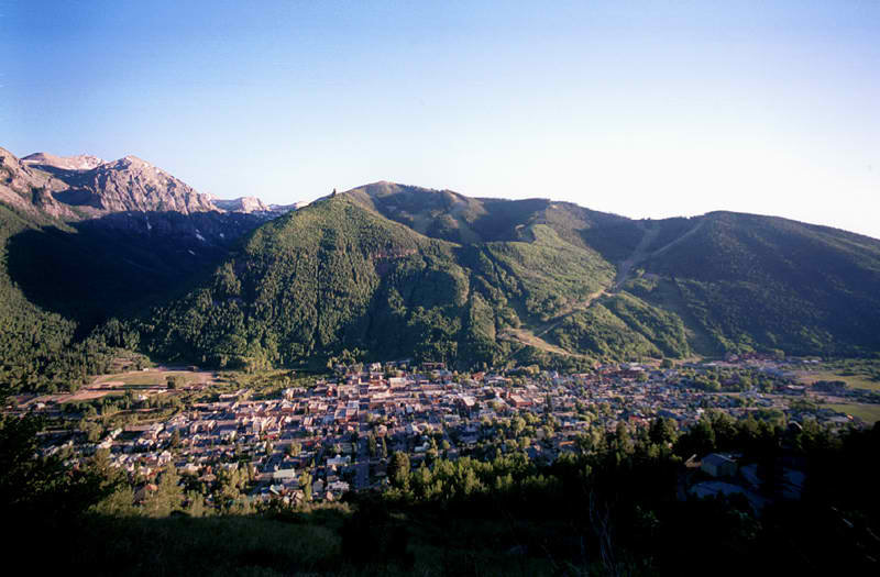
From The Telluride Daily Planet (Benjamin Preston):
The Colorado Water Conservation Board hosted an informational meeting Wednesday about its Drought Assessment for Recreation and Tourism, or DART. CWCB designed the program to fill gaps in the state’s drought impact data — which had been focused more on agriculture — and provide county-specific assessments.
“This is the first time anyone has done an assessment like this in the U.S.,” said Taryn Hutchins-Cabibi, a CWCB official who traveled to Telluride to reach out to potential survey coordinators and participants. She called the I-70 corridor a threshold region and said the area south of it needs more detailed drought impact analysis. “Anything below I-70 seems to be more susceptible to drought.”
Hutchins-Cabibi sought more survey participants affected by drought, finding representatives from the Telluride Foundation, Mountain Studies Institute and other organizations around town at Wednesday’s meeting. But Hutchins-Cabibi said she needed as many participants as possible to make the survey more accurate. Honed in on the San Juan, San Miguel and Dolores River watersheds, DART’s Southwest Colorado component will evaluate a region of the state where tourism is particularly prone to the effects of drought.
A preliminary list of industries DART will evaluate includes skiing, wildlife viewing, hunting, fishing, camping, golf, boating and rafting. Meeting attendees offered a number of other suggested industries from which to seek input; everything from dog sledding and horseback riding to dude ranch operation. Cooperation with the Colorado Department of Corrections — which maintains fisheries in Cañon City — was also suggested.
While DART’s main collaborators are CWCB, the Colorado Department of Agriculture and Colorado State University, the study incorporates a long list of other participants: Colorado State Parks; the Colorado Division of Wildlife; the Colorado Tourism Office; the National Park Service; the U.S. Bureau of Land Management; the U.S. Forest Service; Ft. Lewis College; the University of Colorado; area tribal communities; Telluride, Silverton and Durango Mountain Resorts ski areas; and the River Rafting Association.
More CWCB coverage here.
Here’s the release from the U.S. Bureau of Reclamation (Peter Soeth):
The Bureau of Reclamation is seeking eligible non-federal entities interested in participating in the 2012 Basin Studies under the WaterSMART Program. Eligible partners include states, tribes, water districts, cities and other local governmental entities with water delivery or management authority located in the 17 Western States.
Applicants must submit a letter of interest to their respective Reclamation regional office by November 30, 2011. To determine the Reclamation region in which a particular basin is located, please visit www.usbr.gov/main/regions.html.
Each Basin Study should include four main components:
– Projections of water supply and demand within the basin, including the risks of climate change.
– Analysis of how existing water and power infrastructure and operations will perform in response to changing water realities.
– Development of appropriate adaptation and mitigation strategies to improve operations and infrastructure to meet future water demands.
– A trade-off analysis of the options identified, findings and recommendations as appropriate.The non-federal partners must contribute at least 50 percent of the total study cost in non-federal funding or in-kind services. Basin Studies are not financial assistance and Reclamation’s share of the study costs may only be used to support work done by Reclamation or its contractors.
Proposed letters of interest for Basin Studies will be reviewed by Reclamation regional office staff. Those selected for consideration will then work with Reclamation technical experts to develop a joint study proposal for evaluation and prioritization by a Reclamation review committee.
The WaterSMART Program addresses increasing water supply challenges, including chronic water shortages due to population growth, climate variability and change and growing competition for finite water supplies. Through the Basin Studies, Reclamation will work cooperatively with state and local partners in the 17 Western States to evaluate future water supply and demand imbalances, assess the risks and impacts of climate change on water resources and develop potential mitigation and adaptation strategies to meet future demands.
For specific information on the WaterSMART Basin Studies, please visit www.usbr.gov/WaterSMART/bsp. For information on the WaterSMART Program, please visit www.usbr.gov/WaterSMART/.
More Reclamation coverage here.

From The Colorado Springs Gazette (John Schroyer):
Utilities’ budget is projected to jump by 8.6 percent in 2012, an increase made possible by a 12 percent increase in water rates, a 5 percent increase in natural gas rates, and about a 1 percent increase in electricity rates.
Roughly three-quarters of the $87 million will be devoted to SDS work, and the remainder will go to other projects, such as the installation of new emissions-cleaning technology at Drake Power Plant, said Utilities Finance and Planning Chief Bill Cherrier.
The 187-page budget, which the Utilities Board is analyzing, also predicts that water, electricity and natural gas usage will remain flat throughout 2012. Hence the need for the rate increases. The budget likely will be approved by the board, comprised of City Council members, in December without any substantive changes…
Utilities plans to spend $333 million on coal and natural gas to power both Drake and other power plants, and will spend $310 million on capital projects, such as SDS. “That’s more than 60 percent of our budget,” Cherrier pointed out.
Water rates will continue to increase by 12 percent every year until SDS is completed, which is slated for 2016. After that, Cherrier said, rates should even out, and may even decrease. Utilities board and city council member Tim Leigh suggested Colorado Springs may even become a water broker for other Front Range municipalities once SDS is finished. “Not everyone has a pipeline to the Arkansas River,” Leigh said.
From The Christian Science Monitor (Pete Spotts):
“I was shocked” when this result emerged, says Gregory Pederson, a hydrologist at the US Geological Survey’s Northern Rocky Mountain Science Center in Bozeman, Mont., who led the [study] effort. Similar shifts show up in the 1300s and 1400s, when the Rockies experienced warming periods, he says, but temperatures then weren’t nearly as warm as today. Nor was the shift as strong. Many studies have documented the West’s declining snowpack. And at least as early as 2005, some researchers began to notice the potential regime shift that Dr. Pederson and his colleagues see, notes Klaus Wolter, a researcher at the National Oceanic and Atmospheric Administration’s Earth System Research Laboratory in Boulder, Colo…
The new study, conducted by a team of scientists in the United States and Canada, drew on tree-ring records that the team related to snowpack. The scientists focused on three broad regions in the Rockies that host the headwaters for major Western river systems, such as the Columbia, Missouri, and Colorado Rivers. While the shrinking snowpack in the 20th and early 21st centuries is not unprecedented from a climate-history standpoint, at no time in the past 800 years have so many people relied so heavily on these winter snows for their fresh water…
Typically, gains and losses of mountain snowpack seesaw between the northern and southern Rockies with these natural swings in Pacific climate patterns, Pederson explains. This feature stands out in the team’s data throughout the past millennium, with a couple of notable exceptions around 1350 and the early 1400s, when warmer average temperatures reduced snowpack up and down the length of the Rockies at the same time. The seesaw still occurs to some extent. But since the 1980s, snowpacks again have been declining along the entire length of North America’s geological spine, regardless of the state of these natural climate swings.
From The Denver Post (Bruce Finley):
The project launched this week by foresters and private-sector partners will try to rework the altered flow of Trail Creek to make it more natural. For Fort Collins-based hydrologist Dave Rosgen, this also is a chance to demonstrate techniques increasingly in demand worldwide…
“This is how Mother Nature does it,” he said Friday, describing his plan to stabilize what has become a sluice for corrosive sediment. The steep banks will first be reshaped, and fallen tree trunks will be used to reinforce the new channel. Then, the stream bed will be raised by about 7 feet so water carrying sediment disperses into a willow studded plane instead of racing down stream. “We’re going to basically go back in here and re-establish a braided, meandering channel,” Rosgen, 69, told a gathering of county and federal employees…
Rosgen has developed formulas for calculating rates of erosion, enabling detailed analysis of mountain slopes, fire impact and hydrology. His team at Wildland Hydrology Inc. has restored dozens of damaged streams in Argentina, Costa Rica, Tanzania and around the western United States.
Ever since the Hayman fire, heavy rains have led to increasingly severe flooding across the scorched burn area. Foresters and volunteers have tried to address this, planting 3.5 million tree seedlings. “But it seems that 137,000 acres doesn’t heal as quickly as we’d like it to,” said Pikes Peak District Ranger Brent Botts.
More restoration coverage here.

From The Fort Morgan Times (Jenni Grubbs):
The water rates had been scheduled to increase by 4 percent in January, but Acting City Manager Jeff Wells told the council Tuesday night that an increase of 5 percent was necessary to cover the cost of running water and wastewater treatment operations in the city, as well as the purchase of water and other water-enterprise-related costs, such as complying with Environmental Protection Agency regulations. “We initially thought the regular increase would be enough, but it wasn’t,” Wells said. “Where we’re at is not where we expected to be.” The council approved the suggested 5 percent increase, which Wells said likely would amount to about $3 per month for average residential users.

Say hello to DefendTheColorado.org, a new website designed to connect interested people and raise awareness of the issues around transbasin diversions from the Upper Colorado River here in Colorado. Here’s a report from Tonya Bina writing for the Sky-Hi Daily News. From the article:
For the Trout Unlimted Project, [Editorial Photographer and Videographer Ted Wood of Story Group, Boulder] brought in Boulder colleagues Beth Wald, a photojournalist who of late has been covering environmental and cultural stories in Afghanistan, and Mark Conlin, a seasoned underwater photographer.
“We launched the project as a way to get more visibility of the stream-flow issues on the Fraser and Upper Colorado,” said Trout Unlimited’s Randy Schoefield. “What we’re trying to portray is the community’s deep connection to the river.”
The Story Group plans to add more portraits to the website in coming days and weeks. Eventually, Trout Unlimited hopes to host public events that display the portraits as well as work by other photographers, granting a full sense of the river’s significance in Grand County and the consequences of further transbasin diversions.
Click on the thumbnail graphic above and to the right for a map of Denver Water’s collection system. More Colorado River basin coverage here.

From the Delta County Independent (Kathy Browning):
On Oct. 21, volunteers worked on a half-mile of the easement. Tamarisk, Russian olive and Siberian elm were cut out and stumps of the invasives were treated with herbicide. Tamarisk and Russian olive were introduced in the 19th century as ornamentals. Tamarisk is now seen as a problem as it out-competes native plants for moisture and displaces them along river eco-systems in the West.
Webb Callicutt, Delta County weed coordinator, trained volunteers on how to apply the herbicide.
Rosa Brey of the Colorado Canyons Association explained why it was partnering on this project. “We are a Grand Junction based group and are looking to expand our membership and our volunteer base in Delta and Montrose counties,” Brey said. “The other reason we are involved is because this river flows into the Gunnison which flows through several of our conservation areas. So if we can get tamarisk eradicated on the upstream sections of the river, then there will be fewer seeds that will flow down the river and down into the conservation areas.”

From the Pagosa Sun (Jim McQuiggin):
That research will involve two projects, one large scale, the other much smaller in scope.
Dr. Terry Young (head of the Geophysics department), Dr. Michael Batzle and Dr. André Revil (both professors of geophysics) described the research their School of Mines team will conduct in Pagosa.
Although faculty and students would be researching numerous characteristics of the aquifer, that research would be the result of the two primary studies: deep seismic profiles made of a portion of the aquifer and passive, “geoelectrical methods” of data collection — “including self-potential, electrical resistivity, and induced polarization” — that Revin describes on his website.
As far as deep seismic profiling, Young said that, “The technique is very similar to medical technology, such as an MRI or a CAT scan.”
What Young meant was that significantly large sound waves are directed beneath the earth’s surface, allowing a computer to translate the received echoes as shapes and depths (much in the way that an MRI — Magnetic Resonance Imaging — provides three dimensional images of a patient).
Those sound waves will be generated through the use of so-called “thumper trucks” — 60,000-pound pieces of equipment that generate controlled seismic energy.
Through both reflection and refraction, seismic surveys of the subterranean topography are achieved as seismic waves, travelling through a medium such as water or layers of rocks, are recorded by receivers, such as geophones or hydrophones.
Revin’s research, on the other hand, measures electrical signals associated with the movement of water in porous, fractured materials to locate the movement and characteristics of geothermal water.
With dozens of graduate students in tow, working with Mines faculty, the team will mobilize in specific areas throughout Pagosa Country, attempting to map portions of the aquifer for the first time ever.

From The Pacific Institute:
The production of electricity, from fuel extraction to generation, has growing impacts on both water availability and quality. The new analysis from the Pacific Institute evaluates future water needs for different energy futures and identifies a growing risk of conflicts between electricity production and water availability in the U.S. Intermountain West. The new report also identifies strategies to ensure the long-term sustainable use of both resources.
The study, Water for Energy: Future Water Needs for Electricity in the Intermountain West, examines the water requirements for current and projected electricity generation within the Intermountain West, which is the area bound by the Rocky Mountains in the East and the Sierra Nevada and Cascade Mountains in the West. While water and energy conflicts are increasing across the United States, the Intermountain West is of particular interest for this study because it has a growing population (and growing demand for energy and water), a diverse fuel mix for power generation, and existing water constraints and limitations that are expected to worsen.
Under current trends, by 2035, water withdrawals and consumption for electricity generation in the region are projected to increase by 2% and 5%, respectively, over 2010 levels – but water availability is already affecting power plant operations and siting in the Intermountain West. And in addition to the water needed for electricity generation, population and economic growth will increase demands for water resources, even as climate change makes the available water supply less reliable.
Here’s the link to the report. Here’s the introduction:
In the past few years, there has been a growing interest in the complex connections between energy and water, typically called the energy-water nexus. For much of the 20th century, these two vital resources have largely been analyzed and managed separately, with different tools, institutions, definitions, and objectives. We now know, however, that there are very important links between water and energy and that long-term sustainable use of both resources requires more comprehensive and integrated study and management. The current report addresses the water implications of energy choices and offers some new insights into the water risks of different electricity futures.1
The energy sector has a major impact on the availability and quality of the nation’s water resources (Table 1). Water is used to extract and produce energy; process and refine fuels; construct, operate, and maintain energy generation facilities; cool power plants; generate hydroelectricity; and dispose of energy-sector wastes. Some of this water is consumed during operation or contaminated until it is unfit for further use; often much of it is withdrawn, used once, and returned to a watershed for use by other sectors of society.
Energy use also affects water quality and ultimately human and environment health. The discharge of waste heat from cooling systems, for example, raises the temperature of rivers and lakes, which affects aquatic ecosystems. Wastewaters from fossil-fuel or uranium mining operations, hydraulic fracturing, boilers, and cooling systems may be contaminated with heavy metals, radioactive materials, acids, organic materials, suspended solids, or other chemicals (EPA 2011, Urbina 2011). Nuclear fuel production plants, uranium mill tailings ponds, and under unusual circumstances, nuclear power plants, have caused radioactive contamination of ground- and surface-water supplies (EPA 2010). Too often, however, these water-quality impacts are ignored or inadequately understood.
Thanks to KUNC’s Kirk Siegler for the heads up via Twitter (@kunc). Here’s his post. He writes:
The report, “Water for Energy,” concludes that water scarcity in the inter-mountain West will continue to pose problems for electricity production unless a set of concrete action steps are taken.
Heather Cooley, the report’s lead author, says many western power plants and other energy producers such as oil and gas operations aren’t implementing as many conservation tools as they could.
“By adopting dry cooling, by expanding energy efficiency improvements and having greater reliance on renewables, we can dramatically reduce the water requirements for electricity generation in the West, and therefore reduce our vulnerability to future water supply constraint,” Cooley said.
More energy policy coverage here.

Year on year the human race is just not getting the message. China jumped past the U.S. as the world’s largest polluter in 2010 which is a dubious distinction at best. Spewing CO2 into the atmosphere is not a race where there are any winners. The Chinese are talking the talk at least when it comes to climate change. Meanwhile, here in the U.S., many of our Republican politicians are arguing that humankind is in no way responsible for the warming we are witnessing. Worse than that, the politicians are controlling the argument by saying that we have to choose between jobs and the environment.
Here’s an article about the jump in greenhouse gases from the Associated Press (Seth Borenstein) via USA Today. From the article:
The new figures for 2010 mean that levels of greenhouse gases are higher than the worst case scenario outlined by climate experts just four years ago. “The more we talk about the need to control emissions, the more they are growing,” said John Reilly, co-director of MIT’s Joint Program on the Science and Policy of Global Change.
The world pumped about 564 million more tons (512 million metric tons) of carbon into the air in 2010 than it did in 2009. That’s an increase of 6%. That amount of extra pollution eclipses the individual emissions of all but three countries — China, the United States and India, the world’s top producers of greenhouse gases. It is a “monster” increase that is unheard of, said Gregg Marland, a professor of geology at Appalachian State University, who has helped calculate Department of Energy figures in the past…
India and China are huge users of coal. Burning coal is the biggest carbon source worldwide and emissions from that jumped nearly 8% in 2010. “The good news is that these economies are growing rapidly so everyone ought to be for that, right?” Reilly said Thursday. “Broader economic improvements in poor countries has been bringing living improvements to people. Doing it with increasing reliance on coal is imperiling the world.”
But Reilly and University of Victoria climate scientist Andrew Weaver found something good in recent emissions figures. The developed countries that ratified the 1997 Kyoto Protocol greenhouse gas limiting treaty have reduced their emissions overall since then and have achieved their goals of cutting emissions to about 8 percent below 1990 levels. The U.S. did not ratify the agreement. In 1990, developed countries produced about 60% of the world’s greenhouse gases, now it’s probably less than 50%, Reilly said.
Here’s an article about the Chinese passing the U.S. in 2010 from Michael McCarthy writing for The Independent. From the article:
Global CO2 emissions in 2010 reached 33.51 billion tonnes, up from 31.63 billion tonnes in 2009 – an increase of nearly 6 per cent. This is believed to be the highest-ever percentage increase year on year, despite growth in many industrial economies being sluggish or non-existent.
However, the figures from the US Department of Energy show clearly that it is the surging Chinese economy that is driving the growth: China’s emissions in 2010 were 8.15 billion tonnes, up from 7.46 billion tonnes the year before – a 9.3 per cent increase in 12 months.
The 694-million-tonne increase alone dwarfs all the carbon emissions that Britain produces in a year. China now accounts for 24.3 per cent of global carbon emissions and has taken over the role, held by America for decades, of the world’s biggest polluter.
The US, whose emissions totalled 5.49 billion tonnes in 2010, up from 5.27 billion tonnes in 2009 – an increase of 4.1 per cent – now accounts for 16 per cent of emissions worldwide. So although the Chinese did not overtake the US in carbon emissions until 2007, their share of the world total is now half as much again.
Between them, the two industrial giants produce 40 per cent of the world’s greenhouse gases, and neither shows any sign of slowing down.
The figures, produced by the Carbon Dioxide Information Analysis Centre of the Oak Ridge National Laboratory in Tennessee, show another significant trend: India, the world’s third-biggest carbon polluter, is rapidly catching up. In 2010, its annual emissions passed two billion tonnes of CO2 for the first time, totalling 2.06 billion tonnes. The increase of 178,330 million tonnes on the year before was 9.4 per cent, a growth rate now exceeding China’s.
Where are your bicycles? More climate change coverage here and here.
From email from the Water Center at Colorado Mesa University (Hannah Holm):
The Fall 2011 Natural Resources of the West seminar series at Colorado Mesa University focuses on Restoration. Our next guest speaker will be Patty Gelatt, US Fish and Wildlife Service
Habitat Restoration for Endangered Colorado River Fishes in the Grand Valley
Monday 7 November 2011 4 pm – 5:15 pm
Wubben-Science, Room 141 (Saccomanno Lecture Hall)
Colorado Mesa University (for maps and directions, see: http://www.coloradomesa.edu/campusinfo/maps.html)
Grand Junction, COPlease note that this is an adjustment to the published schedule. Steve Renner’s talk on mine remediation will be held the following Monday 11/14.
The seminars are free and open to the public, no registration necessary.
For the complete schedule, see http://home.coloradomesa.edu/~grichard/WSS/Seminar2011.htm
Please contact Dr. Gigi Richard (970-248-1689) or Dr. Tamera Minnick (970-248-1663) for more information.
![]()
Here’s the release from the U.S. Bureau of Reclamation (Peter Soeth):
The Bureau of Reclamation is seeking comments on the draft WaterSMART Cooperative Watershed Management Program Funding Opportunity Announcement. The draft Funding Opportunity Announcement was published in the Federal Register and may be read here.
The Cooperative Watershed Management Program contributes to the WaterSMART program by providing funding for watershed groups to encourage diverse stakeholders to form local solutions in addressing their water management needs. It will be implemented in three phases.
This Funding Opportunity Announcement will implement phase one by providing funding to establish or expand a watershed group. Comments on the Funding Opportunity Announcement are encouraged and may be submitted per the announcement in the Federal Register.
The purpose of the Cooperative Watershed Management Program is to improve water quality and ecological resilience, and to reduce conflicts over water through collaborative conservation efforts in the management of local watersheds. Its primary goal is to address two major concerns synonymous with watershed groups—1) the need for funding to pay the salary of a full-time coordinator and 2) the limited funding available for project management. The Cooperative Watershed Management Program provides financial incentives to mitigate these concerns and to encourage diverse stakeholders to continue to work together.
The Cooperative Watershed Management Program will provide financial assistance to form new watershed groups, to enlarge existing watershed groups, and/or to conduct one or more projects in accordance with the goals of watershed groups. Priority may be given to watershed groups that represent maximum diversity of interests and serve sub-basin-sized watersheds with an 8-digit hydrological unit code, as defined by USGS.
Secretary of the Interior Ken Salazar established the WaterSMART program in February 2010 – the SMART in WaterSMART stands for “Sustain and Manage America’s Resources for Tomorrow” – in cooperation with Commissioner Connor, Deputy Secretary David J. Hayes and Assistant Secretary for Water and Science Anne Castle. WaterSMART grants are given for water and energy efficiency projects, system optimization reviews, advanced water treatment pilot and demonstration projects and for the development of climate analysis tools.
To learn more about the Cooperative Watershed Management Program or WaterSMART, please visit www.usbr.gov/WaterSMART.
More Reclamation coverage here.

We humans love being in and around water and this report underscores that association with the majority of projects dealing with waterways and wetlands. Here’s the link to the report. Here’s the release:
Secretary of the Interior Ken Salazar today released a final 50-State America’s Great Outdoors Report outlining more than 100 of the country’s most promising projects designed to protect special places and increase access to outdoor spaces. The full report – which contains two projects per state – comes as part of President Obama’s America’s Great Outdoors (AGO) initiative to establish a community-based, 21st century agenda for conservation, recreation, and reconnecting Americans to the outdoors.
“We have listened to the American people and their elected representatives about the most important things we can do to conserve our land and water and reconnect people, especially young people, to the outdoors,” Salazar said. “These projects represent what states believe are among the best investments in the nation to support a healthy, active population, conserve wildlife and working lands, and create travel, tourism and outdoor-recreation jobs across the nation.”
The full list released today includes:
24 projects to restore and provide recreational access to rivers and other waterways – such as establishing the Connecticut River as a National Blueway and expanding recreational opportunities at the confluence of the Mississippi and Minnesota Rivers in the Twin Cities;
23 projects to construct new trails or improve recreational sites – such as completing gaps in the Ice Age Trail in Wisconsin and expanding the multi-use Shingle Creek Trail in Florida;
20 projects that will create and enhance urban parks – such as rehabilitating wetlands habitat and building new outdoor recreational opportunities on Chicago’s South Side and increasing river access at Roberto Clemente State Park and restoring the Harlem River in the Bronx; and
13 projects that will restore and conserve America’s most significant landscapes – such as conserving Montana’s Crown of the Continent, establishing the Flint Hills of Kansas as a new easement-based conservation area, and conserving the native grasslands of North and South Dakota.
The list also includes 11 initiatives requested by states to establish new national wildlife refuges, national park units and other federal designations; five projects that will assist states and communities to protect key open space; and five initiatives to educate young people and connect them to nature.
The report is a result of 50 meetings with governors and stakeholders held by Salazar and other senior Interior officials to solicit ideas on how to best implement AGO in their states. These projects were identified for their potential to conserve important lands and build recreation opportunities and economic growth for the surrounding communities. Key stakeholders that were engaged in the conversation included private landowners, local- and tribal-elected officials, community organizations and outdoor-recreation and conservation groups.
Interior Department agencies will work with states and communities to advance the projects with existing resources through technical support and with their administrative authorities, and coordinate among each of its key bureaus – including the National Park Service, the Bureau of Land Management, the Bureau of Reclamation, and the U.S. Fish and Wildlife Service – and, where possible, other federal agencies, to direct available resources and personnel to make tangible progress on these projects. They will also partner with states and communities to leverage grants, private funding and other resources.
In the next month, the Secretary will identify a Department official to lead each project. Those individuals will be held accountable for the development of an action plan, in collaboration with local stakeholders; and the advancement of that plan during the next year.
When President Obama launched the AGO last year, he assigned the Secretaries of the Departments of the Interior and Agriculture, the Administrator of the Environmental Protection Agency, and the Chair of the White House Council on Environmental Quality to lead the initiative.
Based on the extensive listening sessions, the federal agencies submitted to the President “America’s Great Outdoors: A Promise to Future Generations,” a report which defines an action plan for conservation and recreation in the 21st century.
Among the goals set forth in the report were better focusing the conservation and recreation efforts of the federal government by creating and enhancing urban parks and green spaces, renewing and restoring rivers, and conserving large, rural landscapes.
“The America’s Great Outdoors Initiative turns the conventional wisdom about the federal government’s role in conservation on its head,” Salazar said. “Rather than dictate policies or conservation strategies from Washington, it supports grassroots, locally driven initiatives.”
To view the full report, see below or click here.
To download a PDF of the report, click here.
To view a map of the projects announced, click here.
For more information on the President’s America’s Great Outdoors initiative, click here.
Here’s the description of the Rocky Mountain Greenway project in Colorado from the report:
As a result of decades of private, local, state, and federal investment, significant areas of open land are now protected and available for public use in and around the Denver metropolitan area. This investment includes establishment of 40,000 acres of parks and open space, creation of over 140 miles of trails, and completion of water quality and recreation improvements within the Denver metro greenway system. There has been significant federal, state, and local investment in the cleanup and restoration of the Rocky Flats and Rocky Mountain Arsenal National Wildlife Refuges, as well as private and public investment in the creation of Confluence and Commons parks in the Central Platte Valley in Denver. An investment of $100 million in these environmental and recreational improvements has created an estimated $10 billion of related economic benefits.
To maximize the benefit of these disparate assets, federal, state, and local partners want to create links to creeks, river corridors, and local, state, and federal parks and open space areas. The state and DOI are joining forces to create a “Rocky Mountain Greenway”—a system of uninterrupted trails linking the three national wildlife refuges in the metro region (Rocky Mountain Arsenal NWR, Two Ponds NWR, and Rocky Flats NWR) and other trail systems in the Denver Metro Region. The NPS also will explore creating connections from Rocky Mountain National Park to the Denver metro area.
Potential Action: Provide technical and financial support to connect the three national wildlife refuges in the metro region. Provide financial assistance for water quality and riparian habitat improvements and for work to extend trails and open space along the South Platte River and Sand Creek Greenway.
Partners: FWS, NPS, State of Colorado, local governments, and nonprofit and private sector partners.
Here’s the description of the Yampa River Basin project from the report:
The Yampa River Basin in northwestern Colorado is one of the most hydrologically and biologically intact watersheds in the West. As the largest naturally flowing river in Colorado, the Yampa hosts high-quality recreational experiences for boaters and fisherman. It provides roosting and nesting habitat for the sandhill crane, blue heron, and bald eagle. The river is also vital winter habitat for Colorado’s second largest elk herd, and large deer herds, making the area a world-class hunting destination.
Good stewardship and conservation of these lands and waters—both public and private—is critical to ensuring strong local economies built around ranching, wildlife, and recreation that contribute greatly to the economic and ecological health of the state of Colorado and the Colorado River basin as a whole. Two recent successes in the area include 61,485 acres of private land on 131 different properties that have been placed under conservation easement and extensive public and private investment in the Upper Colorado River Endangered Fish Recovery Program. The creation of the Yampa River State Park, the reconstruction of important buildings at Dinosaur National Monument, and recreation improvements at Elkhead Reservoir are the first of many steps that will help spur tourism, recreation, jobs, and greater public use, all goals of AGO. The stronger and better coordination among governments at all levels and local communities afforded by AGO will help leverage current resources to increase the pace and scale of future accomplishments, including voluntary conservation of working agriculture lands, invest- ment in forest management and wildlife corridors, and support for a diverse and sustainable outdoor recreation economy.
Potential action: Support the acquisition of conservation easements from willing sellers. Increase efforts to control invasive vegetation that seriously threatens important river val- ues, and work at the headwaters of the river to conserve and promote important fisheries.
Partners: BLM, FWS, NPS, State of Colorado, county and local governments, land conservation groups, veterans organizations, and youth corps.
More coverage from Wendy Koch writing for USA Today. From the article:
To reconnect Americans to nature, the Obama administration is promoting 100 projects nationwide — two in each states — such as new urban parks, wildlife refuges and walking trails as well as completing gaps in Wisconsin’s Ice Age Trail and restoring the Bronx’ Harlem River.
The projects are part of President Obama’s Great Outdoors Initiative, announced last year, and result from 50 meetings between state leaders and senior federal officials. They won’t receive new federal funding but technical support and guidance.

Here’s a in-depth report from Chris Woodka writing for The Pueblo Chieftain. Click through and read the whole article. Here’s an excerpt:
A corridor master plan Friday was combed over by the citizens advisory group to the Fountain Creek Watershed Flood Control and Greenway District board. The panel could not agree on whether a dam or series of dams is needed to protect projects that beautify the creek with trails and parks on Fountain Creek, a normally gentle stream prone to occasional violent floods. There also was no consensus on whether water quality should be improved before or after people are encouraged to enjoy the water…
The corridor plan addresses just the area in the flood plain between Pueblo and Colorado Springs, and is aimed at projects that will fit within the $50 million the district expects to receive five years from now. The district also needs to have projects that could convince voters to approve a mill levy when the time comes, said Larry Small, general manager of the district…
A dam on Fountain Creek could require moving railroad tracks and Interstate 25 or acquiring private land. A series of dams could be built on any of 21 tributaries along Fountain Creek and would be easier to clear as they periodically filled with sediment, Ready said. “You need a greenway so the creek can meander to slow down the water,” [Tom Ready, a Pueblo member of the committee] said. “You need to keep construction away from the creek. But no big dam will ever work.”[…]
[Larry Howe-Kerr of Better Pueblo] questioned the wisdom of drawing people to the creek if the water quality remains impaired. Small, Ready and others on the committee said the corridor plan does recommend actions that would improve water quality. They said recreation on the creek would get people to care about it, and does not necessarily mean coming in contact with the water…
The district is awaiting information from a U.S. Geological Survey study of the impact dams would have on Fountain Creek. In addition, Colorado Springs is developing a stormwater criteria manual which the district wants other communities to consider as well. It won’t be finalized until 2013. A white paper that looks at a comprehensive stormwater plan for El Paso County communities also is being drafted and should be presented to the district in the near future.
Meanwhile, two technical advisory committee meetings are on the horizon to discuss dam proposals and water rights issues on the creek, according to Chris Woodka writing for The Pueblo Chieftain. From the article:
The technical advisory committee of the Fountain Creek Watershed Flood Control and Greenway District will discuss the U.S. Geological Survey study of Fountain Creek dams at 10 a.m. Nov. 30 at the Pikes Peak Area Council of Governments office, 15 S. Seventh St., Colorado Springs.
The committee will have a panel discussion of water rights by experts from various organizations at 1 p.m. Dec. 7 at Fountain City Hall.
The USGS study is looking at the impacts of putting dams at various points along Fountain Creek to control floods. The study would not design or recommend dams, but is designed to measure the effectiveness of single projects or combinations of projects. The study is expected to be ready for review late next year and completed in 2013. The study is funded, in part, by $300,000 from Colorado Springs Utilities as a condition of the Pueblo County 1041 permit for the Southern Delivery System.
The water rights discussion is needed as the district and its partners develop demonstration projects for Fountain Creek, said Dennis Maroney, chairman of the technical committee.

From TheSpectrum.com:
An interdisciplinary team of Utah and Wyoming researchers, led by Norm Jones, professor of civil and environmental engineering at Brigham Young University, received a $6 million National Science Foundation award for the project, which participants say could glean critical information to help answer questions about environmental sustainability in the arid Western states. The team plans to develop high-performance computer modeling and computational resources known as cyberinfrastructure to simulate how factors such as population growth, land use and climate variability might impact water supplies in the Intermountain West. Participants include researchers from BYU, the University of Utah, Utah State University and the University of Wyoming. “The work of this team, which includes some of the leading researchers in hydrology and related fields in the Western United States, will lead to a greater understanding of long-term water resource forecasting than ever before,” Jones said in a written statement.
Zach Frankel, executive director of the Utah Rivers Council, said water managers from Western states are starting to look at water supplies in a more regional way, taking notice of the effect one state has on another…
Access to the new NCAR-Wyoming Supercomputing Center, a facility slated to open in early 2012, could help the process. The team could develop simulations that better detail the hydrologic process, accounting for more variability in topography, land cover, geology and water management infrastructure, according to a statement from the researchers.
More Colorado River basin coverage here.

Here’s the release from Colorado State University (Emily Narvaes Wilmsen):
Tom Brown of the USDA Forest Service Rocky Mountain Research Station and his team, Colorado State University Professor Jorge Ramirez and recent CSU graduate Romano Foti, received recognition by Colorado Gov. John Hickenlooper as Designated Finalists in CO-LABS 2011 Governor’s Award for High Impact Research awards for their research, “Quantifying the Current and Future Vulnerability of the United States Water Supply System.”
Brown is the lead Water Resources Scientist for the U.S. Forest Service Forest and Rangeland Renewable Resources Planning Act (RPA) 2010 update. For the last 15 years, he has been researching, evaluating, and modeling water supply and demand. Ramirez and Foti were both key partners in this research.
This research assesses the current and future vulnerability of our nation’s water supply system and models projected changes in vulnerability using three climate models with several emission scenarios. One key finding shows that future increases in the vulnerability of the U.S. water supply to shortage will depend more on changes in supply than on growth in water demand. This research maps out the demand for, and supply of, water in the contiguous U.S. today and into the future and will be a foundation for water management policy decisions. The publication of this study is anticipated in spring 2012.
“The research conducted by Brown and his team is exemplary of the Station’s mission to ‘develop and deliver knowledge and innovative technology to improve the health and use of the nation’s forests and rangelands’,” said Sam Foster, Rocky Mountain Research Station Director.
Colorado State is known internationally for its water expertise with about 150 scientists in all eight colleges dedicated to some aspect of water research. The university is also home to the Colorado Water Institute, a state-funded institution that exists to assist agencies and state residents with evolving water concerns. Ramirez, a Colorado State professor of civil and environmental engineering, leads the I-WATER (Integrated Water, Atmosphere, Ecosystems Education and Research) program, a $2.75 million research and education program funded by the National Science Foundation to train the next generation of water scientists. He teaches courses in hydrologic science and engineering and does research on eco-hydrology, land surface atmosphere interactions, sustainability and integrated vulnerability analysis of water and environmental systems, regional evapotranspiration trends and climate change, and the impacts of climate variability on hydrologic processes.
The RMRS is one of seven regional units that make up the U.S. Forest Service Research and Development organization – the most extensive natural resources research organization in the world. The Station maintains 12 field laboratories throughout a 12-state territory encompassing the Great Basin, Southwest, Rocky Mountains, and parts of the Great Basin, and administers and conducts research on 14 experimental forests, ranges, and watersheds, while maintaining long-term databases for these areas. To find out more about the RMRS go to http://www.fs.fed.us/rmrs.
The CO-LABS organization is a non-profit that informs the public about the breakthroughs and impacts from the 24 federal labs in Colorado. The annual awards for “High Impact Research” acknowledge Colorado-based research centers for breakthroughs in atmospheric science, renewable energy, sustainability and disease prevention. For more information about CO-LABS and the 2011 Governor’s Awards for High Impact Research go to www.co-labs.org.

From The Pueblo Chieftain (Tracy Harmon):
Steve Tarlton, state health department radiation control program manager, wanted to assure those attending a public meeting Wednesday that both surface water and groundwater is prevented from moving off the mill site by an earthen dam and a pumpback system located between the mill site and the Lincoln Park neighborhood. He said no new contamination is leaving the site.
Cotter Corp.’s license will expire in early 2012, so company officials must submit a renewal application by the end of this year. State health officials also want a better look at the “legacy” contamination in the neighboring Lincoln Park community, which became part of the Superfund cleanup site in 1984 after the 1958 to 1979 use of unlined tailings impoundments allowed uranium and molybdenum contamination to seep into the groundwater.
“Ten new wells will be drilled in Lincoln Park and we will examine test results to try to get good data to define the edges of the contamination plume,” Ethington said. The hydrology of the area is controlled by the leaking of irrigation ditches, but one irrigation ditch — the Pump Ditch — may be blocking contamination from escaping the Lincoln Park neighborhood. “I believe it is like a dam that is obstructing movement,” Ethington explained, pointing out that officials want to figure out how to allow the contamination to get out of the Lincoln Park neighborhood.
“A hundred years down the line what is that (Arkansas) river going to be like? And a thousand years from now people will be saying what in the hell were those guys thinking,” asked Tony Belaski, a local resident.
“I have no answer for how long it will take to get to the river. We thought it would be diluted by now — that is something we need to figure out,” Tarlton said. Tarlton said the diluting power of the Arkansas River will be much more powerful than the springs and runoff affecting groundwater in Lincoln Park.
Tarlton said officials will look for alternatives to capture groundwater sooner at the mill site before it flows away and becomes more difficult to deal with. Among alternatives that will be considered are trenching, a new evaporation pond and a water treatment facility which would be costly, Tarlton said. “All the alternatives will be evaluated during the license renewal,” Tarlton said…
State health officials said there will be several opportunities for the public to comment during meetings throughout the license renewal process. The process also will include an environmental impact assessment, Tarlton said…
And finally, state officials want to investigate the potential source of a separate groundwater plume found under the Shadow Hills Golf Course which sits just south of the mill site. “That plume only has uranium in it so it is probably a different source. It is the kind of material derived more from an ore rather than the processing of ore,” Ethington explained.
More Lincoln Park/Cotter Mill superfund site coverage here and here.

Here’s the release from the RCAC:
RCAC provides low interest loans to lower income rural residents in Colorado and Utah to construct, refurbish or replace their household water well system. Applicants must own and occupy the home being improved or be purchasing the home. New home construction and community water systems are not eligible.
Please send the complete loan application package with original signature to:
Josh Griff
Rural Community Assistance Corporation
501 S. Cherry St., Ste. 400
Denver, CO 80246If you have any questions as you work through the process, please do not hesitate to contact Josh at 720/898-9463.
Click through to the website for the link for loan applications.
More infrastructure coverage here.

That’s according to a study commissioned by the National Fish and Wildlife Foundation. Here’s a look at the report from the Theodore Roosevelt Conservation Partnership. Here’s an excerpt:
A new study finds that growing the U.S. economy is as easy as fishing your favorite stream or heading out for a hunt. According to the economic study, the great outdoors and historic preservation generate a conservative estimate of more than $1 trillion in total economic activity and support 9.4 million jobs each year.
“Sportsmen put billions of dollars of their own money annually into conservation through the licenses they buy and the excise taxes that they pay on hunting and fishing equipment,” said Lindsay Thomas, a former U.S. Congressman and current chairman of the Congressional Sportsmen’s Foundation. “This combined with the other taxes that are paid through activities associated with outdoor recreation and historic preservation total over $100 billion annually contributed to state and federal coffers.”
Conducted by Southwick Associates, the study is packed with highlights including:
– In 2006, the total contribution from outdoor sports in the U.S. was nearly $730 billion per year, generating more than 6.4 million U.S. jobs and $99 billion in federal and state tax revenues.
– In 2006, the combined spending effect of hunting, fishing and wildlife watching associated with National Forest Service land totaled $9.5 billion in annual retail sales, supported 189,400 jobs and provided $1.01 billion in annual federal tax revenues.
More conservation coverage here.

From the Vernal Express (Mary Bernard):
…widespread resistance to the project continues from the tri-state area. That resistance prompted Uintah County officials to formalize their opposition in a resolution last year. Elsewhere, Daggett County, the Wyoming communities of Green River and Rock Springs, Sweetwater County, Wyo. and Moffatt County, Colo. joined Utah in formal opposition…
Wyoming’s Gov. Matt Mead opposes the project. “I generally oppose trans-basin diversion projects and in particular I believe Aaron Million’s project is not well thought out,” Mead wrote.
Criticism spans concern over the reduction in scant water resources as well as impact to existing habitats. The proposed project has little popularity west of the Rockies where variable snowfall and runoff make assured flows into the Flaming Gorge Reservoir somewhat unpredictable.
Stacy Tellinghuisen, Western Resource Advocates, energy and water analyst, calls Million’s latest effort blatantly misleading. “He’s now trying to re-classify his project as a power supply project,” Tellinghuisen said. “It’s a water supply project — not a power supply project because it’s going to consume more energy than it will produce.”[…]
Million proposes to pump water from western Wyoming’s natural gas region through a system of turbines and reservoirs along to generate electricity along the pipeline. “We’re planning on using natural gas turbines to maximize the hydro-power and minimize energy use, perhaps tying some wind,” Million said…
Colorado estimated the price of water under a voluntary agreement between cities and farmers for the temporary leasing of ag-water ranged from $300 to $500 per acre-foot per year. Tellinghuisen said a private consultant to the Western Resource Advocates gauged Million’s water as costing as much as $4,000 and acre-foot per year. “Realistically, I just don’t see this project relieving pressure on any of the basins in Colorado,” she said.

From The Telluride Daily Planet (Benjamin Preston):
According to the National Weather Service, La Niña, a condition where colder-than-average sea surface temperatures off the coast of Peru push the jet stream further north, usually dumps precipitation farther north. First hitting the Pacific Northwest, these systems tend to travel through the Northern Rockies before expiring over the Ohio River Valley.
“Colorado is the transition zone where the northern mountains get more snow than the southern mountains,” said Dennis Phillips, a meteorologist at the NWS station in Grand Junction. Droughts and fires across the Front Range and Southern Plains suggest that conditions this season will most likely resemble last year’s, although cold air masses in the Arctic could cause conditions in Colorado to change quickly. But although Arctic weather conditions can impact weather in the Rockies more rapidly than South American sea surface temperatures, forecasters are unable to predict its impact further than two weeks in advance…
Joe Ramey, another of NWS Grand Junction’s team of meteorologists, said that precipitation during the weeks leading up to the April ski area closure approached average levels. He compared this year to the 2000-2001 winter season, which produced La Niña weather patterns after a La Niña had occurred the year before.
“The 2000-2001 season gives us the best idea of what will happen this year,” he said, adding that he expected below average precipitation in the Southern San Juan Mountains. From Telluride north, he expects near average snowfall, especially toward the end of the season.
From The Rifle Citizen Telegram (Jenny Lavey):
City of Rifle Director of Utilities Richard Deussen said although the project is years out, it’s clear the current water treatment plant needs to be replaced. “It’s getting to the point where it’s difficult to find parts when it needs to be fixed,” Deussen said.
Rifle City Council is currently holding budget workshops and reviewing how the city could fund a new plant. Development and construction of a brand new water plant could cost up to $30 million and would have to be funded through either an increase in city water rates or a sales tax increase, according to Deussen.
The new plant would be of high quality, utilizing the reverse osmosis process and granular activated carbon (GAC), a specialized filter medium that removes tastes and orders from city water. Deussen said the current water plant uses sand filters, which may contribute to the taste and odor of Rifle’s water — a common complaint among Rifle residents…
Rifle City Manager John Hier said finance matters and an application to the Colorado Water and Power Authority have to be completed before further details can be planned for building a new plant. “Design plans are scheduled to completed in February, and even then we’re a few years out from construction,” Hier said.
More water treatment coverage here.

From The Pueblo Chieftain (Chris Woodka):
“It’s the same question I kept asking on the Vision Task Force,” said Dan Henrichs, superintendent of the High Line Canal and secretary of the Arkansas Valley Ditch Association. “Whose water is it [ed. flood water/storm water], and how do you get it to them?”
While the September rainfall was heavy in Colorado Springs, it was light or nonexistent in the farmlands along the Arkansas River. In addition, the native flows from the Arkansas River were held back during the high-water event on Fountain Creek to avoid worsening flood conditions. Flows at Avondale were only briefly above the flood limit of 6,000 cfs. The return flows from the banks and side channels along Fountain Creek lasted for two weeks…
While Pueblo’s side detention pond may have had a negligible impact on the September stormwater, a whole series of them could have a much bigger impact. Water rights must be incorporated into the current U.S. Geological Survey study of the impact a dam or series of dams would have on Fountain Creek, Henrichs added. There are indications many others agree. The technical advisory committee of the Fountain Creek Watershed Flood Control and Greenway District wants to better understand how water rights would be affected by projects the district is coordinating, according to comments at last week’s meeting by Executive Director Larry Small…
Henrichs said he would prefer a more detailed analysis of the historic timing of Fountain Creek flows and development of a way to release flows to the appropriate users — like the winter water program that allows irrigators to store during winter months when irrigation is impractical or unnecessary.
From The Pueblo Chieftain (Tracy Harmon):
About 50 people attended an update meeting Wednesday night hosted by the Colorado Department of Public Health and Environment and the Environmental Protection Agency. A major topic of concern to those in attendance was whether the ponds leak. “I don’t see any significant evidence of a release,” said Edgar Ethington, environmental protection specialist for the state health department.
Using magnesium as the “best geochemical indicator of impoundment water” presence, Ethington said he tested at several sites all along the impoundment edges at depths up to 70 to 80 feet. Magnesium levels in the impoundment water are 60,000 to 100,000 parts per million and all but one of the edge test sites produced magnesium levels of 200 parts per million. “If the impoundment was leaking that would be sky high and it isn’t. There is minor evidence of a leak at one well that is twice what the others are (400 parts per million),” Ethington explained.
“Is it strong evidence — no — but I always make the conservative assumption. So in the license renewal phase I will ask Cotter (officials) to look at how much water is moving through there and where it is going,” Ethington said.
During his presentation, Steve Tarlton, state health department radiation control program manager, said both surface water and groundwater is prevented from moving off the mill site by an earthen dam and a pumpback system located between the mill site and the Lincoln Park neighborhood. “Surface water and groundwater are pumped back before it leaves the site,” Tarlton said…
Cotter has no immediate plans to reopen, [Cotter Mill Manager John Hamrick] said, but Cotter officials continue to study whether building a new mill would be economically feasible. Hamrick said Colorado Health Department Executive Director Chris Urbina toured the mill site Wednesday and Gov. John Hickenlooper’s Chief of Staff Roxane White will visit the site Nov. 11 to gauge remediation progress.
More coverage from Rachel Alexander writing for the Cañon City Daily Record. From the article:
Edgar Ethington, an environmental protection specialist with CDPHE, described the investigation into a possible leak in the primary impoundment. “We’re not seeing any indication of significant release,” Ethington said…
Steve Tarlton, radiation control program manager at CDPHE, said Cotter’s license is set to expire on Jan. 31, 2012. They are required to submit a renewal application by Dec. 31. Once the department receives the application, they have 45 days to determine if the application is complete. Within 45 days after that, a public meeting must be conducted, with a second one organized within 30 days of the first meeting. The county commissioners have 90 days after the first public meeting to submit comments on the environmental report. The department will have 360 days after the second public meeting to issue their decision.
Here’s the link to the publication from the Environmental Protection Agency. Here’s an excerpt:
This guide serves as a primer on the role of biological assessments in a variety of water quality management program applications, including reporting on the condition of the aquatic biota, establishing biological criteria, and assessing the effectiveness of Total Maximum Daily Load determinations and pollutant source controls. This guide provides a brief discussion of technical tools and approaches for developing strong biological assessment programs and presents examples of successful application of those tools.
The objective of the Clean Water Act (CWA), and water quality management programs generally, is “to restore and maintain the chemical, physical, and biological integrity of the Nation’s waters.” Although we have achieved major water quality improvements over the past four decades and have reduced the discharge of many toxic chemicals into our nation’s waters, many environmental challenges remain, such as loss and fragmentation of habitat, altered hydrology, invasive species, climate change, discharge of new chemicals, stormwater, and nitrogen or phosphorus (nutrient) pollution. In the face of such challenges, how can we best deploy our water quality programs to meet the vision of the CWA for protection of aquatic life?
Measuring the condition of the resident biota in surface waters using biological assessments and incorporating that information into management decisions can be an important tool to help federal, state, and tribal water quality management programs meet many of the challenges.Biological assessments are an evaluation of the condition of a waterbody using surveys of the structure and function of a community of resident biota (e.g., fish, benthic macroinvertebrates, periphyton, amphibians) (for more information, see Biological Assessment Key Concepts and Terms)1. Assessments of habitat condition, both instream and riparian, are typically conducted simultaneously. Such information can reflect the overall ecological integrity of a waterbody and provides a direct measure of both present and past effects of stressors on the biological integrity of an aquatic ecosystem. The benefit of a biological assessment program is based in its capability to:
– Characterize the biological condition of a waterbody relative to water quality standards (WQS).
– Integrate the cumulative effects of different stressors from multiple sources, thus providing a holistic measure of their aggregate effect.
– Detect aquatic life impairment from unmeasured stressors and unknown sources of impairment.
– Provide field data on biotic response variables to support development of empirical stressor response models.
– Inform water quality and natural resource managers, stakeholders, and the public on the environmental outcomes of actions taken.
More water pollution coverage here.

Here’s the release from Colorado State University (Emily Narvaes Wilmsen):
The U.S. Bureau of Reclamation has awarded Colorado State University biology Professor LeRoy Poff and his team $105,000 for their two-year research project on the effects of climate change on stream hydrology.
Under this new grant, Poff will focus on the Colorado River basin to identify streams that are prone to have no-flow days and go dry in summer, pushing vegetation to become more drought tolerant and the species surrounding the stream to also adapt.
Ultimately, the researchers intend to use this new information to understand vegetation sensitivity to climate change and the ability of vegetation to move with changing conditions as a basis for developing maps for policymakers and conservation groups. The grant comes from the Bureau of Reclamation’s WaterSMART Program through their Southern Rockies Landscape Conservation Cooperative.
“We want to show how the vegetation is vulnerable to climate change in temperate streams,” said Lindsay Reynolds, post-doctoral researcher and principle investigator. “We are focusing our attention on the Colorado River areas projected to have longer and drier summers as the climate rapidly changes. Also, the biggest challenge we have faced in the field is understanding variability for the future and determining how much the fresh water supply will decrease for future generations.”
Poff, Reynolds and other scientists in the group also work closely with U.S. Geological Survey and The Nature Conservancy on climate change research.
In 2010, Poff was among a selected group of scientists to receive a grant of $3 million from the National Science Foundation to evaluate temperatures and extreme weather and its affect on stream life in temperate and tropical streams. Their hypothesis going into the research was that temperate species were likely to be less sensitive to climate change than those in the tropics because temperate streams naturally experience major annual swings in temperature and stream organisms often occupy a wide range of elevations. Sampling of steams in Colorado commenced this summer. Ecuadorian sampling will start early next year.
More Colorado River basin coverage here.

From the Summit County Citizens Voice (Bob Berwyn):
This year, the $274,000 central Colorado mountains program includes seven Front Range water providers and four ski areas: Arapahoe Basin, Keystone, Winter Park and Breckenridge, all contributing to the cost of the cloud-seeding program, according Joe Busto, head of the state’s weather modification program. The CWCB supports the program with grant funding…
The report estimates that last winter’s cloud-seeding between early November and early February resulted in an additional 12 inches of snow at Breckenridge, 16 inches at Keystone and 22 inches at Arapahoe Basin…
To avoid unwanted consequences such as excessive flooding, cloud-seeding operations stop when certain snowpack thresholds are reached, or if avalanche hazards rise to a critical level. For example, seeding operations in Summit County were suspended last winter during a pre-Christmas storm because of the high snowpack in the area.
Here’s the link to the report. More cloud-seeding coverage here and here.

From email from Reclamation (Kara Lamb):
As our maintenance work continues into November, folks along the river and Horsetooth Reservoir have likely noticed a few more changes.
After releases from Olympus Dam to the Big Thompson River went up Thursday and Friday last week, they briefly cut back again for some maintenance work at the Dille Diversion Dam in the lower part of the canyon. That work was completed yesterday. As a result, releases from Oly Dam went back up and we are now sending about 340 cfs down the Big T from the dam. We anticipate this release to continue for about two weeks.
With maintenance complete at the Dille Diversion, we are now using it to capture about 300 cfs from the river to send north to Horsetooth Reservoir. With about 300 cfs coming in, Horsetooth’s water level elevation has started to rise again. It’s gone up about six inches since yesterday and is at an elevation of 5400.40 feet.
From email from Reclamation (Kara Lamb):
The ramping down of releases from Green Mountain Reservoir that started last week continued through the weekend and into today
By yesterday, releases had been cut back in 50 cfs intervals to 400 cfs. Today, we followed the same pattern the past few days have seen and cut releases by 50 cfs at 8 a.m. and again at 5 p.m. resulting in a flow of about 300 cfs in the Lower Blue.
More Colorado-Big Thompson Project coverage here.
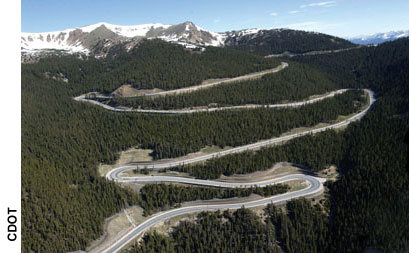
Here’s the release from Denver Water (Stacy Chesney):
The Fraser River is on its way to a better future. Sediment created by sand applied to Berthoud Pass to improve winter driving conditions now has a better place to go, thanks to a partnership between entities on both sides of the divide. The Colorado Department of Transportation (CDOT), Denver Water, Grand County and Town of Winter Park, along with the U.S. Forest Service-Sulphur Ranger District, East Grand Water Quality Board, Army Corps of Engineers and Colorado Parks and Wildlife have come together to construct a settling pond on the Fraser River on the east side of U.S. Highway 40 near the entrance of the Mary Jane ski area.
“This project and the Colorado River Cooperative Agreement show that by working together we can save the Fraser River,” said Grand County Commissioner James Newberry.
“This is a great example of collaboration, ingenuity, and the value of the Cooperative Agreement we recently negotiated with Grand County and other West Slope entities,” said Dave Little, director of planning for Denver Water.
The project began in August and is expected to be completed by mid-November. Crews have been constructing a settling pond in Denver Water’s existing diversion facility, building an access road and establishing a mitigation pond – or, new wetland area – downstream of the project. The purpose of the settling pond is to trap and remove sediment that enters the Fraser River below Berthoud Pass. This project builds on previous efforts funded by a Colorado Nonpoint Source Program grant from the Colorado Department of Public Health and Environment, which involved an initial construction phase years ago and helped pay for this new design.
“CDOT is very excited to see this project take form,” said CDOT Region 1 Director Tony Devito. “The end result of removing traction sand from this drainage basin is so critical for the environment and end users of this watershed. This could not have happened without those involved collaborating toward the common goal.”
The project is funded through multiple partners. Led by president Kirk Klancke beginning in 2002, the East Grand Water Quality Board acquired a grant from the Colorado Water Conservation Board in 2008 for $187,900 to construct the settling pond. Grand County is administering the grant and contributing $45,000 plus one-third of the cost of all change orders. In addition, CDOT is contributing $175,000 toward project engineering and construction. As part of the enhancements recently agreed to in the Colorado River Cooperative Agreement Denver Water has contributed $90,000 toward construction, is managing the project, and is allowing the construction of the settlement pond within its Fraser River diversion facility.
“This will be a great enhancement for our water treatment system,” said Mike Wageck from Winter Park Water and Sanitation District. “The excess sediment clogs Winter Park’s drinking water intake pipes and Winter Park Resort’s diversion pumps.”
The settling pond design, created by JVA, Inc., captures sediment and includes a diversion structure to channel water away from the basin when it is necessary remove the sediment. The design also includes access improvements from U.S. Highway 40 to accommodate long-term maintenance and sediment removal without impacting wetlands or Denver Water’s infrastructure. The new access route will allow CDOT to easily remove the sediment from the pond and load it into trucks to be hauled to a Grand County gravel pit for reuse. The sediment was tested to make sure it contained no potentially unsafe materials.
For more information, please contact Grand County at 970-725-3347, ext. 101, or go to www.co.grand.co.us.
More coverage from Bob Berwyn writing for the Summit County Citizens Voice. From the article:
Better maintenance and capture of highway sand can help reduce impacts to tiny aquatic organisms that form the base of the food chain in the river, helping to sustain healthy fisheries. The larvae of the aquatic insects need a coarse bed of rocks at the bottom of the stream to thrive. When the sand fills in all the gaps between the rocks, the bugs have nowhere to go.
The settling pond will also protect municipal and resort water infrastructure and equipment.
Work started in August and should be done by mid-November. Crews have been constructing a settling pond in Denver Water’s existing diversion facility, building an access road and establishing a new wetland area downstream of the project.

From The Durango Herald (Dale Rodebaugh):
“We’re very pleased and grateful that the community rallied behind the proposition,” City Manager Ron LeBlanc said Tuesday. “Generations to come will benefit from this action.”[…]
The city is counting on borrowing money from the Colorado Water Resources and Power Development Authority at 1.95 percent. Over 20 years, the loan will cost almost $5 million.
City officials say additional water is needed to satisfy demand at peak periods and to prepare for population growth. In the short term, officials want to have more water available than the 60 million gallons they can store now – a seven-day supply. During peak season, daily use is 9.5 million gallons.
With the acquisition of 3,800 acre-feet of water from the Animas-La Plata Project, the city would have about 680 million gallons available.
More Animas River watershed coverage here.
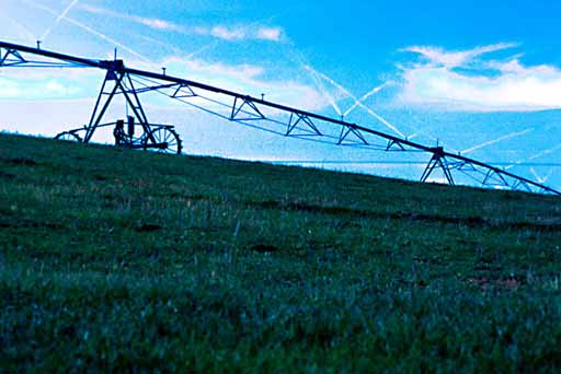
From Lawn and Landscape (Brian Vinchesi):
This year’s water conference was titled: “Water for the Future: The Role of Efficient Irrigation.” The two-day conference was moderated by Mary Lou Smith from the Colorado Water Institute at Colorado State University. The conference drew a wide range of participants, including farmers, design professionals, government agencies, association representatives, lawyers, national corporations and irrigation contractors and consultants.
The conference also included two pre-conference sessions. Of interest to the landscape industry was the one titled “Integrated Water Management for Buildings and Grounds.” This half-day seminar outlined the theory and applicability of having a “net-zero” building. A net-zero building involves having all water and energy be produced by the building and then used by the building or returns the same amount of water and energy it takes externally back to its source. From the irrigation side, this means using captured rainwater, stormwater, recycled water and air conditioning condensate as well as solar powered controllers and, in some cases, pumps. From a landscape side: native or low water use plants, green roofs, bioswale, green walls and porous pavers are important components.
The conference format consisted of general sessions on water policy and future irrigation issues while breakout sessions on specialized subjects were utilized for both agriculture and landscape stakeholders. The general sessions included an opening session by IBM on groundbreaking technologies in water management and a presentation on “Conservation Partnerships: Promoting Healthy Fisheries through Efficient Irrigation” by Trout Unlimited. This presentation outlined success stories where fish habitat was conserved as well as water while the farmer or urban area still received enough water to grow crops or provide services.
More conservation coverage here.
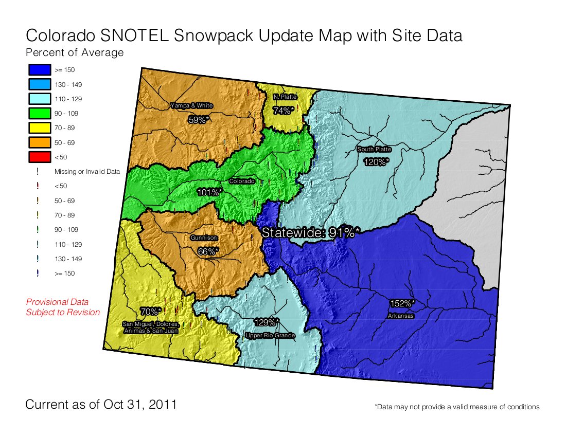
It’s that time of year again when water suppliers and irrigators keep one eye on the sky (and the NRCS snowpack reports). Click on the thumbnail graphic to the right for the October 31 snowpack chart from the NRCS. It’s too early to forecast the entire season.
May your water rights always be in priority during the year.
![]()
From the Summit County Citizens Voice (Bob Berwyn):
Some stakeholders in Eagle and Pitkin counties said they are concerned that the planned releases from Ruedi Reservoir could threaten the economically valuable trout fishery in the Roaring Fork.
But if the various stakeholders can make all the pieces fit together, it could be a win-win, with less water coming out of Ruedi and some additional flows from Granby Lake and Green Mountain Reservoir, according to Dave Nickum, director of Colorado Trout Unlimited.
Most trout species (with the exception of cutthroats) are not native to Colorado, but angling has become a huge part of the recreational economy. As such, the plan to recover the native fish sets up an interesting conflict between protection of endangered native species and potential impacts to non-native fish that are a big part of the culture and economy of the West Slope. Learn more about the recovery effort at this U.S. Fish and Wildlife Service website.
At issue are the Colorado pikeminnow, the bonytail and humpback chub and the razorback sucker. The four species are native to the Colorado River, but dam-building and diversions reduced their habitat to just a few pockets.
Under a 1999 programmatic biological opinion from the U.S. Fish and Wildlife Service that addresses impacts to the four endangered species, Front Range and West Slope water users agreed to provide equal amounts of water for the recovery effort.
Here’s the order from the COGCC. Here’s a report from the Associated Press (Catharine Tsai) via the Columbus Republic. Here’s an excerpt from the article:
A rulemaking hearing is scheduled for Dec. 5…An outside group called STRONGER, or the State Review of Oil & Natural Gas Environmental Regulations, has commended Colorado’s rule requiring well operators to disclose the fracking chemicals they use to state or health officials upon request. But Texas has gone further. This year it passed a law requiring drillers to publicly disclose those chemicals.
More coverage from Mark Jaffe writing for The Denver Post. From the article:
The audit [ed. by STRONGER], requested by the Colorado Oil and Gas Conservation Commission, identified areas in which the state could improve its oversight:
• Set a minimum amount of surface casing for a well to protect groundwater. Colorado does not have a requirement.
• Include details of fracking fluids as part of the well-completion form a driller files with the state.
• Evaluate the chance of fracking fluids falling under the disposal requirements for “naturally occurring radioactive waste.”
• Evaluate available sources of water for use in hydraulic fracturing. “Given the significant water-supply issues in this arid region, this project should also include an evaluation of whether or not availability of water for hydraulic fracturing is an issue,” the audit said.
More coverage from Cathy Proctor writing for the Denver Business Journal. From the article:
“Overall we’re pleased with the recommendations; it was a positive review,” said David Neslin, COGCC’s director, in an interview. COGCC has already met with state public health and water resources officials to work on recommendations made in the report. The agency also will hold a stakeholder meeting to review the report, Neslin said. The review panel met in Denver on June 23.