
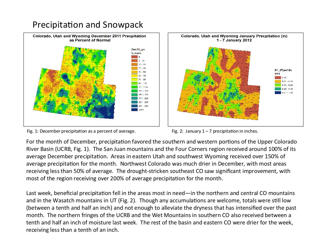
Click on the thumbnail graphic to the right for the precipitation map for the first week of 2012. Here’s the link to the summaries from the Colorado Climate Center.
Here’s an explanation of the uncharacteristic winter weather pattern from Discovery News (Emily Sohn):
Several forces are at work, experts say. To begin with, La Niña conditions have pushed warm water toward Australia in the western Pacific, leaving ocean waters off the American West coast about 5 degrees F colder than usual. As a result, moisture levels are currently low in the atmosphere from California to Washington State.
To understand why, you can think of a La Niña-dominated Pacific like a cold bathtub, said Jeff Weber, a climatologist at the University Corp for Atmospheric Research in Boulder, Colo. Compared to a hotter and steamier vat, water is less likely to evaporate from a chilly ocean. And since weather patterns generally move west to east, very little rain or snow is falling from the jet stream right now. La Niña also pushes the jet stream northward, so that it flows near the border between Canada and the United States.
A widespread lack of snow cover explains the recent spell of high temperatures, Weber said. Snow normally acts to reflect the sun’s energy, adding more moisture to the air and causing even cooler conditions. Without snow on the ground, though, exposed brown soils and green grasses are absorbing solar radiation, warming the ground, and feeding back into exceptionally warm temperatures from Michigan to California’s Sierra Nevada mountains.
But last winter was a La Niña year, too, and conditions couldn’t have been more different — with massive and relentless snow storms pounding much of the West and Midwest. It turns out that, even though La Niña and El Niño get all the press, they are not the only drivers of seasonal weather patterns.
“A few months ago, just about everyone was predicting colder and snowier for northern tier states based on La Niña,” Douglas said. “We are discovering that every La Niña is different. And there are larger forcings on the atmosphere that really transcend anything La Niña can do.”
There are two forces that have made the difference between last year’s relentless series of snowmaggedons and this year’s January blooms. They are the Arctic Oscillation and the North Atlantic Oscillation, and they work together like gears to alter jet stream patterns across the U.S.