DOI to Present Summary of Public Input on a Long-Term Plan for Glen Canyon Dam Operations March 27

glencanyondamconst.jpg

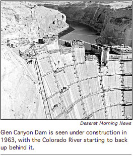
Here’s the release from the Bureau of Reclamation (Barry Wirth/Maureen Oltrogge):

The public is invited to participate in web-based presentations, to be held on March 27 that will summarize public comments on the scope of the Long-Term Experimental and Management Plan Environmental Impact Statement for Glen Canyon Dam operations.

Two web-based meetings will be held that day from 1 to 3 p.m. MDT and again from 6 to 8 p.m. MDT. Instructions on how to join those meetings will be provided at http://ltempeis.anl.gov. Bureau of Reclamation and National Park Service staff will present an overview of the public scoping report and answer questions.

More information on these meetings and other project news will be announced through social media Reclamation, the NPS Intermountain Region, and the Grand Canyon Twitter feeds [#gcltemp] and Facebook pages) and on the project website.

The LTEMP could determine changes in water release patterns from Glen Canyon Dam and also define a framework for continued experimentation leading to an improved knowledge base and protection of resources. Dam operations and related actions being considered have the potential to affect hydroelectricity production, beaches for river recreation, native fish and other aspects of the Colorado River ecosystem including plants, animals, and archeological sites in Grand Canyon National Park and Glen Canyon National Recreation Area.

Possible changes to dam operations and other actions proposed by the Department of the Interior will be evaluated as alternatives in the LTEMP EIS being prepared by Reclamation and the NPS. The EIS will document and evaluate the impacts of the alternatives.

The plan will ensure that releases from the dam and other actions being considered meet the goals of protecting the resources of the Grand Canyon and Glen Canyon while continuing to supply water and power for communities, agriculture and industry.

In a series of public scoping meetings held in November 2011, Reclamation and the NPS provided the public with information about the LTEMP EIS, opportunities to meet with technical experts and ask questions. Public comments were received up to the close of the scoping period on January 31, 2012. Reclamation and the NPS reviewed and evaluated the comments received and developed a “scoping report” which is now available on the LTEMP EIS website.

More Colorado River basin coverage here.

NIDIS Weekly Climate, Water and Drought Assessment Summary of the Upper Colorado River Basin

utwycoprecipitationmarch1to172012ccc.jpg

Here are the presentations from the Colorado Climate Center. Click on the thumbnail graphic to the right for the precipitation summary.

Colorado Water 2012: Water conservancy districts and water conservation districts explained

coloradowater2012

Here’s the current installment of their Colorado Water 2012 series from The Valley Courier (Mike Gibson). Click through and read the whole article. Here’s an excerpt:

Water Conservation Districts determine policies, own water rights and other real property, coordinate local engineering and legal studies, and assist in the development of water resource projects. They may levy ad valorem taxes for the expenses of the organization…

In contrast, Water Conservancy Districts are formed at the request of communities and are local instrumentalities of state government. They are organized under procedures in state district courts and remain under their jurisdiction. These are formed in conformance with the Water Conservancy Act of 1937 and Colorado State Statutes 37-45-10 and have the powers of a public or municipal corporation.

More Colorado Water 2012 coverage here.

Snowpack news: Areas of the San Juan mountains receive good snowfall from the storm Sunday and Monday, lower elevations not so much

snowpackcolorado03192012

From The Pueblo Chieftain:

Wolf Creek Ski Area reported 17 inches of snow from the storm system, which hit the San Juan Mountains on Sunday and lingered in the San Luis Valley through Tuesday morning. The storm left little snow on the SLV floor. Weather spotters recorded 0.8 inches of snow just south of Great Sand Dunes National Park and 1 inch in the foothills east of Fort Garland, while 0.5 inches fell east of Monte Vista.

From the Fort Collins Coloradoan (Bobby Magill):

Monday’s snowstorm was expected to dump no more than 2 to 4 inches of snow at the highest elevations of western Larimer County, said Mark Heuer, a meteorologist with DayWeather in Cheyenne, Wyo. But the brunt of the storm tracked south, blanketing the San Juan Mountains in southwestern Colorado with up to 18 inches of snow, he said…

As of Monday morning, every river basin in Colorado had a snowpack at least 20 percent below average. Locally, the South Platte Basin, which includes Poudre Canyon and the Poudre River, had a snowpack 26 percent below average. On March 1, the region’s snowpack was only 12 percent below average, according to U.S. Natural Resources Conservation Service data.

The prescription for a good runoff this year is average or cooler-than-average temperatures with three major upslope snowstorms between March 1 and June 1, Colorado State climatologist Nolan Doesken said. “We’re definitely off to a bad start,” Doesken said…

Currently, NRCS data show water content of the snow above 10,000 feet is above average in only a handful of snowpack monitoring stations throughout the South Platte River Basin, with most below 10,000 feet hovering at about 50 percent of average or less.

From the Summit County Citizens Voice (Bob Berwyn):

Both Telluride and Wolf Creek did well with the southerly flow, picking up about a foot of snow, while Silverton reported 14 inches. Crested Butte and Vail reported 5 inches, with three inches around Aspen.

Perhaps more significantly, the storm brought another significant deposition of desert dust to at least some parts of the high country. According to early reports, dust was reported in the Summit County zone by backcountry observers, said Colorado Avalanche Information Center forecaster Scott Toepfer. Based on the wind direction, the Sawatch Range may have also seen a dust event. It’s not clear yet whether the San Juans also saw a dust event, Toepfer said, adding the observations are still trickling in. The storm was the fifth dust event of the season, according to the Silverton-based Center for Snow and Avalanche Studies, where researchers have been conducting ground-breaking research on how the dust layers affect everything from avalanche danger to high alpine tundra ecosystems.

Waterton Canyon three-week closure: Contractor removing 75-ton dredge and other machinery

watertoncanyontroutsflyfishing.jpg

Here’s the release from Denver Water (Stacy Chesney):

Waterton Canyon will be closed for three weeks beginning at 7 p.m. on Sunday, April 1, for a Denver Water contractor to remove its 75-ton dredge and other equipment from Strontia Springs Reservoir. The canyon will reopen Monday, April 23, at 7 a.m.

Waterton Canyon reopened March 1, 2012, after being closed since August 2010 for a contractor to dredge Strontia Springs Reservoir. This three-week closure was announced earlier this year, and is the final phase in demobilizing the project, which was needed in the aftermath of the Buffalo Creek and Hayman fires.

“We are glad to see people enjoying the canyon since it reopened earlier this month,” said Doug Raitt, construction project manager for Denver Water. “The recent warm weather melted the ice on the reservoir quickly, so the contractor needs to remove its machinery soon. In the interest of public safety, we have to close the canyon while the work to demobilize this complex project is completed. Unfortunately, we can’t open the canyon during this three-week process. We ask for the public’s patience and understanding as this project wraps up.”

While the canyon was closed, Denver Water made improvements to the popular recreation area. “We wanted to make subtle changes, so we didn’t drastically alter the look and feel that people love about Waterton,” said Neil Sperandeo, recreation manager for Denver Water. “Recreationists will notice new mini-shelters to get out of the sun or rain, more parking spots, and improved signs with information about wildlife and the canyon.”

For questions related to recreation, email recreation@denverwater.org.

More Denver Water coverage here and here.

Nature Conservancy Speaker to Headline Colorado State University Water Café Series Thursday and Friday

fortcollinsflood07281997

Here’s the release from Colorado State University (Emily Narvaes Wilmsen):

Colorado State University will host a special two-part Water Café series in conjunction with Hydrology Days on Thursday and Friday, starting with a discussion with a leader of The Nature Conservancy’s Global Freshwater Team.

Water Café is an interdisciplinary, interactive series designed to examine critical water issues and the University’s roles in their solutions.

The event on Thursday, March 22 will feature Richter discussing the importance of ecologically sustainable water management. His lecture, titled “Meeting the Global Challenges of Water Scarcity,” will be at 5 p.m. in the Lory Student Center North Ballroom.

As co-leader of the Nature Conservancy’s Global Freshwater Team, Richter leads a staff of hydrologists, aquatic ecologists, policy specialists, educators and communicators that support conservation projects across the Americas, Asia and the Pacific region.

The second event in the Water Café series will consist of Richter and a CSU panel discussing water sustainability in the 21st century and how we can integrate and build cross-campus research and education in water sustainability.

The panel will be Friday, March 23 at 10 a.m. in the Cherokee Park Room in the Lory Student Center. CSU participants on the panel include:

• LeRoy Poff, Biology department
• Kurt Fausch, Fish, Wildlife, and Conservation Biology department
• Brian Bledsoe, Civil and Environmental Engineering department
• Gene Kelly, Soil and Crop Sciences department

More education coverage here.

Arkansas Valley Super Ditch: Proponents tout the project as a way to meet increased demand for basin supplies

arkbasinditchsystem.jpg

Terry Scanga, General Manager of the Upper Arkansas Valley Water Conservancy District is calling the water court filing for the Super Ditch the Mother of all Change Cases. And so it may be. Re-quantification is the name of the game nowadays whenever an entity gets in water court. Objectors hammer applicants on consumptive use calculations, historical use, the reservoir one-fill rule, etc. The Super Ditch plods on however. Here’s a report from Chris Woodka writing for The Pueblo Chieftain:

While the program was set up as a way to allow farmers to retain water rights while selling water through lease programs, it could become a way to meet increasing demands within the basin. The boards of the Super Ditch and Lower Arkansas Valley Water Conservancy District met jointly for the first time Tuesday to brainstorm how water needs throughout the valley could be met through Super Ditch…

The key is to develop enough flexibility in how the water is used to make what is now agricultural water more valuable in the future. A hint of that is seen in the Lower Ark’s exchange application in water court, which lists 85 points of exchange [ed. emphasis mine]. A report accompanying the application explains the needs of augmentation water for sprinklers or wells, as well as a new supply for the Arkansas Valley Conduit that will require more than 50,000 acre-feet annually in the next 50 years…

While the Lower Ark’s goal is to keep water in the valley, those in the Super Ditch are looking to maximize the value of water. Some believe both can be accomplished. “The Super Ditch is about the gap in the Arkansas basin,” said Lower Ark General Manager Jay Winner. “The goal is to make the water so valuable that nobody wants to sell.”

Here’s a report about the Super Ditch pilot project substitute water supply filing from Chris Woodka writing for The Pueblo Chieftain. From the article:

The pilot program would lease 500 acre-feet of water to Fountain, Widefield and Security this year. A substitute water supply plan has been filed with the state engineer’s office, and a comment period will continue through April 9. The price will be $500 per acre-foot…

Opponents have put the program under a microscope, engineer Heath Kuntz told the boards.“We had 20 requests for specific information,” Kuntz said. “One engineer asked for less complicated accounting, and another wanted simpler accounting. They spent an hour arguing about it.”

At one point, he was asked to justify every cell on a spreadsheet. There were more than 10 million cells. The Super Ditch sponsored a meeting in Rocky Ford in January to explain the application to potential opponents. There have been several technical meetings since then to hash out details. Among the chief objections are that the Lower Ark should file a change of use case before seeking a substitute water supply plan for the program. The water for the pilot program would come from nine farms on the Catlin Canal.

More Arkansas Valley Super Ditch coverage here and here.