
From The Pueblo Chieftain:
Wolf Creek Ski Area reported 17 inches of snow from the storm system, which hit the San Juan Mountains on Sunday and lingered in the San Luis Valley through Tuesday morning. The storm left little snow on the SLV floor. Weather spotters recorded 0.8 inches of snow just south of Great Sand Dunes National Park and 1 inch in the foothills east of Fort Garland, while 0.5 inches fell east of Monte Vista.
From the Fort Collins Coloradoan (Bobby Magill):
Monday’s snowstorm was expected to dump no more than 2 to 4 inches of snow at the highest elevations of western Larimer County, said Mark Heuer, a meteorologist with DayWeather in Cheyenne, Wyo. But the brunt of the storm tracked south, blanketing the San Juan Mountains in southwestern Colorado with up to 18 inches of snow, he said…
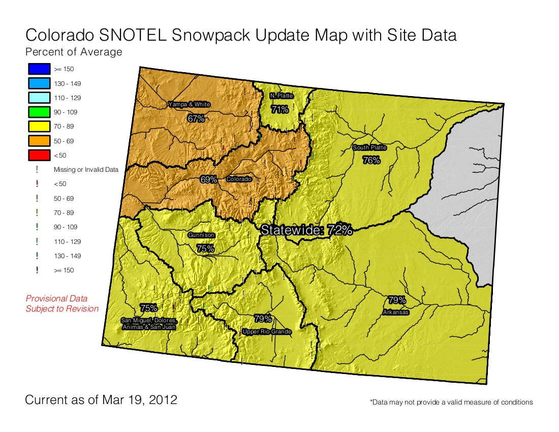
As of Monday morning, every river basin in Colorado had a snowpack at least 20 percent below average. Locally, the South Platte Basin, which includes Poudre Canyon and the Poudre River, had a snowpack 26 percent below average. On March 1, the region’s snowpack was only 12 percent below average, according to U.S. Natural Resources Conservation Service data.
The prescription for a good runoff this year is average or cooler-than-average temperatures with three major upslope snowstorms between March 1 and June 1, Colorado State climatologist Nolan Doesken said. “We’re definitely off to a bad start,” Doesken said…
Currently, NRCS data show water content of the snow above 10,000 feet is above average in only a handful of snowpack monitoring stations throughout the South Platte River Basin, with most below 10,000 feet hovering at about 50 percent of average or less.
From the Summit County Citizens Voice (Bob Berwyn):
Both Telluride and Wolf Creek did well with the southerly flow, picking up about a foot of snow, while Silverton reported 14 inches. Crested Butte and Vail reported 5 inches, with three inches around Aspen.
Perhaps more significantly, the storm brought another significant deposition of desert dust to at least some parts of the high country. According to early reports, dust was reported in the Summit County zone by backcountry observers, said Colorado Avalanche Information Center forecaster Scott Toepfer. Based on the wind direction, the Sawatch Range may have also seen a dust event. It’s not clear yet whether the San Juans also saw a dust event, Toepfer said, adding the observations are still trickling in. The storm was the fifth dust event of the season, according to the Silverton-based Center for Snow and Avalanche Studies, where researchers have been conducting ground-breaking research on how the dust layers affect everything from avalanche danger to high alpine tundra ecosystems.