Durango: The parks department has released their draft management plan for the Animas River through town

animasrivertubing.jpg

From The Durango Herald (Jim Haug):

“We will create amenities so they will behave more legally,” said Cathy Metz, the director of the city’s Parks and Recreation Department. “We’ll create changing rooms so they’re not changing (clothes) in the middle of the street.”

Metz unveiled a draft of the Animas River Corridor Management Plan during a public hearing at the Durango Community Recreation Center.

The proposed plan will also be discussed with citizen advisory boards this month before a revised version goes to the City Council for a vote.

City staff wrote the plan for managing recreation along 16 miles of river after soliciting input from interest groups as varied as homeowners, rafters, anglers and conservationists from a series of meetings held earlier this year.

More Animas River watershed coverage here and here.

Ouray: Crystal Lake Dam to get new outlook works over the summer

crosssectionearthdam.jpg

From the Montrose Daily Press (Katharhynn Heidelberg):

A massive repair project is expected to interrupt summer fishing at Crystal Lake Dam above Ouray — there is no other way to make the critical safety augmentations but to close the structure for a few months, starting in early July. “Probably about 50 percent of the dam will be removed and taken off-site. They’ll install a new outlet works,” said Tom Condos, engineering and minerals staff officer with the U.S. Forest Service. The dam provides water storage for the Uncompahgre River headwaters. During an inspection two years ago, officials noticed a problem.

From Colorado Radio (James MacDonald):

The Crystal Lake Dam near Ouray is going to be getting some major repairs. The dam will be closed this summer and partially removed to make the proper repairs and upgrades. The $300,000 project will also include the installation of an emergency spillway for the dam. The closure is slated for July and the repairs will force fishermen to look elsewhere until the project is completed in October.

More Uncompahgre River watershed coverage here.

Denver: U.S. House Subcommittee on Energy and Mineral Resources hearing about hydraulic fracturing today

marcellushydraulicfracturing.jpg

Update: Here’s a report from the Associated Press via WJTV.com. From the article:

The field hearing by the Subcommittee on Energy and Mineral Resources was called in response to last month’s announcement by the Obama administration that it would seek coordinated federal oversight of natural gas production. The Interior Department, meanwhile, is expected to issue new rules in the next few weeks on natural gas drilling on public lands The federal oversight was denounced by officials from Colorado, Wyoming and Utah, all of which rely heavily on oil and gas production…

Shawn Reese, policy director for Wyoming Gov. Matt Mead, testified that 20 percent of the entire state workforce is tied to energy production. “The importance of natural gas to the state’s economic situation cannot be overstated,” said Reese, who said federal oversight would be “unnecessary and unreasonable.”

Colorado Rep. Doug Lamborn, a conservative Republican who heads the subcommittee, introduced the hearing by blasting the Obama administration and the U.S. Department of Interior for trying to “hijack” state oversight of drilling practices including hydraulic fracturing, also called fracking…

“Do Coloradans react differently to water pollution?” asked a skeptical Rep. Rush Holt, a New Jersey Democrat who attended the field hearing and questioned the state officials who argued against national safety regulation. Holt told a Utah official who testified that her state saw no water contamination in 50 years that perhaps that was because the state wasn’t looking…

Democratic Rep. Diane DeGette of Denver, who has sponsored unsuccessful bills seeking required disclosure of fracking fluids used by energy companies, argued that all levels of government, including municipalities, should have a say in how and where drilling is done. She pointed out that technological advances in direction drilling and fracking have brought the drilling procedure closer to populated areas, triggering a need for more governmental oversight.

Update: From The Denver Post (Mark Jaffe):

The Department of Interior is considering rules on disclosure of frack fluid ingredients, management of fluids and waste water. The Bureau of Land Management, which oversees oil and gas development on federal lands, however, has not yet issued any draft of rules…

There are also significant geological differences between oil and gas fields that are best addressed at the state level, said Colorado Rep. Jerry Sonnenberg, a Sterling Republican.

The states may be the right level for regulation but they have to prove they can do the job, said Bruce Baizel, an attorney for the environmental group Earthworks. Baizel said that a review by his group found that in Texas, Colorado, New Mexico and Pennsylvania the majority of operating wells are not annually inspected.

From the Fowler Tribune:

The U.S. House Subcommittee on Energy and Mineral Resources will be in Denver this Wednesday, holding a field hearing on proposed federal regulations for hydraulic fracturing, or fracking. The testimony is by invitation only, and it’s expected to explore the economic impact of the Interior Department’s draft proposal, which would require public disclosure of chemicals used in fracking on public lands, as well as increased water and air protections.

More oil and gas coverage here and here.

Colorado Water 2012: As both an importing and exporting basin the Arkansas Basin’s history is interesting

arkansasriverbasin.jpg

Here’s the latest installment of the Valley Courier’s Water 2012 series, written by Terry Scanga the General Manager of the Upper Arkansas Water Conservancy District. Here’s an excerpt:

…the Arkansas has some remarkable features that distinguish it from others in the state. By 1890 most of the basin’s reliable water was appropriated and decreed. One of the more distinguishing characteristics is the number of trans-basin diversions that import water into the Arkansas.

Further, a substantial amount of both native water, as well as trans-basin water previously imported into the basin, is diverted from the Arkansas to other Colorado basins. It is the largest in land area of all water basins in Colorado…

Early in the state’s history the major use of water was for mining and milling. As the state matured and mining became less significant agricultural uses of water for irrigation of crops became the dominate use of water. Today irrigation consumes nearly 80 percent of the water diverted within the basin.

Since the 1950’s population growth in the cities along the Front-Range of Colorado have exerted tremendous pressure for the change of the irrigation water rights to municipal uses. Farmers seeking water to supplement their native water supplies developed most of the major trans-mountain diversions by successfully capturing un-appropriated water supplies from the wetter Colorado River Basin. Many of these were open ditches that were dug from the Western side of the divide to the Eastern slope. Others were major diversions transiting the continental divide through tunnels bored through the mountains…

One of the benefits of the trans-mountain projects are the storage vessels built at the headwaters and lower downstream at critical terminal points such as Pueblo. In recent years Upper Arkansas River flows became contentious as recreational activities such as boating and fishing developed into a major economic force. Water entities became involved and agreed to a Voluntary Flow Program to provide consistent and dependable minimum river flows to sustain boating through August 15th and maintain even flow in the critical Fall period to assist the fishery with spawning. With reservoir storage at both the upper and lower ends of the Arkansas River, releases and exchanges can be timed to coincide with these recreational and environmental events.

More Colorado Water 2012 coverage here.

Snowpack/drought/runoff news: Arkansas River Basin snowpack is at 30% of average, statewide = 25%

snowpackcolorado05012012.jpg

basinhighlowstatewide05012012.jpg

basinhighlowarkansas05012012.jpg

Click on the thumbnail graphics for the current statewide snowpack map, the Basin High/Low graph statewide and the Basin High/Low graph for the Arkansas River Basin. Things are generally better east of the Great Divide but snowpack is near 2002 levels everywhere.

From The Pueblo Chieftain (Chris Woodka):

“Some are planting as if they forgot a drought ever showed up,” said Dan Henrichs, superintendent of the High Line Canal. “I’m going to recommend we run more water at the next ditch board meeting, like I did last month.” Finding additional water to irrigate crops with could be tough this year. At last month’s Southeastern Colorado Water Conservancy District meeting, the possibility was raised that no agricultural water allocations may be available this year.

The Bureau of Reclamation has not completed its May 1 forecast, but water supplies are likely to be at 2002 levels or less. Statewide, snowpack is at 25 percent of average, and it has begun to melt at lower elevations. “The conditions we’re seeing are about five weeks ahead of normal,” [Steve Witte, Water Division 2 engineer] said. “It doesn’t look or feel like 2002, however. You can drive out on the plains and see green.”

Cities have more water in storage in 2012, but farmers could feel the pinch because the National Climate Prediction Center is predicting higher temperatures and average precipitation through October for this area. So far this year, Pueblo precipitation is half of normal.

From the Boulder Daily Camera (Laura Snider):

In April, Boulder got 1.32 inches of precipitation, compared to an average of 2.92 inches, according to local meteorologist Matt Kelsch. Taken together, it was the fourth-driest March and April on record in Boulder. Normally, the two months bring a total of 5.02 inches of water. But this year, only 0.01 inches of precipitation fell in March, making the total 1.33 inches for both months.

The situation hasn’t been better in the mountains. A lack of spring snowfall and above-average temperatures have conspired to shrink the already-small snowpack. The snowpack in the South Platte River Basin is 32 percent of what it normally is on May 1, and statewide, the snowpack has shrunk to just 25 percent of average.

On Tuesday, Boulder water managers met to discuss whether the city should declare drought conditions and enact water restrictions. City officials are expected next week to announce their decision, which will be based on snowpack measurements in the mountains where Boulder draws some of its water, the amount of water stored in the city’s reservoirs, the amount of water Boulder can expect to draw from the Colorado River through the Colorado-Big Thompson project, and the amount of expected demand for water…

The snowpack on May 1 was similarly low during the 2002 drought, when the snowpack in the South Platte River Basin was 31 percent of normal…

“Boulder’s storage situation is currently good, which will help get us through the summer,” Wilson wrote. “The worry is really whether we have low snowpack next winter. That could be very serious.”[…]

The low snowpack — and correspondingly low creek flows — isn’t bad news for everyone. It could make for good fishing on Boulder Creek, according to Randy Hicks, manager of Rocky Mountain Anglers in Boulder. Normally, fishing on Boulder Creek is nearly impossible in June, and last year, the creek wasn’t especially fishable until even later in the summer.

From the Summit County Citizens Voice (Bob Berwyn):

March inflow into [Lake Powell] was about 10,000 acre feet higher than forecast, mainly due to the early snow-melt season, but still only 84 percent of average. Through July, the inflow is only expected to be 49 percent of average. For the water year, the inflow is now projected to be about 63 percent of average. That marks a setback in regional water storage, which saw improvement since 2005, following a string of dry years. Between 2005 and 2011, Lake Powell’s inflow was 101 percent of average, thanks in particular to the 2011 water year, when inflow peaked for the period at 147 percent of average.

Sand Creek: So far Suncor Energy has not been able to stanch the flow of polluted groundwater

suncorcleanupsandcreek.jpg

From The Denver Post (Bruce Finley):

Neither state regulators nor Suncor has calculated how much cancer-causing benzene and other contaminants have entered the waterways from an underground plume spreading from the refinery under the adjacent Metro Wastewater Treatment Plant. But interceptor trenches, vapor-extraction systems and recovery wells over the past five months have removed about 697,200 gallons of material from the ground, Suncor officials said Tuesday in a response to Denver Post queries.

A fountain aeration system designed to separate benzene from water, before the creek reaches the river, has been shut down. Colorado Department of Public Health and Environment regulators ordered the shutdown April 24. Health department spokesman Warren Smith said this was done to evaluate the effectiveness of Suncor’s underground walls and extraction systems installed on Metro Wastewater property near Sand Creek. Smith acknowledged “fluctuations” in benzene levels in the creek and river but disputed any overall upward trend…

“We believe that the permanent solutions being installed and operated — trenching systems and treatment systems on both Suncor and Metro’s property — will effectively isolate and manage the plume and dramatically lower the dissolved benzene level in Sand Creek,” company vice president John Gallagher said in a prepared response. The latest water-test data show benzene levels at 400 parts per billion or higher in the South Platte and at two monitoring wells along Sand Creek. The federal drinking-water standard for benzene is 5 ppb. At the South Platte location (about 50 feet downriver from the confluence with Sand Creek), the 400 ppb detected April 25 was more than double the 180 ppb recorded April 6 and 73 percent higher than the 230 ppb recorded Dec. 2 — when EPA overseers launched an emergency response. Three monitoring sites along Sand Creek were tested April 2-4 and again April 9. During that period, benzene levels at the sites increased — to 150 ppb from 12 ppb; to 490 ppb from 89 ppb; and then to 510 ppb from 73 ppb. On April 25, the two sites nearest the creek bank, where black goo began oozing into the creek in November, still showed benzene concentrations of 410 ppb and 450 ppb.

More Sand Creek coverage here. More oil and gas coverage here and here.

Fryingpan-Arkansas Project update: 110 cfs in the Fryingpan River below Ruedi Reservoir

fryingpanarkansasproject.jpg

From email from Reclamation (Kara Lamb):

As you have likely already heard or noticed, yesterday and today we are increasing releases from Ruedi Dam to the Fryingpan River. Yesterday, releases bumped up from 40 cfs to about 80 cfs. Today, they will bump up another 30 to about 110 cfs.

The change is seasonal. This time every year we adjust outflow from the dam. In a dry year, like this year, the release is typically the lesser of either inflow or 110 cfs. The reason for the seasonal change is so we can promote storage in the reservoir behind the dam as well as maintain flows in the Fryingpan River.

The reservoir is slowly starting to fill. We are hoping to fill it this year, but we have not finalized our May forecast for run-off, yet.

More Fryingpan-Arkansas Project coverage here.

Green Mountain Reservoir operations update: 75 cfs in the Lower Blue River below the dam

greenmountainreservoir.jpg

From email from Reclamation (Kara Lamb):

This morning, we had a slight change in releases from Green Mountain Dam to the Lower Blue River. To meet a call for water, we bumped releases up by 15 cfs. That means there is now approximately 75 cfs in the Lower Blue below the dam.

Meanwhile, the road across Green Mountain Dam is still closed as we upgrade the bridge. Access below the dam and to the Town of Heeney is open by driving around the reservoir from the south.

More Green Mountain Reservoir coverage here and here.

The latest edition of the Colorado Water 2012 newsletter is hot off the press

coloradowater2012.jpg

Here’s the link to the May 2012 Newsletter from Colorado Water 2012. Click through and read the whole thing along with the impressive list of events that are planned over the next few months.

More Colorado Water 2012 coverage here.

Carrizo Creek: Students, Scientists Team Up On Stream Survey

carrizocreekbacomanchenationgrasslandbacacounty.jpg

Here’s the release from Colorado Parks and Wildlife via FishExplorer.com:

A team of 20 Campo School students armed with sharp eyes and nets helped scientists learn more about a rare Eastern Plains fish community last week by participating in an aquatic life survey on the East Fork of Carrizzo Creek as it runs through the Sikes Ranch in southeastern Colorado.

Working alongside Colorado Parks and Wildlife biologists, the students collected fish stunned by a mild electric shock, netted them and then recorded data such as species, size and location. Fish were also collected using trap nets, dip nets and seines. The information will be used to help develop management goals for the property.

“This is a fun science project that gave students an experience that will have a long-lasting impact,” said Chris Pague, lead scientist for the Nature Conservancy of Colorado, which partnered with the state agency on the project. “The Sikes Ranch is a unique piece of property with amazing pools and streams. Some of the fish and plants found here are not found anywhere else in the state.”

The 7,100-acre ranch, located between the small communities of Pritchett and Kim, consists of shortgrass prairie, riparian woodlands, rocky outcrops, shrublands, marshes and an Eastern Plains stream. The headwaters of the East Fork of Carrizo Creek provides a critical and unique riparian corridor for migrating waterfowl and amphibians as well as native prairie fishes. The property also has three crop circles irrigated from well water that provide feeding areas for mule deer and white-tailed deer as well as several species of birds including quail and lesser prairie chicken.

Management goals could include protecting portions of the water with fences and managing grazing to ensure water is delivered to livestock while protecting the vegetation and stream banks.

“Without the efforts of landowners like the Sikes, Coloradans would not enjoy the remarkable wildlife heritage we have today,” said District Wildlife Manager Aaron Bartleson of Springfield. “This research will paint a clear picture of how amphibians and fish are doing in this area. We can use this data to work with the Sikes family and the Conservancy to help protect this important habitat.”

The stream survey by the Conservancy and Colorado Parks and Wildlife is part of a broader conservation effort to protect the Sikes Ranch and provide recreation for Coloradoans. The Nature Conservancy will place a conservation easement on 7,100 acres of the ranch, which will help support the family’s bottom line while precluding future development. Once that’s completed, Colorado Parks and Wildlife will place a public access easement on the land, which means people can hike to observe wildlife and hunt in the area.

“We’re thrilled we can provide this opportunity to connect people with the landscape,” added Bartleson “Some of life’s best memories are made outdoors.”

The Nature Conservancy is a leading conservation organization working around the world to protect ecologically important lands and waters for nature and people. To date, the Conservancy and its more than 1 million members have helped protect 130 million acres worldwide. Visit The Nature Conservancy on the Web at http://www.nature.org/Colorado.

Colorado Parks and Wildlife was created by the merger of Colorado State Parks and the Colorado Division of Wildlife, two nationally recognized leaders in conservation, outdoor recreation and wildlife management. Colorado Parks and Wildlife manages 42 state parks, all of Colorado’s wildlife, more than 300 state wildlife areas and a host of recreational programs.

More Arkansas River basin coverage here.

‘The Watershed’ to be screened at Whole Foods stores in May

coloradoriverbasin.jpg

From Whole Foods via PRNewsWire.com:

Whole Foods Market announces the online premiere of “WATERSHED: Exploring a New Water Ethic for the New West,” the second film in this year’s Do Something Reel Film Festival. Produced by James Redford, narrated by his father, Robert Redford, and directed by award-winning filmmaker, Mark Decena, “WATERSHED” will be available to online audiences for one month, beginning May 1, at http://www.dosomethingreel.com for $5.99.

“WATERSHED” tells the story of the threats to the once-mighty Colorado River, a river so dammed, dibbed and diverted, it no longer flows to its natural end at the Gulf of California. Told through heartening character vignettes, this film defines the demands of 30 million people on this precious water lifeline and illustrates the simple and effective solutions available to all to restore this watershed.

“The American West is defined by the Colorado River. It is as hardworking as it is gorgeous, but it needs someone to give it a voice,” said James Redford, producer of “WATERSHED.” “If we can raise awareness of the unprecedented demands placed on this mighty river, and then engage the masses to conserve just 5 percent of their water usage, we will have done something crucial to keep this river healthy for future generations.”

Do Something Reel, which kicked off on Earth Day, is an ongoing collection of provocative films about food and environmental issues that can be purchased and streamed online at http://www.dosomethingreel.com for a limited time. Whole Foods Market will stream a different film each month with proceeds helping to fund the 2012 Whole Foods Market/AFI-Discovery Channel Silverdocs Festival filmmaker grants. The festival is presented in association with Applegate Organic & Natural Meat, Earthbound Farm Organic, Popcorn Indiana, and siggi’s.

“WATERSHED” will be screened in-store at select Whole Foods Market locations across the country throughout the month of May. A list of screenings and tips on how to conserve water and work towards a greener planet can be found at http://www.dosomethingreel.com and on the company’s Facebook page, http://www.facebook.com/wholefoods under the Movie Premier tab. To further support the film’s mission, Whole Foods Market has partnered with Crowdrise to help those inspired by the storyline to take action in several ways including donating to the Colorado River Delta Water Trust: http://www.crowdrise.com/watershed . Crowdrise is a platform that provides fundraisers, charities and events with a unique way to raise money and share compelling stories with personal networks, allowing anyone to turn friends into an active base of donors for a cause.

Here’s the link to the trailer.

More Colorado River Basin coverage here.

Snowpack/drought/runoff news: Upper Colorado River basin drops to 25% of average, South Platte = 37%

snowpackcolorado04302012.jpg

basinhighlowsouthplatte04302012.jpg

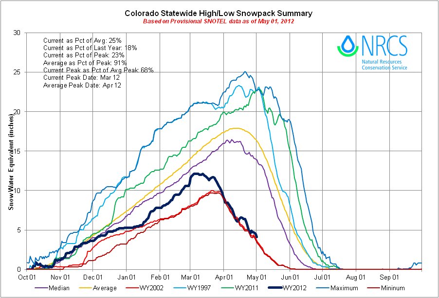
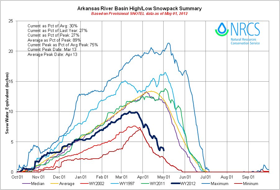
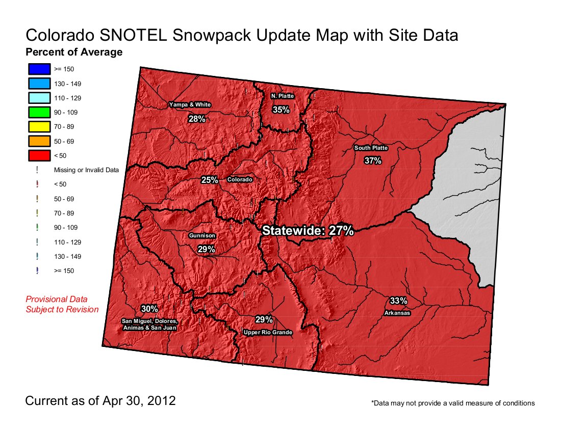
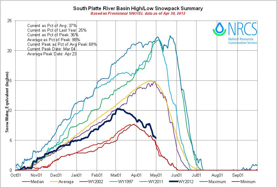
Click on the thumbnail graphics for the current statewide snowpack map and the Basin High/Low graph for the South Platte Basin (the basins that millions of Coloradans depend on) from the Natural Resources Conservation Service. The storm last week kept the South Platte about 1 inch of SWE above 2002 and moved the Upper Colorado River basin to the 2002 line. Keep doing your rain dances.

From The Denver Post (Kyle Wagner):

Colorado’s reservoirs are at normal levels, according to Denver Water, and state rivers are running at or below normal flows for this time of year. That means rafting, particularly for first-timers and families, could be just right.

“Here’s the thing that people forget,” says David Costlow, executive director of the Colorado River Outfitters Association. “Low season doesn’t mean no water. That snow still comes down that defined ditch. It might not ever get to the super-wild stage, but there’s water, and it flows. It will still be at an acceptable level for people to get out there and have a great time.”

Costlow says that despite rumors outside the industry, concerns that this season will be a repeat of the severe drought of 2002 are unlikely. “I make a point of keeping in contact with what I call the ‘water buffaloes,’ you know, Denver Water, CWC (Colorado Water Congress), to see what their take is. Well, it’s gonna be low, yes, but it’s not going to be 2002.”[…]

Outfitters on the Arkansas River are in especially good shape, Costlow says, because they’re on a voluntary flow-management program that allows for a dam release of water from the reservoirs upstream. “That water’s always there when they need it,” he explains. “Like last year, it wasn’t needed really until right at the end. This year, they’ll probably need it earlier.”

From The Aspen Times (Janet Urquhart):

Flows out of Ruedi increase seasonally on May 1, according to Kara Lamb, spokeswoman for the U.S. Bureau of Reclamation. The agency began increasing the release Monday, anticipating a hike in flows into the Fryingpan below the dam from 45 cubic feet per second to 80 cfs by the end of the day. Another increase Tuesday is expected to bring the flow on the lower Fryingpan to 110 cfs, which is typical for this time of year, according to Lamb.

In a normal spring, runoff from melting snow coming into the reservoir, located east of Basalt, would peak in late May or early June, she said. Next week, the bureau will have a better idea of what to expect this spring, after the latest data have been analyzed, but it’s a good bet flows coming into Ruedi won’t match the surge experienced last year…

The bureau expects Ruedi and the other reservoirs in the Fryingpan-Arkansas transmountain diversion system, as well as reservoirs in the Colorado-Big Thompson Project, to fill up this spring, according to Lamb. Both projects transfer water from Colorado’s Western Slope to the Front Range. The reservoirs started out in good shape because last year was a strong one for water collection, Lamb said…

Among Western Slope reservoirs that send water west instead of east, however, both Taylor Park and Blue Mesa reservoirs are expected to reach only 80 to 85 percent of capacity, according to Dan Crabtree, water management group chief for the bureau’s Grand Junction office. Other, smaller reservoirs, including Paonia, Ridgway and Silverjack, are all expected to fill up, he said…

…in the Roaring Fork River Basin on Monday, the snowpack was down to 19 percent of average, according to the Natural Resources Conservation Service, or NRCS. The SNOTEL measuring site on Independence Pass, located southeast of Aspen at 10,600 feet in elevation, was holding 4 inches of snow Monday, down from 7 inches Sunday. Snow at the measuring site is likely to be gone by Tuesday, said Mage Skordahl, assistant snow survey supervisor for the NRCS in Denver. That doesn’t mean snow has disappeared from the pass, but that it’s melted off the SNOTEL measuring station, she said.

Updated streamflow forecasts will soon be available, according to Skordahl, but projections based solely on snowpack put the flow into Ruedi Reservoir at 55 percent of average from April through July, she said. The Roaring Fork River flow at Glenwood Springs is expected to be at 45 percent of average for the same period.

Southern Delivery System: ‘Pueblo will not pay for the failure of the Colorado Springs stormwater enterprise’ — Jeff Chostner

fountaincreekstormwater092011chieftain.jpg

From The Pueblo Chieftain (Chris Woodka):

“We’re paying five times per capita in Pueblo County, while El Paso County has five times the resources,” Chostner said. “Pueblo will not pay for the failure of the Colorado Springs stormwater enterprise. This has implications for the 1041 permit.”

The Fountain Creek board got its first look at a regional stormwater study by Summit Economics that suggests a coordinated regional approach is needed to meet a backlog of more than $750 million in stormwater management needs. The study, which will be finalized after the sponsors have a chance to review it, also points out that Colorado Springs pays only $4.63 per capita for stormwater protection, less than one-tenth of the Front Range average. Pueblo pays $25.81 per capita.

Chostner, who guided the Fountain Creek board away from contributing any money to the study, was adamant that it is not Pueblo’s responsibility to pay for stormwater projects in Colorado Springs, which abolished its stormwater enterprise in 2009. As part of 2009 Pueblo County 1041 conditions, Colorado Springs agreed to provide $50 million to the district over five years after SDS goes online in 2016. Chostner balked at the economists’ suggestion that some of that money could defray stormwater costs. “This board decides how to spend that,” he said.

More Fountain Creek coverage here and here.