Here’s the May 1 release from the Natural Resources Conservation Service (Mage Skordahl):
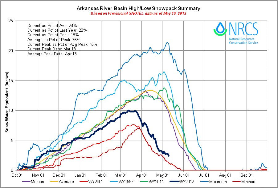
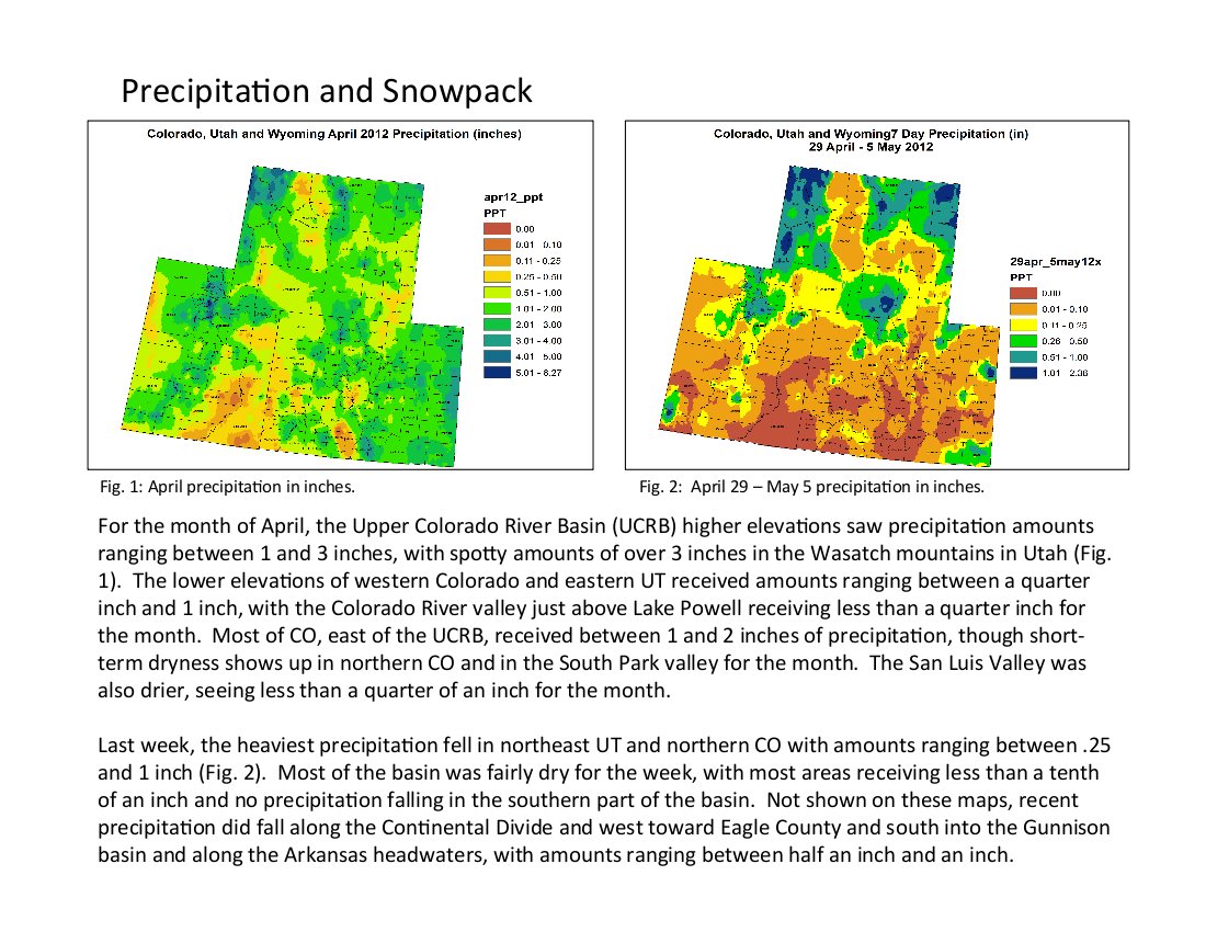
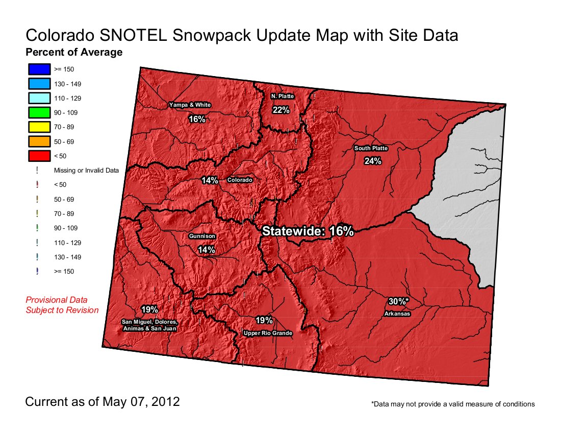
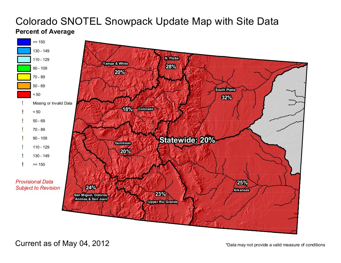
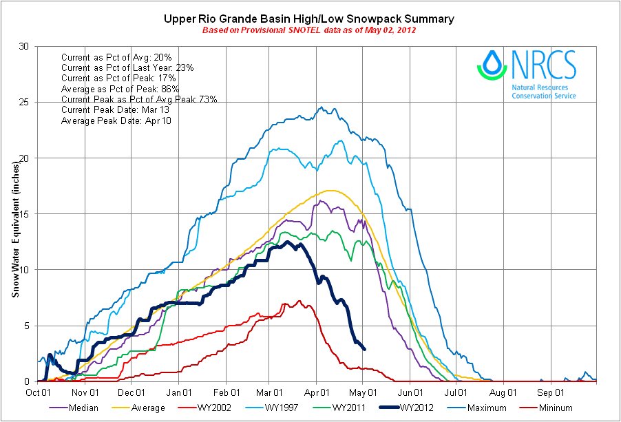
The month of April brought another significant drop in snowpack percentages across the state. Warm, dry conditions continued to prevail in the mountains of Colorado setting the stage for snowmelt to begin early and fast. “Statewide snowpack looks to have peaked around March 12, a month ahead of the average peak date, and began melting in late March at rates typically not observed until May,” said Phyllis Ann Philipps, State Conservationist with the Natural Resources Conservation Service (NRCS). The latest snow surveys conducted by the NRCS show that most low and mid elevation measurement locations have little or no snow and the higher elevation sites are well below average and rapidly melting. The May 1 statewide snowpack report reflects this; measuring just 19 percent of average. For the second month in row statewide snowpack conditions match those recorded during the record setting drought year of 2002.
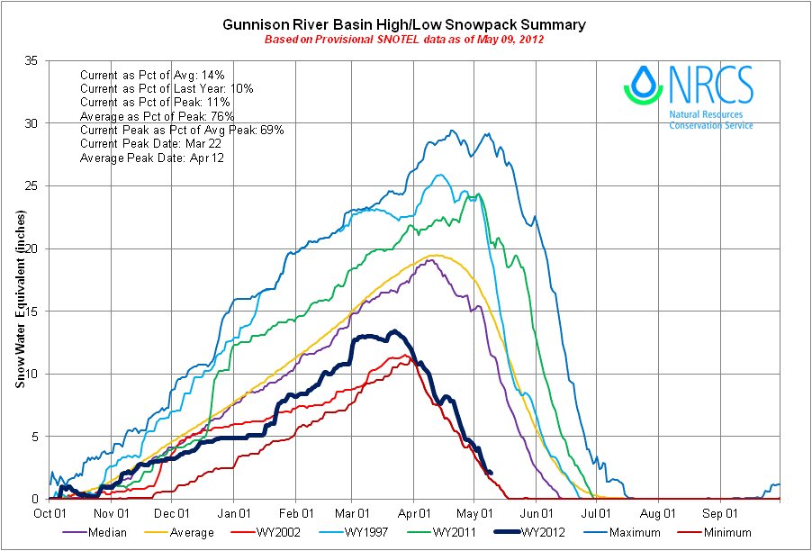
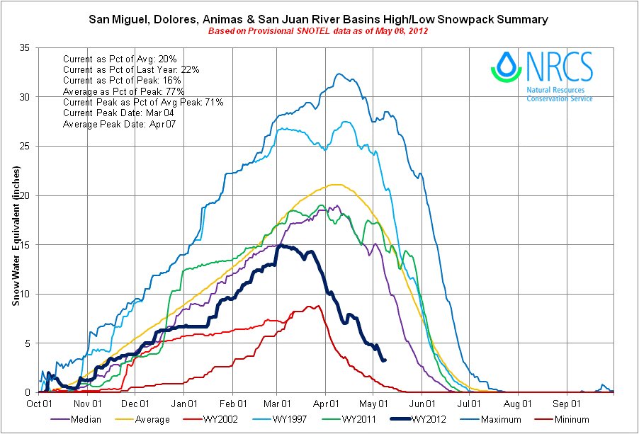
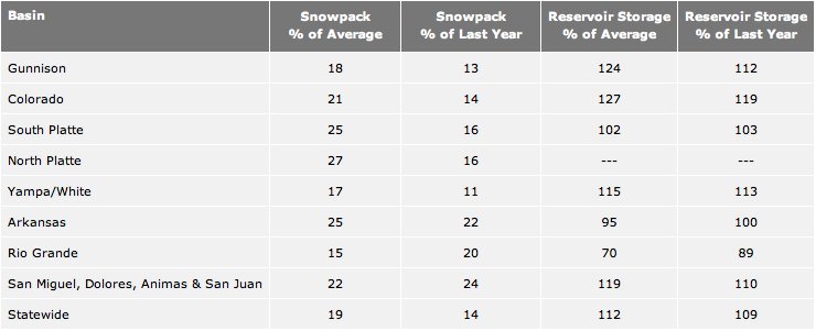
The largest losses in snowpack percentage were measured in the Gunnison and the Upper Rio Grande basins; both reported drops of 38 percentage points from April 1 to May 1. The Upper Rio Grande basin now has the lowest snowpack percentage in the state, at just 15 percent of average as of May 1. The combined Yampa and White basins, while no longer the lowest in the state, are not far behind at 17 percent of average. The North Platte basin, still a dismal 27 percent of average, has the highest basin wide snowpack in the state. Snowpack reports in the other major basins range from 18 to 25 percent of average.
In an average year, the snowpack in Colorado continues to accumulate during the first half of April and then slowly begins to melt during the second half of the month. This year by April 1 the shallow snowpack had already advanced well into the melt season and melt continued progressing 4 to 6 weeks earlier than normal throughout the rest of the month. As of May 1, 55 percent of the snow survey locations throughout Colorado reported no snow.
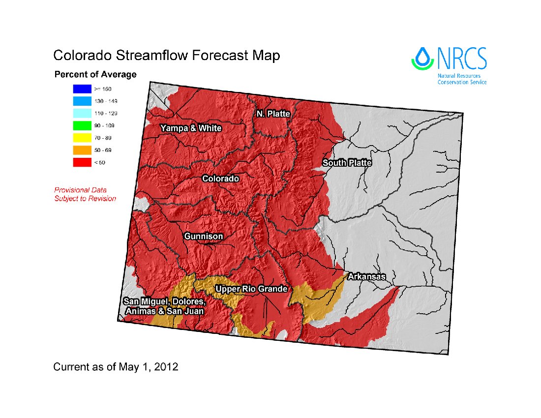
Streamflow forecasts across Colorado have dropped significantly for the second consecutive month. At this point most forecast points in Colorado are expected to see streamflow volumes that are less than 50 percent of average for the May to July season
The state’s reservoir storage continues to provide a glimpse of hope this year, with total storage volumes across the state remaining above average. This stored water may help alleviate conditions early in the season; however water users should be aware of the potential for late season shortages
The table below shows Colorado’s snowpack and reservoir storage as of May 1, 2012.
Click on the thumbnail graphic for the table of snowpack and storage.
From The Greeley Tribune (Eric Brown):
Statewide snowpack as of May 1 was 19 percent of the 30-year average, according to a report released by the Natural Resources Conservation Services office in Colorado late Thursday afternoon. That ties for the state’s worst snowpack on record for May 1. Only May 1, 2002, — a historic drought year for the state — was as bad. At 21 percent of average, the Colorado River Basin’s snowpack on May 1 of this year was at a record low…
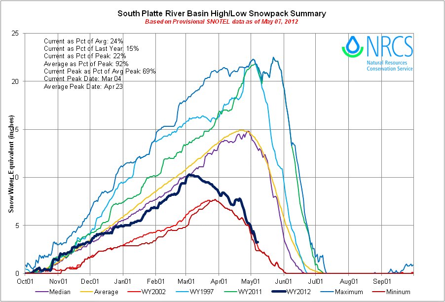
This year’s May 1 report showed the South Platte River Basin’s snowpack — which accounts for the rest of the water supply in northern Colorado — was at 25 percent of average. That’s the third-worst mark on record for the basin on May 1…
Many producers — who are also dealing with historically low precipitation along the Front Range and Eastern Plains — have been holding off on planting certain crops this spring, waiting to see how the water and rain situations play out.
Having enough water in the Colorado River for the four endangered species is a challenge this year. Here’s a report from Bob Berwyn writing for the Summit County Citizens Voice. Click through for the cool photos. Here’s an excerpt:
As flows are reduced to a trickle, the Colorado pikeminnow, razorback sucker, and especiallly the humpback chub and bonytail chub, will face serious threats from competing non-native species. But they’ll get a little help from Upper Colorado River Endangered Fish Recovery Program biologists, who will be doing their best to remove remove smallmouth bass, northern pike, and in some areas, white sucker, walleye and burbot. Overall, recovery program leaders say they’ll manage the little bit water they do have based on experience from the drought in the early 2000s.
“We’ve been there before,” said program director Tom Chart, explaining that low flows will likely result in a temporary setback for recovery efforts, especially in tributaries like the Yampa River. There are places we saw on Yampa in 2002 where there was virtually no surface flow,” Chart said. “It was just a connected series of pools on the river. Native fish seem to have a propensity to vacate those places … but some of them don’t, and that’s the real concern.”
From The Denver Post (Joey Bunch):
Colorado’s iconic Independence Pass will open at 9 a.m. on May 11, almost two weeks ahead of schedule.
From the Ag Journal via the Bent County Democrat:
A Drought Preparedness Workshop will be held Tuesday, May 15, from 10 a.m. to 3:30 p.m. at the Colorado State Fairgrounds in the 4-H Auditorium Building, 1001 Beulah Avenue in Pueblo. Registration will start at 9:30 a.m. with plenty of coffee to get you ready for a few hours of informative presentations. The program begins at 10 a.m. and will conclude at 3:30 p.m.
Brian Bledsoe will start by giving us insight on the weather with a Drought Outlook and his guide of what to expect in 2012-2013. His presentations will teach you about current weather patterns and help you to know what to expect in the short term and long term future. Next, Dr. Perry Cabot, Water Resource Specialist with the Colorado Water Institute and CSU Extension, will share the outlook for water supplies and methods for optimal water use. This information will be very useful as we look to our storage and irrigation needs compared to current water availability.
An update from Farm Service Agency (FSA) will be presented by Brent Fillmore, the County Director of Farm Service Agency. He will discuss Noninsured Crop Disaster Assistance Program (NAP): FSA’s Disaster Risk Management Tool. The information Brent presents will go well with Jeff Tranel, Agriculture and Business Management Economist with CSU Extension, as he speaks about Pasture, Rangeland, Forage (PRF) Insurance. Both presentations will enlighten us all on available insurance and risk management tools for agricultural producers.
From the Associated Press:
The National Weather Service pronounced the two-year La Nina (NEEN’-yah) finished on Thursday.
From the Summit County Citizens Voice (Bob Berwyn):
“Statewide snowpack looks to have peaked around March 12, a month ahead of the average peak date, and began melting in late March at rates typically not observed until May,” said Phyllis Ann Philipps, State Conservationist with the Natural Resources Conservation Service.
In some parts of the Upper Colorado, stream are flowing at October levels at a time when they should be cresting toward peak flows. For the summer, most streams are expected to flow at less than 50 percent of average.
The latest snow surveys show that most low and mid elevation measurement locations have little or no snow and the higher elevation sites are well below average and rapidly melting. The May 1 statewide snowpack report reflects this, measuring just 19 percent of average. For the second month in row statewide snowpack conditions match those recorded during the record-setting drought year of 2002.
The largest losses in snowpack percentage were measured in the Gunnison and the Upper Rio Grande basins; both reported drops of 38 percent from April 1 to May 1. The Upper Rio Grande basin now has the lowest snowpack percentage in the state, at just 15 percent of average as of May 1.
The combined Yampa and White basins, while no longer the lowest in the state, are not far behind at 17 percent of average. The North Platte basin, still a dismal 27 percent of average, has the highest basin wide snowpack in the state. Snowpack reports in the other major basins range from 18 to 25 percent of average.
From the Fort Collins Coloradoan:
Statistics released Tuesday by the Colorado Climate Center at CSU show that April’s average temperature was 54.8 degrees – 5.9 degrees higher than normal. With dry weather turning Northern Colorado into a tinderbox, a separate report issued Tuesday by the National Integrated Drought Information System recommends that a severe drought be declared for the Fort Collins area.
CSU data show high-temperature records for Fort Collins being broken by as many as 4 degrees, including the warmest day of the month, April 24. The high temperature reached 88 degrees that day, breaking the previous record of 84, set in 1996. Four high-temperature records were broken or tied in April. Three records for the warmest low temperature, called the “minimum” temperature, were also broken, one by 5 degrees. April 11’s low temperature of 50 breaks the previous minimum temperature record of 45, set in 1992.
Fort Collins received only 0.4 inches of precipitation last month, 1.66 inches below normal, making April the eighth-driest on record.
From The Pueblo Chieftain (Tracy Harmon):
Thanks to a warm spring, the excitement will start as early as mid-May when snowmelt will begin to buoy the river levels. The river should peak by early June while rafting will continue through mid-August, aided by water releases from reservoirs, said Bob Hamel of Arkansas River Tours in Cotopaxi.
Micah Salazar, operations manager for Noah’s Ark Rafting in Buena Vista, said summers seldom produce the exact same conditions on the river. He has seen everything from rousing 5,000 cubic feet per second flows in 1995 to the dismal trickle of water that came during the drought year of 2002. One thing is for sure: this year won’t be like either one, Salazar said. “With the current snowpack conditions, we can expect a low-water summer,” Salazar said.