
Click on the thumbnail graphic for the graphics from their email. Here’s the June 2012 Drought Update from the Colorado Water Conservation Board’s Water Availability Task Force (Veva DeHeza/Kevin Rein):
The persistence of above average temperatures throughout the state continues to exacerbate persistently dry conditions on the west slope and parts of the eastern plains. Some areas of the state have received good June precipitation. However, high temperatures and winds have decreased the beneficial moisture. Municipalities are reporting increased demand and decreasing storage volumes. Some have implemented restrictions. Evapotranspiration rates are at, or near, all time highs for this time period throughout much of the state. Wheat harvest is occurring 2 weeks early due to high temperatures and limited water supplies. Agricultural impacts to both crops and herds are being reported. Snowpack in most river basins is comparable to June 1, 2002 and melt out has completed in many. Extreme drought conditions have been expanded across the northwest quadrant of the state according to the U.S. Drought Monitor; similar conditions also exist on the eastern plains in the Arkansas River Basin.
The last three months temperatures have been five degrees above average for most of Colorado, with some areas experiencing temperatures eight degrees above normal.
Reservoir storage remains decent throughout most of the state, at 98% of average and 92% of this time last year. The Upper Colorado and Yampa/ White river basins have the highest percent of average storage with both at 113%, while the Rio Grande has the lowest at 57% of average. All basins have seen a decline in average storage volumes since last month.
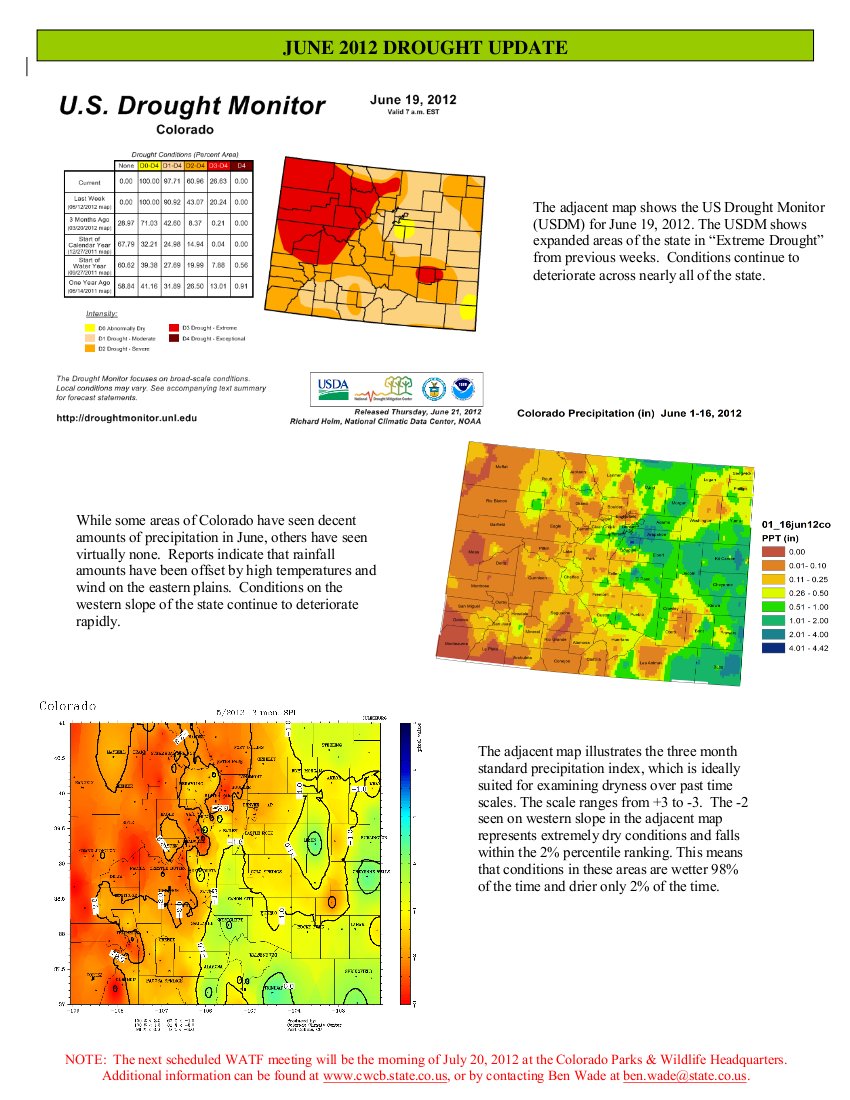
As of the June 19, 2012 US Drought Monitor, 100% of Colorado is experiencing some level of drought classification. D1, moderate drought, conditions remain in much of the eastern plains, while the west slope is now classified as experiencing D2, severe, and D3 extreme drought conditions. Pockets of D2 and D3 also exist in the San Luis Valley and on the eastern plains. 27 % of the state is classified as experiencing “Extreme Drought”
All streamflow forecasts are well below average. Most are below 50% statewide, with Tomichi Creek at Gunnison the lowest at 7% and the Rio Grande at Wagon Wheel Gap the highest at 65% of average.
ENSO conditions remain neutral. A full transition to El Niño could occur in the second half of 2012. El Niño conditions would favor more moisture for the state.
Producers are reporting mixed yields from the early wheat harvest, with some areas seeing as much as 25-30 bushels per acre and others as low as six. Rangeland conditions are poor to very poor and many counties are in the process of requesting emergency grazing on CRP lands. Dry-land farmers are the most impacted at this time, although irrigators are reporting needing more water than normal for this time of year.
No federal drought declarations have been issued as of yet, but many counties anticipate needing to request a declaration due to commodity loss as a result of drought.
The fire situation rating for the Rocky Mountain Area remains at Preparedness Level 4, indicating that highly complex large fire activity is occurring. Fires are escaping initial attack, as evident by the number of larger fires. Fire severity is very high to extreme as reported in multiple areas. One or more regional dispatch centers are experiencing an incident requiring type-1 or type-2 teams, and a majority of zone resources are committed. Priority setting is needed for critical resources.
There is a statewide ban on open burning and the private use of fireworks due to high fire danger.
I live-tweeted the meeting using the hashtag #cwcbwatf.
More CWCB coverage here.