

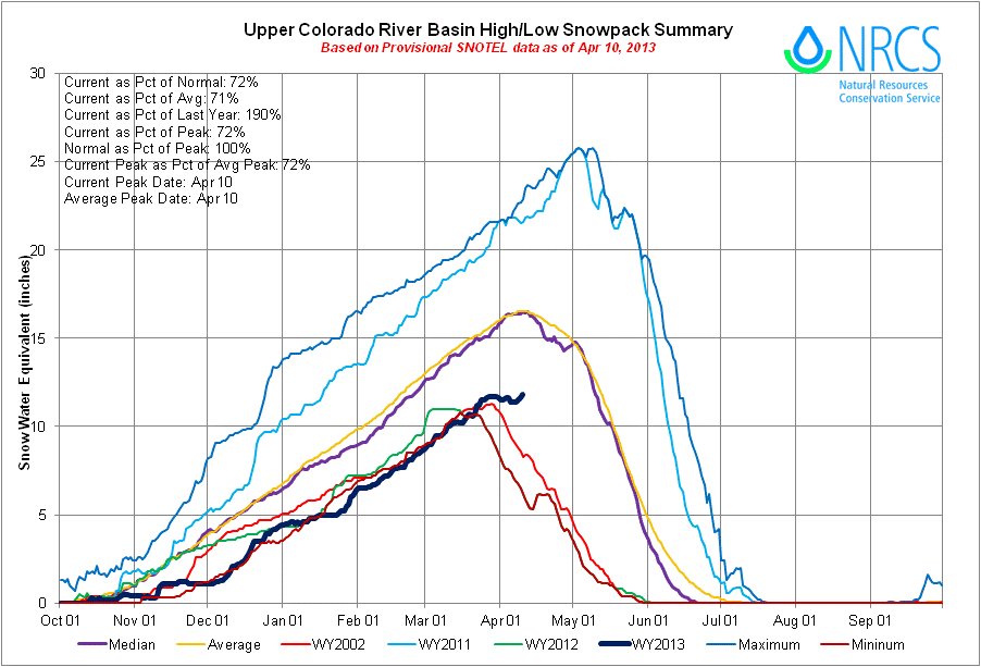
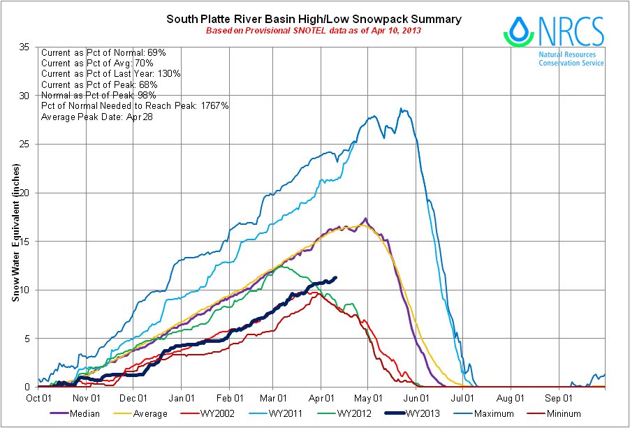
Click on the thumbnail graphics for the South Platte Basin High/Low and Upper Colorado River Basin High/Low graphs, along with the current statewide snowpack map.
From the Fort Collins Coloradoan (Bobby Magill):
The snowstorm that brought strong winds but less snow than expected on Tuesday had a minor effect on the Larimer County snowpack, dropping about 2 inches of snow in the Red Feather Lakes area and about an inch near Estes Park. Some areas west of Fort Collins reported up to 4 inches on Tuesday. Despite the recent spate of spring storms, the snowpack in all the region’s river basins remains far below normal. The water content of the snow in the South Platte River Basin, which includes the Poudre River and Poudre Canyon, is 29 percent below normal, and the Laramie and North Platte Basin is 20 percent below normal, according to federal SNOTEL data released Wednesday.
From The Greeley Tribune:
Following a hot and drought-plagued 2012, this year is so far cooler and wetter than normal. The average temperature last month in Greeley was 40.1 degrees, 3.7 degrees below normal for March, and it stands as the 18th-coolest March on record for the city, according to numbers provided by the Colorado Climate Center in Fort Collins. Through the end of March, Greeley’s average temperature for 2013 was 33.8, 2.9 degrees below normal, and this year is so far tied for the 16th-coolest.
Precipitation in March was down a bit — at 1.10 inches, just 0.02 below normal — but total precipitation for 2013 through the end of March is above normal. As of March 31, Greeley had received 2.17 inches of precipitation for the year, which is 0.17 inches above normal, and this year stands as the 13th-wettest on record.
From the Leadville Herald-Democrat:
Snowfall in March produced a nominal increase in the statewide snowpack percentage, according to Phyllis Ann Philipps, State Conservationist with the Natural Resources Conservation Service. The latest snow surveys confirm that statewide snowpack has increased slightly from 73 percent of median on March 1 to 74 percent on April 1. This is the third consecutive month that the snowpack has increased by just one percentage point. Most major basins saw slight improvements to snowpack percentages during March. Although the state snowpack remains well below normal, the good news is that most basins continue to accumulate snow and have yet to reach their peaks for the year.
The Arkansas River basin had an increase of 3 percentage points.
In a typical winter the state receives around 20 percent of its seasonal snow accumulation during March. This winter, however, March precipitation recorded at SNOTEL sites was well-below normal, with the exception of the South Platte and Colorado River basins. There is almost no chance that the snowpack will reach normal conditions before beginning to melt.
Reservoir storage remains well-below average statewide, and all major basins in Colorado are expected to see below-average stream-flow runoff this spring and summer.In the Arkansas Valley as of April 1, snowpack is at 74 percent of median and 122 percent of what it was this time last year. Reservoir storage is at 55 percent, and 64 percent of this time last year.
From the Canyon Courier (Sandy Barnes):
Extended drought conditions and non-point-source pollution are concerns for those who monitor water quality in the Bear Creek watershed. “We’re going to have a little less water and will have to adjust,” Russ Clayshulte, Bear Creek Watershed Association manager, said during a panel discussion on April 4.
According to recent data from Snowtel, the snowpack was 74 percent of the normal amount, he said.
In addition to low snowpack, both humans and animals are impacting the health of the creek, said Clayshulte. Although advanced wastewater treatment facilities are effective in containing phosphorus, nitrogen and other harmful elements, there are 27,000 septic systems in the Evergreen area that are totally unregulated, he said…
“This year, water managers are worried,” said Clayshulte. Even with extensive precipitation, it takes three to four years to restore water levels to pre-drought conditions, he said. “You may have to let your grass die,” Clayshulte said to those in the audience at the Evergreen Fire/Rescue auditorium, where the event was held.
From the Fort Lupton Press (Gene Sears):
With last year’s hotter than normal temperatures expected again this summer and a snowpack hovering at around 77 percent of average, the outlook is dire. The South Platte basin has it the worst in the state so far, with snow totals more than 30 percent under averages for the year. In response, several municipalities are already setting restrictions in place for the spring/summer watering season. Ranging from outright bans on watering until a specified date, restrictions limiting turf water usage to as little as two days per week and strictly enforced time-of-day watering cycles, the conservation practices are expected to be tighter than last season, with fire danger potentially higher. According to Fort Lupton’s Finance Director Leann Perino, aside from the normal yearly restrictions in place on an annual basis, the city has no current plans to cut back water usage on the part of residents — at least not at this point.
From Steamboat Today (Matt Stensland):
With no end to the drought in sight, Steamboat Springs has joined many other Colorado communities in announcing upcoming water restrictions. The Stage 2 restrictions will go into effect May 1. The same restrictions were enacted last year on June 28. Mount Werner Water and Sanitation District General Manager Jay Gallagher said imposing the restrictions earlier this year will be more effective in curbing the consumption of treated water…
The restrictions affect the four districts that provide water to the Steamboat area: Mount Werner Water and Sanitation District, the City of Steamboat Springs District, the Steamboat II Metro District and the Tree Haus Metro District.
Starting May 1, no outdoor watering will be allowed from 10 a.m. to 6 p.m. Residents who have an even-numbered address can water only Sundays, Tuesdays and Fridays. Residents with an odd-numbered address can water only Mondays, Thursdays and Saturdays. No watering is permitted Wednesdays…
Among other restrictions, vehicles cannot be washed at residences and hard surfaces such as driveways, sidewalks and parking lots cannot be washed with potable water…
The Steamboat Springs Water Conservation Plan adopted in 2011 outlines when water restrictions will be put in place. Among the criteria is when the snowpack at the Tower measuring site April 1 is below 80 percent of average. On April 1, the snow-water equivalent was at 64 percent of average. The snowpack rebounded a bit April 3 to 71 percent of average. Among the other criteria, above-average temperatures are predicted from April to August. Below average precipitation also is being forecast…
In the Steamboat area, Fish Creek provides most of the drinking water. Gallagher said the reservoir fed by natural flows from the melting snowpack is expected to fill. The problem is that the irrigation season likely will be like last summer when it was four to six weeks longer. That means reservoir levels will begin to drop sooner than typical prompting the conservation efforts.
From the Cortez Journal (Jordyn Dahl):
The deadly combination of below-normal precipitation and warmer-than-normal temperatures has local fire officials on edge and preparing for an active fire season…
The forecast for water inflow into McPhee Reservoir this year is 43 percent of average, said Mike Preston, general manager for the Dolores Water Conservancy District.
The mountains have below-average snowpack and what precipitation does run down is seeping into the extremely dry soil, he said. The snowpack is running between 70 and 80 percent of normal, said Chris Cuoco, a meteorologist with the National Weather Service, based in Grand Junction.
From The Aspen Times (Scott Condon):
…the snowpack isn’t great. The Independence Snotel site, an automated measuring device, shows the snowpack at just 70 percent of average east of Aspen but 130 percent of the level one year ago, according to the Natural Resources Conservation Service, a federal agency. In the Fryingpan River Valley east of Basalt, the snowpack at the Ivanhoe site is 98 percent of average and 133 percent of last year’s level. However, the snowpack is bleak at lower elevations of the valley. At the Kiln site, the snowpack is just 69 percent of average and at Nast Lake it’s only 39 percent. In the Crystal River Valley south of Carbondale, the snowpack at Schofield Pass is just 75 percent of average but 119 percent of last year. It’s even more pronounced at McClure Pass, with the snowpack at 74 percent of average but 179 percent of last year, the agency reported…
The U.S. Drought Monitor weekly map released April 2 shows all of Pitkin and Eagle counties rated in “extreme” drought. That is the fourth-worst classification of drought on a scale from 1 to 5. The entire state is rated in some level of drought. The southeast corner is the worst with “exceptional” drought. The southwest corner is best off with “moderate” drought. Pitkin County has been rated in “extreme” drought since early January…
The ongoing drought already has spurred talks of lawn-watering restrictions in some Colorado cities and towns. Basalt Town Manager Mike Scanlon said his staff hasn’t discussed yet if there is a need for lawn-watering restrictions.
Meanwhile, Ruedi Reservoir is significantly lower now than it was at the same time last year. The reservoir is about 60 percent full with 61,383 acre-feet of water. Last year it was 70 percent full with 71,174 acre-feet. The U.S. Bureau of Reclamation, which manages the reservoir, generally waits for snowpack data and streamflow forecasts on May 1 to make definitive projections on whether the reservoir will fill. “At this point, we’re skeptical it will get all the way full,” said bureau spokeswoman Kara Lamb.
From The Colorado Springs Gazette (Matt Steiner):
Venetucci Farm learned in a Feb. 20 letter from the Colorado Water Protective and Development Association that it will not receive any augmentation water for the 2013 pumping season. The news left farm leaders wondering how they would keep the livestock fed and continue to cultivate crops, including bright orange pumpkins that have been given out to about 5 million kids over the last 70-plus years. “Our entire operation is in jeopardy,” said Mike Hannigan, CEO of Pikes Peak Community Foundation, which runs the farm…
According to Hannigan, the farm sits on “tremendous resources” of water but the Pikes Peak Community Foundation does not own the surface water rights on its own property. Instead the farm must lease water from the CWPDA. So, foundation officials did not hesitate after receiving the letter. They’ve been on a quest to find other sources to make a quick fix for 2013. “I immediately started calling everybody I knew who owned any surface water,” Hannigan said.
He found a family in Colorado Springs that might be willing to share some water. “They have been absolutely wonderful to us and I just got an email saying they think they can help us out,” Hannigan said Tuesday morning. The foundation is negotiating with the family to lease water for this season and Hannigan is “working with them to “keep the price reasonable” despite rising water costs amid a drought that began in 2011.
As for a long-term solution, Hannigan said the plan is to look into purchasing the water rights at the farm. That would cost about $2 million but would be a “permanent solution,” he said.