
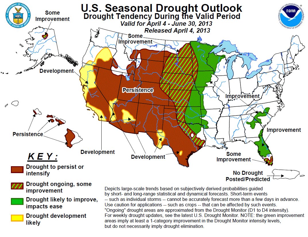
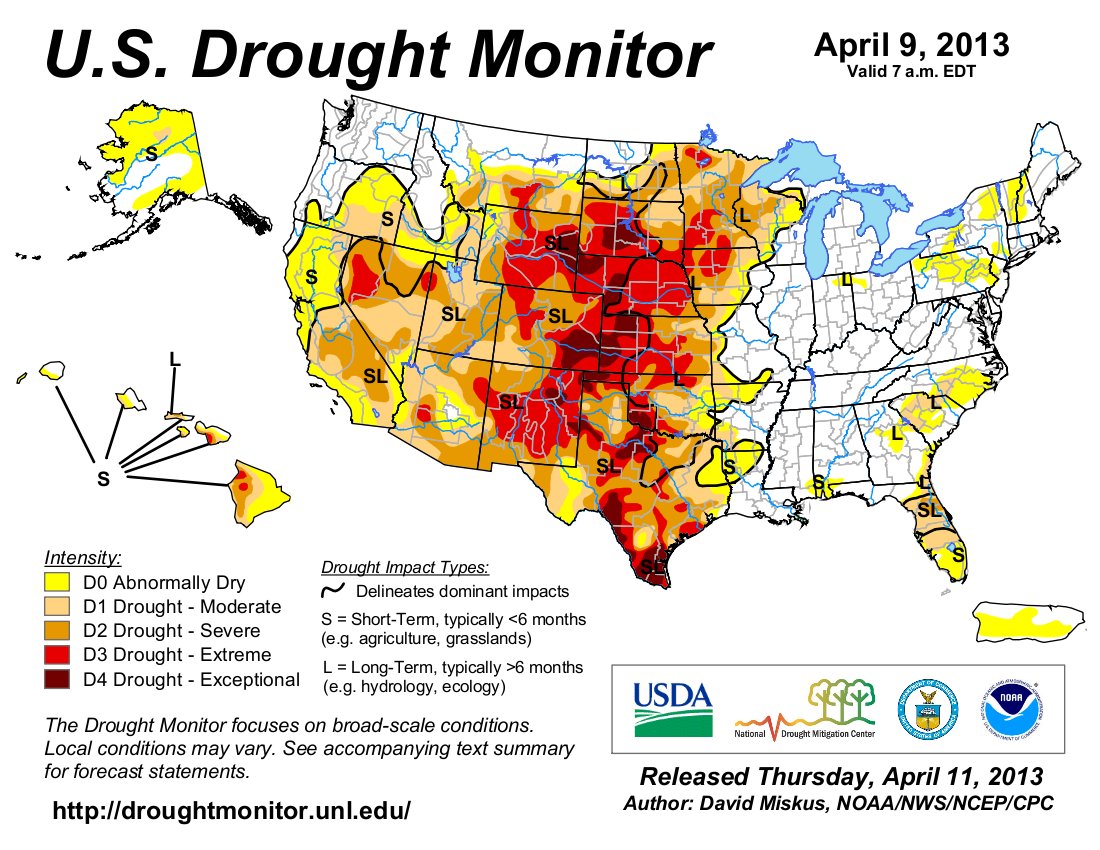
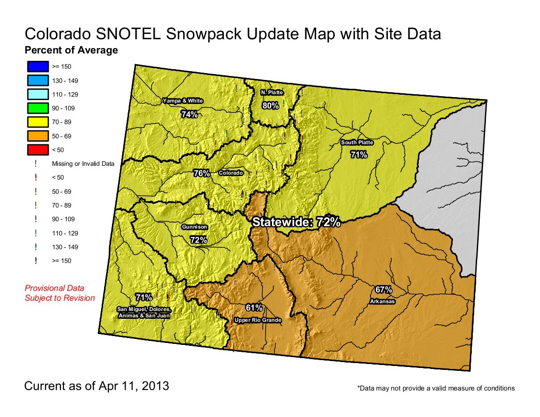
Click on the thumbnail graphics for the current Colorado statewide snowpack map (NRCS), the current U.S. Drought Monitor map and the most recent drought forecast map from the Climate Prediction Center.
From the North Forty News:
April streamflow forecasts show a decline in parts of every Western state and most basins, according to USDA’s Natural Resources Conservation Service water and climate experts.
NRCS hydrologists predict reduced spring and summer water supply for much of the West.
This month’s forecast is especially important because there probably won’t be significant snow accumulation after April 1, according to hydrologist Tom Perkins.
“April is usually the endgame. We’re not likely to make up this deficit. Snowpack is not good. Reservoir carryover is not good,” said Perkins.
Although other parts of the country got more snow, it didn’t have impact in the western mountains, he said.
“What fell in the West didn’t really amount to much,” Perkins said. “New Mexico, Nevada and Colorado are especially vulnerable because their reservoirs are at low levels due to sustained drought conditions.”
Water resource managers face difficult decisions due to this shortage, he said. Western states should prepare for potentially increased vulnerability to forest and rangeland fires and mandatory water restrictions. In addition, wildlife that depends on surface water is going to suffer.
There are a few exceptions to the dry forecasts. The North Cascades – including Washington and Western Oregon – and the headwaters of the Missouri and Columbia Rivers are near normal. “For the rest of the West,” Perkins said, “there is no silver lining. I think it’s going to be a long, hot, dry summer.”
According to NRCS Meteorologist Jan Curtis, most Western snowpacks peaked two to three weeks early this season and are now in decline. The best scenario would be for those snowpacks to melt slowly, providing a steady water supply through the spring and summer. This seems unlikely, given the above-average temperatures forecasted for the spring and summer.
“Although NRCS’ streamflow forecasts do not predict drought, they provide valuable information about future water supply in states where snowmelt accounts for the majority of seasonal runoff,” according to Perkins.
In addition to precipitation, streamflow in the West consists largely of accumulated mountain snow that melts and flows into streams as temperatures warm into spring and summer.
The April forecast is the fourth of six monthly forecasts issued each year between January and June by the national center. The forecast compares the current level of water content in snowpack in the 13 Western states with historical data to help the region’s farmers, ranchers, water managers, communities and other stakeholders make informed decisions about water use and future availability.
The snowfall, air temperature and numerous other factors taken from remote climate sites ultimately contribute to water supply. Now that Western snowpacks have peaked, the Governor’s Drought Task Force of each Western state will begin meeting to discuss drought preparations.
NRCS will continue to monitor levels across the Western states to provide the most up-to-date water supply information each month. The next two forecasts will measure rate of snowmelt and refine streamflow predictions.
“USDA streamflow forecasts play a vital role in the livelihood of many Americans,” said Jason Weller, NRCS acting chief. “With much of this region greatly affected by drought, our experts will continue to monitor snowpack data and ensure that NRCS is ready to help landowners plan and prepare for water supply conditions.”
Since 1935, NRCS has conducted snow surveys and issued regular water supply forecasts. NRCS installs, operates and maintains an extensive, automated system called Snow Telemetry, or SNOTEL, designed to collect snowpack and related climatic data in the Western United States and Alaska.
View April’s Snow Survey Water Supply Forecast map or view information by state.
Other resources on drought include the U.S. Drought Monitor and U.S. Seasonal Drought Outlook map, which forecast drought conditions through March 31. For information on USDA’s drought efforts, visit http://www.usda.gov/drought. And to learn more about how NRCS is helping private landowners deal with drought, visit the NRCS site.
From the Loveland Reporter-Herald (Tom Hacker):
State climatologist Nolan Doesken, in his 36th year of tracking data, told his Loveland audience the record shows “spring matters.” And this spring, so far, holds some hope that a second consecutive year of drought in Northern Colorado might ease slightly. “I’m actually optimistic about this year,” Doesken said at the annual spring water users meeting hosted by Northern Water, the agency that distributes water to nearly a million people and almost 700,000 acres of Colorado farmland. “I’m not wildly optimistic. But there is snow falling, and actually quite a bit of it.”
Doesken said spring can make or break the water year for farmers and municipal water providers, and that this one is measuring up to lessen the effects of a drought that still will have the state in its grip. “Spring precipitation does two things for us,” he said. “It adds to supply, and it takes away from demand. We get a double whammy.”
From Grand Valley DRIP:
The snow survey taken on April 3 in the City of Grand Junction’s watershed on the Grand Mesa is showing a slight drop from the averages of this time of year in snow depth and water content. The snow depth is showing 83% of average for this time of year, and water content is 88% of average.
The full results of the survey can be found at: http://www.gjcity.org/WaterSupply.aspx
Winter weather is not quite over yet, as evidenced by the snowstorms that moved through the state yesterday. The cold temperatures have also helped delay the spring snowmelt, unlike last year’s unusually early and warm spring.
However, the entire Grand Valley remains in a Stage 1 Drought, with voluntary watering restrictions in place. Water has begun filling the canals and laterals, and some homeowners have even begun watering their lawns. If you can delay your watering until the temperatures heat up, you can also avoid frozen sprinkler lines when the temperatures drop below freezing as they did the last two nights.
From the Tri-Lakes Tribune (Lisa Collacott):
Colorado Springs City Council approved “stage two” of the Water Shortage Ordinance for Colorado Springs Utility customers and because Donala has a contract for water transfer through the Northgate connection, Donala customers are required to comply with the twice a week irrigation schedule. Donala has their own watering standards program. Customers have been on restrictions for the past couple of years with mandatory watering limits to three times per week from Memorial Day to Labor Day. The new schedule limits users to two days a week, putting Donala at “stage three,” beginning April 1…
The water district will follow an odd-even program. Odd day users can water on Monday and Friday, and even day users can water Tuesday and Saturday. There is no watering on Sunday. Customers can still use a hose to water plants, shrubs and trees as long as the hose has a positive shut-off nozzle which shuts the hose off when not in use.
From the Englewood Herald (Tom Munds):
Englewood residents won’t face mandatory lawn watering restrictions this summer but are urged to follow conservation measures…
The city’s plentiful raw-water supply is due in large part to the efforts of Englewood Mayor Charles Allen and water attorney Mark Shivers in the late 1940s and early 1950s, when the city began planning its water system. That was when city officials purchased senior water rights that are the foundation of Englewood’s supply of raw water. Over the years, Englewood has continued to secure valuable water rights. In 1987, the water utility spent about $200,000 on water-attorney fees in successful court actions to secure about 1,400 acre-feet of water. Fonda said the lawyer fees in this case were a good investment when the going price for water rights then was about $10,000 an acre-foot…
Englewood purchased land and built McClellan Reservoir in 1965. It is a major water-storage location for the city. In addition, Englewood has agreements for Denver to store water and release it as requested. The sufficient raw water supply also makes it possible for Englewood to meet the threshold of the water sales contract with Centennial Water District, which supplies water to Highlands Ranch. Fonda said the threshold is delivery of about 1,800 acre-feet of water to Centennial Water District, which brings about $1.8 million in revenue to the city. He said it would hurt the city financially if Englewood was not able to meet the water sales contract…
The effort to have customers switch from flat rate to meters began in 1985. “We find water use declines about 30 percent when a customer is on a meter,” Fonda said. “We now have about 80 percent of our customers on water meters.” The city installs a meter at a customer’s request or when a home is sold, installing about 300 meters a year.
From the Estes Park Trail (John Cordsen):
“At this time, we do not foresee the need for mandatory water restrictions,” said Reuben Bergsten, Utilities Director, Town of Estes Park. “If drought conditions warrant, we may request voluntary conservation efforts. Based on our experience during the 2002 drought, this was effective.”[…]
The water problem starts with the lack of snow in the high country. The recent snow aside, reporting areas west of Estes Park are drastically below historical levels. Through March, sites in the Big Thompson River watershed in Rocky Mountain National Park are close to being parched, with water equivalents ranging from a low of 30 percent of the 30-year average to 61 percent of the 30-year average. They are also well below the 2012 totals, which were also down.
The Deer Ridge Junction was just 30 percent of the 30-year average for water content in the sparse snow. The average snow depth at this junction not far from the Beaver Meadows entrance to Rocky Mountain National Park was a scant 6 inches. This translated out to 1.3 inches of moisture. The 30-year average is 4.4 inches of moisture in the March readings. Bear Lake was on the other end of the spectrum with an average snow depth of 40 inches, which equates to 10.1 inches of moisture, or 61 percent of the 30-year average.
From the Associated Press via The Denver Post:
The U.S. Department of Agriculture has approved new designations allowing farmers and ranchers around the West, including nine Colorado counties, to seek federal aid to get through the drought. All but a handful of Colorado’s 64 counties have been designated this crop year as either primary natural disaster areas due to drought or as contiguous to those counties. The USDA on Wednesday approved contiguous county designations for Jackson, Larimer, Logan, Moffat, Phillips, Routt, Sedgwick, Weld and Yuma counties, making producers there eligible to be considered for emergency loans from the Farm Service Agency.
MORE COLORADO SPRING FRESHIES. @breckenridgemtn 8″, @vailmtn 7″, @beavercreekmtn 4″.(24hr totals) #CelebrateOnSnow
— Snow.com (@snowdotcom) April 12, 2013