A milestone in state water planning was reached Tuesday as members of the state’s Interbasin Compact Committee unanimously endorsed the latest version of a “conceptual framework” to guide discussions between East and West Slope interests about any new transmountain diversion.
“It’s not perfect, but I think we’re in general agreement this is a good starting point, and if ever there is a transmountain diversion, there will be, no doubt, additional negotiations,” said John Stulp, chairman of the IBCC.
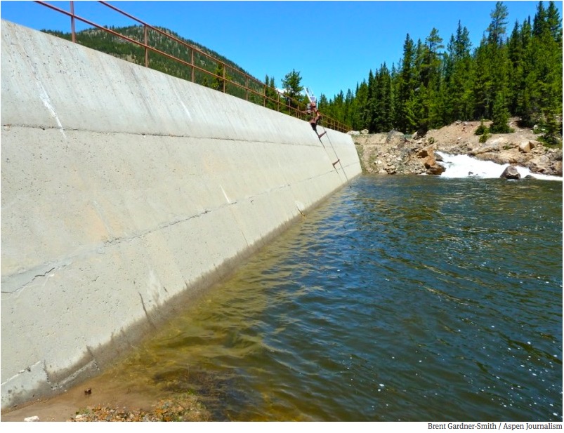
Today in Colorado, between 450,000 and 600,000 acre-feet of water is diverted each year from the West Slope to the more populous East Slope.
The latest draft of the framework, tweaked Tuesday regarding statewide water conservation goals, will now be forwarded to the Colorado Water Conservation Board for inclusion in the final Colorado Water Plan, which is to be delivered to Gov. John Hickenlooper by Dec. 10.
“I would be surprised if it would change significantly from where we’re at today,” Stulp said of the conceptual framework.
To help satisfy the concerns of some members of the IBCC, staff from the Colorado Water Conservation Board drafted an additional introductory paragraph – during a break in the meeting – about the conceptual framework to be included in the water plan.
“The intent of the conceptual framework is to represent the evolving concepts that need to be addressed in the context of a new transmountain diversion as well as the progress made to date in addressing those concepts,” the new introductory paragraph states. “The conceptual framework refers to several topics, including conservation, storage, agricultural transfers, alternative transfer methods, environment resiliency, a collaborative program to address system shortages, already identified projects and processes (IPPs), additional Western Slope uses, and other topics that are not exclusively linked to a new TMD, but are related to Colorado’s water future. The conceptual framework, like the rest of the Colorado Water Plan, is a living document and is an integrated component of the plan. Many of these topics are further discussed in more detail in other sections of Colorado’s Water Plan.”
The IBCC is made up of two members from each of the state’s nine basin roundtables, six governors’ appointees and two members of the Legislature.
Since 2013, the committee has been working on the seven core principles in the framework, which spells out under what terms a new transmountain diversion might be acceptable to the West Slope.
For example, a new project should not increase the likelihood of a call from California for more water under the Colorado Compact, or preclude future growth on the West Slope.
And it “should avoid, minimize or mitigate adverse environmental impacts where possible” and address the concept of “environmental resiliency.”
“Nothing is perfect, but I think adding environmental resiliency into the water plan – which happened because we got it into the conceptual framework and now it’s also in the body of the plan in chapter six – I think that’s a big step forward,” said Melinda Kassen, who represents environmental interests on the IBCC, and was speaking during a break in the meeting.
“And I like the fact that it’s also combined and we have a much more robust commitment and description of what we need to do in regard to compact compliance,” Kassen said. “So I think there are a lot of things in the conceptual framework that we have to work on – triggers, collaborative water management program, environmental resiliency, conservation – those are the action steps for moving forward. I think we need to move on, but I think the conceptual framework is a pretty good deal and we should take it and move on. And not just in terms of the conceptual framework, but in terms of the whole water plan. It’s a plan, and now we have to ‘do.’”
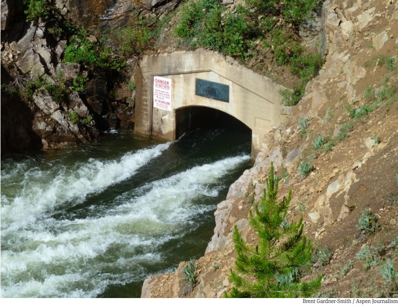
The east end of the Independence Pass tunnel, bringing water from the headwaters of the Roaring Fork River to the East Slope
“A bunch of hoops”
Bill Trampe, a rancher in Gunnison County and a member of the Gunnison River Basin Roundtable, also supports the framework.
“For future transmountain diversions to occur, according to the framework, the proponent is going to have to go through a bunch of hoops,” Trampe said. “If the proponent is willing to take the gamble that there is enough water to merit the expense of the project, then go for it.”
Trampe’s suggested that if a project proponent takes a hard look at a potential new transmountain diversion, and does so through the lens of the conceptual framework, they may find that there just isn’t enough water to make a project viable.
Principle three of the framework deals with “triggers,” or the amount of water available in the larger Colorado River system, that may or may not allow water to be diverted to the East Slope.
“Triggers are operating parameters that determine when and how much water a potential new TMD could divert, based upon predetermined conditions within the Colorado River System,” a recent draft of the framework states. “Such parameters include, but are not limited to, specific storage elevations in one or more Colorado River System reservoirs, projected inflows at key Colorado River System locations, actual reservoir inflows over specific defined periods, snowpack levels, predictive models – or combinations of these – which would trigger certain actions and prevent others.”
In a brief interview after the meeting, Trampe said the water trends do not favor a new transmountain diversion.
“If hydrology does not improve, then the issues on the Colorado River are going to become worse,” Trampe said. “Mead and Powell continue to go down. They are not stabilized. They are not rising. They continue to go down. So if a proponent of a project looks at all of that, and still thinks there is water available, I guess there is not much we can do about it, except go through step four, the collaborative process, where we identify the risks and the ways we go about alleviating those risks to the various parties, particularly on the West Slope.”
Step, or principle, four in the framework discusses a proposed collaborative program to manage water in the Colorado River basin, and points out such a program is needed regardless of whether a new diversion is built or not.
“The collaborative program should provide a programmatic approach to managing Upper Division consumptive uses, thus avoiding a Compact deficit and insuring that system reservoir storage remains above critical levels, such as the minimum storage level necessary to produce hydroelectric power reliably at Glen Canyon Dam (minimum power pool),” the draft framework states. “A goal of the collaborative program is that it would be voluntary and compensated, like a water bank, to protect Colorado River system water users, projects and flows. Such protection would NOT cover uses associated with a new TMD.”
Trampe also pointed out that the conceptual framework is only a first screen for a potential new transmountain diversion, as any project would still have to go through existing regulatory reviews at, potentially, the federal, state and county level.
“Even if you think you can get through this process, you still have to go through the normal legal channels and permitting that is in existence today,” Trampe said. “You’re still going to have the traditional things to go through, particularly if you’ve not adopted the principles within the framework.”
The conceptual framework is not legally binding, as Colorado water law still allows for a water provider to propose a new transmountain diversion without referencing the conceptual framework. But it is seen as a way for Western Slope communities to review a proposed diversion against publicly adopted parameters.
The conceptual framework has been discussed at various other roundtable meetings around the state in recent weeks.
“I think that this gives us protections that otherwise we don’t have,” said Karn Stiegelmeier, a Summit County commissioner, during a July 27 meeting of the Colorado River Basin Roundtable, shortly before that roundtable endorsed the conceptual framework.
But during the same meeting, Ken Ransford, who represents recreational interests on the Colorado Roundtable, voted against the framework.
“This agreement doesn’t have teeth,” Ransford said. “It’s not enforceable. It gives us no legal rights. And the Front Range has said they are still willing to come over here and purchase agricultural water rights as necessary to protect their existing diversions. So I keep asking myself, what are we getting out of this?”
However Ken Neubecker, the associate director of the Colorado River Basin Program for American Rivers, and the environmental representative on the Colorado River Basin Roundtable, supported the conceptual framework, arguing it gives the Western Slope more protection.
“They could come over for a new transmountain diversion and ignore all of this right now, that’s just the way Colorado water law is,” Neubecker told the roundtable. “What this does do, along with the water plan, is set a high bar that they really are going to have to look at and try and comply with if they want to have a smoother road rather than a rougher road toward that end. They still have to go through permitting processes with the local counties and with the state, and the counties and the state can all look at it and say, ‘Well, where are you with complying with this? Where is your plan with point number four, point number three, whatever?’ It does give us that element of a condition, while not legally required, is something that politically would be a good thing to pay attention to.”
After the August 25th meeting in Keystone, Eric Kuhn, the general manager of the Colorado River District, which represents 15 West Slope counties, said the framework — if deployed correctly — could help protect West Slope interests.
“The West Slope is better off under the conceptual framework if, and it’s a big if, we follow through and have the discussions that are contemplated by the framework,” Kuhn said. “If it just sits on the shelf, it’s worthless for us.”
The first of the seven principles in the framework states “East Slope water providers are not looking for firm yield from a new transmountain diversion, and the project proponent would accept hydrologic risk for that project.”
That means that a Front Range water provider who proposes a new transmountain diversion must understand that there may not be water to divert every year, depending on snowpack, weather and the amount of water stored in Lake Powell and Lake Mead, the latter because of legal minimum water guarantees for downstream states.
“It’s not just, is there enough water, it is whether there is enough reliable water,” Kuhn said of the core principle. “If you are a community, and you are providing water to people, it’s not good enough to have water three out of four years. People want water four out of four years.”
Which may mean, Kuhn said, that a big new diversion project is not worth pursuing.
After the meeting, Kuhn wrote a memo to the River District’s board of directors, in which he spelled out the divide evident at the Keystone meeting over the appropriate levels of water conservation that should be expected of municipal water providers.
“The IBCC met on Tuesday August 25th in Keystone,” Kuhn wrote. “The primary area of discussion (and conflict) was conservation. A separate IBCC committee on conservation developed what we now refer to as the stretch goal. Under the most simplified explanation, the ‘stretch goal’ is stretching the medium goal of 280,000 acre-feet of statewide conservation savings to 400,000 acre-feet. The goal timeline is 35 years, from now to 2050.
“The framework committee tried to incorporate this into the seven point framework in principle 6, but we did so in an awkward way,” Kuhn wrote. “The bottom line is that the South Platte and Metro roundtables are having second thoughts about the stretch goal. I heard three concerns: First, they could become part of the federal permitting process. Second, they’re not really attainable at this time. And third, they will undermine the ability to finance and operate new projects. The more our customers conserve, the less money they pay.
“We ultimately agreed to ‘soften’ the language, but the underlying tensions remain,” Kuhn wrote. “The West Slope roundtables remained united behind achieving the stretch goals, but expressed concern about smaller entities (which under the rules are not covered if they use less than 2,000 acre-feet per year).”
Clamoring for water
But to water interests on the Front Range, a new transmountain diversion is seen as an important tool to meet growing water demands, and getting the conceptual framework into the Colorado Water Plan is seen as a victory.
“It seems to me we’ve got a tremendous opportunity,” said Sean Cronin, the executive director of the St. Vrain & Left Hand Water Conservancy District in Longmont, during an Aug. 11 meeting of the South Platte Basin Roundtable in which he urged the roundtable members to endorse the conceptual framework.
“We have been clamoring for a transmountain diversion since the very first day of the roundtable,” Cronin said. “We now have a transmountain diversion framework sitting in a statewide water plan that’s nearly to the point of being approved and adopted.”
After Tuesday’s meeting in Keystone, IBCC member Wayne Vanderschuere, who oversees water planning for Colorado Springs Utilities, said a new transmountain diversion “needs to be in the cards,” especially to slow the practice of buying water from agricultural operations to meet growing municipal demands.
“The Colorado River has its own unique challenges irrespective of transmountain diversions, that everyone needs to take ownership of,” Vanderschuere said, referring to the state’s obligations under the Colorado Compact. “So we need to address that. But we also have an obligation to responsibly develop our portion of the compact entitlement, and to the extent we can do that, we should pursue that.”
Vanderschuere also praised the state’s existing array of transmountain diversions.
“The current transbasin diversions and the associated storage with them have done more to booster the economic, environmental, and environmental resiliency of Colorado than any other thing I can think of,” he said. “The storage, the flatwater recreation, the whitewater recreation, the environmental habitat, the economic benefits of having that water available, east and west, for recreation, for municipal and industrial – huge. Colorado would not be where it is today without those transbasin diversions that are currently in place. So we have to acknowledge that that’s been a huge success on all fronts.”
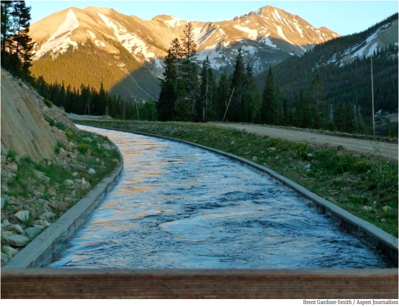
The ditch that moves water from Lost Man Reservoir to Grizzly Reservoir and then under the Divide to the South Fork of Lake Creek and the Arkansas River.
View from the CWCB
At a meeting on Aug. 21 in Vail of the Colorado Water Congress, John McClow, the general counsel of the Upper Gunnison Water Conservancy District, and a board member of the Colorado Water Conservation Board, described the conceptual framework, and the “historic conflict” in Colorado over transmountain diversions, for a ballroom full of members of the state’s professional water community.
“The most pressing question I’ve heard throughout the Western Slope is ‘What are we going to do about new transmountain diversion?’ All of the Western Slope roundtables addressed it to some extent in their basin implementation plans,” McClow said. “The South Platte Roundtable, the Metro Roundtable, talked about it in their plans. But those collective comments still reflected what I believe was conflict on the issue. It is a historic conflict – east versus west – and it’s been going on before Colorado was a state. What I’m happy to report is that the IBCC took it upon themselves to try and find a solution to that conflict.
“That group worked for over a year putting together seven principles that would create a framework around which a new transmountain diversion could be developed. It is not an agreement, it is not a regulation, it is not mandatory, but it confronts reality on every aspect of what will be necessary to consider in the event that a proponent wishes to pursue a new transmountain diversion. It’s couched in terms of seven principles, and each of them addresses one element of it. Some go a little bit beyond the strict interpretation of a transmountain diversion.
“What’s most important to remember is that it is not a rule,” McClow said. “What it does is set forth the obstacles that would occur in the event that a proponent were considering one, that it is to say, the physical and legal availability of water in the basin of origin, which is addressed by Colorado water law. But it reaches beyond that to say that if the new development occurs within the Colorado River system, which is what we’ve always identified as our source of new supply, we have to look beyond the state boundary and look at the big river system because of our obligations to other states on the Colorado River.
“We have to be careful that in developing that additional water, we don’t overdraft our entitlement under the Colorado River Compact and Upper Colorado River Compact. This framework provides a process to address those issues. And further, to say we have to have some means of evaluating the possibility of diversions by this new project through triggers. And without defining the triggers, its says there are places you need to look to figure out when and how much water could be diverted by a new transmountain diversion.
“The principles go beyond that and look at issues such as West Slope – East Slope collaborative benefits from a single project, it talks about conservation standards for the proponent of a new transmountain diversion, it talks about environmental and recreational sustainability within the state.
“I hope that we, the conservation board, will adopt this framework and incorporate it into the water plan so that we can remove this controversy because Colorado can’t move forward in conflict, we’ve got to move forward with consensus,” McClow said. “And this is a burning issue, Front Range and West Slope, and I’m hoping that for once in our history we can sit down and say ‘We’ve agreed on how this can actually happen, should it be possible, as long as it is done reasonably and responsibly and reflects the reality of our circumstances at the time.'”
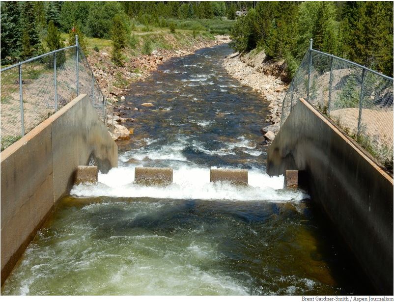
The outfall of the Bousted Tunnel, which delivers water from the Roaring Fork and Fryingpan rivers to the East Slope.
The seven principles b the draft conceptual framework:
1. East Slope water providers are not looking for firm yield from a new transmountain diversion (TMD) and the project proponent would accept hydrologic risk for that project.
2. A new TMD would be used conjunctively with East Slope supplies, such as interruptible supply agreements, Denver basin aquifer resources, carry-over storage, terminal storage, drought restriction savings, and other non-West Slope water sources.
3. In order to manage when a new TMD would be able to divert, triggers are needed.
4. A collaborative program that protects against involuntary curtailment is needed for existing uses and some reasonable increment of future development in the Colorado River System, but it will not cover a new TMD.
5. Future West Slope needs should be accommodated as part of a new TMD project.
6. Colorado will continue its commitment to improve conservation and reuse.
7. Environmental resiliency and recreational needs must be addressed both before and conjunctively with a new TMD.
Editor’s note: Aspen Journalism is collaborating with The Aspen Times and the Glenwood Springs Post Independent on coverage of water and rivers. The Times published a shorter version of this story on Wednesday, Aug. 26, 2015, as did the Post.
Here’s report Stephanie Paige Ogburn writing for KUNC. Click through for the photos. Here’s an excerpt:
…Kerber Creek, is just a small piece of the legacy left by hard rock mining across the West. When Tang-colored water spilled from a mine into the Animas River, it caught the nation’s attention. Yet unknown to most, there are people who work day in and day out cleaning up the many hundreds of abandoned mine sites across Colorado. This sort of mine cleanup work is a seldom never-ending process, fraught with logistical challenges, financing problems, even the looming threat of lawsuits.
To understand what killed Kerber Creek, it’s helpful to drive 15 miles above Wagner’s ranch, into the mountains where miners tunneled and blasted searching for gold, silver, and copper over 100 years ago. You’ll pass hillsides bored through with abandoned mine tunnels. Old mine structures, like the Cocomongo Mill and mine, and piles of rocky waste dot the landscape.
Operations at Cocomongo ended in the late 1950s or early 1960s. The mill is giant. The piles of mine waste around it are equally impressive.
Much of mine waste is referred to as tailings, pea-sized rocks that were processed by miners. That, along with larger waste — stained yellow, orange, white, gray, brown — reaches many stories high. It almost looks like the mountain was turned inside out…
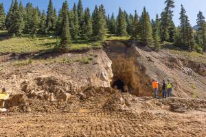
The Rawley 12 tunnel and rehabilitation site once gushed orange, acidic water into Squirrel Creek, then down into Kerber Creek. The tailings below were difficult enough to walk on that some workers used snowshoes so they wouldn’t sink in.
It took hundreds of dump trucks to remove the tailings mess. The Fish and Wildlife Service, working in conjunction with a couple handfuls of state, local and federal agencies, had to build a holding pond to store and treat the mine wastewater as they worked. Workers also had to rebuild part of the mine tunnel here before they could plug it. It’s hard, expensive work.
“Sometimes mine restoration looks a lot like mining,” Archuleta said, showing off a picture of workers in hard hats and head lamps.
Today, the tailings have been trucked away and safely stored. Native grasses and plants have sprouted, and tiny evergreens are beginning to colonize the bare soil. Archuleta points to the ground.
“Dandelions are growing here, dandelions are actually a good sign because they will not grow in metals enriched soils.”
All this had to be done before any restoration could happen lower down, at the creek running through the Wagner’s ranch. In 2012, the U.S. Department of Agriculture’s Natural Resources Conservation Service started a cleanup at the ranch…
Finding that money is an ongoing problem for these large scale cleanups. One solution could be requiring existing mines on public lands to pay royalties, said University of Colorado law professor Mark Squillace.
“You could easily impose a fee on the tonnage that is produced from these mines to fund a program to reclaim hardrock mines.”
That would take legislation, though, which is unlikely, said Squillace.
Liability is another issue, since groups that take on big cleanups can be sued if they can’t bring a creek up to Clean Water Act standards. That limits groups like Trout Unlimited’s ability to take on certain types of cleanups. So-called “Good Samaritan” legislation to address these problems has been proposed, including by former Colorado senator Mark Udall, but has failed to pass.
The highly visible spill on the Animas River has led to renewed calls to update these laws. Those involved say Good Samaritan legislation could be hard to get right, for a couple of reasons. First, changes to the law would need to ensure it didn’t over protect mining companies who could reopen mines, make money, and then hide behind Good Samaritan liability protections. Second, because it involves opening up the Clean Water Act for modification, some on the environmental side are worried the law could be weakened through the amendment process.
Back at the Wagner ranch, an excavator clangs as it lifts giant boulders and places them in the creek, stabilizing the bed and preventing erosion. That heavy equipment will also till in lime to neutralize the soil, and compost to help plants grow. Since the rehabilitation work began, Carol Wagner said she’s seen a huge difference.
“And now there’s trout living here in the creek and a lot of wildlife are here, and it’s just changed everything,” she said.
That cleanup has been decades in the making. For Colorado to deal with its abandoned mine problem, this work has to happen over and over, in various iterations and circumstances. The state Division of Mining Reclamation and Safety estimates out of the 22,000 abandoned mines across the state, 500 of them are currently polluting the water down below. It will take decades to address the problem, one mine tunnel and creek at a time.
Click here to go to the US Drought Monitor website. Here’s an excerpt:
Summary
A significant upper-level trough over the central part of the contiguous U.S., accompanied by a slowly moving cold front, brought up to several inches of rain across the eastern and southern states during the past week. The cold front reached the Eastern Seaboard and continued out over the western Atlantic, while the southern portion of this front stalled across the deep South. Later in the week, another upper-level trough moved out of central Canada across the northern High Plains of the United States, before heading east and bringing additional rainfall to the eastern contiguous U.S. In the Southwest, light to moderate precipitation (generally less than 1.5 inches) was observed in association with the summer monsoon. In the northern Rockies and Pacific Northwest, the USDA Forest Service reported approximately 40 large wildfires in progress as of August 26th, as warm and very dry weather persisted…
Northern and Central Plains
Abnormal dryness (D0) in eastern Montana was expanded south-southwestward due to the ongoing lack of precipitation. No changes were rendered to the depiction in Kansas, as rains that did fall during the week missed the residual D0 area in the northwest part of the state…
Southwest and California
Light to moderate rain (generally less than 1.5 inches) fell across southern sections of both Arizona and New Mexico. In New Mexico, no changes were made to the drought depiction. However, the counties of Curry, Roosevelt, and Lea, in eastern New Mexico (bordering Texas) are being monitored after a fairly dry August (so far) and soil moisture observations. No revisions were considered necessary this week in either the Southwest or California. An Associated Press report (dated August 20th) notes land in central California’s agricultural region is sinking quickly because of the state’s historic drought. This is forcing farmers to spend millions of dollars upgrading irrigation canals, and putting roads, bridges, and other infrastructure at risk. The extent of Short to very Short topsoil moisture for the state of California as a whole, is generally around 80 percent, a decline of about 5 percent since last week…
Looking Ahead
For the upcoming 5-day period, August 27-September 1, attention will be focused on southeastern Florida, which may experience very heavy rainfall early next week in association with what is currently Tropical Storm Erika. Preliminary forecasts from the National Hurricane Center in Miami strengthen Erika to a hurricane either this Sunday or Monday, as it bears down on the southeastern Florida coast. However, Erika is still 4-5 days away from Florida, and its track and intensity may change significantly by then. In the desert Southwest, up to an inch of rain is predicted to fall during this period, which would at least help to offset additional deterioration in many areas. Several inches of precipitation are anticipated across the coastal ranges and Cascades of the Pacific Northwest, an area that could certainly use the moisture. Up to several inches of rain are also forecast for portions of the Midwest/Upper Midwest/Upper Great Lakes region. Depending on exactly where the rain does fall, some reduction in drought coverage is possible.
For the ensuing 5-day period, September 2-6, chances for above-median rainfall are elevated across the Southeast, due to the anticipated approach of Erika near the beginning of the period. Above-median rainfall is also favored across the northwestern and north-central portions of the lower 48 states, in advance of an upper-level trough. Odds for below-median rainfall are elevated across portions of the Northeast, and the southwestern and south-central CONUS. In Alaska, above-median precipitation is favored for much of the northern and western sections of the state, while below-median precipitation is favored along the southern coast from about Kodiak Island to Juneau.
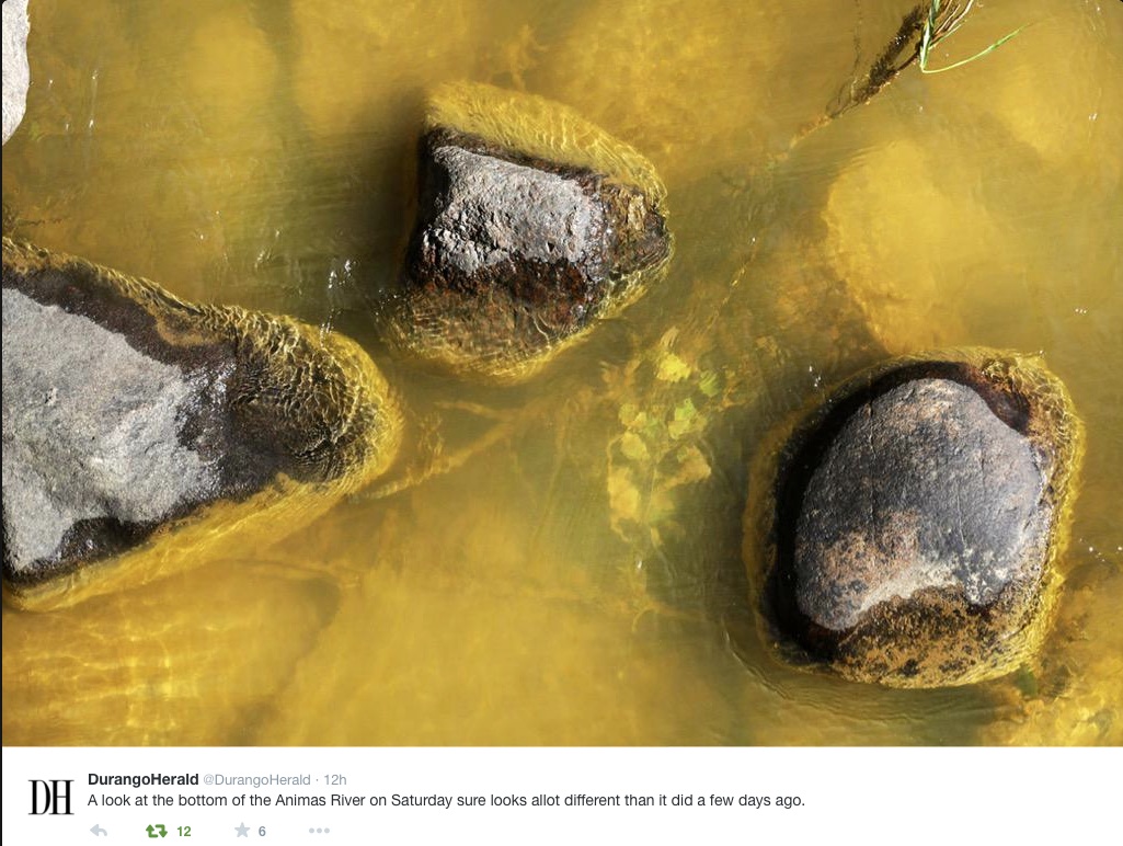
Environmental officials said Thursday their long-term concern after the 3 million-gallon Gold King Mine spill centers around the metallic sediment left in its wake.
Specifically, the Environmental Protection Agency says it is worried about the “effect of metals deposited in sediments in the entire watershed and their release during high-water events and from long periods of recreational use.”
The EPA mentioned the concerns as part of a data release accompanying 77 pages of documents chronicling the minutes and hours before and after the agency-triggered spill…
Experts say metals lining the riverbed could continue to cause long-term effects for agriculture, aquatic life and other life-forms along the Animas River.
The EPA specifically has been studying concentrations of arsenic, cadmium, lead and mercury in surface water.
The acidic heavy metals that flooded into Cement Creek in Silverton and the Animas River through La Plata County after the spill initially broke state water quality limits.
The new data comes after the EPA on Wednesday released an internal review of the events leading up the Gold King spill showing crews underestimated waste pressure behind the mine’s collapsed opening.
The report called the underestimation of the pressure the most significant factor leading to the spill.
According to the report, had crews drilled into the mine’s collapsed opening, as they had done at a nearby site, they “may have been able to discover the pressurized conditions that turned out to cause the blowout.”
Colorado River Basin including Mexico, USBR May 2015
Here’s the release from the Colorado Department of Natural Resources (Todd Hartman):
The states of Wyoming, Colorado, Utah, and New Mexico have embarked on a unique test program to shore up declining reservoir levels if the 15-year drought that has plagued the Colorado River continues into the future.
On July 1, the four states approved 10 projects that allow farmers, municipalities and other water users to voluntarily and temporarily forego use of their water in exchange for compensation. On August 13, 2015, the first agreement was reached on one project within Colorado, in the Yampa River basin.
The states hope that this “forbearance” of water use will supply information that can be used in times of extreme drought as part of a contingency plan to ultimately reduce impacts on Lake Powell, a major Colorado River reservoir located on the Utah-Arizona state line. Lake Powell releases water to Lake Mead for use by the states of Arizona, Nevada, and California and the Republic of Mexico pursuant to an interstate agreement among the seven Colorado River states and a treaty between the United States and Mexico. Lake Powell is also a major producer of hydropower for the Western United States.
“We had a tremendous response from water users in the Upper Colorado River Basin to our request for pilot projects. We are hopeful that these projects will yield valuable information that can be used to develop a long-term program to provide incentives for people to conserve sufficient water to increase the water levels at Lake Powell during times of extreme drought. This will help the four Colorado River states above Lake Powell continue to meet their obligations to Arizona, California and Nevada. It will also protect hydropower generation at the reservoir and the associated revenues that support salinity control as well as endangered fish recovery efforts,” said Don Ostler, Executive Director of the Upper Colorado River Commission, the interstate entity that is overseeing the implementation of the projects.
“Better understanding our water management tools affords us greater control over our own water future,” said James Eklund, Director of the Colorado Water Conservation Board and Colorado’s Commissioner on the Upper Colorado River Commission.
The 10 projects, five in Colorado and five in Wyoming, will be funded for one or more years, at a total cost of roughly $1 million. This program is part of a larger $11 million Pilot System Conservation Program involving all seven Colorado River states. Denver Water, Southern Nevada Water Authority, Metropolitan Water District of Southern California and Central Arizona Water Conservation District, together with the United States Bureau of Reclamation, are funding the Pilot System Conservation Program. Additional projects will be solicited beginning in fall 2015.
Not long ago, mentions of growth control as a tool to reduce water demands tended to be written off by Colorado water insiders as too complicated, outside the control of water providers and anti-economic development.
However, as the state’s water leaders have continued to debate how to meet the water needs of a growing population, the problems associated with getting more water from farms and West Slope streams have loomed larger, while the barriers to addressing water demand through land use strategies appear to have shrunk.
The link between water demand and land-use patterns occupied prime space on the agenda at last week’s summer meeting of the Colorado Water Congress, an entire issue of the Summer 2015 issue of Headwaters magazine, and its own subsection (6.3.3) in the July 2015 draft of the Colorado Water Plan. And House Bill 008, passed in 2015, requires land use strategies to be included in the water conservation plans that are required for large water providers to get financial assistance from the state.
While it’s been obvious for many years that big, green lawns require more water than apartment patios and rock gardens, the socially and politically acceptable tools for guiding growth in a less thirsty direction have been much less evident. Now, local governments and water providers with urgent water supply concerns are taking the lead in developing and implementing these tools in Colorado.
Communities south of Denver have been tapping groundwater faster than it can be replenished and are scrambling to get on a more sustainable water supply path. Eric Hecox, executive director of the South Metro Water Supply Authority, reported to the Water Congress crowd that in addition to re-using their groundwater supplies and participating in a regional water re-use project with Denver and Aurora, South Metro communities are beginning to address water demand in the land development process.
Douglas County has a water section in its Master Plan, which promotes infill development and the preservation of rural and open space. Castle Rock is offering lower tap fees to developers that limit turf areas and install other water-efficiency measures in new developments and is seeking to reduce water demands in existing homes by paying residents to rip out grass. Residents of Castle Rock and Highlands Ranch face higher water rates if they exceed a customized “water budget,” and Parker requires rain sensors on irrigation systems.
A long-standing barrier to relying on conservation as a “new” water supply is the perception that people’s behavior is too fickle to be relied upon for future planning. Building conservation measures into land development through measures such as increasing density and establishing low water-use landscaping from the beginning can take away some of that uncertainty.
Better data on exactly how much water use comes with each style of development can also help. The Keystone Policy Center is working with Denver, Aurora and other local governments through the Colorado Water and Growth Dialogue to combine existing water use data with modeling tools to better quantify the water demand changes that could come with different land use patterns.
The fact that increased population does not necessarily lead to proportional increases in water use is already clear. As Allen Best points out in the summer Headwaters issue, Denver Water’s total water use has decreased by 5 percent since 1990, despite the fact that the population it serves has increased by more than 30 percent during the same period.
As our understanding of the link between water use and different land use patterns, pricing strategies and landscaping requirements becomes more precise, it may be possible to further de-couple population growth from increasing water use. This, in turn, could significantly reduce the need for irrigated agriculture and West Slope streams to supply more water for urban growth, without the need to erect any fences at the border.
To learn more about efforts to integrate water and land use planning in Colorado, see:
Hannah Holm is coordinator of the Water Center at Colorado Mesa University. This article is part of a series coordinated by the Water Center in cooperation with the Colorado and Gunnison Basin Roundtables to raise awareness about water needs, uses and policies in our region. To learn more, go to http://www.coloradomesa.edu/WaterCenter.
On Aug. 5, about 3 million gallons of contaminated water burst out of an abandoned mine above Silverton and sent a plume of cloudy, orange water down Cement Creek to the Animas River, through the heart of Durango, and on into the San Juan River in New Mexico, the Navajo Nation and Utah. Downstream: Lake Powell.
The plume of acidic orange water, containing arsenic, lead and other toxic heavy metals, had built up as a result of “wild west” mining activity dating back to the 1870’s, as well as work to plug some mines, which ultimately redirected contaminated water into other mines. The massive plume was set loose by workers for the US Environmental Protection Agency attempting to assess and remediate the source of an ongoing trickle of pollution from the Gold King mine.
Immediate impacts appear to be less dramatic than the appearance of the water suggested. Colorado Parks and Wildlife held fish in cages in the Animas River to see if exposure to the plume would kill them, and it didn’t. The Mountain Studies Institute reports that the small bugs that live in the stream bed and make up the base of the aquatic food chain are holding on at sampling sites in the Durango area.
In terms of human health impacts, drinking water intakes on the Animas and San Juan Rivers for Durango, CO, Farmington, NM and other communities were shut off before the plume arrived. These communities relied on stored water and other sources until they were cleared to begin diverting and treating from the rivers again.
Medium-term, irrigators forced to forego irrigation from the rivers for over a week could face crop damage. Rafting companies took a hit as people were kept off the river during the peak rafting season and may still be wary. People are still being advised not to eat fish from the rivers, pending the results of testing for levels of contaminants that may have accumulated in their tissues.
Long-term impacts are harder to assess, since health impacts to both people and wildlife depend on the level and duration of exposure to the contaminants. It’s clear that the heavy metals will settle out into the sediments on streambeds and the bottom of Lake Powell, but it’s not clear how concentrated the contaminants will be and to what extent they will move back into the water column in response to storms and floods.
In assessing how this catastrophe fits into the overall regional water picture, it is instructive to zoom out geographically and look back in time. The 3 million gallons of contaminated water from the spill translate to a little over 9 acre-feet of water. This quantity is dwarfed by the approximately 13 million acre-feet currently in Lake Powell, despite the fact that it is only 54 percent full. Particularly given that the heavy metals will increasingly drop into the lake floor as the water slows down, impacts to the Grand Canyon and downstream water users should be minimal.
Looking back in time, Jonathan Thompson points out in a web article for High Country News (“When our river turned orange”) that pollution of the Animas River from mines has been a problem for over 100 years, with previous dramatic blow-outs, and waxing and waning impacts to fish as remediation efforts have gained and lost ground.
Looking ahead, this latest catastrophe may stimulate more comprehensive solutions to this long-standing problem, in the Animas Watershed and around the region.
The Colorado Geological Survey inventoried abandoned and inactive mine sites on National Forest lands across Colorado between 1991 and 1999. Of the 18,000 mine features they inventoried, 900 presented environmental problems significant enough for future study. About 250 of those were found to be causing significant or extreme environmental degradation. Priority watersheds were identified in the Animas, Uncompahgre, Arkansas and Rio Grande headwaters.
Fortunately for the Grand Valley, the inventory did not identify any mine features on the Grand Mesa National Forest that were causing environmental degradation. The Grand Mesa National Forest is the source of most of our drinking water. However, problematic sites do exist in the Gunnison National Forest.
Cleanups of leaking abandoned mines have been hampered by the fact that many of the companies that established and worked the mines no longer exist. Nonprofit watershed groups often take on these problems, but are hampered by a lack of resources and liability concerns — which the Gold King blow-out demonstrates are not just hypothetical. Additional federal government resources can come with “Superfund” designations, but communities often shy away from the stigma associated with such a designation, which had previously been proposed for the upper Animas. Communities may now reassess the dangers of the potential stigma of a Superfund designation in light of the flood of publicity that has attended the orange plume descending the Animas and San Juan Rivers.
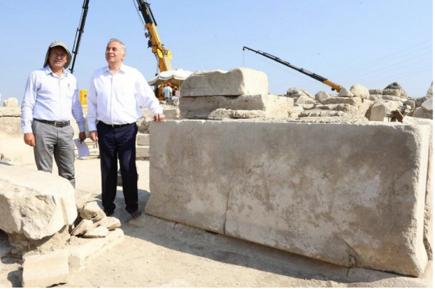
An ancient Roman water law inscribed in Greek on a large marble slab has been unearthed in Laodicea, Turkey, which appointed curators to oversee the city’s water supply and set fines for people who polluted or diverted the water.
An article in the Hurriyet Daily News says the city’s water supply is still controlled 1,900 years later. The law was passed by the Laodicea Assembly and approved by a Roman governor in Ephesus on behalf of the Roman Empire.
The marble block dates to 114 AD and detailed control of the water from the Karci Mountains, which arrived in the city through channels. It also delineated controls of a fountain that was dedicated to the Roman emperor Traianus. Anatolian State Governor Aulus Vicirius Matrialis wrote the rules, Hurriyet says. The marble slab upon which the laws are carved measures 90 by 116 cm (35 by 45 inches).
The fines were stiff, but the heaviest penalties were reserved for city personnel who failed to enforce the water laws.
Laodicea excavations chief Celal Şimşek of Pamukkale University, said: “Water was vital for the city. This is why there were heavy penalties against those who polluted the water, damaged the water channels or reopened the sealed water pipes. Breaking the law was subject to a penalty of about 12,500 denarius – 125,000 Turkish Liras.” As of August 2015, 125,000 Turkish Liras equal about $42,000.
“The fine for damaging the water channel or polluting the water is 5,000 denarius, nearly 50,000 Turkish Liras,” he said. “The fine is the same for those who break the seal and attempt illegal use. Also, there are penalties for senior staff that overlook the illegal use of water. They pay 12,500 denarius. Those who denounce the polluters are given one-eighth of the penalty as a reward, according to the rules.”
The inscription reads in part:
Those who divide the water for his personal use, should pay 5,000 denarius to the empire treasury; it is forbidden to use the city water for free or grant it to private individuals; those who buy the water cannot violate the Vespasian Edict; those who damage water pipes should pay 5,000 denarius; protective roofs should be established for the water depots and water pipes in the city; the governor’s office [will] appoint two citizens as curators every year to ensure the safety of the water resource; nobody who has farms close to the water channels can use this water for agriculture.
The excavations on Stadium Street in Laodicea are being carried out by Pamukkale University with support from Denizli Municipality.