Two-thirds of the water that originates in the Colorado mountains must go to downstream states and Mexico, recently retired State Supreme Court Justice Gregory Hobbs noted at the Water 101 seminar on Sept. 25 at the Pine River Library in Bayfield.
This includes Kansas, Nebraska, and New Mecico as well as Arizona, Utah, Nevada, and California.
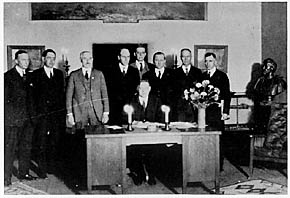
Herbert Hoover presides over the signing of the Colorado River Compact in November 1922. (Courtesy U.S. Department of Interior, Bureau of Reclamation)
“The legal doctrine is equitable sharing of interstate waters,” Hobbs said. This is governed by an assortment of interstate compacts, starting with the 1922 compact with three upper basin (Western Colorado and parts of Wyoming and New Mexico) and four lower basin states. Compacts are between states, but they become federal law when approved by Congress.
The 1922 compact dictates that 75 million acre feet, averaged over 10 years, must be delivered to the lower basin states. That’s measured at Lee’s Ferry in the Grand Canyon below Glen Canyon dam and Lake Powell. Seventy percent of that water comes from Colorado, Hobbs said.
There are nine interstate compacts governing Colorado water, he said…
Colorado transmountain diversions via the State Engineer’s office
Within Colorado, the hot issue for many years, at least on the Western Slope, has been trans-mountain water diversions to the Front Range. “We are one Colorado. Isn’t that the problem?” Hobbs asked. Before his 19 years on the State Supreme Court, he represented the Northern Colorado Water Conservancy District (northern Front Range) for 17 years.
“The water in these rivers is available to Colorado. There’s an overlay of federal supremacy,” he said. There are trans-basin diversions within the Colorado River Basin and around 24 diversions that go from Colorado headwaters to the east, he said.
Colorado water law is based on prior appropriation (first in time, first in right) and putting the water to beneficial use. A water right is conditional until it’s put to beneficial use.
The problem is, “If you can’t get your structure permitted by the Corps (of Engineers) or permits to cross federal land, you can’t put the water to beneficial use,” he said. “Getting the right is one thing; getting the permit to build the project is something else.”
Hobbs also listed a progression of federal laws – the 1862 Homestead Act to promote Western settlement, the 1866 Mining Law that severed water from federal lands and turned it over to states, and the 1902 Reclamation Act that opened the way for Western dam construction projects.
Colorado became a territory in 1861, he said. That year the territoriaal legislature created the right for settlers to build ditches to get water to their land that wasn’t next to the stream. It prevented corporations, railroads and land barons from buying up the river banks to control the water. In 1864, the legislature made prior appropriation the basis for water diversion and use.
San Luis People’s Ditch via The Pueblo Chieftain
The earliest ditch right was the 1852 People’s Ditch near San Luis. Ute water rights date to 1868, the basis for constructing the Animas/La Plata Project.
“Our (state) constitution from 1876 says the public owns the water. You get a right to use it by prior appropriation,” Hobbs said. “The most valuable rights in the state are water and ditch rights.”
He showed pictures of several historical hand drawn maps of rivers in the mountain region. One from 1841 showed a big blank space of unknown land. The land was considered vacant, at least to settlers coming from back East, he said, noting that Native Americans already lived “from sea to shining sea.”
Farview Reservoir Mesa Verde NP
Before all those maps, Hobbs showed a picture of Far View Village on Chapin Mesa at Mesa Verde and a nearby structure that he said was a water reservoir. There are four reservoirs at Mesa Verde and one at Hovenweep, Hobbs said. Paleohydrology is one of his interests. “I can’t teach about water law without talking about history, culture, governance. There are enduring problems that go way back,” he said.
“Everywhere across this country there are water features, because water is the basis of life,” he added
Hobbs was just appointed as Jurist in Residence at Denver University. He also serves on the Colorado Foundation for Water Education that publishes the quarterly Headwaters magazine and the Citizens’ Guide to Colorado Water Law.
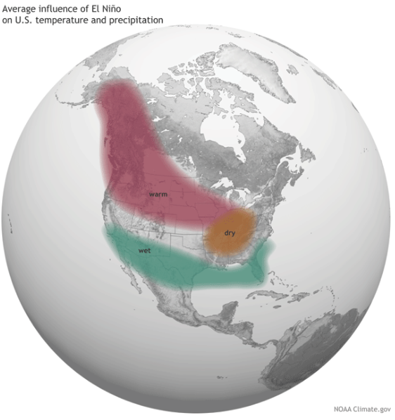
Average influence of El Niño on US temperature and precipitation
From the Fort Collins Coloradoan (Jacy Marmaduke):
…there’s another factor at play this season to complicate an already inexact science regarding El Nino. And it’s leaving even seasoned forecasters unsure what this winter will look like.
It’s called the Pacific Decadal Oscillation, and it only happens about every two decades. The combination of the PDO with a historic El Nino means the normal El Nino pattern might be thrown off course.
“In my 27 years, I don’t know if I’ve ever seen anything like this,” said Mike Baker, meteorologist and climate service focal point with the National Weather Service in Boulder…
The last two big-time El Ninos took place in 1997-98 and 1982-83. Both periods started out warmer and drier than usual for Northern Colorado but were punctuated by a small number of heavy snowfalls in the area.
Fort Collins averages 15 inches of rain and 47 inches of snow a year. Looking at each of the four years individually, those years brought above to well-above rain and two well-above average, one average and one below average snowfall. The most rain was in 1997, when Fort Collins last experienced a major flood, with 25.24 inches. That year also saw 75.9 inches of snow, second in those years only to 1983’s total of 81.7 inches.
A Christmas Eve blizzard in 1982 dropped about 24 inches of snow on Denver, although Fort Collins only received about 4 inches. A late October snowstorm in 1997 slammed Denver with more than 24 inches of snow and Fort Collins with about 18 inches.
Northern Colorado is less affected by El Nino than southern and southwestern Colorado, and even Denver. That’s because it’s further from the storm track, or the Pacific jet stream —a river of wind in the upper atmosphere that picks up storms.
“These little weather disturbances are carried along like leaves in a river, and these little disturbances when they move across an area produce the weather,” Baker said. “That’s why we don’t see weather all the time. We have to wait for one of those little leaves of energy to come by in the jet stream.”
The Pacific jet stream sets itself up along the coast where the water is relatively warmer, which is why storms come from the south during El Nino years.
Here’s where things get weird, though. Remember the Pacific Decadal Oscillation, the thing that happens every 20 years? It causes warmer water in the northern part of the Pacific, all the way from the Pacific Northwest up to Alaska.
So right now, the entire Pacific coast is warm and there’s no temperature gradient, which means the jet stream is wandering around like an awkward party guest, unsure where to sit down.
Whether Fort Collins gets any big snows depends on where the jet stream eventually finds a seat.
“We always tell the media, if the jet stream sags 50 miles, we’re gonna see nothing here along the Front Range,” Baker said. “If it sags a little farther north, we’re gonna get clobbered.”
Forecasters say the precipitation outlook for the next three months is indeterminable. The jet stream’s location might be farther north than normal for an El Nino period, its movement toward the U.S. might be delayed, or it may not set up at all.
“The fact of the matter is it’s always unpredictable,” said Nolan Doesken, state climatologist at the Colorado Climate Center. “People get all excited about a strong El Nino as if this will absolutely predict the rest of the late fall and winter … But it’s just one modifier of the otherwise beautiful and complex atmospheric-oceanic circulation system.”
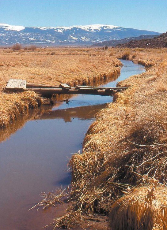
EPA spokeswoman Laura Williams said the agency is continuing to investigate samples taken from the creek to see whether the metal content in the water is higher than historic levels.
Officials said that samples collected did not show the presence of some of the metals the EPA tests for, but, as of Monday, they had not explained what metals were present in the samples and in what concentration.
The tests look for aluminum, antimony, arsenic, barium, beryllium, cadmium, calcium, chromium, cobalt, copper, iron, lead, manganese, magnesium, nickel, potassium, selenium, silver, sodium, thallium, vanadium and zinc.
The deluge of water from the Swathmore Mine on Sept. 21 temporarily turned the creek orange and led officials to briefly shut down water intake systems downstream.
Boulder and Nederland use the creek as part of their water supplies.
EPA officials said soon after the spill that the discharge from the mine was not toxic, but sent water samples for testing. They expect further results to be available later this week.
Todd Hartman, a spokesman for the Colorado Department of Natural Resources, said the mine has discharged at a “low flow rate,” less than 15 gallons a minute, for as long as the landowner can remember, but had apparently never surged before…
The Colorado Division of Reclamation, Mining and Safety has identified six old or abandoned mining sites in the county that impact water quality or likely do: Bueno, Emmett, Evening Star, Fairday, Captain Jack and Golden Age.
Four of the mines — Bueno, Emmett, Evening Star and Fairday — likely impact water quality, but currently have no active water treatment programs, records show.
Hartman said the six mines are designated as “legacy mines” because they were mined prior to modern mining reclamation laws that came into effect in the 1970s.
The Captain Jack Mill is designated as a Superfund site because of multiple contaminants, including lead, arsenic and thallium, along with several other heavy metals, according to the EPA.
Mary Boardman, a project manager with the Colorado Department of Public Health and Environment, said the Captain Jack Mill Superfund Site was added to the national priorities list in 2003 and a decision was made to begin clean-up in 2008. That project remains ongoing.
Hartman said the Golden Age Mine is still in the investigative stage, so officials can determine the best approach to managing it.
Boulder County has several waterways deemed “mine related impaired streams” and one state-run “nonpoint source mine reclamation project” that includes removing mine tailings, waste piles and restoring streams, according to the Colorado Division of Reclamation, Mining and Safety.
Hartman said “mining impacted” means the streams have been degraded by acidity or metals from a combination of mining sources and natural background geological sources in such a way that they fall below Clean Water Act Standards.
He said it’s difficult to determine how many old or abandoned mines are in Boulder County, but nearly 1,200 safety closures have been conducted in the last 25 years, and the owner of Swathmore Mine has asked that one be installed by the Colorado Division of Reclamation, Mining and Safety.
“Those are grates and other measures to prevent people and animals from entering (or) falling into old mines,” Hartman said.
Sure, Fountain Creek is going to flood from time to time.
But one landowner says that’s inevitable, and a district formed to improve the creek should be looking at using conservation easements to build a trail system from Pueblo to Colorado Springs.
“You could create an easement to connect the two cities,” said Jerry Martin, a Pueblo West Metropolitan District board member who owns property on Fountain Creek about 5 miles north of Pueblo. “It doesn’t solve flooding, but it helps mitigate the damage.”
Martin spoke at Friday’s meeting of the Fountain Creek Watershed Flood Control and Greenway District board.
Martin’s idea is for the district to secure easements, either through donations such as he is willing to do or by purchasing them. Martin, who chose to live in Pueblo West after working in Colorado Springs, said state funding is more likely if Pueblo and Colorado Springs can pull together for a common goal.
“My whole point is that we have a sow’s ear, but you can make a silk purse,” Martin said.
The district was receptive, and in fact already on the case.
Already, the district has secured Great Outdoors Colorado funding for trails in both El Paso and Pueblo counties, as well as recreational activities such as the wheel park on Pueblo’s East Side, slated to open in November.
Executive Director Larry Small noted that recreation has always been a purpose of the district, and is included in the strategic plan and corridor master plan.
Board member Richard Skorman added that the district is working to include the Fountain Creek trail as part of Gov. John Hickenlooper’s recently announced $100 million critical connections program for hike and bike trails.
“The designation would help,” Skorman said.
The idea of connecting Pueblo to the Front Range Trail via Fountain Creek goes back to then-Sen. Ken Salazar’s “Crown Jewel” vision in 2006. Skorman was a staffer for Salazar at the time.
“What can I do?” Martin asked. “I know it’s not a new idea, but one that I hope gets to the top of the list.”
“We’ve always felt we’ve been a stepchild,” Skorman said. “Colorado Springs and Pueblo need to push together. If we could get that (critical connection) designation, it could go a long way. We’re on a roll here if we can get this to work.”