Acid mine drainage long a problem for the waterways of #Colorado

Colorado abandoned mines

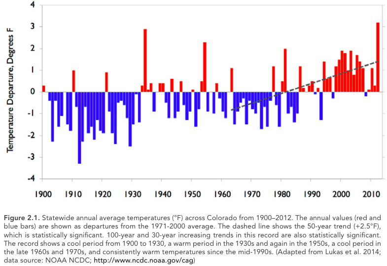
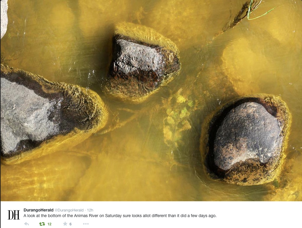
From The Denver Post (Bruce Finley):

Ninety miles west of Denver, 347 gallons a minute of acidic heavy metals leak into a tributary of the South Platte River every day from the defunct London Mine. Not even the bugs that fish eat have survived in South Mosquito Creek west of Alma, let alone the trout local leaders hope to restore for the South Park recreational economy.

The London Mine is one of many that leach toxic materials into Denver’s watershed. Municipal water treatment plants keep contaminants from flowing out taps in homes; ecosystems, however, continue to be poisoned.

For years, state agencies and contractors worked on a cleanup at the London Mine, including installation of a water treatment plant.

But the resurgent discharge into Denver’s watershed shows how difficult cleanup of old mines can be.

“You’re never going to walk away from these things,” said Bruce Stover, director of Colorado’s inactive mine reclamation program. “Things happen inside mines that are unpredictable. Wood can rot. There’s rock stress. Old mines are constantly changing. Gravity rules.

“You cannot just cork these up so it all goes away. That’s not going to happen.”[…]

On Tuesday, state lawmakers at a legislative committee hearing began investigating the broader problem. Colorado health and natural resources officials told them it is so complex that state agencies have yet to prepare a full inventory and assess which mines are most prone to the kind of blowout that occurred Aug. 5 at the Gold King Mine above Silverton…

Other mines in the metro Denver watershed where state records show continuing contamination of streams and rivers include:

• The Perigo Gold Mine near Nederland discharges toxic liquid at a rate of 174 gallons per minute into Gamble Gulch, which flows into South Boulder Creek above Gross Reservoir, according to a March 2015 assessment by the Colorado Division of Reclamation, Mining and Safety.

In 1993, the Colorado Geological Survey conducted a study of inactive mines on U.S. Forest Service land west of Boulder and ranked cleanup at the Perigo Mine the top environmental priority. In May, backed-up water behind a collapsed portal surged out, spewing several thousand gallons of carrot-orange acid metal-laced water. State records show another blowout in 2011.

• At the Waldorf Mine west of metro Denver, a blowout in 2013 triggered a cascade of hundreds of gallons of orange liquid waste into Clear Creek. State officials said elevated levels of zinc and lead have leaked from this mine for years, about 70 gallons per minute, and records show cleanup is not completed. A mine opening “continually drains and intermittently discharges large surges of contaminated water that erode the mine waste pile.”

• At Geneva Mine above Georgetown, a “belch” in 2013 sent a surge of metals-laced drainage that turned Geneva Creek yellow.

• At the Puzzle Mine above Breckenridge, EPA and state officials have known since 2006 about draining water, at least 50 gallons a minute, laced with zinc and cadmium at levels several times higher than the state standard, records show. A few years ago, Breckenridge residents watched the Blue River turn orange after ice melted inside the mine and pooled contaminants gushed through town toward Dillon Reservoir…

Colorado Sen. Michael Bennet has supported action to encourage cleanups by shielding companies and conservation groups from liability, but he has not committed to help create a national cleanup fund drawn from mining industry royalties. Heinrich said he’ll press Bennet, D-Colo., and Republican Sen. Cory Gardner for support.

Bennet’s staffers say the senator is supporting efforts to reform the mining law, including charging mining companies royalties to create a cleanup fund and he is “working with” Heinrich and New Mexico Sen. Tom Udall.

Environmental groups contend that, beyond liability reform, better funding is essential to deal with the West’s estimated 500,000 inactive mines, which have tainted 40 percent of watersheds at a time when residents increasingly seek more water.

“The federal and state governments should wake up and fix the problem before more spills occur,” said Alan Septoff of Earthworks, a Washington D.C.-based advocacy group. “This matters because the mines drain acid into water that we use for drinking and that drives economies, like the economy in La Plata County.”

Colorado officials said they do as much as they can with limited legal power and resources.

“We know where the draining mines are, but a statewide prioritization has not been done. That’s something we’re talking about now,” Stover said.

Nor does the state keep a list of mine site owners. Most owners are not “viable” as sources of funding for cleanups, state natural resources spokesman Todd Hartman said. Only the EPA can determine whether “potentially responsible parties” may exist and are viable, he said.

Meanwhile, three or four inactive mines blow out each year, spewing backed-up metals-laced waste into waterways. That’s in addition to trickles and seeps from scores of inactive mines that, by state and federal estimates, inject the equivalent of a Gold King disaster every two days.

County wins money for reservoir study — Montrose Daily Press

From the Montrose Daily Press (Katharhynn Heidelberg):

Montrose County on Thursday nabbed a significant award from the Colorado Water Conservation Board, which unanimously approved a combined total of $300,000.

The money from the state’s Water Supply Reserve Account will be used to help fund a feasibility study of up to four possible reservoir sites on the West End. The county will spend $966,000 on the study, which was included in its annual budget.

The conservation board, as part of its Montrose meeting, awarded approval of the funds on the condition that some of the money be spent to assess the effect each proposed site will have on recreational uses, especially rafting, on the San Miguel River.

The county is glad to comply with the condition, and would have noted that on its application had the form allowed for it, Marc Catlin, Montrose County’s water rights manager, told the board.

“If there’s going to be a future on the West End, those people are going to need water,” Catlin said.

The county needs to determine where and how reservoirs would be built to impound the water it secured under a 2012 water rights decree.

“It’s the result of two and a half years of hard work and paying attention to detail, wanting to do the right thing,” Montrose County Commissioner Ron Henderson said later on Thursday.

“It’s finally starting to pay off. It’s just a really nice thing for the West End of Montrose County, actually, the whole county, but most especially the West End.”

Montrose County in a controversial move previously filed for water rights on a 17.4 stretch of the San Miguel. Under settlements reached, the county agreed to a volumetric use limitation of 3,200 acre-feet. An acre-foot is roughly the amount of water it would take to cover a football field at a depth of 1 foot.

Conditions of the water right decree include a means of capturing and impounding the water. The county, which is considering four possible sites for a reservoir, needs to know the best place to site it and therefore applied for funding to offset feasibility study costs.

It sought $50,000 from the Southwest Water Board and $250,000 from statewide accounts, both to be approved by the conservation board.

April Montgomery, a conservation board member representing the San Juan and San Miguel basins, on Thursday commended the county and Catlin for having been proactive.

“I think it’s setting an example,” she said, referring to the county’s feasibility study. The county showed forethought in looking at multiple uses, Montgomery said.

Fellow member Patricia Wells, representing the City and County of Denver, called Montrose County’s approach commendable.

“It’s simply a very good approach,” she said.

“Storage is part of the answer for the future,” Catlin later told the Daily Press. “The state’s moving toward multiple use. I think this is the first project that is investigating multi-use at the feasibility stage.

“It’s a good thing for the community.”

Ouray County also won funding, $50,000, from the board. The money will help fund the upper Uncompahgre Basin water supply protection and enhancement project.

A call on water in 2012 served as a wakeup call, Ouray County Attorney Marti Whitmore told the board. That dry year brought to the forefront the need to plan for accommodating needs, while also sustaining agriculture and tourism, industries that are part of Ouray County’s economic backbone, she indicated.

Whitmore said she anticipates that Ouray’s study will show a need for additional water storage.

The board awarded 15 Water Supply Reserve Account grants Thursday.

“We passed all the grant applications. There was about $5.5 million, total, in grant applications we approved,” said James Eklund, Colorado Water Conservation Board director.

#ClimateChange: Governor Hickenlooper announces Colorado Climate Plan

coloradoclimateplancover092015
Here’s the release from Governor Hickenlooper’s office:

Gov. John Hickenlooper, business and industry leaders and department directors today released the Colorado Climate Plan, a statewide strategy of policy recommendations and actions to mitigate greenhouse gas emissions and to increase Colorado’s level of preparedness.

“Colorado is facing a potential increase in both the number and severity of extreme weather events,” said Hickenlooper. “We’ve seen what Mother Nature can do, and additional risks present a considerable set of challenges for the state, our residents, and our way of life. This comprehensive plan puts forth our commitment from the state and sets the groundwork for the collaboration needed to make sure Colorado is prepared.”

Colorado has warmed substantially in the last 30 years and even more in the last 50 years, with projected temperatures rising an additional 2.5 degrees by 2050, as reported by Climate Change in Colorado: A Synthesis to Support Water Resources Management and Adaptation. Rising temperatures pose many challenges to Colorado’s environment, health, economy and infrastructure. In response to these risks, the state developed a plan for mitigating and adapting to a broad range of possible impacts from multiple sectors.

The Colorado Climate Plan focuses on seven main sectors including water, public health, energy, transportation, agriculture, tourism and recreation, and ecosystems. The plan also includes a chapter highlighting ways local governments and businesses are playing a significant role.

Some of the plan’s key recommendations include:

Water: Promote and encourage drought preparedness through comprehensive drought planning mitigation implementation; incorporate climate variability and change into Colorado’s Water Plan.

Public Health: Coordinate with the Colorado Department of Public Health and Environment, Public Utilities Commission, the Colorado Energy Office, and additional stakeholders to develop and implement a Colorado-specific plan to substantially reduce carbon dioxide emissions from fossil fuel fired EGUs, in accordance with the EPA’s Clean Power Plan; continue to assess potential correlations between vector-borne diseases and climate factors.

Energy: Assure the timely and complete attainment of the state’s RES 2020 goals; assist all utilities (investor-owned, municipal, and cooperative) in identifying and implementing best practices for integrating cost-effective renewable resources, both utility-scale and distributed; increase access to capital for commercial, residential, agricultural, and industrial customers seeking to improve the energy performance of their facilities.

Transportation: Promote and encourage fuel-efficient vehicle technologies and programs to reduce vehicle emissions; provide guidance to local governments on land use planning strategies to promote efficient use of public resources and reduce GHG emissions through compact, transit-oriented development that utilizes smart growth practices and complete streets.

Agriculture: Partner with research institutions and federal agencies to support producer’s efforts to mitigate and adapt to climate change through improved irrigation and efficiency and enhanced tillage practices.

Moving forward, the Colorado Climate Plan will serve as a roadmap for state agencies to confront some of the worst effects of climate change and identify priority actions. The state will work to ensure the plan complements other relevant efforts, including the Climate Change in Colorado Report, and the Colorado Climate Change Vulnerability Study.

Dr. Larry Wolk, executive director and chief medical officer of the Colorado Department of Public Health and Environment, said, “​The Climate Plan helps develop our strategies for protecting public health as our climate changes. It also demonstrates our commitment to reducing greenhouse gas emissions through EPA’s Clean Power Plan and Colorado’s own initiatives.”

“This plan outlines many steps state agencies can take – and are taking – to both reduce the emissions that affect our climate and prepare for the potential impacts that temperature and weather changes may have on our economy and lifestyle in Colorado,” said Mike King, executive director of the Department of Natural Resources.

Contributing agencies include the Colorado Department of Natural Resources, the Colorado Department of Public Health and Environment, the Colorado Energy Office, the Colorado Department of Transportation, the Colorado Department of Agriculture, the Office of Economic Development and International Trade, Colorado Tourism Office and the Department of Local Affairs, along with input from key stakeholders.

“This plan highlights the results to date of Colorado’s leadership in innovative energy production and efficient energy consumption,” said Jeffrey Ackermann, director of the Colorado Energy Office. “Our continued progress is reinforced by forward-thinking policies like the renewable energy standard, strong public-private partnerships and creative strategies to foster new market development.”

Public and private sector organizations also contributed to the plan including Apt Environmental, Colorado Municipal League, Colorado Solar Energy Industries Association, Colorado State University/ Colorado Water Institute, Denver Water, Fort Collins Sustainability Group, Rocky Mountain Climate Organization, Rocky Mountain Institute, The Nature Conservancy, Western Water Assessment/ CIRES/ University of Colorado, Southwest Energy Efficiency Project, Xcel Energy and 360 Colorado.

The plan, developed to meet the requirements of HB 13-1293, lays out many of the ways the state is working to find solutions. Each state agency that helped develop the plan will hold public engagement sessions specific to their agency throughout the coming year.

The Colorado Climate Plan, along with additional information related to the state’s response to climate change is available at http://cwcb.state.co.us/environment/climate-change/Pages/main.aspx.

Click here to read the report.

Statewide annual average temperature 1900-2012 via Western Water Assessment

#AnimasRiver: EPA considers treatment facility — The Durango Herald

Confluence of Cement Creek and the Animas River from the Coyote Gulch archives (11/21/2010)

From The Durango Herald (Peter Marcus):

Documents released this week highlight a bidding process that began a little over two weeks after last month’s spill. The request is for a subcontractor to begin work in anticipation of a treatment facility. Water would be piped from the Gold King Mine near Silverton to Red and Bonita Mine and the “future site” of a water-treatment plant in Gladstone.

The EPA tasked Environmental Restoration, LLC with the Request for Proposal. The contractor was performing reclamation with the EPA on Aug. 5 when an excavation error by the team at Gold King caused an estimated 3 million gallons of orange mining sludge to pour into the Animas River. Initial tests showed spikes in heavy metals.

Experts agree that the best solution is a treatment facility, though such a plant would be costly. The EPA offered no cost estimates for such a facility, nor would it say where the funding would come from. A reclamation expert with the Colorado School of Mines told The Durango Herald a temporary treatment plant would cost around $3 million…

“The issuance of a work order doesn’t mean that there has been a final decision to build a wastewater treatment plant. Agency staff initiated the RFP process immediately after the spill so that the procurement process would be well underway if that decision were to be made,” said EPA spokeswoman Christie St. Clair…

“The agency is conducting an analysis to determine if a temporary treatment plant provides a measurable benefit to water quality downstream in the Animas River,” St. Clair said. “The agency is closely coordinating with officials in Colorado, New Mexico, Utah, Southern Ute tribe, Mountain Ute tribe and Navajo Nation to develop a comprehensive, long-term plan for the Gold King Mine site.”[…]

“The system must be able to be operated all year at elevations between 11,400 feet and 10,500 feet. Extreme cold and heavy snow are to be expected and planned for. The system must be self-contained as there are no amenities on site,” the RFP says.

Meanwhile, the EPA on Thursday released a long-term monitoring plan to evaluate water conditions after the spill. Tests have continued to show that water quality has returned to “pre-event” conditions, though the Animas has long been plagued by inactive-mine leakage.

“This monitoring plan represents the next phase of this important work and reflects our commitment to continue working closely with state, local and tribal officials to evaluate the potential impacts of the spill,” EPA Administrator Gina McCarthy said in a statement.

The long-term plan calls for sampling for water and sediment quality, biological impacts and fish tissue under a variety of flow conditions at 23 sites in Cement Creek, the Animas and San Juan rivers and the upper section of Lake Powell within Colorado, Southern Ute Reservation, New Mexico, Ute Mountain Ute Reservation, the Navajo Nation and Utah.

Stakeholders, including state, local and tribal officials, have until Oct. 8 to comment on the monitoring proposal.

The goal is to begin long-term monitoring in the fall. Data would be collected for one year and reviewed to determine if additional steps are needed.

#AnimasRiver: NM Sec. of State claims that EPA kept Gold King Mine spill data secret for weeks

Bottom of Animas River at Durango August 8, 2015 via Twitter and The Durango Herald

From the Associated Press (Matthew Brown) via the Farmington Daily-Times:

U.S. Environmental Protection Agency officials refused for weeks to share water-quality data with their state counterparts following a blowout of toxic wastewater from a Colorado mine that fouled rivers across the Southwest, New Mexico’s top environmental regulator testified Thursday.

The move by federal agencies aimed to downplay the severity of the spill, hobbling the state’s response to the high levels of arsenic, lead and other contaminants involved in the spill, New Mexico Secretary of Environment Ryan Flynn said.

His criticisms, aired before a U.S. House committee investigating the Aug. 5 accident, offered more fodder for congressional Republicans eager to find fault with a federal agency they perceive as having an anti-business agenda…

EPA spokeswoman Laura Allen said water-quality test results were made public on the agency’s website as soon as they were validated. The EPA has closely coordinated with state officials and American Indians from the Navajo Nation, Southern Ute and Ute Mountain Ute tribes to keep them apprised of the test results, Allen said.

But Flynn said the EPA’s warning about the pollution came belatedly, and it was followed by incomplete testing data presented in a way that minimized the presence of contaminants above drinking-water standards. He called it a “PR stunt” by the EPA…

Flynn said he remained concerned about contaminated sediments harming the environment, and a long-term monitoring plan offered by the agency is inadequate. That echoed concerns raised by Navajo President Russell Begaye, who questioned the EPA’s role overseeing the response to a spill that it caused.

Thursday’s hearing before the House committees on Natural Resources and Oversight and Government Reform was the fourth this month examining the spill. Republican lawmakers have used the events to bash the EPA for its handling of issues ranging from climate change to the protection of streams.

Democrats have sought to put the focus on the mining industry and ongoing pollution from tens of thousands of abandoned mines across the country…

The Colorado spill came from a cluster of century-old mines in the San Juan mountains that together discharge an estimated 330 million gallons of toxic wastewater annually, EPA Administrator Gina McCarthy testified. That’s over 100 times more pollution than the Gold King spill.

“We were trying to get a handle on a situation that was growing increasingly dangerous,” McCarthy said. “This is not the EPA’s … finest hour. But I am here to tell you that we are taking responsibility.”

She added that mining companies contribute “close to zero” money to help clean up such sites, under an 1872 mining law that the administration of President Barack Obama has proposed to change…

McCarthy responded that she did not believe the law had been broken, but a review of the accident needs to be completed before a final determination. An Interior Department investigation of the spill is due in late October. The EPA Inspector General’s office is conducting a separate review.

From The Durango Herald (Jonathan Romeo):

The 3-million-gallon blowout of mine waste last month didn’t cause a massive die-off of trout in the Animas River, but wildlife officials are still concerned about the steady decline of fish populations over the past decade.

In August and early September, Colorado Parks and Wildlife crews conducted a survey of trout numbers in sections of the Animas near Durango and Silverton.

“We did it last year, and normally we skip a year,” Parks and Wildlife spokesman Joe Lewandowski said at the time. “But because of the spill, our biologists decided it’d be a good time to do it again, and see what’s going on.”

A prepared statement from the Parks and Wildlife on Tuesday said the survey did not show effects on fish from the mine spill, but the results did provide a “mixed picture” for trout.

In Durango, officials saw an increase in the overall biomass of fish, but aquatic biologist Jim White said that’s because Parks and Wildlife stocks about 40,000 fingerling trout every year.

Two segments – from the La Plata County Fairgrounds to the Ninth Street Bridge, and from Cundiff Park to the High Bridge – met the “Gold Medal” water status for biomass, a standard of 60 pounds of fish per surface area.

But overall, the river did not meet the Gold Medal status.

Fish greater than 14 inches improved slightly from 2014 – from nine to 11 fish per acre – but the Gold Medal standard is 12 fish longer than 14 inches or more per acre.

Parks and Wildlife officials said the number of large fish remains low, and trout have shown little signs of natural reproduction, issues that wildlife experts have been combating for almost 10 years.

Fryingpan-Arkansas Project operations update: Surplus supply going into water year 2016

From The Pueblo Chieftain (Chris Woodka):

What to do with all the water?

The Southeastern Colorado Water Conservancy District tackled the question Thursday by approving additional allocations requested by cities and farms in the Arkansas Valley.

But more than half of additional water brought in by the Fryingpan-Arkansas Project will be carried over to next year and added to next year’s allocations.

In May, the district allocated about 46,000 acre-feet (15 billion gallons), with about one-third going to cities and two-thirds to farms. But continued wet conditions added another 22,500 acre-feet to the amount available for allocation.

A total of 72,000 acrefeet were imported, but some of it goes for other obligations or to account for losses.

Wet conditions and the way water has to be delivered or accounted for cut down on demand for the additional water, Executive Director Jim Broderick explained.
Most cities had plenty of water in storage and not many places to store additional water.

“A lot of people were at their limit and not making request,” Broderick said. “It’s been a wet year and there is no place to put the water. Everything got full.”

The big exception was the Pueblo Board of Water Works, which did not take any water from the first allocation. Pueblo Water took 6,500 acre-feet. All told, cities added 8,200 acre-feet to their supplies.

The large canal companies downstream did not jump at all of the additional water either, because there was no way to store it for when it would be needed. About 2,600 acre-feet were allocated during the second round.

That still leaves about 11,700 acre-feet that was brought over from the Fryingpan River basin through the Boustead Tunnel into Turquoise Lake for later distribution in the Arkansas River basin.

“It will be applied to the first allocation next year,” Broderick said. “My guess is that a lot of the water is going to be available to agriculture.”

That could create a problem even with average moisture next spring, raising the possibility that water stored in excess capacity, or if-and-when accounts, could spill.

About 55,000 acre-feet of if-and-when water is stored in Lake Pueblo now, about one-quarter of the water in the reservoir.

Some winter water could also spill, if the amount exceeds 70,000 acre-feet. About 24,000 acre-feet are now in storage. However, winter water could be stored downstream as well.

Turquoise and Twin Lakes are nearly storing at capacity. Lake Pueblo is at 80 percent of capacity, but 145 percent of average for this time of year, according to Roy Vaughan, manager of the Fry-Ark Project for the Bureau of Reclamation.

If water conditions are typical, 26,000 acre-feet could spill next spring, but it is too soon to make an accurate prediction, Vaughan said. But he said most forecasts are calling for at least 100 percent of snowpack.

“Part of the question is are we bringing water in and using it that year, or are we storing it?” Broderick said. “For the past few years, we have been using other water and storing (Fry-Ark) water.”

Fryingpan-Arkansas Project via the Southeastern Colorado Water Conservancy District