Click on a thumbnail below for the WISE system map and Prairie Waters map.

WISE System Map via the South Metro Water Supply Authority

Prairie Waters schematic via Aurora Water.

Click on a thumbnail below for the WISE system map and Prairie Waters map.
Here’s the release from the US Army Corps of Engineers (Omaha District):
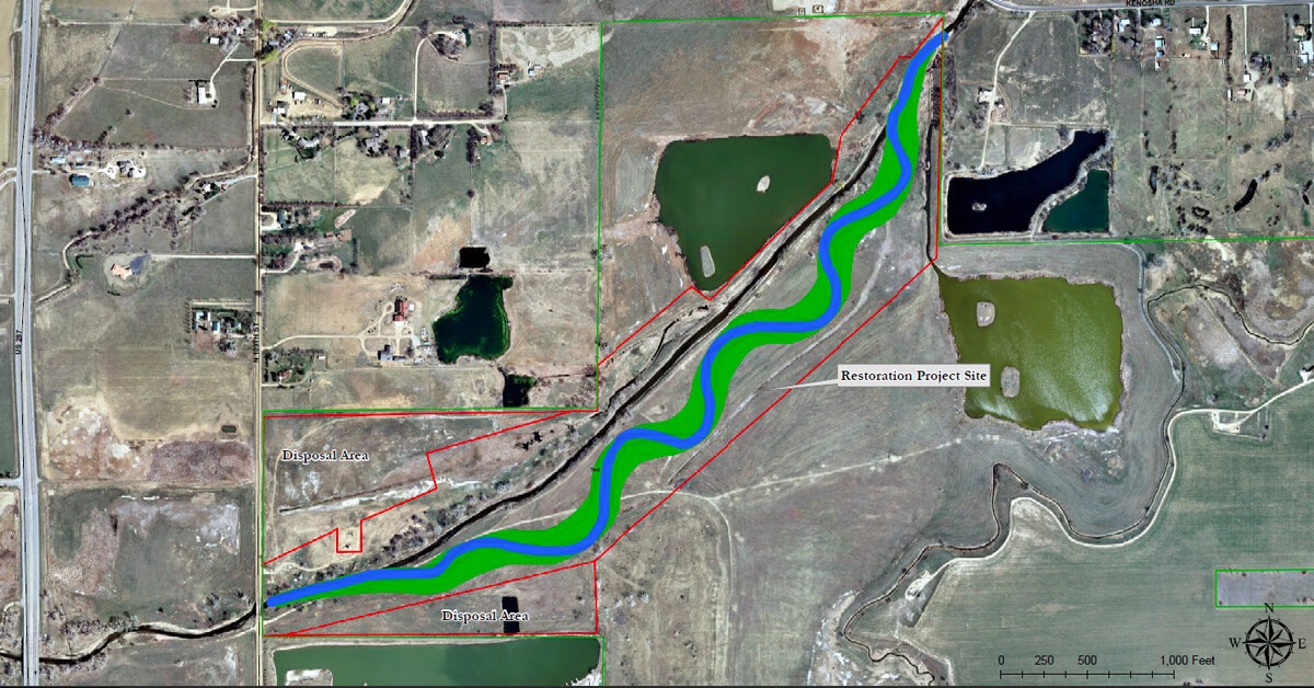
The U.S. Army Corps of Engineers, Omaha District, in partnership with the Boulder County Parks and Open Space Department, will hold a groundbreaking ceremony to celebrate the start of construction of an ecosystem restoration project along an approximately one-mile stretch of Lower Boulder Creek. The ceremony will take place on Thursday, October 8, starting at 12:30 p.m. MDT at the project site, which is located between N 109th Street and Kenosha Road in Boulder County approximately 3.5 miles west of the Boulder County-Weld County line and 8 miles east of the city of Boulder. Limited parking will be available along the Boulder County property access road located just east of the 109th Street Bridge. See attached map. In case of inclement weather, the ceremony will take place at the Goodhue Farmhouse located at the Carolyn Holmberg Preserve, 2009 S. 112th Street, Broomfield, Colorado.
BACKGROUND: Lower Boulder Creek once meandered across a broad floodplain that supported numerous wetlands, streamside vegetation, and associated native fish and wildlife populations. Since European settlement, the project reach and its associated habitats have been dramatically degraded by activities including upstream development, water diversions, pollution, non-native species, and gravel mining. During past on-site mining activities, the project reach of Lower Boulder Creek was channelized, and earthen levees were constructed along portions of its banks, thus disconnecting the channel from its historic floodplain and creating an impoverished stream and riparian environment. The project area is currently in a highly degraded state, which without active ecological restoration would take decades or longer to improve.
In 2011, the Omaha District completed a feasibility study which identified a feasible project to restore habitat for migratory birds and other wildlife, restore wetland and stream values, reduce invasive species and provide other ecosystem improvements. A construction contract was awarded to American West Construction LLC of Denver, Colo. for $2.6 million, which includes realigning the one-mile section of Lower Boulder Creek to restore natural meanders, in-stream habitat, and the creek’s floodplain and planting native riparian, wetland, and upland grasses, forbs, trees and shrubs along the stream and within the floodplain to greatly improve wildlife habitat. The project is expected to be complete by Fall 2016.
Click here to go to the Boulder County Open Space website for all the inside skinny.


Click here to go to the US Drought Monitor website. Here’s an excerpt:
Summary
Large sections of the nation experienced dry weather, reducing topsoil moisture but promoting summer crop maturation and harvesting. On the Plains, some producers awaited rain before planting winter wheat. Pastures in portions of the Southern and Mid-Atlantic States continued to suffer from the effects of late-summer and early-autumn dryness. In contrast, locally heavy showers soaked Florida’s peninsula and the immediate southern Atlantic Coast. Significant rain also fell—albeit briefly—in parts of the Midwest, providing localized relief from recent dryness. Above-normal temperatures dominated the Plains and upper Midwest, favoring fieldwork and helping to push summer crops toward maturity. The late-season warmth also extended across the Great Lakes region and into the Northeast. Meanwhile, cool air settled across the southeastern and northwestern U.S. for several days, helping to hold weekly temperatures more than 5°F below normal in a few locations. Elsewhere, locally heavy showers dotted the West, with the most significant rain falling in the lower Southwest, southern California, and the northern Intermountain region. California’s rain, heaviest along and near the coast, fell mostly on September 15 in conjunction with tropical moisture associated with former Hurricane Linda, while Southwestern rainfall was courtesy of Tropical Depression 16E later in the period…
Central Plains
Dry, unseasonably warm weather maintained or worsened dryness over the central Plains. With sunny skies and temperatures topping 80°F from Colorado into Kansas and central Nebraska, Abnormal Dryness (D0) and Moderate Drought (D1) remained or expanded. Precipitation deficits are most pronounced at 60 days, with rainfall tallying less than 50 percent of normal in D0 areas, and locally less than 25 percent of normal in the D1 region of central Kansas. The rain which has since fallen over the central Plains will be accounted for in next week’s drought assessment, as the data cutoff for inclusion into the assessment is Tuesday morning…
Northern Plains and Dakotas
Warm, dry conditions in eastern and southern portions of the region contrasted with showery, chilly weather farther west. Despite year-to-date precipitation averaging near to above normal, Abnormal Dryness (D0) expanded over southeastern South Dakota and immediate environs where 90-day rainfall has totaled 60 percent of normal or less (locally less than 40 percent). Similar precipitation deficits were noted in the newly introduced D0 over eastern Wyoming, while 60-day rainfall totaling a meager 15 to 40 percent of normal led to the expansion of Abnormal Dryness into southwestern South Dakota and northwestern Nebraska. Farther west, below-normal temperatures were accompanied by periods of rain (1-2 inches, locally more), though rain was generally not sufficient to alleviate longer-term (9 months and beyond) precipitation deficits…
Southern Plains and Texas
Despite areas of beneficial rain in the north and west, the overall trend toward intensifying “flash drought” continued. After record-setting rainfall over central and eastern Texas in May, sharply drier weather over much of the state during the summer resulted in rapidly deteriorating conditions despite longer-term precipitation surpluses. To illustrate, the 6-month precipitation in Texas’ core Extreme Drought (D3) area from just east of Austin to Nacogdoches still stands at 120 to 150 percent of normal. However, over the past 3 months, this same area has received a meager 10 to 20 percent of normal. With another hot, dry week, the drought intensity and coverage expanded over much of the Lone Star State. Exceptions included the Red River Valley, where rain totals greater than an inch resulted in localized reductions in drought intensity and coverage. Farther north, widespread moderate to heavy showers (1-3 inches) eased Abnormal Dryness (D0) and Moderate Drought (D1) over central and southern Oklahoma. At the end of the period, showers and thunderstorms were overspreading northern Texas and western Oklahoma, areas generally devoid of drought at this time…
Western U.S.
The overall trend toward drought persistence continued, though pockets of beneficial rain were noted in the northern Rockies, Pacific Northwest, and lower Four Corners. The west was generally cooler than normal, easing stress on pastures, crops, and livestock.
In the north, most of the region’s core Extreme Drought (D3) areas were dry. However, moderate to heavy rain on Washington’s Olympic Peninsula (2-4 inches, locally more) staved off D3 expansion. Farther east, 1 to 3 inches of rain eased drought intensity and coverage over central and southern Idaho, though northern portions of the state remained dry.
Across the California and the Great Basin, drought remained unchanged as the region continued through its climatologically dry summer season. Some showers associated with the remnants of Hurricane Linda were noted along the coastal regions of southern California, though the totals (mostly less than 2 inches) were not sufficient to warrant any reductions to the Extreme (D3) to Exceptional (D4) Drought.
In the Four Corners States, a late-season surge in monsoon rainfall was enhanced by moisture associated with Tropical Depression 16E, whose remnants tracked from Baja, Mexico onto the central Plains. While passing over the Southwest, the remnants of 16E generated 1 to as much as 4 inches of rain, resulting in reductions of Moderate (D1) and Severe Drought (D2) coverage in southeastern Arizona and southwestern New Mexico…
Looking Ahead
A cold front infused with tropical moisture will remain the focus for locally heavy showers, primarily from the southern High Plains into the upper Midwest. Additional rainfall in the vicinity of the front could reach 1 to 3 inches in a few spots. Meanwhile, a low-pressure system will drift westward toward the middle and southern Atlantic Coast, bringing a mid- to late-week increase in rainfall. Five-day rainfall totals could reach 2 to 5 inches or more in the Carolinas and parts of neighboring states. Warm, mostly dry weather will cover the remainder of the country, except for some late-week showers in the Northwest. The NWS 6- to 10-day outlook for September 29 – October 3 calls for the likelihood of above-normal temperatures nationwide, with near-normal temperatures confined to the Pacific Coast States. Meanwhile, wetter-than-normal conditions over the Southeast and from the north-central Plains into the western Corn Belt will contrast with drier than normal conditions across the central and eastern Great Lakes Region and from the lower Four Corners into central and northern Texas.

From The Pueblo Chieftain (Matt Hildner):
For the second time in 40 years, the state engineer has come up with rules and regulations for groundwater wells in the San Luis Valley.
The rules, which were submitted by State Engineer Dick Wolfe to the Division 3 Water Court Wednesday, aim to restore the valley’s two major aquifers and protect senior surface water users from the harm caused by pumping.
The rules would apply to roughly 4,500 high-capacity irrigation wells spread across the valley, with the exception of southern Costilla County, which is not above either aquifer.
Wolfe pointed to provisions that defined sustainable levels for the valley’s groundwater, noting they were a first for any of the river basins in the state.
“You see a lot of what’s going on in a lot of other parts of the Western U.S., particularly California right now, we’re going to look back on this time and say we’re glad we took this step,” he said.
The engineer’s office aims to return the two major aquifers to the levels that existed until 2000, when drought and persistent withdrawals sent them into steep decline.
Toward that end, the rules will require users of the confined aquifer — the deeper and larger of the two — to submit plans to achieve and maintain a sustainable water supply.
The rules would also give the engineer’s office the ability to shut down wells that are not operating under one of three options to mitigate pumping.
To avoid being shut down, well users could join a groundwater management subdistrict, in which its members pool resources to either buy water or pay surface water users for injury.
They could also take out individual augmentation plans for the same purpose.
Third, they could have a short-term temporary water supply plan.
The development of the sustainability section partly accounted for the six years Wolfe, his staff and upward of 100 valley water users took to come up with the regulations.
Developing the computer model that would eventually be used to calculate stream losses from groundwater pumping also took a period of years, Wolfe said.
But it is that computer model that could be one of the biggest differences from these rules and the version from 40 years ago that was never implemented.
“It was really apparent to me that we did not have the hydrologic knowledge to really effectively control wells,” said Mac McFadden, who served as division engineer in the valley in 1975.
After the water court publishes notice of the rules submission, there will be a 60-day period for objectors and supporters to file statements to the court.
Wolfe said he hoped to work out stipulations with objectors that would allow the court to avoid a trial.
It is possible that at least one group of water users in the La Jara Creek drainage will be among the objectors.
They sued the engineer’s office earlier this year, alleging the state’s computer model had failed to find pumping losses to a spring they depend on to irrigate.
Parties in that case are scheduled to meet in court Oct. 5 to determine if consolidation into the rules and regulations is appropriate.
From the Grand Junction Free Press (Hannah Holm):
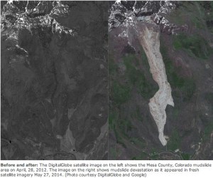
On the evening of May 25, 2014, the longest landslide in Colorado’s recorded history rumbled down the West Salt Creek drainage on the Grand Mesa, overtopped 2 adjacent ridges, and buried three men: Wes Hawkins, Clancy Nichols, and Danny Nichols. The men were investigating irrigation disruptions and safety hazards from smaller slides earlier that day.
Now, a detailed report of the landslide has been released by the Colorado Geological Survey and the Colorado School of Mines. The report describes the geological history of the location, what investigators believe actually happened during the slide, current conditions in the slide area, potential hazards, and recommendations for future risk reduction. You can download the report for free from http://coloradogeologicalsurvey.org/.
According to the report, melting snow and intense rainfall likely played a role in lubricating existing weaknesses in the underlying rock to send a “rapid series of cascading rock avalanche surges of chaotic rubble” down the slope. The toe of the slide, which just missed an active gas well, is 2.8 miles from the top, where a ½ mile wide block rotated and slipped free of the northern flank of Grand Mesa. At its deepest point the pile of debris is 123 feet deep.
The slide is located about 6 miles southeast of the town of Collbran, which sits along Plateau Creek downstream from its confluence with Salt Creek. In addition to the loss of life, impacts to the surrounding community include irrigation disruptions, loss of grazing land, and the ongoing threat of additional slide movement and the threat of a sudden release of water from a pond that formed at the top of the slide.
When the water level in the pond began rising quickly last spring, there was fear that the pond could overtop. Collbran residents were warned that they may need to evacuate, but then the water levels gradually diminished again.
The slide area is being intensively monitored, and so far there haven’t been any major movements beyond the settling of the debris field.
The pond at the top remains a concern. Several different scenarios could cause the pond to spill suddenly, sending large amounts of water and debris downslope and downstream. These include further slumping of the block of material that created the natural dam holding the water in place; exposed bedrock above the slide falling into the pond and causing a “mini-tsunami,” and simple overtopping that then erodes the bank holding the pond in place.
Alternatively, it’s possible that the slide will remain mostly stable and the water will find its way out less dramatically, gradually re-establishing the stream channel. Water is already beginning to percolate through the slide and emerge at the toe.
The report notes that it is very likely that similar slides have occurred in this area in the past, and that the existing inventory of landslides from published maps doesn’t capture the full story. New technology has made it possible to identify many old slides.
The report recommends conducting a comprehensive landslide risk assessment of the greater Plateau Creek Valley and other landslide-prone areas in Mesa County, as well as limiting development in hazardous areas.
This is part of a series of articles coordinated by the Water Center at Colorado Mesa University in cooperation with the Colorado and Gunnison Basin Roundtables to raise awareness about water needs, uses and policies in our region. To learn more about the basin roundtables and statewide water planning, and to let the roundtables know what you think, go to http://www.coloradomesa.edu/WaterCenter. You can also find the Water Center at http://www.Facebook.com/WaterCenter.CMU or http://www.Twitter.com/WaterCenterCMU.

From the Fort Collins Coloradoan (Jacy Marmaduke):
The Colorado Water Plan, more than two years in the making, reached the end of its final public comment period last week. Now, the Colorado Water Conservation Board is combing through an estimated 26,000 comments with the intent to respond to them and prepare a final draft for the Dec. 10 due date.
The hardest part, board members and water wonks say, will be whittling down the second draft’s 16-page list of goals into a shortlist of action items. The goals were derived from eight regional “basin implementation plans.”[…]
It’s too early to tell exactly which action items will make the cut for the final draft, but Eklund said it will prioritize conservation – the point at which every water conversation must start, as Gov. John Hickenlooper likes to say — and storage.
The plan will be action-oriented, Eklund said, although the document can’t directly instigate action. That power lies in the hands of Hickenlooper, government agencies and the Colorado Legislature. New water projects will need regional coordination and funding.
Fort Collins is part of the South Platte River Basin, which also includes Boulder, Windsor and Greeley. The South Platte Basin worked with the Metro Basin – Denver – to come up with a basin implementation plan.
The basin goals include:
Initiating new water storage projects, especially ones that integrate the South Platte River Finding alternatives to buy-and-dry, or the municipal purchase of farm land for water use Instilling stricter requirements for efficiency in plumbing fixtures, appliances and landscaping to conserve water There’s one thing the final plan won’t include: a transmountain diversion project. The second draft included seven tough criteria for evaluating proposals for those kinds of projects, and none of the basin plans advocated for one…
The [CWCB] wanted the plan to present a wide range of viewpoints in language that “you don’t need to be a Ph.D. water scientist to understand.”
From the Fort Collins Coloradoan (Nick Coltrain):
Fort Collins’ state legislators will host a forum on the Colorado Water Plan on Saturday.
The forum will include a panel discussion with local water experts and presentations. Time for audience questions, comments and ideas will follow. Sen. John Kefalas, and Reps. Joann Ginal and Jeni Arndt, all Democrats, will host the event.
The free event will run from 10:30 a.m. until noon Saturday at the Old Town Library, 201 Peterson St., Fort Collins.