Concrete barriers along the eroded creek bank in downtown Evergreen are still in place nearly two years after the 2013 flood that caused the damage.
Evergreen businessman Jeff Bradley, manager of the property, said he has obtained a permit from Jefferson County for the project, and has plans to restore the bank. Bradley said he also needs a permit from the federal government, although the project does not involve funds from the Federal Emergency Management Agency.
A few miles down Highway 74 at Lair O’ the Bear Park, a bridge restoration project dating from the 2013 flood is scheduled for this fall…
Another major bridge project is in the works at Evergreen Lake Park, which is owned by Denver Mountain Parks. The aging bridge that provides the only vehicle access to the park is scheduled for replacement next year. The Evergreen Park and Recreation District and the Evergreen Metropolitan District are each contributing $40,000 for the project, which is estimated to cost $790,000. The park district has added an additional $40,000 from Jeffco grant funding it received to assist with the bridge replacement cost.
The 2013 flood contributed to the deterioration of the bridge at the Lake Park, EPRD board member Peter Lindquist noted.
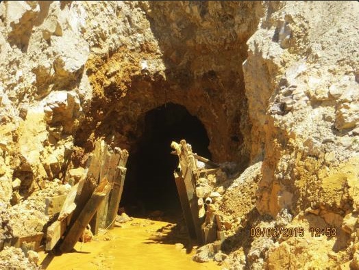
Silverton, Colo., lies an at elevation of 9,300 feet in San Juan County, and the Gold King Mine is more than 1,000 feet higher in the valley at the left side of the photo. Photo/Allen Best
But Superfund — the federal program designed to clean up America’s most toxic sites — usually only proceeds with community support. And in Silverton, that’s lacking. Even after the Aug. 5 spill captured national attention and reinvigorated downstream communities’ insistence that the leaky mines be cleaned up, locals continue to bristle at the suggestion of Superfund. “We’re a tourist area,” Bev Rich, a lifelong Silverton resident, told the Durango Herald in 2013. “You hear the word ‘Superfund’ site and 99 percent think ‘danger.’ So why would you want to go to a Superfund site?”
Those who support Superfund, however — including many residents of the downstream city of Durango — say that there’s simply no other way for the region to move beyond its toxic past. Travis Stills, a Durango lawyer who’s worked on and studied Superfund sites, thinks the problem is too politically entrenched (and expensive) to be handled by state or local authorities alone.
Fearn disagrees. The 71-year-old engineering consultant and former mine owner is one of the strongest voices in Silverton’s anti-Superfund contingent. In 1994, he helped form the Animas River Stakeholders Group to try to prove that acidic drainage from the watershed’s mines could be cleaned up without interference from the federal government. And in recent weeks, he’s explained to the New York Times and other national media why Superfund still isn’t right for Silverton. Among the reasons: a designation would stigmatize the town and turn away tourists. Litigation and bureaucracy could delay the clean-up. Property values could decrease, new mining ventures be deterred, and local input be ignored.
All are valid fears — but not entirely rooted in fact. True, the idea of visiting a Superfund site doesn’t exactly appeal to tourists, but neither does the idea of visiting a Superfund-eligible site. And any stigma seems not to linger after the project is completed: There was a Superfund project in Aspen, Colorado, where million-dollar homes now stand. According to the U.S. Environmental Protection Agency, a peer reviewed study found that residential property values within three miles of Superfund sites increased 18.6 to 24.5 percent after the sites were cleaned up and deleted from the National Priorities List…
…asking Congress for emergency funds to deal with a long-term problem is unrealistic, and the piecemeal approach the Animas River Stakeholders Group has used isn’t a long-term solution either. While the group has been been moderately successful — it’s relocated mine waste away from streams, bought water rights and diverted ditches, and completed more than a dozen mitigation projects that have helped bring fish back to a once-lifeless stretch of the Animas — it hasn’t solved the problem. After more than 20 years of work, the Gold King Mine alone continues to dribble 200 gallons of tainted water per minute. More than a dozen others have similar discharge.
A “get well soon” balloon floats in the contaminated waters of the Animas River flowing through Durango on Monday August 10, 2015 — photo The Durango Herald, Shane Benjamin
Mountain Studies Institute, a nonprofit scientific research organization with an office in Durango, found a spike in metals as the orange plume passed through Durango on Aug. 6. But that spike quickly returned to conditions similar to how the river looked before the incident, according to samples.
“We tried to digitalize the data so that people can … come to their own conclusions about whether they’re comfortable with those numbers or not,” said Marcie Demmy Bidwell, executive director of the institute.
“There’s currently a ‘distrust’ for government that exists in our community, no matter what,” she continued. “I can’t answer the question for people whether they should trust their government on that versus everything else.”[…]
Early tests released by federal, state and local government agencies found initial spikes in metals, including lead, arsenic, cadmium, aluminum and copper. But the river returned to either nondetectable or pre-plume levels within a week.
Tests released Saturday by Mountain Studies Institute reflect similar data distributed after government testing. The results represent sampling at Rotary Park from Aug. 6 through Aug. 11. The data results are from samples taken from the Animas before the arrival of the Gold King plume, during the event and several days after the plume passed.
MSI was the only group taking samples from Rotary Park. It has been contributing as part of a unified response effort along with government agencies.
“At these levels, you would need to drink 2 liters of Animas water four days a week, for 16 weeks, to possibly experience adverse, noncancerous effects of those metals over a long period of time, years later,” MSI’s report states.
A slight increase in metals from a sample taken at noon Aug. 9 was observed, though it did not exceed toxic water-quality levels. Researchers believe the increase was caused by more water flow after rain Aug. 7.
“This slight uptick speaks to the lingering concerns post-plume from the deposited sediments. We would expect to see slight increases in metal detections as we experience precipitation events this fall and with spring runoff next year,” the report states.
The study focused only on risks to human health, not impacts to fish and other wildlife. Colorado wildlife officials on Wednesday said trout tested from the river appear to be safe to eat.
The MSI data was compared to national recreational screening levels for long-term chronic exposure. The analysis took into account how a person would contact the river, for how long at each exposure and then how that is repeated over a length of time.
The levels shown in MSI’s data reflect EPA screening levels for surface water consumption by an adult or child who intentionally or accidentally ingests 2 liters of water per day, for four days per week, over a 16-week period. The levels are conservative, assuming a person drinks 2 liters of river water every day while swimming or boating four times a week and is exposed to the sediments by camping or living along the river bank for a continuous 64-day period…
It also explains that pH dipped as the plume passed in the first 24 hours, but then stabilized to normal levels previously seen in the Animas.
Only manganese exceeded water-quality levels, which is naturally high in the Animas. Many were especially worried about mercury, but that was barely detectable after the plume moved through, and that offers a positive sign to researchers. Still, they urge caution moving forward.
“We don’t know exactly how those sediments will respond, where they’ll be transported to … ” Bidwell said. “The way we interact with metals is complicated, unlike drinking water where there’s a clear path of how we connect with it … our exposure to the sediments is nowhere near as simple.”
Meanwhile “The Durango Bootleggers” have christened a new orange-tinted ale, “Heavy Metal EPA,” according to Jonathan Romero writing for The Durango Herald. Here’s an excerpt:
Durango’s microbreweries have concocted a new microbrew to commemorate the Gold King Mine spill that even those lacking Gov. John Hickenlooper’s strong gastronomical constitution shouldn’t be afraid to try.
“I guarantee he’ll say it’s safe to drink,” Ska Brewing co-founder Dave Thibodeau joked. The city’s six breweries, which operate under the moniker Durango Bootleggers Society when working together for charitable causes, will debut their newest beer on Friday: the Heavy Metal Extra Pale Ale. Or … the Heavy Metal EPA.
Thibodeau, pleased with the clever wordplay, said through a burst of mischievous laughter that even the beer’s color was made to replicate that of the orange plume that rushed through town Aug. 5.
The brewers experimented at Ska to capture the yellowish-orange tinge that sent the Animas River to the top of national and international headlines, and ended up adding strains of yeast to make the beer extra cloudy and hazy. “And that’s all intentional,” Thibodeau added, still short of breath with laughter.
All joking aside, Thibodeau said the real reason for the beer is to raise money for the Community Emergency Relief Fund (CERF), which donates to those directly financially impacted by the spill.
Of the more than 550,000 abandoned mines in the United States, Colorado is home to approximately 23,000 of those, according to the Colorado Geological Survey.
Boulder County sits on one of two mineral belts in Colorado. Known as the Colorado Mineral Belt (CMB), this strip of deposits extends some 250 miles north from the La Plata Mountains in the southwestern part of the state to Boulder County. It is the CMB that bore the lion’s share of the state’s silver and gold deposits.
The majority of Boulder’s mining industry was “hard rock” mining for minerals and precious metals such as gold, silver and tungsten. And while hard rock mining was lucrative, the process of exposing these metals created what has become one of the West’s most enduring environmental concerns — acid mine drainage.
Virginia Brannon, director of the Colorado Division of Reclamation, Mining and Safety, says that there are about 500 abandoned mining sites that create environmental issues statewide and about 220 of those affect waterways.
“The fact of the matter is that the vast majority of abandoned mine sites are actually just mine openings, and they are a public safety issue — and that’s most of what we have, especially in Boulder County,” Brannon says. “It’s not tailings piled up or soil that’s contaminated or waterways getting contaminated — it’s an old mine opening, and maybe people think it’s cool to go into those when in fact it’s extremely dangerous. Or people fall in — it’s happeend in the backcountry.”
Brannon says there are six abandoned mines in Boulder County with environmental, as opposed to public safety, issues; two have been remediated and have on-going treatment, while four have not been addressed.
“But none of them have direct flows going into waterways as is the case with Gold King,” Brannon says…
Summitville Mine superfund site
Colorado’s share of the burden
The EPA’s website says that as of March 2012, the agency was spending $30,000 per day to treat contaminated mine drainage at the Summitville Mine in Colorado, “which will cost an estimated $170 million to clean up.”
Located in Rio Grande County, just 25 miles south of Del Norte, the Summitville Mine was first excavated around 1870, according to the EPA. However, the area was mined out by the mid-1880s. The site was reopened a number of times in attempts to extract more gold, but traditional mining techniques proved unsuccessful.
The site wasn’t lucrative again until the mid-1980s, when a new company — the Summitville Consolidated Mining Company, Inc. — bought the area and used new techniques to extract gold by treating the ore with a sodium cyanide solution, which pulled gold out of the ore. The valuable metal was extracted from the resulting solution using activated carbon in a large pool known as a heap leach pad.
The EPA claims that a leak was almost immediately detected in the liner of the mine’s heap leach pad.
The state government issued the Summitville Consolidated Mining Company a cease-and-desist order in 1991 after high levels of heavy metals were found in surrounding waters, presumably due to the damaged pad liner in the heap leach pad. The mining company filed for bankruptcy in 1992 and the EPA assumed cleanup of the site, but it would be another three years before the site was placed on the National Priorities List of Superfund sites.
At the time they took over the Summitville Mine cleanup, the EPA estimated that 3,000 gallons of contaminated water were leaking from the site every minute. Troublesome contaminants included copper, cadmium, manganese, zinc, lead, nickel, aluminum and iron, which leaked into tributaries of the Alamosa River and eventually into the river itself. The contamination ultimately wiped out all life across a 17-mile stretch of the Alamosa River.
This year marks the fourth five-year review of the Summitville Mine site.
Troubling as it is, the Summitville Mine is only one such story of mining contamination in the state. Many of the state’s abandoned mines leak at consistent low levels throughout the year. Some release toxic wastes during the spring melt. Still others release large quantities of contamination in one fell swoop — in the early 1980s, a spill occurred at the California Gulch Superfund site near Leadville, Colorado, killing off aquatic life on the headwaters of the Arkansas River. In 2009, thousands of gallons of Tangcolored mining waste flowed into a 400-mile watershed at the North Fork of Clear Creek, again killing life along part of the river.
With 23,000 abandoned mines, limited funding for cleanups and mining sites located across public and private lands, the possibilities for disaster are daunting.
Big 5 adit
Trouble at home
With Boulder’s rich history of mining, the county has shouldered its share of mining’s toxic legacy.
Just a mile and a half south of Ward in Boulder County sits the Captain Jack Mill site at the headwaters of the Upper Left Hand Creek. The site includes a number of mines, the Big Five discharging tunnel, a waste rock pile and a settling pond.
To fully understand the problem at Captain Jack, you have to first understand the flow of water near the site: Left Hand Creek is fed by James Creek, which in turn is fed by Little James Creek.
Little James Creek is currently devoid of life, but full of arsenic, beryllium, copper, iron, lead, manganese and zinc — all mining products. Yet by the time the Little James meets James Creek, just a mile downstream, most of the metals have settled and aquatic life resides. Even further down, where James Creek meets Left Hand Creek, the water is even cleaner — but not before Left Hand Creek gets a dose of polluted runoff from abandoned mines at the Captain Jack site.
All of this is old news: complaints about the quality of water on Upper Left Hand Creek have accumulated since the first days of mining, but the federal government didn’t got involved at the Captain Jack site until September 1986, when the Mine Safety Health Administration (MSHA) found the owners of the site improperly storing chemicals at the mill buildings. The EPA sent an emergency response team to the site. They recovered and removed barrels of chemicals, and then the EPA began testing Left Hand Creek.
But it wasn’t until 1992 that the Colorado Mined Land Reclamation Division received reports that mill operators were dumping waste directly into Left Hand Creek. The EPA was alerted soon after when a Boulder County Health Department official noticed a milky substance in the water. Subsequent water samples reveled high levels of zinc, cadmium, copper and lead.
The Left Hand Water District temporarily shut down its intake value while the EPA cleaned up, and the Captain Jack Mill was soon shut down permanently. In 2003 the EPA decided that the risk was too large not to place the mill site on the National Priorities List as a Superfund.
And while all eyes are on abandoned mines in the wake of the accident at Gold King Mine, Brannon from the Colorado Division of Reclamation, Mining and Safety asks people to remember that it was only in 1977 that the federal and state governments created laws to regulate soft and hard rock mining practices.
“People tend to think there’s always a responsible party or there most be some kind of financial assurance or someone we can go after,” Brannon says. “And in these old mines where mining happened before we had laws to restrict their activities, we don’t usually have anyone to go after.”
Bonita Mine acid mine drainage
Meanwhile Governor Hickenlooper would request a superfund listing for the area around the Gold King Mine if locals support it. Here’s a report from David O. Williams writing for The Colorado Statesman. Here’s an excerpt:
“The governor would certainly consider making the request [to the EPA] if there is broad local community support,” Hickenlooper spokeswoman Kathy Green said, adding that the governor has had several talks with local officials and the EPA Superfund topic has come up…
The same amount of contaminated water that was discharged suddenly on Aug. 5, when workers breached a dammed mining tunnel, is flowing out of the Gold King approximately every four days and has been for years, according to the EPA, which puts the current discharge rate at between 500 and 600 gallons per minute.
State and federal officials say three more mines near Gold King — Sunnyside, Mogul and the Red and Bonita — are cumulatively discharging more acidic mine drainage, laden with heavy metals such as lead, zinc, cadmium and copper, than the Gold King. That contamination, dating back to the late 19th Century, has rendered the upper drainage devoid of aquatic life.
“Everything’s on the table: EPA Superfund or other remedies,” Silverton Town Administrator Bill Gardner told The Statesman on Wednesday. “We’ve got to find something that works, and the most important thing is that we do it right, and we do it right the first time so this doesn’t become some prolonged study and analysis and not taking action.”
EPA officials say NPL listing, which on average takes about six months from initial proposal if a site qualifies, can bring millions of dollars of federal funding into play for remediation, but it has to have local support.
“The Gold King Mine site has never been proposed to be listed on the National Priority List (NPL),” the EPA states on its website. “At this time we haven’t received any requests from the governor to propose listing this site on the NPL, which we look for as part of the agency’s policy and practice.”
One thing local officials don’t support is suing the EPA, which the Navajo Nation — downstream from the Animas along the San Juan River in northern New Mexico — is preparing to do. Colorado Attorney General Cynthia Coffman also is considering legal action against the EPA.
“Absolutely not,” Gardner said. “I think that’s the worst thing that we as a community could be involved in. What we’re interested in is partnering with the EPA and whatever other federal and state organizations are necessary to find a solution. Legal action is only going to delay any kind of real results.”[…]
Silverton’s Gardner said the EPA is “doing quality work up at the site itself to get us through this winter,” building holding ponds that are slowing the discharge of acid mining drainage so contaminants can settle and pH levels can be lowered. He said town and San Juan County staff will meet with the EPA on Friday to discuss more permanent solutions, such as a water treatment facility or other high-tech fixes for a problem that has plagued the drainage for decades…
“The Hazardous Materials and Waste Management Division has very limited authority and funding outside of the Superfund process,” CDPHE spokesman Mark Salley told The Statesman. “The most likely way sufficient funds will be available to address the issue is by listing the site on the NPL.”
Silverton and San Juan County officials are seeking federal disaster funds after Hickenlooper already made an official state disaster declaration, sending $500,000 in assistance.
Professor Mark Squillace, who specializes in environmental, natural resources and water law at the University of Colorado Law School, said the heated political rhetoric needs to be removed from the discussion.
“It’s fair to say that the Republicans have blocked efforts to set up a reclamation fund for these abandoned mines,” Squillace said, referring to the lack of congressional action on the 1872 Mining Act. Proposals to reform the law would establish a system of royalties for mining on public lands and use that revenue to set up a clean-up fund. “If the state were to sue over this, it would tend to politicize an issue that needs to be addressed in a more bipartisan and constructive way than litigation is likely to achieve.”
Squillace adds that Superfund listing could get private mine owners to contribute to the cleanup, easing the burden on taxpayers.
“It’s not just a federal fund that would have pay for the cost of the cleanup, but it’s also private parties that have some responsibility for creating the mess in the first place,” Squillace said.
The alignment of the Arkansas Valley Conduit project was updated for Prowers County Commissioners and interested citizens during an informational meeting on Wednesday, September 2. The $400M project, to move 15 million gallons of water per day to 39 entities between Pueblo and Lamar, was proposed in the early 1960s. Because of lack of funding, it has made little progress until the past several years. Jean Van Pelt, Project-Program Coordinator for the Southeastern Colorado Water Conservancy District, and members of the Bureau of Reclamation, described the latest plans, concentrating on the path the water conduit will take through Prowers County, leading up to the City of Lamar’s two water storage tanks south off of Memorial Drive. Van Pelt stated that the group was also seeking, ”Local input on different infrastructures or features they may not be aware of that could affect the alignment.”
Kevin Meader, Principal Engineer for the Conservancy District said, “The Bureau is working on the preliminary design. We started that a year ago after the record of decision was issued on the Environmental Impact Statement. At that time we identified the preferred alternative for the conduit. By next year, we’ll put together an updated cost estimate which will go to Congress for appropriations for final design and construction towards the end of next year. From that we can move into final design and we’re looking at about 2017 and 2018 and the initial bidding on construction contracts is expected by around early 2020.” He added that if Congress approves the cost, it won’t be funded all at once, but probably in $25M to $45M payments over several years. Van Pelt added that in 2011 Congress agreed to share the project costs with the communities on a 65%/35% basis, and the $140M balance will not have to be borne by the 39 entities. Construction would begin at Pueblo Dam and head east to Lamar with a junction to Eads. Holly, Bristol, Granada and Hartman are not included in the conduit plans as those communities decided to opt out of a contract with the S.E. Water Conservancy District when the project was first proposed over 50 years ago. Van Pelt, when asked if they could opt back in, replied the process would be lengthy and costly for each of the communities, and any work on the conduit would be stalled while the necessary studies were conducted on constructing those new routes.
Meader pointed out the water supply would be a supplemental, not a primary water source, which would become palatable only after each entity provided its own disinfectant procedure before making it accessible to the public. The water would be strictly for human use and not for any ag-related purposes. He added that water quality in some communities along the pipeline, such as La Junta, Boone or Fowler, has shown a need for a potable water source.
A $600,000 project to produce a flood restoration master plan for Monument Creek is in the works.
The Fountain Creek Watershed Flood Control and Greenway District at its August meeting agreed to manage the project, which will be funded by the Colorado Department of Local Affairs, Colorado Springs, El Paso County and the Air Force Academy.
A team headed by Matrix Design Group will identify areas of concern within the Monument Creek watershed that are at greater risk for flooding after the 2012 Waldo Canyon Fire and damage from heavy flooding in 2013.
“When we get this finished, this will completely develop a master plan for the entire Fountain Creek Watershed,” said Larry Small, executive director of the Fountain Creek district. “If all the plans are implemented, this will be a big benefit to lower Fountain Creek area as well.”
It will look at mitigating damage from the AFA, where tributaries were most heavily affected in the 2012 fire, to the confluence with Fountain Creek.
The Waldo Canyon Fire burned 346 homes in western Colorado Springs, leaving much of the 18,000 acres it destroyed susceptible to increased flooding and erosion. That has also created problems in Upper Fountain Creek watershed as well as Monument Creek.
Those two waterways join in Colorado Springs and flow to Pueblo through Fountain Creek.
A $437,500 study of Upper Fountain Creek and Cheyenne Creek restoration was launched last year and completed on June 30.
The Cheyenne Boulevard drainage improvement demonstration project, a $367,000 effort to reroute floodwater, has started as a result of the study. It will be managed by the district.
The master plan for Fountain Creek south of Colorado Springs was completed in 2011.
The Fountain Creek district was formed in 2009 to deal with problems throughout the entire 932-square-mile watershed. Pueblo and El Paso counties jointly form the district.
The master plan would attempt to identify areas of concern in the watershed that affect public health, safety, infrastructure or critical habitat for Preble’s meadow jumping mouse. It would develop a plan for restoration, including preliminary design and cost estimate.
The project is expected to be complete by the end of 2016.