Conejos River FromThe Pueblo Chieftain (Matt Hildner):
Water officials in the San Luis Valley will once again set up a temporary radar station this winter to help measure the region’s snowpack.
Although the technology was in use last winter, it’s hoped another season of gathering data from radar and other new technologies will eventually lead to a model that can more accurately translate snowpack to stream flows.
“No one in the country has ever used radar to measure snow,” Nathan Combs, manager of the Conejos Water Conservancy District, told a committee of state lawmakers Monday.
Getting an accurate prediction of stream flows is important for valley water users, who are often forced to forgo flows to help the state comply with the Rio Grande Compact.
Delivery obligations under the compact, which divvies up the river’s flows between Colorado, New Mexico and Texas, go up in wet years and down in dry years.
Combs told lawmakers in April the forecast for the Conejos called for 235,000 acre-feet of stream flow for the year, with a delivery requirement of 65,000 acre-feet for the compact.
But runoff was bigger than expected, boosting both stream flow projections for the year and the amount of restrictions on irrigators.
As of the beginning of the month, the Conejos’ stream flow projection had jumped to 255,000 acre-feet and its compact obligation grew by another 12,000 acre-feet.
Combs said that kind of jump is hard to deal with after runoff has come and gone.
“The farther we get down the season, the less water there is to pay this increased obligation,” he said.
Nor is an overestimation of stream flows any help.
“If we’ve overpaid early and then we go through and our stream forecast goes down, now we’ve sent all this water we can’t get back,” he said.
Combs said in the past the snow measurements and forecast data from the Natural Resources Conservation Service had not caused problems.
But that has changed over the last decade as forest fires, spruce-beetle infestations and increasing dust storms have changed the snowpack’s behavior.
Combs’ district has taken part in a pilot project funded by the Colorado Water Conservation Board and Rio Grande Basin roundtable that also added extra stream and snow gauges to the Conejos’ watershed.
Likewise, water officials have also been active in the revision of the Rio Grande National Forest Plan.
“We need more instrumentation in the wilderness areas,” said Travis Smith, who represents the Rio Grande on the state conservation board.
The tour and hearing with the Water Resources Review Committee did not include any funding requests for projects and was mainly a way for water officials to educate lawmakers about valley water issues, Smith said.
Sprawl Click here to read the newsletter. Here’s an excerpt:
LAND USE IN WATER DISCUSSION
Addressing land use patterns has recently become more central to the discussion over how to meet Colorado’s future water needs. For more details, see this Water Center column.
Here’s the release from the US Bureau of Reclamation (Justyn Liff/Jennifer Ward):
Reclamation announced today that it has released a draft environmental assessment for a hydropower project at Drop 5 of the South Canal, part of the Uncompahgre Project in Montrose, Colorado.
The project, proposed by the Uncompahgre Valley Water Users Association, will be located approximately four miles downstream from the Drop 4 hydropower project on the South Canal. A Lease of Power Privilege will authorize the use of federal facilities and Uncompahgre Project water to construct, operate and maintain a 2.4 megawatt hydropower facility and associated interconnect power lines.
The hydropower plant will operate on irrigation water conveyed in the South Canal and no new diversions will occur as a result of the hydropower project. Construction activities and operation of the hydropower plant will not affect the delivery of irrigation water.
The draft environmental assessment is available and can be received by contacting Jennifer Ward by phone at 970-248-0651 or email jward@usbr.gov.
Reclamation will consider all comments received prior to preparing a final environmental assessment. Comments can be submitted by email to lmcwhirter@usbr.gov or to: Ed Warner, Area Manager, Bureau of Reclamation, 445 West Gunnison Ave, Suite 221, Grand Junction, CO 81501. Comments are due by Monday, September 14, 2015.
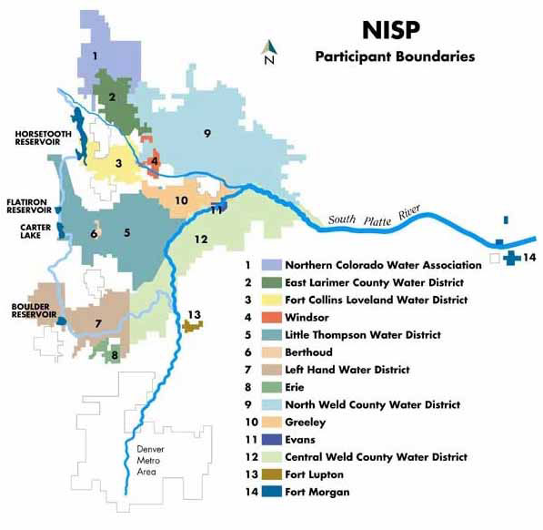
Map of the Northern Integrated Supply Project via Northern Water
From the Northern Water Twitter feed and FaceBook:
“The 15 Northern Integrated Supply Project participants and Northern Water are disappointed in the City of Fort Collins’ staff report pertaining to the NISP supplemental draft environmental impact statement.
“NISP participants have spent $12 million on the detailed SDEIS process. Under the direction of the Army Corps of Engineers, several expertly qualified independent consultants have thoroughly studied all aspects of NISP as reflected by the funding provided by the NISP participants to complete those studies. Two different consultant teams have independently studied the issues surrounding water and wastewater treatment and have concluded that NISP will have little to no impact on the City of Fort Collins operations. As a result of these efforts, we had sincerely hoped that staff would have had a more favorable opinion of those analyses and of the SDEIS as a whole.
“As planned by the Corps, in addition to the river water quality evaluation completed for the SDEIS, detailed water temperature and water quality analyses will be completed prior to the release of the Final EIS.
“We are very pleased that NISP has received more than 100 endorsements from throughout the state including the Fort Collins Coloradoan editorial board, BizWest, the Fort Collins Area Chamber of Commerce and the Larimer County commissioners.
“The NISP participants and Northern Water look forward to establishing working groups with both the City of Fort Collins and the City of Greeley to develop measures to address their concerns and further enhance the Poudre River.”
Outdated hard-rock mining laws enacted in the 1870s tie the hands of the federal government to curb pollution that contaminates water supplies, as was the case with the Gold King Mine spill.
Perhaps the most significant deficiency comes in the form of a “free and open” provision of the Mining Law of 1872, otherwise known as a “right to mine.” Limited reforms have been made to the law over the last 143 years, leaving in place a provision that prohibits the federal government from blocking a mine from opening or even collecting royalties from operations.
The law also left little to government regulation, falling in line with the theme of Manifest Destiny from Western expansion in the 19th century. When the nation’s mining laws were crafted, the goal was settlement, not environmental regulation.
“The 1872 mining law is the freest ride of all free rides on the books,” said Roger Flynn, an adjunct professor at the University of Colorado School of Law and the director and managing attorney of Western Mining Action Project, a nonprofit that handles hard-rock mining cases…
Just who holds the liability remains unclear. Flynn said some of the responsibility rests with the mine’s owner, Todd Hennis. Some liability also may fall on the EPA, which became a sort of operator when it began working there.
But it’s much more complicated than that. Gold King, near Silverton, became inactive in the 1920s. But the neighboring mine of Sunnyside also is entangled in the web. The mine became inactive in the 1990s, and ownership at the time reached an agreement with Colorado to install bulkheads in the mine. Since that mine was dammed, wastewater in nearby mines has increased.
Sunnyside Gold Corp., a subsidiary of Kinross Gold, entered into a consent decree, allowing for the mine to continue to leak heavy metals, while the company agreed to costly reclamation projects.
Judging by the disaster earlier this month, overall efforts have not been enough, which begs the question: How did it get to this point?
The simplest answer is money. The Mining Law of 1872 allows companies to extract billions of dollars worth of precious metals – such as gold and uranium – pay no royalties and avoid liability for environmental damage in several situations. Without the royalties, there is limited government funding for reclamation, and few burdens are placed on the companies themselves.
Over the years, beginning in the 1970s, the federal government began to take action on environmental issues, enacting laws around clean water and endangered species. But companies have found loopholes. One example is hiring experts to vouch for water quality.
Because the federal government is charged with the “free and open” provision under mining laws, officials often default to this clause. In other words, if the experts say the water is safe, and the government is obligated to let a company operate, then there’s little recourse for regulators.
An option for reclamation is declaring an area blighted with a Superfund listing, which opens the doors to funding. But as was the case with Gold King, communities sometimes resist the federal listing, as they fear it leaving a stain. Flynn said the end result is a government that is rendered impotent.
“The 1872 mining law makes mining the highest and best use of the land,” he said. “Whatever minerals you find on that are free. … Agencies will say we can’t say no to the mine no matter how destructive, unless you can prove there will be a Clean Water Act violation on Day 1.”
The irony, of course, is that those violations don’t occur until well after operations have begun.
“The feds don’t have the ability on public land to say no – no matter how bad the idea is, how bad the place is – because of the 1872 mining law,” Flynn said. “So, they permit these things all over … and they allow potential pollution.”[…]
State Rep. Don Coram, R-Montrose, is not so sure that the answer is additional regulations, suggesting that there are new technologies out there that allow for cleaner mining activities. Coram has years of experience in hard-rock mining, having owned several mines, including uranium.
“I don’t think the problem lies with what we’re doing today. … That changed. We do a lot better,” he said.
“I’m not comfortable with the EPA being in charge,” Coram said. “I would much rather that federal funding goes into letting the state run those projects.”
Meanwhile Durango and parts thereabouts are worried about the spill and its affect on the economy. Here’s a report from Jonathan Romeo writing for The Durango Herald. Here’s an excerpt:
Some fear the frenzy of images broadcast around the world when the Animas River turned a sickly orange for more than 12 hours could have an effect for years to come.
“Stigma is the perception of the public, even after fixing the problem,” said Tom Alleman, an attorney at Dallas-based Dykema Cox Smith. “The Animas had brand damage.”
Alleman told the crowd of about 20 people Friday at the DoubleTree Hotel that the state of Colorado does allow individuals to file claims for compensation for stigma damages, but those kinds of situations aren’t common and can be subjective.
He said the law lists stigma damage as an event that is not “reputationally enhancing,” and in the case of the Gold King Mine spill, that might be easier to prove.
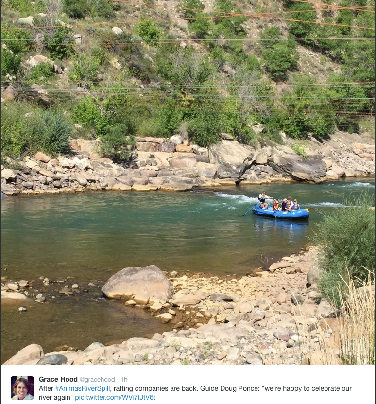
Jack Llewellyn, executive director at the Durango Chamber of Commerce, said it’s too early to tell the long-term effect the spill will have on the city’s tourism industry, but there is no denying the hit river-related businesses took in the immediate aftermath of the blowout.
“We definitely saw an impact, and it directly affected the river-rafting industry. It was like shutting down Main Street at Christmas time,” Llewellyn said, referencing the fact that August is a critical revenue month for summer tourism businesses.
Llewellyn added that just the other day, a woman bringing 20 senior citizens to the area called ahead to ask if the water was safe to drink, and it’s that skepticism he fears might influence other visitors to choose a different destination when making vacation plans.
Durango & Silverton Narrow Gauge Railroad Owner Al Harper said the train suffered some cancellations at first, but ridership rebounded rather quickly. Most of the railroad’s projected 183,000 riders come from outside Durango.
He’s more concerned about how stakeholders of the mining network north of Silverton will implement a wastewater-treatment plan.
And that brings in yet another layer of “stigma” in connection to the Gold King Mine spill: a Superfund listing, which is an EPA program that cleans up hazardous waste sites.
Since the spill, there has been considerable pushback from Silverton residents who believe visitors will fear and avoid the small tourism town if it is designated a “Superfund” site and prefer to explore other options.
However, those in favor of the Superfund argue the stigma of a town that refuses to clean up once and for all a history of unregulated mining regulations that have tainted the Animas for decades is far worse.
Harper, who also owns a hotel in Silverton, said residents of the town may be more open to the Superfund designation if the EPA draws clear lines of where the boundary extends.
“Let’s face it, the city limits of Silverton have not been polluting the river,” he said. “We need to make clear the mining area is a Superfund; Silverton is not.”
If you’re following the legal fallout from the Obama Administration’s finalization of its initiative to protect critical streams and wetlands – called the Clean Water Rule – you were probably on the lookout for action this week. (And, you’re a bit odd. It’s OK – me too.)
That’s because the rule, which the Environmental Protection Agency Administrator, Gina McCarthy, and the Assistant Secretary of the Army for Civil Works, Jo-Ellen Darcy, signed back in May, was scheduled to take effect today.
That didn’t entirely happen as planned, due to a single court ruling yesterday. More on that in a minute, but first some background to provide context for my ultimate message in this post: this is just part of the process, and there is no need to overreact to a preliminary ruling in one case…
What Happened [last] Week
In the run-up to the rule’s implementation date today, a number of the parties that sued the agencies claiming that the rule is too protective of the nation’s water resources asked four trial-level courts to block the rule from taking effect. One of these courts, in Oklahoma, where two cases were pending, granted the federal government’s request weeks ago to put those cases on hold while the government seeks to have the cases transferred and consolidated in Washington, DC. The other three courts – located in Georgia, North Dakota, and West Virginia – all issued rulings this week. (All but one of the remaining district courts with pending challenges from state or industry opponents have postponed any further proceedings in the cases, at the federal government’s request. Similar requests are pending in the challenges that the conservation groups have filed.)
Of the three courts that issued rulings this week on opponents’ requests to delay the rule, two of them, the Northern District of West Virginia and the Southern District of Georgia, both refused to grant the delay and held instead that the cases should be heard by the appellate court.
That leaves one court – the District of North Dakota – which ruled yesterday that it both has the jurisdiction to decide the case and that it should temporarily prevent implementation of the rule while the case is more fully argued. The court concluded that the state plaintiffs in that case, led by North Dakota, were likely to prevail on their legal claims that the rule was too protective, and that the states would be harmed by the rule taking effect.
Although we are still reviewing the decision closely and evaluating our options for next steps, we profoundly disagree with the court’s conclusion that the extraordinary remedy of an injunction is justified here, and are disappointed that the rule’s implementation will be delayed, at least to some extent. Every day the rule is not in force in a given place, the streams, ponds, and wetlands that people swim in, fish from, boat on, and depend on for drinking water are at unnecessary risk of being polluted or destroyed.
At the same time, let’s see this ruling for what it is – a temporary delay in one of a dozen or so cases. Indeed, the agencies have explained that the Clean Water Rule will take effect today for those states not involved in the North Dakota litigation. And, even in that case, proponents of the Clean Water Rule will have additional opportunities to explain why the rule’s safeguards are well within the bounds established by the Supreme Court and are supported by the voluminous scientific evidence of the importance of the waters that the rule protects.
Consider a recent point of reference: the Affordable Care Act was found to be invalid by some different courts when it was similarly challenged in a number of places. At the end of the day, however, it was twice upheld by the Supreme Court, and is now the law of the land.
Cases such as that, plus the certainty that the Clean Water Act authorizes the agencies to protect those water bodies that significantly affect downstream waters, give me confidence that, despite the delay in this instance, the cases attacking the rule as too protective will ultimately fail. When that happens, the rule will remain in place with necessary protections for the health and well-being of our families and communities, as well as our prosperous fisheries and tourism industries.
Here’s the release from the Center for Biological Diversity (Rex Tilousi, Sherry Counts, Art Babbott, Art Goodtimes, Anne Mariah Tapp, Katie Davis, Bonnie Gestring, Matthew Sanders):
In the wake of the toxic spill in the Animas River earlier this month, tribes, local governments and environmental groups today petitioned the Department of the Interior and Department of Agriculture to reform outdated mining rules on the federal lands they manage. The 74-page petition requests four key changes to federal mining regulations to help protect western water resources from future environmental disasters like the recent Gold King Mine spill in Colorado, and ensure that mine owners cannot simply walk away from existing and inactive mines.
“The Hualapai Tribe supports the petition to make long overdue changes to the mining regulations,” said Councilwoman Sherry Counts of the Hualapai Nation. “Indian tribes have always viewed themselves as stewards with an obligation to take care of the Earth that has provided for them. The Animas disaster only accentuates the urgency for federal agencies and the mining industry to do a much better job of protecting our precious land, air, and water.”
The petition, submitted under the federal Administrative Procedure Act, requests that the Bureau of Land Management and U.S. Forest Service reform existing mining rules by: limiting the lifetime of a mine permit, imposing enforceable reclamation deadlines and groundwater monitoring requirements on mines, requiring regular monitoring and inspections, and limiting the number of years that a mine can remain inactive.
“As a county with hundreds of abandoned mines affecting two headwaters rivers of the Colorado Basin, we really place a high importance on sustainable uses of our public lands and protecting water,” said Art Goodtimes, a commissioner in San Miguel County, Colo. “The proposed rules will help ensure that existing and inactive mines are reclaimed in a timely manner and the environment will be better protected than what happened with our San Juan County neighbors.”
“The Animas River disaster must mark the end of the days where irresponsible mining threatens our region’s livable future,” said Anne Mariah Tapp, energy program director for the Grand Canyon Trust. “Our coalition’s petition provides the federal agencies with a reasonable path forward that will benefit western communities, taxpayers, water resources, and our most treasured landscapes.”
The threat that uranium mining poses to the Grand Canyon prompted the support of many regional governments for regulatory reform. Uranium mines in the Grand Canyon region are operating under environmental reviews and permits from the 1980s, with no requirements for groundwater monitoring once mining is complete.
“The Havasupai Tribe supports this petition that will better protect our aboriginal homelands and the waters that flow into our canyon home,” said Rex Tilousi, Havasupai tribal chairman. “This petition is an important part of our decades-long fight to protect our tribal members, homeland, and sacred mountain Red Butte from toxic uranium mining contamination.”
Along with the threats posed by existing mines, there are hundreds of thousands of abandoned mines in the United States that pollute an estimated 40 percent of streams in the headwaters of western watersheds. Most of these toxic mines, including the Gold King Mine, exist because the 1872 Mining Law, still the law of the land, didn’t require cleanup.
“If we are serious about the protection of the Grand Canyon and Colorado River water resources, we need to call for change,” said Art Babbott, a county supervisor in Coconino County, Ariz. “Common sense reforms to the federal agencies’ mining regulations and the 1872 Mining Law serve the interests of healthy watersheds, strong regional economies, and having science — as opposed to politics — guide our decision-making for mining on public lands.”
“For too long, the federal government has allowed our public lands to become toxic dumping grounds for mining corporations,” said Katie Davis, public lands campaigner with the Center for Biological Diversity. “Federal agencies have the ability to start addressing the problems unfolding at existing mines now, without waiting for congressional action, to ensure better protection of public lands, water supplies and wildlife habitat.”
“We must act to prevent future disasters like the one that turned the Animas River orange,” said Earthworks’ Bonnie Gestring. “Our petition for stronger mining rules would help reform dangerous industry practices while we push to reform the 1872 Mining Law, which would fund the cleanup of the hundreds of thousands of abandoned mines that litter the West.”
Background
Today’s petition, submitted under the federal Administrative Procedures Act, requests four changes to existing federal mining regulations: (1) limit the duration of approved plans of operations to 20 years, with the option to apply for 20-year renewals; (2) require supplemental review under the National Environmental Policy Act and National Historic Preservation Act, as well as a new approval for any mining operation that has been inoperative for 10 or more consecutive years; (3) require the BLM and Forest Service to regularly inspect mining operations, and mining operators to regularly gather and disclose information regarding the status and conditions of those operations, during non-operational periods; and (4) impose deadlines for commencing and completing reclamation activities once a mining operation ceases, and impose long-term monitoring requirements for surface water and groundwater quality.
The petition was prepared by the Stanford Law Clinic and is supported by the Havasupai Tribe (Arizona), the Hualapai Tribe (Arizona), the Zuni Tribe (New Mexico), Coconino County (Arizona), and San Miguel County (Colorado), as well as more than a dozen national and regional environmental organizations including the Grand Canyon Trust, the Center for Biological Diversity, Earthworks, the Sierra Club, the Information Network For Responsible Mining, Uranium Watch and others, representing millions of people who treasure our public lands and waters.
“We do live in a desert. It’s hard to see that because we have made it this,” said Jim Havey, director of a new documentary called “The Great Divide.”
It explores how Colorado settlers, from early Native Americans to 20th century civil engineers, used water to create the state we call home today. 9NEWS is also broadcasting documentary film “The Great Divide” on Monday, Aug. 31, at 7 p.m. on KTVD-TV, Channel 20…
The film looks forward as well, specifically at the Colorado Water Plan. It’s the first ever comprehensive plan, attempting to guide the state towards a future where more water will be needed to deal with a predicted doubling of the population: 10 million people by 2050.
“We’ve got multiple sectors all across this state that depend on water and making sure that water is delivered with some certainty to them and reliably,” said James Eklund, director of the Colorado Water Conservation Board, which is shaping the water plan.
The pressure for more water could potentially put a strain on the state’s agriculture sector, where farmers and ranchers – who have senior water rights – could sell those rights to growing urban areas.
“Those farmers and ranchers who made an economic decision to move that water from their land and move it to a municipal use—that’s where the balance comes about,” said Colorado Farm Bureau President Don Shawcroft…
We want to make sure that as we move forward with a strategic plan, we’re able to deal with drought, flooding, wildfire – all the things that have been thrown at this state over the course of the last several years — in a strategic manner,” Eklund said.
The final draft of the Colorado Water is set to be finished by Dec. 10. The state is still taking public comment on it, but that will end on Sept. 17. To add your voice to the plan, go to http://coloradowaterplan.com.
Next year, the Fountain Creek Watershed Flood Control and Greenway District could receive the first of five $10 million annual payments.
But the district still may be forced to pass the hat among El Paso and Pueblo County governments to scrape together its operating revenue.
“We’ve limped along for years,” said Pueblo County Commissioner Terry Hart. “But the $50 million is not going to answer everything. We can’t use the $50 million to hold the district together, although it should pay its share.”
The $50 million is a commitment by Colorado Springs Utilities to Pueblo County under the 1041 permit for the Southern Delivery System, an $841 million pipeline from Pueblo Dam to Colorado Springs. The pipeline is scheduled to come online by early 2016, triggering the payment.
The money must be used for flood control projects on Fountain Creek that provide a “significant and not merely incidental” benefit to Pueblo.
On Friday, the board continued to contemplate its cash-flow problems.
Executive Director Larry Small has worked for just $2,500 monthly — half the salary of his predecessor — since 2011 has patched together the budget during that time. His own payment includes the use of project management fees as part of the austerity program.
Under the language of the 1041 permit, all of the $50 million is to be used for flood control to benefit Pueblo, so there is no cushion for general operations. The district intends to use that money to leverage other grants, which would be administered through its enterprise, not the general fund.
Meanwhile, the district has the ability to levee a 5-mill tax on El Paso and Pueblo counties. Each mill would raise more than $7 million, and voters in both counties would have to approve it.
The district put the brakes on its mill levy investigation in 2012 in order for El Paso County to consider forming a regional drainage authority. That failed to pass in a vote last November.
More coverage of the district from Chris Woodka writing for The Pueblo Chieftain:
Merely proving that water rights would be a relatively minor issue compared with the benefits of flood control on Fountain Creek is not enough.
“Negative comments will continue, but science is science,” Pueblo County Commissioner Terry Hart said Friday. “I think we will still have concerns regardless of what the science shows.”
The Fountain Creek Watershed Flood Control and Greenway District Friday briefly discussed the progress of its study to assess water rights impacts of dams or retention ponds built on Fountain Creek. The study by engineer Duane Helton was released for review last week.
It shows there would have been minor impacts if projects were designed to allow 10,000 cubic feet per second of water to flow during certain storm events. In larger storm events, there would be almost no impact to water rights because the river call would be John Martin Reservoir storage. The report also describes steps to mitigate water rights that are injured.
The bigger political problem is to reassure doubters that it can be done.
State Sen. Larry Crowder, R-Alamosa, earlier this month yanked his support for a dam on Fountain Creek after listening to opposition from some downstream farmers and counties.
The Arkansas Basin Roundtable last year refused to advance a state grant until water rights issues were resolved.
Even the state Legislature failed to include Fountain Creek in a bill that allowed floodwater storage for three-five days depending on the size of the event.
“It helps to continue the conversation that junior water rights can be protected, and that will help us with the design (of flood control projects),” Hart said.
Melissa Esquibel, a member of the Lower Arkansas Valley Water Conservancy District board, said the results of the study need to be presented to a wider audience at a future meeting of that board in Rocky Ford.
Executive Director Larry Small noted that representatives from downstream ditch companies have been attending the technical meetings that were part of the study.
“We need to be proactive in sharing the information,” Esquibel said. “We have people from Otero all the way down to Prowers County. It would be a slightly different turnout.”
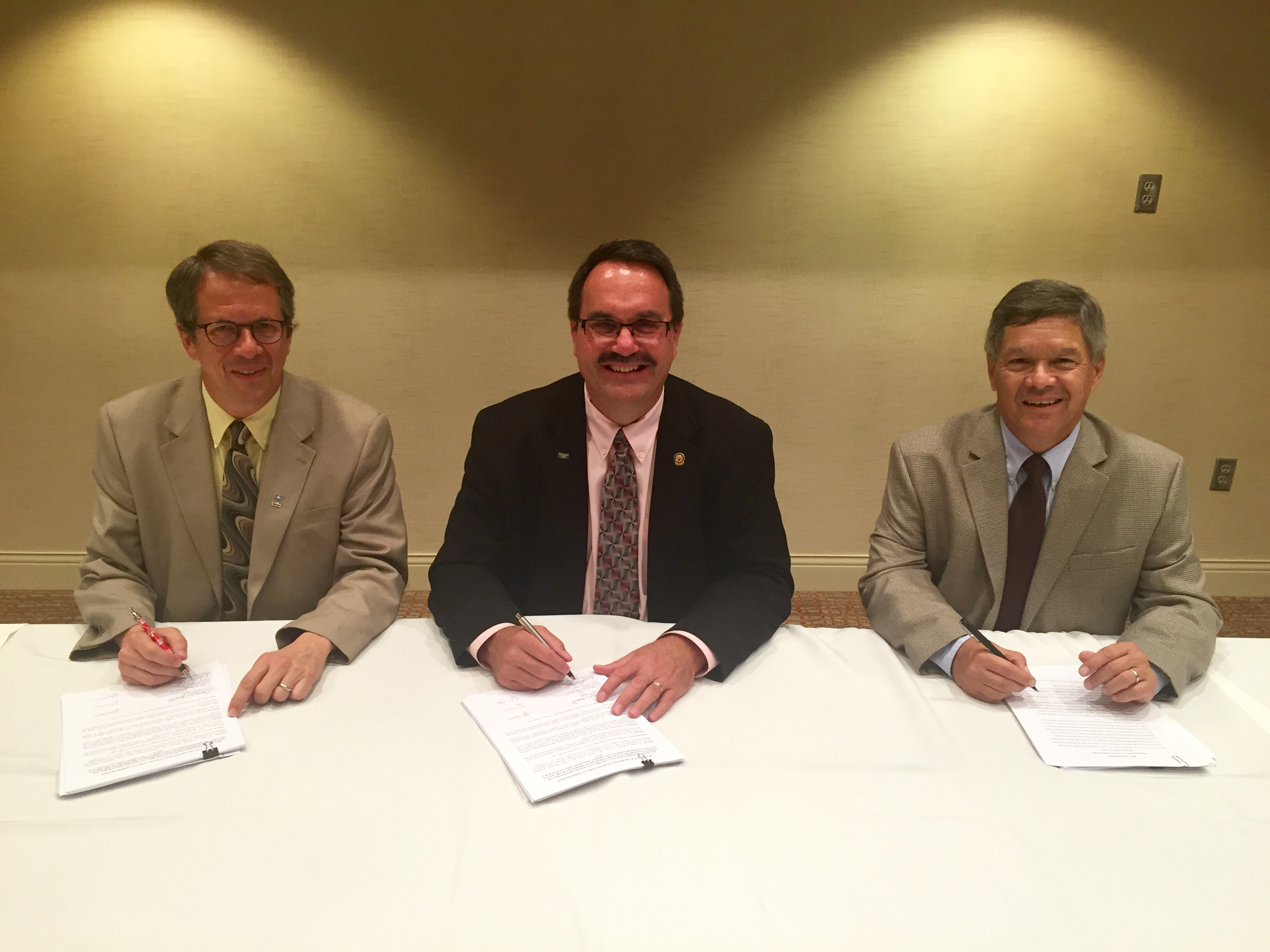
RRCA resolution signing August 27, 2015. From left to right: David Barfield, Dick Wolfe and Jeff Fassett(Photo courtesy RRCA) From the Kansas Department of Agriculture:
Republican River Compact Adjustments to Benefit Basin Water Users
(Lincoln, Neb.) Today, the states of Colorado, Kansas and Nebraska have reached an agreement that will ensure more certainty to the basin’s water users in both Nebraska and Kansas. The agreement, in the form of a Resolution approved by the Republican River Compact Administration (RRCA), was achieved through collaborative negotiations that began in April 2015 and will provide timely notice and access to water for the 2016 irrigation season.
The agreement provides additional flexibility for Nebraska to achieve its Compact obligations while ensuring that the interests of Kansas are protected. The additional flexibility will allow the Nebraska Department of Natural Resources to provide a portion of the forecasted compliance water early in 2016 and provide any additional shortfall later in 2016 and through April 1, 2017. This also provides some improved operational predictability for Nebraska water users in that water users will not be subjected to closing notices related to the 2016 irrigation season.
The 2016 agreement builds upon the agreement reached for the 2015 irrigation season with further beneficial developments for water users. This agreement provides more advanced notice to irrigators in the basin of compliance activities that will likely occur in 2016, allowing for an advanced planning period producers desire for their efficiently run operations.
The States’ agreement is contingent upon the Nebraska and the Kansas Bostwick Irrigation Districts, working with the U.S. Bureau of Reclamation, – reaching agreement on modifications of certain contract provisions contained in their Memorandum of Agreement (MOA) also adopted last year. Thus, ensuring the availability of the water pumped from Nebraska augmentation projects for RRCA compliance.
Current RRCA Chairman, Gordon W. “Jeff” Fassett, Director of the Nebraska Department of Natural Resources, said, “Today’s agreement is good news for Nebraska water users and represents the continuation of the cooperative and positive collaboration we’ve fostered between our states as we work to find mutually agreeable solutions that best serve our citizens. Additionally, we are hopeful that this positive momentum will continue to move us closer to the goal of securing a long-term agreement. With significantly more planning time, Nebraska’s water users will have greater certainty in their water supply and make the best decisions for their operations.”
“We are pleased to collaborate with Nebraska and Colorado as we continue to develop balanced and fair water solutions benefiting all of the basin’s water users that reflects good water management,” said Kansas Commissioner David Barfield. “This fourth in our series of recent agreements with Nebraska allows Kansas to make effective use of its water supply in 2016 and allows the states additional time and experience with Nebraska’s compliance activities as we continue to move toward long-term agreement.”
Colorado Commissioner Dick Wolfe said, “This agreement exemplifies the success that can be achieved through collaboration and cooperation of the RRCA and the water users in the basin.”
The RRCA is comprised of one member each from the States of Colorado, Kansas and Nebraska. The purpose of the RRCA is to administer the Republican River Compact. This Compact allocates the waters of the Republican River among the three states. The next RRCA annual meeting is scheduled for August of 2016 and will be hosted by the State of Colorado in a location of their choice.
Water infrastructure as sidewalk art From the Fort Collins Coloradoan (Kevin Duggan):
Developers accustomed to Fort Collins Utilities’ relatively inexpensive water service face the other districts’ unfamiliar requirements and exponentially higher costs — as much as $32,000 per lot — that some say will drive up the city’s already escalating housing prices.
And water delivery costs in Colorado are expected to rise as Front Range population growth further taxes systems that provide the lifeblood of Colorado industry, agriculture, recreation and modern living…
Combining forces to focus on the water supply needs of the [Growth Management Area] — land that is expected to eventually be within Fort Collins city limits — would be a departure from long-standing practices. But such an approach is “absolutely the way to go” to manage the area’s water resources, said Mike DiTullio, general manager of the Fort Collins-Loveland Water District, which serves much of the southern third of Fort Collins.
“We’ve got to figure out a method in which we can get water where it’s needed without jeopardizing the ownership of it,” he said. “We need to [wheel] it around like you do electricity.”
But DiTullio, who has managed Fort Collins-Loveland for 34 years, said interest in taking a new approach to managing local water resources will take time to develop.
“The political will comes only when there is a crisis,” he said. “We don’t have a crisis yet.”
Here’s a report from Jonathan Thompson writing for the High Country News. Click through and read the whole thing and check out Thompson’s drawings explaining acid mind drainage and the geology of the area. Here’s an excerpt:
While there are a variety of ways that mining can pollute watersheds, the most insidious and persistent is acid mine drainage, which is really a natural phenomenon exacerbated by mining. Acid mine drainage was the root cause of the Gold King blowout, and it plagues tens of thousands of abandoned mines across the West. It’s almost impossible to fix, and it lasts forever…
…the early settlers also were struck by the reddish orange color (like the Animas River after the “spill”) of some of the mountains. They were also struck by the same orange in some streams during times of high runoff, streams that were lifeless even then. Indeed, an observer in 1874 noted that Cement Creek was “so strongly impregnated with mineral ingredients as to be quite unfit for drinking.”[…]
Mining begins. The tunnels follow veins of gold or silver deep underground. The adits (horizontal tunnels) and shafts (vertical tunnels) intersect the cracks and faults through which groundwater had run toward springs. The groundwater follows the path of least resistance: The new mine adit. Whereas the cracks and faults are mostly anaerobic, or free of oxygen, the mine is relatively rich in oxygen. Meanwhile, the water as it flows through the mine runs over deposits of pyrite, or iron sulfide. Water (H2O) meets up with oxygen (O2) and pyrite (FeS2). A chain of reactions occurs, one of the products being H2SO4, otherwise known as sulfuric acid. The result is acid mine drainage, water that tends to have a pH level between 2 (lemon juice) and 5 (black coffee).
So now there is acidic water running through the mine. And since the mine follows the metals, so does the water, picking up the likes of zinc, cadmium, silver, copper, manganese, lead, aluminum, nickel and arsenic on the way. The acidic water dissolves these metals, adding them to the solution. After the water pours from the portal (mine opening), it percolates through metal-rich waste rock piled up outside the portal, picking up yet more metals. Next, the water may run through old tailings or leftovers from milling ore and pick up yet more nasty stuff. The soup that eventually reaches the stream is heavily laden with metals and highly acidic. It is acutely and chronically toxic to fish and the bugs they eat.
There would be little impact on water rights if flood control structures on Fountain Creek were designed to allow 10,000 cubic feet per second of water to pass through Pueblo.
That’s the conclusion of a draft report by engineer Duane Helton commissioned by the Fountain Creek Watershed Flood Control and Greenway District, released this week.
The district is looking at the issue as part of its investigation into the feasibility of building either a large dam or series of detention ponds on Fountain Creek. A U.S. Geological Survey study shows those are the most effective way to stop high flows from inflicting more damage on the waterway through Pueblo.
A study for Pueblo County by Wright Water Engineering indicates those flows have been worsened by development in Colorado Springs for the past 35 years — from both more impervious surfaces and the introduction of imported water. About 363,000 tons of additional sediment each year are deposited between Colorado Springs and Pueblo.
Helton’s study, which is now under review by interested parties, indicates that water rights during extremely large floods would not be affected because water would be stored in John Martin Reservoir. That same situation occurred this year during six weeks of moderate, but prolonged flows on Fountain Creek.
“Although the owners of the ditches and reservoirs on the Arkansas River are appropriately concerned about the effects of the Fountain Creek flood remediation project on their diversions under the priority system, a conclusion from this analysis is that the operation of the Fountain Creek Flood Remediation Project will not have significant effects on the diversions into the ditches and reservoirs on the Arkansas River in at least some of the years,” Helton’s report states.
Helton analyzed data since 1921, with about 75 years of flow records for Fountain Creek. The records were unavailable for some years. There were 18 years where the peak flow exceeded 10,000 cfs.
He modeled floods in 1999 and 2011, concluding that about 5,291 acre-feet would have been impounded during the 1999 flood and 368 acre-feet in the 2011 event if flood control was managed for everything above 10,000 cfs. In the 1999 flood, there would have been little if any impact on downstream rights, since John Martin storage was active.
The report also concluded that a method could be developed to ensure downstream water users would get water they otherwise would have been entitled to receive.
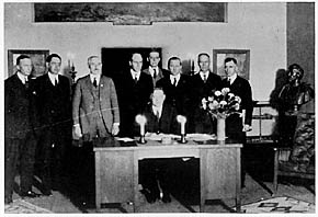
Herbert Hoover presides over the signing of the Colorado River Compact in November 1922. (Courtesy U.S. Department of Interior, Bureau of Reclamation)
Here’s the release from the Colorado River Water Conservancy District via Jim Pokrandt:
Two of the most important women in Western water leadership will be addressing the Colorado River District’s popular Annual Water Seminar in Grand Junction, Colo., that takes place Thursday, Sept. 10, 2015, from 9 a.m. to 3:30 p.m. at the Two Rivers Convention Center.
Headlining the event are Jennifer Gimbel, the Assistant Secretary for Water and Science, the U.S. Department of the Interior; and Pat Mulroy, Senior Fellow for Climate Adaptation and Environmental Policy at the University of Nevada-Las Vegas’ Brookings Mountain West, as well as a senior fellow in the Brookings Institution’s Metropolitan Policy Program in Washington, D.C. She retired in 2014 as General Manager of the Southern Nevada Water Authority.
Ms. Gimbel is well known in Colorado for her work as director at the Colorado Water Conservation Board before she moved to federal positions with the Department of the Interior that culminated with her ascendency to the post that oversees the Bureau of Reclamation, the U.S. Geological Survey and Colorado River administration. Ms. Mulroy oversaw the Southern Nevada Water Authority for 21 years where she got results as well as headlines in positioning Las Vegas for growth in the face of limited water supply.
The theme of the seminar is: “Will What’s Happening in California Stay in California?” Cost of the seminar, which includes lunch, is $30 if pre-registered by Friday, Sept. 4, $40 at the door. Register at the River District’s website: http://www.ColoradoRiverDistrict.org. Call Meredith Spyker at 970-945-8522 to pay by credit card.
The day’s speakers will draw an arc of water supply and policy concern from the Pacific to Colorado, looking at the basics of climate and weather generated by the Pacific, dire drought in California and what that means to the interior West, the still-on-the-horizon planning to deal with low reservoir levels at Lakes Powell and Mead, and finally, an analysis of Colorado’s Water Plan, still in draft form.
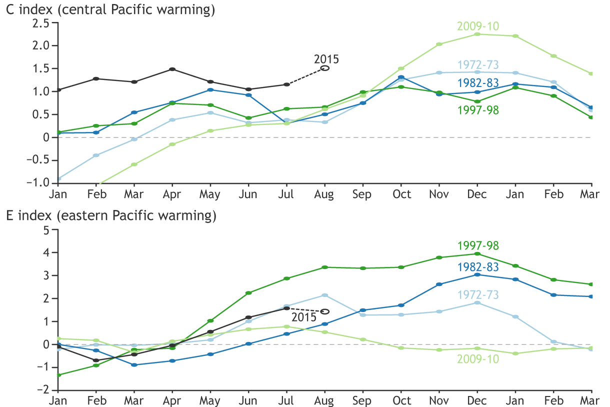
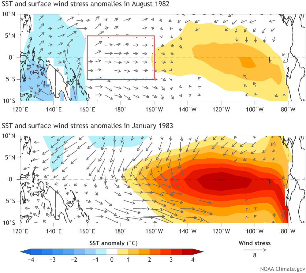
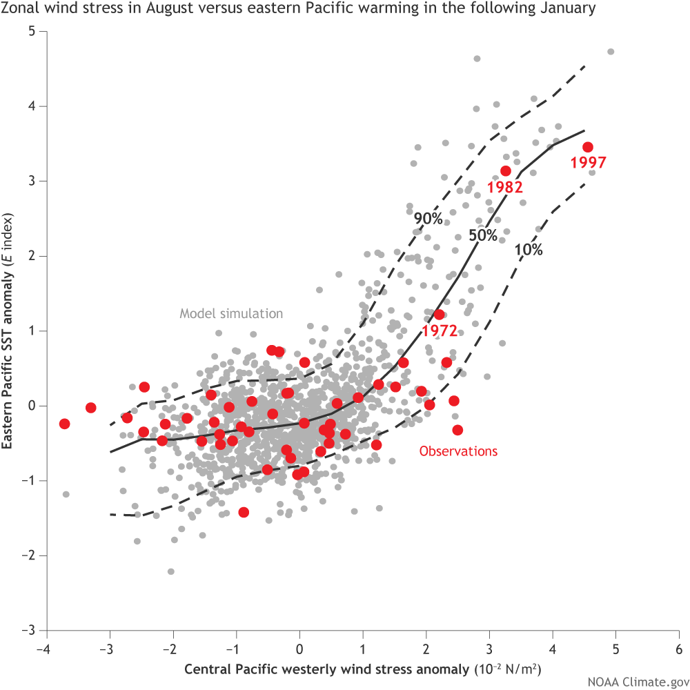
Klaus Wolter, a pre-eminent analyst of El Nino-La Nina conditions in the Pacific will preview the growing El Nino conditions and what they will mean for snowpack this winter. He is a research scientist at the NOAA Earth System Research Laboratory’s Physical Sciences Division in Boulder and world renowned in his field.
Also at the seminar, Colorado River District staff will speak to its policy initiative that new paradigm in Colorado Water Planning is how to protect existing uses, especially irrigated agriculture in Western Colorado, in the face of diminishing supplies and potential demand management necessities. Issues of planning for new transmountain diversion (TMD) remains a big focal point in Colorado’s Water Plan, but it is drought and reservoir levels that will command the system before a TMD can be honestly contemplated.
Other speakers will address irrigated agriculture’s role in water planning, efficiency and conservation planning and financing and more.
The council on Tuesday is expected to consider comments the city would submit to the U.S. Army Corps of Engineers on its draft Environmental Impact Statement regarding the project, which would draw water from the Poudre River.
After studying the document, city staff members and consultants concluded the project would adversely impact the river’s ecology and go against the city’s interests if it were built.
A resolution drafted to go with the staff comments proposed to be submitted to the Corps states the council “cannot support NISP as it currently described and proposed” in the document.
The city’s 108-page report details technical issues with the draft EIS as well as impacts NISP would have by reducing the river’s flow levels through town during times of high runoff.
Potential problems cited in the report include degraded water quality, wildlife habitat and recreational opportunities. The draft EIS does not adequately analyze alternatives to building the project as proposed by Northern Water and 15 participating water districts and towns, according to the report…
In 2008, Fort Collins came out against the project as it was described in the initial draft EIS. After seven years of more research and analysis, the Corps issued a supplemental draft EIS in June.
Comments on the document are due Sept. 3. The Corps is expected to review comments and potentially issue a final EIS next year.
Take part
The Fort Collins City Council will meet at 6 p.m. Tuesday at city hall, 200 Laporte Ave. The meeting will be broadcast on cable Channel 14.
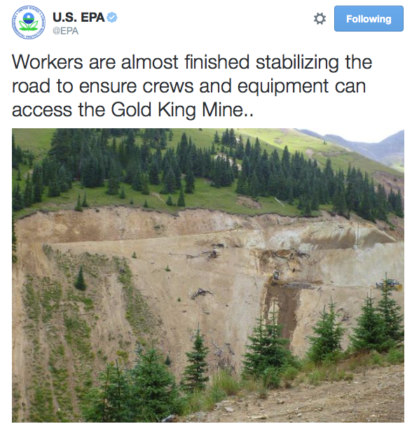
A large SUV in the upper-left is barely visible because it is submerged in the initial deluge of contaminated wastewater Aug. 5 at the Gold King Mine — photo EPA via The Durango Herald
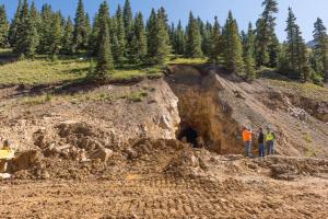
The EPA-released documents include a detailed chronology of events leading to the Aug. 5 blowout, which resulted in an estimated 3 million gallons of wastewater streaming into the Animas River. An EPA-contracted team was working on reclamation at Gold King Mine near Silverton when excavation work resulted in the disaster.
Stunning photos taken of the incident document how a leak quickly turned into a flood of mustard-yellow sludge flowing into a creek then the river from a hole about 10 feet wide by 15 feet high. The leak was first noticed about 10:51 a.m. The muddy water flowed around trucks and heavy equipment used by the team, clearly taking workers by surprise as they ran for safety and to save trucks and equipment, according to a contractor’s memo of the incident. The name of the contractor was removed from the document.
As the access road washed away, the team realized that a vehicle had been parked in the line of the rushing water. The vehicle would not start following the water damage. Meanwhile, the water continued to pile up.
Some of the team left on foot to get picked up and taken to an area with phone service to notify authorities. It took more than 90 minutes for a team member to get to a location where he could notify authorities. There were no satellite phones at the site, though workers were able to use two-way radios.
Meanwhile, a Flight for Life helicopter flew overhead, photographing the alarming situation. It turned out the helicopter was not there for the incident, but instead was related to a tourist who was injured on Corkscrew Pass…
All the while, pH readings plummeted, leading the team to believe that it had caused a major water disturbance.
It took the team nearly five hours to reconstruct a temporary road to remove equipment and personnel, according to the document.
The event actually began on Aug. 4, when the team was clearing away rubble in front of the “plug” that ultimately gave way. An email released by the EPA describing the chronology states, “Because all this was unconsolidated material it was considered safe to remove, it was not buttressing the plug.
“We were constantly and carefully watching for and closely inspecting the digging for indications of the plug,” the email continues.
The document was redacted by the EPA, removing the name of the team member who sent it. He was described as an EPA on-scene coordinator.
The rock face of the wall was described as a “puzzle,” with the email stating that material had to be removed just to see the plug.
On the morning of Aug. 5, the team saw the outer face of the plug, which appeared dry and solid, but they couldn’t get close because of dirt from overhead. There was no change in water flow at the time, according to the email.
“Keeping in mind that the mine should be assumed to be full of water – that is backed up to the top of the plug or higher – we did not want to get anywhere close to the top of the plug,” the email from the team states.
The team needed to determine where the bedrock was to plan a safe approach to the plug, and that is where the problematic excavation work happened.
When the leak was spotted, the team first assumed it was a rock spring.
“On as close inspection as I dared, I could see that the clear water was spurting up not down. A couple of minutes later red water began to flow out from near that spot. …” the email states. “In a couple of minutes it became obvious there was a lot of water coming.”[…]
“EPA is establishing a longer term watershed monitoring strategy for the surface water and sediments that have been affected by the Gold King Mine spill to identify potential long-term impacts working closely with state and local officials,” EPA officials said in the release.
It all has to do with the water levels in two reservoirs that draw their supplies from the Colorado River: Lake Powell, on the border between Utah and Arizona; and Lake Mead, which gets its water from Lake Powell.
Earlier this year, Lake Mead experienced, for the first time, a drop below a critical level. The drop lasted only about an hour, but it is a sign of things to come, and it’s raising concerns for everyone on the Colorado River.
At last week’s Colorado Water Congress, water experts discussed how changes in these two lakes will affect the Colorado River.
“It’s in our vested interests” as well as that of other Upper Colorado River states of Wyoming, Utah and New Mexico, to make sure Lake Powell stays full, according to James Eklund, director of the Colorado Water Conservation Board. Eklund is also the state representative to the Upper Colorado River Commission, an interstate administrative agency for the four states in the Upper Basin.
The problem: Lake Mead is running a “structural deficit” – it’s tapping about 2.5 million acre-feet of water per year more than it’s getting from Lake Powell. An acre-foot is the amount of water it takes to cover one acre of land by one foot, or about 325,000 gallons.
Eklund told The Colorado Independent that differences in legal interpretations of a 1922 interstate compact have led to a disagreement about just how much water the three Lower Basin states (Arizona, Nevada and California) should get.
The three Lower Basin states believe they are entitled to more water from Lake Mead, which gets its water from Powell. The Upper Basin states believe the Lower Basin states are getting exactly what they should. It’s a standoff, Eklund said this week. “Everyone’s agreed to disagree.”
That’s been okay in the past, because there was enough water in the system. But years of drought in the West have changed the situation from “more than enough” to “not enough,” according to Eklund.
Eklund pointed out that the Colorado River will send more than 9 million acre-feet to Lake Powell this year, and that happened last year, too. The compact requires only 7.5 million, on average, per year. But the Lower Basin states are still drawing about 2.5 million acre-feet more than Powell can supply. That’s put Mead below its critical levels.
The deficit has led to planning among the seven states along the Colorado to ward off potential critical low levels at Lake Powell. That plan calls for several actions, including moving water from several Upper Colorado River reservoirs to Lake Powell, and stronger conservation efforts.
There are dire consequences for everyone, Eklund told the audience at the Water Congress’ summer conference last week. Should Lake Powell drop below its critical levels, the Glen Canyon Dam could lose its ability to turn its turbines. That would result in less electrical generation, and force rural electric companies that rely on power from Glen Canyon to buy electricity elsewhere.
That leads to less money available for endangered species recovery and a system to control salt buildup where the Colorado River ends, in Mexico.
Since 1988, rural electric revenue has helped pay for species recovery for four endangered fish species on the Colorado: the humpback chub, bonytail, Colorado pike minnow and razorback sucker. “This has impacts for the health of the entire system,” according to Eklund.
Eklund told The Independent that all the stakeholders have seen the modeling for these scenarios.
“Everyone loses if we act in our own self-interest,” he said.
The Lower Basin states have been reluctant to talk about the deficit at Lake Mead, but that’s coming to an end, and everyone is now at the table, discussing how to manage the river system more cooperatively.
Eric Kuhn of the Colorado River Water Conservation District has been involved with the Colorado River since 1980. He pointed out during last week’s forum that 90 percent of the Colorado River water is in the Upper Basin while 90 percent of the people are in the Lower Basin, including Southern California.
Over the next few years, Kuhn said, they are looking for several solutions, including a “Godzilla El Niño” year in 2016, similar to what happened in 2011, that will help refill Mead and Powell. The El Niño in 2011 provided an additional 4 million acre-feet of water to the lakes.
Kuhn advocates for a solution among the seven states on the Colorado that keeps the parties out of court. That includes building up enough water in the lakes to create a buffer, which he said is essential.
The bottom line, according to Kuhn, is that in theory, the 2.5 million acre-feet deficit in Mead has no impact on the Colorado. Mead’s deficit has existed since the 1940s, he explained. But “in practice, the deficit has a major impact,” he said.
Could it lead to a “call” on the Colorado River? A call is when the Colorado can’t supply the amount of water required under the compact. It would require the Upper Basin states to send more water down the Colorado to Lake Powell, and it would mean less water for the Upper Basin states.
A call is years away, if ever, according to both Eklund and Kuhn. But both say it’s better to plan now when “we’re not in a crisis,” like California.
Colorado River Basin including Mexico, USBR May 2015
At the heart of the $500-million plan is the construction of two new reservoirs: Galeton Reservoir, northeast of Greeley, and Glade Reservoir, northwest of Fort Collins. Both are designed to provide water for the growing populations of several communities in Larimer, Weld, Morgan and Boulder Counties. Building Glade Reservoir would also involve the relocation of seven miles of Highway 287, at a cost of $45 million.
“We’ve got to figure out how we’re going to provide water for future generations and these communities – the 11 cities and towns and the four water districts – are taking a very proactive step in planning for their future,” [Brian Werner] said.
The water to fill both reservoirs would come from the Poudre River – diverting away about ten percent of that river’s annual flow and use it to provide water for an additional 80,000 to 100,000 households…
Reagan Waskom is with the Colorado Water Institute at CSU, which has taken no formal position on the project.
“We’re playing out in this one basin what’s going to happen all over the state,” Waskom said. “It’s an urban, environmentally conscious group of folks, that don’t want to see another depletion. There’s communities that are growing that need that water – that’s the tension: how much more can we take out of these rivers?”
The Army Corps of Engineers is taking public comment on the NISP until Sept. 3.
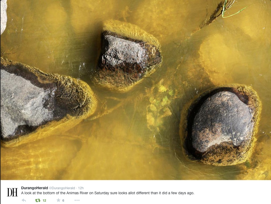
A “get well soon” balloon floats in the contaminated waters of the Animas River flowing through Durango on August 10, 2015 — photo The Durango Herald, Shane Benjamin
Farmers in the Nenahnezad, San Juan and Upper Fruitland chapters of the Navajo Nation were cleared Thursday to resume using San Juan River water for irrigation soon.
Navajo Nation President Russell Begaye gave the directive Thursday night to open the the Fruitland Irrigation canal, which delivers water from the San Juan River to the three chapters. Begaye made the announcement during a meeting with chapter officials and farmers inside the Nenahnezad Multipurpose building.
The chapters have been without water since the canal was shut down in response to the Gold King Mine spill…
In a presentation, Begaye said the entire canal will be flushed before irrigation can start.
“You’ll have water that’s good for irrigation,” the president said.
Begaye added that the Navajo Nation Environmental Protection Agency will continue monitoring the water quality, and collecting soil and water samples for testing.
Shiprock Irrigation Supervisor Marlin Saggboy said flushing could start as soon as he receives the written directive from the president’s office.
A federal judge in North Dakota on Thursday granted a request by Colorado and 12 other states and blocked a federal rule that aims to extend the agencies’ authority to over small streams and wetlands.
The rule from the U.S. Environmental Protection Agency and the U.S. Army Corps of Engineers aims to redefine the legal description of the “waters of the United States,” known as WOTUS under the Clean Water Act, to include water that’s adjacent to navigable rivers and also water that may fill a normally dry streambed after a heavy rainstorm — which happens often across Colorado.
The states argued that the rule illegally removed water and land resources from state control. The decision by Judge Ralph Erickson, granting a preliminary injunction against the rule, will stop it from taking effect until a fuller review can be conducted.
The EPA and the Army Corps argued that the new definition would protect streams and wetlands, which the agencies say form the foundation of the nation’s water resources, from pollution and degradation. The agencies also say the new definition is easier for businesses and industry to understand.
“Colorado has primary responsibility to protect and manage its own water resources, and it takes that responsibility seriously,” said Colorado Attorney General Cynthia Coffman in reaction to Erickson’s ruling…
Two other federal judges, in West Virginia and Georgia, had declined to block the new rule.
Colorado joined litigation filed in the U.S. District Court in North Dakota. The other parties in the lawsuit are: North Dakota, Alaska, Arizona, Arkansas, Idaho, Missouri, Montana, Nebraska, Nevada, South Dakota, Wyoming, the New Mexico Environment Department, and the New Mexico Office of the State Engineer.
An agricultural impact statement for water transfers might become a state tool as the result of a state water plan that’s expected to be finished later this year.
“When I’ve talked about it with the agricultural community, they see it like NEPA (National Environmental Policy Act) and more red tape,” said James Eklund, executive director of the Colorado Water Conservation Board. “But really, it’s just making sure all information about impact is disseminated.”
Eklund and John Stulp, the governor’s water policy adviser, visited with The Pueblo Chieftain editorial board Thursday.
Eklund threw out the idea of an ag impact statement as one way to evaluate how taking water from a community could change it down the road. Like many other parts of the water plan, however, it remains more of a suggestion than a directive.
The CWCB is writing the water plan on orders from Gov. John Hickenlooper, and it is due by Dec. 10. Nearly two years and dozens of meetings and hearings have gone into the document. More than 26,000 comments have been received in a process that Eklund called “unprecedented” for including public comment.
An ag impact statement would help ensure that taking water permanently out of agriculture is a last resort, but there is no way the state can ban the practice, Eklund said.
“If how development occurs becomes a Colorado question, it takes us out of being a local control state,” he said.
Instead, the water plan provides a wealth of options about alternative transfer methods that do not permanently dry up agriculture.
“Where agriculture will keep water, it will buy time,” Stulp said. “If alternative transfers are voluntary, they have options.”
It’s not possible to ban future transfers, because of the nature of water rights in Colorado, Eklund said.
But the flexibility or agility to use water rights in different ways is important. Eklund insisted the water plan does not condone flex water rights that have failed to become law in the last two legislative sessions.
“When we talk to the ag community, you can get nervous looks, and they ask ‘What’s that going to mean to us?’ We can’t say your property right is the subject of our investigation,” Eklund said. “But stopping buy-and-dry, that’s going to take agility or flexibility.” The water plan won’t supersede state water law, but could expand or introduce concepts in much the same way as recent changes like instream flows, recreational in-channel diversions and storage as a beneficial use.
“We’ve done things as pilots like HB1248 (a 2013 bill allowing long-term leasing), and the danger is they become permanent,” Stulp said. “But the purpose is to give generational changes a chance temporarily.”
“We’re looking for that sweet spot where we can keep producers in agriculture,” Eklund added.
A milestone in state water planning was reached Tuesday as members of the state’s Interbasin Compact Committee unanimously endorsed the latest version of a “conceptual framework” to guide discussions between East and West Slope interests about any new transmountain diversion.
“It’s not perfect, but I think we’re in general agreement this is a good starting point, and if ever there is a transmountain diversion, there will be, no doubt, additional negotiations,” said John Stulp, chairman of the IBCC.
Today in Colorado, between 450,000 and 600,000 acre-feet of water is diverted each year from the West Slope to the more populous East Slope.
The latest draft of the framework, tweaked Tuesday regarding statewide water conservation goals, will now be forwarded to the Colorado Water Conservation Board for inclusion in the final Colorado Water Plan, which is to be delivered to Gov. John Hickenlooper by Dec. 10.
“I would be surprised if it would change significantly from where we’re at today,” Stulp said of the conceptual framework.
To help satisfy the concerns of some members of the IBCC, staff from the Colorado Water Conservation Board drafted an additional introductory paragraph – during a break in the meeting – about the conceptual framework to be included in the water plan.
“The intent of the conceptual framework is to represent the evolving concepts that need to be addressed in the context of a new transmountain diversion as well as the progress made to date in addressing those concepts,” the new introductory paragraph states. “The conceptual framework refers to several topics, including conservation, storage, agricultural transfers, alternative transfer methods, environment resiliency, a collaborative program to address system shortages, already identified projects and processes (IPPs), additional Western Slope uses, and other topics that are not exclusively linked to a new TMD, but are related to Colorado’s water future. The conceptual framework, like the rest of the Colorado Water Plan, is a living document and is an integrated component of the plan. Many of these topics are further discussed in more detail in other sections of Colorado’s Water Plan.”
The IBCC is made up of two members from each of the state’s nine basin roundtables, six governors’ appointees and two members of the Legislature.
Since 2013, the committee has been working on the seven core principles in the framework, which spells out under what terms a new transmountain diversion might be acceptable to the West Slope.
For example, a new project should not increase the likelihood of a call from California for more water under the Colorado Compact, or preclude future growth on the West Slope.
And it “should avoid, minimize or mitigate adverse environmental impacts where possible” and address the concept of “environmental resiliency.”
“Nothing is perfect, but I think adding environmental resiliency into the water plan – which happened because we got it into the conceptual framework and now it’s also in the body of the plan in chapter six – I think that’s a big step forward,” said Melinda Kassen, who represents environmental interests on the IBCC, and was speaking during a break in the meeting.
“And I like the fact that it’s also combined and we have a much more robust commitment and description of what we need to do in regard to compact compliance,” Kassen said. “So I think there are a lot of things in the conceptual framework that we have to work on – triggers, collaborative water management program, environmental resiliency, conservation – those are the action steps for moving forward. I think we need to move on, but I think the conceptual framework is a pretty good deal and we should take it and move on. And not just in terms of the conceptual framework, but in terms of the whole water plan. It’s a plan, and now we have to ‘do.’”
The east end of the Independence Pass tunnel, bringing water from the headwaters of the Roaring Fork River to the East Slope
“A bunch of hoops”
Bill Trampe, a rancher in Gunnison County and a member of the Gunnison River Basin Roundtable, also supports the framework.
“For future transmountain diversions to occur, according to the framework, the proponent is going to have to go through a bunch of hoops,” Trampe said. “If the proponent is willing to take the gamble that there is enough water to merit the expense of the project, then go for it.”
Trampe’s suggested that if a project proponent takes a hard look at a potential new transmountain diversion, and does so through the lens of the conceptual framework, they may find that there just isn’t enough water to make a project viable.
Principle three of the framework deals with “triggers,” or the amount of water available in the larger Colorado River system, that may or may not allow water to be diverted to the East Slope.
“Triggers are operating parameters that determine when and how much water a potential new TMD could divert, based upon predetermined conditions within the Colorado River System,” a recent draft of the framework states. “Such parameters include, but are not limited to, specific storage elevations in one or more Colorado River System reservoirs, projected inflows at key Colorado River System locations, actual reservoir inflows over specific defined periods, snowpack levels, predictive models – or combinations of these – which would trigger certain actions and prevent others.”
In a brief interview after the meeting, Trampe said the water trends do not favor a new transmountain diversion.
“If hydrology does not improve, then the issues on the Colorado River are going to become worse,” Trampe said. “Mead and Powell continue to go down. They are not stabilized. They are not rising. They continue to go down. So if a proponent of a project looks at all of that, and still thinks there is water available, I guess there is not much we can do about it, except go through step four, the collaborative process, where we identify the risks and the ways we go about alleviating those risks to the various parties, particularly on the West Slope.”
Step, or principle, four in the framework discusses a proposed collaborative program to manage water in the Colorado River basin, and points out such a program is needed regardless of whether a new diversion is built or not.
“The collaborative program should provide a programmatic approach to managing Upper Division consumptive uses, thus avoiding a Compact deficit and insuring that system reservoir storage remains above critical levels, such as the minimum storage level necessary to produce hydroelectric power reliably at Glen Canyon Dam (minimum power pool),” the draft framework states. “A goal of the collaborative program is that it would be voluntary and compensated, like a water bank, to protect Colorado River system water users, projects and flows. Such protection would NOT cover uses associated with a new TMD.”
Trampe also pointed out that the conceptual framework is only a first screen for a potential new transmountain diversion, as any project would still have to go through existing regulatory reviews at, potentially, the federal, state and county level.
“Even if you think you can get through this process, you still have to go through the normal legal channels and permitting that is in existence today,” Trampe said. “You’re still going to have the traditional things to go through, particularly if you’ve not adopted the principles within the framework.”
The conceptual framework is not legally binding, as Colorado water law still allows for a water provider to propose a new transmountain diversion without referencing the conceptual framework. But it is seen as a way for Western Slope communities to review a proposed diversion against publicly adopted parameters.
The conceptual framework has been discussed at various other roundtable meetings around the state in recent weeks.
“I think that this gives us protections that otherwise we don’t have,” said Karn Stiegelmeier, a Summit County commissioner, during a July 27 meeting of the Colorado River Basin Roundtable, shortly before that roundtable endorsed the conceptual framework.
But during the same meeting, Ken Ransford, who represents recreational interests on the Colorado Roundtable, voted against the framework.
“This agreement doesn’t have teeth,” Ransford said. “It’s not enforceable. It gives us no legal rights. And the Front Range has said they are still willing to come over here and purchase agricultural water rights as necessary to protect their existing diversions. So I keep asking myself, what are we getting out of this?”
However Ken Neubecker, the associate director of the Colorado River Basin Program for American Rivers, and the environmental representative on the Colorado River Basin Roundtable, supported the conceptual framework, arguing it gives the Western Slope more protection.
“They could come over for a new transmountain diversion and ignore all of this right now, that’s just the way Colorado water law is,” Neubecker told the roundtable. “What this does do, along with the water plan, is set a high bar that they really are going to have to look at and try and comply with if they want to have a smoother road rather than a rougher road toward that end. They still have to go through permitting processes with the local counties and with the state, and the counties and the state can all look at it and say, ‘Well, where are you with complying with this? Where is your plan with point number four, point number three, whatever?’ It does give us that element of a condition, while not legally required, is something that politically would be a good thing to pay attention to.”
After the August 25th meeting in Keystone, Eric Kuhn, the general manager of the Colorado River District, which represents 15 West Slope counties, said the framework — if deployed correctly — could help protect West Slope interests.
“The West Slope is better off under the conceptual framework if, and it’s a big if, we follow through and have the discussions that are contemplated by the framework,” Kuhn said. “If it just sits on the shelf, it’s worthless for us.”
The first of the seven principles in the framework states “East Slope water providers are not looking for firm yield from a new transmountain diversion, and the project proponent would accept hydrologic risk for that project.”
That means that a Front Range water provider who proposes a new transmountain diversion must understand that there may not be water to divert every year, depending on snowpack, weather and the amount of water stored in Lake Powell and Lake Mead, the latter because of legal minimum water guarantees for downstream states.
“It’s not just, is there enough water, it is whether there is enough reliable water,” Kuhn said of the core principle. “If you are a community, and you are providing water to people, it’s not good enough to have water three out of four years. People want water four out of four years.”
Which may mean, Kuhn said, that a big new diversion project is not worth pursuing.
After the meeting, Kuhn wrote a memo to the River District’s board of directors, in which he spelled out the divide evident at the Keystone meeting over the appropriate levels of water conservation that should be expected of municipal water providers.
“The IBCC met on Tuesday August 25th in Keystone,” Kuhn wrote. “The primary area of discussion (and conflict) was conservation. A separate IBCC committee on conservation developed what we now refer to as the stretch goal. Under the most simplified explanation, the ‘stretch goal’ is stretching the medium goal of 280,000 acre-feet of statewide conservation savings to 400,000 acre-feet. The goal timeline is 35 years, from now to 2050.
“The framework committee tried to incorporate this into the seven point framework in principle 6, but we did so in an awkward way,” Kuhn wrote. “The bottom line is that the South Platte and Metro roundtables are having second thoughts about the stretch goal. I heard three concerns: First, they could become part of the federal permitting process. Second, they’re not really attainable at this time. And third, they will undermine the ability to finance and operate new projects. The more our customers conserve, the less money they pay.
“We ultimately agreed to ‘soften’ the language, but the underlying tensions remain,” Kuhn wrote. “The West Slope roundtables remained united behind achieving the stretch goals, but expressed concern about smaller entities (which under the rules are not covered if they use less than 2,000 acre-feet per year).”
Clamoring for water
But to water interests on the Front Range, a new transmountain diversion is seen as an important tool to meet growing water demands, and getting the conceptual framework into the Colorado Water Plan is seen as a victory.
“It seems to me we’ve got a tremendous opportunity,” said Sean Cronin, the executive director of the St. Vrain & Left Hand Water Conservancy District in Longmont, during an Aug. 11 meeting of the South Platte Basin Roundtable in which he urged the roundtable members to endorse the conceptual framework.
“We have been clamoring for a transmountain diversion since the very first day of the roundtable,” Cronin said. “We now have a transmountain diversion framework sitting in a statewide water plan that’s nearly to the point of being approved and adopted.”
After Tuesday’s meeting in Keystone, IBCC member Wayne Vanderschuere, who oversees water planning for Colorado Springs Utilities, said a new transmountain diversion “needs to be in the cards,” especially to slow the practice of buying water from agricultural operations to meet growing municipal demands.
“The Colorado River has its own unique challenges irrespective of transmountain diversions, that everyone needs to take ownership of,” Vanderschuere said, referring to the state’s obligations under the Colorado Compact. “So we need to address that. But we also have an obligation to responsibly develop our portion of the compact entitlement, and to the extent we can do that, we should pursue that.”
Vanderschuere also praised the state’s existing array of transmountain diversions.
“The current transbasin diversions and the associated storage with them have done more to booster the economic, environmental, and environmental resiliency of Colorado than any other thing I can think of,” he said. “The storage, the flatwater recreation, the whitewater recreation, the environmental habitat, the economic benefits of having that water available, east and west, for recreation, for municipal and industrial – huge. Colorado would not be where it is today without those transbasin diversions that are currently in place. So we have to acknowledge that that’s been a huge success on all fronts.”
The ditch that moves water from Lost Man Reservoir to Grizzly Reservoir and then under the Divide to the South Fork of Lake Creek and the Arkansas River.
View from the CWCB
At a meeting on Aug. 21 in Vail of the Colorado Water Congress, John McClow, the general counsel of the Upper Gunnison Water Conservancy District, and a board member of the Colorado Water Conservation Board, described the conceptual framework, and the “historic conflict” in Colorado over transmountain diversions, for a ballroom full of members of the state’s professional water community.
“The most pressing question I’ve heard throughout the Western Slope is ‘What are we going to do about new transmountain diversion?’ All of the Western Slope roundtables addressed it to some extent in their basin implementation plans,” McClow said. “The South Platte Roundtable, the Metro Roundtable, talked about it in their plans. But those collective comments still reflected what I believe was conflict on the issue. It is a historic conflict – east versus west – and it’s been going on before Colorado was a state. What I’m happy to report is that the IBCC took it upon themselves to try and find a solution to that conflict.
“That group worked for over a year putting together seven principles that would create a framework around which a new transmountain diversion could be developed. It is not an agreement, it is not a regulation, it is not mandatory, but it confronts reality on every aspect of what will be necessary to consider in the event that a proponent wishes to pursue a new transmountain diversion. It’s couched in terms of seven principles, and each of them addresses one element of it. Some go a little bit beyond the strict interpretation of a transmountain diversion.
“What’s most important to remember is that it is not a rule,” McClow said. “What it does is set forth the obstacles that would occur in the event that a proponent were considering one, that it is to say, the physical and legal availability of water in the basin of origin, which is addressed by Colorado water law. But it reaches beyond that to say that if the new development occurs within the Colorado River system, which is what we’ve always identified as our source of new supply, we have to look beyond the state boundary and look at the big river system because of our obligations to other states on the Colorado River.
“We have to be careful that in developing that additional water, we don’t overdraft our entitlement under the Colorado River Compact and Upper Colorado River Compact. This framework provides a process to address those issues. And further, to say we have to have some means of evaluating the possibility of diversions by this new project through triggers. And without defining the triggers, its says there are places you need to look to figure out when and how much water could be diverted by a new transmountain diversion.
“The principles go beyond that and look at issues such as West Slope – East Slope collaborative benefits from a single project, it talks about conservation standards for the proponent of a new transmountain diversion, it talks about environmental and recreational sustainability within the state.
“I hope that we, the conservation board, will adopt this framework and incorporate it into the water plan so that we can remove this controversy because Colorado can’t move forward in conflict, we’ve got to move forward with consensus,” McClow said. “And this is a burning issue, Front Range and West Slope, and I’m hoping that for once in our history we can sit down and say ‘We’ve agreed on how this can actually happen, should it be possible, as long as it is done reasonably and responsibly and reflects the reality of our circumstances at the time.'”
The outfall of the Bousted Tunnel, which delivers water from the Roaring Fork and Fryingpan rivers to the East Slope.
The seven principles b the draft conceptual framework:
1. East Slope water providers are not looking for firm yield from a new transmountain diversion (TMD) and the project proponent would accept hydrologic risk for that project.
2. A new TMD would be used conjunctively with East Slope supplies, such as interruptible supply agreements, Denver basin aquifer resources, carry-over storage, terminal storage, drought restriction savings, and other non-West Slope water sources.
3. In order to manage when a new TMD would be able to divert, triggers are needed.
4. A collaborative program that protects against involuntary curtailment is needed for existing uses and some reasonable increment of future development in the Colorado River System, but it will not cover a new TMD.
5. Future West Slope needs should be accommodated as part of a new TMD project.
6. Colorado will continue its commitment to improve conservation and reuse.
7. Environmental resiliency and recreational needs must be addressed both before and conjunctively with a new TMD.
Editor’s note: Aspen Journalism is collaborating with The Aspen Times and the Glenwood Springs Post Independent on coverage of water and rivers. The Times published a shorter version of this story on Wednesday, Aug. 26, 2015, as did the Post.
Here’s report Stephanie Paige Ogburn writing for KUNC. Click through for the photos. Here’s an excerpt:
…Kerber Creek, is just a small piece of the legacy left by hard rock mining across the West. When Tang-colored water spilled from a mine into the Animas River, it caught the nation’s attention. Yet unknown to most, there are people who work day in and day out cleaning up the many hundreds of abandoned mine sites across Colorado. This sort of mine cleanup work is a seldom never-ending process, fraught with logistical challenges, financing problems, even the looming threat of lawsuits.
To understand what killed Kerber Creek, it’s helpful to drive 15 miles above Wagner’s ranch, into the mountains where miners tunneled and blasted searching for gold, silver, and copper over 100 years ago. You’ll pass hillsides bored through with abandoned mine tunnels. Old mine structures, like the Cocomongo Mill and mine, and piles of rocky waste dot the landscape.
Operations at Cocomongo ended in the late 1950s or early 1960s. The mill is giant. The piles of mine waste around it are equally impressive.
Much of mine waste is referred to as tailings, pea-sized rocks that were processed by miners. That, along with larger waste — stained yellow, orange, white, gray, brown — reaches many stories high. It almost looks like the mountain was turned inside out…
The Rawley 12 tunnel and rehabilitation site once gushed orange, acidic water into Squirrel Creek, then down into Kerber Creek. The tailings below were difficult enough to walk on that some workers used snowshoes so they wouldn’t sink in.
It took hundreds of dump trucks to remove the tailings mess. The Fish and Wildlife Service, working in conjunction with a couple handfuls of state, local and federal agencies, had to build a holding pond to store and treat the mine wastewater as they worked. Workers also had to rebuild part of the mine tunnel here before they could plug it. It’s hard, expensive work.
“Sometimes mine restoration looks a lot like mining,” Archuleta said, showing off a picture of workers in hard hats and head lamps.
Today, the tailings have been trucked away and safely stored. Native grasses and plants have sprouted, and tiny evergreens are beginning to colonize the bare soil. Archuleta points to the ground.
“Dandelions are growing here, dandelions are actually a good sign because they will not grow in metals enriched soils.”
All this had to be done before any restoration could happen lower down, at the creek running through the Wagner’s ranch. In 2012, the U.S. Department of Agriculture’s Natural Resources Conservation Service started a cleanup at the ranch…
Finding that money is an ongoing problem for these large scale cleanups. One solution could be requiring existing mines on public lands to pay royalties, said University of Colorado law professor Mark Squillace.
“You could easily impose a fee on the tonnage that is produced from these mines to fund a program to reclaim hardrock mines.”
That would take legislation, though, which is unlikely, said Squillace.
Liability is another issue, since groups that take on big cleanups can be sued if they can’t bring a creek up to Clean Water Act standards. That limits groups like Trout Unlimited’s ability to take on certain types of cleanups. So-called “Good Samaritan” legislation to address these problems has been proposed, including by former Colorado senator Mark Udall, but has failed to pass.
The highly visible spill on the Animas River has led to renewed calls to update these laws. Those involved say Good Samaritan legislation could be hard to get right, for a couple of reasons. First, changes to the law would need to ensure it didn’t over protect mining companies who could reopen mines, make money, and then hide behind Good Samaritan liability protections. Second, because it involves opening up the Clean Water Act for modification, some on the environmental side are worried the law could be weakened through the amendment process.
Back at the Wagner ranch, an excavator clangs as it lifts giant boulders and places them in the creek, stabilizing the bed and preventing erosion. That heavy equipment will also till in lime to neutralize the soil, and compost to help plants grow. Since the rehabilitation work began, Carol Wagner said she’s seen a huge difference.
“And now there’s trout living here in the creek and a lot of wildlife are here, and it’s just changed everything,” she said.
That cleanup has been decades in the making. For Colorado to deal with its abandoned mine problem, this work has to happen over and over, in various iterations and circumstances. The state Division of Mining Reclamation and Safety estimates out of the 22,000 abandoned mines across the state, 500 of them are currently polluting the water down below. It will take decades to address the problem, one mine tunnel and creek at a time.
Click here to go to the US Drought Monitor website. Here’s an excerpt:
Summary
A significant upper-level trough over the central part of the contiguous U.S., accompanied by a slowly moving cold front, brought up to several inches of rain across the eastern and southern states during the past week. The cold front reached the Eastern Seaboard and continued out over the western Atlantic, while the southern portion of this front stalled across the deep South. Later in the week, another upper-level trough moved out of central Canada across the northern High Plains of the United States, before heading east and bringing additional rainfall to the eastern contiguous U.S. In the Southwest, light to moderate precipitation (generally less than 1.5 inches) was observed in association with the summer monsoon. In the northern Rockies and Pacific Northwest, the USDA Forest Service reported approximately 40 large wildfires in progress as of August 26th, as warm and very dry weather persisted…
Northern and Central Plains
Abnormal dryness (D0) in eastern Montana was expanded south-southwestward due to the ongoing lack of precipitation. No changes were rendered to the depiction in Kansas, as rains that did fall during the week missed the residual D0 area in the northwest part of the state…
Southwest and California
Light to moderate rain (generally less than 1.5 inches) fell across southern sections of both Arizona and New Mexico. In New Mexico, no changes were made to the drought depiction. However, the counties of Curry, Roosevelt, and Lea, in eastern New Mexico (bordering Texas) are being monitored after a fairly dry August (so far) and soil moisture observations. No revisions were considered necessary this week in either the Southwest or California. An Associated Press report (dated August 20th) notes land in central California’s agricultural region is sinking quickly because of the state’s historic drought. This is forcing farmers to spend millions of dollars upgrading irrigation canals, and putting roads, bridges, and other infrastructure at risk. The extent of Short to very Short topsoil moisture for the state of California as a whole, is generally around 80 percent, a decline of about 5 percent since last week…
Looking Ahead
For the upcoming 5-day period, August 27-September 1, attention will be focused on southeastern Florida, which may experience very heavy rainfall early next week in association with what is currently Tropical Storm Erika. Preliminary forecasts from the National Hurricane Center in Miami strengthen Erika to a hurricane either this Sunday or Monday, as it bears down on the southeastern Florida coast. However, Erika is still 4-5 days away from Florida, and its track and intensity may change significantly by then. In the desert Southwest, up to an inch of rain is predicted to fall during this period, which would at least help to offset additional deterioration in many areas. Several inches of precipitation are anticipated across the coastal ranges and Cascades of the Pacific Northwest, an area that could certainly use the moisture. Up to several inches of rain are also forecast for portions of the Midwest/Upper Midwest/Upper Great Lakes region. Depending on exactly where the rain does fall, some reduction in drought coverage is possible.
For the ensuing 5-day period, September 2-6, chances for above-median rainfall are elevated across the Southeast, due to the anticipated approach of Erika near the beginning of the period. Above-median rainfall is also favored across the northwestern and north-central portions of the lower 48 states, in advance of an upper-level trough. Odds for below-median rainfall are elevated across portions of the Northeast, and the southwestern and south-central CONUS. In Alaska, above-median precipitation is favored for much of the northern and western sections of the state, while below-median precipitation is favored along the southern coast from about Kodiak Island to Juneau.
Environmental officials said Thursday their long-term concern after the 3 million-gallon Gold King Mine spill centers around the metallic sediment left in its wake.
Specifically, the Environmental Protection Agency says it is worried about the “effect of metals deposited in sediments in the entire watershed and their release during high-water events and from long periods of recreational use.”
The EPA mentioned the concerns as part of a data release accompanying 77 pages of documents chronicling the minutes and hours before and after the agency-triggered spill…
Experts say metals lining the riverbed could continue to cause long-term effects for agriculture, aquatic life and other life-forms along the Animas River.
The EPA specifically has been studying concentrations of arsenic, cadmium, lead and mercury in surface water.
The acidic heavy metals that flooded into Cement Creek in Silverton and the Animas River through La Plata County after the spill initially broke state water quality limits.
The new data comes after the EPA on Wednesday released an internal review of the events leading up the Gold King spill showing crews underestimated waste pressure behind the mine’s collapsed opening.
The report called the underestimation of the pressure the most significant factor leading to the spill.
According to the report, had crews drilled into the mine’s collapsed opening, as they had done at a nearby site, they “may have been able to discover the pressurized conditions that turned out to cause the blowout.”
Colorado River Basin including Mexico, USBR May 2015
Here’s the release from the Colorado Department of Natural Resources (Todd Hartman):
The states of Wyoming, Colorado, Utah, and New Mexico have embarked on a unique test program to shore up declining reservoir levels if the 15-year drought that has plagued the Colorado River continues into the future.
On July 1, the four states approved 10 projects that allow farmers, municipalities and other water users to voluntarily and temporarily forego use of their water in exchange for compensation. On August 13, 2015, the first agreement was reached on one project within Colorado, in the Yampa River basin.
The states hope that this “forbearance” of water use will supply information that can be used in times of extreme drought as part of a contingency plan to ultimately reduce impacts on Lake Powell, a major Colorado River reservoir located on the Utah-Arizona state line. Lake Powell releases water to Lake Mead for use by the states of Arizona, Nevada, and California and the Republic of Mexico pursuant to an interstate agreement among the seven Colorado River states and a treaty between the United States and Mexico. Lake Powell is also a major producer of hydropower for the Western United States.
“We had a tremendous response from water users in the Upper Colorado River Basin to our request for pilot projects. We are hopeful that these projects will yield valuable information that can be used to develop a long-term program to provide incentives for people to conserve sufficient water to increase the water levels at Lake Powell during times of extreme drought. This will help the four Colorado River states above Lake Powell continue to meet their obligations to Arizona, California and Nevada. It will also protect hydropower generation at the reservoir and the associated revenues that support salinity control as well as endangered fish recovery efforts,” said Don Ostler, Executive Director of the Upper Colorado River Commission, the interstate entity that is overseeing the implementation of the projects.
“Better understanding our water management tools affords us greater control over our own water future,” said James Eklund, Director of the Colorado Water Conservation Board and Colorado’s Commissioner on the Upper Colorado River Commission.
The 10 projects, five in Colorado and five in Wyoming, will be funded for one or more years, at a total cost of roughly $1 million. This program is part of a larger $11 million Pilot System Conservation Program involving all seven Colorado River states. Denver Water, Southern Nevada Water Authority, Metropolitan Water District of Southern California and Central Arizona Water Conservation District, together with the United States Bureau of Reclamation, are funding the Pilot System Conservation Program. Additional projects will be solicited beginning in fall 2015.
Not long ago, mentions of growth control as a tool to reduce water demands tended to be written off by Colorado water insiders as too complicated, outside the control of water providers and anti-economic development.
However, as the state’s water leaders have continued to debate how to meet the water needs of a growing population, the problems associated with getting more water from farms and West Slope streams have loomed larger, while the barriers to addressing water demand through land use strategies appear to have shrunk.
The link between water demand and land-use patterns occupied prime space on the agenda at last week’s summer meeting of the Colorado Water Congress, an entire issue of the Summer 2015 issue of Headwaters magazine, and its own subsection (6.3.3) in the July 2015 draft of the Colorado Water Plan. And House Bill 008, passed in 2015, requires land use strategies to be included in the water conservation plans that are required for large water providers to get financial assistance from the state.
While it’s been obvious for many years that big, green lawns require more water than apartment patios and rock gardens, the socially and politically acceptable tools for guiding growth in a less thirsty direction have been much less evident. Now, local governments and water providers with urgent water supply concerns are taking the lead in developing and implementing these tools in Colorado.
Communities south of Denver have been tapping groundwater faster than it can be replenished and are scrambling to get on a more sustainable water supply path. Eric Hecox, executive director of the South Metro Water Supply Authority, reported to the Water Congress crowd that in addition to re-using their groundwater supplies and participating in a regional water re-use project with Denver and Aurora, South Metro communities are beginning to address water demand in the land development process.
Douglas County has a water section in its Master Plan, which promotes infill development and the preservation of rural and open space. Castle Rock is offering lower tap fees to developers that limit turf areas and install other water-efficiency measures in new developments and is seeking to reduce water demands in existing homes by paying residents to rip out grass. Residents of Castle Rock and Highlands Ranch face higher water rates if they exceed a customized “water budget,” and Parker requires rain sensors on irrigation systems.
A long-standing barrier to relying on conservation as a “new” water supply is the perception that people’s behavior is too fickle to be relied upon for future planning. Building conservation measures into land development through measures such as increasing density and establishing low water-use landscaping from the beginning can take away some of that uncertainty.
Better data on exactly how much water use comes with each style of development can also help. The Keystone Policy Center is working with Denver, Aurora and other local governments through the Colorado Water and Growth Dialogue to combine existing water use data with modeling tools to better quantify the water demand changes that could come with different land use patterns.
The fact that increased population does not necessarily lead to proportional increases in water use is already clear. As Allen Best points out in the summer Headwaters issue, Denver Water’s total water use has decreased by 5 percent since 1990, despite the fact that the population it serves has increased by more than 30 percent during the same period.
As our understanding of the link between water use and different land use patterns, pricing strategies and landscaping requirements becomes more precise, it may be possible to further de-couple population growth from increasing water use. This, in turn, could significantly reduce the need for irrigated agriculture and West Slope streams to supply more water for urban growth, without the need to erect any fences at the border.
To learn more about efforts to integrate water and land use planning in Colorado, see:
Hannah Holm is coordinator of the Water Center at Colorado Mesa University. This article is part of a series coordinated by the Water Center in cooperation with the Colorado and Gunnison Basin Roundtables to raise awareness about water needs, uses and policies in our region. To learn more, go to http://www.coloradomesa.edu/WaterCenter.
On Aug. 5, about 3 million gallons of contaminated water burst out of an abandoned mine above Silverton and sent a plume of cloudy, orange water down Cement Creek to the Animas River, through the heart of Durango, and on into the San Juan River in New Mexico, the Navajo Nation and Utah. Downstream: Lake Powell.
The plume of acidic orange water, containing arsenic, lead and other toxic heavy metals, had built up as a result of “wild west” mining activity dating back to the 1870’s, as well as work to plug some mines, which ultimately redirected contaminated water into other mines. The massive plume was set loose by workers for the US Environmental Protection Agency attempting to assess and remediate the source of an ongoing trickle of pollution from the Gold King mine.
Immediate impacts appear to be less dramatic than the appearance of the water suggested. Colorado Parks and Wildlife held fish in cages in the Animas River to see if exposure to the plume would kill them, and it didn’t. The Mountain Studies Institute reports that the small bugs that live in the stream bed and make up the base of the aquatic food chain are holding on at sampling sites in the Durango area.
In terms of human health impacts, drinking water intakes on the Animas and San Juan Rivers for Durango, CO, Farmington, NM and other communities were shut off before the plume arrived. These communities relied on stored water and other sources until they were cleared to begin diverting and treating from the rivers again.
Medium-term, irrigators forced to forego irrigation from the rivers for over a week could face crop damage. Rafting companies took a hit as people were kept off the river during the peak rafting season and may still be wary. People are still being advised not to eat fish from the rivers, pending the results of testing for levels of contaminants that may have accumulated in their tissues.
Long-term impacts are harder to assess, since health impacts to both people and wildlife depend on the level and duration of exposure to the contaminants. It’s clear that the heavy metals will settle out into the sediments on streambeds and the bottom of Lake Powell, but it’s not clear how concentrated the contaminants will be and to what extent they will move back into the water column in response to storms and floods.
In assessing how this catastrophe fits into the overall regional water picture, it is instructive to zoom out geographically and look back in time. The 3 million gallons of contaminated water from the spill translate to a little over 9 acre-feet of water. This quantity is dwarfed by the approximately 13 million acre-feet currently in Lake Powell, despite the fact that it is only 54 percent full. Particularly given that the heavy metals will increasingly drop into the lake floor as the water slows down, impacts to the Grand Canyon and downstream water users should be minimal.
Looking back in time, Jonathan Thompson points out in a web article for High Country News (“When our river turned orange”) that pollution of the Animas River from mines has been a problem for over 100 years, with previous dramatic blow-outs, and waxing and waning impacts to fish as remediation efforts have gained and lost ground.
Looking ahead, this latest catastrophe may stimulate more comprehensive solutions to this long-standing problem, in the Animas Watershed and around the region.
The Colorado Geological Survey inventoried abandoned and inactive mine sites on National Forest lands across Colorado between 1991 and 1999. Of the 18,000 mine features they inventoried, 900 presented environmental problems significant enough for future study. About 250 of those were found to be causing significant or extreme environmental degradation. Priority watersheds were identified in the Animas, Uncompahgre, Arkansas and Rio Grande headwaters.
Fortunately for the Grand Valley, the inventory did not identify any mine features on the Grand Mesa National Forest that were causing environmental degradation. The Grand Mesa National Forest is the source of most of our drinking water. However, problematic sites do exist in the Gunnison National Forest.
Cleanups of leaking abandoned mines have been hampered by the fact that many of the companies that established and worked the mines no longer exist. Nonprofit watershed groups often take on these problems, but are hampered by a lack of resources and liability concerns — which the Gold King blow-out demonstrates are not just hypothetical. Additional federal government resources can come with “Superfund” designations, but communities often shy away from the stigma associated with such a designation, which had previously been proposed for the upper Animas. Communities may now reassess the dangers of the potential stigma of a Superfund designation in light of the flood of publicity that has attended the orange plume descending the Animas and San Juan Rivers.
An ancient Roman water law inscribed in Greek on a large marble slab has been unearthed in Laodicea, Turkey, which appointed curators to oversee the city’s water supply and set fines for people who polluted or diverted the water.
An article in the Hurriyet Daily News says the city’s water supply is still controlled 1,900 years later. The law was passed by the Laodicea Assembly and approved by a Roman governor in Ephesus on behalf of the Roman Empire.
The marble block dates to 114 AD and detailed control of the water from the Karci Mountains, which arrived in the city through channels. It also delineated controls of a fountain that was dedicated to the Roman emperor Traianus. Anatolian State Governor Aulus Vicirius Matrialis wrote the rules, Hurriyet says. The marble slab upon which the laws are carved measures 90 by 116 cm (35 by 45 inches).
The fines were stiff, but the heaviest penalties were reserved for city personnel who failed to enforce the water laws.
Laodicea excavations chief Celal Şimşek of Pamukkale University, said: “Water was vital for the city. This is why there were heavy penalties against those who polluted the water, damaged the water channels or reopened the sealed water pipes. Breaking the law was subject to a penalty of about 12,500 denarius – 125,000 Turkish Liras.” As of August 2015, 125,000 Turkish Liras equal about $42,000.
“The fine for damaging the water channel or polluting the water is 5,000 denarius, nearly 50,000 Turkish Liras,” he said. “The fine is the same for those who break the seal and attempt illegal use. Also, there are penalties for senior staff that overlook the illegal use of water. They pay 12,500 denarius. Those who denounce the polluters are given one-eighth of the penalty as a reward, according to the rules.”
The inscription reads in part:
Those who divide the water for his personal use, should pay 5,000 denarius to the empire treasury; it is forbidden to use the city water for free or grant it to private individuals; those who buy the water cannot violate the Vespasian Edict; those who damage water pipes should pay 5,000 denarius; protective roofs should be established for the water depots and water pipes in the city; the governor’s office [will] appoint two citizens as curators every year to ensure the safety of the water resource; nobody who has farms close to the water channels can use this water for agriculture.
The excavations on Stadium Street in Laodicea are being carried out by Pamukkale University with support from Denizli Municipality.
Lower Arkansas River near Bent From the La Junta Tribune-Democrat (Bette McFarren):
The Lower Arkansas Valley Water Conservancy District maintains its position on current issues with flood control in Colorado Springs but acknowledges not much storage space available for water.
Roy Vaughan of the Bureau of Reclamation reported as of Aug. 16, 230,980 acre-feet are stored in Pueblo Reservoir. Turquoise, Twin Lakes and Pueblo Reservoir are all fuller than they were last year at this time.
Jack Gobel and Henry Schnable of Lamar reported the Colorado Water Protection and Development Association and possibly other well associations will go together to talk with lobbyist and try to get more water storage, for the benefit of well farmers.
Henry Schnable is interested in creating a role for John Martin Reservoir in the storing of water for areas nearer that reservoir.
State Senator Larry Crowder reported he is withdrawing his support for a dam on Fountain Creek because local constituents oppose it.
That means Coloradans have a lot of reasons to celebrate. “Statewide, we’re in the best situation we’ve been in since 2011,” says Taryn Finnessey, a climate change risk management specialist with CWCB. “The rains really have not only alleviated drought conditions, but, in most portions of the state, they’ve eliminated them. And as far as reservoirs, we’re doing great. We’re better off than we were last year in all portions of the state.” Per the USDA Natural Resources Conservation Service, Colorado reservoir storage was at 117 percent of average at the end of July, the most recent info available; soil moisture is up, which typically makes farmers and ranchers do a happy dance; and cooler weather has also helped reduce demand on our water resources.
Of course, recent news that “this year’s El Niño weather pattern could be the most powerful on record” leaves just one question on the tip of Coloradans’ tongues: What’s that mean for the upcoming ski season? “An El Niño year does typically mean more moisture for Colorado,” Finnessey says, “But I don’t know that we have the information yet to determine whether or not that’s going to fall in the mountains or along the Front Range.”
Unfortunately, Klaus Wolter, a local climate scientist, says Colorado’s highest elevations typically don’t benefit from the system. “It’s the flip side of El Niño,” he says. But it’s not all bad news: “Typically what happens is you go through the winter and if you come out just slightly below normal, which is a very typical outcome, there is a good chance you might still play catch-up in the spring.
From the Fort Collins Coloradoan (Jacy Marmaduke):
A map released last week by the Colorado Division of Reclamation, Mining and Safety shows the majority of the mines clustered in the Silverton area and the Summit and Clear Creek county areas.
The closest leaking mines to Fort Collins are a Boulder County cluster of seven, four of which aren’t undergoing active water treatment. There are about 23,000 abandoned mines in Colorado, according to the state geographical survey.
The map also charts mine-related impaired streams — waterways with levels of potential mining-related minerals that surpass state standards. Red lines on the map denote mine-related impaired streams.
The map shows a short red section on the North Fork of the Poudre River and a lot of red lines around the Big Thompson River in the southern part of the county.
The North Fork of the Poudre is red because it contains higher-than-normal levels of lead, cadmium and copper. The Big Thompson is red because of higher levels of the same minerals, plus selenium and zinc as well as low pH levels indicating acidity.
But it’s not as bad as it sounds, said Nicole Rowan, watershed section manager with the Colorado Department of Public Health and Environment.
“It could be mining or it could be the geology of the area,” Rowan said. “This is one of the most mineralized areas in the world. That’s why people mine here.”
Federal law requires the state to assess its water quality and report the results. The map draws from the state’s last complete report in 2012. Of the Larimer County waterways included on the map, three segments are ranked high priority — meaning they’re a source of public drinking water or contain an endangered or threatened species with no plan in place to protect it.
These segments are:
•Big Thompson River’s Fish Creek below Mary’s Lake, due to low pH levels
•Big Thompson River from Rocky Mountain National Park to Home Supply Canal Diversion due to sulfide, copper, cadmium and zinc levels as well as high temperature
•Big Thompson’s North Fork due to copper levels
Zack Shelley, program director of the Big Thompson Watershed Forum, said the metals in the Big Thompson probably aren’t results of mining. The copper levels in particular are high because federal and state government used to treat algae in the river with copper sulfide, Shelley said. Other potential sources of metal in the Big Thompson include abandoned landfills, forest fires and septic systems in the area.
“To my knowledge, I don’t see a human health risk,” Shelley said, but the metals do present risks for fish and other aquatic life in the river.
The Big Thompson Watershed Forum will present new data on the river’s water quality next month.
From the Sterling Journal-Advocate (Marianne Goodland):
The Colorado Water Congress last week took a look at the Michigan Agriculture Environmental Assurance Program, known as MAEAP. It’s a program that has had limited success in other states, largely dependent on whether it gets support from the ag community.
According to Joe Kelpinski, who runs the program for the Michigan Department of Agriculture and Urban Development, the ag industry is being pressured to do “something” to demonstrate that farms and related businesses are being responsible about water quality. “We were under tremendous pressure from the environmental movement, especially for livestock,” Kelpinski told the audience at the CWC’s Vail summer conference.
That’s where MAEAP comes in. About 15 years ago, a coalition of farmers, commodity groups, state and federal agencies, and conservation and environmental groups in Michigan designed the voluntary program to minimize agricultural pollution risks. But it had low participation until 2011, when the state legislature added incentives to encourage more farmers to be involved.
The program has three phases: education, on-farm risk assessment and third-party verification. Producers are required to attend a state-reviewed meeting in environmental best management practices and conservation.
In the second phase, state technicians work directly with the farmers to provide technical assistance, conduct a risk assessment on the operation; whether it’s farm, livestock, cropping or forestry/wetland and habitat. The technician walks the operation with the producer, looking at pesticide or fertilizer storage, soil and water erosion and wells, or location of wetlands, for example. The assessments are confidential. The technician then scores the assessment and comes up with an improvement or action plan, and what to do to mitigate risks so the third phase, verification, can take place.
The verification is done by a third-party verifier. Kelpinski said environmentalists wanted the third-party verification instead of self-certification. A verification then lasts for five years.
According to the program’s website, verification reduces legal and environmental risks through use of proven scientific standards, balances efficient production and sound environmental practices; and helps ensure safe storage of fuel, fertilizer and pesticides. Verification is also a tool for local emergency responders. Technicians develop emergency plans, using aerial photographs, which help first responders know where fuel or fertilizer is stored when there’s a fire or other emergency situation.
With these three systems, “we can look at farms holistically,” Kelpinski said.
But buy-in from the agriculture industry is essential, he added. “If you don’t have industry support, it will fail,” and he noted that other states have tried without having buy-in from the agricultural industry, only to see their programs flop. Michigan’s program now has about 11,000 participating farms, out of 52,000 total in the state. Kelpinski said that last year, sediment runoff was reduced by 357 tons, phosphorus levels have dropped and 566,000 acres have approved pesticide management plans. And once the incentives were added in 2011, the department went from 150 verifications per year to about 500.
The incentives included eliminating fines for accidental discharges, which Kelpinski called “the golden carrot.” There are also incentives related to watershed management.
Cindy Lair of the Colorado Department of Ag has had a proposal waiting for a similar program for several years, and believes the time has come. “But we won’t do anything without complete support of the industry,” she said. “Farmers are asking for details and for certainty.” She’s hoping for dialogue between Colorado ag producers and those in other states where this program has been successful. “It would take the scare and fear out of it,” she said. Ag producers feel vulnerable about this, but there are benefits, too, she said, such as getting higher ranking for certain federal programs that provide technical and financial assistance on conservation practices. She believes a pilot program might be the best way to get this started.
“Municipalities have already been working on their side of nutrient pollution,” Lair explained. “It’s appropriate for the ag industry to show some goodwill and activity in this area.”
A group in Colorado is already looking at something similar to MAEAP. The Colorado Agricultural Nutrient Taskforce started last January, in response to a new regulation from the Colorado Water Quality Monitoring Council, part of the state’s water quality control division. Regulation 85 looks at nutrient pollution resulting from excess nitrogen and phosphorus, a leading cause of degradation of U.S. water quality, according to the council. Reg 85, as it is known, seeks to establish scientifically-based nutrient regulations and allow those who discharge those chemicals time to develop plans to begin treating both nitrogen and phosphorus. The regulation was passed in March 2012, with a ten-year waiver for ag on nutrient control.
Mary Gearhart of Brown and Caldwell is facilitating the taskforce. She explained that in 2022, if there has been no substantial progress by the ag community in improving water quality, the commission will consider whether to regulate agricultural runoff and discharge. “It’s a touchy subject,” Gearhart noted. The taskforce is looking at a modest assurance program, not as substantial as Michigan, she said, adding that a lot of farms are doing best practices but there isn’t a formal documentation or verification process.
Former ag Commissioner Don Ament of Iliff is a member of the taskforce. Water quality is becoming more of an issue, he told this reporter. “Agriculture is very willing to step up to the plate and do their fair share. It just needs to be science-based,” he explained. “I want ag to be in the front, being a part of the solution — but a scientific one, not an emotional one.”
Reductions in ag runoff have improved dramatically, Ament said. “We can make the case that we’re an environmentally-sound partner. We can demonstrate a lot of that already.”
And how will the legislature react? Sen. Jerry Sonnenberg, R-Sterling, told this reporter he is hesitant to back yet another program with a permit or registration process for a farmer to do what they’re already doing. “We’ve become a little gun-shy of giving any information to government on how we do business,” he said. “The vast majority are doing things correctly and doing things that are environmentally sensitive, because they have to leave the land better tomorrow than they did today, or it doesn’t provide for their families.”
El Niño was first identified by fisherman in the late 19th century off the coasts of Peru and Ecuador (Carranza, 1892; Carrillo, 1893). Unusually high Pacific Ocean temperatures depressed the region’s fisheries, and intense rainfall led to coastal flooding. The most extreme El Niño events, in terms of the surface warming in the eastern and central Pacific, occurred during 1982-1983 and 1997-1998. During these two events, Piura, a city in the coastal desert in northern Peru, experienced annual rainfall amounts equivalent to the other 40 rainiest years combined! The economic loss due to extreme weather in Peru during those events is estimated as 7% and 4.5% of its GDP, respectively (CAF, 2000).
The desire to help society prepare for those kinds of disruptions has led to great scientific advances in understanding El Niño. Still, one of the most frustrating things about El Niño for forecasters is why it doesn’t have the same impacts in the same places every time. In the past decade, the scientific community began to focus research on the diversity or flavors of El Niño and La Niña (the cold phase) as a possible explanation for the variability of impacts.
Pattern of sea surface temperature deviation from average (°C) associated with a unit value of the C index (top) and the E index (bottom), based on Takahashi et al., 2011. The Niño 3.4 and 1+2 regions are indicated as dashed boxes. Most El Niño events can be described as a combination of these two patterns. Image from Ken Takahashi
In particular, they’ve focused on where along the equator the surface warming is largest, which does affect how El Niño and La Niña impact the global climate (Larkin & Harrison, 2005). Especially in Peru, El Niño can lead to very different rainfall impacts depending on whether the warming occurs in the eastern (wetter) or central Pacific (drier) (Lavado-Casimiro & Espinoza, 2014).
There are many different ways of classifying El Niño, but it is most common to measure it using sea surface temperature (SST) anomalies (departures from average conditions). In order to classify the different types of El Niño, however, we need at least two indices or time series (Trenberth and Stepaniak, 2001). Some colleagues and I introduced an E index and a C index (data here), which isolate the SST changes in the Eastern and Central Pacific, respectively, that are unique to each region (Takahashi et al, 2011).
How different are the extreme El Niño events from the regular ones?
Usually the SST warming in the central and eastern Pacific overlap, or correlate, during El Niño. But during the two “extreme” El Niño events (1997-98 and 1982-83), the warming in the east, near the coast of South America was much stronger than the warming farther west in the central Pacific (as can be seen in the left panel below).
December-February average eastern and central Pacific sea surface temperature deviations from average: (left) Niño 1+2 (east Pacific; on x-axis) and Niño 3.4 (central Pacific; on y-axis); and (right): E (east Pacific; x-axis) and C (central Pacific; y-axis) departures from average. The year corresponding to December is indicated. Extraordinary El Niño events are indicated in red, while other eastern Pacific and central Pacific El Niño events are in green and blue, respectively. Gray indicates non-El Niño years. In both graphs, the dotted lines are an attempt to summarize the relationships shown by the dots, and the abrupt change of the slope of the dotted line highlights the uniquely different behavior shown by the 1982 and 1997 cases, and to a much smaller extent the 1972 case
In fact, the values of the central Pacific Niño 3.4 index were only slightly greater than those of the 1972-1973 event, but the values were around 3 times greater in the eastern Pacific Niño 1+2 region. These geographic differences are also clearly depicted using the E and C indices (right panel), with very high E values during the two extreme El Niño events. This difference in central versus eastern Pacific warming during extreme events compared to regular ones is also evident in monthly C and E index values (see graphs below).
(top) Central Pacific (C) and (bottom) eastern Pacific (E) monthly SST indices during selected El Niño events and the current year. The estimated values for August 1-19, 2015, are indicated with an open circle. Graph by Ken Takahashi
We found that this is because, once the normally cooler eastern Pacific warms enough for heavy precipitating storms, El Niño shifts to a faster gear: the Walker circulation shifts dramatically towards the eastern Pacific and the processes that lead to El Niño growth strengthen threefold (Takahashi & Dewitte, 2015).
Predicting extreme El Niño this year
If the physics of extreme El Niño events are different, then they should sometimes be analyzed separately from the rest; this also makes sense considering their large societal importance. Of great urgency this year: Are our scientific understanding and models good enough for the prediction of an extreme El Niño?
Although climate models provide objective predictions, models are far from perfect. They have common errors (particularly large in the eastern Pacific) and misrepresentation of slower changes in SST (decadal or 10-year timescales) or SST trends (2). By considering a collection of different models, or a multi-model ensemble (3), we hope that the errors cancel out among the different models. However, there are errors common to all models, such as the warm and rainy tendency in the cold and dry southeastern Pacific.
And we know that the models have a harder time making accurate predictions in the eastern Pacific. In particular, the models do not predict large enough SST anomalies in the far eastern Pacific during the extreme El Niño events (Takahashi et al, 2014). Even so, many models are predicting a strong El Niño in the central and eastern Pacific this year, similar to (or stronger than) 1972-1973, 1982-1983, and 1997-1998.
In addition to models, forecasters have other tools available, such as observational predictors and ideas based on physical common sense. The limitation in this case is the small number of events, with only two well-observed extremes, coupled with the fact that one El Niño is never a perfect mirror image of another El Niño, not even the extremes.
This year the ocean has accumulated a substantial amount of heat, a necessary condition for El Niño, but this does not tell us whether El Niño will be extreme or not in the eastern Pacific (Takahashi & Dewitte, 2015). Again, an extreme El Niño is a very different beast from the others in terms of impacts on weather and wildlife in the coastal regions of northern Peru and Ecuador, so El Niño strength is not just a detail.
One feature we found potentially useful is that if the trade (easterly) winds in the central Pacific become very weak around August, this allows the eastern Pacific to warm up a few months later, possibly enough to trigger strongly enhanced precipitation that could help El Niño become extreme (Takahashi & Dewitte, 2015). This did not happen in 1972, which is perhaps why that El Niño did not become as extreme.
Difference from average sea surface temperature (colors) and difference from average of surface wind stress (arrows showing direction and strength by the length of the arrow line) in August 1982 (top) and January 1983 (bottom). The red box outlines the averaging region for the wind stress predictor for judging the probability of occurrence of an extreme condition in the Eastern Pacific 5 months later in January. Images adapted from Ken Takahashi
This year we are putting this tool to the test. So far, the trade winds in August have not weakened as much as in 1997 but more than in 1982, indicating the probability of an extreme El Niño in 2015-2016. However, the eastern Pacific (E index) has been tracking the substantially weaker 1972 event and it would have to surge upwards, as in 1982, to become extreme (Fig. 3b). A quite different outcome could be that E keeps following 1972, remaining below the extreme threshold, while the central Pacific continues to warm into perhaps a larger version of the 2009-2010 El Niño (see bottom graph of Figure 3).
Predicted departure from average westerly wind stress (see footnote 1) in August (x-axis) vs. the eastern Pacific warming (E) in the following January (y-axis). Observations are in red, while the CM2.1 model ensemble forecasts (repeated model runs with different starting conditions) are grey, with their 10%, 50%, and 90% percentiles shown by the black sloping curves to summarize the positions of most of the gray dots. Adapted from Takahashi & Dewitte (2015)
As you can see, the chance of an extreme El Niño in the eastern Pacific is not straightforward to assess (5). Several factors will affect such a estimation. This year’s El Niño is already different from anything seen before. Furthermore, the rules of how the climate system works do not stay the same throughout time (e.g. climate change may affect El Niño), so statistical relationships found in a previous period might not be valid anymore.
Also, it is possible that random factors outside of the El Niño system could go against El Niño to keep it below the extreme threshold. Although several climate models are predicting a very strong El Niño, due to their common errors, we cannot fully trust them. Perhaps the only reliable rule is that El Niño can surprise us, and this year could be yet another example.
Anthony Barnston, lead reviewer
Footnotes
(1) The wind stress is based on the wind speed squared. Here, we are talking about the departure from average of the westerly wind stress. When the trades winds (winds from the east) become weaker, as they do during an El Niño event, the departure from average of the westerly wind becomes positive (because weaker trade winds mean stronger westerly winds, even if the actual wind is still from the east, but less strong than average). Then we square that departure from average. For example, if the westerly wind is usually -9 miles per hour, and now it is only -2 miles per hour, then the departure from average of the westerly wind is +7 miles per hour. And the departure from average of the westerly wind stress is the square of 7 miles per hour, which is 47 miles per hour.
(2) Changes in the entire North Pacific plus tropical Pacific on an approximately 10-year time scale, known as decadal variability, can change the backdrop behind El Niño and La Niña and encourage one of these at the expense of the other. As it turns out, much of the advances in El Niño science took place during a warm Pacific decadal phase, but we have been in a cold phase since approximately the year 1999 (although there are hints that we might be switching back to warm; we need to wait another year or two to make sure). Which decadal phase we are in can subtly, but noticeably, affect the strength of El Niño or La Niña, and our prediction models may not adequately take this decadal variability into account.
(3) A multi-model ensemble refers to the use of more than one model to make a forecast of deviations from average of climate or of sea surface temperature. Because each single model has its own biases or peculiarities, averaging the forecasts of several models tends to cancel these out and deliver a forecast having fewer specific biases. If several models have common biases, however, using more than one model does not help as much.
(4) The 1953-54 El Niño (leftmost green dot in both panels) had its largest warming in the eastern Pacific around mid-1953, but in DJF the eastern Pacific became relatively cool.
(5) Despite the large uncertainties in the eastern Pacific, Peru’s ENFEN will produce an estimate of the probabilities of the various strengths of El Niño, including the extreme type, later this week.
Here’s the release from the Colorado Water Conservation Board (Taryn Finnessey/Tracy Kosloff):
Colorado remains largely drought free despite decreased precipitation in late July and early August. This is in part due to moderate summer temperatures over the same time period. Drier conditions in recent weeks have led to declining soil moisture levels, but overall evapotranspiration rates are below average for the season, and pasture conditions are reportedly good. Water supplies continue to increase and statewide storage is the highest we have seen since 2000. Water providers are reporting system-wide storage levels greater than 90 percent of capacity. Demand is also lower than this time last year.
State wide water year-to-date precipitation is 99 percent of average, up 19 percent since May 1st. Precipitation to-date in August is 79 percent of average following multiple months of above average precipitation.
July temperatures were below average resulting in the coolest July in over a decade (2004). August temperatures have been warmer, but the western slope continues to be below average.
In the San Miguel, Dolores, Animas and San Juan river basins August precipitation to-date is 118 percent of normal, exceeding average total August precipitation in just the first two weeks of the month. Coupled with abundant accumulation in the two previous months this region is seeing greatly improved conditions.
Reservoir Storage statewide is at 117 percent of average as of August 1st. The Arkansas has the highest levels in the state at 153 percent of average. John Martin Reservoir in the lower Arkansas is experiencing its highest storage levels since 2001. The Upper Rio Grande has the lowest storage levels at 92 percent of average, this is also the only basin with below average storage.
The Surface Water Supply Index (SWSI) is abundant across much of the South Platte and Arkansas, and near normal in the remainder of the state. The state has recently complete a automation tool for the index and a revised detailed monthly report can be found at http://water.state.co.us/DWRDocs/Reports/Pages/SWSIReport.aspx
El Niño has gained strength over the last few months and continues to be forecasted as a strong event, if not a “Super El Niño.” The last “Super El Niño” was in 1997 when Colorado experienced above average precipitation.
Short term forecasts favor mountain precipitation over the plains with localized storms statewide.
Its central administration building at its 34.6-acre campus southeast of downtown, between West Sixth and West 12th avenues just east of the freight railroad tracks, pre-dates the computer age.
Jim Lochhead, Denver Water’s CEO, says the administration is the “nerve center” of the organization, and “in the ‘70s, when we built this building there were no computers — now there are.”
The average age of the buildings on the campus is 55 years old, and one of the buildings is 130 years old — an old pump station now converted into a conference center.
So when Denver Water decided that it needed to upgrade for the 21st century, the biggest question was whether the agency should leave its historic location, or stay, Lochhead said.
After a review, the decision was that it was more cost efficient to stay, he told the Denver Business Journal.
So Denver Water is embarking on a four-year, $195 million redevelopment of the campus — and in the process building a showcase for state-of-the-art energy and sustainable water conservation practices, Lochhead said.
Construction is slated to begin in January 2016 and finish in the summer of 2019…
Denver Water has hired Trammell Crow, a real estate developer; Mortenson Construction, which will be the prime general contractor; and RNL Design, which will be the prime architect on the project.
Money to pay for the project will come from the agency’s capital fund, which is supported with bonds that are repaid using revenues from water sales to customers, he said.
Construction will focus first on consolidating equipment, warehouse and maintenance buildings on the north side of the property into new, dedicated buildings on the southern edge of the property, near the Sixth Avenue side. The new administration center will be on the north side of the property, along West 12th Avenue.
Lochhead said Denver Water hopes the new administration center will be certified as LEED Platinum, the highest certification under the Leadership in Energy & Environmental Design program overseen by the U.S. Green Building Council for buildings that have taken steps to cut water and energy usage at the site.
Lochhead said Denver Water wants the new campus to demonstrate state-of-the-art water conservation techniques, including the capture, treatment and reuse rainwater to irrigate landscape on the site.
That will require the agency to seek a water right for the rainwater from the state’s water courts, he said.
Also, the agency wants to build a mini-water treatment plant to collect and treat water used at the new administration building — and reuse that water, such as from toilets and sinks, for irrigation purposes.
And Lochhead said plans also are in the works to tap into a Denver Water pipeline along West 12th Avenue and couple it with a geothermal heating and cooling system for the new administration building.
After the water is piped through the building to heat it or cool it, depending on the weather, the water will be sent back to the larger pipeline for use by customers, he said.
“We want to be financially responsible and we also have a commitment to sustainability, we’re building a campus that will be here for decades, with the water and energy use that mirrors that sustainability,” he said. “These are concepts that we can prove out and others can use.”
On the revitalized campus, graywater, the gently used water from sinks, clothes washers and showers, will be treated and reused in toilets and irrigation, where potable water isn’t necessary.
Stormwater runoff will be minimized and collected for reuse in irrigation. Rainwater will be harvested.
A geothermal well system, tied into a water conduit on 12th Avenue, will allow the utility to “extract energy from our own drinking water,” Lochhead said.
An “eco machine” in the new administration building’s lobby will look like a greenhouse but will be a working biotreatment system, treating wastewater on-site for irrigation or discharge into the South Platte River.
“We think we can be at the cutting edge, to help prove out a lot of the technology and sustainability concepts that can be replicated at other major developments in the city,” Lochhead said.
San Juan Smelter Durango back in the day via Western Americana
From the Associated Press (Felica Fonsceca) via The Durango Herald:
One of the largest communities of Navajo farmers along the San Juan River has voted to keep irrigation canals closed for at least a year following a spill of toxic sludge at the Gold King Mine above Silverton.
The unanimous vote by more than 100 farmers in Shiprock, New Mexico, was heart-wrenching and guarantees the loss of many crops, Shiprock Chapter President Duane “Chili” Yazzie said Monday.
But he said farmers don’t want to risk contaminating the soil for future generations.
“Our position is better safe than sorry,” Yazzie said.
The U.S. Environmental Protection Agency and the Navajo Nation EPA have said the water is safe for irrigation, based on surface water testing. Other communities off the reservation have cleared the water for drinking, recreation and irrigation.
The Navajo Nation has been hesitant to lift restrictions on using the river water, mostly over concerns about contaminants being stirred up and washed down the river.
Tribal President Russell Begaye has asked several farming and ranching communities impacted by the Aug. 5 spill from the Gold King Mine, to weigh in by passing resolutions with an official position.
Shiprock is the only community that has submitted a resolution so far, tribal spokesman Mihio Manus said.
Officials in Silverton and San Juan County announced Tuesday they will work with communities downstream to petition Congress for federal disaster funds to clean up mine waste in the Upper Animas Mining District.
In a joint resolution passed Monday night by the town’s board and Tuesday morning by the county commission, officials said they hope the petition will bring adequate funding to the area to clean up the long-term impacts of historic mining.
“The people of the town of Silverton and San Juan County understand that this problem is in our district and we feel we bear a greater responsibility to our downstream neighbors to help find a solution to the issue of leaking mines,” the resolution said…
The resolution says disaster funding could pay for building and operating a water treatment facility in upper Cement Creek and further remediation of the contaminated mines in the Upper Animas River Basin.
Officials say the federal money could also help support the Southern Ute, Ute Mountain Ute and Navajo Nation which were hit hard by the Gold King spill.
Mark Eddy, a spokesman for the town and San Juan County, said Tuesday while this petition for federal funds is not linked to Superfund, it does not remove that option from the table.
“It’s not saying ‘Let’s do this instead of something else,’ ” Eddy said. “It’s ‘Let’s do this while we look at all the other options.’ ”
“Superfund goes through its own longer-term process. Federal disaster funds can be released a lot quicker,” he added.
The town’s board and county commissioners say they hope a formal request for disaster funds can be made to Congress within several weeks.
Less than three weeks after 3 million gallons of contaminated mine runoff surged down the Animas River, Environmental Protection Agency officials said metal concentrations in surface water are trending toward pre-event conditions.
The EPA said it validated river samples from the Animas River and San Juan River in New Mexico collected on Aug. 11 and Aug. 14. Officials believe the samples indicate the rivers are returning to levels before the Aug. 5 spill…
But some say there is far more concern and uncertainty when it comes to the mineral-rich orange sediment that settled on the banks and Animas riverbed.
The sediment, which contains elevated levels of lead and arsenic, poses a potential health risk in both the short- and long-term…
As of Monday afternoon, EPA spokeswoman Jennah Durant said the mine is releasing water at a rate of approximately 559 gallons per minute. Durant said that water is captured and treated before being discharged into Cement Creek, a tributary of the Animas.
The Independence Pass transmountain diversion system shut down for more than a month this year around the June peak runoff due to ample water supplies in the Arkansas River basin, only the fourth such time this has happened for these reasons since the 1930s.
Seeing rivers in this more-natural state has reinvigorated local interest in the health of the Roaring Fork watershed and how it is managed.
Recently, a group of more than two dozen interested locals and tourists met up at the Lost Man trailhead parking lot near Independence Pass to learn more about how water is diverted east from the watershed. The sold-out event was hosted by the Basalt-based Roaring Fork Conservancy, and was led by both its employees and those of the Twin Lakes Reservoir and Canal Co., which manages water flows through the transmountain diversion system…
Medved noted that there are 24 major diversion tunnels in Colorado, and two of the five largest are in the Roaring Fork watershed.
The fifth largest is the 3.85-mile-long Twin Lakes tunnel, which diverts water from the headwaters of the Roaring Fork River to the Arkansas River basin. It is a bit over nine feet wide and boring began in November of 1933, with the workers “holing out” in February 1935.
The Boustead Tunnel is the third-largest diversion tunnel and is located on the headwaters of the Fryingpan River. It stretches 5.5 miles, and empties into Turquoise Reservoir near Leadville.
Scott Campbell, general manager of the nonprofit Twin Lakes Reservoir and Canal Co., which is privately owned and based out of Ordway, has worked with water for about 40 years and explained that the Twin Lakes diversion was originally a supplemental water right in the 1930s. He added that when water from the Arkansas River was coming up short on the eastern side of the Continental Divide, Twin Lakes Reservoir water would help to fill the gap.
Each year, the transmountain diversion system collects water from the Roaring Fork River, as well as the Lost Man, Lincoln, Brooklyn, Tabor, New York and Grizzly creeks, and moves it through the Twin Lakes Tunnel into the Arkansas basin. From there much of it aids agricultural pursuits near Pueblo and Crowley counties…
The Twin Lakes Reservoir is owned and operated by the U.S. Bureau of Reclamation, but the Twin Lakes Reservoir and Canal Co. retains ownership of 54,452 acre-feet of space within to store water…
More storage on East Slope needed
When asked why Eastern Slope reservoirs aren’t being expanded to store more water, Campbell replied, “That’s a very good question.”
Alan Ward, water resources administrator for the Pueblo Board of Water Works, explained that many of the reservoirs on the Front Range are under federal purview, and changes would require an act of Congress.
“As it turns out, we’ve been trying to do that for almost 15 years,” he said. “It’s not easy to get Congress all together and actually passing legislation that would allow us to study the enlargement of that.”
Ward added that while some potential reservoir sites may be good from an engineering point of view, they don’t always make sense environmentally.
“It’s just a challenge to be able to find a spot that you can get permitted, that you can afford to build on, and that you can get permission to build on, if it requires an act of Congress,” he said. “But something I think is very much in the forefront of the minds of water planners on the East Slope, is where and how can we build more storage to be able to better manage the limited supply [of water] we have.”
Into the Styx
Following a bumpy Jeep ride up Lincoln Creek, care of Blazing Adventures, to see the opposite end of the tunnel through Green Mountain, Campbell concluded the tour by leading people on a subterranean descent into the Twin Lakes Tunnel.
The concrete “road” dropped down quickly into the darkness, and constant seepage water dripped from above, creating the feeling of being caught in an underground monsoon.
Campbell noted that the site’s caretakers, Kim and Glenn Schryver, use the underground route in the winter to reach the outside world while Independence Pass is buried under the snowpack.
He explained that the workers boring the tunnel converged on each other from either side and averaged just under 50 feet in progress a day. When they met up, the holes were six inches apart, Campbell said, adding that the route was determined with a line of mirrors shot over Independence Mountain.
Environmental Protection Agency officials released new data Sunday that they said indicates surface water concentrations from the Animas River are returning to their normal conditions.
Water samples collected by the EPA on Aug. 16 and 17 have been validated, the agency said. An agency review of the data included a comparison to screening levels for exposure during recreational river use to see if the metal concentrations in the water are consistent with levels prior to the disastrous 3 million-gallon spill that inundated the river in early August.
“Based on the results of the surface water samples in the Animas River, surface water concentrations are trending toward pre-event conditions,” the EPA said Sunday.
The Environmental Protection Agency says there may still be blockages in the Gold King Mine that could lead to future wastewater surges more than two weeks after 3 million gallons of contaminants were released at the site.
Officials say while the EPA and state responders have “begun efforts” to ensure such plugs do not exist, the work has not been completed.
The news came as 92 pages of internal documents were released by the EPA late Friday showing the agency knew the Gold King was at risk for blowout more than a year before wastewater spilled from the mine above Silverton on Aug. 5.
The papers say workers at the site had a list of precautions they were supposed to take to prevent such a disaster. It was unclear Saturday from the documents whether those steps were taken.
“Conditions may exist that could result in a blow-out of the blockages and cause a release of large volumes of contaminated mine waters and sediment from inside the mine, which contain concentrated heavy metals,” an EPA task order from June 2014 said.
Media outlets and political figures alike have been pushing for weeks to see the documents released on Friday. The agency has come under intense criticism, much of it from politicians throughout the Southwest, for a lack of transparency in the Gold King disaster’s wake…
The task order, sent to contractor Environmental Restoration LLC, called the mine a “time critical” site and said water could be backed up in the Gold King because of the partial collapse of its portal and blockages within its workings.
The documents show the Gold King’s workings had no maintenance since 1991 and that its tunnels had been inaccessible since 1995, when its portal collapsed.
In an action plan dated in May, the EPA contractor slated to work on the mine — Environmental Restoration — said it planned to “de-water” the mine and remove blockages to prevent any blowout danger.
According to the plan, work was to be completed in the summer and fall of 2015, with an official start date of Aug. 17. The EPA said Saturday “work began at the site based on the availability of personnel and equipment, and appropriate weather conditions.”
“Collapse blockage material removal will be performed in a controlled manner in (order) to control the rate of release of water and allow for appropriate treatment and sludge management,” the EPA work order said.
The documents show the work crew was supposed to remove loose rock from the Gold King’s portal bit-by-bit while simultaneously pumping out backed-up wastewater inside the mine. The waste was then to be directed to the adjacent Red and Bonita Mine, lower in elevation, where the EPA and contractors already had set up treatment areas to prevent contaminants from entering the watershed.
The work plan also indicates the crew was to set up structures at the Gold King portal to prevent a blowout, including bedding material and a culvert section. Also as a precaution, the task order instructed the crew to install a gate at the portal that could be locked as part of blowout prevention.
However, EPA supervisor Hays Griswold, who was at the scene of the blowout Aug. 5, told The Denver Post in an interview this month the plan in place “couldn’t have worked.” He said conditions in the mine were worse than anticipated.
“Nobody expected (the acid water backed up in the mine) to be that high,” he said.
Griswold and his crew were using a backhoe to investigate the area near the Gold King’s portal when the blowout happened.
“All that was holding it back was the dirt. The dirt just wasn’t going to hold,” Griswold said…
The Post visited the Gold King Mine on Wednesday, when wastewater was still flowing from its portal at about 600 gallons per minute. The EPA is treating the sludge below the mine through a series of sediment ponds and says it plans to construct a commercial water treatment apparatus before winter.
The Associated Press reported the agency had spent $3.7 million through Thursday on response efforts in the spill’s aftermath.
The EPA’s inspector general, the agency’s internal watchdog, is investigating the disaster, and the Department of the Interior is conducting an independent review expected to be completed in October.
Seven-point draft conceptual agreement framework for negotiations on a future transmountain diversion screen shot December 18, 2014 via Aspen Journalism
Some might think the upcoming state water plan is a recipe book for an elegant 10-course dinner.
Turns out something else is on the menu.
Stone soup.
You know, that old tale where a boiling rock becomes a tasty, fulfilling and nutritious dish as everyone adds a little something to the mix.
That’s the upshot of a three-day meeting of the Colorado Water Congress where the water plan served as the centerpiece of discussion. Gov. John Hickenlooper ordered up the water plan in 2013, a tumultuous weather year that featured drought, huge wildfires and floods. The document is expected to be completed in December, but even then will serve more as a cookbook than rule book or guidebook.
“The early discussion was, is this a textbook or a novel?” said Travis Smith, a Rio Grande basin member of the Colorado Water Conservation Board that is writing the state water plan.”We provided the textbook. I was interested in the novel that told the stories (of water).”
The plan has to be digested one bite at a time, Smith said. He advised Water Congress members to pick a chapter that interested them and read it, then add their own comments to the stew.
John McClow, who represents the Gunnison River basin on the CWCB, picked the section that discusses a collaborative framework for interbasin transfers — an idea that few from the Gunnison basin would have discussed 10 years ago.
The Interbasin Compact Committee still is seasoning that portion of the plan, so the current set of instructions already is outdated, he said. When it’s done, it will remain only a suggestion.
“We’re close to finding consensus about how a transfer could occur,” McClow said. “But it’s not a rule. It spells out the obstacles.”
Those obstacles are finding the balance among municipal water needs, protecting the Western Slope environment and satisfying Colorado River Compact needs with downstream states.
Patti Wells, representing Denver on the CWCB, dug through the ingredients already tossed in the pot and didn’t really like the taste.
While most of the people in Colorado have chosen to live in cities, their use of water — particularly for outdoor watering — has been described in terms of a problem, rather than a benefit, Wells said.
She pointed out that lawns and gardens reduce urban heat islands, improve water quality, increase property value and provide a place to play.
“That’s not to say we can’t use water wisely, but there is a value to people using water for outside uses,” she said.
By couching everything as a problem, it could be tougher to find solutions.
“Instead of trying to avoid the train wreck, we’re trying to figure out where to build the field hospitals,” she said.
Gold King mine entrance August 2015 via the EPA FromThe Farmington Daily Times (James Fenton):
Weeks after 3 million gallons of heavy metals-laden toxic waste from the Gold King Mine in Colorado traveled down the Animas and San Juan rivers, many business leaders in San Juan County say the local economy dodged a bullet — more or less.
Raymond Johnston, owner of the Float ‘N Fish Fly Shop and Guide Service at Navajo Dam, said that aside from an uptick in phone calls from people asking about conditions at the Quality Waters section of the San Juan, his business remained fairly steady.
“I couldn’t really tell any difference, but I did have quite a few phone calls,” Johnston said. “Mostly calls from people back east who had guide trips planned, and they were really freaked out. It didn’t affect us financially, but there was a lot of concern.”
Johnson, a fourth-generation Aztec resident, said he has seen incidents like the Gold King Mine spill before.
“This is the third time in my lifetime,” he said of such river-pollution events. “The other two times, it wasn’t any big tailings. But, you know, Aztec has been drinking polluted Durango sewage for 100 years, so we’re used to something.”
But just three miles downstream on the San Juan River, Larry Johnson tells a different story.
Johnson’s Soaring Eagle Lodge — which is the only private riverfront lodge on the San Juan River and offers lodging, meals, guide services, fly fishing instruction, float trips and private river access for its clients — took a sizeable hit.
That was not so much from the pollution, but, as Johnson explained, from the perception of pollution.
“It’s ironic, (the water in the river) is the clearest I’ve ever seen it right now,” Johnson said after getting back from giving a fishing guide tour for charity on Friday. “No, we haven’t been harmed by the spill, I told people. We’re conservationists, not environmentalists. We’re stewards of the river, and we were disheartened by the (mine spill).”
Despite lingering problems at many places, the Pennsylvania Mine in Summit County seems to be one place where contaminated water from hard-rock mining a century ago is finally being abated. Photo courtesy of Jeff Graves, Colorado Division of Reclamation, Mining and Safety
Swiping at the EPA was easy enough, but context matters in river spills
It was the cheap story, and none less than the Economist ran with it this week in recapping the mine spill into the waterways of Southwestern Colorado. “Arsenic and lost face,” was the headline over a short story about the troubles stirred up after a contractor working for the Environmental Protection Agency breached a dam holding back the Kool-Aid-looking water in the Gold King Mine above Silverton.
Plenty of people piled on the EPA after the Aug. 5 spill. It seems lots of people hate the EPA—and this was before the Clean Power Plan. “To be accused of unconstitutional overreach is unfortunate,” concluded the Economist. “To give proof of incompetence when faced with such an accusation is unforgivable.”
But the Durango Herald may have been much closer to the truth of the situation when, only a day after the fouled waters reached Durango, it described the EPA as the one “left holding the hot potato.”
Silverton, Colo., lies an at elevation of 9,300 feet in San Juan County, and the Gold King Mine is more than 1,000 feet higher in the valley at the left side of the photo. Photo/Allen Best
Indeed, Silverton and San Juan County had resisted a Superfund designation, afraid of the bad publicity for the community. Instead, there had been what the Herald described as a “piecemeal cleanup effort. …It was a compromise and gamble,” the newspaper went on to say. “It failed, but there is a valuable lesson that must not be missed amid the finger-pointing and grieving over a river run foul.”
The lesson along the I-70 corridor in Colorado is that the EPA has managed to achieve cleanups where others have bumbled or done nothing. Consider the Eagle Mine, between Minturn and Red Cliff, just around the corner from Vail. Mining ended there in the late 1970s after a century. The mess was designated a Superfund site. But by the winter of 1989-90, the Eagle River looked much like the Animas River of a couple weeks ago. State officials had signed off on a low-cost gamble of their own, sealing the Eagle Mine. This lower-cost solution didn’t work. Water contaminated by heavy metals in the mine escaped into the river. At one point, snow at the Beaver Creek Resort, manufactured with water drawn from the Eagle River, had a faint orange hue. It wasn’t a year the Denver Broncos were going to the Super Bowl. Then the EPA was called in. Things got fixed—more or less.
That even a well-funded cleanup continues to have problems should be sobering. This week, Todd Fessenden, board president of the Eagle Mine Limited, a group charged with disseminating technical information in ways the layman can understand, sent an e-mail to elected officials in Eagle County assessing the river conditions there, in the wake of the Animals spill.
“What you may not know is that we’ve had more than a dozen spills of heavy metal-laden mine water, or partially treated mine water, in the last 6 years,” he wrote. “Those spills have ranged in magnitude from 0.5 gallons per minute to 428,000 gallons over a 23-hour period. I’ve personally seen the Eagle River run green and the same shade of orange the Animas turned in the last 6 years.”
Still, the river is much better now. Vail seems to have survived just fine, despite the presence of the EPA.
In Summit County, the Pennsylvania Mine was a long-time mess. It’s in Peru Gulch, not far from the A-Basin ski area, and upstream from Keystone. The original miners had been gone many decades. A couple had purchased the property for back taxes but, realizing the problems, couldn’t unload it. Nobody else would touch it either, because of the liability if something went wrong.
But progress has been made in recent years. The mine less than a decade ago was running red downstream to Keystone and into Dillon Reservoir. It was, as the Summit Daily News noted in a story last week, long one of the most toxic abandoned mines in the state.
Again, the EPA’s involvement was crucial for making progress. By stepping in, explained Paul Peronard, the EPA’s on-site coordinator at the Pennsylvania Mine, the EPA takes on liability. With the EPA involved, the state will step in and do work, too. “When bad things happen, it becomes the EPA’s fault,” he explained.
And things can go wrong. “It’s like working on the bomb squad. You have a set of techniques, but, every now and then, the bomb goes off,” he said.
Jeff Graves, the senior project manager for the Colorado Division of Reclamation, Mining and Safety, said the potential for a “catastrophic release, surge event, whatever you want to call it, will be significantly reduced if not eliminated” by late September.
Portal of the Pennsylvania Mine in Summit County, upstream from Keystone Resort. Photo courtesy of Jeff Graves, Colorado Division of Reclamation, Mining and Safety
The Pennsylvania Mine currently puts 12,000 pounds annually of zinc into Peru Creek. No fish can be found in the creek nor in the Snake River downstream as far as Keystone, where the pollution is diluted. But if not as bad as the Pennsylvania Mine, more than 100 abandoned mines remains in the Snake and Blue River watersheds.
Reviewing the Animas pollution, Wyatt laments the “finger-pointing without putting what happened (at Silverton) into context.” The mining history above Silverton was difficult, with the mines interconnected and covering a broad area.
Lynn Padgett, a geologist, has been studying abandoned mines in the San Juan Mountains since 1990. Elected a Ouray County commissioner in 2009, but has kept after her interest, most recently appearing before a committee of Club 20 meeting in Lake City in support of Good Samaritan legislation.
Good Samaritan legislation would allow third parties to step in and clean up a mine site without incurring liability if something goes wrong, such as occurred at the Gold King Mine, as specified by the Clean Water Act. By Padgett’s rough count, there have been 15 different pieces of legislation have been introduced into Congress over the years—and all have foundered.
“The Clean Water Act is ironically a barrier to having clean water,” she says.
Padgett remembers going to the Gold King Mine in 2012 with then-U.S. Sen. Mark Udall, who had worked to move Good Samaritan legislation. As had several other congressional representatives. The problem always ends up being a concern about potentially responsible individuals being allowed to get duck their responsibilities.
The current proposal is being pushed by U.S. Sen. Michael Bennet and U.S. Rep. Scott Tipton. The legislation would create pilot projects. Other counties have been asked to lend support, and a letter from Pitkin County Commissioner Rachael Richards asks that the pilot be broadened to include the hard-rock mineral belt of Colorado, specifically including Eagle, Gunnison, Pitkin and Summit counties.
Padgett says the Gold King Mine doesn’t provide a good argument against mining. It and most of the other old mines pre-date modern laws that govern mining. “Our problem is these very old, historic mines,” she says.
Did the EPA truly mess up, as critics say, or was it, as the Durango Herald said, the party left holding the hot potato? Padgett says she’s waiting to get more information.
But like Wyatt and many others, she’s worried that too many will draw the wrong less from Gold King and the Animas, calling for reduced funding of the EPA by Congress. “That would be the wrong answer,” she says.