#Colorado Springs stormwater plans now total $445 million over 20 years, 73 critical projects

Fountain Creek
Fountain Creek

From The Pueblo Chieftain (Chris Woodka):

Colorado Springs is upping the ante for what it would pay for stormwater control on Fountain Creek after getting a cold shoulder by Pueblo officials from presentations in January.

“I’ve dug and dug and dug,” Colorado Springs Mayor John Suthers told The Pueblo Chieftain editorial board Monday. “This is an enforceable contract.”

Colorado Springs is offering to spend at least $445 million over 20 years on 73 critical projects that have benefit both to the city and Pueblo County. That is more than double than the $190 million over 10 years If the projects are not done by that time, Colorado Springs would spend another $24 million annually until they are complete.

The offer was made Friday to Pueblo County commissioners as part of negotiations over the 1041 permit for the Southern Delivery System.

In addition, the city is offering to make EPA requirements enforceable by Pueblo County, to pay for $125,000 in administrative costs of the Fountain Creek district, offer more help with dredging and provide $3 million more for dredging Fountain Creek in Pueblo.

Finally, it would release the first $10 million for Fountain Creek dams to the district as part of the condition to provide $50 million over a 5-year period.

Colorado Springs wants to tie up all of the loose ends with the 1041 permit by the end of April, when testing of SDS will be complete.

“The city is not going to delay operating the system and let warranties expire on a $900 million project,” Suthers said, adding that litigation would be the next step if an agreement with Pueblo County cannot be reached.

Pueblo County commissioners must decide whether commitments made in the 1041 permit have been met before SDS is turned on. There is no timetable for when that would happen.

In January, Suthers and other Colorado Springs officials met with the commissioners, Pueblo City Council and the Pueblo Board of Water Works on the stormwater issue. Commissioners asked for more long-term assurances and more commitment to resolving Fountain Creek concerns. City Council asked for $500 million over 10 years, along with other conditions. Even the water board, which works cooperatively with Colorado Springs Utilities, backed the county.

Suthers outlined how the $445 million would be spent over the 20year period, escalating from about $20 million annually to $25 million per year. It would not include any outside grants. Payments would be guaranteed by excess revenue payments from Colorado Springs Utilities that total about $32 million a year.

Pueblo County engineers, at Colorado Springs’ expense, would be able to jointly review projects in order to ascertain benefits.

“CSU is an enterprise, and will guarantee the expenditures if we fall short,” Suthers said. [ed. emphasis mine]

There would be fines of up to $1 million annually if the required amounts were not spent, he added. Provisions for dispute resolution are included, and Colorado Springs would pick up the legal tab if Pueblo County prevailed in a court case.

Initially, the money would come from city cutbacks, refinancing and Utilities. That would not preclude Colorado Springs from identifying a permanent source of funding.

“Also, whatever we resolve with the EPA by court order or consent decree would be incorporated in the IGA, so is enforceable by Pueblo County,” Suthers said, referring to the city’s current violation of its stormwater permit under the Clean Water Act.

Aspinall Unit Spring operations update #ColoradoRiver #COriver

Fog-filled Black Canyon via the National Park Service

From email from Reclamation (Erik Knight):

The March 1st forecast for the April – July unregulated inflow volume to Blue Mesa Reservoir is 580,000 acre-feet. This is 86% of the 30 year average. Snowpack in the Upper Gunnison Basin is currently 94% of average. Blue Mesa Reservoir current content is 557,000 acre-feet which is 67% of full. Current elevation is 7487 ft. Maximum content at Blue Mesa Reservoir is 829,500 acre-feet at an elevation of 7519.4 ft.

Black Canyon Water Right

The peak flow and shoulder flow components of the Black Canyon Water Right will be determined by the May 1 forecast of the April – July unregulated inflow volume to Blue Mesa Reservoir. If the May 1 forecast is equal to the current forecast of 580,000 acre-feet of runoff volume, the peak flow target will be equal to 4,188 cfs for a duration of 24 hours. The shoulder flow target will be 354 cfs, for the period between May 1 and July 25. The point of measurement of flows to satisfy the Black Canyon Water Right is the Gunnison River below Gunnison Tunnel streamgage at the upstream boundary of Black Canyon of the Gunnison National Park.

Aspinall Unit Operations ROD

Pursuant to the Aspinall Unit Operations Record of Decision (ROD), the peak flow and duration flow targets in the lower Gunnison River, as measured at the Whitewater gage, will be determined by the forecast of the April – July unregulated inflow volume to Blue Mesa Reservoir and the hydrologic year type. At the time of the spring operation, if the forecast is equal to the current forecast of 580,000 acre-feet of runoff volume, the hydrologic year type will be set as Average Dry. Under an Average Dry year the peak flow target will be 8,070 cfs and the duration target at this flow will be 10 days.

Projected Spring Operations

During spring operations, releases from the Aspinall Unit will be made in an attempt to match the peak flow of the North Fork of the Gunnison River to maximize the potential of meeting the desired peak at the Whitewater gage, while simultaneously meeting the Black Canyon Water Right peak flow amount. The magnitude of release necessary to meet the desired peak at the Whitewater gage will be dependent on the flow contribution from the North Fork of the Gunnison River and other tributaries downstream from the Aspinall Unit. Current projections for spring peak operations show that flows in the Gunnison River through the Black Canyon could be in the 5,000 to 5,500 cfs range for 10 days in order to achieve the desired peak flow and duration at Whitewater. If actual flows on the North Fork of the Gunnison River are less than currently projected, flows through the Black Canyon could be even higher. With this runoff forecast and corresponding downstream targets, Blue Mesa Reservoir is currently projected to fill to an elevation of around 7513.0 feet with an approximate peak content of 772,000 acre-feet.

Big T district asks Larimer for money for forest health — Loveland Reporter-Herald

Big Thompson River near RMNP

From the Loveland Reporter-Herald (Pamela Johnson):

The Big Thompson Conservation District has asked Larimer County for $31,470 to continue two programs and launch a new healthy forest initiative.

The conservation district hopes to use $16,000 of that total to hire a forester to facilitate forest health projects on private forest land within Larimer County through a partnership with the Natural Resources Conservation District.

The idea is to create healthy forest land on private property that will cut down on the severity of damage from wildfires and other disasters, which would then cut the risk of damage to public roads, water systems and other infrastructure, according to information presented to the county commissioners during a work session on Monday.

“You’re investing in something that future generations are going to benefit from,” said County Commissioner Steve Johnson, one of three elected officials who will decide whether to spend $31,470 of county money on the conservation district projects.

“It really is investing in the future. The investment is really small compared to the benefits. We’re getting 10 times our investment.”

Johnson stressed that it is essential that communities and governments start making sure forests are healthy because past neglect has resulted in massive pine beetle infestations and devastating wildfires…

Last year, Larimer County contributed $16,000 to the effort, and the district was able to leverage that to $157,314 in grants and other funding to benefit the land.

This year, the conservation district asked the county for nearly twice that amount to continue those existing programs and launch the forest health initiative.

The first piece of the healthy forests would be to hire a forester, which would be shared with the Fort Collins Conservation District, to look at the 150,000 private forest acres in the county for potential priorities, to create some demonstration projects and to begin thinning.

The entire budget for that forest health initiative is $270,450. The bulk of that would be provided by the NRCS in funding and equipment ($141,250), but additional dollars would come from Northern Water, the land owners in fees for the service as well as Loveland, Fort Collins, Greeley and a share in the forester from Fort Collins Conservation District, according to the presentation Monday.

“There are lots of partners, and it leverages our money quite well,” said Lori Hodges, the county’s emergency management director.

“This kind of work is exactly what is envisioned in our hazard mitigation plan.”

If approved, the conservation district would work as the connection between the landowners and the NRCS. The federal agency would advise on what work needs to be done and provide equipment and assistance, while the conservation district would step in to handle grant requests and hire contractors on behalf of the property owners. That would alleviate the complexities for willing land owners and help facilitate healthy forests, officials said.

Sam Adams, district conservationist with NRCS, estimated that there are 6,000 property owners with acreages that range from 10 to 40 acres the program could help as it continues. He believes up to 1,000 acres per year could benefit through this partnership.

“It’s going to be a long term thing,” conservation board member Kevin McCarty said before the work session. “If we go out and do 50 acres in the first year, that isn’t going to have a huge impact as far as fire mitigation or the other factors, but cumulatively over time it could make an impact.”

This request would cover just the first year, but in future years, more of the cost could be recouped by landowner fees, noted Gordon Gilstrap, president of the Big Thompson Conservation District.

Johnson and fellow commissioner Lew Gaiter seemed supportive of the idea. However before it comes to vote, they noted that they would need to look at where the money would come from and consult with the third commissioner, Tom Donnelly, who was not at the Monday [Feb. 29th] meeting.

Groundwater subdistrict plan advances in San Luis Valley

From The Pueblo Chieftain (Matt Hildner):

The second groundwater management subdistrict in the San Luis Valley cleared an initial hurdle earlier this week.

Rio Grande County District Court Judge Pattie Swift approved the formation of Subdistrict No. 2, although the finalization of a water management plan remains.

There were no protests or objections filed with the court, according to Swift’s order.

The subdistrict lies roughly along the Rio Grande between Alamosa and Del Norte, and only includes landowners who volunteered to join.

It takes in 230 groundwater wells. As with its larger predecessor — Subdistrict No. 1 in the north-central part of the valley — the primary goal is to mitigate the impacts of groundwater pumping on surface water users.

The valley’s groundwater is hydraulically connected in varying degrees to the region’s streams and rivers, meaning that pumping can cause losses to surface water users.

The subdistrict’s parent organization, the Rio Grande Water Conservation District, is seeking to organize as many as four other subdistricts around the valley.

The mechanisms used to raise funds from members have yet to be determined, but the subdistrict’s annual revenue will not exceed $4 million in 2014 dollars.

The subdistrict’s petition for formation included a draft water management plan, but it will be subject to public hearing and approval of the Colorado Division of Water Resources before it can be finalized.
Should objectors remain after those steps, the subdistrict’s water management plan could also be subject to water court review.

Pond on the Garcia Ranch via Rio Grande Headwaters Land Trust

Nominations open for Bob Appel “Friend of the Arkansas Award”

From the Arkansas Basin Water Forum via The Pueblo Chieftain:

Nominations are being sought for the Bob Appel Friend of the Arkansas Award, which will be presented at the Arkansas River Basin Water Forum in April.

The award has been presented each year at the forum to an individual who has demonstrated commitment to the Arkansas River over the years.

Contributions in the areas of development, preservation, conservation and leadership are considered.

The forum will be April 27-28 at the Steam Plant in Salida, with a special dinner for decision-makers on April 26.

Past winners of the award are Mike Conlin, Denzel Goodwin, Paul Flack, Reed Dils, Carl Genova, Allen Ringle, Bud O’Hara, Alan Hamel, Steve Witte, Greg Policky and Lorenz Sutherland.

Nominations may be sent to Jean Van Pelt, ARBWF, P.O. Box 11295, Pueblo, CO 81001, or ARBWF1994@gmail.com.

Arkansas River Basin via The Encyclopedia of Earth

2016 #coleg: League of Women Voters of La Plata County’s Legislative Lowdown recap

George Washington addresses the Continental Congress via Son of the South

From The Durango Herald (Ann Butler):

“We need to have a grown-up conversation about what we can afford,” said Sen. Ellen Roberts, R-Durango, who was joined by Rep. J. Paul Brown, R-Ignacio, at the event. “When we took $450 million from the severance tax, which was set up to help local communities affected by the oil and gas industry and support water-storage construction, it was just one more attempt to delay a tough conversation. We need to figure out what our priorities are and make our revenues and expenses match up.”

[…]

About 40 people filled the room at the Durango Recreation Center, including all three La Plata County commissioners. Attendees asked questions about all of the hot topics in the news, such as the desirability of the Superfund to clean up the Animas River, moving the hospital provider fee from under the Taxpayer Bill of Rights cap, a single-provider health care system and funding for K-12 education.

#Snowpack news: Snowpack above Middle Park = 104% of avg. #ColoradoRiver #COriver

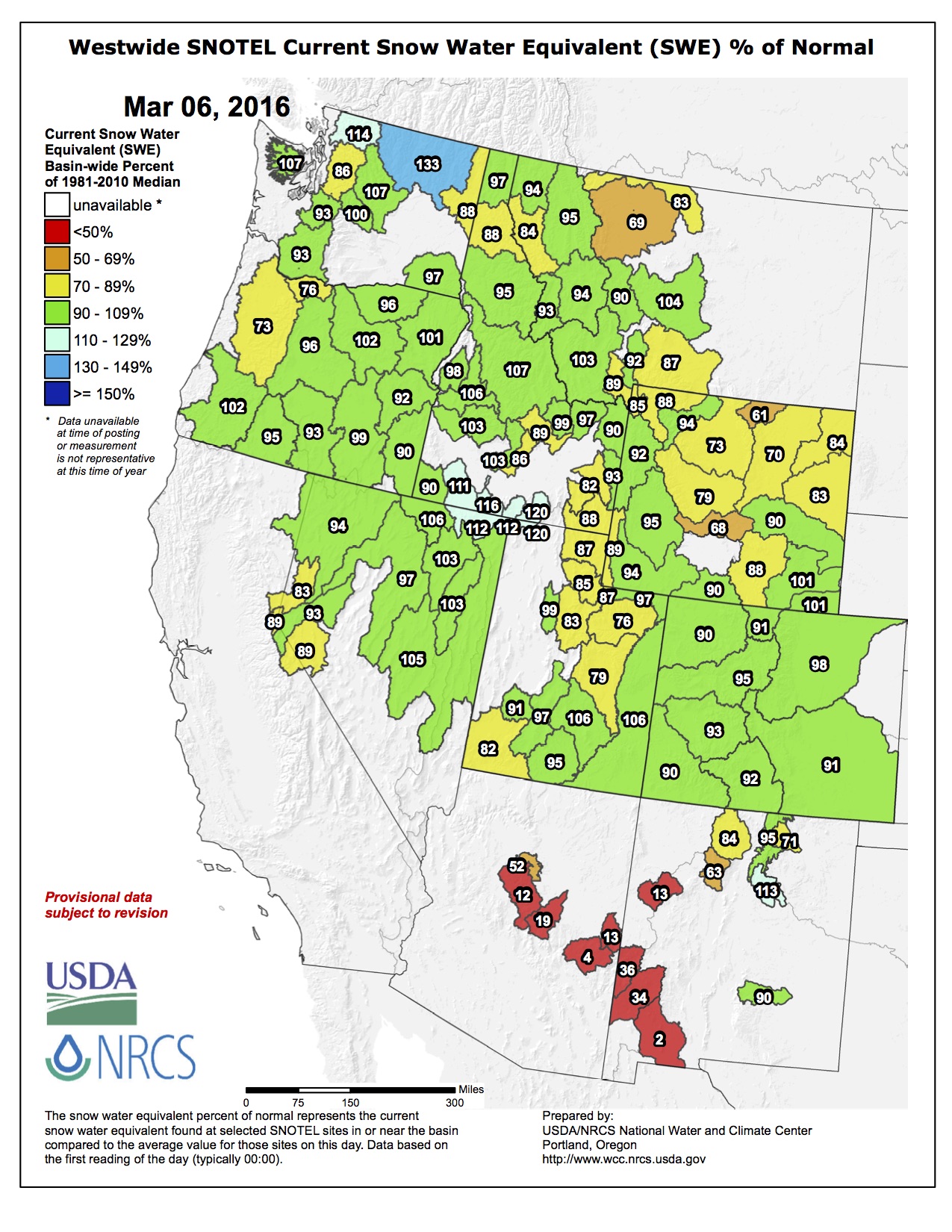
Westwide SNOTEL map March 6, 2016 via the NRCS.

Good timing for today’s storm, all basins have dipped below 100% of median.

From the Natural Resources Conservation Service via the Sky-Hi Daily News

The USDA Natural Resources Conservation Service (NRCS) Kremmling Field Office snow surveyors Mark Volt and Vance Fulton took the March 1st. snow survey measurements during the last days of February. Even with the recent warm weather, the survey shows that the county is in pretty good shape up high, they said.

Valley snowpack has decreased significantly during February.

Snowpack in the high elevation mountains above Middle Park now ranges from 86 percent to 125 percent of the 30-year average, with the overall average for Middle Park at 104 percent.

“Last year at this time we were at 102 percent of average,” they said.

Snow density is 28 percent, which means that for one foot of snow there is 3.4 inches of water, which is normal for March 1st.

Most of the snow courses around Middle Park have been read since the 1940s. Snow course readings are taken at the end of each month, beginning in January and continuing through April. March is historically the snowiest month and the April 1 readings are the most critical for predicting runoff and summer water supplies, as most of our high country snowpack peaks around that time.

From The Grand Junction Daily Sentinel (Dennis Webb):

[The blue] skies and warm days have contributed to Colorado’s snowpack falling to below normal, at 98 percent of median as of Monday, according to Natural Resources Conservation Service data.

That comes after what had been a strong start for snowfall accumulation in the state in recent months. But a drier midwinter also was expected by forecasters as part of this year’s El Niño weather pattern. And the good news from a snowpack perspective is that the experts also believe the odds are that moister weather lies ahead this month and next based on past El Niño patterns.

“Right now it does look like that we are looking toward a change in (weather) pattern right around the seventh of March,” said Joe Ramey, a meteorologist with the National Weather Service in Grand Junction.

He said that in recent weeks, a ridge of high pressure west of Colorado has weakened storms coming in from the Pacific Ocean…

Painful as a weather change might sound to some, it would provide a welcome boost for the state’s water supplies. Statewide snowpack is down 19 percentage points from 117 percent as of Feb. 2. The Colorado and Gunnison river basins were respectively at 116 and 122 percent of median then, but by Monday both had fallen to exactly 100 percent of median, with the Upper Rio Grande and South Platte basins also at that amount.

The San Miguel, Dolores, Animas and San Juan basins dipped to 98 percent of median, the Yampa/White basins are at 93 percent, the North Platte is at 92 percent and the Arkansas is at 99 percent.

Colorado’s winter so far has been doing pretty well at following the script for El Niño winters, a reference to winters with weather dictated by above-normal water temperatures in the eastern equatorial Pacific Ocean. That script called for an above-average start precipitation-wise in the state, followed by a below-average period and then a wet end to the snowfall accumulation season, if a strong El Niño persists long enough, which Ramey said it’s doing.

Ramey said he had expected the dry period to arrive in January, but it showed up a little later.

“We’re still thinking that March and April overall have a tendency to be wet during especially strong El Niños,” he said…

Ramey is uncertain how long the moister trend next week may last, however, pointing to signs that the high-pressure ridge to the west could rebuild beyond March 10 and lead to a drier pattern again.

Erik Knight, a hydrologist with the U.S. Bureau of Reclamation’s Western Colorado Area Office, said he’s expecting Blue Mesa Reservoir to fill this year.

“Some of that is based on hoping the storms return in March and April,” Knight said.

He said it has helped that recent problems and maintenance work at power plants downstream from the reservoir led to reduced water releases from the reservoir and let it carry more water through the winter.

As of Feb. 1, reservoir storage across the state was at 110 percent of average. Storage was at 108 percent of average in the Upper Colorado basin and 109 percent in the Gunnison basin.

Knight said that outside of a storm at the start of February, “things have been pretty dry, not a whole lot of extra snow accumulation up there” for the month.

“Now we’re just kind of banking on El Niño producing in March and April, and if it does we’ll be good and if it doesn’t we might struggle to fill the (Blue Mesa) reservoir,” he said.

All of the snowfall in Grand Junction in February came at the start of the month, including 4 inches on Feb. 1 and small amounts on Feb. 4 and 6, Ramey said. The 4.7 inches in total amounted to above-average overall snowfall for Grand Junction for February, he said…

“Let’s keep our fingers crossed for a wet spring,” Ramey said.

Mineral owners assert property rights #keepitintheground

Directional drilling from one well site via the National Science Foundation

From The Denver Post (John Aguilar):

At a contentious meeting in Adams County in January that carried on until the early-morning hours, several mineral rights owners stood up before the commissioners and lambasted a proposed 10-month drilling moratorium as an abrogation of their property rights.

In late February, a group of mineral owners appeared before a state House committee to support HB-1181, a bill that would require communities that ban drilling to compensate mineral owners for lost royalties.

And on Tuesday, those who own minerals are being encouraged to attend a Greeley City Council special meeting in which the council will consider an appeal from Extraction Oil & Gas to drill up to 22 wells on the city’s west side. The plan was turned down by the city’s planning commission earlier this year in the wake of strong public resistance.

“It’s all about protecting the economic foundation of our country, which is private property rights,” Smith said. “The issue is this is my property, and I have every right to realize the benefit of that property right.”

That right, she said, is enshrined in the very fabric of the state constitution and reflected in Colorado’s long history of mining.

No simple line

But Rep. Michael Foote, D-Lafayette, said the issue is not that cut and dried. Where one person’s property right ends, he said, another’s begins.

Foote was one of five Democratic legislators on the State, Military and Veterans Affairs committee to vote to kill HB-1181 on Feb. 24.

“It can’t just be that someone has mineral rights and they say they can exploit those rights any way that they see fit,” he said. “You have surface property owners who are losing value in their homes when drilling is done right next door.”

Foote characterizes the clash of property rights revolving around oil and gas activity as a “big issue” playing out across the state. It has even reached the Colorado Supreme Court, where the high court is set to decide in the coming weeks on how far a local community can go in limiting oil and gas development.

Emily Hornback, a community organizer with the Western Colorado Congress, has spent the past few years advocating for residents of Battlement Mesa. They worry about the impacts of a plan by Ursa Resources to drill 53 natural gas wells in the neighborhood.

In December, the company got special use permits from Garfield County but still must get approval from the Colorado Oil and Gas Conservation Commission before moving forward.

Hornback said residents of the 5,500-person community, many of whom are retirees, fear for their property values in the face of heavily industrialized activity on their doorstep.

But they don’t have the political power as an unincorporated community to do much to mitigate the impacts, she said.

“For the adjacent landowner, the world appears against them and they don’t have much legal recourse,” Hornback said. “Whose property right is winning and whose property right is losing?”

Doug Saxton, a retiree who has lived in Battlement Mesa for 11 years, said his wife has asthma that is exacerbated by emissions from oil and gas activity.

Saxton said with the dramatic advances in horizontal drilling technology in the last few years, Ursa should be able to get to the natural gas deposits under Battlement Mesa — and in turn pay the mineral rights owners for their assets — from a much farther distance.

“They have tremendous technology they like to brag about,” he said, “and they ought to be using it when they’re going to impact this many people.”

Key issue

Lance Astrella, a Denver-based attorney who has represented landowners and mineral owners alike, said providing “reasonable” access to minerals beneath the surface is the key issue under Colorado law.

That’s because the state operates under a “split estates” rubric, in which the surface rights and the subsurface rights are often owned by different parties.

Under state law, the mineral estate is considered the dominant estate and operators cannot be prevented from “entering upon and using that amount of the surface as is reasonable and necessary to explore for, develop and produce oil and gas.”

But that dominance isn’t unbridled.

Astrella helped draft a 2007 state statute that introduced the concept of “reasonable accommodation” for a surface owner affected by nearby drilling activity. The law states that an operator shall conduct its operations in a manner that minimizes “intrusion upon and damage to the surface of the land.”

The industry insists that it has made numerous accommodations to surface owners and communities over the years, buffering noise with berms and walls and reducing pad size through the use of directional drilling.

In some communities, oil and gas operators have agreed to abide by memorandums of understanding, which are specific agreements between companies and local governments spelling out stricter standards of operation than what the state mandates.

But Astrella said the people who own the oil and gas deposits that the companies are trying to extract find it hard to prevail in the court of public opinion.

“The ones who have the intrusion and negative effects of oil and gas drilling — their situation is obvious and they have the public’s attention,” he said. “The mineral owners are less likely to have that benefit.”

Smith, with the National Association of Royalty Owners, said that’s because the conflict is between a property you can see — a home — and one you can’t — a pocket of natural gas.

“We don’t have the same voice because the legislature will take care of the property right on the surface rather than the property in the mineral estate,” she said. “It’s out of sight and out of mind. However, it’s a property right you can buy and sell like any other property right.”

Paying the bills

Minerals rights can also be inherited. That’s how Mike Paulsen, a wine and spirits deliveryman in Denver, obtained his minerals in Weld County. He said he used to get $200 a month from his holdings, but the industry’s recent price and production drop means he now gets a $50 check every few months.

It’s harder for him to keep up on his bills and pay off his debts.

“I not only used it to pay my bills but to have something to pass on to my kids,” said Paulsen, 53. “There’s not going to be anything left by the time I get my bills paid.”

He worries about the rising movement to limit oil and gas operations spreading to where his minerals are and impinging on his property rights.

“It really bothers me,” Paulsen said.

The total amount of royalty income in Colorado is hard to determine, Smith said, because agreements between oil and gas companies and mineral owners are privately negotiated. But based on the $475 million in royalties paid out in 2014 on state and federal lands, Smith extrapolates that total payouts statewide were around $1.1 billion.

Jon Isaacs of Adams County showed off a measley $102 check from Anadarko Petroleum Corp. The money represents a year’s worth of royalty payments off a 30-year-old oil and gas well on Isaacs’ property.

It’s not much, he concedes, but the real value under his 40-acre spread located just 4 miles north of Denver International Airport lies in the future. He smooths out a spreadsheet in his basement office that shows estimated royalty collections should a firm using the latest highly productive extraction methods drill new wells on his land.

At $31 per barrel, Isaacs says he’d get $19,000 in royalties a year. That rises to $37,000 annually by 2021, assuming a rebound in prices to $75 per barrel.

It’s his retirement fund, he said. No different than someone who invests in stocks, bonds or cattle futures.

“It’s so I can stay here at this house that I’ve improved and plant crops on my land and stay in Adams County into retirement,” said the 58-year-old, who bought this windswept parcel only because it came with mineral rights. “I bought this land as an investment.”

Roni Sylvester of La Salle is also looking to the future, which she now deems “uncertain” given recent anti-oil and gas efforts in the state. Her husband was planning to donate a ranch he owns in Wyoming to Colorado State University’s agricultural college.

That plan is now on hold because the couple can’t be certain their royalty income stream will remain intact.

“There’s no way you can plan,” Sylvester said. “It knocks the foundation out from underneath you. You have to plan for the absolute worst-case scenario.”

New Interior rule to protect streams in coal-mining areas draws criticism #keepitintheground

Mountain top removal for coal mining

From The Grand Junction Daily Sentinel (Dennis Webb):

A federal proposal to better protect streams from impacts of coal mining is coming under scrutiny regarding its level of necessity, particularly out West, and what benefits it would provide.

The National Mining Association is criticizing the proposal by the federal Office of Surface Mining Reclamation and Enforcement, saying it applies a nationwide approach to dealing with issues arising with so-called mountaintop removal surface mining in Appalachia.

“Obviously we’re very concerned about this (proposal), for the impact it will have on production,” said Luke Popovich, an NMA spokesman.

The Interior Department released the proposal last July, saying it would protect some 6,500 miles of streams over 20 years. It would replace regulations adopted in 1983, incorporating updated science and benefiting surface and groundwater, fish and wildlife, Interior said.

Companies would have to monitor stream conditions before, during and after operations, and the rule also addresses post-mining stream restoration. [ed. emphasis mine]

A rule adopted during the Bush administration in 2008 was challenged by environmental groups, who said it would weaken existing stream protections. That rule was vacated in a court ruling in 2014 and remanded for further action.

Adam Eckman, associate general counsel with the National Mining Association, said the Obama administration instead decided to develop a rule that “bears no resemblance” to the 2008 rule, which was narrowly aimed at a small set of issues in Appalachia.

“It really is confusing why this is being expanded out West to Colorado when Colorado has a nearly perfect reclamation record (by mines) and when no science related to impacts in the West has been cited at all” in support of the proposal, he said.

The NMA sees the rule, and other Obama administration moves including its court-challenged Clean Power Plan and its current moratorium on new federal coal leasing, as being part of an administration effort to eliminate coal-burning altogether.

Jeremy Nichols of the conservation group WildEarth Guardians said the proposal would impact Colorado’s underground mines only to the limited degree they have surface impacts, while having larger implications for surface mines like Colowyo and Trapper in northwest Colorado.

But he said a minimum level of such protections should apply nationally.

“Our clean water is just as deserving of protection as Appalachia’s clean water,” he said.

A study done for NMA estimates the new rule could cost up to 77,520 mining jobs, including potentially more than 10,000 in the West.

The Office of Surface Mining Reclamation and Enforcement says it could cost an average of 260 jobs related to coal production a year, which would be offset by an average increase of 250 jobs a year related to complying with the rule.

It estimates the compliance cost at $52 million a year, including $2.5 million for Colorado Plateau surface mines and $200,000 for underground mines on the plateau.

The NMA study estimates the rule could result in a 27 to 64 percent decrease in access to recoverable coal reserves, and up to $6.4 billion annually in lost federal and state revenue.

The Colorado Division of Reclamation, Mining and Safety has sent the Reclamation and Enforcement office a letter supporting certain details of the proposal, but listing a number of concerns about it.

It says the rules would require extensive permit coordination between Reclamation and Enforcement, the Environmental Protection Agency, the Army Corps of Engineers and states, which could delay permitting.

“The proposed rules do not account for regional differences in hydrology, climate, and mining methods/practices,” the Division of Reclamation, Mining and Safety added.

Thank you Peyton! #Broncos #peytonmanning

Peyton Manning at O.co Coliseum on December 6, 2012 in Oakland, California. Generated by  IJG JPEG Library.
Peyton Manning at O.co Coliseum on December 6, 2012 in Oakland, California. Generated by IJG JPEG Library.

R.I.P. Jim Isgar #coleg

Jim Isgar via the Southwestern Water Conservation District

From The Durango Herald (Ann Butler):

Standing on his deep roots in La Plata County, former state Sen. Jim Isgar may have made his largest mark on the state’s agricultural community. Two months shy of his 65th birthday, he died in Denver on Friday after a 4½-year battle against a rare form of leukemia.

Isgar had a long background in water before he was appointed to the Senate in 2001 to finish the term of former Sen. Jim Dyer, who resigned to take a position with the Colorado Public Utilities Commission. As a farmer and rancher in the Breen area, Isgar served on numerous water boards, including the La Plata and Animas-La Plata conservancy districts, the HH Ditch Co., including 25 years as president, and the Southwestern Water Conservation District.

Isgar would subsequently be re-elected twice to the Senate, chairing the Senate Agricultural Committee, before President Obama appointed him director of Rural Development for Colorado under the U.S. Department of Agriculture in 2009.

“Jim was a true Coloradan and a strong supporter of agriculture and water issues in the state,” said Bruce Whitehead, executive director of the Southwestern Water Conservation District. “Sen. Isgar was well-known for his influence over state water law and policy, and many bills had to be ‘Isgarized’ prior to passing out of his committee.”

Ann Brown, Isgar’s former campaign manager, still has a box marked Isgar campaigns in her garage.

“Jim fought in the state Legislature for the common-sense use of available water,” she said. “Not only was Jim a champion for water use, he was a champion for education. He lobbied hard for Fort Lewis College.”

Fountain Creek: Suthers ‘frustrated’ by impasse on stormwater projects — The Colorado Springs Gazette

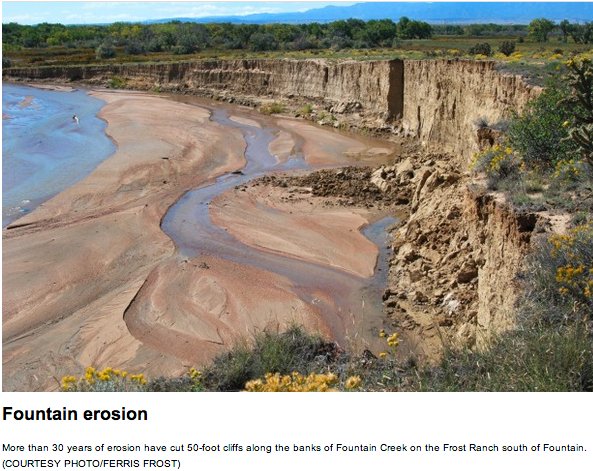
Fountain Creek erosion via The Pueblo Chieftain

From The Colorado Springs Gazette (Billie Stanton Anleu):

Mayor John Suthers is discouraged, frustrated and more than a tad disgruntled by Pueblo County’s failure to accept Colorado Springs’ offers of hundreds of millions of dollars for stormwater projects.

Friday, the county was to receive an offer to beat all previous propositions, one that also trumps the $15 million to $16 million annual expenditures under the city’s Stormwater Enterprise, a tax-funded program that ran from 2005 to 2009.

The new proposal calls for $445 million to be spent over the next 20 years through an enforceable intergovernmental agreement that carries $1 million penalties if the promised amounts aren’t spent.

In the first five years, at least $100 million would be spent, followed by $110 million over the next five years, $115 million over the ensuing five years and $120 million over what could be the final five years.

Why “could be”? Because if 73 targeted projects aren’t done by then, $24 million would continue to be spent each year until those fixes are finished.

The county’s consulting Wright Water Engineers and the city’s consulting MWH Global engineers mutually chose those projects to benefit Pueblo and Colorado Springs.

Since he took office in June, Suthers has stressed the importance of meeting the city’s obligation to Pueblo, vowing to spend $19 million a year, including $3 million from Colorado Springs Utilities, to improve conditions along Fountain Creek and its tributaries.

The mayor, City Council and Utilities have upped the ante considerably, though, since Pueblo County threatened to withhold the 1041 permit that would allow Utilities to launch the Southern Delivery System, or SDS, on April 27…

Pueblo County isn’t the sole source of consternation, however. The U.S. Environmental Protection Agency found during an August inspection that Colorado Springs falls short on water quality and stormwater infrastructure. The EPA warned the city and the U.S. Department of Justice that it might sue to restrict the city’s MS4 water permit.

City officials have been busy since, hiring engineer Richard Mulledy to head a reorganized Stormwater Division, scurrying to clean weed-crowded culverts, scattered riprap in channels and sediment-laden pipelines.

Mulledy, who previously worked for Pueblo, is optimistic about Colorado Springs’ new program.

“The improvement plan is very good – detailed, actionable, realistic,” he said Thursday. “The city has incredibly talented, motivated professionals. That, with the plan, I think we have a great opportunity.”

But the challenges are immense, Mulledy acknowledged.

“Fountain Creek is one of the most unstable, flashy creeks in all the nation. It’s a unique animal.”

Flows can vary from a base flow of 120 cubic feet per second to 20,000 cubic feet per second during a 25-year event, swelling the creek to 100 feet wide and 10 feet deep, he said.

“On top of that, the material along that creek is an alluvial field; it’s a sand. So it’s kind of the perfect storm.”

Pueblo knows that all too well. Colorado Springs’ growth has resulted in more impermeable pavement. But with the Waldo Canyon fire in 2012 denuding mountainsides, sediment in Fountain Creek increased at least 278-fold, pushing water levels far higher, Wright Water Engineers found in a 2015 study.

Plenty of federal and state grants helped Colorado Springs address that damage, and now the city is embarking on 73 projects designed to control flooding, reduce sedimentation and improve water quality.

Three-step process a beginning

First comes a $3 million detention pond along Sand Creek – “named appropriately,” Mulledy notes – to stop the sediment flow before it hits Fountain Creek.

Next is $2 million in Federal Emergency Management Agency projects from the presidential disaster declaration after the 2013 flooding, work that will rehabilitate wash-out areas, remedy sediment transport issues and improve water quality.

Then comes a $250,000 King Street detention pond off Fountain Creek, a retrofit to ensure full detention and address channel-forming flows.

“Instead of having just a flood-control facility, it manages that flow to more closely mimic natural discharge,” Mulledy explained. “And that’s a great thing, because what transports the most sediment is the everyday flow.

“Of course, sediment is the issue, because that’s what affects their levee levels” in Pueblo.

That’s only the start of the $445 million worth of work Colorado Springs promises to provide over the next two decades.

“Man, we put everything on the table,” Suthers said Thursday. “To the extent they’ve long cited that we did away with the Stormwater Enterprise, and we’ve offered far more than that. We’ve made offers to help with sediment issues and to push forward to fund the Fountain Creek (Watershed, Flood Control and Greenway) District.”

Colorado Springs Utilities is to pay that district $10 million a year for five years to perform more flood-control measures starting in December. But the district could get its first $10 million earlier if the SDS gets to start delivering water April 27.

“The other thing we’ve done, we’ve offered that any provisions in the EPA agreement to benefit them would also be put in the IGA,” Suthers said.

“We still don’t have an agreement despite the fact that we’ve stepped up,” the mayor said. “I’m very frustrated that we’re still so far apart. If we go to court, we’re going to say we’re in for far greater amounts. Litigation would simply not be a constructive way to resolve this.”

Pueblo County commissioners are set to meet at 9 a.m. Monday and Wednesday in the Pueblo County Courthouse, 215 W. 10th St.

#COWaterPlan: We all need to work together to meet water demands — Selina Heintz

From The Grand Junction Daily Sentinel (Selina Heintz):

After nearly three years in development and 30,000 public comments, Gov. John Hickenlooper in November announced the first-ever Colorado state water plan. The plan prioritizes conservation measures by setting impressive statewide water conservation targets for cities and industry, and proposes annual funding for healthy rivers, creating ongoing unprecedented financial support for river assessments and restoration.

As the plan was being developed, the Routt County Conservation District decided to talk with farmers and ranchers on the West Slope about what water means to their families and communities. With an aim to increase awareness for people during the Colorado water planning process, the interviews were made into videos that vividly tell the stories of several agricultural families whose livelihoods depend directly on the availability of clean water to grow crops and feed livestock. Our hope was to educate Coloradans and provide real context about agricultural water use.

While talking to farmers and ranchers, we heard the same messages over and over.

For example, all are proud to be part of Colorado’s agricultural community, and proud that agriculture is integral to our entire state and a big piece of Colorado economy, history and heritage. And in that heritage and heartbeat, water is everything. Without water, a Colorado way of life is lost.

The biggest cautionary message from Western Slope farmers and ranchers: taking water from the West Slope could devastate the region’s farms and ranches and, as a result, the entire state economy. This would not be a viable answer to the state’s water challenges.

The reality is that Colorado’s population is increasing and as drought conditions mean less water, there is a looming shortage that must be addressed with smarter solutions to ensure a sustainable future for Colorado. Whether for domestic or agricultural purposes, we can all use water better. A recent poll found that most of us are willing to reduce our use and find other ways to protect our water supply.

Farmers and ranchers have already made some changes to help conserve water through methods like grazing plans and storage, where many farming and ranching families are ensuring that existing water is maximized and can be re-used downstream.

Education also becomes pivotal in the conservation process to help urban residents understand the multiple uses of water in the state. When someone turns the faucet on, it helps to know that their water came through a tunnel from a source on the other side of the mountains. That knowledge promotes awareness of our connectedness and sharing.

Should we forget that, we risk hitting a “tipping point” where we take so much water from agricultural use that we impact the economy of the entire state. We must implement conservation measures and use water wisely first. Drying up valleys is not what works best for the state as a whole. Once that’s done there is no going back to what makes our state beautiful.

While the new plan is far from perfection, we see some value for West Slope agriculture.

The plan includes a goal that would help shift from the so-called buy-and-dry of agricultural water rights toward greater efficiency and flexible ways to share water with cities and streams. And the plan, while not categorically ruling out transmountain water diversions, makes it much less likely that we will experience new, costly and controversial large trans-mountain diversions, which would harm rivers and diminish the water supply for farms and ranches.

In the coming months and years, the Colorado Water Plan will require that people from all corners of the state work together. We each have a role to play to meet challenging water demands and the demands of our entire economy. If we work together, and with the conservation goals and smart thinking included in the Colorado Water Plan, we should able to meet our water needs and keep our farms and ranches a key part of the Colorado landscape and economy.

Selina Heintz joined the Routt County Conservation District as a supervisor in 2014 and currently serves as treasurer. She is a fourth-generation rancher in northwest Colorado and has a bachelor’s degree in animal science from Kansas State University.

Colorado Water Plan website screen shot November 1, 2013

#Snowpack news: The March 1, 2016 #Colorado Water Supply Outlook is hot off the presses

watersupplyoutlookreport03012016

Click here to read the report.

Here’s the March 1, 2016 snowpack by basin:

snowpackbybasin03012016nrcs

Here’s the March 1, 2016 streamflow forecast by basin:

streamflowforecastbybasin03012016

Finally, here’s the monthly precipitation by basin for Water Year 2016:

precipitationbybasin03012016nrcs

San Juan Clean Water Coalition to hold launch party Monday

A “get well soon” balloon floats in the contaminated waters of the Animas River flowing through Durango on Monday afternoon August 10, 2015 -- photo The Durango Herald, Shane Benjamin
A “get well soon” balloon floats in the contaminated waters of the Animas River flowing through Durango on Monday afternoon August 10, 2015 — photo The Durango Herald, Shane Benjamin

From the San Juan Clean Water Coalition via The Durango Herald:

Six months before the Gold King Mine blowout, a grass-roots movement prompted elected officials in Southwest Colorado to propose a site-specific good Samaritan legislation for counties within the San Juan Mountains.

The idea was to implement a pilot program that would provide adequate protections for parties undertaking remediation projects in the hopes the legislation could spread to other communities dealing with mines polluting watersheds.

Ty Churchwell, Animas River coordinator for Trout Unlimited, said businesses, organizations and individuals formed the San Juan Clean Water Coalition to engage and educate towns such as Ouray, Rico and Lake City, while at the same time support lawmakers.

“Every water source from the San Juan Mountains has mine-related problems, so it was a perfect place to do a pilot legislation,” Churchwell said. “And then Aug. 5 happened, and everything changed.”

The Gold King Mine was breached by Environmental Protection Agency contractors on Aug. 5, releasing 3 million gallons of tainted water into the Animas River.

Now, senators Michael Bennet, D-Colo., and Cory Gardner, R-Colo., and Rep. Scott Tipton, R-Cortez, are pushing a measure that would expand the reach of treating leaking mines, an endemic problem in the West caused by years of unregulated mining.

In response, the goals of the clean water coalition broadened.

The group advocates a five-point plan: a permanent water treatment plant in the Upper Cement Creek basin; legislation to facilitate remediation of mines across the West; proper watershed monitoring; economic recovery from the spill; and community involvement.

Churchwell said the group has grown into a coalition of more than 100 businesses and hundreds of individuals.

“River recreation is a key component of Durango’s healthy recreation/tourism-based economy,” Duranglers Flies and Supplies co-owner Tom Knopick said in a prepared statement. “The health of our businesses and the success of our clients depend on it.”

The clean water coalition will hold a launch party at 5 p.m. Monday at Animas Brewing Co.

Churchwell said the event will be an opportunity for community members to learn how to become more involved, as well as celebrate the river.

“If nothing else, post-Gold King spill, this community recognized our very essence and being are tied to the health of our river, and as such, we are all the Animas,” he said.

Tough week for ag with loss of great people — Jerry Sonnenberg

longspeak

From The Greeley Tribune (Jerry Sonnenberg):

The last week of February was a tough one for agriculture. I am not speaking of low commodity prices or weather conditions, but rather the loss of four icons and proven leaders in our industry.

Bill Wailes passed this past week, but his passion for improving agriculture will never be forgotten and was underscored by his induction into the Colorado Agriculture Hall of Fame.

“My desire is to make sure our industry is sustainable — that means profitable and environmentally sound. The animal welfare part of it has to be the best it can be,” said Wailes, whose department, the largest in the College of Agricultural Sciences at CSU, has become a leader in food safety and animal behavior and welfare.

“Bill Wailes has been one of the most positive and enlightening people I have met,” said Katlin Hornig, a student leader in the College of Agricultural Sciences. “He never fails to make sure his animal science students understand their animals’ value in life and within our industry.”

Charlie Bartlett from Merino also went to a place where water is plentiful and your tractor never breaks down.

Mr. Bartlett was a leader in the water community and served as the Chairman of the Colorado Ag Water Alliance, whose goal was to empower agriculture stakeholders to make the most informed and viable decisions regarding Colorado’s agricultural water.

“We all need each other in this state. I provide food that I produce, but I also need medical care, attorneys, all kinds of other goods and services that the people in the cities provide,” Bartlett said. “At the same time, much of the water we use on the farm goes back to cities, just in a different form. Milk, for example, is 80 to 90 percent water. Are these things that we’re willing to give up?”

He not only was a leader in the water community, but also served on a number of boards working on agriculture issues. Mr. Bartlett’s most recent years of work with Colorado Corn have been key to expanding markets within that industry.

“Ben Houston was highly beloved and had a renowned reputation across the country for his quality of cattle and expertise,” said Bill Hammerich, Chief Executive Officer of the Colorado Livestock Association.

Houston was a pioneer in the livestock breeding arena, utilizing artificial insemination since 1952, decades before the rest of the industry. When asked how he would like to be remembered, Mr. Houston replied without hesitation, “as a person who has helped improve the genetics of beef cattle and to further the meaningful Houston family traditions.”

Mr. Houston also helped lead the livestock industry as he has served on many boards in agriculture, including the Colorado Cattle Feeders and the National Western Stock Show, among many others. He also served as council to the governments of Turkey, Japan and Costa Rica on livestock issues and has worked with producers in the former U.S.S.R. and the Republic of Ukraine.

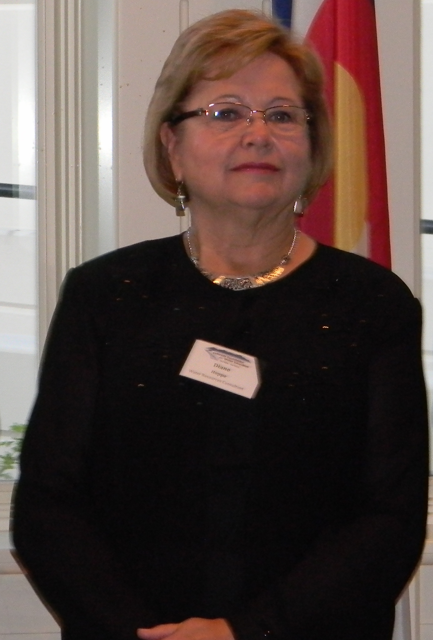
Diane Hoppe also passed this past week and will forever be remembered in the water community as the go-to person who worked to solve water issues.

As a Colorado State Representative for eight years representing northeastern Colorado, she served as chairwoman of the House Agriculture Committee and the interim Legislative Water Committee; she also helped create the Colorado Foundation for Water Education to help people not associated with water to understand the issues surrounding the use of water. As the current chair of the Water Conservation Board, her leadership indeed will be missed.

Each of these icons in the agriculture industry will be missed but their accomplishments will live on forever. The world is a better place because of each of their lives and contributions.

— Jerry Sonnenberg represents District 1 in the Colorado State Senate.

The Yampa, White, and Green Roundtable is down two members

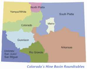
Basin roundtable boundaries

From the Community Agriculture Alliance via The Rio Blanco Herald-Times:

Living at the headwaters of the Yampa and White rivers and many of their tributaries makes it very easy for us to take water for granted. We turn on the faucets and water flows. We open our headgates and water rushes through. We put our boats into the rapids and water takes us downstream. We toss a line into a high mountain lake and a fish attaches itself to the hook.

But things may change. The population in Colorado is predicted to double by 2050. Drought, wildfire, flooding or climate change could create circumstances we cannot currently imagine. Existing municipal and agriculture infrastructure will age and the costs of replacement are rising. Our demands will grow while the supplies dwindle.

So who is watching out for Northwest Colorado? Who cares if we have enough water to meet our needs? Who is taking the challenge to guarantee that our water will continue to flow?

Many individuals and groups are working tirelessly on water issues. And the group that funnels everyone together is the Yampa-White-Green Rivers Basin Round Table (YWG RT). Since being formed by a gubernatorial order in 2010, our basin roundtable has met hundreds of times spending thousands of hours to assure that Northwest Colorado is ready for the future.

The board of YWG RT is comprised of 32 positions representing a variety of water stakeholders and interests in Routt, Moffat and Rio Blanco counties. Members are elected and/or appointed to their positions per the requirements of the statute and the roster is filled with people who have a passion for preserving the water in our region. Their officers are elected annually and must represent the Yampa and White river basins.

Currently, YWG RT is has two vacancies on its board and is seeking applicants to fill these at-large positions. An at-large position may represent environmental, agriculture, recreation, domestic water provider, industrial or community interests. The applicant must reside in the geographical area defined by the Yampa, White and Green river basins. It is not mandatory to own or represent water right holdings to be eligible to serve in this position. Applications for these positions must be submitted by Wednesday March 1 and will be reviewed at the Round Table meeting in Craig on March 9.

After years of analysis and base-line studies, development of the Basin Implementation Plan and collaboration with regional and state groups, the YWG RT is now ready to promote “on-the-ground” projects. They have grant funds available to assist with the cost of projects that focus on actions that can help Northwest Colorado meet immediate challenges or adapt to changing conditions that face our water supply and demand.

There are things to be done to preserve the quantity and quality of the waters we treasure. Don’t let the issues flood by. Become educated and take an active role in determining which way our water will flow.

The next Yampa-White-Green Round Table is Wednesday March 9 at the American Legion Shadow Mountain Clubhouse, 1055 County Road 7 in Craig starting at 6:15 p.m. The meeting is open to the public and attendance is encouraged.

For information about applying for a roundtable position or grant funding, contact Mary Brown, Round Table Chair at 970-361-0068 or marytaylorbrown@gmail.com

Marsha Daughenbaugh is the Executive Director of the Community Agriculture Alliance, Inc.

#Snowpack news: February Mountain Precipitation Lowest in Last Thirty Years — Brian Domokos

Here’s the release from the Natural Resources Conservation Service (Brian Domokos):

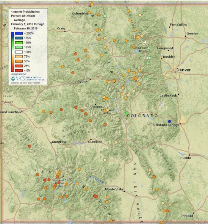
According to the USDA Natural Resources Conservation Service (NRCS) SNOw TELemtery network of mountain weather stations, Colorado statewide precipitation during February was the lowest in more than 30 years. The combined San Miguel, Dolores, Animas & San Juan basin only received 35 percent of the normal February precipitation. Statewide mountain precipitation, while still poor, was only slightly better at 56 percent of normal. “February in the mountains of Colorado is typically a slightly drier month than compared to say, April. But a dry February like this could have big ramifications should April and May not pan out” comments Brian Domonkos, Snow Survey Supervisor with the USDA NRCS.

Figure 1:February precipitation for SNOTEL sites (Click on map for link)

As expected, snowfall came up short as well, statewide snowpack is thankfully near normal at 99 percent, down 13 percent during the month of February. Most major watersheds in the state currently fall within a narrow range from 102 percent in the Arkansas and South Platte to 97 percent in the combined San Miguel, Dolores, Animas and San Juan basins. The numerical outlying basins are the combined Yampa, White & North Platte River basins at 93 percent of normal.

Reservoir storage has been very consistent since the beginning of the water year, not wavering one percentage point at 110 percent of the thirty year normal. Currently reservoir levels are far better than the deficits that were experienced during the winters of 2013 and 2014.

The majority of streamflow forecasts in the state fall between 75 and 105 percent of normal, yet are down from last month. With the two most significant precipitation months yet to come, spring and summer runoff are heavily dependent on March and April weather systems which leave room and the possibility for improvement.

snowpackreservoirstoragetable03012016vianrcs

For more detailed information about individual Colorado watersheds or supporting water supply related information, have a look at the Colorado Water Supply Outlook Report or feel free to go to the Colorado Snow Survey website at:

http://www.nrcs.usda.gov/wps/portal/nrcs/main/co/snow/

Or contact Brian Domonkos, Colorado Snow Survey Supervisor at Brian.Domonkos@mt.usda.gov or 720-544-2852.

#Snowpack news: March 3 Basin High/Low graphs

Click on a thumbnail graphic to view a gallery of snowpack data from the Natural Resources Conservation Service.

From The Greeley Tribune (Nikki Work):

A warm, dry February led to a drop in snowpack numbers across the state, according to the latest numbers from the Natural Resources Conservation Service. Still, all basins — including the South Platte and the Upper Colorado River Basins, which feed northern Colorado — are at or slightly below average for this time of year. Since the last snowpack update at the beginning of February, the state’s river basins dropped an average of nearly 19 percent. A month ago, numbers showed the state’s snowpack totals for all river basins was above average.

The reservoir storage numbers for the end of February for all the state’s basins had not yet been updated late Wednesday. But Sarah Smith, water resources engineer at Northern Water, said if the reservoirs for the Colorado-Big Thompson Project are any indicator — and they likely are — the state is still sitting pretty when it comes to water storage.

Though the state’s future water sources are still running close to average, if the streak of dry, sunny weather continues through March, that prognosis might change.

“February was just dry,” Smith said. “We had a pretty big storm in the beginning of the month and then after, that we just didn’t get the storms that we normally would.”

Smith said right now in the South Platte River Basin, which feeds into the Greeley area, snowpack is slightly above 100 percent of the historic average, but if the snow stopped right now, it would only be at about 70 percent of what’s needed for the year.

That’s why springtime storms are so important.

“We’re right around where we should be on March 1, but March and April are critical months for snowpack development,” Smith said. “I think we need to keep an eye on the weather during March and see if the storms come in. If the dry weather from February continues, we could be in a bit of a bind in terms of water supply.”

#cwcac2016 Colorado Water Congress Annual Convention recap #COWaterPlan

Jim Broderick panel Colorado Water Congress Annual Convention January 2016

From The Washington Park Profile (Haines Eason):

The Colorado Water Congress—a professional networking association providing a forum for Colorado water-focused organizations and businesses—held its annual convention Jan. 27-29 at the Hyatt Regency Denver Tech Center. Leading the agenda after the opening of the General Session was a panel discussion entitled “Unwrapping Colorado’s Water Plan.” Discussion covered an array of topics, from the need for more risk taking in regards to partnerships between bodies that had not historically aligned to our debt to previous generations’ work on storage and other water-related infrastructure to the recent water supply problems in Flint, Michigan.

Immediately following, a second panel entitled “Securing Our Water Present” was tasked with discussing whether Colorado is committed to ensuring water supply in the face of current pressures. Pressures illustrated included aging infrastructure, natural disasters and water compact compliance.
Before discussion, moderator David Robbins of law firm Hill & Robbins reminded the audience of certain concrete water realities:

“On a large scale there is no new water supply for us to talk about,” Robbins said.

“There’s a certain amount of water that’s available in our state each year under various hydrologic conditions. The water in our rivers is governed by interstate compacts … [and] we must learn to live with what we have and manage our plans accordingly.”

[…]

“Knowing that agriculture controls 85 percent of the water kind of makes us nervous when a water plan comes out,” [Don Ament] said.

“I believe in collaboration, but it makes you kind of nervous. If [a neighbor] doesn’t have any water and I have a lot of water and we’re going to share, what do you suppose is going to happen to me? [Sharing] means we’re going to spend less water in agriculture.”

“The second contributor to this economy that we’re all worrying about is agriculture,” Ament added…

Others like “Securing Our Water Present” panel member Sean Cronin of the Saint Vrain and Left Hand Water Conservancy District urge taking a broader view with regards to water usage in Colorado.

“If there’s a sector of the population laser focused on ensuring adequate flow and another segment of the population laser focused on consuming water up until our compact entitlement, I think the point of Colorado’s Water Plan is those are both values that Colorado needs to invest resources ensuring both happen for this generation and the next generation,” Cronin says.

“We’re all fighting for the same thing. We need to come together as stakeholder groups to ensure everybody has something.”

To read Colorado’s Water Plan, visit http://coloradowaterplan.com.

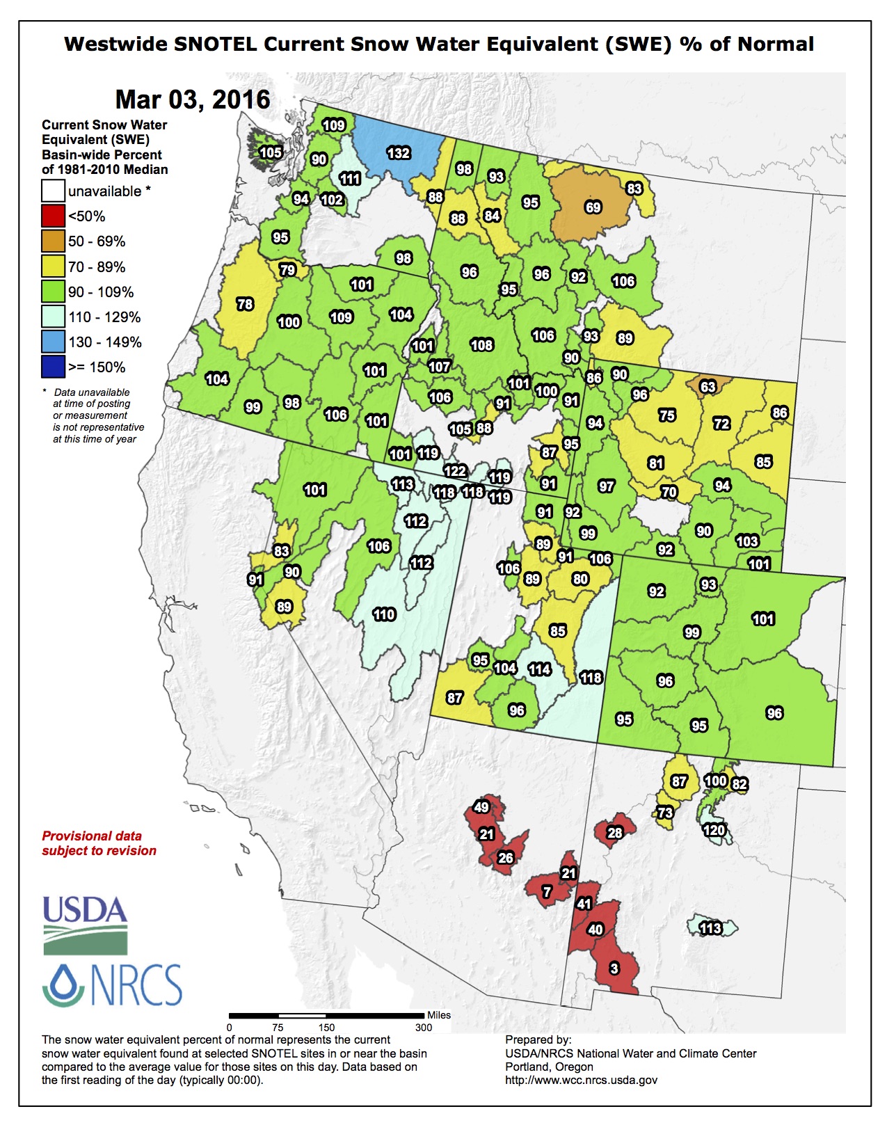
#Snowpack news: All basins still in the avg. range, stay hopeful for a stormy spring

Westwide SNOTEL map March 3, 2016 via the NRCS.

From TheDenverChannel.com (Mike Nelson):

Most of the snow you see on Colorado’s Grand Mesa fell back in the early part of the season.

“It snowed for 9 weeks straight, on average 3 feet per week,” recalls Jeff Kieper. “We were trudging around in sometimes waist deep powder.”

While there was plenty of snow in Colorado’s high country in the early part of season, the snowpack numbers are starting to drop.

Bob Steger is the Manager of Raw Water Supply for Denver Water.

“Our snowpack is a little above average for this time of year,” he said. “But we are monitoring what is going on in the way in [sic] climate change.”

Climate scientists at Denver Water study changes to weather patterns that could impact that snowpack and our water supply.

Changes like less snow during the winter or melting earlier in the season.

“We are seeing a little bit earlier snow melt which so far has not had a huge impact on us because we are still able to store that melting snow,”

[…]

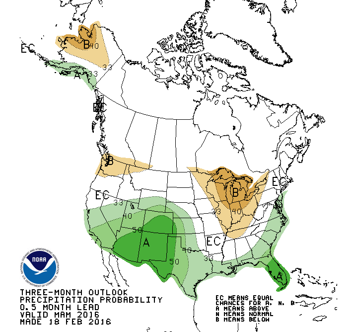
Our spring weather pattern will bode well for the snowpack and summer water supply for the state.

Expect a stormy weather pattern to resume across the central Rockies by late March and continue through early May. A series of storm systems will swing through Colorado and bring heavy snow to the mountains.

Three month precipitation outlook through May 31, 2016 via the Climate Prediction Center.

@ASU: Future of the #ColoradoRiver Basin

asufutureofthecoloradoriverbasin03032016

From Arizona State Universilty:

Experts share the good, the bad and the hopeful at panel hosted by ASU’s Decision Center for a Desert City

The Colorado River provides water for nearly 40 million people in seven western states, irrigating millions of acres of farmland, and generating thousands of megawatts of electricity.

And though an official declaration of water shortage on the Colorado River has never been declared, and that careful planning has ensured Arizona and Colorado are well-supplied with water, residents need to know it’s a precious resource.

That was the message Thursday as the water chieftains of Arizona and Colorado spoke before a crowd of about 100 at the Water/Climate Briefing Annual Keynote Event held by Arizona State University’s Decision Center for a Desert City.

Tom Buschatzke, director of the Arizona Department of Water Resources, and his counterpart from Colorado, James Eklund, director of the Colorado Water Conservation Board, held a discussion moderated by Wellington “Duke” Reiter, special advisor on urban initiatives to ASU’s Office of the President.

Among the topics: The states of the Colorado River Basin are developing strategies to address water needs but the question remains, can an over-allocated Colorado River Basin achieve water sustainability?

“What California does is curtailment,” Buschatzke said. “What we’ve done since the 1980s is conservation. … We took the slow and steady path. But they’re in a crisis. … Our goal is for that not to happen (in other states).”

Colorado’s population is projected to go from current 5.3 million residents to 10 million between 2050 and 2060. To prepare for that increase, the state came up with a flexible water plan last year with measurable objectives, guided by local users, Eklund said.

“We have more interest, more data, and more planning tools than we’ve ever had,” he said.

Arizona’s conservation policies have left the state with water security, Buschatzke said. When he is asked by California water managers why Arizona doesn’t have mandatory curtailment policies, Buschatzke tells them, “We don’t have to.”

Cooperation between basin states is critical, Eklund said. “We have to work together on these compacts, because if we go it alone there are no winners,” he said.

Water managers are well aware that the endless legal battles before the 1990s didn’t achieve anything.

“For many years the way the river worked was litigation,” Buschatzke said.

Arizona Department of Water Resources director Tom Buschatzke (center) speaks with Colorado Water Conservation Board director James Eklund (right) and moderator Wellington "Duke" Reiter, special adviser on urban initiatives for ASU, during the DCDC Annual Keynote: "A Conversation about Solutions for Water Sustainability in the Colorado River Basin," on Thursday, March 3. Photo by Charlie Leight/ASU Now
Arizona Department of Water Resources director Tom Buschatzke (center) speaks with Colorado Water Conservation Board director James Eklund (right) and moderator Wellington “Duke” Reiter, special adviser on urban initiatives for ASU, during the DCDC Annual Keynote: “A Conversation about Solutions for Water Sustainability in the Colorado River Basin,” on Thursday, March 3.
Photo by Charlie Leight/ASU Now

Water managers have dumped historical data sets used to predict rainfall and snowpack because they’re not representative of what’s happening now. [ed. emphasis mine] Arizona’s Department of Water Resources uses rainfall records going back to 1988 — what Buschatzke called a stress test period — plus models that incorporate climate change.

Predicting future water supplies is difficult in Colorado, Eklund said. Between climate change and a vacillating snowpack, “it’s a constantly changing thing that you can’t use to predict the future,” Eklund said.

Colorado residents have sat up and paid attention, Eklund said. If it rains, municipal water suppliers notice a significant drop in use because customers didn’t water their lawns. “There’s a really reactive ratepayer base,” he said.

In Arizona, municipalities are banking water underground. “There is some resiliency there in having water in the ground,” Buschatzke said.

Still, there is some concern that not enough people are aware water is such a precious resource.

“We have a long way to go on market penetration on that issue,” Eklund said. The Colorado native talked about arguments with his wife — a Bostonian — on whether to have a lawn or not. “We have a real disconnect between what people understand about the resource and reality,” he said.

“I agree with James,” Buschatzke said. “They just don’t understand where their water comes from.”

Sustainability and benefits can take different forms, Eklund said. He talked about how Coloradans go to Las Vegas and are horrified by the apparent waste of the Bellagio fountains. Attracting tourists is Nevada’s lifeblood, he said.

“That provides more economic benefit to the people of Nevada than growing a field of alfalfa.”
New wells, treatment improvements erase Wiggins’ water supply problems

Wiggins
Wiggins

From the Brush News Tribune (Stephanie Alderton):

After many years of struggling to provide enough clean water for the town’s growing population, Larino reported Feb. 24 that Wiggins now has more than enough for several years to come — even taking into account the two new housing developments that will begin construction this year.

Much of the water system’s success can be attributed to improved filtration methods, new wells the town has added over the last few years and some recent water deals with the Front Range. But although the water system is in better shape today than it has been in years, Larino said there’s still room for improvement.

“A lot of people don’t recognize, I think, over the last couple of years, how (the water system) has changed and diversified,” he said.

Wiggins gets most of its water from three wells that pull from the Kiowa Bijou basin, and two more recently dug wells that pull from the South Platte River.

The town also owns permits for two more Kiowa Bijou wells that have not yet been drilled. These wells are augmented by a 112-acre recharge pond facility north of town, shares in Weldon Valley ditch water and a recently approved lease agreement with the city of Castle Rock for augmentation water over the next three years.

The town also has two more recharge ponds and a few more Weldon Valley shares pending court approval.

Larino also pointed out that, thanks to an improved cleaning and filtration system, Wiggins’ water is well below the state limit for nitrates and other chemical content.

The water’s quality, particularly its nitrates level, has been a problem for the town in the past, but Larino said those days are over.

In 2015, the town pumped about 182 acre feet of water out of the 256 available acre feet. Thanks to the new water agreements, Larino said they will be able to pump up to 737 acre feet in 2016 and for the next two years.

“We have a lot of water,” he said. “Three times the town, basically.”

Gary Boyce dies

bacanationalwildliferefuge

From The Denver Post (Tom McGhee):

Gary Boyce, a flamboyant rancher whose attempt in the 1990s to export San Luis Valley water to urban markets sparked a battle over water that continues to this day, has died.

Friends of Boyce, who was 68 and died early Wednesday, remembered him as a self-made man who loved the land and attempted to market water from the historic land-grant Baca Ranch in order to endow a wildlife preserve.

“When they decided to sell the Luis Maria Baca Grant No. 4, Gary purchased it,” recalled John Lubitz, a Denver lawyer who knew Boyce for more than 25 years.

Backed by Farralon Capital Management, a San Francisco-based investment partnership, Boyce bought the 100,000-acre ranch, created by an 1824 Mexican land grant.

He proposed drilling wells into the deep aquifer beneath the Baca and pumping the water to the Front Range.

“His goal was to endow that ranch to create a wildlife preserve,” Lubitz said.

But Boyce had more than altruistic aims in selling water.

“Struck by the prospect of selling water at the prevailing rate of $4,000-$7,000 an acre-foot, Boyce announced that he and his Stockman’s Water Co., were ‘in the San Luis Valley to do business,’ ” according to “The San Luis Valley and the moral economy of water,” a case study included in “Water, Place and Equity,” a book that explores water policy.

The plan failed amid resistance from residents (many of them potato farmers), the Rio Grande Water Conservation District and environmental activists.

The Nature Conservancy later purchased the Baca ranch, and it is now public land that includes the Baca National Wildlife Refuge.

In 2014, Boyce launched another attempt to sell water from the Valley; he was still pursuing that plan at the time of death. “I assume his investors will still be interested in doing that,” said George Whitten, a former member of the Rio Grande Water Conservation District’s board.

Steve Vandiver, general manager of the water district, often opposed Boyce’s plans but considered him a friend.

From The Pueblo Chieftain (Matt Hildner):

Gary Boyce, a Crestone-area rancher who spearheaded two efforts to transport groundwater from the San Luis Valley, died Tuesday.

He was 68.

Boyce died following a battle with pancreatic cancer, said Gene Kirby, an office manager for the Boyce Land and Cattle Co. His latest effort to tap the groundwater beneath the valley came on behalf of Sustainable Water Resources.

The Denver-based company aims to pump up to 35,000 acre-feet per year of groundwater from the north end of the valley, over Poncha Pass and on to cities on the Front Range.

Spokeswoman Monica Mc-Cafferty said the company was deeply saddened by Boyce’s passing, but that it would continue to push its water project. “We don’t expect any changes on that front,” she said.

The company has unsuccessfully sought support from the Rio Grande Water Conservation District and Saguache County, an effort that included mitigation payments of up to $150 million for schools and local governments.

It has yet to apply to the water court in the valley for the needed approval to move forward.

Boyce, who was born in Del Norte and spent part of his childhood growing up north of Monte Vista, grabbed the attention of his valley neighbors in the 1990s with his first proposal to export groundwater.

He called for pumping between 100,000 acrefeet to 150,000 acre-feet from underneath the Baca Ranch.
In 1995, Boyce and his financial partners purchased the 100,000-acre ranch from American Water Development Inc. after the latter group lost its court case seeking the right to develop its own export scheme.

Boyce’s scheme, commonly referred to as the Stockman’s Water Co. proposal, never made it to water court for the approvals it would have needed to move forward.

Nevertheless, his unsuccessful effort to get two statewide ballot measures passed to meter valley groundwater wells and to fine the pumping of groundwater from state lands in the valley stirred intense opposition from local water users.

While the export of valley groundwater has yet to materialize, an indirect legacy of Boyce’s efforts was the creation of the Baca National Wildlife Refuge and the designation of Great Sand Dunes as a national park by Congress in 2000.

Valley, state and federal officials pushed both moves, in part, to protect the valley’s groundwater and negotiated the sale of the Baca Ranch with Boyce’s partners.

#Drought news: Area of D0 added to SE #Colorado

Click here to go to the US Drought Monitor website. Here’s an excerpt:

Summary

Early in the period, a strong storm system tracked from the western Gulf Coast northeastward into interior New England, triggering numerous and widespread showers and thunderstorms across most of the eastern third of the Nation. Some of the storms produced severe weather that included numerous reports of tornadoes, some with fatalities, in the Southeast (February 23) and the mid-Atlantic (February 24). As the system traversed the Northeast, moderate to heavy (more than 2 inches) rain fell on most locations as temperatures were well above freezing. In the central Great Lakes region, however, colder air allowed snow to fall, with up to 15 inches measured in northwestern Indiana. As the storm exited the U.S., colder and drier weather enveloped the East. Elsewhere, after a dry start, weak Pacific systems brought light precipitation to the Northwest during the last 4 days of the period, eventually spreading eastward into the Midwest and south-central Great Plains by week’s end. Unfortunately, precipitation bypassed most of the southwestern quarter of the lower 48 States and northern Plains, and weekly temperatures averaged above normal in the West and across the northern half of the Nation. The El Nino induced dryness across Hawaii has started producing negative impacts as parts of the islands were degraded…

Southern Plains

After last week’s welcome rains and improvements to short-term dryness and drought in Texas, lingering precipitation from the departing storm system early in the week (12Z Tue-12Z Wed) brought another 0.5-2 inches of rain to northern, eastern, and southeastern Texas, and southeastern Oklahoma, while the Texas Panhandle received 0.1-0.3 inches. Then late in the week (12Z Mon-12Z Tue), eastern Oklahoma recorded another 0.5-2 inches of rain. Accordingly, in Texas, some D0 was removed in the north-central Panhandle, northern (along Red River), and southeastern (near Houston) portions. D0 was also removed in eastern Kenedy and Willacy counties as leftover soil moisture from the October deluges plus the lack of persistent lower humidity days away from the coast has kept these two South Texas counties from degrading.

In contrast, mostly dry weather covered the rest of Texas (southwest, south-central, and far south) and Oklahoma (Panhandle and northwest). Where little or no rain fell this week in Texas, D0 persisted and slightly expanded in extreme southwestern, far southern, east-central (going into northwestern Louisiana), and far northeastern Panhandle (continuing into north-central Oklahoma), while D1 expanded into Nueces County. Although surplus precipitation has fallen since the start of the Water Year (Oct. 1) in much of Texas and Oklahoma, recent short-term (60- and 90-days) dryness, unseasonable warmth, and strong winds have created numerous wild fires (including a 17,000 acre fire in Harper County, OK, on Feb. 18 when Buffalo hit 91F). In addition, the unseasonable warmth caused the winter wheat crop in Cimarron County, OK to break dormancy early, thus producing some stress to the crop due to inadequate topsoil moisture. Therefore, a new D0 area was added in the Oklahoma Panhandle, southeastern Colorado, and southwestern Kansas…

Central and Northern Plains

From South Dakota into Kansas, little or no precipitation fell, except for a band of precipitation (0.2-0.5 inches) in southeastern Montana, central South Dakota, southern Minnesota, northern Iowa, and southern Wisconsin. Recent surplus precipitation, however, over the past several months was enough to keep this region drought free with the exception of a few small lingering D0 areas. A watchful eye, however, will be necessary from northeastern Oklahoma northeastward into northwestern Illinois as short-term (2-months) dryness has so far been offset by very wet conditions at 3-months and longer. For example, as of March 1, Kansas City, MO had 28 consecutive days without measurable precipitation, the longest stretch since 41 days in 2002; however, Nov. 1-Dec. 31, 2015 precipitation totaled 7.67 inches, or more than twice of normal (208%).

In southwestern North Dakota, recent dryness at 60- and 90-days, along with unseasonably mild readings and minimal snow cover (mainly due to melt, sublimation, and evaporation), created similar conditions that justified the merging the two D0 areas in southeastern Montana and central North Dakota. In southeastern Montana, however, re-evaluation of the tools pointed to wet conditions out to 4 months, thus the D1(S) was removed there…

Rockies, Intermountain West, and Southwest

In the northern Rockies, light to moderate (0.5-1.5 inches) amounts fell, but the central and southern Rockies saw little or no precipitation as temperatures averaged above normal. The Water Year To Date (WYTD; since Oct. 1) basin average precipitation in the Rockies was close to or above normal, with most basins between 90-110%. The lowest values were found in Wyoming (between 60-95%). Basin average Snow Water Content (SWC) on March 1 in the Rockies was also close to normal in most basins, with Wyoming coming in again at the lower end (64-99%). Based upon information from Canada regarding southern British Columbia winter precipitation and drought conditions (none), northwestern Montana was re-evaluated and determined to be wetter than depicted. Accordingly, the western and northern D2 area was shrunk (improved), and the D1 area shifted southward away from the U.S.-Canadian border. Short-term tools were wet (out to 6-months), but 9- to 12-month indices were quite dry. In contrast, recent dryness and warmth in the north-central Rockies and High Plains called for expansion of the D0 and D1 into south-central Montana (while D1 was removed from southeastern Montana – see Central and Northern Plains), and for some D1 and D2 increases in central Wyoming due to recent dryness, warmth, and minimal SWC. Surprisingly, percent of average reservoir storage was close to or above normal as of Feb. 29 at most locations in the northern and central Rockies. No changes were made in the central Rockies and Intermountain West.

In the Southwest, the WYTD basin average precipitation was a mixed bag, with above-normal totals in central Arizona and New Mexico, but below-normal amounts in southern California and southwestern Arizona. March 1 average basin SWC was also mixed, with central Arizona and western New Mexico ranging between 4-45%, but northern New Mexico from 80-121%. With recent precipitation below normal in southern California, Arizona, and western New Mexico, December-February climatologically wet in western sections, and low SWC in Southwest basins, D0 was expanded across most of Arizona and western New Mexico, D1 slightly increased around the Yuma, AZ area, and D2 edged into California’s eastern Imperial Valley. With much of this area semi-arid and irrigated, impacts were difficult to determine. The Impact lines were also redrawn to depict the short-term, long-term, and both types of drought…

The Far West

With only weak Pacific storm systems entering the Northwest, moderate precipitation (2-4 inches) was limited to coastal Washington, parts of coastal Oregon, and the central Cascades. Lighter amounts fell on interior sections of Washington and Oregon and northwestern California. WYTD average basin precipitation continued near to above normal in Washington, Oregon, northern Nevada, and California’s Sierra Nevada, but March 1 average basin SWC declined from earlier values in Washington and Oregon, now ranging between 80-119%. However, central Oregon conditions continued to improve with decent snows and good inflows into reservoirs, hence D1 was trimmed a bit. Elsewhere, with conditions better than a year ago but nothing extraordinary about this week, status-quo was the story for Washington, Idaho, Nevada, and the rest of Oregon.

In northern and central California, after experiencing decent December and January precipitation and mountain snows, February (normally a wet month) was rather disappointing. The Feb. 1 average snow water equivalent (SWE) for the northern, central, and southern Sierras (23, 22, and 17 inches) was 120, 117, and 105% of normal, respectively. By March 1, the SWEs in all 3 basins were still the same as Feb. 1, but the percent of normal had declined to 89, 85, and 75%, respectively, as the SWEs should have increasing during February but instead remained static. The peak SWEs in the Sierra normally occurs on April 1, so there is still March left to build the snow pack. Even with the subnormal February precipitation, reservoirs were mostly stable as there was some carryover from high January flows and low elevation February snowmelt that kept inflows from being exceptionally low. On Feb. 24, with decent December and January precipitation, the California Department of Water Resources increased the allocation of 2016 State Water Project water for the long-term contractors from 631,115 acre-feet to 1,268,724 acre-feet, or 30% of the requested allocation, an increase from 15% earlier this year. However, recipients were warned that continued dry weather could force an allocation reduction. Except for the minor changes (1-cat deterioration) in extreme southeastern California, the rest of the state was unchanged…

Looking Ahead

During the next 5 days (March 3-7), heavy precipitation is expected to drench the Pacific Coast. Totals include up to 9 inches in western Washington, 7.3 inches in northwestern California, 8.2 inches in the northern Sierra Nevada, 5 inches near San Francisco, and 1-2 inches near San Diego and Los Angeles. The precipitation will extend eastward into the Intermountain West and northern Rockies, albeit with lower amounts. Unfortunately, little or no precipitation is forecast for the Southwest and southern half of the High Plains. Light to moderate amounts are predicted for most of the eastern half of the Nation, except for dry conditions in Florida. Temperatures should average above-normal in the western half of the U.S., especially the High Plains, and below-normal in the Northeast.

For days 6-10 (March 8-12), the odds favor above-median precipitation in the western third and eastern half of the Nation, with the highest probabilities in Oregon and northern California, and the Delta. Below-median probabilities were limited to the northern half of Alaska. Above-median temperatures are likely in the eastern two-thirds of the lower 48 States and southern Alaska, especially the eastern Great Lakes region and Ohio Valley, while below-normal temperatures are favored in the Southwest and western Alaska.

#ClimateChange: “The Old Normal Is Gone”: February Shatters Global Temperature Records — Future Tense

temperatures022016

From Future Tense (Eric Holthaus):

Our planet’s preliminary February temperature data are in, and it’s now abundantly clear: Global warming is going into overdrive.

There are dozens of global temperature datasets, and usually I (and my climate journalist colleagues) wait until the official ones are released about the middle of the following month to announce a record-warm month at the global level. But this month’s data is so extraordinary that there’s no need to wait: February obliterated the all-time global temperature record set just last month.

Using unofficial data and adjusting for different base-line temperatures, it appears that February 2016 was likely somewhere between 1.15 and 1.4 degrees warmer than the long-term average, and about 0.2 degrees above last month—good enough for the most above-average month ever measured. (Since the globe had already warmed by about +0.45 degrees above pre-industrial levels during the 1981-2010 base-line meteorologists commonly use, that amount has been added to the data released today.)

Keep in mind that it took from the dawn of the industrial age until last October to reach the first 1.0 degree Celsius, and we’ve come as much as an extra 0.4 degrees further in just the last five months. Even accounting for the margin of error associated with these preliminary datasets, that means it’s virtually certain that February handily beat the record set just last month for the most anomalously warm month ever recorded. That’s stunning.

It also means that for many parts of the planet, there basically wasn’t a winter. Parts of the Arctic were more than 16 degrees Celsius (29 degrees Fahrenheit) warmer than “normal” for the month of February, bringing them a few degrees above freezing, on par with typical June levels, in what is typically the coldest month of the year. In the United States, the winter was record-warm in cities coast to coast. In Europe and Asia, dozens of countries set or tied their all-time temperature records for February. In the tropics, the record-warmth is prolonging the longest-lasting coral bleaching episode ever seen.

#AnimasRiver: Secretary Jewell on the hot seat #GoldKingMine

This image was taken during the peak outflow from the Gold King Mine spill at 10:57 a.m. Aug. 5. The waste-rock dump can be seen eroding on the right. Federal investigators placed blame for the blowout squarely on engineering errors made by the Environmental Protection Agency’s-contracted company in a 132-page report released Thursday [October 22, 2015]

From The Denver Post (Bruce Finley):

House Republican lawmakers grilled Interior Secretary Sally Jewell Tuesday challenging her agency’s review of the Environmental Protection Agency’s Gold King Mine disaster — and Jewell maintained it was an accident.

“Do you want to amend that statement or retract it at all?” House Natural Resources Committee chairman Rep. Rob Bishop, R-Utah, said in a brief exchange during a three-hour budget oversight hearing.

Bishop showed an Aug. 7 e-mail from a Bureau of Land Management official in Colorado. That official informed superiors that “the EPA was attempting to relieve hydrologic pressure behind a naturally-collapsed adit/portal of the Gold King Mine. … While removing small portions of the natural plug, the material catastrophically gave-way and released the mine water.”

House staffers interpreted that e-mail to mean the EPA was “deliberately” removing small portions of a plug to relieve pressure when the Aug. 5 blowout occurred.

Jewell told Bishop she stood by her previous testimony to committee lawmakers and the conclusions of Interior’s Bureau of Reclamation technical review of EPA actions leading up to the mine disaster.

But Bishop said the e-mail “basically says the EPA was deliberately removing a small portion of the plug to relieve pressure in the mine.”

Jewell said the EPA work at the mine was “preparatory” for future work at the mine — rejecting notions that the EPA purposely triggered the blowout.

“It was an accident,”Jewell said…

Rep. Raul Grijalva, D-Arizona, noted that Jewell runs the Interior Department, which is separate from the EPA, and cannot compel the EPA to produce requested documents. Grijalva also put the 3 million-gallon Gold King deluge in the context of more than 330 million gallons leaking annually from the Gold King and other inactive mines in the area — “which the EPA was trying to fix.”

EPA officials on Tuesday declined to comment directly on House Republicans’ interpretation of the BLM e-mail. However, EPA spokeswoman Nancy Grantham referred to an EPA addendum to its internal review of the blowout that describes the EPA crew on Aug. 4 “slowly and carefully” scraping away “loose soil and rubble” near the mine opening to try to find blockage. On Aug. 5, the EPA crew “began additional excavation to identify the location of bedrock above and around the adit. Through this careful scraping and excavation, they were able to locate the bedrock.”

Then as state mining officials who had been at the scene moved to other nearby mining sites, the EPA document says, somebody at the site “continued to oversee the final cleanup work, which included clearing of the loose colluvium near the adit. Just prior to finishing, the team noticed a water spout a couple of feet high in the air near where they had been excavating above the top of the adit. Within a few minutes, the spout had turned into a large gush of yellow/orange water that ultimately resulted in a release of an estimated 3 million gallons.”

#Snowpack news: Slopes around Aspen get 63 – 76% of normal snowfall in February

Westwide SNOTEL map March 2, 2016 via the NRCS.

From the Glenwood Springs Post Independent (Scott Condon):

Aspen-area ski slopes ended up with only 63 to 76 percent of average snowfall in February after the faucet was abruptly turned off after a promising start to the month.

But weather experts said Tuesday skiers and snowboarders shouldn’t worry — winter will return next week and possibly stick around for a long, long time.

“Things get better next week,” said Ryan Boudreau, a partner in Aspen Weather, a micro-forecasting subscription service. “It’s (going to be) pretty active next week through May, really.”

Boudreau said his partner, Cory Gates, is envisioning a May that could mimic the month in other “super El Nino years.” The winter of 1982-83 was another strong El Nino, like this year, with a record 41 inches of snow in Aspen in May — the most ever for the month. Even higher amounts fell on the slopes.

February started off gangbusters. The Aspen Water Plant’s weather trackers recorded that 20.5 inches fell Feb. 1 through 3, and then warm and mostly dry weather took over. Only 5.5 inches of snow fell the rest of the month. Nevertheless, February squeaked by the average of the month of 26.12 inches of snow.

The dry conditions hit the ski slopes even harder. Snowmass saw 33 inches of snow for the month, according to Aspen Skiing Co. spokesman Jeff Hanle. That was 63 percent of average. Of the total, 22 inches of snow fell Feb. 1 and 2.

Aspen Mountain recorded 38 inches of snowfall in February, with 26 inches falling in the first two days. The total was 76 percent of average, according to Skico records.

The Aspen-area snowpack paid the price for warm, dry weather. The snowpack at the headwaters of the Roaring Fork River east of Aspen soared to 117 percent of average on Feb. 3, according to the U.S. Natural Resources Conservation Service. It dropped to 99 percent of average late last week.

For the heart of the winter, it’s been slightly dry and warmer than average, according to the National Weather Service in Grand Junction. For December, January and February — which the weather service refers to as meteorological winter — the Aspen-Pitkin County Airport picked up 3.06 inches of liquid precipitation, including the water equivalent in the snowfall. That was about one-quarter inch below average for the three months, said Jeff Colton, a meteorologist with the weather service. The average temperature was 1.7 degrees above average for that three-month period, according to the agency.

Like Aspen Weather, the National Weather Service is also forecasting a change next week. The Grand Junction office posted on its website to expect a “significant change to the weather pattern over the western U.S. by early next week.”

Colton said a ridge of high pressure that has deflected most storms to the north of Colorado over the past few weeks is breaking down.

“It’s going to open up the door for El Nino to get going again,” Colton said. The weather service foresees a wetter-than-normal last half of March and April, he said.

2016 #coleg: How will HB16-1005 (rain barrels) fare in the State Senate?

Rain barrel schematic

From The Durango Herald (Peter Marcus):

The Colorado House on Tuesday gave overwhelming bipartisan approval to a bill that would allow Coloradans to collect rain water that falls on their roofs.

The House passed the bill 61-3…

House Bill 1005 now heads to the Republican-controlled Senate, where Sen. Jerry Sonnenberg, R-Sterling, has previously objected to the measure. He chairs the Agriculture, Natural Resources and Energy Committee, where the bill was assigned last year and delayed in committee over objections from Sonnenberg.

The concern is with eroding the state’s prior appropriations system, in which water rights are granted to the first person to take water from an aquifer or river, despite residential proximity.

A study by Colorado State University in September, however, stated that allowing 100 gallons of rainwater storage per household would not decrease surface runoff by any detectable amount on a typical lot.

With the amendments added this week, and the momentum behind the bill, it has its best chance of passing through the Legislature this year…

“The people of Colorado have spoken and their elected officials have listened,” said Pete Maysmith, executive director of Conservation Colorado. “Citizens in our state want the senseless ban on rain barrels to be lifted so they can use this conservation tool to water their lawns and gardens.”

Colorado Sens. Bennet, Gardner urge law to spur cleanup at old mines — The Denver Post

Bonita Mine acid mine drainage

From The Denver Post (Bruce Finley):

Colorado’s senators Wednesday urged fellow lawmakers to support “good Samaritan” legislation to spur voluntary cleanups at dormant mines polluting waterways around the West.

Sen. Michael Bennet also is pushing a more-ambitious reform of the nation’s 1872 Mining Law to raise funds.

The bill he and Sen. Cory Gardner propose would protect companies and conservation groups if things go wrong.

“There’s no time like the present,” Gardner said in a Senate Environment and Public Works Committee hearing.

Bennet called the bill “a very important step forward.”

But with thousands of mines draining acid heavy metals into western headwaters — for which the EPA estimates cleanup costs as high as $50 billion — Bennet and others say voluntary work isn’t sufficient.

“The Gold King Mine spill has served as a catalyst to focus Congress’ attention on the dangers posed by the thousands of abandoned mines in Colorado and throughout the West,” Bennet said.

“Mining has been intrinsically linked to our history, economy, development and culture, but it’s also left scars that are hurting communities in our state. We need to take action to help clean up the hundreds of mines in Colorado that are leaking acid mine drainage, polluting our headwaters and worsening water quality for the communities downstream.”

[…]

“It requires a large-scale solution — 1872 Mining Law reform,” Jennifer Krill, director of the advocacy group Earthworks, said at the hearing. “We’re looking forward to moving beyond the good Samaritan debate to get to the heart of the problem: the lack of funding for cleanups.”

Sen. Barbara Boxer, D-Calif., lauded Gardner and Bennet but cited “problems” with the bill. “I want to make improvements to the legislation so that it will protect the environment and ensure that taxpayers will not be on the hook if a good Samaritan makes the pollution worse.”

Bennet said volunteers causing a spill “is extremely unlikely.”

CDPHE tags 105 miles of the Lower Dolores River as impaired

Dolores River watershed

From The Cortez Journal (Jim Mimiaga):

Colorado has listed 105 miles of the Dolores River between Slick Rock and the Utah state line as an impaired waterway because of high water temperature from chronic low flows.

The Water Quality Control Commission of the Colorado Department of Health and Environment ruled on the river’s impairment status during a hearing in December.

The section on the Lower Dolores River is “considered impaired because the temperature was greater than standards adopted to protect aquatic life,” said Meghan Trubee, media relations official with the Colorado Water Quality Control Commission. “We’re mostly concerned about the fish and macro invertebrates.”

[…]

“Because the stream is listed as impaired, the division is responsible for developing a plan to address the temperature impairment known as total maximum daily load (TMDL),” Trubee said. “The segment will remain on the 303(d) list until a TMDL is developed and approved by the EPA.”

A year’s worth of temperature data from a water-quality station at Slick Rock showed the river went above the daily maximum temperature standard 10 times – five in September 2013 and five in June 2014.
The separate readings went above daily maximum standard for March to November of 28.6 Celsius, or 83 degrees Fahrenheit.

“Warmer water has less ability to hold dissolved oxygen, which fish need,” said Jim White, a fish biologist with Colorado Parks and Wildlife. “The other reason is that higher base flows in the summer would create more habitat for growing invertebrates, the food relied on by native fish.”

The impaired section is below McPhee dam and reservoir and has not had a recreational whitewater release since 2011.

Water allocated for fish habitat, about 31,796 acre-feet, is held in McPhee reservoir and released throughout every year. In the winter, flows below the dam are 20-30 cfs. During summer, they reach 60-80 cfs if there is no whitewater release.

A series of low snowpack years have left the reservoir below full and only able to supply irrigation demands. A whitewater release occurs when there is more runoff than the reservoir can hold.

The Dolores Water Conservancy objected to the lower Dolores impairment listing, but wasn’t successful

@ColoradoStateU: ‘Most important water manager in the Western U.S.’ on campus

From Colorado State University (Jim Beers):

The Deputy Secretary of the U.S. Department of Interior, Mike Connor, will headline an evening of water-related discussions as part of the Dr. Norm Evans Endowed Lecture Series. Connor will offer his reflections on eight years as the water leader for the Interior Department at 6 p.m. Wednesday, March 9 in the Lory Student Center Theater. The evening is sponsored by the Colorado Water Institute, a part of CSU’s Office of Engagement, and the CSU Water Center.

Connor, who is a former commissioner of the Bureau of Reclamation, is a key leader in implementing the Administration’s priorities for the Department of the Interior, including water policy and relations in the face of an unprecedented Western drought. He serves as the Chief Operating Officer of the Interior Department, an agency of more than 70,000 employees with an annual budget of approximately $12 billion.

Important Western water manager

“Having Interior Deputy Secretary Connor as our first distinguished speaker in the Norm Evans Endowed Lecture Series is a rare opportunity for the CSU community to learn and interact with the most important water manager in the Western U.S.,” said Reagan Waskom, director of the Colorado Water Institute.

Prior to joining the Department of the Interior, Connor served as the Commissioner of the Bureau of Reclamation from 2009 to 2014, where he led efforts to promote the sustainable use of water to effectively address current and future challenges associated with water supply and power generation in the American West. Connor helped to forge major Indian water rights settlements and worked to resolve water conflicts in California, New Mexico, Oregon and other western states. He led the Department of the Interior’s efforts and completed two major binational agreements with Mexico on the Colorado River that have received international attention and acclaim.

Left to right: Four of the five current and former Colorado Water Institute directors – Reagan Waskom, Norm Evans, Neil Grigg, and Robert Ward. Photo by Lindsey Middleton.

Recognition of former directors

Left to right: Four of the five current and former Colorado Water Institute directors – Reagan Waskom, Norm Evans, Neil Grigg, and Robert Ward. Photo by Lindsey Middleton.

The evening will also include a special recognition of former Colorado Water Institute director Norm Evans along with former directors Neil Grigg and Robert Ward. The Evans Endowment, established by Ken and Ruth Wright of Boulder, sponsors an annual lecture on water management education and policy, and honors the longest serving director of the Colorado Water Institute.

The evening will conclude with four CSU water experts discussing western water issues and tradeoffs. Stephanie Kampf, associate professor of Ecosystem Science and Sustainability; Kelsea Macilroy, doctoral candidate in sociology; Pete Taylor, professor in the Department of Sociology, and; Brad Udall, senior water and climate research scientist/scholar with the Colorado Water Institute, will cover topics such as public shifts in attitudes toward water, changing notions of beneficial use, climate effects on water supply, water security, and possible approaches to governance for multiple water uses. Waskom will moderate the panel.

The event is free and open to the public. For more information, visit http://watercenter.colostate.edu/NormEvans_Lecture.shtml.

CFWE “Water for Commodity Production Tour” recap

Agratech.com photo via Todd McPhail

From The Pueblo Chieftain (Chris Woodka):

Plants need water.

Simple, right?

Until you begin to decide which kind of “plant.”

Pinto beans or cannabis? Steel or electricity?

While water is vital for life, it’s also a commodity, and determining the “highest and best use,” as water lore terms it, is a complicated proposition.

The Colorado Foundation for Water Education hosted a tour of about 50 people through history, farms and industry to show how water is used in Pueblo County.

“It’s a real blending of traditional and contemporary, where the Old West meets the New West,” said Kristin Maharg, of the foundation, which was formed by the state Legislature to provide impartial water information.

Most of the participants in the day-long tour were not from Pueblo County, which met the foundation’s goal of educating people from all over the state about the needs of the Arkansas River basin.

From the traditional side, Avondale farmer Tom Rusler explained the inner workings of the Bessemer Ditch and his own 1,600-acre farming operation that grows everything from onions and pinto beans to alfalfa hay and corn for livestock.

“On March 15 each year, water starts flowing in the Bessemer Ditch. It has to come 40 miles and takes about 40 hours to get here,” Rusler told guests as they enjoyed a lavish spread of Mexican food at tables in a farm shed. “We go up to the ditch and have a pizza party as we watch the water come in. From that point on, water dominates every conversation we have. It’s water all day, every day. It’s all we think about.”

Half of the 14 employees at Rusler Produce have the last name Rusler, including his sons Tommy and Nick. He joked that one of his young grandsons was quickly becoming the youngest farm manager in history — the sixth generation to work the land.

Rusler said he is blessed that his own sons have chosen to follow in his footsteps and at the same time excited that new technologies like sprinklers, GPS and drones are improving the efficiency of irrigation.

“It’s hard to make a farmer,” said Rusler, illustrating with his hands the basic equation of using soil, water and seeds to make a crop. “We would like to give young farmers a chance to see if they like it.”

On the modern side of farming, cannabis has become the hot new crop for Pueblo County, whether it’s marijuana or hemp.

“We’re getting an influx of people from out of state who know nothing about how Colorado water works,” said Kevin Niles, manager of the Arkansas Groundwater Users Association.

AGUA, like Pueblo Water, has set aside some of its water for growing hemp or marijuana. The association augments depletion from wells, and meets its members’ needs first. This year, it will set aside 250 acre-feet for cannabis grows, close to its limit of 300 acre-feet.

Growers explained their own particular challenges.

“We’re under a microscope,” said Jeff Ayotte of the Southern Colorado Growers Association. He is using some of his water to grow marijuana near Boone.

He explained that marijuana is far more profitable than other crops, but that the paperwork associated with all aspects, including water, makes things difficult.

His farm uses 250 acre-feet of water, but only 5 acre-feet for marijuana. The water for marijuana is treated and reused eight times because it is so valuable.

Tony Adza, of Notis Global, is working with a company that plans to grow hemp east of Pueblo.

“We’re facing competition all over the world,” Adza said.

Because hemp is treated like marijuana — both are forms of cannabis and still illegal under federal law, but legal in Colorado — hemp growers have overpaid for water, he said. The hemp grown here has only minuscule amounts of THC, and is used to make oil claimed to have therapeutic benefits. The fiber from stalks could be used for things such as textiles or biofuel.

On the industrial side of things, Tim Hawkins, executive director of the Steelworks Center of the West, explained the history of CF&I Steel, now known as EVRAZ, while Water Division 2 Engineer Steve Witte outlined the company’s extensive water rights.

Founded in 1872, CF&I’s story covers the spectrum of American industry. Built from scratch, the company sopped up water, coal and iron ore resources in three states initially to supply rail for the Old West. Many of those resources — including some, but not all, of the water — were sold off as the U.S. steel industry weathered storms of global competition.

The New West use for industrial water comes with Xcel Energy’s Comanche Station southeast of Pueblo. First constructed in the 1970s, and expanded in 2005, the behemoth of a power plant is Pueblo Water’s largest customer using more than 10,000 acre-feet annually.

Lauren Nance, Xcel water resources analyst, explained how the newest addition, Unit 3, is a hybrid type of generation facility that cools and recirculates water to reduce consumption.

Finally, the connection between past and future uses was addressed by Pueblo County Commissioner Terry Hart, who said the county is still coping with an outdated comprehensive plan when it comes to blending water planning and land use.

That comes into play on both land use decisions in the county and multicounty projects like the Southern Delivery System, he said.

“Rapid growth is going to put more and more strain on limited resources, both land and water,” Hart said, saying the county has to be zealous in keeping water in the Arkansas River basin. “If you look at Crowley County, it was devastated when the water was taken. Water is connected to economic development.”

Weekly Climate, Water and #Drought Assessment of the Upper #ColoradoRiver Basin

Upper Colorado River Basin month to date precipitation through February 27, 2016 via the Colorado Climate Center.

Click here to read the current assessment. Click here to go to the NIDIS website hosted by the Colorado Climate Center.

#Snowpack news: Statewide snowpack dips below median

From The Denver Post (Jesse Paul):

Colorado’s statewide snowpack has dipped below its median level for the first time in 2016 as a warm, dry spell keeps storms at bay.

The Natural Resources Conservation Service says the snowpack as of Tuesday was 97 percent of normal and 94 percent of the average.

Compared to the same time last year, the snowpack is 14 percent greater.

Westwide SNOTEL map March 2, 2016 via the NRCS.

Fort Collins hopes to augment instream flows through town

From the Fort Collins Coloradan (Kevin Duggan):

The City Council on Tuesday unanimously approved a resolution directing the city manager to work with several entities to develop a plan for adding water to the river and keeping it from being diverted.

The city has been talking about augmenting in-stream flows on the river below the mouth of Poudre Canyon and through Fort Collins for about 45 years, said John Stokes, director of the city’s Natural Areas Department.

If an augmentation plan comes to pass, it could serve as a model for river systems across the state, Stokes said.

“The idea is to identify a stretch of the river and protect that water in that reach,” he said.

State water law allows in-stream flow augmentation, but the city and its various partners would pursue a novel approach to the concept, Stokes said.

It would allow water-rights holders to dedicate water to the augmentation program. The proposal ultimately would have to be approved through the state Water Court.

Crafting an agreement involving players such as Fort Collins, Greeley, Northern Water and irrigation companies that tap into the river would be the first in a three-phase process of creating an in-stream flow program, Stokes said.

How long the three-phase process will take and how much it will cost is not clear. The first phase of the project is expected to cost Fort Collins about $20,000, with partners contributing similar amounts…

A clause was added to Tuesday’s resolution stating any agreement accepted by the city for in-stream augmentation program does not indicate support for NISP.

Council members said the proposed augmentation plan was innovative. Councilmember Gino Campana said he hopes the pieces come together and “it actually happens.”

Poudre River Bike Path bridge over the river at Legacy Park photo via Fort Collins Photo Works.

CRRG report calls #ColoradoRiver environmental efforts disjointed

From the Associated Press (Dan Elliott) via The Washington Post:

Environmental protection for the Colorado River — the lifeblood of the Southwest — is disjointed and too often gets a low priority in the management of the waterway, independent researchers said in a new report.

Four, multimillion-dollar conservation programs do valuable work but would have more impact if they treated the entire 1,450-mile river as a single, integrated system, the report said.

“We can have something different and better than the existing patchwork of programs,” it said…

“I would assert that we can meet water supply needs and have a much healthier and restored river,” Jack Schmidt, a professor of watershed sciences at Utah State University and a member of the research group, said in an interview…

The Upper Colorado River Endangered Fish Recovery program, the Lower Colorado River Multi-Species Conservation Program and the San Juan River Recovery Implementation Program focus on saving endangered species in the river and its tributaries.

The Glen Canyon Dam Adaptive Management Program concentrates on mitigating environmental impacts in the Grand Canyon and other areas downstream from Lake Powell in Utah.

Combined, the programs spend about $54 million a year. The money comes from federal, tribal and state governments and from conservation groups.

The programs are administered by federal agencies with guidance from various partner agencies.

The report didn’t suggest who should be in charge of coordinating conservation work. Agency officials didn’t immediately respond to requests for comment on the report.

Bart Fisher, president of the Colorado River Water Users Association, which represents utilities, irrigators and others, said he agrees that collaboration is helpful and that his group supports many environmental programs.

Ken Neubecker of the conservation group American Rivers also advocated a more unified approach toward the river environment.

Glen Canyon Dam
Glen Canyon Dam

#ColoradoRiver: “You have to invoke temperatures to explain the current #drought” — Brad Udall

While Lake Powell entered 2002, when this photo was taken, with a pretty healthy amount of water stored, by 2004 the bathtub rings had expanded as drought deepened. Photo/U.S. Bureau of Reclamation.

From The Mountain Town News (Allen Best):

Invoking rising temperatures to explain drought in Colorado River

The drought in the Colorado River Basin in the 21st century has been phenomenal. There was that harrowing year of 2002, which broke records for low streamflows going back 150 to 300 years. Even now, the levels of water in the two big reservoirs on the river, Powell and Mead, continue to decline.

And then there’s California, epic in its drought.

But here’s something to confuse the storyline. Precipitation in these droughts alone fails to explain the droughts, as we conventionally think about them. California’s Sierra Nevada last winter got 40 to 90 percent of normal precipitation. That would suggest a drought, yes, and a memorable one. But this drought was defined as the worst in 1,200 years.

Declining reservoir levels in the Colorado River Basin this century similarly can’t be explained simply by lack of precipitation. There have been some good snow years, too. Yet Lake Mead has fallen from 91 percent of capacity in 2000 to just 35 percent of capacity now.

What’s going on? Global warming, say scientists. The story is of rising temperatures. In the Sierra Nevada last winter, the average temperature was above 32 degrees Fahrenheit, the first time in 120 years of recorded history. This, in turn, influences —and reduces—runoff.

The increased warmth results in more moisture sublimating directly out of the snowpack into the atmosphere, more water in creeks, lakes, and reservoirs evaporating, and plants requiring more water because they transpire moisture at higher levels into the atmosphere.

“Repeat after me: precipitation is not runoff,” instructed Brad Udall, a climate research scientist at the Colorado Water Institute, at a recent presentation.

lakemeadesince200002292016capviaallenbest

A hydrologist by training, Udall has been boring down at the intersection of water and climate change in recent years. He pays particular attention to the Colorado River, where he once was a river guide in the Grand Canyon. But he points to the Rio Grande as probably the most stressed river in the West.

“Climate change is water change. The two go hand in hand,” he said in a lecture at the Chautauqua Community House in Boulder, Colo. “Heat drives the water cycle.”

The Intergovernmental Panel on Climate Change has reported all kinds of observations that are consistent with climate change. Seven of 10 were water-recycle related. For example, sea-surface temperatures have gone up by about 0.5 degrees Fahrenheit since 1950. Water vapor in the atmosphere has increased by about 5 percent, consistent with projections.

Greenhouse gas emissions, he said, exacerbate existing drought sequences. One report, by Benjamin Cook and others, found that probability of a drought lasting 35 years or longer in both the Central Plains and the Southwest exceeds 80 percent in the 21st century.

Brad Udall via CSU Water Institute

Udall, working with Jonathan Overpeck, a climate scientist at the University of Arizona, has been studying runoff in the Colorado River, to understand the broader story of supply and demand, droughts, and falling reservoirs.

The current 15-year drought in the basin, he says, has had only 40 percent of the precipitation decline associated with a similar drought of the 1950s.

Why isn’t the water in the river? It’s because of rising temperatures.

“You have to invoke temperatures to explain the current drought,” Udall said.

It’s 1.6 degrees C warmer already, and climate models show that every degree C increase in warming will see about a 6.5 percent decrease in flows.

“Over the course of a century, you are looking at 20 percent to 30 percent losses (in river volume) due to temperature, and some models show up to 80 percent,” he said.

The Rio Grande looks to have the largest threat to flow reductions in the United States, perhaps 50 percent. It has a small collection basin in the San Juan Mountains of Colorado before flowing south into arid New Mexico and along the border of Texas and Mexico.

modeledtotalnewmexicostorage1950thru210002292016viaallenbest

Climate change will slam the Rio Grande. One study projects annual reservoir storage in the basin will drop 55 percent by century’s end.

Udall also had this to say:

  • Dams are not the entire answer, or maybe even much of an answer, to the need for storage. “There is a logical limit to what you can do to dams,” he said. “It’s like building more highways in Denver or building more interstates.”
  • The United States has 98,000 dams, including 8,000 big ones, and while they store water, they have adverse consequences: they inundate riparian areas, they waste water, they change the river flows, and they hold back sediments.

    Udall sees aquifers as a preferred place to store water. Arizona already has a robust aquifer recharge program, and water districts in the southern part of metropolitan Denver have also started recharging aquifers.

  • Rain barrels probably make sense. In Colorado, it’s still illegal to capture rain falling off your roof. That’s because Colorado’s prior appropriation doctrine requires that all water diversions, no matter how tiny, be adjudicated through courts. This astounds people, as the barrels don’t capture all that much water. The value of rain barrels, said Udall, is that they can cause people to think about water.
  • Desalinization can be done, but is extremely expensive. Cloud-seeding may offer just a sliver of increased snowpack. There are no magic bullets.
  • Undergoing severe drought, Australia upended its entire water allocation system. Will Colorado and other Western states ever upend their prior appropriation doctrine? Probably not, Udall said.
  • 2016 #coleg: HB16-1005, rain barrels to State Senate

    Rain barrel schematic
    Rain barrel schematic

    From The Pueblo Chieftain (Chris Woodka):

    Support is pouring in for a bill that would make rain barrels legal in Colorado.
    HB1005 passed the House on a 61-3 vote Tuesday and now goes to the Senate. Rep. Clarice Navarro, R-Pueblo, was one of the three votes against the legislation.

    Reps. Justin Everett, R-Littleton, Jim Wilson, R-Salida, also voted against it.

    “We amended the legislation so that it has broader support,” said Rep. Daneya Esgar, D-Pueblo.

    The bill allows homeowners to collect water in two 55-gallon barrels for later use on lawns and gardens.

    She provided a list of supporters that includes Trout Unlimited, the Farm Bureau, Denver Water and other diverse groups across the environmental spectrum. Pueblo Board of Water Works President Nick Gradisar personally supported the bill as well.

    The amendments came after 10-2 approval from the House ag committee, and all of the committee members voted for the final product.

    The amendments included a clear statement that having a rain barrel is not a water right, that the state engineer can curtail rain barrel use if necessary and a review of any allegations of injury to other water users by the state engineer in three to six years.

    Esgar is optimistic the bill will get a hearing in the Senate this year, after Senate ag committee chairman Sen. Jerry Sonnenberg, R-Sterling, spiked a similar bill that passed the House in 2015.

    “I’m hoping with the work that we’ve been doing on the bill he’ll support it,” Esgar said.

    Colorado is the only state where rain barrels are largely illegal, but studies by Colorado State University show there would be no additional impact to water rights than from simply allowing water to flow from downspouts onto lawns.

    R.I.P. Diane Hoppe

    Diane Hoppe at CFWE President's Award Reception 2012
    Diane Hoppe at CFWE President’s Award Reception 2012

    Diane was a friend of Coyote Gulch. She was always friendly, encouraging, informative, and generally interested in those around her, and in the water issues facing Colorado.

    The first time I had the opportunity to talk at length with Diane the conversation drifted towards storage.

    “Everyone wants gravel pits,” she said.

    I said to myself, “Diane knows the South Platte River.”

    She will be missed.

    Here’s the announcement from the Colorado Water Conservation Board:

    With a heavy heart we regret to inform you that Colorado has lost a truly remarkable woman in Diane Hoppe, who passed away on Saturday, February 27.

    Diane, a native of Colorado, was raised in Sterling. She spent almost 30 years in both the public and private sectors stewarding Colorado’s natural and agricultural resources.

    “Representative Hoppe’s contribution to the State of Colorado was substantial and the loss of her leadership and friendship will be felt by many statewide,” said Colorado Gov. John Hickenlooper.

    Diane’s list of accomplishments is inspiring, and here are a few of the many. Diane served in the Colorado House of Representatives from 1999 through 2006 and chaired the House Agriculture, Livestock & Natural Resources Committee, the Water Interim Committee, and the Water Resources Review Committee, and served as Minority Whip. She was a founding member of the Colorado Foundation for Water Education and served as President from 2002 through 2007. Governor John Hickenlooper appointed Diane to the Colorado Water Conservation Board as the South Platte Basin representative in 2012, and she was elected chair of the Board in 2015. Diane received many honors during her lifetime including the Colorado Water Congress 2013 Wayne N. Aspinall Award for Outstanding Water Leader.

    Diane Hoppe’s spirit will forever be remembered and will serve as an inspiration to the many lives she touched.

    Here’s a column she penned about the Colorado Water Plan and its importance to the state.

    WaterNews: March 2016 is hot off the presses from @DenverWater

    Strontia Springs Reservoir started spilling on May 2, 2015.
    Strontia Springs Reservoir started spilling on May 2, 2015.

    Click here to read the newsletter. Here’s an excerpt:

    Count after count, statistics show Colorado’s population is booming. And with all those new people, the pressures on our water system are bigger than ever.

    “We don’t know what’s going to happen down the road, but as a water provider, we need to be prepared for a number of different scenarios,” said Greg Fisher, Denver Water manager of demand planning.

    Denver Water plans not just for population growth, but also for climate change, economic variability, changes in environmental attitudes, changes in water-use patterns, government regulations, new industries, droughts and more.

    Last year was a perfect example of why it’s so difficult to predict future water consumption. We recorded the lowest demand for water since 1970, despite a population increase of 400,000 people. We also saw wild weather swings, with record-high precipitation for a watering season that also happened to end with the warmest September in our records.

    With half a million more people expected in the metro area by 2040, our planners are taking an “all-in” approach that includes conservation, water reuse and development of new water supplies.

    2016 #coleg: Colorado’s fight over land and water rights hits the Statehouse — The Colorado Independent

    Kerry Donovan from her State Senate website
    Kerry Donovan from her State Senate website

    From The Colorado Independent (Marianne Goodland):

    Millions of Coloradans and tourists agree they love public lands, which take up more than a third of the state. Thousands of residents depend on national parks, forests, monuments and grasslands for their livelihood.

    Underpinning any discussion of public lands, no matter how innocuous, is a squabble over who manages them: federal or state agencies.

    In the past several years, those clashes have led to armed standoffs in Nevada and Oregon, including the recent months-long occupation at the Malheur Wildlife Refuge.

    Fights over land management have provoked legislation from conservative Colorado lawmakers seeking to put federal lands under state control. Most of the state’s environmentalists prefer federal management, arguing it protects public lands from rampant development, including oil and gas drilling and mining.

    But Sen. Kerry Donovan, a Vail Democrat, would like Coloradans to step back from the debate over who manages the land and celebrate what that land means to Coloradans. She’s the sponsor of a bill that would dub the third Saturday in May Colorado “Public Lands Day,” to celebrate the contributions Colorado’s national lands have made to the state’s economy and quality of life.

    Public Lands Day would not be a state holiday, according to the bill. Schools would be expected to recognize it, even though it’s on a Saturday. Donovan told The Colorado Independent that she hoped schools would set up field trips or volunteer days when students would help repair trails, for example.
    Colorado’s public lands “are the defining feature of our state,” Donovan told the Senate State, Veterans and Military Affairs Committee during the bill’s hearing last month.

    But the measure also skirts the federal-versus-state control controversy over public lands, by design.

    Last year, Colorado lawmakers enamored of state control over public lands attempted a bill that would begin the process of taking control away from the federal government. The bill, co-sponsored by Sterling Republican Sen. Jerry Sonnenberg, would have commissioned a study on how to do that. The measure died when one Republican, Sen. Larry Crowder of Alamosa, voted it down with Senate Democrats.

    Crowder is the Senate’s most moderate Republican, and comes from a swing district in southern Colorado where he is up for re-election in the fall.

    Donovan’s success in putting together a public lands bill without getting into the public lands controversy helped earn her a rare unanimous vote from the Senate state affairs committee Monday. The measure now awaits further action from the Senate.

    There’s at least one more public lands issue on the horizon at the state House: a bill that would remind federal agencies that Colorado controls the water rights tied to public lands.

    In 2012, the U.S. Forest Service demanded that ski areas, in exchange for renewing their leases on public lands, turn over water rights to the federal government. The ski areas sued and the Forest Service lost on procedural grounds. The Court ordered the agency to go back to the drawing board, although in the end the Forest Service came up with the exact same rule.

    The agency claimed it wanted the water rights in order to protect them from being sold as a valuable asset when ski areas went bankrupt, although that’s never happened in Colorado.

    Lawmakers quickly jumped to action three years ago, attempting a succession of bills that would say “hands off!” to the Forest Service and to the Bureau of Land Management, which witnesses said was trying to do the same with water rights on public lands leased for grazing cattle.

    Those efforts have failed, despite bipartisan support from rural lawmakers in both parties.

    In December, the U.S. Forest Service finally backed off on the requirement that ski areas turn over their water rights.

    But Colorado lawmakers still want a bill that would ensure no further water-rights grabs from either the Forest Service or Bureau of Land Management. This year, such a measure has a better than average chance of passing.

    Rep. Jon Becker, a Fort Morgan Republican, has teamed up with Democratic Rep. KC Becker, whose district includes Boulder and rural mountain counties such as Grand, Gilpin and Jackson. The bill Becker and Becker are proposing asserts to the two federal agencies that Colorado water is a property right and as such is governed by Colorado water law, even on lands owned by the federal government.

    The measure also sets up a requirement that the federal government go through the same state process to acquire water rights like anyone else in Colorado, in effect putting the federal government on the same footing as any municipal water provider, farmer or rancher who wants to acquire water rights.

    And given Colorado’s prior appropriation doctrine that says water rights belong to those who first lay claim to them, the feds would be at the end of a long line of water users.

    The House Agriculture, Livestock and Natural Resources Committee will hear the bill on March 7.

    2016 #coleg: Colorado Rain Barrel Bill Inches Forward, Earns House GOP Support — KUNC

    Photo via the Colorado Independent
    Photo via the Colorado Independent

    From KUNC (Bente Birkeland):

    Colorado is on the road to becoming the final state in the country to legalize rain barrels, after Democrats reached an agreement with several Republicans who opposed previous versions of the measure.

    “It is a water right and what you have done with this, you have protected that water right,” said Rep. Don Coram (R-Montrose), who had voted against a rain barrel bill last session.

    Now he said he can back it – and other Republicans are also on board with HB 16-1005 [.pdf].

    “I’ve gotten a lot of emails asking for this bill, even though it may seem a trivial issue, it’s not to somebody who is very cognizant of Colorado water law,” said Rep. Bob Rankin (R-Carbondale). “And I would not have voted for it without the amendments.”

    Rep. Jon Becker (R-Fort Morgan) sponsored one of the amendments. It clarifies that having a rain barrel is not a water right. It would also give the state engineer the ability to curtail rain barrel usage.

    Another amendment would require the state engineer to write a report to the House and Senate agriculture committees if rain barrels are found to negatively impact downstream water users.