#ColoradoRiver: The latest Hutchins Center E-Newsletter is hot off the presses #COriver

April 24-Month Study Date: April 14, 2016 via USBR

Click here to read the newsletter. Here’s an excerpt:

POWELL, ASPINALL FORECASTS
The Bureau of Reclamation’s April 14 forecast of April – July unregulated inflow into Lake Powell is 5.3 million acre-feet, or 74% of average. Forecasted inflow to Blue Mesa Reservoir over the same period is 515,000 acre-feet, or 76% of the 30-year average. Details on inflows and operations of these reservoirs and others in the Colorado River Storage Project can be found here.

Pueblo County OKs stormwater deal with Colorado Springs — The Pueblo Chieftain

From The Pueblo Chieftain (Anthony A. Mestas):

It was called a historic day for Pueblo County and Colorado Springs.

Pueblo County commissioners approved an agreement over the Southern Delivery System with its Front Range neighbors to the north during a meeting at the courthouse.

The agreement is a clarification of the rules and responsibilities with regards of one of the issues with a 1041 permit dealing with the SDS project, mainly how to control stormwater, flooding and sediment transports along Fountain Creek.

“We think it is historic,” Commissioner Terry Hart said. “This has been a growing process. It’s been a learning process as the growth of Colorado Springs has impacted more and more our downstream community.”

In the agreement, Colorado Springs would pay more than $605 million to cover environmental damage for SDS should the intergovernmental agreement with Pueblo County be approved.

The proposed deal includes a guarantee to spend at least $460 million over the next 20 years to repair and build storm water structures in Colorado Springs in a way that benefits downstream communities, particularly the city of Pueblo.

Colorado Springs approved the agreement last week.

“We are thrilled that we reached this point,” Hart said.

“A lot of folks see this as an ending to a process and it’s just the opposite. It’s just the beginning. It’s a more cooperative approach between the two communities.”

Cartoon via The Pueblo Chieftain

MCWC: Glenwood Springs Wastewater Treatment Plant Tour, April 27 #ColoradoRiver #COriver

From email from the Middle Colorado Watershed Council:

Have you ever wondered what happens to the dirty water from your shower, laundry and toilet after it goes down the drain? What about the runoff from lawns and gardens, and rainwater and car washing?

The Middle Colorado Watershed Council invites you to join us and the Roaring Fork Conservancy for a tour of Glenwood Springs’ wastewater treatment plant. Trent Mahaffey from the City of Glenwood Springs will give us an in-depth look at the process of treating wastewater and allow its safe return to our rivers and streams.

Treatment processes at the facility include extended aeration with aerobic digesters and oxidation ponds, with odor control provided by air ionization and circulation. Before all effluent is returned to the environment it is even disinfected though an ultraviolet process. Come join us for a free tour of this state of the art facility.

Location: Glenwood Springs Wastewater Treatment Plant, West Glenwood Springs. Find a map to the facility here.
Date: April 27, 2016
Time: 4:00pm-5:30pm
Cost: free
Registration Deadline: Registration is required by clicking here. The tour will be limited to 15 participants. For additional information, contact Dan at 970-389-8234.

This workshop is hosted by the City of Glenwood Springs in partnership with the Roaring Fork Conservancy and the Middle Colorado Watershed Council.

Glenwood Springs via Wikipedia

#Snowpack news: #Colorado basins are melting out some

Westwide SNOTEL map April 25, 2016 via the NRCS.

westwidesnotel04252016

Mark Pifher and Dallas May join the Southeastern #Colorado Water board of directors

Fryingpan-Arkansas Project via the Southeastern Colorado Water Conservancy District

From The Pueblo Chieftain (Chris Woodka):

Two new board members from opposite ends of the water spectrum joined the Southeastern Colorado Water Conservancy District Thursday.

Dallas May, 58, a farmer and rancher from the Lamar area, and Mark Pifher, 65, a former director of Aurora water, were appointed to the board by 10th Judicial District Chief Judge Deborah Eyler and sworn in Thursday.

Eyler consults with district judges from the areas where appointments are made, because the Southeastern district covers a nine-county area. Terms are for four years.

May is a fourth-generation farmer who owns water shares on the Fort Lyon Canal, Amity Canal, Lower Arkansas Water Management Association and other ditches in the area. He replaces Leonard Pruett, who served one term on the board.

“I’ve been passive and always thought someone else would make the decision,” May said. “But given some of the controversial issues going on, I decided it was time to get involved.”

May said he is most concerned with protecting the water rights of those who choose to continue farming.

“My concern is that irrigation water does not depart the valley and leave it a wasteland,” May said.
He also would like to see the completion of the Arkansas Valley Conduit, the top priority project of the Southeastern district.

“It’s ironic and absurd that Rocky Mountain snowmelt flows past us and we have to buy bottled water,” May said, regarding the need for the conduit. “It’s absurd that people try to buy it and pipe it into another water basin.”

Pifher, 65, of Colorado Springs, replaces Harold Miskel on the board.

Miskel, a retired Colorado Springs Utilities executive, had served since 2002.

Pifher four years ago left Aurora water to work on the Southern Delivery System for Colorado Springs Utilities, retiring last year. He continues as a consultant on SDS and water quality issues. He is the former executive director of the Colorado Water Quality Control Commission.

His expertise on state water issues and additional time on his hands since his retirement led him to apply.

“I hope to continue the work already started by the district on the Arkansas Valley Conduit, the use of water resources and the opportunities for storage,” Pifher said. “I will give a municipal point of view to the board.”

Reappointed to the board were: Gibson Hazard of Colorado Springs, who has been on the board for 28 years; Kevin Karney, an Otero County rancher and commissioner, now in his eighth year; and Vera Ortegon of Pueblo, a former City Council and water board member, who has been on the board for 12 years.

Officers were elected as well. Bill Long of Las Animas is president; Gary Bostrom, Colorado Springs, vice president; Ortegon, secretary; and Ann Nichols, Manitou Springs, treasurer.

Fall River Hydroplant And Upper Fish Hatchery Reaches Stabilization Project — Estes Park News

From the Town of Estes Park (Tina Kurtz) via The Estes Park News:

The Town is currently working with Otak and Flywater on a streambank stabilization and channel restoration project on Fall River from the Rocky Mountain National Park boundary to approximately 550 feet downstream of the western Fish Hatchery Road Bridge.

The September 2013 flood caused significant erosion of the streambanks and channel scour in this reach, which resulted in the loss of aquatic habitat and posed safety concerns for visitors to the Town’s historic Hydroplant museum. In addition, the mobilized sediment during the flood event and subsequent runoff events resulted in significant deposition downstream.

The project is being conducted in two phases. Phase I, which was completed on March 1, 2016, consists of streambank stabilization, channel restoration and aquatic habitat improvement for the reach between the RMNP boundary and the pedestrian bridge at the Hydroplant. Phase II will occur during the summer of 2016 and will continue the Phase I work downstream of the pedestrian bridge to the downstream project boundary and include revegetation of the entire project reach.

Phase I of the project was funded through a Community Block Development Grant – Disaster Recovery Round 1 Infrastructure grant administered by the Colorado Office of Emergency Management through the Colorado Department of Local Affairs. Phase II is anticipated to be funded through Senate Bill 14-179 funds administered by the Colorado Water Conservation Board.

If you would like more information on this project, please contact Tina Kurtz, Town of Estes Park Environmental Planner at tkurtz@estes.org or 970-577-3732.

Proposal creates ‘monumental’ friction — the Valley Courier

Rio Grande del Norte National Monument via the Bureau of Land Management

From the Valley Courier (Ruth Heide):

Proponents of an expanded national monument met with water leaders and some resistance on Tuesday in Alamosa.

Rio Grande Water Conservation District (RGWCD) Board Member Dwight Martin , who lives in the southern part of the San Luis Valley where the proposed expansion would occur, was clear in his opposition to expanding the existing Rio Grande del Norte National Monument northward from New Mexico into the San Luis Valley.

“I am adamantly opposed to this monument designation ,” Martin said. “We really don’t need this monument in Conejos County. I really don’t see what it serves.”

He added that the Conejos County commissioners are also opposed to the monument expansion. Martin said about 90 percent of Conejos County residents at a meeting he attended on the monument were opposed to the expansion, and he questioned why the expansion was needed.

Anna Vargas, project coordinator for Conejos Clean Water, the organization promoting the monument expansion, responded that the meeting Martin attended was a meeting hosted by opponents .

“There has been interest in supporting the national monument, and there has been opposition that has been raised,” Vargas said. “We have tried to address all the concerns.”

Vargas told water board members on Tuesday that Conejos Clean Water had accepted language recommended by the water district to safeguard water rights within the monument, if it is expanded into the Valley. The language also recognizes the existing Rio Grande Natural Area, which lies in the proposed monument expansion.

“We are not trying to trump any of the work that’s been done on the natural area,” Vargas said.

Vargas recently completed the intensive water leadership course sponsored by several water groups including the Rio Grande Water Conservation District. She said the course gave her a better understanding of water issues and rights, such as the Rio Grande Compact. She said she had not viewed the monument expansion as affecting water rights but as more of a land protection issue . She said she now understood the potential problem implied water rights could generate.

“We don’t want national monument designation to have any implied water rights,” she said. The goal of the monument expansion, she said, is to preserve the land for traditional uses.

The Rio Grande del Norte National Monument, encompassing 242,500 acres, was designated by presidential proclamation in 2013. The expansion proposal would bring the monument north of the New Mexico state line into the southern part of the Valley and would encompass about 64,000 additional acres of Bureau of Land Management (BLM) land, Vargas explained.

She said the goal would be to preserve traditional uses such as piñon and wood gathering, hunting, fishing and other recreational uses. The monument would also prevent the land from being sold or leased for mining extraction. The turquoise mine would be “grandfathered in,” she said.

Vargas said proponents of the monument expansion want to be proactive in protecting the land from oil and gas activity.

“To us, that is a threat,” she said.

In 2007 that threat was real, she said, with four oil/gas sales involving 14,500 acres in the San Luis Hills and Flat Tops. The reason drilling did not occur, she added, was “basically because of a loophole” created because private landholders had not been notified of the sales.

“What we don’t want is a repeat of that,” she said. There might not be a loophole to prevent it in the future, she added.

Martin said, “This is really about oil and gas and not about protecting the land. All the monument will do is make it more restrictive for landowners.”

Vargas said that is why Conejos Clean Water is trying to get more community input and address these issues. She said there are rumors that the group is trying to prevent such uses as cattle grazing, but that is not the case. Such traditional uses are what the monument would protect, she said.

The land would continue to be BLM property, public lands, she said.

“We want it to stay publicly accessible.”

“Thank you for recognizing the concerns the district expressed,” RGWCD Attorney David Robbins told Vargas.

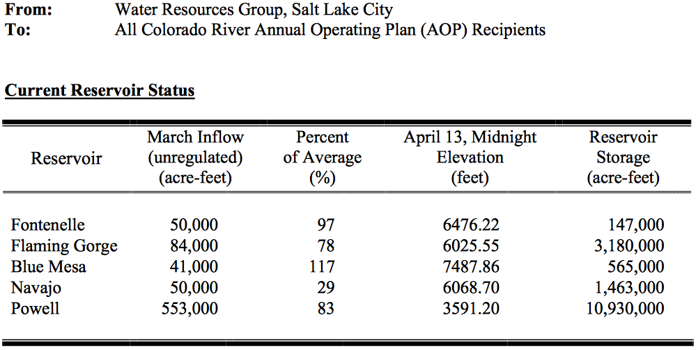
The district also sent a letter to the Department of the Interior and Colorado’s congressional delegation expressing the district’s concerns about the monument expansion without terms and conditions that would ensure water resources and the Rio Grande Natural Area are not adversely affected. The Rio Grande Natural Area, created through a federal, state and local partnership, integrates the management of federal and private properties along the Rio Grande between Alamosa and the state line to protect the riparian corridor for several purposes including Rio Grande Compact deliveries.

The district’s letter to congressmen regarding the monument expansion stated: “Every federal withdrawal or designation carries with it an implication that sufficient water will be made available to support the purposes of the designation unless specifically disavowed. The flows of the Rio Grande and the Conejos rivers in this area of the San Luis Valley are intimately tied to the economic and social health of the entire region, and reflect 150 years of water use practices that support the entirety of the San Luis Valley’s population as well as a water management structure designated to allow Colorado to freely utilize its share of the Rio Grande and its tributaries pursuant to the Rio Grande Compact. Any new federal land use designation that could impact or interfere with the water use practices in the San Luis Valley or Colorado’s ability to utilize the water resources to which it is entitled must be strenuously resisted by our elected federal representatives , as well as all of our state officials . This matter is of enormous importance.”

Representatives of the district also personally met with congressmen and Deputy Secretary of the Interior Mike Connor.

The district presented language protecting the Rio Grande Natural Area that it requested be included in the monument designation, were that to occur, and Conejos Clean Water has agreed to that language.

Robbins said the Valley’s congressmen and Department of Interior also assured the district they would not move forward with a monument expansion unless the district’s concerns were properly addressed.