The program, authorized in 2008, has faced cutbacks in recent years just as mussels and their larvae are increasingly being found on boats entering Colorado reservoirs.
According to Doug Krieger, aquatic section manager for the Colorado Division of Parks and Wildlife (CPW), about a half million inspections are done every year at Colorado’s 80 reservoirs. The state was able to declare itself mussel-free in January, but that victory was short-lived, according to Krieger, when mussel larvae were detected in August at Green Mountain Reservoir in Summit County. Seven other Colorado reservoirs that previously detected mussel larvae have since been declared mussel-free, including Pueblo Reservoir, which had the worst problem in the state with mussel larvae between 2008 and 2011.
Unfortunately, the inspection program at Green Mountain has been cut back about 35 percent, Krieger told the committee, due to funding cuts. That means a shorter inspection season and shorter hours for those inspections. And that can lead to boaters who avoid inspections, whether putting in boats on private land around the reservoir or at the public ramps when inspections aren’t available.
At the same time, the discovery of mussel larvae at the reservoir means boats entering and exiting the reservoir are now subject to what Krieger called “high-risk” inspections and decontamination.
Green Mountain isn’t the only reservoir that has seen mussel activity; Krieger said there were seven other reservoirs this year with mussel detection.
Boats at state reservoirs are inspected and decontaminated, if necessary, at no charge, Krieger told Colorado Politics. Mussel larvae can attach itself to anything that gets wet, whether it’s the boat, anchors and anchor ropes, fishing gear, boat trailers or outboard or inboard engines. In one case, in southwestern Colorado, a boat came in heavily contaminated with mussels and their larvae, and it took weeks to completely decontaminate the boat, according to Doug Vilsack, the legislative liaison for the Department of Natural Resources. But because there’s no basis in law to recoup those costs, the boat owner was charged nothing for that decontamination.
The bill the committee decided to sponsor Tuesday would do two things: require boaters to obtain a stamp for their boats, and allow the division to recoup the costs of decontaminating boats that come in with mussels or their larvae.
Bicycling the Colorado National Monument, Grand Valley in the distance via Colorado.com
Click here to read the summary. Here’s an excerpt:
Fallowing test project allocated CRD funds
In 2017, the Grand Valley Water Users Associa on (GVWUA) conducted a temporary agricultural fallowing program to save 3,200 acre feet of conserved consumptove use normally applied to crops. It was an experiment in water banking — to see how a program to send saved water to bolster Lake Powell might work.
GVWUA is extending the program to the 2018 growing season and received a $50,000 contribu on from the Colorado River District Board of Directors toward the program’s $1 million budget.
Mark Harris, GVWUA General Manager, told the Board that a second year is needed to con nue learning the lessons of fallowing and to broaden the knowledge of it among water users who are watching how this program might work for them.
Harris said that the Drought Contingency Plans (DCP) being developed by the Upper Division states and the Lower Division states to address low levels at Lakes Powell and Mead have put a “clearer focus” on demand management, which means reduced use by agricultural and municipal water users.
“The implications for the Colorado River District, its cons tuents and the GVWUA is that they will be majorly impacted” if demand management becomes necessary, Harris said. “We don’t need to do this for the Lower Basin’s benefit, we need to do this for our own benefit.”
Harris said that if West Slope interests don’t try to come up with a plan for how demand management might work, “others will be making those plans for us.” He said it was important to figure out how irrigators could par cipate in such a plan “in a way that does not ravage agriculture and does not ravage the West Slope.”
He said the 2018 program will keep the conversa ons about these issues moving forward and will advance the learning in economics, agronomics and the political implications.
Click here to go to the US Drought Monitor website. Here’s an excerpt:
Summary
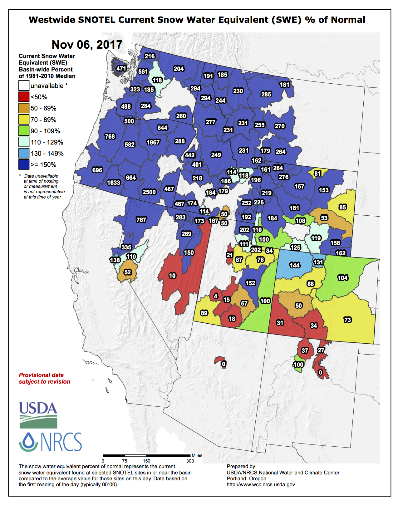
A vigorous Pacific storm system and a series of low pressure centers traversing along a semi-stationary front in the eastern half of the Nation brought moderate to heavy precipitation to portions of the Northwest, the Ohio and Tennessee Valleys and eastern Great Lakes region, and parts of the lower Mississippi Valley and west-central Gulf Coast. With subnormal temperatures present, heavy snows fell on higher-elevations of the Cascades, northern Sierra Nevada, and northern and central Rockies, producing an early Water Year to Date (WYTD; Oct. 1-Nov. 7) basin average snow water content (SWC) much above normal across the northern half of the West, along with above-normal basin average precipitation. Unfortunately, the WYTD basin average SWC and precipitation values were below to much below-normal across the southern third of the West. In the East, strong upper-air energy and low-level moisture produced widespread showers and thunderstorms, including some that were severe, in the Ohio Valley. In contrast, little or no precipitation fell on Southwest, southern Rockies, much of the Plains, western Corn Belt, the Southeast, and along coastal New England. Temperatures averaged below normal in the Pacific Northwest, northern Rockies, northern half of the Plains, upper Midwest, and Florida while above-normal readings occurred across the Southwest, southern Plains, Southeast, Ohio Valley, East Coast, and Alaska. Drier weather returned to both Alaska and Hawaii after several weeks of ample precipitation while light to moderate showers fell across Puerto Rico…
High Plains
Cold weather and light precipitation (about 0.5 inches or less) occurred across most of the High Plains region, including light snow blanketing parts of the Dakotas and northern Nebraska. The combination of subnormal temperatures and light precipitation was enough to keep conditions from deteriorating, but not enough for improvement, thus no changes were made. The exception to this was some improvements made in southeastern Wyoming and adjacent southwestern Nebraska where short-term surpluses existed and most indices were normal or wet, even out to 1-2 years. Accordingly, D0 was removed in southeastern Wyoming and D0 and D1 slightly trimmed in southwestern Nebraska. The D0 and D1 remained where long-term indices were still negative. In South Dakota, winter wheat conditions continued to be poor, with the USDA condition index reported as the second lowest in the last two decades. Causes included the ongoing long-term drought impacts, and most recently the sudden cold spell…
West
This week’s weather pattern produced a story of the haves (northern half) and have nots (southern half) as a strong storm system brought plentiful precipitation to coastal and mountainous areas (including high-elevation heavy snows). Along coastal Washington, Oregon, and northern California, 1-4 inches of rain fell while the Cascades, northern Sierra Nevada, and northern Rockies reported 1-5 inches of liquid equivalents. After a rather wet September in Wyoming, Idaho, and Montana (although precipitation is normally low) and a wet October is Washington and Oregon, November has also started out wet in the Northwest, leading to favorable WYTD basin average precipitation and snow water content (SWC). Since October 1, the basin average precipitation was between 100-150% of normal across the northern half of the West while recent colder conditions have increased basin average SWC from 100-900%, although it is early in the season and normal SWC values are low. However, with the recent wetness across much of the northern half of the West, and since the abnormal dryness and drought were short-term in western and southern sections (e.g. Washington, Oregon, Idaho, southwestern Montana), it was easier to justify improvements across this area as compared to long-term drought in northern and eastern areas (e.g. northern and eastern Montana, the Dakotas). Accordingly, with most short-term deficits nearly erased or some areas now with surpluses, most USGS streams have risen to near or above normal levels, including western Montana’s Clark Fork, Bitterroot, and Blackfoot River basins that indicate they have recovered from the dry summer, and SPEI values during the past 2-3 months have been positive (wet) across most of Washington, Oregon, Idaho, and the southern half of Montana. The 2-month SPEI values, however, have remained negative (dry) across northern Montana but not as significant as earlier (thus less or no improvement here), but SPI values depicted significant improvements nearly statewide. Soil moisture continued to show low values along the U.S.-Canada border and northeast Montana, and it may be a while (spring thaw?) before we know if the soil moisture has truly improved. Large precipitation deficits remained in northeastern Montana, and stock ponds have water quality issues or no water currently. Unfortunately, cattle pregnancy terminations are likely due to the high nitrates in the feed due to the drought.
Further south, the opposite is true of the WYTD conditions, with subnormal basin average precipitation and SWC, including no snow at some Utah, Arizona, and New Mexico basins. But the majority of the cold season precipitation normally occurs later in the winter here, so there is still plenty of time left. However, due to a weak summer monsoon and early withdraw, 90-day deficits existed in northwestern and southeastern Arizona, southwestern Utah, and extreme western New Mexico, thus D0 and some D1 was added to these areas.
Synopsis: La Niña conditions are predicted to continue (~65-75% chance) at least through the Northern Hemisphere winter 2017-18.
During October, weak La Niña conditions emerged as reflected by below-average sea surface temperatures (SSTs) across most of the central and eastern equatorial Pacific Ocean. The weekly Niño indices were variable during the month, with values near -0.5 C during the past week in the Niño- 3.4 and Niño-3 regions. Sub-surface temperatures remained below average during October, reflecting the anomalously shallow depth of the thermocline across the central and eastern Pacific. Also, convection was suppressed near the International Date Line and slightly enhanced over parts of the Maritime Continent and the Philippines. Over the equatorial Pacific Ocean, low-level trade winds were mainly near average, but the upper-level winds were strongly anomalously westerly and the Southern Oscillation Index was positive. Overall, the ocean and atmosphere system reflects the onset of La Niña conditions.
For the remainder of the Northern Hemisphere fall and winter 2017-18, a weak La Niña is favored in the model averages of the IRI/CPC plume and also in the North American Multi- Model Ensemble (NMME). The consensus of forecasters is for the event to continue through approximately February-April 2018. In summary, La Niña conditions are predicted to continue (~65-75% chance) at least through the Northern Hemisphere winter (click CPC/IRI consensus forecast for the chance of each outcome for each 3-month period).
La Niña is likely to affect temperature and precipitation across the United States during the upcoming months (the 3-month seasonal temperature and precipitation outlooks will be updated on Thursday November 16th). The outlooks generally favor above-average temperatures and below-median precipitation across the southern tier of the United States, and below-average temperatures and above- median precipitation across the northern tier of the United States.
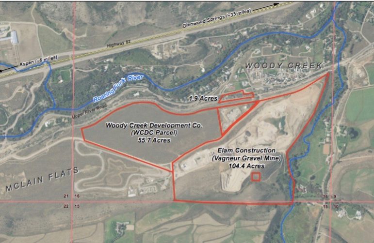
A map provided by the city of Aspen showing the two parcels in Woody Creek it has under contract. The city is investigating the possibility of building a reservoir on the site, as well as looking at the possibility of a reservoir in the neighboring Elam gravel pit.
Aspen voters denied the city permission Tuesday to use $5.5 million in general obligation bonds to buy a piece of land in Woody Creek that would potentially be converted into a reservoir for future water storage.
Unofficial results showed the measure was decided by a 53.4 percent to 46.6 percentage margin.
The outcome of the vote won’t preclude the city from acquiring a 58-acre parcel of land from Woody Creek Development Co. The city has had the property under contract to buy for $2.65 million.
The city had said that even without voter approval, it would still buy the property possibly by using certificates of participation to finance the deal or through cash and internal financing.
The city’s pending purchase of the land was in response to public outcry over statements it had made in previous water court filings that it could dam both Maroon and Castle creeks for future water supply.
The city has various reservoir options for the Woody Creek land, as Aspen Journalism reported in October that the largest one would span 8,000 acre-feet at a cost of $81 million, with a 5,000-foot-long dam, based on a study by Longmont-based engineering firm Deere and Ault.
The actual development of the reservoir is not in the city’s immediate future, Aspen Journalism reported.
“Developing water storage is an effort that will take time to fully implement, as it involves property acquisition, studies, planning, permitting, engineering and design before any construction can begin,” Margaret Medellin, a utilities portfolio manager in the city’s water department, was quoted as saying. “This is not an overnight process. Securing the property is the first step.”
Ballot Issue 5A, the San Juan Water Conservancy District’s (SJWCD) request for an increase to 1 mill to help with the land acquisition for and support the San Juan River Headwaters Project reservoir, was soundly defeated Tuesday, with 75.44 percent of voters against the measure (2,697 votes).
A total of 878 voters, or 24.56 per- cent, were in favor of the measure.
SJWCD board chair Rod Proffitt indicated Wednesday morning the district knew it would be an uphill battle and will now obtain feedback on the loss at the polls and “proceed accordingly.”
“The District was disappointed in the results, but we knew even when we negotiated the terms of the $2 Million loan with CWCB [the Colo- rado Water Conservation Board] that it would be a difficult challenge we might have to put in front of the vot- ers more than once,” Proffitt wrote in an email to SUN staff.
Proffitt added, “The facts have not changed. In fact, the need for this water storage project is becoming more apparent. CWCB and PAWSD agree this community may face a serious demand supply gap as early as 2024. The Growing Water Smart Group that formed this past summer and committed to endorsing a 3 Mile Plan and a Watershed Management Plan as good ways to integrated better land use Planning and wise water conservation also determined the best, most important thing we can do is arrive at a set of data and popula- tions projections we can agree on by consensus, and then use for planning purposes by the various entities responsible for infrastruc- ture needs is (sic) the community.”
Caption: Imperial Valley, Salton Sea, CA / ModelRelease: N/A / PropertyRelease: N/A (Newscom TagID: ndxphotos113984) [Photo via Newscom]
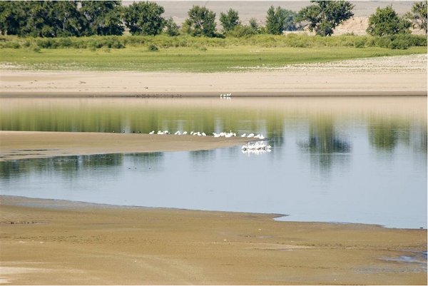
American Avocets in the Salton Sea. Photo: David Tipling/NPL/Minden Pictures. Screen shot American Audobon Society western water website, October 4, 2017.
California’s top water regulators adopted an agreement that commits the state to following through on plans of building wetlands and controlling dust around the shrinking Salton Sea over the next 10 years.
The order approved Tuesday by the State Water Resources Control Board sets targets for state agencies in building thousands of acres of ponds, wetlands and other dust-control projects around the lake.
The agreement is based on California’s 10-year plan for the lake, which Gov. Jerry Brown’s administration released in March. So far, most of the funding hasn’t been secured for the $383 million plan.
California’s largest lake is about to start shrinking more rapidly at the end of this year under a water transfer deal, leaving vast stretches of dusty lakebed exposed near communities that already suffer from extremely high asthma rates. The Salton Sea is also growing progressively saltier, threatening to kill off remaining fish and drive away birds that have relied on the lake as a migratory haven for more than a century.
The agreement represents a consensus among local and state agencies after years of delays, and formalizes state officials’ commitments over the coming decade…
Officials from several agencies and water districts told the board at the meeting in Los Angeles that the agreement is a key step toward preparing for a “smaller but sustainable” Salton Sea.
Under the order, state agencies are to build a total of 29,800 acres of dust-control projects and habitat areas around the lake by the end of 2028. The State Water Board, which is taking on an oversight role, set a timetable of increasing annual targets for building those projects, starting at 500 acres in 2018 and increasing to 4,200 acres in 2028.
State agencies will have to report on their progress each year, and if they fail to meet an annual acreage target by more than 20 percent, they’ll be required to present a plan to “cure the deficiency” within 12 months.
The agreement requires that at least half of the total acreage must “provide habitat benefits for fish and wildlife.” The remaining areas could include dust-control projects that don’t require water, such as plowing sections of lakebed or laying down bales of hay to block windblown dust…
The agreement was reached during negotiations involving state officials, the Imperial Irrigation District, Imperial County and the San Diego County Water Authority…
Board member Tam Doduc asked a few of those who spoke how they define a “smaller but sustainable” Salton Sea.
Kelley said it’s “a lake that won’t make people sick.” Others added that it’s also critical to protect the important bird habitats that the lake provide along the the Pacific Flyway…
The lake has been sustained for more than a century by water running off farmland in the Imperial Valley. But the amount of water flowing into the lake is decreasing, and more than 18,000 acres of dry lakebed have been left exposed as the shorelines have retreated over the past two decades. The lake, which has no outlet and is already saltier than the ocean, regularly gives off odors resembling rotten eggs.
The sea’s decline reflects the growing strains on the Colorado River. Under a water transfer deal signed in 2003, the Imperial Irrigation District is selling increasing quantities of water to cities in San Diego County and the Coachella Valley.
The agreement called for the Imperial district to send “mitigation water” from its canals into the sea through 2017. At the end of this year, that flow of water will be cut off and the lake will recede more rapidly.
Over the next 30 years, the lake is projected to shrink by a third.
State officials touted the new consensus as a landmark agreement that defines California’s commitment to restoring and managing the Salton Sea…
Many communities around the Salton Sea are predominantly Latino and among the poorest in California.
Imperial County already has the highest rate of asthma-related emergency room visits for children in California, and the problem is expected to get worse as tens of thousands of acres of lakebed are left high and dry around the lake over the next decade.
If the ponds and wetlands are fully built as planned, they would cover up less than half of the more than 60,000 acres of dry lakebed that are projected to be left exposed over the next 10 years…
Funding for the state’s plan also remains uncertain. So far, $80.5 million has been approved. California voters will have the opportunity to approve $200 million more for Salton Sea projects as part of a $4 billion bond measure on the ballot in June.
Malissa Hathaway McKeith, a Riverside lawyer who leads the nonprofit Citizens United for Resources and the Environment, urged the board ahead of the meeting to put the ramp-up of the water transfer on hold until there is an “actual Restoration Plan.”
McKeith said in a letter that adopting an agreement that treats the state’s 10-year Salton Sea Management Plan as a restoration plan “is a disservice particularly to the communities” around the lake. She said the board should hold more hearings to address “the core issues of what inflows will be needed to sustain this undefined ‘smaller Salton Sea.’”
The agreement includes requirements for state agencies under the next governor who takes when Brown steps down after the 2018 election. Among other things, the Natural Resources Agency is required to complete a long-term by the end of 2022.
With the agreement finalized, Wilcox said his agency is focused on getting projects going on portion of the exposed lakebed…
The agreement on the Salton Sea also could help ease the way toward a larger Colorado River deal between California, Arizona and Nevada. Representatives of the three states have been negotiating a proposed Drought Contingency Plan, which would involve drawing less water from Lake Mead to avert severe shortages.
The Imperial Irrigation District holds the biggest single water entitlement along the Colorado River and supplies water to lucrative farms producing crops from hay to Brussels sprouts. During the past year, the district had warned the state that without a credible plan for the Salton Sea, it wouldn’t take part in the proposed Colorado River deal. That condition now appears to have been met.
The Fountain Creek Watershed is located along the central front range of Colorado. It is a 927-square mile watershed that drains south into the Arkansas River at Pueblo. The watershed is bordered by the Palmer Divide to the north, Pikes Peak to the west, and a minor divide 20 miles east of Colorado Springs. Map via the Fountain Creek Watershed Flood Control and Greenway District.
Pueblo County officials said Wednesday that they are excited about Colorado Springs voters approving a ballot measure securing $17 million in annual stormwater fees to be used exclusively for stormwater drainage and flood control projects.
“This is a fine example of the new relationship between Pueblo and Colorado Springs. I think it’s wonderful to have two communities rolling up their sleeves to tackle problems the two communities share,” Pueblo County Commissioner Terry Hart said.
The money coming from the new ballot measure will be used to fund projects, including the list of 71 projects identified in the intergovernmental agreement between Pueblo County and Colorado Springs regarding the permit for the Southern Delivery System. SDS is the large pipeline that transfers water from the Pueblo Dam to Colorado Springs…
The IGA commits the Front Range city and its utilities department to pay $460 million for storm water infrastructure, maintenance and education programs over the next two decades.
“As evidenced by the incredible progress that has been made in our stormwater program over the past two years, the city of Colorado Springs is committed to operating an outstanding stormwater program,” said Colorado Springs Mayor John Suthers.
“Our commitment, and the commitment of our citizens, is evident in passage of Ballot 2A to provide a dedicated funding source for stormwater infrastructure, operations and maintenance.”
Suthers said this commitment will continue as the city of Colorado Springs and Colorado Springs Utilities invest $460 million over the next two decades to stormwater operations that will improve the city’s ability to mitigate flooding and preserve water quality while meeting the requirements of its MS4 Permit.
Voters on Tuesday passed a controversial ballot issue that gives Broomfield more local oversight of oil and gas operations in the city, a move that probably will invite a legal challenge from Colorado’s large energy sector.
According to a late-night vote tally in the mail-in election that accounts for most of the ballots cast in the city, the yes vote for Question 301 was comfortably ahead of the no vote by a margin of 57.5 percent to 42.5 percent…
Jennifer Dulles, a Broomfield resident who supports 301, attended a watch party at Brothers BBQ in Broomfield…
As to the question of whether the industry would sue, Dulles said, “The concept that an industry would need to sue the people over a ballot initiative that is about health and safety is incredulous.”
[…]
Question 301 has been a highly contentious topic in Broomfield and is perhaps one of the most fought-over issues on a Colorado ballot in 2017. The measure attracted nearly $400,000 from groups either pushing it or trying to quash it.
Of that amount, the energy extraction industry put in the lion’s share — nearly $345,000 — in both monetary and in-kind contributions to defeat 301.
“It is in violation of state law as upheld by the state Supreme Court,” said Don Beezley, a “No on 301” committee member. “The result will be Broomfield spending tens of thousands of dollars or more defending lawsuits, most likely from both the state of Colorado and the operators, with apparently 100 percent likelihood of losing said suits.”
[…]
Past efforts by cities — including Fort Collins, Broomfield and Lafayette — to temporarily ban oil and gas drilling have met defeat in court. In May 2016, the Colorado Supreme Court ruled that municipally imposed fracking bans are illegal because state power to regulate the industry trumps local efforts to do so.
While 301 doesn’t propose an oil and gas ban, its potential to restrict energy extraction activities doesn’t sit well with the industry. Last month, two industry groups sued Thornton weeks after the city passed oil and gas regulations that the industry claims conflict with state law, characterizing the city’s new setback distances for wells and requirements on abandoned flowlines an overreach…
But the pro-301 side points to a Colorado Court of Appeals ruling from March, known as the Martinez decision, that stipulates the protection of public health and the environment is “a condition that must be fulfilled” by the state before oil and gas drilling can be done.
That’s essentially what the measure asked of Broomfield voters, said Judy Kelly, co-chair of the 301 Committee. The measure is an amendment to Broomfield’s home rule charter requiring protection of health, safety and the environment as preconditions for drilling inside city limits.
“It might be worth taking a step back to ask ourselves, ‘Why in the world would people be sued for simply stating that their city places health and safety as a first priority?’” Kelly asked. “If the industry is safe and can operate safely, this is a non-issue for them.”
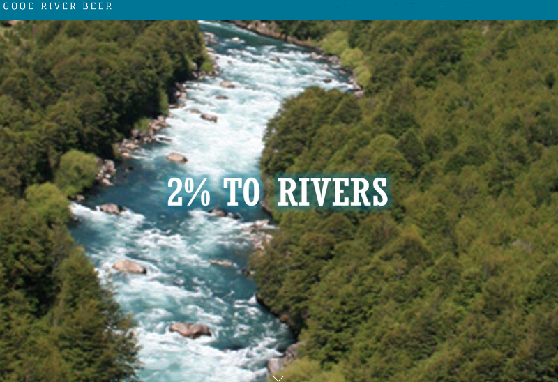
…while most new breweries on the scene were hoarding their earnings to curb debt, Good River Beer made a commitment to donate two percent of its gross profits to river conservation efforts. Last month, the brewery officially launched its own non-profit, called “2% to Rivers,” to do just that.
“I believe that every for-profit should be involved in some sort of conservation effort—some sort of movement that they really believe in,” says Odoski, who was inspired to create Good River Beer after meeting Hartman on a nine-day river trip in Utah. A passion for whitewater kayaking, craft beer, and do-goodery is at the core of the trios’ business.
While committing a portion of its profits to benefit organizations like American Whitewater and the Colorado Water Trust comes with challenges, the team at Good River Beer vows to stay the course.“The meaning behind what we’re doing far outweighs the challenges,” Odoski notes. While GRB currently relies on contract breweries like Denver’s Sleeping Giant to brew its bold Class V Colorado Style IPA and Gunny German Black Lager, Odoski and his team have plans to open a tasting room in the near future.
Supporting Good River Beer’s conservation efforts is easy. Coloradans can pick up 12-ounce six-pack cans of the brewery’s American Authentic Pilsner and Class V Colorado IPA and 750 ml bottles of Fu Fighter—a 8.9 percent ABV Belgian Golden Ale—at nearly 400 accounts throughout the Denver metro area.
Bonus: To boost fundraising efforts, the brewery also throws a handful of events each month, including educational opportunities, pint nights, and beer dinners. Check out Good River Beer’s Facebook page for info on upcoming happenings.
Colorado Springs voters passed Ballot Issue 2A, a dedicated stormwater fee. The city says it will generate $17 to $20 million annually for stormwater infrastructure and maintenance.
The fee stems from a lawsuit filed by the EPA, State of Colorado and Pueblo County against the City of Colorado Springs. It alleged the city failed to “adequately fund its stormwater management program,” causing problems for cities to the south. In an agreement with Pueblo, the City of Colorado Springs committed to providing at least $17 million in funding every year for stormwater infrastructure improvements to prevent issues downstream.
Mayor John Suthers says the money the city was using under that agreement, came out of the city’s general fund. Now, he says the general fund money can be reallocated to hire more police officers and firefighters.
“What this means is we’ll be able to take this dedicated revenue stream, deal with our legal problems surrounding stormwater and we’re also going to be able to deal with our public safety staffing issues,” Mayor Suthers said.
The approved measure means a monthly fee, of $5.00 per residential property, and $30.00 per acre for non-residential properties. The fee will show up on utility bills starting in July 2018.
The city says, properties bigger than five acres with significant areas of previous surface will be assessed by the Water Resources Engineering department.
Western legislators can be leaders on two critical issues: water-saving tax reforms and funding the EPA’s WaterSense conservation program, says Kerry Stackpole of Plumbing Manufacturers International.
CONGRESS HAS A marvelous opportunity as members negotiate the various elements of tax reform and the federal budget. Our senators and representatives have the chance to revise tax rules to reward consumers who save water and to authorize the United States Environmental Protection Agency (EPA)’s WaterSense program, which has saved 2.1 trillion gallons of water over a little more than a decade. Authorization, or codification, would provide the WaterSense program with greater permanence by giving it a direct annual congressional appropriation rather than leaving its annual budget up to the EPA’s discretion.
Members of Congress from California and other Western states can lead this advocacy, which can benefit the whole country. Federal tax reform related to water efficiency rebates and WaterSense authorization can create more incentives for water savings across the entire nation, saving the necessity for a state-by-state approach to this challenge.
Making rebates received for water conservation improvements exempt from federal income tax is “win-win” thinking. Right now, if you receive a $100 rebate for installing a water-efficient toilet you must pay federal taxes on it. That should change.
The bipartisan Water Conservation Rebate Tax Parity Act (H.R. 448/S. 1464) amends federal tax law to exclude homeowners from paying income tax on rebates from water utilities for water conservation improvements, including the purchase of manufactured products certified by the EPA’s WaterSense program. This legislation is sponsored by Jared Huffman (D-California) and Dana Rohrabacher (R-California) in the House and Dianne Feinstein (D-California) and Dean Heller (R-Nevada) in the Senate.
WaterSense is a voluntary public-private sponsorship program that encourages the use of water-efficient toilets, showerheads, faucets and other plumbing products – most of which are manufactured by U.S. companies. More than 21,000 product models bear the WaterSense label. While saving 2.1 trillion gallons of water since 2006, WaterSense has enabled consumers to keep more than $46.3 billion in water and energy bill savings in their pockets. As a result, the program enjoys bipartisan support in Congress, as well as from plumbing manufacturers, retailers, water utilities, state and local governments and nongovernmental organizations.
The savings achieved by WaterSense, while impressive, would be even greater if more American homeowners and businesses installed water-efficient plumbing products. A 2017 research study released by Plumbing Manufacturers International (PMI) and the Alliance for Water Efficiency showed that water-efficient toilets could save up to 170 billion potable gallons of water per year across just five states – Arizona, California, Colorado, Georgia and Texas – all facing water scarcity due to drought, regional population growth and other factors.
Three bills have been introduced that include language providing WaterSense authorization: the Water Efficiency Improvement Act of 2017 (S. 1700), the Clean, Safe, Reliable Water Infrastructure Act (S. 1137) and the Water Advanced Technologies for Efficient Resource Use Act of 2017 (H.R. 3248).
WaterSense is a federal program that has achieved quantifiable water and energy savings, a rave review from the EPA inspector general and bipartisan support. Let’s reward this strong track record with authorization and consumer relief on rebate taxes – and set an example of how to encourage all Americans to save water.
A map from a study done for the City of Aspen by Deere and Ault showing the two parcels of land in Woody Creek that the city sees as potential water storage sites. Both locations are a short walk from the Woody Creek Tavern and the Woody Creek post office.
The Aspen City Council has directed the city manager to buy a parcel of land in Woody Creek, regardless of the results of a current ballot question, and told staff via a resolution to “proceed with plans to develop the Woody Creek parcel for water storage.”
The parcel is 58 acres of land now owned by Woody Creek Development Co. (WCDC) that the city plans to buy for $3 million, even if city voters reject a $5.5 million bonding question to finance the purchase in next week’s election.
And the water storage includes a variety of potential reservoirs on the WCDC property and the neighboring gravel pit, which is operated by Elam Construction.
The biggest reservoir in the city’s options could top out at 8,000 acre-feet, would cost $81 million, and require “construction of a 5,000-foot-long dam, with a 60-foot maximum section,” according to a study completed in September for the city by Deere and Ault, an engineering firm in Longmont.
The study includes four alternatives, all of which are flexible and could be adjusted, city officials said.
The first option is to build a 1,000 acre-foot surface reservoir in the existing gravel pit. That could be built “relatively quickly, possibly within a few years,” the study says, while additional reservoirs on the WCDC site could then be completed within “the order of a decade.”
The city has no stated plans to buy the gravel pit, and the mine’s current reclamation plan, regulated by Pitkin County, does not mention turning the gravel pit into a reservoir. Nonetheless, the existing gravel pit and potential new pits on the neighboring WCDC parcel are at the center of the city’s water storage plans.
“The city and its consultant, Deere and Ault, have identified a property located in the Woody Creek area … as a high-value property for water storage,” states a resolution approved by Aspen City Council on Oct. 23. The resolution directs the city manager to buy the property and staff to move forward with developing the water storage.
The WCDC parcel and the neighboring gravel pit are a short walk up a hill behind the Woody Creek post office, on a level bench formed by 200 feet of cobble, gravel, and large boulders left behind by melting glaciers.
Margaret Medellin, a utilities portfolio manager in the city’s water department, said the reservoirs in Woody Creek, seen by the city as good options to potential reservoirs on Castle and Maroon creeks, will not be built anytime soon.
“Developing water storage is an effort that will take time to fully implement, as it involves property acquisition, studies, planning, permitting, engineering and design before any construction can begin,” Medellin said. “This is not an overnight process. Securing the property is the first step.”
Another step is clarifying the city’s demand for stored water.
A recent risk analysis done for the city by Headwaters Corporation suggests in a worst-case scenario in 2065, the city might see occasional shortages in the range of 2,000 acre-feet, but more work needs to be done to see how that translates into a specific water-storage need.
The Deere and Ault study recommends that the city should next “perform a water resources analysis to better understand how the [Woody Creek] site can be used to optimize the flexibility of the city’s water rights.”
The property next to the Elam gravel pit and the Woody Creek raceway that the city of Aspen has put under contract. The city is investigating the site as a place for potential water storage.
Finance and water rights
Before voting to approve Resolution 139 at an Oct. 23 City Council meeting to buy the WCDC parcel, Councilman Adam Frisch described how he saw the ballot question, which is question 2C on the city of Aspen ballot.
“This is an election question [and] council’s direction is that this [is] going to be purchased, it’s just a matter of how,” Frisch said. “And it’s either going to be done with using general obligation bonds, if the voters give us approval, [or] with COPs, which will be slightly more expensive, but we’re planning on executing that path if the voters don’t support us.”
Certificates of participation (COPs) are an alternative method for the city to obtain project financing.
Aspen City Manager Steve Barwick then said, “We may not use COPs. COPs would be possible. But we could also do some internal financing and use cash. You’ve identified the key issue though. It’s about the financial method rather than whether or not you are going to buy it.”
And while the city has said it intends to develop reservoirs in Woody Creek as an alternative to the potential Castle and Maroon reservoirs, it is still officially pursuing approval in water court for two due-diligence applications that would allow it to maintain conditional water storage rights on Castle and Maroon.
The city issued a press release in July stating its intent to transfer a portion of its water storage rights out of the Castle and Maroon creek valleys to Woody Creek, but it has not done so to date. It also is in settlement talks with the 10 parties opposing its due-diligence applications, and a status conference is set for Nov. 9.
The city holds conditional water rights to the potential Castle Creek Reservoir, two miles below Ashcroft, and to the potential Maroon Creek Reservoir, about a mile below Maroon Lake.
An Oct. 13 staff memo from David Hornbacher, the city’s director of utilities and environmental initiatives said the city is working to transfer “some or all of its Maroon and/or Castle creek conditional water storage rights” to the Woody Creek parcel.
In his remarks last week, Frisch said “this is about a stage of protecting water rights and hopefully, possibly, moving our water storage plans from the upper Ashcroft and Maroon Creek down to the Woody Creek area.”
A view of the downvalley end of the existing gravel pit in Woody Creek. The first potential reservoir to be built by the city could be in this location.
Reservoir details
The potential reservoirs studied by Deere and Ault are not on either a creek or a river, but are “off-channel” reservoirs that would be filled “using a pipeline from existing ditch structures,” which are not specified.
Water in the reservoir would be released via an outlet pipe and a spillway to the Roaring Fork River, which is 150 feet below the reservoir sites.
The first alternative in the Deere and Ault study shows three reservoirs totaling 2,500 acre-feet of storage.
The first phase of the first alternative in the Deere and Ault study is to build a 1,000 acre-foot reservoir in the lower end of the existing gravel pit. The reservoir would require “low asphalt cored dams” to hold back the stored water.
The next phase is to excavate the lower end of the WCDC parcel to create a 700-acre-foot reservoir. It would require a 20-foot-high dam and a “geosynthetic liner” on the bottom of the excavated area.
A second reservoir could then be dug out and lined on the WCDC property to hold 800 acre-feet of water.
Building the two reservoirs on the WCDC site would require mining 3 million cubic yards, or 4.5 million tons, of material, according to Deere and Ault.
Combined, the three reservoirs — two on the WCDC site, one in the existing gravel pit — would hold 2,500 acre-feet and would cost $73 million to build ($29,000 an acre-foot of stored water).
The second alternative in the Deere and Ault study shows a potential 8,000-acre-foot reservoir, on both the gravel pit parcel and the WCDC parcel.
The next alternative “represents the maximum storage vessel that could be realized using both parcels,” according to Deere and Ault.
This reservoir requires a 5,000-foot-long dam wrapping around the downvalley end of the existing gravel pit and then along the west side of the WCDC parcel. It would store 8,000 acre-feet and cost $81 million ($10,000 per acre-foot).
It would also require excavating 11 million cubic yards, or 16.5 million tons, of gravel.
The third alternative in the Deere and Ault study shows a 1,000-acre-foot reservoir in the gravel pit and a 2,000-acre-foot reservoir on the WCDC parcel.
The third alternative describes a 1,000-acre-foot reservoir in the existing gravel pit and another 2,000-acre-foot reservoir on the WCDC parcel. These two reservoirs would together store 3,000 acre-feet and cost $74 million ($25,000 an acre-foot).
The fourth alternative is a small and expensive underground reservoir built on the WCDC parcel and would hold 320 acre-feet and cost $48 million ($150,000 an acre-foot).
Aspen Journalism is collaborating with The Aspen Times, the Glenwood Springs Post Independent, the Vail Daily, and the Summit Daily on coverage of rivers and water. The Times published this story on Wednesday, Nov. 1, 2017
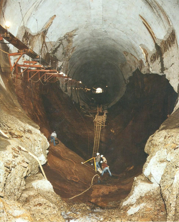
Fifteen miles upstream from Lee’s Ferry, Glen Canyon Dam halts the Colorado River. Over 50 years ago, before the last bucket of concrete hardened in the 714-ft tall Glen Canyon Dam, Glen Canyon, whose magnificence was said to rival the Grand Canyon was just upstream. As Lake Powell filled, becoming the second largest reservoir in the United States, Glen Canyon was drowned under hundreds of feet of water. Since its creation, all the way through the present, Glen Canyon Dam has had its supporters and adversaries.
There are a variety of issues, opinions, and concerns surrounding Glen Canyon Dam, and whether this dam that has created many controversies over its 50 years of existence should be removed, or at least bypassed. In Episode Five, we hear from a trio of voices on the issue of Glen Canyon Dam, New York Times Bestselling Author Kevin Fedarko, Glen Canyon Institute President Eric Balken, and American Rivers’ Intermountain West Communication Director Sinjin Eberle.
In this episode, we seek to understand the dam’s purpose, its impact on the Upper and Lower Basin water management, and the concept of restoring a world currently under water.
Volunteers spread a native seed mix and applied biodegradable erosion control fabric along a section of a closed forest service road that runs adjacent to Lime Creek. In total, over three miles of a closed forest service road were decommissioned and rehabilitated through revegetation and subsequent erosion control. This effort will help protect cutthroat trout spawning habitat in Lime Creek.
Volunteers spread a native seed mix and applied biodegradable erosion control fabric along a section of a closed forest service road that runs adjacent to Lime Creek. In total, over three miles of a closed forest service road were decommissioned and rehabilitated through revegetation and subsequent erosion control. This effort will help protect cutthroat trout spawning habitat in Lime Creek.
Click here to read the newsletter. Here’s an excerpt:
Cutthroat Trout Habitat Restoration Project
Thanks to the very hard work of our volunteers, the U.S. Forest Service, and National Forest Foundation, the Watershed Council was able to complete our cutthroat trout habitat restoration project on Shrine Pass before the snow began to stick. Over 3 miles of a closed Forest Service road, which was contributing sediment to Turkey and Lime Creeks and degrading spawning habitat, was scarified (making it impassible to 4-wheel drive traffic) and reseeded with a native seed mix and erosion control fabric to return it to its natural state.
In total, three miles of stream bank, 10 acres of watershed, and 20 acres of wildlife habitat were enhanced. These efforts will establish a healthy riparian buffer which will improve instream water quality by filtering sediment and pollutants that would otherwise enter Turkey and Lime Creeks.
Arkansas River Basin via The Encyclopedia of Earth
From the High Plains Midwest Ag Journal (Kylene Scott):
Kansas v. Colorado began in 1902 with the issue of whether Colorado was taking too much Arkansas River water from Kansas. Claims were made that the land surrounding the river banks was less valuable because of reduced flow. The issue was again revisited in 1907 where the Supreme Court dismissed Kansas’ petition. After examination of transcripts from the litigation, the court found Kansas was justified in its claims. It has continued to be brought to the Supreme Court with official designations in 1943, 1985, 1995, 2001 and 2009.
“In fact, this was the largest U.S. Supreme Court case that had ever come before the justices up to this time,” Sherow said during his presentation at the 3i Show in Dodge City, Kansas, Oct. 13.
To delve into the case, one must understand a little bit about economics and the American market system at the time.
“The American economic system is more than just economics. It’s also culture. It embodies values,” Sherow said.
There are three components to the market culture. The first, any natural resource is looked at for its economic potential.
“When you see a tree you see lumber. When you see water you see cubic feet per second that can be used in economic production. When you see a mountainside you see mining and the ores that are in it,” Sherow said.
The second part is human beings have a natural right to use their own labor to create value out of those commodities.
The third component is the government has the right and the obligation to protect individual natural rights to use those commodities for their own economic gain.
“These were things that were very important in terms of making sense out of this lawsuit,” Sherow said.
Even though the case originated with central Kansans wanting water in the Arkansas River, blame was placed on farmers irrigating in western Kansas. Sherow said early pump systems in the western part of the state were based on windmills with small ponds feeding flood irrigation systems.
“Sugar beets made irrigation in western Kansas profitable,” he said. “Irrigation was an iffy proposition in Kansas, but with this it became a very important economic source in the state.”
At the time of the litigation, Colorado and Kansas had different ways of thinking about water, according to Sherow. Colorado had prior appropriation built into their state constitution. It recognized three beneficial uses the state would protect—domestic, agricultural and industrial uses.
“With the prior appropriations system, which stresses first in time first in right,” Sherow said, “the first person to use the water establishes the right to it and we’ll have that right in perpetuity.”
The next person has the right to the water they put in economic use. The later the date on the prior appropriation right, the less likely the later person will get the water use.
“The earlier the date, the more likely to get water as the rivers flow,” Sherow said.
By 1900 between Pueblo, Colorado, and the Kansas/Colorado state line there were nearly 100 irrigation systems in place. These systems provided for more than 7,000 farms and 300,000 acres in the Arkansas River Valley of Colorado as well as domestic uses in Pueblo and Colorado Springs. The Colorado Fuel and Iron Company also used water off the Arkansas River.
“So the economic use of water in those three beneficial uses was extensive, well developed by 1900,” Sherow said.
Around Garden City, Kansas, there was approximately 30,000 acres in irrigation by the time the suit came in to play. What is now the Bureau of Reclamation also got involved with one of the first pump irrigation projects in the area.
Marshall Murdock was the editor of the Wichita Eagle in the early 1900s. He was a powerful individual and concerned for his city since they had to rely solely upon railroads for transportation of goods in and out of the city.
“Everybody was held captive to what railroad rates were,” Sherow said. “If you’re a farmer shipping out wheat or if you’re a retailer bringing in goods on the railroad, those railroad rates determine what your bottom-line is going to be.”
Murdock felt held hostage by the railroad companies and wanted another source of transportation in and out of Wichita. He wanted it to be river transportation.
“Think about that,” Sherow said. “Bringing river transportation and steamboats up the Arkansas River to Wichita.”
Sherow said Murdock was no fool but he knew the river needed more depth and more flowing water. During his time as editor he noticed the flow seemed to lessen each year. The riverbanks were compressing, which concerned him. He convinced the Army Corps of Engineers to bring a snag boat to Wichita in the Arkansas River in 1880.
“It got to Wichita, believe it or not, and when the snag boat was turned around to go back down the river it got stuck on sand bars almost immediately. People jumped off the boat and landed in 2.5 inches of running water in the Arkansas River,” Sherow said. “It was about the last time the Army Corps of Engineers really considered making Wichita an inland port.”
Undeterred, Murdock still wanted to get more water down the Arkansas River. He pointed fingers at “those greedy farmers out around Garden City causing all our water problems here at Wichita,” Sherow said.
“Now think about how you feel about that if you’re a farmer relying on the Arkansas River at Garden City and all at once one of the most powerful newspaper editors in Kansas is saying you’re the root of all my problems,” he said. “Well they didn’t take that very well.”
Murdock did some research and learned about the other irrigation companies in Colorado and later shifted his blame.
“Everybody knew something was going to have to break here because the United States government prior to the creation of the reclamation service was very interested in including the federal resources to increase irrigation,” Sherow said.
Eventually the case came to a head and in May 1907 the suit was settled.
“So out of this comes the notion we’ve got to put states together to come up with a way to divide water among themselves,” Sherow said. “This created interstate water compacts.”
The interstate water compacts helped avoid litigation like the Kansas v. Colorado case and became very important to water in the west.
“It is prime to everything else has followed since that time,” Sherow said. “So western Kansas and eastern Colorado have created the modern litigating system that we have today and it came out of this suit. I can’t over emphasize how important this suit was.”
EVs still small share of market share, but that could change
Remember the riddle about the lily pond that begins with one lily, the number doubling each day? The pond seems empty even when it has become an eighth filled. But you can do the math for the three days beyond.
That riddle comes to mind when Will Toor talks about the adoption rate for electric vehicles in Colorado. Today they constitute just 10,000 or so among the 5 million-plus cars, trucks, and motorcycles. But the growth rate for EVs has averaged 41 percent since 2012, and this year sales are up 73 percent over the same months of last year.
Toor, the transportation program director for the Southwest Energy Efficiency Project, sees this progression as evidence for a coming tipping point in transportation electrification. Like the lilies, this automotive pond will soon look very different.
“We are clearly headed toward lower-carbon electricity, and we now seem to be getting to the tipping point in electrification of transportation,” says Toor, who has a doctorate in physics. Sales will double within three years at this rate of growth. With certain policy supports, Colorado could have a million EVs by 2030, he adds.
Colorado now has the 6th largest market share of EVs in the country, behind California and other West Coast states, Hawaii, and Vermont. Fort Collins, Boulder, and the Roaring Fork Valley stand out as early adopters, says Toor.
To be sure, there are some who remain skeptical, seeing more measured and incremental growth unlike the quick adoption of smart phones and other new wrinkles in technology. EVs, they say, do not obviously represent a transformative improvement for consumers as compared to gas- and diesel-fueled vehicles.
Graphic credit The Mountain Town News.
State governments, however, want to smooth the way for EVs, creating charging infrastructure to create comfort for potential buyers. Colorado agencies propose to spend $10.3 million of the state’s $68 million share of the Volkswagen settlement for charging stations or fueling stations for zero-emission passenger cars and trucks. The settlement is a result of Volkswagen’s admission that it tampered with its diesel cars to allow more emissions than permitted by the Clean Air Act.
In anticipation of that settlement, Colorado a year ago was moving to join Utah and Nevada in creating charging infrastructure on interstate highways—and, in some places, beyond. Soon, it will be possible to drive from Kansas to the Pacific Ocean with some sort of fast-charging infrastructure guaranteed about every 50 miles. But there are still gaps, such as between Denver and Summit County.
Last year, Colorado also released a tiered program for implementation of electric charging stations and other alternative fuels on secondary highways, such as along U.S. 285 between Denver and Buena Vista and along U.S. 36 between Denver and Estes Park. Other corridors, including U.S. 40 and U.S. 50, are also being targeted for alternative fueling stations.
More policy supports may be on the way as advisors to Gov. John Hickenlooper put together strategies to support the governor’s executive order, issued July 11, “supporting Colorado’s clean energy transition.”
The order directs state agencies to develop a statewide electric vehicle plan by Jan. 1 to build out key charging corridors that “will facilitate economic development and boost tourism across the state while reducing harmful air pollution.”
Denver, Salt Lake City, and other cities have also identified electrification of transportation as crucial to achieving their greenhouse gas reduction goals. Denver is aiming for an 80 percent reduction of greenhouse gases by 2050.
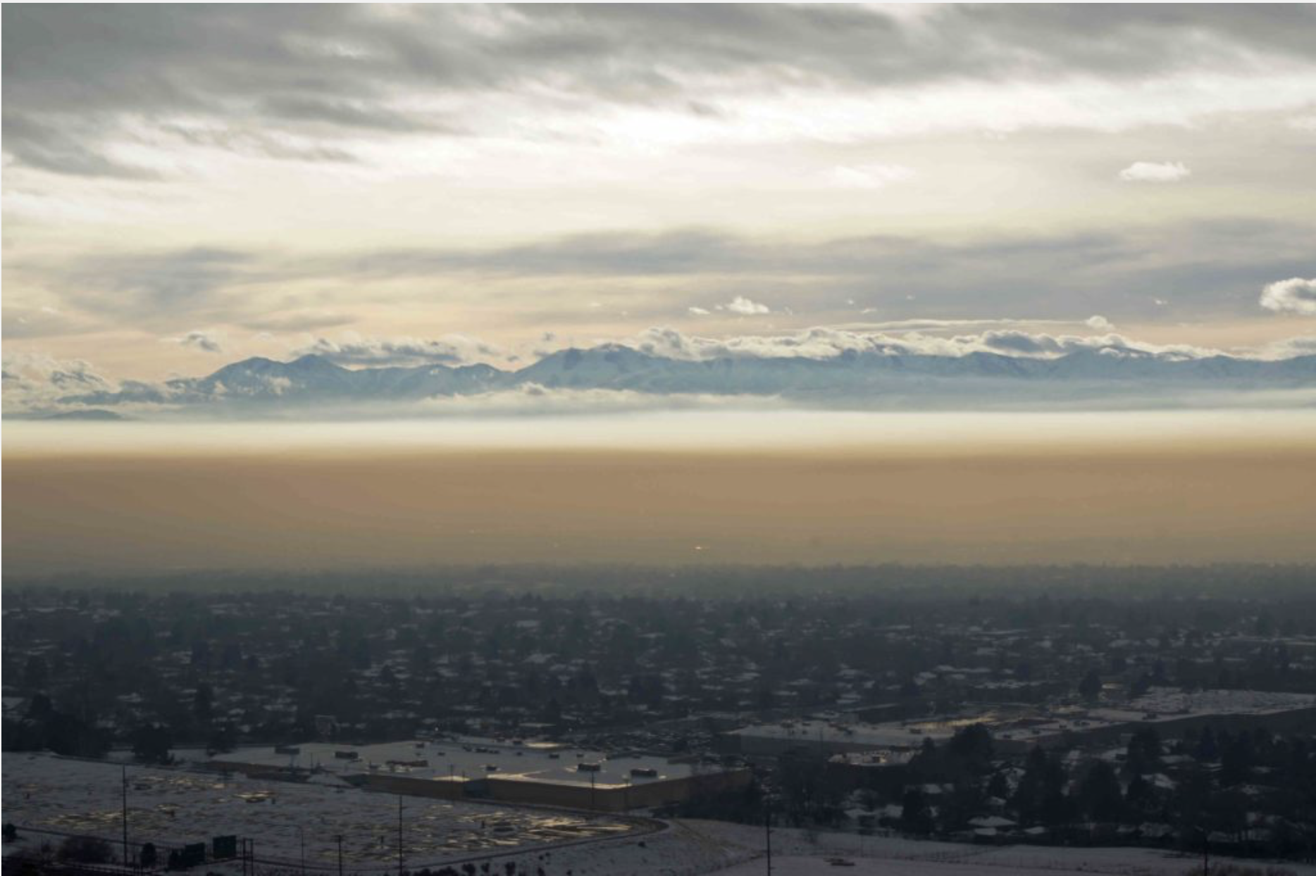
The Salt Lake Valley each winter suffers through temperature inversions that trap pollutants from cars, trucks and buildings. Photo credit The Mountain Town News.
In Salt Lake City, vehicle electrification is seen as a crucial strategy for addressing the pollution that badly fouls the air during winter. Temperature inversions trap local pollution in the valley, leaving many of the one million residents of the metropolitan area wheezing, hacking, and scratching their eyes.
“It’s absolutely miserable,” says Nick Norris, communities and neighborhoods planning director. The pollution is also unhealthy, exacerbating asthma and even causing spikes in heart attacks. Medical authorities have attributed 1,000 to 2,000 premature deaths to the air pollution.
Transportation is the single largest source of the pollution, followed by exhausts from heating buildings, according to analysis by the state government. Electric power plants are located well away from Salt Lake.
This clear and obvious problem of pollution is causing more rapid acceptance of electric vehicles in the Salt Lake Valley, says Norris. It also fits with the goals of the city to reduce carbon emissions from transportation and home heating 80 percent by 2040.
Rocky Mountain Power, the electrical utility for Salt Lake City as well as Park City and Moab, supports this transition with installation of charging stations. And why shouldn’t it? Electric cars represent new demand even as improved energy efficiency has leveled off and even caused declines from other sectors. “It’s a different world out there than it was only a few years ago,” said Cindy Crane, chief executive of Rocky Mountain Power at the Western Power Summit last week.
Utah now leads the nation in percentage growth in EV sales, followed by Nevada, North Carolina, and Colorado. About 1.2 percent of all cars in Colorado are now electric, compared to more than 4 percent of all cars in California.
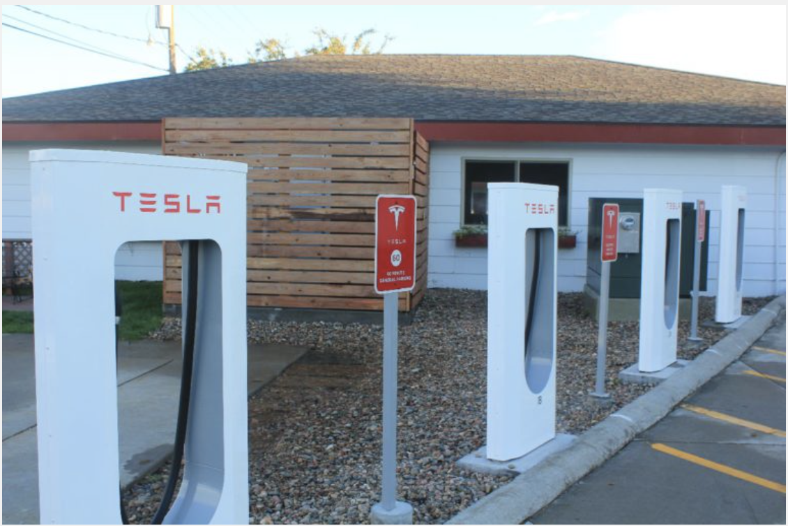
Tesla several years ago installed fast-charging stations in Lusk, Wyo., located in eastern Wyoming. It is the county seat for one of the nation’s least-populated counties, Niobrara. Photo/Allen Best.
Wyoming, too, doesn’t want to be left behind. It joined with the effort to put electric charging infrastructure along major highways in concert with other Western states, despite the lack of current demand. Wyoming Gov. Brad Mead, at at the Center for the New Energy Economy conference in Fort Collins this week, characterized it as a chicken-and-egg situation. But given the importance of tourism in Wyoming, he said, “we don’t want to be left behind. We don’t want to be the gap state.”
Federal tax credits of $7,500 are available everywhere, but Colorado buyers have an additional incentive of $5,000 in state tax credits of, bringing an electric car so ld by Boulder Nissan, one of the West’s busiest electric-car dealers, down to about $22,500.
Boulder Nissan’s Nigel Zeid says tax credits will not always be needed to foster sales of electric vehicles. “This is like when you have a kid in college,” said Zeid, a member of the Colorado Electric Vehicle Coalition, a state-sponsored group. “Once you’re out (of college), you’re on your own.”
Zeid also sees range concerns diminishing. The Chevy Bolt has 238 miles of range, and Tesla’s Model X has 295 miles of range (but at a cost of $98,500). But many more models are coming with 150 miles of range, satisfactory for nearly all daily commutes. “Now that you have 150 to 200 mile range, range is not really an issue,” he says.
A Federal Highway Administration map shows existing fueling infrastructure for Colorado, Utah, and other states, not just for electricity but also hydrogen and natural gas. However, the map has been outdated in recent weeks by the announcement that Wyoming, Montana, New Mexico, and Idaho will be joining in the interstate infrastructure.
A case can be made that hydrogen still represents the fuel of the future. California now has 31 fueling stations and plans more. Colorado, perhaps surprisingly, also has some hydrogen fueling stations, all in the metropolitan area. Hydrogen fuel is energy dense and can be produced from water through a variety of fuels, both renewables and natural gas.
But U.S. car manufacturers are now rushing to produce electric cars. General Motors several weeks ago announced plans to embrace an all-electric, zero-emissions future, leaving behind the internal combustion engine “General Motors believes the future is all-electric,” says Mark Reuss, the company’s head of product. Wired Magazine reports that GM plans almost two-dozen fully electric models by 2023.
Other car manufacturers have also announced plans to offer new EV models. China and India are embracing electrified transportation as they develop their economies and try to tame emissions that have fouled skies and scarred lungs. China, Britain, and France all plan to ban sales of vehicles powered by fossil fuels but have not set dates.
Some see the transition to electric vehicles happening more slowly.
“I am not sure they (EVs) will come quite as fast as some people say,” said Colorado Gov. John Hickenlooper at the Western Power Summit on Oct. 24. But one indication that it will occur sooner, he went on to say, is the announcement by GM of its robust commitment to EV models.
Some bumps in the road of this transition. “Certainly, there will be some issues around lithium and cobalt, two constituents of batteries. There could be some supply challenges,” says Toor, a former mayor of Boulder. “But I don’t think they will derail electrification.”
Discounts yields 42 EVs and hybrids in group buy
From April through June, a group buy for electric vehicles was organized in the Pitkin, Garfield, and Eagle county areas (Aspen, Glenwood Springs, and Vail).
Dealers in Boulder and Loveland, plus two in Glenwood Springs, were enlisted to offer discounts on top of the $12,500 state and federal tax credits. The best deal was offered by Boulder Nissan, which offered an $8,000 discount on Leafs. Other dealers offered somewhat lesser discounts for all electric and hybrid models.
The goal of 50 EV sales in the three-county area fell short: 42 were sold. However, the goal for 25 percent expansion of charging stations by the end of this year will almost certainly be exceeded. A recent report predicted an 85 percent increase.
The program was sponsored by Clean Energy Economy for the Region. It was based on similar group buys in the Fort Collins and Boulder areas in 2015 and 2016.
Notable was the support of Holy Cross Energy, the co-operative that serves most of the three counties. Holy Cross offered rebates of $200 to EV purchasers.
Can e-bikes help decongest the highway to Yellowstone?
JACKSON, Wyo. – Now come e-bikes and the question whether they can ease the congestion of cars found in ski towns like Jackson.
The specific question at hand is whether the e-bikes should be allowed on the local trails normally frequented by pedestrians and bicycle riders. Or should they instead be restricted to streets? Jackson town officials will soon be talking with their counterparts in Teton County, reports the Jackson Hole News&Guide.
An important distinction, according to the federal Consumer Product Safety Act, is 20 mph. That’s the maximum assisted speed when powered solely by the motor of a low-speed electric bike. However, there are some ways to use a larger motor, allowing an e-bike to go more than 30 mph without pedaling.
Brian Schilling, coordinator for Teton County Pathways, told Jackson town officials recently that e-bikes have been called a game-changer. He sees great potential for their application in Jackson during warm months.
“It changes the way people get around town, especially during the busy summer months when they don’t want to be sitting in traffic on Broadway,” he said, referring to the street that is the main street in Jackson and the primary route for many thousands of travelers going to and from Yellowstone National Park.
Crested Butte may slowly ease into paid parking
CRESTED BUTTE, Colo. – Crested Butte is planning to take a year to gather public feedback before moving ahead with paid parking in the town’s interior.
The town has gone along with a committee’s recommendation and has allocated $45,000 for the year-long study and a community outreach effort.
“The committee feels parking in town is ‘free and easy’ and we can’t build our way out of the problem,” said Bob Nevins, town planner for Crested Butte, according to a story reported by the Crested Butte News. “I want to get people out of their cars,” said Jackson Petito, a council member.
The plan calls for paid parking along Elk Avenue, the town’s main street, and other adjoining areas. Residents will get permits. The start-up costs if the town decides to go forward will be $220,000, or about the same price as paving a parking lot.
About Allen Best
Allen Best is a Colorado-based journalist. He publishes a subscription-based e-zine called Mountain Town News, portions of which are published on the website of the same name, and also writes for a variety of newspapers and magazines.
This is an important book. Raworth posits a system where economies live in the sweet spot between the carrying capacity of the planet and providing the social needs of the world population and regenerative capitalism rules the day. Click here to buy your copy. Here’s a review from Resilence:
Economics is the mother tongue of public policy. It dominates our decision-making for the future, guides multi-billion-dollar investments, and shapes our responses to climate change, inequality, and other environmental and social challenges that define our times.
Pity then, or more like disaster, that its fundamental ideas are centuries out of date yet are still taught in college courses worldwide and still used to address critical issues in government and business alike.
That’s why it is time, says renegade economist Kate Raworth, to revise our economic thinking for the 21st century. In Doughnut Economics, she sets out seven key ways to fundamentally reframe our understanding of what economics is and does. Along the way, she points out how we can break our addiction to growth; redesign money, finance, and business to be in service to people; and create economies that are regenerative and distributive by design.
Named after the now-iconic “doughnut” image that Raworth first drew to depict a sweet spot of human prosperity (an image that appealed to the Occupy Movement, the United Nations, eco-activists, and business leaders alike), Doughnut Economics offers a radically new compass for guiding global development, government policy, and corporate strategy, and sets new standards for what economic success looks like.
Raworth handpicks the best emergent ideas–from ecological, behavioral, feminist, and institutional economics to complexity thinking and Earth-systems science–to address this question: How can we turn economies that need to grow, whether or not they make us thrive, into economies that make us thrive, whether or not they grow?
Simple, playful, and eloquent, Doughnut Economics offers game-changing analysis and inspiration for a new generation of economic thinkers.
A team of Colorado Parks and Wildlife and U.S. Forest Service biologists, staff and volunteers fanned out along rugged Newlin Creek and four tributaries on Oct. 25, 2017, to search of cutthroat trout rescued from the South Prong of Hayden Creek during a 2016 wildlife. Photo credit Colorado Parks and Wildlife.
Here’s the release from Colorado Parks and Wildlife:
Conservation work often involves grueling slogs through dense forests
WETMORE, Colo. – On a recent cold October morning, a team of 20 aquatic biologists, other staff and volunteers from Colorado Parks and Wildlife and the U.S. Forest Service fanned out across five drainages in the rugged foothills of the Wet Mountains.
They split into six teams and bushwhacked up and down six miles, give or take, of the remote upper reaches of Newlin Creek and its four tributaries, following the creek beds as they snaked along treacherous cliffs, through jumbles of huge boulders and under fallen trees between Locke and Stull mountains.
The teams hiked for hours as the sun turned the day into short-sleeve weather, taxing some of the crew clad in rubber wading outfits and lugging 30-pound Electrofisher units on their backs.
The Electrofishers were needed to test the waters of each tributary for the presence of fish, especially any of the genetically unique cutthroat trout that had been rescued from the massive 2016 Hayden Creek wildfire.
At the time, CPW biologists ducked behind fire lines and rescued 194 of these fish from the South Prong of Hayden Creek. Of the total, 158 were taken to a CPW hatchery near Gunnison and placed in isolation. The other 36 were released in Newlin Creek in hopes they would reproduce naturally.
Hundreds more of these genetically unique fish were left behind in Hayden Creek with hopes they would survive. But monsoon rains later inundated the stream with debris, ash and sediment, leaving little hope the remaining cutthroats survived.
That knowledge gave special importance to the Newlin fish survey. Anywhere that trickles of water pooled enough to offer fish habitat, the CPW/USFS teams stopped and utilized the electrofishing units in hopes of catching a few of the 36 fish that were released.
They repeated the process dozens of times as they thrashed through the brush, scrambled over rocks, under felled trees and past caves and piles of bones from predator kills. At the end of a 10-hour marathon fish survey, the results were less than what they had hoped for: biologists were unsuccessful in locating any of the introduced fish.
But Josh Nehring, senior aquatic biologist for CPW’s Southeast Region, said the day was far from a wasted effort. In fact, it was a pretty typical day in the life of CPW biologists who are on the front lines of the agency’s efforts to perpetuate the wildlife of Colorado.
“We came to see if we can find any of the Hayden cutthroat,” Nehring said. “We wanted to see how they were doing. And we wanted to assess Newlin Creek for potentially re-introducing more of those fish here in the future.”
As with greenback cutthroat trout found in Bear Creek in Colorado Springs, CPW’s goal is to reintroduce native fish their historic landscape. And if Hayden Creek is unable to support fish in coming years as it recovers from the wildfire, CPW biologists need to find other creeks where they might thrive.
“Newlin Creek is a fairly small stream that we’ve had cutthroat in for a number of years,” Nehring said. “We presumed the upper portions of Newlin were fishless, but we needed to know definitively and assess the quality of the habitat. That’s why today’s fish survey was important. Now we know exactly what we’ve got in Newlin, if we decide we want to put more fish in it someday.”
Similar surveys on creeks, lakes and rivers go on year-round by CPW biologists and interns as they take study the state’s fish, assess the health of the various populations and decide whether to stock the waters. It’s the rarely seen conservation grunt work that pays off in gold-medal streams and lakes and attracts anglers from around the world to Colorado.
And it doesn’t matter if a grueling day of slogging through dense forests doesn’t result in big numbers of fish. Assessing the habitat and documenting what is there, and what is not, will help guide wildlife management and conservation into the future.
“Our mission is to perpetuate the wildlife of the state and conserve the native populations,” Nehring said. “That’s what days like today are about. These native fish were here before man was. If man hadn’t introduced rainbow trout, brown trout or brook trout – all these non-native fish – and altered their habitat, all these streams would be full of cutthroat.
“Unfortunately, they all out-compete the native cutthroat and some of them can mate with them diluting the uniqueness of these fish. I think it’s our duty to protect the cutthroat and make sure they are around for future generations.”
In coming months, Nehring and his team will assess other streams – hiking miles in the heat and cold – to search for new homes for the Hayden Creek cutthroat so they can get out of the hatchery and back in the wild where they belong.
Upper Colorado River Endangered Fish Recovery Program
FromThe Grand Junction Daily Sentinel (Gary Harmon):
Once dismissed as a “trash fish,” the Colorado pikeminnow has come to be regarded by Western Slope water officials as a powerful ally, one they hope retains its usefulness even when the magic of an endangered-species listing is gone.
And the listing could be gone relatively soon, once officials figure out how to deal with an infestation of walleye, an invasive predator that makes mincemeat out of pikeminnow juveniles.
The pikeminnow, along with the other three endangered fish species of the upper Colorado River, has been useful to western Colorado in that federal and state officials have worked diligently under a 30-year-old recovery program to ensure that there is enough water in the river to keep the fish alive.
“We’ve got the benefit of that,” said Mark Harris, general manager of the Grand Valley Water Users Association, one of the last diverters of water as the Colorado approaches Utah through the 15-mile reach of the Grand Valley, a critical pikeminnow spawning ground…
If the pikeminnow, however, is removed from the list of endangered species — and it was on the first list drawn up half a century ago — that means the recovery program could also go. It is set to expire in 2023.
During its three decades, the program has been used to keep water in the river while accommodating more than 2,000 diversions from the main stem of the river and its tributaries, including 1,225 in Colorado alone, all with no lawsuits.
Should the fish be delisted and the recovery program go away, the approach it inspired should remain, said Patrick McCarthy, deputy director of the Colorado River program for The Nature Conservancy.
When the fish is taken off the endangered list, “We just declare victory and keep working,” McCarthy said.
What victory looks like, though, isn’t clear, said Harry Crockett, who represents Colorado Parks and Wildlife on the recovery project’s biology committee.
“What happens after delisting is a really good question and one the recovery program is wrestling with right now,” Crockett said. “Who does all these things after the fish are no longer listed and there’s no longer a recovery program?”
Not the least of those questions concerns money. The recovery program has cost $380 million since it was established in 1989, the bulk of the costs being picked up by sales of hydroelectricity generated from dams along the Colorado system ($96 million,) the Bureau of Reclamation and Fish and Wildlife Service and other federal contributions ($189 million,) Colorado, $24 million and a variety of other sources.
The key issue, though, is species recovery, Crockett said.
“It’s important to us to recover the fish,” he said. “We are not resigned to having these fish on the list.”
The Colorado water plan wasn’t predicated on the continued endangered status of four of the river’s fish species, said James Eklund, who headed the Colorado Water Conservation Board during the plan’s drafting.
“I’d hope the plan would still be relevant” should the fish recover, Eklund said. “The goal of any listed species should be delisting after having been recovered, I would think.”
Whether endangered fish are an ally of Western Slope water interests ought not be a question, said Greg Walcher, a Grand Valley fruit grower and former chief of the Colorado Department of Natural Resources.
“There is no scenario under which having species in danger of extinction is better than having fully recovered healthy populations,” Walcher said in an email. “There will always be plenty of reasons to oppose further Front Range water diversions, and to ensure Colorado’s water entitlement is not threatened by downstream states, federal regulations, or transmountain diversions. But water issues should be decided based on Colorado and interstate water law, not the distraction of federal species regulation.”
General Manager Jay Winner of the Lower Arkansas Water Conservancy District received the prestigious 2017 Non-Point Source Award at the Colorado Watershed Assembly Conference in Avon, Colorado on last month.
He was honored for his outstanding work on multiple non-point source projects as well as being the only person to combine water quality with water quantity. These projects include, but are not limited to: 2,000 acres of Best Management Practices (BMP), Soil Health, Pond Sealing, Canal Lining, Riparian Buffer Zone, Fallowing, and Dry Up.
The conference, displaying best practices for watershed plans and rivers across Colorado, acknowledged the Arkansas River for the first time in years. This conference provided an opportunity for the Arkansas River Valley farmers, producers, agencies, and other interested parties to be recognized for their efforts in water quality and quantity.
Winner thanked the Lower Ark staff and the cooperation of farmers, as these projects would not be possible without any of them.
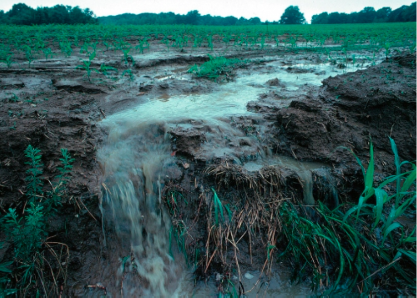
View of runoff, also called nonpoint source pollution, from a farm field in Iowa during a rain storm. Topsoil as well as farm fertilizers and other potential pollutants run off unprotected farm fields when heavy rains occur. (Credit: Lynn Betts/U.S. Department of Agriculture, Natural Resources Conservation Service/Wikimedia Commons)
Graph showing the decline in costs for large lithium ion batteries in US dollars per kilowatt-hour (kWh), 2006-2016. Graphic via the Climate Reality Project.
Building solar and wind farms has started to become a cheaper proposition than running aging coal and nuclear generators in parts of the U.S., according to financial adviser Lazard Ltd.
Take wind: Building and operating a utility-scale farm costs $30 to $60 a megawatt-hour over its lifetime, and that can drop to as low as $14 when factoring in subsidies, according an annual analysis that Lazard’s been performing for a decade. Meanwhile, just keeping an existing coal plant running can cost $26 to $39 and a nuclear one $25 to $32.
Two years ago, “what was interesting to us was the lifetime cost of renewables on an energy basis reached parity with conventional resources in a bunch of geographies in the U.S.,” said Jonathan Mir, head of the North American power group at Lazard. “Now, what we are seeing is that renewable technologies on a fully loaded basis are beating” existing coal and nuclear plants in some regions.
The report by Lazard, whose estimates are widely used in the power sector as benchmarks, comes as President Donald Trump’s administration is vowing to stop the “war on coal” and put America’s miners back to work. Hundreds of power plants burning the fuel have shut in recent years amid escalating competition from natural gas, wind and solar. Energy Secretary Rick Perry has proposed rewarding coal and nuclear plants with extra payments for their dependability, touching off a national debate over the country’s future power mix.
“We still need, in a modern grid, fuel diversification and a diverse generation stack,” Mir said. “So someone has to think hard about how to organize this transition.”
Here’s the release from The Earth Institute at Columbia University (Kevin Krajick):
By law, every four years Congress is provided with a state-of-the-art report on the impacts of climate change on the United States. The next National Climate Assessment is scheduled for 2018, but its scientific findings were published today. The massive document was produced by 13 federal agencies including NASA, the Army Corps of Engineers and the Environmental Protection Agency, along with top university scientists, and approved by the National Academy of Sciences. Four of its 32 lead authors are affiliated with Columbia University; two of them speak below.
Among the report’s conclusions:
-Since 2014, evidence that humans are causing rapid warming of the atmosphere and oceans has only strengthened. Many lines of evidence abound “from the top of the atmosphere to the depths of the oceans,” the draft says. “There are no convincing alternative explanations.”
-Average temperatures in the Lower 48 states increased 1.2 degrees F from 1986 to 2016, and are projected with very high confidence to rise faster in coming decades.
-Scientists have made significant progress in linking human influence to specific extreme weather events. Some extremes, including droughts, heat waves and huge rainfalls, have already become “more frequent, intense, or of longer duration, and many [are] expected to continue to increase or worsen.”
-The report increases the worst-case projection for global sea-level rise by 2100 to 8.5 feet, up from 6.6 feet in the last report.
-With rising sea level, tidal floods in some coastal cities have increased 5- to 10-fold since the 1960s, and continue to rise. The rate of increased flooding along the East Coast is accelerating.
-The rate of ocean acidification due to increasing carbon dioxide entering the water “is unparalleled in at least the past 66 million years.”
-Alaska, warming twice as fast as the global average, is “on the front lines,” with fast-wasting glaciers and “crumbling buildings, road and bridges and eroding shorelines.”
The report follows similar, though smaller-scale federal assessments published in the last 10 days by the Government Accountability Office and the Congressional Budget Office. All the reports fly in the face of the current administration, whose top officials have publicly denied or questioned the reality of human-induced climate change. In June, the administration announced its plan to withdraw from the Paris climate accord, signed by all nations on earth except Syria. In recent weeks, the EPA has scrubbed references to climate change from its website and barred its own scientists from speaking on the subject. A recently leaked Department of Interior strategic plan shows that climate change has been expunged from consideration in favor of “energy dominance.” For all this and more, some scientists have expressed fears that the new report will be ignored.
Radley Horton is an associate research professor at Lamont-Doherty Earth Observatory. Timothy Hall is an adjunct professor at Columbia Engineering, and a senior scientist at the Columbia-affiliated NASA Goddard Institute for Space Studies.
What is new about this latest report?
Radley Horton: With additional years of observations, and in many cases accelerating trends, the evidence is stronger than ever. The report reaffirms what over 97 percent of climate scientists have known for decades: the climate is changing, and humans are largely responsible. The risks to things we care about–the health of our children, our economic viability, the existence of our coastal cities–are real and growing. U.S. citizens have a right to know what risk they face.
Timothy Hall: Since 2014, the planet has experienced its warmest years on record. This renders moot previous talk about a climate-change “pause,” which was never very compelling anyway. Data continues to accumulate that shows increased rates of extreme rainfall, one of the most robust climate-change predictions. Trends in hurricane activity are beginning to pop out of the noise. Regions of peak hurricane intensity have expanded poleward in concert with expanding regions of warm seawater.
At this point, can we say specific extreme events are related to climate change?
Hall: With increasing computer power, so-called attribution studies are becoming more common and more reliable. We can now simulate an extreme event many times with and without human climate change, and say what fraction of the event’s hazard–the odds of the event occurring, rain amount, flood level, wind speed, etcetera–can be attributed to climate change. For example, attribution studies show that hurricanes Iselle, Julio and Ana, which hit Hawaii in 2014, were much more likely in a warming climate. We finished working on the report before the 2017 hurricane season. But climate change clearly played a role in Harvey’s rain-driven damage, and possibly a role in Maria’s wind-driven damage.
Could it be that we are in for bad surprises?
Horton: This is one of the most important points the report makes. While climate models incorporate many important processes, they cannot include all the possible changes that can contribute to tipping points and irreversible changes. These would be things like accelerated melting of the Greenland and Antarctic ice sheets, and resulting rapid sea-level rise. Or, extreme events like droughts and wildfires occurring in multiple places at the same time, or sequentially in one place. Such tipping points and compound extreme events can greatly multiply the systemic risks to society.
What is the likely damage? Will we be able to stem it?
Hall: Damage is already easy to see: more frequent events like Hurricane Sandy‘s storm surge, and Harvey’s rain flooding. More flooding like what Miami sees under clear skies. We can just sit and respond haphazardly after each crisis–more suffering and unplanned displacement–or we can adapt with some better long-term planning.
Horton: Paradoxically, there is reason for optimism. Just like it’s harder to dismiss climate change, it’s harder to dismiss the idea that we could see rapid societal transition away from a carbon-centric economy. Global CO2 emissions appear to have been level over the past couple of years, during a period of economic growth. The cost of renewable fuels such as wind and solar have decreased dramatically. This is sending powerful signals to long-term investors and businesses about which way the wind is blowing. More and more businesses are asking the question: what risks do we face if we do not plan for a changing climate?
Purple, which has become the international symbol for recycled water, is used on valve boxes, manhole covers, newer sprinkler heads and even the pipes inside our Recycling Plant via Denver Water.
Here’s a guest column from Doug Pushard that’s running in The Sante Fe New Mexican. Here’s an excerpt:
Some city in the United States will become the water-recycling capital of the country. Why not Santa Fe, New Mexico? This is a logical place to grow this industry. Santa Fe by necessity has a large need for recycled water. We are an area prone to drought. We have a very high ratio of water professionals in our state. These are a few reasons we could become the water-reuse capital of the country.
Why not put programs together to make this an economic engine for the area as well as New Mexico? Israel has used its need for water conservation to grow multibillion-dollar worldwide water businesses. The Water Smart Innovation Conference is held annually in Las Vegas, Nevada, bringing together conservation professionals from around the world. These are examples of how water conservation can be linked to economic vitality…
So what would a strategy look like? It would mean our state and local economic-development efforts would target people and businesses in this industry. It would mean we put in place programs that highlight existing businesses and attract new ones to our community and state. It would mean we would have centers of excellence. It would mean we would partner with our local education institutions to make sure we’re training individuals in these fields, so companies would have ready access to a local workforce. It would mean we put programs promoting Santa Fe and New Mexico as the place to be!
Colorado State University (CSU) is teaming with the National Western Complex for the One Water Solutions Institute, connecting world-class research with real-world solutions. The university plans to complete its water laboratory, which will be a water-reuse showcase, by 2021.
New Mexico could move into a leadership position, resulting in new jobs and the ability to promote the state as having a sustainable long-term water plan. Water is key to our survival in this beautiful, but harsh state. We can lead, follow, or get out of the way. We need to grow local industries to provide good paying jobs for our communities. Why not water, why not here?
Map of the Rio Grande watershed, showing the Rio Chama joining the Rio Grande near Santa Fe. Graphic credit WikiMedia.
Here’s the release from the American Association for the Advancement of Science:
A new federal report strengthens our understanding of global climate change, providing policymakers with scientific evidence to develop responses, said Rush Holt, CEO of the American Association for the Advancement of Science, following the release of the Climate Science Special Report on Friday.
The report, written and reviewed by leading U.S. scientists as part of the National Climate Assessment, reinforces that warming temperatures and extreme weather around the globe are “extremely likely” to be the result of carbon pollution from human activities.
“The overwhelming scientific evidence of our changing climate cannot be ignored,” Holt said in a statement. “Scientists at federal agencies, national labs and academic institutions worked to summarize what we know about climate change in the United States and around the world. The Climate Science Special Report lays out the most recent scientific evidence of climate change, once again confirming that climate change is real, it’s happening now, and human activity is the primary cause.”
Holt stressed that the report “provides scientific evidence to decision-makers at all levels – local, state, regional and national – to help inform how society can respond to climate change.”
In its executive summary, the report concludes “it is extremely likely that human influence has been the dominant cause of the observed warming since the mid-20th century. For the warming over the last century, there is no convincing alternative explanation supported by the extent of the observational evidence.”
Greenhouse gas emissions that trap heat in the atmosphere, widespread clearing of forests and agricultural activities are major factors driving temperature increases since 1951, the report states.
The burning of fossil fuels also is highlighted as having an unparalleled impact on the Earth’s climate, and continued emissions have the potential to accelerate human-induced climate change and contribute to unanticipated changes that may be difficult or impossible to manage.
Limiting increases in global average temperatures to a 3.6 F target would require significant reductions in carbon pollution levels and ultimately eliminating net greenhouse gas emissions altogether, the report says. Yet, such a shift will be particularly difficult to achieve in light of President Donald Trump’s decision in June to withdraw from the Paris Agreement.
“This report underscores the vast body of evidence that firmly establishes how climate is changing, humans are responsible, the risks are real, and the window of time to prevent serious and even dangerous impacts is closing,” said Katharine Hayhoe, one of the report authors and a professor and director of Texas Tech University Climate Science Center in Lubbock.
Extreme weather events such as excessive precipitation and heat waves are on the rise, the report finds. Warming temperatures and high precipitation levels contribute to destructive wildfires, extensive property damage and costly flooding, as was recently seen in northern California and in the aftermath of the rain and resulting flooding from Hurricane Harvey in Houston.
The report finds that the U.S. is particularly vulnerable to projected sea level rise; areas such as the Northeast and western Gulf of Mexico could face rates that exceed global average sea level rise. As sea levels have risen, many coastal areas have seen increased flooding during high tides and extreme flooding during coastal storms; these trends are projected to continue in the coming century.
Hurricanes are exhibiting some changes that have been linked to climate change, including increases in intensity and precipitation rates, but additional studies are still needed to understand these trends and how they may continue in the future, the report says.
“The further we push the Earth’s climate away from its natural state, the greater the risks of dangerous and even potentially unforeseen consequences,” said Robert Kopp, a report author and professor in the Department of Earth and Planetary Sciences at Rutgers University in New Jersey.
Kopp noted recent findings have revealed the possibility of even more serious impacts including “ice sheet melt in Greenland and Antarctica to compound extremes, where events occurring simultaneously or in rapid sequence can amplify the risks to both human and natural systems.”
The U.S. Global Change Research Program, which coordinates the National Climate Assessment report process, also released draft versions of two other reports for public comment: the Second State of the Carbon Cycle Report and the Fourth National Climate Assessment. The National Academy of Sciences will conduct a peer review of these reports.
“Providing these reports for public comment is a key step toward ensuring that the reports and the larger National Climate Assessment process are transparent and maintain standards for scientific integrity,” said Emily Cloyd, AAAS public engagement project director.
Four authors of the Climate Science Special Report – Hayhoe, Kopp, Radley Horton and Sarah Doherty – will discuss the report’s key findings and recent developments in climate science during a AAAS Facebook Live discussion on Nov. 8 at 3:00 p.m. Eastern. In addition, Victoria Keener will discuss the draft National Climate Assessment and Anna Michalak will discuss the draft Second State of the Carbon Cycle Report.
The National Oceanic and Atmospheric Administration is the lead federal agency on the report for the U.S. Global Change Research Program, which produced Volume 1 of the 4th National Climate Assessment. The full National Climate Assessment is expected to be completed and published in 2018. A 1990 law, known as the Global Change Research Act, requires federal agencies to provide an overview of the latest climate science and a thorough review of the impact of climate change throughout the U.S. to the president and the Congress every four years.
[Associated image: The aftermath of flooding in North Charleston, South Carolina caused by over 15 inches of rainfall resulting from a fall 2015 storm. | Ryan Johnson/North Charleston CC BY-SA 2.0]
Parts of the U.S. are particularly vulnerable to sea level rise, factors that are exacerbated by storms producing extreme flood surges and increases in tidal flooding. | Air Force/Tech. Sgt. Larry E. Reid Jr.
Here’s the release from Colorado Trout Unlimited (Randy Scholfield):
Living with less water—that’s the reality facing all of us who depend on the Upper Colorado River for our drinking water, food production, and outdoor recreation.
A recent scientific paper found that the Upper Colorado River Basin has lost 7 percent of its flows in last three decades due to higher temperatures caused by human-induced climate change. In a basin that supplies water for 40 million people and where every drop is used and accounted for, that’s only the latest red flag that our world is changing and that we need to take collective action to keep our rivers and communities healthy.
That’s why projects like Abrams Creek are so important.
This tiny creek outside of Gypsum has a rare population of native Colorado River cutthroat trout that’s genetically unique and the only aboriginal trout population in the Eagle River watershed. And because Abrams Creek has a lower elevation than many cutthroat streams, say biologists, its native trout might be better adapted to warmer temperatures—another reason why this vulnerable fish population is important to preserve.
For more than a century, however, Abrams Creek has been dewatered by irrigation diversions that drastically reduce its flows in late summer and fall. The trout have been hanging on, but they’re seriously pressured. Colorado Parks and Wildlife has called this population the “highest priority” for cutthroat conservation efforts in Western Colorado.
In 2016, Trout Unlimited’s Mely Whiting helped negotiate a deal with the local irrigation company, Buckhorn Valley Metro District, which agreed to pipe their irrigation ditch and thereby reduce leakage by 40 percent, with the water savings going back into the creek to keep the fish healthy.
The biggest hurdle was money. Piping the irrigation ditch along several miles of ditch would cost more than $1 million.
A year later, says Whiting, this fundraising goal has been met, thanks to efforts by TU, Eagle Valley Trout Unlimited, Buckhorn Valley, CPW and the Eagle River Watershed Council, who secured grants from a variety of sources, including the Colorado Water Conservation Board, Colorado River Basin Roundtable, Bureau of Reclamation and the town of Gypsum, as well as donations from BLM, Colorado’s Species Conservation Fund and local busnesses Fortius Realty, NAI Mountain and Alpine Bank.
“Turns out, a lot of people were ready and willing to step up to protect this jewel of a stream,” says Whiting. Because of these collective efforts, she says, the project is officially a go. Construction is expected to start next year on piping the ditch, and the future of Abrams Creek cutthroats looks bright.
In an age of changing climate and paralyzing partisanship, it’s easy to get discouraged about the prospects for our rivers and streams.
One lesson of Abrams Creek: In a world of less water, there’s hope for preserving the health and quality of our rivers, fish and wildlife if we dig in and work together on solutions.
For more information and to donate to the project, go to TU’s Abrams Creek project page.
Randy Scholfield is Trout Unlimited’s director of communications for the Southwest.
The Western Governors’ Association on Thursday sent a letter urging Interior Secretary Ryan Zinke to put in place by spring 2018 controls to prevent the spread of zebra and quagga mussels.
The governors are asking that federal agencies conduct mandatory inspections and decontamination of boats leaving infected water bodies.
The governors say they’re particularly concerned about the mussels reaching the Columbia River Basin, Lake Tahoe, and the Colorado River Basin above Lake Powell.
Colorado River water use, data courtesy USBR. Graphic via John Fleck.
FromThe Grand Junction Daily Sentinel Gary Harmon):
A social contract on water use in the Colorado River Basin is needed — this time one between cities and rural areas — as the Colorado River Compact approaches its second century, a University of New Mexico professor said Thursday.
“We need to rethink the social contract on how we manage the (Colorado) River,” John Fleck told more than 100 people at the Upper Colorado River Basin Water Forum at Colorado Mesa University on Thursday.
Despite being based on “bad science,” the original contract is the 1922 compact among seven states and the federal government that shaped the way the southwest has developed, Fleck said.
Fleck studies the workings of science and political and policy processes and is the author of the 2016 book, “Water is For Fighting Over and Other Myths About Water in the West.”
The authors of the 1922 agreement relied on estimates that oversold the amount of water in the Colorado River system, Fleck said.
“We built a lot of stuff based on old, bad science,” Fleck said.
Science, however, also is changing the how water use is understood, he said.
While it has become more clear over decades that the water available in the 108,000 square-mile basin, it’s becoming clear that the demand for water also was overstated, Fleck said.
Even as the population of the basin has grown — the river is now a source of water for 49 million people — economies and populations also have grown.
That trend is evident from Albuquerque to Denver and Los Angeles to Phoenix, Fleck said.
“Everybody is using less water,” even as gross regional products are on the rise, he said, noting that water use in the upper Colorado River basin is lower now than its was in the 1980s.
“This suggests that (growth in the face of scarcity) is a real phenomenon,” Fleck said.
That’s true for agriculture, as well as municipal and industrial use, he said.
It’s important to better understand the realities of how water is used, especially in the face of scarcity, Fleck said, noting that fights already are breaking out in California between rural and urban water users.
“Otherwise, the risk is that rich and politically powerful cities” such as Denver, Albuquerque, Phoenix and others “will start throwing sharp elbows” at rural water-rights holders as the cities search for water to meet the supposed needs of growing populations, Fleck said. “That sends a really wrong and dangerous message.”
Any new social contract use on water management also should take into account the segments of American society that were ignored the last go-round, he said, pointing to the Navajo and other tribes whose water needs weren’t included in the 1922 pact.
Detailed Colorado River Basin map via the U.S. Bureau of Reclamation.
While Mayor John Suthers touts stormwater fees as a route to financial stability for Colorado Springs, others see them as a symptom of the city’s insatiable appetite for cash.
Some worry the city will inevitably raise the fees, which appear on El Paso County’s November ballot as Issue 2A.
According to the ballot language, the city can raise the fees if ordered to do so by a judge, to come into compliance with state and federal laws or to abide by any intergovernmental agreements preceding June 1, 2016.
A high-profile lawsuit filed against the city by state and federal governments or an intergovernmental agreement the city entered into with Pueblo County last year are the two most likely causes of future fee increases.
Suthers argues that any increase from the agreement with Pueblo would be minimal and 2A is a proactive effort to mitigate high-dollar judgments against the city in the ongoing lawsuit.
If passed, the fees would charge homeowners $5 a month and nonresidential property owners $30 per acre each month. The fees would last 20 years and are expected to raise as much as $18 million a year for the city’s stormwater obligations, which currently are met using the general fund.
With a dedicated stormwater funding source in place, money freed in the general fund would be spent hiring new police officers and firefighters, Suthers said. If 2A passes, the city will be in good financial shape for the next two decades, he has said.
But Councilmen Bill Murray and Don Knight, who oppose 2A, are dubious.
Knight said the city’s wants will always be greater than the budget allows. The general fund has increased in recent years and the city can afford to continue paying for stormwater that way.
And Murray said new police officers and firefighters serve a “Trojan horse” and open the door for fee increases.
In April 2016, the city entered into a $460 million, 20-year agreement with Pueblo County to complete 71 stormwater projects. The city’s annual investments in those projects increase
every five years and average $20 million a year over the life of the agreement. The investments currently sit at $17 million a year.
If 2A passes and revenue hits the $18 million estimate in 2019, the first full year the fees will be in effect, the city can cover the $17 million investments. But in 2021 the city’s scheduled investments increase to $19 million a year, leaving a $1 million deficit.
Suthers said he expects growth to help cover the increases, but money from the general fund can also help.
Solar power is clean, affordable and popular with the American people. The amount of solar energy currently installed in the U.S. can power one in 14 American homes; that amount is expected to triple within the next ve years.
The growth of American solar energy in the past decade has been the result of smart solar-friendly state policies like net metering and tax incentives for solar infrastructure, putting clean energy within nancial reach of millions more Americans. The recent appointment of officials favored by electric utilities and fossil fuel interests to key positions within the Department of Energy and other federal agencies makes the preservation of strong solar policies in the states more important than ever.
In 2017, utilities continue to chip away at key state policies that put rooftop solar on the map in the United States, making it harder for Americans to invest in clean energy.
This report documents 20 fossil fuel-backed groups and electric utilities running some of the nation’s most aggressive campaigns to slow the growth of solar energy in 12 states, including eight attempts to reduce net metering bene ts and seven attempts to create demand charges for customers with solar power. Citizens and policy-makers must be aware of the tools that utilities are using to undermine solar energy across America and redouble their commitment to strong policies that move the nation toward a clean energy future.
A national network of utility interest groups and fossil fuel-backed think tanks has provided the funding, model legislation and political cover to discourage the growth of rooftop solar power.
• The Edison Electric Institute, the trade group that represents U.S. investor-owned electric utilities, launched the current wave of attacks on solar in 2012. Since then, EEI has worked with the American Legislative Exchange Council to create model legislation to repeal state renewable electricity standards and attack net metering.
• The American Legislative Exchange Council also provides utility and fossil fuel interests with access to state legislators, and its anti-net metering policy resolution has inspired legislation in states like Washington and Utah.
• The Koch brothers have provided funding to the national fight against solar by funneling tens of millions of dollars through a network of opaque nonpro ts. The Koch-funded campaign organization Americans for Prosperity (AFP) has carried out anti-solar organizing exorts.
• The Consumer Energy Alliance (CEA) is a Houston-based front group for the utility and fossil fuel industry, representing companies like Florida Power and Light, ExxonMobil, Chevron and Shell Oil. CEA has spent resources and shipped representatives across the country to help utilities fight their battles in states like Florida, Indiana, Maine and Utah.
• The state industry group Indiana Energy Association successfully lobbied on behalf of the state’s biggest electric utilities to end net metering, replacing it instead with a new solar policy that limits consumer compensation for generating rooftop power.
At the state level, electric utilities have used the support provided by national anti-solar interests, as well as their own ample resources, to attack key solar energy policies.
• In Florida, Florida Power and Light, Gulf Power Electric, Tampa Electric Company and Duke Energy, the largest utility in the U.S., spent millions of dollars funding the front group, Consumers for Smart Solar, which was the primary backer of a failed 2016 ballot initiative that would have restricted rooftop solar growth. In 2017, Florida Power and Light drafted language for a new bill to restrict solar growth in Florida.
• Two major Arizona utilities – Arizona Public Service and Salt River Project – have success- fully pushed for anti-rooftop solar policies. Arizona Public Service, the biggest utility in Arizona, has also been accused of improperly cultivating in influence with the state commission that regulates utilities and funneling dark money into recent commissioner elections.
• In Utah, Rocky Mountain Power tried once again to eliminate net metering and charge additional fees to its 20,000 customers that generate rooftop power. Public outcry from ratepayers and the solar industry forced Rocky Mountain Power to settle, grandfathering all current solar customers into net metering.
• In Texas, El Paso Electric renewed its past attempt to create a separate, and more expensive, rate class for solar customers. In 2015, the utility spent $3.1 million on filing and negotiating fees, an amount ultimately charged to ratepayers, before dropping the proposal, only to pick it up again this year.
• In 2015, Nevada Energy successfully campaigned the Nevada utilities commission to eliminate net metering, a move that e ectively halted the growth of rooftop solar in its service territory for two years. After widespread public protest, state legislators e ectively reinstated net metering in 2017.
As of mid-2017, there were at least 90 ongoing policy actions in U.S. states with the potential to a ect the growth of rooftop generation, such as limits on net metering or new utility fees that make solar power less a affordable.
State decision-makers should resist utility and fossil fuel industry in influence, and reject policies such as
• Elimination of, restrictions on, or unfair caps on net metering;
• Discriminatory surcharges or tariffs for solar customers;
• Utility rate designs that discourage solar adoption;
• Unnecessary regulatory burdens on solar energy; and
• Rollbacks of renewable electricity standards.
In addition, state leaders should embrace ambitious goals for solar energy and adopt policies that will help meet them, including:
• Considering the bene ts of distributed solar energy to the grid, to ratepayers and to society in any rate making or policy decisions about solar energy;
• Implementing strong net metering and interconnection standards, which enable many customers to meet their own electricity needs with solar power;
• Encouraging community shared solar projects and virtual net metering, which can expand solar access to more customers;
• Enacting or expanding solar or distributed renewable carve-outs and renewable electricity standards;
• Enabling financing mechanisms to allow for greater solar access to businesses and residents;
• Allowing companies other than utilities to sell or lease solar to residents and businesses; and
• Making smart investments to move toward a more intelligent electric grid that will enable distributed sources of energy such as solar power to play a larger role.
Policymakers should also uphold our country’s commitment to reduce carbon pollution. Solar power will play a major role in any strategy to reduce global warming pollution and the carbon footprint of the energy we generate and consume.
In 1922, Federal and State representatives met for the Colorado River Compact Commission in Santa Fe, New Mexico. Among the attendees were Arthur P. Davis, Director of Reclamation Service, and Herbert Hoover, who at the time, was the Secretary of Commerce. Photo taken November 24, 1922. USBR photo.
Upper Basin States vs. Lower Basin circa 1925 via CSU Water Resources Archives
President Hoover at the signing of the Colorado River Compact.
Nearly the full length of Lake Powell on the Colorado River in southern Utah and northern Arizona is visible in this photograph shot by an astronaut aboard the International Space Station, on Sept. 6, 2016. The view is toward the southwest. Water flow is from the lower right toward the top. (Source: NASA Earth Observatory)
Glen Canyon Dam June 2013 — Photo / Brad Udall
Glen Canyon Dam
Glen Canyon Dam discharge via Tom Smart
From the Getches-Wilkinson Center (Lawrence J. MacDonnell and Anne J. Castle). Click through and read the whole paper. Here’s an excerpt:
To achieve the intended benefit to the Colorado River System, the Upper Basin, and the State of Colorado in particular, the Compact security water must actually make its way to Lake Powell. That is, the water must be moved from its existing place of use or storage and reach Lake Powell when necessary without being diminished by other water users. Absent relatively specialized circumstances, most conserved consumptive use water will require some form of administrative “shepherding” to reach the state line and Lake Powell. Water shepherding here refers to the delivery of a specified volume of conserved consumptive use water from its original place of storage or use to a downstream location without diminishment by other users.
A recent report on Alternative Transfer Methods (ATMs) addresses the issue of Colorado River Compact security and concludes that the ability to shepherd conserved or changed water to Lake Powell is essential. This report reflects the consensus opinion of many knowledgeable water users in Colorado. But existing water law in the Upper Basin states, including in Colorado, presents challenges for protecting Compact security water from diversion and use by others.
This paper explains the basis for the concern about storage levels in Lake Powell and, focusing on Colorado, discusses some of the legal and policy issues involved with moving Compact security water to the reservoir. It offers recommendations for revisions to Colorado law. It considers interstate issues and the management of Compact security water once it reaches Lake Powell. The Technical Appendix provides a more comprehensive discussion of the legal and policy issues.
Click here to go to the US Drought Monitor website. Here’s an excerpt:
Summary
A series of storm systems traversed from the Canadian Prairies southeastward across the eastern half of the Nation during the week, with a strong weekend storm tapping ample tropical moisture from the Gulf of Mexico, the Caribbean Sea, and disorganized Tropical Storm Philippe that was eventually absorbed into the system. With plentiful moisture available to the weekend storm system, widespread, copious rains (2-6 inches, locally to 12 inches) inundated most of the Northeast, especially New England, abruptly ameliorating short-term deficits accumulated during the late summer and fall months. Heavy rains also fell on southern Florida (from Philippe), while light to moderate precipitation occurred in the Great Lakes region, Ohio and Tennessee Valleys, and the Appalachians. With high pressure entrenched over the West, little or no precipitation was reported west of the Mississippi River. Temperatures averaged well below normal east of the Rockies and to the Appalachians, especially in the South and Midwest that had weekly departures of -6 to -12 degF. Sub-freezing readings were common across the northern and central Plains and Midwest, along with decent snows in the upper Midwest. In contrast, above-normal temperatures prevailed across the West and New England. Showers frequented the Hawaiian Islands during the week, maintaining a recent wet pattern that allowed for additional improvements to some windward locations…
High Plains
After several weeks of modifications to the northern Plains (mostly improvements but some deterioration), little or no precipitation fell this week – which is normal for the fall and winter months in the northern Plains. In addition, weekly temperatures averaged near to below normal, along with widespread sub-freezing readings, basically ending the growing season. With typical precipitation (dry), cool temperatures, little or no evapotranspiration or plant growth, no major changes were made in the High Plains this week. Two small exceptions included extending D0 into eastern areas of North Dakota and northwestern Minnesota as a dry October accumulated enough deficits at 60- and 90-days in a slightly wetter climate regime (D0 into Pembina, Steele, and Traill counties of ND and Kittson and Polk counties of MN)…
West
Tranquil conditions returned to the West after last week’s stormy and wet weather in the Northwest. Little or no precipitation and above-normal temperatures were the rule in the West as upper-air ridging enveloped the region. With improvements made to the Northwest last week, no changes were made there this week. Farther south, however, persistently dry and warm weather over the past several months, including a weaker than normal summer monsoon and early ending in Arizona and Utah, along with increased evaporative demand, has started to portray negative impacts. In west-central Arizona (D0 added), a poor monsoon and long-term negative anomalies has started to affect reservoir levels and recreation. In northeastern Arizona, D0 was expanded and D1 was added as soil moisture data showed shallow and deep moisture profiles falling to their lowest level in a year. Ranchers were hauling in hay as any natural forage is dead or dormant. D1 was expanded northward into south-central Arizona due to lack of rain past 60-days, poor growing conditions, numerous small brush fires occurring out of season, and ranchers bringing in hay. D2 was added in extreme southern Arizona (Santa Cruz, southeast Pima, and southwest Cochise counties) as farmers and ranchers reported extremely poor conditions and only half of the year-to-date rainfall. All typical forage is dead or dormant, and Patagonia Lake is down 4 feet from normal (versus 3 feet low last year). D0 was also expanded into south-central Utah and D1 in southeastern Utah with similar conditions in neighboring northern Arizona. In southwestern Colorado, even though the indices at 2-6 months were similar to the adjacent D1 area in southeastern Utah, ground reports indicated much better conditions in Colorado than in neighboring southeastern Utah, so no D1 was drawn…
Looking Ahead
During the upcoming 5-day period (November 2-6), a potent Pacific storm should drop decent precipitation (1-5 inches) on most of the Northwest, southward into central California and the Sierra Nevada, and eastward into parts of the central and northern Rockies. Light to moderate precipitation is expected in the lower Mississippi Valley northeastward into the eastern Great Lakes region and western New England. Little or no precipitation should occur in the Southwest, central and southern Plains, and the Southeast. 5-day temperatures will average well above-normal across most of the lower 48 States except for subnormal readings in the Far West and across the northern thirds of the Rockies and Plains and the upper Midwest. Well below-normal temperatures are expected in Montana and North Dakota.
During the 6-10 day period (November 7-11), odds favor above-median precipitation along the Pacific Northwest Coast, from the middle Mississippi and Ohio Valleys eastward into the Northeast, and northern Alaska. Probabilities for below median precipitation are greatest in the Great Basin, northern Rockies and Plains, upper Midwest, along the Gulf Coast States, and southern Alaska. Above-normal temperatures are likely from the Four Corners region eastward to the southern and middle Atlantic regions and in western and northern Alaska while a tilt toward subnormal temperatures were found in the southeastern Alaskan Panhandle, the Far West, and across the northern thirds of the Rockies, Plains, and Midwest.
Several tributaries of the Colorado River get their start in the crags of the Central Colorado mountains. Storied rivers: Blue, Eagle, Roaring Fork and the powerhouse Gunnison. They’ve all faced the footstep of humankind. The mines dotting the slopes, hay fields, ranching, orchards and cornfields bear witness and are now part of the allure of the high country. Folks cast a line, shoot rapids and enjoy the scenery of those waterways.
On September 27, 2017, the International Boundary and Water Commission, United States and Mexico inked Minute 323, the amendment to the 1944 United States-Mexico Treaty for Utilization of Water covering operations on the Colorado, Rio Grande and Tijuana rivers. (The Rio Grande is another of Central Colorado’s contributions to the Western U.S. economy.)
An important part of Minute 323 are environmental flows for the Colorado River Delta. Most everyone knows the river doesn’t reach the sea any longer. Environmental streamflow was initiated under Minute 319 signed by then Secretary of Interior Ken Salazar.
Young girl enjoying the river restored temporarily by the pulse flow March 2014 via National Geographic
In March 2016 a diverse group of conservationists, biologists, irrigators and government officials effected a release of 100,000 acre-feet of water from Morelos Dam into the dry Colorado River Delta. There was a line of vehicles racing point to point along the river to witness the river’s front. At San Luis Rio Colorado, most of the residents went down to the river to celebrate the return of the river although many had no memory of running water in the sandy channel.
There was a great deal of success from channeling some of the streamflow to restoration sites in the Delta. Within weeks, new growth sprouted – cottonwoods and willows. Much of the diverted water served to replenish groundwater supplies. Wildlife immediately started using the habitat.
There probably won’t be a repeat of the Colorado River once again reaching the sea. The environmental flows in Minute 323 are planned to be set to work in the restoration of the Delta. It was great to see the river reach the sea but the conservationists want to concentrate flows like irrigators do for maximum yield.
Another feature of the deal allows Mexico to store water in Lake Mead to better manage their diversions for agriculture. The U.S. is also helping to rebuild and upgrade Mexican infrastructure. Under Minute 319, Mexico was allowed to continue storing water, and that water was used for the pulse flow. The idea is that greater efficiency in Mexico will lead to more storage in Lake Mead.
Currently, Arizona, California and Nevada are working on a drought contingency plan to stave off a shortage declaration in Lake Mead. Arizona’s Colorado River allocation takes a big hit under a declaration. Mexico’s water in Lake Mead will help. Negotiations about the drought contingency plan will now move forward with greater certainty with the signing of Minute 323.
The final signatures for the Minute came from Roberto Salmón (Mexico) and Edward Drusina (U.S.). There were several officials from President Obama’s administration in attendance, including Jennifer Gimbel and Mike O’Connor. The negotiations started before last year’s election but did not conclude before the inauguration.
Minute 323 is an important piece of the puzzle for administering the Colorado River.
Central Colorado is joined at the economic hip with the Colorado River. A lot of transbasin water flows down the Arkansas River from the Twin Lakes and Fryingpan-Arkansas projects. Some is pumped over to South Park by Colorado Springs and Aurora but most of it goes down to Lake Pueblo and the Fry-Ark partners. Colorado Springs, Fountain and Security pump some back north in the Fountain Valley. Cities along the river divert and treat the water for their populations. The water also is used to grow the famous crops in the Arkansas Valley: Rocky Ford melons, Pueblo chile, corn and others. Timing the releases from Twin Lakes and Turquoise Reservoir also contributes to the rafting economy. 100 miles of the Arkansas River are designated as gold medal fisheries. Transbasin flows help the riparian habitat.
SHORT TAKES
• Comments about managing the Arkansas Headwaters Recreation Area are due by November 10, 2017. Check out the AHRA Plan Revision page on the Colorado Parks & Wildlife website.
• Congratulations to Wet Mountain Valley ranchers Randy and Claricy Rusk for winning the Dodge Award for a lifetime of conservation from the Palmer Land Trust.
• Congratulations to the Colorado Parks & Wildlife folks at the Roaring Judy Hatchery for successfully spawning the line of Cutthroat trout rescued from Hayden Creek during the Hayden Pass Fire.
• James Eklund has moved on from the Colorado Water Conservation Board and Becky Mitchell is the new director.
• Coloradans cam now legally collect rain off their roofs. Governor John Hickenlooper signed House Bill 1005 in May.
• R.I.P. Gary Bostrom. He was one of the driving forces behind Colorado Springs’ $825 million Southern Delivery System.
John Orr works for a Front Range water utility where he keeps one eye on the sky to monitor Colorado snowpack. He covers Colorado water issues at Coyote Gulch (www.coyotegulch.blog) and on Twitter @CoyoteGulch.
Martha Gomez-Sapiens, a monitoring team member and postdoctoral research associate in the UA Department of Geosciences, stands on a riverbank next to willows and cottonwoods that germinated as a result of the pulse flow. (Photo: Karl W. Flessa/UA Department of Geosciences)
FromThe Grand Junction Daily Sentinel (Charles Ashby):
There are many ways to use the Colorado River other than just relying on its water, a panel of local people who have been working to create more public access to the river told participants at a water conference Wednesday.
As recently as 30 years ago, the community was like many others in the nation, the panelists told participants at the 2017 Upper Colorado River Basin Water Forum at Colorado Mesa University. The forum continues today.
“We didn’t do a great job of treating the river with respect,” said Stacy Beaugh, executive director of the Tamarisk Coalition, who moderated a panel of five local residents who have, in their own ways, been working on ways to help revitalize the riverfront.
“There was no public access to the river for boating or anything 30 years ago,” said Beaugh, who also is co-chairwoman of the Colorado Riverfront Commission. “We had a bunch of junk cars and uranium mill tailings all over the river. It was pretty gross.”
The panel — Brian Mahoney, Colorado Riverfront Commission and Foundation board member; Cindy Enos-Martinez, a Riverside neighborhood resident and former Grand Junction mayor; Traci Wieland, Grand Junction’s recreation superintendent; Thaddeus Shrader, part owner of Bonsai Design; and Jen Taylor, owner of Mountain Khakis — talked about the work they and others have done since then to clean up the riverfront.
Over those years, the city, the commission, the Grand Junction Lions Club and many other groups and individuals have dedicated their time and money on various projects to, first, clean up the river, and then to provide public access to it.
Lately, that access has now included development of Las Colonias Park along with a business park along a two-mile section where the Colorado and Gunnison rivers meet.
It all began thanks to many people, but particularly to Mahoney and the Lions Club, who have been working on revitalization of the riverfront since the 1980s.
“In 1986, this project actually started in the minds of many people at the Lions Club,” Mahoney said. “In 1986, it was almost the bottom of the oil shale bust, the economy had gone to hell in a hand basket, and there were 1,400 home foreclosures. They could have put a sign up on the edge of town, ‘The last one out, turn out the lights.’”
The six talked about how the effort snowballed over the years, and attracted not only many volunteers, but also state and local grant money to get things done. What needs to happen next, the group said, is more of the same.
“More and more over the past few years, more community members were coming together,” Shrader said. “There’s change in the air. There’s an amazing opportunity here.”
Graphic vie the National Drought Mitigation Center November 2017.
From the National Drought Mitigation Center (Shawna Richter-Ryerson):
New framework shows investments in water for nature are also investments for people
A team of researchers, including two from the University of Nebraska-Lincoln, have developed and proposed a new definition of drought that integrates ecological, climatic, hydrological, socioeconomic and cultural dimensions of drought. This novel approach to thinking about drought may help decision makers better prevent and respond to drought impacts.
Up until now, definitions of drought have tended to focus primarily on drought’s effects through a human-centric lens — reduced streamflow and lowered reservoir and lake levels, crop stress and failure, and socioeconomic impacts. What these definitions ignore is the high cost of drought on nature and how that affects human communities as well.
“Ecological drought impacts are important,” said Shelley Crausbay, a researcher on the project conducted by the Ecological Drought Expert Working Group with support from the U.S. Geological Survey National Climate Change and Wildlife Science Center and the Science for Nature and People Partnership. “But so far, they have not easily fit under the existing drought definitions long used by the drought community and, as a result, ecosystem responses to drought remain largely absent from most drought-planning efforts.”
The new definition, which was presented in the Bulletin of the American Meteorological Society, describes ecological drought as a deficit in available water to the point that ecosystems are irreversibly altered, affecting benefits people typically gain from nature, such as food, water, clean air or recreation. The lack of benefits, in turn, triggers new reactions in both natural and human systems.
When ecosystems change, the services they once provided may be altered or lost altogether — and replacing them can cost communities millions. After a decade-long drought, for example, Australia spent about $6.2 million to support air quality regulation, water treatment, erosion prevention and other services that previously had been provided by a river ecosystem.
Those costs are likely to keep increasing.
Over the course of the 21st century, the researchers said, droughts have grown hotter, longer and more expansive than those previously recorded. Human demands for water will exacerbate the issue, and combined with changes in human land-use practices, such as fire suppression, and with climate change, ecosystems will continue to become increasingly sensitive to drought.
“We now see profound ecological responses to drought, like mass fish kills or widespread tree mortality in the western U.S., that have real consequences for biodiversity, including complete ecosystem transformations in some cases, for example, from forest to shrubland,” said Crausbay, currently a post-doctoral researcher with the National Center for Ecological Analysis and Synthesis at the University of California.
Working group members Mike Hayes, professor within the School of Natural Resources, and Deborah Bathke, climatologist with the National Drought Mitigation Center, both at University of Nebraska-Lincoln, said the definition for ecological drought will be a benchmark in drought risk management and planning. It already is being utilized by planners in Montana to identify which ecosystem services, if lost, would matter the most to their communities, and how they can reduce the services vulnerability to drought.
Going forward, the SNAPP working group hopes to continue integrating ecological drought into drought science, planning, policy and management, so communities can take a proactive approach to combat drought, rather than a reactive one.
“It is time for ecosystems to have a seat at the drought decision-making table, with the realization that an investment in water for nature may also be an investment in water for people,” Crausbay said. “A more holistic planning and research approach that includes ecological drought means both people and nature will be better prepared for the rising risk of drought.”
The drought expert working group is a collection of specialists from a variety of fields. They are climatologists; hydrologists; wildlife, fish and plant biologists; fire ecologists; science communicators; planners and policymakers; environmental economists; and social scientists dedicated to creating a framework to help communities better prepare for drought and adopt management strategies that support whole ecosystems. For more on the group, click here.
Long-time environmental activist and folk singer Katie Lee has died at the age of 98 at her home in Jerome.
Lee was born in Tucson and graduated from the University of Arizona. She traveled to Hollywood for a career as an actress and singer, working with the likes of Burl Ives. But after a rafting trip down the Colorado River in the early 1950’s, and the exploration of Glen Canyon upstream, Katie Lee became a staunch opponent of the construction of the Glen Canyon Dam. She helped document the beauty of Glen Canyon before it was submerged under Lake Powell, and was featured in the recent documentary Damnation, detailing the political history of the dam. She was dubbed “The Goddess of Glen Canyon” for her activism and grit.
Sterling City Manager Don Saling said Tuesday that water use in September was lower than a year ago, but revenue was up.
Saling shared graphs with the Sterling City Council at their meeting that showed monthly water production and demand for 2013-2017. Those figures have dropped for September in each of the last two years.
However, Saling said monthly revenue for the water enterprise fund was $564,014 for 2017, up from $501,946 in 2016. He attributed some of the increase to the flat $5 per 3/4-inch tap rate increase the council implemented in 2017, which accounted for around $21,000.
The rest of the increased revenue, he said, comes from 11 new accounts for the city as well as more accurate readings due to the new radio read water meters the city installed in 2016. The $1.5 million project was intended to make reading meters more time-efficient and also identified numerous leaks in the water system.
Martha Gomez-Sapiens, a monitoring team member and postdoctoral research associate in the UA Department of Geosciences, stands on a riverbank next to willows and cottonwoods that germinated as a result of the pulse flow. (Photo: Karl W. Flessa/UA Department of Geosciences)
A group of scientists, including those from the U.S. Geological Survey, are also gaining insight into how the flow was felt by plants, animals and the overall delta ecosystem.
Using a mix of groundwater monitoring and satellite imagery, scientists say even the pulse’s modest flow of water — approximately one-twentieth the amount that spilled into the delta before humans built the river’s massive upstream dams — recharged aquifers, greened plant life and spurred the return of bird species.
Years before the flow, Mexico and the United States agreed to the experiment, and to the idea that the water was not just for human use, but can and should be used to revive ecosystems. The agreement — an update to a 1944 treaty between the two countries — gave Mexico the ability to store more water in American reservoirs and, just once, flood the final miles of the dry river bed to see what happened.
From above you can use the naked eye to see the water’s effect. Before and after photos show plant life greening not just in the river’s bed where water actually flowed, but beyond the banks, which Leenhouts says is a sign of recharged groundwater.
“In the two years following the flow it was possible to measure increased green up,” using satellite images, he says.
During that same period both the number of and varied species of birds increased, he says, a side effect of the revived vegetation.
Even though the pulse flow only lasted a few months in 2014, its effects lasted for years. The greenness of vegetation wasn’t as vibrant the following year, but it was still greener compared to 2013. That indicates the single sustained flow provided enough water to keep plants alive for at least a year…
Scientists’ chance to study and test the effect of simulated floods isn’t over. A new update to the 1944 treaty signed this year allows for more pulse flows when Mexico stores surplus water.
Time Sat Nov 04 2017 at 08:00 am
Venue Santa Maria de la Paz Catholic Community
11 College Ave, Santa Fe, United States
Created by New Mexico Acequia Association
The Congreso de las Acequias is a dynamic and vibrant gathering that celebrates the acequias as part of our way of life and our livelihood. Our theme this year is “La Sabiduria del Agua” or “Wisdom of the Water” followed by “Stories of Enduring Acequias.” We celebrate the people who keep our acequias flowing and the deep connection to land, family, and community. The NMAA convenes the Congreso, which is our statewide governing body, to learn about current issues affecting acequias, to pass resolutions that guide our policy positions and strategic direction, and to elect leadership. Each year, the Congreso contributes to our ongoing history with honoring community leaders and collectively identifying organizational priorities for the coming year. NMAA works to continue building the acequia movement by protecting our land and wáter resources for future generations of acequia farmers and ranchers.
A rash of earthquakes in southern Colorado and northern New Mexico recorded between 2008 and 2010 was likely due to fluids pumped deep underground during oil and gas wastewater disposal, says a new University of Colorado Boulder study.
The study, which took place in the 2,200-square-mile Raton Basin along the central Colorado-northern New Mexico border, found more than 1,800 earthquakes up to magnitude 4.3 during that period, linking most to wastewater injection well activity. Such wells are used to pump water back in the ground after it has been extracted during the collection of methane gas from subterranean coal beds.
One key piece of the new study was the use of hydrogeological modeling of pore pressure in what is called the “basement rock” of the Raton Basin – rock several miles deep that underlies the oldest stratified layers. Pore pressure is the fluid pressure within rock fractures and rock pores.
While two previous studies have linked earthquakes in the Raton Basin to wastewater injection wells, this is the first to show that elevated pore pressures deep underground are well above earthquake-triggering thresholds, said CU Boulder doctoral student Jenny Nakai, lead study author. The northern edges of the Raton Basin border Trinidad, Colorado, and Raton, New Mexico.
“We have shown for the first time a plausible causative mechanism for these earthquakes,” said Nakai of the Department of Geological Sciences. “The spatial patterns of seismicity we observed are reflected in the distribution of wastewater injection and our modeled pore pressure change.”
A paper on the study was published in the Journal of Geophysical Research: Solid Earth. Co-authors on the study include CU Boulder Professors Anne Sheehan and Shemin Ge of geological sciences, former CU Boulder doctoral student Matthew Weingarten, now a postdoctoral fellow at Stanford University, and Professor Susan Bilek of the New Mexico Institute of Mining and Technology in Socorro.
The Raton Basin earthquakes between 2008 and 2010 were measured by the seismometers from the EarthScope USArray Transportable Array, a program funded by the National Science Foundation (NSF) to measure earthquakes and map Earth’s interior across the country. The team also used seismic data from the Colorado Rockies Experiment and Seismic Transects (CREST), also funded by NSF.
As part of the research, the team simulated in 3-D a 12-mile long fault gleaned from seismicity data in the Vermejo Park region in the Raton Basin. The seismicity patterns also suggest a second, smaller fault in the Raton Basin that was active from 2008-2010.
Nakai said the research team did not look at the relationship between the Raton Basin earthquakes and hydraulic fracturing, or fracking.
The new study also showed the number of earthquakes in the Raton Basin correlates with the cumulative volume of wastewater injected in wells up to about 9 miles away from the individual earthquakes. There are 28 “Class II” wastewater disposal wells – wells that are used to dispose of waste fluids associated with oil and natural gas production – in the Raton Basin, and at least 200 million barrels of wastewater have been injected underground there by the oil and gas industry since 1994.
“Basement rock is typically more brittle and fractured than the rock layers above it,” said Sheehan, also a fellow at the Cooperative Institute for Research in Environmental Sciences. “When pore pressure increases in basement rock, it can cause earthquakes.”
There is still a lot to learn about the Raton Basin earthquakes, said the CU Boulder researchers. While the oil and gas industry has monitored seismic activity with seismometers in the Raton Basin for years and mapped some sub-surface faults, such data are not made available to researchers or the public.
The earthquake patterns in the Raton Basin are similar to other U.S. regions that have shown “induced seismicity” likely caused by wastewater injection wells, said Nakai. Previous studies involving CU Boulder showed that injection wells likely caused earthquakes near Greeley, Colorado, in Oklahoma and in the mid-continent region of the United States in recent years.
Screen shot of the Narrows Dam which was proposed to be built on this Weldon Valley land located one-half mile below the Narrows Bridge. (Fort Morgan Times photo)
Here’s Part One of The Fort Morgan Times series on the proposed Narrows Dam on the South Platte River from the Community History Writers. Here’s an excerpt:
Getting a nickname
In 1870, the first settlers in Weldon Valley irrigated their crops by diverting water from the South Platte River.
This river, which Mark Twain described as “sick” and “sorry,” snakes through Weldon Valley, flanked by bluffs to the north and the south.
Towards the eastern edge of the valley, the northern bluff connects with the river and comes closest to the southern bluff. This closest gap between the bluffs is called “The Narrows.”
Early water rights
Construction of the Weldon Valley Ditch was begun in 1881 and was completed in 1883.
Colorado water rights are based on the “Colorado Doctrine,” which states that whoever uses the water gets to keep on using it or “first in time, first in right.”
Sterling built its first ditch in 1873, so they have “senior” water rights over Weldona. In years of drought, the Sterling area farmers and water rights holders can “call” for the river, and Weldona may get no water at all.
In 1910, the Narrows Dam was first conceived of and filed for by the Colorado Engineering and Construction Company. The cost estimate for this project was $5 million. No action was ever taken and the filing lapsed…
Reviving the Narrows Dam idea
Yet, in 1958, a group of northeast Colorado farmers and businessmen asked the Colorado Water Board for assistance in reviving the Narrows project.
They sponsored a petition drive, which resulted in the formation of the Lower South Platte River Water Conservancy District.
Don Hamil, a prominent Atwood rancher and former head of REA during the Eisenhower administration, helped unify support for the proposed dam and became president of the organization. Its purpose was to serve as a contracting/negotiating agency with the federal government.
In September 1964, the Colorado Water Board approved the Narrows Dam site for the project.
Flood hits
In the spring of 1965, the South Platte River overflowed its banks, causing a huge three-day flood in Denver.
Colorado Gov. John Arthur Love called it the worst disaster in Colorado history.
Due to the severity of the flood, there was an outpouring of support for flood control in general and, specifically, for the Narrows Dam project.
Flooding in the Fort Morgan area wasn’t caused so much by the South Platte River, but by the higher crests flowing out of the Bijou and Kiowa creeks. Therefore, farmers and businessmen in the area called for some kind of flood protection of the Bijou and Kiowa to be included in the Narrows Dam project.
In 1966, the U.S. Army Corp of Engineers explored constructing a dam in the upper Bijou Valley. They determined that the flooding was too infrequent and so it wouldn’t be worth the cost. Due to this study, the Bureau of Reclamation dropped its original plans to divert water from the Bijou Creek into the Narrows Dam.
By 1967, the Bureau of Reclamation had completed a feasibility study of the Narrows project. The estimated cost was $61.82 million.
Colorado Congressman Wayne Aspinall held the powerful and influential office of chair of the U.S. House Committee on the Interior. He was a big supporter of the project and vowed to fight for it, but only if local water users showed that they were in favor of it.
Competing interests
In April 1970, Gov. Love complained publicly about the massive waste of water flowing into Nebraska from the South Platter River. He said he wanted the Narrows Dam built so that water could be stored for irrigation, to provide flood control, and because he claimed its reservoir would attract 1 million visitors annually.
Land speculators started buying up parcels in the Weldon Valley, and prices spiked.
Felix Sparks, director of the Colorado Water Conservation Board, complained that if land prices increased too much, the project’s expense might become prohibitive.
On Sept. 9,1975, a couple of buses set out from Brush to tour the Narrows project area. Sparks told the dignitaries and other passengers aboard that local opposition to the dam had died.
So imagine their surprise when the buses pulled up to the Narrows bridge and the passengers saw about 300 protesters carrying signs such as, “Hart, Have a Heart!” and “Don’t be a Rascal, Haskell!”
The buses drove on by the demonstrators and parked nearby at the future site of the proposed dam’s spillway.
As politicians made their speeches, a woman’s voice was heard saying, “What’s going to happen to our small little lives?” And then a man spoke out, saying, “How would you like to be on your fifth generation on a farm and have it yanked out from under you?”
The protesters questioned a speaker about politicians buying up land in the valley under assumed or corporate names, and the speaker replied, “You’re getting into questions that are not in the context of this tour!”
Later, Sparks pointed out that the greatest opposition to the project’s environmental impact were wealthy duck hunters from Denver. He also said that the towns in the valley had long since died as a result of the advent of the automobile. He explained to his passengers that the locals were angry, not because they opposed the project, but because it had taken so long for the government to start buying land.
Apparently, he was out of touch with the true feelings of the residents of Weldon Valley. The seeds of the Regional Landowners Group (RLG) had already taken root and were ready to sprout.
Landowners fight back
Don and Karen Christensen and other interested landowners had already reached out for help from student lawyers volunteering for the Colorado Environmental Legal Service (CELS).
On Sept. 10, 1975, the Fort Morgan Times described a memorandum written by the service. It claimed that an alternative site, upriver from Weldon Valley in Hardin, would be much more suitable than the Narrows Dam site. There would be less seepage in this dam because of its geology. Only about 50 families would be displaced compared to 175 in Weldon Valley, plus no school would have to be closed down, since Hardin no longer had a school. The Hardin site’s closer proximity to the front range was another advantage of this location for the dam.
On Sept. 26,1975, the Regional Landowners Group was officially organized at a meeting held at the Weldon Valley School.
Don Christensen and Corky Tomky were appointed co-chairs of the group. They discussed the success of the protest at the dam site and planned strategies for fighting the project, which included mounting an advertising campaign, speaking at Fort Morgan organizations’ meetings, writing letters to the editor and government officials, and soliciting funds. The group agreed that they were willing to go to court in order to stop the Narrows project.
Don Christensen vowed: “We’re going to kill the Narrows Dam one way or the other!”
Over the next four months the RLG attended meetings, asked questions, and took their concerns to state officials, including Gov. Dick Lamm, Director of Natural Resources Harris Sherman, and Felix Sparks. Sherman and Sparks listened respectfully, but refused to back down.
“I’m not going to argue with 30 years of history,” Sparks said.
Meanwhile, 106 local businesses donated money for the landowners group’s ad campaign.
For many months, “Dam Foolishness” ads kept popping up in the Fort Morgan Times; each one outlining the reasons why the group opposed the building of the dam.
One of the slogans found in the ads stated: “If you enjoy paying taxes for a lot of nothing You’ll love the Narrows. But if you really want to save a bundle, join us in fighting ‘Dam Foolishness’ on the South Platte.”
Trains at 14th St and South Platte River June 19, 1965. Photo via Westword.com
Here’s Part Two of the Fort Morgan Times series about the Narrows Dam. Here’s an excerpt:
Not really dead
The worries of the Weldon Valley residents and farmers about the proposed Narrows Dam project may have seemed like they were over when things faltered in 1952 and the U.S. Bureau of Reclamation dropped the request for federal funding of the project.
However, the uncertainty of the Narrows project still hovered over Weldon Valley like a dark cloud.
In March 1953, a family who was interested in building a home in Goodrich sent a letter to President Dwight Eisenhower, asking him if it would be safe for them to build. They asked, “Is the Narrows Dam project really dead?”
Apparently not.
Their letter was referred to the U.S. Department of Interior, and its response to the family essentially was: Although we try to take in consideration the feelings of landowners, the Narrows site is the best site. We need your land and don’t worry, when the time comes, you’ll get paid fair market value for your property.
It was all too clear that this matter was far from over.
Still, the rest of the 1950s were fairly quiet in regard to this proposed dam, and the South Platte River continued its typical flood/drought cycles.
Yet, in 1958, a group of northeast Colorado farmers and businessmen asked the Colorado Water Board for assistance in reviving the Narrows project.
They sponsored a petition drive, which resulted in the formation of the Lower South Platte River Water Conservancy District.
Don Hamil, a prominent Atwood rancher and former head of REA during the Eisenhower administration, helped unify support for the proposed dam and became president of the organization. Its purpose was to serve as a contracting/negotiating agency with the federal government.
In September 1964, the Colorado Water Board approved the Narrows Dam site for the project.
South Platte River Basin via Wikipedia
Here’s Part Three of the Fort Morgan Times series about the Narrows Dam. Here’s an excerpt:
The fight over building the Narrows Dam in the Weldon Valley was burning hot in the 1970s. The federal and state governments continued to pursue it, and local landowners kept trying to push it down.
On Dec. 10, 1975, the Narrows Dam Environmental Impact Statement was published, and the Fort Morgan Times then ran a seven-part story, covering its details.
A month later, the Regional Landowners Group (RLG) and 50 other supporters met at the Denver Hilton Hotel and held a press conference expressing their resistance to the project.
They complained that the environmental impact statement was a deliberate misrepresentation of the Weldon Valley community. They said the dam flunked as a flood control project, that fishing and recreation would be unsafe because of polluted water and that the claims that agriculture would be benefited by the project were wrong because in truth, rich, irrigated cropland would be taken out of production.
“If you cannot convince someone with logic, baffle him with buffalo chips,” one RLG member remarked about the environmental impact statement.
Public hearings held
On Jan. 14 and 15, 1976, public hearings were held in Denver, where 26 of 31 speakers were against the project.
Denver attorneys Barry Satlow and W.B. Tourtillot and Colorado Environmental Legal Service (CELS) representative Renelle Rae threatened to take the Narrows Dam project to court.
Responding to the opposition during a Lower South Platte Water Conservancy District board meeting, Mark Pascoe derided the idea of locating the dam at the Hardin site.
“The dam is going to be at the Narrows or there will be no dam at all,” Pascoe said.
Then, taking an apparent jab at his opponents, he added that the RLG could take the project to court – if they could get free lawyers.
Water lawyer enters
Unbeknownst to Pascoe, the RLG had already retained Glenn Saunders, who was the former chief counsel for the Denver Water Board and the most respected water lawyer in Colorado. Saunders also was known as an adamant supporter of all dam projects.
So how and why did this long-time water project supporter agree to represent this small group of landowners from Weldon Valley?
As Marc Reisner describes it in his book, Cadillac Desert, Saunders told the story of a bunch of farmers walking into his office and asking him to stop the Narrows Dam.
“What? I’m not going to stop a dam from being built!” Saunders thought.
Yet, the farmers kept throwing a bunch of facts at the water lawyer, and the more Saunders listened, the more he realized what a boondoggle the project was. He decided to represent them, and thus began an unlikely alliance between a high-powered Denver lawyer and a small group of farmers from northeast Colorado, according to Reisner.
Saunders instructed the farmers to go home and start raising funds. He said they’d need at least $100,000 if they were to bring a lawsuit against the Bureau of Reclamation.
EPA wades in
Meanwhile, the Environmental Protection Agency also found the Narrows Dam Environmental Impact Statement inadequate.
In a letter to the Bureau of Reclamation, the EPA said that the draft didn’t adequately analyze water quality issues or project alternatives. The EPA worried about eutrophication and pesticides that would make the water unsafe for swimmers and water-skiers.
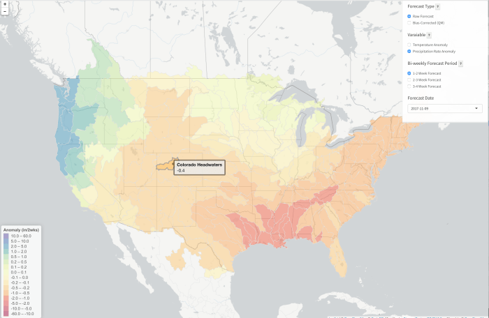


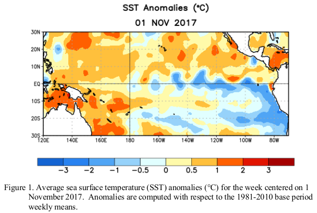

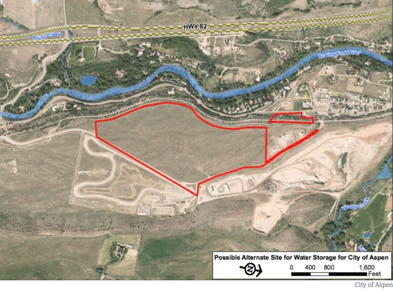
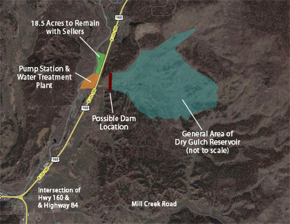


![Caption: Imperial Valley, Salton Sea, CA / ModelRelease: N/A / PropertyRelease: N/A (Newscom TagID: ndxphotos113984) [Photo via Newscom]](https://i0.wp.com/coyotegulch.blog/wp-content/uploads/2016/06/imperialvalleyfieldssaltonseawikipedia.jpg?w=338&h=254&ssl=1 "Imperialvalleyfieldssaltonseawikipedia")