Transportation is the Biggest Source of U.S. Emissions — Climate Central #ActOnClimate

Graphic credit Climate Central

From Climate Central:

The busiest travel day of the year brings a renewed focus on transportation, and for the first time since the 1970s, U.S. carbon dioxide emissions from transportation have eclipsed emissions from electricity generation as the top source of greenhouse gases.

The change comes as U.S. electricity generation relies less on coal and more on renewables and natural gas (a less carbon-intensive fossil fuel). Transportation emissions have also declined from a peak in 2008 due to steadily improving fuel economies, although there has been a small uptick recently as a result of a drop in gas prices. The projected growth in electric vehicles suggests decreases in CO2 transportation emissions are on the horizon. Even when accounting for how electricity is generated, an electric vehicle emits less carbon dioxide than a comparable gasoline car in a majority of U.S. states.

A typical gasoline-powered passenger car emits 20 pounds of carbon dioxide for each gallon of gas burned, or about a pound for each mile traveled, and both electric and hybrid vehicles can cut back on those emissions. A recent Climate Central report, Climate Friendly Cars, shows which cars are the most climate friendly in each state. The rankings are based on the type of engine and the method in which electricity is generated in each state.

From 2011 to 2016, the number of plug-in electric vehicles sold each year in the U.S. increased by a factor of eight. Projections for electric car sales vary among organizations, but all indicate a substantial increase in plug-in electric car sales in the coming years.

Traveling longer distances with electric vehicles is getting easier, as the number of publicly available charging stations has tripled since 2012, with 35,000 in place through 2016. And for those in a hurry, the number of fast charging stations, which can charge a battery most of the way full in about 30 minutes, has also tripled in that same time, with more than 5300 installed. However, America is playing catch up to China, which had 17 times more fast chargers than the U.S. at the end of 2016.

Coyote Gulch’s Leaf connected in the parking garage in Winter Park, August 21, 2017.

@ColoradoClimate: Weekly Climate, Water and #Drought Assessment of the Intermountain West #ColoradoRiver #COriver

Upper Colorado River Basin month to date precipitation through November 20, 2017 via the Colorado Climate Center.

Click here to read the current assessment. Click here to go to the NIDIS website hosted by the Colorado Climate Center.

Here’s an explainer about forecasting snowfall in a La Niña winters from NOAA:

This is a guest post by Dr. Stephen Baxter who is a NOAA Climate Prediction Center (CPC) meteorologist and does applied research on subseasonal-to-seasonal climate variability. In particular he specializes in understanding how the middle-to-high latitude circulation is influenced by the tropics versus other processes. He also has a lot of opinions on Siberian snow cover and the role of the western tropical Pacific in forcing seasonal climate over North America.

Recent cold air outbreaks over the north-central and northwestern U.S., along with record cold on Veterans Day in parts of the Northeast and Mid-Atlantic, should have people excited about (or dreading) the upcoming winter. My colleagues and I at the Climate Prediction Center have just issued our final outlook for the upcoming “meteorological winter,” that is, December through February. Right now, our official outlook covers only temperature and total precipitation, with the latter combining both liquid and frozen precipitation. However, what about the frozen stuff? What about snow?

Because many people remember winters that were either exceptionally snowy or not snowy at all, we get a lot of questions about what the winter forecast portends for seasonal snowfall accumulation. In many parts of the country, snowfall also has major economic and societal ramifications, including water resource management and winter tourism, among others.

Snow Way!

Tackling this problem is not easy, though. Part of the issue boils down to the technical difficulties of snowfall measurements—a real “problem child” as Deke Arndt (NCEI) puts it. The other issue is related to the difficulties with prediction. As many people in the Northeast corridor are aware, snowfall with any given storm system is a function of the dreaded rain-snow line that separates air masses that are below or above freezing.

For any given storm system, the exact boundaries between rain and snow can be hard to predict even days in advance. Luckily, at CPC, we aren’t trying to predict specific events, but the climate instead. We take a step back and see how seasonal temperature and precipitation forecasts might play a role in determining seasonal snowfall accumulation.

In regions that receive a large percentage of their cold-season precipitation in the form of snow, increased seasonal precipitation is intuitively related to increased snowfall accumulation. In more temperate areas that receive a relatively small percentage of frozen precipitation, temperature becomes important. Anomalously cold temperatures are, more or less, a necessary condition for snow in those areas. Therefore, a region with a relatively cold winter may find itself on the cold side of storm systems more often.

In more mountainous areas, where temperature varies as a function of elevation, colder systems result in snow falling at lower altitudes and more total snowfall coverage over a given region. This is where the long-term warming trends, recently discussed by Tom, become important over western North America. Drier and warmer climate signals will generally result in lower snow coverage.

Because a La Niña Advisory was recently issued, we will take a look at how La Niña, in general, affects snowfall across North America. This analysis is part of a broader effort at CPC to better understand and potentially predict seasonal snowfall, made possible in part by a new snowfall dataset (1).

La Niña = Skiers Delight over the Northern United States

In a nutshell, La Niña is associated with a retracted jet stream over the North Pacific Ocean. The retreat of the jet stream results in more blocking high pressure systems that allow colder air to spill into western and central Canada and parts of the northern contiguous U.S. At the same time, storm track activity across the southern tier of the U.S. is diminished under upper-level high pressure, which also favors milder-than-normal temperatures. The storm track is in turn shifted northward across parts of the Ohio Valley and Great Lakes (2).

Based on climate analysis (3) from this new snow dataset, we see that La Niña favors increased snowfall over the Northwest and northern Rockies, as well as in the upper Midwest Great Lakes region. Reduced snowfall is observed over parts of the central-southern Plains, Southwest, and mid-Atlantic.

Snowfall departure from average for all La Niña winters (1950-2009). Blue shading shows where snowfall is greater than average and brown shows where snowfall is less than average. Climate.gov figure based on analysis at CPC using Rutgers gridded snow data.

This La Niña footprint is pretty intuitive. Given the northward shift of the storm track, relatively cold and wet conditions are favored over the northern Rockies and northern Plains, resulting in the enhancement of snowfall. Warmer and drier winters are more likely during La Niña over more southern states, and this is exactly where seasonal snowfall tends to be reduced (4). The more vigorous storm track and slight tilt toward colder temperatures over the northern tier of U.S. during La Niña modestly increases the chance of a relatively snowy winter.

Snow and Strength

We can break up the snow pattern further and look at the weakest and strongest La Niña events. Splitting La Niña events into strength reveals some interesting differences worth investigating further. In this preliminary analysis below, there is a suggestion that weaker events are snowier over the Northeast and northern and central Plains on average.

Snowfall departure from average for weaker La Niña winters (1950-2009). Blue shading shows where snowfall is greater than average and brown shows where snowfall is less than average. Climate.gov figure based on analysis at CPC using Rutgers gridded snow data.

On the other hand, stronger La Niña events (see below) are snowier across the Northwest, northern Rockies, western Canada, and the Alaska panhandle. Also, there is a tendency toward below average snowfall over the mid-Atlantic, New England, and northern and central Plains, which is not seen during weak La Niña.

Snowfall departure from average for weaker La Niña winters (1950-2009). Blue shading shows where snowfall is greater than average and brown shows where snowfall is less than average. Climate.gov figure based on analysis at CPC using Rutgers gridded snow data.

Overall, stronger La Niña events exert more influence on the winter climate pattern over western North America. Weaker events appear to be associated with more widespread above-average snow over the northern United States. Because a weak La Niña means that the forcing from the Pacific is weaker than normal, it may imply other mechanisms (e.g. Arctic Oscillation) may be at play and is worth further investigation.

The predictability of seasonal snowfall may be somewhat similar to precipitation in that one or two big events can dramatically affect the seasonal average. Thus, in general, the expected prediction skill is likely to be lower than for temperature. However, because temperature also plays an important role in snowfall, some predictability is likely nonetheless. And like for seasonal temperature and precipitation, knowing the state of ENSO is a pretty reasonable place to start.

Footnotes

(1) This new dataset is documented in Kluver et al. (2016) “Creation and Validation of a Comprehensive 1° by 1° Daily Gridded North American Dataset for 1900-2009: Snowfall” in the Journal of Atmospheric and Oceanic Technology. The dataset for this analysis goes up to 2009, so we are going to look at winters from 1950-51 to 2008-09. Total cold season snowfall accumulation from October through April is used here.

(2) This is consistent with the temperature pattern: the storm track is enhanced where the temperature gradient is stronger than normal.

(3) Here we are using composite analysis to show snowfall. In this case we take just the La Niña years between 1950-51 and 2008-09 and compute the mean. For the strength composites, we divide the 18 La Niña winters between 1951-2009 into weak or strong cases. The median ONI value used to split them is -0.95°C during December-February (DJF) average. We need to be cautious drawing too many conclusions based on the large reduction in our sample size. Composites also emphasize variance: regions with more year-to-year variability will have higher amplitude composite signals.

(4) The areas in the South that favor below-average snowfall during La Niña are most evident where the snowfall climatology is reasonably high. That is where the signal is most likely to come through the noise.

The latest @WaterCenterCMU E-Newsletter is hot off the presses #ColoradoRiver #COriver

The confluence of the Colorado and Green rivers, fall 2016. If water makes it here, it’s bound for the lower Colorado River basin, so just how much water gets to this point matters to people in seven states. Photo credit Brent Gardner-Smith, Aspen Journalism.

Click here to read the newsletter. Here’s an excerpt:

FORUM PRESENTATIONS POSTED
This year’s Upper Colorado River Basin Water Forum featured a wide range of excellent presenters. You can review their slides and posters here and review the live twitter stream from the Forum here. Next year’s forum is scheduled for Nov 7-8, 2018.

R.I.P. Paul Buckmaster

Paul Buckmaster via YouTube.com

From The New York Times (Neil Genzlinger):

Paul Buckmaster, whose orchestral arrangements brought power and poignancy to signature songs by David Bowie, Elton John, the Rolling Stones, Carly Simon and countless other rock, pop, country and jazz stars, died on Nov. 7 at his home in Los Angeles. He was 71.

McDaniel Entertainment, which represented Mr. Buckmaster, announced the death. The cause was not given.

Mr. Buckmaster was something of a child prodigy on the cello and might have made a career solely as a musician, but a few fortuitous introductions connected him to Mr. Bowie and brought him the assignment of arranging “Space Oddity,” the eerie 1969 Bowie song that begins with the lyric “Ground control to Major Tom.”

Not long after, at a concert by Miles Davis (with whom Mr. Buckmaster would later collaborate), someone introduced him to a singer and pianist then in his early 20s, Elton John, who was working on his second album, which would be released in 1970 as simply “Elton John.”

Mr. Buckmaster was invited to do the arrangements, putting his fingerprints on one of the most acclaimed albums of the period. (It lost the Grammy Award for album of the year to Simon and Garfunkel’s “Bridge Over Troubled Water.”) His string enhancements elevate “Your Song,” Mr. John’s breakthrough single off that album. It was Mr. Buckmaster’s idea to put a harp at the start of “Sixty Years On,” which opens Side 2. He would continue to work with Mr. John regularly.

“He helped make me the artist I am,” Mr. John wrote on Twitter after the death, calling Mr. Buckmaster “a revolutionary arranger” who “took my songs and made them soar.”

@AmericanRivers: The big picture of @ColoradoWaterPlan – two years in

Click here to listen to the podcast. From the American Rivers website:

Last week, the state celebrated the second anniversary of Colorado’s Water Plan. Over the last two years, the state has made solid progress funding grants to advance water projects and increase funding for stream management plans. However, the challenges identified in the plan are significant. A swelling population is stretching our water resources, and climate change is having an impact, by reducing flows on the Colorado River. We need to pick up the pace toward implementing all of the Plan’s water solutions if we are to reach our goal of securing clean reliable water for our communities, preserving our agricultural heritage, and protecting our rivers. Over the next few months, We Are Rivers will highlight the Colorado Water Plan through a series of episodes breaking down the opportunities, challenges, and successes to date from Colorado’s Water Plan. Join us for the first installment, as we look back at the last two years of the water plan and identify a sustainable path forward.

Growing up in New York, I envied the posters pinned up in my middle school hallways that honored Colorado landscapes like the Maroon Bells, Dinosaur National Monument, the Great Sand Dunes, and of course the Colorado River as it weaves through canyons and deserts. But moving to Colorado six years ago, tacking on to Colorado’s growing population, I haven’t exactly made life easier for the state’s water managers. Without the native badge, I empathize with the influx of people flooding into Colorado who have recreational fervor, career hopes, and of course adventure in mind, straining the West’s already overtapped water supply.

Colorado’s population is projected to double by 2050, with most of the growth occurring on the Front Range, where about 80% of the people live. With about 80% of the state’s water coming from west slope snowpack, the imbalance is striking. Additionally, like many other states across the Southwest, Colorado is experiencing higher temperatures, reduced precipitation, and earlier and faster runoff. With growing population and climate change impacts, how can Colorado work to close our gap in supply and demand? Through increased collaboration, dialogue, and efficiencies, the Colorado Water Plan sets out to address this grand dilemma.

The Colorado Water Plan sets a goal of conserving 400,000 acre-feet of municipal and industrial water by 2050. By 2025, if the Water Plan objectives are met, 75% of Coloradans will live in communities that have water-saving actions incorporated into land-use planning. Furthermore, by 2030, the plan sets out to A) re-use and share at least 50,000 acre-feet of water amongst agricultural producers, B) cover 80% of locally prioritized rivers with Stream Management Plans, and C) ensure 80% of critical watersheds with Watershed Protection Plans. In order for a project to utilize the Water Plan’s budget to meet these goals, the proposed conservation project must be appropriate in that it addresses real needs and is cost-effective, sustainable, and supported by local stakeholders.

The state has taken a great step forward by allocating $10 million per year for Water Plan Implementation grants. While this is a first step, we must further fund the plan’s broader strategies as well. Public investment in water projects must be smart, which starts with meeting all of the “criteria” in the Colorado Water Plan. Before any new, significant projects are proposed, the state should apply all of the Water Plan’s criteria in order to demonstrate that the state is committed to investing in (or endorsing) only projects that use public resources wisely, protect rivers and wildlife, and reflect community values. The last two years have seen state funding disproportionately spent on costly structural projects while sustainable, cost-effective methods, such as water reuse and flexible water-sharing agreements have been undervalued and underfunded. Creative conservation projects are essential in upholding the Water Plan to sustain the natural beauty of Colorado’s rivers and streams and ensure a safe and reliable drinking water supply.

However, it is important to note that there is nothing legally binding in the Water Plan that requires Colorado to abide by its outlined goals. Therefore, the success of the plan solely relies on the motivation of everyday people to work together as a community to hold politicians and basin roundtables accountable with respect to the plan. I encourage you to learn more about where your water comes from and what you can do as an individual to reduce your water consumption. We all need to work collaboratively to reduce our demand for water.

As we celebrate the second anniversary of Colorado’s Water Plan, we have an opportunity, and a responsibility to rally behind the premise of the Plan, keeping Colorado beautiful and sustainable for all. Join us over the next few months as we dive into the mechanics of Colorado’s Water Plan, and why it is so important to see it succeed.

Colorado Water Plan website screen shot November 1, 2013

Dept. of Ag, @ColoradoCorn, others reaching out to producers about Reg. 85, stewardship, preventing additional rules

Photo credit: Bob Berwyn

Here’s the release from Colorado Corn:

Across Colorado, farmers and ranchers are using best management practices to help keep nutrients out of lakes and streams and improve Colorado’s water quality.

These forward-thinking producers believe the most effective way to reach agriculture and achieve the best results is through outreach and voluntary action.

Their stories and resources are now available to help other producers care for Colorado’s waterways.

The Colorado Department of Public Health and Environment (CDPHE) and Colorado Department of Agriculture (CDA) recently announced the release of “Colorado Ag Water Quality” — an outreach project developed by Colorado State University Extension.

The resources, found at http://www.ColoradoAgNutrients.org, include videos, a factsheet and publications on nutrient and water quality management.

Across the U.S., nitrogen and phosphorus have the potential to accumulate in waterways, causing water quality issues such as algal blooms, fish kills and impaired drinking water supplies.

Colorado Regulation 85 — adopted by the Water Quality Control Commission in 2012 — currently addresses nutrient concentrations in surface water by encouraging the voluntary adoption of best management practices.

Regulation 85 sets a 2022 timeline for evaluation of this voluntary approach for reducing nutrient pollution.

Additional regulations may be considered, depending on the success of these voluntary efforts.

Many of Colorado’s farmers and ranchers have responded by working proactively to safeguard the state’s waterways, and leaders in the ag industry are encouraging more producers to do the same.

The Taos Land Trust scores $575,000: “It was a beautiful series of serendipitous events” — Kristina Ortez de Jones

From The Taos News (Cody Hooks):

In a partnership between the Coca-Cola Company and the nonprofit National Recreation and Park Association, the land trust was awarded a $575,000 grant to make those visions a reality.

The “timely … and transformational” money will mostly be put toward the revival of the wetland associated with the Río Fernando, according to Taos Land Trust Executive Director Kristina Ortez de Jones.

Some of the funds will also be used to rebuild the Vigil y Romo Acequia on the property so that mountain streams can again irrigate the land, opening opportunities for experiments in community gardening and other agricultural projects.

“The Río Fernando Park is emblematic of the values held by all Taoseños with its seven acres of wetlands and 13 acres of now-fallow land that will be brought back to life with this important award,” Ortez de Jones said. The Romo property and future park are adjacent to Fred Baca Park.

“It was a beautiful series of serendipitous events,” she said of getting the award. “We are grateful for the opportunity to create a public space that meets our community’s need for open space, locally grown food and pathways for walking and bike-riding.”

The land trust purchased the Romo property in December 2015 and moved into the house-turned-office this past April. Since then, a quarter-mile trail was built on the property — laying the physical and mental foundations for the Río Fernando Park that will now come into shape a lot faster thanks to the grant, explained Ortez de Jones.

The beginning of the wetland restoration, she said, will start with “safely and deliberately removing those introduced species,” like Russian olive and Siberian elm. At the same time, the land trust will reintroduce native plants that can help maintain and mitigate the flow of the river through the wetland.

The stream has been channelized, such that water rushes through the stream bed, making it harder for wetland life to really flourish. In some places, the river may need re-engineering to improve the banks.

In the long run, the land trust wants the Río Fernando to be a functional wetland — slowing down and cleaning water. As climate change forces water users to take a hard look at the availability, timing and quality of water in the future, wetlands have come to be seen as an important tool.

At the same time as the land trust works to restore the wetland to peak conditions, the organization will use that momentum to continue planning for more trails and access to public spaces.

“We’ve asked neighbors, the community — What is missing in terms of public spaces and places? What should we do here? Overwhelmingly, people felt this place should be a park. People really want trails,” said Ortez de Jones.

Yet not all parks are created equal. “You have to look at this through the lens of access. You have to make an effort to get to our parks in Taos. And who doesn’t have access to those public places … the immigrant community, people without cars. A lot of people don’t have access,” she said.

The money for the land trust is part of Coca-Cola’s corporate effort to fund water-related projects in important watersheds around the country. Coca Cola’s money has also funded stream and wetland restoration in the Valle Vidal in the Carson National Forest.

USDA awards $1 million for Roaring Fork and #Colorado rivers conservation programs

From the Bookcliff, Mount Sopris and South Side Conservation Districts (Dennis Davidson) via The Glenwood Springs Post Independent:

The Bookcliff, South Side and Mount Sopris Conservation Districts have received funding of $500,000 for the next two years to assist agriculture landowners in portions of Garfield and Pitkin counties improve water quality and conserve water use.

The Targeted Conservation Program is part of the USDA Natural Resource Conservation Service’s (NRCS) Environmental Quality Incentives Program.

Local landowners must match these funds from loans, grants or their own funds. This will make a total investment to improve water quality of nearly $2 million in the Colorado and Roaring Fork river drainages.

The request was developed by the local conservation districts because landowners could not obtain cost share funds through the normal cost share programs of USDA conservation programs. The request targets the need of cost share on larger group projects.

Some of the goals of Bookcliff, South Side and Mount Sopris Conservation Districts that will be addressed with this funding are:

• Improve overall water quality, watershed health and water quantity in the mainstream of the Colorado River and its tributaries.

• Reduce salts and sediments in the waters of the Colorado River.

• Reduce unwanted vegetation such as tamarisk, Russian olive, willow, reed canary grass and other hydrophytic plants.

• Help landowners reduce annual maintenance and disturbances in ditches.

• Improve the habitat for the threatened and endangered warm water fish in the Colorado River below Rifle.

• Reduce labor and production costs for agriculture producers.

The first year’s allocations have already received requests for funds to install irrigation pipelines, irrigation diversion structures and associated management practices.

The consumptive use of agriculture water benefits beyond local citizens, but also extends worldwide in the production of food and fiber. Ecosystem improvement will include the upland, rangeland, forest land, wildlife land and the riparian area along each of the natural streams and rivers, while maintaining the water rights of the landowners.

Our local farmers and ranchers are conservationists striving to improve our environment through the proper use and management of water, plants, soil and animals and maintaining these resources for the current production of food and fiber, and for the future.

For additional information or questions, call the local conservation district office or the NRCS at (970) 945-5494.

Seasonal outlooks from the Climate Prediction Center

Below are the seasonal outlooks through February 28, 2018 from the CPC.

Seasonal temperature outlook through February 28, 2018 via the CPC.
Three month precipitation outlook through February 28, 2018 via the CPC.
Season Drought outlook through February 28, 2018 via the CPC.

#Snowpack news: Storm last week helped N. Colorado

Click on a thumbnail graphic to view a gallery of snowpack data from the NRCS>

And here’s the Westwide SNOTEL basin-filled map for November 20, 2017.

Westwide SNOTEL basin-filled map November 20, 2017 via the NRCS.

Moffat Collection System Project will impact forest surrounding existing Gross Reservoir

The dam that forms Gross Reservoir, located in the mountains west of Boulder. Photo: Brent Gardner-Smith/Aspen Journalism

From The Boulder Daily Camera (Charlie Brennan):

The Federal Energy Regulatory Commission is expected to rule early next year on what would be the biggest public works project in Boulder County history, exceeding the original construction of the Gross Reservoir Dam, which was completed in 1954.

The tree removal plan outlined in Denver Water’s FERC application states that all trees and their associated debris on about 430 acres along 12.5 miles of shoreline will have to be removed in the course of the expansion, which is envisioned as being completed by 2025.

Denver Water spokeswoman Stacy Chesney said the agency has estimated that “the density of the forest ranges from approximately 150 to 1,800 trees per acre. Based on these initial plans, we estimate up to 650,000 trees will need to be removed in the area surrounding Gross Reservoir.”

In a recent interview, Denver Water President Jim Lochhead vowed that every aspect of the project’s completion is being designed and executed with an eye toward mitigation of its impacts on the high country environment and those who depend on it for their recreation or call it home.

“We recognize that this is a major construction project and it has adverse impacts to the community,” said Lochhead, whose utility serves 1.4 million in Denver and many of its suburbs — but not Boulder County.

“We are trying to understand exactly what those impacts are, and see what the needs of the community are, and do everything we can to help address them.”

Referencing project manager Jeff Martin, Lochhead said, “Whether it’s traffic, hauling on the roads, whether it’s noise associated with the quarry, whether it’s the tree removal issues, it’s Jeff’s job to make sure it goes in a way that we’re doing the best that we can by the local community.”

Martin said: “We recognize the brutal aspects of the project. We don’t want to hide from those. That’s not our objective.”

Stressing that Denver Water intends to factor the concerns of reservoir neighbors into its planning of what’s officially known as the Moffat Collection System Project, Martin said, “We look forward to getting that feedback, seeing how we can make it into the most palatable project we can, and turn it into, maybe not reducing all the impacts, but for the greater good, reducing them as much as we can.”

[…]

A 48-page plan for the required tree removal prepared by Denver Water describes a mix of ponderosa pine, Douglas fir and Rocky Mountain juniper.

According to data the agency compiled in 2005, most of the trees at that time were 20 to 50 feet high, with a breast-high diameter ranging from 4 to 14 inches.

“Because of the topography, e.g., very steep slopes, rock outcrops, etc., several more complex tree removal (logging) systems will need to be used, and some temporary roads will need to be constructed to remove the trees,” the plan states.

It estimates that 50,000 tons of forest biomass are expected to be produced during the required clearing for the expansion of Gross Reservoir, which is to see its dam raised by 131 feet, expanding the reservoir’s capacity by 77,000 acre feet to a total storage capacity of 118,811 acre feet.

While noting that, “Traditionally, most of the slash would have been piled and burned in place,” the plan acknowledges that, “Today, burning large quantities of forest residue, in close proximity to residential areas, is problematic in the extreme.”

Allen Owen, Boulder District forester for the Colorado State Forest Service — a contracted forest resource management partner to Denver Water through the Forests to Faucets program — said he had been unaware of the number of trees Denver Water is planning to pull out of the Gross Reservoir area, or that it will involve the leveling of all growth on 430 acres of shoreline.

He doubts it would actually reach the 650,000 figure.

“That would mean 1,500 trees per acre over the entire 430-acre unit, and I know that’s not the case,” he said. “The stand densities vary all around the perimeter of the shoreline. There are areas that are nothing but solid rock, with no vegetation on it, to units that may have those number of trees. But there are not that many trees over the entire 430 acres. The number seems high.”

Owen expects state foresters will be involved in plotting how the trees’ removal proceeds.

“It’s something way beyond the ability of the Colorado State Forest Service,” he said. “I would consider that a big logging job, on very steep slopes, with very poor access. It is going to be very difficult, at best.”

Martin discussed three different potential scenarios, including removal by truck, burning and burial of felled lumber, or some combination of those strategies.

In cases where trees are located on small rock bluffs, Denver Water’s current removal plan notes, “the use of helicopter may be necessary.”

Denver Water believes new emerging technologies may pose options for removal that weren’t contemplated when its plan was authored.

“One of the things we’ve committed to is developing a process with public input … going out and getting some public input and some stakeholder input and that includes the U.S. Forest Service, the Colorado state forester and Boulder County, and developing some concepts … and then seeing what fits best for the community from there, and then moving forward with the plan,” Martin said…

Denver Water points to steps it is taking to mitigate the effects of construction wherever possible, and also emphasizes measures that it contends offers some in Boulder County a benefit. Lochhead and Martin touted the provision of a 5,000-square-foot environmental pool in the expanded reservoir, to be available for replenishing South Boulder Creek for the benefit of both Boulder and Lafayette at times when it is running dangerously low.

“That’s kind of a neat partnership there,” Lochhead said.

That does not mean that Boulder supports the Gross Reservoir expansion — but nor does it oppose it.

“Boulder has a neutral position on the overall expansion,” said Boulder’s source water administrator, Joanna Bloom.

“If the project somehow falls apart, then Boulder will continue to try to establish the streamflows on South Boulder Creek through other means,” Bloom said…

Boulder County’s stance on the expansion is more complicated.

The county filed extensive comments on both the draft and final environmental impact statements in the Army Corps of Engineers’ review process, and doesn’t agree that the EIS adequately addressed “the myriad of impacts” that would result for Boulder County and its citizens.

On March 23, the county filed an unopposed motion to intervene in the FERC approval process. One of the points the county addressed at length in that intervention relates to tree removal — and its arguments are based on the presumption of a far more modest, but still significant, removal of trees, at a total of 200,000.

“County roads (Flagstaff Road, Magnolia Road and others) are windy with low volume residential traffic and would be inappropriate for use by trucks hauling trees,” the county argued.

“In addition, it may not be possible to safely navigate SH 72 with trucks full of trees. These heavily laden trucks will cause damage to the roads and present safety concerns for road users.”

Moreover, the county contends Denver Water’s project must come through its land use review process, while the utility maintains that the county’s role is superseded by the FERC review process.

Until that conflict is resolved, the county is tempering its remarks, pro or con, on the Gross Reservoir project, so that it will not be seen as having prejudged any application Denver Water might make in the future through the county’s land review process.

Martin recalled that Denver Water worked extensively with Boulder County in 2012 exploring a potential intergovernmental agreement to facilitate the reservoir expansion.

While such a pact was ultimately rejected by Boulder County commissioners by a 3-0 vote, Martin said, “What we did receive was a lot of information from Boulder County and the public on how we need to shape the project in order to meet the needs of both the community and Boulder County.”

However, independent of the environmentalists’ planned federal lawsuit, there might be a need for another judge to sort out the critical question of whether Denver Water’s plans for tree removal and many other aspects of its reservoir expansion must pass through the county’s land use review process.

“I would say that it is likely that it will take litigation, because neither party is willing to give up its position,” said Conrad Lattes, assistant county attorney for Boulder County. “We need some neutral third party to decide this for us.”

However, on a warm and sunny day back before the chill of approaching winter descended on Colorado’s high country, Denver Water’s brass were flush with optimism.

Martin said that for Denver Water, it’s not just about getting the project done.

“We’re also looking at the social responsibility,” he said, “making sure that when it’s said and done, that we did it in the right way; that we could look back and say we did everything within reason and practicality to make this really the most environmentally, socially responsible project we can.”

Gross Dam enlargement concept graphic via Denver Water

Supporters seeking rights for Colorado River meet in Denver, amend complaint

The Colorado River in Cataract Canyon.

By Lindsay Fendt, Aspen Journalism

DENVER — Beneath the dim red glow of string lights at the Mercury Cafe in downtown Denver, about 25 people gathered Tuesday afternoon to rally support for a lawsuit against the state on behalf of the Colorado River.

The case, the first of its kind in the United States, has the potential to shift American environmental law by granting nature a legal standing. The suit lists “the Colorado River Ecosystem” as the plaintiff along with people who hope to serve as “next friends” for the river and represent its interests in court.

Five potential next friends were named in the original complaint — Deanna Meyer, Jennifer Murnan, Fred Gibson, Susan Hyatt and Will Falk — all members of the environmental group Deep Green Resistance, which states its goal is to “deprive the rich of their ability to steal from the poor and the powerful of their ability to destroy the planet.”

In an amended complaint, filed on Nov. 6, two more “next friends” were added to the case.

Owen Lammers of Moab is the executive director of Living Rivers, “which empowers a movement to realize social-ecological balance within the Colorado River watershed,” the amended complaint states. Living Rivers is a member of the Waterkeeper Alliance, a New York-based nonprofit dedicated to clean water founded by Robert F. Kennedy Jr.

“Because of Mr. Lammer’s significant relationship with, and dedication to, the Colorado River ecosystem, he is qualified to serve as next friend,” the amended complaint states.

This is a change from the original complaint, which did not cite any particular relationship between the Colorado River and the members of Deep Green Resistance.

Also added to the case was John Weisheit, who is “the person designated as the on-the-water ‘keeper’ per the Waterkeeper Alliance policies. In other words, Mr. Weissheit is the ‘Colorado Riverkeeper,'” the amended complaint states.

Weisheit, 63, “has enjoyed the Colorado River and its tributaries since childhood,” the complaint says. A resident of Moab, he’s been a river guide since 1980 and “continues to lead river trips that support scientific research and public education, in fulfillment of Colorado Riverkeeper’s mission statement.”

Weisheit is also a co-author of the 2004 book “Cataract Canyon, a human and environmental history of the rivers in Canyonlands,” which is a detailed 268-page guide to the “center of the universe.”

Jason Flores-Williams, the lawyer representing members of Deep Green Resistance in Colorado River Ecosystem v State of Colorado, speaks at a rights-for-nature meeting at the Mercury Cafe in Denver on Nov. 14, 2017. The state has moved to dismiss the lawsuit, and is expected to do so again in response to a recently amended complaint filed by Flores-Williams.

Signs of protest

Though the novel case is seeking personhood for the Colorado River ecosystem, the suit’s proponents hope to use it as a launching pad for a broader rights-of-nature movement.

“For you or I to defend a river in court right now we have to show how injury to the river injured us,” said Mari Margil, the associate director for the Pennsylvania-based Community Environmental Legal Defense Fund, a rights-for-nature legal group and a legal adviser on the Colorado River case. “There is a growing understanding that our environmental laws are starting in the wrong place.”

Rather than maneuvering within existing environmental law, where nature is considered property, rights-of-nature lawsuits seek to give the natural world rights to exist beyond its use to humanity.

Margil and other rights-of-nature proponents say that our current environmental legal framework — which is based on legislation like the Clean Air Act and Clean Water Act — does not go far enough. They point to past court decisions that have granted legal rights to corporations, like the 2010 Citizens United case, and say nature should have that same standing.

“I’ve long acknowledged that what we are doing in the environmental movement has not created change,” Meyer, one of the potential next friends in the lawsuit, said in a recent interview. “We see every biotic system on the planet in decline and nothing has gotten better. Until the river has rights, I don’t see any change happening in the way it is being used and exploited.”

At the meeting in the café in Denver on Tuesday, activists supporting the lawsuit propped up poster boards that said “The Colorado River runs through us” and “Legal standing for the Colorado River,” that were made for a courthouse rally held earlier that morning. They kicked off their meeting with a slow chant praising “sacred Colorado waters” before sitting down to strategize about building support around the lawsuit.

The group is planning protests, awareness campaigns and other rights-of-nature lawsuits in an effort to open up the courts for cases defending ecosystems from environmental ills.

“The court isn’t going to just give us anything,” Jason Flores-Williams, the Denver-based lawyer representing Deep Green Resistance and the potential next friends in the lawsuit, said at the meeting. “How we won’t lose is not based on whatever will happen inside the courtroom, but what happens outside of it.”

So far, the case has moved forward only a couple of short steps. Flores-Williams filed the case on Sept. 25, which the state followed with a motion to dismiss on Oct. 17 on the grounds that the case does not fall under federal jurisdiction and lacked specific injuries attributable to the state.

“The complaint alleges hypothetical future injuries that are neither fairly traceable to actions of the state of Colorado, nor redressable by a declaration that the ecosystem is a ‘person’ capable of possessing rights,” reads the motion to dismiss, which was filed by the Colorado attorney general’s office.

The plaintiffs were then allowed to amend their complaint, and on Nov. 6 Flores-Williams filed a new complaint, invoking rights under the U.S. Constitution in order to keep the case in federal court.

The map of the Colorado River basin included in the amended complaint filed on behalf of the Colorado River ecosystem by members of Deep Green Resistance and other next friends. The map understates the contribution of the Green River to the Colorado River system.

246,000 square miles

Flores-Williams used the opportunity clarify aspects of the original complaint. For example he added that the Colorado River has the right to “be restored” in addition to the right “to exist, flourish, regenerate, [and] naturally evolve.”

He also defined the scope of the plaintiff in the case, the “Colorado River Ecosystem,” saying it “encompasses the area bound by the highpoints and ridgelines where drop-by-drop and grain-by-grain, water, sediment, and dissolved materials ebb their way toward the Gulf of California: some 246,000 square miles (640,000 km2) in southwest North America including portions of Colorado, New Mexico, Wyoming, Utah, Nevada, Arizona, California in the United States, and portions of Baja California and Sonora in Mexico.”

The amended complaint states that the Colorado River ecosystem includes the river’s “major tributaries” and “all the creeks, streams, and tributaries that feed them, along with the surrounding landscape where water percolates and flows underground,” and it includes a map of the entire Colorado River basin.

It also cites the native endangered fish species that are struggling to survive in the Colorado River basin and says the Endangered Species Act “has failed to reverse the pace of biodiversity degradation.”

In terms of the connection between the river ecosystem and those who wish to be seen as “next friends” by the court, the amended complaint claims that “as the human part of the Colorado River ecosystem, next friends and guardians are capable of speaking through words on behalf of the natural communities that comprise the Colorado River ecosystem.”

The amended complaint also elaborates on the idea of personhood for the river, noting “the recognition of the Colorado River ecosystem as a ‘person’ is far less of a stretch than bestowing upon inanimate corporations the status of personhood.'”

And the amended complaint argues that by lack of such recognition the river’s rights are being denied under the due process and equal protection provisions in the U.S. Constitution.

On thing the amended complaint did not do is correct claims in the original complaint that the state of Colorado operates a number of dams and reservoirs on the Colorado River system that are, in fact, operated by the Bureau of Reclamation or other water-management organizations, including Blue Mesa Reservoir on the Gunnison and Green Mountain Reservoir on the Blue River, both tributaries of the Colorado River.

Will Falk,a member of Deep Green Resistance, speaking at the Mercury Cafe in Denver on Nov. 14, 2017. Falk is one of the named plaintiffs in Colorado River Ecosystem v State of Colorado, and has recently been traveling along portions of the Colorado River.

Beyond the law

The courthouse rally and the following rights-of-nature meeting were originally scheduled around a status conference slated for Tuesday, but the court vacated the hearing and gave the state until Dec. 1 to respond to the amended complaint. Flores-Williams expects the state will again move to dismiss the case.

Regardless of the outcome of the lawsuit, the case’s plaintiffs plan to keep fighting against what they see as exploitation on the Colorado River and hope to inspire others to file rights-of-nature cases.

“Our case by itself is not going to transform the American legal system,” Falk, a potential “next friend” in the case said in an interview. “People who care about the environment need to realize that one court case is not going to be a quick fix for a system that has a tradition of exploiting the natural world.”

The amended complaint notes that Falk “recently traveled the waters of the Colorado River.”

“To support the idea that the Colorado River needs rights, I wanted to go see firsthand the problems along the river,” Falk said in a recent interview.

Grand River Ditch July 2016. Photo credit Greg Hobbs.

“It started a couple weeks ago when we went up to La Poudre pass north of Rocky Mountain National Park to see the headwaters of the river,” Falk said. “And you don’t really find a whole lot of natural or wild water. What you find is the Grand Ditch, which is a ditch build in the 1880s that is still carrying water across the Continental Divide and over the Rocky Mountains and to the Front Range. From the very beginning, the river is being exploited. The water is taken from her birthing grounds. From the moments she begins to flow she is being stolen.”

Editor’s note: Aspen Journalism is covering rivers and waters in collaboration with the Glenwood Post Independent, The Aspen Times, the Vail Daily and the Summit Daily News. The Post Independent published a shorter version of the story on Sunday, Nov. 19, 2017.

@UNFCCC: More than 20 Countries Launch Global Alliance to Phase Out Coal #COP23

Here’s the release from UN Climate Change:

The United Kingdom and Canada are leading a new global coal alliance aimed at accelerating clean growth and achieving the rapid phase-out of traditional coal power.

More than 20 countries, including France, Finland, and Mexico, are part of the “Powering Past Coal Alliance” which also brings together a wide range of businesses and civil society organizations that have united for climate protection.

According to the International Energy Agency, Coal-fired power plants produce almost 40% of global electricity, making carbon pollution from coal a leading contributor to climate change. Air pollution from the burning of coal causes severe respiratory diseases and has many other damaging health effects, in addition to being a key driver of climate change.

The member countries of the alliance, launched during the UN Climate Change Conference in Bonn, have agreed to phase out existing traditional coal power and place a moratorium on any new traditional coal power stations without operational carbon capture and storage. Businesses and other non-government partners have in turn made commitments to focus on powering their operations without coal.

The partners in the Powering Past Coal Alliance will also work together to share real-world examples and best practices to support the phase-out of coal, including through climate financing, and adopt practical initiatives that support this transition toward clean energy. Member countries aim to grow the alliance to 50 partners by the 2018 UN Climate Change Conference (COP24) in Katowice,

The full text of the declaration can be found here.

@NASA_Climate: Map of Earth over 20 years highlights astonishing impact of climate change

From The Independent (Tom Embury-Dennis):

The animation shows our planet’s seasonal fluctuations as seen from space after the US space agency condensed two decades of data into just a few minutes.

The polar ice caps and snow cover are shown ebbing and flowing with the seasons. But as time passes the Arctic can be seen getting greener, as shrubs grow more widely in the warmer temperatures.

The visualisation also captures the state of the oceans and life within it. Recent years feature more and more purple patches – areas where little life thrives known as “biological deserts”.

“It’s like watching the Earth breathe. It’s really remarkable,” said Jeremy Werdell, a Nasa oceanographer who took part in the project.

“It’s like all of my senses are being transported into space, and then you can compress time and rewind it, and just continually watch this kind of visualization.”

This autumn marks 20 years since Nasa began a continuous, global view of life on both land and sea using multiple satellites known as the Sea-viewing Wide Field-of-view Sensor.

Mr Werdell said the visualization shows spring coming earlier and autumn lasting longer in the Northern Hemisphere. Also noticeable to him is the Arctic ice caps receding over time – and, though less obvious, the Antarctic, too.

On the sea side, Mr Werdell was struck by “this hugely productive bloom of biology” that exploded in the Pacific along the equator from 1997 to 1998, when a water-warming El Nino event merged into cooling La Nina. This algae bloom is evident by a line of bright green.

Brenda Burman confirmed as Commissioner of @USBR

Lake Nighthorse August 2017 via the US Bureau of Reclamation.

From The Arizona Republic (Marcella Baietto):

Brenda Burman, the director of water policy for Salt River Project who previously worked for the U.S. Department of the Interior, has been confirmed as the nation’s first female commissioner of the U.S. Bureau of Reclamation.

Burman, who was nominated for the post in June by President Donald Trump, was confirmed on a unanimous voice vote by the U.S. Senate on Thursday, according to the Senate record.

Burman will take the helm of an agency with nearly 5,000 employees and assist in maintaining almost 500 dams and about 330 reservoirs managed by the bureau across 17 Western states, according to a U.S Department of the Interior press release that announced her nomination this summer.

The bureau also maintains 53 hydroelectric plants in the United States.

Burman, a University of Arizona law-school graduate, previously worked for the bureau, a division of the U.S. Department of the Interior, from 2006-08, as deputy commissioner for external and intergovernmental affairs and as the deputy assistant secretary.

She also was on the staff of former U.S. Sen. John Kyl of Arizona, specializing in water and energy matters.

“​I welcome this opportunity and am thankful for the chance to serve again on the Bureau of Reclamation team,” Burman said in a prepared statement after she was nominated. “The men and woman of Reclamation have helped the West work through our most difficult water issues for over a hundred years.”

[…]

Burman’s background also includes working for the Metropolitan Water District of Southern California and the Nature Conservancy.

@CoAgWater: Colorado’s Ag Water Summit 2017 December 5, 2017

Lake Loveland

Click here to read the agenda. Click here for the inside skinny and to register.

The Ag Water Summit brings together agricultural leaders from across the state, water professionals, elected officials, and decision makers to discuss agricultural water issues. We want to continue the discussion of pertinent water issues, but also want to make this event an opportunity to tell the story of “Water and Agriculture” for people unfamiliar with the role of agriculture in Colorado.

Long Hollow Reservoir late season augmentation water working as planned

Long Hollow location map via The Durango Herald

From The Durango Herald (Jonathan Romeo):

In the 1960s, irrigators in southwestern La Plata County had their dreams dashed when plans for a major transmountain diversion, which would have taken water from the Animas River into the low-flow La Plata River, were quashed.

The water project – called the Animas-La Plata Project – was considered the last major water storage effort in the American West. Then in 1990, the project was downsized again, removing plans for irrigation out of Lake Nighthorse.

“That’s when we started thinking seriously about this,” said Brice Lee, president of the La Plata Water Conservancy District.

Irrigators on the western side of the county have historically had to rely on the La Plata River, a generous moniker for a relatively low-flow waterway that is reduced to a trickle, and even dries up, after a short spring runoff.

Yet despite the lack of natural flows, the water has been terribly over-appropriated.

In the 1920s, Congress approved a water compact that requires the state of Colorado to deliver one-half of the daily flow of the La Plata River, measured at Hesperus, to the New Mexico state line for the use of irrigators to the south.

However, Colorado, which must live up to those terms from Feb. 1 to Dec. 1, has not always made good on that requirement for a number of reasons, including drought and water demands.

As a result, Long Hollow Dam was concocted in the 1990s, with construction starting in 2012. It cost nearly $23 million. Funds set aside from the Animas-La Plata Project paid for the 151-foot-high, 800-foot-wide dam.

The reservoir, located along Colorado Highway 140, has a capacity of nearly 5,400 acre-feet – small change when you consider Vallecito Reservoir has a capacity of 125,000 acre-feet and Lake Nighthorse, also relatively new, has a capacity of 123,541 acre-feet.

Still, the stored water in Long Hollow Dam functions as a win-win water exchange.

About 100 to 150 irrigators in southwestern La Plata County can draw and divert water out of the La Plata River farther north of Long Hollow Dam.

Then, to meet the terms of the compact, water is released from the Long Hollow Dam into the La Plata River, which takes water from Long Hollow Creek and Government Draw, tiny tributaries of the La Plata River that drain 43 square miles east of Colorado Highway 140.

Lee said thanks to strong winter snowfall and spring rains, Long Hollow Dam was able send 2,000 acre-feet to New Mexico this year. That means irrigators in southwestern La Plata County were able to use an additional 2,000 acre-feet out of the La Plata River.

“We’re pretty pleased,” he said. “We had a good year.”

The uptick in available water has had a predictably positive affect for ranchers and farmers, extending the growing season anywhere from 10 to 14 days – a vital extension in an industry that runs on margins.

“This is helping families that were drying up and getting discouraged,” said Ron Crawford, a fourth-generation La Plata County resident who is in charge of dam maintenance.

Taylor, whose father, Bobby, sold the land for the dam, said he was able to produce 30 to 40 percent more hay and grain than in years past because of the water Long Hollow Dam freed up.

Lower Arkansas Water Conservancy District board meeting recap

Fountain Creek erosion via The Pueblo Chieftain

From The La Junta Tribune-Democrat (Bette McFarren):

Mark Shea of Colorado Springs Public Works Department was early to the meeting with the Lower Arkansas Valley Water Conservancy District with the good news that Colorado Springs voters have approved funding of the Fountain Creek Flood Mitigation Project by approving Ballot Issue 2A. The project has not been funded for several years, but some of the projects have been funded through the general fund, explained Engineer Richard Mulledy. The project is now the subject of litigation between Colorado Springs and the LAVWCD, so Attorney Bart Mendenhall urged both sides not to get into the territory of the lawsuit in progress.

Mulledy has been at the helm of the storm water project for two and a half years. Anthony Nunez, Director from Pueblo, asked Mulledy if the current 2A funding replaced the Enterprise Zone, which was originally designed to fund the project but voted out by the people of Colorado Springs. Mulledy said yes. The 2A mandate is intended only for capital projects associated with Fountain Creek Flood Mitigation, drainage maintenance over the 395 square miles of the Colorado Springs area, and the water quality program associated with it. Fees for litigation are not included…

Winner brought up sedimentation as the major cause of the North La Junta flooding problem. “Thirteen feet of sediment under the North La Junta Bridge,” said Winner. “More like 15 feet,” said Bud Quick, whose volunteer earth-moving has protected North La Junta several times. Earlier Quick had declared the problem of flooding in North La Junta will never be solved until the river is dredged and sediment controlled in the Arkansas River.
At the end of the meeting, Rose Ward thanked the LAVWCD for its help in flood mitigation for North La Junta, and at the present time for helping them establish a special district that will enable North La Junta Conservancy District to help itself.

@USBR: Bureau of Reclamation Announces Fiscal Year 2018 Drought Response Program Funding Opportunities

Graphic vie the National Drought Mitigation Center November 2017.

Here’s the release from Reclamation (Peter Soeth):

States, tribes, irrigation districts, water districts, and other organizations with water or power delivery authority are eligible to apply for drought resiliency projects and drought contingency planning grants

The Bureau of Reclamation has released two funding opportunities for fiscal year 2018 through its Drought Response Program, which is part of the Department of the Interior’s WaterSMART program. These funding opportunities are available for entities to develop drought contingency plans and build long-term solutions to drought.

The drought resiliency project funding opportunity is available for projects that will increase water management flexibility, and improve the resiliency of water resources throughout the West. Award recipients will leverage their resources by cost-sharing with Reclamation on drought resiliency projects.

Drought resiliency projects mitigate drought impacts by increasing the reliability of water supplies, improving water management, and providing benefits for fish, wildlife and the environment.

Applicants for drought resiliency projects funding must submit their proposals by 4:00 p.m. MST on Tuesday, February 13, 2018. To view this funding opportunity, please visit http://www.grants.gov and search for funding opportunity number BOR-DO-18-F008.

The drought contingency planning funding opportunity is available for applicants interested in developing a new drought plan or updating an existing drought plan. Applicants may request technical assistance from Reclamation for developing elements of the drought contingency plan.

Applicants for drought contingency planning must submit their proposals by 4:00 p.m. MST on Wednesday, February 7, 2018. To view this funding opportunity, visit http://www.grants.gov and search for funding opportunity number BOR-DO-18-F007.

Reclamation’s Drought Response Program supports a proactive approach to drought by providing financial assistance to water managers to: develop and update comprehensive drought plans (drought contingency planning), and implement projects that will build long-term resiliency to drought (drought resiliency projects).

To learn more about Reclamation’s Drought Response Program please visit https://www.usbr.gov/drought.

The November 2017 Water Information Program newsletter is hot off the presses

Credit The Pagosa Daily Post.

Click here to read the newsletter. Here’s an excerpt:

San Juan Water Conservancy District Proposed Mill Levy a No-Go

San Juan Water Conservancy District was disappointed in the results of the Tuesday election. SJWCD put forth a proposed mill levy (Ballot Measure 5A) to help fund the proposed San Juan Headwaters Project (previously known as Dry Gulch) raw water storage project. The measure did not pass.

The District needed to pass this measure as a means to pay debt servicing on a $2 Million loan secured from the Colorado Water Conservation Board this past May. The loan is contingent on securing a revenue source sufficient to pay the loan back.

The District knew, and this election confirmed, passage of a tax increase was an uphill effort. “The strategy we embarked on for this past election was educational. We truly felt that if we could inform voters that the failed effort to build a 35,000 acre foot reservoir that would cost $400 Million is not the same project now being proposed, which is an 11,000 acre foot reservoir costing $70 Million. Obviously, our education effort fell short,” stated Rod Proffitt, SJWCD President.

“Since we have few options to improve our revenues, it is highly likely we will again propose a mill levy increase this coming year,” added Proffitt. In the meantime, the District is heavily involved in local efforts to implement the objectives of the Colorado Water Plan.

Lincoln Park/Cotter Mill Superfund site cleanup update

Lincoln Park/Cotter Mill superfund site via The Denver Post

From The Canoñ City Daily Record (Sara Knuth):

The Denver-based Colorado Legacy Land, which has been in negotiations with Cotter since July, received a conditional approval from the Colorado Department of Public Health and Environment on Nov. 8 to take over the defunct uranium mill’s radioactive materials license.

But the company still has a few more obstacles to cross before the deal is final.

During a Community Advisory Group meeting Thursday, Paul Newman of Colorado Legacy Land said the company is waiting for approvals from the state.

Colorado Legacy Land, which is part of environmental cleanup companies Legacy Land Stewardship and Alexco, also is seeking to take over Cotter’s

Schwartzwalder Mine via Division of Reclamation and MIning
Mine near Golden. The project, included in the same transaction as the Cañon City site, still needs a mine permit transfer from the Colorado Division of Reclamation, Mining and Safety.

“The DRMS is taking a bit more time in their evaluation and approval of that transfer,” Newman said. “Hopefully, we can get that resolved and that one transferred here shortly.”

The company also met with the Colorado Attorney General’s Office and Environmental Protection Agency attorneys to get assigned an administrative order on consent. That process also is still pending.

But if all goes according to plan, Newman said, Colorado Legacy Land hopes to close the deal by the middle of December. From there, the company would “come in where Cotter left off,” Newman said. “So, we have the whole clean-up process in front of us.”

The first major step toward cleanup, he said, would be working through a remedial investigation, a deep look into how far the contamination goes.

Cotter, which opened the Cañon City site in 1958 to process uranium for weapons and fuel, was found in the 1980s to have contaminated nearby wells. It was placed on the U.S. list of Superfund sites, putting Cotter in charge of cleanup efforts. In 2011, Cotter decided to put a halt to uranium production altogether.

Newman, the executive vice president of Legacy Land Stewardship, said Cotter approached Alexco — a company that has been working on the Schwartzwalder Mine for four years — to step in. Colorado Legacy Land was formed by Alexco and Legacy Land Stewardship specifically to take over the cleanup process.

If the state approves the final requirements, the company will own the land. Additionally, Newman said, Colorado Legacy Land is planning to open offices in Cañon City.

As part of requirements outlined in the CDPHE’s conditional license approval, Colorado Legacy Land will need to inform the department of the closing date in writing.

#Snowpack news: Quick moving storm should be good snowfall to the #Colorado high country

Westwide SNOTEL basin-filled map November 16, 2017 via the NRCS.

Windy Gap Firming Project update

Windy Gap Reservoir

From KUNC (Luke Runyon):

Collaboration is a lofty goal touted by political and business leaders as a potential way forward on anything from climate change to healthcare to obesity. Drop your weapons, turn your enemies into partners and achieve great things — or so the thinking goes. But collaboration is a concept that sounds great in the abstract and quickly turns messy in practice, with plenty of pitfalls along the way toward a common goal.

Avoiding drawn out fights has always been tough when dealing with water issues in the West. Collaboration wasn’t always the go-to strategy for environmentalists, political figures and water managers who held competing interests on overtaxed, overdrawn rivers.

But with the Windy Gap Firming Project in northern Colorado’s mountains, old grudges are being put aside in favor of new, collaborative tactics. While some of the West’s oldest enemies are working together, those who feel left behind by all the newfound teamwork aren’t ready to sing “Kumbaya.”

[…]

Windy Gap Reservoir — at the heart of the dispute — is a shallow, human-made lake just west of Rocky Mountain National Park. Colorado River water sits in a wide, shallow pool, kept in place by a dam…

It’s just one piece of a much larger diversion project that moves water from the headwaters of the Colorado through the mountains for use along the Front Range. Water managers have proposed, and received the federal permits needed, to use this small reservoir to move more water eastward, exercising water rights they say they’re unable to use now because the system is full to the brim at inopportune times.

That type of proposal — to send more Colorado River water eastward to supplement urban and suburban growth — stirs up all kinds of West Slope anxiety about Front Range growth.

“We know the flows are going to be diverted,” [Kirk] Klancke says. “We know the state’s not going to stop growing, that’s reality.”

“The pragmatic approach would be then to figure out how to keep your aquatic habitat healthy with those diminished flows, and that’s what we’re doing,” he says.

Rather than fight powerful water managers like Denver Water and Northern Water in the duke-it-out, courtroom-style battle some environmental groups have perfected over the years, Trout Unlimited and some of its allies took an unprecedented step: working together. Since the Windy Gap project’s revival more than a decade ago, they’ve had a seat at the negotiating table. If cities want to siphon away West Slope water, Klancke says, they need to give something in return.

“These are some of the most powerful people in the state because they control one of the state’s most important resources,” he says.

Which is exactly why other environmentalists, like Ken Fucik, don’t trust the water diverters and, by association, environmental groups like Trout Unlimited for working with them.

“When you look at the process over here, there are some of us over here who are unhappy,” Fucik says.

Fucik, a retired environmental consultant from Grand Lake, is opposed to a 2012 deal brokered by Trout Unlimited, county officials and others. In exchange for a permit to allow more water be sent to the Front Range as part of Windy Gap, the negotiators got $10 million in required mitigation to upgrade water quality in the headwaters and an additional $12 million in mitigation work for fish and wildlife, projects not required by law. That includes partial funding for a bypass channel that would skirt around Windy Gap dam and reservoir, reconnecting the upper reaches of the Colorado River, allowing fish to move more freely.

Grand County was also able to negotiate additional flows out of Windy Gap Dam to flush out sediment, an agreement that Northern Water be in charge of operation of the new bypass and more flows to support endangered fish in a stretch of the Colorado near Grand Junction…

Environmental consultant Geoff Elliott agrees. He lives in Grand County and says when you’re not part of collaborative agreements and weren’t invited to the negotiations, you end up feeling left out and unheard.

“It comes down to trust and we’re asked to trust in a process where we’ve been eliminated, pushed out and punished,” he says. “It’s hard for us to trust in that process.”

Fucik and Elliott are now supporting a recently filed lawsuit from a handful of environmental groups who take a different tactic with water projects, like Save The Colorado and WildEarth Guardians. Their goal is to prevent more water pulled from the Colorado River watershed from traveling to the Front Range…

For an environmentalist concerned about the health of the river, this conundrum has become the fork in the road: When do you collaborate with someone who’s supposed to be your enemy? And when do you roll the dice in court?

Lurline Curran photo credit Aspen Journalism.

Lurline Underbrink Curran says the path of most resistance has been tried before, with pretty erratic results. She’s the former Grand County manager and sat at the negotiating table with Northern Water.

“I don’t understand collaboration becoming a dirty word,” she says. “Because I can tell you, I can throw out some dirty words that will curl your hair, and that is not one of them.”

Because Grand County officials, like Curran, held the key to a permit that would allow the project to move forward, she joined forces with environmental groups like Trout Unlimited and ranchers concerned about the river’s flow downstream of Windy Gap. The negotiations took years and Curran says her team was a formidable opponent to the Front Range water suppliers, despite what detractors might think.

Curran admits some of the negotiations were done behind closed doors, as she says, to build trust among old enemies. But adds that the solutions they came up with will benefit the river in the long-term.

“Will the Colorado be as wide and deep as it used to be? Hell no. But that’s gone. Like it or not that’s been gone for decades,” she says. “But you can make it so it’s functional.”

Map from Northern Water via the Fort Collins Coloradan.

The idea of bringing parties with old grudges to the negotiating table was meant to avoid lawsuits in the first place. Now that one’s been filed it threatens to bring down the whole deal. Northern Water has already started planning the $400 million Chimney Hollow Reservoir. Trout Unlimited is still fundraising to secure enough money to build the Windy Gap bypass channel, the crown jewel of the agreement.

Northern Water spokesman Brian Werner says the agency is moving ahead with its plans.

“I’d be lying if I said there weren’t any concerns, we’d rather not have a lawsuit filed,” Werner says.

Werner doesn’t have any regrets on how the compromise went down. For decades, water managers have been seen as bullies who strong arm their opponents to get what they want. He says the Windy Gap Bypass project seemed like a turning point.

“What’s best for the river?” he asks. “We need water for growth in Colorado, there’s no question about that. How are we going to do it, folks?”

Either by working with your enemies. Or against them.

#Drought/#snowpack news: It was a dry week for the Nation as a whole, sorry #Colorado

Click here to go to the US Drought Monitor website. Here’s an excerpt:

Summary

It was a dry week for the Nation as a whole. Widespread heavy precipitation was restricted to the central and northern West Coast from the Cascades and northern Sierra Nevada westward. A few patches near the coast recorded 6 to 12 inches of precipitation. Across the remainder of the contiguous states, only a few small areas reported over 1.5 inches, with most locations observing little or none. As a result, short-term dryness continued to develop and expand across the south-central and southeastern U.S. as 30- to 90-day precipitation deficits continued to steadily increase, overcoming the wet weather that had squelched dryness impacts in much of these regions several months ago…

High Plains

Cold weather, accompanied by little or no precipitation, kept dryness and drought unchanged across the Dakotas and Montana, with extreme drought persisting in portions of western South Dakota and northeastern Montana…

West

Dryness continued to slowly improve east of the Cascades in Washington and Oregon, eliminating D1 in north-central Washington and restricting D0 to areas recording less than 1.5 inches of precipitation during the past 30 days. Farther south, no measurable precipitation has fallen for at least the last 30 days on the central and western Four Corners States, Nevada, and the southeastern half of California. This is not unusual here in late autumn, and while notable impacts are lacking, increasingly impressive dryness over the past few months induced some D0 expansion in southeastern Monterey County, CA and in the drier areas of southwestern Utah, southeastern Nevada, and part of southeastern California…

Looking Ahead

During the next 5 days (November 16-20), Moderate precipitation at best is expected for most of the country. Amounts of 0.5 to locally approaching 2.0 inches are expected in the Northeast, the northern and central Appalachians, the eastern Great Lakes, and the central and northern sections of Ohio, Indiana, and Illinois. Farther west, more than 0.5 inch is forecast from the Sierra Nevada and the Cascades westward to the Pacific Ocean, with heavy amounts anticipated in the typical orographically-favored areas, specifically along the coast and on the windward (western) slopes of the mountains. Between 5.0 and 8.5 inches could fall on the Washington Cascades, northwestern Washington, the northwestern and west-central California Coast, and the Sierra Nevada. In addition, 0.5 inch or more is expected in some of the higher elevations of western Colorado, western Wyoming, central and north-central Utah, northeastern Nevada, and parts of Idaho. Isolated amounts of 2.0 to 4.5 inches could be dropped on the highest elevations and windward slopes.

During the 6-10 day period (November 21-25), odds favor above-median precipitation only across the Florida Panhandle, the northern Intermountain West, and the northern half of the West Coast States. Below-median precipitation is anticipated elsewhere except in the southern half of the High Plains, the northern Plains, most of the Great Basin, and the Southwest, where neither abnormal wetness nor dryness is favored. Warmer than normal weather is expected from the Pacific Coast eastward into the upper Mississippi Valley, the central Great Plains, and central Texas, with subnormal temperatures favored in most areas from the eastern Great Lakes and southern half of the Mississippi Valley eastward to the Atlantic Coast.

Westwide SNOTEL basin-filled map November 16, 2017 via the NRCS.

@ColoradoClimate: Weekly Climate, Water and #Drought Assessment of the Intermountain West

Upper Colorado River Basin month to precipitation through November 13, 2017 via the Colorado Climate Center

Click here to read the current assessment. Click here to go to the NIDIS website hosted by the Colorado Climate Center.

Jerry Sonnenberg awarded Colorado Livestock Association’s Legislator of the Year Award

From The Sterling Journal-Advocate (Jeff Rice):

State Sen. Jerry Sonnenberg, the Republican who represents Senate District 1 of northeast Colorado, told the Colorado Livestock Association’s Northeast Livestock Symposium on Tuesday that he’ll work to keep the Environmental Agricultural Program alive because it gives agriculture a voice in state environmental concerns.

The program, administered by the Colorado Department of Public Health and Environment, oversees air and water quality protection regulations specific to animal feeding operations. That includes permitting, conducting site inspections, developing and implementing policies and regulations, providing technical assistance and initiating enforcement actions in coordination with the CDPHE’s Air and Water Quality divisions.

“A lot of people thought, when this program started, that it was just another way for CDPHE to hammer on us, and that’s why it’s sunsetted,” Sonnenberg said. “But it’s turned out to be one of those programs that actually uses a lot of common sense, and it gives (livestock producers) a voice when it comes to making regulations and policies.”

The senator said that, with the program’s track record, there is talk of removing the sunset requirement of the program, or at least moving it to a seven-year interval, and that he would support that move.

The legislature also will likely get involved with the Gilcrest high water table problem, which is causing property damage in and around Gilcrest as well augmentation practices — necessary to maintain the health of the South Platte River aquifer — have raised the water table during the irrigation season. A pilot program allows irrigators to pump without augmenting locally, but putting water in the river from other sources.

Sonnenberg said it might be better to store the augmentation water in reservoirs further away from Gilcrest so release of the water into the river can be better timed to the need for water downstream…

Sonnenberg said that, while he remains absolutely committed to the ideals and values of the Republican party, there is a certain efficiency and effectiveness that comes from split ownership of the General Assembly. He said it tends to moderate the extremes on both sides of the aisle in both houses and forces members of the parties to work together. The senator said he didn’t see the balance changing much in the 2018 elections.

And, he said, as long as he is in the legislature, he will represent all of agriculture…

Because of that representation, Sonnenberg was later awarded the Colorado Livestock Association’s Legislator of the Year Award for his work on behalf of farming and ranching families and the industries that support them.

“Senator Jerry Sonnenberg is a real-life farmer and rancher who has a deep-rooted understanding of and passion for agriculture in Colorado. This is most evident in his actions as he represents not just his constituents in Senate District One, but all of Colorado agriculture in carrying out his duties in the Colorado Senate,” Bill Hammerich, CEO of Colorado Livestock Association, said in an announcement. “Because of his commitment to and support of agriculture in the legislative arena the Colorado Livestock Association is proud to recognize Senator Jerry Sonnenberg as the CLA 2017 Legislator of the Year.”

Algae bloom primer

Satellite imagery of a toxic algal bloom on Lake Erie in 2011. The image is gorgeous, but microcystis aeruginosa, the green algae pictured here, is toxic to mammals.
NASA Earth Observatory via Popular Science.

From the Associated Press (John Flesher) via The Colorado Springs Gazette:

Harmful algae blooms have become a top water polluter, fueled by fertilizers washing into lakes, streams and oceans. Federal and state programs have spent billions of dollars on cost-sharing payments to farmers to help prevent nutrient runoff, yet the problem is worsening in many places. Here’s a look at the algae menace and what’s being done:

___

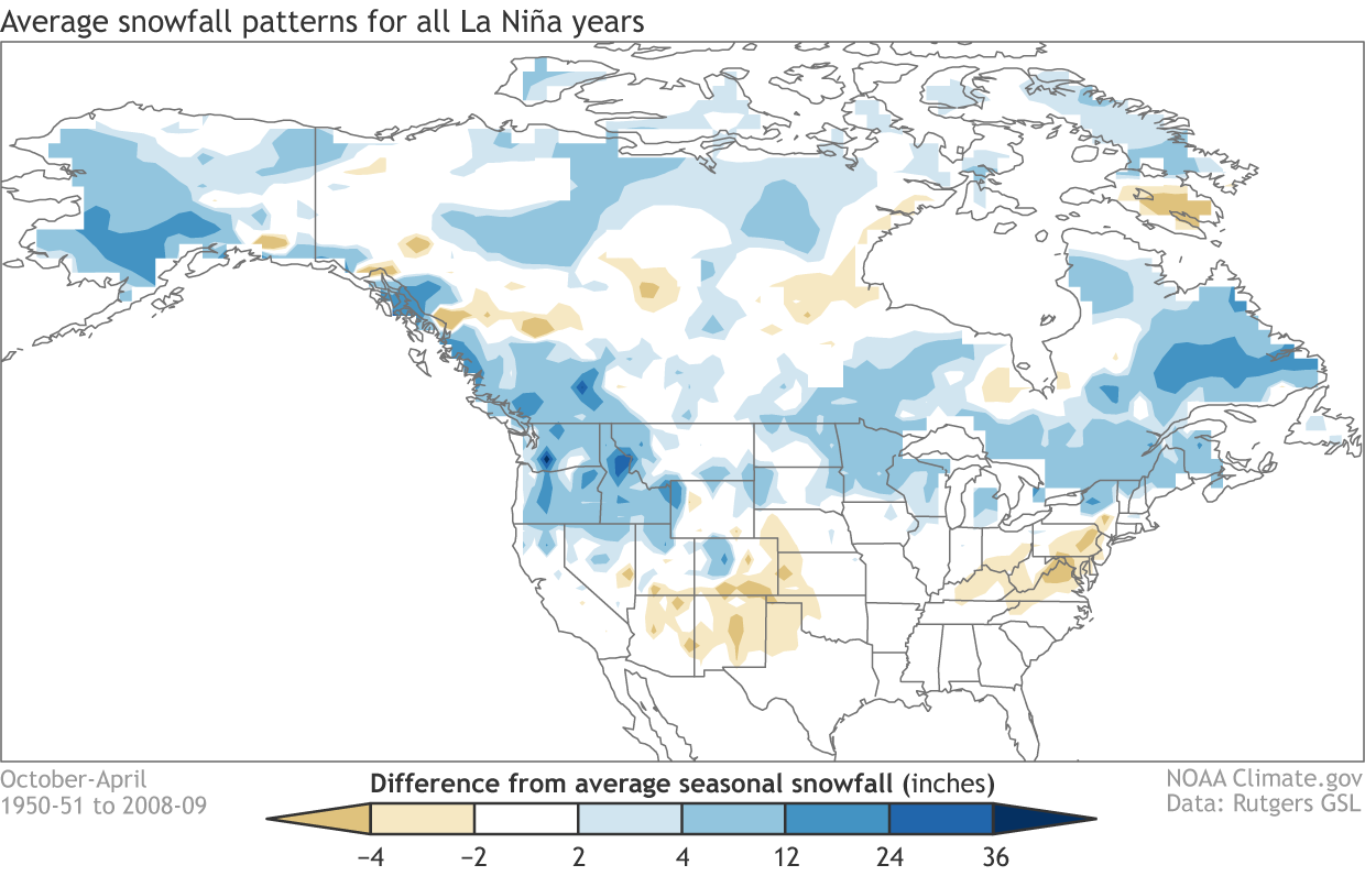
ANCIENT ORGANISMS, NEW THREAT

Among the oldest life forms, algae are simple aquatic plants that form key links in food chains. Some types of bacteria are also considered algae, including cyanobacteria, or “blue-green algae,” which is increasingly common across the U.S.

Scientists believe a combination of factors can trigger large blooms, including warm temperatures, slow water circulation and excessive nutrients, especially nitrogen and phosphorus. Among nutrient sources are runoff from farms and urban lawns as well as industrial wastes and sewage.

Some blooms generate toxins such as microcystin, which can cause nausea, fever and liver damage in humans and kill animals. A federal study detected microcystin in nearly 40 percent of lakes sampled around the nation, although mostly at below-harmful levels. Even when blooms aren’t toxic, they can turn waters ugly shades of green or other colors, stink like rotten vegetables, foul beaches and kill fish by sucking oxygen from the water as they decompose.

___

A WORLDWIDE PROBLEM

The U.S. isn’t alone.

Many countries are experiencing “disturbing trends of increasing bloom incidence” and growing economic losses, the National Oceanic and Atmospheric Administration says.

China’s largest blooms on record washed onto beaches in 2013 from the Yellow Sea, as bulldozers scraped up rotting mats by the ton. A bloom the size of Mexico spreads across the Arabian Sea twice a year.

In Australia, blue-green algae extended more than 1,000 miles (1,600 kilometers) on the Murray River in 2016.

A European Commission study says blooms in Greece, Italy and Spain cost the economy $355 million (300 million euros) annually.

University of Alberta researchers say microcystin has been detected in more than 240 Canadian water bodies. Lake Winnipeg algae blooms are so large that they’re visible from space.

___

IS CLIMATE CHANGE BEHIND THIS?

Many scientists believe global warming is making conditions more favorable for algae blooms, primarily by raising water temperatures and causing heavier rainstorms that wash more nutrients into waterways.

A study in the journal Science this year said nitrogen runoff into lakes, rivers and bays could increase 19 percent by the end of the century if greenhouse gas emissions keep rising.

Climate change research in the journal Environmental Science and Technology predicts the number of days U.S. reservoirs are infected with blue-green blooms could triple by 2050.

___

PLAYING CATCH-UP

Congress first enacted legislation to deal with harmful algae in 1998 and has updated it several times, with another version pending. Critics say it’s too little and too slow.

A White House report last year said progress had been made in forecasting blooms and issuing warnings. The Governmental Accountability Office said 12 agencies had spent $101 million on studies and monitoring between 2013 and 2015.

But only in 2014 was the law updated to make inland waters a priority; the focus previously had been on coastal areas and the Great Lakes. Even then, no funding was included for inland water study.

And the law sidesteps the nutrient runoff problem, with no limits and no enforcement provisions.

___

WHAT ABOUT GOVERNMENT CONSERVATION MEASURES?

The Associated Press obtained data from the U.S. Department of Agriculture about the costliest of several programs that help farmers avoid pollution.

The agency awarded $1.8 billion between 2009 and 2016 for use of 45 practices intended to prevent fertilizer runoff.

The five most heavily funded included upgrading irrigation systems; managing brush growth; planting “cover crops” in fall and winter that hold soil in place and absorb fertilizers; stabilizing erosion-prone areas used by livestock; and developing plans for applying fertilizer in ways that will minimize runoff. Another popular measure is planting grass or other vegetation between croplands and streams.

Farmers in Texas, Kansas, Oklahoma, Indiana and Nebraska were pledged the most funding between 2009 and 2016.

Farmers in Sussex County, Delaware, a top chicken-producing area, received $17 million over the seven years, the most of any U.S. county.

View of runoff, also called nonpoint source pollution, from a farm field in Iowa during a rain storm. Topsoil as well as farm fertilizers and other potential pollutants run off unprotected farm fields when heavy rains occur. (Credit: Lynn Betts/U.S. Department of Agriculture, Natural Resources Conservation Service/Wikimedia Commons)

From the Associated Press (John Flesher and Angeliki Kastanis) via The Colorado Springs Gazette:

Competing in a bass fishing tournament two years ago, Todd Steele cast his rod from his 21-foot motorboat — unaware that he was being poisoned.

A thick, green scum coated western Lake Erie. And Steele, a semipro angler, was sickened by it.

Driving home to Port Huron, Michigan, he felt lightheaded, nauseous. By the next morning he was too dizzy to stand, his overheated body covered with painful hives. Hospital tests blamed toxic algae, a rising threat to U.S. waters…

He recovered, but Lake Erie hasn’t. Nor have other waterways choked with algae that’s sickening people, killing animals and hammering the economy. The scourge is escalating from occasional nuisance to severe, widespread hazard, overwhelming government efforts to curb a leading cause: fertilizer runoff from farms.

Pungent, sometimes toxic blobs are fouling waterways from the Great Lakes to Chesapeake Bay, from the Snake River in Idaho to New York’s Finger Lakes and reservoirs in California’s Central Valley.

Last year, Florida’s governor declared a state of emergency and beaches were closed when algae blooms spread from Lake Okeechobee to nearby estuaries. More than 100 people fell ill after swimming in Utah’s largest freshwater lake. Pets and livestock have died after drinking algae-laced water, including 32 cattle on an Oregon ranch in July. Oxygen-starved “dead zones” caused by algae decay have increased 30-fold since 1960, causing massive fish kills. This summer’s zone in the Gulf of Mexico was the biggest on record.

Tourism and recreation have suffered. An international water skiing festival in Milwaukee was canceled in August; scores of swimming areas were closed nationwide.

Algae are essential to food chains, but these tiny plants and bacteria sometimes multiply out of control. Within the past decade, outbreaks have been reported in every state, a trend likely to accelerate as climate change boosts water temperatures.

“It’s a big, pervasive threat that we as a society are not doing nearly enough to solve,” said Don Scavia, a University of Michigan environmental scientist. “If we increase the amount of toxic algae in our drinking water supply, it’s going to put people’s health at risk. Even if it’s not toxic, people don’t want to go near it. They don’t want to fish in it or swim in it. That means loss of jobs and tax revenue.”

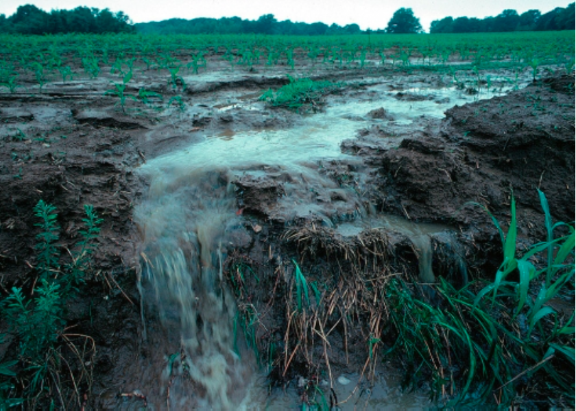
Many monster blooms are triggered by an overload of agricultural fertilizers in warm, calm waters, scientists say. Chemicals and manure intended to nourish crops are washing into lakes, streams and oceans, providing an endless buffet for algae.

Government agencies have spent billions of dollars and produced countless studies on the problem. But an Associated Press investigation found little to show for their efforts:

—Levels of algae-feeding nutrients such as nitrogen and phosphorus are climbing in many lakes and streams.

—A small minority of farms participate in federal programs that promote practices to reduce fertilizer runoff. When more farmers want to sign up, there often isn’t enough money.

—Despite years of research and testing, it’s debatable how well these measures work.

___

DEPENDING ON FARMERS TO VOLUNTEER

The AP’s findings underscore what many experts consider a fatal flaw in government policy: Instead of ordering agriculture to stem the flood of nutrients, regulators seek voluntary cooperation, an approach not afforded other big polluters.

Farmers are asked to take steps such as planting “cover crops” to reduce off-season erosion, or installing more efficient irrigation systems — often with taxpayers helping foot the bill.

The U.S. Natural Resources Conservation Service, part of the Department of Agriculture, says it has spent more than $29 billion on voluntary, incentive-based programs since 2009 to make some 500,000 operations more environmentally friendly.

Jimmy Bramblett, deputy chief for programs, told AP the efforts had produced “tremendous” results but acknowledged only about 6 percent of the nation’s roughly 2 million farms are enrolled at any time.

In response to a Freedom of Information Act request, the agency provided data about its biggest spending initiative, the Environmental Quality Incentives Program, or EQIP, which contracts with farmers to use pollution-prevention measures and pays up to 75 percent of their costs.

An AP analysis shows the agency paid out more than $1.8 billion between 2009 and 2016 to share costs for 45 practices designed to cut nutrient and sediment runoff or otherwise improve water quality.

A total of $2.5 billion was pledged during the period. Of that, $51 million was targeted for Indiana, Michigan and Ohio farmers in the watershed flowing into western Lake Erie, where fisherman Steele was sickened.

Yet some of the lake’s biggest algae blooms showed up during those seven years. The largest on record appeared in 2015, blanketing 300 square miles — the size of New York City. The previous year, an algae toxin described in military texts as being as lethal as a biological weapon forced a two-day tap water shutdown for more than 400,000 customers in Toledo. This summer, another bloom oozed across part of the lake and up a primary tributary, the Maumee River, to the city’s downtown for the first time in memory.

The type of phosphorus fueling the algae outbreak has doubled in western Lake Erie tributaries since EQIP started in the mid-1990s, according to research scientist Laura Johnson of Ohio’s Heidelberg University. Scientists estimate about 85 percent of the Maumee’s phosphorus comes from croplands and livestock operations.

NRCS reports, meanwhile, claim that conservation measures have prevented huge volumes of nutrient and sediment losses from farm fields.

Although the federal government and most states refuse to make such anti-pollution methods mandatory, many experts say limiting runoff is the only way to rein in rampaging algae. A U.S.-Canadian panel seeking a 40 percent cut in Lake Erie phosphorus runoff wants to make controlling nutrients a condition for receiving federally subsidized crop insurance.

“We’ve had decades of approaching this issue largely through a voluntary framework,” said Jon Devine, senior attorney for the Natural Resources Defense Council. “Clearly the existing system isn’t working.”

Farmers, though, say they can accomplish more by experimenting and learning from each other than following government dictates.

“There’s enough rules already,” said John Weiser, a third-generation dairyman with 5,000 cows in Brown County, Wisconsin, where nutrient overload causes algae and dead zones in Lake Michigan’s Green Bay. “Farmers are stewards of the land. We want to fix the problem as much as anybody else does.”

The Environmental Protection Agency says indirect runoff from agriculture and other sources, such as urban lawns, is now the biggest source of U.S. water pollution. But a loophole in the Clean Water Act of 1972 prevents the government from regulating runoff as it does pollution from sewage plants and factories that release waste directly into waterways. They are required to get permits requiring treatment and limiting discharges, and violators can be fined or imprisoned.

Those rules don’t apply to farm fertilizers that wash into streams and lakes when it rains. Congress has shown no inclination to change that.

Without economic consequences for allowing runoff, farmers have an incentive to use all the fertilizer needed to produce the highest yield, said Mark Clark, a University of Florida wetland ecologist. “There’s nothing that says, ‘For every excessive pound I put on, I’ll have to pay a fee.’ There’s no stick.”

Some states have rules, including fertilizer application standards intended to minimize runoff. Minnesota requires 50-foot vegetation buffers around public waterways. Farmers in Maryland must keep livestock from defecating in streams that feed the Chesapeake Bay, where agriculture causes about half the nutrient pollution of the nation’s biggest estuary.

But states mostly avoid challenging the powerful agriculture industry.

Wisconsin issues water quality permits for big livestock farms, where 2,500 cows can generate as much waste as a city of 400,000 residents. But its Department of Natural Resources was sued by a dairy group this summer after strengthening manure regulations.

The state’s former head of runoff management, Gordon Stevenson, is among those who doubt that the voluntary approach will be enough to make headway with the algae problem.

“Those best-management practices are a far cry from the treatment that a pulp and paper mill or a foundry or a cannery or a sewage plant has to do before they let the wastewater go,” he said. “It’s like the Stone Age versus the Space Age.”

___

QUESTIONABLE RESULTS

Do the anti-pollution measures subsidized by the government to the tune of billions of dollars actually work?

Agriculture Department studies of selected watersheds, based largely on farmer surveys and computer models, credit them with dramatic cutbacks in runoff. One found nitrogen flows from croplands in the Mississippi River watershed to the Gulf of Mexico would be 28 percent higher without those steps being taken.

Critics contend such reports are based mostly on speculation, rather than on actually testing the water flowing off fields.

Although there is not a nationwide evaluation, Bramblett said “edge of field” monitoring the government started funding in 2013 points to the success of the incentives program in certain regions.

Federal audits and scientific reports raise other problems: Decisions about which farms get funding are based too little on what’s best for the environment; there aren’t enough inspections to ensure the measures taken are done properly; farm privacy laws make it hard for regulators to verify results.

It’s widely agreed that such pollution controls can make at least some difference. But experts say lots more participation is needed.

“The practices are completely overwhelmed,” said Stephen Carpenter, a University of Wisconsin lake ecologist. “Relying on them to solve the nation’s algae bloom problem is like using Band-Aids on hemorrhages.”

The AP found that the incentives program pledged $394 million between 2009 and 2016 for irrigation systems intended to reduce runoff — more than on any other water protection effort.

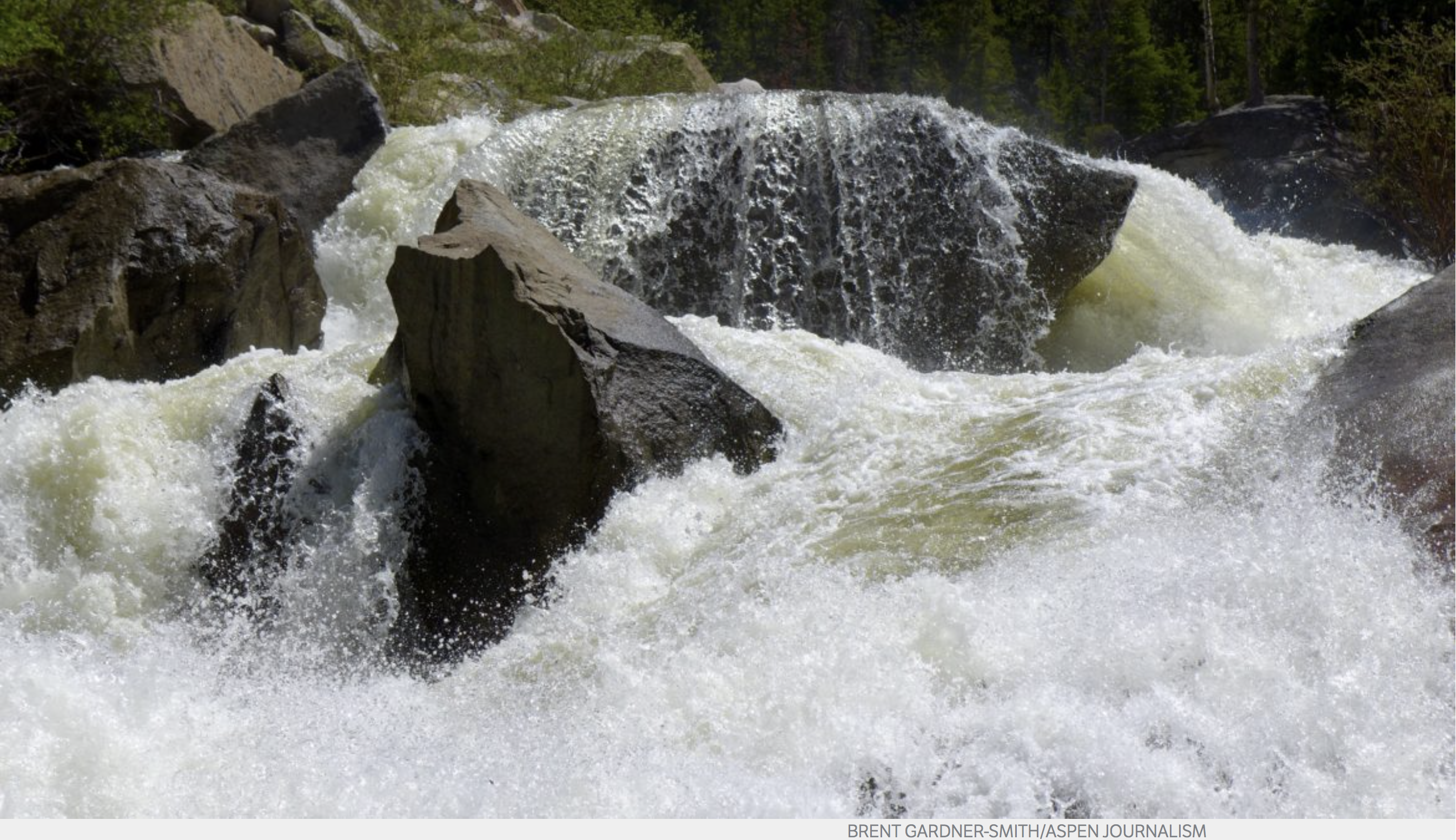
In arid western Idaho, where phosphorus runoff is linked to algae blooms and fish kills in the lower Snake River, government funding is helping farmer Mike Goodson install equipment to convert to “drip irrigation” rather than flooding all of his 550 acres with water diverted from rivers and creeks.

But only 795 water protection contracts were signed by Idaho farmers between 2014 and 2016, accounting for just over 1 percent of the roughly 11.7 million farmland acres statewide. Even if many farmers are preventing runoff without government subsidies, as Bramblett contends, the numbers suggest there’s a long way to go.

Goodson says forcing others to follow his example would backfire.

“Farmers have a bad taste for regulatory agencies,” he said, gazing across the flat, wind-swept landscape. “We pride ourselves on living off the land, and we try to preserve and conserve our resources.”

But allowing farmers to decide whether to participate can be costly to others. The city of Boise completed a $20 million project last year that will remove phosphorus flowing off irrigated farmland before it reaches the Snake River.

Brent Peterson spends long days in a mud-spattered pickup truck, promoting runoff prevention in eastern Wisconsin’s Lower Fox River watershed, where dairy cows excrete millions of gallons of manure daily — much of it sprayed onto cornfields as fertilizer.

The river empties into algae-plagued Green Bay, which contains less than 2 percent of Lake Michigan’s water but receives one-third of the entire lake’s nutrient flow. Farmers in the watershed were pledged $10 million from 2009 to 2016 to help address the problem, the AP found.

Peterson, employed by two counties with many hundreds of farms, has lined up six “demonstration farms” to use EQIP-funded runoff prevention, especially cover crops.

“This is a big step for a lot of these guys,” he said. “It’s out of their comfort zone.”

And for all the money devoted to EQIP, only 23 percent of eligible applications for grants were funded in 2015, according to the National Sustainable Agriculture Coalition.

Funding of the incentives program has risen from just over $1 billion in 2009 to $1.45 billion last year. The Trump administration’s 2018 budget proposes a slight cut.

“It sounds like a lot, but the amount of money we’re spending is woefully inadequate,” said Johnson of Heidelberg University.

___

ALGAE PLAGUE SPREADS

While there’s no comprehensive tally of algae outbreaks, many experts agree they’re “quickly becoming a global epidemic,” said Anna Michalak, an ecologist at the Carnegie Institution for Science at Stanford University.

A rising number of water bodies across the U.S. have excessive levels of nutrients and blue-green algae, according to a 2016 report by the Environmental Protection Agency and U.S. Geological Survey. The algae-generated toxin that sickened Steele in Lake Erie was found in one-third of the 1,161 lakes and reservoirs the agencies studied.

California last year reported toxic blooms in more than 40 lakes and waterways, the most in state history. New York created a team of specialists to confront the mounting problem in the Finger Lakes, a tourist magnet cherished for sparkling waters amid lush hillsides dotted with vineyards. Two cities reported algal toxins in their drinking water in 2016, a first in New York.

More than half the lakes were smeared with garish green blooms this summer.

“The headlines were basically saying, ‘Don’t go into the water, don’t touch the water,'” said Andy Zepp, executive director of the Finger Lakes Land Trust, who lives near Cayauga Lake in Ithaca. “I have an 11-year-old daughter, and I’m wondering, do I want to take her out on the lake?”

The U.S. Centers for Disease Control and Prevention is developing a system for compiling data on algae-related illnesses. A 2009-10 study tallied at least 61 victims in three states, a total the authors acknowledged was likely understated.

Anecdotal reports abound — a young boy hospitalized after swimming in a lake near Alexandria, Minnesota; a woman sickened while jet-skiing on Grand Lake St. Marys in western Ohio.

Signs posted at boat launches in the Hells Canyon area along the Idaho-Oregon line are typical of those at many recreation areas nationwide: “DANGER: DO NOT GO IN OR NEAR WATER” if there’s algae.

In Florida, artesian springs beloved by underwater divers are tainted by algae that causes a skin rash called “swimmer’s itch.” Elsewhere, domestic and wild animals are dying after ingesting algae-tainted water.

A year ago, shortly after a frolic in Idaho’s Snake River, Briedi Gillespie’s 11-year-old Chesapeake Bay retriever stopped breathing. Her respiratory muscles were paralyzed, her gums dark blue from lack of air.

Gillespie, a professor of veterinary medicine, and her veterinarian husband performed mouth-to-nose resuscitation and chest massage while racing their beloved Rose to a clinic. They spent eight hours pumping oxygen into her lungs and steroids into her veins. She pulled through.

The next day, Gillespie spotted Rose’s paw prints in a purplish, slimy patch on the riverbank and took samples from nearby water. They were laced with algae toxins.

“It was pretty horrendous,” Gillespie said. “This is my baby girl. How thankful I am that we could recognize what was going on and had the facilities we did, or she’d be gone.”

#Texas v. #NewMexico and #Colorado lawsuit update

Elephant Butte Reservoir back in the day nearly full

From the Associated Press (Susan Montoya Bryan) via The Torrington Register-Citizen:

Farmers in southern New Mexico, water policy experts, lawyers and others are all working behind the scenes to craft possible solutions that could help to end a lengthy battle with Texas over management of the Rio Grande.

The case is pending before the U.S. Supreme Court and all sides say the stakes are high given uncertainty about the future sustainability of water supplies throughout the Rio Grande Valley.

The New Mexico Attorney General’s Office, Las Cruces city officials and agricultural interests provided state lawmakers with an update Tuesday.
Lawyers involved in the case say the court could schedule arguments early next year, but New Mexico is still open to settlement talks. Separately, the farmers, municipalities and commercial users that would be affected by a ruling have been meeting regularly to build a framework for a possible settlement.

Details of what that might look like are under wraps because of a court-issued confidentiality order.

Samantha Barncastle, an attorney representing the irrigation district that serves farmers from Elephant Butte south to the U.S.-Mexico border, said there’s no question groundwater will continue to be relied upon into the future to protect everyone’s access.

She said the parties are looking at managing the aquifer in ways New Mexico has never seen before. That could include more flexibility and policies aimed at avoiding the permanent fallowing of farmland…

Texas took its case to the Supreme Court in 2013, asking that New Mexico stop pumping groundwater along the border so that more of the river could flow south to farmers and residents in El Paso.

In dry years when there’s not enough water in the river, chile and onion farmers and pecan growers in southern New Mexico are forced to rely on wells to keep their crops and trees alive. Critics contend the well-pumping depletes the aquifer that would otherwise drain back into the river and flow to Texas.

New Mexico has argued in court documents that it’s meeting delivery obligations to Texas.

The Rio Grande is one of North America’s longest rivers, stretching from southern Colorado to Mexico and irrigating more than 3,100 square miles (8,000 square kilometers) of farmland along the way. Several major cities also rely on the river’s water supply.

Depending on the outcome of the case, New Mexico could be forced to pay millions of dollars in damages. The New Mexico attorney general’s office plans to ask the Legislature for $1.5 million to handle the Rio Grande litigation for the next year.

Tania Maestas with the attorney general’s office said the willingness of New Mexico water users to work together could lead to a “dream settlement.”

State gives Aspen officials until Dec. 29 to answer dam questions

The location of the potential Maroon Creek Reservoir, just below the confluence of East and West Maroon creeks, where a beaver dam now backs up water. The Maroon Bells are well within view from the dam site.

By Brent Gardner-Smith, Aspen Journalism

The city of Aspen now has until Dec. 29 to provide a “substantive” response to central questions raised by state officials in water court regarding the city’s efforts to develop dams and reservoirs on upper Maroon and Castle creeks.

The questions raised by the state include whether the city can get a permit for the dams, if it can build the dams in reasonable time, if it has a specific plan to build them, and if it needs the water the reservoirs would hold.

After a status conference on Nov. 9 in water court in Glenwood Springs regarding two due diligence applications the city filed in December 2016 for the two potential dam-and-reservoir projects, a water court referee said, for the second time since August, that the city must provide a substantive response to key issues raised by the state.

Susan Ryan, the referee in Division 5 water court, said the city must do so whether or not it is able to reach settlement agreements with the 10 opposing parties in the two cases.

“It is going to require a written response to that summary of consultation regardless of whether or not settlement is reached with all the opposers in the case,” Ryan said during the status conference. “And so I just wanted to clarify that that is what I typically require in every water case and that is what I will require here.”

A summary of consultation in water court can be a routine review of a water rights application by two state officials, the division engineer, who administers water rights, and the water court referee, who functions as an administrative judge and seeks to resolve cases, if possible, before they are sent to a water court judge.

But the twin summaries of consultation released on Jan. 23 concerning the city’s diligence applications for the Castle and Maroon creek reservoirs raised threshold questions.

They said the city “must demonstrate that it will secure permits and land-use approvals that are necessary to apply the subject water rights to beneficial use” and the city must show it “will complete the appropriations within a reasonable time.”

They also said “a specific plan is in place to develop the subject water rights,” that the city “must demonstrate substantiated population growth in order to justify the continued need for these water rights” and that the city is “not speculating with the subject water rights.”

Maroon Creek Reservoir would hold 4,567 acre-feet of water behind a 155-foot-tall dam and encroach on portions of the Maroon Bells-Snowmass Wilderness. Castle Creek Reservoir, as currently decreed, would hold 9,062 acre-feet of water behind a 170-foot-tall dam, and would also flood some land in the wilderness boundary.

In two diligence applications filed on Oct. 31, 2016, the city told the court it has “steadily applied effort to complete the appropriation” of the conditional water rights for both of the reservoirs over the past six years, and that it has done so “in a reasonably expedient and efficient manner under all the facts and circumstances.”

In July, the city said it was seeking a way to transfer decreed storage rights to locations other than the decreed locations on Castle Creek and Maroon Creek.

On Nov. 7, city of Aspen voters rejected a ballot question that would have given the city the go-ahead to issue $5.5 million in general obligation bonds to purchase a 60-acre parcel in Woody Creek to use for water storage, in conjunction with the gravel pit operated by Elam Construction.

But city officials, before the vote, had stated they intended to buy the Woody Creek parcel whether the ballot question was approved or not. A recent study for the city found that between 1,000 acre-feet and 8,000 acre-feet of water could be stored using varying combinations of the land the city intends to buy and the gravel pit.

Also in July, the city filed brief responses to the summaries of consultation. But in August the water court referee said the city’s effort fell short.

A wetland that would be flooded under the potential Castle Creek Reservoir. The reservoir would stand across the main channel of Castle Creek, about two miles below Ashcroft.

City not eager to file response

During the Nov. 9 status conference, the city’s water attorney, Cynthia Covell of Alperstein and Covell, told Ryan the city would still prefer not to lay out its case in a substantive response at this stage of the proceedings.

“Since the last status conference the city has been working to finalize the reports that it has needed to assist in the settlement process, including its supply-and- demand risk assessment study, and its evaluation of one or more alternative storage sites that are not located in federal wilderness areas or on Castle Creek or Maroon Creek,” Covell said.

Covell said the city has only this week received responses from all 10 of the opposing parties to a Sept. 20 settlement proposal from the city, and that the City Council was scheduled meet in executive session Monday to discuss the responses.

“So at this point, Aspen would like to devote its time and resources to seeing if we can reach a settlement by the end of the year, we hope in both cases,” Covell said.

Attorneys in the cases said in August the main sticking point in the settlement negotiations was that the city wanted to keep open its options regarding transferring rights tied to the potential Castle Creek reservoir, while opposing parties want the rights for the potential reservoirs fully removed from both valleys.

During the status conference, after determining it was still the city’s position that it would prefer not to provide substantive answers at this time, Ryan asked the opposing attorneys what they thought.

“I frankly don’t buy the argument that it’s a hiccup or roadblock in terms of settlement,” attorney Paul Noto said. “I actually feel that it may lay some cards on the table that may in fact help settlement.”

Noto is representing American Rivers, Colorado Trout Unlimited, and the Roaring Fork Land and Cattle Co. in the Maroon Creek case, and the two environmental groups in the Castle Creek case.

Also opposing the city in the cases are Western Resource Advocates, Wilderness Workshop, Pitkin County, USFS, Larsen Family Limited Partnership in the Maroon Creek case, and Double R Creek Ltd. and Asp Properties LLC in the Castle Creek case.

Editor’s note: Aspen Journalism is collaborating with The Aspen Times on coverage of water and rivers. The Times published this story online on Wednesday, Nov. 15, 2017.

New report urges global action on mining pollution — UN Environment

Here’s the release from UN Environment:

Mining Tailings Storage: Safety is no accident, was prompted by tailings dams disasters and rising global concerns about the safety, management and impacts of storing and managing large volumes of mine tailings.

The increasing number and size of tailings dams around the globe magnifies the potential environmental, social and economic cost of catastrophic failure impact and the risks and costs of perpetual management. These risks present a challenge for this generation, and if not addressed now, a debt we will leave to future generations.

From the Associated Press (Matthew Brown) via The Denver Post:

The UN Environment Program report tallied 40 significant mine waste accidents in the past decade. Most involved dams or other storage areas that failed, releasing torrents of polluted water.

Among the accidents highlighted by the agency were a 2015 dam collapse at a Brazilian iron-ore mine that killed 19 people and the Gold King Mine disaster in the U.S. that spilled pollution into rivers in three Western states.

Although the rate of such accidents has been falling, the report warned that the consequences have grown more serious as waste impoundments get larger. The iron-ore mine accident in Samarco, Brazil, for example, released some 40 million cubic meters (52 million cubic yards) of waste that polluted hundreds of miles of rivers and streams.

The UNEP recommended governments and mining companies adopt a “zero-failure” goal for mining impoundments known as tailings dams and impose stronger regulations.

There are an estimated 30,000 industrial mines worldwide and hundreds of thousands of abandoned mines that continue spewing pollution for decades after they’ve closed.

Advocacy groups said in response to this week’s UNEP report that 341 people have been killed by mine waste accidents since 2008.

Waste storage sites are “like ticking time bombs,” said Payal Sampat with the U.S.-based group Earthworks, adding that governments and the mining industry have done too little to prevent accidents.

A “get well soon” balloon floats in the contaminated waters of the Animas River flowing through Durango on Monday afternoon August 10, 2015 — photo The Durango Herald, Shane Benjamin

Roaring Fork Valley Youth Water Summit recap

The Roaring Fork River coursing down the Cascades, near the Grottos, on Independence Pass east of Aspen. The phoro was taken mid-day on June 15, 2017, the day after the Twin Lakes Independence Pass Tunnel that delivers water to the east slope was closed. Credit Aspen Journalism — Brent Gardner-Smith.

From Aspen Public Radio (Elizabeth Stewart-Severy):

Last month, students from across the Roaring Fork Valley gathered to discuss water. At the first-ever Youth Water Summit, teenagers presented their own white papers on everything from water rights to environmental activism…

Pitkin County’s Healthy Rivers and Streams Board sponsored the event, and hired Sarah Johnson of Wild Rose Education to organize it.

“We want these kids to have a stronger water ethic, and a stronger sense of water literacy and river literacy, you might say,” Johnson explained.

Students from local middle and high schools studied issues related to water management across the west at the summit. They learned from water experts and posed their own big questions: What are the effects of the Colorado River running dry? How are art, literature and film used for water activism?

“Watershed issues are not science issues by themselves, they’re very interdisciplinary, whole picture, watershed-wide problems – or opportunities,” Johnson said.

The kids spent months researching the context and the consequences of their chosen topics and presented their findings to classmates. This runs the gamut, as students explore the scarcity of fresh water, the ways graffiti have represented public opinion on dams and how much water is used for agriculture in the arid west…

Tasker said part of the goal is to encourage students to acknowledge the roles they play in the complex world of water management. For example, the Colorado Rocky Mountain School owns a water right on the Crystal River.

“They actually irrigate some fields on their property, and so they are part of the diversion system,” Tasker explained.

The event allowed kids to consider current issues in their own backyards and the bigger picture of water policy across the west. Tasker was particularly impressed with a presentation on the 1922 Colorado River Compact, which governs water rights in seven seven states across the west.

Sterling: Northeast Livestock Symposium recap

North Sterling Reservoir

From The Sterling Journal-Advocate (Jeff Rice):

Increased water conservation along Colorado’s Front Range doesn’t translate into increased water supplies in the farmlands along the South Platte River.

That was part of the message Jim Yahn had for the Northeast Livestock Symposium in Sterling Tuesday. Yahn, who is manager of the North Sterling and Prewitt reservoirs and who represents the South Platte Basin on the Colorado Water Conservation Board, briefed the three dozen people attending the symposium on the Colorado Water Plan of 2015 and how that plan is being put into effect.

Yahn repeated the assertion that, by 2030, the need for water in Colorado will exceed supplies by 560,000 acre feet, or 182 billion gallons per year, and most of that is here in the South Platte River Basin.

The Colorado Water Plan is the road map to closing that gap…

Yahn said the plan is important because developers along the Front Range, where the building and population booms continue unabated, have no plan to provide water for the growth other than to heavily promote water conservation. The Colorado Water Plan calls for conservation measures to save 400,000 acre feet of water per year by 2030. While conservation is important, Yahn said, it’s not nearly enough to close the gap between supplies and demand.

“When cities start conserving (water) less water comes downstream, and we rely on those return flows to irrigate,” he said. “So the 400,000 acre feet of conservation does not apply directly to the gap. It’s not a one-to-one return, one for one, so if municipality has xeriscaping, we don’t see that runoff down here for agricultural use.”

That’s why increasing storage is vital to closing the water gap by 2030, Yahn said. He told the symposium that $21 million in water supply reserve funds already has been approved to find new storage and more than $65.6 million in loans has approved since the governor’s receipt of the Colorado water plan two years ago.

Yahn also pointed to what are called “alternative methods of transfer” to temporarily move water from agricultural uses to non-ag uses when the water isn’t needed for irrigation. He said there are seven known ATMs in Colorado; two in the Arkansas River Basin, four in the South Platte basin and one in the Colorado River basin.

Two of the four in the South Platte basin are with the North Sterling Irrigation Co., which Yahn manages; one is for 3,000 acre feet with Xcel Energy for its Pawnee Generation Plant at brush, and one for 6,000 acre feet with BNN Energy for hydraulic fracturing of oil and gas wells in Weld County.

Yahn pointed out that ATMs aren’t a panacea to closing the water gap, but are better than permanent sale of irrigated crop land to obtain water rights.

#ColoradoSprings in a scramble to get finance systems in place to collect #stormwater fees

Channel erosion Colorado Springs July 2012 via The Pueblo Chieftain

From The Colorado Springs Independent (Pam Zubeck):

…the Colorado Springs Utilities Board, composed of City Council, must approve placing the monthly $5-per-household fee on residential utility bills, for which the city would pay the agency a one-time fee of $1.8 million and $200,000 a year, the Gazette reported.

Approval of Utilities handling collections is expected, and Strand says it appears that customers who don’t pay the stormwater fee would risk losing all utility services.

“We’re discussing this with Utilities [staff],” Strand says. “If someone doesn’t pay their bill, what’s likely to happen is their utilities will be turned off.”

Fees of $30 per acre for non-residential developed parcels will be billed by the city, which must set up the mechanics to do that. Undeveloped properties will be assessed by the stormwater manager based on impervious surface. (Suthers has said the city will pay an annual bill of about $100,000 for its property, including park land.) Those, too, will be billed by the city.

Strand says the consequence for nonpayment of non-residential billings is “likely” a lien placed on the property, which would require cooperation from El Paso County, the keeper of deed records. “The county commissioners I’ve talked to say they will cooperate,” he says.

In 2011, when the city wanted to collect $765,000 still owed for stormwater fees implemented in 2007 but halted in 2009, county officials refused to add the fees to property tax bills or deeds. Those fees, however, were not approved by voters.

Another complication is which properties, if any, will be deemed exempt from the stormwater fee. The measure approved on Nov. 7 entitles the city to bill nonprofits and churches, but what about federal agencies, such as post offices?

Federal agencies didn’t pay the city’s stormwater fees imposed in 2007, citing sovereign immunity and claiming the fees were a tax and, thus, unconstitutional. But, thanks to a bill signed into law by President Obama on Jan. 4, 2011, which amended the Clean Water Act, the federal government will pay its fair share of local stormwater management services, according to the Association of State Floodplain Managers.

Whether that bill applies to military installations is unclear. However, the association wrote in a newsletter that the law was envisioned as a way to resolve billing disputes with various federal agencies, including in Aurora where the city had billed Buckley Air Force Base $143,445 in outstanding stormwater fees as of May 2010.

Although Strand initially said he thought Peterson Air Force Base, which overlaps into the city limits, could be exempted, when told of the 2011 amendment to the Clean Water Act, he was eager to learn more about it.

“They use our resources, and we respond to help them with fire protection, although they have their own fire service,” he says. “I think they ought to be accountable under this current situation [ballot measure] we passed on Tuesday [Nov. 7].”

NRCS Accepting Applications to Assist Farms and Ranches with Natural Resource Concerns

Beef cattle on a feedlot in the Texas Panhandle. Photo credit: Wikimedia

From The North Forty News (Theresa Rose):

The Natural Resources Conservation Service (NRCS) in Colorado is currently accepting applications for enrollment into the Environmental Quality Incentives Program (EQIP). EQIP is a voluntary Farm Bill program that provides financial assistance for conservation systems such as animal waste management facilities, irrigation system efficiency improvements, fencing, water supply development, riparian protection, and wildlife habitat enhancement. Producers interested in implementing conservation practices to improve natural resources on their private agricultural land have until Friday, December 15, 2017 to submit applications.

The opportunities to participate in EQIP are diverse. In addition to the general EQIP enrollment, the Program also affords Veterans, socially disadvantaged, beginning, and limited resource farmers and ranchers specific opportunities to improve or enhance natural resources on their lands. There are even specific opportunities for landowners with interests in improving forest and soil health as well as those wanting to enhance sage grouse, southwestern willow flycatcher, and lesser prairie chicken habitat.

Applications are accepted at all Colorado NRCS offices which are located in USDA Service Centers. To find out more information about EQIP or to locate a local NRCS office near you, please visit http://www.co.nrcs.usda.gov and select the Contact Us or Programs links.

When visiting with NRCS staff about the EQIP program, landowners are encouraged to inquire about NRCS’ comprehensive conservation plans. The Agency continually strives to put conservation planning at the forefront of its programs and initiatives. Conservation plans provide landowners with a comprehensive inventory and assessment of their resources, as well as an appropriate start to improving the quality of soil, water, air, plants, and wildlife on their land.

Merino gets closer to deploying new R.O. plant

Ashcraft & Brown Building, Merino, Colorado, as it appeared on a 1909 postcard. Image courtesy of Ken Wilson.

From The Sterling Journal Advocate (Jeff Rice):

Merino Town board approved change orders for the town’s nearly-finished water purification and delivery system Monday night during a short, emergency-delayed meeting.

Boyd Hanzon of Rocky Mountain Water Solutions, primary contractor on the new water system, told the board the system could be up and running in a few weeks if the appropriate branch of the Colorado Department of Public Health and Environment signs off on at least one of the system’s three settling ponds. The ponds are necessary for disposal of the impurities filtered out of the water.

Two of the ponds were found to have leaks during testing, Hanzon said, but the third pond is satisfactory. The system can run with only one pond, he said, so J.B. Wright & Associates, the on-site supervising company, has submitted a conditional certification report to the state.

“The (reverse osmosis) system is set up and ready to go, but we need a place to put the waste,” Hanzon said. “I hope to hear back (from CDPHE) sometime this week, and once we get the go-ahead on that one pond, we can start using the system.”

Hanzon said once the two damaged ponds are repaired, all three will be re-certified, but for now the system can run with just one pond.

There was just one catch, however. Hanzon said three small change orders need to be implemented in order to fully automate the system and make it accessible via remote control. The system can be accessed by certified users using internet connections, which means the system can be controlled by people in Merino and at the headquarters of the company that built the RO system. The remote control and automation means Merino doesn’t need a staff on-site to run the system.

The four attending trustees approved the change order in a 4-0 roll call vote.

Fort Lupton: #Colorado GOP gubernatorial candidates hit the trail

Colorado Capitol building

From 9News.com (Anusha Roy):

When it comes to education, several candidates supported more vocational training.

Two candidates, Doug Robinson and Greg Lopez, said a four-year college may not be the right choice for everyone.

And candidate Tom Tancredo, who’s run twice for governor before, said any student who graduates from a public high school should also be able to pass a citizenship test.

The candidates also supported the oil and gas industry. However Steve Barlock, who worked on President Trump’s campaign, qualified his support saying the industry shouldn’t’t impact Colorado’s water.

Several candidates also mentioned transportation and the need for road improvements and called for more transparency with budgets.

From The Denver Post (John Aguilar):

Several candidates on Monday called for additional water storage in the state to help Colorado capture more of it and allow less of it to flow out of state. They said several large-scale reservoir projects need to move forward.

New Antarctic heat map reveals sub-ice hotspots — British Antarctic Survey #ActOnClimate #KeepItInTheGround

The most high resolution map of the geothermal heat beneath the Antarctic Ice Sheet. Credit: The British Antarctic Survey

Here’s the release from the British Antarctic Survey (Athena Dinar):

The data used come from magnetic measurements mainly collected by aircraft flying over the continent and the results reveal the ‘hot spots’ under West Antarctica and on the Antarctic Peninsula, the most rapidly changing areas of the Antarctic Ice Sheet.

Lead author, geophysicist Dr Yasmina Martos who completed the work at BAS says:
“This new map of heat escaping from inside the Earth will help advance our understanding of the conditions at the base of the ice sheet, improving our ability to understand the past and to project future changes of the Antarctic Ice Sheet and its impact on global sea level”.

Co-author BAS geophysicist Dr Tom Jordan says:
“It is incredibly difficult to take direct measurements of heat from the Earth’s interior beneath 3-4 km of ice in extremely cold and hostile conditions. That’s why we have used magnetic data to infer the heat and we’re pleased that what we have is 30-50% more accurate than previous studies.”

The Antarctic Ice Sheet contains the largest reservoirs of fresh water on our planet – around 70% of the world’s fresh water – and is currently losing ice, which contributes to rising sea levels.

The BAS twin otter aircraft features geophysical survey equipment which collected some of the magnetic observations in Antarctica

BAS Science Director and glaciologist Professor David Vaughan says:
“If we are to predict with any certainty the future response of Antarctica in a warming world, scientists need to understand the role that heat from the Earth plays. What we know is that over time, the heat flow into the ice is quite constant and so the ice sheet adjusts to it. The ice loss we’ve seen in recent decades is actually the result of changes in air and ocean temperatures. How the ice sheet will respond to these recent changes is influenced by the pattern of geothermal heat, and that’s why this new map is so important”.

#Snowpack news: Better up North, thin down South.

Click on a thumbnail graphic to view a gallery of snowpack data from the NRCS.

And here’s the Westwide SNOTEL basin-filled map from the NRCS.

Westwide SNOTEL basin-filled map November 13, 2017 via the NRCS.

Brush councillors receive update on stormwater improvements

From The Fort Morgan Times (Paul Albani-Burgio):

Storm water flooding has been a long-standing problem in Brush, but City Manager Monty Torres recently told the city council that the city has made significant strides towards addressing that problem in recent years.

During a presentation made to the council at its most recent meeting, Torres explained that the city is nearly finished with a five-phase downtown storm water improvement project. During that project, large inlets were installed on the downtown blocks, along with a 60-inch drainage pipe that is double the size of the old pipe.

Torres said each of those phases cost $1 million-plus. Grants from the Colorado Department of Local Affairs and the Colorado Department of Transportation covered the majority of those costs, according to the city manager…

Torres said the city has also made improvements to its storm inlets, which are designed to take in water during storms. Most of those improvements took the form of open-throated gates, which Torres said are designed to continue to take in storm water even if leaves and other debris build up around the grate’s opening. Torres said the previous grates the city had in place would often get clogged with newspapers, leaves and other debris during storms.

Torres said that some new inlets have been installed at strategic points throughout the city in order to prevent flooding during the majority of the city’s storms. He said the inlets would quickly take care of the water produced by 90 percent of the city’s storms. Torres said that there would be another 5 percent of storms where the water would sit in the street for only a short time before being drained away.

That left the most severe 5 percent of storms, which Torres said would still likely lead to flooding…

The city manager said Brush also has more flooding projects on the horizon, including one intended to reduce flooding on Williams Street and another that would reduce flooding at the city’s golf course, which would also help to reduce flooding on Cambridge Street near the course. However, Torres said the latter project would be contingent on the city receiving additional funds to go through with paving the course’s parking lot from the J/N Foundation, its partner on that project.

Torres said the city will also continue to look at adding additional inlets throughout Brush. However, he cautioned that the city does not have the funds to put in an inlet “whenever someone finds puddle of water.” Rather, those inlets will continue to be installed in strategic locations to help reduce flooding throughout the city.

Trustees reject consultant recommendation about Meeker Water Supply Improvements Project

Yampa/White/Green/North Platte river basins via the Colorado Geological Survey

From The Rio Blanco Herald-Times (Niki Turner):

In an unprecedented move, the board voted against the bid award recommendations for the Meeker Water Supply Improvements Project from contracted civil engineer Olsson Associates. Olsson recommended awarding RNA Enterprises of Glenwood Springs for $340,948 and Ridge Electric of Grand Junction for $150,603 as the lowest bidders. Several trustees expressed concerns over the recommendation, as there was more than $100,000 difference between the low bid and the next highest bid, and the bid was not itemized.

Wyatt Popp of Olsson cautioned the board that the Department of Local Affairs (DOLA) grant funding received from the town would be at risk if the board chose to go with a higher bid. State statutes for DOLA funds require awarding the lowest bid as long as the bidders are responsive and qualified.

“Deviating from the process at this point in time is not recommended,” Popp said. Refusing to accept the recommendation risks losing approximately $300,000 in DOLA grant funds…

Town Attorney Melody Massih asked if there is a way to re-bid the project. Popp said that would require additional discussion with DOLA.

@AmericanRivers: Don’t let energy companies weaken clean water protections at hydropower dams

The generator building of Glen Canyon hydro power plant in Arizona via Wikimedia.

From American Rivers:

The hydropower industry is pushing a flurry of legislation that would create massive environmental exemptions for hydropower dam operations, taking us back to a time when dam owners could destroy rivers without concern.

If passed, the voices of local communities and people like you would be silenced when it comes to dam operations. We could see more dead fish, more dried up rivers, and degraded water quality on rivers and streams nationwide.

Under the guise of “modernizing” hydropower, these bills actually take hydropower dam operations back decades. They create giant loopholes for hydropower dam operators, so they can avoid requirements to protect fish, wildlife, or water quality. This is about whether states, tribes and citizens will continue to have a say in how dams are operated. It’s about the future of rivers nationwide.

This legislation could result in many more dried up rivers, dead fish and wildlife, and destroyed recreational opportunities. Tell Congress to oppose this power grab by the energy companies.

Click here to take action.

@NOAAClimate: U.S. had 3rd warmest and 2nd wettest year to date

Here’s the release from NOAA (Brady Phillips):

October typically ushers in those crisp, sunny days of fall. But last month was no ordinary October, as warm and wet conditions dampened peak leaf viewing across many parts of the Midwest and New England and fires devastated parts of Northern California and the West.


Here’s how things shook out in terms of the climate record:

Climate by the numbers
October 2017

October’s nationally averaged temperature was 55.7 degrees F, 1.6 degrees above average, which placed it among the warmest third of the historical record. Record warmth spanned New England with much-above-average temperatures stretching into the Great Lakes and Mid-Atlantic. Below-average temperatures were observed in the Northwest and Northern Rockies. The precipitation total for the month was 2.53 inches, 0.37 of an inch above average.

The year to date
The year to date (January–October 2017) average temperature for the contiguous U.S. was the third warmest on record at 57.5 degrees F, 2.5 degrees above average,. Every state across the contiguous U.S. had an above-average temperature for the first 10 months of the year. The year-to-date precipitation was the second wettest on record for this period at 28.93 inches, 3.57 inches above average.


More notable climate events include:

Hurricane Nate made double Gulf Coast landfall: On October 7, Nate made landfall near the mouth of the Mississippi River in Louisiana and a second landfall near Biloxi, Mississippi, as a Category 1 hurricane. Nate brought heavy rains to the central Gulf Coast and Southern Appalachians.

Tropical Storm Philippe saturated Florida and the East Coast: On October 29, Philippe made landfall near the Everglades National Park in Florida with sustained winds of 45 mph. The remnants of Philippe interacted with a storm off the East Coast and brought heavy rain, hurricane-force winds and battering waves to the Northeast.

Northern California endured catastrophic wildfires: A hot and windy weather pattern during the second week of October caused several wildfires to grow out of control very quickly in N. California. More than 40 people died, and thousands of homes and business were destroyed — it was the deadliest week in California wildfire history, according to state officials.

Drought eased in the North and expanded in the South: Drought spread in parts of the South while beneficial rains helped alleviate drought in northern areas of the U.S . As of October 31, the contiguous U.S. drought footprint (total area) was 12 percent, down 2.4 percent from the start of the month.

More: Find NOAA’s report and download related maps and images by visiting the NCEI Website.

@ColoradoStateU seminar: Compacts & Downstream States: Political Process in #WaterManagement Nov 13, 4-5pm

“America is facing a crisis over its crumbling water infrastructure” — The New York Times

Water infrastructure as sidewalk art

From The New York Times (Hiroko Tabuchi):

Two powerful industries, plastic and iron, are locked in a lobbying war over the estimated $300 billion that local governments will spend on water and sewer pipes over the next decade.

It is a battle of titans, raging just inches beneath our feet.

“Things are moving so fast,” said Reese Tisdale, president of the water advisory firm Bluefield Research. And it’s a good thing, he says: “There are some pipes in the ground that are 150 years old.”

How the pipe wars play out — in city and town councils, in state capitals, in Washington — will determine how drinking water is delivered to homes across America for generations to come.

Traditional materials like iron or steel currently make up almost two-thirds of existing municipal water pipe infrastructure. But over the next decade, as much as 80 percent of new municipal investment in water pipes could be spent on plastic pipes, Bluefield predicts.

The outcome of the rivalry will also determine the country’s response to an infrastructure challenge of epic proportions.

By 2020, the average age of the 1.6 million miles of water and sewer pipes in the United States will hit 45 years. Cast iron pipes in at least 600 towns and counties are more than a century old, according to industry estimates. And though Congress banned lead water pipes three decades ago, more than 10 million older ones remain, ready to leach lead and other contaminants into drinking water from something as simple as a change in water source…

The American Chemistry Council, a deep-pocketed trade association that lobbies for the plastics industry, has backed bills in at least five states — Michigan, Ohio, South Carolina, Indiana and Arkansas — that would require local governments to open up bids for municipal water projects to all suitable materials, including plastic. A council spokesman, Scott Openshaw, criticized the current bidding process in many localities as “virtual monopolies which waste taxpayer money, drive up costs and ultimately make it harder for states and municipalities to complete critical water infrastructure upgrades.”

Opponents of the industry-backed bills, including many municipal engineers, say they are a thinly veiled effort by the plastics industry to muscle aside traditional pipe suppliers.

Timelapse Video Shows ‘Ocean’ of Clouds Lap Over Colorado Springs — Lars Leber

Credit: Lars Leber Photography via Storyful

Say hello to “Colorado Ag Water Quality” from @ColoradoStateU

View of runoff, also called nonpoint source pollution, from a farm field in Iowa during a rain storm. Topsoil as well as farm fertilizers and other potential pollutants run off unprotected farm fields when heavy rains occur. (Credit: Lynn Betts/U.S. Department of Agriculture, Natural Resources Conservation Service/Wikimedia Commons)

From The High Plains/Midwest Ag Journal:

The Colorado Department of Public Health and Environment and Colorado Department of Agriculture announce the release of “Colorado Ag Water Quality,” an outreach project developed by Colorado State University Extension. The resources, found at http://www.ColoradoAgNutrients.org, include videos, a factsheet and publications on nutrient and water quality management.

Across the United States, nitrogen and phosphorus have the potential to accumulate in waterways, causing water quality issues such as algal blooms, fish kills and impaired drinking water supplies. Colorado Regulation 85 currently addresses nutrient concentrations in surface water by encouraging the adoption of best management practices.

“Myself along with a number of other agricultural entities became aware of it [Regulation 85] and were actively engaged in the stakeholder discussions until it was adopted by the Water Quality Control Commission in 2012,” said Bill Hammerich, CEO, Colorado Livestock Association.

Regulation 85 sets a 2022 timeline for evaluation of this voluntary approach for reducing nutrient pollution in surface waterways. Additional regulations may be considered, depending on the success of these voluntary efforts. Colorado’s farmers and ranchers have responded by working proactively to safeguard Colorado’s waterways.

“Many farmers and ranchers are already using some of the latest-and-greatest agricultural technologies and best management practices to produce the world’s food, fuel and fiber in the most sustainable ways possible,” said Colorado Corn Growers Association President Dave Eckhardt, a Weld County farmer. “However, in order to preserve agriculture’s non-regulated status, we have to figure out how to quantify the progress we’ve made over recent decades in terms of managing the entire land-water-nutrient picture and also share that data to show how we achieved these successes.”

Visit http://www.ColoradoAgNutrients.org to find out more about how Colorado’s farmers and ranchers are working to improve nutrient management and Colorado’s water quality.