Bradford gave a presentation at the recent Society of Exploration Geophysicists (SEG) annual meeting about his vision, and he said it was very similar to the presentation he was asked to give when he applied for the job at Mines. Apparently, it was a meeting of the minds.
So what do 21st century geophysicists look like? They need to be ready to solve some of society’s “grand challenges.” Largely, that means population growth. The world’s population is headed toward about 9 billion people by 2050, mostly in less-developed countries, Bradford said. A number of issues stem from this. How can geophysics help? Firstly, Bradford noted the correlation between the consumption of energy and the quality of life.
Secondly, there’s the issue of water. Much of Asia, in particular, is estimated to be living in river basins under severe water stress by 2050. And climate change is also a concern, with ExxonMobil going on the record as saying, “The risk is real, and appropriate steps should be taken to address that risk.” Geophysicists can help the world understand and monitor the earth’s response to climate change. Bradford noted examples like the Sleipner Field in Norway, where CO2 is being sequestered, and the ability to understand climate change through glacier hydrology such as the work being done in the Bench Glacier in Alaska. Through techniques like prestack depth migration and tomography of radar data as well as studies of fracture-induced seismic anisotropy, effects like water distribution and stress fields are better understood.
Finally, programs like the SEG’s Geoscientists Without Borders have been involved in several successful campaigns to help water-stressed areas tap into new sources of groundwater.
One of the surprises for Bradford was the renewed emphasis the department was placing on innovative computation. “My focus was on the application side and increasing diversity in the department,” he said. “But the department was also thinking about completely revising the curriculum with a focus on high-performance computing, machine learning and Big Data analytics.” This is the direction the industry is headed, he said, and Mines plans to be at the cutting edge.
Other technology trends will include robotics and distributed networks for data acquisition as well as space-borne remotely sensed data with terrestrial-based information, he said. And future work for geophysicists will include geology; hydrology; petroleum engineering; civil and environmental engineering; physics, chemistry and materials science; chemical and electrical engineering; and computer science and applied math.
Spring and summer temperatures in the Arctic were cooler in 2017 than they have been in many years this decade, but the annual average surface temperature was still the second highest on record according to the annual issue of NOAA’s Arctic Report Card.
This map shows temperature from October 2016-September 2017 compared to the 1981-2010 average. (The climate-monitoring year in the Arctic traditionally ends in September, when sea ice reaches it smallest extent of the year). A dashed line at 60 degrees North shows the boundary of the Arctic region. Dark red shows places that were up to 11 degrees Fahrenheit warmer than the long-term average; blue areas show the opposite.
Below the map is a graph that compares the history of surface temperatures at land stations in the Arctic (red line) to the whole globe (gray line). Each year temperature is compared to the 1981-2010 average (dashed line at zero). The past year was slightly cooler than 2016, but it was still nearly 1.5 degrees Celsius warmer than the 1981-2010 average. The rate of warming in the Arctic is twice the rate occurring over the globe as a whole.
According to the 2017 Arctic Report Card, the near-record warmth was driven largely by an extremely warm fall, during which low pressure and persistent southerly winds drew in warmer air from over the mid-latitudes of the both the Pacific and Atlantic Oceans. That atmospheric pattern clearly left its mark on the annual map, which shows the largest departures from average in the central Arctic, with lower latitudes experiencing conditions closer to the 1981-2010 normal.
Map based on NCEP Reanalysis data provided by NOAA ESRL. Graph adapted from Figure 1.1 in the “Surface Air Temperature” chapter of the 2017 Arctic Report Card.
Durango City Council unanimously committed to opening Lake Nighthorse on April 1 and forming an advisory group to help guide the management of the area…
The advisory group, called the Friends of Lake Nighthorse, would likely include people representing motorized boating, fishing, sailing, city advisory boards, governments involved in the lake and the Quiet Lake Nighthorse Coalition, among others, Parks and Recreation Director Cathy Metz said…
The recommendation from the advisory group go to both the city of Durango and the Bureau of Reclamation, which owns the lake.
Big changes in lake management could require an amendment to the lease agreement with the Bureau of Reclamation, and that could postpone opening of the lake beyond 2018, Metz said.
None of the councilors supported changes that would require a delay, but they did seem interested in responding to the flood of emails and suggestions they received on the issue…
Councilor Sweetie Marbury supported designating hours for motorized and non-motorized use to help accommodate both groups.
Limiting use at the lake could raise some budgetary concerns, City Manager Ron LeBlanc said.
The city and the Bureau of Reclamation agreed to split any budget shortfalls from operating the lake, and the city has only about $153,000 in the general fund that is not already allocated for other uses. The city as already set aside about $400,000 for operating the lake.
A 2010 market assessment found about 32 percent of Lake Nighthorse visitors would be interested in power boating and 33 percent would be interested in nonmotorized boating.
Limiting the uses on the lake or restricting the hours of certain uses on the lake could cut into the revenue the city can earn, he said.
Before the council started its discussion on Lake Nighthorse Jerry Olivier defended motorized use on the lake…
Johnson with the Quiet Lake Nighthorse Coalition, suggested the city consider charging admission to the lake by the person instead of by the carload and to ask residents about the management of the lake in an upcoming Parks and Recreation survey.
Marrying electrical utilities and electrified transportation
Electric cars constitute disruptive technology. By one estimate, sales will increase almost six-fold nationally during the next five years. Another study foretells that 10 percent of all cars nationally will be plug-in hybrid or all-electric vehicles by 2025.
Instead of driving up to gas pumps at Shell and other stations, we’ll be fueling up with electricity. This represents increased demand for utilities, a sector that has seen little or no growth in recent years because of improved energy efficiency. For governments that have set aggressive goals for reduction of greenhouse gases, it represents an opportunity to pair up electrified transportation with low-cost renewables, shrinking the carbon footprint in the process.
Where does the Colorado Public Utilities come into this? That was the essential questions asked by PUC commissioners recently as they heard testimony from a dozen speakers.
The intent when inviting their comments, said Jeffrey Ackermann, the chairman of the PUC, was to get a feel for what constitutes “reasonable expectations of utilities.”
The goal is to “see where the market is going and work with the momentum that is already out there,” said Ackermann.
Speakers at the Dec. 8 information meeting repeatedly told the PUC commissioners the same thing: You do have a larger role in this business and technology transformation, not less. Many also spoke about the imminence of autonomous vehicles, such as has been the focal work of another Coloradan, Rutt Bridges.
Chris Nelder, manager of vehicle-grid integration for the Rocky Mountain Institute, described the transition as potentially a problem, but also a benefit. “It’s not something we can sleep on,” he said.
Nelder and other speakers called for the PUC to help ensure that sufficient charging stations are provided by utilities. He and others also called for utility rate schedules that encourage EV-charging in ways that maximize use of low-cost renewable energy.
Widespread adoption of EVs will be good for utility ratepayers altogether, commissioners were told. The significant increase in demand will occur mostly during off-peak periods, causing a downward pressure on electrical rates that benefit all ratepayers.
The commissioners also heard that air quality and greenhouse gas reduction efforts will be aided by more rapid adoption of EVs. Instead of burning gasoline and diesel, EVs will be fueled by electricity, increasingly so from renewable sources. In that way, air quality will be improved.
Will Toor, transportation manager for the Southwest Energy Efficiency Project, said that driving an EV today in areas serviced by Xcel Energy, the state’s largest utility, is the equivalent of driving an internal-combustion car that gets 48 miles per gallon, in terms of its air quality benefits. By 2025, as Xcel further cleans up its electricity, that same car will be getting the equivalent of 75 mpg in terms of air quality benefits.
Shifting to electrified transportation can also reduce greenhouse gas emissions. In 2015, transportation overtook electrical production as the leading source of greenhouse gas emissions in the United States, according to the U.S. Department of Energy.
Nelder, drawing heavily from the Rocky Mountain Institute’s October 2017 report, “Gas to Grid,” which he co-wrote, said that getting people to buy EVs isn’t the main problem anymore. “The EVs are coming—and fast,” he said. Range anxiety has diminished as new models are capable of traveling 200 miles or more on a single charge. You can even buy a Tesla with 600-mile range, but at a cost: $250,000.
EV owners in Colorado are currently clustered along the Front Range, as is the population altogether. But there are small clusters on the Western Slope, mostly clearly in the Aspen-Glenwood Springs area.
Despite this strong market momentum, speakers testified that the state-regulated utilities have a role in accelerating the transition.
So does Colorado. Gov. John Hickenlooper, in an executive order issued July 11, specified a 2025 goal of cutting greenhouse gas emissions statewide by more than 26 percent. He asked for a plan by Jan. 1 to “build out key charging corridors that will facilitate economic development and boost tourism across the state while reducing harmful air pollution.”
Colorado intends to use $10 million of its $68.5 million in proceeds from the Volkswagen emissions settlement for charging stations along interstate highways.
Should utilities take part in this installation of charging stations beyond this program? Speakers repeatedly said yes.
More than 80 percent of charging is expected to be at home. However, public charging plays a role, too. That’s why Tesla several years ago began installing charging stations in sometimes out–of-the-way places, to give comfort to owners of Tesla’s electric cars that they could get across North America and back again.
Studies have shown that somebody with charging infrastructure at a workplace is six times more likely to buy an electric car.
While any electrical outlet can charge an EV, more rapid fueling occurs with Level 2 chargers. Faster yet are direct-current fast-chargers, called DCFC. Colorado next year is expected to have 87 of them, but if this rapid growth occurs, within 15 years it will need 3,239. The slower, level-2 chargers will need to grow from almost 23,000 next year to 842,000.
These are apples and oranges in cost, too. Level 2 chargers can be had for $500, but a high-speed charger can cost up to $500,000. With that much invested, they need high rates of use.
“It’s all about utilization, utilization, utilization,” said Jonathan Levy, director of policy and strategy for Vision Ridge Partners, a Boulder-based equity and venture capital fund that specializes in the sustainability sector.
The agency has direct responsibility for regulation of the state’s two investor-owned utilities, Xcel Energy and Black Hills Energy, which together provide electricity for between 60 and 70 percent of Coloradans, and also the transmission planning by Tri-State Generation & Transmission. The agency has no authority in regulating the mostly rural electrical co-operatives or the municipal providers, such as Colorado Sprigns Utilities.
Nelder said the PUC might allow Xcel and Black Hills higher rates of return if they can figure out how to get high use of the high-speed chargers. He said chargers placed along major highways get higher use than those in cities.
That same point was made by SWEEP’s Toor. He pointed to a study that found the operating cost for a high-speed charger located along a major highway was $10,000 a year, compared to $39,163 for those in urban areas.
He also pointed to the need for charging infrastructure in multi-family housing. In Colorado, 24 percent of people live in multi-family housing. In Denver, it’s closer to 40 percent, he said. That’s challenging on the face of it, and lower-income housing introduces a social-equity issue. He suggested this is where PUC commissioners should nudge utilities into providing charging stations.
That same point was made by Liz Babcock, manager of air, water and climate for the Denver Department of Public Health and Environment. She said Denver plans to invest $250,000 in charging infrastructure. But she said it was “critical” that incentives be given Xcel Energy to install charging stations in multi-family housing projects.
Denver, she said, has a goal of attaining 100 percent carbon-free energy for public transportation by 2050.
To push vehicle electrification, the city introduced a public messaging campaign to drive electrify vehicles. It’s called Pass Gas Denver. “Kind of cheeky,” said Babcock.
A different kind of social justice issue is how more rural areas can have access to charging infrastructure.
Christian Willis, director of transportation fuels & technology for the Colorado Energy Office, said another question is how to incentivize charging infrastructure along Colorado’s secondary highways, which don’t get as much traffic.
The sheer bulk of vehicle electrification may strain existing utility infrastructure in times and places. Nelder pointed to the effort to develop next-generration solid-state batteries. Toyota says it will deliver these to market within two years. Nelder reported potential for major charging, such as at facilities handling electric buses, causing demand to surge. “Ten to 15 megawatts at a single charging location? That’s not trivial,” said Nelder.
At the pace of adoption that the Rocky Mountain Institute foresees, Colorado will need 37 times as many charging stations in 15 years, said Nelder.
That adoption rate will also cause electrical demand for cars in Colorado to grow from 23 megawatts in 2018 to 849 megawatts in 2033. That’s the load equivalent to Xcel’s largest single electrical sources, such as major coal plants or giant wind farms.
Rate structures that encourage electric car owners to use low-cost electricity at non-peak times, called time-of-use rates, is another area where the PUC may work with utilities.
California utilities have adopted policies that encourage charing of EVs during non-peak times. Slide/SWEEP
“You all control rate design, and rate design is crucial to adoption of electrified transportation,” said Max Baumhefner, an attorney with the Natural Resources Defense Council, an environmental group
Thad Kurowski, from Tesla, echoed that argument, calling for time-of-use rate structures that encourage charging of car batteries when electricity is cheapest.
As for Xcel Energy, it’s not publicly advocating anything, said Jack Ihle, director of regulatory and strategic analysis for the Public Service Co. of Colorado, the Xcel subsidiary. “Our customers and communities are asking for help to do this; we are excited about the opportunity to electrify transportation.”
Colorado won’t necessarily have to invent this electrified wheel. California, said Nelder, is the leader,” far and away. They are hacking through the jungles and clearing the path for everyone else to follow.”
The PUC already has some authority to move into this new arena of electrified transportation, said Ackermann. Another commissioner, Frances Koncilja, suggested the commission may need legislative guidance.
The PUC has scheduled no next steps in this discussion about electrified transportation. The commission uses such information meetings as educational opportunities, but not necessarily as a stepping stone to further action, says Terry Bote, external affairs manager for the PUC. “As far as I am aware, there are no plans to issue a position paper.”
The PUC has scheduled no next steps in this discussion about electrified transportation. The commission uses such information meetings as educational opportunities, but not necessarily as a stepping stone to further action, says Terry Bote, external affairs manager for the PUC. “As far as I am aware, there are no plans to issue a position paper.”
From The Walton Family Foundation (Sheldon Alberts):
As director of Trout Unlimited’s western water and habitat program, Scott [Yates] builds partnerships with private landowners to find creative ways to reduce demand for water in the arid Colorado River basin.
The search for innovative ideas is driven by fears of future water shortages – and conflicts – in a region where a rapidly growing population, extended drought and changing weather are all combining to threaten supply. Declining snow pack and water supply also puts critical fish and wildlife habitat at risk.
Because the system, agricultural producers and fish all need water, there is significant incentive for cooperation among different stakeholders.
Some of the most promising water management solutions are being tested along the mountain-fed tributaries of the upper Green River, near the headwaters of the Colorado River system.
For more than a century, farmers and ranchers in Wyoming’s high desert rangeland have relied on irrigation water from these streams to raise crops and cattle, sustain their livelihoods and build the state’s agricultural economy.
Trout Unlimited has worked with landowners to construct fish passages to prevent trout from getting stuck in irrigation ditches and save water by improving the efficiency of aging canals, some of which were dug in the 1880s.
Over the past three years, the conservation organization has also focused on helping landowners enroll in the System Conservation Pilot Program, which compensates ranchers and farmers in the upper and lower Colorado basin for voluntarily reducing water consumption.
Started by the Bureau of Reclamation and large municipalities including Denver and Las Vegas, the program aims to help stabilize water levels in Lake Mead and Lake Powell. In Wyoming, landowners are paid to stop irrigating in early July when mountain runoff is lighter and trout benefit most from having more water in the stream.
“In higher elevation country like the upper Green River, ranchers have shown remarkable interest in marketing late-season water flows. It’s after haying season and their crop is already baled and harvested, so they have less need to irrigate,” Scott says. “That’s good news for fish because the water that flows in late July, August and September is of really high value to them – especially during drought years.”
Detailed Colorado River Basin map via the U.S. Bureau of Reclamation.
If streams become too shallow, water temperatures rise and trout die off. Streams can dry up and become disconnected from the main stem of the Green River.
While many of the creeks in the upper Green River are small, Trout Unlimited has sought to enlist multiple landowners to participate in water markets. “When you do that, there is a significant amount of land and a significant amount of water. It adds up.”
The Walton Family Foundation supports Trout Unlimited as part of its strategy to address the supply/demand imbalance of water throughout the Colorado River basin, which includes pursuing a flexible market-based water management system in cooperation with the agricultural community, rewarding water efficiency and restoring targeted flows.
Whether conversations about water management in the West occur in major cities, ranch houses or small town bars or coffee shops, they have the potential to stir controversy.
“These rural communities depend on that resource for their livelihood. It’s a hot bed issue,” Scott says.
The key to getting buy-in from landowners on reducing water use, he says, is to design a solution that adds value to their operation.
“The goal is to create a market so if it makes economic sense for a landowner to take land out of production – temporarily, on a voluntary and compensated basis – they can choose to leave the water in the stream,” says Scott. “That improves the overall reliability of the Colorado River system and provides maximum benefits for both ranchers and fish.”
Trout Unlimited staff work in small agricultural communities throughout the West, so they can build personal relationships with landowners and listen to their concerns and ideas.
“You have to bring something to the table that works for the community,” Scott says.
“The potential with water markets is that water can be acquired temporarily. The water right stays attached to the land. That’s important for landowners.”
For Scott, the personal reward is seeing the tributaries feeding the upper Green River remain healthy and viable for fish.
“The small streams draining out of the Wyoming Range support some of last native habitat for Colorado River cutthroat trout populations,” he says.
Cutthroat trout historic range via Western Trout
Many of these streams are no wider than a one-lane road but produce trout 16 inches long.
“That signifies that the fish have everything they need. The water is clean, and there’s enough of it, for the most part,” he says.
“You can’t get any closer to great fly fishing than right here. It is truly one of the last great places.”
The beginning of the project was delayed because Evans kept the bidding for contractors open for a longer period than it planned, which pushed the project completion date to August 2018. The increased costs come from more complicated trash removal than contractors foresaw, and from increased wages for workers mandated by the Davis-Bacon Act. The project will cost $12.1 million, still under the $13.2 million budget.
Riverside Park, 4000 Riverside Parkway, was destroyed in the 2013 floods when a berm protecting the park broke and inundated it under seven feet of water. The flood scattered debris all over the park and uncovered a landfill underneath Evans officials said they were unaware of. The park has been closed to the public since.
Keith Meyer, the project manager for the restoration, said workers discovered asbestos in the trash that made cleanup riskier than they’d foreseen. It’s also heavier and denser than expected because it’s packed with dirt. Because Evans is paying for trash removal by the ton, that added $976,488 to trash removal costs.
Additionally, Meyer said, Evans has to pay a total of $27,567 to workers to conform to the Davis-Bacon Act, which mandates public works laborers be paid the local prevailing wage — the hourly wage, usual benefits and overtime paid in the largest city in each county.
The council will vote whether to accept the added costs in its next meeting, at 7 p.m. Jan. 2.
On Dec. 8, the commission announced an award of $2 million to the Nebraska Bostwick Irrigation District for the automation of the Franklin Canal and a grant of $897,300 for the Platte to Republican High Flow Diversion project, which would redirect excess Platte River flows to the Republican River via Turkey Creek in Gosper and Furnas counties.
Both grants were awarded from the state’s Water Sustainability Fund, which was established to assist high-priority conservation projects around the state. They were two out of the five large-project grants (amounts of $250,000 and up) awarded from the WSF, and among 12 total projects that received a combined overall total of more than $10 million in commitments…
According to the grant application form, the Franklin Canal project would allow for timelier and more precise deliveries of water to surface irrigation customers, eliminating average annual spillage of 2,721 acre-feet from the canal plus additional, unmeasured spillage, and allowing water releases from the Harlan County Reservoir to be timed more appropriately for maximum benefit.
The Nebraska Bostwick district, headquartered in Red Cloud, serves water to 22,455 surface-irrigated acres below Harlan County Dam through the Naponee, Franklin, and Courtland/Superior canals. The water is provided by the U.S. Bureau of Reclamation under a long-term contract between the irrigation district and the federal agency.
The Franklin Canal stretches from the north side of the Harlan spillway to about 10 miles east of Red Cloud. Tracy Smith, Nebraska Bostwick general manager, said about 150 customers irrigate a combined total of around 13,000 acres off that canal.
The Natural Resources Commission approved the full $2 million requested for the canal project, which has an estimated price tag of $3.2 million. An additional $1 million has been committed by the LRNRD, with Nebraska Bostwick to cover the remaining $200,000.
Dicke said NRD and Nebraska Bostwick officials have been meeting with the Nebraska Department of Natural Resources to work out details of getting the project built.
Smith said construction activities for the project are expected to take about four months, and that if weather delays and other snags don’t interfere, the newly automated canal will be ready in plenty of time for the 2018 irrigation season.
When the LRNRD board agreed to include $1 million for the work in its fiscal 2017-18 budget, it made the commitment contingent on NDNR agreeing to provide an “acceptable” credit to the Lower Republican district under Republican River Compact accounting for water savings achieved through the investment.
Dicke said the accounting issue will be covered a memorandum of agreement between the NRD and the irrigation district that is being developed to outline how the project will work to everyone’s satisfaction. The NRD board will review the memorandum when it is complete, but Dicke said all parties are anxious to see the project move forward…
Nebraska Bostwick is working with a company called Rubicon Water on the plan to install Rubicon’s Total Channel Control system, or TCC.
Rubicon Water was founded in Australia and does business around the world. The company has a U.S. office in Fort Collins, Colo.
The Nebraska Bostwick project involves installing precise flow measurement and control gates along the length of the canal. The automated gates will be integrated into a radio telemetry network that provides real-time field measurement of water levels and flows at locations all along the canal.
Based on those field measurements, a central computer located in Red Cloud will continually update real-time flow setpoints for each check structure along the length of the canal, matching flows to demand and eliminating spillage.
Smith said both Nebraska Bostwick and Rubicon Water employees are to be involved in the automation project, with Rubicon building and installing 38 structures and installing the computer to run them.
The planned Rubicon project is just the latest of Nebraska Bostwick’s efforts to make water deliveries more efficient…
In an interview, Smith said he was happy to secure the Water Sustainability Fund grant. He said the idea for the Rubicon Water system came from a system already in place in the Frenchman-Cambridge Irrigation District upstream on the Republican.
Smith credited his district board of directors for its interest in pursuing the idea when it came up for discussion last summer…
Colorado, Nebraska, Kansas and the federal government are signatories to the Republican River Compact, a 1943 agreement allocating the waters of the Republican River Basin to the three states through which the river flows.
In times of hydrological shortage, Nebraska is obligated to ensure that Kansas, its downstream neighbor, receives its rightful share of river water. To accomplish this, the Department of Natural Resources can issue a “compact call” requiring the Lower, Middle and Upper Republican NRDs to take extra management steps to offset projected deficits in their beneficial consumptive use of groundwater as compared to their assigned share of the river basin’s virgin water supply.
For the Lower Republican district, those management steps include pumping groundwater toward the river for streamflow augmentation through the Nebraska Cooperative Republican Platte Enhancement project, or N-CORPE.
N-CORPE, which operates a giant wellfield in southern Lincoln County, was established by the Lower, Middle and Upper Republican and Twin Platte NRDs five years ago. When the wellfield is being pumped, each NRD pays whatever share of the pumping costs is commensurate with the accounting credit that district is trying to earn.
Even though the N-CORPE project is in place, the Lower Republican district — which encompasses all of Furnas, Harlan and Franklin counties, plus most of Webster County and southern Nuckolls County — continues to pursue other initiatives that could generate compact accounting credit and reduce the need for pumping in Lincoln County.
Nebraska Bostwick’s Franklin Canal project is one such initiative. Another is the Platte to Republican High Flow Diversion project, or PRD for short, which would divert water from the Platte through the Central Nebraska Public Power & Irrigation District’s E-65 Canal, then release it into the east branch of Turkey Creek at a location between Smithfield and Elwood.
The diverted water would flow about 3,000 feet through a pipeline, then be released into the open creek channel. It would enter the Republican River roughly 25 miles to the south, at a point between Edison and Oxford.
The Platte-to-Republican planning effort is being advanced by an interlocal agency of the same name — a joint venture of the Lower Republican NRD based in Alma and the neighboring Tri-Basin NRD based in Holdrege. The NRDs are working cooperatively with CNPPID, which also is headquartered in Holdrege.
The overall cost of building the project is estimated at $1,495,500, plus $95,000 worth of engineering costs already incurred. According to the WSF grant application, the Lower Republican and Tri-Basin NRDs would provide $141,600 each, and CNPPID would provide $315,000, for a total of $598,200 in funding by those three entities to match the state contribution.
Construction features would include riprap to prevent erosion in 21 locations; nine grade control structures; four new drainage structures; three new culvert crossings; and improvements to seven farm ponds to prevent adverse impacts along the creek.
Dicke said he was gratified to see that the Natural Resources Commission had assigned its top score to the Platte-to-Republican grant application. As with the Nebraska Bostwick project, the commission awarded the full amount of funding that had been requested.
Now, however, the NRDs and Central district are working on the all-important application for a surface water appropriation from the state of Nebraska that they must have in order to operate the project. A surface water appropriation is also is commonly known as a “water right.”
Dicke said putting that application together, and doing it correctly, is the project partners’ current top priority…
Mike Thompson, division head for NDNR’s Permits and Registrations Division, said that in order to proceed with the type of proposed project he understands the Platte-to-Republican to be, the project partners first would need a variance from his department’s director giving them permission to apply for a appropriation in an area subject to a moratorium or stay on new applications.
This variance would be needed, Thompson said, because CNPPID would be diverting water for the Platte-to-Republican project near North Platte, which is in a stretch of the Platte River Basin that has been designated as overappropriated.
If that variance petition were to be granted, Thompson said, the project partners then would officially file their application, and NDNR would issue a public notice in newspapers and on its website inviting any interested parties to file written comments. The application packet would address many issues including whether the diverted water would be put to beneficial use.
Anyone objecting to the application also could pay a small fee and request a public notice on the matter, Thompson said. Alternatively, the NDNR director could call for a hearing on his or her own accord.
The department’s internal review of the application would include consultations with the Nebraska Game and Parks Commission concerning whether the proposed project would have adverse impacts on threatened or endangered species, four of which rely on the Platte River for habitat.
Thompson said that in addition to meeting all the requirements for a normal surface water appropriation, the Platte-to-Republican applicants would need to address a number of additional issues since they are proposing an interbasin diversion, transferring water from one river basin to another…
Dicke said it’s important to note that the potential water right being sought for the Platte-to-Republican project would be only for occasional excess flows in the Platte (up to 100 cubic feet per second, for no more than five days at a time due to erosion concerns) that were not earmarked for any other project — for example, in times when extra water is being released from or passed through upstream reservoirs to prevent flooding.
The water right for the Platte-to-Republican project would be junior to all existing projects and even all future projects on the Platte itself…
Project officials expect the construction required to bring the Platte-to-Republican project online would take about seven months, with the timing to be dictated by when a water right might be granted and other permits could be obtained. Meanwhile, conversations continue with landowners along the creek to obtain the needed easements and maintenance agreements…
One possible need is for a permit from the U.S. Army Corps of Engineers under Section 404 of the federal Clean Water Act, which is required when projects affect public waters in certain ways.
With a warm start to the year and only one month remaining, the globe remains on track to go down as the third warmest year in the 138-year climate record.
So, let’s get straight to the data and dive deeper into NOAA’s monthly analysis to see how the planet fared for November, the season and the year to date:
Climate by the numbers
November 2017
The average global temperature in November 2017 was 1.35 degrees F above the 20th-century average of 55.2 degrees, according to scientists from NOAA’s National Centers for Environmental Information. This average temperature tied 2016 as the fifth highest for November in the 1880-2017 record. This marked the 41st consecutive November and the 395rd consecutive month with temperatures above the 20th-century average.
Seasonal | September through November 2017
The end of November marks the end of the fall season for the Northern Hemisphere and spring for the Southern Hemisphere. The average seasonal temperature for the globe was 1.35 degrees F above the 20th century average of 57.1 degrees F. This was the fourth highest for September-November in the 1880-2017 record.
Year to date | January through November 2017
The year-to-date average temperature was 1.51 degrees F above the 20th-century average of 57.2 degrees. This was the third warmest for this period on record.
Map:These are some of the noteworthy climate-related events that occurred around the world during November and the year to date. (NOAA NCEI)
Other notable climate events and facts around the world last month included:
Near-record-low sea ice at the poles
The average Arctic sea ice coverage in November was 11.6 percent below the 1981-2010 average, the third smallest since records began in 1979.
Antarctic sea ice extent in November was 5.7 percent below average, the second smallest on record.
Warmer-than-average lands and oceans
The globally averaged land-surface temperature ranked as ninth warmest for the month of November, fifth warmest for the season (September – November) and second highest for the year to date (January to November).
The globally averaged sea-surface temperature ranked fourth warmest for November and the season, and third highest for the year to date.
South America and Asia led the continents in November, seasonal warmth rankings
South America and Asia had their 10th warmest November on record; Oceania, its 13th; Africa, its 19th; Europe, its 22nd; and North America, its 30th.
For the season, South America and Asia had their second warmest September-November on record; Africa, its fourth; North America, its fifth; Oceania, its sixth; and Europe, its seventh.
Colorado River managers find themselves in an odd position. They are at once moving closer to and farther away from sealing a drought contingency plan they’ve been negotiating since 2015.
In a packed room Thursday morning at Caesars Palace, about 45 minutes from a more-than-half empty Lake Mead, Arizona, California and Nevada water managers affirmed their commitment to the drought plan. Nevada is ready to sign the plan. But California is working through a few issues, and in Arizona, several in-state agencies are arguing over how to manage the river.
“Our challenge is growing, not contracting,” said Tom Buschatzke, director of the Arizona Department of Water Resources, adding that he needs to get legislative approval for the plan.
The drought contingency plan builds upon a 2007 agreement. Under those guidelines, Arizona and Nevada agreed to reduce the amount of water they pulled from Lake Mead if the federal government declared a shortage (the threshold for a shortage is 1,075 feet; the current elevation of Lake Mead is 1082 feet). California, which has senior rights to Colorado River water and takes the largest allocation from the reservoir, was not required to take cuts in the 2007 deal.
Since the agreement, projections for Lake Mead have worsened, with hydrologists predicting a higher probability of reaching 1,025 feet by 2026, a breaking point at which the federal water managers would take more control from the states. All states want to avoid reaching this point.
Their solution was to expand the 2007 guidelines and store more water in Lake Mead through voluntary cuts to how much water states receive during low elevations. This is at the heart of the drought plan. According to a version of the plan presented in January, all of the states would take voluntary cuts, marking the first time that California would agree to voluntary cuts.
“It’s a White Swan of a deal. The last couple of years have felt like a real Nutcracker,” joked Jeffrey Kightlinger, general manager of the Metropolitan Water District of Southern California, who was riffing off the title of the panel discussion, “A Ballet in the Making: Choreographing Issues Across the Basin.” “We have the ability to close this and we should do it in 2018.”
The deal asks that Nevada agree to a maximum reduction of about 30,000 acre-feet, which is 10 percent of its allocation. Arizona and California would agree to cut a maximum of 720,000 acre-feet and 350,000 acre-feet (an acre-foot meets the annual needs of about two Las Vegas homes).
Las Vegas is dependent on the Colorado River for its water supply, getting about 90 percent of its water from the reservoir. Last year, Southern Nevada Water Authority spokesman Bronson Mack told the Las Vegas Sun that the agency could manage the cuts without “drastic measures.”
“We got our house in order very early on,” Mack told the paper.
SNWA already stores a portion of its allocation in Arizona and Las Vegas aquifers. It continues to push conservation measures and a pipeline project that would allow SNWA to pump billions of gallons of groundwater 250-miles from groundwater rights it owns in Northern Nevada.
If the other states were ready, Nevada would sign the drought contingency plan today, SNWA general manager John Entsminger said during the panel. But he noted, this is not a ballet.
“This is not a ballet,” he said. “It is by turns a mosh pit and at times an extremely awkward 7th grade dance in the gym. No one will come off of the wall and engage in a meaningful fashion.”
All the water managers agreed that they need to get to a deal, and they said that they all want an agreement soon, but they acknowledged some remaining roadblocks in California and Arizona.
Arizona is a “mosh pit” right now, Buschatzke said.
Winter storms at the end of 2016 improved Rocky Mountain snowpack, which feeds the river, and created better hydrological conditions in Lake Mead. As the lake’s hydrology improved, an internecine battle broke out among Arizona constituencies, the Arizona Daily Star has reported.
The issues in California could be easier to overcome. As a prerequisite for agreeing to the plan, the Imperial Irrigation District, which disburses a large Colorado River allocation to Southern California farms, wanted to the state to develop a plan to control dust billowing off a shrinking Salton Sea. The state has moved forward with those plans, the Desert Sun reported in November.
Another uncertainty lies in a $17.1 billion plan in California to build tunnels through the Sacramento-San Joaquin Delta, a source of water for the Metropolitan Water District. The agency’s argument has been that the northern California tunnels would create more reliability in its system and in turn, give the water district more flexibility to take Colorado River cuts.
On top of that, some believe the states need federal legislation to execute the drought plan.
Yet there are also reasons to believe that a drought contingency plan will be signed, University of Mexico professor John Fleck, who writes about the river, observed in a blog post Thursday:
“Even though we don’t have [the drought contingency plan] done, all the basin users are acting, operationally, like it’s a done deal. The states of the Lower Basin are leaving significant quantities of water in Lake Mead this year, kind of like if DCP was already in place. And, crucially, Nevada and Southern California seem to be presuming, in leaving that water in the lake, that the new rules for taking it out under drought conditions, embodied in DCP, will be in effect when they’re needed. Absent DCP, this would pose significant risk for them that they might not be able to get their water out of Lake Mead. This is a strong vote of confidence that DCP, while not done, soon will be.”
The plan gives the states more flexibility to recover some of the water it leaves in the lake.
Eric Kuhn, general manager of the Colorado River District, introduced the panel. He joked that Arizona had been a pain on the Colorado River, going all the way back to the Colorado River Compact.
“When you look at the minutes of the 1922 compact — the first meeting — about 10 minutes into that meeting, the other six states and Chairman [and Commerce Secretary Herbert] Hoover had come to a conclusion that guides us on Arizona for the remaining 95 years. And what that is, when it comes to the Colorado River, Arizona is going to be a big pain in the ass,” Kuhn said.
Click here to listen to the podcast from David McGimpsey:
A little something different for this year’s wrap-up. Rather than a monologue by me, I decided to pull in some water leaders and have a virtual panel about a remarkable year in water. Charles Fishman, Cindy Wallis-Lage and Jeff Kightlinger join the virtual panel to discuss a wide range of water issues from 2017 and offer their prognosis on water in 2018. Take a listen!
In this session, you’ll learn about:
Each panelist’s thoughts on the big issues in water in 2017
How water issues are interrelated and entangled with everything from climate change to land planning to infrastructure development
Water supply volatility and how utilities deal with it
Public education and what’s needed to enhance it
Each panelist’s thoughts on what 2018 portends in the water industry
Here’s the release from NOAA (John Leslie, Maureen O’Leary):
New satellite proved vital for forecasters, emergency managers during 2017’s active hurricane season
Now in its new GOES-East position, the advanced GOES-16 satellite has officially joined NOAA’s operational observation network, providing forecasters with sharper, more defined images of severe storms, hurricanes, wildfires and other weather hazards in near real-time 24/7.
GOES East Hurricane Harvey image.
“The GOES-16 satellite provided invaluable data on deadly hurricanes long before they touched the shore this season,” said Secretary of Commerce Wilbur Ross. “As it becomes fully operational, GOES-16 will continue to monitor extreme weather events, safeguarding American lives and property from its perch thousands of miles above the Earth.”
Since its launch in November 2016, NOAA’s GOES-16, even in its testing stage, showed its potential to improve weather forecasts and brought new levels of situational awareness to forecasters, emergency managers, and the public. The satellite covers most of North America – all of the continental U.S., Mexico and most of Canada, from 22,300 miles above the earth.
“GOES-16 has proven to be one of the most important tools we’ve ever developed for our weather and hazard forecasts,” said retired Navy Rear Adm. Timothy Gallaudet, Ph.D., acting NOAA administrator. “From its impressive first image of Earth last January to monitoring tropical storms and wildfires, GOES-16 has and will continue to greatly improve our ability to visualize potential threats, and enhance forecasts and warnings to save lives and protect property.”
GOES observations help save lives
GOES-16 provided critical data which enabled emergency preparations and response during this year’s extremely active hurricane season. The new satellite delivered experimental imagery with detail and clarity never achieved before. Its high resolution – four times higher than previous NOAA satellites – and views of Earth taken every 30 seconds allowed forecasters to monitor how and when storms developed. Data from GOES-16 allowed forecasters to better assess and predict how much rain Hurricane Harvey would produce over Texas and see its rapid intensification, along with hurricanes Irma, Jose, and Maria.
GOES-16 data helped monitor and detect wildfires, and gave forecasters detailed images of wildfire smoke, enhancing their air quality forecasts. Imagery from GOES-16 helped forecasters spot new wildfires in California, Kansas, Oklahoma, and Texas, and determine which fires were hottest and where the fires were spreading. This critical information was shared with and used by firefighters and emergency managers.
GOES-16 testing showed potential improvements for aviation weather forecasting and airport operations. Forecasters are now able to predict with greater accuracy than before when fog and clouds will form and clear. The new satellite can also detect turbulence, enabling forecasters to issue timely advisories, aiding in aircraft and passenger safety.
‘A game changer’
“We are using the GOES-16 data in ways we planned and in ways we didn’t even imagine,” said National Weather Service director Louis Uccellini, Ph.D. “GOES-16 has been a game changer for monitoring hurricanes, wildfires, severe storms, and lightning. Now that it is operational and the data is incorporated into the forecast process, we will be able to use it across all our service areas, starting with winter storms.”
Data from GOES-16 has been available to NOAA forecasters and the national and international weather modeling and forecasting community during the satellite’s testing phase and will continue to do so.
GOES-16 is the first in the series of next-generation geostationary satellites, that provides valuable data in support of NOAA’s Weather-Ready Nation initiative. The next new NOAA satellite, GOES-S is scheduled to launch March 1, 2018 followed by GOES-T in 2020 and GOES-U in 2024. These satellites will enable NOAA to more closely monitor weather systems over North America, South America, and the Atlantic and Pacific Oceans, to help protect lives and property.
Here’s a report from Jonathan Thompson writing in The High Country News. Click through and read the whole article. Here’s an excerpt:
Beneath the murky green waters on the north end of Lake Powell, entombed within the tons of silt that have been carried down the Colorado River over the years, lies a 26,000-ton pile of unremediated uranium-mill tailings. It’s just one radium-tainted reminder of the way the uranium industry, enabled by the federal government, ravaged the West and its people for decades.
In 1949, the Vanadium Corporation of America built a small mill at the confluence of White Canyon and the Colorado River to process uranium ore from the nearby Happy Jack Mine, located upstream in the White Canyon drainage (and just within the Obama-drawn Bears Ears National Monument boundaries). For the next four years, the mill went through about 20 tons of ore per day, crushing and grinding it up, then treating it with sulfuric acid, tributyl phosphate and other nastiness. One ton of ore yielded about five or six pounds of uranium, meaning that each day some 39,900 pounds of tailings were piled up outside the mill on the banks of the river.
In 1953 the mill was closed, and the tailings were left where they sat, uncovered, as was the practice of the day. Ten years later, water began backing up behind the newly built Glen Canyon Dam; federal officials decided to let the reservoir’s waters inundate the tailings. There they remain today.
If you’re one of the millions of people downstream from Lake Powell who rely on Colorado River water and this worries you, consider this: Those 26,000 tons of tailings likely make up just a fraction of the radioactive material contained in the silt of Lake Powell and Lake Mead.
During the uranium days of the West, more than a dozen mills — all with processing capacities at least ten times larger than the one at White Canyon — sat on the banks of the Colorado River and its tributaries. Mill locations included Shiprock, New Mexico, and Mexican Hat, Utah, on the San Juan River; Rifle and Grand Junction, Colorado, and Moab on the Colorado; and in Uravan, Colorado, along the San Miguel River, just above its confluence with the Dolores. They did not exactly dispose of their tailings in a responsible way.
At the Durango mill the tailings were piled into a hill-sized mound just a stone’s throw from the Animas River. They weren’t covered or otherwise contained, so when it rained tailings simply washed into the river. Worse, the mill’s liquid waste stream poured directly into the river at a rate of some 340 gallons per minute, or half-a-million gallons per day. It was laced not only with highly toxic chemicals used to leach uranium from the ore and iron-aluminum sludge (a milling byproduct), but also radium-tainted ore solids.
Radium is a highly radioactive “bone-seeker.” That means that when it’s ingested it makes its way to the skeleton, where it decays into other radioactive daughter elements, including radon, and bombards the surrounding tissue with alpha, beta, and gamma radiation. According to the Toxic Substances and Diseases Registry, exposure leads to “anemia, cataracts, fractured teeth, cancer (especially bone cancer), and death.”
The outflow of the Bousted Tunnel just above Turquoise Reservoir near Leadville. The tunnel moves water from tributaries of the Roaring Fork and Fryingpan rivers under the Continental Divide for use by Front Range cities, and Pitkin County officials have concerns that more water will someday be sent through it.
From the Southeastern Colorado Water Conservancy District via The Pueblo West View:
Jim Broderick was elected president of the Colorado River Water Users Association at its meeting in Las Vegas last week. The presidency is a two-year term that rotates among states.
“The continued collaboration of the seven states, tribes and the country of Mexico is important, not only for the state of Colorado, but for all of those who rely on the Colorado River’s water supply,” said Broderick, executive director of the Southeastern Colorado Water Conservancy District. “It’s an honor to be selected to guide this prestigious group.”
CRWUA was founded in 1945 as a nonprofit, non-partisan organization that provides a forum for the exchange of ideas and perspectives on the Colorado River. Its members include the seven states in the 1921 Colorado River Compact, as well as the Ten Tribes Partnership. The states are Arizona, California, Colorado, New Mexico, Nevada, Utah and Wyoming.
The group includes top water officials from all of the partners, and has been influential in brokering landmark agreements to satisfy increasing demands on the Colorado River.
At its meeting last week, the group heard details about the latest agreement with Mexico, which resolves flow and storage issues to revive the Colorado River delta in Mexico. Representatives from both sides of the border shared their perspectives.
The Arkansas River basin benefits from imports from the Colorado River basin each year through the Fryingpan-Arkansas Project, which is overseen by the Southeastern District. This year, the Fry-Ark Project brought in more than 67,000 acre-feet of water.
“That water is a supplemental supply that tides us over in times of drought,” Broderick said.
Mixing reportage, historical inquiry, and personal narrative, environmental journalist Thompson uses the Gold King Mine disaster as the starting point of an investigation into the environmental history of Colorado’s Animas River Valley, stretching back to the beginning of European colonization. In 2015, three million gallons of bright-orange, heavy-metal-tainted water spewed out in a matter of minutes from the defunct Gold King Mine near Silverton, Colo. Though the immediate danger of the toxins passed relatively quickly, it irreparably altered the relationships that the local Diné (Navajo) had with their land. “Our history is a history of pollution,” Thompson writes, detailing the damages caused by even the most primitive forms of mining in a seemingly endless war between mining companies and the humans and wildlife that depend on the water systems near mining sites. Thompson, a southwestern Colorado native, knowledgeably and sensitively addresses ethical questions at the heart of his inquiry, including what it would mean to restore the water system to its precolonial state. He also effortlessly explains the technical elements of this story, such as the complex chemistry of the environmental effects of mining. This is a vivid historical account of the Animas region, and Thompson shines in giving a sense of what it means to love a place that’s been designated a “sacrifice zone.”
Cement Creek aerial photo — Jonathan Thompson via Twitter
Click here to order the book from the Tattered Cover Book Store:
Award-winning investigative environmental journalist Jonathan P. Thompson digs into the science, politics, and greed behind the 2015 Gold King Mine disaster, and unearths a litany of impacts wrought by a century and a half of mining, energy development, and fracking in southwestern Colorado. Amid these harsh realities, Thompson explores how a new generation is setting out to make amends.
As shocking and heartbreaking as the Gold King spill and its aftermath may be, it’s merely the tip of the proverbial iceberg. The disaster itself was the climax of the long and troubled story of the Gold King mine, staked by a Swedish immigrant back in 1887. And it was only the most visible manifestation of a slow-moving, multi-faceted environmental catastrophe that had been unfolding here long before the events of August 5, 2015.
Jonathan Thompson is a native Westerner with deep roots in southwestern Colorado. He has been an environmental journalist focusing on the American West since he signed on as reporter and photographer at the Silverton Standard & the Miner newspaper in 1996. He has worked and written for High Country News for over a decade, serving as editor-in-chief from 2007 to 2010. He was a Ted Scripps fellow in environmental journalism at the University of Colorado in Boulder, and in 2016 he was awarded the Society of Environmental Journalists’ Outstanding Beat Reporting, Small Market. He currently lives in Bulgaria with his wife Wendy and daughters Lydia and Elena.
This image was taken during the peak outflow from the Gold King Mine spill at 10:57 a.m. Aug. 5. The waste-rock dump can be seen eroding on the right. Federal investigators placed blame for the blowout squarely on engineering errors made by the Environmental Protection Agency’s-contracted company in a 132-page report released Thursday [October 22, 2015]
November 2017 was the third warmest November in 137 years of modern record-keeping, according to a monthly analysis of global temperatures by scientists at NASA’s Goddard Institute for Space Studies (GISS) in New York.
Last month was +0.87 degrees Celsius warmer than the mean November temperature from 1951-1980, an insignificant 0.03°C cooler than November 2016 (+0.90°C). The warmest month of November according to the analysis happened in 2015 (+1.03°C) due to a strong El Niño. The last three Novembers — 2015, 2016, and 2017 — are the three warmest in the entire modern record.
The past meteorological year (December 2016 through November 2017) is the second warmest such period, only surpassed by the El Niño enhanced December 2015 through November 2016 period.
The monthly analysis by the GISS team is assembled from publicly available data acquired by about 6,300 meteorological stations around the world, ship- and buoy-based instruments measuring sea surface temperature, and Antarctic research stations.
The modern global temperature record begins around 1880 because previous observations didn’t cover enough of the planet. Monthly analyses are sometimes updated when additional data becomes available, and the results are subject to change.
A global map of the November 2017 LOTI (land-ocean temperature index) anomaly, relative to the 1951-1980 November average. Part of Antarctica is gray because data from some stations there were not yet available at the time of this posting.
This re-engineering along headwaters of the Dolores River requires replanting wetlands with native grasses and laying in soil to mimic natural processes — an innovative approach that may be deployed more widely across the water-challenged West, where tens of thousands of toxic mines foul rivers and streams. So far, the experiment is working, removing fish-killing zinc, manganese linked to birth deformities and cancer-causing cadmium from muck flowing from the Argentine Mine complex uphill from Rico.
“Mining is what brought communities to life at the turn of the 19th century, but now residents and visitors would like to see these scars restored as much as possible — especially focusing on water cleanup,” San Miguel County commissioner Hilary Cooper said from her perch in Telluride, 22 miles north of the mess. “For many of these areas, human intervention is required to initiate the cleanup. But planning, which ultimately allows native vegetation, restored natural floodplains and the engineering skills of beavers to assist with the cleanup is generally preferred when possible. In the end, we will find it is more effective.”
[…]
Wildlife, including river otters, may be reviving in Rico because multiple factors favor environmental recovery.
First, federal agencies enforced laws. The Environmental Protection Agency in 2011 issued an emergency order compelling action to stop contamination of Dolores headwaters after state regulators and mine owners failed to get a grip. Then, EPA officials swiftly identified and enlisted a private company legally responsible for the mess — something agency officials haven’t done at other sites, including the Gold King Superfund district, where a potentially responsible corporation is fighting the EPA in court.
And the company, Atlantic Richfield — now owned by global energy giant BP — resolutely embarked on a cleanup, investing tens of millions of dollars. This compares with less than $5 million that the EPA has mustered for cleanup of the 48-site Gold King district above Silverton. For another Superfund disaster that the EPA declared in 2008 in Creede, federal funds have been so scarce that cleanup has barely begun.
In 2012, Atlantic Richfield contractors at Rico faced rising water inside mine tunnels that threatened a ruinous blowout. The St. Louis Tunnel, within a few hundred yards of the Dolores River, had collapsed and was oozing as much as 1,300 gallons a minute of toxic muck. A lime water treatment plant installed to neutralize sulfuric acid in the flow, churning out thousands of cubic yards a year of waste solids, wasn’t working. (The acid, private contractors later determined, is mostly neutralized by natural calcium deposits inside the tunnel before the muck flows out.) Cleanup crews also had to deal with eroding, unlined tailings ponds where rain and melting snow leached toxic metals into the river…
The innovative cleanup by Atlantic Richfield modernizes the standard approach of installing water treatment plants in the high country along with bulkhead plugs to try to control leaks. Contractors scooped out and lined the old ponds, planted grasses interspersed with stones and put in a sediment mix of manure, hay, alfalfa and woodchips — all aimed at filtering out toxic metals…
This massive experiment now covers 55 acres, closed inside fences and berms, below the newly dammed St. Louis Tunnel. The toxic muck still flows at rates fluctuating from 700 to more than 1,000 gallons a minute but now is channeled through three black tubes that carry the muck through the engineered ponds and wetlands.
In one pond, the toxic mine water seeps down vertically 2.5 feet through sediment, where chemical reactions help break out the manganese, zinc and cadmium. Native sedge and rush grasses are starting to grow atop that sediment layer. In other ponds, water is pushed through wetlands created using stones and grasses that grow naturally in the San Juan Mountain to filter out and chemically extract toxic metals.
Once contractors figure out which method or combination works best, they say they’ll seek EPA approval and then fully install engineered wetlands, eventually removing fences and roads.
Replacing aging and failing infrastructure was the primary topic of discussion for Meeker Sanitation District board members at its Dec. 6 meeting. Cooper Best and Josh McGibbon, from JVA Consulting Engineers, presented their assessment of the town’s sewer system.
JVA had Action Services “clean and jet” the lines and record their findings, resulting in 180 hours of sewer line video…
JVA uncovered three instances of fiber optic cable punched through sewer lines. The county is paying for and finishing repairs for those now.
One of the main problems in the system involve “service laterals.” While the district is responsible for the main system, homeowners are responsible for the connection between their homes and the district line…
The assessment identified “quite a few areas” where the service laterals have become separated from the main line, allowing water and roots to get into the system.
The district is facing about $10 million worth of repairs and replacements during the next nine years, starting with the highest priority projects. Some areas will require “full line replacements.”
Funding options include capital reserves, increasing tap and user fees, but none of those options are enough to cover the costs…
McGibbon and Best outlined necessary steps for the district to qualify as a “disadvantaged community” for grant purposes.
The “disadvantaged” label is limited to the Colorado State Revolving Fund and only applies to water and sewer projects…
The board, with JVA’s help, will begin pursuing grant monies to fund the suggested repairs and replacements…
The board also approved the 2018 budget, which includes a “tax holiday” for taxpayers, temporarily reducing the mill levy from 9.47 mills to 6.47 mills. The district anticipates $769,281 in revenue in 2018. According to the budget, “For the operation of the district, the estimated expenditures for 2018 have increased by $17,379.57 from the 2017 appropriated expenditures. The district has seen an increase in the property and liability insurance, employee health insurance program, an increase in the water sampling program, an increase in sewer main maintenance, and the employees will realize a 3 percent wage increase based on the average of salaries.” The district employs five people, two in the office and three at the wastewater treatment plant.
Weather forecasters say the dry conditions may be a sign of what’s to come for much of the winter, which officially starts Thursday. A La Niña weather pattern appears to be shaping up, bringing cold and snow to the Northwest and unusually dry conditions to the southern tier of the U.S.
Meteorologist Andrew Lyons with the National Weather Service in Grand Junction said there has been no recorded precipitation in Durango this month, making it the driest start to December on record.
He said temperatures, too, are continuing to run above average.
“We started off November very dry and warm, and we broke several record highs here and around the state,” Lyons said.
Precipitation levels are recorded at Durango-La Plata County Airport. The National Weather Service recorded 0.13 inches of precipitation for the month of November, more than an inch below what was recorded in November 2016.
Snowpack is 22 percent of average for this time of year for the San Miguel, Dolores, San Juan and Animas basins – the lowest average in the state. Statewide, snowpack is at 52 percent of normal.
The average high temperature for December is 39 degrees, with an average low of 13 degrees. And although most nights have been cold this month with an average of 11 degrees, the days are significantly warmer, with an average of 48 degrees – nine degrees above average…
He said an area of high pressure over the western United States is pushing storms up into Canada and down into the Upper Midwest and East Coast.
And because big snowstorms are memorable, people often forget the dry winters in Durango, he said.
The plan, known as Minute 323 , calls for Mexico to give up claim to some water in exchange for U.S. investment in water improvement projects there. It also calls for an international plan to respond to drought conditions in Lake Mead that would include Mexico in water reductions.
Before that can take effect, however, a drought contingency plan between U.S. states and water users has to be worked out.
At the time of Minute 323’s approval, Sen. Jeff Flake, R- Arizona, called the deal “a major step forward in guaranteeing a reliable long-term water supply by protecting Arizona’s share of the Colorado River” and said the binational deal was “setting the table for the Lower Basin Drought Contingency Plan.”
That drought response plan would call on California, Nevada, Arizona, Mexico and the Bureau of Reclamation to reduce their shares of the Colorado River water in times of drought, according to Sarah Porter, the director of the Kyl Center for Water Policy at Arizona State University.
“What it is really about is creating an accounting system for water forbearance,” Porter said. “The plan creates an incentive for all the lower basin states, and the big water players to keep their water in Lake Mead, ensuring its levels.”
Even though serious negotiations are ongoing, however, the draft plan is far from completion. Disagreements between states, namely Arizona and California over who would take cuts, as well as conflicts within the states have stalled any draft from moving forward.
2018 is the centennial year. Click here to go to their website:
Everyone in Colorado shares in the beauty of our water and in the responsibility for taking good care of it. Because water doesn’t just sustain our bodies, it nourishes our state’s agriculture, industry, recreation, tourism, and environment.
In 2018, Denver Water celebrates its 100th anniversary — a milestone that will usher in a new century of innovation and foresight to preserve and protect our water supply for generations to come.
We have some impressive stories in our past: The longest underground tunnel in the world, the tallest dam in the world, even a project built with a blast from President Calvin Coolidge. But between those remarkable engineering feats, we’ve built something unparalleled: A system that delivers safe, clean water to a quarter of all Coloradans.
Water pioneers knew Denver had potential to be a world-class city, but it couldn’t do much without a reliable water source. In Denver’s early years, multiple water companies fought, collapsed and merged trying to provide water to the growing city. But nobody stayed for long. That was until 1918, when residents voted to establish Denver Water, supplying the city “with water for all uses and purposes.” That progressive move paved the way for 100 years of stable water service, foresight we value now more than ever.
A century later, there are new trails to blaze. And our legacy is only beginning. We’re expanding a dam, undergoing a planning process to guide our water system for 50 years, modernizing our north system and using revolutionary sustainability practices in our new operations complex. We’re proud of our century of service to the Denver-metro area, and we’ll continue to build on our impressive legacy long into the future.
As we enter our next century of service, we’re facing new challenges with innovation, hard work and grit, never swaying from our original pursuit to manage and improve the complex system entrusted to us. We stand by and thank our fellow citizens who are also good stewards of water, our life-giving, finite resource. Past, present and future: our commitment to water runs deep.
Click here for all the inside skinny and to register:
Flexible water sharing agreements or alternative transfer methods (ATMs) could help keep water in agriculture while supplies are shared with municipalities or others to meet the many water needs of the state’s population. Colorado’s Water Plan calls for 50,000 acre-feet of water to be identified in ATMs by 2030.
How can Colorado reach its goal and scale up the adoption of alternative transfer methods? Join Water Education Colorado to explore the conversations around existing policy and policy changes that might increase the adoption of ATMs.
We’ll hear from expert speakers:
Kevin Rein, Colorado’s State Engineer
Peter Nichols, Special counsel to the Lower Arkansas Valley Water Conservancy District and to the Lower Arkansas Valley Super Ditch Co., Inc.
In agreeing to move ahead with the environmental analysis, the Federal Energy Regulatory Commission launches a 60-day period for public comment on the project, which has been controversial in communities along the Colorado, a river system that supplies water to some 40 million people across seven states but is in danger of shrinking supplies because of climate change and overuse.
“This is a major milestone toward meeting southern Utah’s need to diversify its water supply and develop resources to meet anticipated demand,” said Eric Millis, director of the Utah Division of Water Resources. “Permitting a water project is a lengthy process and this is a significant step.”
Click here to read the discussion from the Climate Prediction Center. Here’s an excerpt:
ENSO Alert System Status: La Niña Advisory
Synopsis: La Niña is likely (exceeding ~80%) through the Northern Hemisphere winter 2017-18, with a transition to ENSO-neutral most likely during the mid-to-late spring.
La Niña strengthened during the past month, as indicated by an increasingly prominent pattern of below-average sea surface temperatures (SSTs) across the central and eastern equatorial Pacific Ocean. The latest weekly Niño-3.4 index value was -0.8C, with the easternmost Niño-3 and Niño-1+2 indices at or below -1.0C during much of the month. Sub-surface temperature anomalies weakened slightly during November, but remained significantly negative due to the anomalously shallow depth of the thermocline across the central and eastern Pacific. The atmospheric circulation over the tropical Pacific Ocean also reflected La Niña, with convection suppressed near the International Date Line and enhanced over Indonesia. The low-level trade winds were stronger than average over the western and central Pacific, with anomalous westerly winds at upper-levels. Overall, the ocean and atmosphere system reflects La Niña.
La Niña is predicted to persist through the Northern Hemisphere winter 2017-18 by nearly all models in the IRI/CPC plume and in the North American Multi-Model Ensemble (NMME). Based on the latest observations and forecast guidance, forecasters favor the peak of a weak-to- moderate La Niña during the winter (3-month Niño-3.4 values between -0.5C and -1.5C). In summary, La Niña is likely (exceeding ~80%) through the Northern Hemisphere winter 2017-18, with a transition to ENSO-neutral most likely during the mid-to-late spring (click CPC/IRI consensus forecast for the chance of each outcome for each 3-month period).
La Niña is anticipated to affect temperature and precipitation across the United States during the upcoming months (the 3-month seasonal temperature and precipitation outlooks will be updated on Thursday December 21st). The outlooks generally favor above-average temperatures and below-median precipitation across the southern tier of the United States, and below-average temperatures and above- median precipitation across the northern tier of the United States.
The district’s board of directors approved the resolutions by a 9-0 voice vote.
The district levies one-half mill on all property within the district, which includes parts of Morgan, Washington, Logan and Sedgwick counties.
The budget itself was formally approved by the board’s executive committee during the November meeting.
For the first time in the district’s history the budget has inched up over the $1 million mark, although a large chunk of that is for grants for specific projects in 2018. The bottom line on the budget is $1,024,992.
The district will use almost $350,000 in Colorado Water Conservation Board and U.S. Bureau of Reclamation funds to help the Northeast Colorado Water Cooperative find ways to develop infrastructure for water exchanges, primarily when water augmentation plans are involved.
The budget also contains $269,107 for contingency reserve, a capital reserve of $20,000, and a TABOR reserve fund of $10,000. Subtracting the reserve funds and project grants from the $1,024,877 budget proposal leaves a little more than $376,000 for district operations.
On the revenue side, the district anticipates a 4.3 percent increase in general property tax revenues based primarily on higher valuations for property as opposed to greater value because of development.
The budget includes a separate budget for the Julesburg Recharge Project, which is a subsidiary of the LSPWCD. Although all of the funds for the JRP are contained within the overall LSPWCD budget, they are accounted separately. The JRP began in 1990 as a recharge demonstration project. In 1993 it was incorporated into the LSPWCD as a water activities enterprise. That means participating well users pay for all costs associated with the recharge project and well augmentation while LSPWCD manages the project and provides water and financial accounting for the augmentation plan.
Colorado Open Lands announced continued support from The Trinchera Blanca Foundation to protect historic water rights and increase awareness of conservation across the San Luis Valley. A generous grant from The Trinchera Blanca Foundation, an affiliate of The Moore Charitable Foundation, founded by Louis Bacon in 1992, will allow Colorado Open Lands to work toward the conservation of 2,000 acres of naturally and culturally significant land and acequia water rights in the Culebra Watershed.
The protection of these important lands will promote working agriculture throughout the Culebra Basin. Dating back to the historic Spanish Land Grant, the Culebra Basin has the oldest water rights in Colorado and serves as a major wildlife corridor for the nationally protected Southwest Willow Flycatcher, Yellow Billed Cuckoo, and Sangre de Cristo elk herds. Conservation easements will ensure that the water rights can never be sold separately from the land. The LOR Foundation and Great Outdoors Colorado are also supporting this critical initiative.
“We are grateful for the support of The Trinchera Blanca Foundation to help Colorado Open Lands kick off our Acequia Initiative Project and support ongoing efforts to encourage conservation leadership,” said Judy Lopez, Colorado Open Lands Conservation project manager. “Protecting these local farms and ranches and the water that irrigates them ensures they can remain in historic agricultural production, which is essential to the future of the community.”
“Colorado Open Lands’ Acequia Initiative Project is an essential and significant effort to preserve working agriculture and the unique cultural and conservation heritage in Costilla County,” said Ann Colley, executive director and vice president of The Moore Charitable Foundation and its affiliates.
A portion of The Trinchera Blanca Foundation grant will continue support for the “Emerging Leaders Program,” an ongoing initiative to promote conservation leadership among people with business, community, conservation and philanthropic backgrounds. The funding will help encourage individuals to champion conservation in their respective fields.
The partnership between The Trinchera Blanca Foundation and Colorado Open Lands has helped complete important community projects, including:
The creation of comprehensive outreach programs to educate communities of the value of conservation and urge them to participate in conservation efforts.
Conservation Easement Acquisition in the southern San Luis Valley. To date Colorado Open Lands has completed three conservation easements, totaling about 700 acres, on acequia-irrigated lands along the Rio Culebra. This group of conservation easements have paved the way for the new and more widespread 2017 Acequia Initiative Project.
About Colorado Open Lands
Colorado Open Lands is a statewide land conservation organization dedicated to preserve open lands through private and public partnerships, innovative land conservation techniques, and strategic conservation tailored to the land it protects. All of Colorado Open Lands conservation easements share the same goal: permanent protection from the property being subdivided or developed. That means that all the treasures that come from the land remain: scenic views, fresh water, wildlife habitat, local food production, and Colorado’s heritage.
About The Trinchera Blanca Foundation
The Trinchera Blanca Foundation, the Colorado affiliate of The Moore Charitable Foundation, founded by Louis Bacon in 1992 supports organizations committed to protecting land, water and wildlife habitat in Colorado’s San Luis Valley.
The Trinchera Blanca Foundation also supports community programs dedicated to improving quality of life in the surrounding region.
Click here to go to the US Drought Monitor Website. Here’s an excerpt:
Summary
Conditions were dry and windy across much of the western United States over this past drought week, December 5-12. Wildfires, fueled by strong Santa Ana winds, destroyed hundreds of structures and burned well over 100,000 acres, enhancing the state’s deadliest and costliest wildfire year on record. An unprecedented purple flag (wind) warning was posted on the 8th. Red flag warnings were posted from Colorado to Illinois on the 11th. Daily temperatures were above average across the western two-thirds of the U.S., particularly notable across the Southwest stretching into the High Plains. Snow fell across the South and Southeast, a rarity in many places, including southern Texas eastward into Georgia. The storm unexpectedly dumped more than a foot of snow in parts of northern Georgia and North Carolina, with at least several inches widely reported. The storm continued to track across the mid-Atlantic and Northeast, leaving several inches on the ground there as well. Temperatures were as much as 15-25°F below average from parts of the Southern Plains to the Gulf Coast. Overall, with respect to drought, continued lack of moisture led to more degradation across parts of the West, High Plains, Midwest, and the South. A few areas improved, mainly in some of the far southern areas, where plentiful precipitation fell this past week…
High Plains
Most of the region had above-average temperatures and little to no rainfall. [ed. emphasis mine] The lack of precipitation continues a pattern of dryness in the region over at least the past couple of months. Lincoln, Nebraska, has received only 0.08 inch of precipitation since October 15, its driest such period on record. Abnormally dry conditions (D0) expanded greatly over Colorado into western Kansas, and northeastward into Nebraska. Moderate drought (D1) deteriorated to extreme drought (D2) in south central Kansas, adjoining the already extreme drought condition in north central Oklahoma. Abnormally dry conditions were expanded across the remainder of southeastern Kansas. Moisture there is less than half of average. Soil moisture levels are down and surface water supplies (stock ponds) are shrinking…
West
In November, California’s South Coast climate division reported its second and third highest monthly minimum and average temperatures, respectively, and an average of just 0.10 inch of rainfall (average is 1.51 inches for that period). This heat and dryness continued into early December. Fueled by these conditions and Santa Ana winds up to 80 mph that resulted in numerous Red Flag Warnings. These drought and weather conditions were also a contributing factor in the explosive growth of the fires that started in Southern California the first week of December. Inland, along the southeastern California/Nevada border region, abnormally dry conditions (D0) were extended northwestward into southern Inyo County (CA) and most of southern and central Nye County (NV). It has been be extremely dry across the Mojave Desert this fall. For the first time since records began in 1937, Las Vegas reported no measurable rainfall in October and November, and was on its 89th consecutive day without rain as of the writing of this report. Several other areas were also reporting no rainfall for at least two months: Death Valley (86 days); Barstow-Daggett (69 days); Needles (72 days); Kingman (67 days). In Utah, the continuing dry conditions warranted degrading the remaining abnormally dry conditions in the southeastern portion of the state to moderate drought (D1). In New Mexico, the lack of precipitation over the past two months has taken a toll on soil moisture at 2-8 inch depths at most monitoring sites. Abnormally dry conditions spread across most of the eastern part of the state, save a small area in the southeastern corner…
Looking Ahead
The precipitation pattern across the contiguous United States over the next week appears to be somewhat similar to the pattern seen over this past week: dryness from California stretching over to eastern Texas and Kansas. The far Pacific Northwest is poised to see heavy precipitation and some precipitation is expected over other parts of the Northwest and the High Plains. Most of the East Coast should also see some precipitation, with the heaviest amounts likely in New England. Looking further ahead, the Climate Prediction Center’s (CPC) 6-10-day forecast (December 19-23) indicates probable dryness across the western U.S., and parts of the Midwest, Mid-Atlantic, and Florida. Temperatures are expected to be above normal during this time across most of the contiguous U.S.; however, New England may be colder than average. Wet conditions are expected across the northern tier of the U.S. and in the Southeast, from Mississippi to Georgia. Looking even further out, CPC’s 8-14 day forecast (December 21-27) suggests dryness will prevail across the western U.S. and southern Florida. Wetness is projected across much of the northern U.S. most of the High Plains, and much of the South and Southeast. Warmer-than-average temperatures are expected across most of the Southwest and the Southeast, while cooler-than-average conditions may occur across most of the rest of the contiguous U.S.
Fort Collins hasn’t seen measurable snow in 35 days. You can blame the abnormally long streak and recent short-sleeve weather on a familiar atmospheric phenomenon that has been unusually stubborn: a high-pressure ridge crouching over the western third of the United States.
That ridge might finally leave us for the eastern Pacific Ocean this weekend, which could mean cooler weather and a dash of snow.
The ridge is nothing new for the Western states. It’s the reason late summer and early fall are often warm and dry in Fort Collins. Like a giant dome stationed over Colorado, the ridge fends off cold fronts and moisture and usually clears out by early October, said National Weather Service meteorologist Todd Dankers.
Except this year it won’t budge.
“That’s what’s abnormal,” Dankers said. “Normally, you’re seeing more active weather as we move into winter patterns.”
The ridge has kept Fort Collins pretty much snow-free since Nov. 7, the last time the city got measurable snow. We’ve had three measurable snows this fall, but two of them were in October. In all, we’ve received less than half the normal amount of snow between Oct. 1 and Dec. 11 — 6.2 inches compared with a normal amount of 15.4 inches, according to 1981-2010 averages from the Colorado Climate Center’s weather station at Colorado State University.
The ridge is also the culprit of this month’s surprisingly warm highs. Through Dec. 12, nine days of December have seen high temperatures of 55 F or more. Normal highs for early December are in the lower 40s, like what we saw for a spell last week.
November was Fort Collins’ sixth-warmest on record. Highs regularly defied historic normals by 10 to 20 degrees, reaching a peak of 77 degrees Nov. 27.
Why isn’t the ridge moving? It’s hard to say, Dankers said.
It’s similarly hard to say whether La Nina, or the cooling of waters in the equatorial Pacific, has anything to do with recent conditions. Dankers added that La Nina is still developing and is “rather weak right now.”
[…]
As of Tuesday, 10 snowpack monitoring sites hit record lows for this time of year, according to the Colorado Climate Center. Another six locations had the second-lowest snowpack levels ever recorded this time of year.
Several of those records and near-records are in the Colorado River and South Platte River basins. On Tuesday, snowpack in the South Platte and Colorado river basins sat at 76 percent and 62 percent of the averages for this time of year, respectively, according to data from the Natural Resources Conservation Service.
Statewide we have almost half of the normal snow for this time of year. The San Miguel, Dolores, Animas and San Juan River areas are some of the worst spots with 24% (nearly 1/4) of the average snow water equivalent. The Arkansas River valley, including cities like Colorado Springs and Pueblo, is slightly better off but still far below average with only 61% of the normal snow water equivalent…
This is fitting the La Nina pattern that tends to give southern Colorado dry, drought filled winters. It’s very likely we’ll see below average snowfall through the rest of the winter.
GRAND JUNCTION – The Colorado River District says it stands behind the recent hiring of Zane Kessler as communications director, despite concerns from some of the more-conservative counties in the district about his past political activities regarding oil and gas leases in the Thompson Divide area.
Scott McInnis, a Mesa County commissioner and Glenwood Springs native, represented the Western Slope and Colorado’s 3rd District as a Republican in Congress from 1993-2005.
He said at a special river district meeting in Grand Junction last week that he wants to ensure Kessler is “riding for the River District brand,” and not that of his former employer, the Thompson Divide Coalition.
“It’s important that we all ride for the same brand,” McInnis said. “But sometimes its hard to change brands.”
Kessler was executive director for the TDC from 2012 until earlier this year when he took the communications job as part of the river district’s external affairs team.
In his previous role, Kessler championed the TDC’s efforts to either buy out leaseholders or have the Bureau of Land Management cancel several oil and gas leases in the Thompson Divide area west of Carbondale.
Most of the canceled leases were on lands within Garfield and Pitkin counties, but three leases were partially in Mesa County, covering about 3,800 acres.
A broader BLM review of 65 leases in the region resulted in other leases outside the Thompson Divide in Mesa County near De Beque being modified with new restrictions. Other leases were reaffirmed in full.
In addition to lobbying for the leases to be canceled, the coalition also advocated for the White River National Forest to close off the Thompson Divide area to new leasing as part of its 20-year oil and gas leasing management plan approved in 2014.
McInnis said the efforts by the Thompson Divide Coalition lead to restrictions on oil and gas development throughout the whole White River National Forest.
“What happened is, their efforts then expanded to the new White River National Forest policy and [now] they are not going to allow any more drilling,” McInnis said in a phone interview. “That’s a huge forest.”
A special Colorado River District meeting underway on Dec. 6, 2017, in a ballroom at Colorado Mesa University in Grand Junction. The meeting was sparked by opposition from some of the 15-member counties in the river district to the hiring of Zane Kessler as its new communications director and lobbyist.
Root of the issue
At the Dec. 6 meeting, McInnis and a posse of other county commissioners from Mesa, Moffatt, Rio Blanco, and Hinsdale counties, called Kessler’s allegiances into question.
Their concerns track to a comment Kessler made in a Sept. 6 Glenwood Springs Post Independent article about his departure from the TDC that he may continue to volunteer for the organization, if the opportunity arose.
In the article, Kessler was quoted by Post Independent reporter John Stroud as saying, “I will continue to be active with the coalition in a volunteer capacity.”
McInnis then called Stroud to confirm that the quote was accurate, and Stroud assured him it was, according to both Stroud and McInnis.
McInnis said at the Dec. 6 meeting that Mesa County had “deep differences” with the TDC. And he said he’s worried that the coalition might next turn its attention to the Colorado River and that he was upset no one had called Mesa County to ask about Kessler.
Kessler started as communications director for the River District on Sept. 5. He reports to Chris Treese, the district’s external affairs manager. Like Treese, Kessler is a registered lobbyist for the river district, which was formed in 1937 to protect and develop Western Slope water interests.
The district’s board is made up of representatives from 15 Western Slope counties, appointed by the commissioners in the member counties for three-year terms. Member counties include Delta, Eagle, Garfield, Grand, Gunnison, Hinsdale, Mesa, Moffat, Montrose, Ouray, Pitkin, Rio Blanco, Routt, Saguache, and Summit counties.
Zane Kessler, on one of the trips he made on horseback through the Thompson Divide area. Kessler grew up in Oklahoma and spent time on a family member’s ranch in east Texas.
GM backs decision
Outgoing Colorado River District General Manager Eric Kuhn, who is in the process of handing duties over to new GM, Andy Mueller, assured McInnis and the others that he was comfortable with the hiring process and the ultimate decision to hire Kessler.
Kuhn acknowledged in a Sept. 8 memo to river district board members that he had received a call from a “very concerned county commissioner” about the Kessler hiring, in apparent reference to McInnis, who later said he called both Kuhn and Treese.
“Both Chris [Treese] and I have confirmed that Zane has severed his ties with Thompson Divide and works exclusively for the River District under Chris,” Kuhn wrote in that memo.
He said the district received 25 applications for the position. Eight candidates were interviewed by a committee of five district employees, and Kessler was the unanimous choice, he said in the memo.
“”I was quite emphatic 1n my defense of our hiring process,” Kuhn told his board. “It was competitive. It was not arbitrary. There are no political litmus tests. We don’t ask what political party they belong to or who they voted for, or anything else of that nature. Where we had concerns, we vetted those issues.”
McInnis was perturbed by Kuhn’s reference to a “political litmus test.”
“This has nothing to do with partisan politics,” McInnis said in a phone interview after the meeting last week. “I don’t care whether he is a Democrat, a Republican, unaffiliated. I care about who he led. He was the four-star general for the Thompson Divide, and we had a rough history with them, coming into Mesa County, uninvited,” McInnis said.
Kessler, in a Sept. 12 letter to the editor of the Post Independent sought to assure his critics.
“While I am no longer working for the coalition, I look forward to continuing to work with diverse, Western Slope interests to protect western Colorado water for the welfare of the entire district.”
Contacted after the river district meeting last week, Kessler declined to talk on the record, but offered in a follow-up statement via email: “I have one job nowadays: to advocate on behalf of the Western Slope’s water interests and the water interests of every county in the district.”
According to Thomas Divide Coalition board member Chuck Ogilby, the coalition is in a quiet mode, and there are no plans to expand their mission beyond preserving the Thompson Divide area.
“Our mission was solely based on the Roaring Fork valley and the environments right around the Thompson Divide lands,” Ogilby said. “It was a very singular mission and continues to be.”
But McInnis thinks otherwise.
“My understanding is that discussions have taken place, and that the Thompson Divide intends to remain a coalition to take on other causes,” McInnis said in an interview. “And it seems to me the most logical cause they’re going to take on, not today, but they’ll be there, is the Colorado River.”
And he noted, “If there is anything that is sacrosanct over here on the Western Slope, it’s water, and that Colorado River.”
One of several large irrigation canals in Mesa County that divert water from the Colorado River.
Pressing the issue
The same day that Kessler’s letter appeared, on Sept. 12, McInnis and fellow Mesa County Commissioner Rose Pugliese sent a letter to about 50 people, including all of the river district’s board members, according to McInnis.
“Mr. Kessler, as an anti-oil and gas activist, has led the effort, for many years, to cancel oil and gas leases on public lands, including retroactive action to existing leases,” McInnis and Pugliese wrote. “These cancellations will have a broad and far reaching detrimental impact on energy related needs and jobs on the Western Slope.”
They said Kessler’s prior positions on behalf of the coalition “conflict with many of the River District’s goals and positions, and are harmful to the critical water rights the River District is charged with protecting for the multi-use concepts of energy, development, agriculture, to name a few.”
During the ensuing weeks, letters critical of the hiring decision were also sent from commissioners in Moffat, Rio Blanco and Hinsdale counties.
The three commissioners in Rio Blanco County advised the river district in a Sept. 25 letter, “If your decision to hire Mr. Kessler was made based upon a change in direction and philosophy by the CRD Board, we are even more concerned. A biased anti-energy, pro-environmentalist approach to public lands decisions would have a significant detrimental effect on the citizens of Rio Blanco County. It is our hope that the hiring of Mr. Kessler is not an indication of a change in direction or philosophy by the CRD Board. If it is, we are extremely concerned.”
On Oct. 3, Kuhn responded to the Rio Blanco commissioners in a letter, saying, “None who interviewed Zane and none who have had the opportunity to work with him had any question that he is a consummate professional who understands what it means to be an advocate for his employer.”
He also noted that the river district’s two attorneys once both worked for Front Range water interests, and that had not kept them from loyally serving the district.
“The River District has never hired nor failed to hire because of a candidate’s past associations, and I hope we never will,” Kuhn wrote. “Our two attorneys both represented and were closely associated with major Front Range municipalities immediately before joining the Colorado River District.”
But the issue did not die down. In fact, it morphed to include other concerns about the river district.
On Nov. 9, Kuhn sent a memo to the board informing them that Mesa Commissioner Pugliese was asking about the size of the district’s staff of 25 people, their salaries and benefits, and the district’s offices.
“I have to share with you that, to me, the most troubling implication of these questions and this controversy is the suggestion that the River District Board is not properly executing its fiduciary responsibilities,” Kuhn told his board.
On Nov. 13, the three Mesa County commissioners sent a letter to Tom Alvey, the president of the river district board, assuring him it was not a political issue and that they thought the river district staff was now using the suggestion of a “political litmus test” to “spin” the situation and “avoid answering the legitimate inquiries” made by Mesa County.
Then, on Nov. 22, Pugliese raised the issue of whether Mesa County should even stay in the river district.
“I am still trying to determine if it is beneficial for Mesa County to stay in the River District, and if staff is really representing the interests of our Mesa County constituents,” she wrote.
All that led to the Dec. 6 special meeting in Grand Junction, where McInnis reiterated his concerns to river district board members and staff, including incoming GM Mueller.
“If we don’t have the toughest, smartest, shrewdest voice in that state capitol, we are going to find an internal rift, and we’re going to find we’re losing a lot of ground,” McInnis said.
Mueller responded by saying he took McInnis’ comments to heart.
“We will be examining all of our staff members and expecting that they will all be the best,” Mueller said. “And I do mean the best team for everybody in the room. We will be reviewing our personnel hiring process.”
He added, “I do think that getting input from our constituents is important when we’re engaging in critical hiring.”
A mule deer browses near one of the Willsource Enterprise wells in the headwaters area of West Divide Creek, in the Mesa County corner of the Thompson Divide.
“Vendetta meeting”
Kessler did get some support at the meeting from other constituent county commissioners.
Rachel Richards of Pitkin County said she considered it “a vendetta meeting,” and warned the other commissioners about “wrongful interference” with the district’s employment practices.
“It seems like an attack on all the citizens of the Crystal River Valley, the ranchers, agriculturalists, the outfitters, the fishermen, everyone who came together to become the Thompson Divide Coalition,” Richards said. “Zane Kessler might seem like a figurehead to that group, but I’ve never seen as much unanimous support by a huge diverse community as I saw behind the Thompson Divide Coalition.”
Merritt Linke, a commissioner from Grand County, added, “He is obviously good at what he does. … Maybe we can accept that someone on this staff knew what they were doing, and he is going to be able to ride for the brand.”
Even McInnis said during the post-meeting phone interview that he had respect for Kessler’s professional abilities and the job he did for the Thompson Divide Coalition.
“It mushroomed into this large, very well-politically connected, very well-financed, strong organization under the leadership of Zane,” McInnis said. “I’ve never questioned Zane’s ability to organize something. He did a good job with them — it’s just the wrong goals — but anyway, he did a good job.”
He also said he was satisfied with the outcome of the special meeting.
“The river district is going to take a close look at their personnel policies in January, and if they need tightening up, tighten them up,” McInnis said.
Mesa County Commissioner Scott McInnis, in white shirt, talking with officials from the Colorado River District at a meeting in Grand Junction on Dec. 6, 2017.
Timeline and links to public documents
Below are links to public documents provided by the Colorado River District in response to requests from Aspen Journalism. The documents are listed by date.
(Note: “CRWCD” is short for Colorado River Water Conservation District, the organization’s full name).
5.1.17: CRWCD posts a job description for the new position of communications director.
9.5.17: Zane Kessler starts his new job as communications director at CRWCD.
9.6.17: Glenwood Springs Post Independent article, “Kessler leaving Thompson Divide Coalition for Colorado River District job.”
9.8.17: memo from Kuhn at CRWCD to board on the hiring of Kessler.
9.12.17: letter to editor from Zane Kessler, published in GSPI.
9.12.17: letter from Mesa County to CRWCD board members and others.
9.13/14.17: CRWCD meeting minutes from meeting GJ w/ Kessler in attendance and Kuhn discussing hire practices.
Editor’s note: Aspen Journalism is collaborating on the coverage of rivers and water with the Glenwood Springs Post Independent, The Aspen Times, the Vail Daily, and the Summit Daily News. The Post Independent published a version of this story on Tuesday, Dec. 12, 2017.
Here’a report from Marianne Goodland) writing in Colorado Politics. Click through and read the whole article. Here’s an excerpt:
The 567-page plan sets nine goals, but its biggest focus is for a subset: Conservation and storage, with agricultural sharing and water recycling further down the list. The conservation goal asks for savings of 400,000 acre-feet of water, most of it to be born by municipal water providers and their customers. Storage needs hit the same number — 400,000 acre-feet — a gap that is most likely to be handled by water providers through new or expanded storage projects, such as those currently in the works in the Northern Front Range: the Windy Gap Firming Project, scheduled to break ground for a new reservoir near Loveland in 2019, and the Northern Integrated Supply Project, which is planning new reservoirs on the Poudre and South Platte rivers.
Now that the water plan has hit its two-year anniversary, what kind of progress has the water plan made? It depends on who you ask. Those who favor more storage, particularly in northern and northeastern Colorado, claim not enough money is being devoted to increasing storage capacity. Those who favor environmental goals say not enough money is being spent in that area, either.
According to a draft implementation update that is likely to become public in December, the water plan has made significant progress in the past year. That includes:
• Water plan grants to begin addressing the supply-demand gap: $2 million was set aside from a $10 million appropriation from the General Assembly in 2017 to pay for nine water plan grants, which the draft update said would reduce the municipal/industrial water supply gap by 48,000 acre-feet.
• Integrated water resource planning, part of the conservation goal: 22 water providers have submitted water efficiency plans to the CWCB, with 18 approved and 4 in review. These plans allow water providers to set local goals on indoor and outdoor conservation activities, including incentives, regulations, education and pricing mechanism. The CWCB has so far awarded more than $800,000 in grants for conservation planning and public education.
• $1 million (out of the $10 million for the water plan) to conservation and land use activities, drought planning, water meter replacements and projects to reduce water loss.
• The water plan sets an objective that by 2050, 75 percent of Coloradans will live in communities that have incorporated water-saving activities into land-use planning. The draft implementation report notes that the CWCB has teamed up with other organizations and state agencies to train more than 300 participants on how to integrate water and land-use planning.
• The water plan sets a goal of finding 50,000 acre-feet of water through agricultural sharing. In the past two years, the draft implementation report said, the CWCB and its partners have worked on education and assistance programs for farmers and ranchers that will promote water sharing, as well as $1 million for grant and loan programs that would improve aging agricultural infrastructure or other water efficiency projects.
• Under the goal of increasing water storage, the draft report notes a study underway to investigate storage possibilities along the South Platte, primarily near Sterling. The results of that study are expected relatively soon.
• Another $3 million funds water projects that will lead to the development of additional storage, according to the draft implementation report. That includes recharging water into aquifers and expanding existing reservoirs to provide more storage…
One of the organizations that has worked with the CWCB on water projects is Western Resource Advocates. Drew Beckwith, water policy manager, told Colorado Politics recently that the state has made good progress in the first two years, and that $10 million per year is “a sound start.”
The problem and urgency, as Beckwith sees it, is how to meet clean, safe and reliable drinking water standards and protect rivers. “We have to pick up the pace” to protect clean drinking water and preserve Colorado’s agricultural heritage, he said.
As of Sunday, Denver has gone 62 days with no measurable snow, and the National Weather Service forecast calls for mild temperatures and clear skies through the rest of the week.
We’ve had periodic cold blasts breaking up the sun and warmth and some dustings of snow along the way. But the last time we had measurable snow was Oct. 10.
The record for the season — defined as the time from first snowfall to last snowfall — is 69 days, from Nov. 26, 2002, to Feb. 2, 2003. We’ll break that record and hit 70 days without snow if we make it to Dec. 19. Not that that’s a record we should want to break.
This comes on the heels of the warmest November on record, as Colorado Public Radio reported. Despite the many warm days, it was higher than normal overnight lows that tipped us over.
FromThe Grand Junction Daily Sentinel (Gary Harmon):
While western Colorado remains dry well into December, it’s far too early to draw conclusions, said Ryan Christianson, chief of the Water Management Group of Reclamation’s western Colorado area office.
This time of year in particular, “We’re trying to prepare for the dry and the wet at the same time.”
So far, 2017 doesn’t look all that different from 2016.
Snowpack in the Gunnison Basin is now 46 percent of average, a bit better than last year.
“Last year weather began to change by mid-December and so far we are not seeing that change coming this year,” Knight said.
The 10-day outlook on Friday anticipated no change in the high-pressure ride dominating the western United States, keeping skies clear over the Rockies and sending snow to Houston.
“We’re still early in the snow accumulation season,” said Aldis Strautins, service hydrologist with the National Weather Service office in Grand Junction. “That being said, we’re still watching it.”
Ute Water Conservancy District, the biggest supplier of domestic water in the Grand Valley, is watching with interest, but not worrying, General Manager Larry Clever said.
Some 80 percent of the snow season is still ahead for the Rockies.
“If it was February and this dry, we’d be looking at some things,” Clever said. “Right now, there’s no need to.”
…in Colorado, Aksel Svindal won the downhill at Beaver Creek on snow that was almost entirely human-manufactured. Farther south, in the Telluride area, where it had been too warm to make snow until after Thanksgiving, people last weekend were posting photographs on Facebook of a Lizard Head Peak almost entirely absent of snow. It looked like October.
This not necessarily unusual. “We all panic, but it always turns around,” Joe Raczak, manager of a condominium complex in Aspen, told The Aspen Times. Precipitation there in November was about half average, reported the newspaper. Warm temperatures exacerbated the dry conditions, hampering the snowmaking ability of the Aspen Skiing Co.
Snowmaking removes the uncertainty of early season, at least to a point, and serves as an insurance policy against drought.
But there are still limits. At Beaver Creek, there was too little snow for spectators to slip-slide down along the race course…
To make large volumes of snow as required to cover larger amounts of terrain requires below-freezing temperatures. Snow-making manufacturers say that this is unlikely to change. There are just basic immutable laws of physics.
With that in mind, it’s worth noting the latest reports about warming temperatures. NASA’s Goddard Institute for Space Studies in mid-November reported that October 2017 was the second warmest October in 137 years of records. The three warmest October globally have been in the last three years.
This analysis is based on data from 6,300 stations around the world, including meteorological stations, instruments measuring sea-surface temperatures and Antarctic research stations.
Jonathan Erdman, a senior meteorologist at Weather.com, also noted that the last three years — 2014, 2015, and 2016 — all set new global records for warmth.
This continues a theme of the 21st century. Sixteen of the 17 warmest years on record have occurred this century. Only one year from the last century, 1998, cracks the top-10 list of warmest years globally.
Westwide SNOTEL basin-filled map December 11, 2017 via the NRCS.
In 2016, Arizona and the Hualapai Tribe reached an agreement that would allocate 4,000 acre-feet of water per year from the Colorado River to the Hualapai, settling a decade’s long dispute over the tribe’s water rights.
Senators Jeff Flake and John McCain have introduced legislation to ratify that agreement and provide about $170 million in federal funds to construct a 70-mile-long pipeline from the river up to the Hualapai’s capital and to Grand Canyon West.
Harvard University’s Joseph Kalt, co-director of the Harvard Project on American Indian Economic Development, studied the economic impact of the water agreement and spoke at a recent congressional hearing.
“My research finds that the project would pay off the federal appropriation of approximately $173 million in less than three years, then have 47 years of benefits if you have a 50-year life to a pipeline,” he said.
The Senate has not yet voted on the measure.
Grand Canyon vicinity map via Arizona State University.
I’m heading out to Las Vegas for the conference this week. Posting may be intermittent. Follow the conference @CRWUAwater and with the hash tag #CRWUA2017. For a look back to last year use hash tag #CRWUA2016. Click on the “Latest” button for all the Tweets.
Peterson is just happy the town is getting help, hundreds of thousands of dollars worth from the Colorado Water Conservation Board, the Colorado Department of Local Affairs and the South Platte Basin Roundtable Groundwater Technical Committee. Some members of those organizations have come out against allowing more well pumping around Gilcrest, so it puts the town in a tricky spot.
Money from those groups has covered emergency dewatering east of U.S. 85, a dewatering study and the drilling of a dewatering well at the sewage treatment plant.
Dewatering involves pumping water out of the ground and getting it directly to the river. Workers began drilling the well at the sewage treatment plant Friday.
The plan now is to pump water out of the ground and stick it in an old, 6-inch pipeline that will take the water to the South Platte. The pipeline is probably too small, state officials agree, because it’s also used to drain stormwater and sewage effluent. So the state may provide even more money to replace the pipeline.
But the town needs more money if it’s going to address flooding in residents’ basements. A study by JVA, a civil engineering consulting firm, was released this past fall, and it showed a couple options involving adding more dewatering wells — one for $7 million and one for $11 million. Add in hundreds of thousands of dollars in operating costs for the wells each year, and Peterson said she has no idea how the town will pay for that. Gilcrest is able to salt away only $75,000-$80,000 toward capital expenditures each year.
On April 7, 2016, the Environmental Protection Agency proposed adding the “Bonita Peak Mining District” to the National Priorities List, making it eligible for Superfund. Forty-eight mine portals and tailings piles are “under consideration” to be included. The Gold King Mine will almost certainly be on the final list, as will the nearby American Tunnel. The Mayflower Mill #4 tailings repository, just outside Silverton, is another likely candidate, given that it appears to be leaching large quantities of metals into the Animas River. What Superfund will entail for the area beyond that, and when the actual cleanup will begin, remains unclear. Eric Baker
Here’s the release from the Environmental Protection Agency (Andrew Mutter/Lisa McClain-Vanderpool):
EPA announces elevation of 21 sites nationwide
Today, the U.S. Environmental Protection Agency released the list of Superfund sites that Administrator Pruitt has targeted for immediate and intense attention. The 21 sites on the list – from across the United States – are in direct response to the Superfund Task Force Recommendations, issued this summer, calling for this list.
“By elevating these sites we are sending a message that EPA is, in fact, restoring its Superfund program to its rightful place at the center of the Agency’s mission,” said EPA Administrator Scott Pruitt. “Getting toxic land sites cleaned up and revitalized is of the utmost importance to the communities across the country that are affected by these sites. I have charged the Superfund Task Force staff to immediately and intently develop plans for each of these sites to ensure they are thoughtfully addressed with urgency. By getting these sites cleaned up, EPA will continue to focus on ways we can directly improve public health and the environment for people across America.”
In Colorado, the Bonita Peak Mining District (BPMD) site is on the Administrator’s Superfund list for emphasis. EPA is currently working with the State of Colorado as well as its federal partners, the U.S. Forest Service and the Bureau of Land Management, to develop a Five-Year Plan that outlines cleanup activities and remediation objectives for the site. EPA is working closely with the local government and community stakeholders to ensure the interests of the community are met.
“We are heavily invested in achieving tangible water quality improvements in the Upper Animas watershed,” said EPA Regional Administrator Doug Benevento. “EPA has a unique responsibility at this site and by placing it on this list we are recognizing that responsibility and ensuring the community that it is going to be a priority.”
While long-term planning continues, EPA is using an adaptive management approach at the site that supports early actions to improve water quality, stabilize mine features and address priority areas that pose a risk to human health. Through his hands-on engagement at the BPMD site, Administrator Pruitt will advance progress on site cleanup without expending additional taxpayer dollars.
“Today’s announcement to include the Bonita Peak Mining District site to the EPA’s Superfund “Emphasis List” is an important step forward,” said Governor John Hickenlooper. “We visited the site with EPA Administrator Pruitt in August and are encouraged by his follow through with resources and support to the agency’s cleanup efforts. This is in addition to other national priority list sites like the Colorado Smelter site in Pueblo, where important EPA cleanup actions also are underway. We look forward to working closely with the EPA, our communities and our Congressional delegation to remediate these sites.”
“Secretary Pruitt assured me when I met with him before his confirmation and when we visited the site in August that the EPA would make the right decision for the people of Southwest Colorado, and I appreciate his agency following through on their promise,” said Senator Cory Gardner. “The Gold King mine spill has had a significant impact on our state and there will continue to be a lot of work done by our elected officials and community. This latest commitment to the Bonita Peak Mining District along with continued attention to Colorado Smelter cleanup actions in Pueblo are important steps in the progress that needs to be made by the EPA at both locations.”
“We applaud the EPA’s decision to prioritize the Bonita Peak Mining District site, and we encourage them to keep working with state officials to secure funding for a local community liaison based in Silverton to improve coordination for the BPMD site among local, state, and federal governments,” said Senator Michael Bennet. “The administration and Congress should also work together to ensure all Superfund sites, including important clean-up efforts underway in Pueblo, have the resources and support they need.”
The Bonita Peak Mining District (BPMD) became a Superfund site on Sept. 9, 2016, when it was added to the National Priorities List. The site consists of historic and ongoing releases from mining operations in three drainages: Mineral Creek, Cement Creek and Upper Animas, which converge into the Animas River near Silverton, Colorado. The site includes 35 mines, seven tunnels, four tailings impoundments and two study areas where additional information is needed to evaluate environmental concerns.
In developing this initial list, EPA considered sites that can benefit from Administrator Pruitt’s direct engagement and have identifiable actions to protect human health and the environment. These are sites requiring timely resolution of specific issues to expedite cleanup and redevelopment efforts. The list is designed to spur action at sites where opportunities exist to act quickly and comprehensively. The Administrator will receive regular updates on each of these sites.
The list is intended to be dynamic. Sites will move on and off the list as appropriate. At times, there may be more or fewer sites based on where the Administrator’s attention and focus is most needed. There is no commitment of additional funding associated with a site’s inclusion on the list.
EPA remains dedicated to addressing risks at all Superfund sites, not just those on the list. The Task Force Recommendations are aimed at expediting cleanup at all Superfund sites and Administrator Pruitt has set the expectation that there will be a renewed focus on accelerating work and progress at all Superfund sites across the country.
The Task Force, whose work is ongoing, has five overarching goals:
Expediting cleanup and remediation;
Reinvigorating cleanup and reuse efforts by potentially responsible parties;
Encouraging private investment to facilitate cleanup and reuse;
Promoting redevelopment and community revitalization; and
Many local and national officials saw the listing as the agency fulfilling commitments it made after the EPA in June 2015 released acid mine drainage into the Animas River watershed.
“That is exactly what was promised to us when we signed up for the National Priority List,” San Juan County Commissioner Pete McKay said of the recent announcement.
Sens. Cory Gardner, R-Colorado, and Michael Bennet, D-Colorado, and Gov. John Hickenlooper also supported the announcement.
While the list is expected to be dynamic, Benevento said the announcement signified a long-term commitment to the area.
Inclusion on the list is not a commitment of additional funding, according to a news release. But it does place an obligation on the regional administrator to make sure the project manager has the resources that she needs, Benevento said.
The EPA is working with Colorado, the U.S. Forest Service and the Bureau of Land Management to develop a five-year plan for the Bonita Peak area that outlines cleanup activities and remediation objectives, the release said.
The site includes 35 mines, seven tunnels, four tailings impoundments and two study areas where additional information is needed to evaluate environmental concerns.
Project Manager Rebecca Thomas expects human health and aquatic risk assessments to be finished in the spring and some cleanup work to start in the summer.
San Juan County commissioners McCay and Scott Fetchenhier also said some sites could be cleaned up in the short-term.
“There are a couple sites with tailings that could be cleaned up pretty quickly,” Fetchenhier said.
McCay said understanding the flows of polluted water in the Gladstone area and how best to mitigate those is an immediate priority.
The push is part of Administrator Scott Pruitt’s promise to prioritize the decades-old cleanup program, even as the Trump administration shrinks the size and reach of the EPA. The 21 sites highlighted by the agency span the country, from a former tannery site in New Hampshire to a contaminated landfill from the World War II-era Manhattan Project in St. Louis to an abandoned copper mine in Nevada…
David Konisky, a political scientist at Indiana University’s School of Public and Environmental Affairs, questioned how EPA put together the list of sites it released Friday.
“I do find the rationale for inclusion on the list to be strange,” Konisky, who has written extensively about the Superfund program, said in an email. “The EPA selected sites based on the ability of the Administrator to help achieve an upcoming milestone or site-specific action. This strikes me as mostly about creating a credit-claiming opportunity for Pruitt, rather than prioritizing additional resources to sites where communities face the most significant health risks.”
There are more than 1,300 Superfund sites nationwide, some of which have lingered for years on the EPA’s “national priorities list.” While Pruitt has repeatedly spoken about his focus on the program, calling it “vital” and a “cornerstone” of the EPA’s mission, critics have noted that the Trump administration has proposed slashing the Superfund budget by 30 percent. They also worry that a single-minded focus on speeding up the process at particular sites could result in inadequate cleanups…
“It’s happy talk,” Nancy Loeb, director of the Environmental Advocacy Center at Northwestern University’s Pritzker School of Law, told The Washington Post in the summer, noting how funding for the program has shrunk over time. “We have Superfund sites, but we don’t have a super fund.”
Cement Creek aerial photo — Jonathan Thompson via Twitter


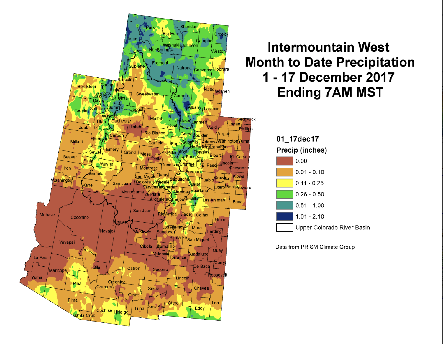
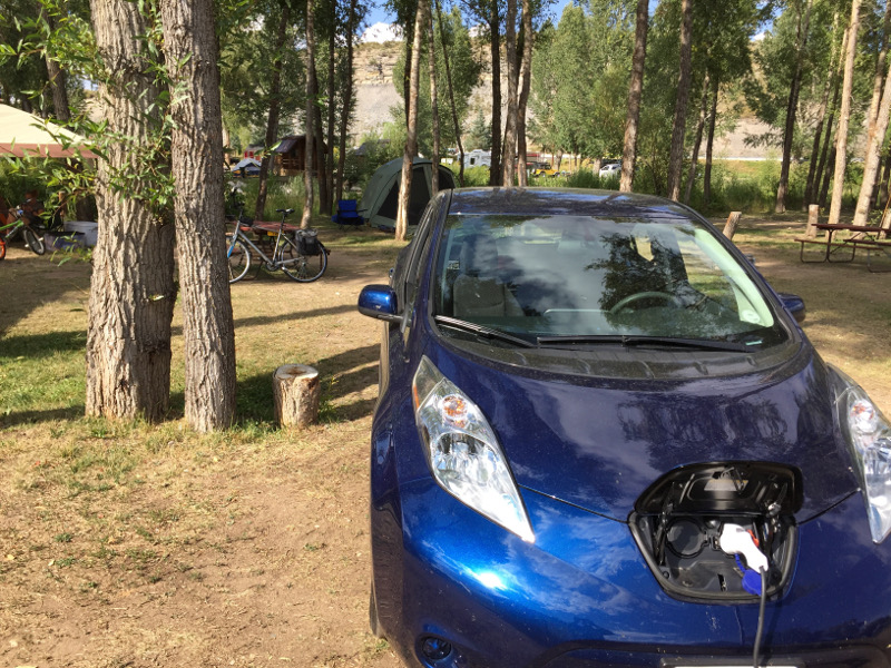

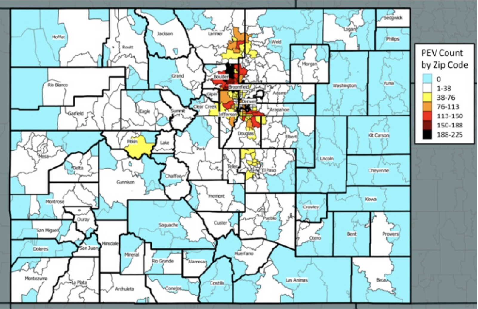


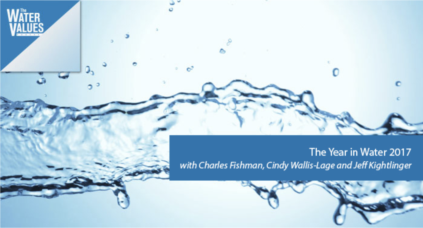


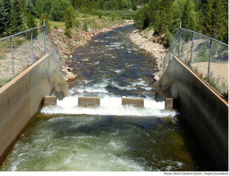
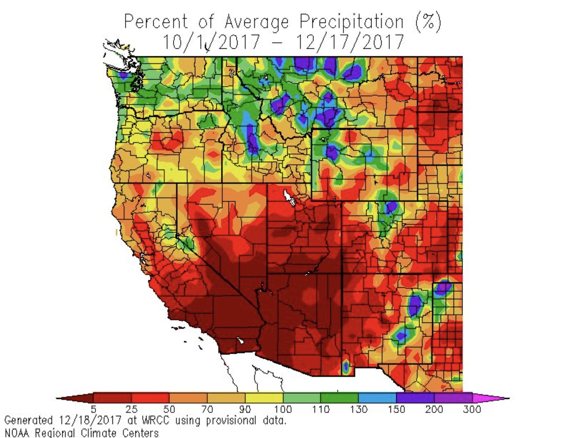


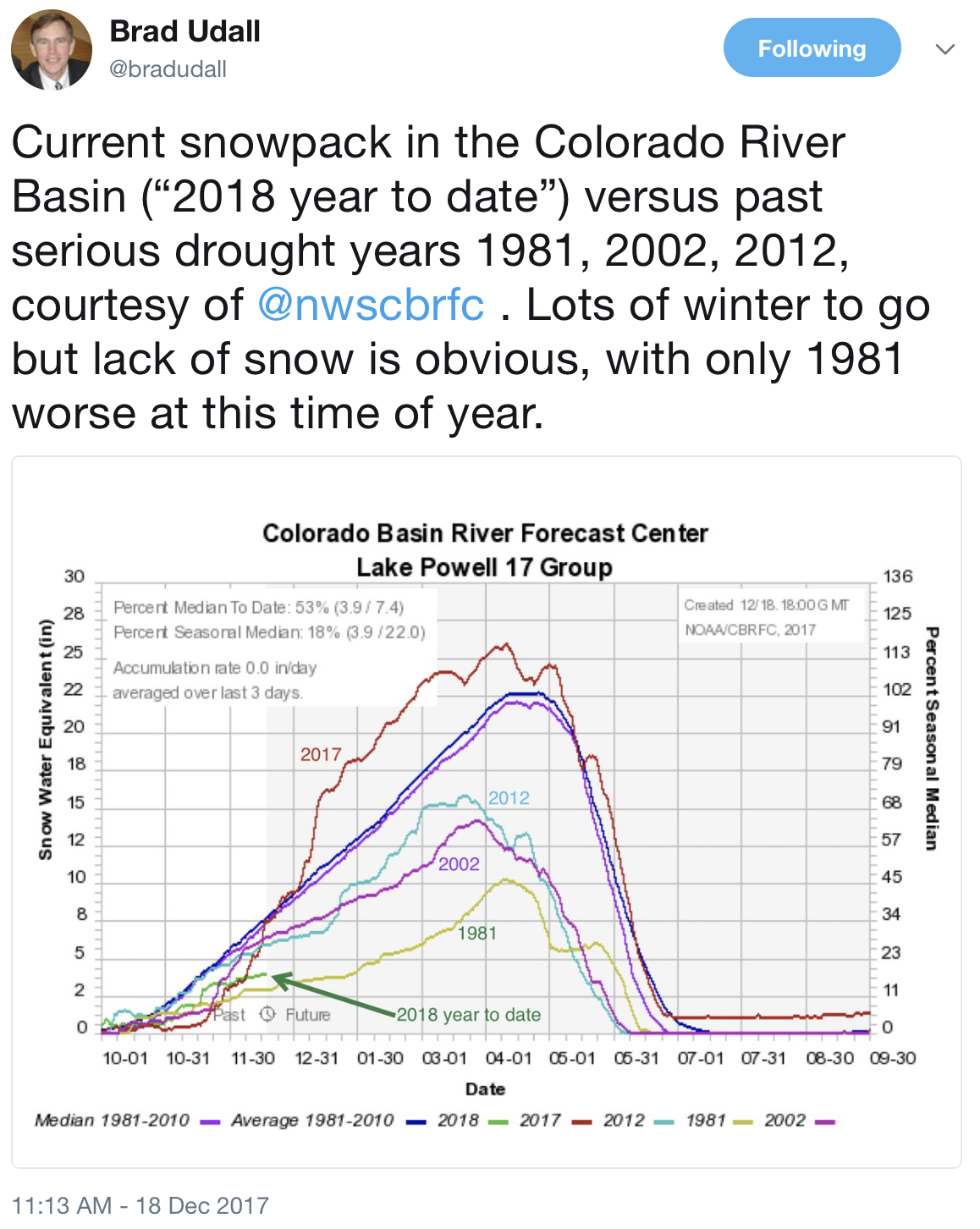


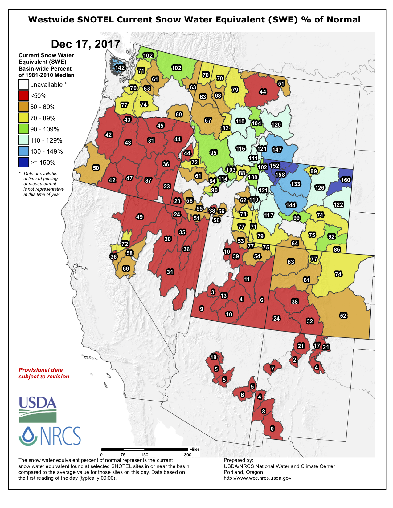

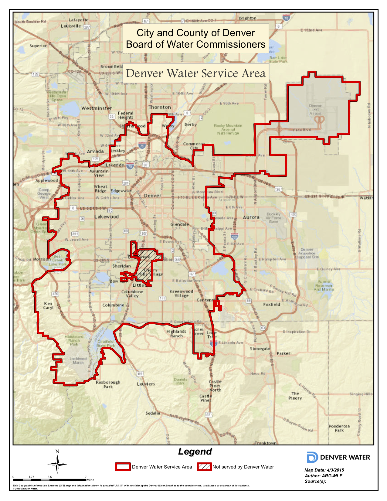
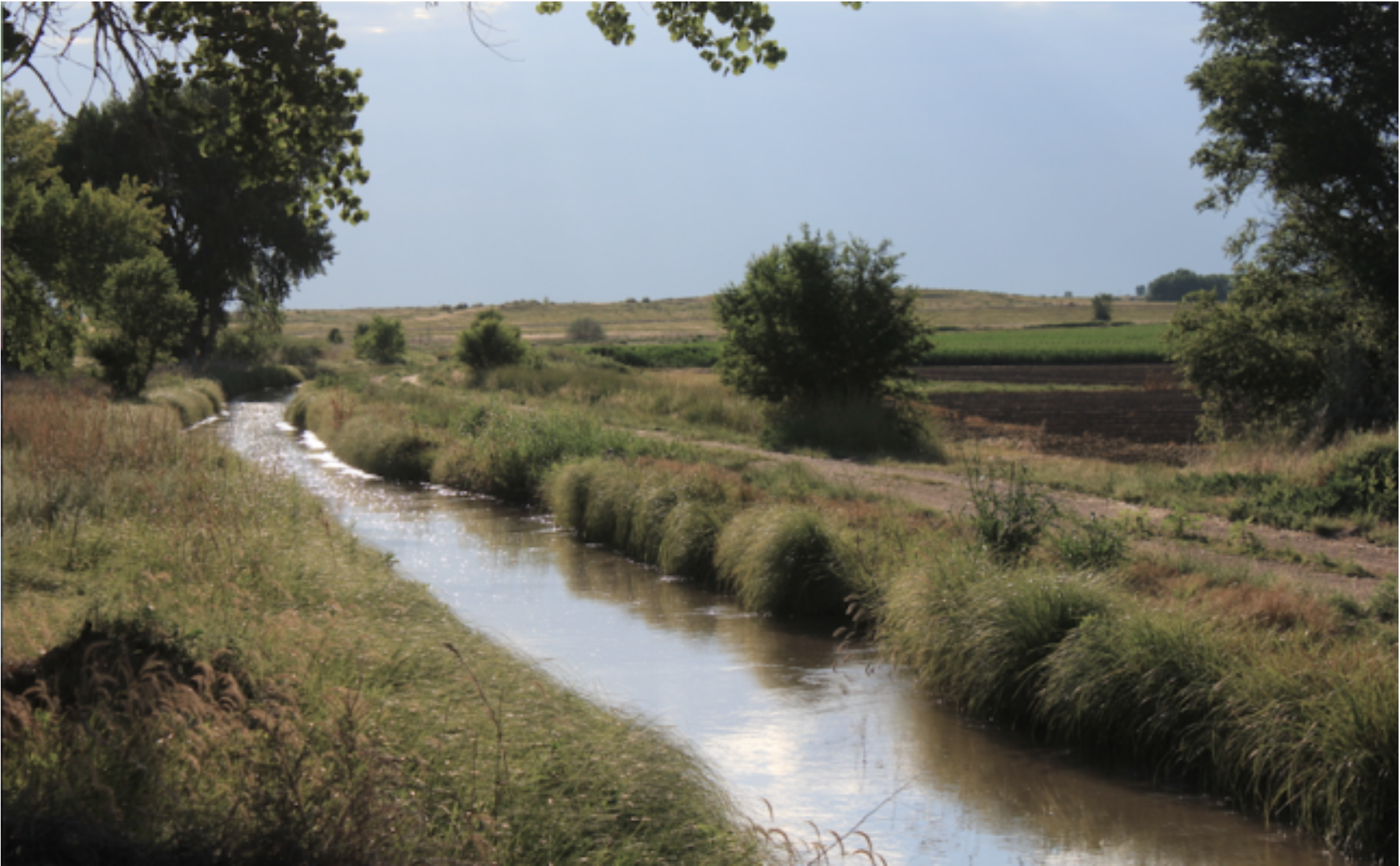
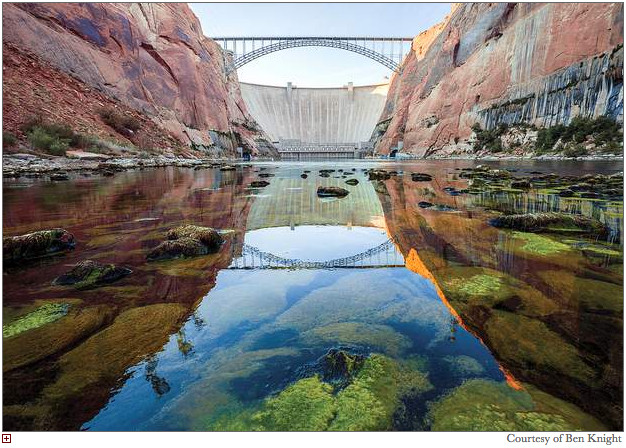

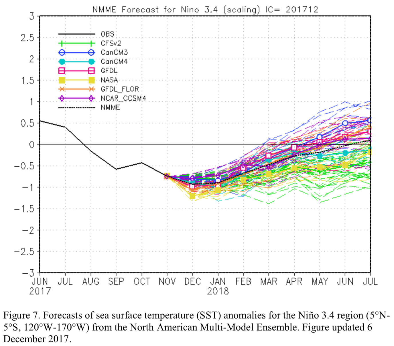

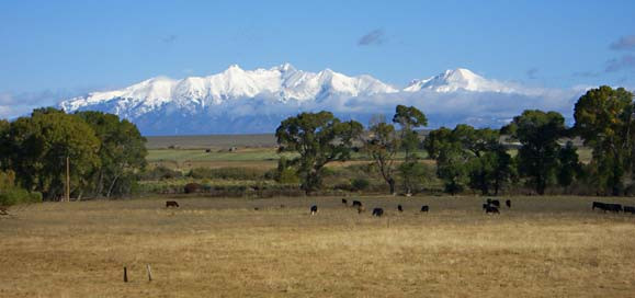


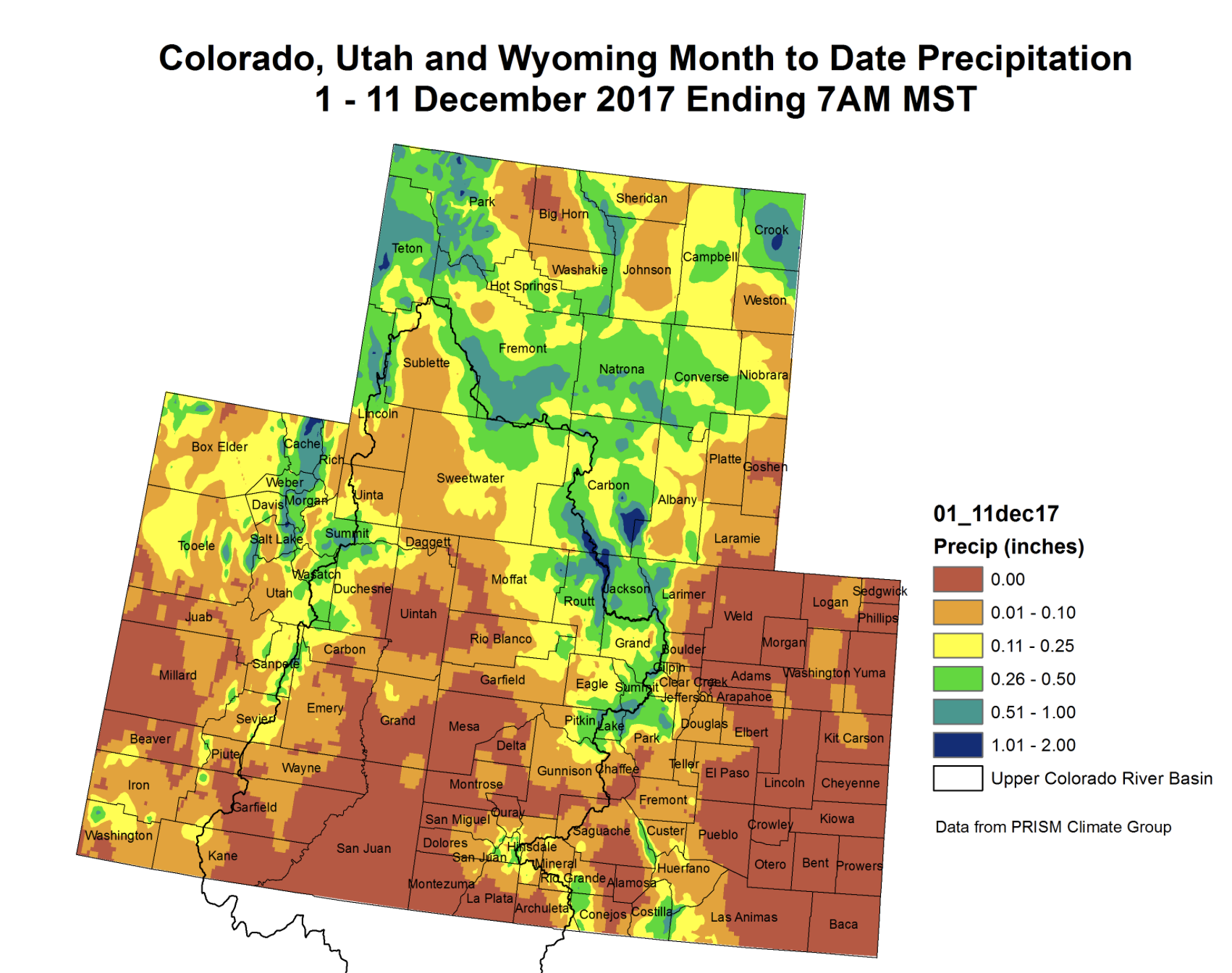
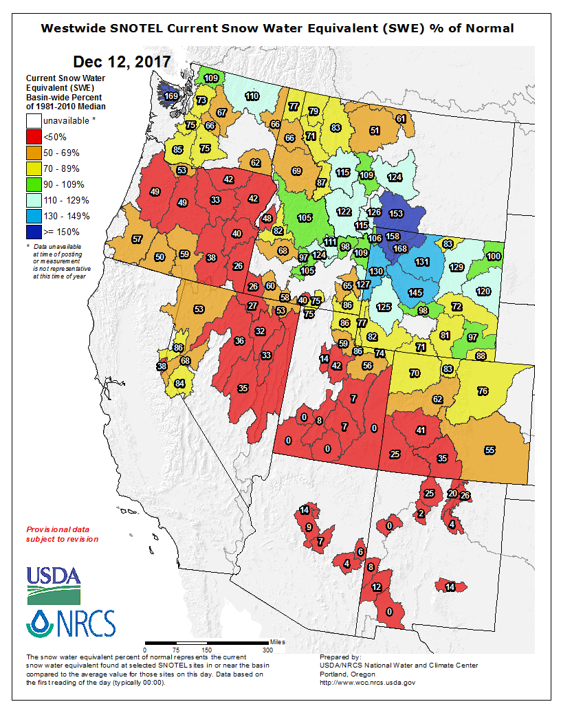
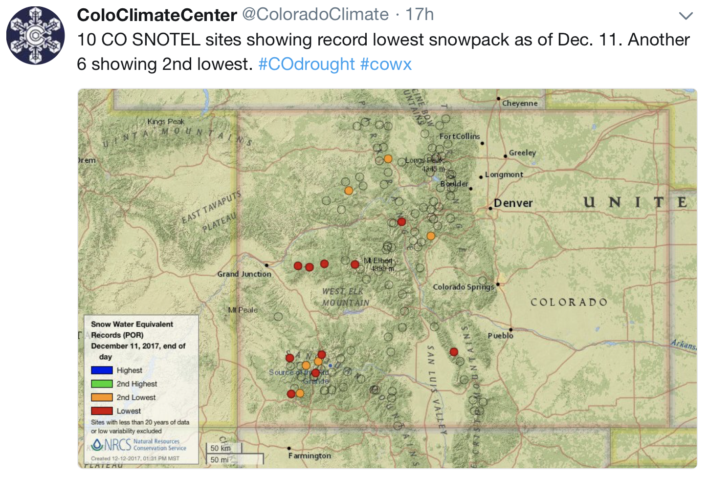


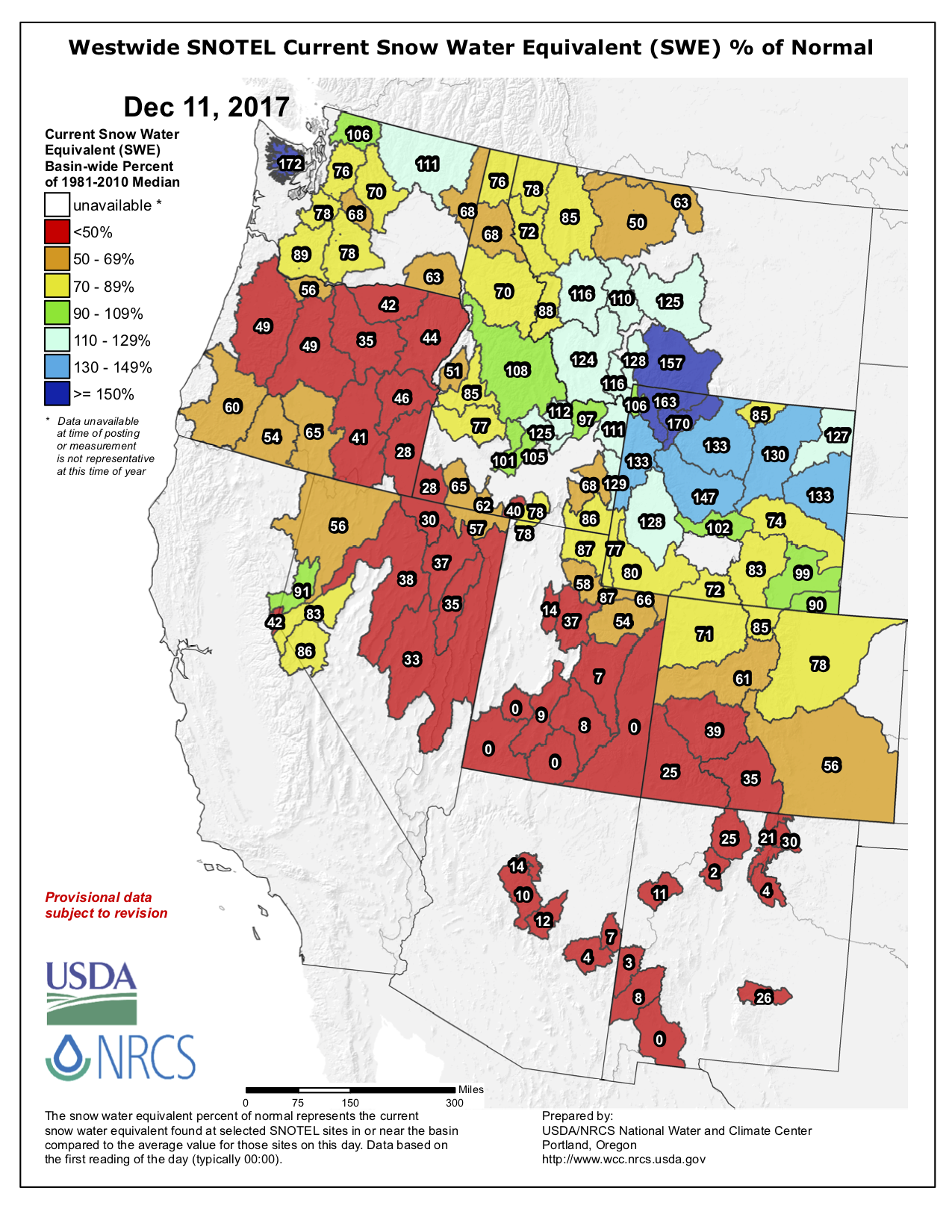


