Click on a thumbnail graphic to view a gallery of drought data from the US Drought Monitor.
Colorado Drought Monitor August 27, 2019.
West Drought Monitor August 27, 2019.
US Drought Monitor August 27, 2019.
Click here to go to the US Drought Monitor website. Here’s an excerpt:
This Week’s Drought Summary
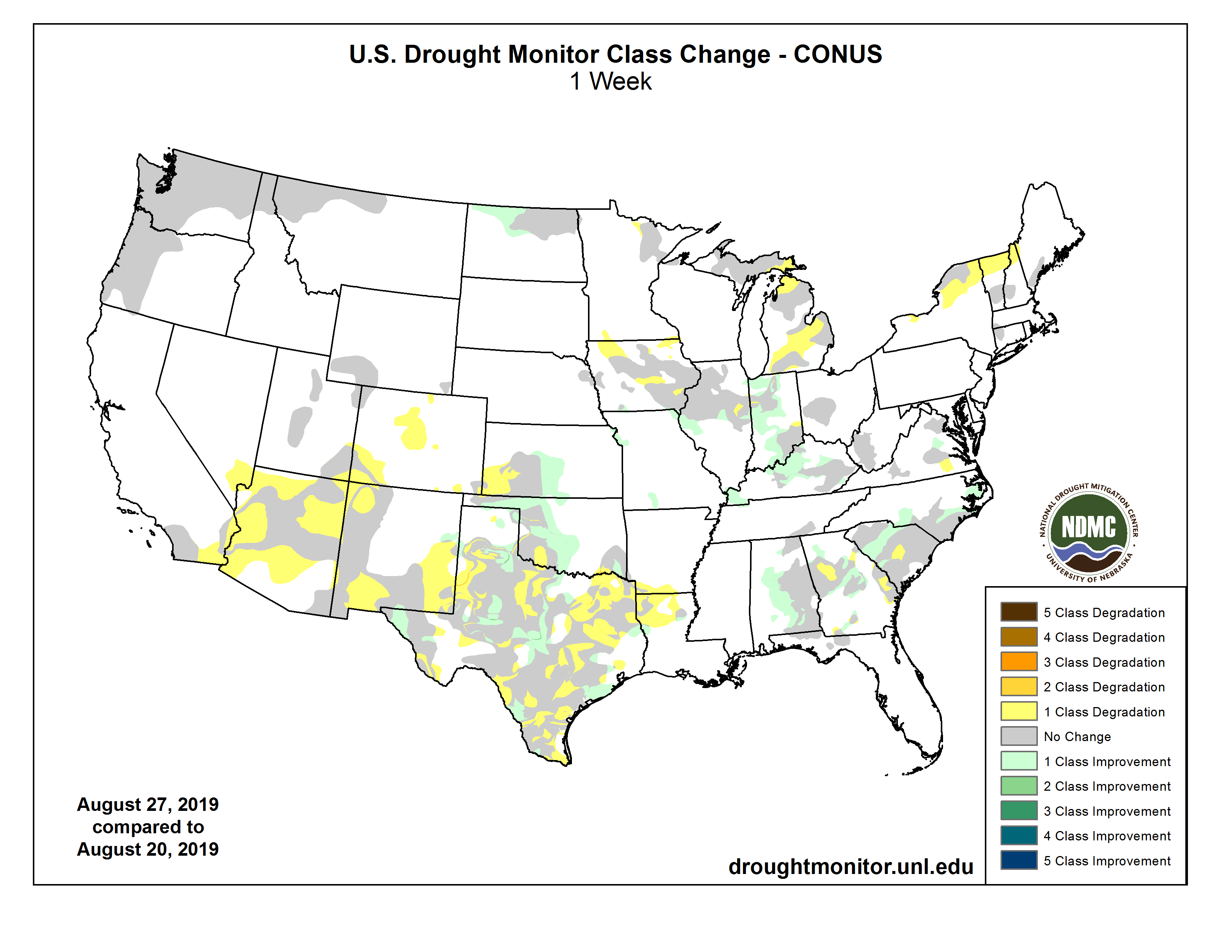
Summer thunderstorms brought heavy rainfall to the Central Plains into parts of the Northeast, with showers and thunderstorms also occurring across parts of the Northwest, Southern Rockies, and Central Gulf Coast. Below-average temperatures accompanied the heavy precipitation for the most part. The Southwest saw little to no rain and record to near-record heat, while heat and humidity continued to the east. The above-average temperatures and dry conditions brought elevated fire risk over the Great Basin and portions of the northern Intermountain West. South central Alaska remained dry and fires continued to burn, with smoke warnings in effect. Heavy rains, flash flooding, and severe weather occurred as a front stretched from the Southern Mid-Atlantic into the Southern Plains…
In the Northern High Plains, normal conditions returned along the western to central North Dakota/Canadian border. Precipitation has been adequate and soil moisture conditions have improved. In the Southern High Plains, rainfall has been below average over the last couple of months – including the past week – in eastern Colorado while temperatures have been above average. Several areas of abnormal dryness were introduced this week, including in the central Colorado Mountains over the higher elevations, eastern Larimer and western Weld Counties and Colorado springs, and in Las Animas. With the heat, evaporative demand has been high for many of these locations. Reports from water providers indicate that there has been peak demand in the last week with lawn irrigation. Peak demand usually occurs in July. Southwestern Kansas has also seen a dearth of precipitation, and both D0 and D1 expanded westward in this area. The rest of the state, on the other hand has seen plentiful rainfall and D0 contracted westward in the central and south central region…
With respect to precipitation, 2019 to-date is a year of extremes in parts of the West. As monsoon rains continue to fail and heat continues to build, impacts, including wildfire risk, are growing in the Southwest. After emerging from nearly a decade of drought conditions on June 11, moderate drought (D1) returned to both the eastern and western parts of Arizona this week, and abnormally dry (D0) conditions spread across much of the rest of the state, save for part of the south. Locally, many areas are experiencing one of their 10 driest monsoon seasons on record. Phoenix is also on track to have its third or fourth hottest June-August period on record and Tucson its second hottest. The D1 that spread to eastern Arizona also spread over the remainder of northwestern New Mexico into southwestern Colorado and southeastern Utah at the Four Corners. In New Mexico, D1 in the south expanded eastward from Sierra County to the D1 area at the Texas border. Abnormally dry conditions also spread outward across the southwestern states, including across Imperial County, California, to join with the long-lasting D0 area in San Diego, Orange, and Riverside Counties…
Texas, Oklahoma, Arkansas, and Louisiana saw sharp gradients and some complicated rainfall patterns, with heavy precipitation in some places and little to none in others, and so many areas saw improvement in short-term dryness and drought while many others saw degradation. Conditions improved across part of the Oklahoma Panhandle into northern Texas and also in in the central region and southeast, but there was also a degradation to extreme drought (D3) along the Texas border, encompassing parts of Kiowa, Comanche, Cotton, and Tillman Counties (and northern Wichita and northeastern Wilbarger County in Texas) where rain was scarce. This is the first occurence of D3 in Oklahoma since September 2018. Temperatures here were in the 105-109 degree F range. In Texas, the D3 area to the west expanded, as did the D3 area in the extreme south, with a new small spot as well. Primary impacts across the state include wildfires, dry stock tanks, supplemental feeding, and impacts to late-season crops, namely cotton. Moderate drought spread from east Texas into southwestern Arkansas and northwestern Louisiana. Abnormal dryness also spread eastward to south central Arkansas and central to northeastern Louisiana…
Looking Ahead
Over the week beginning Tuesday, August 27, according to NOAA’s Climate Prediction Center, dry conditions are expected to continue across southern Texas and much of the western third of the continental U.S., while light to heavy rainfall may occur across the remainder of the country. Parts of Kansas may receive up to about 4 inches, with isolated higher amounts. Hurricane Dorian will bring heavy rain and potential flooding to Puerto Rico and Florida, where 4-8 inches of rain are expected from the storm, with locally higher amounts. Looking further ahead to September 2-6, below-normal temperatures are favored across Maine and parts of the Northern Plains and Midwest, nosediving into Oklahoma and northern Arkansas, while above-normal temperatures are forecast forAlaska, the western third of the CONUS, across most of Texas, and into the Southeast and Mid-Atlantic states. Much of the Southwest and Alaska are both favored to have some badly needed above-average precipitation, as is the Southeast and the northern tier of the CONUS. There are enhanced probabilities of below-normal precipitation for the Southern and Central Plains into parts of the Midwest. Please note the forecast confidence for this period is above average, according to CPC.
US Drought Monitor one week change map ending August 27. 2019.
Denver Water’s Youth Education Program uses fun to focus on developing future water citizens. The post Summer is almost over, but the fun has just begun appeared first on News on TAP.
A behind-the-scenes look at what it takes to keep the water flowing 24/7/365. The post We’ll be there, even on Labor Day appeared first on News on TAP.
National Water Quality Month reminds us all just how important it is to protect our drinking water. The post Now that’s what we call quality appeared first on News on TAP.
Check out Denver Water’s new maintenance shop and meet the mechanics who maintain a $42 million fleet. The post Wheels rollin’ keeps the water flowin’ appeared first on News on TAP.
Here’s the release from the Colorado State Forest Service:
Wildfires are both natural and inevitable – including in wildland-urban interface settings where millions of Coloradans live. These fires can be particularly destructive in areas where forests are unhealthy, unmanaged and unnaturally dense.
The grant program is designed to reduce risk to people and property in the wildland-urban interface (WUI). Photo credit: Colorado State Forest Service
For those interested in taking action, but who have lacked the means, funding is now available to help address this risk.
The Colorado State Forest Service announced today that it is accepting proposals from Colorado HOAs, community groups, local governments, utilities and nonprofit organizations seeking funding to restore forested areas, improve forest health, and reduce wildfire risk on non-federal land in the state.
Approximately $1 million in total funding is available.
The Forest Restoration and Wildfire Risk Mitigation Grant Program helps fund projects that strategically reduce the potential wildfire risk to property, infrastructure and water supplies and that promote forest health through scientifically based forestry practices.
Reduction of hazardous fuels
The competitive grant program is designed to reduce risk to people and property in the wildland-urban interface (WUI) and support long-term ecological restoration. Applications must not only promote forest health and address the reduction of hazardous fuels that could fuel a wildfire – such as trees and brush near homes – but also utilize wood products derived from forest management efforts.
Long-term ecological restoration and the protection of water supplies are among the goals of the grant program. Photo credit: Colorado State Forest Service
The state can fund up to half the cost of each awarded project; grant recipients are required to match at least 50 percent of the total project cost through cash or in-kind contributions. Projects can be located on private, state, county or municipal forestlands.
Program funds also are allowable to fund the purchase of equipment that directly supports and expands on-the-ground opportunities to reduce hazardous fuels.
Applicants must coordinate proposed projects with relevant county officials to ensure consistency with county-level wildfire risk reduction planning. Follow-up monitoring also is a necessary component of this grant program, to help demonstrate the relative efficacy of various treatments and the utility of grant resources.
The CSFS will work with successful project applicants to conduct project monitoring and conduct site visits to assess effectiveness and completion of projects.
Additional emphasis will be given to projects that:
Are implemented strategically across land ownership boundaries; are conducted within a priority area identified in the Colorado State Forest Action Plan
Utilize the labor of an accredited Colorado Youth or Veterans Corps organization
Include forest treatments that result in the protection of water supplies
Applications must be submitted electronically to local CSFS Field Offices by 5 p.m. MST on Oct. 23, 2019. A technical advisory panel convened by the CSFS will review project applications and make funding recommendations. The CSFS will then notify successful applicants next spring.
Applications and additional information about the Forest Restoration and Wildfire Risk Mitigation Grant Program are available at CSFS Field Offices and online on the CSFS Grants & Funding Assistance webpage.
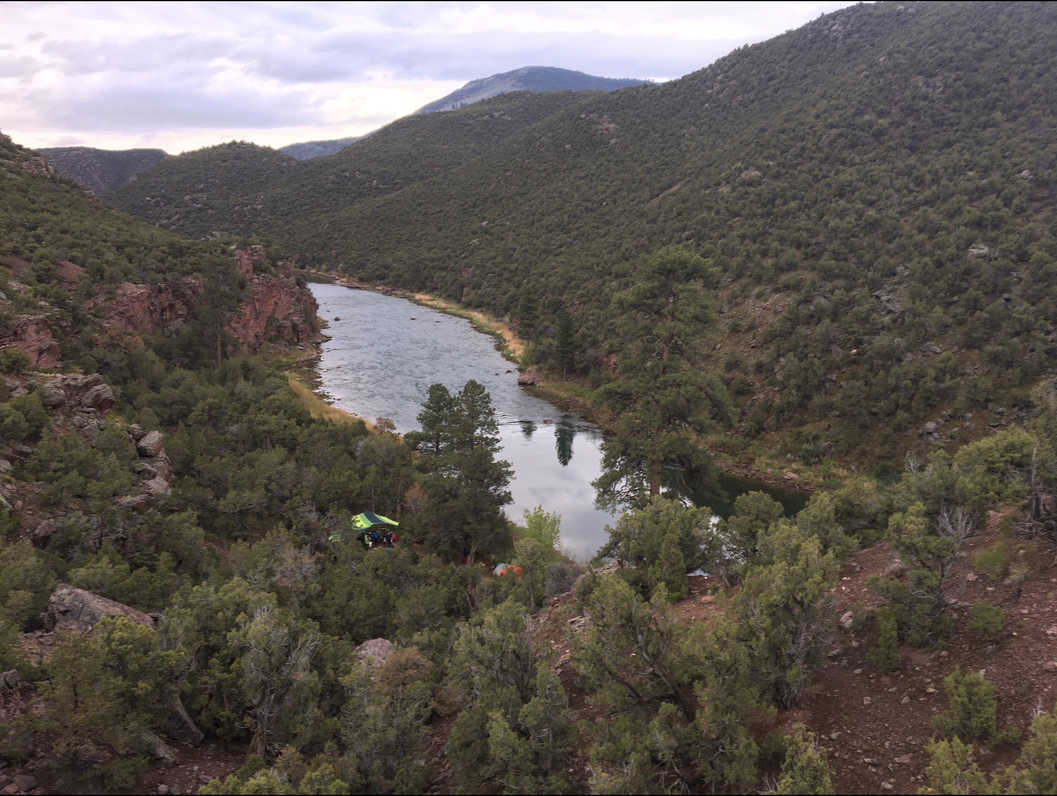
Looking down on camp at Big Pine, Red Canyon. The photo shows the SCREE Powell 150 expdition camp at Big Pine Campground in Red Canyon of the Green River, Utah. The large green tarp was set up to keep the kitchen area and campers dry. Two very large ponderosa pines are in the center of camp, and surely were witness to the 1869 Powell expedition. Photo credit SCREE via the USGS.
Here’s a report from Katie Klingsporn writing for Wyofile.com. Click through to read the whole article and for the photos. Here’s an excerpt:
May 24, 2019 was 150 years to the day after a scraggly and ill-prepared outfit led by a one-armed Army major gathered in Green River Station, beside the outpost’s namesake watercourse, and embarked on one of the most significant river expeditions America has ever seen.
On the sesquicentennial anniversary of John Wesley Powell’s historic launch, a new band of river explorers assembled at the site to begin a bold journey down the artery of the American West — the Green and Colorado Rivers.
This time, things looked starkly different. The crew, made up of academics, scientists, educators and artists from the University of Wyoming, was a far cry from the rag-tag band led by Powell. In place of the gallingly ill-suited wooden boats of Powell’s expedition, state-of-the-art 18-foot rubber rafts lined the bank. And, perhaps most notably, this crew came equipped with the tools of modern adventure such as maps, streamflow forecasts and satellite phones. These travelers were, in other words, prepared — not something Powell’s expedition had going for it as the men ventured into what was then a little-understood blank spot on the American map.
Meet UW’s Sesquicentennial Colorado River Exploring Expedition, which set out on that May 2019 day to follow Powell’s arduous journey. Over 70 days and some 1,000 river miles this summer, its members retraced Powell’s route and mimicked other key aspects of his expedition — like collecting scientific data. But theirs was not to be a simple journey into the past. Instead the team set out with an eye toward the future and solutions for the river system’s modern-day problems. In this way, the expedition conducted a study not only of the geology or hydrology of the Colorado River Basin, but of Western economies, policies, climate, public lands and ideologies as they relate to the overtaxed river system…
The inspiration
A century and a half is a mere blip in the life of the Colorado River, but much has changed in its basin since Powell’s expedition. Cities have bloomed in the desert, diversions and pipelines have been built and a complex web of regulations has been written to divvy the water to its 40 million users. What once was a large swath of unknown today encompasses five states, two basin districts, more than a dozen dams and 15 special-management areas. Add to that ever-increasing agricultural and energy development, a nearly two-decade-long drought and wild swings brought by climate change, and the picture of the Colorado River Basin is one of a riverway so overburdened it no longer reaches the sea.
It’s the river’s predicaments that prompted the SCREE trip, Minckley said. A paleo-ecologist, Minckley specializes in Western ecologies and long periods of drought. A few years ago, with the anniversary of Powell’s expedition on the horizon and the quandary of the basin’s water management fresh in his mind, he said, he began thinking about how Powell was one of the first people who took the concern of water in the West seriously…
The takeaways
Spring gave way to summer as the crew wended its way south and west, plunging deeper into the Earth as rock layers climbed above. There were guests aplenty, too many campfires to count, breathtaking vistas and a couple mishaps — a raft flipped in Cataract Canyon, an engine broke down during the slog across Lake Powell.
When the crew arrived at its final destination, the approximate confluence of the Virgin and Colorado rivers (now under Lake Mead) on Aug. 1, it had amassed hours of recorded conversations, pages of notes and drawings, hundreds of scientific samples, many ideas for classroom curriculum and a pile of memories from an unforgettable experience.
One thing the team did not have? The hard-and-fast answer to the Colorado Basin’s perplexing water puzzle. But, Minckley said, they’ve got a good starting place. The next step is to begin analyzing and digesting the information they gathered, while thinking about the most effective ways to move key findings into the public conversation.