Click here to read the current assessment. Click here to go to the NIDIS website hosted by the Colorado Climate Center. Here’s the summary for this week:
Summary: October 1, 2019
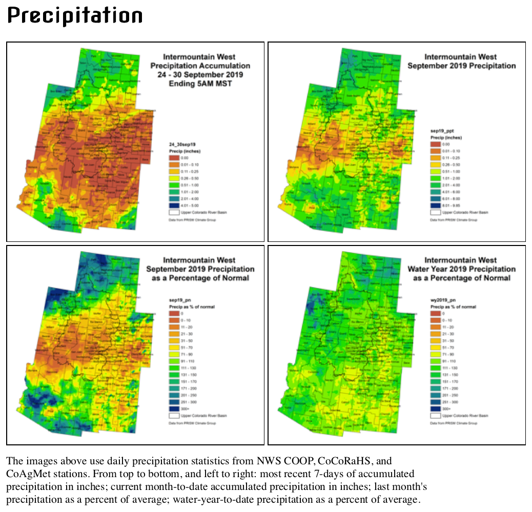
Water Year 2019 ended in an unfortunate whimper. What started out with a bang (cooler than average temperatures, above average snow, wet spring into early summer) shifted to hot and dry conditions for much of the Intermountain West, ending with an underperforming monsoon season.
The result of this sudden shift is evident in SPIs, where short-term out to 120 days are very negative for the southern half of the IMW, and then positive on the longer timescales for most of the IMW. Wyoming has fared the best, with closer to average conditions throughout the water year. New Mexico has struggled the most.
The hydrology of the region still holds up, with streamflows near average and water supplies in good condition. Rainfall fed agriculture this summer has struggled, but irrigated ag has been fine and winter crops did well. Short-term indicators such as soil moisture and evaporative demand show the stress in the region, and reports of struggling corn crops support those indicators.
The outlook points to more dry conditions over the next two weeks. Temperatures will be more seasonal this week, but a return to the warmer than average pattern is probable after that.
Fort Lewis College is now home to a new collaboration between regional water leaders and academics. The Four Corners Water Resources Center, housed in Reed Library under the leadership of Director Gigi Richard, will be a space where students and community members can work together to address water issues in the Four Corners.
Richard has been a visiting instructor in Geosciences for the last year at FLC, and prior to that was a professor of Geosciences at Colorado Mesa University, where she taught for 16 years and co-founded and directed the Ruth Powell Hutchins Water Center. Most colleges in Colorado have a water center with a specific geographic focus. The Four Corners Water Resources Center will have a Southwest and Tribal focus, with collaborations with other colleges possible.
“A water center at FLC creates an exciting opportunity for the college to be a part of solutions to some of the challenging issues facing the region and to help develop the next generation of water leaders,” says Richard. “Water underpins everything in the Southwest, including our agriculture, economy, ecosystems, recreation, spiritual values, and cultural history.”
Students across all majors will be able to engage with the center, from courses to campus projects and events. The center will connect students to the broader water community and expand student opportunities for internships and careers. As Richard states, water touches everything and everyone, and the greatest global challenge is having both clean water and enough water.
“Students are interested in water! So many aspects of water are urgent for present and future grand societal challenges in the Southwest and globally. The new water center will strive to leverage FLC’s existing strengths to develop coherent water-related curricular and co-curricular opportunities for students,” says Richard.
The water center serves as an interdisciplinary information hub to harness the expertise of faculty and enhance or facilitate new relationships between campus and the region. Water leaders, professionals, and other entities will be able to bring data and initiatives under one roof, to generate greater impact and access to regional water issues.
“Fort Lewis is uniquely poised to play a leadership role in facilitating the development of solutions to the challenging water issues facing the Southwest,” says President Tom Stritikus. “FLC already possesses faculty expertise in water-related fields across disciplines, from science, policy and engineering, to the humanities.”
Located in the middle of the San Juan River basin, which is a major tributary to the Colorado River, the water center will be able to engage with both major Western water issues and local water issues. The first undertaking for the center will be to form an advisory council of local and regional water leaders to develop the mission of the center. Richard will be focused on developing an online database of the rivers of the Four Corners, beginning with the Dolores River. The interface will be user-friendly to the general public, and those who are interested can dig in for more technical information, too.
“Many opportunities for partnerships exist both on campus and in the local and regional community. We are looking forward to collaborating with existing groups and building new connections for Fort Lewis students and faculty,” says Richard.
Community events, public talks and tours, and more information about the water center are at https://www.fortlewis.edu/water.
Here’s the release from Governor Gordon’s office (Michael Pearlman):
Reflecting his goal of making Wyoming a national leader on combating invasive species, Governor Mark Gordon announced today he has launched an initiative to address terrestrial invasive plants in the state.
The initiative will be comprised of two teams– a Policy Team and a Technical Team, each comprised of local, state and federal government representatives, private citizens representing industry and agricultural groups, as well as scientists and practitioners.
The two teams will work cooperatively to develop recommendations for the Governor in the context of a large-scale strategy for invasive species management. Terrestrial invasive species represent a significant threat to Wyoming’s forests, rangelands and agricultural lands with varying levels of impact.
“Wyoming is faced with threats from multiple invasives species, both on land and in our waters,” Governor Gordon said. “I have specifically asked these groups to address terrestrial plants and provide recommendations on how to take the first step towards tackling some of the toughest questions. Our best efforts should begin close to home.”
The first meeting of the two teams will take be held at 9:30 am on October 10 at the NRCS Building, located at 100 East B. Street, room 3002 in Casper.
Policy Team members are Steve Meadows (chair), Wyatt Agar, Brian Boner, Jacque Buchanan, Josh Coursey, Jessica Crowder, John Elliot, Jack Engstrom, Colleen Faber, Jamie Flitner, Slade Franklin, Rob Hendry, Mark Hogan, Matt Hoobler, Astrid Martinez and Tom Walters.
The Technical Team includes Justin Derner (chair), Bob Budd, Ben Bump, Todd Caltrider, Justin Caudill, Scott Gamo, Lindy Garner, Ken Henke, Brian Jensen, Julie Kraft, Rod Litzel, Brian Mealor, Dwayne Rice, Pete Stahl, Amanda Thimmayya and Mahonri Williams.
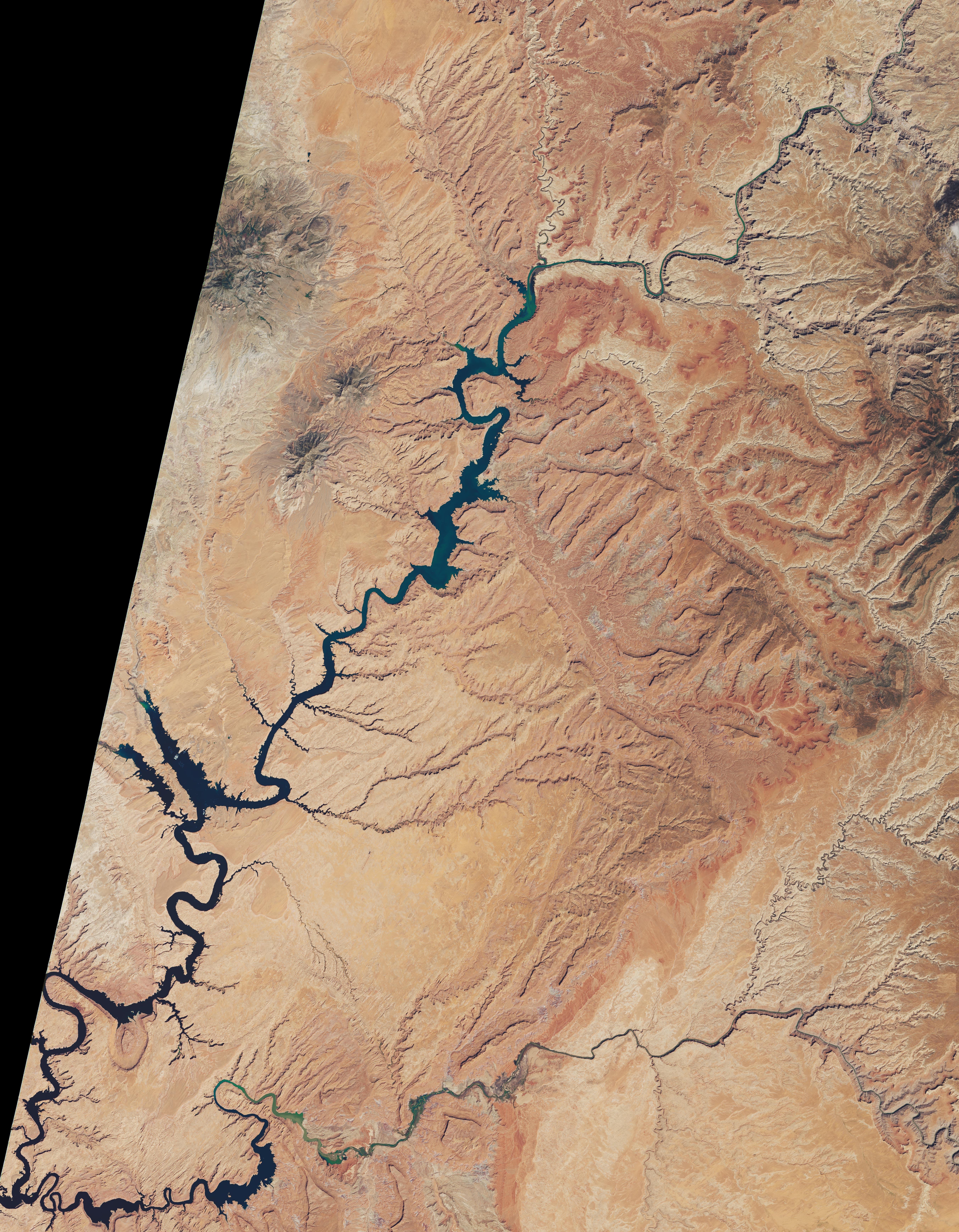
Click through to check out the slider comparing the upper sections of Lake Powell in April 2012 and May 2019 from NASA Earth:
Heavy snowfall in the Rocky Mountains in the winter and spring of 2019 provided a much-needed pulse of meltwater into Lake Powell, the second largest reservoir (by maximum water capacity) in the United States. Still, the effects of long-term droughts and rising air temperatures, combined with increasing demands for water in the American Southwest, mean the lake is still nowhere near its highs from the 1980s and 90s.
Lake Powell stretches across southeastern Utah and northeastern Arizona. Water managers first started filling the reservoir in 1963, when the Glen Canyon Dam was completed along the Colorado River. By the mid-1980s, the lake approached its full capacity. Water levels dropped due to drought and then rose again in the late 1990s. Lake levels have been mostly dropping over the past 20 years, punctuated by a few strong water years like 2019.
The images above, which also appear in our World of Change series, show Lake Powell in 2012 and 2019. The first (left) image was acquired by the Thematic Mapper on the Landsat 5 satellite on April 20, 2012, when then lake was near its highest spring level since 2000 because of an abundance of precipitation in 2011. The second image was acquired by the Operational Land Imager on Landsat 8 on May 2, 2019. A third image (below) shows the lake on August 31, 2019, near its peak level this year.
August 31, 2019. Photo credit: NASA
As of September 29, 2019, the water elevation level at Glen Canyon Dam was 3615.49 feet, and the lake stored 13.29 million acre-feet (maf) of water, about 55 percent of capacity and more than 100 feet below “full pool.” On May 1, 2019, before the abundant snow cover started melting, the lake stood at 3584.65 feet and held 10.34 million acre-feet of water. In May 2012 (comparison image), Lake Powell stood at 3636.83 feet and held 15.63 maf. (One acre-foot equals about 326,000 gallons.)
Snow came late in the 2018-19 winter, but when it arrived, it was heavy and frequent. Spring temperatures in the Rocky Mountains remained cooler than normal, keeping snow cover from melting quickly. A major snowfall in late June in Colorado raised snow water equivalents—a measure of the amount of water in the snowpack on the mountains—to 40 times the norm for June in the state. The Upper Colorado River basin as a whole reached snow water equivalent levels about 130 percent of the long-term median.
The abundance of snow in 2019 ended a severe drought that kept water flows into the river at 43 percent of normal in 2018. According to the Bureau of Reclamation (USBR), which manages Lake Powell, “the total water year 2019 unregulated inflow to Lake Powell is projected to be 13.19 million acre-feet (122 percent of average).”
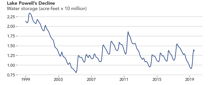
Lake Powell volumes January 1999 – August 2019. Graphic credit: Reclamation
The boom in 2019 will help stabilize water storage in the lake. However, it will take several more years of abundant snow and rain to offset the steady decline since 1999, as shown in the graph above. Lake Powell was around 94 percent capacity in 2000. It sank to an all-time low in 2005.
USBR reported in September 2019: “During the 19-year period 2000 to 2018, the unregulated inflow to Lake Powell, which is a good measure of hydrologic conditions in the Colorado River Basin, was above average in only 4 out of the past 19 years. The period 2000-2018 is the lowest 19-year period since the closure of Glen Canyon Dam in 1963, with an average unregulated inflow of 8.54 maf, or 79 percent of the 30-year average (1981-2010). (For comparison, the 1981-2010 total water year average is 10.83 maf.)”
A century of river flow records and several centuries of tree-ring data show that there is some precedent for the dry years of the past few decades; extended droughts have been part of the long-term climate variability of the American Southwest. However, global warming is expected to make droughts more severe. For a long view, see the Earth Observatory feature World of Change: Water Level in Lake Powell, which documents changes in lake levels each spring since 1999.
NASA Earth Observatory images by Lauren Dauphin and Joshua Stevens, using Landsat data from the U.S. Geological Survey and water storage data from the Bureau of Reclamation. Story by Michael Carlowicz.
FromThe Durango Herald (Jonathan Romeo) via The Cortez Journal:
Last week, the Zinks officially announced they received approval from a consortium of government agencies – including the U.S. Army Corps of Engineers, the Environmental Protection Agency, La Plata County government, among others – to expand the wetlands project by 15 acres…
Before Western settlement reached Colorado, the best estimates show there were probably around 2 million acres – about 3% – of wetlands across the state, which provide some of the most biologically diverse habitats for wildlife and serve as a natural filter for water.
It’s estimated that about 80% to 90% of all wildlife rely on wetland habitats.
But development and other human-related impacts over the decades have caused many wetlands, about half, to disappear. In recent years, though, there has been a push for restoration projects to bring back the instrumental ecosystems when possible.
At the Zinks’ ranch, for instance, a bird count in 2009 tallied 26 species. This year, after more acres of wetlands have returned, that number has jumped to more than 110 species. Patti Zink, Ed’s wife, said other wildlife, too, like deer, are frequenters on the property.
And though the Zinks’ effort is voluntary and self-funded, it is likely they will see some returns for their project, Ed Zink said.
The Clean Water Act of 1974 requires any new development that will destroy wetlands to find new land to restore back to a wetland.
Zink said his property could be used for this purpose.
As an example, he said if the Colorado Department of Transportation ever sought to expand U.S. Highway 160 between Durango and Bayfield, about 20 acres of wetlands could be affected. In turn, CDOT could reimburse the Zinks for their restoration project…
[Patti Zink] said the wetlands will enhance the environment, as well as conserve the land forever as open space.
“We’re really glad we’ve done it,” she said. “It will be a family legacy for us.”
Ed Zink said he has heard some of his neighbors express interest in wetland projects, which would provide more robust and expanded habitat for wildlife and improving water quality.
Ed Zink Animas River wetlands. Photo credit: The Durango Herald (Deep link not working)
Coloradoans are being asked to decide two statewide ballot issues this fall, and we encourage voters to approve both measures, which have garnered widespread bipartisan support.
Proposition CC
Proposition CC proposes to eliminate the state’s revenue cap and reallocate that excess revenue to fund transportation and education. It is not a new tax but instead, would allow the state to retain tax revenue rather than refunding it back to taxpayers. The retained revenue would be equally divided and specifically spent on public schools, higher education and transportation projects.
The proposition mandates that the third of the revenue earmarked for transportation be divided between the Colorado Department of Transportation, counties and cities. According to Steamboat Springs City Council member Kathi Meyer, who serves on the executive board of the Colorado Municipal League, which has endorsed Proposition CC, Steamboat and Routt County stand to gain millions of dollars in revenue that can be spent on local roads and bridges during years when there is a Taxpayers Bill of Rights — or TABOR — excess.
In addition to helping to fund Colorado’s crumbling transportation infrastructure, Proposition CC would also boost funding for education, which we think is crucial to the future of our state, which currently ranks in the bottom third of the nation when it comes to per-pupil funding at the K-12 level.
Proposition CC also requires an annual audit of funding, which ensures transparency and allows taxpayers to know exactly how money is being spent.
We realize that Proposition CC is a De-Brucing at the state level, but we believe TABOR needs to be addressed due to the unintended consequences it has had on the state’s ability to fund core services. Proposition CC provides a mechanism to address TABOR’s flaws, and that is one of the reasons why we believe it deserves voter support.
Proposition DD
With broad support from across the state and at the capitol, Proposition DD seems like a no-brainer. The proposition is asking voters to legalize casino sports betting and tax profits to fund the Colorado Water Plan, and we think the measure deserves a resounding “yes” vote.
DD, if approved, will provide a dedicated, predictable revenue stream to help address Colorado’s future water needs. Funding from DD will help keep water in rural Colorado through the support of projects that are prioritized by the state’s various basin roundtables. And with the Yampa River flowing through downtown Steamboat, our communities know first-hand how important water and water quality are to recreation and our local agriculture community.
Sports betting is going to happen whether DD is approved or not, and we believe it’s smart for Colorado to tax it and use that revenue to fund water projects. The proposition also will create a regulated betting market as opposed to the black market, and a small portion of the revenue will be used to support resources to combat gambling addiction — an amount that was established with input from key stakeholders.
Supporters of Proposition DD offer a great analogy for how they believe the proposition will impact Colorado. They think DD will do for water what Great Outdoors Colorado, funded by the Colorado Lottery, did for open space across the state.
DD won’t provide the $20 billion needed to meet all of Colorado’s water demands, but it does create a significant down payment that can be leveraged in a big way.
Ninety percent of the revenue will be placed in a cash fund for Colorado Water Plan implementation. This fund will support the allocation of grants to support projects that focus on water storage, supply, water conservation, land use, agriculture, the environment and recreational uses, which all have the potential to positively affect our local community.
A screenshot from the website for Colorado’s Water Plan.
The group Yes on Proposition DD said the coalition of ag interests in support includes the Colorado Association of Wheat Growers, the Colorado Cattlemen’s Association, the Colorado Corn Growers Association, Colorado Dairy Farmers, the Colorado Farm Bureau, Colorado Pork Producers and the Rocky Mountain Farmers Union…
“Most farmers and ranchers could care less about sports betting. But this is a smart way to pay for the critical water infrastructure that Colorado’s future needs,” Chad Vorthmann, the executive vice president of the Colorado Farm Bureau, said in a statement.