Rancher, Ditch Company and Environmental Group Work Together to Restore and Improve Left Hand Creek in Boulder County Following 2013 Flood — #Colorado Ag Water Alliance

Left hand creek restoration. Photo credit: Colorado Ag Water Alliance

From the Colorado Ag Water Alliance (Marilyn Bay Drake):

Those of us who lived in Colorado in September 2013 likely remember the days of hard rain that are so uncharacteristic of Colorado, especially this time of year. We watched in horror as television footage showed rivers overflowing their banks and houses, barns and livestock being washed away. Aerial shots showed entire farms under water.

Rural communities came together to salvage what they could and make sure neighbors and livestock were safe. Six years later, another story is being told. The Colorado Agriculture Water Alliance is showcasing how farmers, ranchers, ditch companies, conservancy districts, environmental groups and other entities came together to improve river health, irrigation efficiency and environmental and recreational use of Colorado’s limited water supplies.

The story of how different users united to restore Left Hand Creek after the 2013 flood shows how working together can make the creek better for all users, including improving the efficiency of irrigators.

“(The 2013 flood) was the third flood I’ve seen come through here, but it was by far the most destructive,” said cow-calf operator Ron Sutherland, Twin Lakes Ranch, Niwot, Colo. Sutherland’s ranch has been designated a Colorado Centennial Farm and has been operated by his family since 1881.

“There was 11-15 feet of water, canyon wall to canyon wall,” said Terry Plummer, Left Hand Ditch Company, which provides irrigation water for 30,000 acres of farmland as well as providing water to Left Hand Water District to make drinking water for towns and cities.

“The water jumped the banks and created four rivers coming down,” explained Plummer.
Farmers and ranchers along the creek had to deal with washouts that were 30 feet long and eight to ten feet deep. The flooding on Sutherland’s property washed out Left Hand Creek, eroding pastureland and making the creek difficult for his cattle to access for water.

According to Jessica Olson, Left Hand Watershed Center, Longmont, Colo., the the flood was the catalyst that brought together farmers, the ditch company and municipal and environmental groups to decide on a plan that would restore what the flood destroyed. The group worked with the state and federal governments to secure funding to help implement the plan.

The plan included stabilizing the creek bed to protect agriculture infrastructure and restoring creek banks for both aesthetic and practical reasons. It also included reconnecting floodplains and grading low flow channels in the creek bottom. On Sutherland’s ranch, ramps were created to allow cattle to access water at a designated location along the creek, while also protecting newly planted vegetation.

“The low flow channels sped up the water (in the creek), and when we get past the run-off and the river shrinks, the water is concentrated over several feet instead of ten to 15 feet, said Plummer. “This enables us to get the irrigation water where it needs to go faster and more efficiently.”

“That (his ranch land) has all been filled in and reseeded,” said Sutherland. “I’m glad to see them come in and restore it.”

Olson added that the project also incorporated bank stabilization, which reduces the amount of sediment flowing into the creek, which reduces the need for irrigation users to clean clogged creek beds and diversion areas.

“This work was a win-win,” said Olson. “We were able to return the river to a more natural and beautiful state, improve fish habitat and increase the efficiency and quality of water used by agriculture. Improving our watersheds requires understanding all users. Multi-benefit projects require collaboration; we really do need to work with each other.”

To see a six-minute video of the Left Hand Creek restoration project, a fact sheet on this project and other resources, visit https://www.coagwater.org/stream-management

Grants to help fund stream management planning, such as those used by the Left Hand Creek project, are available through the Colorado Water Conservation Board. The deadline for the next round of funding is Nov. 1, 2019. For more information on stream management planning in your area or for resources available to assist agriculture with irrigation infrastructure visit http://coloradosmp.org., or contact Alyssa Clarida with the Colorado Department of Agriculture State Conservation Board at alyssa.clarida@state.co.us or Greg Peterson with the Colorado Ag Water Alliance at coagwater@gmail.com

Video: The Science of Soil Health: Cover Crops and Moisture

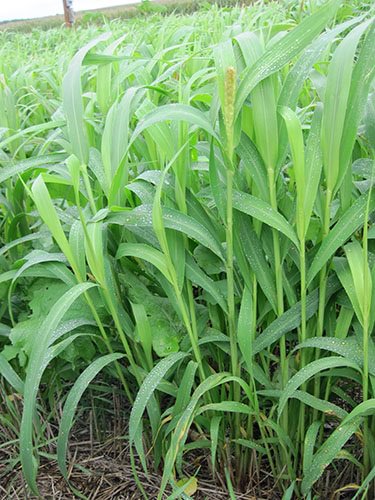
Cover crops. Photo credit: NRCS

No cropping system is drought proof, but there are things that farmers can do to mitigate the effects of a dry year. North Carolina State University’s Dr. Chris Reberg-Horton discusses how cover crops affect water dynamics through the life-cycle of the cash crop.

Predicting Flash #Drought explainer from Drought.gov

Photo credit. Shutterstock via Drought.gov

From Drought.gov:

In its simplest form, flash drought is the rapid onset of drought. In contrast with conventional drought, which is mainly driven by lack of precipitation, flash drought usually includes abnormally high temperatures, winds, and/or incoming radiation that leads to abnormally high evapotranspiration (ET) rates. Flash droughts occur more often than perceived and can cause major agricultural losses if they are not predicted and detected in a timely manner. In fact, flash drought has recently developed in the Mid-Atlantic and Southeast regions. The prediction of flash droughts on subseasonal timescales is of critical importance for impact assessment, disaster mitigation, and loss prevention.

Researchers from the NOAA/NWS/NCEP Climate Prediction Center undertook a study to increase our understanding of the characteristics of flash drought events with the goal of further predicting the onset of such events on subseasonal timescales. The study, titled, “Flash Drought Characteristics Based on U.S. Drought Monitor” and published in the journal Atmosphere, defined a flash drought as an event with greater than or equal to two categories degradation in a four-week period based on the U.S. Drought Monitor.

The research team analyzed the conditions and evolution of five selected flash droughts using North American Land Data Assimilation System-2 (NLDAS-2) data. NLDAS-2, a collaboration between NASA, NOAA, and others, are land-surface model (LSM) datasets from the best available observations and model outputs to support modeling activities. The researchers selected the following flash droughts to study: 2000 Southern US, 2003 Midwest, 2006 Northern Plains, 2007 Northern Rocky Mountains, and the 2012 Midwest.

Overall, the research team found that all five droughts had sudden decreases in ET anomaly over the drought regions before onset. That means that soil moisture was plentiful prior to the drought, but rapidly evaporated due to heat/wind/radiation. The researchers noticed sharp declines in soil moisture anomaly associated with the sudden decreases in ET anomaly. Temperatures during the development periods were warmer than normal, due to heatwaves in the regions, and the three-month Standardized Precipitation Indexes were negative for all five droughts.

These results are consistent with other studies on flash droughts. This suggests that closely monitoring rapid changes in ET (a responding variable to temperature), along with soil moisture and precipitation conditions, can provide early warnings of flash drought development. The authors also plan to utilize the knowledge gained from this study to develop a flash drought prediction tool to advance our ability to forecast these events.

#Drought news: Dryness and drought are becoming a concern in southwest #Kansas and into #Colorado, D1 (Moderate Drought) expanded in the central mountains in #CO

Click on a thumbnail graphic to view a gallery of drought data from the US Drought Monitor.

Click here to go to the US Drought Monitor website. Here’s an excerpt:

This Week’s Drought Summary

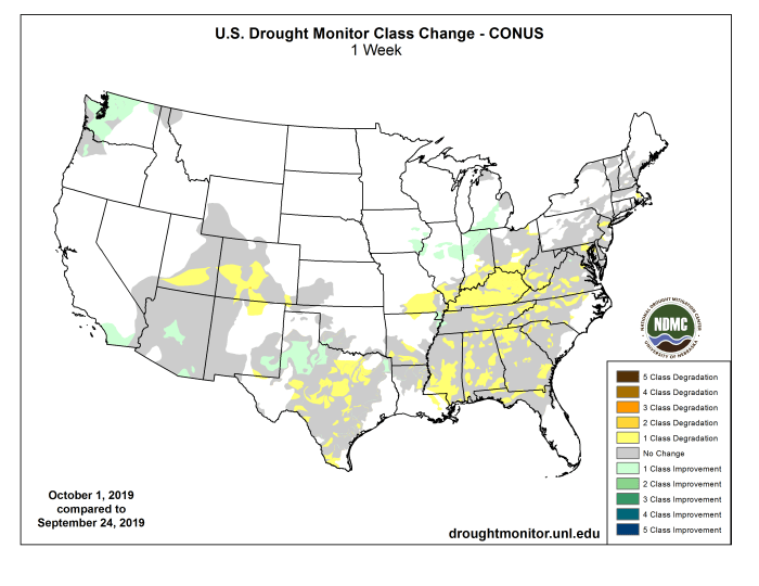
Warmer than normal temperatures dominated the eastern two-thirds of the country, with many areas having temperatures that were 9 to 15 degrees above normal. Cooler than normal temperatures dominated the western portions of the country into the northern Rocky Mountains. Very dry conditions also dominated regions in the southern Plains, southern Midwest and along most of the east coast. The heat and dryness have continued setting the stage for rapidly developing drought, impacting mainly agricultural sectors right now…

High Plains

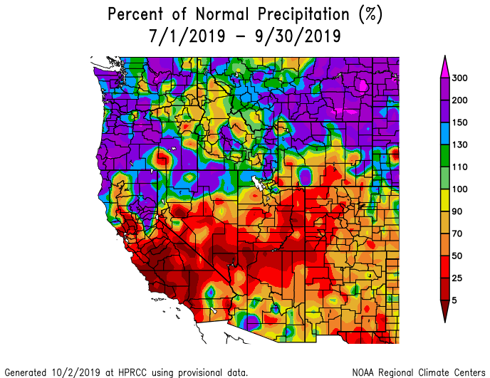
Temperatures were warmest over the southern portion of the area and were actually below normal over the northern. Much of Kansas and Nebraska were 6-12 degrees above normal while North Dakota and portions of northern South Dakota were 3-6 degrees below normal. Precipitation was just as varied over the region with much of North Dakota, eastern Nebraska, and eastern Kansas recording over 200 percent of normal precipitation. Conditions were dry in western Kansas, Colorado, western Nebraska and southeast South Dakota. Some of these areas welcomed the drier weather while dryness and drought are becoming a concern in southwest Kansas and into Colorado. Abnormally dry conditions were expanded over southeast Colorado in response to the recent dryness…

West

An active weather pattern was evident over the West this week with 4 to 5 feet of snow over portions of Montana, rain and snow in the Pacific Northwest, and rains over portions of the southwest. Areas from the Great Basin to the northern Rocky Mountains recorded over 400 percent of normal precipitation, with several feet of snow in portions of Montana. Rain was also observed in areas of southern California, southern Arizona and New Mexico. Improvements were made to the moderate drought in the Pacific Northwest, eliminating it from the region. The long-term dryness is still evident, but the short-term precipitation has allowed for the improvements. Abnormally dry conditions were also improved in western Washington and into western Oregon. In Arizona, the rains allowed for moderate drought to be improved in the central portion of the state and for the removal of abnormally dry conditions in the southeast portion of the state. Abnormally dry conditions were also removed from most of southern California…

South

Warmer than normal temperatures dominated the region, with most areas 6 to 12 degrees warmer than normal for the week. The warmest temperatures were in central Oklahoma to central Texas. Most areas were precipitation free this week with only portions of the Texas panhandle, northern Arkansas, and eastern Oklahoma having recorded significant precipitation. Most of the rain in the Texas panhandle was observed right at the data cutoff for this week with some improvements being made to moderate drought, but the area will be looked at again and drought will be assessed next week. Improvements were made in far northeast Texas in response to recent rains. Degradations were widespread in Texas with several new areas of extreme drought in central to eastern portions of the state and more severe drought being represented in the state. Drought was also expanded in portions of southern Arkansas, northern Louisiana and all of Mississippi…

Looking Ahead

Over the next 5-7 days, precipitation is anticipated to continue over the Midwest, Plains and areas of the Southwest, with the greatest amounts anticipated over Kansas and Missouri. Precipitation tries to work farther south, with areas of Kentucky and Tennessee and West Virginia being at the center of the greatest precipitation totals of 1 to 2 inches. Dry conditions are expected over much of the West as well as from the Mid-Atlantic to Florida. Temperatures during this time are forecast to be above normal over the Southeast and Southwest, with departures of 3 to 6 degrees above normal. Cooler than normal conditions are expected over the Plains and Pacific Northwest with temperatures 3 to 6 degrees below normal.

The 6-10 day outlooks show that the Plains, upper Midwest, and Southwest, including western Alaska, has above-normal chances of observing above-normal temperatures, with the greatest chances over the Southwest and Southeast. The Pacific Northwest and southeast Alaska have above-normal chances of below-normal temperatures. The areas that have the greatest chances of above-normal precipitation during this time are along the east coast, Alaska, and the Pacific Northwest. Much of the Plains, Midwest, South, and Rocky Mountains have the greatest chances of below-normal precipitation.

US Drought Monitor one week change map ending October 1, 2019.

Leaders Of #DCP Effort Take Home #Arizona Forward “Governor’s Award” For Environmental Excellence — @AZwater #ColoradoRiver #COriver #aridification

L to R: Ted Cooke, Grady Gammage, Jr., Tom Buschatzke, and Anni Foster. Photo credit: Arizona Department of Water Resources

From the Arizona Department of Water Resources:

In several respects, the big environmental winner this year in the Southwest has been in the realm of water.

The Rocky Mountains snowpack last winter was deep and cold, resulting in an excellent runoff into the Colorado River system. Likewise, California largely shrugged off its terrible struggle with drought as wave after wave of “atmospheric rivers” delivered deep moisture to the Sierra Nevada.

In terms of water-resource management, meanwhile, the Colorado River Basin States and the Department of the Interior signed the long-sought Drought Contingency Plans on May 20, a huge step forward for Colorado River system management.

Nowhere was the pursuit of a DCP more front and center than in Arizona, the only one of the seven Colorado River states that required legislative authorization to join in signing onto the DCP.

Following more than eight months of debate and negotiation, Arizona’s water-using community turned to the state Legislature, which quickly responded with legislation authorizing Arizona’s standard-bearer – Arizona Department of Water Resources Director Tom Buschatzke – to sign the DCP on the State’s behalf. Governor Ducey signed the authorizing legislation on January 31, the same day lawmakers passed it.

On the evening of September 21, at a black-tie gala at the Arizona Biltmore Resort, all that hard work by Arizona’s water-user community and its elected officials received a great nod of appreciation.

A panel of officials from the lower basin states at the Colorado River Water Users Association in Las Vegas, on Dec. 13, 2018. From left, Thomas Buschatzke, director of the Arizona Department of Water Resources; Ted Cooke, General Manager, Central Arizona Project;Peter Nelson, chairman, Colorado River Board of California; and John Entsminger, General Manager, Southern Nevada Water Authority.

With over 650 people in attendance, Arizona Forward – one of the State’s leaders in promoting quality of life issues and sustainability – presented the Governor’s Award for Arizona’s Future to Arizona’s Drought Contingency Plan Process and the co-chairs of the effort, ADWR’s Director Buschatzke and Ted Cooke, General Manager of the Central Arizona Project.

In accepting his award, Director Buschatzke observed that Arizona’s Drought Contingency Plan process “was one built on collaboration, compromise and consensus and its success was the direct result of the tireless efforts of many in this room.”

He noted, too, that the DCP already was proving its value: “Its focus on stabilizing Lake Mead and creating incentives to “bank” water in the reservoir are already proving that DCP is already a success.”

Stephen Roe Lewis via the Gila River Indian Community.

The evening’s most prestigious award – the President’s Award, the top honor of all of the competition’s 93 submissions – went to the MAR 5 Gila River Indian Community Interpretive Trail.

The spectacular MAR 5 project combined the Tribe’s Managed Aquifer Recharge Site 5 and an interpretive trail that provides the community with a sustainable way to provide water for farming, materials for artisans to carry on their crafts, and educational classes to teach future generations, rejuvenating land that for decades had languished.

“It is an honor to have our Community recognized as a leader in Arizona for innovative water management and sustainability practices, as we are focused on addressing the ongoing drought and climate change,” said Gila River Indian Community Governor Stephen Roe Lewis.

Wet start to water year gives way to dry reality — The Grand Junction Daily Sentinel

From The Grand Junction Daily Sentinel (Dennis Webb):

This week the Colorado Climate Center at Colorado State University recommended expanding the U.S. Drought Monitor drought designation now mostly limited to the far-southwest corner of the state to include generally all of the southern half of western Colorado. The recommendation, expected to be adopted by the Drought Monitor today, would include all of southern Mesa County, where only the far-southwest corner of the county previously had officially gone into drought. It also would take in Delta County and western Gunnison County, which already had moderate drought conditions in its eastern half.

Moderate drought is the mildest of four drought designations. Farther south into the San Juan Mountains, some areas were recommended for possible revision from moderate drought to severe drought, the next step up on the drought scale…

Becky Bolinger, assistant state climatologist at the center, said it appears that most areas of the West Slope will end up at near- to above-average for precipitation for the just-finished water year, meaning the dryout this summer doesn’t show up when looking back at the last 12 months as a whole, even if the recent trend is a concern.

Matthew Aleksa, a meteorologist for the National Weather Service in Grand Junction, said the city ended the 2019 water year with 11.01 inches of precipitation. That ranks 16th-highest in data going back to 1893, and compares to a historical average of 8.74 inches and a record 15.01 inches during the 1929 water year…

Aleksa said the city’s wettest month during the last water year was last October, with 2.76 inches of moisture, followed by March with 2.29 inches. While the city was on a pace earlier this year to have a record water year, July produced only a measly 0.12 inches of rain. August did little better, with just 0.14 inches. And in September 0.26 inches of rain fell, much of that in one storm on Sept. 10. That compares to 1.19 inches in an average September…

Longer term, Bolinger said the federal Climate Prediction Center is showing a slightly above-average chance of precipitation over the next three months. But she said there appears to be a stronger chance of a continued warmer-than-average fall, which can be problematic from a snowpack standpoint.

“It makes it harder for the snow season to begin and when it does start snowing it makes it harder for the snow to stay,” she said.

She said it’s easier to get out of a precipitation deficit that is short-term, as is currently the case, but there’s not a lot of promise in the seasonal forecast of things changing.