Click on a thumbnail graphic below to view a gallery of drought data from the US Drought Monitor.


Click here to go the US Drought Monitor Website. Here’s an excerpt:
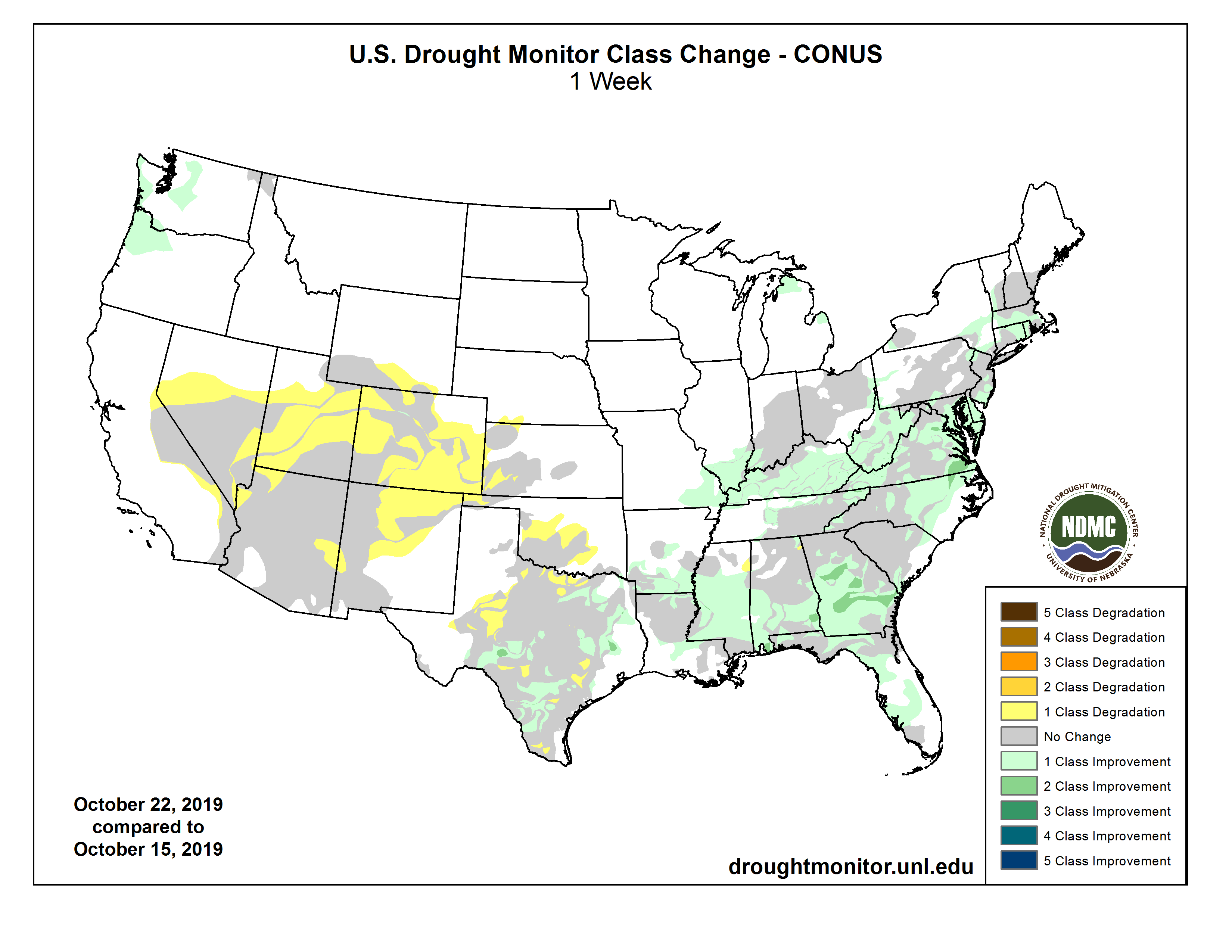
This Week’s Drought Summary
The discussion in the Looking Ahead section is a description of what the official national guidance from the National Weather Service (NWS) National Centers for Environmental Prediction is depicting for current areas of dryness and drought. The utilized NWS forecast products include the WPC 5-day QPF and 5-day Mean Temperature progs, the 6–10 Day Outlooks of Temperature and Precipitation Probability, and the 8–14 Day Outlooks of Temperature and Precipitation Probability – valid as of late Wednesday afternoon of the USDM release week. The NWS forecast Web page used for this section is http://www.cpc.ncep.noaa.gov/products/forecasts/.
This U.S. Drought Monitor (USDM) week began with a low pressure and frontal system draped across the Gulf and East Coasts. Tropical Storm Nestor and its remnants moved across the Southeast then up the East Coast at mid-week. Another front moved across the South and approached the East Coast as the week ended. This combination of synoptic systems dropped several inches of rain across the drought areas of eastern Texas and from the Mississippi River to the East Coast. Meanwhile, several Pacific frontal systems brought precipitation to the Pacific Northwest while the Southwest to southern High Plains continued dry. Drought and abnormal dryness contracted across parts of the Pacific Northwest and southern Plains, and much of the Southeast, Ohio Valley, and Mid-Atlantic to Northeast. Drought and abnormal dryness expanded in the Southwest and parts of the southern and central Plains, as well as northeast Puerto Rico…
One to locally over 2 inches of precipitation fell across the Dakotas, but southern parts of the region were dry. Abnormal dryness and drought expanded in Colorado, Kansas, and Wyoming, and abnormal dryness established a toehold in southwestern Nebraska…
The abnormally dry (D0) areas of western Washington and Oregon received 2 to locally over 5 inches of precipitation this week, which was enough to end the D0 in those areas. But abnormal dryness and drought expanded from New Mexico to Nevada, with D0 inching a little further into eastern California. In southwest Utah, St. George (as of October 17) reported 122 days without measurable precipitation. As noted by the National Weather Service, this breaks the previous record of 121 days set in 1930. The Colorado Climate Center notes that this is only the fourth time since the site started reporting data in the late 19th century that the streak of consecutive rain-free days has topped 100, and not since the 1970s has that happened—until now. The last time St. George reported measurable precipitation was June 17, 2019…
Drought and abnormal dryness expanded across parts of Texas and Oklahoma where precipitation deficits continued to mount. But other parts of Texas, and parts of Arkansas, Louisiana, Mississippi, and Tennessee experienced a reduction of drought and abnormal dryness…
Looking Ahead
For October 24-29, another low pressure/frontal system will spread heavy precipitation across eastern Texas and Oklahoma, and the Lower Mississippi Valley to southern New England, with 2 or more inches expected across much of this area. Half an inch to 2 inches can be expected from this band to the East Coast, except parts of northern Florida to coastal South Carolina which likely will receive less than half an inch of rain. Up to an inch of precipitation is forecast along the Rocky Mountain Chain and in parts of the Washington coastal range. Otherwise, little to no precipitation is in the forecast for the rest of the West, the central to northern Plains, and western Great Lakes. Below-normal temperatures are predicted for the central contiguous U.S. (CONUS) and warmer-than-normal temperatures for the East and West coasts. For October 29-November 2, a huge trough in the upper atmosphere will continue to funnel cold air into the central part of the country, resulting in below-normal temperatures for most of the CONUS. Odds favor above-normal temperatures only along the East Coast and parts of northern California, as well as all of Alaska. Above-normal precipitation is favored across most of Alaska and across the CONUS mostly east of the Mississippi River, while below-normal precipitation is expected from the Rockies to the West Coast as well as the southern High Plains.