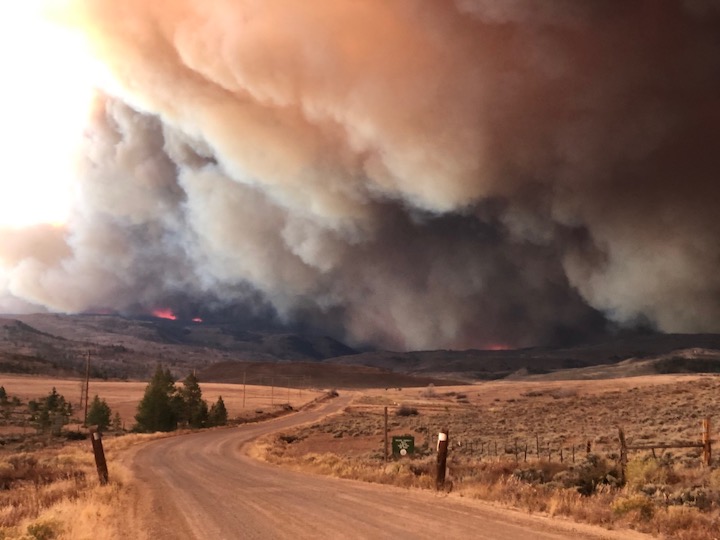
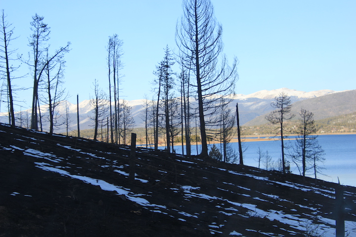
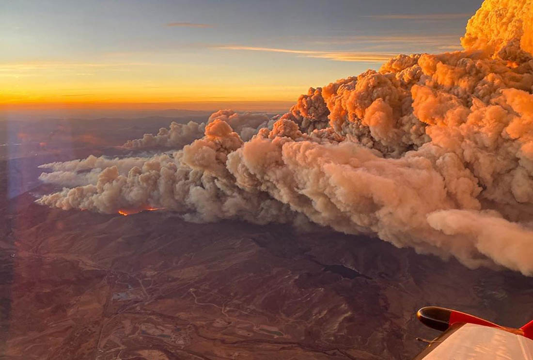
A view from the highway of the massive East Troublesome wildfire smoke cloud near Rocky Mountain National Park in Colorado on October 16, 2020. As of November 4, 2020, the wildfire has consumed more than 193,000 acres of land a was only 37% contained. Photo credit: Inciweb
Extreme weather events took the spotlight again in October as the nation saw raging wildfires, record hurricane activity and record snowfall in some parts.
Temperature and precipitation, however, ranked very close to average across the contiguous U.S. last month.
Here are more highlights from NOAA’s latest monthly U.S. climate report:
Climate by the numbers
October 2020 | Temperature and precipitation
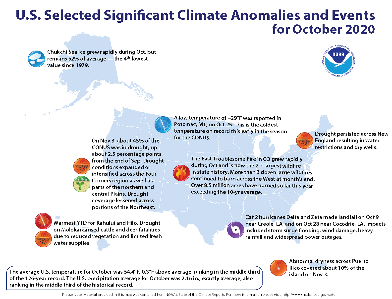
The average October temperature across the contiguous U.S. was 54.4 degrees F, 0.3 of a degree above the 20th-century average and placed the month in the middle third of the climate record.
Some state standouts include California, which had its hottest October on record, as well as Arizona and Florida where each ranked third hottest. The coldest temperatures covered much of the northern Rockies, Great Plains and the Great Lakes.
The average precipitation last month was 2.16 inches — exactly average. This placed October in the middle third of the historical record.
Some places, however, were quite dry. Below-average precipitation fell across much of the Western U.S., the Deep South, central and northern Plains as well as across portions of the Southeast. California had its second driest October on record.
Year to date | January through October 2020An annotated map of the United States showing notable climate and weather events that occurred across the country during October 2020. For text details, please visit http://bit.ly/USClimate202010.
The average contiguous U.S. temperature for the year to date (YTD) was 57.0 degrees F, 2.1 degrees above the 20th-century average. This tied 2006 as the seventh-warmest YTD on record.
Arizona, Florida and New Mexico ranked as warmest on record for this 10-month period, while there were no notable regions reporting below-average temperatures.
The YTD U.S. precipitation total was 26.30 inches, 0.94 of an inch above average, and ranked in the wettest third of the record. So far this year, Tennessee has had its wettest YTD; North Carolina, its second wettest.
An annotated map of the United States showing notable climate and weather events that occurred across the country during October 2020. For text details, please visit http://bit.ly/USClimate202010.
More notable climate events in October
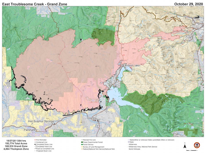
Record wildfires scorched the West: Colorado had its three-largest wildfires in state history last month — the Cameron Peak, Pine Gulch and East Troublesome fires. In particular, the East Troublesome fire spread rapidly to more than 193,000 acres. Wildfires also grew explosively in California, with nearly 100,000 Orange County residents evacuating as the Silverado and Blue Ridge fires burned.
Historic tropical activity in the Atlantic: Through October 31, 11 named Atlantic tropical cyclones have made landfall in the U.S. this hurricane season, breaking the previous record of nine landfalls in 1916. In October alone, Hurricanes Delta and Zeta both struck Louisiana just a few weeks apart.
Record snowfall in some places: Heavy snow was reported across parts of the West and Plains last month. It was the snowiest October on record for many places, including: Great Falls, Montana (28.0 inches); Minneapolis-St. Paul (9.3 inches) and St. Cloud, Minnesota (7.2 inches); Spokane, Washington (7.5 inches); Albuquerque, New Mexico (4.2 inches); Amarillo, Texas (7.4 inches); and Wichita, Kansas (1.6 inches).
Click through to read the whole interview from David Marchese. Here’s an excerpt:
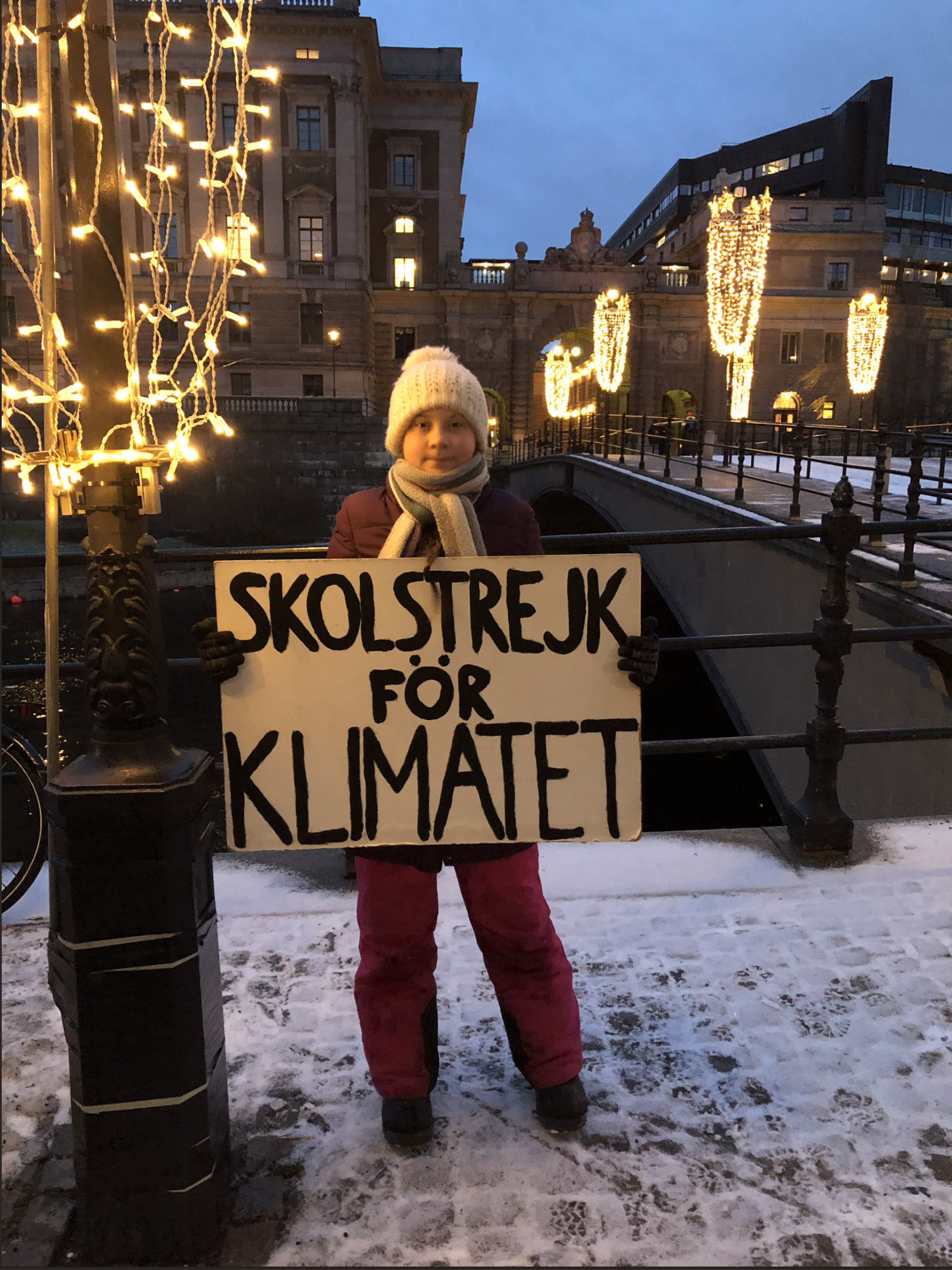
Greta Thunberg has become so firmly entrenched as an icon — perhaps the icon — of ecological activism that it’s hard to believe it has been only two years since she first went on school strike to draw attention to the climate crisis. In that short time, Thunberg, a 17-year-old Swede, has become a figure of international standing, able to meet with sympathetic world leaders and rattle the unsympathetic. Her compelling clarity about the scale of the crisis and moral indignation at the inadequate political response have been hugely influential in shifting public opinion. An estimated four million people participated in the September 2019 global climate strikes that she helped inspire. “There’s this false image that I’m an angry, depressed teenager,” says Thunberg, whose rapid rise is the subject of “I Am Greta,” a new documentary on Hulu. “But why would I be depressed when I’m trying to do my best to change things?”
What do you see as the stakes for the U.S. presidential election? Is it a make-or-break ecological choice? We can’t predict what will happen. Maybe if Trump wins that will be the spark that makes people angry enough to start protesting and really demanding things for the climate crisis. I think we can safely say that if Trump wins it would threaten many things. But I’m not saying that Joe Biden is good or his policies are close to being enough. They are not…
I definitely understand that on some level it’s ridiculous to ask a 17-year-old about complicated geopolitical problems, but by the same token, you’re not 10 and you are a leader. Is there an age at which you would consider it reasonable for people to expect that you have ideas about solutions? Right now, I spend I don’t know how much of my time reading and trying to learn, but that doesn’t mean I’m an expert. So I choose to hand over that debate to those who know more than I do. I know maybe more about communicating, so that’s what I’m going to stick to, where I can be most helpful. The mainstream communication strategy for the last decades has been positivity and spreading inspiration to motivate people to act. Like: “Things are bad, but we can change. Just switch your light bulb.” You always had to be positive, even though it was false hope. We still need to communicate the positive things, but above that we need to communicate reality. In order to be able to change things we need to understand where we are at. We can’t spread false hope. That’s practically not a very wise thing to do. Also, it’s morally wrong that people are building on false hope. So I’ve tried to communicate the climate crisis as it is.
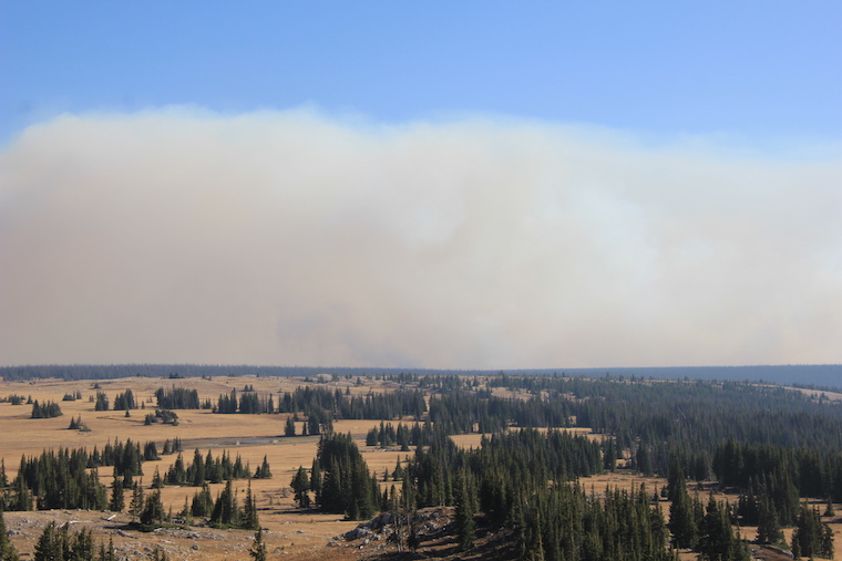
Firefighters on the march: The Pine Gulch Fire, smoke of which shown here, was started by a lighting strike on July 31, 2020, approximately 18 miles north of Grand Junction, Colorado. According to InciWeb, as of August 27 2020, the Pine Gulch Fire became the largest wildfire in Colorado State history, surpassing Hayman Fire that burned near Colorado Springs in the summer of 2002. Photo credit: Bureau of Land Mangement-Colorado, via InciWeb and National Interagency Fire Center.
East Troublesome Fire October 21, 2020 via Wildfire Today.
Scenes of the CalWood Oct. 17, 2020 (Jivan West/CU Independent)
The Cameron Peak fire soon after it started on Aug. 13, 2020. By Sept. 11, the fire had grown to more than 102,000 acres (now >200,000 acres) and was not expected to be considered out until Oct. 31. Photo credit: InciWeb via The Colorado Sun
A COVID-19 test in Utah. The country’s pandemic response has been politicized, making comprehensive changes to public health more difficult. AP Photo/Rick Bowmer
Much has been written about the U.S. coronavirus response. Media accounts frequently turn to experts for their insights – commonly, epidemiologists or physicians. Countless surveys have also queried Americans and individuals from around the world about how the pandemic has affected them and their attitudes and opinions.
Yet little is known about the views of a group of people particularly well qualified to render judgment on the U.S.‘s response and offer policy solutions: academic health policy and politics researchers. These researchers, like the two of us, come from a diverse set of disciplines, including public health and public policy. Their research focuses on the intricate linkages between politics, the U.S. health system and health policy. They are trained to combine applied and academic knowledge, take broader views and be fluent across multiple disciplines.
To explore this scholarly community’s opinions and perceptions, we surveyed hundreds of U.S.-based researchers, first in April 2020 and then again in September. Specifically, we asked them about the U.S. COVID-19 response, the upcoming elections and the long-term implications of the pandemic and response for the future of U.S. health policy and the broader political system.
Overall, the results of our survey – with 400 responses, which have been published in full in our recent academic article – paint a picture of a damaged reputation to government institutions. Surveyed scholars also believe the poor government response will shift the politics of health care. At the same time, our findings don’t show strong belief in major policy changes on health.
Parceling out the blame
We first asked respondents how much responsibility various actors bear for the lack of preparedness in the U.S. Here scholars overwhelming assign blame to one source: 93% of respondents blamed President Trump for the overall lack of preparedness “a lot” or “a great deal.” Moreover, 94% in April and 98% in September saw political motivations as the main drivers of the president’s actions.
The Centers for Disease Control and Prevention and the Food and Drug Administration, as well as Congress, also deserve a significant amount of blame, survey respondents said. At the other end of the spectrum, scholars were relatively content with the response by local and state governments as well as that of the World Health Organization.
Insufficient testing was one of the first major problems the U.S. confronted in the pandemic. AP Photo/Mark J. Terrill
Notably, perceptions grew significantly more negative for all entities between April and September. This likely reflects frustrations with the continued inability to rein in the spread of the virus.
Effects on the political system and health policy
Respondents also offered a particularly grim view of the long-term implications of the failed coronavirus response for the United States.
Survey after survey has shown that partisanship influences individuals’ perceptions of the coronavirus pandemic. Early research indicates that right-leaning media and presidential communication may have significantly contributed to these discrepancies and increased polarization.
And according to scholars in our study, these stirred-up partisan differences may lead to increases in distrust in government, a lack of faith in political institutions and even further growth in political polarization in the long term.
Overall, scholars were generally skeptical about any major progressive changes like the adoption of universal health care, paid sick leave, or basic income in the aftermath of the pandemic. At the same time, they also do not expect popular conservative changes like the privatization of Medicare or block grant Medicaid, which restricts expenditures from the federal government to states to a set lump sum.
Once more, hyperpartisanship, combined with the cumbersome political process, is seen as the major culprit here.
There is one major exception: adoption of a federal public option, a government-run health plan to compete with private insurers. Here, more than 60% of scholars initially thought that adoption would be somewhat or very likely in the next five years; however, this number dropped to 50% by September. This expectation appears to be driven by the expectation of a Biden presidency.
Two-thirds of respondents expected public health, health infrastructure, and pandemic preparedness to take on more prominent roles going forward. Just under half expected a larger focus on inequalities and inequities. Yet, with major reforms unlikely, scholars are generally skeptical about much progress on the issues.
Looking Ahead
There is ampleevidence that the U.S. has fared significantly worse than its peers in handling the coronavirus pandemic.
In our view, no matter the outcome of the elections, the impacts of the failed coronavirus response will likely reverberate through the U.S. political system for decades. Much rebuilding will need to be done.
The long-term forecast for Colorado doesn’t look good, but experts say context is necessary
November in Colorado is usually a time for hyping up the winter powder season, speculating on how many snow days students will get and generally looking forward to flaky, fluffy precipitation.
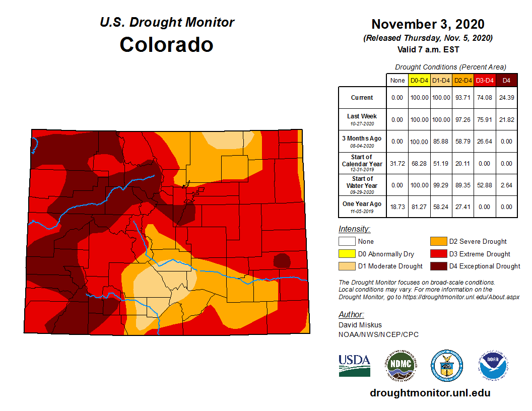
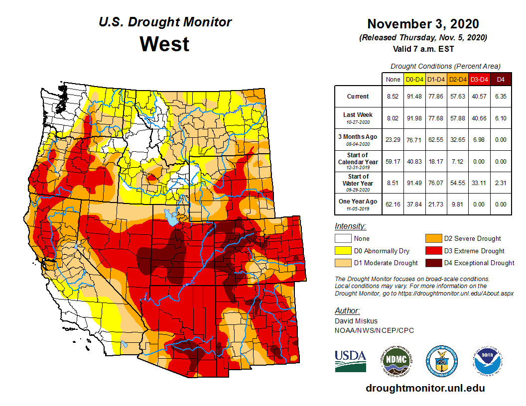
But with almost 25% of the state classified in “exceptional” drought status, as of the latest drought monitor report released Thursday, and little reprieve on the horizon, snow enthusiasts might not want to get their hopes up just yet.
Colorado Drought Monitor November 3, 2020.
There is a nugget of good news in this week’s report: The snowstorm a couple weeks ago meant the drought status for some of southern Colorado shifted to “severe” from “extreme,” or to “moderate” from “severe.”
Still, Colorado has been completely in drought, to varying degrees, since mid-October. The state has had at least some drought since August of 2019, and this November is starting out worse compared to last year. Lackluster snowfall last winter coupled with this summer’s below-average rain have been some of the main factors…
…the drought monitor report isn’t the end-all document for how the state’s climate is doing. Peter Goble, a service climatologist with the Colorado Climate Center, cautioned against assuming too much from any one weekly report.
This is especially true for November. By fall, the most water-intensive operations of the year — namely, irrigating crops — are finished, and a dry winter won’t have the same detrimental impacts as summer drought. As a result, this month is a sort of “wait and see” season for Colorado, as Goble called it, as it’s still too early to tell what the winter will bring.
The analysis also doesn’t factor in seasonality, especially on regional scales, so future reports may show improvement compared to this week. But the general drought trend — and its long-term impacts, such as dry soils and vegetation — will likely continue until there’s significant precipitation.
Historically, “exceptional” drought — the worst category — is supposed to indicate drought conditions so severe that they occur no more frequently than once every 50 years. The last time a drought was this pervasive across the state was in the summer of 2013, but that was followed by record-breaking floods in September that devastated many communities, especially on the Front Range.
“Of course, that’s not really the way you want to come out of a drought either,” Goble said.
Weather predictions for the next few months in Colorado are not optimistic, to put it lightly — Colorado is forecast to continue its drought-heavy status — but Goble said it’s hard to see much further out than a year. And even forecasts for this winter might not hold true. The region is currently in a La Niña year, and in Colorado, that has tended to correlate with a drier-than-normal winter.
But with climate change making weather patterns more unpredictable, this year may not follow history’s footsteps.
Western Slope voters have overwhelmingly passed a proposal by the Colorado River Water Conservation District to raise property taxes across its 15-county region.
According to preliminary results as of 10:45 p.m. Tuesday, encompassing about 246,245 ballots, about 72% of voters said yes to the measure. Saguache County was the lone county to vote against the measure.
Pitkin County voters passed ballot question 7A with 80% in favor, despite three of five county commissioners and Pitkin County’s representative to the River District board John Ely opposing the measure. Nearly 69% of voters in Mesa County, which has the largest population base in the district, supported the measure.
The River District announced that the measure had received voter approval in a news release at 7:55 p.m. Tuesday, saying the organization is ready to get to work implementing water projects across the district.
River District general manager Andy Mueller said the results prove that water is the one issue that can unite voters in western Colorado.
“It was the one issue that’s not partisan, that was about uniting a very politically diverse region,” he said. “Everybody is so sick of the nasty, divisive, partisan politics. People with (Donald) Trump signs and (Joe) Biden signs voted for the same thing.”
Ballot measure 7A raises property taxes by a half-mill, or an extra $1.90 per year for every $100,000 of residential home value. The measure will raise nearly an additional $5 million annually for the River District, which says it will use the money for fighting to keep water on the Western Slope, protecting water supplies for Western Slope farmers and ranchers, protecting drinking water for Western Slope communities, and protecting fish, wildlife and recreation.
According to numbers provided by the River District, the mill levy will increase to $40.28 from $18.93 annually for Pitkin County’s median home value, which at $1.13 million is the highest in the district. In Eagle County, where the median home value is $660,979, the mill levy will increase to $23.63 from $11.11 annually.
Property owners can expect to see the mill-levy increase on their 2021 tax bill.
The proposal received wide support among county commissioners, agricultural organizations and environmental groups.
Eagle County Commissioner and River District board member Kathy Chandler-Henry, who also served as vice-chair of the political action committee Yes on 7A, said it would have been nearly impossible for the River District to protect Western Slope water without the tax increase.
“I’m glad people throughout the district saw the value in that, even though it’s a tough time to be asking for a tax increase,” she said. “I think that’s a huge win and a huge vote of confidence in the work the River District’s been doing.”
The River District, based in Glenwood Springs and created by the state legislature in 1937 to develop and protect water supplies in western Colorado, spans Grand, Summit, Eagle, Pitkin, Gunnison, Garfield, Rio Blanco, Routt, Moffat, Mesa, Delta, Montrose, Ouray, Hinsdale and Saguache counties.
The River District’s fiscal implementation plan for the revenue that would be raised by the tax hike says 86% would go toward funding water projects backed by roundtables and local communities. Those projects would fall into five categories: productive agriculture; infrastructure; healthy rivers; watershed health and water quality; and conservation and efficiency.
This story ran in The Aspen Times, the Glenwood Springs Post Independent, the Summit Daily News, the Vail Daily, the Steamboat Pilot and Today and the Sky-Hi News.
The Colorado River Water Conservation District spans 15 Western Slope counties. River District directors are asking voters this fall to raise the mill levy.
FromThe Grand Junction Daily Sentinel (Dennis Webb):
A 2007 deal creating guidelines governing how Lake Powell and Lake Mead are operated in coordination isn’t scheduled to expire until 2026. But water officials in Colorado River Basin states are already beginning to talk about the renegotiations that will be undertaken to decide what succeeds the 2007 criteria.
“I think the guidelines have been a big success,” John Entsminger, general manager of the Southern Nevada Water Authority, said Wednesday during the 10th annual Upper Colorado River Basin Water Forum. The forum is put on by Colorado Mesa University’s Ruth Powell Hutchins Water Center and this year is taking place online due to the pandemic.
The 2007 criteria dictate how much water must be released each year from Powell into Mead, in an effort to equalize water levels in the two reservoirs. The criteria are important to Colorado and other states in the Upper Colorado River Basin because those states rely on Powell water storage for meeting long-term delivery obligations to downstream states based on a 1922 interstate compact.
Amy Haas, executive director of the Upper Colorado River Commission, which represents Upper Basin states, said she thinks the 2007 guidelines have reduced the “safe yield” of water for the Upper Basin. Even with low inflows into Powell, the guidelines resulted in releases of 9 million acre-feet a year of water from Powell every year from 2015-19, compared to the 8.3 million acre-feet negotiated average minimum objective, she said.
Entsminger called that a simplistic analysis that cherry-picks data. He says his entity’s modeling indicates that under the 2007 criteria there is more water in Powell and less in Mead than otherwise would have been the case.
Tom Buschatzke, director of the Arizona Department of Water Resources, said that with the guidelines in places, Powell water levels largely have remained around 50% of capacity “through some horrendously dry years” and only three or four years of above-average inflows.
The criteria encourage water conservation and provide rules for determining water shortages and reducing water use by Arizona and Nevada.
Entsminger said the 2007 agreement increased cooperation and communication among states in the river basin, provided certainty by operating the two reservoirs together, and headed off litigation only two years after states were close to going to the Supreme Court over river water issues…
Those states are evaluating the possibility of demand management measures to temporarily curtail agricultural, municipal and other use during droughts. The goal is to bolster Powell levels with water that could be reserved for compact delivery obligations. But Haas said it’s important to assess the risk of curtailment of Upper Basin uses occurring as well. Such a curtailment has never happened.
The “bathtub ring” at Lake Powell evidences lower flows coming into the reservoir. Federal officials are making emergency releases from upper basin reservoirs to prop up levels and Lake Powell and preserve the ability to make hydroelectric power. CREDIT: BRENT GARDNER-SMITH/ASPEN JOURNALISM
The white bathtub ring along Lake Mead reflects the effects of years of drought in the Colorado River Basin. Source: Water Education Foundation
Between the lack of moisture this spring, summer and fall, rising temperatures and a heads-up statewide wildfire season, the Gunnison Valley continues to feel the severe effects of drought as we head into what’s expected to be a warmer than average winter season.
According to the United States Drought Monitor’s latest update…every region of Colorado is currently in at least moderate drought, with more than 21 percent of the state in the most severe “exceptional” category. The last time the entire state of Colorado had been in drought was July 2013. Most of Gunnison County is one level below, in “extreme” drought, with the northwestern tip in the “exceptional” category.
West Drought Monitor November 3, 2020.
Water levels
Water availability is a growing concern as we experience less and less precipitation and rising temps. Due to such dry soil moisture conditions and early warm temperatures this past spring, last winter’s average snowpack dried up very quickly and the water supply in Gunnison County “was literally disappearing before our very eyes,” said Sonja Chavez, general manager for the Upper Gunnison River Water Conservancy District (UGRWCD).
According to Chavez, peak water flows occurred about two weeks early and quickly fell. Blue Mesa’s projected max fill capacity this summer was approximately 604,000 acre-feet, only about 72 percent of maximum capacity. The Taylor Reservoir’s highest fill this summer was about 80,000 acre-feet, only about 75 percent to 80 percent full.
“We knew things were really dry and we knew we weren’t going to have a lot of water, and were likely going to have a deficit at the end of the year,” said Chavez. So the UGRWCD, in partnership with the Taylor Local Users Group (TLUG), made the decision to forego typical fall water releases from Taylor Reservoir in order to provide enough water for water users this summer.
This, said Chavez, meant agricultural water users would finish their only hay crop of the season, forego any potential second cut and not put fall water on their fields. “Upper Gunnison users had to go into their irrigation season having less water available to them,” said Chavez, which will then affect their crop supply. Bill Trampe of the Colorado River District estimates that hay crops around Gunnison were at 50 percent to 60 percent of normal.
The water adjustments were also intended to let recreational water users make the most of a limited seasonal water supply. But the lower water levels limited the boating season, impacted water temperatures in the fisheries and ended up funneling anglers to certain segments of the rivers. This then put more pressure and impact on those river sections experiencing higher concentrations of people…
Winter forecast
Even though Colorado already experienced a couple of early wet snow storms this fall, bringing a little moisture to our soils and helping to tame the wildfires, Chavez said the combination of warm weather in between storms and already dry soils are not reassuring looking ahead to 2021. “The soils are like a sponge,” she said. “If the soils are wet going into winter and the water freezes and stays there, the soils will melt come spring and help get the crops going. But if you don’t have that and you go into the next season dry, it’s much harder to fill that crop.”
[…]
The National Oceanic and Atmospheric Administration’s (NOAA) annual winter outlook calls for a drier-than-average and warmer than average winter season in Colorado, especially for the southern half of the state. This, according to the Rocky Mountain Biological Laboratory (RMBL), will likely lead to an escalation of the drought we are experiencing.
Researchers from OU and the University of Colorado at Boulder are working together by using drones to study how storms form in coastal urban areas to help improve weather forecasting.
This team of researchers wants to better understand how storms form through the relationship between atmospheric circulations, according to an OU press release. Atmospheric circulations are the winds driven by changes in temperature and pressure, and particles in the air, known as aerosols, and convection.
“By deploying a fleet of remotely piloted aircraft systems in the Houston, Texas, area, we will gain valuable insight to improve the ability for computers to predict how and why storms will form so that meteorologists can provide better warnings in advance of dangerous hail, flash flooding or high winds,” Liz Pillar-Little, OU’s Center for Autonomous Sensing and Sampling assistant director and College of Atmospheric and Geographic Sciences research scientist, said in the release.
The release reads Houston is an excellent location to study these processes due to the interactions between different air masses, which have been observed previously to induce or enhance storm formation.
In the release, Pillar-Little said “mid-latitude” storm systems can produce severe storms with flooding, strong wind and lightning. The physics behind this is hard to represent in models, she said.
“Like a pot of water coming to boil, convection is the transfer of heat from a warmer area to a cooler one,” Pillar-Little said in the release. “The combination of these atmospheric circulations and aerosols in coastal urban environments, like Houston, can drive convective processes by which big storms are created.”
The team involved in this study includes researchers from OU’s CASS, along with scientists from the Cooperative Institute for Research in Environmental Sciences at the University of Colorado Boulder and the Integrated Remote and In-Situ Sensing Laboratory, according to the release.
As wildfires, avalanches and drought increase in intensity, worried city managers are planning and budgeting for better water systems and backup sources.
Communities across Colorado are…problems linked to a changing climate, from forest fires to drought. They are also already spending money on solutions to address them.
It cost Summit County nearly $88,000 to dig out from under historic avalanches in 2019 and in Carbondale the year before, low stream flows imperiled the town’s water supply spurring a $600,000 water system upgrade.
“The impacts are very real and lived and are concretely affecting communities,” said Jacob Smith, executive director of Colorado Communities for Climate Action, a coalition of 34 local governments promoting state climate policies…
At the moment, Colorado finds itself grappling with its worst wildfire season ever. Hundreds of thousands of acres burned in eight significant fires this fall, including the three largest on record, as all of the state drifted into drought status for the first time since 2013…
Colorado Drought Monitor November 3, 2020.
Over the past few decades, forest fires have been more frequent and larger in a hotter, drier West. This year’s unparalleled wildfire season Colorado coincided with the state’s warmest August on record.
Studies have shown that average summer temperatures in Colorado have risen by more than 2.5 degrees Fahrenheit since 1986. The growing heat creates drier soils, lower snowpack, earlier thaws, lower stream flows.
All those add up to increased risk of wildfires and, according to one study, added 26 days to the average fire season in the West between 1979 and 2015, a 41% increase.
There are serious risks when wildfires fires damage or destroy the watersheds towns and cities rely upon for their drinking water.
“Burned watersheds are prone to increased flooding and erosion, which can impair water-supply reservoirs, water quality, and drinking-water treatment processes,” according to the U.S. Geological Service.
The 2010 Fourmile Canyon fire, for example, burned just 23% of the watershed near Boulder, still a USGS study found that after severe thunderstorms the water heading to the city’s water treatment plant was laden with mud, nutrients and metals – some at levels four times normal.
After the High Park fire burned more than 87,000 acres in Larimer County in 2012, the Poudre River ran black after heavy rains and choked the intake pipes of Fort Collins’ water treatment plant. The water smelled and tasted like smoke.
The city now has sensors in 10 locations in the Upper Poudre to alert the treatment plan if there is a water quality problem and Fort Collins Utilities runs an average of 110 lab tests a day on its water.
Fort Collins is now “very concerned” about the Cameron Peak fire, the state’s largest fire ever, burning west of the city, Gretchen Stanford, a utility spokeswoman, said in an email…
Horsetooth Reservoir is out of commission for upgrades, leaving it only with Poudre River water. Stanford said processes are in place to deal with any water quality, odor or taste problems.
And the effects of these fires can last for years. Five years after the 2002 Hayman Fire, Denver Water was still dealing with water quality problems created by the wildfire, including a $30 million project to remove tons of sediment from the Strontia Springs Reservoir…
A warming world will create drier soils, more evaporation and more water sucked up by plants and all that led to lower stream flows, according to several scientific studies.
“There is no question that climate change is affecting stream flow,” said Brad Udall, a senior researcher at Colorado State University’s Colorado Water Institute.
Heat, not a lack of precipitation, was the key driver in a 20% decline in Colorado River flow between 2000 and 2014, compared to 20th century averages, and if the current trends continue, it will decline another 20% by 2050, according to a study co-authored by Udall.
Since 2000, the Roaring Fork’s streamflow has been about 13% lower than the 20th century average, according to a study done for Carbondale by the Western Water Assessment, an affiliate of the University of Colorado.
The study found that while there was no appreciable change in the average snow and rainfall the average temperature for the area increased 2.2 degrees Fahrenheit above the 20th century average.
That trend is projected to continue. “All climate models indicate that the climate of the Roaring Fork Valley will continue to warm well into the 21st century. Under the lower-emissions scenario, by 2050, average temperatures are projected to be 3-5°F warmer than the late-20th century average,” the study said…
The Carbondale and Glenwood Springs water projects are a sign of things to come. “What people are looking for now is redundancy, multiple sources of water supply,” Udall said. “One source, one pipeline has become a risk. It’s like betting on one stock.”
It is not only low stream flows but the timing of those flows that are presenting problems for some communities, such as Northglenn.
“Climate change isn’t going to impact Northglenn from a quantity perspective, but from a timing perspective,” said Tamara Moon, the city’s environmental manager. “The city has water rights that come into priority in the fall and rights in late May and early June. A concern is we may not have the availability of water in the fall that we have now.”
Northglenn’s worries are prompted by three trends associated with climate change: lower snowpack, earlier thaws and hotter summers. They could add up to less water in the fall.
One study led by John Abatzoglou, a University of Idaho geography professor, used 20 different climate models and federal data on snowpack to assess potential changes and projected a 5% to 20% decline in snow levels in the central and southern Rockies by 2050.
The snow season will also shorten, with more precipitation coming as rain instead of snow and earlier thaws of the snowpack, according to the study. All this could change the timing and availability of water supplies creating a need for alternative supplies or more storage.
“It is entirely possible if the runoff is early, we may not get our full quantity,” Moon said, “and in dry years we may not get the fall water.”
This scenario has Northglenn looking for ways to capture and store more water during the spring.
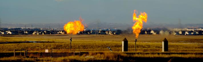
Natural gas flares near a community in Colorado. Colorado health officials and some legislators agree that better monitoring is necessary. Photo credit the Environmental Defense Fund.
The Colorado Oil and Gas Conservation Commission also gave initial approval to a rule requiring companies and regulators to assess the cumulative impacts of oil and gas development locally and on a broader scale. The COGCC and other state agencies will evaluate the ongoing effects on air and water quality, greenhouse gas emissions and provide reports.
The rules, up for a final vote Nov. 20, are part of the implementation of Senate Bill 181, a 2019 law mandating that oil and gas be regulated in a way that protects public health, safety and the environment.
The provisions on flaring and venting prohibit routine releases of natural gas from oil and gas equipment. Alaska is the only other state that bans the releases, said Dan Grossman, the regional director of the Environmental Defense Fund…
Efforts to prevent the flaring and venting of natural gas from wells have taken on urgency as the impacts of climate change have intensified. Methane, the main component of natural gas, is a potent greenhouse gas and is 84 times more effective than carbon dioxide at trapping heat over the short term.
Flaring and venting also emit nitrogen dioxide and volatile organic compounds, which contribute to ground-level ozone pollution…
The World Bank says four countries — Russia, Iran, Iraq and the U.S. — are responsible for nearly half of the gas flaring worldwide. Flaring in the U.S. rose 48% from 2017 to 2018, according to the World Bank. Activity in North Dakota’s Bakken oil and field and the Permian Basin in southeastern New Mexico and Texas accounted for the overwhelming majority of the flaring, according to the U.S. Energy Information Administration.
In Colorado, companies must submit a form seeking permission to vent and flare and must regularly report the volumes of gas.
Under the new rules, companies will have to ship the gas in a pipeline or put it to some kind of beneficial use, such as generating energy. Operators can seek approval of flaring or venting gas under certain conditions and must notify regulators.
Companies will have a year to submit plans to bring existing sites into compliance. Environmental and community groups argued that a six-month grace period was long enough because the COGCC made it clear a year ago that the change was likely.
The industry argued for consistency between the COGCC and the Air Quality Control Commission, which also regulates oil and gas, said Carrie Hackenberger, associate director of the American Petroleum Institute-Colorado. She said after discussions and input from the various parties, the industry “is largely OK with where the rules ended up.”
[…]
Most of Colorado’s oil- and gas-producing areas have pipelines and other infrastructure to transport natural gas. One exception is Jackson County in northern Colorado, where drilling has grown the past few years.
Barbara Vasquez has lived in Jackson County since 2005. She said the amount of natural gas being flared has substantially increased. Large combustion units are used to flare the gas.
Click on a thumbnail graphic to view a gallery of drought data from the US Drought Monitor.
US Drought Monitor November 3, 2020.
West Drought Monitor November 3, 2020.
Colorado Drought Monitor November 3, 2020.
Click here to go to the US Drought Monitor website. Here’s an excerpt:
This Week’s Drought Summary
Hurricane Zeta made landfall near Cocodrie in southeastern Louisiana during the late afternoon on Wednesday, October 28, as a Category 2 hurricane with sustained winds estimate at 110 mph. With a fast northeastern track that took it off the mid-Atlantic Coast in about 24 hours, the rapid pace limited rainfall totals along its track to between 2 and 4 inches, with locally heavier amounts in southern Mississippi and Alabama of up to 8 inches. Unfortunately, the fast pace delayed the weakening of Zeta’s winds, and widespread wind damage and power outages occurred along Zeta’s path, even into the mid-Atlantic. In addition as the period started, an upper-air low over the southern Rockies slowly tracked eastward, becoming infused with tropical moisture from Zeta and the Gulf of Mexico. It dumped 1.5 to 3.5 inches of precipitation, locally to 5 inches, from the western Oklahoma and northern Texas Panhandles eastward across northern Oklahoma and southern Kansas, southern Missouri and northern Arkansas, and into the Ohio and Tennessee Valleys. Although the precipitation was very beneficial to the winter wheat crop and pastures, some of the precipitation fell in the form of snow and freezing rain in western Texas, Oklahoma, and Kansas, causing damage. Once the upper-air low and Zeta cleared the East Coast, much drier and colder air rushed into the Northeast and Southeast, with light snow accumulating across parts of western New England and upstate New York. Elsewhere, little or no precipitation occurred in the Far West, Southwest, Rockies, southern and northern Plains, and upper Midwest. Subnormal weekly temperatures enveloped the Midwest, southern and central Plains, and Northeast, while the West, Rockies, and Southeast experienced near to above-normal readings. Welcome showers fell across most of Puerto Rico while drought expanded across portions of Hawaii’s Big Island…
With much of the region cold and dry this week, status-quo was the norm for most states that either received precipitation 2 weeks ago (Wyoming, Montana, the Dakotas), or deteriorations were made (North Dakota). Unfortunately, southern Nebraska and northern Kansas missed out on precipitation during late October, thus some degradations were made there. With short-term (out to 90-days) SPIs much drier than D1, and 90-day precipitation less than half of normal – producing 4-6 inch deficits – D1 was extended across northern Kansas and into southeastern Nebraska. D2 was slightly expanded into northwestern Kansas and southwestern and northeastern Nebraska. Wetter conditions at 4-months limited the deteriorations made this week, along with a dry climatology during October and November. In contrast, the upper-air low that trekked from the southern Rockies to the mid-Atlantic and became infused with Gulf moisture courtesy of Hurricane Zeta dumped welcome and heavy precipitation (1-4 inches) across southern Kansas, effectively allowing a 1-category improvement across the southern third of the state. The middle third of Kansas remained unchanged…
Dry weather prevailed across the entire West, with only light precipitation (less than 2 inches) reported in western Washington and the extreme northern Cascades. Temperatures gradually increased during the week, with most locations averaging at or above-normal weekly anomalies. With beneficial precipitation falling the previous week (Oct. 21-27) across the Northwest and Rockies, no deteriorations were made this week where precipitation fell in late October. However, with two consecutive weeks of no precipitation, the wet season that should be in full swing by now, and lingering long-term impacts, some slight deterioration was made in Oregon (D2 and D3 expansions) and southwestern Idaho (Elmore County to D1). In northern Colorado, D4 was expanded into northern Routt and northern Grand Counties which missed significant precipitation 2 weeks ago, with SPIs, evaporative demands, and precipitation out to 6-months at D4 levels. No changes were made in the Southwest as October and November are climatologically dry. In contrast, additional investigations to last week’s precipitation called for improvements to central Idaho (D0 removed in Clearwater Basin) and south-central Colorado (D3 and D2 reductions) from recent precipitation and overall favorable impacts…
As the week started, the upper-air low over the southern Rockies tapped Gulf moisture, bringing welcome and beneficial precipitation (1.5-5 inches) to the south-central Plains. Unfortunately, the demarcation of the haves versus have-nots was sharp, with southern Kansas, the northern half and far eastern Oklahoma, and the Panhandles of Oklahoma and Texas coming out favorably. Accordingly, the copious precipitation resulted in 1- and 2-cat improvements, particularly in northwestern Oklahoma where 3-5 inches fell, including some light amounts the previous week. Western Texas, much of it in D3-D4, did receive some light precipitation (0.25-1 inch), but could have used a lot more, and improvements were minimal. In contrast, little or no precipitation fell on the southern half of Texas for the second consecutive week, resulting in additional degradation. October is normally one of the wetter months in south-central Texas, so with many locations measuring less than 25% of normal the past 30 days, short-term deficits have rapidly accumulated. USGS 7-day average stream flows have also picked up on the dryness, with many gauges in the much below category (less than tenth percentile)…
Looking Ahead
During the next 5 days (November 5-9), a change in the upper-air pattern should bring unsettled weather (cold and wet) to the West, including moderate to heavy totals (1-3 inches) to the Cascades, Sierra Nevada, and Rockies, according to WPC’s 5-day QPF. Light rain is expected in the upper Midwest, while moisture from the remnants (or reformation) of Hurricane Eta (currently in Central America) will soak southern Florida. The rest of the contiguous U.S. should be mostly dry. Temperatures during the next five days will average above-normal for much of the Nation (from the Rockies eastward), while cooler weather envelops the Far West.
The Climate Prediction Center’s 6-10 day outlook (November 10-14) favors above-normal precipitation across Alaska, the Northwest, Midwest, and East Coast. Subnormal precipitation was limited to the northern Plains, with equal chances elsewhere. Odds for subnormal temperatures are quite likely across the West, Rockies, and High Plains, while above-normal readings are strongly favored in the eastern third of the Nation.
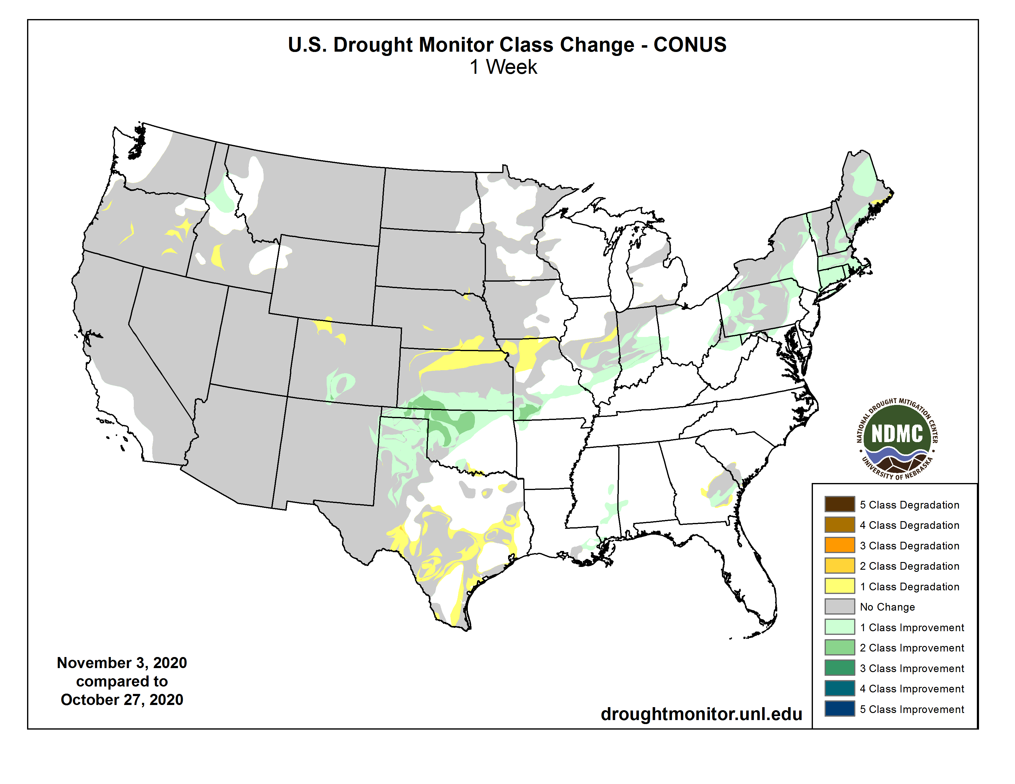
US Drought Monitor one week change map ending November 3, 2020.
And just for grins here’s a gallery of early November US Drought Monitor maps for the last few years.
Water won big in Colorado on Election Day as voters in two multi-county districts approved property tax increases to fund water projects and programs.
Voters in two local water districts — the Colorado River Water Conservation District on the West Slope and the St. Vrain and Left Hand Water Conservancy District on the Front Range — said yes to ballot measures that will generate millions of dollars in new money for conservation, water education, stream health, storage and agriculture.
Based on vote totals as of 4:30 a.m. this morning, 72 percent of voters in the Colorado River District approved ballot issue 7A, with nearly 28 percent voting against the measure.
Meanwhile, 69 percent of voters in the St. Vrain and Left Hand Water Conservancy District approved a separate ballot issue 7A, with 31 percent voting against.
Though statewide funding for water projects has historically been a tough sell for Colorado voters, local initiatives with a more direct connection to residents are finding more success at the polls in recent years. These 2020 water funding ballot measures come on the heels of similar successes in 2018, when voters in Denver, Eagle, Chaffee and Park counties approved tax increases, new taxes, and tax extensions for water and land-focused initiatives.
“Passing any type of fiscal measures statewide in Colorado is going to continue to be an extreme challenge but it’s a much different story on the local level and the regional level,” said Matt Rice, director of the Colorado Basin Program for American Rivers, which supported the Colorado River District measure. “People in Colorado like to make their own decisions locally about fiscal issues, but also about how we manage and protect and restore our rivers for the environment, for agriculture and for local economies.”
In deciding to ask voters for more money this year, the two districts’ leaders cited factors like growing demand for water, drought, higher temperatures, population growth, declining oil and gas revenue, and declining property tax levels under the state’s Gallagher Amendment.
Those reasons resonated with voters on both sides of the political spectrum across the state. On the West Slope, for example, voters in right-leaning counties like Mesa and Montrose and left-leaning counties like Pitkin and Summit approved the ballot measure. (Of note: Nearly 80 percent of voters in Pitkin County approved the ballot measure, despite opposition by three county commissioners and the county’s representative on the district’s board.)
“It’s really a testament to what can happen if people put aside partisan differences on water issues,” said Andy Mueller, general manager of the Colorado River District. “Voters in Colorado are seeing the effects of rising temperatures, changing climate and the impact it’s having on water resources, and they know that we need to adapt and mitigate and that it’s going to cost money to do that.”
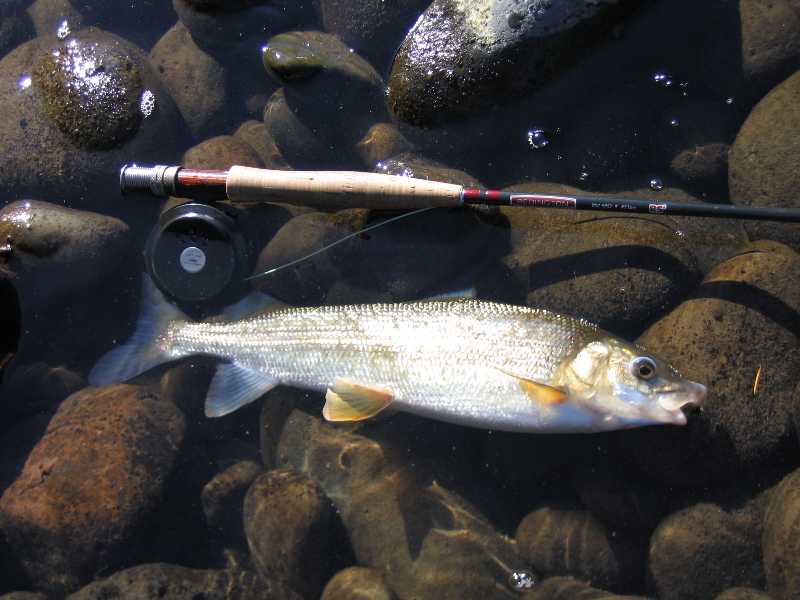
An angler casts a line on the Roaring Fork River upstream of Basalt in Pitkin County. West Slope voters said yes to millions in new taxes for the Colorado River District. Credit: Jerd Smith, Fresh Water News
West Slope says yes
In the large Colorado River District, which includes 15 counties and some 500,000 residents, voters approved a mill levy increase that will double the district’s budget by generating an additional $4.9 million every year starting in 2021.
The district spans an area that covers 28 percent of the state and encompasses the Colorado River and its major tributaries, which include the Yampa, the White, the Gunnison and the Uncompahgre rivers.
With the passage of the ballot measure, West Slope voters approved a median residential property tax increase of $7.03 per year for residents of Grand, Summit, Eagle, Pitkin, Garfield, Routt, Moffat, Rio Blanco, Mesa, Delta, Ouray, Gunnison and parts of Montrose, Saguache and Hinsdale counties. The increase represents an additional $1.90 per year for every $100,000 of home value.
The district, which has 22 employees, will use the new funding for projects related to agriculture, infrastructure, water quality, conservation, efficiency, and other key priority areas determined by local communities and river basin roundtables.
District leaders say they will also stretch the extra money further by using it to solicit matching funds from state, federal and private sources.
Water funding on the Front Range
It was also a historic night for the St. Vrain and Left Hand Water Conservancy District, where voters approved a property tax increase for the next 10 years. This is the first time in nearly 50 years — since its founding in 1971 — that the district has asked voters for more funding.
The district’s board thought long and hard about how best to approach voters — and whether this was the right year to do it. But in the end, their approach paid off.
“The discussions were good and essentially resulted in consensus and agreement with the board,” said Chris Smith, board vice president representing district 3, which encompasses northwest Longmont and parts of unincorporated Boulder County. “It was all done in a very thoughtful manner, which speaks a lot to having a board that represents, geographically, the entire watershed.”
Smith said he was happy to see the West Slope ballot measure pass, too.
“The people of Colorado have really keyed in on the importance of water,” he said. “There are so many new people moving to Colorado, it’s good to see that they’re carrying on that mantle of protecting our most important resource.”
The St. Vrain and Left Hand district encompasses some 500 square miles along the St. Vrain and Left Hand creeks in Boulder, Weld and Larimer counties. Voters agreed to a mill levy increase from 0.156 mills to 1.25 mills through 2030.
The tax increase will generate an additional $3.3 million per year for the district starting in 2021, up from the $421,000 generated annually by the current mill levy. On a $350,000 home, the tax increase represents an additional $2.61 per month; on a $500,000 commercial building, it’s an extra $15.10 per month.
District leaders say they will use the extra money for projects related to water quality, river and creek health, water education, agriculture, storage and conservation, among others.
Sarah Kuta is a freelance writer based in Longmont, Colorado. She can be reached at sarahkuta@gmail.com.
The South Platte River Basin is shaded in yellow. Source: Tom Cech, One World One Water Center, Metropolitan State University of Denver.
Here’s the release from Western Resource Advocates (Jennifer Talhelm):
Today, the Water for Colorado coalition celebrates the passage of two key local ballot measures that will increase investment in Colorado’s rivers and streams. Together these measures will generate nearly $8 million annually to support critical water-related needs.
Voters approved a property tax increase for the St. Vrain and Left Hand Water Conservancy District, which will provide $3.3 million a year to protect water quality, safeguard drinking water, maintain healthy forests, rivers and creeks, plan ahead for dry years and grow food locally. The funds will be allocated using the District’s recently developed 5-Point Water Action Plan that will protect rivers, forests, and local water quality.
On the West Slope, voters approved a mill levy increase for the Colorado River Water Conservation District, which will bring in nearly $5 million a year to support healthy rivers, local agriculture, watershed health, and water quality in the 15 counties that make up the district. According to its Fiscal Implementation Plan, the District will allocate these funds through partnerships with water users and communities for priority projects identified by local communities and Basin Roundtables.
Local funding from both measures will support the types of solutions and water management projects outlined in Colorado’s Water Plan. The Water Plan, finalized in 2015, provides a blueprint to address the gap between water supply and demand across the state.
“Whether they’re on the Front Range or the West Slope, Coloradans know that water is essential for life; they value protecting our rivers and streams, and that’s why an incredibly diverse group of Coloradans unified in support of the two funding measures,” said Bart Miller, Western Resource Advocates’ Healthy Rivers Program Director. “The passage of these two ballot measures will mean communities will have $8 million more a year working to ensure there is enough water for everyone – for drinking, farming and ranching, recreation, and wildlife. But while we’re justifiably celebrating today, the wildfires that have been burning across the state this fall are a destructive reminder that climate change and drought will keep stressing our water, and we all need to keep working for full funding for Colorado’s Water Plan.”
“Both measures provide an essential blueprint to these river districts to better manage water supplies and, in turn, support the communities and economies that rely on them,” said Matt Rice, Director of the Colorado Basin Program for American Rivers. “Voters have clearly rallied around water as a shared priority and recognized the urgent need to safeguard our drinking water, protect forests that are critical to water supplies, and maintain healthy rivers and creeks.”
“Our economy depends on a healthy, reliable Colorado River System, and Colorado voters realized that in the passage of two ballot issues on water yesterday. Billions of dollars are generated every year in Colorado by river-related recreation, and we know that healthy rivers mean a thriving economy across our communities. The St. Vrain and Left Hand Water Conservancy District can now implement their five-point plan to protect that area’s rivers and water sources, and the Colorado River District can continue its important, locally driven work throughout the 15 counties they serve,” said Molly Mugglestone, Director of Communications and Colorado Policy for Business for Water Stewardship.
“The passage of these measures comes as Colorado continues to grapple with extreme wildfires and ongoing drought conditions across the state. The water Coloradans use to drink, irrigate crops, recreate, and sustain our communities is water that we share with wildlife that depend on our rivers, streams, and lakes. In the face of a historic drought and the ongoing threat of climate change, these kinds of forward-looking investments in how we care for and sustain our water supplies are critical to ensuring the collective future of the people and wildlife of Colorado,” said Abby Burk, Western Rivers Regional Program Manager for Audubon Rockies .
“I want to applaud Coloradans who voted to keep our rivers healthy and flowing. The wise investment they approved will protect clean drinking water and iconic waterways now and for future generations,” said Kelly Nordini, Executive Director of Conservation Colorado.
Coloradans continue to prioritize water by voting to approve ballot measures that use tax revenues to invest in healthy rivers, clean drinking water, resilient agriculture, and a thriving recreation economy. This year’s double win marks another voter-approved effort to fund work that supports the Water Plan. In November 2019, voters passed Proposition DD to legalize sports betting and use the resulting taxes to help fund Colorado’s Water Plan.
However, the Water for Colorado Coalition will continue its efforts to fully fund the Water Plan. This is essential, because even though these local ballot measures will generate significant funding for water in Colorado, a larger funding gap for implementing Colorado’s Water Plan remains. The Water Plan estimates that $100 million dollars per year is needed to protect scarce water resources and to prevent future water shortages in the state.
About the Water for Colorado Coalition
The Water for Colorado Coalition is dedicated to ensuring our rivers support everyone who depends on them, working toward resilience to climate change, planning for sustained and more severe droughts, and enabling every individual in Colorado to have a voice and the opportunity to take action to advocate for sustainable conservation-based solutions for our state’s water future.
The community of organizations that make up the Water for Colorado Coalition represent diverse perspectives and share a commitment to protecting Colorado’s water future to secure a reliable water supply for the state and for future generations.
The Colorado River Water Conservation District spans 15 Western Slope counties. Voters across the district are considering a mill-levy increase that would raise the River District’s budget by $5 million, funding a variety of water-related projects. Colorado River District/Courtesy image
St. Vrain and Lefthand Water Conservancy District map.
Here’s the release from Rice University (Jade Boyd):
Boron nitride coating is key ingredient in hypersaline desalination technology
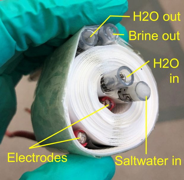
A thin coating of the 2D nanomaterial hexagonal boron nitride is the key ingredient in a cost-effective technology developed by Rice University engineers for desalinating industrial-strength brine.
Rice University’s Kuichang Zuo (left) and Qilin Li helped develop a highly efficient technology for desalinating industrial-strength brine with a salt content as much as 10 times greater than seawater. (Photo by Jeff Fitlow/Rice University)
More than 1.8 billion people live in countries where fresh water is scarce. In many arid regions, seawater or salty groundwater is plentiful but costly to desalinate. In addition, many industries pay high disposal costs for wastewater with high salt concentrations that cannot be treated using conventional technologies. Reverse osmosis, the most common desalination technology, requires greater and greater pressure as the salt content of water increases and cannot be used to treat water that is extremely salty, or hypersaline.
Hypersaline water, which can contain 10 times more salt than seawater, is an increasingly important challenge for many industries. Some oil and gas wells produce it in large volumes, for example, and it is a byproduct of many desalination technologies that produce both freshwater and concentrated brine. Increasing water consciousness across all industries is also a driver, said Rice’s Qilin Li, co-corresponding author of a study about Rice’s desalination technology published in Nature Nanotechnology.
“It’s not just the oil industry,” said Li, co-director of the Rice-based Nanotechnology Enabled Water Treatment Center (NEWT). “Industrial processes, in general, produce salty wastewater because the trend is to reuse water. Many industries are trying to have ‘closed loop’ water systems. Each time you recover freshwater, the salt in it becomes more concentrated. Eventually the wastewater becomes hypersaline and you either have to desalinate it or pay to dispose of it.”
Rice University’s desalination technology for hypersaline brine features a central passage for heated brine that is sandwiched between two membranes. A stainless steel heating element produces fresh, salt-free water by driving water vapor through each membrane. A coating of the 2D nanomaterial hexagonal boron nitride (hBN) protects the heating element from the highly corrosive brine. (Image courtesy of Kuichang Zuo/Rice University)
Conventional technology to desalinate hypersaline water has high capital costs and requires extensive infrastructure. NEWT, a National Science Foundation (NSF) Engineering Research Center (ERC) headquartered at Rice’s Brown School of Engineering, is using the latest advances in nanotechnology and materials science to create decentralized, fit-for-purpose technologies for treating drinking water and industrial wastewater more efficiently.
One of NEWT’s technologies is an off-grid desalination system that uses solar energy and a process called membrane distillation. When the brine is flowed across one side of a porous membrane, it is heated up at the membrane surface by a photothermal coating that absorbs sunlight and generates heat. When cold freshwater is flowed across the other side of the membrane, the difference in temperature creates a pressure gradient that drives water vapor through the membrane from the hot to the cold side, leaving salts and other nonvolatile contaminants behind.
A large difference in temperature on each side of the membrane is the key to membrane desalination efficiency. In NEWT’s solar-powered version of the technology, light-activated nanoparticles attached to the membrane capture all the necessary energy from the sun, resulting in high energy efficiency. Li is working with a NEWT industrial partner to develop a version of the technology that can be deployed for humanitarian purposes. But unconcentrated solar power alone isn’t sufficient for high-rate desalination of hypersaline brine, she said.
“The energy intensity is limited with ambient solar energy,” said Li, a professor of civil and environmental engineering. “The energy input is only one kilowatt per meter square, and the production rate of water is slow for large-scale systems.”
Adding heat to the membrane surface can produce exponential improvements in the volume of freshwater that each square foot of membrane can produce each minute, a measure known as flux. But saltwater is highly corrosive, and it becomes more corrosive when heated. Traditional metallic heating elements get destroyed quickly, and many nonmetallic alternatives fare little better or have insufficient conductivity.
“We were really looking for a material that would be highly electrically conductive and also support large current density without being corroded in this highly salty water,” Li said.
The solution came from study co-authors Jun Lou and Pulickel Ajayan in Rice’s Department of Materials Science and NanoEngineering (MSNE). Lou, Ajayan and NEWT postdoctoral researchers and study co-lead authors Kuichang Zuo and Weipeng Wang, and study co-author and graduate student Shuai Jia developed a process for coating a fine stainless steel mesh with a thin film of hexagonal boron nitride (hBN).
Rice University engineers created a robust heating element for desalinating highly corrosive industrial-strength brine by adding a protective coating of the 2D nanomaterial hexagonal boron nitride to a commercially available stainless steel mesh. (Photo by Kuichang Zuo/Rice University)
Boron nitride’s combination of chemical resistance and thermal conductivity has made its ceramic form a prized asset in high-temperature equipment, but hBN, the atom-thick 2D form of the material, is typically grown on flat surfaces.
“This is the first time this beautiful hBN coating has been grown on an irregular, porous surface,” Li said. “It’s a challenge, because anywhere you have a defect in the hBN coating, you will start to have corrosion.”
Jia and Wang used a modified chemical vapor deposition (CVD) technique to grow dozens of layers of hBN on a nontreated, commercially available stainless steel mesh. The technique extended previous Rice research into the growth of 2D materials on curved surfaces, which was supported by the Center for Atomically Thin Multifunctional Coatings, or ATOMIC. The ATOMIC Center is also hosted by Rice and supported by the NSF’s Industry/University Cooperative Research Program.
The researchers showed that the wire mesh coating, which was only about one 10-millionth of a meter thick, was sufficient to encase the interwoven wires and protect them from the corrosive forces of hypersaline water. The coated wire mesh heating element was attached to a commercially available polyvinylidene difluoride membrane that was rolled into a spiral-wound module, a space-saving form used in many commercial filters.
A coiled distillation membrane system for desalinating hypersaline brine. Rolling the system into a coil demonstrated the possibility of adopting a common space-saving, water-filtration format. (Photo by Kuichang Zuo/Rice University)
In tests, researchers powered the heating element with voltage at a household frequency of 50 hertz and power densities as high as 50 kilowatts per square meter. At maximum power, the system produced a flux of more than 42 kilograms of water per square meter of membrane per hour — more than 10 times greater than ambient solar membrane distillation technologies — at an energy efficiency much higher than existing membrane distillation technologies.
Li said the team is looking for an industry partner to scale up the CVD coating process and produce a larger prototype for small-scale field tests.
“We’re ready to pursue some commercial applications,” she said. “Scaling up from the lab-scale process to a large 2D CVD sheet will require external support.”
NEWT is a multidisciplinary engineering research center launched in 2015 by Rice, Yale University, Arizona State University and the University of Texas at El Paso that was recently awarded a five-year renewal grant for $16.5 million by the National Science Foundation. NEWT works with industry and government partners to produce transformational technology and train engineers who are ready to lead the global economy.
Ajayan is Rice’s Benjamin M. and Mary Greenwood Anderson Professor in Engineering, MSNE department chair and a professor of chemistry. Lou is a professor and associate department chair in MSNE and a professor of chemistry.
The research was supported by NSF. Additional co-authors include Hua Guo and Ruikun Xin, both of Rice; and Menachem Elimelech and Akshay Deshmukh, both of Yale.
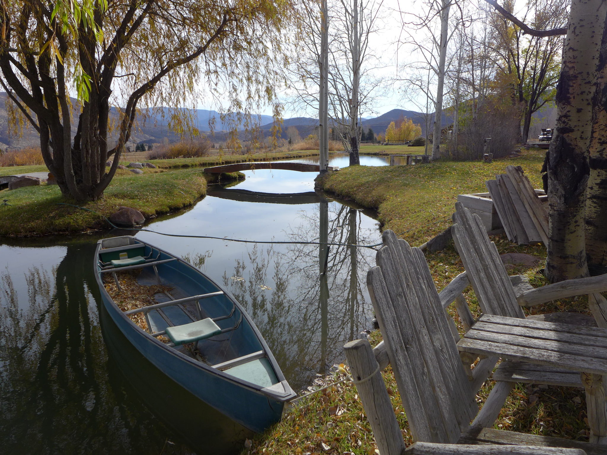
A canoe floats in the Milvich family pond in Old Snowmass. The Colorado Division of Water Resources issued a cease-and-desist letter because the pond, which does not have a legal water right, was taking water out of priority. Photo credit: Heather Sackett/Aspen Journalism
Rebecca Milvich has many fond childhood memories of playing in the pond on her family’s Old Snowmass property, which they purchased in 1985.
Every summer, the pond off Little Elk Creek Avenue in Old Snowmass, became the neighborhood hangout as Milvich and her siblings and friends swam and paddled a canoe. Still today, the pond, which is filled by a ditch branching off Little Elk Creek, brings the family joy as they admire the ducks, fish and muskrats that live there.
“Those are the passions that are wrapped around it,” Milvich said. “It’s very personal. It’s something that has enhanced our quality of life a thousandfold. Our ability to have a water feature has changed our lives for the better, for sure.”
But on Sept. 22, the Milvich family received a cease-and-desist order from the Colorado Division of Water Resources that said they had to stop filling their pond because of a downstream call on the Colorado River, in which water users junior to the Grand Valley irrigators’ water rights had to be shut off.
It turned out the Milvich family did not have a legal water right for their pond, making them one of the most junior water users on the Colorado River system and one of the first to be curtailed.
“We were from Southern California and we missed having the beach,” Milvich said. “And my dad was excited to purchase an actual piece of property that had water on it, totally not knowing that we were in some ways for these last 35 years breaking some rules and regulations. We had absolutely no idea.”
The Milvich family’s pond is not the only one in the area lacking a water right. DWR officials say undecreed ponds throughout the region are depleting the Colorado River system in a time when a climate change-fueled drought makes it more important than ever to account for every last drop of water.
The Glenwood Springs-based Division 5 engineer’s office issued five cease-and-desist orders for ponds without water rights this season in the upper Roaring Fork Valley. And officials say there are many more ponds like these out there. Some of them are recently built for fire protection.
The main concern with these ponds is water loss to the Colorado River system through evaporation. The bigger the surface area, the more water that is lost.
“A lot of the depletions are pretty small, but it’s death by a thousand cuts,” Division 5 Engineer Alan Martellaro said. “When you have these all over the place, they add up at some point.”
According to Colorado water law, anyone is allowed to divert water from a stream simply by putting it to beneficial use as long as it does not harm senior water-rights holders. To protect their ability to keep using the water and save their place in line, most users make their water right official by getting a decree through water court. This enshrines the water right in Colorado’s system of prior appropriation in which the older the water right, the more powerful it is.
“It’s a good idea because it protects your standing,” Martellaro said. “It protects your priority. That’s the whole point of a water right.”
That means ponds without a decree are last in line and are the first to be shut off when there’s a downstream call from irrigators in the Grand Valley, which have much older water rights — one from 1912 and one from 1934. Known as the “Cameo Call,” these irrigators can control all junior water rights upstream of their diversion at the roller dam in DeBeque Canyon.
Most summers, Grand Valley irrigators “call” for their water when streamflows begin to drop. In general, the drier the year, the earlier the call comes on. This year, the Cameo Call first came July 30 and went off at the end of irrigation season Oct. 26.
As long as the call is on, junior upstream water rights must be shut off or “curtailed” so that the downstream irrigators can get the full amount of water to which they are legally entitled. It is up to the division engineer’s office to decide exactly how to administer the call and which junior water rights to curtail, but undecreed water use is generally the first to go.
“When the call is on, they are stealing somebody else’s water if they don’t have a water right,” said Bill Blakeslee, water commissioner for District 38, which encompasses the Roaring Fork River watershed.
Blakeslee said he doesn’t like to issue cease-and-desist orders, and his goal is to educate people about the Colorado River system.
“We don’t like to do our business this way, but this is one of the tools we use to help people understand we don’t have as much water as we used to and we all need to take steps to preserve as much as we can,” he said. “It makes a statement to the general public that we are in a drought situation, so let’s not do things that continue to contribute to further loss of water.”
Even though the ponds are causing water loss to the river system at all times, Blakeslee said he can apply the pressure of the law only when there is a call.
“I can’t enforce the rules until the call goes on the system,” he said.
Rebecca Milvich has many fond childhood memories of playing in this pond on her family’s property in Old Snowmass. Officials from the Colorado Division of Water Resources say ponds without a water right, such as this one, are depleting the Colorado River system. Photo credit: Heather Sackett/Aspen Journlism
Compact call
The Milviches were supposed to have stopped diverting water out of priority within 10 days of receiving the order or else face enforcement actions such as having to pay the state’s costs and legal fees. But Martellaro said his office so far has not fined the owners of any of the five ponds and won’t as long as they are working toward a solution. And since the Grand Valley call is now off the river, the issue is less urgent — for the moment.
Colorado is entering a period of tighter accountability for some water users as Lake Powell’s levels continue to drop and the threat of a compact call looms larger in a warming West.
A compact call could occur if the upper-basin states (Colorado, Wyoming, Utah and New Mexico) can’t deliver the 7.5 million acre-feet of water per year to the lower-basin states (Arizona, California and Nevada), as required by the Colorado River Compact, a nearly century-old binding agreement. Upper-basin water managers desperately want to avoid this scenario.
“I guess you could say one of the elephants in the room is the interstate compact situation,” Blakeslee said.
So what are the Milviches’ options to remedy the situation? In order to be allowed to keep using water for the pond when a call is on, they must replace that water to the system. One possibility is getting a contract for an augmentation plan with a local water-conservancy district to release water from Ruedi Reservoir to make up for depletions from the pond. The Milviches have met with an engineer to assess their options.
Whatever they decide, securing a water right through water court can be a lengthy, expensive process.
“We are definitely terrified about that reality,” Milvich said.
Aspen Journalism is a local, nonprofit, investigative journalism organization covering water and rivers in collaboration with The Aspen Times and other Swift Communications newspapers. This story ran in the Nov. 2 edition of The Aspen Times.
If nothing else, [Wes] McKinley’s crusade has brought attention to the profound disconnect between the emerging water crisis in eastern Colorado and a state policy that encourages total depletion of the resource. The surface water in virtually all of the state’s major river basins, from the Colorado, Arkansas and Rio Grande rivers to the humblest creeks, has been over-appropriated for decades. The major source of non-tributary water in the Far Quarter is the High Plains Aquifer, also known as the Ogallala Aquifer. Farms and ranches have been draining the aquifer, a vast underground reservoir of fresh water stretching across eight states, at an accelerating rate, despite warnings that the overpumping is likely to have catastrophic effects on fish habitat, interstate compact agreements and the sustainability of the aquifer itself, which requires centuries to recharge.
The warnings have been trickling through Baca County for more than fifty years. A 1966 study of groundwater in the area of the Cimarron River, which cuts across the southeast corner of Colorado and then vacillates between Kansas and Oklahoma, concluded that “the most serious problem in the Cimarron Basin appears to be the extreme decline of water levels from pumping.” A 2001 report prepared for the Southern High Plains Groundwater Management District noted that groundwater levels in the district had dropped a hundred feet in the past half-century; the report recommended a moratorium on all new and replacement wells in the High Plains Aquifer, except for domestic wells with a modest pumping rate of 15 gallons per minute.
Yet no moratorium was ever put in place. Instead, the Colorado Ground Water Commission has continued to issue large-capacity well permits like they were gimme caps. Data provided by the Colorado Division of Water Resources indicates that the commission granted 64 permits for new wells in the Southern High Plains in the last 21 months — a rate that’s more than triple the average number for the previous five years.
“Colorado does not have a statutory directive that impact to an aquifer needs to be considered when issuing a well permit,” says Kevin Rein, the state engineer, who also serves as executive director of the groundwater commission.
Long-range studies about climate change and dwindling aquifers don’t figure in the permitting process, which is preoccupied with mundane questions of how many other wells are operating within half a mile of the new well and whether an immediate neighbor would suffer “material damage” from additional pumping. McKinley contends that the rules as currently written don’t adequately protect the resource and shift the burden of proof to the opponents, who have to show that their own water rights would be adversely impacted by a new well. But Rein points out that some groundwater management districts have successfully petitioned the commission for a declaration that their area is over-appropriated, a finding that prevents the issuance of new well permits.
“That has happened in many of the basins, but it hasn’t happened in the Southern High Plains,” Rein observes. It isn’t the commission’s place to get involved in promoting such prohibitions or seeking changes in the law that would protect the High Plains Aquifer from more wells, he adds: “As the state engineer, I don’t have the charge to bring that sort of policy discussion.”
Water attorney Curtis estimates that McKinley’s objections cost his clients $200,000 in legal expenses and delays. McKinley’s time would have been better spent, he suggests, gathering the required technical data to petition the commission to close the district to new wells.
“Water rights are vested property rights, and you can’t strip someone of those rights without a proper basis,” Curtis says. “He knows the process. Either he doesn’t have the energy to do it the right way or he doesn’t care. But he never presented a single piece of relevant evidence to support his position.”
A major factor in the recent surge of permits in Baca County is a ramping up of irrigation wells on the Cimarron Valley Ranch, a 45,000-acre cattle ranch that stretches along 22 miles of the Cimarron River in Oklahoma and Colorado. Owned by Georgia-based LGS Holding Group, the property is for sale for $39,900,000, reduced from $45 million. An online real estate listing touts “some of the best hunting in the country,” including the ranch’s resident elk herd, as well as “incredible diversity in regard to terrain, wildlife, livestock grazing, income opportunities and more.” Also prominently mentioned is the ranch’s ample water supply and new well permits, which will allow the operation to double its number of irrigation pivots.
The mega-ranch’s wells account for nearly half of the permits the commission has issued in the Southern High Plains over the past two years. That rankles local rancher Dan Caldwell, a longtime friend of McKinley’s, whose property lies just across the state line from the Oklahoma stretch of the Cimarron Valley Ranch. Caldwell says that he, too, filed an objection to the LGS permits, but was told he hadn’t proved material damage — and that he could be liable for legal fees if he persisted. He knew his objection wasn’t going anywhere, he says, when he learned a representative of the Colorado Attorney General’s Office was joining the case —representing the groundwater commission, not the citizens of Baca County.
“We have no recourse,” Caldwell says. “We are nothing to them. There’s no reason to give our water away so freely, but they’re doing it.”
The Southwest Kansas Groundwater Management District also protested the LGS applications, on the grounds that new pumping along the Cimarron River was bound to diminish supplies downstream. A few years ago, Kansas won a long-running lawsuit concerning Colorado’s excessive water use under the Arkansas River Compact, but no such compact exists regarding the Cimarron.
“Colorado has a presumption that there’s water available for any application unless there’s a hearing,” notes Mark Rude, executive director of the district. “We had to become an opposer of the application in order to be involved in the hearing process. We’ve since discovered that Colorado works to not have a hearing process.”
Like Caldwell and McKinley, Rude was told there wouldn’t be a hearing because he lacked the legal standing to object. Southwest Kansas no longer permits new wells that would draw upon the High Plains Aquifer out of concern over the falling water table. But neither Colorado nor Oklahoma has followed suit.
“We have tools in Kansas to propose reductions in allocations, just to make the water last a little longer,” Rude says. “But it’s hard to have those conversations locally when people say, ‘Well, it’s unrestricted in Colorado and the Oklahoma Panhandle.’”
Rein calls the recent spike in permits in Baca County “anomalous” and doesn’t see any particular cause for concern in the recent water enhancements at a 45,000-acre ranch. “Certainly, some people in the basin are alarmed,” he says. “Is the commission alarmed? I don’t think we’ve had open discussion about that.”
McKinley doesn’t know what his objections might have accomplished, but he hopes more people will ask questions about where the water is going. “You don’t know what works and what don’t,” he says. “I’ve always thought there’s nothing wasted; it’s an experience gained. Sometimes, though, you pay a lot of tuition and wonder what you’ve learned.”
Dinosaur tracks in Picketwire Canyon. Photo credit: USFS
The only public access to the dinosaur tracks in Picketwire Canyon is by way of the Withers Canyon trailhead, an eleven-mile round trip. With the guided four-wheel tours suspended, you have three choices for mode of transport: mountain bike, horseback or on foot.
Bikers might think twice, after watching a few cautionary YouTube videos about the many, many goat’s head stickers and opportunities for flat tires. The horse option has some drawbacks, too; although most of the path is a level stroll along the canyon floor, the steep descent into the canyon on a rock-strewn trail and the purgatorial ascent at the end may not be something you want to do on top of a thousand-pound animal.
That leaves the third option, a six-hour hike in rugged and largely exposed country. Since temperatures in the canyon can be intense from late spring until early fall, reaching as high as 110 degrees in July and August, the Forest Service advises visitors to carry “at least” a gallon of water per person. (In 2017, two summer hikers died in separate heat-related incidents.) But on a temperate fall day, the startling, shifting environment of the canyon — from juniper-and-piñon prairie to meadows lined with cottonwoods to bright fields of yarrow and cacti in bloom — can make you forget you’re wandering through the northern edge of the Chihuahuan Desert.
For most visitors, the highlight of the journey is crossing the Purgatoire to arrive at a vast limestone plain, the stamping ground of monsters. The giant paw prints embedded in the ancient lake shore, back when the canyon was a lush, steamy tropical retreat, tell a story about lumbering, plant-eating apatosauruses traveling in gregarious herds, and the three-toed carnivores who stalked them. This quarter-mile stretch of the river is the most extensive set of dinosaur tracks in North America, yet it’s just a small portion of the Jurassic riches in the area; numerous fossils have been painstakingly unearthed by volunteers under the supervision of a Forest Service paleontologist.
The bones and tracks may be the main draw, but they’re hardly the only one. In 1988, a University of Wisconsin student on a field trip headed down from the west rim of the canyon to check out the dinosaur tracks. On the way down, he came across a petroglyph panel in a shallow alcove and snapped a picture of it. He assumed the panel was already well known to researchers. It wasn’t. According to Loendorf’s account in his book Thunder & Herds: Rock Art of the High Plains, when a wildlife biologist familiar with the canyon saw the photo, “he realized that he was looking at a significant and previously unknown site.”
The panel features a single human figure in the center, surrounded by three dozen quadrupeds — some with elaborate antlers, some suggestive of bison and sheep. The central figure holds an object in its right hand, possibly a net or snare, indicating a form of control over the animals. Loendorf regards the Zookeeper, as the panel has become known, as one of several key rock-art sites in the area that provide glimpses into the hunter-gatherer culture that once flourished there. He believes a climatic event more than 600 years ago, one that ruined crops and drove the game away, may have been responsible for its abrupt disappearance.
“You have these obvious hunt scenes, driving animals — antelope, probably — into nets, and then it just ends,” he notes. “It pretty much suggests that the Apishapa were affected, like all of the Southwest, by drought. I personally think at least some of the Apishapa people were seasonal and pulled back to the mountains in the wintertime. And the drought period ended that; then they stayed close to the mountains year-round. Then came the Apache and the Comanche. They weren’t dependent on trying to grow corn.”
The Colorado River Water Conservation District spans 15 Western Slope counties. River District directors are asking voters this fall to raise the mill levy.
FromAspen Journalism (Heather Sackett) via The Aspen Times:
According to preliminary results as of 10:45 p.m. Tuesday, encompassing about 246,245 ballots, about 72% of voters said yes to the measure. Saguache County was the lone county to vote against the measure.
Pitkin County voters passed ballot question 7A with 80% in favor, despite three of five county commissioners and Pitkin County’s representative to the River District board John Ely opposing the measure. Nearly 69% of voters in Mesa County, which has the largest population base in the district, supported the measure.
River District general manager Andy Mueller said the results prove that water is the one issue that can unite voters in western Colorado. [ed. emphasis mine]
“It was the one issue that’s not partisan, that was about uniting a very politically diverse region,” he said. “Everybody is so sick of the nasty, divisive, partisan politics. People with (Donald) Trump signs and (Joe) Biden signs voted for the same thing.”
Ballot measure 7A raises property taxes by a half-mill, or an extra $1.90 per year for every $100,000 of residential home value. The measure will raise nearly an additional $5 million annually for the River District, which says it will use the money for fighting to keep water on the Western Slope, protecting water supplies for Western Slope farmers and ranchers, protecting drinking water for Western Slope communities, and protecting fish, wildlife and recreation.
According to numbers provided by the River District, the mill levy will increase to $40.28 from $18.93 annually for Pitkin County’s median home value, which at $1.13 million is the highest in the district. In Eagle County, where the median home value is $660,979, the mill levy will increase to $23.63 from $11.11 annually.
Property owners can expect to see the mill-levy increase on their 2021 tax bill.
The proposal received wide support among county commissioners, agricultural organizations and environmental groups…
The River District’s fiscal implementation plan for the revenue that would be raised by the tax hike says 86% would go toward funding water projects backed by roundtables and local communities. Those projects would fall into five categories: productive agriculture; infrastructure; healthy rivers; watershed health and water quality; and conservation and efficiency.
Aspen Journalism is a local, nonprofit, investigative news organization covering water and rivers in collaboration with The Aspen Times and other Swift Communications newspapers. For more, go to aspenjournalism.org.
Troublesome questions about where we’re headed during our hotter, drier, longer summers in Colorado
East Troublesome, now the second largest fire in Colorado as defined by acreage, appears to have started on Oct. 14 within a mile or so of my first backpack trip 40 years ago.
My days of backpacking have ended. These very large, very strange fires such as East Troublesome will almost certainly become more common in coming decades. For about a decade, wildfire specialists have been using a new word to describe those of another dimension: megafires. Colorado this year has had three wildfires that crossed the threshold of the simplest metric, 100,000 acres in size.
East Troublesome hurtled past that metric in less than 90 minutes. Like at least one other fire, it appears to have created its own weather. And then there’s the weirdness of the timing. It started in mid-October, traditionally a time of down comforters and, if not every year, most years in the mountains, snow on the ground.
The largest fire in Colorado history is now the Cameron Peak Fire. It started Aug. 15 and has now reached 209,000 acres. The East Troublesome Fire is second at 194,000 acres. Both remain live fires. The third largest fire, Pine Gulch, north of Grand Junction, also occurred this year, covering 139,000 acres before being declared completely contained in September. Partly in Colorado, but mostly in Wyoming, is the Mullen Fire, at 177,000 acres.
Smoke from the Mullen Fire along the Wyoming-Colorado border as seen from the Snowy Range in Wyoming on Oct. 6. Photo/Allen Best
But first, about that backpack trip. In 1980, I was living in Kremmling, a small town with a blue collar and cowboy boots. The busiest bar was called the Hoof ‘n’ Horn. Most people worked at the Edwards Hines sawmill, one of several sawmills in the region, or at the Amax Henderson molybdenum mill, which was “up” the Williams Fork Valley 25 miles away.
About backpacking, I knew nothing. My equipment was laughable, more suitable for a city park than a stretch of country rarely visited by people except cowboys during roundup time. A girlfriend drove me up Colorado 125, the road between Granby and Walden, and then onto a Forest Service road, and dropped me off.
It rained hard that night, lightning crashing fiercely, and there were bumps in the night, probably cattle and maybe elk, but I thought for sure bears. Then the sun came up. I had caught the bug. Exploring places beyond the roads became a passion. A decade later I had become an avid backpacker and a pretty good backcountry skier, too.
The East Troublesome fire started Oct. 14 and would have been a record fire in the 20th century and, by 21st century standards it was still respectably large. But in the dull, gray sky along Front Range, it was indistinct from the smoke of the Cameron Peak Fire and then the fire near Boulder called CalWood.
We had watched the CalWood fire that Saturday evening from a restaurant in Boulder, the last one along Broadway before it joins Highway 36. The fire had started about seven hours before and was already, I believe, the largest in Boulder County history. Sitting outside at the restaurant, we could see the fire flaring in the distance, maybe 10 miles away. I didn’t realize how personal it was to people in the next socially distanced table until later. Cathy, my companion, who still has good hearing, said they were people who had homes in the fire area. One was calling his insurance agent.
Like a volcanic eruption
On Oct. 21, a week to the day after East Troublesome had started, I saw a Facebook post showing a giant plume of smoke as seen from Park Meadows, in Denver’s South Metro area. I assumed one of these Front Range fires had blown up. It had been another unseasonably warm day. The person who posted the photo compared it to Mt. Vesuvius erupting.
Later, the story has been pieced together. The fire had advanced to northeast of Hot Sulphur Springs but still east of Colorado 125, the highway that goes from Windy Gap—west of Granby a few miles—north to Willow Creek Pass and to Walden.
Brad White, the fire chief for Grand County Fire Protection District No. 1, whose service territory includes most of the affected area other than Grand Lake, says the fire made a run toward evening, as the sun was getting low in the sky. The fire had been burning a mixture of live and dead trees in the Kinney Creek area northeast of Hot Sulphur Springs. In 90 minutes, pushed by winds from the southwest, the fire rushed to Rocky Mountain National Park and across Trail Ridge Road. By White’s calculation, that’s a distance of 17 miles.
Slow-burning fires spread by the ground, often from tree crown to tree crown. This fire, during its runs, leaped great distances, a process called spotting. Visiting the charred remains of Columbine Lake, a housing development west of Grand Lake, White and others found a burning fist-sized ember—a piece of burning tree that they believe was hurled into the sky and came down miles away, like hail.
The East Troublesome fire was large by conventional Colorado standards, having covered a large area north of Hot Sulphur Springs. Then, in one evening it sprinted past Grand Lake and across the Continental Divide.
The current issue of Wired magazine tells of something similar, but set in Redding, Calif. An employee of the Forest Service, Eric Knapp, barely escaped a fire alive. The assumption he had made was that the fire would spread in typical fashion, on the ground. It instead created a giant column of fire and smoke, like a tornado, and then spread ashes and embers. That is what nearly killed the Forest Service fire expert and many of his neighbors. It sounds like something similar happened with the East Troublesome fire.
A key paragraph from that story:
“Knapp knew this could signal a once rare and dangerous phenomenon known as plume-driven fire, in which a fire’s own convective column of rising heat becomes hot enough and big enough to redirect wind and weather in ways that can make the fire burn much hotter and, with little warning, spread fast enough to trap people as they flee.”
Michael Kodas, the Boulder-based author of a 2017 book called “Megafire,” says Cameron Peak, East Troublesome and Pine Gulch fires all produced what are called pyrocumulus clouds, basically thunderheads. In the case of Pine Gulch, it produced lightning. Lightning from such smoke-born clouds can make the fire worse or spread it.
So far, though, Colorado has escaped what has now been observed in California: tornadoes caused by wildfires. They’ve been nicknamed firenadoes.
But the East Troublesome fire had enough wind to sprint hard across Grand County. White’s estimate bears repeating: This fire ran 17 miles in 90 minutes. And 105,000 acres in an evening. To put that into perspective, Colorado’s largest forest fire until 2020 was the Hayman Fire of 2002, which covered 138,000 acres. It’s largest single-day run was 60,000 acres.
The Troublesome fire got big and did so fast in a month when fires are rare. It also leaped across the Continental Divide. In some areas, where the Continental Divide in Colorado is forested and relatively low, that wouldn’t be all that notable. But in this case it leaped across two miles of rock and tundra to start a fire that quickly forced the evacuation of the east side of Estes Park, including the downtown area, and eventually the entire valley. In published reports, firefighting experts described it as so rare as to cause head-scratching.
It may have created its own weather, as big fires can do. Some anecdotal reports gleaned second-hand describe intense winds. From Fraser, about 30 miles to the south, Andy Miller, with whom I worked almost 40 years ago at the now-defunct Winter Park Manifest, said he saw tall columns of smoke, thunderhead-type formations. Atop this cloud of smoke were lenticulars, which commonly are at 40,000 feet.
On the outskirts of Granby, Patrick Brower and his wife and children had packed their car that Wednesday. The town was under a pre-evacuation order, but some areas on the mesa north of the high school were ordered to evacuate. That afternoon, there had been a steady stream of evacuees flowing through Granby—people from Grand Lake and the Three Lakes area—driving by his former office at the Sky-Hi News. Police did a good job of getting people out of harm’s way, he says, just as they had in Granby in 2004.
“It was scary for sure, because there were massive, massive clouds of smoke,” he says. “But the fire was still west and north of Granby.”
Brower has a habit of sticking around until the last minute. In 2004, when he was still editor and publisher of the newspaper, Brower fled through the back door of the newspaper office just as the bulldozer of the small-town terrorist Marvin Heemeyer crashed through the front door.
Heemeyer nursed his grudges against the world in Grand Lake, the town of knotty-pine-sided buildings at the entrance to Rocky Mountain National Park. It mostly escaped the fire.
Despite the greenery evident in the foreground of this photo, there was a stench all around such as being amid 10,000 smoldering campfires. Photo/Allen Best
On Saturday, 11 days after East Troublesome made its big run, I drove to Granby and then Grand Lake. An electric sign at the entrance said, “Locals only please.” My companion and I instead followed Highway 34 to the blockade at the entrance to Rocky Mountain National Park. In the background of Grand Lake were giant hillsides of charred, dead trees. Immediately along the highway, only a few areas had burned. Nearly all the houses remained standing. The Grand County Sheriff had estimated the loss of 100 houses. I suspect considerable luck. Easily, hundreds of houses could have burned if the wind had been in a slightly different direction.
Munching on our ham sandwiches, the car windows open, because it was warm, almost hot, we smelled the stench, the stink of being in a landscape of 10,000 campfires. It became unpleasant, almost sickening. We wondered what it would be like to live amid that strench for days, even weeks.
This is from the Nov. 2, 2020, issue of Big Pivots. To join the mailing list go to BigPivots.com
President Trump famously blamed environmentalists in the case of California’s fires this summer with his comment that “you gotta clean your floors, you gotta clean the forest.” The general grievance that I heard in Trump comments was that it’s those darned environmentalists wanting nature pure and pristine. If only the logging industry were allowed to get out the harvest.
In fact, sawmills in Colorado during the 20th century did cut a lot of wood. The mill in Kremmling when I was there ran 12 to 14 million board-feet a year. When Louisiana-Pacific came in, it did 20 million board feet. I assume the mill in Walden had some comparable numbers to the earlier Kremmling mill. These mills would mostly have had access to the wood on national forest lands in the East Troublesome fire area.
Then came the beetle epidemic. There had been a fairly significant epidemic in the lodgepole pine that dominates that country in the early 1980s. Then, in 1996, a much, much bigger epidemic, first along Keyser Creek, near the molybdenum mill where I had once worked, then spreading outward: the Fraser Valley and Winter Park, Grand Lake, Summit County and Vail, Steamboat Springs and along I-70 near the Eisenhower Tunnel.
Some of this wood has been harvested, such as for wood pellets at a new mill in Kremmling. More in recent years has been used to produce electricity at a plant at Gypsum.
Mostly it was left standing or it fell down. The economics of wood in Colorado just aren’t that good. To make electricity, for example, requires a subsidy. Even so, it makes no sense to haul the wood more than 70 miles. And the dimensional timber from Colorado’s mostly scrawny lodgepole pine just isn’t worth that much. Bigger trees in the Pacific Northwest and British Columbia, that’s where the money is. As for the beetle killed trees, they begin twisting and cracking fairly soon after they’ve died.
Suppressed fires
A century of fire suppression also mattered. Fires had been big in the 19th century in Colorado. There were big fires in the 1850s and then again in 1878. The latter fires were attributed to Ute Indians and were called spite fires. Maybe, maybe not. Better authenticated are the fires set by prospectors to study the rock outcrops more easily. We do know that Vail’s famous Back Bowls lost their trees in 1878.
This federal policy of fire suppression in landscapes that are fire prone has been written about often, and in various ways. In “The Big Burn,” Timothy Egan wrote about the fire in northern Idaho that covered three million acres in 1910 and triggered the fire-suppression policy in the new federal agency created to manage the forest reserves. In his delightful novel “English Creek,” Ivan Doig created a central figure who was dogged by a disquieting past that never comes out until late in the book. He had, we learned, let a fire get out of hand.
The East Troublesome fire burned to the shores of Granby Reservoir in one or two places but more generally had a northeasterly trajectory. Photo/Allen Best
In 1988, by which time I was in Vail, the harm of fire suppression had become apparent. That was the year that Yellowstone was “lost.” But – the ecologists insisted – fire is natural in forests, even if the scale in Yellowstone was mind boggling: 1.2 million acres. Colorado that summer was smoked up by the I Do fire west of Craig, named because a firefighter got married the day lightning caused the fire. It covered 15,000 acres. At the time, it was Colorado’s record.
In Vail in the 1990s, the Forest Service tried to reintroduce fire to improve game habitat. There was bitter opposition, although fire did occur after I left. Trees were cut, mostly with more thought to aesthetics and biology, along Red Sandstone Road north of Vail and in the Buffehr Creek area. And swathes of forest on the south—think ski mountain—side of Vail were thinned of wood in the first decade of this century after the big drought, the big fires of 2002, and the bark beetle left forests red and then needle-less.
In Summit County, the pivot may have been even greater. I greatly oversimplify here, but think of public policy that went from thou-shalt-cut-no-trees to thou-shalt-cut-trees.
Climate change matters, too—immensely so. During my years in Kremmling, it routinely got to 20 and 30 below. Most memorable was the January morning in 1979 when the thermometer at the Phillips 66 gas station next to where I lived registered 62 below. That wasn’t an official record temperature, but it’s as cold as it gets on Colorado’s record books. Nowadays, In Fraser, the self-described “icebox of the nation,” it got to 14 below last week. During mid-winter it can get to 30 below. But that’s not routine, like in the good, cold days.
Then add to that warming trend this year’s exceptional heat. It wasn’t particularly a dry winter at the headwaters of the Colorado River where the East Troublesome fire began. But spring came early, and summer turned hot.
Many homes along Highway 34 and west of Granby Reservoir were spared, perhaps the result of the luck of winds. Photo/Allen Best
This August was the driest and hottest on record in much of Colorado. By mid-month, several fires were raging: The Williams Fork fire began almost precisely at the epicenter of the bark beetle epidemic from 1996, near where I had worked during that year of my first backpack trip. There was Grizzly Creek above Glenwood Canyon, which shut down Interstate 70 for two weeks, causing bumper-to-bumper traffic across South Park as people took the long, long detour through Gunnison to get to Denver. But after a a snowstorm in early September, it got hot again. I was in the Steamboat area a few days before that East Troublesome fire began, and it had been 85 degrees at an elevation of almost 8,000 feet. Yikes.
The current issue of Foreign Affairs has an article by Michal Oppenheimer of Princeton University titled: “As the World Burns: Climate Change’s Dangerous Next Phase.” He talked about wildfires and cyclones, disparate, but alike in important ways, and increasingly common:
“Soon, some once-in-a-lifetime catastrophes will become annual debacles. As temperatures rise, the odds that such events will occur at any specific location in a given year are growing quickly, particularly in coastal areas,” wrote Oppenheimer. He went on to make the case for adaptation getting equal billing with mitigation.
Megafires—including 2020’s Cameron Peak, East Troublesome, and Pine Gulch—are burning hotter and longer, with record destruction this year of 700,000 acres in Colorado and 6 million acres around the West. The smoke that exposed tens of millions of people to heavy particulates, health researchers say, will pose an even greater risk to public health in years to come.
The U.S. Interagency Fire Center defines a megafire by its size: more than 100,000 acres. By that count, Colorado has had three alone this year after having just one before in 2002.
Kodas, the “Megafire” author, dislikes a simple metric of size in deciding when to apply mega to a fire. Impacts also matter, and by that measure none of this year’s fires caused near as much damage as those along the Front Range in years past: Waldo Canyon at Colorado Springs, Four Mile west of Boulder and High Park west of Fort Collins.
Colorado, he agrees, has entered a new era of wildfires: a time of larger fires more resistant to suppression and fires outside what has typically been considered wildfire season. In this, Colorado has company with California but also other parts of the world, he says. Next year may not be as bad as this year. Every year won’t look the same. But the trend is clear.
There’s also something else, as was hinted by the October fire near Boulder.
“We will see bigger fires and I think we will also see fires closer to and more threatening to our infrastructure, our communities, our homes,” he says. “That’s when these fires will really become mega.”
Fires, some of them very big, have always been a part of our ecosystems. In the early 1600s, for example, there was a giant, stand-replacing fire in the Fraser Valley. But in the 20th century, it was still possible to describe the high-elevation forests on the Western Slope as “asbestos forests,” the threat of fire was so remote. We’ve lost that illusion. Now we have the unnatural created by accumulating greenhouse gases like a heavy wool blanket on top of what is natural.
In 1980, during my first backpack trip, the accumulation of greenhouse gases measured at Mauna Loa stood at 338 parts per million. This year we hit 411 ppm.
East Troublesome, foremost among the several giant fires in Colorado during 2020, tells me we’ve entered a new era. Call it a Big Pivot.
Allen Best is a Colorado-based journalist who publishes an e-magazine called Big Pivots. Reach him at allen.best@comcast.net or 303.463.8630.
With the setting of the sun and the onset of polar darkness, the Arctic Ocean would normally be crusted with sea ice along the Siberian coast by now. But this year, the water is still open.
I’ve watched the region’s transformations since the 1980s as an Arctic climate scientist and, since 2008, as director of the National Snow and Ice Data Center. I can tell you, this is not normal. There’s so much more heat in the ocean now than there used to be that the pattern of autumn ice growth has been completely disrupted.
To understand what’s happening to the sea ice this year and why it’s a problem, let’s look back at the summer and into the Arctic Ocean itself.
Siberia’s 100-degree summer
The summer melt season in the Arctic started early. A Siberian heat wave in June pushed air temperatures over 100 degrees Fahrenheit at Verkhoyansk, Russia, for the first time on record, and unusual heat extended over much of the Arctic for weeks.
The Arctic as a whole this past summer was at its warmest since at least 1979, when satellite measurements started providing data allowing for full coverage of the Arctic.
With that heat, large areas of sea ice melted out early, and that melting launched a feedback process: The loss of reflective sea ice exposed dark open ocean, which readily absorbs the sun’s heat, promoting even more ice melt.
The Northern Sea Route, along the Russian coast, was essentially free of ice by the middle of July. That may be a dream for shipping interests, but it’s bad news for the rest of the planet.
Warmth sneaks in underwater
The warm summer is only part of the explanation for this year’s unusual sea ice levels.
Streams of warmer water from the Atlantic Ocean flow into the Arctic at the Barents Sea. This warmer, saltier Atlantic water is usually fairly deep under the more buoyant Arctic water at the surface. Lately, however, the Atlantic water has been creeping up. That heat in the Atlantic water is helping to keep ice from forming and melting existing sea ice from below.
It’s a process called “Atlantification”. The ice is now getting hit both from the top by a warming atmosphere and at the bottom by a warming ocean. It’s a real double whammy.
While we’re still trying to catch up with all of the processes leading to Atlantification, it’s here and it’s likely to get stronger.
Climate change’s assault on sea ice
In the background of all of this is global climate change.
The Arctic sea ice extent and thickness have been dropping for decades as global temperatures rise. This year, when the ice reached its minimum extent in September, it was the second lowest on record, just behind that of 2012.
On the Atlantic side of the Arctic, open water this year extended to within 5 degrees of the North Pole. The new Russian Icebreaker Arktika, on its maiden voyage, found easy sailing all the way to the North Pole. A goal of its voyage was to test how the nuclear-powered ship handled thick ice, but instead of the hoped-for 3-meter-thick ice, most of the ice was in a loose pack. It was little more than 1 meter thick, offering little resistance.
For sea ice to build up again this year, the upper layer of the Arctic Ocean needs to lose the excess heat it picked up during summer.
The pattern of regional anomalies in ice extent is different each year, reflecting influences like regional patterns of temperature and winds. But today, it’s superimposed on the overall thinning of the ice as global temperatures rise. Had the same atmospheric patterns driving this year’s big ice loss off Siberia happened 30 years ago, the impact would have been much less, as the ice was more resilient then and could have taken a punch. Now it can’t.
Is sea ice headed for a tipping point?
The decay of the Arctic sea ice cover shows no sign of stopping. There probably won’t be a clear tipping point for the sea ice, though.
Research so far suggests we’ll stay on the current path, with the amount of ice declining and weather systems more easily disrupting the ice because it’s thinner and weaker than it used to be.
The bigger picture
This year’s events in the Arctic are just part of the climate change story of 2020.
Global average temperatures have been at or near record highs since January. The West has been both hot and dry – the perfect recipe for massive wildfires – and warm water in the Gulf of Mexico has helped fuel more tropical storms in the Atlantic than there are letters in the alphabet. If you’ve been ignoring climate change and hoping that it will just go away, now would be an appropriate time to pay attention.
Here’s an in-depth report about the East Troublesome fire from Jesse Paul that’s running in the The Colorado Sun. Click through and read the whole article, it is a terrific bit of writing. Here’s an excerpt:
The Colorado Sun interviewed about a dozen firefighters, first responders and evacuees to piece together a timeline of the East Troublesome fire’s terrifying 100,000-acre run on Oct. 21
Grand Lake Fire Marshal Dan Mayer was horrified.
In a matter of minutes, the East Troublesome fire had transformed his community into an unrecognizable hellscape. Homes were burning all around him. Hundreds of spot fires threatened more structures. Embers and smoke were blowing by in what seemed like hurricane-force winds.
The fire was so intense that Mayer was forced to flee along with scores of civilians and other first responders as the inferno — perhaps the fastest-moving in Colorado history — made its initial pass through the high-altitude vacation community of Grand Lake. ..
The Colorado Sun interviewed about a dozen firefighters, first responders and evacuees to piece together a timeline of the East Troublesome fire’s terrifying run on Oct. 21, the day it became one of the most destructive wildfires in Colorado history, burning more than 100,000 acres in a matter of hours and consuming more than 300 homes…
The accounts provided to The Sun reveal just how dire the situation became within a short span, and just how narrowly many people and homes escaped death and destruction. Within two hours, the East Troublesome blaze had turned from a docile foe into an unstoppable force, prompting evacuations over an area so large that authorities thought it would take hours to get everyone out. They had about 90 minutes.
A mix of paid and volunteer firefighters from a few small Grand County departments were on their own to try to save their community. Some of their own homes were destroyed in the flames.
Todd Holzwarth, chief of the East Grand Fire Protection District in Winter Park, Fraser and Tabernash, said firefighters took a major risk. “I told my guys, ‘You have engaged a fire that, under most circumstances, what everybody does is back off, get into safe areas and get their cameras out,’” Holzwarth said.
It’s not totally clear what happened, but firefighters now believe the smoke column that was building over the fire all day suddenly collapsed, sending a rush of air downwards and shooting flames out in every direction toward fuels that were tinder-dry after a summer of climate-change-driven drought.
Baumgarten said the firestorm reminded him of a weather event in Grand County a few years ago that sent damaging microbursts from Kremmling to Grand Lake…
East Troublesome Fire October 21, 2020 via Wildfire Today.
The first fire engines arrived in the Trail Creek Estates neighborhood between 5:30 and 6 p.m. Crews quickly realized there was little they could do. The fire was moving too fast and was too intense for them to actually battle it.
“By the time our engines got to the area, they couldn’t get in,” White said, calling the fire behavior “pretty chaotic.”
Sagebrush in the subdivision was burning so intensely that the shrubs put off 10-to-15-foot flames. The fire was also racing through the crowns of lodgepole pine.
“In some areas the fire seemed to be at ground level,” White said. “In other areas it was in the canopy and throwing off a lot of heat.”
The East Troublesome fire as it tore through the Trail Creek Estates subdivision on Oct. 21, 2020. (Brian White, Grand Fire Protection District)
The operation quickly moved from structure protection to evacuation. Crew gave up on using their fire engines to battle the flames and instead started using them to get people out of the fire’s path.
Planting strips of native prairie grasses on a farm in Iowa provides habitat for pollinators and protects soil and water. Omar de Kok-Mercado/Iowa State University, CC BY-ND
The Research Brief is a short take about interesting academic work.
The big idea
Restoring native habitats to at least 20% of the world’s land currently being used by humans for farming, ranching and forestry is necessary to protect biodiversity and slow species loss, according to a newly published study conducted by a team of environmental scientists including us. Our analysis found that this can be done in ways that minimize trade-offs and could even make farms more productive by helping to control pests, enhancing crop pollination and preventing losses of nutrients and water from soil. These working landscapes can still be grazed, mowed, harvested or burned, as long as these activities sustain or restore native species diversity.
Only 38% of the 82 countries we reviewed have national laws requiring native habitat on working lands. Most were in Europe and required that just 5% be kept wild. In many countries only forest habitats are regulated, while grasslands and other highly threatened landscapes are ignored. These decisions are driven by politics, economics and cultural values, but overall they lack clear scientific guidelines.
Through the establishment of a conservation bank on the Sparling Ranch in California, more than 2,000 acres of valuable habitat for tiger salamanders and red-legged frogs will be protected, including 14 breeding ponds, while the Sparling family continues to raise and graze cattle on their land. Steve Rottenborn, USFWS/Flickr
Why it matters
Restoring habitat creates homes for wildlife, but it also contributes to human well-being and supports all life on Earth. Native vegetation prevents erosion and purifies the water we drink and the air we breathe. It sequesters carbon, mitigating climate change, and acts as a buffer against flooding, landslides and storms. The wildlife species that move in may pollinate crops or control pests.
For more than a century, conservationists have worked to save threatened species by protecting them within large national parks and refuges. This clearly hasn’t been enough: The Earth is losing plants and animals at more than 100 times the normal rate, in what some scientists believe is the Earth’s sixth mass extinction event.
[The Conversation’s newsletter explains what’s going on with the coronavirus pandemic. Subscribe now.]
Under the 1992 Convention on Biological Diversity, an international treaty ratified by 196 nations, countries have pledged to conserve 17% of the planet’s land area in protected zones by 2020. So far, they have failed to meet that target. Now many conservationists are proposing an expanded effort that would conserve as much as 30% of land by 2030, and as much as half by 2050. Where will all this land come from?
With global land use expanding and becoming more intensive and dominated by monocultures, there is an urgent need to conserve and restore native species outside of protected areas – within landscapes managed for people.
Forests in upstate New York protect and filter New York City’s drinking water supply. The forests are managed and monitored to ensure water quality; they also provide habitat for wildlife and recreation opportunities. NYDEC
What’s next
Though the benefits are many and there are numerous successful restoration models to draw upon, wild habitats continue to be degraded, razed and eliminated.
Critical policy opportunities are just ahead. Europeans are now deciding how much agricultural land to devote to “landscape and habitat features.” New conservation targets will be part of the post-2020 global biodiversity framework negotiated at next spring’s 15th meeting of the Convention on Biological Diversity. Its ambitious global vision is nothing less than “living in harmony with nature” by 2050.
this 16 inch long Mountain whitefish (Prosopium williamsoni) was caught and released in the McKenzie River near the town of Blue River, Oregon on September 1, 2007. By Woostermike at English Wikipedia – Transferred from en.wikipedia to Commons by OhanaUnited., Public Domain, https://commons.wikimedia.org/w/index.php?curid=5099696
As a Yampa River Botanic Park team member, [Jeff] Morehead removes the diversion dam on Fish Creek under U.S. Highway 40 every year. The water flows through two arches under the road, and the dam keeps the water level high enough in one of them so water diverts to the Yampa River Botanic Park.
Each fall after Halloween, the park closes and Morehead removes the dam. This year, as requested by Steamboat Springs Water Resources Manager Kelly Romero-Heaney and Public Works City Engineer Ben Beall, Morehead removed the structure a bit earlier. Additionally, he created a wing dam of rock and fabric to divert the water through one arch instead of two, deepening the flow of water.
“I was just happy to help,” said Morehead. “You could tell the fish were going right past me while I was doing it. I was like, ‘Holy crap, this is absolutely working.’”
Without the diversion, waterflow through both arches isn’t deep enough to allow the fish to swim and jump through the box culvert steps. The middle arch has one large step of about 18 inches, according to Morehead, which would be nearly impossible for the fish to leap over.
“It’s staircased in a way that the drops are like 18 inches and there’s a long flat that approaches the staircase, so the whitefish can’t really swim and get a jump over that 18 inches.”
There used to be a third arch, but as of summer 2019, a sidewalk underpass filled the far right arch. That left the far left arch as the only viable option for fish to get upstream.
With more water flowing through the arch, it allowed whitefish to swim upstream and spawn in the waters of Fish Creek. Development and low water levels have made it harder to access their main spawning tributary for the fish living in the headwaters of the Yampa. The whitefish spawn, or lay their eggs, in early to mid-October. The eggs will hatch in the spring before the waters reach their peak flow.
As seen in a video taken and edited by Morehead, the whitefish seem to have utilized the access point to Fish Creek.
Whitefish populations in the Yampa River Basin have been dwindling for years, so, as part of the Yampa River Health Assessment and Streamflow Management Plan adopted in 2018, the city of Steamboat Springs vowed to “promote native fish populations from further decline and promote range expansion where possible.” The Fish Creek diversion is just one way the city is working to accomplish that task.
The mountain whitefish isn’t endangered, but its numbers are falling in the Yampa River Basin, where it’s one of two native salmonids in the area, the other being cutthroat trout. The species is also found in Colorado in the White River Basin. They live in the Northwest in cool waters of high elevation streams, rivers and lakes, particularly in Montana, Idaho, Oregon and Washington.
While they are thriving in other areas of the country, including the White River Basin, they are struggling in the Yampa River Basin as noted in samples taken from the river every few years, most recently conducted by Billy Atkinson, an aquatic biologist for Colorado Parks and Wildlife.
A huge reason for their decline is the non-native northern pike. Pike are predacious fish and feed on the whitefish. There have been efforts to control the pike population in the area, which is another goal of the Yampa River Health Assessment and Streamflow Management Plan.
Mountain whitefish are doing well in the White River, where there are no northern pike to prey on the native fish. There are other ecological factors that can be attributed to the whitefish’s success in the White River basin, but no pike is the biggest difference between that system and that of the Yampa River.
Predation is just one issue plaguing the whitefish.
The whitefish, which can grow up to 2 feet, loves cold water in high elevations. A 20-year drought in Colorado has brought on some particularly rough water years, though, lowering the flow in rivers across the state.
The Yampa River was extremely low this year, closing to usage Sept. 2 when the streamflow dropped below 85 cubic feet per second. Shallower water is warmed by the sun far easier than deeper water, causing stress to fish that prefer cooler temperatures.
Thankfully, there are already efforts in place to improve this on two fronts. The Upper Yampa Water Conservancy District releases water from Stagecoach Reservoir to improve river flow and prevent the loss of fish habitat when the water line lowers.
Additionally, the Yampa Valley Sustainability Council and Retree have been planting young trees on the banks of the Yampa in designated spots. When they grow, the trees will provide shade to the river, helping maintain lower temperatures.
This year, with water levels so low, the end of summer river closure extended into the fall to put less stress on the entire Yampa River ecological system. With low flow, fish, such as the mountain whitefish, concentrate in small pools due to limited resources.
The new regulations would require PAWSD to treat wastewater so that it is cleaner than the water initially taken in through their river diversions, Ramsey explained. This would mean the treated wastewater that gets discharged downstream would be cleaner than the water PAWSD takes in upstream.
Ramsey went on to explain how treating the wastewater to that extent may not be worth it, given the next water district to pull from that water source is over 100 miles away.
According to Ramsey, this would be upward of a $12 million capital investment project.
When asked in a phone interview about where the funding needed for a project like this would come from, he said, “We have no idea, that’s the problem.”
The board also discussed the possibility of raising the monthly sewer service base charge from $32 to $47 in 2025…
In the meeting, Ramsey ex- plained that PAWSD could fight the state on the imposed regulations.
PAWSD has already hired an at- torney to assist with the matter. According to Ramsey, PAWSD chose to hire attorneys with Law of The Rockies, who are currently representing Mt. Crested Butte in its dispute…
According to Walsh, the revised intergovernmental agreement with the Pagosa Springs Sanitation Gen- eral Improvement District (PSS- GID) “clearly stated that expansion and/or modification was a joint expense.”
PAWSD and the PSSGID entered into the agreement for PAWSD to treat the PSSGID’s wastewater.
Drought surcharge plan
The board also discussed the possibility of implementing a new drought surcharge rate plan. The new plan would include five stages of drought, progressing from a vol- untary stage to stage four.
The triggers used to determine the drought stage would include the San Juan River flow rate and the Hatcher Reservoir water level, along with the call date on the Four Mile diversion and the date when snowpacks on the mountains have melted away.
According to a presentation from Ramsey, for the voluntary through stage two categories, there would be no extra sur- charge for up to 4,000 gallons of water used in residential units per month. For stages three and four, there would be a surcharge of $7.68 per unit.
According to the presentation, for the voluntary stage and stage one, there would be no surcharge for residential units using more than 4,000 gallons of water a month. In stage two, a “2x stan- dard tier rate fee” would be ap- plied when using more than 4,000 gallons. Stage three would incur a “surcharge and a 3x standard tier rate fee” and stage four would in- cur a “surcharge and a 4x standard rate fee” for residential units using more than 4,000 gallons of water a month.
These new rates have not been applied yet, and according to Ramsey, PAWSD will be conducting a water usage study before imple- menting a new plan.