A powerful sprinkler capable of pumping more than 2,500 gallons of water per minute irrigates a farm field in the San Luis Valley June 6, 2019. Credit: Jerd Smith via Water Education Colorado
When Congress passed the 2018 Farm Bill, it included provisions tailored specifically to help Western farmers, ranchers, tribes—and for the first time, irrigation districts—transition to water-efficient practices. The new programs help meet several important needs for farmers, irrigators, and the environment. Unfortunately, many potential applicants are too busy handling the day-to-day challenges of their farming operations to learn about the funding and other assistance.
That’s where Kim Mitchell, Western Resource Advocates’ Arizona-based senior water policy advisor, comes in.
Mitchell is a native Arizonan and hydrologist who has worked to solve some of Arizona’s biggest water challenges. She knows how important water efficiency is to revitalize the Colorado River and benefit farmers struggling with more frequent drought brought on by climate change. She saw that by connecting farmers and irrigators with the Farm Bill’s new funding and programs, she could help growers and advance WRA’s goal of keeping more water in the river.
Mitchell assembled a fact sheet about the Farm Bill programs and started reaching out to state agriculture officials, decision makers, irrigation districts, producers, and Arizona’s tribal communities.
The COVID-19 pandemic hit just as Mitchell was starting her outreach, so she moved some of her meetings to Zoom. Still, she’s been able to have a few—socially distant—field visits to learn more about how to help growers connect the resources in the legislation with their everyday challenges.
For example, she visited an Indigenous community interested in improving water conservation by transitioning from flood furrow irrigation to sprinklers or drip and adding other infrastructure improvements.
Mitchell is talking to other growers who are considering changing cropping patterns or transitioning to less water-intensive crops—like substituting cotton or alfalfa with wheat that uses about one-third less water. This can be unaffordable because such lower-value crops often bring in less income. The Farm Bill provides financial incentives, but growers have to know about the programs to take advantage of them. That’s one reason Mitchell’s outreach is so valuable.
La Niña strengthened over October, with both the tropical Pacific Ocean and the atmosphere clearly reflecting La Niña conditions. Forecasters estimate at least a 95% chance La Niña will last through the winter, with a 65% chance of it hanging on through the spring.
The October sea surface temperature anomaly (departure from the long-term average) in the Niño 3.4 region of tropical Pacific was -1.3°C according to the ERSSTv5 dataset, substantially cooler than the La Niña threshold of -0.5°C. This is the eighth-strongest negative October value in the ERSSTv5 record, which dates back to 1950. I’ll talk more about feats of strength (vis-à-vis La Niña, that is) later.
October 2020 sea surface temperature departure from the 1981-2010 average. Lots of cool water at the equator in the Pacific. Image from Data Snapshots on Climate.gov.
Let’s count our chickens
First, we’ll check in with the tropical Pacific ocean-atmosphere system. One of the ways we monitor the atmospheric response to ENSO is through satellite images of the amount of thermal radiation leaving the Earth’s surface. Clouds block this outgoing long-wave radiation, so when the satellites see less outgoing long-wave radiation than average, it means more clouds and rain than average. Conversely, when the satellite picks up more OLR, the skies are clearer than average.
During La Niña, we’d expect to see less rain than average over the central tropical Pacific and more rain over Indonesia—the strengthened Walker circulation, La Niña’s atmospheric response. The OLR map for October 2020 shows this pattern clearly.
Outgoing long-wave radiation anomaly in October 2020. Regions with more clouds and rain than average are shown in green; areas with fewer clouds and less rain are shown in brown. Figure from the IRI from CPC data.
Another component of the strengthened Walker circulation is stronger Pacific trade winds, the near-surface winds that blow from east to west near the equator, and stronger west-to-east winds high up in the atmosphere. Both strengthened wind patterns were observed during October, providing more evidence that the ocean-atmosphere coupling we expect during both phases of ENSO is present.
As Michelle discussed just a couple of weeks ago, this coupling is a feedback mechanism that strengthens ENSO. In the case of La Niña, cooler-than-average waters in the tropical Pacific mean the difference between the warm western Pacific and the cooler central Pacific is greater than average. This greater difference leads to the stronger Walker circulation, and the stronger trade winds further cool the surface water in the central Pacific and also pile up warm water in the west. For more details on this feedback, and a whiff of fresh-baked bread, check out Michelle’s post.
Eggs in baskets
Several computer models are suggesting that this La Niña is likely to be a stronger event, with a Niño 3.4 anomaly during November–January cooler than -1.5°C.
Climate model forecasts for the Niño3.4 Index. Dynamical model data (black line) from the North American Multi-Model Ensemble (NMME): darker gray envelope shows the range of 68% of all model forecasts; lighter gray shows the range of 95% of all model forecasts. NOAA Climate.gov image from University of Miami data.
The substantial atmospheric coupling supports these predictions, as does the amount of cooler water under the surface. These cooler subsurface waters, which are also evidence of the coupled system, will provide a source of cooler-than-average water for the surface over the next few months. October’s average subsurface temperature was the 7th-coolest October since 1979.
The Climate Prediction Center is now providing a probabilistic outlook for the strength of El Niño and La Niña events. Tom described this new technique in a blog post a little while back—it’s too much to get into here, so please check out his post for the details. While forecast probabilities are provided for every season, it is the November–January season that has the largest chance (54%) of Niño-3.4 being below -1.5°C. This would make it a strong event; of the 23 La Niña events since 1950, seven have had maximum Niño 3.4 cooler than -1.5°C.
What came first
As we’ve observed in a few earlier posts about this La Niña, it appears to be relatively rare in our observed record (starting in 1950) for La Niña to develop following a neutral or slightly warm winter like we had in 2019–2020. I got curious about this, so I thought I’d exercise my newfound Python skills a bit and look at the data. (Python is a computer programming language. I’m not a snake wrangler…yet!)
Relationship between the Niño3.4 index in one November–January (vertical axis) with the Niño3.4 the following October (horizontal axis). Figure by climate.gov; data from CPC.
It turns out that the previous La Niña events we’ve observed so far (dots below the blue line) have all been preceded by either El Niño or La Niña. 2020 stands out, following a winter where tropical Pacific sea surface temperatures were slightly warm, but not quite El Niño. Since we only have about 70 years of observations, it’s hard to say exactly how unusual this is—we’d need to do more studies with climate models to find out, but that’s a lot for my monthly ENSO Blog post, to say nothing of my Python skills!
When the conditions come home to roost
We pay so much attention to ENSO because it affects global weather and climate; a stronger La Niña event means these effects are more likely. We’ve already seen hints of some of the weather and climate patterns we’d expect during La Niña. The most obvious one of these is the extraordinarily active Atlantic hurricane season. La Niña leads to reduced shear (the change in wind from the surface to the upper levels) in the atmosphere over the Atlantic, allowing hurricanes to grow and strengthen.
Although October is a little early for clear La Niña impacts, global precipitation and temperature patterns during the month did give some hints of a La Niña effect, including more rain in Indonesia, drier conditions in southeastern China and the U.S. Southwest, and cooler weather in Canada and into the U.S. Northern Plains. I wrote about potential impacts in more detail last month, so check that out if you missed it.
Nat will cover the winter outlook for North America in his post later this month. And of course, we’ll be here, brooding over La Niña and keeping you up-to-date.
Lake Nighthorse and Durango March 2016 photo via Greg Hobbs.
Click here to read the newsletter. Here’s an excerpt (Elaine Chick):
The Animas-La Plata Water Conservancy District (ALPWCD) Celebrates Final Water Purchase from the Colorado Water Resources and Power Development Authority
The Animas-La Plata Water Conservancy District (ALPWCD) celebrates the Districts final purchase of the water from the Colorado Water Resources and Power Development Authority.
On Saturday, October 17th the ALPWCD held a celebration at the Tribute Gardens at Lake Nighthorse commemorating the final payment option of their incremental purchase from the Colorado Water Resources and Power Development Authority (CWR & PDA) for their share of 700 AF of depletion purchased as part of the Animas La Plata Project.
First authorized by the U.S. Congress on September 30, 1968 (Public Law 90-537), the Animas-La Plata Water Project experienced a few decades of delays due in part to political concerns, farming claims, environmental challenges, cost overruns and government funding issues. A breakthrough to the delays came with the Colorado Ute Settlement Act Amendments in December 2000 (Public Law 106-554).
Christine Arbogast, Kogovsek & Associates, lobbyist at that time with ALPWCD for the project, stated, “Advocacy is all about relationship. This project would not have happened if all of the partners for the project had not stuck together in that family relationship that is ALP.”
The Bureau of Reclamation began construction in 2003, with the reservoir filling to capacity on June 29, 2011 at a total cost of $500 million. Lake Nighthorse is named in honor of former United States Senator Ben Nighthorse Campbell, R-Colo. The reservoir is part of the Animas-La Plata Water Project, providing water storage for tribal and non-tribal water right claim-holders on the Animas River in both Colorado and New Mexico.
The Animas-La Plata Water Conservancy District was one of the seven original sponsors of the ALP Project: The other sponsors included the Southern Ute Indian Tribe, Ute Mountain Ute Tribe, Navajo Nation, State of Colorado, La Plata Conservancy District in New Mexico, and San Juan Water Commission in New Mexico.
The general purpose of the District includes, but is not limited to: “acquire and appropriate waters of the Animas and La Plata rivers and their tributaries and other sources of water supply by means of ‘works’ as defined in the ‘Water Conservancy Act’ and to divert, store, transport, conserve and stabilize all of said supplies of water for domestic, irrigation, power, manufacturing and other beneficial uses within and for the territory to be included in the District.”
The ALPWCD Statutory Project Allocation was purchased in advance on behalf of local entities by the Colorado Water and Power Resource Development Authority. ALPWCD being one of those entities, worked for many years to make that incremental purchase from the Authority, and now that water is in local hands and is being put to use. ALPWCD has made subsequent sales of their portion of the original allocation of that water that provides multiple benefits to the community. One of ALPWCD’s principle missions is to develop water for the benefit of the local community, and that has happened!
The City of Durango has purchased the remaining amount of the original ALPWCD Project Allocation from the Authority to firm up their future water supplies, and the La Plata West Water Authority and Lake Durango Water Authority have made subsequent purchases of water from the Animas-La Plata District which is being put to use for rural domestic water in the western part of La Plata County.
The Animas-La Plata Project is managed by the ALP Operations, Maintenance and Replacement, Association, and includes representatives from the project participants. (ALPOM&R Association). Recreation at Lake Nighthorse is managed by the City of Durango in cooperation with the Bureau of Reclamation.
Water projects can take decades to come to fruition, but after many years of hard work by countless individuals and organizations uses are occurring from this reservoir and associated project facilities. This is one more step in making the water in Lake Nighthorse of beneficial use to local communities!
Interior Sec. David Bernhardt’s order on Friday requires new provisions for Land and Water Conservation Fund allocations, further clouding the Great American Outdoors Act.
The White River National Forest’s request for Land and Water Conservation Fund money to permanently protect Garfield County’s Sweetwater Lake — a pristine oasis surrounded by public lands — has been granted.
But the agency did not say how much of the requested $8.5 million from the fund will be distributed. That’s just one of several recent examples of foot dragging by Trump Administration land managers who have missed critical deadlines imposed by the Great American Outdoors Act, a sweeping public lands bill that President Donald Trump promoted to help buoy Republican senators facing tough re-election bids in the West.
The Forest Service on Friday released its 2021 list of Land and Water Conservation Fund projects for state grants under the Forest Legacy Program and for land acquisition. The list was due Nov. 2 as part of the passage this summer of the Great American Outdoors Act, which promised to whittle down an estimated $20 billion in deferred maintenance on public lands and directed $900 million a year into the Land and Water Conservation Fund. (The fund is supported by oil and gas royalties paid by energy companies exploring and drilling on federal land and water.)
The Great American Outdoors Act requires the Forest Service and the Department of Interior to submit “a detailed description of each project, including the estimated expenditures from the fund for the project for applicable fiscal years,” by Nov. 2. Both agencies missed that deadline. The list released Friday by the Forest Service also lacked the dollar figures required by the legislation.
As an added twist, Interior Secretary David Bernhardt on Friday issued an order that added new provisions to the Land and Water Conservation Fund, including severe limitations on the Bureau of Land Management’s ability to add new acreage. Bernhardt’s Secretarial Order 3388 prioritized land acquisitions by the National Park Service and U.S. Fish and Wildlife Service over the BLM.
A vague list he scripted last week distributing $900 million worth of Land and Water Conservation Fund money sent just $2.5 million to the BLM for land acquisition, and dismissed six projects that had been previously trumpeted by the Trump Administration during the summer’s cheerleading for the Great American Outdoors Act.
“That is consistent with the disdain Bernhardt has had for the Land and Water Conservation Fund,” said Aaron Weiss, the deputy director for the Center for Western Priorities. “He tried to defund it for three years and now he’s throwing sand in the gears before he leaves. Really, these guys are just making it up as they go along right now because they know it doesn’t matter. They are going to be gone soon.”
Bernhardt’s order also requires both the approval of state governors and local county leaders for all federal land acquisition. The Garfield County Commissioners have long opposed adding federal land in their county but they do support the protection of Sweetwater Lake…
In the final line of Friday’s order, Bernhardt added a legally questionable clause.
“The termination of this order will not nullify the implementation of the requirement and responsibilities effected herein,” he wrote.
A workaround emerges
But there is another option for seeing the Great American Outdoors Act fully deployed. Congress could force Bernhardt and the Forest Service to fund all the projects that were part of the promotions for the legislation. And lawmakers appear to be preparing to do just that.
The U.S. Senate’s Appropriations Committee on Tuesday released funding recommendations for the Interior Department and Forest Service with specific projects and dollar amounts. The committee plan directs $54.1 million to the BLM — a $51.6 million increase over Bernhardt’s plan — and $120 million to the Forest Service for land acquisition. The committee’s list for LWCF acquisition projects includes $8.5 million for the Forest Service for Sweetwater Lake.
Sweetwater Lake and the surrounding 488 acres has been owned for decades by private developers who pondered a luxury retreat, a golf course and even a water-bottling facility. The White River National Forest’s request for Land and Water Conservation Fund support was among the agency’s Top 10 priority projects for 2021.
Officials with the White River National Forest directed all calls about plans for Sweetwater Lake to the agency’s national press office, where spokeswoman Babete Anderson said there was no more information to share…
When, or if, the land becomes part of the National Forest System, the White River has a long list of priorities for Sweetwater Lake, including improvements to the water supply on the property and upgrades to a campground and boat launch.
The agency is in talks with Colorado Parks and Wildlife about a shared management plan at Sweetwater Lake that could lead to the property becoming a new state park.
“Sweetwater checks some important boxes for CPW and what we want stuff to look like. There is obviously water recreation and we also like the location as close as it is to I-70,” said Colorado Parks and Wildlife spokesman Randy Hampton. “Then there’s the access it provides to federal land, just a massive amount of land. So yes, there are many reasons we want to be part of that conversation with the Forest Service. We are in a mode right now where we are looking at other parcels. The governor has let his intention be known that he wants more state parks.”
The 77-acre Sweetwater Lake and more than 400 acres surrounding it could be open to the public if a conservation plan shifts the property into the White River National Forest. (Provided by The Conservation Fund via The Colorado Sun)
The East Troublesome fire as seen from Cottonwood Pass looking north on the evening of Wednesday, Oct 21, 2020. (Andrew Lussie via InciWeb via The Colorado Sun)
Over the past two decades, fire seasons in Colorado have consistently grown larger and more destructive. The three largest wildfires in tracked history ignited within 10 weeks of one another this year, putting the year’s total wildfire-burned acreage above the past six years combined.
It’s a trend caused by several factors, experts and researchers say, and it’s likely to continue.
large fires that characterized this year, said Camille Stevens-Rumann, a Colorado State University professor whose research focuses on fire ecology.
“If you think about other areas like California, or even other Rocky Mountain states, like Montana or Idaho,” she said, “they’ve had huge fires. We’ve not seen those. We had Hayman in 2002, then bad years in 2010 and 2011, but we haven’t had to face this reality until this year.”
Hotter, drier seasons, along with some misguided forest management practices, are to blame, she and other experts agree.
Fires in Colorado are a natural event, they stressed. The lodgepole pine is cited as an example of how the ecology has evolved to coexist with regular fires. The tree’s pine cone opens and releases the seeds when it raises to a certain temperature. And the natural cycle is for the adult lodgepole pines to be burned…
Higher temperatures — average global temperatures have risen about 1 degree Celsius since the middle of the 20th century — mean the mountain snowpack doesn’t last as long, Hurteau said. The same higher temperatures that shorten the winter then, in the summer, sap moisture from the ecosystem, priming Colorado’s forest vegetation for a fire.
Two key metrics quantify for researchers how much the higher temperatures cause the more rapid drying of the environment.
“Vapor pressure deficit and climatic water deficit: How much moisture does the atmosphere want to pull out of the soil, versus how much there is,” Stevens-Rumann said. “As temperatures increase, there’s more demand in those two metrics.”
The natural process plays out every summer, but with snowpack disappearing earlier in the year and not arriving until later, it happens more intensely and for a longer duration…
Bark beetle is another factor that stokes Colorado’s wildfires. If a patch of trees becomes infested, after time, the trees die, leaving dead, drying timber that’s primed to ignite because of the drying pattern, the experts said. And while pine needles, twigs, loose foliage or leaves on the forest floor can burn quickly without burning larger trees, standing dead trees burn hotter for longer, further contributing to more intense fires…
Forest management practices have contributed to the problem as well. The doctrine of extinguishing forest fires as quickly as possible, without regard to the natural cycle of burning and regeneration for forests, has led to more fire-prone wildland…
He said there are now efforts to bring a better approach to forest management, which lets some of the fuel burn, to better match the natural cycle.
The U.S. Geological Survey is in the beginning stages of learning more about this river via an expanded and more sophisticated monitoring system that aims to study details about the snowpack that feeds the river basin, droughts and flooding, and how streamflow supports groundwater, or vice versa.
Begun earlier this year, the probe is part of a larger effort by the federal agency to study 10 critical watersheds throughout the country by expanding its monitoring capabilities.
According to the research agency, it maintains real-time monitors that provide data on the nation’s water resources, including more than 11,300 stream gauges that measure surface-water flow and/or levels; 2,100 water-quality stations; 17,000 wells that monitor groundwater levels; and 1,000 precipitation stations.
While that may seem like a lot, the network falls short of meeting the demands of modern-day analysis. The monitors in place cover less than 1% of the nation’s streams and groundwater aquifers and were designed to meet the needs of the past, according to the agency.
The USGS will be installing new monitoring equipment and enhancing existing streamgages in the headwaters of the Colorado and Gunnison River Basin (Upper Colorado River Basin) beginning in 2020, subject to availability of funding. Credit: USGS
Because of this, the agency is investing in the Next Generation Water Observing System, which will tap sophisticated new monitoring capabilities resulting from recent advances in water science.
The effort will also bring together the knowledge and expertise of agency scientists, resource managers and other stakeholders to determine water information needs not only now, but into the future.
The system will use both fixed and mobile equipment — including drones — to collect data on streamflow, evapotranspiration, snowpack, soil moisture, water quality, groundwater/surface-water connections, stream velocity distribution, sediment transport and water use.
When it comes to the Colorado, understanding snowpack is critical because the Upper Colorado River Basin supplies about 90% of the water for the entire Colorado River Basin — with about 85% of the river flow originating as snowmelt from about 15% of the basin at the highest altitudes.
The lower basin is arid and depends upon that managed use of the Colorado River system to make the surrounding land habitable and productive.
“New monitoring technology is essential to addressing many issues associated with our annual water balance in the Upper Colorado River Basin,” said Dave “DK” Kanzer, who is deputy chief engineer at Colorado River Water Conservation District.
FromThe Associated Press via The Kearney Star-Herald:
Todd Siel with the Lower Republican Natural Resources District said he expects the state will be able to meet the terms of the Republican River compact next year without putting additional restrictions on irrigation or pumping additional water into the basin.
Siel told the Kearney Hub that Harlan County Lake is still mostly full thanks to the extremely wet weather of 2019, and that is a major factor in helping Nebraska comply with the river pact next year.
The Republican River Compact allocates the waters of the basins between the states of Colorado, Nebraska and Kansas.
Nebraska, Kansas and Colorado have fought for decades over water entitlements provided under the compact. The compact has resulted in lawsuits among the states, which regulate access to the water.
The compact signed in 1943 gives Nebraska the rights to 49 percent of the river’s water, while Kansas receives 40 percent and Colorado gets 11 percent. The Republican River originates in Colorado, crosses the northwestern tip of Kansas into Nebraska, then runs through Nebraska before re-entering Kansas through its northeastern corner.
More than 9,000 Landsat images provide vegetation health metrics for the Republican River Basin. Credit: David Hyndman
The Next Generation Water Observing System provides high-fidelity, real-time data on water quantity, quality, and use to support modern water prediction and decision-support systems that are necessary for informing water operations on a daily basis and decision-making during water emergencies. The headwaters of the Colorado and Gunnison River Basin provide an opportunity to implement the NGWOS in a snowmelt-dominated system in the mountain west.
The USGS Next Generation Water Observing System (NGWOS) is generating integrated data on streamflow, groundwater, evapotranspiration, snowpack, soil moisture, water quality, and water use. When fully implemented, the NGWOS will intensively monitor at least 10 medium-sized watersheds (10,000-20,000 square miles) and underlying aquifers that represent larger regions across the Nation.
The USGS will be installing new monitoring equipment and enhancing existing streamgages in the headwaters of the Colorado and Gunnison River Basin (Upper Colorado River Basin) beginning in 2020, subject to availability of funding. Credit: USGS
The USGS has selected the headwaters of the Colorado and Gunnison River Basin (Upper Colorado River Basin) in central Colorado as its second NGWOS basin. This decision was based on rigorous quantitative ranking of western basins, input from USGS regions and science centers, and feedback from targeted external stakeholders in the west.
The Upper Colorado River Basin is important because nearly all flow in the Colorado River originates in the upper basin states and runoff from the Upper Colorado River Basin is nearly three times that of other basins in the area. Thus, the Upper Colorado River Basin is particularly critical for downstream users.
Long-term drought conditions facing the Upper Colorado region, interstate ramifications of the drought, water-quality issues, stakeholder support, and alignment with Department of Interior and USGS priorities make the Upper Colorado an ideal basin to implement the USGS’s integrated approach to observing, delivering, assessing, predicting, and informing water resource conditions and decisions now and into the future. Of note, a newly released (October 2019) Federal Action Plan for Improving Forecasts of Water Availability includes a milestone to pilot long-range water prediction in the Upper Colorado River Basin, an activity that will greatly benefit from the newly selected USGS NGWOS basin.
An integrated data-to-modeling approach in the Upper Colorado River Basin will help improve regional water prediction in other snowmelt dominated systems in the Rockies and beyond. The approach is useful for addressing issues of both water availability and water quality and for evaluating the effects of both short-term climate perturbation (for example, fire, insect mortality, drought) and long-term climate change.
Water Resources Challenges in the Colorado River Basin
The Colorado River supplies water for more than 40 million people and nearly 5.5 million acres of farmland across the western United States and Mexico. The Colorado River and its main tributaries originate in the mountains of western Wyoming, central Colorado, and northeastern Utah. The large amount of snowmelt that feeds the Upper Colorado is central to water availability throughout the Basin. In 2019, urgent action was required to prevent previously developed rules from potentially reducing Colorado River water allocations to Arizona, Nevada and Mexico due to declining water levels in the two largest reservoirs within the Colorado River Basin—Lake Powell and Lake Mead. A Colorado Drought Contingency Plan was signed in April 2019.
NGWOS Characteristics
State-of-the-art measurements
Dense array of sensors at selected sites
Increased spatial and temporal data coverage of all primary components of the hydrologic cycle
New monitoring technology testing and implementation
An elbow-shaped water flume as a special adaptation for the Barbegal mill complex and a symbol of the ingenuity of Roman engineers
The Barbegal watermills in southern France are a unique complex dating back to the 2nd century AD. The construction with 16 waterwheels is, as far as is known, the first attempt in Europe to build a machine complex on an industrial scale. The complex was created when the Roman Empire was at the height of its power. However, little is known about technological advances, particularly in the field of hydraulics, and the spread of knowledge at the time. A team of scientists led by Professor Cees Passchier from Johannes Gutenberg University Mainz (JGU) has now gained new knowledge about the construction and principle of the water supply to the mills in Barbegal. The research results were published in Scientific Reports.
A mill complex consisting of a total of 16 water wheels in two parallel rows
Watermills were one of the first sources of energy that did not depend on the muscle strength of humans or animals. In the Roman Empire they were used to make flour and sawing stone and wood. As one of the first industrial complexes in European history, the Barbegal watermills are an outstanding example of the development at that time. The mill complex consisted of 16 water wheels in a parallel arrangement of eight wheels each, separated by central buildings and fed by an aqueduct. The upper parts of the complex were destroyed and no traces of the wooden structures have been preserved, which is why the type of mill wheels and how they worked remained a mystery for a long time.
However, carbonate deposits that had formed from the flowing water on the wooden components remained. These were stored in the archaeological museum in Arles and only recently examined in detail. The researchers found an imprint of an unusual, elbow-shaped flume that must have been part of the mill construction. “We combined measurements of the water basins with hydraulic calculations and were able to show that the flume to which this elbow-shaped piece belonged very likely supplied the mill wheels in the lower basins of the complex with water,” said Professor Cees Passchier. “The shape of this flume was unknown from other watermills, either from Roman or more recent times. We were therefore puzzled as to why the flume was designed this way and what it was used for.”
Carbonate deposits from the side wall of the elbow-shaped water flume, which have formed on the inside of the wooden flume. The vertical patterns are imprints of saw marks on the wood. Photo credit: Universitaet Mainz
An elbow-shaped flume as a unique adaptation for the Barbegal mills
At first glance, the team found such a flume unnecessary and even disadvantageous, because it shortens the height from which the water falls onto the mill wheel. “However, our calculations show that the oddly shaped flume is a unique adaptation for the Barbegal mills,” explained Passchier. The distribution of the carbonate deposits in the elbow-shaped flume shows that it was inclined slightly backwards against the direction of the current. This created a maximum flow rate in the first, steep leg of the flume, and at the same time the water jet to the mill wheel obtained the correct angle and speed. In the complicated mill system, with small water basins, this unique solution was more efficient than using a traditional, straight water channel. “That shows us the ingenuity of the Roman engineers who built the complex,” emphasized Passchier.
“Another discovery was that the wood of the flume was probably cut with a mechanical, water-powered saw, which is possibly the first documented mechanical wood saw – again evidence of industrial activity in ancient times.” The research was carried out by a multidisciplinary team of experts in geology, geochemistry, hydraulics, dendrochronology, and archaeology.
Sketch of the Barbegal mill complex with the lower three water basins with mill wheels and water flumes: The lower basins most probably had elbow-shaped flumes. Credit: Cees Passchier
The carbonate deposits that formed on the ancient hydraulic structures are an important tool for the researchers for archaeological reconstructions. In an earlier project, the team led by Professor Cees Passchier was able to show that the flour from the Barbegal mills was probably used to make ship biscuits. “The carbonate deposits give us extremely exciting insights into the skills of Roman technicians at a time that can be seen as the direct predecessor of our civilization,” added Passchier, Professor of Tectonic Physics and Structural Geology at the JGU Institute of Geosciences from 1993 to 2019, now Senior Research Professor in Geoarchaeology.
…city leaders say they are increasingly frustrated by Larimer County’s unwillingness to let them build a critical pipeline that would carry the water from the Cache La Poudre River near Fort Collins to Thornton — so much so that they have started alerting developers that the city may have to stop issuing building permits.
The new language warns that “the City does not guarantee capacity in its water or wastewater systems for proposed or future developments.”
Among the projects at stake for the state’s 6th largest city is dense multi-family housing planned around new N-Line rail stations that just went operational in September.
That’s frustrating to Thornton Mayor Jan Kulmann, who points to the thousands of acre-feet of water the city owns free and clear in the Cache La Poudre River northwest of Fort Collins — water rights it purchased more than three decades ago…
The answer goes back to February 2019, when the Larimer County commissioners unanimously voted to deny Thornton a permit for a 72-mile-long pipeline the city wants to install to carry that water to this suburb of 140,000. Jeff Coder, Thornton’s deputy city manager of city development, said the denial essentially holds Thornton’s growth plans “hostage.”
The city has enough water in its portfolio to supply 5,000 additional housing units, he said, or approximately 160,000 residents. The city’s long-term vision is for a population of 240,000 by 2065.
While no builders have pulled out of the city, Coder said, that day may not be far away. Maybe as soon as 2024 or 2025, he said.
“It’s understandably creating a great deal of concern,” he said. “In fairness to those who are making significant investments in our community, we don’t want someone who has gone through the approvals process expecting to get a building permit to have us at the last minute tell them we can’t because of this water issue.”
We want to prepare people for a worst-case scenario.”
[…]
Fort Collins community members kayak and sit on the shore of the Poudre River during the grand opening of the Poudre River Whitewater Park off of North College and Vine Drive Oct. 12. (Alyssa Uhl | The Collegian)
The obvious solution, [Gary Wockner] said, is for Thornton to let its water flow down the Poudre through Fort Collins — “use the river as a conveyance” — and take it out further downstream near Windsor, obviating the need for a $450 million pipe that will require trenching and burial across 26 miles of Larimer County…
The city counters that allowing its share of water to flow through Fort Collins — and past several water treatment facilities — would severely degrade its quality and cost the city dearly to clean it. Emily Hunt, deputy infrastructure director for Thornton, said the river option was merely one of a number of alternatives the city put on the table as it was firming up plans to access its water.
“We specifically picked a site that was above urban impacts and the price we paid reflected that,” she said. “If we wanted a low-quality source that we clean up later, we could have done that and paid less money.”
According to the city, Thornton paid $578 million for 289 shares of water and storage rights in the Poudre River, along with $92 million for more than 18,000 acres of farmland in Larimer and Weld counties, where it has been sending its Poudre shares by ditch over the last 30 or so years.
But that level of investment wasn’t enough to sway the commissioners in Larimer County last year.
Outgoing Commissioner Steve Johnson said then that the proposed 48-inch diameter pipe, which would run across the northern edge of Fort Collins to Interstate 25 before turning south toward Thornton, ranked as one of the most contentious issues he had ever seen raised in the county.
But just this past September, the same commissioners voted 2-1 to approve a 1041 permit for the Northern Integrated Supply Project, a controversial $1.1 billion water storage initiative that would create Glade Reservoir northwest of Fort Collins and a second reservoir out on the eastern plains.
It also involves several water pipelines running through Larimer County.
Thornton recently included the NISP approval in its court filings appealing Larimer County’s denial of its pipeline project, citing it as evidence that the commissioners’ 2019 decision was “arbitrary and capricious.”
This TomTalks was a huge labor of love! Josie Hart, from the Denver Botanic Gardens, joined us on site at DBG’s Chatfield Farm to discuss their Veterans to Farmers program and the incredible healing nature of farming. We did have some issues with wind and apologize for the sound issues. We hope you enjoy learning about this great program that aims to honor, support, and educate veterans.
Denver is expanding its air quality monitoring and education program to combat high rates of asthma in lower-income neighborhoods and communities of color, focusing on school-age children.
The city’s Department of Public Health and Environment is on schedule with a multiyear grant to install air monitors at 40 public schools and tie them together with a consumer-friendly “dashboard” that families can use to assess danger and alter their activity. Denver will replicate the dashboard and the accompanying clean-air curriculum for the Tri-County Health Department, serving Adams, Arapahoe and Douglas counties, after Tri-County received a state grant.
Urgency for attacking inequitable asthma rates increased through a summer and fall of lung-straining wildfires, and a viral pandemic that has underscored threats to respiratory health, Denver officials said. Metro Denver has this year recorded the highest number of particulate warning days — the form of pollution exacerbated by wildfire smoke — in at least 10 years. Respiratory physicians report a spike in asthma and other complaints among regular patients…
The state’s Greenhouse Gas Pollution Reduction Roadmap released this fall, the official guidance for setting new policies, addressed inequities directly: “In communities that face disparate impacts from pollution—often including the confluence of industrial facilities, highways, and other sources of air pollution—there is greater frequency of more intense exposure to pollution, and a correlation to higher frequency of upper respiratory and other dangerous health impacts,” the report states…
Denver now has real-time air quality “dashboards” available online for 19 schools, on its way to 40, though installation of monitors and smoothing out the technology at the remaining schools on the list were paused by the pandemic.
The Denver health department developed science and health curricula to go along with the dashboards, with the aim that local teachers would help spread word to families about the available air quality information by talking about it in classes. With many elementary students away from classrooms for months because of the pandemic, the health department pivoted to creating instructional videos and worksheets accessible from home, Ogletree said.
Other health departments and school districts can install their own low-cost air quality monitors and replicate the online dashboards and curriculum, he added, with Tri-County Health being the first to work with Denver. Denver trademarked the “Love My Air” program name, and offers free licensing agreements and toolkits for those who want to use it.
The next step, Ogletree said, is working with app developers to turn the Love My Air program into a smartphone tool showing real-time sensors, and also using GPS to automatically detect and display data from the closest monitor. Schools could use the app to push out campaigns like anti-idling at dropoffs and pickups, a common environmental pollution cause at many schools.
President-elect Joe Biden opposes proposals to allow uranium mining around the Grand Canyon, which the Trump administration supports. Michael Quinn, NPS/Flickr, CC BY
The Trump administration has waged what I and many other legal experts view as an all-out assault on the nation’s environmental laws for the past four years. Decisions at the Environmental Protection Agency, the Interior Department and other agencies have weakened the guardrails that protect our nation’s air, water and public lands, and have sided with industry rather than advocating for public health and the environment.
Senior officials such as EPA Administrator Andrew Wheeler assert that the Trump administration has balanced environmental regulation with economic growth and made the regulatory process less bureaucratic. But former EPA leaders from both Democratic and Republican administrations have called this administration’s actions disastrous for the environment.
Rolling back laws and hollowing out agencies
The Trump administration has used many tools to weaken environmental protection. For example, Trump issued an executive order in June 2020 to waive environmental review for infrastructure projects like pipelines and highways.
A worker installs components at the base of a wind turbine blade at the Siemens plant in Fort Madison, Iowa. President-elect Joe Biden views renewable energy as a major source of high-wage manufacturing jobs. Timothy Fadek/Corbis via Getty Images)
A quick about-face
I expect that the Biden administration will quickly signal to the nation that effectively applying the nation’s environmental laws matters to everyone – especially to communities that bear an unfair share of the public health burden of pollution.
With a closely divided Senate, Biden will need to rely primarily on executive actions and must-pass legislative measures like the federal budget and the Farm Bill to further his environmental agenda. Policies that require big investments, such as Biden’s pledge to invest US$400 billion over 10 years in clean energy research and innovation, can make a big difference, but may be challenging to advance. Coupling clean technology with infrastructure and jobs programs to build back better is likely to have broad appeal.
I expect that officials will move quickly to restore the role of science in agency decision-making and withdraw Trump-era policies that make it harder to adopt protective regulations. A Biden EPA will end efforts to impede states like California that are moving ahead under their own authority to protect their residents, and will make clear to career staff that their expertise is valued.
The agency is likely to withdraw or closely scrutinize pending Trump proposals, such as the ongoing review of the current standard for fine-particle air pollution. Officials also will review pending litigation, much of which involves challenges to Trump administration rule revisions and policies, and decide whether to defend any of them. There likely won’t be many.
In their final campaign debate, President Trump and former Vice President Joe Biden offered sharply contrasting views of how environmental protection affects the economy.
One area where EPA can quickly change course is enforcement. Biden’s climate and energy plan pledges to hold polluters accountable, and his administration reportedly plans to create a new division at the Justice Department focused on environmental and climate justice. Biden has promised greater attention to environmental justice communities, where neighborhoods are heavily affected by concentrations of highly polluting sources such as refineries and hazardous waste sites.
Many of these actions can be done quickly through new executive orders or policy changes. Regulatory changes will take longer. In my view, Biden’s biggest challenge will be deciding what to prioritize. His administration will not be able to do (or undo) everything. Even with a revitalized career workforce and political staff all rowing in the same direction, there won’t be enough bandwidth to address all the bad policies enacted in the past four years, let alone move forward with a proactive agenda focused on public health protection and environmental justice.
Christmas Elk via the Middle Colorado Watershed Council December 2013
Here’s a guest column from Leroy Garcia that’s running in The Pueblo Chieftain:
Just 1 percent of Colorado’s landscape borders rivers and streams, yet these areas support 80% of all wildlife habitats. Big game like elk and deer pass down migration routes for generations. Oil and gas developments that happen too close to rivers, streams or within these historic migration corridors, could sacrifice the health of our waterways and disrupt the sustainability of big game in Colorado.
Why does this matter to a sportsman like myself? It is simple: hunting is about tradition. Most hunters I know have learned about the sport from a loved one. Things like field dressing techniques, safety protocols, and recipes have been shared through generations. But if we don’t protect our land, water and wildlife, it’s not just family tradition that will suffer — many Colorado communities will have to find new ways to compensate for the loss of revenue that the hunting community provides.
For families, small businesses and rural communities, navigating the world as it rapidly changes is no small task. Now more than ever, we need to support cultural traditions and invest in the long term economic health of rural towns across Colorado.
As we look to the future, it is imperative that the COGCC adopt development buffers that bravely defend wildlife and the ecosystems that support them. Only then can we protect local sporting communities, the rural towns they call home, and the Colorado way of life that makes us all say “there’s no place else I’d rather be.”
This year, Colorado has seen the two worst fires in its history. On top of this, the dust levels in the Great Plains have doubled in the past 20 years. Both are examples of the real impacts of global warming and the changing of our climate…
The Cameron Peak fire soon after it started on Aug. 13, 2020. By Sept. 11, the fire had grown to more than 102,000 acres (now >200,000 acres) and was not expected to be considered out until Oct. 31. Photo credit: InciWeb via The Colorado Sun
East Troublesome Fire. Photo credit: Brad White via The Mountain Town News
Scenes of the CalWood Oct. 17, 2020 (Jivan West/CU Independent)
It’s November, and the Colorado fires are still not out. According to the Denver Post the East Troublesome Fire, the second-largest fire in Colorado’s history, has burned 193,812 acres and was only 47 percent contained. The Cameron Peak Fire, the largest in Colorado’s history has burned 208, 913 acres and as of November 5 was 92 percent contained with ongoing investigations of the fire…
There are currently seven active wildfires across Colorado. The fire season is in part due to the compound issue of short-term natural climate variability layered with fundamental changes to the long-term climate from global warming. According to the Colorado Climate Center, Colorado is experiencing a drought for the first time since 2013. Fully 97 percent of the state is in exceptional, extreme, or severe drought categories.
The senior water and climate research scientist at Colorado State University, Brad Udall told CBS News “This year was shocking because we had a decent winter and on April 1, we had 100 percent of the snowpack. With 100 percent of snowpack, you’d expect a decent runoff year. Instead, we ended up with 52 percent of what is normal.”
This water runoff is important because how quickly it melts determines water availability for soil and vegetation. The decrease in runoff is due to an increase in evaporation brought on by significant heatwaves in the state.
The high country isn’t the only landscape impacted by rising temperatures and climate change. In October, a storm reminiscent of the dust bowl swept across the Great Plains creating a wall of dust that could be seen from space stretching from eastern Colorado into Nebraska and Kansa.
A study conducted by Gannet Haller, an atmospheric scientist at the University of Utah, explained that these dust storms have become more common and more intense over the past 20 years, due to frequent droughts and the expansion of croplands. Haller even went as far as to say that the result of this study suggests a tipping point that mirrors the return of conditions of the 1930s dust bowl.
These dust storms remove soil nutrients and decrease agricultural productivity while also presenting health hazards, according to Andy Lambert the co-author of the study and a meteorologist at the U.S. Naval Research Laboratory. This dust contains ultrafine particles that can penetrate cells in the lungs, impacting people with long conditions like Asthma, and causing cancer and heart disease.
According to the U.S. Department of Agriculture National Water and Climate Center’s snowpack report, the Wolf Creek Summit, at 11,000 feet of elevation, had 8.1 inches of snow water equivalent as of 2 p.m. on Nov. 11.
That amount is 169 percent of the Nov. 11 median for the site.
The San Miguel, Dolores, Animas and San Juan River Basins were at 148 percent of the Nov. 11 median in terms of snowpack.
River report
With more winter storms rolling through Pagosa Springs and the surrounding areas, the San Juan River flow spiked to over 300 cfs on Nov. 8. As of 2 p.m. on Nov. 11, the river flow at the U.S. Geological Survey station in Pagosa Springs was listed at 58.1 cfs.
Based on 84 years of water records, the average flow rate for this date is listed at 99 cfs.
The highest recorded rate for this date was in 1987 at 340 cfs. The lowest recorded rate was 13 cfs, recorded in 1951.
Swim class on the San Juan River. Photo: Brent Gardner-Smith/Aspen Journalism
From the San Juan Water Conservancy District (Al Pfister) via the The Pagosa Daily Post:
As is custom and per State procedures, the San Juan Water Conservancy District (SJWCD) is in the process of developing our 2021 budget.
Our draft 2021 budget sets the framework for our activities in the coming year. In an effort to better communicate with our district taxpayers as to how we can provide the appropriate amounts of water under wet and drought conditions, we are inviting you to a public meeting and hearing on November 16, 2020 at 5:00pm via ZOOM to discuss our proposed 2021 budget.
We have developed our proposed 2021 budget to be used to set the framework for activities that we will implement in the accomplishment of our mission. Our mission is to ensure water resources are available for beneficial use to those who do provide water (such as the Pagosa Area Water and Sanitation District) for the community. This may come in the form of consumptive uses like agriculture, municipal, fire protection, and industrial pursuits. This may also mean non-consumptive uses such as recreational, wildlife habitat, and aesthetics.
Our main focus with the 2021 budget will be implementation of our Strategic Plan that will deal with the challenge of serving the water needs of the majority of Archuleta County. We look forward to seeing and hearing from you on November 16. If you would like more information or want to discuss the budget and associated issues, please contact me or any board member whose contact info is listed on our website — http://www.sjwcd.org — under the “About Us” tab. The website also has the draft 2021 budget, our draft Strategic Plan, the meeting agenda, and the ZOOM information.
Accomplishment of our mission must take place in accordance with Colorado water law (including the prior appropriation doctrine), and following the direction set forth in the Colorado State Water Plan.
The Colorado Water Plan (Plan) was completed in 2015 and is based on three foundational elements: interstate compacts and equitable apportionment decrees (ie. each of the States are entitled to a certain amount of water as detailed in the respective compacts), Colorado water law, and local control. The Plan is the result of several years of statewide collaborative efforts and discussions about how the water needs of Colorado residents and downstream users will be met. “It sets forth the measurable objectives, goals, and actions by which Colorado will address its projected future water needs and measure its progress- all built on our shared values”. As a headwaters state we need to be actively involved in ensuring our water needs and rights are met, while also complying with interstate compacts.
The San Juan River, and its tributaries, contribute water needed to comply with local water rights user’s needs, as well as several interstate compacts (Colorado River Compact 1922, Rio Grande River Compact 1938, Upper Colorado River Compact 1948, others). Admittedly, how all these water rights needs are met is a very complex and confusing scenario, under which SJWCD is charged with accomplishing our mission under State statute. Nonetheless, the Water District is responsible for ensuring the conditional water rights owned by the District taxpayers are utilized to meet our shared water needs. In order for the District to better understand how the District’s taxpayers want that to happen, we need your input.
We hope to finalize our Strategic Plan that outlines our implementation of the statewide Plan in the next couple months.
Al Pfister is Board President for the San Juan Water Conservancy District.
The Shoshone hydro plant in Glenwood Canyon, captured here in June 2018, uses water diverted from the Colorado River to make power, and it controls a key water right on the Western Slope. Photo credit: Brent Gardner-Smith/Aspen Journalism
It has been a rough year for operations at the Shoshone hydropower plant in Glenwood Canyon.
First, ice jammed the plant’s spillway in February, damaging equipment that required repair. The plant came back online in July but was able to generate electricity for only a few weeks before the Grizzly Peak Fire burned down its transmission lines.
According to the plant’s owner, Xcel Energy, the electricity impacts of the outages at the 15-megawatt generating station have been minimal, and the utility expects the plant to go back online this week. But while the electric grid can manage without the plant, the outage presents a much bigger threat to the flows on the Colorado River because the plant has senior water rights dating to 1902.
This means that any water users upstream with junior rights — which includes utilities such as Denver Water that divert water to the Front Range — have to leave enough water in the river to meet the plant’s water right of 1,250 cubic feet per second when the plant is running. When the Shoshone makes a call, the water makes its way through the plant’s turbines and goes downstream, filling what would otherwise often be a nearly dry section of river down toward Grand Junction.
A Shoshone call keeps the river flowing past the point where it would otherwise be diverted, supporting downstream water uses that would otherwise be impossible on this stretch of river. But when the plant is down, as it has been for most of 2020, that call is not guaranteed.
The Grand River Diversion Dam, also known as the “Roller Dam”, was built in 1913 to divert water from the Colorado River to the Government Highline Canal, which farmers use to irrigate their lands in the Grand Valley. Photo credit: Bethany Blitz/Aspen Journalism
“Historically, what the Shoshone plant has done is kept a steady baseflow, which makes it easier for irrigators down here to be able to divert their own water right,” said Kirsten Kurath, a lawyer for the Grand Valley Water Users Association, which represents agricultural water users. “When the river goes up and down, it takes a lot of operational effort.”
The Shoshone water right also supports important nonconsumptive water uses. It provides critical flows needed for fish habitat and supports a robust whitewater-rafting industry in Glenwood Canyon. When the river drops too much below 1,250 cfs, it can create for a slow and bumpy ride.
Glenwood Canyon/Colorado River. Photo credit: Allen Best/The Mountain Town News
“Customers get off and think, ‘Ugh, it would have been more fun to go to Disneyland,’ ” said David Costlow, the executive director of the Colorado River Outfitters Association. “Much lower and you are really scraping down that river and at some point you just pull the plug.”
The nearly year-long outages at Shoshone have many on the river worried. When the plant is down for repairs or maintenance, it does not make its call on the river allowing users upstream — including those that pipe water to the Front Range — to begin diverting. The Shoshone call can be the difference between the water remaining on the Western Slope or being diverted to the Front Range. Long outages, such as this one, reveal the vulnerability of the water on which so many rely.
“It’s a critically important component to the way that the Colorado main stem water regime has developed over more than a century now,” said Peter Fleming, the general counsel for the Colorado River Water Conservation District. “It’s sort of the linchpin or the bottom card.”
Water interests on the Western Slope have made some headway in recent years to maintain the status quo on the river even when Shoshone is down. Most of the major junior water-rights holders upstream of the plant — including Denver Water, Aurora and the Colorado Big Thompson Project — have signed on to the Shoshone Outage Protocol (SHOP). When the protocol goes into effect, as it has this year, these diverters have agreed to manage their diversions as if the Shoshone Plant — and the call — was online.
The agreement has been in operation for about a decade, helping to maintain flows during periods where the plant has undergone repairs or maintenance. The agreement was formalized in 2016 with a 40-year term. While the outage protocol has staved off major drops in the Colorado River flow over the years, the agreement is not as secure as water users that rely on Shoshone’s flows would prefer.
“SHOP is the best alternative that we have right now, but it doesn’t completely restore the flows,” said Kurath. “And one of the other problems right now is that it’s not permanent.”
For water users downstream of Shoshone, SHOP has three major issues. First, it is only guaranteed for 40 years, which for water planners is considered a short time frame. Second, the agreement does not include every upstream diverter, meaning that it doesn’t completely restore the flows to the levels where they would be if the Shoshone plant were on. Third, the agreement allows some of its signatories to ignore SHOP under certain water-shortage scenarios.
Despite the drought this year, the conditions never reached a point where SHOP’s signatories were able to opt out of the protocol, so the agreement went into effect when river levels dropped. But even though SHOP worked this year, the long outages at the Shoshone plant highlight the uncertainty of the plant’s future.
“We’ve always been nervous about it,” Fleming said. “It’s an aging facility, it doesn’t produce a ton of power, and we don’t know how long it’s going to be a priority to maintain and operate.”
The River District has been working to negotiate a more permanent solution for the Shoshone water rights for years. They have considered everything — from trying to buy the Shoshone plant outright to negotiating with diverters on the river to make something such as SHOP permanent.
The Shoshone outages have given these efforts renewed importance. In a recent board meeting of the River District, Fleming said that resuming talks with Denver Water that had stalled during the pandemic is a top priority.
While Fleming would not elaborate on the specifics of the ongoing negotiations, all options have the potential to impact many water users on the river — even those who aren’t at the negotiating table.
“We don’t approach this like we have water rights that we don’t have,” Costlow said. “But our business depends on water, and it depends on water levels that make water fun.”
This story ran in the Nov. 13 edition of The Aspen Times.
Colorado just completed its latest “water year” — the 12 months from Oct. 1 to Sept. 30 that hydrologists track for water trends — and one thing seems clear to Denver Water’s experts.
The state officials overseeing efforts to reduce reliance on fossil fuels, conserve natural landscapes and beat rising heat in Colorado anticipate better opportunities for federal help under Democratic President-elect Joe Biden.
And they’re preparing for teamwork with the Environmental Protection Agency, Fish and Wildlife Service, Forest Service and the departments of energy, transportation and agriculture, among other federal agencies, to move beyond planning to aggressive action on challenges from saving dying forests to cutting vehicle emissions.
“It’s going to be a 180-degree shift,” Colorado Energy Office director Will Toor said in a video call with state agency chiefs. “The Trump administration has been probably the most anti-environmental administration in history. Certainly when it comes to addressing the challenges of climate change, they’ve done a surgical attack on virtually every federal policy that would support climate action… making it harder to act at the state level…
Biden’s pledge to rejoin the Paris climate agreement and an expected push to contain warming sync with efforts under Democratic Gov. Jared Polis to reduce heat-trapping pollution within Colorado by closing coal-fired power plants and increasing regulation of the fossil fuel industry.
Colorado ranks among the leading oil-and-gas producer states, exporting fossil fuels that when burned elsewhere accelerate climate warming. Biden has called for a $2 trillion stimulus investment to hasten a shift to clean energy and create jobs — funds that Colorado officials planned to tap.
Biden also has promised reversals of Trump rollbacks of environmental regulations for protecting air, land and water. If Congress doesn’t collaborate, Biden has indicated he’ll wield executive power where possible to act unilaterally, which may reduce oil and gas drilling on western public lands.
And Biden transition team officials are reviewing proposals that would advance climate action Colorado officials have begun to consider. For example, they’re mulling creation of a “carbon bank” run by the U.S. Department of Agriculture that would pay farmers who adopt no-till methods and store more carbon in soil — helping a draw-down of heat-trapping air pollution that causes climate warming…
At the Colorado Department of Public Health and Environment, state efforts dealing with air pollution, emerging water contaminants such as PFAS “forever” chemicals and degradation of waterways traditionally have hinged on cooperative support from federal agencies.
John Putnam, director of the state public health department’s environmental programs, anticipated a reinvigoration of agencies for better enforcement of national clean air and clean water regulations that under Trump were weakened…
State officials cited examples where they felt the Trump administration stymied Colorado environmental efforts, including legal action against California’s stricter fuel-efficiency standards, which Colorado recently decided to follow. Trump officials also pressed Colorado to take the lead on toxic mine cleanups, and assume liability if things went wrong. And the weakening of Clean Water Act protections removed safeguards for many streams across Colorado.
The increasing costs of dealing with climate change are falling largely on local communities where extreme weather and wildfires linked to warming hit home. In Boulder County, commissioners recently allocated $1.5 million to help deal with erosion and destruction of homes caused by the Calwood and Lefthand Canyon fires. A consultant hired by the county estimated costs for building resilience to climate warming will top $150 million a year for non-disaster impacts on infrastructure such as roads.
The shift from Trump to Biden “means the world — the future of our planet,” said Boulder County Commissioner Elise Jones, who also serves on Colorado’s Air Quality Control Commission.
“We have to get on track on climate change in the next decade,” Jones said. “If we spent four more years under a climate change denier, we might have dug ourselves into a hole bigger than we can get out of.”
A Texas A&M AgriLife-led team will work with the Colorado Livestock Association and a large team of Colorado stakeholders to refine and evaluate management practices to reduce agricultural ammonia emissions into Colorado’s Rocky Mountain National Park.
Dream Lake with Hallett Peak in the background, one of the Rocky Mountain National Park’s most distinctive summits. Photo credit: Texas A&M University
Agricultural operations along the northern Front Range of Colorado, including livestock operations, are believed to be a significant source of gaseous ammonia and other reactive nitrogen species in the atmosphere. Some of these may travel with air masses into Rocky Mountain National Park under so-called “upslope” conditions.
The Colorado Livestock Association, CLA, has been at the forefront of the nitrogen deposition issue for the last 15 years. Over that period of time, the association has acknowledged that animal agriculture is a source of ammonia and does contribute to ammonia deposition.
Last year, CLA conducted a survey of feedlot and dairy operations in Weld and Larimer counties to determine their use of best management practices recognized as effective in reducing ammonia emissions and the related barriers to adoption of those practices. Going forward, CLA is committed to communicating to the ag community and the public about the progress and results of the research.
Texas project outlined for Rocky Mountain work
Reducing ammonia emissions from livestock operations during upslope events will be the goal of the project led by Brent Auvermann, Ph.D., a Texas A&M AgriLife Research biological and agricultural engineer and Texas A&M AgriLife Research and Extension Center director, Amarillo.
This Trail Ridge Road view of the Colorado Front Range shows how the upslope conditions are created. Photo credit: Texas A&M University
“Upslope conditions bring rain and snow to the eastern side of the Continental Divide,” Auvermann said. Some of the reactive nitrogen in the atmosphere ends up dissolved in that precipitation and lands inside the national park, a process known as “wet deposition.”
Auvermann’s research team has operated a wet-deposition monitoring site on the rim of North Cita Canyon in Palo Duro Canyon State Park south of Amarillo since 2008.
“Our site is nearly identical to the monitoring sites in the (Rocky Mountain National) Park, where ecologists first discovered nitrogen enrichment changing the park’s vegetation and water chemistry,” he said.
Although not all of the atmospheric ammonia along the Front Range comes from agriculture, agriculture has an important role to play, he said.
“It doesn’t all come from Front Range sources either,” Auvermann said, noting that some of the nitrogen drifting into the national park comes from hundreds of miles away. “Still, we can make some good headway with the emitters nearby.”
Joining Auvermann on the research team are Ken Casey, Ph.D., AgriLife Research air quality engineer, Amarillo; and David Parker, Ph.D., research agricultural engineer and leader of the Livestock Nutrient Management Research Unit, USDA-Agricultural Research Service, Bushland.
The research team has a lot of experience with ammonia from cattle feed yards and dairies, having developed the emissions-reporting mechanism that was adopted by the U.S. Environmental Protection Agency from 2009 to 2019.
“EPA’s reporting instrument was based on research conducted right here in the Texas Panhandle,” Auvermann said. “Dr. Casey and Dr. Parker are widely known for their expertise in reactive nitrogen emissions.”
The new research project is funded by a Conservation Innovation Grant from the U.S. Department of Agriculture-Natural Resources Conservation Service, NRCS.
Colorado’s “glidepath” approach
Stakeholders, consultants, and state and federal agencies have been working on a strategy to reduce nitrogen enrichment in Rocky Mountain National Park for nearly 20 years, Auvermann said.
Rocky Mountain National Park entrance. Photo credit: Texas A&M University
Their ultimate goal is to return the national park’s nitrogen budget to where it was many years ago using a strategy called the “glidepath.” The glidepath’s goal is to reduce the rate of nitrogen wet deposition in the park to 1.5 kilograms per hectare, or 1.34 pounds per acre, per year by 2032, with milestones along the way.
“That’s a little less than half of what’s landing in the park right now,” Auvermann said.
The Colorado team designed an early warning system, EWS, to notify crop and livestock producers of weather events that are expected to move the atmospheric nitrogen from Colorado’s eastern plains toward the Continental Divide.
“With a little advance notice, we think producers can make short-term changes that will reduce nitrogen loads in the park,” said Auvermann. “Now we need to figure out how to optimize those changes and make them work cost-effectively.”
Auvermann said while the effectiveness of those practices is proven scientifically, their project will deal with timing, amount, frequency, mode and operational variations of those practices. These details have not been worked out within the specific context of the EWS and components such as the forecast timing, duration and intensity of the upslope conditions.
Details determine management practices success
“We plan to help develop a decision tool for the voluntary implementation of two key practices by livestock producers in northeastern Colorado, both of which are intended to reduce ammonia emissions,” Auvermann said.
The two tools are:
Applying water to open-lot pen surfaces via sprinklers or water trucks. Variations include timing, depth and frequency of application, plus injection of acidifying or enzyme-inhibiting agents.
Diluting irrigated wastewater with fresh water having a low concentration of dissolved nitrogen. Variations include the method of dilution – in-pipeline mixing, alternating effluent and freshwater applications – and injecting acidifying or other ammonia-suppressing agents.
Once the research is complete, the team will work with producers to optimize site-specific operational variables, and gain consensus for including those practices in cost-sharing programs, such as NRCS’ Environmental Quality Incentives Program, EQIP.
Some practices may be part of routine agricultural management and can be delayed or rescheduled due to the upslope conditions with little additional cost or management effort. Others, however, may be more labor-intensive or costly, in which case producers may incur significant costs in increased expenses and/or foregone revenue.
The team believes eligibility to receive EQIP cost-sharing funds to help defray the cost of implementation will increase the potential for voluntary adoption of those practices.
“Rocky Mountain National Park is the crown jewel of the national park system as far as I am concerned,” Auvermann said. “It’s a real privilege to be invited to help protect her.”
The Sterling City Council got its first look at the proposed 2021 Municipal Water Efficiency Plan put together by BBA Water Consultants of Englewood during their meeting Tuesday night. The city must have a new water efficiency plan in place in order to access the financing for the wastewater treatment plan; a previous water conservation plan was completed in 2010.
BBA Water Resources Engineer Tara Meininger gave a short presentation on the plan that focused on the 30 “water efficiency activities” outlined for implementation in the 2021-2027 plan period. Ultimately, the goal of those activities is to reduce unbilled water consumption within the city system, as well as reduce average individual demand, thereby extending the city’s water supply and reducing infrastructure and water treatment costs.
If adopted, the efficiency plan would call for Sterling to:
1. Install AMR [AMI?] meters in Sterling parks that still have manual meters.
2. Identify unmetered uses if they still exist.
3. Identify metered taps that have been inadvertently excluded from the billing system (primarily municipal metered taps) and adding those taps into the system
4. Consider adding a “Municipal” customer type to the water billing system
5. Consider adding a “School” customer type to the water billing system
6. Determine whether current billing software can enhance water bills with customer-specific water use information and comparisons to the use patterns of similar water users.
7. After completion of the waste water treatment plant upgrades, Sterling will consider whether changes to its water rate structure (for example, transition back to an inclined tiered water rate structure) would be feasible and appropriate.
8. Sterling water staff will attend training through the Colorado Water Loss Initiative.
9. By 2023, Sterling will implement a year-long technology-assisted leak detection program for its potable distribution network. Mapping of Sterling’s potable distribution network will be included.
10. Sterling will proactively repair small leaks identified by detection efforts, provided repairs are within Sterling’s budget after higher-priority leaks have been addressed.
11. Hire a new Water/Wastewater Compliance staff member who will also contribute to water efficiency programs.
12. Install irrigation controllers at Sterling parks.
13. If municipal facilities are upgraded or plumbing fixtures are replaced, Sterling commits to replacing those fixtures with water-efficient models.
14. Sterling water staff will research the possibility of equipping fire department hose trucks with water meters.
15. Consider whether any areas (especially parks) currently served by potable water supplies could be transitioned to non-potable supplies.
16. Inventory cooling towers in Sterling to better understand cooling water demands and potential water efficiency activities.
17. Consider a technical assistance program to assist Riverview Golf Course and Riverside Cemetery in controlling their irrigation water use.
18. Sterling staff will approach the Department of Corrections to propose a rainwater collection program to irrigate the approximately 8 acres of fields within the Sterling Correctional Facility compound. Depending on DOC’s responsiveness and program details, the city might consider an incentive such as project assistance or funding.
19. Consider a rebate program for irrigation controllers, using local plumbers as the intermediary.
21. Consider whether additional ordinances could be passed to regulate cemetery and golf course irrigation.
22. Consider improving Sterling’s existing landscape requirements so that xeriscaping options are highlighted and so that properties that do not maintain existing turf are required to replace it with xeriscape.
23. Consider whether point of sale ordinances could achieve both water efficiency goals and property maintenance goals.
24. In 2021, send out at least two educational inserts with water billings: one on water softeners/in-home water treatment, with information related to both water waste and water quality, and a second insert on xeriscaping and rainwater collection.
25. Sterling would also consider installing a xeriscape garden and rainwater collection at City Hall as an example of what can be done.
26. Include information about water efficiency during water treatment plant tours and presentations to the public.
27. Consider whether water staff could make informational presentations at local schools, including information on how Sterling’s water supply is treated and the importance of water efficiency.
28. Consider sending Sterling water staff to participate in the annual Logan County Children’s Water Festival.
29. Post monthly water-efficiency related information on the Public Works Facebook account, or similar social media platforms.
30. As part of the permit approval materials Sterling provides building permit applicants, Sterling Planning staff will include an educational insert on rainwater collection.
Meininger noted that Sterling’s potable water consumption has been declining since the 1990s, which is credited in part to the implementation of watering restrictions and increased water rates. But, she said, when comparing the usage rates to other, similar Colorado municipalities, there is still room to improve…
The council voted 7-0 to put the plan out for a 60-day public comment period, after which time the council will review the comments and possibly incorporate those along with any other changes, then adopt the plan. It will then be forwarded to the Colorado Water Conservation Board for approval, which will allow the city to draw down the loan for the wastewater treatment plant improvements.
Funding details promised by the Great American Outdoors Act were due Nov. 2, but state and federal land managers are still waiting for specifics of what is supposed to be a record amount of money for the Land and Water Conservation Fund and deferred maintenance projects.
The Great American Outdoors Act — brokered in part by Colorado’s U.S. Sen. Cory Gardner and trumpeted by President Donald Trump as they both ran for re-election — directed the full $900 million a year to the LWCF, which uses royalties paid by energy companies to buy federal land for protection. And the legislation spread $9.5 billion over five years toward catching up on an estimated $21.6 billion in delayed upkeep on public lands. It also promised to more than double federal funding to several Western states that rely on LWCF support to acquire and protect public lands and access.
But fear is growing that the promises of the Great American Outdoors Act — which had bipartisan support this election year — were more about politics than public lands.
The deadline for the Department of Interior and Department of Agriculture’s Forest Service to submit its project lists for deferred maintenance and LWCF projects was last week. The agencies submitted lists for maintenance projects on time. But the LWCF lists arrived a week after the Nov. 2 deadline, following a Nov. 9 memo from the Trump Administration that delegated authority to the Interior and Agriculture departments to release the LWCF funding lists.
The broad-stroke lists have left state and federal land managers scratching their heads.
The lists included no details on specific projects or costs, even though those details — like $116 million for 61 ready-to-go BLM, Fish and Wildlife and National Park Service projects — were circulated by federal land agencies earlier this year when lawmakers were studying the Great American Outdoors Act. (The act requires “a detailed description of each project, including the estimated expenditures from the fund for the project for applicable fiscal years.”)
And perhaps most troubling is the Interior Department’s Nov. 9 plan for spending the LWCF’s $900 million. The note from Interior Sec. David Bernhardt to the U.S. Senate allocated only $2.5 million to the Bureau of Land Management for land acquisition. The Forest Service’s list of 36 LWCF projects totaling $100 million included a note that one project was in Colorado’s White River National Forest. The White River National Forest’s only request for LWCF funding for Fiscal 2021 was for $8.5 million to acquire and protect Garfield County’s 488-acre Sweetwater Lake property.
Sweetwater Lake, Garfield County, Colorado. Photo credit: Todd Winslow Pierce with permission
Calls and emails to state BLM and Park Service officials were directed to the Interior Department in Washington, D.C., which did not respond. White River officials said they had not received any information about LWCF funding for Sweetwater Lake, which was acquired by conservation groups this spring with a plan to transfer the property over to the Forest Service.
“The monumental nature of the Great American Outdoors Act deserves more information so the private sector can engage and we know where these investments will be made,” said Jessica Turner with the Outdoor Recreation Roundtable, a coalition of 33 outdoor organizations representing more than 110,000 businesses…
“Apparently they’ve already lost their interest in taking care of our public lands,” Colorado’s Democratic U.S. Sen. Michael Bennet said in an emailed statement. “Coloradans worked for years to secure full and permanent funding for the Land and Water Conservation Fund. The fact that the Trump Administration is failing to follow through and meet LWCF deadlines, while not surprising, demonstrates a serious lack of commitment to conservation.”
A spokeswoman with Colorado Parks and Wildlife said the agency is waiting for information on project lists, official funding, timelines and whether the state grants the agency applied for have been approved…
The U.S. Senate’s Appropriations Committee on Nov. 10 released funding recommendations for the Interior Department and Forest Service that provides specific details. The committee plan directs $54.1 million to the BLM and $120 million to the Forest Service for land acquisition. The committee’s list for LWCF acquisition projects includes $8.5 million for the Forest Service for Sweetwater Lake, $20.5 million for “recreational access” on BLM lands, $1 million for the Fish and Wildlife Service’s San Luis Valley Conservation Area and $850,000 for Dinosaur National Monument.
The committee, in its allocation recommendations said it was “disappointed by the lack of specific bureau- and project-level information” offered by the Interior and Agriculture department secretaries and dismissed Bernhardt’s issues with precise price tags for repairs as “insufficient reason to withhold more specific costs by project.”
The committee directed the two departments “to provide specific project information, including estimated costs by project, as soon as possible,” noting that it intended to fund LWCF through final appropriations — without or without the department lists.
Click on a thumbnail graphic below to view a gallery of drought data from the US Drought Monitor.
US Drought Monitor November 10, 2020.
West Drought Monitor November 10, 2020.
Colorado Drought Monitor November 10, 2020.
Click here to go to the US Drought Monitor website. Here’s an excerpt:
This Week’s Drought Summary
The heaviest precipitation fell on northwestern and southeastern parts of the country. The higher elevations of Washington and Oregon recorded 1.5 to locally 8.0 inches, with 2 to 4 inch totals reported in northwest Montana, north Idaho, and parts of eastern Washington and Oregon. On the other side of the country, Tropical Storm Eta dropped heavy rains on southern Florida. Amounts between 5 and 10 inches soaked parts of the greater Miami area. Meanwhile, moderate precipitation – with locally heavy amounts in the higher elevations – fell in association with the Pacific Northwest storm as it moved eastward. In general, precipitation totals (and drought relief) generally increased moving north and west away from southern California and the southern Rockies. Most higher elevations, in addition to a broad area across Montana, received at least 0.5 inch. East of the Rockies, moderate precipitation of 0.5 to locally 2.5 inches covered a swath from the central Great Plains northward through the upper Mississippi Valley and western Great Lakes. Similar amounts fell on a small area in the Louisiana Bayou, but across the rest of the central and eastern United States, little or no precipitation fell. The High Plains and lower elevations of the southern Intermountain West and Rockies also recorded no more than a few tenths of an inch. Above-normal temperatures broadly dominated the Nation from the Intermountain West eastward to the Atlantic Coast. Temperatures averaged 10 to 18 deg. F above normal from the southern High Plains northward and eastward through the Great Plains and Great Lakes Region. Slightly below normal temperatures were restricted to the western tier of states…
Moderate to heavy precipitation brought some improvement into eastern Nebraska and small sections of southeastern South Dakota, but drier conditions farther west allowed dryness and drought to persist. Some deterioration to D1 was brought into a small area in south-central South Dakota, and D2 was expanded northward through much of north-central North Dakota. Across the vast majority of the region, dryness and drought remained essentially unchanged from the previous week. Now, a few areas of D1-D2 extend from northern Kansas northward through the Dakotas, with a small area of extreme drought assessed in southeastern South Dakota. Across Wyoming and Colorado, protracted and entrenched drought continues. Western Nebraska, most of Colorado, and the central tier of Wyoming are covered by extreme (D3) drought, and the most intense drought classification (D4, exceptional drought) was common across the western half of Colorado…
The Pacific storm dropped significant, widespread precipitation on areas from Washington and Oregon northeastward through the northern tier of Montana. Improvement was introduced in much of this region, although D2 to D3 conditions remain in central and southern Washington, and large areas of Oregon south of the immediate Washington border. Farther south, scattered light precipitation fell on lower elevations while moderate to isolated heavy precipitation dotted the higher mountains. Amounts were insufficient to bring improvement anywhere to south and east of northern Oregon, and conditions deteriorated in northern California, and in much of a broad swath from southwestern California eastward across New Mexico. Severe drought (D3) now covers most of Nevada and the Four Corners States, and broad sections of D4 persisted or expanded in east-central Nevada, much of central and southern Utah, north-central and south-central Arizona, and portions of northern and eastern New Mexico…
Light to moderate rain fell on much of Louisiana, but the rest of the region was warm and dry. As a result, dryness expanded in parts of Oklahoma, and a few patches of D0 began to dot the lower Mississippi Valley. More significantly, dryness and drought broadly intensified across Texas south of the Panhandle. Conditions are abnormally dry or worse across much of the state. Areas of D1 and a few patches of D2 were brought into parts of central and eastern Texas, while severe to exceptional drought is common in central Texas and the western tier of the state. Broad patches of D4 exceptional drought now cover much of the Big Bend and along the New Mexico border. Farther north, little change was noted across the Panhandles of Texas and Oklahoma, and near the Red River Valley…
Looking Ahead
Through November 16, 2020, heavy precipitation is expected from an interaction of a frontal system and Tropical Storm Eta in the Southeast. Up to 5 inches are expected in parts of the eastern Carolinas, and amounts of 1.5 to 4.0 inches are expected in the west-central Florida Peninsula and across the remainder of the Carolinas northward into the middle Atlantic states. Heavy precipitation is also expected in the Pacific Northwest, with 5 to 10 inches fairly common along the north half of the Pacific Coast and over the central and northern Cascades. Lesser amounts are forecast over the rest of the Pacific Northwest from the Cascades westward, and in some higher elevations across the Intermountain West. Moderate precipitation, with isolated amounts approaching 2 inches, could fall on the higher elevations in the central Rockies and in a swath across central Missouri and southern Illinois. In contrast, little or no precipitation is expected through the Plains, Gulf Coast, desert Southwest, and southern parts of California and Nevada. Meanwhile, most of the contiguous United States should average a few degrees above normal, with subnormal temperatures restricted to the northern Rockies and Intermountain West.
The Climate Prediction Center’s 6-10 day outlook (November 17-21) favors above-normal precipitation across much of Alaska, the northern and central Intermountain West, northern California, and the Pacific Northwest. From the Great Plains eastward to the Atlantic Coast, odds favor below-normal precipitation outside Maine and southern Florida. It should be cooler than normal in southeast Alaska, New England, the middle Atlantic region, and the eastern Carolinas. Warm weather should cover northern and western Alaska, from the Mississippi Valley west to the Pacific Coast, and along the Gulf Coast.
US Drought Monitor one week change map ending November 10, 2020.
At the Nov. 2 Board of County Commissioners meeting, commissioners decided to appoint Amber Weber to the Arkansas Basin Roundtable at the recommendation of County Administrator Amy White-Tanabe…
Weber is no stranger to the Arkansas Basin Roundtable. She has participated on the roundtable in other capacities before. Since 2018, she’s served at the roundtable as Public Education, Participation and Outreach Coordinator. She is also on the Basin Implementation Plan Committee, which Weber said facilitates the discussion of how the Arkansas Basin fits into the Colorado Water Plan.
“I facilitated educational opportunities, discussions, curated content, hosted workshops, et cetera, all surrounding one goal — water in the Arkansas Basin,” Weber told the La Junta Tribune-Democrat in an email.
As a PEPO Coordinator, Weber has engaged in agricultural, municipal, recreational and environmental sectors of water, she said.
“As I transition into a voting role, I am thrilled that I have the opportunity to represent Otero County and will be able to represent the best interests of the County and the citizens within it,” said Weber. “Through this voting seat for Otero County, I will be speaking with the commissioners regularly and ensuring each of them are kept in the loop on all items that come to the roundtable.
Likewise, Weber will communicate Otero County’s ideas and concerns to the roundtable.
Weber works as a consultant to Otero County Commissioners in other areas of county interest as well, such as the Ditch and Reservoir Company Alliance, a state-wide organization whose goal is to serve and protect water delivery providers, Weber said; she also serves as the soil health director for the Lower Arkansas Valley Water Conservancy District “as the district works to navigate the nexus between water and soil quality.”
Rate changes are needed to help pay for Denver Water’s Lead Reduction Program, officials said.
Denver Water has been notifying Littleton residents of rate increases, which are set to begin Jan. 1.
Most residents can expect rate increases of less than 70 cents if they use water at similar volumes to 2020, the agency said.
Roman lead pipe — Photo via the Science Museum
The rate changes will help Denver Water pay for its Lead Reduction Program. The agency has sent letters to hundreds of Littleton homes — those built between 1983 and 1987 — to warn of possible lead contamination. The water does not contain lead, but the homes may have lead solder between copper pipes that could contaminate the water.
To protect customers from lead in drinking water, Denver Water raised the pH of the water in March to reduce corrosivity, and the agency will be replacing all customer-owned lead service lines over the next 15 years, officials said.
Can farmers stop cities from buying their water rights and drying out agricultural land?
Flood irrigation in the Arkansas Valley via Greg Hobbs
Crowley County relied on water from the nearby Arkansas River, and had over 50,000 acres of irrigated farmland until a spate of water sales took place in the ’70s and ’80s. (An acre-foot of water is enough to meet the needs for two families in a year.)
By 2002, only about 6,000 irrigated acres remained, and by 2017, the number had dropped to roughly 4,600.
In the dry and arid West, where little rain falls, irrigation is the life blood of farming.
As droughts become more persistent and urban growth across the Mountain West continues to skyrocket, agricultural communities are increasingly worried about losing their water to far away cities — turning the towns into dust bowls with few job prospects.
Photo of Crowley County by Jennifer Goodland
Since 2010, the West’s large cities and small towns have seen an average population growth of 9.1% and 13.3%, respectively. From 2018-2019, Utah, Idaho, and Colorado were the top three fastest growing states in terms of new housing.
At the same time, the West is experiencing one of its worst droughts in years. More than a third of the West is experiencing “extreme” or “exceptional” drought, and 72.5 million people are living in areas “affected by drought,” The Washington Post recently reported.
According to Colorado’s 2015 Water Plan between 500,000 to 700,000 acres of irrigated land in the state could disappear by 2050 due to urbanization.
While places like Colorado’s Front Range, home to a corridor of the state’s largest cities from Denver to Boulder, continues to grow and climate change exacerbates drought conditions, the discourse over water is only going to get more tense.
Water markets didn’t consider the ripple effects
Heimerich, who is originally from New York, met and married a girl from Crowley County and they decided to move there in 1987 after his wife was offered a job as a nurse practitioner.
His father-in-law was a farmer, and he decided to try his hand at the business.
Heimerich’s father-in-law was one of the few who refused to sell his water rights in the past decades…
In Crowley, water wasn’t just sold from one farmer to another, or even to nearby cities. Instead, the water flowed out of the county and to Colorado Springs, Aurora and Pueblo (towns between 50 to 100 miles east of the county).
Because farmers in Crowley organized their farms around joint irrigation canals, once a certain percentage of the farmers that owned shares in a canal sold out, it made maintenance (from repairing breaks in lining to removing vegetation) more difficult and a heavier burden on those left behind.
Heimerich said the water sales were like a divorce, or the splitting of assets after a family member has died and didn’t leave a will: “It’s that kind of underlying tension, and there’s no real forethought to what the long-term consequences are going to be.”
Or, as one Crowley County farmer told a newspaper in 1992, “The ones who sold their water sold out their county.”
[…]
Permanent dry up, like the one time sales that happened in Crowley, happens for a few different reasons: One is if there’s a water shortage that affects both cities and farms, another is water shortages that affect only agriculture, and another is an increased demand for water in areas outside of agriculture.
What happened in Crowley County was so dire that it has since become the poster child for the negative consequences of “buy-and-dry,” when water goes from supplying farms to cities…
Plus, the large swaths of dried out farmland have also created ecological problems — from dust to weeds…
Straight line diagram of the Lower Arkansas Valley ditches via Headwaters
A new way to share water
People in Colorado, and other states in the West, have been looking into alternatives to “buy and dry” — a way to balance booming urban populations, water shortages and the needs of agriculture.
In the past, the roll of water courts in Colorado wasn’t to consider the ripple effects that water sales have on the communities when large amounts of land go dry, said Scott Campbell, a conservation planner and water consultant. “We just need to figure out better ways to help manage our water sources.”
One of the solutions that’s been gaining traction is water sharing agreements. Campbell has been a proponent for a new kind of water market: one where water is a “cash crop,” something farmers can lease to municipalities (rather than a one-off sale) and provides another form of stable income…
However, despite a handful of pilot programs, water sharing agreements have yet to become ubiquitous, although they originated in California nearly two decades ago.
Palo Verde, California, farmers started leasing water to the Metropolitan Water District in Southern California in the early 2000s. A similar agreement occurred with the Imperial Irrigation District in Southern California…
In March, Utah’s governor signed a water banking bill, which would allow farmers to lease water to municipalities. And in Wyoming, ranchers were paid to forgo irrigation and instead let their water run down the rivers that feed Lake Powell and Lake Mead…
Eric Hanagan is a fifth generation farmer in Otero County. He farms about 1,500 acres, primarily vegetables, seedless watermelons, cantaloupes, peppers and tomatoes, along with a few alfalfa fields…
Hanagan began participating in a water leasing agreement a few years ago. A third of his farmland is fallowed (i.e. he does not plant crops) each year. The water is then leased to municipalities…
Hanagan’s land is irrigated by the Catlin Canal, one of many irrigation ditches that feeds water from the Arkansas River to the surrounding land.
His farm is one of six on the canal that participates in the lease-fallowing program. Farms that leased their water received about $700 dollars per fallowed acre according to the 2019 report from the Lower Arkansas Valley Super Ditch Company…
Will cities and farmers accept alternatives at greater scale?
It remains an open question whether or not cities in the Mountain West will be open to leasing rather than buying water rights and permanently drying up farms.
“It just gives us a level of certainty and control that you don’t get as part of a rotational leasing program,” said Alan Ward, the division manager for water resources for Pueblo, another city in the Arkansas Basin that has been experiencing moderate population growth in the past few years.
In 2009, Ward started to worry about the impacts of climate change, making the water they receive from the Colorado River less reliable. So the city of Pueblo started purchasing water in an irrigation ditch east of the city…
Bessemer Ditch circa 1890 via WaterArchives.org
While Pueblo doesn’t need the water they’ve purchased just yet — they currently lease the water back to farmers, some are worried about what will happen when the city does need the water it purchased.
“They are poised to dry about 5,000 acres of some of our best production ground in the state,” said Campbell, who is working on an effort called the Bessemer Project, which aims to retain some of the irrigated land along the Bessemer where water rights were sold to Pueblo.
“Unfortunately what happened in this sale, and what happens in a lot of these buy and dry deals, is that some of the best farm ground could be dried.”Campbell hopes to try a variety of different methods to keep some the best irrigated land along the Bessemer ditch in production — from rotational fallowing to water sharing to using more efficient ways of irrigating.
The Grand River Diversion Dam, also known as the “Roller Dam”, was built in 1913 to divert water from the Colorado River to the Government Highline Canal, which farmers use to irrigate their lands in the Grand Valley. Photo credit: Bethany Blitz/Aspen Journalism
FromThe Grand Junction Daily Sentinel (Dennis Webb):
The district plans to use 14 percent of the new revenues to shore up its finances, funding existing staff positions and business expenses after financial difficulties in recent years. The rest is to be used to partner with others on projects focused on agriculture, infrastructure, healthy rivers, watershed health and water quality, and conservation and efficiency.
District spokesman Jim Pokrandt said the district board will be discussing the project spending at a Dec. 10 meeting where it will be looking to revise its 2021 budget now that the tax has passed.
He said it’s too early to call out any specific project that might be funded at this point, as more analysis and board approval will be required. However, in its July resolution to put the tax measure on the ballot, the district board also adopted a fiscal implementation plan elaborating on how it intends to spend the funds. That plan included specific examples of possible projects the money could help pay for. The district didn’t commit to pursuing those specific projects should the tax pass, noting in its plan “uncertainties associated with most projects related to permitting, litigation, additional funding and other third party actions.” Rather, the projects are representative of the types of projects it intended to pursue, and also are ones that have been endorsed by basin roundtable organizations in the Colorado, Gunnison and Yampa/White/Green basins.
“Those projects listed in the plan are illustrative of the kind of work that we want to do, and indeed some of them could come to fruition in the next year or two,” Pokrandt said.
In the Colorado River Basin, the examples the district gave include rehabilitation of the Grand Valley Roller Dam, which was built in 1913 and is the point of diversion for several large senior irrigation rights in the Grand Valley, and maintaining flows secured by the senior Shoshone hydroelectric plant water right in Glenwood Canyon.
That plant is owned by Xcel Energy and is more than 100 years old, and questions about its longterm viability have the district and others looking for solutions for maintaining the plant’s nonconsumptive right, which is crucial to maintaining river flows through Glenwood Canyon and all the way to Grand Junction.
Among several possible projects in the Gunnison Basin are the Uncompahgre Valley Water Users Association Westside Valley infrastructure improvement project, which would modernize and improve water diversion, delivery and other infrastructure; and the Paonia Reservoir and Fire Mountain Canal rehabilitation, which would involve implementing a sediment control system.
Among possible Yampa/White/Green river basin projects are addressing an algae problem on the White River, and assisting with efforts to build a possible new water storage project in the lower White River basin. The state is challenging a proposed White River reservoir project in water court, questioning the need for the amount of water the reservoir would supply, according to recent reporting by the nonprofit aspenjournalism.org website.
Pokrandt said that while it’s helpful to projects’ chances for them to be on the district’s implementation plan list, funding could go for things that aren’t listed, and that the district may not even know about now.
They turned out in big numbers and overwhelmingly supported the former vice president. Young voters of color played a critical role in battleground states.
…young voters between 18 and 29 will have played a critical role in his election, turning out in force and favoring the former vice president over President Trump by 61 percent to 36 percent, according to an analysis by the Center for Information & Research on Civic Learning at Tufts University.
The Center concluded that those young voters, and particularly young people of color and women, may have helped put Biden over the edge in crucial battleground states, based on an analysis of votes counted by midday Friday.
The Tufts’ center estimated the youth share of the vote in the 2020 election at 17 percent, compared to 16 percent in the 2016 presidential election and 13 percent in the 2018 midterms, based on the 2020 VoteCast from the Associated Press, the National Election Pool exit poll from Edison Research and its own analyses of census population data. That figure could change as more data becomes available and the election comes to a close.
The center, a non-partisan, independent research organization focused on youth civic engagement, also projected that once all votes are counted, youth turnout may rise to 53 to 56 percent, compared to 46 percent in the 2016 election and 36 percent in the 2018 midterms. That would represent the highest youth voter turnout since at least 1984.
Young Black, Asian and Latino voters supported Biden over Trump by margins of 77, 72 and 49 points respectively. By comparison, young white voters supported Biden over Trump by a margin of only 6 points. Support for the two candidates also divided along gender-based lines within racial and ethnic groups, with young white women preferring Biden over Trump by a 13-point margin, while young white men preferred Trump over Biden by a 6-point margin.
The center’s analysis also found substantial pro-Biden youth voter turnout in key battleground states, including in closely-watched Georgia, where youth comprised 21 percent of the vote and gave Biden a 19-point edge over Trump. Specifically, young Black voters, who favored Biden over Trump by an 82-point margin, “put Georgia in play,” the center said in its analysis.
Even if Republicans hang onto the Senate, Biden can use these three strategies to make major progress on climate issues.
With the next president of the United States finally decided, we can now begin moving on to the work at hand.
Joe Biden’s election creates an exciting opportunity for climate action. But there’s one clear hurdle: Unless the January runoff elections in Georgia for two Senate seats deliver surprising success to the Democrats, President-elect Biden will face a Senate led again by Mitch McConnell. That narrows the range of available policy instruments, but Biden should still be able to make real progress.
He has the advantage of the tide moving in the direction of clean energy. Market forces are shifting strongly away from fossil fuels and toward renewables and energy storage. State governments are moving in the same direction. And public opinion has shifted, with more people recognizing the importance of climate change and the benefits of clean energy. The trick will be to leverage these trends into faster and larger changes.
I’d advocate a three-pronged approach to take advantage of these trends: (1) aggressive use of established regulatory tools; (2) funding to improve and deploy new technologies; and (3) government support for state and private sector climate efforts.
The first prong was utilized heavily by the Obama administration.
Like Obama Biden needs to make aggressive use of existing law. Given a 6-3 conservative Supreme Court, it would be best to avoid anything that looks legally innovative and instead push as hard as possible on legally established channels.
That would mean strictly regulating conventional pollution from fossil fuels, using the Clean Air Act as well as other environmental statutes. Additional avenues include ramping up standards for methane emissions, cutting back on leasing public lands for fossil fuels, and higher fuel-efficiency standards.
There will be industry resistance to these efforts, but economic trends may help dampen that.
Storm clouds are a metaphor for Republican strategy to politicize renewable energy for the November 2020 election. Photo credit: The Mountain Town News/Allen Best
The second prong is legislative.
Although a GOP or 50-50 Senate will be a challenge, some kinds of legislation may have a chance of sneaking through.
Sen. Lisa Murkowski has an energy bill she has been trying to get to the floor that seems to have bipartisan support. The bill focuses on spending for research and demonstration projects. Even when the GOP controlled Congress during the first two years of Trump’s presidency, Congress voted to increase funding for renewable energy for the Defense Department and to increase funding for research into innovative new energy technologies.
If Murkowski and fellow Republican Sen. Susan Collins can be brought on board, it may also be possible to adopt energy-related amendments to must-pass bills.
Finally, increased funding for adaptation-related spending by FEMA, the Defense Department and the Army Corps of Engineers may also be feasible.
The third prong involves climate efforts outside the federal government.
During the Trump administration, many states increased their use of renewable energy and a smaller group have adopted serious carbon reduction targets. The federal government can defend these efforts in court; can provide states technical resources; and can use its regulatory powers over energy markets to reinforce state climate programs.
We’ve also seen a serious movement by investors away from fossil fuels and toward renewables. The federal government can support these trends through its regulation of financial markets.
And the power of presidential jawboning should not be underestimated. Presidential appeals to business leaders can carry considerable clout, as can public praise or shaming.
Even if Biden is handicapped by the lack of Senate control, a lot can still be done. And the climate crisis is too urgent for us to pass up any available tool for addressing it.
The opinions expressed above are those of the author and do not necessarily reflect those of The Revelator, the Center for Biological Diversity or their employees.
The Soldier Canyon Dam is located on the east shore of Horsetooth Reservoir, 3.5 miles west of Fort Collins, Colorado. The zoned earthfill dam has an outlet works consisting of a concrete conduit through the base of the dam, controlled by two 72-inch hollow-jet valves. The foundation is limey shales and sandstones overlain with silty, sandy clay. Photo credit Reclamation.
The mandatory water restrictions in Fort Collins are scheduled to end Nov. 10. On Nov. 8, Darin Atteberry, Fort Collins city manager, signed a declaration to end the restrictions.
The restrictions were put in place on Oct. 1 as a level IV restriction due to the Horsetooth Outlet Project. The repairs were successfully completed over the past month with the help of backup pumps and community efforts, according to the announcement…
Recent concerns for the water supply with the recent drought conditions and the Cameron Peak fire also played a role in the water reduction.
The residents managed to reduce water use by 35% within the first day of restrictions, according to the HOP page on the Fort Collins Utilities website. The community then stayed below the 15 million gallons a day request since Oct. 14 rather than the usual 35-40 million gallons.
There’s a concept called “demand management” in the news in Colorado, and here’s a simple definition: Landowners get paid to temporarily stop irrigating, and that water gets sent downstream to hang out in Lake Powell.
It’s an idea long talked about because of increasing drought and the very real danger of both Lake Mead and Lake Powell dropping into “dead pool” where no hydropower can be generated. But fears keep arising about what water markets mean. To some rural people, the idea of separating water from the land sounds like heresy.
Here’s how Andy Mueller, general manager of the Colorado River District sees it: “Just talking about demand management has already attracted deep-pocketed investors, whose motives are money and not for maintaining a healthy river.”
But James Eklund, former head of the Colorado Water Conservation Board, and who shares credit for creating Colorado’s version of demand management, thinks setting up demand management in Colorado is crucial.
“We need to act now,” he said. “Last winter and spring, where 107 percent snowpack turned into 52 percent runoff, was proof we’ve entered a deadly phase where millions of acre-feet of water need to be stored in Lake Powell.”
These days, Eklund is a lawyer for the New York investment company, Water Asset Management (WAM), whose land purchases in Mesa County have sounded alarms about outsiders speculating on water. State Sen. Kerry Donovan, Democrat from Vail, has co-sponsored what could be called an anti-WAM bill, aimed at beefing up the state’s water anti-speculation laws.
“If we don’t do demand management correctly,” Donovan warned, “we are going to create a commodity-based situation where water goes to the highest bidder.”
Eklund’s rejoinder: “Like it or not, we live in a capitalist system.”
[…]
Jim Lockhead, president of Denver Water, argued that by not putting demand management into place, increasing drought could bring about a crisis: “Water rates would spike in cities, just as farm income and output would plunge region-wide.” Without demand management, Lockhead predicted, there would be “an economic black hole.”
To test demand management, four municipal water districts, including Denver Water, funded a pilot program in 2015-2019. It stored 175,000 acre-feet of water in Lake Mead by paying irrigators in Arizona, California and Nevada to fallow fields and forgo cultivation.
Applications rose annually, according to the U.S. Bureau of Reclamation, which funded 53 percent of the study. The rest, 47 percent, came from the four water districts and the Walton Family Foundation. Eklund wants the same players to back Colorado’s program, the first of the Upper Basin states to attempt demand management.
“BuRec built all the dams possible (and) they should steer into conservation,” Eklund said.
But to gain participation in the pilot program, water prices were set at levels that boosted farm incomes above what agriculture alone would produce. That raise in income also increased the value of their land.
Mueller doesn’t like what that could lead to: “That will squeeze out future mom-and-pop operators. Ninety-five percent of Western Slope irrigators are owner-operators and we don’t want that declining.”
Although the Colorado Water Conservation Board hasn’t ironed out how to “shepherd” the water downstream or who will round up willing sellers, investors from outside of Western Colorado are already buying up land with senior water rights.
“We are seeing large, well-financed purchasers — ostensibly agricultural organizations — coming into the Gunnison basin,” said Steve Anderson, who manages the Uncompahgre Valley Water Users Association, a canal company in Montrose County. In Delta County, the Conscience Bay Company, operating out of Boulder, bought the 3,000-acre Harts Basin Ranch, with senior water rights on the Grand Mesa.
Yet, the new owners are hardly quick-buck artists. They have expanded the cattle herds, improved irrigation and hired locals.
For the new water owners, it’s a waiting game until demand management exists and water comes with a price. As drought worsens, the owners of these senior water rights — whether they are from New York City or Texas — could well be sitting on a fortune.
2020 has been a tough year for some of the Colorado River basin’s long-planned, most controversial water projects.
Proposals to divert water in New Mexico, Nevada and Utah have run up against significant legal, financial and political roadblocks this year. But while environmental groups have cheered the setbacks, it’s still unclear whether these projects have truly hit dead ends or are simply waiting in the wings.
The watershed’s ongoing aridification, with record-breaking hot and dry conditions over the last 20 years, and lessened federal financial support for large-scale water projects is adding more pressure on projects that attempt to divert water to fast-growing communities or slow the purchase of agricultural water supplies.
Gila River. Photo credit: Dennis O’Keefe via American Rivers
Gila River watershed. Graphic credit: Wikimedia
In New Mexico, a “solid plan” fails to materialize
Introduced in 2004, when Arizona settled tribal water rights with the Gila River Indian Community, the diversion was billed as a way to provide much needed water supplies for four, mostly rural New Mexican counties.
“The most recent plan was to build this diversion in the Cliff-Gila Valley,” Paskus said. “And to provide water to irrigators,” like farmers and ranchers.
What propelled the project forward was a federal subsidy to cover some of the costs associated with planning and building. Thorny questions over the project’s total cost, its eventual operation and the financial burden of those who would receive the water were present from the start, Paskus said, but the idea of leaving federal dollars unspent kept the effort alive for more than a decade.
“But there was never a really solid plan of how it would be built, or how it would be paid for,” she said. [ed. emphasis mine]
Failure to come up with a plan finally sank the proposal in June this year. The New Mexico Interstate Stream Commission, which had thrown its weight behind the project five years earlier, voted to stop spending money on environmental reviews related to the diversion. Roughly $17 million had already been spent on engineering plans and consultants over the years…
A similar drama played out in Nevada earlier this year. For decades water providers in Las Vegas have pursued a $15 billion plan to pump groundwater from northern Nevada, and pipe it 300 miles south to the fast-growing metro area in the Mojave Desert…
The Southern Nevada Water Authority, the agency pushing for the pipeline, hit legal hurdles this past spring. Just as the coronavirus pandemic was taking hold, a judge denied some water rights associated with the project. A month later the water authority chose not to appeal and tabled the pipeline altogether…
This $2+ billion project would pump 28 billion gallons of water 2,000 feet uphill across 140 miles of desert to provide just 160,000 residents in Southwest Utah with more water. Graphic credit: Utah Rivers Council
Litigation threat puts Utah pipeline on notice
Rising costs have long been at the heart of criticism over the Lake Powell pipeline, a proposal to spend upwards of $2 billion to build a 140-mile water pipeline from the beleaguered Colorado River reservoir to rapidly expanding communities in southwest Utah.
But you can now add political and potential legal troubles to the mix of factors that could put the pipeline’s future in question. And seeing the successes in other parts of the Southwest are giving Utah’s environmental advocates hope that it too can be derailed completely.
“The state of Utah is proposing to divert Colorado River water down the Lake Powell pipeline simply to use more of its water rights out of the Colorado River,” said Zach Frankel, director of the Utah Rivers Council, one of the groups opposed to the pipeline.
But opposition to the pipeline doesn’t end with environmentalists. Political pressure from other users on the river is slowing it down. In September, in the midst of a new environmental review from the Bureau of Reclamation, every other state that relies on the river besides Utah teamed up to say the project has too many unresolved issues to move forward…
Brad Udall: Here’s the latest version of my 4-Panel plot thru Water Year (Oct-Sep) of 2019 of the #coriver big reservoirs, natural flows, precipitation, and temperature. Data goes back or 1906 (or 1935 for reservoirs.) This updates previous work with @GreatLakesPeck
The lesson here, according to Paskus, is that many of these proposals rely on outdated ideas about our relationship to water in the arid West, and that plans will have to change as the region warms.
The Environmental Voter Project, a non-partisan get-out-the-vote group, tells HEATED it spent $2.05 million this year targeting 1.8 million self-identified environmentalists who had never voted before in 12 states, including the critical battlegrounds of Arizona, Nevada, Georgia and Pennsylvania.
Of those 1.8 million environmentalists targeted by Environmental Voter Project, more than 600,000—or about 33 percent—voted early. It’s “a truly astounding number when you consider that these are almost all first-time voters,” said Nathaniel Stinnett, EVP’s president.
It’s also astounding when you consider that, in many cases, those voters outnumber the margin between Trump and Biden in key battleground states.
For example:
54,976 new environmental voters cast early ballots in Pennsylvania, where Biden is leading by about 45,400 votes
56,990 new environmental voters cast early ballots in Arizona, where Biden is leading by 16,730 votes;
69,332 new environmental voters cast early ballots in Georgia, where Biden is leading by 11,596 votes; and
20,705 new environmental voters cast early ballots in Nevada, where Biden is leading by 36,186 votes.
Of course, these aren’t necessarily votes for Biden. EVP only encourages environmentalists to vote; it doesn’t say who they should vote for. But given the environmental hellscape of Trump’s presidency, it’s safe to assume many, if not most of those votes did not go in his direction.
In addition, these are only early vote numbers, and therefore only show part of EVP’s impact. The group will know its full impact in February or March when states release their final voter lists.
Above all, EVP’s results only constitute one part of the climate movement’s broader impact on voter turnout and fundraising in the 2020 election.
After more than three days of uncertainty, CNN and the Associated Press have declared Joe Biden the winner of the 2020 presidential election. It wasn’t the landslide Democrats had hoped for.
At the beginning of the night on Tuesday, it looked like election forecasts that had predicted a blue wave were plagued by a 100 percent margin of error. But as time went on and mail-in ballots rolled in, the former vice president steadily edged ahead of incumbent Donald Trump in Georgia and Pennsylvania. The Keystone State finally pushed Biden over the 270 electoral vote mark. At about 11:30 a.m. on Saturday, Biden finally claimed victory.
Biden’s win marks the beginning of the end of one of the most environmentally damaging terms in United States presidential history. During his nearly four years in office, Trump successfully rolled back dozens upon dozens of environmental protections, dismantling Obama’s climate legacy with a vengeance.
His anti-environment agenda began in earnest with a vow to withdraw the U.S. from the Paris Agreement (a move Biden has promised to reverse once he’s in office — something easier said than done). Since 2017, Trump has sought to remove safeguards from treasured national monuments, made life more dangerous for some very good looking birds, tried to force states to relax their fuel efficiency standards, repealed Obama’s Clean Power Plan, and made it easier for coal-fired power plants to pollute nearby water supplies, among many, many other regulatory changes. Under his leadership, career scientists at the Environmental Protection Agency, the Department of the Interior, the United States Department of Agriculture, and other federal agencies have resigned — citing industry meddling, internal pressure to withhold scientific findings, and other factors more evocative of a Soviet-era Russian government than a 21st-century American one.
It’s likely that Trump will continue dismantling the nation’s environmental protections until January 20. But the good news is there is now an end in sight. The next administration aims to be the polar opposite of the Trump administration on most issues, and especially the environment.
Biden’s $2 trillion climate plan is a cheaper version of what Green New Deal advocates have been publicly pushing for since February 2019. The plan calls for a massive investment in renewable energy, emissions technology, green jobs, and environmental justice. Ahead of the election, Biden surrounded himself with a diverse group of climate advisors, seeking input from Varshini Prakash, the co-founder of the youth-led climate group the Sunrise Movement, former Secretary of State John Kerry, and the Green New Deal co-mastermind herself, Representative Alexandria Ocasio-Cortez of New York.
In the final days of his general election campaign, Biden did what few other presidential candidates have done by making climate change one of his main closing arguments. His campaign pushed out climate ads in Michigan, on cable TV, and on Twitter. At the final presidential debate in Nashville, Biden made history by promising to “transition” the U.S. off of oil (something Trump thought, incorrectly, would tank the Democrat’s favorability).
During the Democratic presidential primary, Biden went from forgotten underdog to presidential nominee in a matter of months. In the general election, he bested Trump despite the incumbent’s ferocious and unyielding offensive strategy. Next up? The most difficult hurdle yet: getting comprehensive climate policy through Congress, possibly without the aid of a Democratically controlled Senate.
The planet needed a big win, and from the top to the bottom of the ballot there were a number of crucial victories.
Election Day 2020 — the day before the United States officially left the Paris climate agreement — didn’t deliver an immediate rebuke to President Trump or relief for environmentalists.
That would have to wait.
“The election hasn’t produced the outcome that the planet badly needed,” Bill McKibben of 350.org summed up in The New Yorker the following day.
But as the votes continued to be counted in battleground states, the mood shifted from despair to hope, and finally, on Nov. 7, to celebration when Joe Biden and Kamala Harris were pronounced victors.
So much was riding on this election — and not just in the United States.
“There is no pathway to meaningful global climate action without our federal government playing a prominent part,” wrote Mary Annaïse Heglar in The New Republic just before the election.
A Biden-Harris victory doesn’t undo all the environmental harm caused by the Trump administration and its 125 rollbacks of environmental protections, but it provides a much-needed opportunity to restore scientific integrity and take action on climate change, environmental justice, biodiversity and other pressing concerns.
That’s good news. And looking down the ballot there were also other environmental victories — as well as some places where ground was lost. Here are the biggest takeaways:
The Good Stuff
Few big-ticket wins were clear early except for the fact that Democrats held onto the House of Representatives — an expected but not inconsequential victory. And although their majority slimmed, several new additions will be a boon for environmental issues.
One of those is progressive Cori Bush, who cruised to victory in Missouri’s 1st congressional district. She’s the first Black woman from the state to be elected to Congress. The nurse, pastor and Black Lives Matter activist is also a Green New Deal supporter.
In gubernatorial fights, Washington’s climate champion Jay Inslee won re-election. So did Democrat Roy Cooper in North Carolina, which E&E News called a significant victory in the state’s push for clean energy.
Mark Kelly flipped a Senate seat blue in Arizona, and so did John Hickenlooper in Colorado.
Hickenlooper, a booster of the fracking industry during his time as Colorado governor, is not exactly beloved by environmentalists in the state. But his defeat of Cory Gardner was hailed by the League of Conservation Voters, which called Gardner one of “worst anti-environmental candidates” running this year. It was also the first time in 84 years that Democrats swept all statewide races in Colorado.
Along with those victories came one for wolves, too. Colorado voters passed Proposition 114, which will require the state Parks and Wildlife department to develop a restoration and management plan for the reintroduction of gray wolves. It comes less than a week after the Trump administration removed federal protection from gray wolves across the country.
Photo by Steve Felberg/Pixabay (CC)
In other statewide races, Nevada’s Question 6, which would require electric utilities to get 50% of their electricity from renewables by 2030, was approved by voters. But how much that helps the state’s clean energy future is a matter of debate. Nevada has already passed similar legislation. Enshrining this benchmark into the state constitution could help protect it from future rollbacks — or it could make efforts to raise the target even harder.
Much further down the ballot, climate champions made gains in city council positions in major cities such as Los Angeles, Phoenix, San Diego, San Jose, San Francisco and Portland.
Denver also approved an increase in sales tax to help fund climate and clean energy initiatives. And Columbus, Ohio passed a measure that would help the city secure more locally sourced renewable energy.
“City leadership is important for advancing climate action but new research finds U.S. cities falling behind,” Daniel Melling, communications manager for the UCLA Emmett Institute on Climate Change and the Environment, wrote for Legal Planet.
The Bad Stuff
An anticipated, decisive retaking of the Senate by Democrats never materialized, and whether it remains in Republican hands won’t be decided for bit. Two Georgia races are headed to a January runoff.
If Republicans do hang on to the Senate, that will mean any bold new climate legislation — or likely any meaningful environmental legislation at all — coming out of the House will be stymied, especially if Mitch McConnell retains his role as Senate leader.
Meanwhile several Republican senators with dismal environmental records will be back, including Iowa’s Joni Ernst, Mississippi’s Cindy Hyde-Smith, Alabama’s Tommy Tuberville and Roger Marshall from Kansas. Lindsay Graham, who has a mixed at best record when it comes to climate legislation, also returns.
While Colorado may have seen a blue wave, Montana was awash in red. A Republican sweep across the state included a victory by coal-industry ally Greg Gianforte, who took the governor’s mansion out of control of Democrats for the first time in 16 years.
Gianforte previously said he “would advocate as governor for increased port capacity on the West Coast to get coal to market,” reported E&E News. Montana coal production fell 21% during the pandemic.
Coal train loading at Spring Creek mine, Montana. Photo: WildEarth Guardians, (CC BY-NC-ND 2.0).
“Montana didn’t just go Republican on Tuesday,” wrote Gwen Florio in The Nation. “It went deeply conservative Republican.” The effect of that will be felt not just on energy policy, but the fate of public lands and wildlife, including sage grouse and grizzlies.
In a new low, Marjorie Taylor Greene of Georgia became the first QAnon conspiracy theory believer elected to Congress. In addition to a record of racist statements, she ran on a platform that included blocking the Green New Deal.
Democrats had hoped to make a small gain in Texas. But even $2.5 million in backing from Michael Bloomberg couldn’t get Democrat Chrysta Castañeda elected to the Texas Railroad Commission, which oversees issues related to oil and gas — a state race that has worldwide impact.
The race was won by Jim Wright, whom the Huffington Post describes as “a hardcore climate change denier and owner of an oil-field services company.”
The oil industry may have also garnered a victory in Alaska. There Measure 1, which would raise taxes on some North Slope oil companies, is trailing by a wide margin.
But when you tally it all up at the end of the day — or week, really — even McKibben had to concede that overall things are looking up.
“It could have gone much better,” he wrote on Nov. 7. “(Specifically, a deadlocked Senate will make action on the dominant issue of our lifetimes, climate change, more difficult to address than it should be.) But it went.”
A slow-moving crisis threatens the U.S. Central Plains, which grow a quarter of the nation’s crops. Underground, the region’s lifeblood – water – is disappearing, placing one of the world’s major food-producing regions at risk.
The Ogallala-High Plains Aquifer is one of the world’s largest groundwater sources, extending from South Dakota down through the Texas Panhandle across portions of eight states. Its water supports US$35 billion in crop production each year.
But farmers are pulling water out of the Ogallala faster than rain and snow can recharge it. Between 1900 and 2008 they drained some 89 trillion gallons from the aquifer – equivalent to two-thirds of Lake Erie. Depletion is threatening drinking water supplies and undermining local communities already struggling with the COVID-19 pandemic, the opioid crisis, hospital closures, soaring farm losses and rising suicide rates.
Changes in Ogallala water levels from before the aquifer was tapped in the early 20th century to 2015. Gray indicates no significant change. Water levels have risen in some areas, especially Nebraska, but are mostly in decline. NCA 2018
In Kansas, “Day Zero” – the day wells run dry – has arrived for about 30% of the aquifer. Within 50 years, the entire aquifer is expected be 70% depleted.
Some observers blame this situation on periodic drought. Others point to farmers, since irrigation accounts for 90% of Ogallala groundwater withdrawals. But our research, which focuses on social and legal aspects of water use in agricultural communities, shows that farmers are draining the Ogallala because state and federal policies encourage them to do it.
A production treadmill
At first glance, farmers on the Plains appear to be doing well in 2020. Crop production increased this year. Corn, the largest crop in the U.S., had a near-record year, and farm incomes increased by 5.7% over 2019.
Our research finds that subsidies put farmers on a treadmill, working harder to produce more while draining the resource that supports their livelihood. Government payments create a vicious cycle of overproduction that intensifies water use. Subsidies encourage farmers to expand and buy expensive equipment to irrigate larger areas.
Irrigation pump in Haskell County, Kansas. Matthew Sanderson/Kansas State University, CC BY-ND
With low market prices for many crops, production does not cover expenses on most farms. To stay afloat, many farmers buy or lease more acres. Growing larger amounts floods the market, further reducing crop prices and farm incomes. Subsidies support this cycle.
While these initiatives are important, they haven’t stemmed the aquifer’s decline. In our view, what the Ogallala Aquifer region really needs is policy change.
Nor should Congress propose to eliminate agricultural subsidies, as some environmental organizations and free-market advocates have proposed. Given the thin margins of farming and longstanding political realities, federal support is simply part of modern production agriculture.
With these cautions in mind, three initiatives could help ease pressure on farmers to keep expanding production. The U.S. Department of Agriculture’s Conservation Reserve Program pays farmers to allow environmentally sensitive farmland to lie fallow for at least 10 years. With new provisions, the program could reduce water use by prohibiting expansion of irrigated acreage, permanently retiring marginal lands and linking subsidies to production of less water-intensive crops.
These initiatives could be implemented through the federal farm bill, which also sets funding levels for nonfarm subsidies such as the Supplemental Nutrition Assistance Program, or SNAP. SNAP payments, which increase needy families’ food budgets, are an important tool for addressing poverty. Increasing these payments and adding financial assistance to local communities could offset lower tax revenues that result from from farming less acreage.
A 40-year sequence of false-color satellite images shows the spread of center-pivot irrigation around Dalhart, Texas from 1972 to 2011. The equipment creates circular patterns as a sprinkler rotates around a well pivot.
Amending federal farm credit rates could also slow the treadmill. Generous terms promote borrowing for irrigation equipment; to pay that debt, borrowers farm more land. Offering lower rates for equipment that reduces water use and withholding loans for standard, wasteful equipment could nudge farmers toward conservation.
The most powerful tool is the tax code. Currently, farmers receive deductions for declining groundwater levels and can write off depreciation on irrigation equipment. Replacing these perks with a tax credit for stabilizing groundwater and substituting a depreciation schedule favoring more efficient irrigation equipment could provide strong incentives to conserve water.
Rewriting state water laws
Water rights are mostly determined by state law, so reforming state water policies is crucial. Case law demonstrates that simply owning water rights does not grant the legal right to waste water. For more than a century courts have upheld state restrictions on waste, with rulings that allow for adaptation by modifying the definitions of “beneficial use” and “waste” over time.
Using these precedents, state water agencies could designate thirsty crops, such as rice, cotton or corn, as wasteful in certain regions. Regulations preventing unreasonable water use are not unconstitutional.
Allowing farmers some flexibility will maximize profits, as long as they stabilize overall water use. If they irrigate less – or not at all – in years with low market prices, rules could allow more irrigation in better years. Ultimately, many farmers – and their bankers – are willing to exchange lower annual yields for a longer water supply.
As our research has shown, the vast majority of farmers in the region want to save groundwater. They will need help from policymakers to do it. Forty years is long enough to learn that the Ogallala Aquifer’s decline is not driven by weather or by individual farmers’ preferences. Depletion is a structural problem embedded in agricultural policies. Groundwater depletion is a policy choice made by federal, state and local officials.
Stephen Lauer and Vivian Aranda-Hughes, former doctoral students at Kansas State University, contributed to several of the studies cited in this article.
Looking east toward the Chimney Hollow Reservoir site, which is just this side of the red ridge. On the other side is Carter Lake Reservoir and beyond that, the Loveland area.
The plan was first approved in 2005 as a way of ensuring that the city has enough water without having to cut back, even in a once-in-a-century drought. It was updated by the council in 2012.
Prepared by city staff members, the update includes several major recommendations. First, the city recommends using a model created by Spronk Water Engineers to continue prepping for a major drought, which was modeled based on the historic drought Colorado faced in 2002.
While the plan encourages water conservation as a buffer and a way of ensuring water security in the event of an even more severe drought, the plan notes that it is not “a tool to directly reduce future demands in long-term planning.”
A target of 30,000 acre-feet remains the city’s long-term goal for water demand. Currently, Loveland has access to a firm yield of about 25,210 acre-feet per year, which should increase by about 5,680 acre-feet by 2031, if the Chimney Hollow Reservoir west of Loveland and the Loveland Great Western Reservoir in east Loveland are completed as recommended.
The master plan projects the resulting 30,890 acre-feet would be enough to support the city until 2056.
Loveland customers used about 13,129 acre-feet of treated water last year, or about 0.166 acre-foot per person.
Points of the recommended policy on developer contributions to the city’s raw water portfolio include:
Requiring at least half and allowing up to 100% of most contributions to be made in the form of Colorado-Big Thompson Project water, cash-in-lieu or cash credits in the Loveland Water Bank.
Decreasing the value of a C-BT credit from 1 acre-foot to 0.9 acre-foot.
Adjusting credits for ditch shares based on the content of the Spronk analysis.
Removing the 5% administrative cost on the cash-in-lieu fee and placing no limit on the amount of cash-in-lieu transactions, as long as they’re dedicated to a specific project.
Tying storage fees to the estimated cost of storage at Chimney Hollow Reservoir.
Including a fee of $482 per acre-foot in the native water storage fee to cover the engineering and legal costs of changing the use of native water in Colorado’s water courts.
Changing the name of the native water storage fee to the “storage fee.”
The plan also leaves open the possibility of the city exploring the use of untreated water for irrigation, taking into account “concerns of cross-contamination and the relatively high expense of building a new utility in already developed parts of the community.”
Updates to water-related fees would go hand-in-hand with the plan and reflect the increasing costs of the Chimney Hollow project and C-BT water.
For the cash-in-lieu fee, in addition to eliminating the 5% administrative add-on, the new calculation would divide the average annual C-BT price by 0.9. Previously, the fee was tied to the average price over the past three to six months.
The native water storage fee would increase by between $15,132 per acre-foot of native water to $21,772 per acre-foot, depending on the source.
Raw water impact fees would increase for commercial, irrigation and some residential taps and would be phased in over a period of two to 10 years.
Loveland’s council will not vote on the items Tuesday, but members will give direction to the staff before the proposal comes back for a future vote.
FromThe High Country News (Anna V. Smith) [November 6, 2020]:
In Arizona and Wisconsin, Native turnout — which often leans liberal — made the difference in Biden’s slim but winning margin.
Biden/Harris supporter Cindy Honani stands outside the Navajo Nation Council Chamber while holding a sign above her head to protect herself from the snow in Window Rock in late October. Sharon Chischilly/Navajo Times via The High Country News
Note: This article has been updated with voter data as of Nov. 9 at 2 p.m. mountain standard time.
This year’s presidential election has been a close race in a handful of states, including Arizona. On Wednesday, for just the second time in 70 years, the Associated Press called the race for a Democratic presidential candidate, in part due to the Native vote.
Indigenous people in Arizona comprise nearly 6% of the population — 424,955 people as of 2018 — and eligible voters on the Navajo Nation alone number around 67,000. Currently, the margin between Democratic candidate Joe Biden — who has released a robust policy plan for Indian Country — and incumbent President Donald Trump is 17,131 as of Monday. (Votes continue to be counted, so numbers may change)
Precinct-level data shows that outside of heavily blue metropolitan areas like Phoenix and Tucson, which also have high numbers of Indigenous voters, much of the rural blue islands that have voted for Biden and Mark Kelly, the Democratic candidate for U.S. Senate, are on tribal lands. On some Tohono O’odham Nation precincts, Biden and Democratic vice presidential candidate Kamala Harris won 98% of the vote. As of Nov. 9, the three counties that overlap with the Hopi Tribe and Navajo Nation went for Biden at a rate of 57%, as opposed to 51% statewide. Voter precincts on the Navajo Nation ranged from 60-90% for Biden.
That pattern is consistent with 2016, when the rest of the state went for Trump. “Partisan groups have long ignored Native voters, including in states such as Arizona, New Mexico, North Dakota, South Dakota and Montana,” says Jordan James Harvill (Cherokee), chief of staff of the nonpartisan group VoteAmerica, which worked directly with Navajo Nation and community partners to get out the vote. “We view these voters as some of the highest-potential voters in the electorate and we’ll continue to invest in voters in Indian Country for years to come.”
Indigenous people in Arizona were hit hard by the pandemic, which was exacerbated by Republican state officials who did little to limit the spread of COVID-19 through public safety measures like required mask wearing, business closures, or adequate translations for COVID-19 resources. All this was compounded by an inadequate federal response that delayed financial relief to tribal governments.
At one point in May, the Navajo Nation had the highest ratio of COVID-19 cases in the U.S., surpassing New York City. President Jonathan Nez has criticized the Trump administration for its botched response, and the Navajo Nation has joined other tribal nations in a lawsuit over the dispersal of the funds. Recent exit polls showing how Indigenous voters favored Biden overall in Arizona also showed the pandemic response to be the most important issue on their minds.
In the weeks before the election, several Navajo citizens filed suit against the state of Arizona over the deadline for mail-in ballots. Pointing to the myriad challenges Indigenous communities face with vote-by-mail, they asked the court to allow ballots to be postmarked — instead of received — by 7 p.m. on Election Day. They lost the case, but because of efforts by groups like VoteAmerica, Four Directions, Rural Utah Project and the Nez administration, counties like Apache County, which overlaps the Navajo Nation and Hopi Tribe, saw 116% voter turnout compared to the 2016 election. (Votes are still being counted, so total numbers and percentages are likely to change.)
On the Tohono O’odham Nation, which spans Pima, Maricopa and Pinal counties, most precincts were above 90% for Biden, according to a statewide map pulled together by ABC15 Arizona. Throughout the Trump administration, O’odham citizens and the tribal government have been vocal in their opposition to the border wall, which Trump has forced through without tribal consultation, even as it severs the landscape and destroys ancestral O’odham sites. Those high numbers were repeated throughout precincts covering the lands of the Hualapai, Havasupai, White Mountain Apache, Gila River, San Carlos Apache, Pascua Yaqui, Cocopah and Colorado River tribes, generally within the range of 70-90% for Biden.
Indigenous voters are by no means a monolith, and the majority of Indigenous people live in urban areas, which makes it likely that many more voted in metro areas and therefore don’t appear in voting data from tribal lands. (In fact, a survey done by a coalition of Indigenous organizations called Building Indigenous Power showed that Indigenous voters on reservations were less likely to vote compared to those in the city or small towns.) Still, clear voting patterns can be seen across Indian Country:
In Montana, though the state went for Trump overall, counties overlapping with the reservations of the Blackfeet Nation, Fort Belknap Tribes, the Crow Tribe and Northern Cheyenne Tribe went blue. The divides were often stark; Glacier County, encompassed by the Blackfeet Nation, went for Biden by 64%, the highest in the entire state, while the neighboring county voted for Trump by 75%. The Native vote in Montana has made the difference before, when Indigenous voters helped Sen. Jon Tester, a Democrat who has advocated for Indian Country in legislation regarding water settlements, missing and murdered Indigenous women, and tribal recognition, get elected the last three terms in often-close races.
Wisconsin, a closely watched swing state, went narrowly for Biden by around 20,500 votes. There, the Indigenous population is 90,189 people as of 2018. Wisconsin counties overlapping the lands of the Bad River Band of Lake Superior Chippewa, the Menominee Tribe and the Stockbridge-Munsee Band of Mohicans show that voters there helped tip the count to a Democratic majority. Menominee County, which overlaps the Menominee Tribe’s reservation, voted for Biden 82%, compared to the state as a whole at 49.4%.
South Dakota went for Trump by 61% — except on tribal lands. Counties overlapping the lands of the Standing Rock Sioux, Cheyenne River Sioux, Oglala Sioux, Rosebud Sioux and Crow Creek tribes went for Biden. In Oglala Lakota County, which overlaps with the Oglala Sioux Tribe’s Pine Ridge reservation, Biden won with 88%. In Todd County, which overlaps the Rosebud Sioux Reservation, Biden won 77% of the vote.
Additionally, Indigenous candidates did well: A historic six Native candidates will be heading to the U.S. Congress next term, New Mexico has made history by becoming the second state after Hawaii whose delegation to the U.S. House of Representatives will now be made up entirely of women of color, two of whom are Native. That’s in addition to dozens of Indigenous candidates elected to state and local offices, 11 of which were elected to state office in Arizona.
As the 2020 election comes to a close, James Harvill says this election illuminates the importance of the Native vote, which is likely to only grow because of an increasing young population aging into the electorate and a strong level of community support. “When we’re looking on to the next several years, we’re going to see that Native American voters become one of the defining members of the electorate, much like we’re seeing of Latinx and Black voters.”
Anna V. Smith is an assistant editor for High Country News. Email us at editor@hcn.org or submit a letter to the editor.
This story was originally published at High Country News (hcn.org) on November 6, 2020..
The Cameron Peak fire soon after it started on Aug. 13, 2020. By Sept. 11, the fire had grown to more than 102,000 acres (now >200,000 acres) and was not expected to be considered out until Oct. 31. Photo credit: InciWeb via The Colorado Sun
Fort Collins City Council members approved the rate increases, 3% for electricity and 2% for water, with some hesitation in light of COVID-19’s continued economic impacts on the community. For the typical household in Fort Collins, the rate increase will mean an average monthly increase of $2.36 for electricity and $0.96 for water.
Several council members said the city should consider a possible moratorium on service shut-offs if COVID-19 risk factors trigger another stay-at-home order. Cases and hospitalizations continue to mount in Larimer County, and the health department elevated restrictions on public gatherings Wednesday.
Fort Collins Utilities recently notified about 4,000 customers that service shut-offs will resume after Nov. 13. The city is encouraging residents and businesses to apply for financial assistance with their bill or set up a payment plan…
The 3% electricity rate increase will cover a bump in wholesale power costs and bolster Utilities reserves to prepare for future capital improvements. The 2% water rate increase is a result of the Cameron Peak and East Troublesome wildfires, which have ripped across Fort Collins’ watershed and are expected to cost the city between $1 million and $4.3 million in mitigation costs…
The city had planned to request a 2% water rate increase for 2022, but moved it ahead one year because of the fire, said Lance Smith, Utilities strategic finance director. Utilities is likely to propose another modest rate increase for 2022.
The Cameron Peak Fire, approaching full containment at nearly 209,000 acres, is the biggest fire in Colorado history. Utilities staff said earlier in October they expect its impact on the city’s water quality to be similar to the 2012 High Park Fire, which filled the Poudre River with ash, soil and sediment and infamously turned the stream black for a brief period. The 2013 flood eventually washed out much of the remaining debris, but city leaders consider it unlikely that Fort Collins will get another flood of that magnitude again soon…
That means the Cameron Peak Fire’s fallout will probably persist for longer, degrading water quality in the river that makes up about 50% of Fort Collins’ water supply. The city’s share of post-fire recovery work will drain an estimated $1 million to $4.3 million from Utilities funds, and the projected 2021 rate increase will produce roughly $600,000 to offset that cost.
Fort Collins Mayor Wade Troxell said he understands the necessity of the unexpected water rate increase given the “extraordinary” circumstances…
The electricity rate increase will cover a 0.3% wholesale cost increase from Platte River Power Authority and partially address a gap between Utilities’ revenues and operating expenses. Utilities has also put a hiring freeze in place and won’t give salary increases in 2021 to address the gap between revenue and expenses…
Council members agreed to approve the rate increases but keep the door open for future discussion about lingering utility rate issues. The time-of-day rate structure, which charges customers higher rates for electricity used during peak-use hours, has been in place for about two years. But council members are still hearing from residents who are dissatisfied with the perceived unfairness of the change and uncertain about how to navigate the rate structure without significantly disrupting their daily routines.
Time-of-day rates, which use cost signals to flatten the community’s peak electricity demand, make “logical, connect-the-dots, engineering sense,” council member Ross Cunniff said, “but it has not made intuitive sense for most of our residents, and that’s risky.”
The four states in the upper basin, including New Mexico, are working on demand management plans to reduce the risk they will be mandated to reduce water use to fulfill obligations of the 1922 Colorado River Compact.
While this could reduce the risk to the water users, New Mexico Interstate Stream Commission Director Rolf Schmidt-Petersen told the San Juan Water Commission that he is not highly optimistic that the upper basin states can reach an agreement about demand management and storage. He said coming to an agreement on these topics will take a while…
The San Juan River, below Navajo Reservoir. Photo: Brent Gardner-Smith/Aspen Journalism
Recognizing that drought could strain the limited supplies in the river, both the upper and the lower Colorado River basins have created drought contingency plans. One key element of the upper basin plan is demand management. This means water users can be paid to temporarily reduce their water consumption and the water saved through that method would be placed in one of the upper basin reservoirs, such as Navajo Lake.
If a situation arose where the upper basin could not reach its contractual obligation to deliver water to Lake Powell, the water stored in one of those reservoirs would be released to meet those requirements.
The details about demand management are still being worked out and, on Nov. 4, representatives from the New Mexico Interstate Stream Commission provided the San Juan Water Commission with an update on those efforts.
Schmidt-Petersn said there is only a small chance that there will be a call on the river that would require the upper basin to curtail use, but the demand management proposal will protect the water users if such situation arose.
Currently, New Mexico is in the stakeholder outreach process of developing a demand management plant, according to Ali Effati, who presented on behalf of the Interstate Stream Commission.
Effati said demand management could be easier to set up in New Mexico than in other upper basin states due to the proximity to Lake Powell, however there are still questions that remain such as how to shepherd the water that is released to meet the compact requirement and make sure that it makes it into Lake Powell.
All four upper basin states — Colorado, Utah, Wyoming and New Mexico — must agree on demand management and storage, as must the Upper Colorado River Commission. This type of agreement may be hard to achieve, Schmidt-Petersen warned, as each state works to protect its own interest in the Colorado River water.
San Juan Water Commissioner Jim Dunlap, who represents rural water users, emphasized the importance of having a way to meet the Colorado River Compact requirements even if a drought reduces the flows significantly in the rivers. Navajo Lake
New Mexico currently does not use all the water that it is allocated and Dunlap said that furnishes a “false benefit” to the lower basin states and could lead to challenges if New Mexico chose to increase its utilization of its allocated water.
Farmington Community Works Director David Sypher highlighted an area that could create challenges: how to fairly share the burden of water shortages. If a drought does occur, entities will have to cut back. But Sypher said the City of Farmington has already invested in efforts to conserve water such as leak detection, storage and maintenance. This has led to higher water rates for customers.
Sypher said conservation is a huge part, if not the most important part, of demand management.
The city would pay a fine of $2 million and commit to an additional $43 million in stormwater projects over 15 years, Mayor John Suthers announced earlier this week.
Suthers said “an agreement in principle” exists for a settlement between the city — the defendant in the case — and the plaintiffs including the Environmental Protection Agency, the Colorado Department of Public Health and Environment, Pueblo County and the lower Arkansas Valley Water Conservancy District.
“We’re now entering a 30-day comment period,” he said. “At the end of it, the judge will evaluate whether he wants to approve the settlement. I suspect he will.”
The mayor said that in the next few weeks, city officials will explain settlement details to the public, and that he already has City Council approval to pay the penalty.
“The federal government would get $1 million of the fine, and the state would get the other half,” he said. “The state’s share actually goes into a current project in the Arkansas River. That’s a lot better than a $12 million fine that was initially discussed.”
As a result of the penalty, however, Suthers said the city will have to raise its stormwater fee to homeowners and businesses over the next 15 years to pay the penalty…
Suthers said the city’s stormwater issues were a result of inaction by previous city councils, but upon his election as mayor in 2015 he pledged to address the issue and heal the rift between Pueblo County leaders, who had threatened to sue the city.
In fact, in the spring of 2016, Pueblo County agreed on a long-range plan in which the city would spend $460 million over 20 years on 71 stormwater projects, maintenance and enforcement.
To help generate the needed revenue, Suthers in 2017 pushed for the re-establishment of a stormwater fee ultimately passed by voters that November…
The city hoped its progress on stormwater issues would prevent a lawsuit, but in November 2016 the EPA initially filed suit and the other plaintiffs joined in. U.S. District Judge Richard Matsch presided over the weeklong bench trial in Denver in September 2018, and issued his ruling two months later.
Gothic mountain shrouded in clouds behind several cabins in the Rocky Mountain Biological Laboratory in Gothic, Colorado, USA. By Charlie DeTar – Own workby uploader, CC BY-SA 3.0, https://commons.wikimedia.org/w/index.php?curid=4795644
FromColorado Public Radio (Joe Wertz, Michael Elizabeth Sakas, and Sam Brasch):
After days of uncertainty and delayed counting, Joe Biden was elected the 46th president of the United States on Saturday — a historic vote that will likely have profound effects on federal environment and energy policy, and the country’s response and adaptation to the hazards of climate change…
In Colorado, voters broke 52.3 percent for Biden and 42.1 percent for Trump, preliminary data shows.
Throughout the campaign, Biden pledged to restore environmental regulations reversed or weakened during the Trump administration, including the Endangered Species Act and rollbacks of methane and mercury rules. Biden also talked up a more-progressive environmental agenda that would see the U.S. rejoin the Paris climate agreement, ban new oil and gas drilling on public lands and promote renewable energy.
Climate change is an increasingly critical motivating issue for a segment of the Colorado electorate. Recent polling finds that well over half of Coloradans think the U.S. government should do more than its doing now to address it.
Here’s a quick review of some key climate change and environmental outcomes from Colorado’s 2020 election.
John Hickenlooper
U.S. Senate
Winner: John Hickenlooper
Background: Colorado’s former two-term Democratic governor, John Hickenlooper, defeated Republican incumbent Cory Gardner in the race for the Senate by nearly 10 percentage points. Both candidates touted their environmental records, but only Hickenlooper highlighted climate change as a major platform issue, calling it “the defining challenge of our time.”
In his acceptance speech, Hickenlooper said that, “Regardless of which party ends up controlling the Senate, I want you to know that I will work with anyone and everyone to help Coloradans… to protect our planet, and address the nightmare of these endless wildfires by tackling climate change.”
If Biden wins the presidency, he would need support from both the House and the Senate to pass major pieces of his $2 trillion climate plan…
Gardner has often refused to acknowledge human-caused climate change, and focused instead on his public lands and conservation record, including the passage of the Great American Outdoors Act. But conservationist saw Gardner’s record as problematic, for things like not stopping the Trump administration from rolling back clean air and water rules.
Denver’s Brown Cloud via the Denver Regional Council of Governments.
Denver Climate Tax
Result: Ballot Measure 2A passes
Background: Denverites signed off on 2A, a measure that increases sales and use taxes levied on most goods by .25 percent, according to unofficial election results. The proposal should generate about $36 million a year to fund programs to combat and adapt to climate change, including cleaner transportation, upgrades to infrastructure and improving the energy-efficiency of streets and local homes and buildings.
Other cities have adopted more direct taxes on carbon emissions, but the Denver climate tax is unique. Opponents worried about the disproportionate impact of hiking the sales tax, which many consider “regressive” because they’re paid equally by people with different income levels.
Image from Grand County on June 6, 2020 provided courtesy of Jessica Freeman via Colorado Parks and Wildlife.
Wolf Reintroduction
Result: Proposition 114 passes
Background: Coloradoans approved Proposition 114, which clears a path for state wildlife authorities to bring wolves back to the Western Slope by 2024.
The Associated Press had not officially called a winner in the campaign by the time this story was published, but proponents of the measure declared victory, opponents conceded defeat and state wildlife officials expect the measure to pass.
Supporters said reintroducing wolves will positively affect other animals’ evolution and support biodiversity in an ecosystem that was long shaped by the predators.
Background: Ten years ago, Boulder voters rejected a new franchise agreement with Xcel Energy and decided instead to pursue a city-run electric utility, which proponents said would give residents more control over the source of the county’s electricity and pollution that fuels climate change.
In approving 2C, Boulder voters agreed to pause the municipalization effort and re-enter a 20-year franchise arrangement with Xcel, part of a settlement agreement in which the utility said it will slash carbon emissions from Boulder operations at least 80 percent by 2030.
Boulder voters also appear to have voted to pass 2D, which extends a city utility tax originally enacted to pay for municipalization expenses. The measure repurposes the tax to fund to-be-determined green energy projects.
Colorado River “Beginnings”. Photo: Brent Gardner-Smith/Aspen Journalism
Colorado River Water Conservation District: Ballot Measure 7A
Result: Approved, according to preliminary count — 163,384 votes in favor; 61,689 opposed
Background: Western Slope voters approved a property tax increase to fund various projects designed to improve and secure water supplies for the 15-county Colorado River Water Conservation District, preliminary results show
Ballot Measure 7A will raise property taxes by a half-mill in 2021 and is expected to bring in $4.9 million, most of which will fund projects that improve the quality and availability of water throughout the Colorado River watershed, which is threatened by climate change.
Kamala Harris has been a rising star in Democratic politics for much of the last two decades
Kamala Harris made history Saturday as the first Black woman elected as vice president of the United States, shattering barriers that have kept men — almost all of them white — entrenched at the highest levels of American politics for more than two centuries.
The 56-year-old California senator, also the first person of South Asian descent elected to the vice presidency, represents the multiculturalism that defines America but is largely absent from Washington’s power centers. Her Black identity has allowed her to speak in personal terms in a year of reckoning over police brutality and systemic racism. As the highest-ranking woman ever elected in American government, her victory gives hope to women who were devastated by Hillary Clinton’s defeat four years ago.
Harris has been a rising star in Democratic politics for much of the last two decades, serving as San Francisco’s district attorney and California’s attorney general before becoming a U.S. senator. After Harris ended her own 2020 Democratic presidential campaign, Joe Biden tapped her as his running mate. They will be sworn in as president and vice president on Jan. 20.
Biden’s running mate selection carried added significance because he will be the oldest president ever inaugurated, at 78, and hasn’t committed to seeking a second term in 2024.
Harris often framed her candidacy as part of the legacy — often undervalued — of pioneering Black women who came before her, including educator Mary McLeod Bethune, civil rights activist Fannie Lou Hamer and Rep. Shirley Chisholm, the first Black candidate to seek a major party’s presidential nomination, in 1972.
“We’re not often taught their stories,” Harris said in August as she accepted her party’s vice presidential nomination. “But as Americans, we all stand on their shoulders.”
[…]
Harris is the second Black woman elected to the Senate. Her colleague, Sen. Cory Booker, who is also Black, said her very presence makes the institution “more accessible to more people” and suggested she would accomplish the same with the vice presidency.
Harris was born in 1964 to two parents active in the civil rights movement. Shyamala Gopalan, from India, and Donald Harris, from Jamaica, met at the University of California, Berkeley, then a hotbed of 1960s activism. They divorced when Harris and her sister were girls, and Harris was raised by her late mother, whom she considers the most important influence in her life…
“British 19th Century, East Indian Lotus (Nelumbo nucifera), late 19th century, gouache on oriental paper, overall: 42.2 x 33.4 cm (16 5/8 x 13 1/8 in.), Ailsa Mellon Bruce Collection, 1970.19.1”. By British 19th Century – This file was donated to Wikimedia Commons as part of a project by the National Gallery of Art. Please see the Gallery's Open Access Policy., CC0, https://commons.wikimedia.org/w/index.php?curid=81415124
Kamala is Sanskrit for “lotus flower,” and Harris gave nods to her Indian heritage throughout the campaign, including with a callout to her “chitthis,” a Tamil word for a maternal aunt, in her first speech as Biden’s running mate. When Georgia Sen. David Perdue mocked her name in an October rally, the hashtag #MyNameIs took off on Twitter, with South Asians sharing the meanings behind their names.
The mocking of her name by Republicans, including Trump, was just one of the attacks Harris faced. Trump and his allies sought to brand her as radical and a socialist despite her more centrist record, an effort aimed at making people uncomfortable about the prospect of a Black woman in leadership. She was the target of online disinformation laced with racism and sexism about her qualifications to serve as president.
Congresswoman Pramila Jayapal of Washington said Harris’ power comes not just from her life experience but also from the people she already represents. California is the nation’s most populous and one of its most diverse states; nearly 40% of people are Latino and 15% are Asian. In Congress, Harris and Jayapal have teamed up on bills to ensure legal representation for Muslims targeted by Trump’s 2017 travel ban and to extend rights to domestic workers…
“That’s the kind of policy that also happens when you have voices like ours at the table,” said Jayapal, who in 2016 was the first South Asian woman elected to the U.S. House. Harris won election to the Senate that same year.
Harris’ mother raised her daughters with the understanding the world would see them as Black women, Harris has said, and that is how she describes herself today.
She attended Howard University, one of the nation’s historically Black colleges and universities, and pledged Alpha Kappa Alpha, the nation’s first sorority created by and for Black women. She campaigned regularly at HBCUs and tried to address the concerns of young Black men and women eager for strong efforts to dismantle systemic racism.
Her victory could usher more Black women and people of color into politics.
After a recent storm that dropped nearly 2 feet of snow across the southern San Juan Mountains, the San Juan River has seen a rise in its flow rate compared to recent readings. Last month, a record low flow rate was set.
According to the U.S. Geological Survey, the San Juan River was flowing at a rate of 48.4 cfs as of 3 p.m. on Tuesday, Nov. 3.
Based on 84 years of water records, the river is still flowing below the average rate of 117 cfs for this date. The highest recorded rate for this date was in 1987 at 657 cfs. The lowest recorded rate was 22 cfs, recorded in 1956.
A boater, John Dufficy, makes his way down the lower end of the San Juan River toward the take-out, in 2014. Photo Credit: Aspen Journalism/Brent Gardner-Smith
From email from Reclamation (Susan Novak Behery):
In response to increasing tributary flows, the Bureau of Reclamation has scheduled a decrease in the release from Navajo Dam from 400 cubic feet per second (cfs) to 300 cfs on Monday, November 9th, starting at 4:00 AM. Releases are made for the authorized purposes of the Navajo Unit, and to attempt to maintain a target base flow through the endangered fish critical habitat reach of the San Juan River (Farmington to Lake Powell).
The San Juan River Basin Recovery Implementation Program recommends a target base flow of between 500 cfs and 1,000 cfs through the critical habitat area. The target base flow is calculated as the weekly average of gaged flows throughout the critical habitat area from Farmington to Lake Powell.


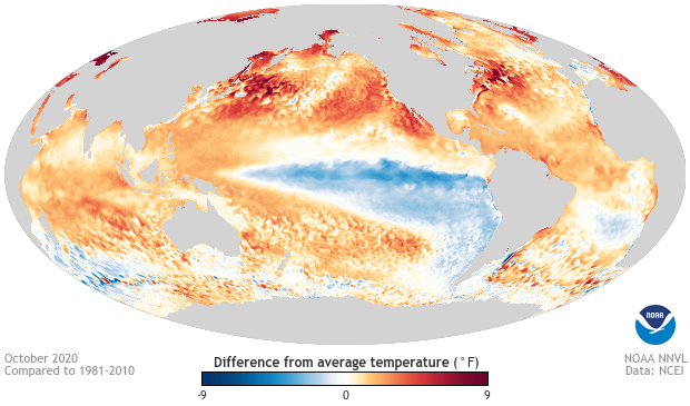
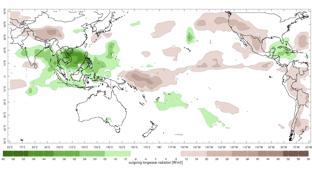
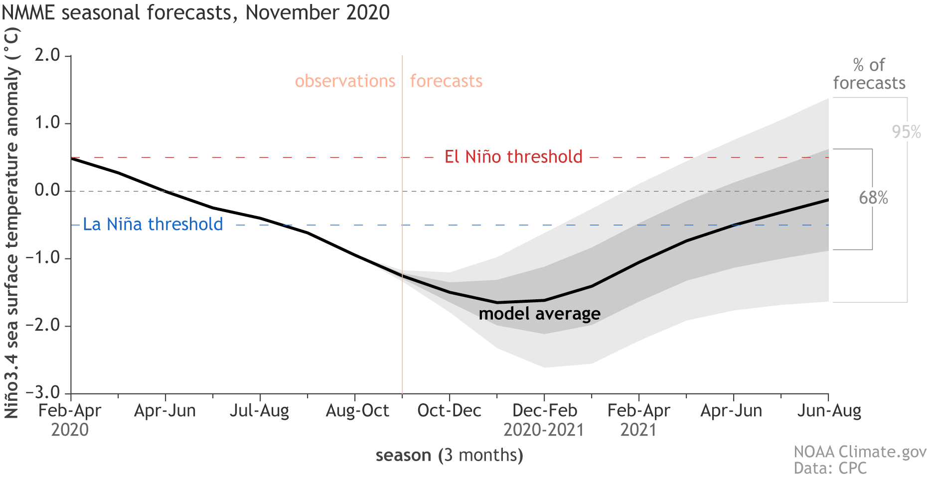
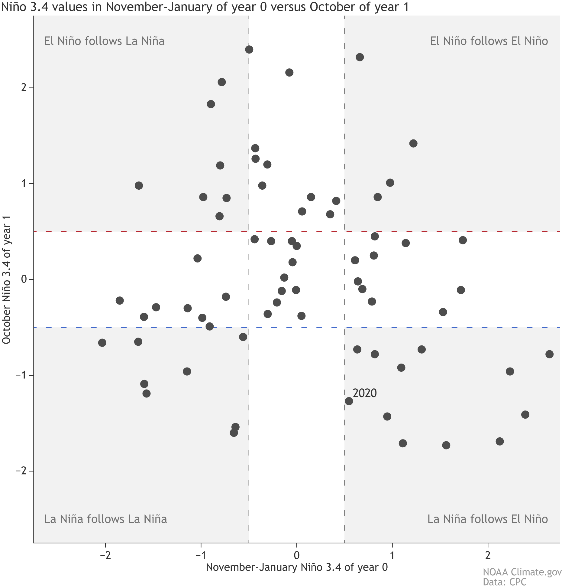


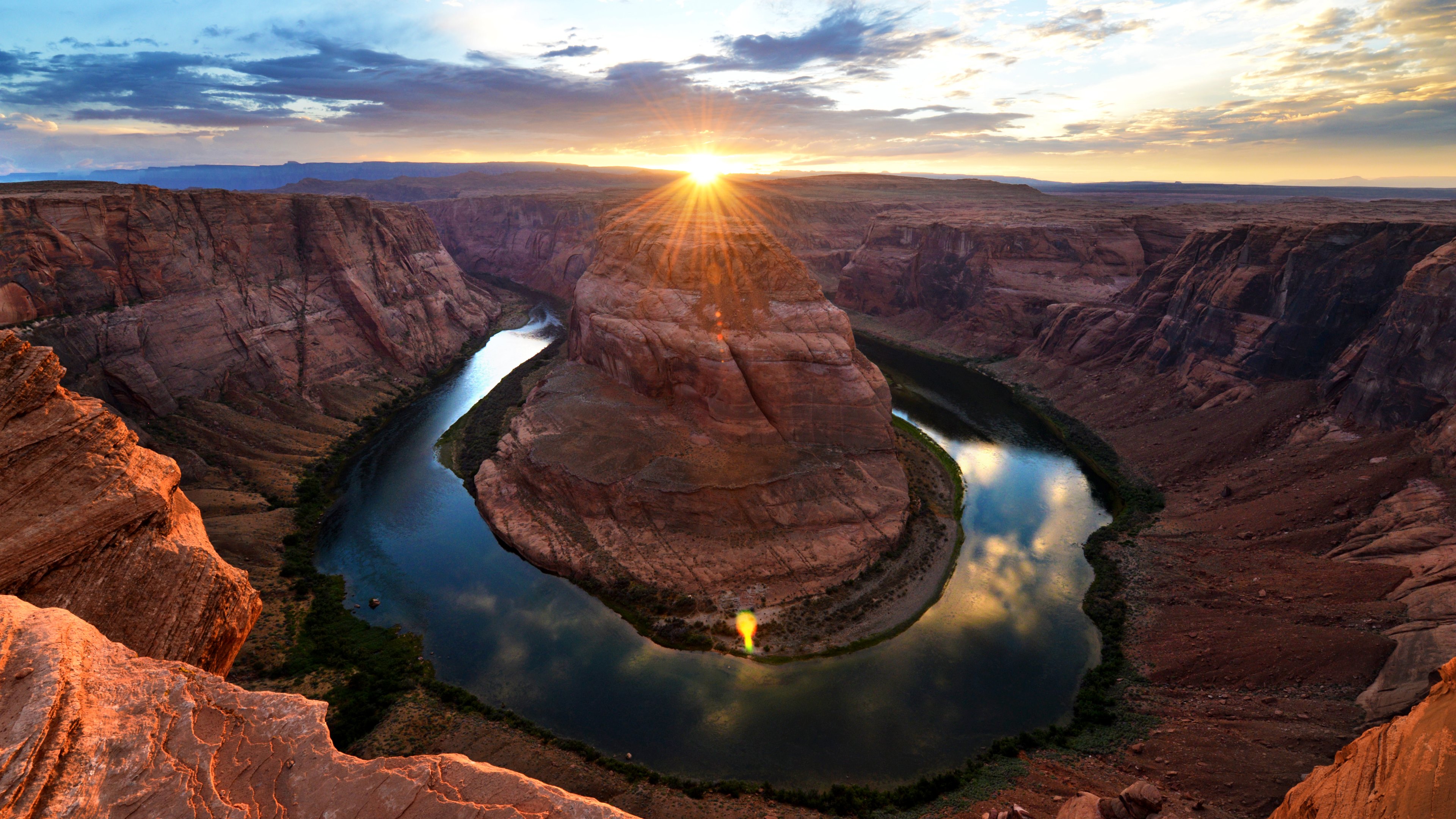
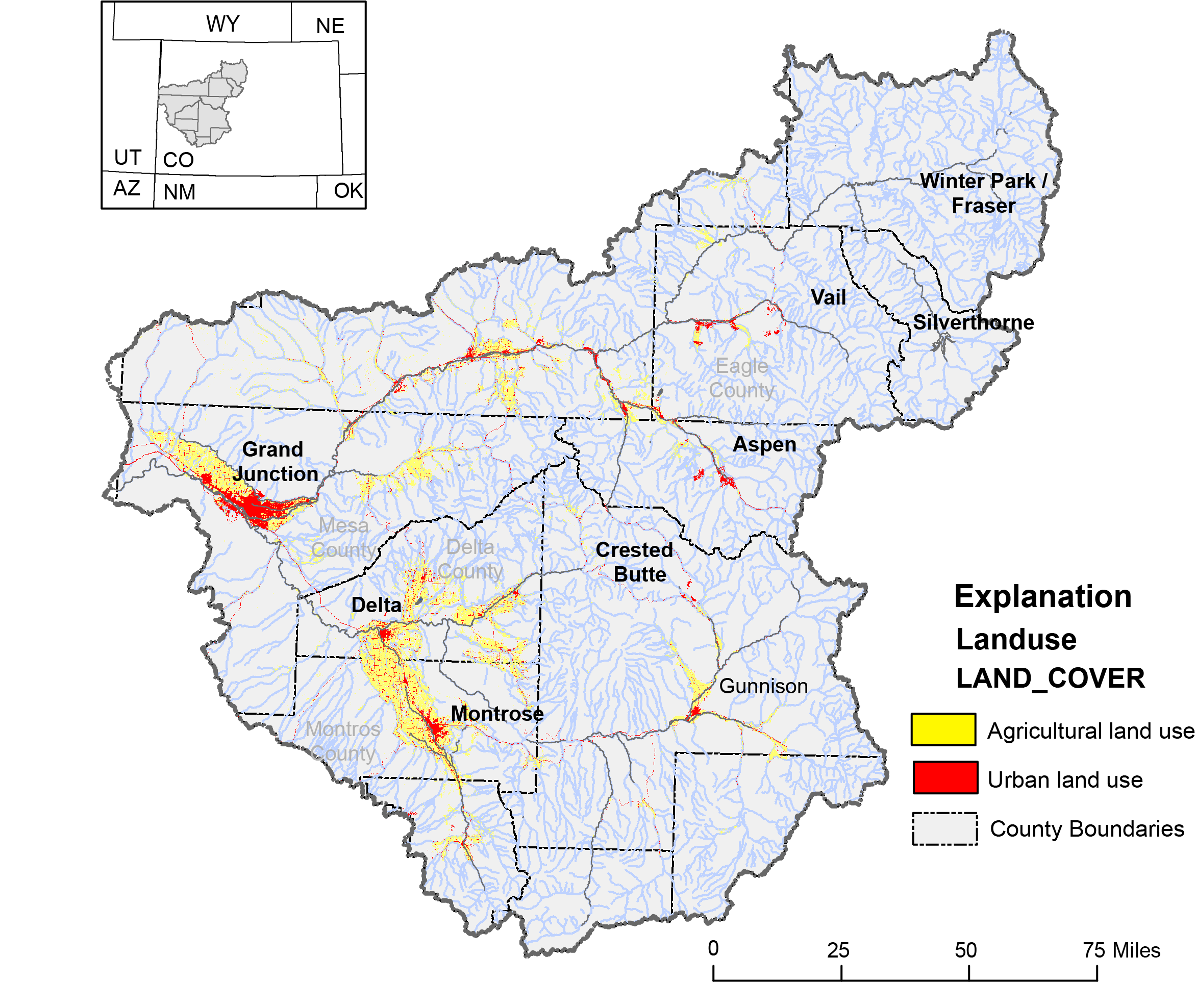
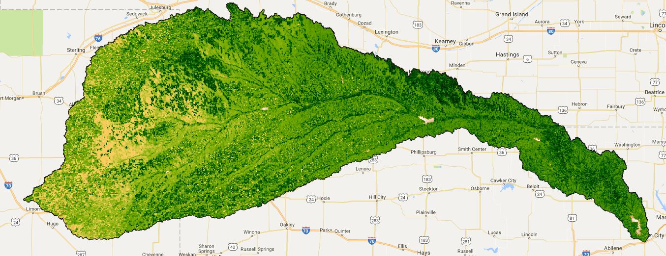


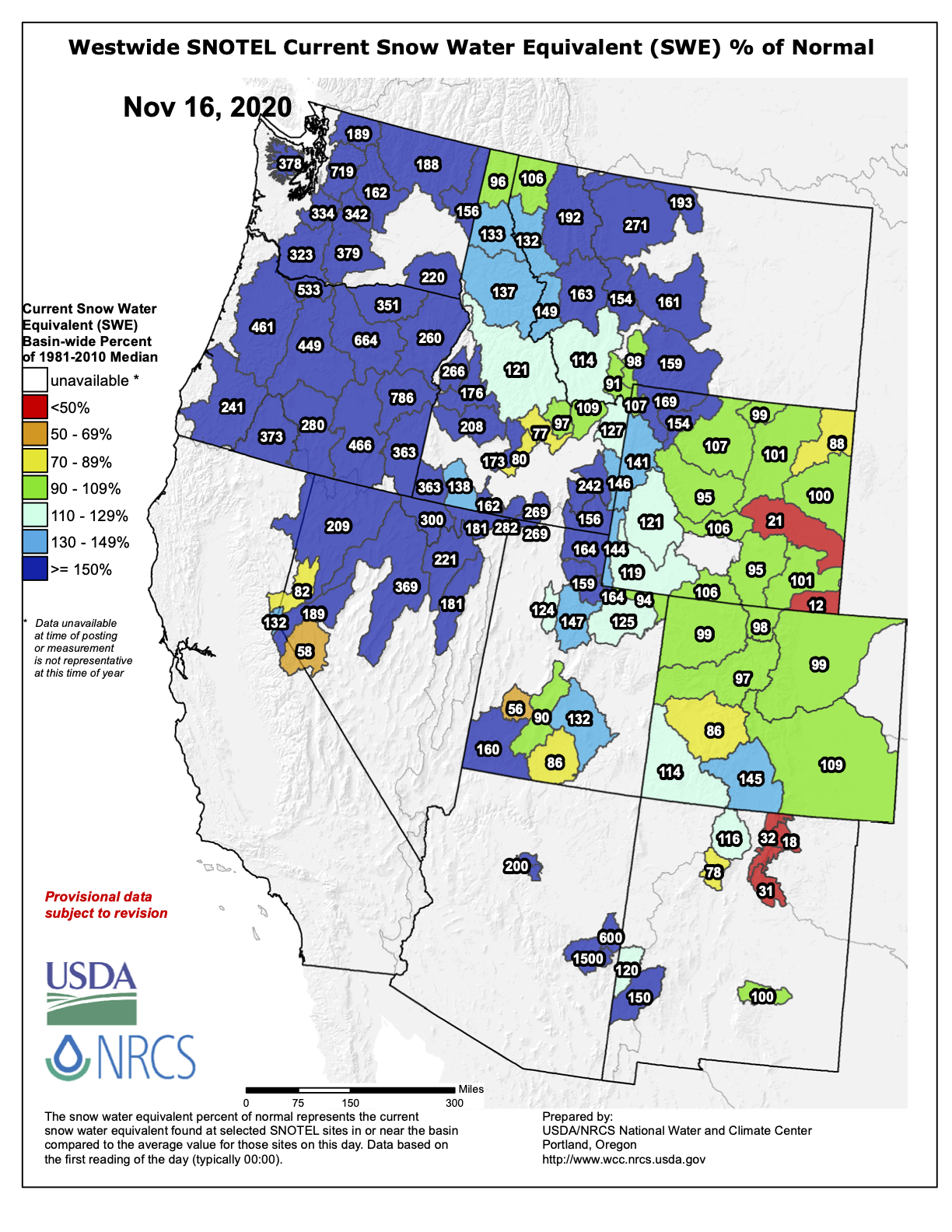

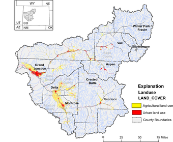
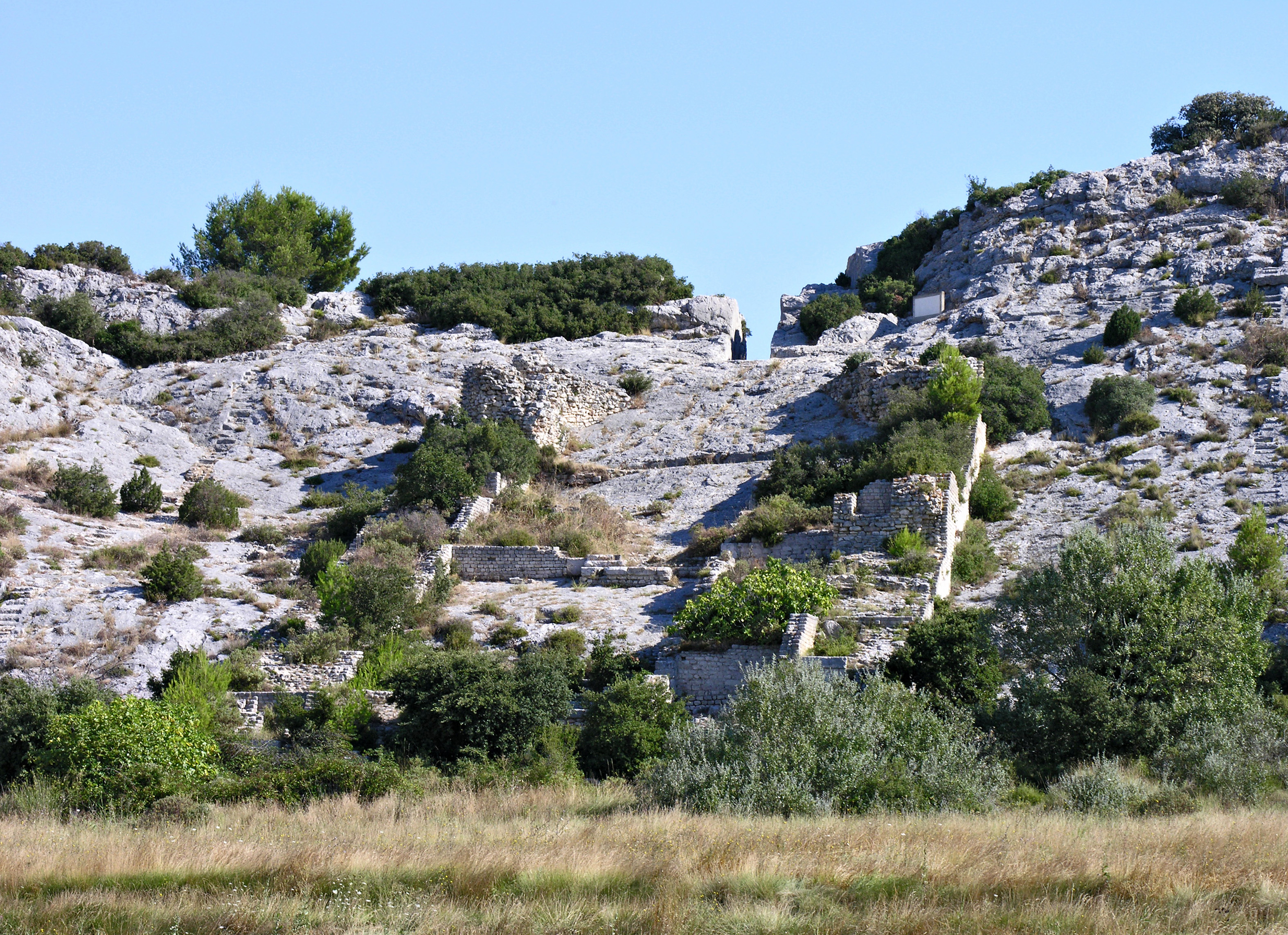
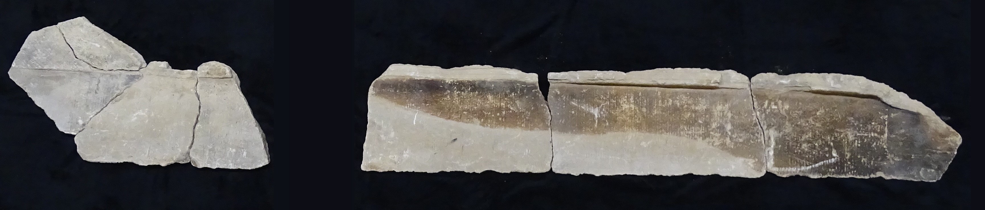

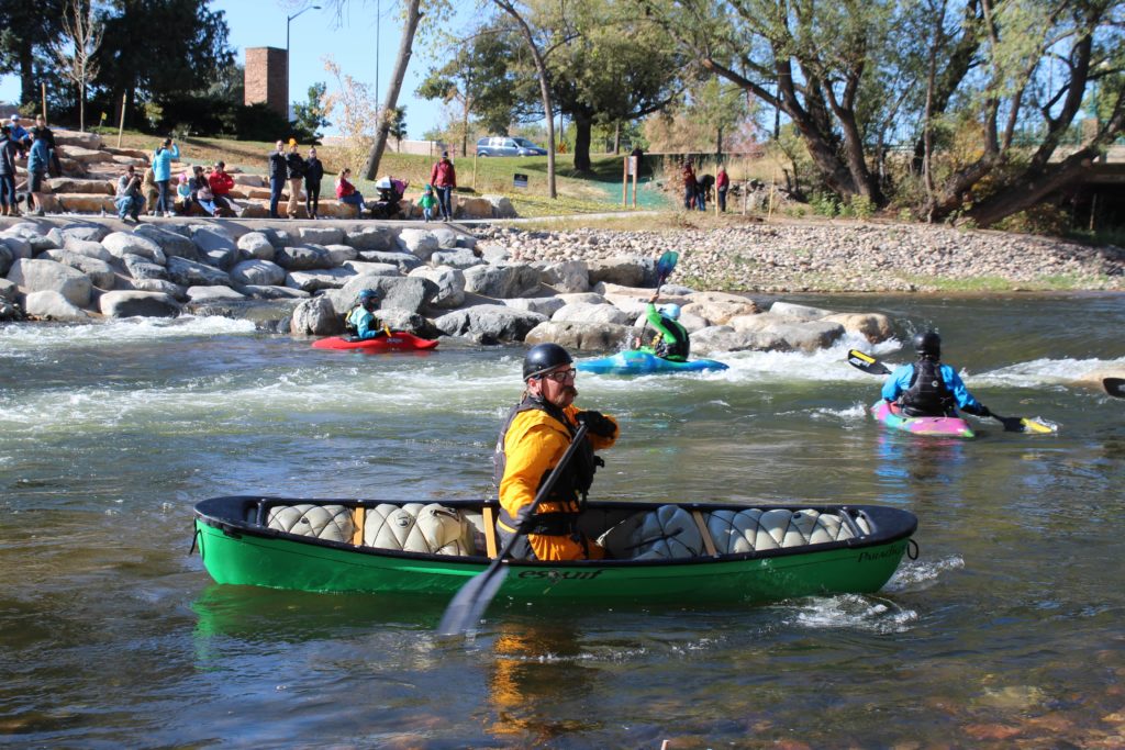
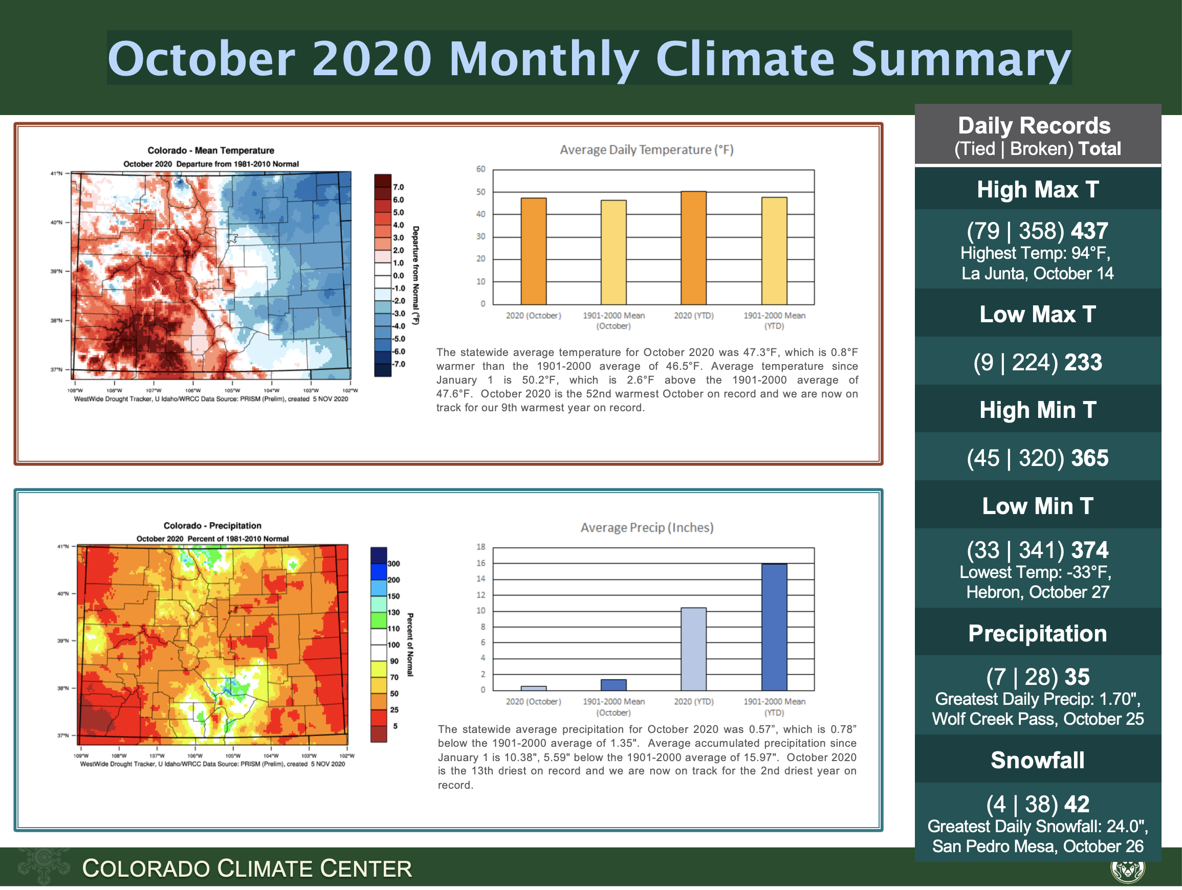
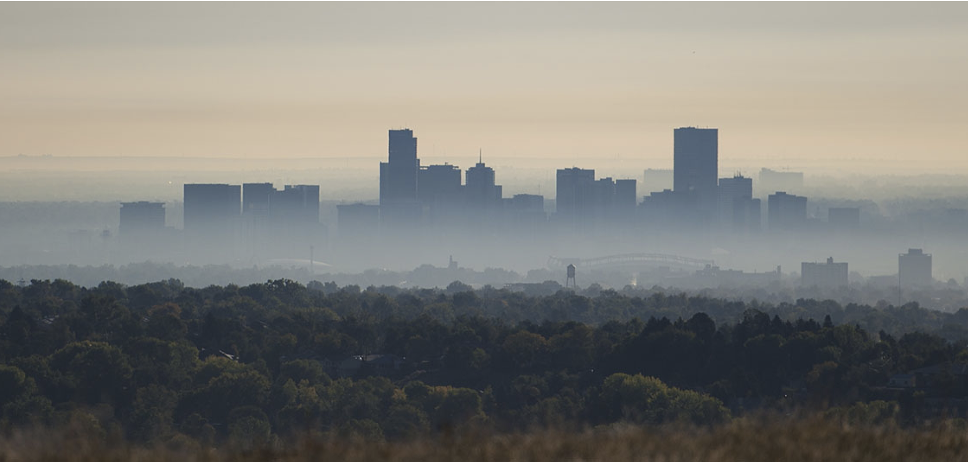
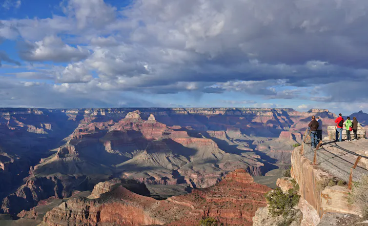


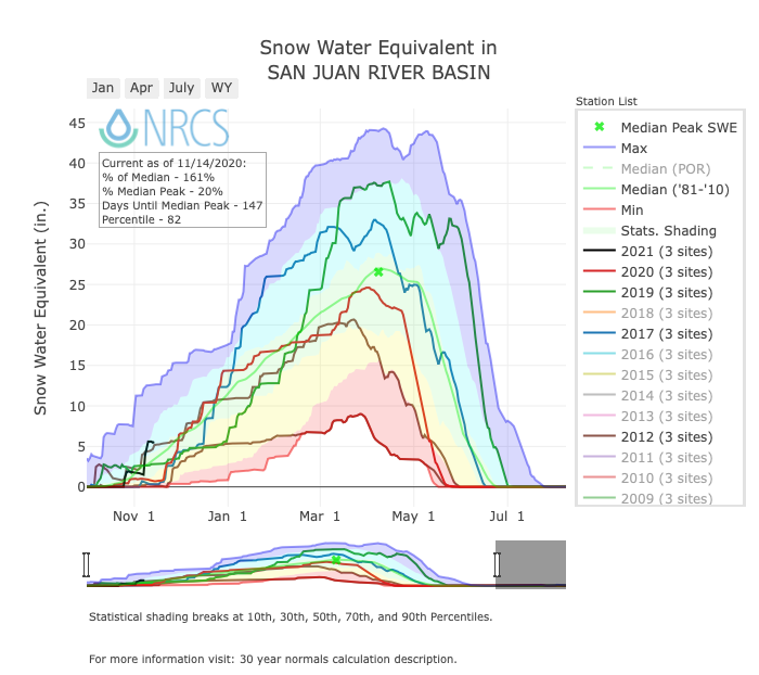
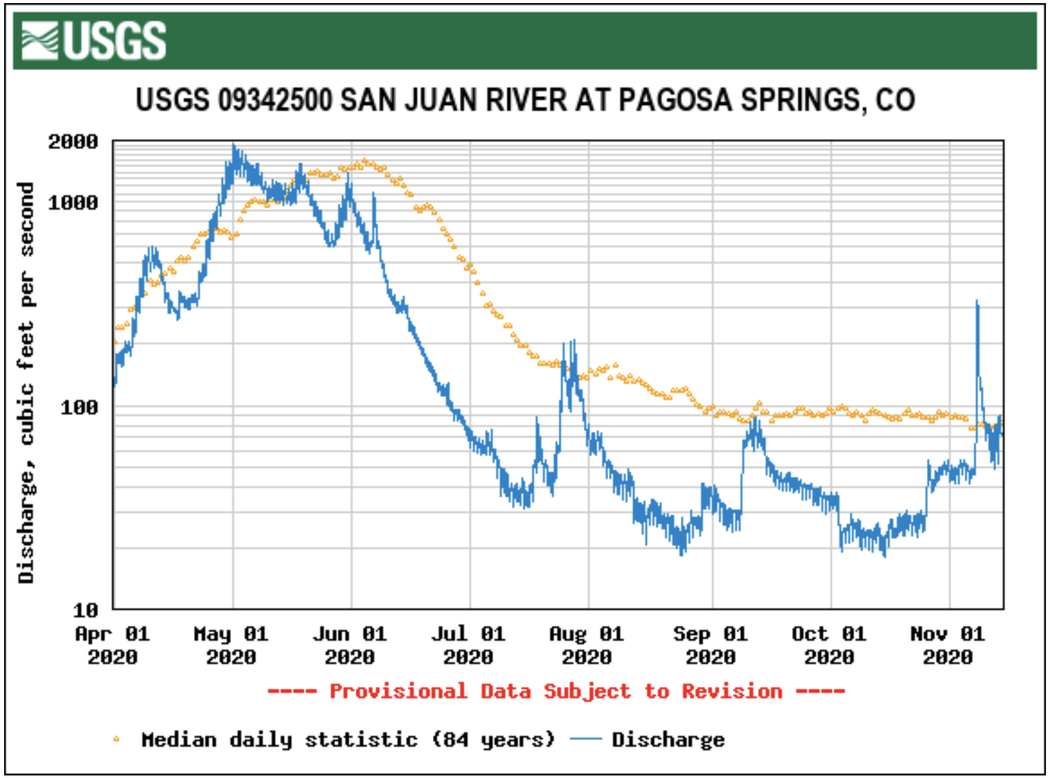


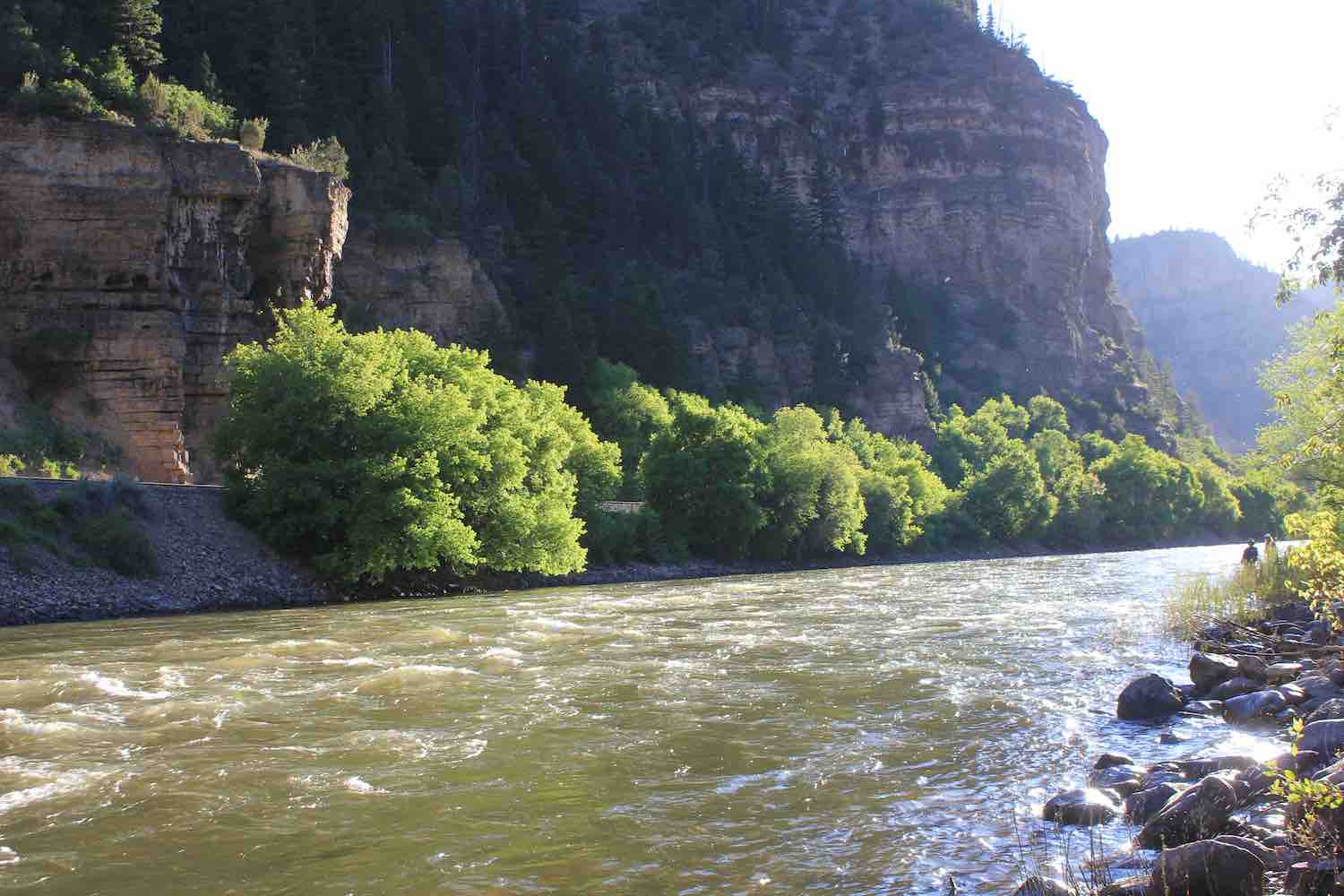

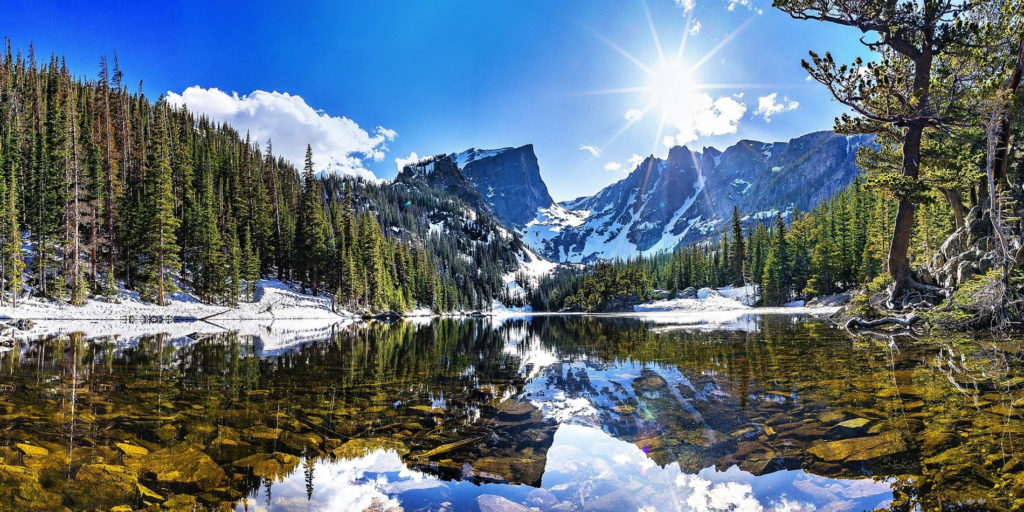
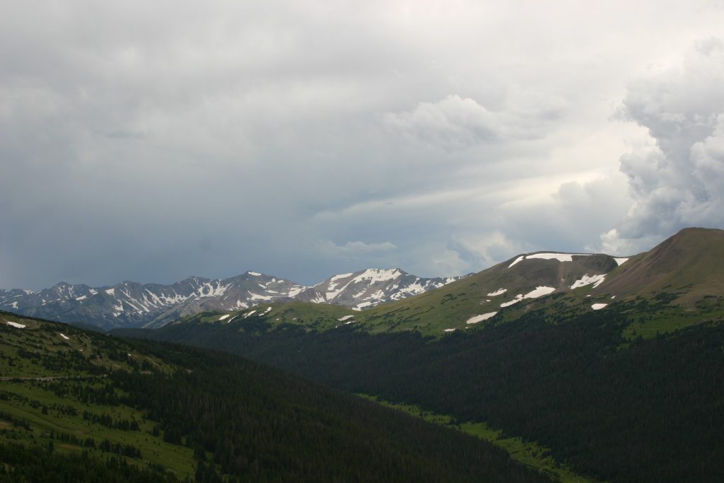
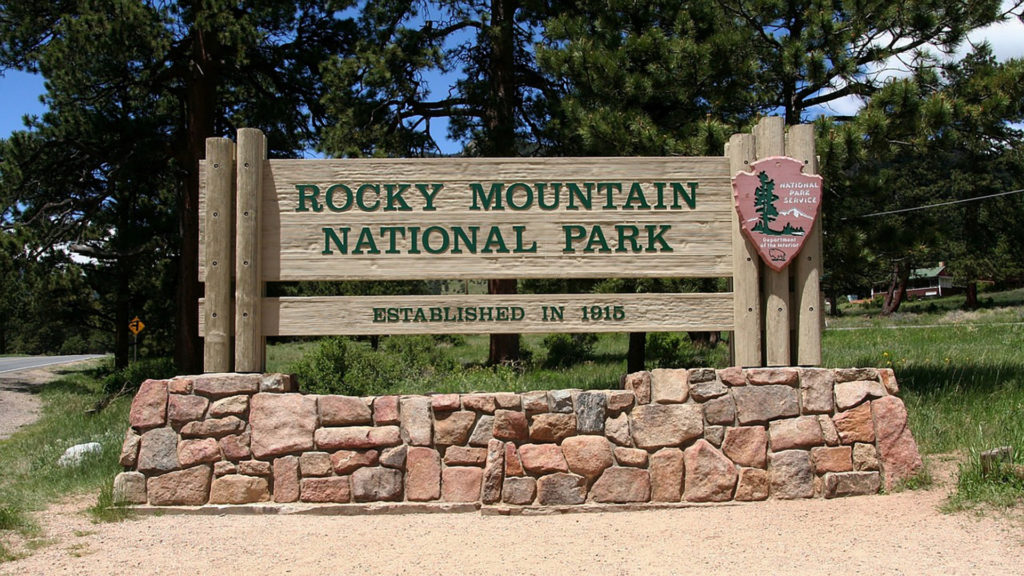
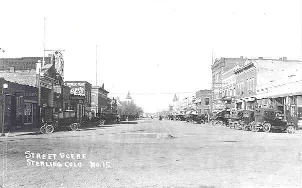
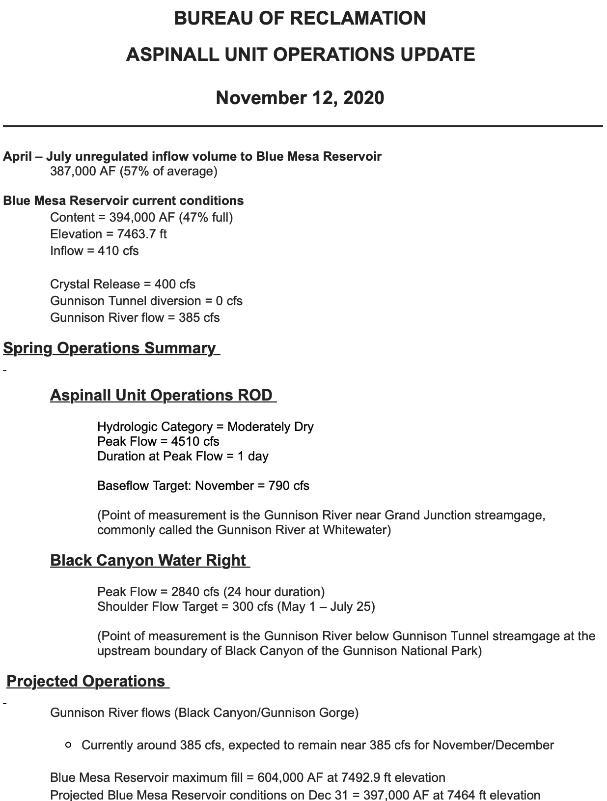


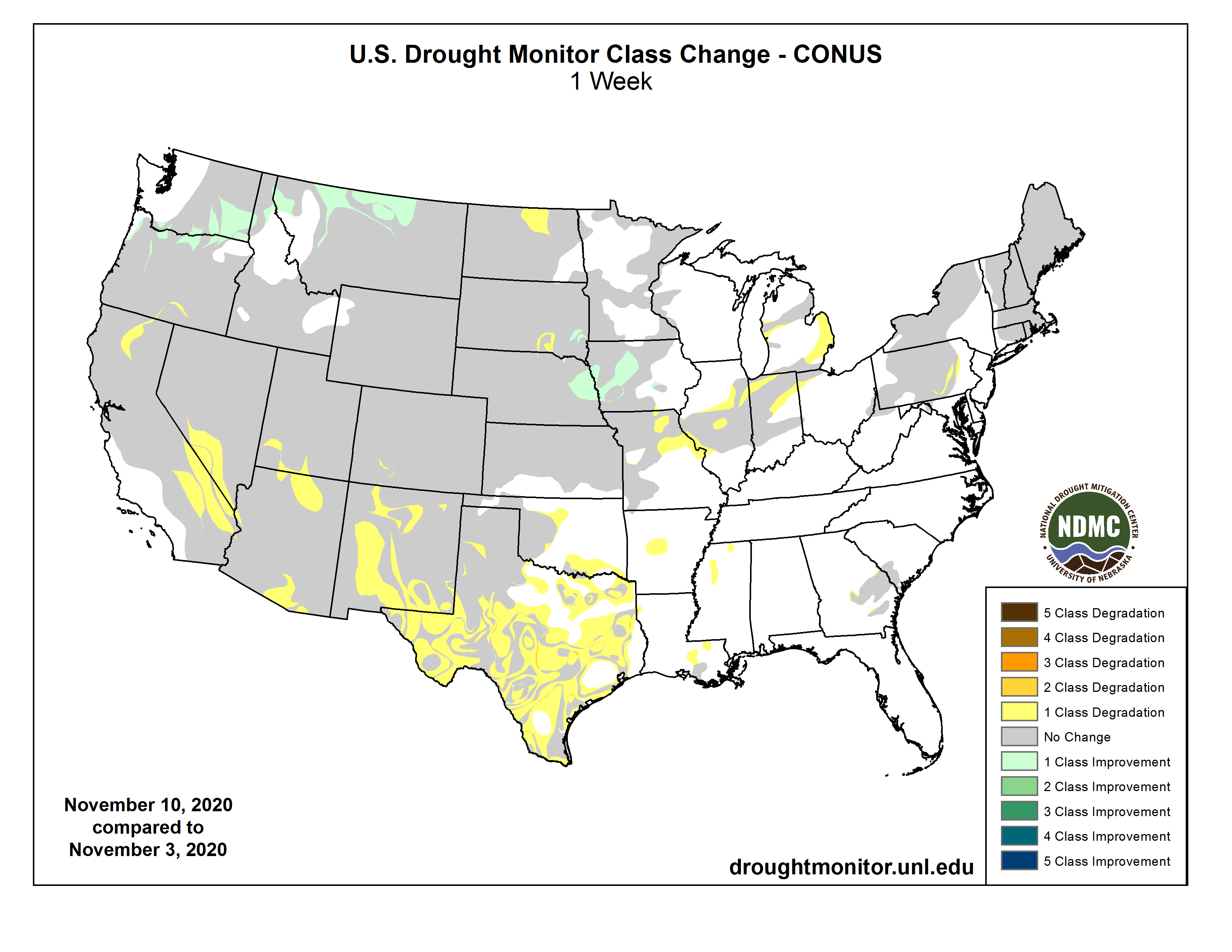


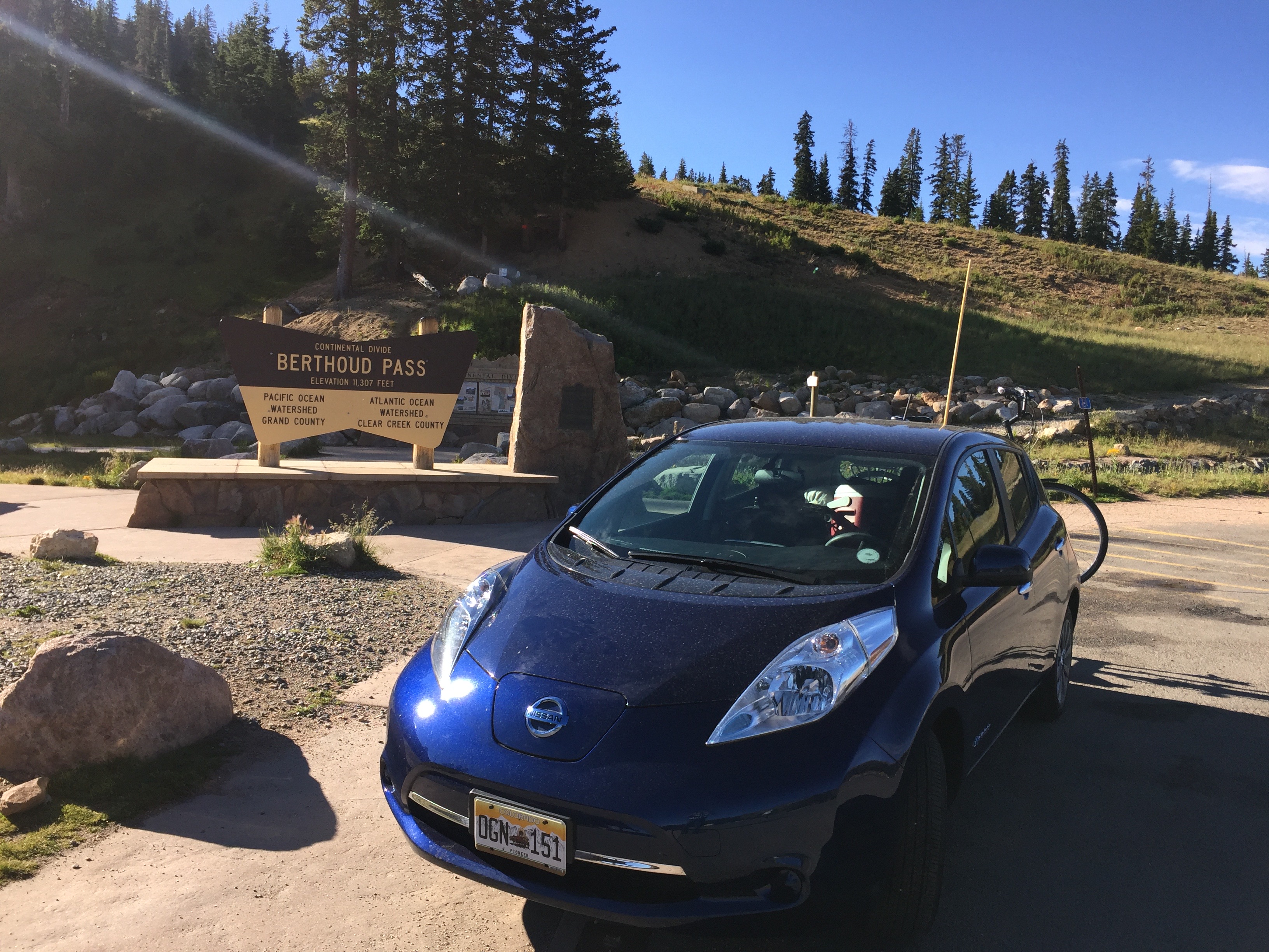
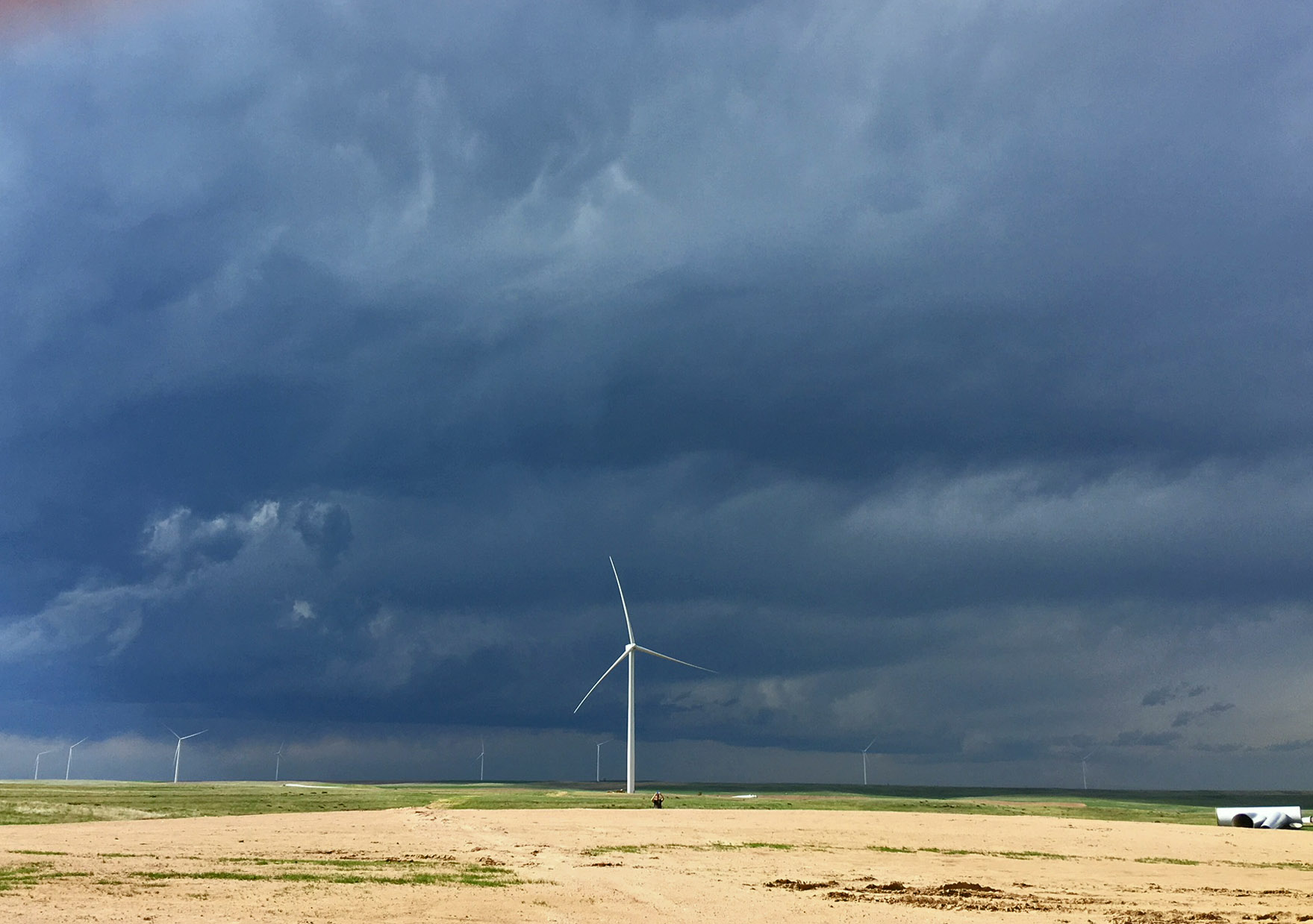

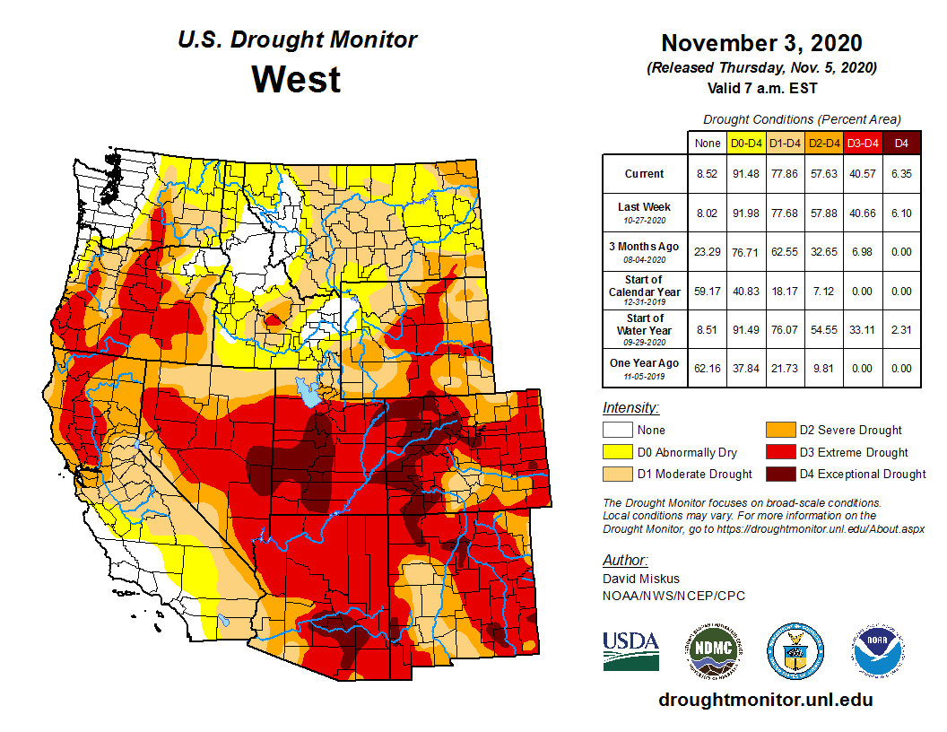


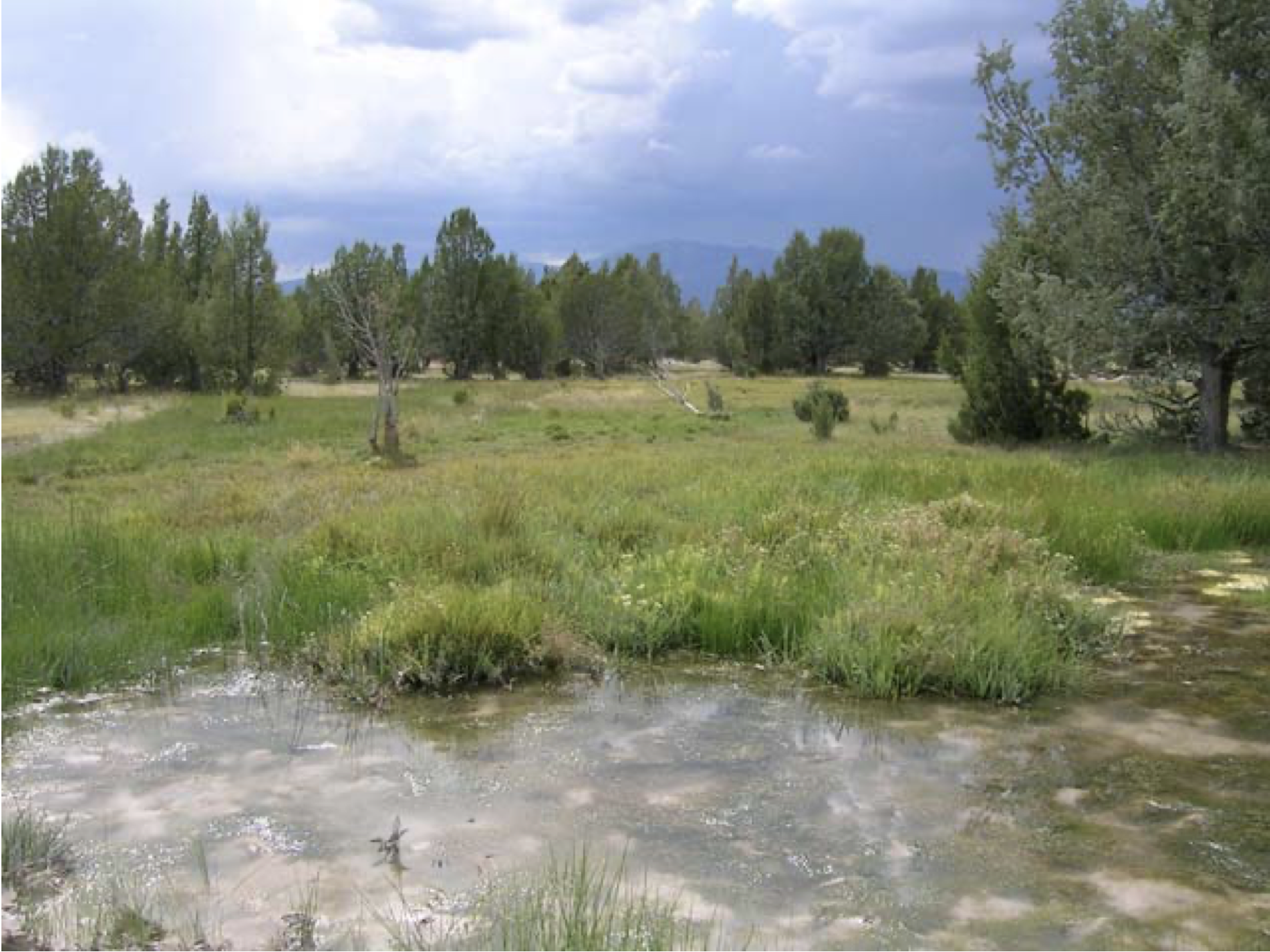
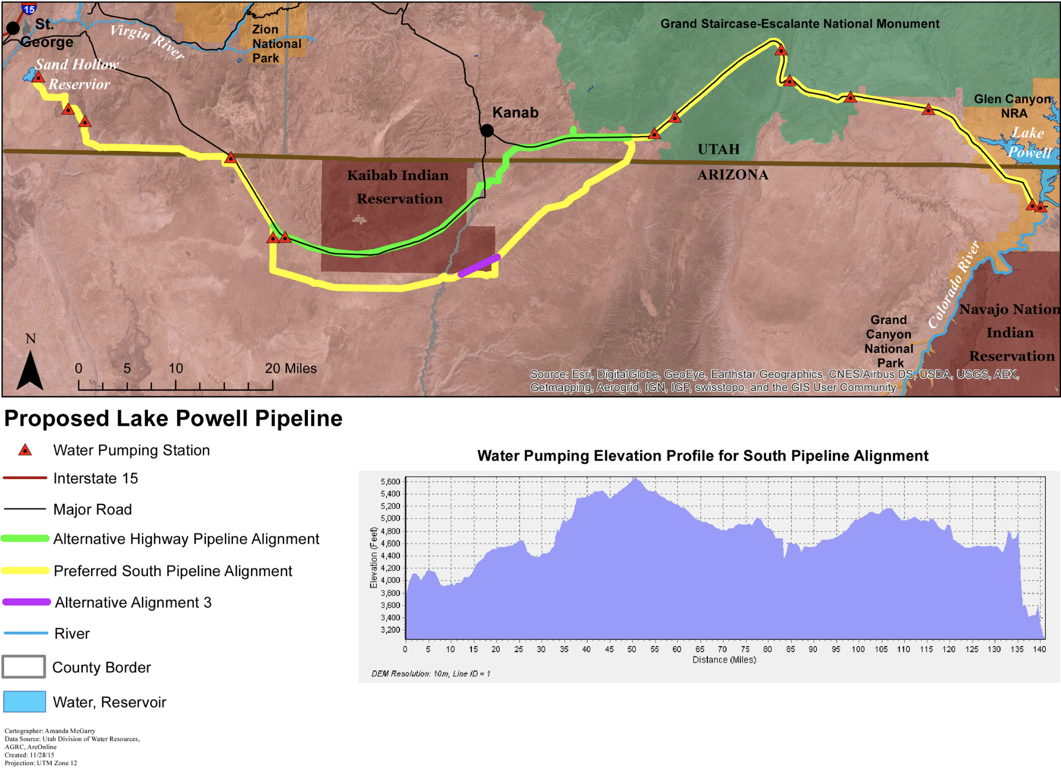


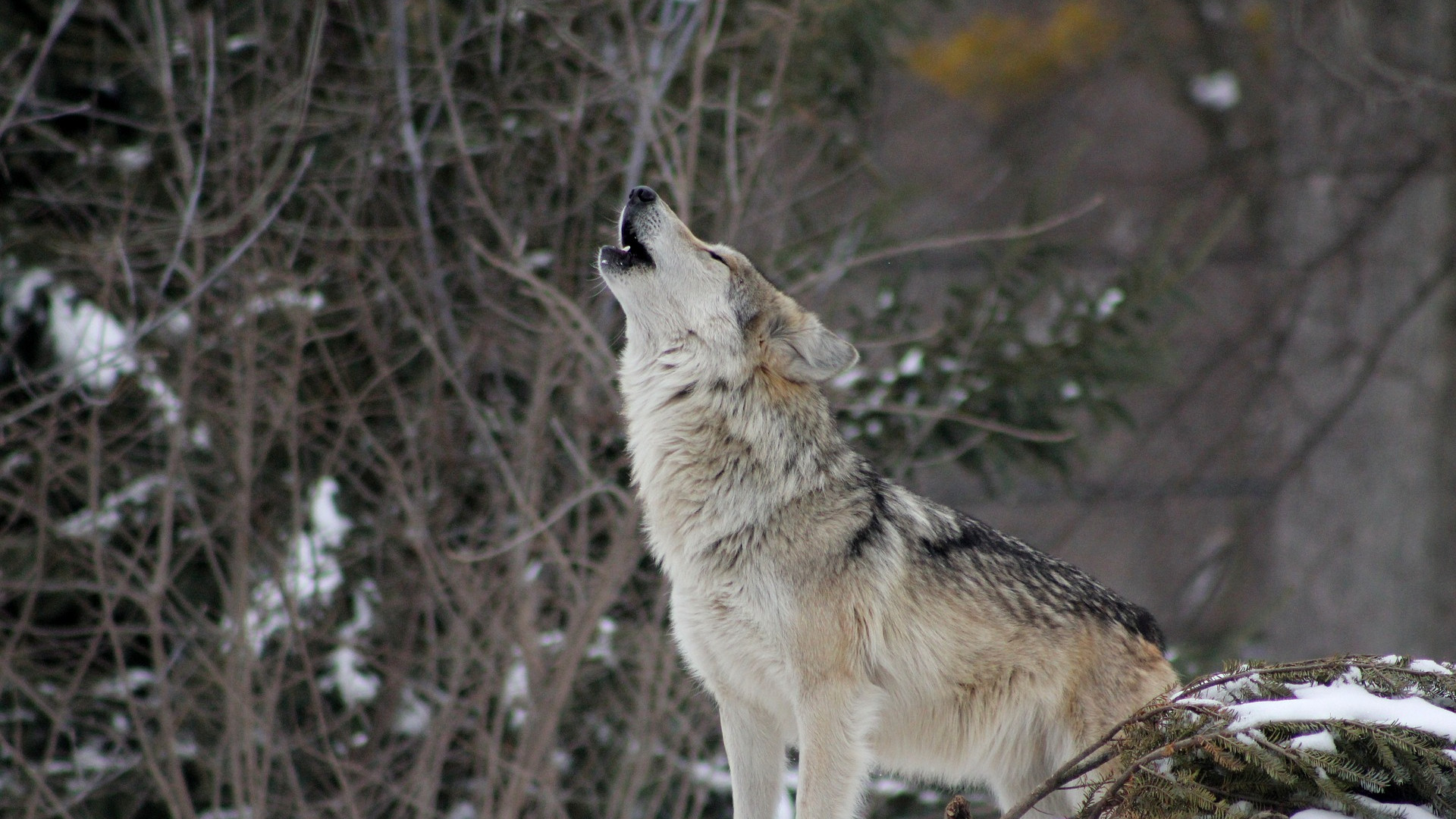
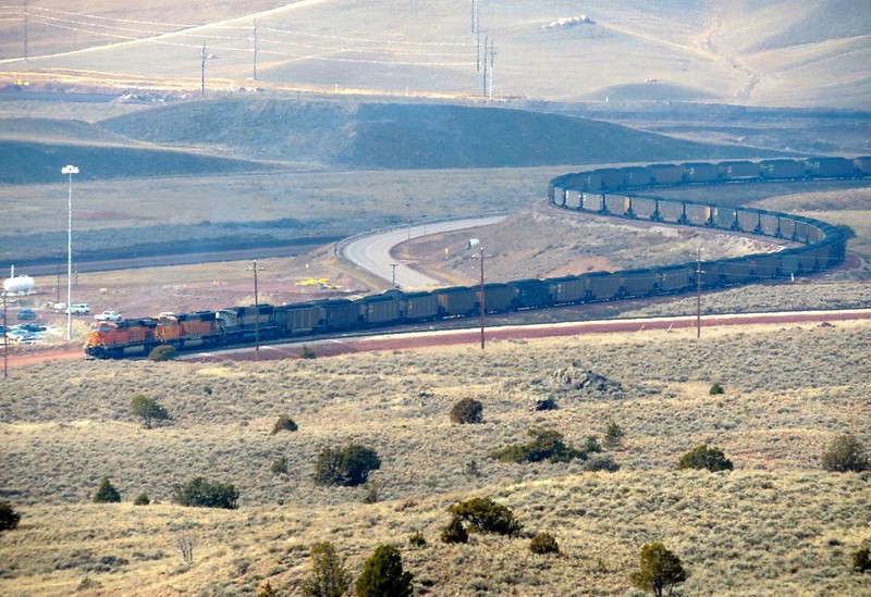
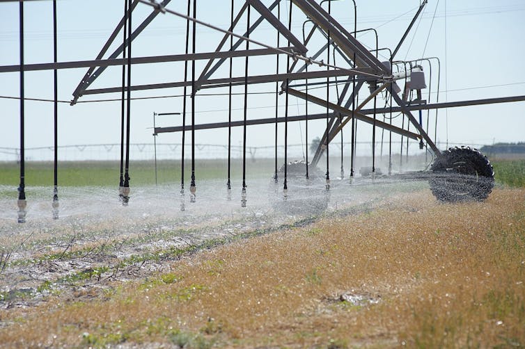


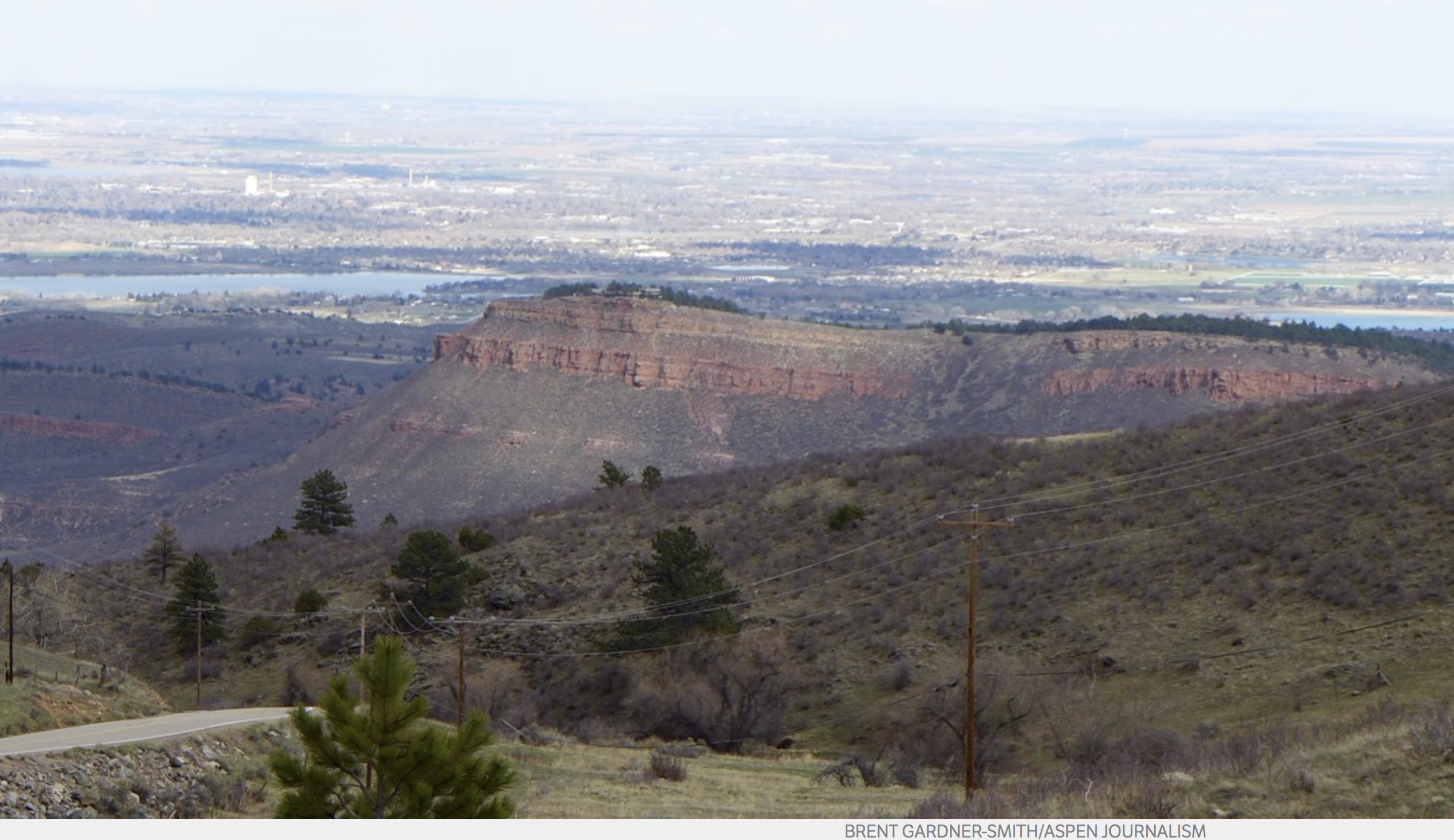
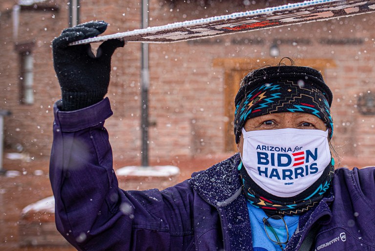


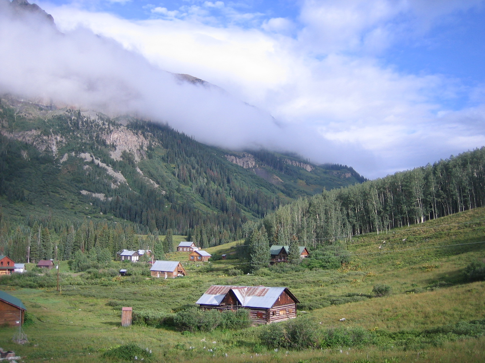

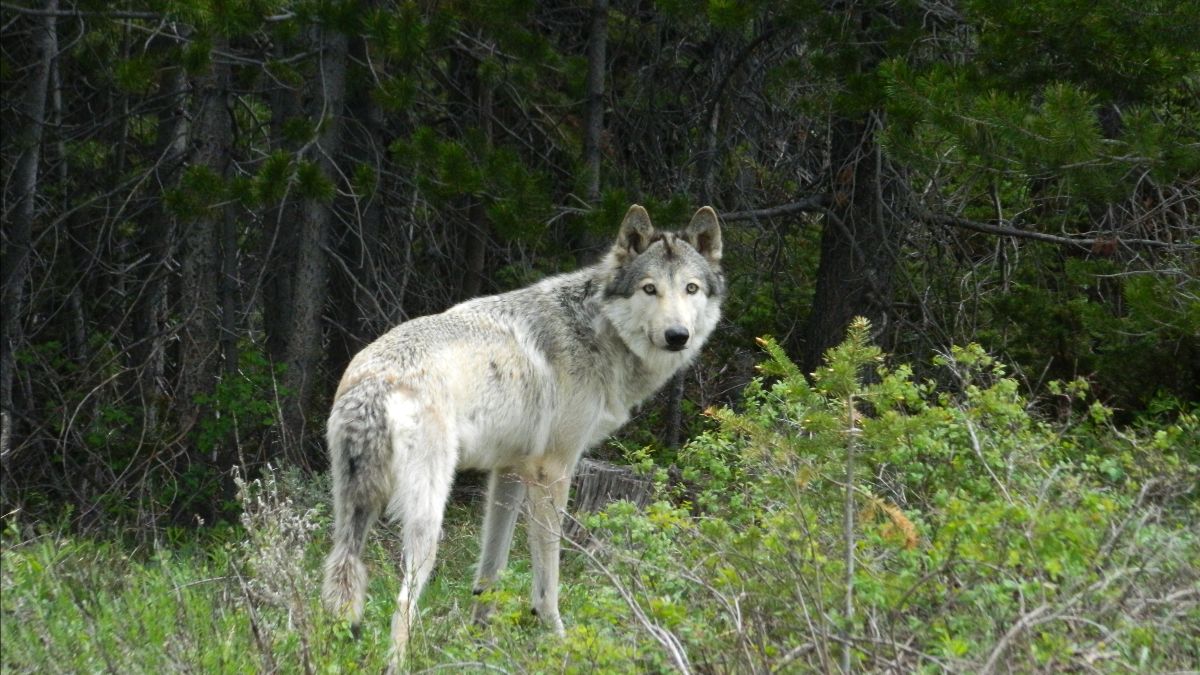
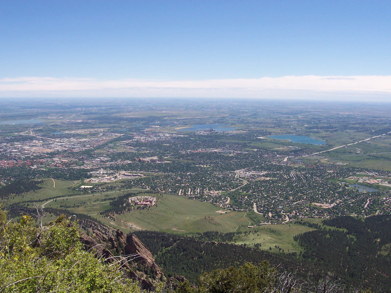


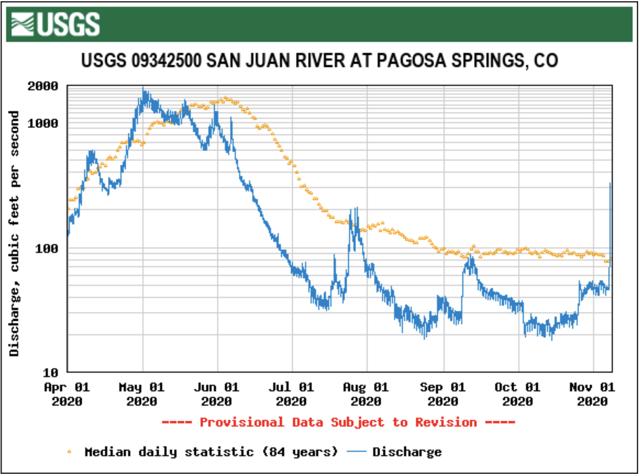
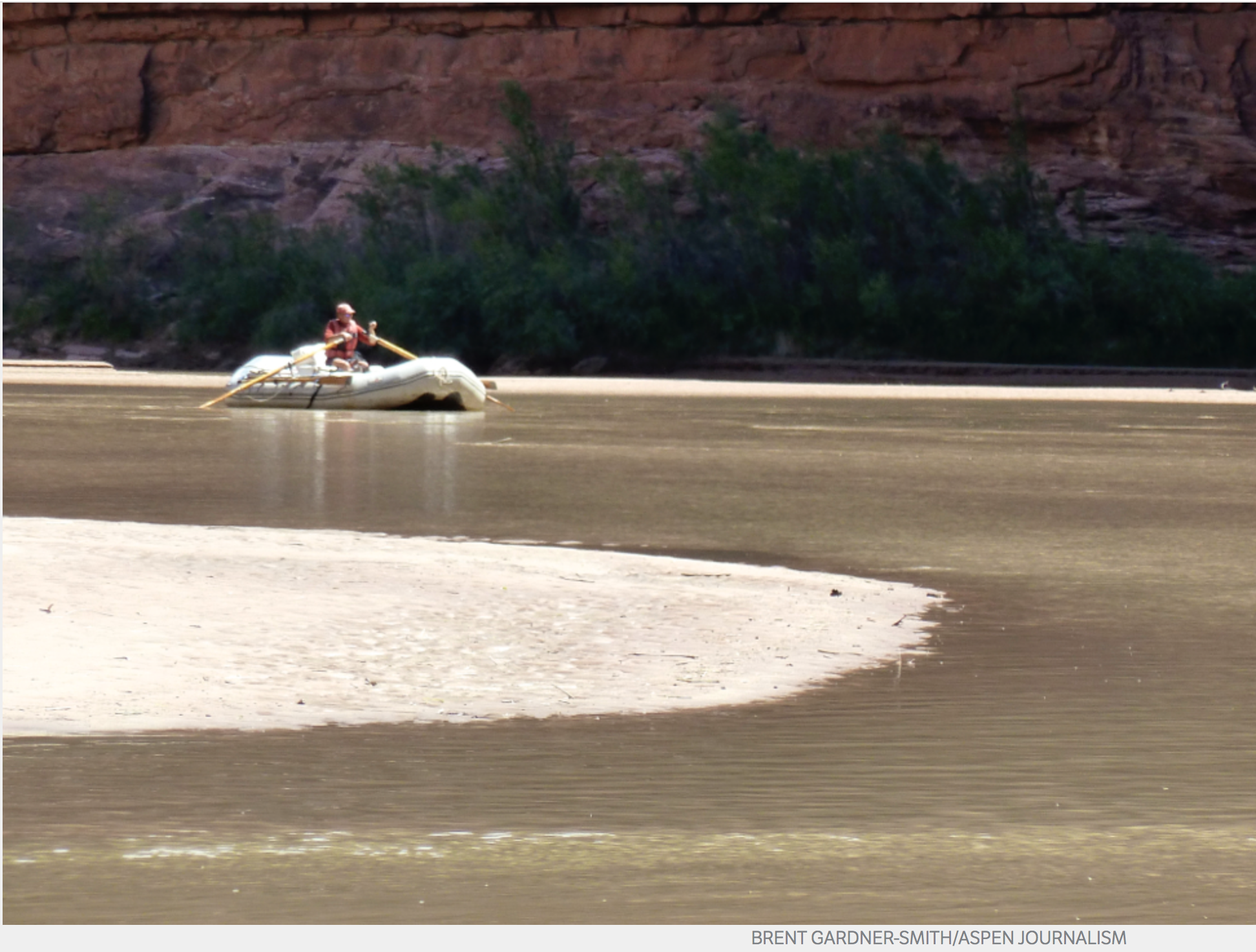
.jpg)
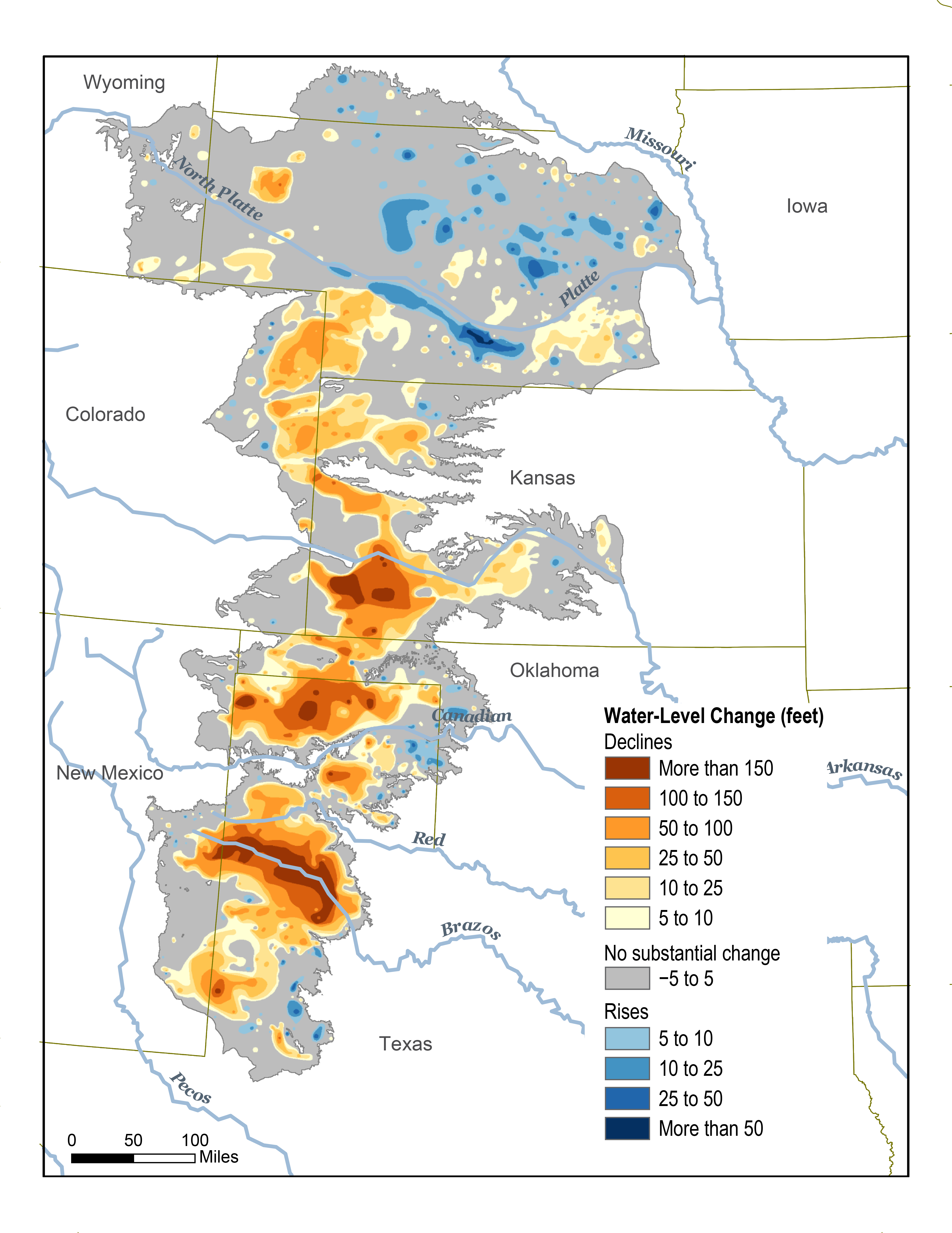