Here’s the release from Colorado State University:
Reagan Waskom via Colorado State University
Reagan Waskom, director of the Colorado Water Center, is retiring after over 30 years of service with Colorado State University. Waskom is a member of CSU’s Department of Soil and Crop Sciences, where he has worked on water-related research and outreach programs, in addition to overseeing the Extension Water Outreach program.
The Colorado Water Center is one of 54 Water Resources Research Institutes created by the Water Resources Act of 1964, which collectively form the National Institutes for Water Resources. As a division in the Office of Engagement and Extension, the Center aims to connect all water expertise in Colorado’s higher education system with research and education needs of the state’s water managers and users, building on the rich water history at Colorado State University.
“CSU has a long history in water-related research, education and outreach, areas that grow increasingly critical to our world every day,” said President Joyce McConnell. “Reagan’s deep wisdom and expertise as the director of the Colorado Water Center has been matched by his humanistic, thoughtful approach to this work. We are grateful to him for his incredible research and leadership, and we will continue the strong engagement he has modeled with the many water faculty, students, stakeholders and users across the state.”
“Reagan is a respected water expert and leader. Colorado has benefitted from his expertise, CSU is better from his service, and our future conversations on water are strong with our Center leadership and researchers,” said Blake Naughton, vice president of Engagement and Extension.
Gimbel interim director
With Waskom’s retirement, Jennifer Gimbel, currently a senior water policy scholar, will serve as interim director of the Water Center. At the center, Gimbel’s focus is on Colorado River issues and developing curriculum and teaching an interdisciplinary graduate class on Western water issues.
Gimbel was the principal deputy assistant secretary for water and science for the U.S. Department of Interior from 2014 to 2016, during which time she oversaw the department’s water and science policies and was responsible for the Bureau of Reclamation and U.S. Geological Survey. She also served as director of the Colorado Water Conservation Board from 2008 to 2013. She brings unique skills and experience working with the water community at the state, regional and federal level, as well as a proactive and creative approach to problem-solving. She has a bachelor of science and Juris Doctorate from the University of Wyoming and a master of science from the University of Delaware, and has authored numerous articles and presentations on state and federal water law.
Supporting Gimbel in this role, Julie Kallenberger will serve as associate director, assisting in leading and ensuring execution of research and education programs, outreach activities, communications and operations in support of the center’s mission. She will work directly with the center’s senior research scientists, CSU Extension water specialists, and water experts to advance knowledge and solutions to priority water challenges. Since 2008, Kallenberger has served as a water education specialist. She holds a bachelor of science degree from South Dakota State University and a master of science from CSU.
Additional information on the search for the next director of the Water Center will be available in 2021.
We know that global warming is forcing many animals around the world to flee their normal habitats, but now, an exhaustive analysis has shown marine species are booking it for the poles six times faster than those on land.
Drawing together 258 peer-reviewed studies, researchers compared over 30,000 habitat shifts in more than 12,000 species of bacteria, fungi, plants, and animals.
The resulting database, named BioShifts, is the first comprehensive analysis of its kind, and while the database is limited by our own, human research biases, the data we have certainly suggests marine species are following global thermal shifts much closer than land animals.
While land species definitely are moving closer to the poles as the planet heats up, this shift is “at a pace that is much slower than expected, especially in areas with warm climates,” the authors write.
In the review, amphibians were found to be moving up slope at over 12 metres a year, while reptiles seem to be headed towards the equator at 6.5 metres a year.
Insects, which incidentally carry many diseases, were found to be moving poleward at 18.5 kilometres per year.
Relatively, that’s a lot, but in the bigger picture, marine species were moving towards the poles at an average pace of nearly 6 kilometres per year, while land animals were only shifting upslope at a mean pace of nearly 1.8 metres per year (slightly faster than previous estimates for land species, but still comparatively slow).
This discrepancy between land and water could exist for several reasons. It might, for instance, be a product of temperature sensitivity. Air conducts heat 25 times less effectively than water, and many land animals can easily regulate their body temperature if they want.
On the whole, this would logically leave marine species and many ectotherms – cold-blooded species – much more susceptible to Earth’s fluctuating temperatures.
Plus, animals in the water can migrate a lot easier if the need arises. On land, human activities often impede the movement of animals. In fact, when animals were exposed to a high degree of anthropogenic disturbances, the authors of this analysis found they tended to move against the thermal grain and not with it.
This is consistent with the general idea that land use and climate change may force species in opposite directions, a sort of push and pull of re-distribution.
“On land, habitat loss and fragmentation due to land use changes may impede the ability of terrestrial species to track shifting isotherms [lines on a map connection regions with the same temperature],” the authors write.
“These complex interactions need to be accounted for to improve scenarios of biodiversity redistribution and its consequences on human well-being under future climate change.”
If the authors are right, and marine life is tracking along temperature changes more closely, it could have dire and far-reaching repercussions. Some of which we might have seen before.
During the Permian-Triassic Extinction, the most calamitous event in Earth’s history, researchers say very few marine organisms stayed in the same habitat as oxygen levels plummeted.
“It was either flee or perish,” according to oceanographer Curtis Deutsch of the University of Washington, and for over 50 percent of marine species at the time, it was unfortunately the latter.
Today, as temperature increases squeeze animals into ever-narrowing habitat ranges, those animals already swimming towards he poles are also at risk of running out of cooler water.
Of course, this is happening on land, too. Animals found high up in the mountains are said to be riding an “escalator to extinction” as temperatures and competition push them over the brink. It’s just that in the water this escalator seems to be moving faster.
“We suggest that commercial fishing may speed up the displacement of marine species distribution through resource depletion and population crashes at the trailing edge, whereas low constraints on dispersal in the oceans may allow marine species living close to their upper thermal limits to better track climate warming at the leading edge,” the authors predict.
As impressive and necessary as the new database is, however, the authors acknowledge it has serious limits.
Despite its comprehensive nature, the meta-analysis used to create BioShifts only covers 0.6 percent of all known life on Earth, and the animals we have researched tend to be the most charismatic, or important to humans, focused predominantly in the northern hemisphere.
So while we call this a global meta-analysis, it’s not really. Instead, it’s as close as we can get given the circumstances.
Still, we can only work with what we’ve got, and it looks like the animals we do know of are struggling to find new habitats in the face of a growing climate crisis.
BioShifts is a way for us to help track those changes so we can possibly predict what will happen next.
North America’s sagebrush steppe ecosystem is home to more than 350 species of plants and animals, many of which live nowhere else. It sustains the water supply, economies, and culture of Western communities. But a deadly invader threatens to send it all up in flames. Learn how cheatgrass and other invasive weeds threaten this ecosystem’s very existence and what we must do to save it: https://rockies.audubon.org/sagebrush/cheatgrass-fire
New research reveals a creeping, permanent dryness expanding across the United States. It’s much more than “drought,” and researchers hope more accurate descriptions will spur critical action.
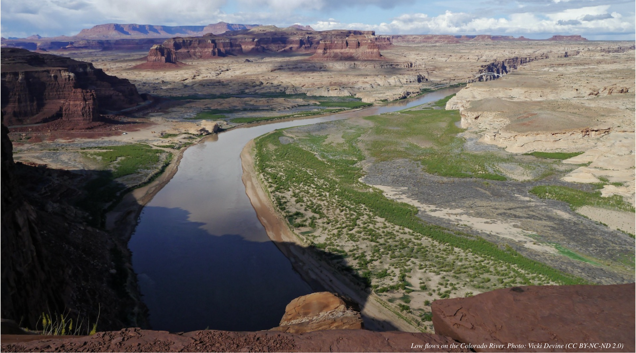
After nearly two decades of declining water flows into the Colorado River Basin, scientists have decided the word drought doesn’t cut it anymore. We need different terms, they say, to help people fully grasp what has happened and the long-term implications of climate change — not just in the Southwest, but across the country.
The term that’s caught the most attention lately is “megadrought.”
It’s not a new word, but it’s one that’s come sharply into focus in recent months, following a study published this April in the journal Science that found the North American Southwest has experienced an abnormally severe drought over the past two decades — its second driest stretch in 1,200 years.
Archaeological evidence has linked previous decades-long megadroughts to several historical societal collapses, including the Mayan civilization and Kublai Khan’s Yuan dynasty in China.
Let that sink in a minute if you need to.
The researchers, led by A. Park Williams of the Lamont-Doherty Earth Observatory of Columbia University, say this prolonged megadrought — which reached from Oregon and Idaho down to northern Mexico — would likely have been just a bad drought if not for climate change. The increase in temperatures from our burning of fossil fuels supercharged naturally varying conditions, creating one of the worst megadroughts in human history.
“The new study provided a nice basis to what many of us have felt now for a number of years,” says Brad Udall, a senior water and climate research scientist at Colorado State University, who was not involved in the research. “The basin has really entered a fundamentally different period than what we experienced during the 20th century.”
Lake Mead in 2017. Photo: Karen, (CC BY-NC-ND 2.0)
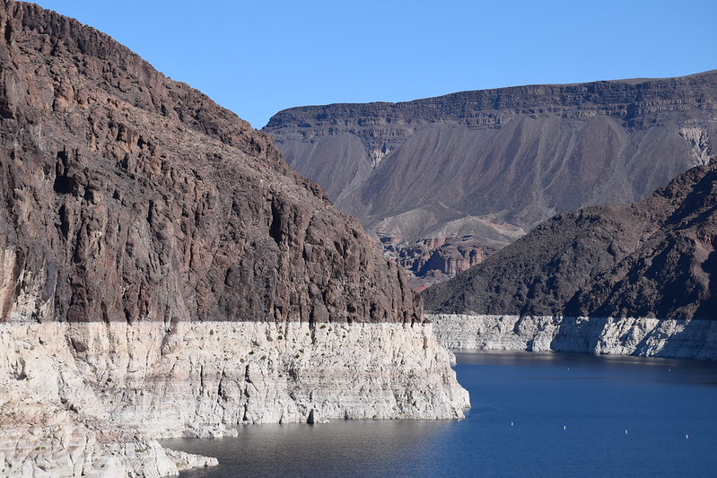
That may not come as a surprise to those who have noticed that the Colorado River’s biggest reservoirs, Lake Mead and Lake Powell, are now sitting half-empty.
But linking modern reality to the megadroughts of history is something new — and researchers say this and other changes to our language matter for the future.
Brad Udall: Here’s the latest version of my 4-Panel plot thru Water Year (Oct-Sep) of 2019 of the #coriver big reservoirs, natural flows, precipitation, and temperature. Data goes back or 1906 (or 1935 for reservoirs.) This updates previous work with @GreatLakesPeck
Hot Drought
The current megadrought in the Southwest is defined not so much by declining precipitation — although that did have an effect too — but by increasing temperatures from climate change. That’s going to continue to climb as long as we keep burning greenhouse gases.
Udall and Jonathan Overpeck, dean of the School for Environment and Sustainability at the University of Michigan, have spent more than a decade studying the effect of this warming on the Colorado River, a crucial water source in the West. The river irrigates 5 million acres of farmland, provides water to 40 million people in seven states — including in the West’s biggest cities like Los Angeles, Phoenix and Denver — and helps keep the lights on in the “city of lights,” among other towns.
This exploitation has come at an ecological cost, though. Thanks to diversions for our various human uses, the river now runs dry before it reaches the sea. More water rights have been allotted than nature can provide, which is undoubtedly a management issue (although a complex one to solve), but in the last two decades this is being more acutely felt.
In part that’s because less water is running off into the basin.
Udall and Overpeck found in a 2017 study published in Water Resources Research that Colorado River flows between 2000 and 2014 were 19% below normal. Reduced rainfall was partially responsible. But on average, they found, about one-third of the runoff decline resulted from warming temperatures from human-caused climate change.
Snowmelt is an important part of the freshwater system in the Colorado River Basin. Photo: NASA/ Thaddeus Cesari
Higher temperatures from this “hot drought,” as it’s also called, means more evaporation from water bodies and soil, more evapotranspiration from plants and more sublimation from snow. For the West, where water resources are stretched thin already, this can have far-reaching economic and ecological consequences.
Which brings us to another proposed change in the way we describe things.
In a 2018 paper the Colorado River Research Group, which includes Udall and Overpeck, called for new language to describe the scientific reality on the ground. The term “drought,” they wrote, wasn’t accurate.
“Aridification,” they argued, was a more fitting description.
The semantics here are important.
Aridification, they explained, “describes a period of transition to an increasingly water scarce environment — an evolving new baseline around which future extreme events (droughts and floods) will occur.”
Or more simply: Drought is temporary. Aridification is permanent.
This reinforces the fact that climate change isn’t a distant phenomenon, but one that’s already underway and causing life-altering changes. Depending on where you live, it’s causing more severe floods, destructive hurricanes, prolonged droughts or lengthened fire seasons.
And it’s here to stay, given our current course. The “new normal” of climate change could, like megadroughts, be felt for decades.
“We’ve been wanting to make the case that this is not a normal drought,” says Udall. “A drought implies that some kind of return to normalcy will occur in the near future, and that’s not what we’ve seen and not what the science tells us is likely to happen.”
Aridification Creep
This isn’t a problem contained to just the Colorado River basin or the Southwest, either.
Warmer summer temperatures are likely to reduce flows in other key western rivers, including the Columbia River in the Pacific Northwest, and rivers across California’s Sierra Nevada, other research has shown. And warming temperatures are driving similar changes further east, too.
A new study in the Proceedings of the National Academy of Sciences examined flows in the Missouri River, the country’s longest river, which cuts through the Midwest. The researchers, led by USGS scientist Justin Martin, found that during the first decade of the 2000s the Upper Missouri River Basin had drought conditions “unmatched over the last 1,200 years.”
The culprit? Warming temperatures from climate change that reduced runoff from snowfall in Rocky Mountain headwater streams that feed the Missouri.
Same story, different river.
But while that paper did occasionally use the term “megadrought,” it mostly characterized what’s happening in the Missouri as a “severe drought.”
Framing the problem in that manner, some say, may not be enough to convey the seriousness of the situation or to inspire action from water managers and the public.
To change the narrative, we have to change the framing, Udall and Overpeck argue in a new commentary published in the Proceedings of the National Academy of Sciences, in response to the Missouri River study. Thinking of what’s happening on the Missouri, and other rivers across the West, as a drought, they wrote, ignores the real and long-term effect that warming temperatures will have on our rivers.
“This translates into an increasingly arid Southwest and West, with progressively lower river flows, drier landscapes, higher forest mortality, and more severe and widespread wildfires,” they wrote, “not year on year, but instead a clear longer-term trend toward greater aridification, a trend that only climate action can stop.”
And that gets to about the only good news in any of the recent research. We know what’s causing the problem. We just need to do something about it.
A first step is making sure changes in water-management policy reflect scientific reality, and that’s where using language for planning that matches the task at hand becomes crucial.
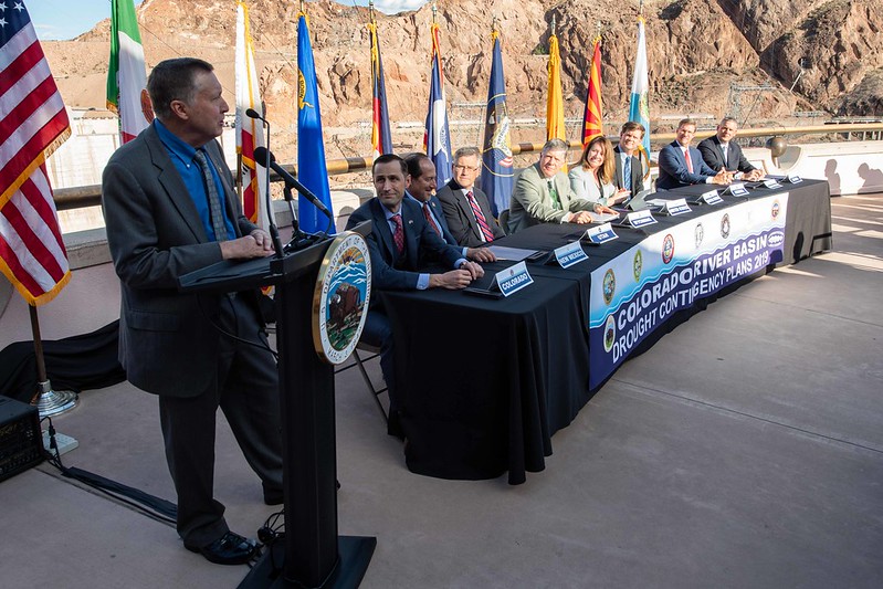
Colorado River drought contingency plans signing ceremony in May 2019. Photo: U.S. Bureau of Reclamation
Water managers traditionally use the past as a guide by examining the hydrologic record to calculate important baselines for the average high and low flows, the size of possible floods and the length of probable droughts.
But that’s all changing now “because the future is no longer going to look like the past,” says Eric Kuhn, the former general manager of the Colorado River Water Conservation District and coauthor of the book Science Be Damned: How Ignoring Inconvenient Science Drained the Colorado River. Now, he says, “water managers are trying to move forward in what we call ‘deep uncertainty’” — a process that requires planning for any number of plausible futures, including a very dry one.
We will get a chance to see what this looks like at the basin-scale as a seven-year process to renegotiate how the Colorado River is shared among its many uses is now underway.
Whether those at the table take to heart the scientific findings about the prognosis for “aridification” and “megadrought” will have big ramifications on the future ecological, economic and political health of the Colorado River basin.
Outside the basin the larger work continues as well.
“The sooner emissions of greenhouse gases to the atmosphere are eliminated,” Udall and Overpeck concluded, “the sooner the aridification of North America will stop getting worse.”
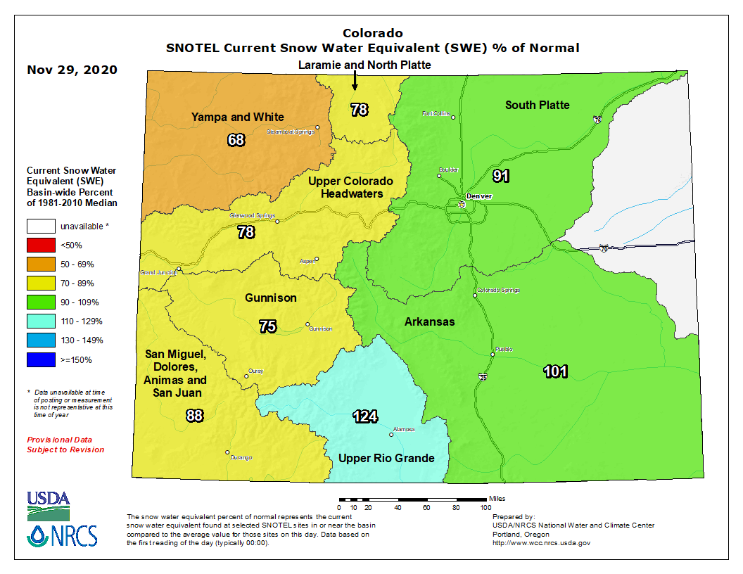
The Pagosa Springs area experienced multiple winter storms over the past week and is forecasted for more snowfall starting Thursday through Saturday, according to the National Weather Service.
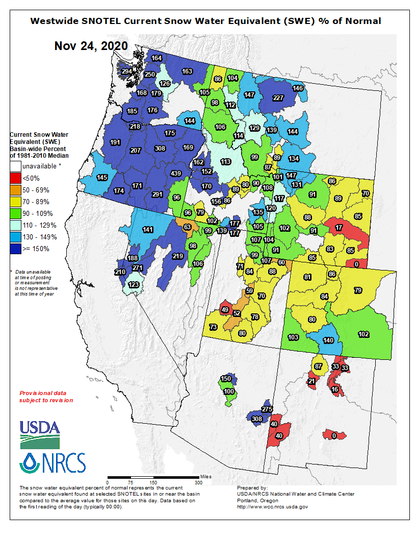
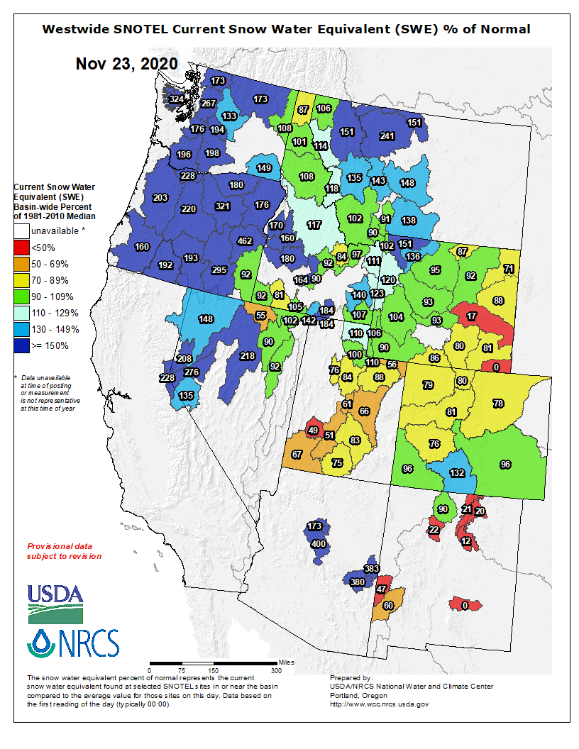
According to the U.S. Department of Agriculture National Water and Climate Center’s snowpack report, the Wolf Creek summit, at 11,000 feet of elevation, had 10.6 inches of snow water equivalent as of 11 a.m. on Nov. 24.
That amount is 145 percent of the Nov. 24 median for the site.
The San Miguel, Dolores, Animas and San Juan River Basins were at 103 percent of the Nov. 24 median in terms of snow pack.
[River Report]
According to the U.S. Geological Survey, the San Juan River was flow- ing at a rate of 113 cfs in Pagosa Springs as of 11 a.m. on Tuesday Nov. 24.
Based on 84 years of water records, the average flow rate for this date is 84 cfs.
The highest recorded rate for this date was in 1987 at 321 cfs. The lowest recored rate was 29 cfs, recorded in 1968.
Colorado snowpack basin-filled map November 29, 2020 via the NRCS.
During a meeting on Nov. 16, the San Juan Water Conservancy District (SJWCD) Board of Directors approved the deactivation of a loan the district currently has with the Colorado Water Conservation Board (CWCB).
According to SJWCD President Al Pfister, the reasoning behind the decision is the state budget situation.
“The state was asking us whether we wanted to deactivate our existing loan of $1.9 plus million that we had applied for and had been approved contingent upon us getting a mill levy approved to pay for that,” Pfister explained during the meeting. “It’s been three years since that was initially approved and, I’ll say, standard procedure is to, basically, after three years of actions have been taken, they deactivate those loans.”
Pfister noted that he told CWCB that the district was fine with deactivating its loan at this time but, by doing this, it would not preclude the district from applying in the future.
“I just want to clearly emphasize that this does not in any way mean that we are not going to pursue a reservoir project in the future,” SJWCD board member John Porco added.
In conversations with CWCB representatives, Pfister explained that the CWCB indicated that CWCB would not take this decision to mean that SJWCD was not pursuing its San Juan River Headwaters Project…
The motion to approve the CWCB loan deactivation was approved unanimously by the SJWCD board.
In a follow-up interview on [November 23, 2020], Pfister explained that the loan that was deactivated was to enable the SJWCD to purchase additional lands that were needed to complete the district having ownership of the pool basin for the San Juan River Headwaters Project.
Additionally, the loan was for environmental work for the land exchange, Pfister added.
Water from the Colorado River irrigates farmland in the Grand Valley. The state of Colorado is looking into how to fund a program that would pay irrigators to reduce their consumptive use in order to send water downstream to a savings account in Lake Powell.Photo credit: Brent Gardner-Smith/Aspen Journalism
The state of Colorado will embark on the second phase of studying a potential water-savings plan, this time by developing a draft framework to test how the structure and design of such a program could work.
The Colorado Water Conservation Board approved at its regular meeting Nov. 18 a Step II Work Plan for its investigation into the feasibility of a demand-management program.
“People in my basin, including myself, are very excited to get down the road of this next phase,” said CWCB board member Jackie Brown, who represents the Yampa, White and Green river basins. “I think it will bring us a lot of certainty with where we end up on this really heavy issue.”
Since June 2019, eight workgroups composed of water experts from different sectors around the state have been hashing out the potential benefits, downsides and challenges of a voluntary and temporary program that would pay water users to cut back in order to leave more water in the Colorado River. The workgroups tackled eight subject areas: law and policy; monitoring and verification; water-rights administration and accounting; environmental considerations; economic considerations and local government; funding; education and outreach; and agricultural impacts. A ninth workgroup, led by the Interbasin Compact Committee, focused solely on equity.
Their work is now done. The results of a year’s worth of meetings, in-depth discussions and workshops resulted in a 200-page report, released in July.
A project management team, made up of state officials from the CWCB, the Division of Water Resources and the attorney general’s office, will now take the input from the workgroups and use it to begin Step II. The overarching goals of this phase are to figure out if demand management would be achievable, worthwhile and advisable for Colorado.
“Ultimately, again, the question is: Is demand management a feasible tool to protect Colorado water users against the risks and impacts of a potential curtailment, and can we create some additional benefits as well?” said Amy Ostdiek, CWCB deputy section chief for interstate, federal and water information.
At the heart of a potential demand-management program is a reduction in water use in an attempt to send water downstream to Lake Powell to bolster levels in the giant reservoir and meet 1922 Colorado River Compact obligations. If Colorado does not meet its obligation to deliver water to the lower basin, it could face mandatory cutbacks, known as curtailment.
Under such a program, agricultural water users could get paid to temporarily fallow fields and leave more water in the river, in order to fill a 500,000 acre-foot pool set aside in Lake Powell as a modest insurance policy. But developing a program raises many thorny questions such as how to create a program that is equitable and doesn’t result in negative economic impacts to agricultural communities.
In Step II, the project management team, with the help of consultants SGM, CDR Associates and WestWater Engineering, will develop a draft “strawman” framework of a demand-management program. Step II does not include a large-scale pilot program, but it leaves the door open to develop one in the future, potentially in collaboration with other upper-basin states. Ostdiek said the project management team should have the initial draft framework ready for the board to look at early next year.
CWCB Director Rebecca Mitchell reminded board members that demand management is just one tool — but an important one — that the state is looking at to deal with looming water shortages.
“When we look at the challenge of a changing climate or a changing hydrology and the frequency and drought and the intensity of drought, it would be irresponsible of us not to look at every tool available,” she said. “I think this is the next, right, appropriate step.”
Aspen Journalism is a local, nonprofit, investigative news organization covering water and rivers in collaboration with The Aspen Times and other Swift Communications newspapers. This story ran in the Nov. 27 edition of The Aspen Times.
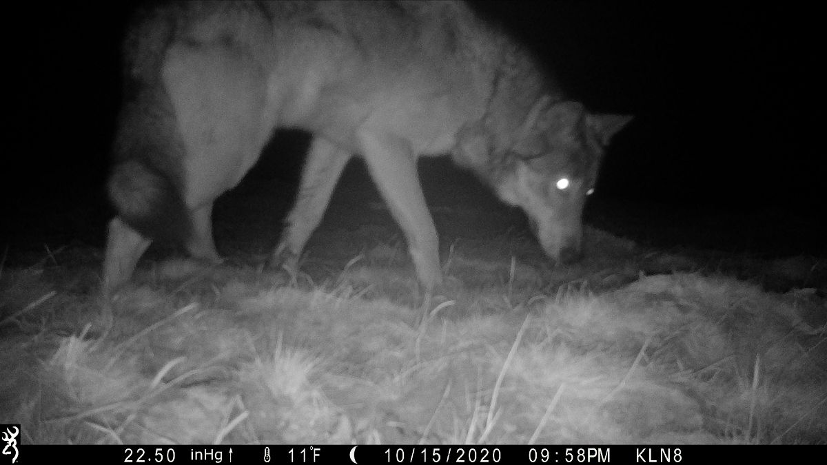
Image of wolf from a game camera, taken Oct 15, 2020, in Moffat County. Photo courtesy: Defenders of Wildlife via Colorado Parks and Wildlife
Here’s the release from Colorado Parks and Wildlife (Rebecca Ferrell):
On November 3, Colorado voters passed Proposition #114 – The Restoration of Gray Wolves, a measure directing the Colorado Parks and Wildlife Commission to develop a plan to reintroduce gray wolves west of the Continental Divide. The passage of Proposition 114 has led to increased interest in wolves in Colorado, specifically, the wolf pack previously confirmed to be present in Moffat County.
The gray wolf remains under the management control of the U.S. Fish and Wildlife Service until at least January 4, 2021, when the proposed removal of Endangered Species Act (ESA) protections would take effect. At this time, CPW continues to monitor the area and take sighting reports and game camera images from citizens, sportspersons and others on the ground.
“The federal delisting discussion has caused some confusion in the state about the status of gray wolves in Colorado,” said Dan Prenzlow, director of Colorado Parks and Wildlife. “Regardless of the USFWS listing status, gray wolves remain listed as a state endangered species, and killing a wolf in Colorado for any reason other than self-defense remains illegal.”
While protected under the ESA, killing a wolf in Colorado can result in federal charges, including a $100,000 fine and a year in prison, per offense. As the gray wolf remains a state endangered species, severe penalties will still apply when CPW regains management control in the state.
Wolves are elusive in nature, making visual confirmation more challenging than some other species. Despite this, game camera images, as well as tracks and fur, have been detected in the field throughout the summer and into November.
“As recently as last week we have confirmed the presence of wolves in Moffat County via pictures and recorded howling. Staff will continue monitoring the area as part of our overall wildlife management and conservation duties, and we will share information when we have updates or can help clear up any misunderstanding of wolf activity in Colorado,” said Prenzlow.
The public is urged to contact CPW immediately and fill out a report if they see or hear wolves or find evidence of any wolf activity in Colorado. The Wolf Sighting Form can be found on the CPW website.
At the November 19, 2020, Colorado Parks and Wildlife Commission meeting, the commission discussed their next steps in undertaking the planning efforts directed by Proposition 114. To stay updated on wolves in Colorado, visit the wolf management page of our website.
Report: Remediation Scenarios for Attenuating Peak Flows and Reducing Sediment Transport in Fountain Creek, Colorado, 2013 FromThe Tri-Lakes Tribune (Ben Ferrell) via The Colorado Springs Gazette:
At its Nov. 16 meeting, the Board of Trustees approved a contract to perform the drilling and casing of a new water well for the town’s water system.
The new well, Well No. 10, will be based in the Arapahoe Basin and will be a depth of approximately 1,100 to 1,800 feet, depending on the determination of where the best draw of water would be. Public Works Director Tom Tharnish said the town’s present water consultant managed the bidding process since the contract required a specialized scope of drilling. The winning bid came in at $624,975 and was awarded to Layne Christensen Co.
Tharnish said the company, operating under a different name prior, had performed work on the town’s older wells in the past and was surprised three bids came back from the invitation.He said he expected one or two.
A follow-up contract to perform the tie-in of Well No. 10 to water treatment plant No. 4 and 5 will be presented to the board after the start of next year, since the new well will be located right outside the plant, Tharnish said.
Mayor Don Wilson asked if Well No. 10 would serve as a replacement for Well No. 9, which is presently offline due to the levels of radium detected and undergoing radium removal.
Tharnish said he hopes to have No. 10 operational and producing in March or April of next year and it would serve as the replacement to Well No. 9’s water production until No. 9 is back online that following fall.
This is the first of 15 major projects for the town’s water system which will be funded through the town’s recent Certificate of Participation issued.
The contract was approved 5-1 with Trustee Jamy Unruh having lost her connection to the virtual meeting and unable to vote.
This $2+ billion project would pump 28 billion gallons of water 2,000 feet uphill across 140 miles of desert to provide just 160,000 residents in Southwest Utah with more water. Graphic credit: Utah Rivers Council
Last month, the Utah Division of Water Resources reported that water conservation efforts have helped meet growing population needs while postponing the need for water development projects.
While state officials primarily referred to water projects in northern Utah, the southwest corner of the state has also seen its own successes with conservation efforts during an ongoing drought, according to local water officials…
The state has launched several water conservation projects in recent years that Adams gave credit to Utah’s citizens and private sectors for embracing…
State conservation efforts have included the creation of regional water conservation goals and plans, water efficiency projects, the “Slow the flow” information campaign, rebates and the metering of secondary water sources…
Local efforts
In Southern Utah, Zachary Renstrom, the general manager of the Washington County Water Conservancy District, said the district has seen its own success with water conservation over the years thanks to collective efforts of the community. Much of that success, Renstrom said, has come through educating the public…
According to the latest data available from the Utah Division of Water Resources, Washington County’s per capita water use decreased 7.5% from 2010 to 2018…
Under regional water conservation goals – which includes Washington and Kane counties – the region is slated to reduce water use 14%, with 262 gallons per capita by 2030 and ultimately 22%, with 237 gallons per capita by 2065. The regional plan uses 305 gallons per capita per day as a baseline.
The water district either oversees, or is a partner in, several water conservation efforts and programs…
This includes demonstration gardens like the Red Hills Desert Garden, water-efficient landscape workshops, local media campaigns, the “Save the Towel” partnership with local hotels and spas, requiring water conservation plans from municipal customers, water-smart rebates and several other programs…
Has water conservation postponed the need for the Lake Powell Pipeline?
As with other water projects, some question whether conservation efforts in Southern Utah delayed the need for the Lake Powell Pipeline. Renstrom said they have but won’t for much longer.
“We’ve gotten to the point that we’ve conserved a big chunk of water already, and we’re still 10 years out from the pipeline,” Renstrom said. “When we start projecting 10 years out, it shows we’re going to get to a critical situation that will require us to have the Lake Powell Pipeline.”
[…]
Recently state and local water officials asked the Bureau of Reclamation to slow its timeline for the potential approval of the pipeline due to concerns raised by neighboring states that also rely on the Colorado River for water. The additional time will be used to review concerns and address them in a revised environmental study related to the project…
Drought and climate change
Pipeline aside, Renstrom said the climate is expected to become increasing dry with monsoonal rains being reduced to short-lived storms that drop large amounts of rain like the one that hit St. George in August.
“Yes, we are planning for a drier climate … and that’s one of the reasons we’re so adamant about our projects and making sure we have the resilience to withstand fluctuations in weather and the climate.”
[…]
The region has been in a drought for 16 of the last 20 years, Karry Rathje, a spokeswoman for the water district, said, adding that despite that, the county has been able to conserve water while a drying climate has gradually decreased supply…
However, both Renstrom and Rathje have said water conservation and the need for a secondary source of water for the county need to be pursued hand-in-hand in order to secure future water needs.
FromThe Mountain Town News, September 11, 2019, (Allen Best):-
Our weekend getaway had us in Salida on Saturday night, enjoying Mexican food while watching people frolic in the Arkansas River.
It’s a different town altogether from the one I first visited in 1978. The river was celebrated then, too, but the economy was based on extraction. There was a limestone quarry near Monarch Pass that was part of the steel-making process in Pueblo. Many of the town’s residents worked 72 miles away at Climax, extracting molybdenum, which also has a key role as a strengthener of steel.
Then Ronald Reagan was elected president and the mines shut down. I think this was correlation, not causation, but my old friend, the late Ed Quillen, who had moved his family to Salida in its late days as a mining town, liked to point out that those in rural areas who had voted for Reagan tended to have bad outcomes. Kind of like the farmers today who voted for Trump in 2016.
Working then at the Mountain Mail, Ed was responsible for producing something called the Progress Edition. One year soon after the mining meltdown he focused the issue on Salida’s attributes as a haven for artists. And that is pretty much the story of Salida today. It’s warmer than the ski-anchored resorts, with a river more at the center, now filled with people of a certain age for whom a good hospital also matters.
Is Salida a role model for those coal towns that need to find a new career? As I’ve pointed out before, I’m not so sure that the coal towns have the same attributes – although Paonia has certainly been prospering as never before since its coal-based economy began snoozing, many of its new residents—well, no surprise here— people of a certain age seek to escape ski towns.
In the mid 1990s, Ed had also urged me to check out Saguache. The old hotel, he said, was available for $30,000. He predicted it as the next getaway.
Saguache Hotel. Photo credit: Allen Best/The Mountain Town News
In fact, Cathy and I have gotten-away to Saguache, near the top of the San Luis Valley, several times in recent years. It’s higher in elevation than I like, about 7,800 feet, but somehow I seem to breathe easier once I take in those big spaces of the San Luis Valley, rimmed by mountains east and west. And we can afford the price of the motel there.
Luckily, I can point to some of the mountains as ones I climbed when in my prime or, in wheezing fashion, just beyond: Kit Carson, Challenger, and just below 14,000 feet, Adams, a Sheep and one or two others.
Saguache has two or three passable restaurants and, at the old Ute theater, had a folk festival going last weekend. As for that old hotel, it looks available and still in need of work.
Rusted beater. Photo credit: Allen Best
Across the street was an old Japanese pickup, a four-wheeler, but with a rusted shell, as had occurred with my old Toyota before I abandoned it with 376,000 miles on the odometer. It was a nice portable motel room.
Rust or not, I wonder what happened that all of our pickups became super-sized. It came during a time when people have become supersized, too. Causation or correlation?
The story here in Salida and Saguache, I think, is of increments but also anchors and also transportation corridors. Salida is not on an interstate highway, but it is on Highway 50. Saguache is more off the beaten path.
Too, Salida has the river, a ski area about 20 minutes away. Saguache has … well, the big sky.
That old hotel may yet get the work it needs to be a viable property. But Ed has been gone now for 7 years, and I suspect I’ll be gone, too, before Saguache becomes a tourist hot spot. That’s OK. It’s nice to know that there are still places with rusted pickups.
Here’s the release from the Community Foundation of Northern Colorado:
Bohemian Foundation to match first $250,000 for NoCoFires Fund
Everyone loves a comeback story.
Northern Colorado’s two primary watersheds – the Poudre and the Big Thompson – each face a long, hard recovery from the damage caused by our recent catastrophic wildfires.
And with the support of the Bohemian Foundation, the NoCoFires Fund is working to get our vital rivers and streams back to sustaining wildlife, recreation, and agriculture, as well as supplying high-quality drinking water for 1,000,000 people.
And with the support of the Bohemian Foundation, the NoCoFires Fund is working to get our vital rivers and streams back to sustaining wildlife, recreation, and agriculture, as well as supplying high-quality drinking water for 1,000,000 people.
Here’s how it will work:
Bohemian Foundation has pledged to match the first $250,000 in donations made to the NoCoFires Fund.
Using that initial funding, the Community Foundation will leverage additional grant dollars from private, state, and federal sources.
The long-term goal for the NoCoFires Fund is to raise $1 million for continuing watershed restoration needs.
“The investment we can make together in NoCoFires Fund will have positive impacts for decades,” said Bohemian Foundation Executive Director Cheryl Zimlich. “This Community Foundation fund supports erosion control efforts that mitigate further degradation, as well as long-term restoration of vegetation and water quality. With this matching grant, we are standing with many generous Coloradans and the Community Foundation to help our region begin to heal.”
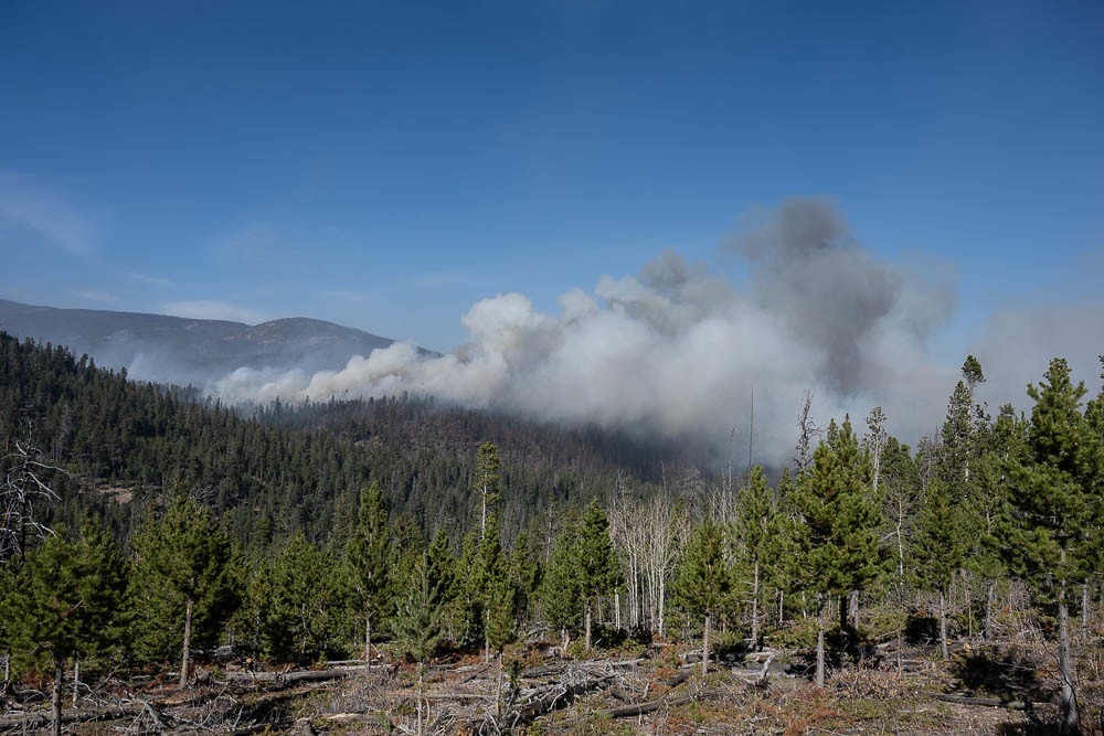
Early estimates show that mitigation in the Poudre River watershed alone will cost around $50 million. Cameron Peak and East Troublesome Fire, the two largest wildfires in Colorado history, together burned over 400,000 acres that impact both Poudre and Big Thompson watersheds and communities downstream.
“We’re gratified that Bohemian Foundation has signed on to match the first $250,000 raised, which we hope to further leverage into additional grant dollars; our goal is to raise $1 million,” said Mark Driscoll, chair of Community Foundation Board of Trustees.
One Community Foundation partner is the Colorado Department of Natural Resources, which is headed by Executive Director Dan Gibbs.
In October, Gibbs was one of the 1,400 firefighters called to fight the Cameron Peak wildfire. “This was perhaps my most intense deployment in over 13 years,” Gibbs said. “The Cameron Peak wildfire burned some of our most pristine watersheds that will require both emergency protection and long-term restoration to protect our water supplies, mitigate flood threats, and preserve the outdoor economic engines Coloradoans depend on. I’m grateful for the Community Foundation’s support. These dollars fill a crucial need to support communities that are already experiencing economic stress by funding emergency protection efforts and assisting with local cost-shares that can leverage additional funding through recovery grants.”
Another organization deeply affected by the damage to the watershed is the city of Greeley, which draws a large percentage of its water from the Poudre. Sean Chambers, director of water and sewer at the city of Greeley, hailed the attention paid to the restoration effort.
“We are working with Larimer County to develop a watershed-scale burn assessment, and with the U.S. Forest Service on plans and permits for post-fire mitigation to protect water quality that will also protect infrastructure and habitat,” Chambers said. “A small amount of mitigation work is under way, but much work lies ahead. Stakeholders need to align with resources to prevent fire debris and sediment loading in Northern Colorado streams, rivers, wetlands, and water supply reservoirs.”
It’s time to focus on mitigation, address the critical needs, and begin long-term recovery work. The Community Foundation has the track record, leadership, and relationships to positively impact Northern Colorado.
Find details about how you can help the rivers make a comeback at nocofoundation.org/fires/.
Breakout box
Cameron Peak Fire impacts
1,000+ river miles
124+ trail miles
40,000+ acres of designated Wilderness Areas
32 miles of Wild and Scenic River corridor
Three watersheds
Five reservoirs that store and deliver water to the Front Range for agriculture and
drinking water
16 mountain communities and neighborhoods in the burn area or immediately
adjacent to it
185,000 irrigated acres rely on the Poudre River
Data source: Coalition for the Poudre River Watershed
The Community Foundation of Northern Colorado has a 45-year history as a catalyst for community projects and as a service provider to philanthropists and nonprofit organizations. Through our flagship program, the Hach Center for Regional Engagement, we bring people together to collaborate on important issues – such as water – and lead visionary community initiatives for our region. nocofoundation.org.
The Cameron Peak fire soon after it started on Aug. 13, 2020. By Sept. 11, the fire had grown to more than 102,000 acres (now >200,000 acres) and was not expected to be considered out until Oct. 31. Photo credit: InciWeb via The Colorado Sun
East Troublesome Fire. Photo credit: Brad White via The Mountain Town News
Vail Resorts Inc., one of the largest financial contributors to Colorado’s cloud seeding program, has dropped out this year, leaving a major hole in the program’s budget.
Cloud seeding is a practice in which silver iodide pellets are sprayed into storm clouds in an effort to trigger more snowfall and ultimately, in the spring, more snowmelt to feed the state’s streams.
Vail has been participating in the program for more than 40 years, state officials said.
Hard-hit by the pandemic, the ski resort company had planned to contribute $300,000 to this year’s effort, roughly 20 percent of the nearly $1.5 million the state spends annually, according to the Colorado Water Conservation Board (CWCB), which oversees the program.
Vail officials did not respond to a request for comment, but their most recent financial statements indicate that the company’s revenues dropped nearly 70 percent for its latest fiscal year as the Covid-19 pandemic forced it to close its resorts early last spring.
According to its financials, revenues for its 2020 fiscal year ending July 31 came in at $503.3 million, down from $706.7 million for the prior year.
“We’re all hoping this is just a temporary suspension in funding from Vail,” said Andrew Rickert, who oversees the cloud seeding program for the CWCB. “Vail is the oldest partner we have in Colorado. They are very serious about the program, but no one is immune to these economic hardships.”
In addition to Vail, the cloud seeding program receives cash from several Lower Colorado River Basin states, who are interested in helping do anything they can to boost water supplies in the Upper Colorado River Basin, on whose flows they rely.
The state and several Front Range water utilities, including Denver Water, the Northern Colorado Water Conservancy District and Colorado Springs Utilities, also help pay for the work.
This year the CWCB will oversee six permitted cloud seeding operations that span the state, from Durango to Winter Park and beyond. The operations are sited in areas most likely to produce snow and aid rivers.
Among the largest of these is a permit operated by the Colorado River District, which includes Grand, Summit, Eagle and Pitkin counties, according to Dave Kanzer, deputy district engineer for the Glenwood Springs-based water agency.
Vail’s cloud seeding program is nested within that area and its annual $300,000 contribution represents more than half the money typically spent in that four-county region, Kanzer said. If additional funding isn’t found, fewer cloud seeding generators will operate there this season.
“It’s a challenging time with respect to Covid-impacted budgets,” Kanzer said. “The overall program is alive and well, but it is a topic of concern.”
Kanzer and CWCB Director Becky Mitchell said the state is actively reaching out to other entities for additional funding for this year’s work, including states in the Lower Colorado River Basin and Front Range utilities.
As the current drought continues, forecasts for the winter indicate that the southern part of Colorado is likely to see light winter snows, while the northern part of the state is likely to see heavier accumulations. Overall, the state has a long way to go to make up for the dry summer and fall.
How much new snow and water seeding clouds actually produces has been difficult to detect, although scientists recently have produced studies indicating it can create new snow.
“Our scientists indicate we can increase water supplies by about 5 percent on an annual basis, with increased snowfall of 5 to 10 percent, although it’s highly variable,” Kanzer said.
Colorado and other Upper Colorado River Basin states have long used cloud seeding as a way to boost water supplies, and with this year’s drought it’s more important than ever that additional water be generated if possible.
“It’s especially acute coming after a pretty dry 2020,” Kanzer said.
“But we’re cautiously optimistic. As the year plays out we will try to carefully manage the resources that we have. I’m not optimistic that we will be able to fill the entire gap. But if we came up with a third [of the money lost], that will be a success in my mind.”
Jerd Smith is editor of Fresh Water News. She can be reached at 720-398-6474, via email at jerd@wateredco.org or @jerd_smith.
Amusement and pleasant surprises – and the laughter they can trigger – add texture to the fabric of daily life.
Those giggles and guffaws can seem like just silly throwaways. But laughter, in response to funny events, actually takes a lot of work, because it activates many areas of the brain: areas that control motor, emotional, cognitive and social processing.
People begin laughing in infancy, when it helps develop muscles and upper body strength. Laughter is not just breathing. It relies on complex combinations of facial muscles, often involving movement of the eyes, head and shoulders.
Laughter – doing it or observing it – activates multiple regions of the brain: the motor cortex, which controls muscles; the frontal lobe, which helps you understand context; and the limbic system, which modulates positive emotions. Turning all these circuits on strengthens neural connections and helps a healthy brain coordinate its activity.
By activating the neural pathways of emotions like joy and mirth, laughter can improve your mood and make your physical and emotional response to stress less intense. For example, laughing may help control brain levels of the neurotransmitter serotonin, similar to what antidepressants do. By minimizing your brain’s responses to threats, it limits the release of neurotransmitters and hormones like cortisol that can wear down your cardiovascular, metabolic and immune systems over time. Laughter’s kind of like an antidote to stress, which weakens these systems and increases vulnerability to diseases.
A good sense of humor and the laughter that follows depend on an ample measure of social intelligence and working memory resources.
Laughter, like humor, typically sparks from recognizing the incongruities or absurdities of a situation. You need to mentally resolve the surprising behavior or event – otherwise you won’t laugh; you might just be confused instead. Inferring the intentions of others and taking their perspective can enhance the intensity of the laughter and amusement you feel.
To “get” a joke or humorous situation, you need to be able to see the lighter side of things. You must believe that other possibilities besides the literal exist – think about being amused by comic strips with talking animals, like those found in “The Far Side.”
Laughter’s social power
Many cognitive and social skills work together to help you monitor when and why laughter occurs during conversations. You don’t even need to hear a laugh to be able to laugh. Deaf signers punctuate their signed sentences with laughter, much like emoticons in written text.
Laughter creates bonds and increases intimacy with others. Linguist Don Nilsen points out that chuckles and belly laughs seldom happen when alone, supporting their strong social role. Beginning early in life, infants’ laughter is an external sign of pleasure that helps strengthen bonds with caregivers.
Later, it’s an external sign of sharing an appreciation of the situation. For example, public speakers and comedians try to get a laugh to make audiences feel psychologically closer to them, to create intimacy.
By practicing a little laughter each day, you can enhance social skills that may not come naturally to you. When you laugh in response to humor, you share your feelings with others and learn from risks that your response will be accepted/shared/enjoyed by others and not be rejected/ignored/disliked.
In studies, psychologists have found that men with Type A personality characteristics, including competitiveness and time urgency, tend to laugh more, while women with those traits laugh less. Both sexes laugh more with others than when alone.
Positive psychology researchers study how people can live meaningful lives and thrive. Laughter produces positive emotions that lead to this kind of flourishing. These feelings – like amusement, happiness, mirth and joy – build resiliency and increase creative thinking. They increase subjective well-being and life satisfaction. Researchers find that these positive emotions experienced with humor and laughter correlate with appreciating the meaning of life and help older adults hold a benign view of difficulties they’ve faced over a lifetime.
Laughter in response to amusement is a healthy coping mechanism. When you laugh, you take yourself or the situation less seriously and may feel empowered to problem-solve. For example, psychologists measured the frequency and intensity of 41 people’s laughter over two weeks, along with their ratings of physical and mental stress. They found that the more laughter experienced, the lower the reported stress. Whether the instances of laughter were strong, medium or weak in intensity didn’t matter.
Maybe you want to grab some of these benefits for yourself – can you force laughter to work for you?
A growing number of therapists advocate using humor and laughter to help clients build trust and improve work environments; a review of five different studies found that measures of well-being did increase after laughter interventions. Sometimes called homeplay instead of homework, these interventions take the form of daily humor activities – surrounding yourself with funny people, watching a comedy that makes you laugh or writing down three funny things that happened today.
You can practice laughing even when alone. Intentionally take a perspective that appreciates the funny side of events. Laughing yoga is a technique of using breathing muscles to achieve the positive physical responses of natural laughing with forced laughter (ha ha hee hee ho ho).
Some tips on how to get started with laughing yoga.
Researchers today certainly aren’t laughing off its value, but a good deal of the research on laughter’s influence on mental and physical health is based on self-report measures. More psychological experimentation around laughter or the contexts in which it occurs will likely support the importance of laughing throughout your day, and maybe even suggest more ways to intentionally harness its benefits.
Like anyone that has so far avoided getting COVID-19, I am most thankful for that this year. I could easily stop there.
However, yesterday the Army Corps of Engineers announced the denial of a permit for the Pebble Mine that was to be constructed in the most important salmon fishery in the world. And, to my surprise the environment and the Clean Water Act won out.
The Army Corps of Engineers today formally denied a permit for the proposed Pebble Mine in Alaska.
In August, the Corps found the mine “cannot be permitted” as proposed under the Clean Water Act following a determination that discharges at the mine site would cause unavoidable, adverse impacts and significant degradation of aquatic resources in Bristol Bay.
Last week, the mine’s developers submitted a new plan for how it would abate the mine’s threat to this globally significant salmon fishery. The developer did not release the plan and the Corps declined to make it available for public comment.
The following is a statement by Lynn Scarlett, chief external affairs officer for The Nature Conservancy:
“Today’s decision affirms what the science and local communities have said all along: Pebble is the wrong mine in the wrong place. The decision is a win for this world-class salmon fishery and the Alaska Natives who have thrived in this region for millennia. This is a commendable and necessary determination that will help protect this watershed and the economies it supports. We appreciate the Army Corps for making the right decision to deny the permit for Pebble Mine, and we’re grateful for the many people who have spoken up with their perspectives and expertise for years so that we could reach this moment.
“Even with this encouraging development, without permanent protection, Bristol Bay’s future is far from certain. Any outcome for the region must align with the health and well-being of Indigenous communities, including a focus on economic opportunity. This can only happen with collaboration, transparency and through decisions informed by science. We will continue supporting Tribal and local governments, Alaska Native corporations, businesses, and other stakeholders in their efforts to chart a sustainable and equitable future for Bristol Bay.”
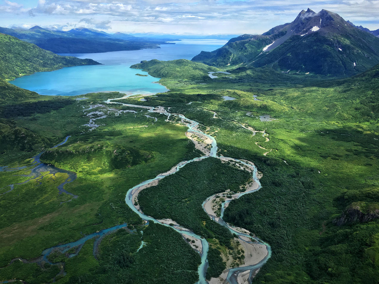
An aerial view of Wood-Tikchik State Park in Bristol Bay, Alaska. Photo credit: Ryan Petersen via The Natural Resources Defense Council
FromThe Washington Post (Juliet Eilperin and Brady Dennis):
In a statement, U.S. Army Corps of Engineers Alaska Commander Col. Damon Delarosa said that a plan to deal with waste from the Pebble Mine “does not comply with Clean Water Act guidelines,” and that “the proposed project is contrary to the public interest.”
While the Trump administration has pressed ahead to weaken environmental protections and expand energy development before the president’s term ends in January, the decision to torpedo the long-disputed mine represents a major win for environmentalists, fishing enthusiasts and tribal rights.
“Today’s decision speaks volumes about how bad this project is, how uniquely unacceptable it is,” Joel Reynolds, a senior attorney for the Natural Resources Defense Council, which has fought the mine for years, said in an interview. “We’ve had to kill this project more than once, and we’re going to continue killing for as long as it takes to protect Bristol Bay.”
Trump officials had allowed the Pebble Limited Partnership, a subsidiary of a Canadian firm, to apply for a permit even though the Obama administration had concluded in 2014 that the firm could not seek federal approval because the project could have “significant” and potentially “catastrophic” impacts on the world’s largest sockeye salmon fishery. As recently as July, the Corps concluded that the mine would have “no measurable effect” on area fish populations.
State and federal agencies warned that the project would permanently damage the region, destroying more than 2,800 acres of wetlands, 130 miles of streams and more than 130 acres of open water within Alaska’s Koktuli River watershed. The proposed site lies at the river’s headwaters.
An unlikely coalition of opponents formed when President Trump’s eldest son, Donald Trump Jr., Fox News host Tucker Carlson and Vice President Pence’s former chief of staff, Nick Ayers — who all have enjoyed fishing or hunting around Bristol Bay — joined with traditional environmental groups and the region’s tribes in opposition to the project.
Opponents received a major boost in September when the Environmental Investigation Agency (EIA) released recordings of secretly taped Zoom calls in which the project’s top executives boasted of their influence inside the White House and to Alaska lawmakers to win a federal permit. Alaska’s two GOP senators, Lisa Murkowski and Dan Sullivan, issued statements saying they opposed the plan and within days Pebble’s chief executive, Tom Collier, resigned.
Both senators praised the administration’s decision.
“Today, the Army Corps has made the correct decision, based on an extensive record and the law, that the project cannot and should not be permitted,” Sullivan said. He added that he supports mining in Alaska, but given the project’s potential impact on the state’s fisheries and subsistence hunting, “Pebble had to meet a high bar so that we do not trade one resource for another.”
[…]
Pebble issued a plan to the Corps this fall outlining how it would compensate for any damage inflicted by the project, which would span more than 13 miles and require the construction of a 270-megawatt power plant, natural-gas pipeline, 82-mile double-lane road, elaborate storage facilities and the dredging of a port at Iliamna Bay…
Bristol Bay Native Corporation President Jason Metrokin, also its chief executive, said his group and others will keep working “to ensure that wild salmon continue to thrive in Bristol Bay waters, bringing with them the immense cultural, subsistence and economic benefits that we all have enjoyed for so long.”
[…]
“The credit for this victory belongs not to any politician but to Alaskans and Bristol Bay’s Indigenous peoples, as well as to hunters, anglers and wildlife enthusiasts from all across the country who spoke out in opposition to this dangerous and ill-conceived project,” [Adam Kolton] said in a statement. “We can be thankful that their voices were heard, that science counted and that people prevailed over short-term profiteering.”
The fight over the mine’s fate has raged for more than a decade. The plan was scuttled years ago under the Obama administration, only to find new life under President Trump. But opposition, from Alaska Native American communities, environmentalists and the fishing industry never diminished, and recently even the president’s son, Donald Trump Jr., a sportsman who had fished in the region, came out against the project.
On Wednesday, it failed to obtain a critical permit required under the federal Clean Water Act that was considered a must for it to proceed. In a statement, the Army Corps’ Alaska District Commander, Col. Damon Delarosa, said the mine, proposed for a remote tundra region about 200 miles from Anchorage, would be “contrary to the public interest” because “it does not comply with Clean Water Act guidelines.”
Opponents said the large open-pit operation, which would dig up and process tens of millions of tons of rock a year, would irreversibly harm breeding grounds for salmon that are the basis for a sports-fishing industry and a large commercial fishery in Bristol Bay. Salmon are also a major subsistence food of Alaska Natives who live in small villages across the region…
Lindsay Layland, deputy director of United Tribes of Bristol Bay, which has fought the project for years, said that while the decision means the project may be dead, the threat remains that the gold and copper ore could still be mined in the future. “It doesn’t mean that those minerals aren’t going to be in the ground tomorrow,” she said. “We need to continue to push for long term and permanent protections down the road.”
[…]
The environmental impact statement was finalized in July by the Corps, which had authority to approve or deny a permit under the federal Clean Water Act. But a few weeks later the Corps said that the company’s plan to compensate for environmental damage from the mine was insufficient, and requested a new plan…
The new plan, which was not publicly released but was believed to designate land near the mine to be permanently protected, was submitted last week.
The mining industry and many state officials have supported the project for the revenue and other economic benefits it would bring. But some important Alaskan politicians, notably Senator Lisa Murkowski, a Republican, had been noncommittal, saying the mine should go forward only if it could be shown to be environmentally sound.
In a statement on Wednesday, Senator Murkowski said the Corps’ decision affirmed “that this is the wrong mine in the wrong place.”
“This is the right decision, reached the right way,” she added.
Under the Trump administration, the Environmental Protection Agency reversed an earlier ruling, allowing the environmental review by the Corps to proceed. Under the Clean Water Act, the Corps reviews any dredging and filling activities in waterways, including wetlands like those in the area of the proposed project.
From left, President François Hollande of France; Laurent Fabius, the French foreign minister; and United Nations Secretary General Ban Ki-moon during the climate change conference [December 2015] in Le Bourget, near Paris. (Credit Francois Mori/Associated Press)
President-elect Joe Biden’s announcement on Tuesday that Kerry—a former secretary of state, senator and presidential candidate—would serve in the newly created role of special presidential envoy for climate underscored the importance the Biden administration will place on international negotiations to address climate change, as illustrated by Kerry’s work in Kigali.
“Even the United States, for all of our industrial strength, is responsible for only 13% of global emissions,” Kerry said during a joint appearance in Wilmington, Delaware, with Biden and other newly announced members of his national security team. “To end this crisis, the whole world must come together. You’re right to rejoin Paris on day one, and you’re right to recognize that Paris alone is not enough.”
Kerry is likely to try to build on the success of the Kigali Amendment by taking swift action to work with other countries to reduce emissions from other sectors of the global economy, Zaelke said.
One place he might look is the International Maritime Organization, a United Nations agency whose member states cooperate on regulations governing the international shipping industry. In 2018, the IMO agreed to cut greenhouse gas emissions from ships by 50 percent by 2050, but the organization later failed to approve any specific emissions reduction measures.
Another is the International Civil Aviation Organization, a UN agency that is currently working to offset growth in carbon emissions from international flights after 2020.
A third possibility would be expanding the scope of the Montreal Protocol, an international agreement developed in the 1980s to phase out the production of ozone depleting chemicals. Some climate policy experts say the agreement should now be extended to reduce emissions of other greenhouse gases such as nitrous oxide, a greenhouse gas produced in chemical manufacturing that is nearly 300 times more potent at warming the planet than carbon dioxide, and also causes depletion of atmospheric ozone.
These lesser-known agreements and UN organizations have the ability to require mandatory emission reductions, giving them more teeth than the more well-known Paris climate agreement, which is voluntary.
“We have to have these sister agreements moving ahead to plug in and support the Paris Agreement,” Zaelke said.
Another place strong U.S. leadership could spur greater international action on climate change is the Climate and Clean Air Coalition, a voluntary U.N.-administered organization, formed in 2012 with support from the Obama administration.
The Coalition focuses on reducing emissions of “short-lived climate pollutants” including methane, HFCs, black carbon and ground level ozone, which are all climate super-pollutants that remain in the atmosphere for a relatively short period of time. Reducing these pollutants is widely seen as a way to quickly begin to address global warming.
The Coalition, in partnership with the United Nations Environment Programme, the European Commission, the Environmental Defense Fund and leading oil and gas companies, announced a new effort to report and reduce methane emissions from the oil and gas sector on Monday.
“Kerry can redouble the efforts and make it go twice as fast, and can also bring it to the highest level of government,” Zaelke said of the Coalition.
However, before the U.S. can seek to lead on any international climate agreement, it must first return to the Kigali Amendment, which the nation abandoned after Kerry had championed the agreement.
More than 100 countries have signed the amendment, which the U.S., China and India have yet to ratify.
U.S. ratification could come quickly. Legislation that would mandate the phase down of HFCs, a prerequisite for U.S. ratification of the Kigali Amendment, is now making its way through the U.S. Senate.
The legislation has rare, bipartisan support and is backed by a broad group of environmental organizations and business interests, including the Natural Resources Defense Council, the U.S. Chamber of Commerce and the National Association of Manufacturers.
The groups say it would both reduce greenhouse gas emissions and create jobs by stimulating the development of new, more climate friendly chemical refrigerants. In a Nov. 18 letter to Republican and Democratic leaders of the House and Senate, the groups called for swift passage of the bill during the current, “lame duck” session of Congress.
“There is a remarkable span of support for this among stakeholders and quite remarkable bipartisan sponsorship in the Senate,” said David Doniger, senior strategic director of the Natural Resources Defense Council’s Climate and Clean Energy Program. “I remain somewhere between hopeful and optimistic that this can succeed in this lame duck session.”
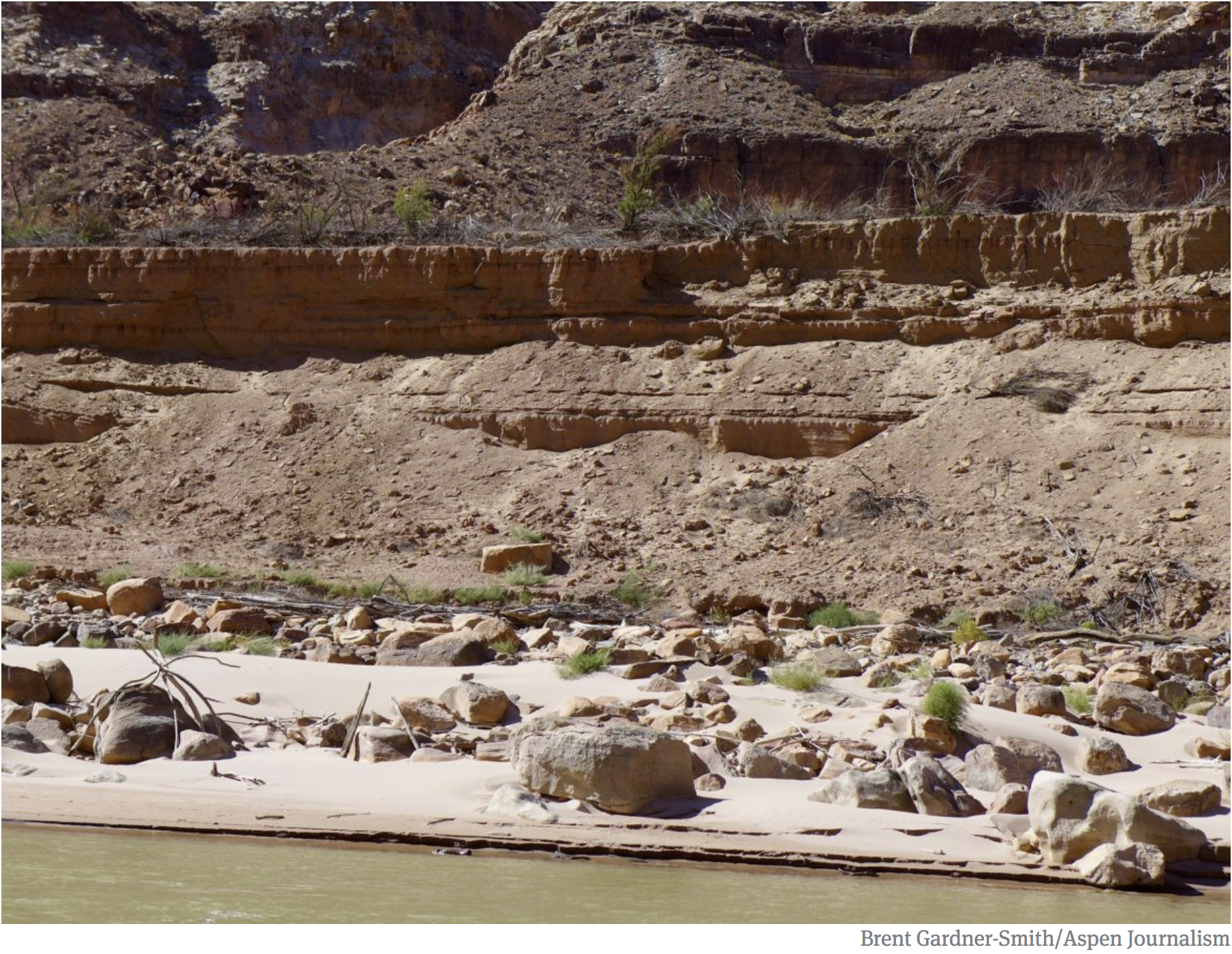
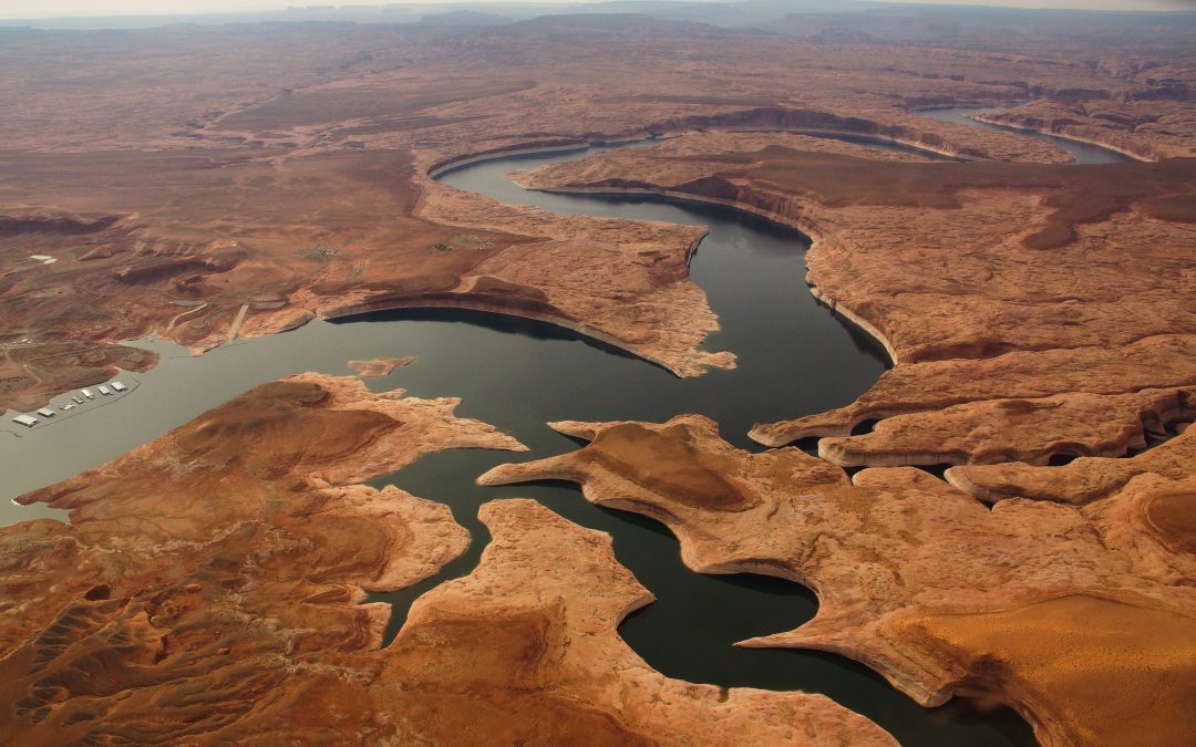
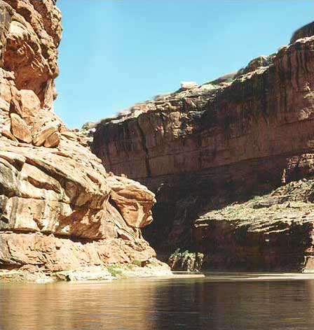
Sand and silt are piling up on the Colorado River above Lake Powell, as water levels continue to fall due to persistent drought and encroaching aridification. Water managers from San Diego to Wyoming are working to find ways to keep the river’s reservoirs, and water delivery systems, functioning.
Climate change and overuse are causing one of the Colorado River’s biggest reservoirs, Lake Powell, to drop. While water managers worry about scarcity issues, two Utah river rafters are documenting the changes that come as the massive reservoir hits historic low points.
For the past three years, Moab-based river runners Mike DeHoff and Pete Lefebvre have carefully photographed and mapped Cataract Canyon on their boating trips. For decades, Lake Powell buried the lower portion of the beloved canyon under flatwater. But now that the lake’s water levels are dropping, things are rapidly changing in the canyon…
The pair photograph these returning rapids year to year, illustrating in real time what it looks like as Lake Powell’s water levels drop and shift. Lefebvre says he was inspired by Chasing Ice, a 2012 film that documented shrinking glaciers from a sustained rise in global temperatures…
It wasn’t long before their hunt for new rapids sent them digging into the past. DeHoff has spent hours poring over old river maps, guidebooks, and historic photos in search of clues…
Their first “eureka moment” came when they correctly matched a 1921 photo from a survey of the Colorado River with one of their own. The picture shows a boat running through a dynamic stretch of Lower Cataract, where the reservoir’s mostly flatwater exists today. But Lefebvre says, some character is now coming back to the area.
“It started with just like a little ripple in the water to the surface, and then there was a little burble. And then oh, there was the tip of a rock sticking out,” Lefebvre said. “And then another rock was sticking out, and then eventually you start seeing this thing turn into a riffle.”
They named the area La Rue’s Riffle for E.C. La Rue, the U.S. Geological Survey hydrologist who took that photo nearly a century ago.
Fed up with the slow rate of guidebooks, the pair recently published their own supplemental river map on their website, Returning Rapids of Cataract Canyon. It lays out the freshest, gnarliest rapids of the lower canyon…
Cataract Canyon is becoming a well-known place to study what happens to an ecosystem when a reservoir recedes, and a river has a chance to return to a sense of former wildness.
“We’ve taken some people who are highly trained scientists, and geologists, and whatever out there,” DeHoff said. “And it’s really neat to see their faces where they’re like, ‘I’ve been studying geomorphology for 15 years and here I am out here seeing it right before my eyes, happening faster than I can even believe it’s happening.’”
Whether due to overuse, prolonged drought, or political change, researchers are beginning to contemplate a future for a severely diminished Lake Powell. This October the reservoir dropped to just under 11 million acre-feet of water, or just 45% of its total capacity. With a dry and warm winter on the horizon in 2021, there’s no relief on the horizon.
The Returning Rapids project is showing a silver lining to a reduced reservoir, Lefebvre said. It’s not only about new thrills for rafters – they’re also watching an entire ecosystem shift.
“Instead of this monoculture of weeds and a mud canal…we’re getting all this character back with rapids, beaches, currents, eddies, animal life, and native vegetation,” Lefebvre said. “And so that’s how I see [Cataract Canyon] recovering. It’s a nicer place to be now.”
Lake Powell, created with the 1963 completion of Glen Canyon Dam, is the upper basin’s largest reservoir on the Colorado River. But 2000-2019 has provided the least amount of inflow into the reservoir, making it the lowest 20-year period since the dam was built, as evidenced by the “bathtub ring” and dry land edging the reservoir, which was underwater in the past. As of October 1, 2019, Powell was 55 percent full. Photo credit: Eco Flight via Water Education Colorado
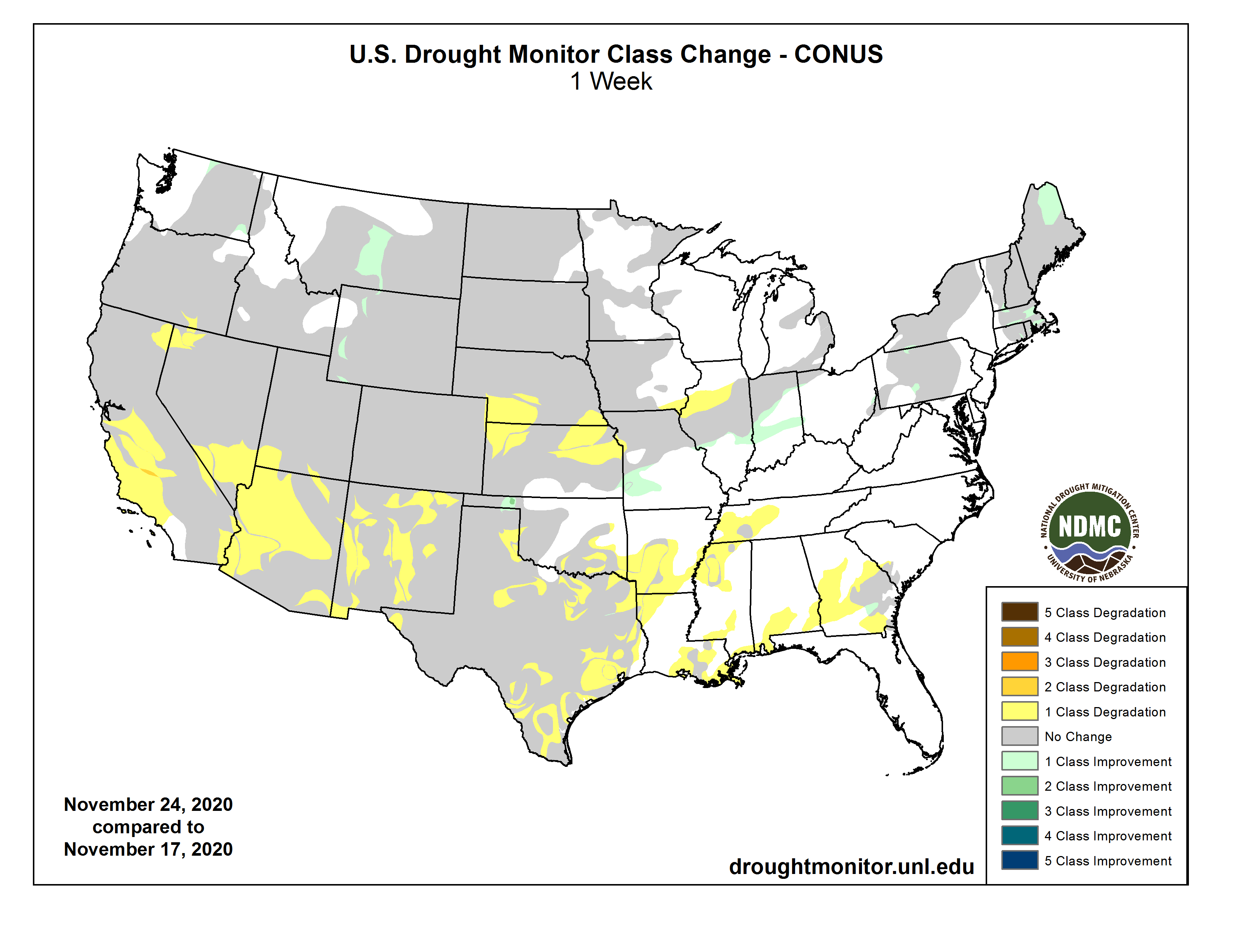
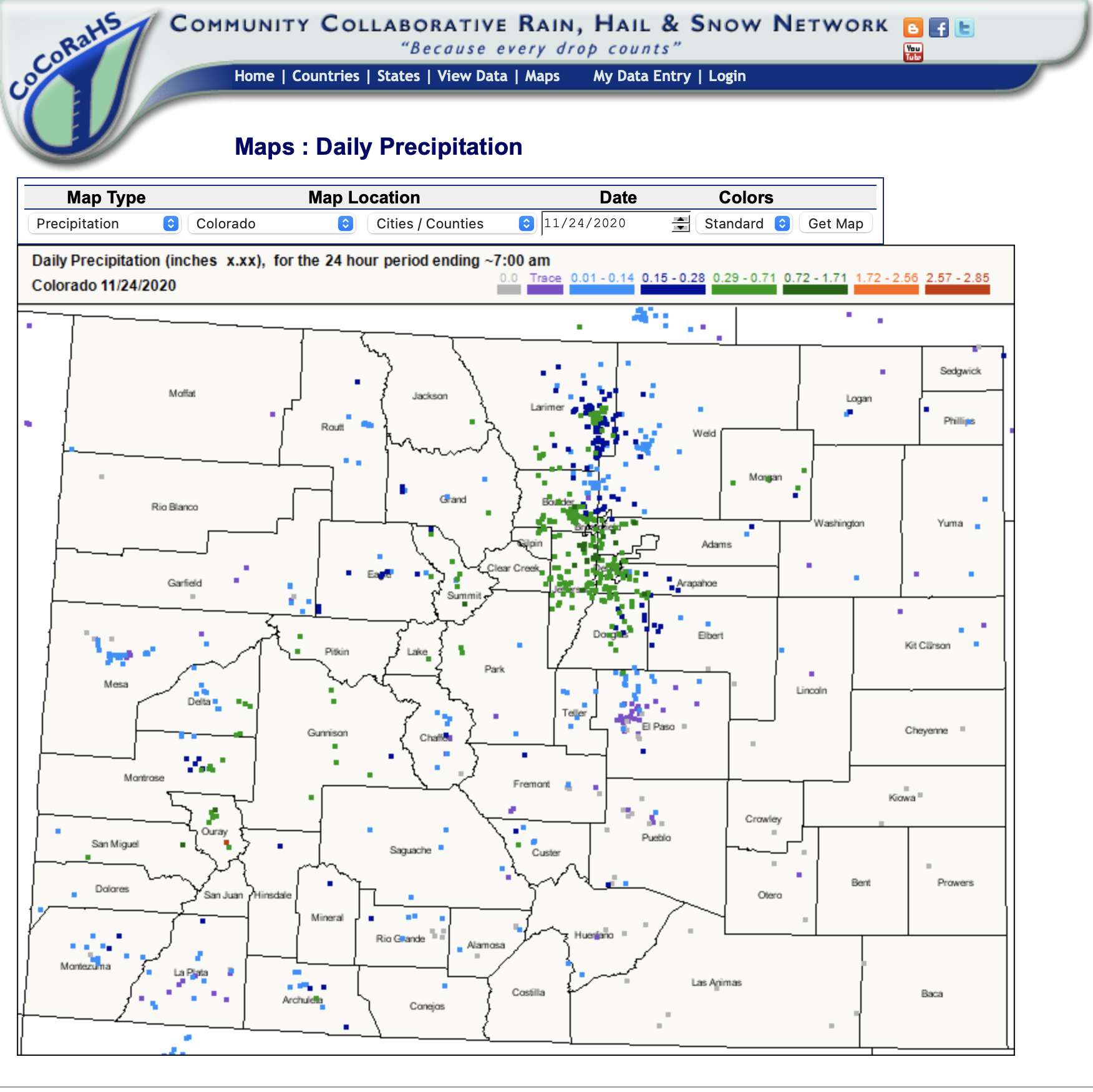
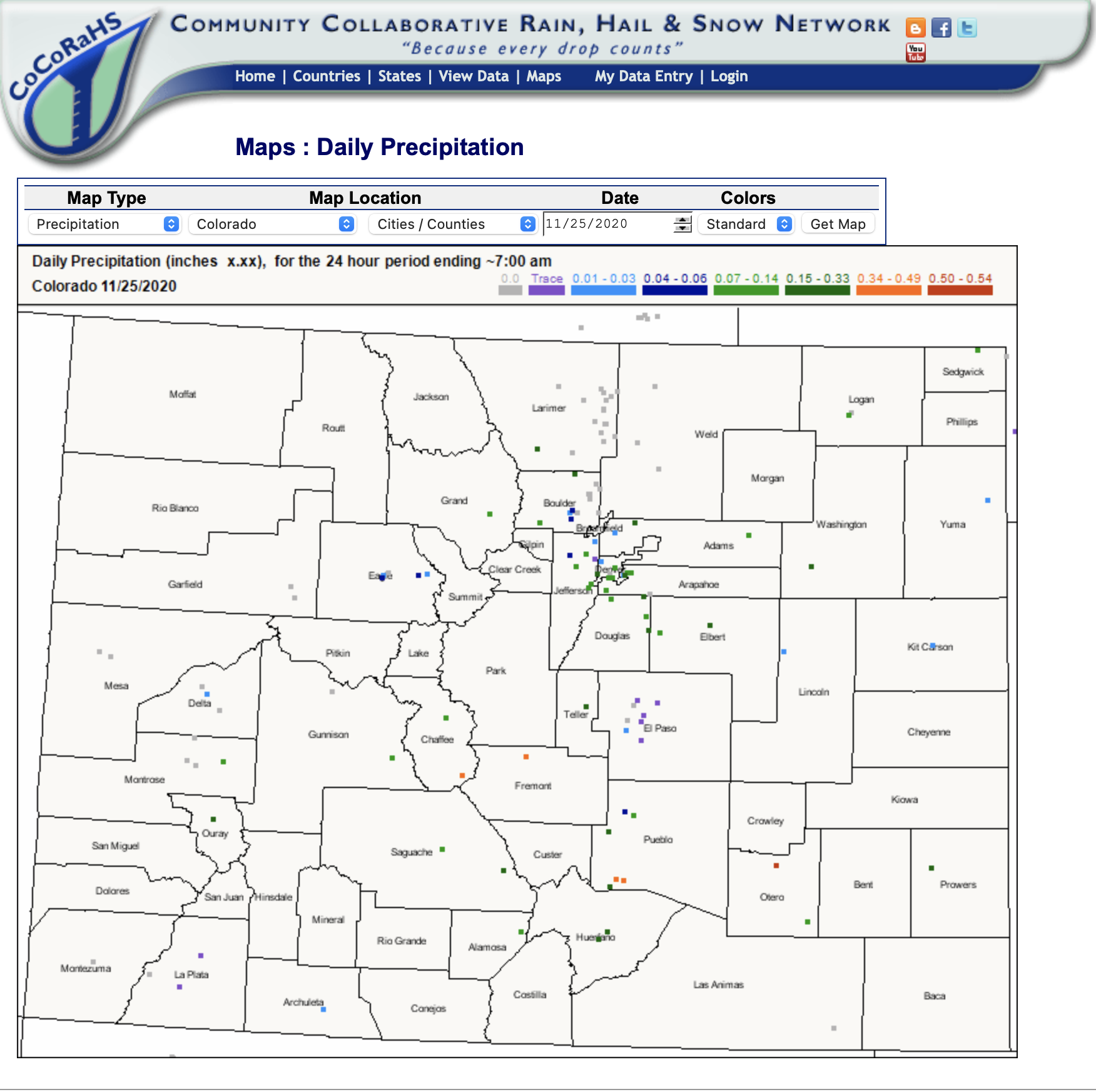
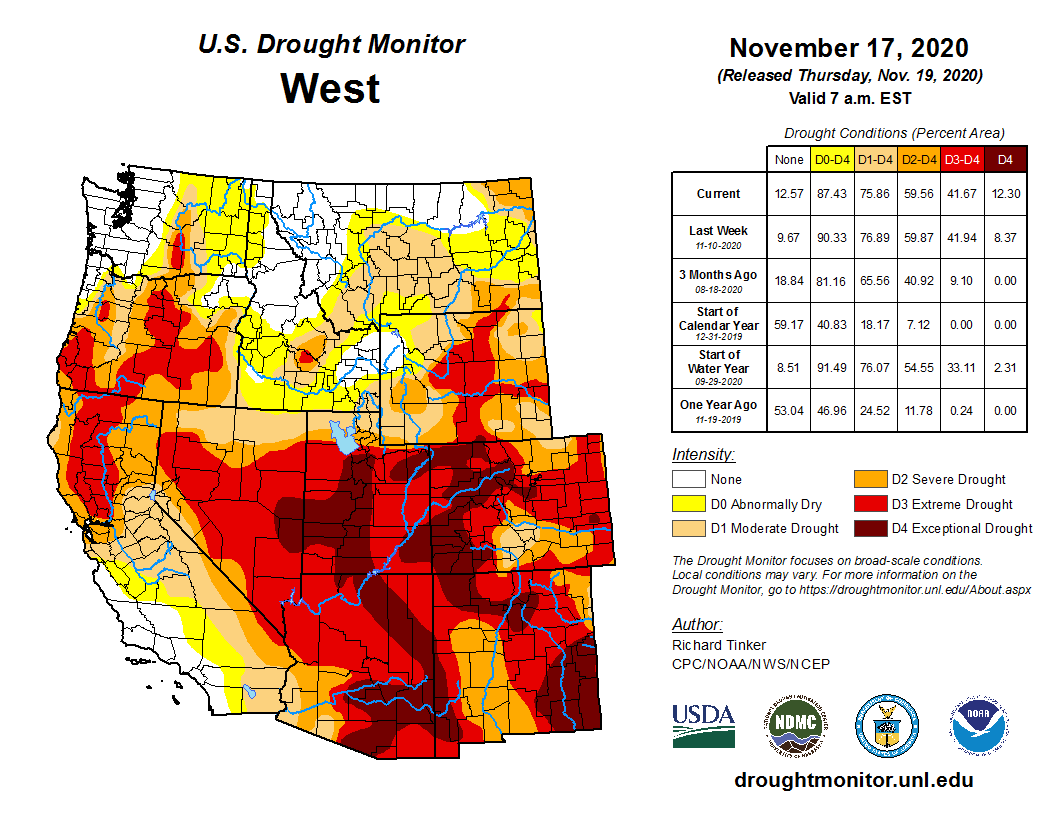
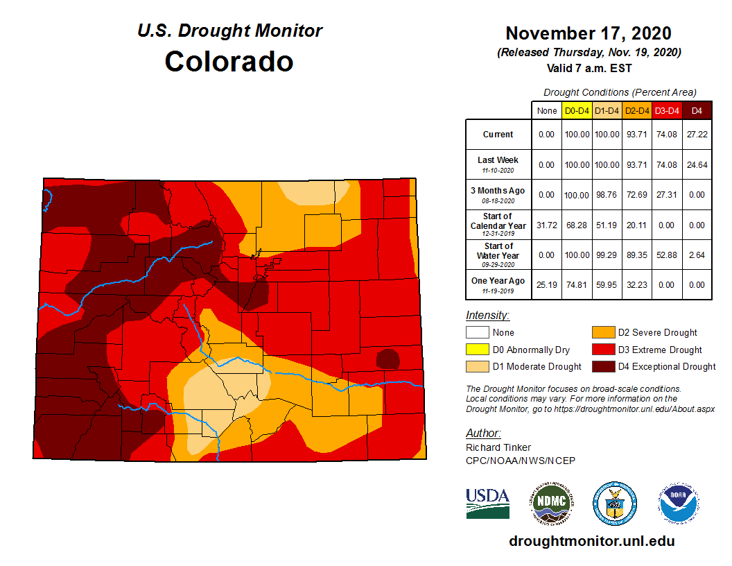
Click on a thumbnail graphic to view a gallery of drought data from the US Drought Monitor.
US Drought Monitor November 24, 2020.
West Drought Monitor November 24, 2020.
Colorado Drought Monitor November 24, 2020.
Click here to go to the US Drought Monitor website. Here’s an excerpt:
This Week’s Drought Summary
Several Pacific weather systems, in the form of shortwave troughs, moved in the jet stream flow across the contiguous U.S. (CONUS) during this U.S. Drought Monitor (USDM) week. The weather systems brought rain or snow to parts of northern California and the Pacific Northwest, western Colorado, the northern Plains to Mid-Mississippi Valley, and Tennessee Valley to Northeast. Rain also fell across parts of Florida. The rest of the CONUS had little to no precipitation. Even where the precipitation fell, it was mostly below normal for the week. Areas receiving above-normal precipitation included parts of the Sierra Nevada, southern Idaho, other scattered parts of the Pacific Northwest, strips across the central Palins to Ohio Valley and across New England, and parts of Hawaii. Improvement in drought conditions occurred where precipitation was above normal, while drought expanded or intensified in some areas where dryness continued. Temperatures were largely warmer than normal across the CONUS, with anomalies 9 degrees F or warmer from the Southwest to northern Plains. Parts of the Pacific Northwest and East Coast were near to cooler than normal. SNOTEL observations of mountain snowpack showed increases in snow depth in the Sierra Nevada and parts of Oregon and Washington, and snow water equivalent (SWE) values were in the high percentiles in the Sierra Nevada, and Pacific Northwest, but this is early in the snow season when the snowpack is just getting established. SWE values were in the low percentiles from Nevada eastward. Western reservoirs continued quite low, especially in Oregon, California, Nevada, Utah, Colorado, Wyoming, and New Mexico. Mounting dryness was indicated in several drought indicators and indices. Maps of 7-day, 14-day, and 28-day USGS streamflow measurements were consistent in showing below-normal streamflow from northern California, Nevada, and southern Idaho, across the Southwest, to the central and southern High Plains; across southern Texas; across western Puerto Rico; and in parts of Hawaii, Iowa, Illinois, Indiana, and the Northeast. The satellite-based Vegetation Health Index shows stressed vegetation across the California valleys and southern California, the Southwest, parts of the central Plains and Ohio Valley, and especially in southeastern New Mexico to western Texas. Where VegDRI is still in season, it shows drought across much of the West (especially the Southwest and west Texas) and parts of the Northeast. Where QuickDRI is still in season, it shows very dry conditions across the West (except for a very small part of coastal southern California) to southern and central Plains; much of Texas, and parts of the Midwest and Northeast. The KBDI shows significantly dry conditions in California, Nevada, Utah, Arizona, New Mexico, and Texas. Evapotranspiration (EDDI) for the last week has been high in the southern to central Plains, southern Alabama, and the Midwest to Northeast; at the 2- to 3-week timescales, across much of the CONUS from the Southwest to Northeast; and at longer time scales (1-3 months), in the Southwest to central Plains, and from the Ohio Valley and southern Great Lakes to Northeast. NIFC wildfire maps show large wildfires still burning in California and Colorado, several across Oklahoma, and some in other parts of the West, Kansas, Texas, Mississippi, the Florida panhandle, and central Appalachians. USGS real-time groundwater level data show low groundwater at points across the West, in northern Indiana, southern Georgia, and parts of the Northeast. NASA GRACE satellite-based groundwater estimates show low groundwater across most of the West to central and southern High Plains, most of New York to New England, much of Texas, and parts of North Dakota, Pennsylvania, Virginia, Alabama, and Florida. Soil moisture is dry across the West from California to the southern and central Rockies, in the southern and central High Plains, in North Dakota, across Nebraska and Iowa, across central Illinois to northern Indiana, parts of Pennsylvania and New York, and (for some indicators) most of New England and southern Alabama (CPC, NLDAS, and UCLA/VIC models; satellite-based AAFC/SMOS, GRACE, and NASA/SPoRT analyses). The Standardized Precipitation Index (SPI) shows dry conditions in various places at different time scales. These include North Dakota to Minnesota, Wyoming, New England, and southern Texas to the Lower Mississippi Valley (at the 1-month time scale); California to the central and southern Rockies, much of the Great Plains, Iowa and Missouri to Indiana, parts of the Northeast, and southern AL (2 to 4 months); California to the central and southern Rockies, much of the Great Plains, Iowa, Indiana to Ohio and Michigan, most of Northeast (6 to 12 months); parts of Pacific Northwest (9 to 12 months); and the Southwest to southern and central High Plains, and parts of Pacific Northwest, Texas, Iowa, Indiana, and the Northeast (24 months). When the desiccating effects of hot temperatures are included, the Standardized Precipitation Evapotranspiration Index (SPEI) shows more intense drought conditions over the SPI dry areas than indicated by the SPI…
Half an inch of precipitation fell over parts of western Wyoming and the Colorado mountains, with a strip of half-inch precipitation bisecting Kansas. But for most of the region, it was a dry week with less than a quarter inch falling or no precipitation. Moderate and severe drought was trimmed slightly in western Wyoming, but the big story was expansion of severe and extreme drought in parts of Kansas and Nebraska; moderate drought also expanded in eastern Kansas. This expansion was prompted by several indicators, including SPI at several time scales and multiple soil moisture tools. According to USDA reports, half to two-thirds of the topsoil moisture was short to very short in all of the High Plains states except Colorado, where 87% of the topsoil moisture was short to very short. USDA statistics show that 43% of the winter wheat was in poor to very poor condition in Colorado, which is a jump of 11% compared to a week ago. In Nebraska and Kansas, the winter wheat statistics were 20% and 26%, respectively, poor to very poor…
Parts of northern California and the Sierra Nevada and the western parts of Oregon and Washington received half an inch to over 2 inches of precipitation this week, with locally over 4 inches in Oregon and Washington. Parts of the Rocky Mountains received half an inch to 2 inches. While beneficial, the precipitation was not enough to overcome deficits that have built up over much of 2020. An exception was contraction of abnormal dryness in a couple spots in Washington. Moderate drought retreated in central Montana, reflecting moisture which has fallen in recent weeks. Severe to extreme drought were expanded in parts of northeast California, northwest Nevada, and adjacent Oregon where precipitation this week was light and deficits over the last several months continued to mount.
Southern portions of the West region received little to no precipitation this week. Moderate to severe drought expanded in the San Joaquin Valley and abnormal dryness expanded in southern California. The failure of the summer monsoon resulted in record dryness to the Southwest states, and record heat over warm season increased evapotranspiration, resulting in record SPEI values over the last 3 to 6 to 9 months. The SPEI values were not only record, they exceeded previous records by huge margins. Extreme to exceptional drought expanded to reflect this prolonged dryness in Arizona, New Mexico, and Nevada. According to USDA reports, topsoil moisture was short to very short across 81% of New Mexico, 75% of California and Utah, 58% of Montana, 55% of Idaho, and 40% of Nevada and Oregon. Parts of interior southern California, the southern Great Basin, and the Desert Southwest have had a seven-month dry streak. According to National Weather Service records, the last measurable precipitation in Bishop, California occurred on April 17, 2020, and the last measurable precipitation in Las Vegas, Nevada occurred on April 20, 2020…
Half an inch or more of rain fell across parts of Oklahoma and Arkansas, but other than that the South region was dry. Abnormal dryness expanded in parts of all of the states in the South region. Moderate to exceptional drought were expanded across various parts of Texas; moderate drought was introduced in Arkansas and Mississippi and expanded in Louisiana; and moderate and severe drought expanded in Oklahoma. In the Oklahoma panhandle, moderate and severe drought retreated. According to USDA reports, topsoil moisture was short or very short across 69% of Texas, 41% of Oklahoma, 31% of Mississippi, 24% of Louisiana, and 14% of Arkansas; 38% of the winter wheat was in poor to very poor condition across Texas…
Looking Ahead
The jet stream will continue to be active during the next couple weeks, sending a parade of Pacific weather systems into the CONUS. For November 25 to December 1, precipitation will fall across the Pacific Northwest, where the coastal mountains may receive over an inch of precipitation, and widespread precipitation is forecast to fall from the southern Plains to East Coast. Amounts may exceed 3 inches from southeast Texas to the southern Appalachians and parts of New England, with an inch or more surrounding these core areas from Texas to Kansas, from the Gulf Coast to Great Lakes, and from the Florida panhandle to the Northeast. A fourth of an inch or less is forecasted to fall across most of the West, from the northern Plains to Upper Mississippi Valley, and over much of Florida. The forecast models predict above-normal temperatures east of the Rockies with near to below-normal temperatures across the West. The outlook for December 2-8 is mostly dry. Odds favor below-normal precipitation across most of the CONUS, with only the Rio Grande Valley and eastern two-thirds of Alaska having odds favoring wetter-than-normal conditions. Odds favor warmer-than-normal temperatures across the West, central to northern Plains, Great Lakes, and eastern Alaska, with below-normal temperatures likely across the southern Plains, Southeast, Mid-Atlantic, and western Alaska.
US Drought Monitor one week change map ending November 24, 2020.
Opinion: We’ve known for years that a shortage is coming, but it’s alarming how quick the conditions are changing. The Colorado River system was not set up for this.
Glen Canyon Dam aerial. Photo credit: USBR
This warm, dry weather we’ve been having may be good for moving activities outside.
But it’s bad news for our water supply.
The chances are growing – and quickly – that a warm, dry winter could push Lake Powell to a trigger point about a year from now that could result in significantly less water for Lake Mead, which supplies about 40% of Arizona’s water supply.
That likely would push Mead into a first-time shortage declaration. And if the same thing were to happen the following year, it would likely plunge Mead into a more severe shortage – a depth from which the lake is unlikely to recover any time soon.
Like I said, bad news.
Why would Mead get less water?
The 2007 operational guidelines lay out how much water is released from the upstream Powell to the downstream Mead. In “normal” years (and yes, I use quotes because nothing about the Colorado River is normal these days), Mead gets about 8.23 million acre-feet.
That drops to 7.48 million acre-feet once Powell’s levels fall below a certain depth. This occurred once before, in 2014, and luckily, Mead was nowhere close to a shortage then.
But lake levels plunged that year and never recovered, even in wet years and despite millions of acre-feet of water that Arizona and others have stored in Mead.
The lake is currently less than 10 feet above its shortage elevation trigger of 1,075 feet. Yet a 7.48 million acre-feet release in water year 2022, which begins in October 2021, could drop levels on Lake Mead by nearly 20 feet.
That could plunge us into shortage
That would place us solidly into a Tier 1 shortage – which for Arizona, means no more Colorado River water for Pinal famers and some water lost from the non-Indian agricultural (NIA) pool, which is a rung higher on the priority list and despite its name, mostly supplies tribes and cities.
Should conditions persist and Mead get another 7.48 million acre-feet release in water year 2023, that would likely plunge us deep into a Tier 2 shortage, nixing most of the NIA water that some cities use for existing development and others had wanted to shore up their long-term supplies.
Without that water, cities will need to find other, more secure sources. Which means if the battle to transfer water from on-river communities to Queen Creek is fierce now, new ones are likely to get a lot fiercer.
How likely is this 7.48 scenario?
We’ve known for years that a shortage would eventually come to Lake Mead, and that when that happens, Arizona – the state with junior water rights – would be the first to face more severe consequences.
But it’s alarming how quickly the conditions are changing.
The chances of a 7.48 million acre-feet release have increased markedly – from less than 20% in April to more than 50% in August, depending on which hydrology forecast you use. The chances of a Tier 1 shortage on Mead were as high as 30% in August, up from roughly 10% in April.
That may not sound like a lot, but it’s enough to keep risk-adverse water managers up at night. Consider that a 1 in 5 chance of Lake Mead tanking was enough to drive ratification of the Lower Basin Drought Contingency Plan, which buys time for the lake through mandatory cuts to our water supply.
So, what is provoking such quick forecast changes?
Last winter was relatively wet. It looked like we were on par for an average runoff year. But the ground was dry before all that snow fell, and as it began to melt, a lot of it sunk into the parched soil.
In the space of a few weeks, what looked like a decent runoff year turned into a mediocre one.
Then we had a record-breaking hot and dry summer. The soil is again parched.
But, unlike last winter, we are now in a relatively strong La Nina weather pattern, which historically has meant warm and dry winters for all but a small corner of the Colorado River basin.
It’s a double whammy. If this winter plays out as expected, we’ll have a meager snowpack that is unlikely to produce much runoff because warm winds blowing over the snow can suck out moisture. And much of what is produced could sink into the ground before it ever makes it to our reservoirs.
If this is the future, then what?
It’s early in the snow season, of course. Things could change.
But while few parts of the Colorado River basin were facing drought conditions a year ago, most are now in extreme or exceptional drought, the most severe categories.
And some worry that this could be the beginning of a multiyear string of similar dry conditions – a la what we saw most recently in 2012-13, the lead-up to the last 7.48 million acre-feet release on Powell.
The good news, if you want to call it that, is that Arizona’s water leaders already assumed that we’d already be in a Tier 1 shortage by now. We have plans to handle these shortages in the short term, even if the details – like forcing Pinal farmers back solely on groundwater – are less than ideal.
The more daunting challenge lies in 2026, when the drought contingency plan and the 2007 guidelines expire. Because, as bad as this winter may look, the science suggests we are in for many more of them as the Colorado River basin gets warmer and drier.
We have a system that assumes water allocations will be steady as she goes, when the best-case scenario may be one of feast or famine.
And all signs point to a future where every competing water use is a valid one and there isn’t enough water to quench them all.
How do we decide who gets what when a dwindling supply becomes even more volatile? That is the fundamental question we must now address.
Reach Allhands at joanna.allhands@arizonarepublic.com. On Twitter: @joannaallhands.
Denver International Airport tallied 5 inches of snow. This is a record daily snowfall for Nov. 24, breaking the old record of 4 inches set in 1946. Even more notably, it was the first daily November snow record to fall in the city since 1994. Snow totals across the rest of the metro area generally range from 3 to 6 inches, with heavier amounts up to 10 inches in the western suburbs.
This was a rare November snowstorm in the Denver area beyond the record-breaking amount. Another rarity lies within the heavy and wet nature of the snow…
The overall air mass above the surface was rather mild for this time of year. At the beginning of the storm, a large layer of the atmosphere above our heads was flirting with the freezing mark. The air mass sitting over the state also had quite a bit of moisture in it. The total amount of water in the air was nearly double the normal amount for late November.
This combination of a mild and moist air mass in place led to snow reaching the ground with an extremely high water content. Heavy, wet snow is something that Denver would expect in early and late season storms, such as in September or April. Winter’s chill is typically well established by late November, promoting very powdery snow.
Extra water in this snow is certainly beneficial for Colorado’s ongoing drought. The snow melted down to just under a half of an inch of liquid at DIA. This makes it Denver’s wettest day since Sept. 8, and the fifth wettest day in all of 2020.
CoCoRaHS map for November 24, 2020.CoCoRaHS map for November 25, 2020.
Photo credit from report “A Preliminary Evaluation of Seasonal Water Levels Necessary to Sustain Mount Emmons Fen: Grand Mesa, Uncompahgre and Gunnison National Forests,” David J. Cooper, Ph.D, December 2003.
The scope of federal jurisdiction under the Clean Water Act remains perplexing, particularly now that Colorado is the only state in the nation where the Navigable Water Protection Rule did not take effect June 22, 2020. In the context of a lengthy “stakeholder” process, on November 20, 2020, the Colorado Department of Public Health and Environment (CDPHE) issued a White Paper addressing its regulatory options in light of the new federal WOTUS rule. Construction companies, developers, and other businesses seeking to permit activities around wetlands, ephemeral waters, and intermittent streams in Colorado would benefit from reviewing this comprehensive discussion of the multitude of dilemmas Colorado and others states face in light of the new rule.
The state’s White Paper includes background on these topics –
Federal permitting including Section 402 and 404 permits.
State waters and the state’s regulation of discharges to state waters.
The Supreme Court’s Rapanos decision and subsequent guidance.
The 2020 Navigable Waters Protection Rule.
Litigation of the 2020 Navigable Waters Protection Rule.
And perhaps most importantly –
Potential impacts of the 2020 Navigable Waters Protection Rule if it were to go into effect in Colorado.
Of most significance in terms of the impacts to state regulatory programs, the White Paper states:
The rule includes several definitions that further limit how the EPA and the Corps will define WOTUS in contrast to the existing regulatory framework. First, it restricts the definition of protected “adjacent wetlands” to those that “abut” or have a direct hydrological surface connection to another jurisdictional water “in a typical year.” 33 C.F.R. § 328.3(c)(1); 40 C.F.R. § 120.3(3)(i). Wetlands are not considered adjacent if they are physically separated from jurisdictional waters by an artificial structure and do not have a direct hydrologic surface connection. The 2020 Rule also limits protections for tributaries to those that contribute perennial or uncertain levels of “intermittent” flow to traditional navigable waters in a “typical year,” a term whose definition leads to additional uncertainty. 33 C.F.R. § 328.3(c)(12); 40 C.F.R. § 120.2(3)(xii); 33 C.F.R. § 328.3(c)(13); 40 C.F.R. § 120.2(3)(xiii).
Collectively, these new definitions in the 2020 Rule will reduce the scope of waters subject to federal jurisdiction in Colorado far below that of the 2008 Guidance. The state waters that would no longer be considered “waters of the United States” under the 2020 Rule have been referred to as “gap waters” and are further described in Section II below. Historically, not all of Colorado’s state waters have been considered WOTUS. However, the [CDPHE] has maintained that the number of state waters considered WOTUS under the 2008 Guidance is far more than would be considered WOTUS under the 2020 Rule. [Emphasis added.]
A proposed $641-million settlement of water crisis lawsuits was filed in U.S. District Court last week, $20 million of which would come from a city insurance policy — if approved by the Flint City Council.
If approved by Judge Judith Levy, the settlement would establish a claims process for those harmed by Flint water and ultimately payouts depending on which of 30 categories individuals fall into, the extent of damages and how many claims are filed.
The council is scheduled to address the settlement in a closed session at 5:30 p.m. Monday, but several members have blocked similar private briefings in the past, saying that the overall settlement that’s been proposed doesn’t provide enough money to those harmed by Flint water or doesn’t divide the settlement fairly.
Flint children who were 6 years old and younger at the time they were first exposed to Flint River water would receive 64.5 percent of the proposed settlement.
Council President Kate Fields has urged other members to be briefed on the city’s portion of the settlement so that they can be informed on the deal before they vote to accept or reject it.
Attorneys involved in negotiating the settlement say lawsuits will continue against the city and its employees in state and federal courts if the settlement is not approved by the council.
More than 100 lawsuits are pending related to the water crisis, alleging parties including the city and the state have responsibility for the distribution of water with elevated levels of lead, bacteria and chlorination byproducts in Flint in 2014 and 2015.
In addition to having had regulatory responsibility for Flint water, the state appointed emergency financial managers to run the city before and during the water crisis.
The briefing at 2 p.m. Monday is designed to give residents the chance to hear “directly from the city’s attorneys on what this settlement would mean to residents,” Neeley said in a statement issued by the city. “This is about transparency and about making sure that residents have access to accurate information regarding the proposed water lawsuit settlement.”
Because the settlement documents were filed in federal court on Tuesday, Nov. 17, city officials said they can now openly discuss them.
The southern half of the state, as of Monday, was sitting in the 60% of normal accumulation of snowpack, and the Lower Sevier River Basin at 36% of normal is experiencing abysmally dry conditions.
West Drought Monitor November 17, 2020.
In fact the U.S. Drought Monitor, in data updated last week, shows a large swath of central Utah in the exceptional drought category and the majority of Utah in extreme drought.
Those conditions persist throughout states in the Southwest, including Arizona, New Mexico and portions of western Colorado. Utah’s neighbor, Nevada, is also experiencing extreme drought as moisture-giving storms avoid most of the region.
Much of the West, in fact, is in some sort of drought with the exceptions of the coastal areas of Southern California, northern Washington, portions of Idaho and extreme northern areas of Montana.
Earlier this year, a grim study released by Columbia University said the entire West is likely headed into a climate-driven “mega drought” based on data from tree rings. The study area stretched across nine U.S. states from Oregon and Montana down through California and New Mexico, and part of northern Mexico. If the study’s predictions prove true, it would be the worst drought in the region in 1,200 years.
Utah’s only “average” areas for accumulation this year so far are the Weber-Ogden River Basin at 102% and the Bear River Basin sitting at 111%.
Westwide SNOTEL November 24, 2020 via the NRCS.
Elsewhere along the Wasatch Front, the Provo-Utah-Jordan River Basin is struggling at 87% of normal, but again it is early in the accumulation season.
The findings pinpointed basins around the world most at risk of not having enough water available at the right times for irrigation because of changes in snowmelt patterns. Two of those high-risk areas are the San Joaquin and Colorado river basins in the western United States. Photo: Kevin Bidwell/ Pexels
The Symposium is hosted by Colorado State University and sponsored in part by the Colorado Dairy Farmers.
It’s the farmers like Chris Kraft of Kraft Family Dairies near Fort Morgan whose livelihoods depend on the increasingly scarce resource.
Kraft: “Without that, we don’t do what we do. So this is critically important for us.”
Kraft says times have changed with more people living in Colorado and a growing dairy industry making water issues more severe.
Kraft:” We’re interested in all the ways water is being discussed. A lot of the water that we use in on dairy farms in Colorado is historically old water rights, some of them going back to before statehood. Our industry doesn’t exist without that water. We have to have that water and we’re interested in making sure that we’re at the table when these kinds of discussions are going on.
Gary Knell, chairman of National Geographic Partners was asked for his focus on the power of storytelling. A panel discussion focused on how social movements, campaigns, and storytelling shape public sentiment.
A dialogue between Vilsack and Axelrod concluded the symposium.
Highlighting [John Wesley] Powell’s devotion to science, his foresightedness and his willingness to speak up was the starting point for the recent annual Water in the West Symposium, hosted by Colorado State University’s new SPUR campus in Denver. Keynote speaker Gary Knell, chairman of National Geographic Partners and former president and CEO of the National Geographic Society, related Powell’s story as he sketched out a history of how early exploration of the West led to formation of the National Park Service and an ethic of conservation that was soon interwoven into the American mindset.
“Facts belong in the domain of science, but the best stories make the facts relevant in ways people can visualize and identify with,” he said. “Embrace the power in your own story to change hearts and minds, and together we can change the world.”
[…]
Stories nestled within other stories is how this year’s symposium served to illustrate many of the ideas the speakers shared as they reflected on the role of storytelling to motivate change, address challenges and produce lasting results.
Water issues are complex, and perspectives are wide-ranging, which means listening and respecting is as important as speaking, for writers and photographers as well as influencers and advocates, Knell said…
Gary Hirshfield, co-founder and now “Chief Creative Officer” of Stonyfield Yogurt, emphasized repeatedly the importance of making the message “visceral,” by relying on ingenuity and originality.
“We launched an organic yogurt company in 1983 at a time when nobody was eating yogurt and no one knew what organic was,” he recalled.
Hirshfield had to come up with creative ways to persuade consumers to buy an unfamiliar product at a steep price premium to conventional brands.
“We had no money, but we had cows. So we came up this very simple idea that if you sent in five yogurt labels, you would get to adopt a cow,” he recalled.
He also used “moos-letters,” farm cams and Yo-Tube, his original version of a YouTube message channel, to sell a fun hip image, while reaching out to bloggers and influencers to spread brand recognition and enthusiasm to millions of followers.
“We had fun. We didn’t take ourselves too seriously but focused on keeping it upbeat, positive and funny,” he said.
Social media “is an artform now,” he added. “It’s highly refined and oversaturated, so how you cut through that is critical.”
Keep the message simple, don’t overwhelm with facts, be positive and solution-oriented, and listen instead of doing all the talking, he advised…
Justin Worland, a journalist covering energy, environment and climate for Time Magazine, talked about choosing to pursue articles that educate and move a larger conversation forward…
Sarah Soule is an academic researcher at the Stanford Graduate School of Business and has written extensively on corporate responsibility and social movements.
“Why are some social movements successful when others are not? That’s one of the big research questions we study,” she said.
Key factors include how the issues are framed, the overall political environment, available resources and the role of media.
The New Mexico Interstate Stream Commission and The Nature Conservancy hope to demonstrate that the strategic water reserve can help endangered fish recover while also providing the ability to meet water compact requirements in the San Juan Basin.
San Juan River. Photo credit: USFWS
The Interstate Stream Commission approved allowing ISC Director Rolf Schmidt-Petersen to continue negotiations with the Jicarilla Apache Nation to lease up to 20,000 acre feet of water annually that became available as it is no longer needed for operation of the San Juan Generating Station.
San Juan Generating Station. Photo credit: Jonathan Thompson
The Jicarilla Apache Nation acquired rights to water stored in Navajo Lake in 1992 and has the authority to lease this water to other entities to help the tribe. Up until recently, the nation has leased water to Public Service Company of New Mexico to operate the San Juan Generating Station.
Navajo Lake
But the potential of the power plant closing in 2022 as well as a reduction in the amount of water needed to operate it due to the closure of two units in 2016 means that this water is now available for the state to potentially lease.
The water would be placed in the strategic water reserve, which has two purposes: assisting with endangered species recovery and ensuring the state meets its obligations under water compacts. When needed, the water could be released from the reservoir to help with the fish or to meet the requirements of the 1922 Colorado River Compact…
Terry Sullivan, the state director of The Nature Conservancy in New Mexico, said the organization has been working on the San Juan River for 15 years trying a variety of restoration projects to help create habitat. The fish rely on slow backwaters for reproduction…
Sullivan said the water lease is a great step forward to achieve both compact requirements and benefits to endangered species.
The amount leased each year would depend on funding available. One of the details of the lease agreement that has not yet been determined is the price…
Peter Mandelstam, the chief operating officer for Enchant Energy, said in a statement that the company believes it has enough water rights without the Jicarilla Apache lease to successfully retrofit the San Juan Generating Station with carbon capture technology and operate it.
An update was given on Wilson Water Group’s (WWG) efforts in completing a water use and water demand analysis for the San Juan Water Conservancy District (SJWCD) and completing a water availability analysis for the West Fork reservoir and canal water rights during a regular meeting on Monday.
WWG was hired by the SJWCD via a board decision at a Sept. 21 meeting for a cost of $19,050 and will complete the efforts by the end of 2020.
Currently, WWG has been working on its first task, which is to develop a water demand analysis strategy, Project Engineer Brenna Mefford noted, adding that the first task would be completed in the next week or so.
The next task, to complete a current water use and water demand analysis, will be completed soon after, Mefford explained.
Task three, which is to complete a water availability analysis, will be started in December, Mefford added…
If the SJWCD were to go through with diligence on the West Fork water rights, it would have to show it has a potential demand for the water and that the district needs it, Mefford explained, adding that the SJWCD needs to show water availability.
“Finally, you have to show that you have the means to develop that water and put it to that use that you had identified earlier,” she said…
“We’ve talked to most of the people we planned to try and fig- ure out how we’re going to lay out this analysis and now we’re going to move into task two, where we’re actually going to do the current water use and water demand analysis. For this task there are a few more people that we need to reach out to and have talks with about water demand,” Mefford said, adding that WWG will need to talk to PAWSD, for example.
Beyond both being in Colorado and along the state’s Front Range, Boulder and Cañon City could not be more different. The differences go back to the state’s founding.
Cañon City had the choice of getting the state penitentiary or the state university. It chose the former, so Boulder got the latter.
In both cities, a franchise vote with the existing utility provider was on the ballot on Nov. 2. This time, they went in different directions once again. The fulcrum in both cases was cost, if the formula was more complex in the case of Boulder.
Boulder voters, after exploring municipalization for a decade, agreed to a new 20-year franchise agreement with Xcel Energy. Xcel had continued to supply the city’s residents with electricity after the last franchise agreement lapsed in 2010.
The new agreement garnered 56% voter approval. Even some strong supporters of the effort to municipalize had agreed that the effort by the city to create its own utility had taken too long and cost too much money, more than $20 million, with many millions more expected. They attributed this to the power of Xcel to block the effort.
Boulder’s effort had been driven primarily by the belief that a city utility could more rapidly embrace renewables and effect the changes needed to create a new utility model. In short, climate change was the driver, although proponents also argued that creation of a city utility would save consumers in the long run. Consumers just weren’t willing to wait long enough.
Going forward, Boulder will have several off-ramps if Xcel stumbles on the path toward decarbonization of its electrical supply. The city will also retain its place in the legal standings, if you will, should that be the case. Also, Xcel agreed to a process intended to advance microgrids and other elements, although critics describe that as toothless. Undergrounding of electrical lines in Boulder will not commence anew as a result of the new franchise agreement.
Cañon City is Colorado’s yin to Boulder’s yang. Located along the Arkansas River in south-central Colorado, it has become more conservative politically even as Boulder has shifted progressive. In the November election, 69% of votes in Fremont County—where Cañon City is located—went for Donald Trump, who got 21% of votes in Boulder County
Economically, they walk on opposite sides of the street, too. The statewide median income in Colorado in 2018 was $68,811. Boulder County stood a shoulder above (and Boulder itself likely even more) at $78,642. Fremont County was at waist level at $46,296.
And along the Arkansas River…
Cañon City also went in the opposite direction of Boulder in the matter of its franchise. There were differences, of course. Boulder turned its back on municipalization in accepting a new franchise.
In Cañon, about 65% of voters rejected a franchise agreement with Black Hills Energy, Colorado’s second investor-owned electrical utility. The city council had approved it, but the city charter also required voter approval.
Unlike in Boulder, decarbonization and reinvention was not overtly among the topic points. Some people in Cañon City do care about decarbonizing electricity, says Emily Tracy, the leader of a group called Cañon City’s Energy Future, which she put together in January 2018. But the cost of electricity was the fulcrum and, she believes, a reflection of how the community feels about Black Hills.
The old franchise agreement with Black Hills expired in 2017. Tracy and other members of Cañon City’s Energy Future persuaded council members to put off a new agreement but failed in their bid to have a community dialogue.
“The power industry, the electric industry, are so different than they used to be, and we simply want the city to explore its options,” she says.
In stories in the Pueblo Chieftain and Cañon City Daily Record, city officials said they had evaluated options before seeking to get voter approval of the franchise.
Partially in play was the effort underway in nearby Pueblo to break away from Black Hills and form a municipal utility. The thought was that if Pueblo voters approved that effort, Canon City could piggyback to the new utility. The proposal lost by a lopsided May vote after a campaign that featured $1.5 million in advertising and other outreach by a pro-Black Hills group.
Black Hills rates are among the highest in Colorado. Tracy illustrates by citing those she pays to Xcel Energy in Breckenridge, where she has a second home.
“I pay 77% more for a kilowatt-hour of electricity for my house in Cañon City than I do to Xcel in Breckenridge,” she says.
This is from the Nov. 20, 2020, issue of Big Pivots, which chronicles the great energy transition in Colorado and beyond. Sign up for copies at BigPivots.com.
Opponents of the franchise renewal were heavily outspent in the campaign. Records that Tracy’s group got from the city clerk showed $41,584 in spending by Power Cañon City, the pro-Black Hills group, through mid-October. Tracy’s group spent less than $5,000, counting in-kind contributions. Tracy suspects that Black Hills didn’t entirely take the vote seriously.
Now it’s back to the drawing board for the Cañon City Council. Tracy hopes for more transparent discussion about the options.
But it’s all about the money.
“You take a poor community like Cañon City or Pueblo, then add in the fact that we’re paying the highest electricity rates in the state, and there’s no doubt it has an impact on families, businesses and attempts to do economic development,” says Tracy.
Frances Koncilja, a former member of the Colorado Public Utilities Commission has offered her legal assistance to Cañon City’s Energy Future.
As for why Cañon City wanted the state prison instead of the state university in the early years of Colorado’s statehood, keep in mind the times. Crime did pay for Cañon City in the 19th century, when few people had or needed college degrees. It was well into the 20th century before this shift toward greater education began.
From the Colorado Ag Alliance (Phil Brink, Greg Peterson) via The Rio Blanco Herald-Times:
Every 10 years, the Colorado Division of Water Resources’ (DWR) publishes its water right abandonment list. The list — released on July 1, 2020 — represents water rights that each division engineer is recommending for abandonment based on real or perceived non-use over the last 10 years. A water right may be placed on the abandonment list if the amount of water diverted over the past 10 years is less than the decreed amount.
The DWR defines abandonment as “the termination of an absolute water right in whole or in part as a result of the intent of the owner to permanently discontinue the use of the water under that water right.” It is rare that an agricultural water right holder actually intends to abandon their water right.
“There can be several reasons why the decreed amount is not diverted in a given year or for multiple years” says water attorney David Kueter of Holsinger Law in Denver. The water source may be dry, or the water right may not be in priority at times when the field needs to be irrigated. Timely precipitation may reduce the need for irrigation. Repair or replacement of irrigation infrastructure — from headgates to ditches to land application equipment — may temporarily prevent diversion of water. Economic, health or legal obstacles can all stymie intentions to fully utilize a water right. Sediment and debris flows can block diversion structures and river and stream hydrology can change, rendering a diversion structure semi-functional or even non-functional. New property owners may not be aware of their water rights.
Management changes can also impact use. A few years ago, Mike Camblin, rancher and manager of the Maybell Ditch, took over irrigation of some fields that had not been fertilized previously. The addition of fertilizer increased grass production three-fold, which also increased the field’s consumptive use of water.
Increased consumptive use may also result from warmer summers, which are predicted by climate models. CSU research has found that evapotranspiration comprises more than 99 percent of plant water use. Increased temperatures drive forage and crop consumptive use higher. Cutting ag water rights down to their current consumptive use will permanently hurt growers’ ability to adapt to a warmer climate.
Water users who wish to challenge termination of their water right due to abandonment should file a written statement of objection with the Division 6 Engineer. An objection statement is needed for each water right. The deadline for filing is July 1, 2021, but Kueter recommends getting started now as it may take time to pull together supporting evidence. “Usually there are no silver bullets,” says Kueter, “it’s more the totality of the circumstances that caused the water right to be under-utilized.”
A water right is removed from the abandonment list if the Division Engineer agrees with the supporting evidence provided. A revised abandonment list will be published by Jan. 31, 2022. Protests to the revised list must be filed with division Water Court by June 30, 2022. The Water Court will begin considering protests in October 2022.
The Colorado Ag Water Alliance will be hosting a workshop on this and other issues on Dec. 7 in Craig.
Phil Brink is the Consulting Coordinator of Colorado Cattlemen’s Ag Water NetWORK. Greg Peterson is the Executive Director of Colorado Ag Water Alliance.
Ralph Parshall squats next to the flume he designed at the Bellevue Hydrology Lab using water from the Cache la Poudre River. 1946. Photo Credit: Water Resource Archive, Colorado State University, via Legacy Water News.
Men viewing vortex tube sand trap in Jackson Ditch at Bellvue Hydraulic Laboratory, 1948. Photograph from Irrigation Research Papers, Water Resources Archive.
This Parshall flume, which was installed in the Yampa River basin in 2020 and is shown in this August 2020 photo, replaced the old, rusty device in the background. State engineers are developing rules for measuring devices, which would apply to the entire Western Slope. CREDIT: HEATHER SACKETT/ASPEN JOURNALISM
Scott Hummer, water commissioner for District 58 in the Yampa River basin, checks out a recently installed Parshall flume on an irrigation ditch in this August 2020 photo. Compliance with measuring device requirements has been moving more slowly than state engineers would like. CREDIT: HEATHER SACKETT/ASPEN JOURNALISM
If you are looking for a great gift for a long-time local or history buff, then you might want to check out “Confluence: The Story of Greeley Water” by Gregory J. Hobbs, Jr. and Michael Welsh.
With water being so vital to life and agriculture, the quote by Congressman Wayne Aspinall on the book’s forward page really sums it all up — “in the West, when you touch water, you touch everything.”
The book begins in 1870 with a single irrigation ditch and follows 150 years of development of the water system in Greeley, including the people who developed and impacted water law, engineering and agriculture including Delph Carpenter, Milton Seaman and W.D. Farr.
Currently, the water system supports more than 140,000 people and utilizes water from four different water basins in the state.
“The vision of this project was to tell the story to a broad audience. We didn’t want our sole audience to be the water nerds,” said Harold Evans, chairman and board member of the City of Greeley Water and Sewer Board. “We wanted to reach out to the average citizen; we wanted to reach out to other in the water profession and historians.”
The book project began around four years ago, Evans explained.
“The more I was involved the history and the policy of Greeley water, I felt that it was a story the community would be interested in,” he said. “I talked to Roy Otto, our city manager and the director of water and sewer and we decided to proceed with a book.”
Evans recruited Greg Hobbs and Michael Welsh to write the book for the city.
Hobbs currently serves as Senior Water Judge and co-directs the University of Denver Law School’s environmental and natural resources program. He is also a board member of Water Education Colorado.
Welsh has been teaching history at the University of Colorado since 1990 and has written manuscripts for several National Park Service sites as well as full-length studies on the U.S. Army Corps of Engineers.
“They spent the first couple of years doing nothing but research,” Evans said. “This was a well-researched book. If you look in the back of the book at the footnotes, you will see the amount of research that was done.”
While the main premise of the book is about water, it really is a story of the Union Colony and a parallel story of the history of our area including the Poudre River, national and local events like the Great Depression and World Wars.
One of the events Evans references from the book is the opening of the Bellvue Water Treatment Plant that opened in 1907.
“We are still today, 113 years later, delivering water from Bellvue,” he said. “In fact, this summer marked 150 continuous years that water has been flowing through the number three ditch in Greeley.
“Without water, we wouldn’t be here; businesses wouldn’t be here,” Evans added.
The book also contains a variety of historical photos and maps of Greeley and Weld County and the front cover depicts a painting of the Cache la Poudre River created by award-winning artist Jay Moore. Moore specializes in paintings of the North American West.
The book can be purchased at Tattered Cover and locally at Lincoln Park Emporium.
So far, the book has been popular with the local community, with the first delivery selling out, and people asking to be put on a waiting list, said Emporium co-owner Mary Roberts.
“It’s one of the most enlightening and visionary, in my view, because it shows what our history has been and what we are going to do for the future,” Roberts commented.
People interested in purchasing the book from the Lincoln Park Emporium can call the store at (970) 351-6222 to have their name put on the list.
Over the last five years, Learning By Doing has made significant progress toward fulfilling its mission to maintain and improve Grand County’s aquatic environment.
PFAS contamination in the U.S. via ewg.org. [Click the map to go to the website.]
Here’s the releaseThe Colorado School of Mines (Emilie Rusch):
Published today in Environmental Science and Technology, the research was led by Mines’ Chris Higgins and Juliane Brown
Chris Higgins. Photo credit: Colorado School of Mines
If state and federal regulators focus only on the safety of drinking water, the public could still be exposed to concerning levels of poly- and perfluoroalkyl substances (PFASs) via the vegetables on their dinner plate if those vegetables are grown with PFAS-impacted water, according to a new study from researchers at Colorado School of Mines and engineering firm Geosyntec.
Published today in the journal Environmental Science and Technology, the study is the first of its kind to examine PFAS in water that is used to grow crops. Researchers compiled available data on how much individual PFASs are taken into vegetable crops irrigated with contaminated water – in this case lettuce – to estimate the daily dietary exposure intake through vegetables of these so-called “forever chemicals” for both adults and children.
Graphic credit: Colorado School of Mines
“While there has been an emphasis on identifying and cleaning up drinking water impacted by PFASs, much less attention has been given to assessing risks from consuming produce irrigated with PFAS-contaminated water,” said Juliane Brown, an environmental engineering PhD candidate at Mines who led the research. “This study brings much needed attention to this issue and highlights the potential risks associated with this critical exposure pathway.”
PFASs are a large and diverse group of synthetic chemicals used in many commercial and household products, including Class B fire-fighting foams, nonstick-coated cooking pan production, food contact materials, waterproof textiles and many others. An emerging body of evidence shows PFAS exposure can cause cancer and developmental, endocrine, renal and metabolic problems.
Globally, PFAS contamination of irrigation water and soils in agricultural areas has arisen from a variety of sources, including the use of aqueous film forming foam (AFFF) on military bases and airfields, the application of treated sewage sludge as agricultural fertilizer and releases from nearby industrial facilities.
But currently, many state and federal agencies are primarily focused on drinking water exposure, missing a potentially importance exposure pathway via irrigation water, said Christopher Higgins, professor of civil and environmental engineering at Mines and senior author of the study.
“Even when drinking water has been treated and is considered safe, there is a potential for exposure from vegetables irrigated with contaminated water or grown in contaminated soil,” Higgins said. “This study shows that regulations that solely target perfluorooctane sulfonate (PFOS) and perfluorooctanoic acid (PFOA) in drinking water are inadequate to protect human health risks from PFASs.”
By using statistical modeling techniques akin to the election model prediction forecasts, the Mines-led team was able to consider a range of variability and uncertainty to identify the “most likely” intake and hazard associated with consuming PFAS-contaminated vegetables, using lettuce as a proxy for produce. The team also predicted risk-based threshold concentrations in produce and irrigation water to provide screening levels for assessment. These represent the range of concentrations for individual PFASs in irrigation water predicted to be below a level of concern for human health.
Using the lowest available human health toxicity reference values and a conservative 5th percentile approach, estimated risk-based threshold concentrations in irrigation water were 38 nanograms per liter (ng/L) for PFOA and 140 ng/L for PFOS, two PFASs commonly targeted by regulators.
In the case of PFOA, this suggests that even if irrigation water meets the current 70 ng/L PFOA and PFOS U.S. Environmental Protection Agency lifetime health advisory for drinking water, this may not be fully protective of PFOA exposure due to vegetables grown in that water, at least compared to toxicity reference values used by the State of California, which has the lowest toxicity reference value for PFOA in the U.S., Higgins said. Importantly, PFAS contamination also typically includes more than just PFOA or PFOS.
“Another major implication of this study is we really need to come up with a plan to address PFAS mixtures, as these chemicals are nearly always present as a mixture,” Higgins said
The team used real-world data from PFAS-contaminated groundwater to conduct a hazard analysis of a theoretical farm comparing different risk estimates based on established state, federal, and international toxicity reference doses. This analysis showed estimated exposures to most PFASs exceeding available or derived human health toxicity reference values – indicating water-to-crop transfer is an important exposure pathway for agricultural communities with PFAS-impacted irrigation water.
The full study, “Assessing human health risks from per- and polyfluoroalkyl substances (PFAS)-impacted vegetable consumption: a tiered modeling approach,” is available online at https://dx.doi.org/10.1021/acs.est.0c03411. In addition to Brown and Higgins, co-authors were Geosyntec principal scientist Jason Conder and project scientist Jennifer Arblaster.
This research was supported, in part, by the National Science Foundation Graduate Research Fellowship and the U.S. Environmental Protection Agency (under Assistance Agreement No G18A112656081.)
Metropolitan Wastewater Reclamation District Hite plant outfall via South Platte Coalition for Urban River Evaluation
Here’s the abstract:
Irrigation water or soil contaminated with per- and polyfluoroalkyl substances (PFASs) raises concerns among regulators tasked with protecting human health from potential PFAS-contaminated food crops, with several studies identifying crop uptake as an important exposure pathway. We estimated daily dietary exposure intake of individual PFASs in vegetables for children and adults using Monte Carlo simulation in a tiered stochastic modeling approach: exposures were the highest for young children (1−2 years > adults > 3−5 years > 6−11 years > 12−19years). Using the lowest available human health toxicity reference values (RfDs) and no additional exposure, estimated fifth percentile risk-based threshold concentrations in irrigation water were 38 ng/L (median 180 ng/L) for perfluorooctanoate (PFOA) and 140 ng/L (median 850 ng/L) for perfluorooctane sulfonate (PFOS). Thus, consumption of vegetables irrigated with PFAS impacted water that meets the current 70 ng/L of PFOA and PFOS U.S. Environmental Protection Agency’s lifetime health advisory for drinking water may or may not be protective of vegetable exposures to these contaminants. Hazard analyses using real-world PFAS- contaminated groundwater data for a hypothetical farm showed estimated exposures to most PFASs exceeding available or derived RfDs, indicating water-to-crop transfer is an important exposure pathway for communities with PFAS-impacted irrigation water.
Colorado’s anti-speculation water laws are considered some of the toughest in the West. Still, state lawmakers worry those laws may not go far enough. That’s why an 18-member work group is exploring ways to strengthen the rules. Recommendations for proposed changes are due by August 2021.
“In my mind, I think speculation is going on,” says Sen. Don Coram, a Republican who represents several Western Colorado counties and who co-sponsored SB20-048, which directed Colorado’s Department of Natural Resources to form the work group. “There are situations that are just not meeting the smell test for me. We need to look under the tent and see what’s going on.”
With water demand and prices soaring, lawmakers worry about loopholes in Colorado’s anti-speculation laws, pointing to recent investment group purchases of farmland and their senior water rights on the West Slope and in the San Luis Valley. So far, the investors are using the water for irrigation, a legally beneficial use, but lawmakers worry they’re making a speculative play, banking on a massive increase in the value of those rights with the intention to profit from them in the future. Irrigation may just be an interim placeholder that’s part of a larger investment strategy.
So, how will the work group’s members make recommendations for improvement? They’ll likely start with a thorough history lesson and a deep dive into existing anti-speculation law, says Kevin Rein, Colorado’s state engineer. Rein leads the group alongside Scott Steinbrecher, a Colorado assistant deputy attorney general. Other participants include water engineers, attorneys, members of the Colorado Water Conservation Board, farmers and ranchers, representatives of environmental nonprofits, and water managers. Given the diversity of group members and knowledge, the group is well-poised to tackle the challenge at hand, Rein says.
But some work group members are already contemplating how changes to Colorado water law could hurt landowners. Joe Frank, general manager of the Lower South Platte Water Conservancy District in northeastern Colorado, plans to participate in the work group with an open mind but has questions: How will the changes impact an irrigator’s ability to sell their water and land? Will the value of their land or water suffer because of these changes?
“There’s this tension here, especially in our basin, but also statewide, of a high demand for water, which inflates the value of it—it’s hard to blame farmers for wanting to sell their water because of all different kinds of circumstances,” Frank says. “We would prefer them to keep their water and stay in agriculture because that’s the economic base for our area. But you can’t just go say, ‘We’re going to put a stop to it.’ Now you’re impacting somebody’s property rights.”
Frank said he also has some questions about the constitutionality of any changes the group may propose.
“I do have some reservations about whether this will actually solve a problem without causing another one,” he says. “You don’t want to cause unintended consequences here.”
Sarah Kuta, a Nebraska native and graduate of Northwestern University, is a freelance writer based in Longmont, Colo.
Straight line diagram of the Lower Arkansas Valley ditches via Headwaters
Here’s an explainer for the High Plains A&M LLC speculation ruling from BLW Law (Stephen H. Leonhardt, Scott A. Clark and Alix L. Joseph). Here’s an excerpt:
High Plains A&M LLC filed two almost identical applications for changes of water rights in late 2002 and early 2003. The Water Court consolidated the two cases. In its Applications, High Plains claimed to own or control of about 30% of the shares in one of the largest irrigation systems in Colorado. High Plains asked the Water Court to approve changes to its water rights from irrigation and other decreed uses in the lower Arkansas River Valley to any beneficial use, including over fifty identified potential uses, in any location within twenty-eight Colorado counties. High Plains’ applications did not identify any end users of the water besides the farmers who currently use the water. In High Plains A&M, LLC v. Southeastern Colorado Water Conservancy District, 120 P.3d 710 (Colo. 2005), Burns, Figa & Will, P.C., on behalf of our client, the Southeastern Colorado Water Conservancy District, successfully argued that High Plains’ application for a change of water right was properly dismissed because the application did not state with specificity the use or location of use of the changed water rights, thus violating Colorado’s anti-speculation doctrine.
In response to decreasing tributary flows, the Bureau of Reclamation has scheduled an increase in the release from Navajo Dam from 300 cubic feet per second (cfs) to 350 cfs on Saturday, November 21st, starting at 4:00 AM. Releases are made for the authorized purposes of the Navajo Unit, and to attempt to maintain a target base flow through the endangered fish critical habitat reach of the San Juan River (Farmington to Lake Powell).
The San Juan River Basin Recovery Implementation Program recommends a target base flow of between 500 cfs and 1,000 cfs through the critical habitat area. The target base flow is calculated as the weekly average of gaged flows throughout the critical habitat area from Farmington to Lake Powell.
The report looked at how much renewable energy potential each state had within its own borders and found that almost every state could deliver all its electricity needs from instate renewable sources.
And that’s just a start: The report found that there’s so much potential for renewable energy sourcing, some states could produce 10 times the electricity they need. Cost remains an issue, as does connecting all of this capacity to the grid, but prices have dropped significantly, and efficiency continues to improve. Clean energy is not only affordable but could be a big boost to the economy. Locally sourced renewables create jobs, reduce pollution, and make communities more climate resilient.
So where are the opportunities? Rooftop solar, the study found, could supply six states with at least half of their electricity needs. But wind had the greatest potential. For 35 states, onshore wind alone could supply 100% of their energy demand, and offshore wind could do the same in 21 states. (The numbers overlap a bit.)
The study follows a similar report conducted a decade ago and shows that the clean energy field has made substantial progress in that time.
The Revelator spoke with Maria McCoy, a research associate at the Institute and report co-author, about what’s changed and how to turn all the potential into reality.
What’s changed in the 10 years since you last looked at the potential for instate renewable energy?
Maria McCoy. Photo: Courtesy of ILSR via The Revelator
There’s definitely been technology improvements in all the energy sources, but especially solar. Obviously there’s the same amount of sun, but the solar panels themselves have a higher percentage of solar photovoltaic efficiency. Most states, on average, had 16% more solar potential this time around than they did a decade ago.
And for the other technologies, it’s a matter of either more space being available or the technologies themselves improving. Wind turbines now can generate a lot more energy with the same amount of wind.
Where do you see the most potential?
There’s been a lot of development in offshore wind and I think it’s on the cusp of really becoming a big player in the clean energy field. But regulations, including at the federal level, have blocked it from happening at scale in the United States. Whereas in Europe there’s already some incredibly efficient offshore wind farms that are generating a lot of electricity. Those companies are just starting to move into the U.S. market.
But it’s onshore wind that has the biggest potential. Our research found that some states could generate over 1,000% of their energy with onshore wind if they really took advantage of it.
Your report didn’t consider the potential of large-scale solar. Why?
We looked at the potential of rooftop solar rather than large-scale solar because as an energy democracy organization, we’re really focused on distributed and community-owned energy. But it’s also because pretty much every state has enough capacity to completely be powered by large-scale solar. It just then becomes an issue of land-usage debates and other challenges.
Your research shows there’s a ton of potential for renewables across the country. How do we realize that potential?
Graphic: ILSR, Energy Self-Reliant States 2020 via The Revelator
Continued support for renewable energy is a big one. There are a lot of credits that are phasing out and without renewing those, it will make it a little bit tougher for the market.
We were looking at just the technical ability to produce the energy and not necessarily the cost effectiveness, but we did recognize in the report that the costs have come down. The cost of solar PV, for example, has dropped 70%. So this is not really a pie-in-the-sky goal. It’s definitely gotten a lot more feasible and many cities are already doing it or planning to in the near future.
I think the will is there and people want renewable energy, it’s just a matter of fighting the status quo. A lot of these utilities have been using the same business model for decades and they’re not really keeping up with where things are going and where the community wants things to go.
They’re holding on to their fossil fuel infrastructure and their business model that profits off building more fossil gas plants when solar plus storage is already a cheaper energy source for customers. And wind is very cheap. If utility regulators and state and national policy could hold these utilities accountable to serving the public, which is their job as regulated monopolies, we could finally get to see some of this potential becoming a reality.
Having the ability to generate energy locally and store it and use it locally will create jobs and provide a lot of resilience to the grid and communities. And with climate change, I think that’s becoming more and more important.
Was there anything that surprised you about your findings?
We definitely expected things to be better but I don’t know if we expected them to be this much better in 10 years. Seeing all this potential and these ridiculously high percentages — I mean, being able to generate greater than 1,000% of the electricity we need with renewables in some states is just a sign of how abundant clean energy is.
And it’s kind of sad, I guess, that some states aren’t even able to get to 25% or 50% clean energy goals in their renewable portfolio standards. I would hope that the train starts rolling a little faster.
And I hope our research can inspire others who think maybe their state doesn’t have a lot of renewable energy capacity in their area to realize that they do, and it could provide for all that they need and more.
Robert Marshall (January 2, 1901 – November 11, 1939) was an American forester, writer and wilderness activist who is best remembered as the person who spearheaded the 1935 founding of the Wilderness Society in the United States. Marshall developed a love for the outdoors as a young child. He was an avid hiker and climber who visited the Adirondack Mountains frequently during his youth, ultimately becoming one of the first Adirondack Forty-Sixers. He also traveled to the Brooks Range of the far northern Alaskan wilderness. He wrote numerous articles and books about his travels, including the bestselling 1933 book Arctic Village.
Bob Marshall.
A scientist with a PhD in plant physiology, Marshall became independently wealthy after the death of his father in 1929. He had started his outdoor career in 1925 as forester with the U.S. Forest Service. He used his financial independence for expeditions to Alaska and other wilderness areas. Later he held two significant public appointed posts: chief of forestry in the Bureau of Indian Affairs, from 1933 to 1937, and head of recreation management in the Forest Service, from 1937 to 1939, both during the administration of President Franklin D. Roosevelt. During this period, he directed the promulgation of regulations to preserve large areas of roadless land that were under federal management. Many years after his death, some of those areas were permanently protected from development, exploitation, and mechanization with the passage of the Wilderness Act of 1964.
Defining wilderness as a social as well as an environmental ideal, Marshall promoted organization of a national group dedicated to the preservation of primeval land. In 1935, he was one of the principal founders of The Wilderness Society and personally provided most of the Society’s funding in its first years. He also supported socialism and civil liberties throughout his life.
Marshall died of heart failure at the age of 38 in 1939. Twenty-five years later, partly as a result of his efforts, The Wilderness Society helped gain passage of the Wilderness Act. The Act was passed by Congress in 1964 and legally defined wilderness areas of the United States and protected some nine million acres (36,000 km2) of federal land from development, road building and motorized transportation. Today, Marshall is considered largely responsible for the wilderness preservation movement. Several areas and landmarks, including The Bob Marshall Wilderness in Montana and Mount Marshall in the Adirondacks, have been named in his honor.
Thursday’s drought monitor report estimates that 27.22% of the state is in “exceptional” drought, a category indicating drought conditions that historically have occurred every 50 years.
This is up from 24.64% last week. The week-to-week increase came mostly from the southwestern corner of the state, which was previously in the “extreme” category. This category is for conditions historically occurring every 10 years.
Colorado Drought Monitor November 17, 2020.
Some of the reasons for the current drought include the low snow totals from last winter, little rain this summer and a continued lack of precipitation into the fall. In the southwest, these factors have meant that soil moisture has continued to drop, and stream flows are much lower than normal.
Rich Tinker, a meteorologist with the Climate Prediction Center and author of this week’s report, noted that even after the state’s recent snowstorms, it’s too soon to tell if they indicate a change in momentum, or if they’re “just a blip on the radar” in what could be a very dry winter…
All of Colorado has been in some degree of drought since mid-October. The last time this happened was in 2013, and even then, “exceptional” drought was not as widespread as it is now.
US Drought Monitor November 5, 2013
Of the 1,090 weeks that the U.S. Drought Monitor has put out its national report, Colorado has seen just seven weeks when “exceptional” drought was this widespread, Tinker said. They all occurred in 2002.
US Drought Monitor August 6, 2002
“This is a pretty anomalous situation that we’re in,” he said…
Tinker noted that the impacts of climate change further emphasize the need to put data in an updated context. “When does dry become normal if it’s always dry?” he said.
FromThe Rifle Citizen Telegram (Ray K. Erku) via The Glenwood Springs Post Independent:
Garfield County is on track to endure one of its worst droughts since 2002, according to a National Weather Service meteorologist…
Meanwhile, exceptional drought conditions – the highest intensity on the drought monitor – cover the majority of the rest of the Western Slope and Southwest regions of the state. To the east, the Front Range and High Plains are also threatened by either abnormally dry or moderate to severe drought conditions…
But, Jim Pokrandt, director of community affairs for the Colorado River District in Glenwood Springs, said the currently dry soils of the Western Slope could pose a threat to the efficacy of a good snowpack altogether.
The same thing happened this past year. The Roaring Fork and Colorado River valleys welcomed an average to slightly above average snowpack. The snow, however, fell on dry soils, causing a domino effect on the ensuing spring and summer seasons.
“What it means is, we’re going into this snowpack season with dry soils once again,” Pokrandt explained. “The problem with dry soils is that they have a degrading effect on next spring’s runoff.”
There is, however, another factor that could make or break next year’s soil conditions: La Nina.
Pokrandt said the entire country this year falls under this weather pattern, meaning time will only tell whether the valley gets hit with a decent amount of snow this coming winter season. Typically, places like Wyoming, Utah and mostly northern Colorado reap the benefits of a precipitation-heavy La Nina.
On the flipside, La Nina is a phenomena that typically leaves parts of southwest Colorado, New Mexico and California high and dry, according to Pokrandt. It’s sibling weather pattern, El Nino, means dryer conditions in the northern part of the Rockies.
The Cameron Peak Fire burns on the ridge between Beaver Creek and the south fork of the Cache la Poudre River one mile east of Colorado State University’s Mountain Campus, in mid-October. Photos: William A. Cotton/CSU Photography
Here’s the release from Colorado State University (Mary Guiden):
A team of scientists at Colorado State University has received an award of nearly $50,000 from the National Science Foundation to study snowpack, streams and sediment in waterways in the areas affected by the largest wildfire in Colorado history.
Stephanie Kampf, principal investigator and a professor in the Department of Ecosystem Science and Sustainability, said the team came up with the study concept as they watched the Cameron Peak Fire begin to burn northwest of Fort Collins in August 2020.
The fire was at 92% containment as of Nov. 18.
“Given that the fire was burning in our local watershed, everyone is curious about what would happen with our waterways,” she said. “The Cameron Peak Fire has been unique, since it started at and burned a large area at high elevation.”
Kampf said the fire is the fifth largest in a high-elevation persistent snow zone in the Western United States since 1984.
“As researchers started looking for examples of other high-elevation fire studies, we realized that not much research has been conducted,” she said.
CSU Assistant Professor Sean Gallen and Professor Sara Rathburn, Department of Geosciences, and Assistant Professor Ryan Morrison, Department of Civil and Environmental Engineering, are co-investigators on this project. Kampf said that scientists from the United States Geological Survey will also collaborate on the research.
Historic wildfire provides unique research opportunity
A helicopter drops water on the Cameron Peak Fire near CSU’s Mountain Campus. Photo credit: Colorado State University
Morrison, who will study how stream channels and floodplains in the Cache la Poudre River basin are impacted by changes in sediment transport and flow after the fire, agreed that the Cameron Peak Fire had unique aspects to study.
“The Cameron Peak Fire in northern Colorado has burned nearly 20% of the upper Cache la Poudre River basin, which supplies water to meet municipal and agricultural needs in the region,” he said. “The fire has also expanded to lower elevations, burning both transitional and intermittent snow zones.”
Morrison said water providers, including cities in northern Colorado, are concerned about the impacts of erosion on streams and reservoirs. Snowpack is crucial for the water supply in Colorado.
“This project will collect critical data for the first snow accumulation and melt season after the fire to address how the fire affects snow processes, flow paths and sediment movement,” he said.
Kampf said previous research on the impacts of wildfires on snowpack have been quite variable.
“When there’s a fire, we can see increased snow accumulation, due to fewer trees intercepting the snow,” she said. “But this doesn’t always happen. Sometimes greater exposure of the snow to the sun leads to lower snowpack after fire.”
And while snow melt doesn’t usually create high elevation snow hazards, Kampf said it’s possible that having greater snowpack in the burn area may cause other hazards like debris flows.
The research team only recently received approval to go into the burn area and begin field work. They hope to complete as much research as possible before there’s a lot more snow on the ground.
Additional researchers on this project at CSU include Paul Evangelista and Tony Vorster (Natural Resource Ecology Lab), Dan McGrath and Ellen Wohl (Department of Geosciences), Peter Nelson (Department of Civil and Environmental Engineering), Steven Fassnacht (Department of Ecosystem Science and Sustainability), and Kristen Rasmussen (Department of Atmospheric Science).
The Colorado River divides Glenwood Canyon slurry on the ridge from the Grizzly Creek Fire on Monday, August 24, 2020. (Kelsey Brunner/The Aspen Times via Aspen Journalism)
Glenwood Springs has received approval for a loan of up to $8 million from the state to upgrade its water system to deal with the impacts of this past summer’s Grizzly Creek Fire.
The Colorado Water Conservation Board approved the loan for system redundancy and pre-treatment improvements at its regular meeting Wednesday. The money comes from the 2020 Wildfire Impact Loans, a pool of emergency money authorized in September by Gov. Jared Polis.
The loan will allow Glenwood Springs, which takes most of its municipal water supply from No Name and Grizzly creeks, to reduce the elevated sediment load in the water supply taken from the creeks as a result of the fire, which started Aug. 10 and burned more than 32,000 acres in Glenwood Canyon.
Significant portions of both the No Name Creek and Grizzly Creek drainages were burned during the fire, and according to the National Resources Conservation Service, the drainages will experience three to 10 years of elevated sediment loading due to soil erosion in the watershed. A heavy rain or spring runoff on the burn scar will wash ash and sediment — no longer held in place by charred vegetation in steep canyons and gullies — into local waterways. Also, scorched soils don’t absorb water as well, increasing the magnitude of floods.
The city will install a sediment-removal basin at the site of its diversions from the creeks and install new pumps at the Roaring Fork River pump station. The Roaring Fork has typically been used as an emergency supply, but the project will allow it to be used more regularly for increased redundancy. During the early days of the Grizzly Creek Fire, the city did not have access to its Grizzly and No Name creek intakes, so it shut them off and switched over to its Roaring Fork supply.
The city will also install a concrete mixing basin above the water-treatment plant, which will mix both the No Name/Grizzly Creek supply and the Roaring Fork supply. All of these infrastructure improvements will ensure that the water-treatment plant receives water with most of the sediment already removed.
“This was a financial hit we were not anticipating to take, so the CWCB loan is quite doable for us, and we really appreciate it being out there and considering us for it,” Glenwood Springs Public Works Director Matt Langhorst told the board Wednesday. “These are projects we have to move forward with at this point. If this (loan) was not an option for us, we would be struggling to figure out how to financially make this happen.”
Without the improvement project, the sediment will overload the city’s water-treatment plant and could cause long, frequent periods of shutdown to remove the excess sediment, according to the loan application. The city, which provides water to about 10,000 residents, might not be able to maintain adequate water supply during these shutdowns.
According to the loan application, the city will pay back the loan over 30 years, with the first three years at zero interest and 1.8% after that. The work, which is being done by Carollo Engineers and SGM, began this month and is expected to be completed by the spring of 2022.
Langhorst said the city plans on having much of the work done before next spring’s runoff.
“Yes, there is urgency to get several parts and pieces of what the CWCB is loaning us money for done,” he said.
The impacts of this year’s historic wildfire season on water supplies around the state was a topic of conversation at Wednesday’s meeting. CWCB Director Rebecca Mitchell said her agency has hired a consultant team to assist communities — through a watershed restoration program — with grant applications, engineering analysis and other support to mitigate wildfire impacts.
“These fires often create problems that exceed impacts of the fires themselves,” she said. “We know the residual impacts from these fires will last five to seven years at minimum.”
Aspen Journalism is a local, nonprofit, investigative news organization covering water and rivers in collaboration with The Glenwood Springs Post-Independent and other Swift Communications newspapers. This story ran in the Nov. 19 edition of the Glenwood Springs Post-Independent.
The entrance to the popular Gates of Lodore stretch on the Green River, not far downstream from where Aaron Million of Ft. Collins has proposed to divert 55,000 acre-feet of water from the river each year and pipe it to the Front Range. There’s plenty of opposition to the idea, but there is also interest in the water in eastern Colorado.
Utah State Engineer Teresa Wilhelmsen has rejected a controversial proposal to divert 55,000 acre-feet of the Green River’s flow from Utah to Colorado’s fast-growing Front Range cities.
A detail of a map produced by Water Horse Resources, and published by the state of Utah, showing the proposed diversion point on the Green River, between Flaming Gorge Reservoir and the Gates of Lodore in Dinosaur National Monument. The red and white line represents a pipeline that heads northeast out of Utah, across a corner of Colorado, and into Wyoming, where it joins an alignment of another potential pipeline that is connected to the Green above Flaming Gorge.
Colorado entrepreneur Aaron Million has been pursuing this idea for more than a decade, resurrecting his pipeline proposal in 2018 after two prior failed attempts at approval. This time his firm White Horse Resources proposed a scaled-down pipeline tapping the Green below Flaming Gorge Dam at Browns Park and running 325 miles underground to Denver. Dubbed the “Green Sun Storage Hydro Power Project,” it would generate hydropower along its 3,800-foot decent from the Continental Divide to the Front Range.
Wilhelmsen found the proposal ran counter to policies Utah has been pursuing for decades regarding the recovery of endangered species of fish and the Beehive State’s own interest in developing its share of water in the Colorado River system…
Meanwhile, Wilhelmsen is considering Utah’s own proposal to substantially alter an 86,000-acre-foot water right associated with Flaming Gorge, moving the point of diversion downstream to feed the proposed Lake Powell Pipeline.
At a hearing before the state engineer two years ago, Million likened his project to the 140-mile pipeline across southern Utah to St. George, claiming there was sufficient flows in the Green to accommodate both diversions.
The Federal Energy Regulatory Commission has previously twice turned down similar Green River diversions proposed by Million.
“This [latest] decision is a big win for the Green River as well as the people and endangered fish that depend on it,” said Taylor McKinnon, a senior campaigner at the Center for Biological Diversity. “We hope the state engineer’s decision is the final nail in the coffin of this absurdly greedy, irresponsible plan.”
[….]
Diverting the water at Browns Park would have undermined costly efforts underway to rescue some of the Green’s native fish, McKinnon and other environmentalists argued.
Click on a thumbnail graphic to view a gallery of drought data from the US Drought Monitor.
US Drought Monitor November 17, 2020.
West Drought Monitor November 17, 2020.
Colorado Drought Monitor November 17, 2020.
Click here to go to the US Drought Monitor website. Here’s an excerpt:
This Week’s Drought Summary
Heavy precipitation – from 2 to locally near 8 inches – pelted the Carolinas, southern Appalachians, mid-Atlantic region, Pacific Northwest from the Cascades westward, higher elevations of the northern Intermountain West and western Wyoming, northeastern Wisconsin, and Michigan’s Upper Peninsula. Lesser amounts of 0.5 to locally over 2 inches dampened most of a large area from eastern sections of the central and northern Great Plains eastward through the middle and upper Mississippi Valley, Great Lakes Region, Appalachians, and Atlantic Coast States. Similar amounts fell on lower elevations of the northern Intermountain West and Pacific Northwest. Meanwhile, light precipitation at best fell on the central and western Gulf Coast States, most of the Plains, and the Southwest. Meanwhile, temperatures were generally cool in the West and warm in the East. Temperatures average 12 to 15 degrees F above normal from the Carolinas through Alabama. above normal from the High Plains of subnormal temperatures. In contrast, it was 8 to 12 degrees F cooler than normal from Montana southward through Utah, Arizona, the Southwest and the Great Basin. This pattern brought areas of improvement to parts of the Northeast the western Ohio Valley, the northern half of the Mississippi Valley, and northern sections of the Rockies, Intermountain West, and Pacific Northwest. In stark contrast, conditions deteriorated through most of central and eastern Texas, parts of the central Great Plains, the southern High Plains, and the central tier of the Four Corners States. As the period ended, dryness had persisted or worsened throughout the large area of entrenched drought from the Rockies westward, and dry conditions were intensifying quickly across Texas and the central Plains…
A few inches of precipitation fell on the highest elevations, particularly in western Wyoming. This induced some reductions in drought severity there, but broad areas of extreme to exceptional drought remained across the rest of Wyoming and Colorado, with the most severe classification D4 almost ubiquitous across western Colorado. Farther east, moderate to severe drought persisted across North Dakota, and generally moderate to severe drought stretched over much of Kansas and Nebraska. Conditions deteriorated across most of Kansas, but conditions were more stable farther north…
Exceptional D4 drought now extends across large sections of New Mexico, Arizona, and Utah as conditions intensified along the middle tier of the Four Corners States. In some areas, moisture budget shortages date back to the weak monsoon season of 2018. Across most of Nevada, Utah, and New Mexico, precipitation totals were among the driest 5 percent on record at many locations. Surrounding these areas, a large area of D3 extreme drought extended from New Mexico and Colorado [westward] through most of Arizona and Nevada, and D3 also stretched from northern California northward through a large part of Oregon into southern Washington. This despite patches of improvement from moderate to heavy precipitation in parts of the Pacific Northwest and northern sections of the Intermountain West and Rockies. Dryness has not been as severe along the northern tier of the region compared to areas farther south, and precipitation was sufficient to remove all dryness from central and northern Idaho eastward across western and much of northern Montana…
Dryness and drought expanded and intensified significantly across Texas and adjacent parts of Oklahoma and Arkansas. Since mid-September, precipitation totals were 4 to locally 8 inches below normal across central and northeastern Texas, southern Oklahoma, and adjacent Arkansas. D0 and D1 broadly expanded across central and eastern Texas. Drought is more entrenched farther west in Teas, where many areas near New Mexico declined into D3 and D4 this week. Drought has been entrenched longer here than farther east. In the last half-year, much of western Texas outside the Panhandle received only 15 to 35 percent of normal precipitation…
Looking Ahead
Through November 23, 2020, moderate to heavy precipitation should primarily fall on a swath from Kansas and Oklahoma through the lower Great Lakes Region, the Ohio Valley, and upstate New York. Over 1.5 inches are expected across parts of southern Illinois, central Missouri, and southeastern Kansas. Through the rest of the country, amounts over 1.5 inches should be restricted to the northern half of the immediate West Coast and the windward Cascades. Light to moderate precipitation – from a few tenths to about an inch – is forecast in the Sierra Nevada and the higher elevations across Idaho, western Montana, northwestern Wyoming, and central Colorado. Light to moderate precipitation could also fall on Florida’s immediate Atlantic Coast, and a few tenths of an inch should dampen the Northeast. Little or no precipitation is expected elsewhere, including most areas in the West experiencing extreme to exceptional drought. Specifically, a dry week is expected in the Southeast, the Gulf Coast, Texas, the northern Great Plains, the High Plains, lower elevations of the Four Corners States, the valleys of the Pacific Northwest, the Great Basin, and the Southwest. Meanwhile, unusually mild weather will prevail across most of the country. Most areas from the interior Atlantic Coast States through the Rockies should average at least 6 degrees F above normal, with means exceeding 12 degrees F above normal over a large area from the Plains through the Southwest. Only portions of the northern Intermountain West and West Coast can expect near to slightly below-normal temperatures…
The Climate Prediction Center’s 6-10 day outlook (November 24-28) favors subnormal precipitation to continue across most of the Plains, the upper Great Lakes Region, the Rockies, the Four Corners States, the Great Basin, and most of the Southwest. Subnormal precipitation is also favored in northwestern Alaska. Meanwhile, odds tilt toward surplus precipitation in southern Alaska, the Pacific Northwest, from the southeastern Great Plains and lower Great Lakes Region eastward to the Atlantic Coast. Meanwhile, a large part of the country has enhanced chances or warmer than normal weather, including central and western Alaska, the southern Rockies, the Plains, the Ohio Valley, the Southeast, and the mid-Atlantic region. Subnormal temperatures are not significantly favored anywhere in the continental 49 states.
US Drought Monitor one week change map ending November 17, 2020.
COVID-19 cases are surging upward around the U.S., reaching 100,000 daily cases for the first time on Nov. 4 and 150,000 only eight days later. Some believe this increase in reported is a result of increases in testing, as more than 1.5 million tests are performed every day in the U.S. But the evidence is clear that these high numbers reflect a true increase in the number of COVID-19 infections.
Hospitalizations, deaths and test-positivity rates are going up. Taken together, this means that serious COVID-19 illness is on the rise and cases are being undercounted.
Steep increases in hospitalizations and deaths
Rather than being an artifact of changes in testing policy, the rise in cases reflects ongoing transmission and serious illness.
Even as COVID-19 treatments have improved and death rates have fallen, record-breaking levels of hospitalizations are already overwhelming ICUs in many parts of the country. Hospitalizations and deaths will continue to climb even if the surge in new cases abates because the majority of cases are diagnosed before serious illness develops. Today’s new infections will add to the death toll for weeks to come.
These hospitalizations and deaths represent confirmed COVID-19 infections. A COVID-19 diagnosis for hospitalized cases must be justified based on symptoms and test results. COVID-19 is simply the only plausible explanation for ongoing high hospitalization and death rates.
Test positivity is the percentage of all COVID-19 tests for active infection that come back positive. For example, Iowa’s test-positivity rate of 51.7% as of Nov. 17 means that for every 100 COVID-19 tests performed, 51 are positive.
Test positivity tells public health officials whether a testing program is casting a wide enough net to catch the majority of COVID-19 cases.
A high test-positivity rate indicates that the people getting tested are mostly those who have symptoms or think they’ve been exposed to someone with COVID-19. But people can be infected or contagious even if they aren’t showing symptoms. A low test-positivity rate means that access to testing is wide enough to reach large numbers of people who may not know they have the coronavirus. This greatly increases the chances of diagnosing people without symptoms or known exposure who may nonetheless be infected.
The World Health Organization recommends a goal of 5% test positivity or less, but test-positivity rates in many parts of the U.S. are well above that. As of Nov. 17, 44 states had test-positivity rates above 5%, meaning their testing programs were not casting a broad enough net and were likely missing many undiagnosed cases.
Hospitalizations and deaths are also rising, though they lag behind increases in diagnoses. AP Photo/Mary Altaffer
Things are worse than they seem
The data on hospitalizations, deaths and test positivity clearly show that the worst of the surge is yet to come. High test-positivity rates mean the current confirmed case numbers are undercounting total cases.
A test-positivity rate above 25%, as is the case in several states, implies there may be more than 10 times as many cases in the population as have been diagnosed. Many of these undetected cases may be contagious even though they have no symptoms, which further contributes to the spread of the virus. Considering the lag between new cases and hospitalization or death, the current surge does not bode well for the coming winter.
The record-breaking surge in COVID-19 cases and hospitalizations around the U.S. represents a true increase in infections and serious illness rather than an increase in testing. In fact, high test-positivity rates show that cases are undercounted because of limited access to testing. Hospitalizations and deaths will continue to rise in the weeks ahead.
Overstretched testing programs remain a weak link in the U.S. pandemic response. Diagnosing cases – and catching them as early as possible – will help cut off transmission chains of the deadly virus. When people learn they’re infected, they’re more likely to take necessary precautions to avoid exposing family, friends and others to the virus. Contrary to what some ill-informed people may be saying, the U.S. should be expanding access to testing to curb the spread of COVID-19. More testing would actually be a crucial step toward finally getting the virus under control.
Here’s the release from Colorado State University (Katie Courage):
The ski slopes of the Rocky Mountain West are facing new challenges as a shifting climate brings shorter winters and more severe droughts.
Few people, of course, are more aware of this than those in charge of running these ski resorts. But new research by the Colorado State University-based Colorado Climate Center found that these same ski managers often lack the tools and information to integrate the latest and most local climate data into operations and in planning for a successful future.
The interdisciplinary center, which is housed in the Department of Atmospheric Science at the Walter Scott, Jr. College of Engineering, recently conducted in-depth interviews with 21 ski area managers and critical staff members from 11 Rocky Mountain ski resorts, including seven in Colorado, about their use of climate data.
“Many ski areas we talked to recognized that they were doing the bare minimum and there was so much more to be learned,” said Natalie Ooi, an assistant professor in Warner College of Natural Resources’ Department of Human Dimensions of Natural Resources. “They are hungry for this information to best position their business, and their communities, to address climate change for the sustainability of the destination.”
Snow depth, lift operations, avalanche mitigation, overnight temperature. Ski area managers have a lot of moving pieces to worry about to keep their resorts running smoothly and safely each day. So it’s no surprise that most managers have little bandwidth to integrate complex climate modeling and projections in their already hectic jobs.
In their research with ski area operators, the Climate Center team, which is also supported by the Colorado State Agricultural Experiment Station, found that “climate data, whether historical climate averages or future climate model projections, were generally beyond the planning ranges of most decision makers,” said Trevor Even, a Ph.D. student in the Department of Anthropology and Geography in the College of Liberal Arts.
That doesn’t mean the mountain resorts aren’t taking general climate-preparedness steps. Aware that winter temperatures are steadily rising and precipitation patterns are changing, essentially every ski resort in the United States now incorporates some sort of artificial snow-making to help ensure enough of the powdery stuff for visitors. Many are shoring up these efforts by buying additional water rights and creating water storage facilities. They are also buffering against fluctuating oil prices for this energy-intensive work by shifting to renewable energy sources, including solar, wind, and hydroelectricity.
Additionally, some resorts are working to mitigate risk from wildfires and changes in forest health. They are also investing heavily in fall and summer attractions to diversify revenue streams.
And they are learning about weather and climate as they go. “They have become – often self-taught – weather experts in their local mountain environment,” said Ooi, who is also the program coordinator of the Ski Area Management program. “However, many are unaware, beyond general climate change studies and data, of the kinds of changes they can expect to see – and therefore plan for – at the local level.”
Even agreed, adding that, “even for those few resorts and companies that were looking out to the long-term horizon, climate change was treated more as a generalized issue, without much time being put into understanding the local-scale implications.”
How the Colorado Climate Center can help
Becky Bolinger. Photo credit: Colorado State University
The Colorado Climate Center is tasked with providing climate services and support to the state.
“We already have long-standing relationships with the agricultural and municipal water sectors, but we have had more limited relationships with recreation,” like the ski industry, said Becky Bolinger, the assistant state climatologist for Colorado. “We have a wealth of climate information to share, and the ski industry is particularly sensitive to climate variability.”
So they saw an opportunity to help.
Newly informed by their conversations with the ski industry managers, the Climate Center team is now working to create a dashboard to bring together key weather and climate forecasting – tailored specifically for winter mountain recreation businesses. Bolinger noted that her group is also on hand to help ski areas make sense of climate data.
These conversations also help Bolinger and her colleagues find out what more they can do. “Sometimes it helps us identify gaps between what the ski area managers want and what is currently available.”
The sharing goes both ways. Ski resorts have been collecting extremely detailed slope-side weather information for decades. This sort of granular data could go a long way in making weather forecasting and climate modeling more accurate for these niche locations. This will help scientists “understand how high elevation, topographically complex areas fit into the overall weather and climate data picture – because these areas have been notoriously difficult to provide accurate predictions and modeling outputs for,” Even said.
Filling in these gaps in forecasting will be a big help, Ooi added, because “many ski areas acknowledged a difference between what they see out their window on the mountain versus what the weather forecasts say for their region or nearby town.”
Deepening these lines of communication can also help “develop a foundation of trust between those generating information and those receiving it,” Even said.
It will also help resort managers make a case to their directors or shareholders for the smartest preparations to weather the near- and long-term changes, “such as bigger investments in forest management and wildfire mitigation,” Even noted. “More importantly, ski areas can play a huge role in helping the broader population understand changes that are already occurring locally – and what sort of cherished experiences and places are at stake when we’re thinking about the real impacts of climate change,” he said.
This partnership work can also reassure people that Rocky Mountain skiing has a future.
“The surprise is that many ski areas are more vulnerable to the public perception of drought and climate change impacts” than the changes themselves, Bolinger said. “This is an opportunity to share with people what the ski industry is doing to tackle these issues – and also to communicate that this industry is resilient and, with proper planning, can continue to be successful in the midst of a changing climate.”
The U.S. Department of Energy (DOE) Office of Legacy Management (LM) is collaborating with Gunnison County, Colorado, to connect more domestic residences with private water wells within the groundwater contamination boundary at the former Gunnison uranium mill site to a municipal water supply.
“This is a major milestone that reflects LM’s mission of protecting human health and the environment,” said Jalena Dayvault, site manager for LM’s Gunnison, Colorado, Site. “Gunnison County Public Works Director, Marlene Crosby, worked diligently to get remaining domestic well users on-board so this project could move forward.”
The Gunnison site is a former uranium ore processing site located about a half-mile southwest of the city of Gunnison. The mill processed approximately 540,000 tons of uranium ore between 1958 and 1962, providing uranium for national defense programs. These ore processing activities resulted in contaminated groundwater beneath and near the site.
In 1994, a water treatment plant, storage tank, and distribution system were partially funded by DOE and installed to supply municipal drinking water to all residences within the contaminated groundwater boundary. This project was part of the remedial action plan at the former uranium mill site and is considered a protective measure in case the contaminated groundwater plume was ever to affect domestic well users within this boundary.
A small handful of homeowners with domestic wells in use before the cleanup continue to use those wells for drinking water. As part of LM’s long-term stewardship activities at the site, the office has monitored these wells annually to verify that mill-related contaminants have remained below U.S. Environmental Protection Agency (EPA) maximum concentration limits for the groundwater.
Working closely with Gunnison County Public Works, LM made funds available in September 2020 to support Gunnison County Public Works in connecting more residences with domestic wells to the municipal water supply. Excavation work began in November to connect the first residence to the alternate water supply.
“We started putting a game plan together back in early January of this year, reaching out to homeowners to get their buy-in and preparing a scope of work and budget for the project,” said Joe Lobato, site lead for the Legacy Management Support Partner (LMSP). “The LM and LMSP team has a great working relationship with Gunnison County.”
This map shows the municipal water system that provides clean water to residents near the former uranium processing site. Credit: Department of Energy
Commissioners want to measure the potential impact of Nestlé’s proposal to pump, truck and bottle up to 65 million gallons of water a year.
After several meetings in the last two months featuring hours of public input — virtually all of it opposing the plan — and executive session discussions with attorneys, the county’s three-member board of commissioners on Tuesday announced a plan to hire an economic analysis firm to study the economic impacts of the water-pumping proposal.
“I want to make the best decision I can with just three people here trying,” Commissioner Greg Felt said on Nov. 10 as he floated the idea of hiring an economist to study Nestlé’s request for a 10-year permit to pump and bottle water from a network of wells on the Arkansas River.
Nestlé, the world’s largest food and beverage company, began drawing water from the valley in 2009 as part of a 10-year permit. That permit allowed the company to drill wells, build a pipeline and truck water to Denver for bottling under the Arrowhead brand. The company acquires water from the Upper Arkansas River Water Conservancy District every year to augment flows in the river and replace its removal of groundwater.
Last year the company asked for a permit renewal and, after pandemic delays, the county began studying the request in October. Chaffee County’s commissioners have heard from dozens of residents that a lot has changed in the decade since Nestlé first arrived…
Nestlé earlier this year announced a plan to replenish all the water it sucks from watersheds and offset the carbon impact of bottling and transporting water. That “zero environmental impact” sustainability plan was followed by news that the international conglomerate was exploring the sale of bottling operations in the U.S. and Canada. The possibility of a sale troubled Chaffee County commissioners. The board drafted new permit rules that, if approved, would require local approval of a new owner to operate under the Nestlé permit.
Nestlé Waters North America was amenable to the new requirement. And the company earlier this month, in response to local input, crafted new conditions for the permit that would direct more Nestlé money into the local community…
The new conditions divide the company’s contributions to the county into two tiers based on how much water is extracted for bottling.
When the company pumps less than 125 acre-feet, or roughly 41 million gallons a year, the school districts in Buena Vista and Salida would get $15,000 a year for the length of the 10-year contract and up to $10,000 more a year for each school district depending on matching funds…
Ruby Mountain Springs site. Photo credit: Nestle Waters North America
The commissioners will meet again on Dec. 8 to discuss a contract with an economic advisory group — the cost of which will be covered by Nestlé Waters North America — as well as the possible extension of the company’s permit during the analysis.