Click on a thumbnail graphic to view a gallery of drought data from the US Drought Monitor.


Click here to go to the US Drought Monitor website. Here’s an excerpt:
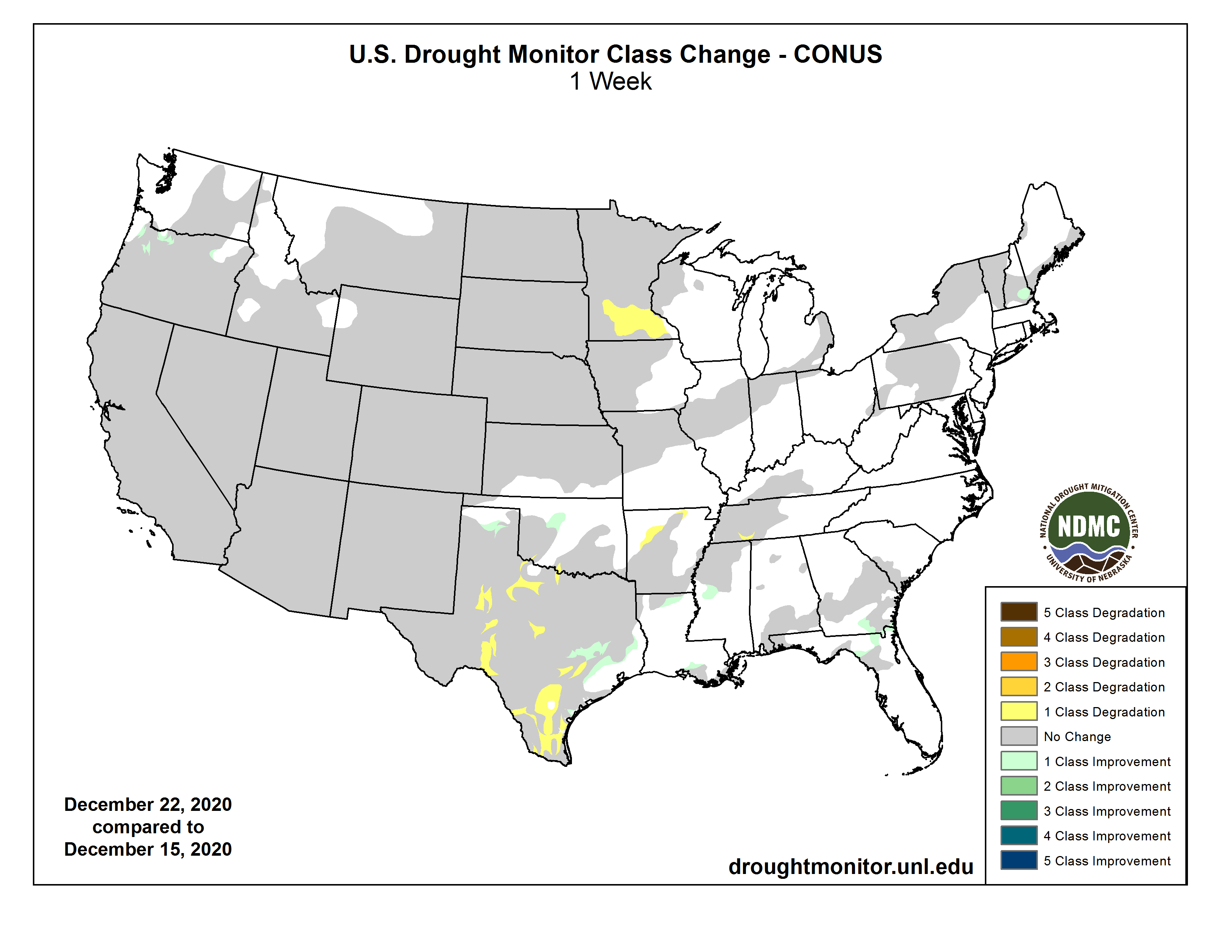
This Week’s Drought Summary
Most of this week’s precipitation across the CONUS fell on portions of the Pacific Northwest, Southeast, and Northeast. Typical of La Nina conditions, the northward displacement of the storm track across the West so far this season has resulted in near to above-normal snowpack across the Pacific Northwest and northern Rockies, and below-normal southward. This week mainly saw a continuation of that seasonal signal, with above-normal precipitation falling again along coastal ranges and the Cascades from central Oregon northward to Canada, leading to some minor improvements, mainly in northwestern Oregon. However, this week did see a slight southward shift in the storm track, providing central and northern California some much needed, albeit below near-normal, precipitation. Over the eastern United States, a storm system developed over the Southeast early in the period and transitioned into a strong Nor’easter that impacted much of the Mid-Atlantic and Northeast, with a swath of 1 to 2 feet of snowfall extending northeastward from southern Pennsylvania into southern Maine. In the wake of that system, several short-wave troughs provided some additional precipitation across the Great Lakes and Northeast. Elsewhere in the CONUS, several areas of the High Plains, Southwest, and western sections of the Midwest saw little to no precipitation. However, the time of year has minimized degradation of drought in many of these areas with low temperatures, frozen ground, and little or no evapotranspiration. Additionally, temperatures averaged near to below-normal across the southern tier of States, further minimizing any deteriorations.
Much of Alaska has received near to above-normal precipitation during the first half of Fall, with some sporadic stations depicting some minor dryness in the last month. However, snowpack is above-normal everywhere south of the Brooks Range for the season as a whole, limiting impacts and warranting D0 removal in the Yukon Flats. In Hawaii, the Big Island received beneficial rainfall after a dry first half of December. However, farther west, southwestern Oahu has shown a drying trend over the past 90 days, resulting in some D1 expansion. Puerto Rico experienced a dry final 4-6 weeks of its wet season, which ended at the start of December. Some expansion of abnormal dryness (D0) was warranted, including some D1 introduction in counties with some locally higher deficits…
The mountainous areas of Colorado and Wyoming saw some additions to their snowpack this week, but amounts were near-normal at best. Above-normal temperatures were widespread across the region, with the highest positive average temperature anomalies (greater than 8°F) across the Dakotas. These positive anomalies can mainly be attributed to below-normal snowpack across much of the Northern Plains. Liquid-equivalent precipitation amounts averaged between 0.01 and 0.25 inches across several locations in the High Plains Region, with several spotty near-normal amounts reported in the Central Plains (co-located with areas seeing the highest average high temperatures) and portions of the Dakotas, reducing further impacts and degradation. Several USGS stations across the region are reporting near and above-normal 7-average stream flows. As such, no changes to drought coverage are warranted this week across the High Plains Region…
Many improvements in the Western Region this season have been designated to the Pacific Northwest due to typical La Nina conditions aiding in a northward-displaced mean storm track. As a result, the Cascades and northern Rockies have accumulated above-normal snowpack, with snow water equivalent (SWE) of 100%-125%. Meanwhile, areas southward have experienced below-normal precipitation and reduced snowpack, ranging from 75% of normal in the central Rockies to less than 25% of normal in the Southwest. This week saw a continuation of the La Nina projection on seasonal precipitation, with the heaviest precipitation (150%-300% of normal) in the coastal ranges and Cascades, resulting in some localized D1 and D2 improvement in western and northeastern Oregon. Additionally, USGS 7-day average stream flows are above-normal, and these same areas are showing surpluses in water year-to-date (WYTD) precipitation estimates. Some precipitation also fell across northern and central California, the Great Basin, and central Rockies. However, amounts were modest, resulting in no major changes this week. Despite the Southwest missing out on precipitation this week, precipitation from the prior week and below-normal average temperatures this week warranted no further degradation…
Much of the region saw below-normal temperatures, and the largest precipitation amounts fell across southeastern Texas, extending eastward to Louisiana and northeastward to the Tennessee Valley. Locations east of Austin, Texas, and along the western Gulf Coast, saw above-normal precipitation (1 to 1.5 inch totals, with some localities receiving more than 2 inches), leading to some D1 and D2 improvement near Austin and a reduction in D0 coverage in southern Louisiana. Western and central Texas saw some degradation in D1-D3 areas, with lack of precipitation (less than 10 percent of normal precipitation in the last 90 days) and low relative humidity. Some slight trimming of the abnormally dry (D0) area in north-central Oklahoma, with 0.25 to 0.5 inches of precipitation falling last week, near-normal average temperatures, and 30-60 day precipitation totals ranging between 150 and 175 percent of normal. Some D0 reduction was also warranted in northern Louisiana and central Mississippi, as SPIs across several time periods show mixed weak above and below-normal signals, indicating near-normal conditions. Some expansion of D0 conditions occurred in north-central and central Arkansas, in favor of D0-D1 SPIs across various periods, coupled with 90-day deficits of 4 to 6 inches (localized 6 to 8 inches). Some southward D1 expansion in southern Tennessee was also warranted in areas missing out on relatively higher rainfall this week, continuing to add to deficits there (6 to 8 inch deficits going back 90 days)…
Looking Ahead
The 5-day Quantitative Precipitation Forecast (QPF) from the NWS Weather Prediction Center (December 24-28) depicts the heaviest precipitation fall across the eastern and western CONUS. In the eastern CONUS, a strong low pressure system is expected to develop over the Midwest, with a trailing frontal boundary extending southward along the Mississippi Valley to the Gulf Coast, and move eastward early in the period, intensifying as it reaches the East Coast. Heavy precipitation is likely along and ahead of the frontal boundary, along with a strong moderation of temperatures, with some snowfall on the backside of the system. After the system’s departure, below-normal temperatures are favored to last through Saturday, before moderating again near the beginning of next week. In the West, a series of low pressure systems are expected to move into the West Coast bringing more than 1.5 inches of precipitation to many areas from Washington to central California, with some much needed precipitation also making into southern California. Later in the period, some of this energy is expected to move across the Southwest and into the Great Plains, increasing chances of precipitation in those regions.
The 6-10 day outlook (December 29, 2020 – January 2, 2021) favors amplified mean troughing across much of the CONUS, with the greatest negative 500-hPa height anomalies centered over the Southwest. This pattern favors an active storm track across the CONUS and above-normal precipitation extending from the eastern Rockies to the East Coast, with enhanced probabilities of above-normal precipitation over the Central Plains and Middle Mississippi Valley. Above-normal precipitation is also favored along the southern Alaska coast and the Pacific Northwest, with mean onshore mid-level flow. Mean surface high pressure over Canada tilts odds toward below-normal precipitation from Montana to northern Minnesota. In association with negative mid-level height anomalies, below-normal temperatures are favored from the Great Basin eastward to the Great Plains. Above-normal temperatures are favored for the eastern CONUS, associated with mean southerly mid-level flow ahead of the trough. Mean onshore mid-level flow from the Pacific increases odds of above-normal temperatures for much of Alaska, with weaker odds in the Pacific Northwest due to a larger northerly component to the flow.