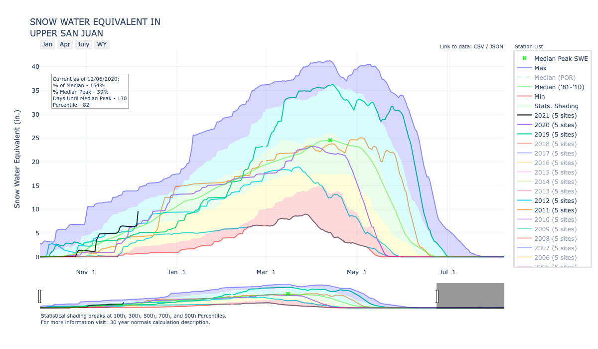
According to the U.S. Depart- ment of Agriculture National Water and Climate Center’s snow pack report, the Wolf Creek summit, at 11,000 feet of elevation, had 10.8 inches of snow water equivalent as of 9 a.m. on Dec. 2.
The median snow water equivalent amount for today’s date is 8.8 inches.
The amount of 10.8 inches of snow water equivalent is 145 percent of the Dec. 2 median for this site.
Last week’s reading showed that the Wolf Creek summit had 10.6 inches of snow water equivalent.
The San Miguel, Dolores, Animas and San Juan River Basins were at 82 percent of the Dec. 2 median in terms of snow pack.
River report
According to the U.S. Geological Survey, the San Juan River was flowing below the average rate at 45.4 cfs as of 10 a.m. on Wednesday, Dec. 2.
Based on 84 years of water records, the average flow rate for this date is 78 cfs.
The highest recorded rate for this date was in 2008 at 253 cfs. The lowest recorded rate was 29 cfs, recorded in 1968.
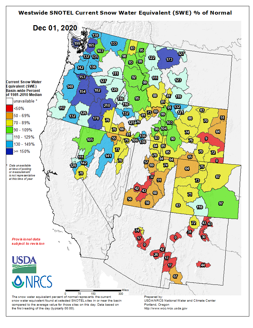
Westwide SNOTEL basin-filled map December 6, 2020 via the NRCS.
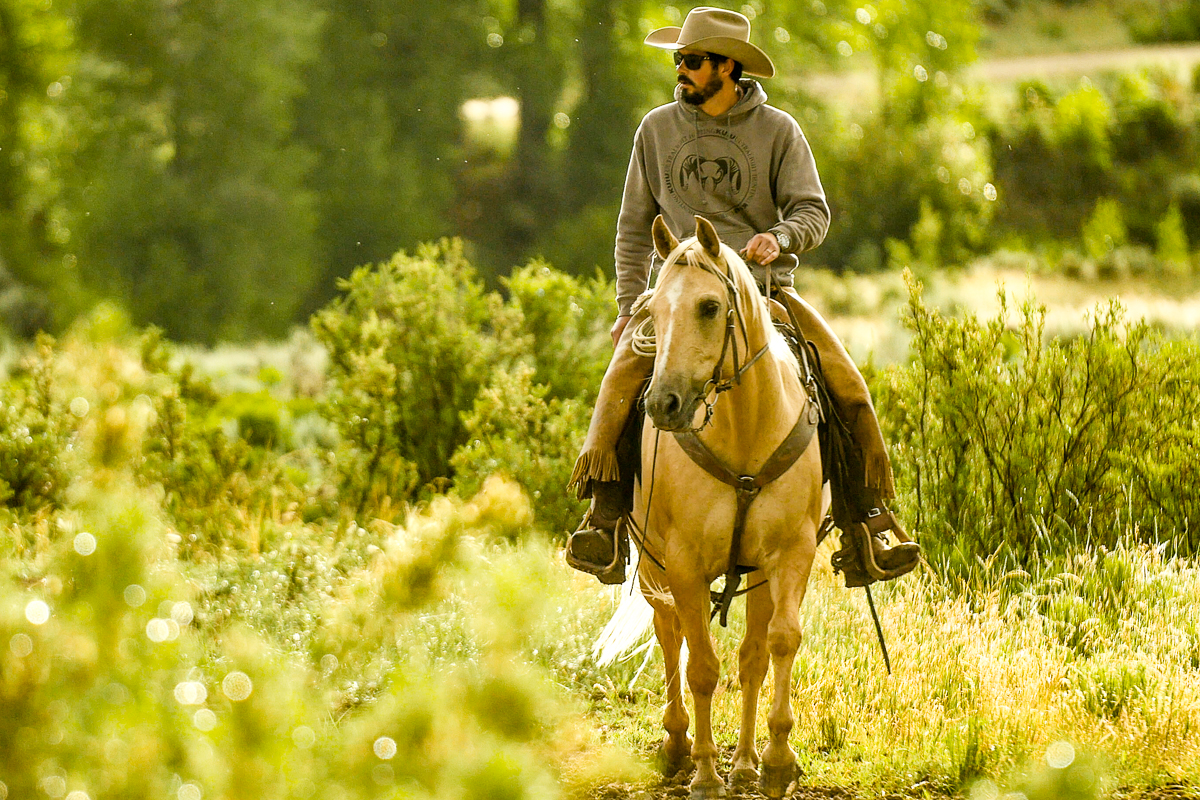
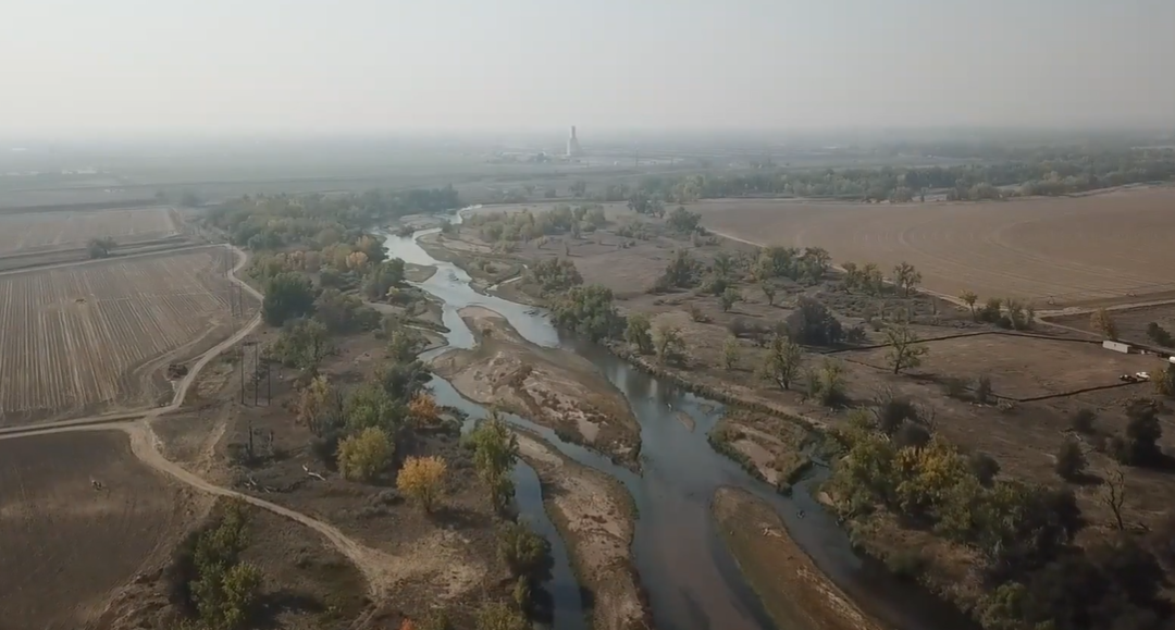
Rancher and fly-fishing guide Paul Bruchez raises cattle on 6,000 acres near Kremmling. Bruchez has taken an active role in Colorado River issues ever since his family suffered from a critical water shortage during the 2002 drought. Photo credit: Russ Schnitzer via Aspen Journalism
Politico (Annie Snider) takes a deep dive featuring Paul Bruchez and the efforts to keep water in the Colorado River. Click through and read the whole thing. Here’s an excerpt:
The power politics of the Colorado River have long pitted families like Paul Bruchez’s against big cities. Under pressure from climate change, they might be finding a path out.
Paul Bruchez’s family has ranched cattle in Colorado for five generations. And twice in his lifetime, his generation has nearly become the last.
The first time, it was the city of Denver that squeezed them out. By the 1990s, when Bruchez was still in high school, the city’s fast-growing suburbs had swept north and totally surrounded their roughly 2,000 acres in Westminster. Bruchez’s father had taken dirt roads to get to school, but by the time Bruchez was a teenager development had engulfed the family homestead so completely that at one point the city needed to send a police escort to help move their harvest equipment safely between fields on what were by then city roads. Running a full-scale farm operation in the middle of a city soon became untenable and the family opted to cut a land deal with the city and start fresh on the other side of the Rocky Mountains.
The second time, it was a drought. Their new land near Kremmling, a small ranching community 100 miles to the west, had one particularly appealing feature for a family that needed hay to feed its cattle: the Colorado River literally ran through it. The ice-cold mountain runoff from the river’s headwaters in Rocky Mountain National Park would feed their land through a network of ditches, offering plentiful water to grow 2,000 acres of hay. And for a family of fly fishermen, it had another attraction. The lush cottonwood trees lining the main stem of the river promised cool water and insects, a spot where trout would bite.
They had one good year before the ditches went dry.
The drought hit while Bruchez was in college and his father was facing a battle with cancer, and it nearly bankrupted the family. It marked the beginning of Bruchez’s mission to secure the future of not just his family’s operation, but the very West that made cowboys like him…
Technically, families like Bruchez’s have the upper hand in water disputes. The whole Western water system is built on a roughly 150-year-old legal regime that gives priority access to whoever put the water to use first. Farmers and ranchers led the settlement of the West, giving them the most “senior” rights and ensuring that they get their water before newer users like sprawling suburbs. Some 70 percent of the Colorado River’s flow is consumed by agriculture.
But as climate change keeps squeezing the water supply, the ranchers’ position is growing more precarious. They are far less powerful and wealthy than the cities that need water, which have often swooped in and bought out farms for their water rights. It is inevitable, now, that large amounts of water will have to leave agriculture in order to sustain cities and suburbs in the far-drier future; the question is simply whether it can be done in a way that keeps agriculture on the landscape.
Over the past century, Denver, Boulder and other cities on Colorado’s dry Front Range have steadily bought up farmers’ water rights on the wet, western slope of the Rockies and built massive, transmountain tunnels to ship the water to thirsty city dwellers. Today, roughly 65 percent of the water that would naturally flow into Grand County, where Kremmling sits, is diverted elsewhere. Many farm and ranch families nurse a grudge to this day, holding tight to the old Mark Twain adage that “whiskey is for drinking; water is for fighting.”
But Bruchez’s twin near-disasters and his path to recovering from them led him to a different conclusion: that in the long term, financial and climatic forces are aligned against agriculture, and ranchers and farmers are likely to lose if they don’t find a way to make themselves part of the solution.
Instead of seeing agriculture and new suburbanites as locked in a zero-sum struggle over who gets the West’s diminishing water, Bruchez has spent the past two decades hatching a series of projects to help ranchers by making common cause with sportsmen, environmental groups and even some big city water officials and lawyers.
Now, Bruchez has emerged as a leading voice for agriculture in Colorado as the state explores a controversial new scheme to manage its own, internal water usage—almost certainly by paying farmers to forgo using their water—in a bid to avoid a nightmare scenario in which river flows dip so low that the terms of a 1922 river compact force junior users like cities to be abruptly cut off. It’s an idea that has been knocking around water policy circles across the West for years without action, but that could be called into place quickly if the river’s flows continue to shrink rapidly.
Bruchez, 39, is as comfortable on a Zoom conference call with state water managers as he is riding horseback with a neighbor to steer cattle away from a quickly spreading forest fire, and in between he steals quiet moments to cast a line into the nearby river, in search of a rainbow or brown trout. What drives him is not just a desire to protect his family’s way of life, but to prove that farmers and ranchers aren’t just part of a mythical Western past but can be a part of the solution to weathering climate change and preserving the environment for the future.
Click here for posts on Coyote Gulch that mention Paul.
Rancher and fly fishing guide Paul Bruchez (Source: Russell Schnitzer, used with permission via the Water Education Foundation)
This mowed hay field is part of Reeder Creek Ranch, owned by the Bruchez family near Kremmling. Little data exists on the impacts of reducing irrigation water on higher elevation pastures like this one, but Paul Bruchez and a group of local ranchers have volunteered their fields for a study that will help scientists learn more about what happens to pastures that receive less irrigation water. Photo credit: Paul Bruchez via Aspen Journalism
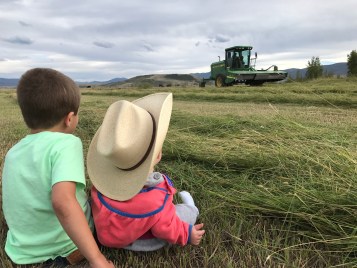
Rancher and fly fishing guide Paul Bruchez’s daughter and nephew sit in a hay field at the family ranch near Kremmling. Bruchez is helping spearhead a study among local ranchers, which could inform a potential statewide demand management program. Photo credit: Paul Bruchez via Aspen Journalism
Funds provided by grants and landowners near Kremmling, Colorado, have facilitated improvements such as this back stabilization project. (Source: Paul Bruchez)
Restoration work along the Colorado River reestablished a riverbank more conducive to irrigation access. (Source: Paul Bruchez)
Banks erosion along the Colorado River near Kremmling, Colorado, affected the ability of irrigators to convey water through ditches. (Source: Paul Bruchez)
Channel and habitat improvement projects along the Upper Colorado River promote irrigation systems and soil and water quality near Kremmling, Colorado. (Source: Paul Bruchez)
Stream improvements on the Upper Colorado River have been going on for five years, the result of a collaborative effort by ranchers and others near Kremmling, Colorado, and Trout Unlimited. (Source Paul Bruchez)
Strategic placement of rocks promotes a more natural streamflow that benefits ranchers and fish. (Source: Paul Bruchez)
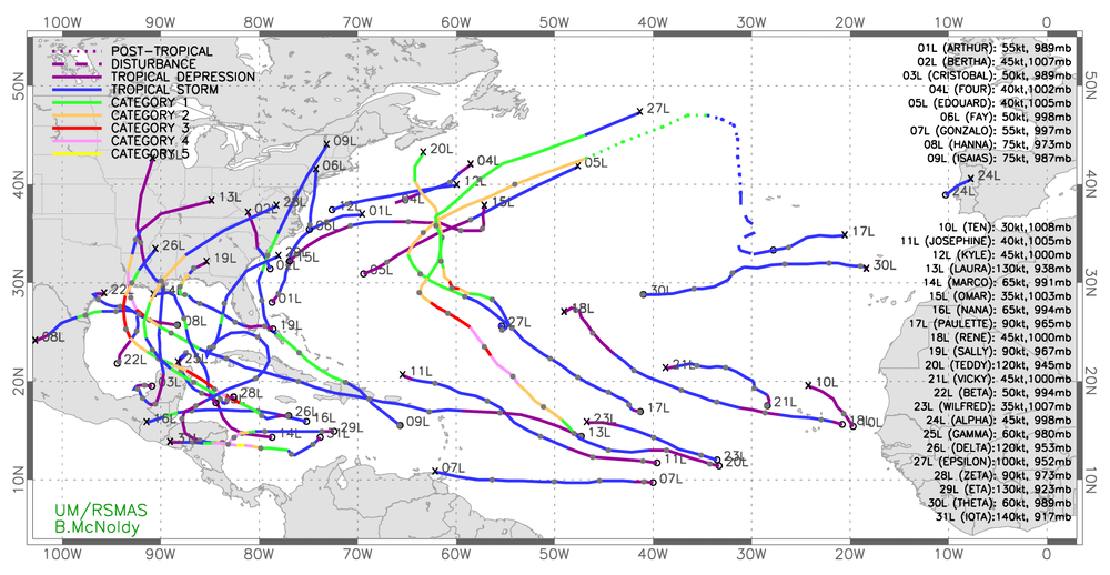
It was clear before the 2020 Atlantic hurricane season started that it was going to be busy. Six months later, we’re looking back at a trail of broken records, and the storms may still not be over even though the season officially ended on Nov. 30.
This season had the most named storms, with 30, taking the record from the calamitous 2005 season that brought Hurricane Katrina to New Orleans. It was only the second time the list of storm names was exhausted since naming began in the 1950s.
Ten storms underwent rapid intensification, a number not seen since 1995. Twelve made landfall in the U.S., also setting a new record. Six of those landfalling storms were hurricane strength, tying yet another record.
Tropical storm tracks show how busy the 2020 Atlantic hurricane season was. Brian McNoldy, CC BY-ND
As atmosphericscientists, we target our research at better understanding both what drives the formation of tropical cyclones and how climate change is affecting them on longer time scales. Here’s what research tells us about the 2020 season and what may be ahead.
Why did 2020 have so many storms?
An unfortunate combination of two key factors made this season ripe for tropical storms.
First, a La Niña pattern of cool surface waters developed in the equatorial Pacific, and it was stronger than anticipated.
Ironically, cooling in the equatorial Pacific makes it easier for tropical storms to form and gain strength in the Atlantic. That’s because La Niña weakens the vertical wind shear over the tropical Atlantic. Vertical wind shear – a change in wind speeds with altitude – is highly disruptive to storm development.
As the La Niña pattern became established this season, it made the tropical Atlantic much more hospitable for storms to form and intensify.
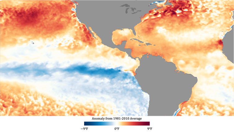
Atlantic sea surface temperatures in September 2020 were warmer than the 1981-2010 average. NOAA
The second critical factor was the extremely warm temperatures in the Atlantic, including the Gulf of Mexico and the Caribbean.
Hurricanes are powered by the transfer of heat from the ocean to the atmosphere. The sea surface temperature therefore dictates the maximum potential intensity a storm can attain under perfect conditions – it’s like a thermodynamic “speed limit” on hurricane intensity.
The sea surface temperature approached record levels in the Atlantic hurricane basin this season, including in September, the most active Atlantic storm month on record.
What does climate change have to do with it?
An important part of this season’s story is the Atlantic warming trend we’re witnessing, which is unprecedented going back at least several millennia.
The oceans store much of the excess heat trapped by greenhouse gases. With greenhouse gas concentrations still increasing due to human activities, such as the burning of fossil fuels, average sea surface temperatures are likely to continue rising over the coming decades.
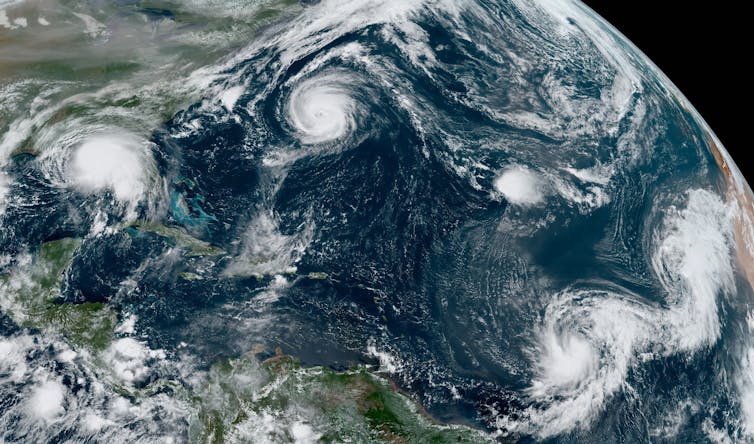
NOAA’s satellite imagery shows 2020’s named Atlantic storms through Nov. 18.
Whether climate change caused the extremely high number of storms this season is unclear. There is no detectable trend in global hurricane frequency, and computer modeling studies have had conflicting results.
However, the warming climate is increasing the threat posed by hurricanes in other ways.
Ten storms this season underwent rapid intensification – a 35 mph increase in maximum winds within 24 hours. Rapidly intensifying storms are especially dangerous because 1) they are challenging to accurately predict, and 2) they provide minimal time for evacuations when they intensify just before making landfall.
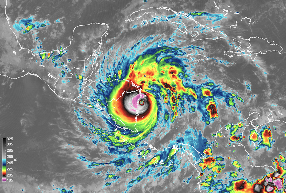
Satellite instruments capture Hurricane Iota making landfall in Nicaragua on Nov. 16. The image shows the temperature of cloud tops, which tells scientists how tall the clouds are. NOAA; James H. Ruppert Jr.
Hurricanes Laura and Sally both rapidly intensified just before making landfall on the Gulf Coast this season. Eta rapidly intensified to a Category 4 just before hitting Nicaragua, and just two weeks later, Iota essentially repeated the act in the same location.
Forecasts for the tracks or paths of tropical cyclones have dramatically improved in recent decades, as much as five days in advance. However, forecasts of storm formation and intensification have improved very little by comparison.
The forecasts for hurricane rapid intensification are especially poor.
While the official forecasts issued by the National Hurricane Center are issued by human forecasters, they depend on the guidance of prediction models, which aren’t very accurate when it comes to rapid intensification.
The complexity of weather models makes this a daunting challenge. However, it becomes more tractable as researchers learn more about how hurricanes form and intensify and identify the root causes for errors in computer model predictions.
Our latest research explores how clouds create their own greenhouse effect, trapping heat that causes hurricanes to form and intensify more quickly. Improving how numerical models account for this cloud feedback may ultimately hold promise for more accurate forecasts. Innovative ways of collecting new measurements in developing storms, down to their smallest scales, will also be necessary for guiding these improvements.
Given the upward trend in high-intensity storms, the risks from these storms will only grow. The ability to accurately predict how and when they will form, intensify and threaten coastal populations is crucial.
This article has been updated with the season ending and NOAA video of 2020’s Atlantic storms.
So far, Mother Nature hasn’t gifted Colorado with much snow overall, and that’s following a dry summer that has left Montrose and other counties locked in exceptional drought. Because it is early enough in the winter season, though, water users and hydrologists aren’t panicking.
“It’s concerning, but we’ve survived before. We’ll survive again,” Steve Anderson, manager of the Uncompahgre Water Users Association, said. “It’s a lot easier to run the project when you’ve got lots of ammunition. I certainly hope we get some snowpack this winter, and we’ll go from there.”
The water users association, or UVWUA, stores its water rights allocations in Ridgway and Taylor Park reservoirs. This past spring, it was faced with a “hole,” when, because of less snow and colder weather in the high country, there was not enough water to feed the project in April. The association at the time took some from its storage to meet contracts; it was able to meet demands for its irrigation season.
As of Monday, Ridgway Reservoir held 52,185 acre-feet of water and sat at an elevation of about 6,837. Taylor Park stood at 67,491 acre-feet and about 9,308 elevation, according to U.S. Bureau of Reclamation data.
“We don’t have a full reservoir, but we’re awfully close at Taylor,” Anderson said.
The big bucket for the Aspinall Unit, Blue Mesa Reservoir, was at 7,464 elevation and 399,755 acre-feet on Monday. It’s sitting lower than what BuRec would like and the hope is for a winter of at least average precipitation.
“If we have another year like this year, operations will be challenging,” BuRec hydrologist Ryan Christianson said.
Normally, the bureau is releasing water from Blue Mesa to hit winter targets, but is about 25 feet below where hydrologists like to be for the winter.
When it comes to how full Blue Mesa is, though, at 48%, that’s typical for the lower part of the year.
Currently, there are about 2 inches of snow-water equivalent as the snowpack starts to build for the season. Over the course of a winter, there is typically 15 to 20 inches and it is not unusual to have only a few inches at this time of year, Christianson said.
The basin is about 15% of average for its typical median peak for snowpack, which tends to peak-out in early April. The basin has several months to catch up; however, below-average runoff is anticipated.
FromThe Grand Junction Daily Sentinel (Dennis Webb):
Preliminary data from the Natural Resources Conservation Service Colorado Snow Survey program pegged the statewide snowpack level at 82% of median on Tuesday.
Powderhorn had hoped to open the day after Thanksgiving Day but temperatures were too warm before then for it to make snow with its new system. But it’s now saying on its website that the Bill’s Run and Peacemaker trails will be open top to bottom thanks to its new system making snow “when Mother Nature has refused to cooperate.”;
[…]
NRCS data for snow measurement sites helps explain the challenges Powderhorn and some other Colorado resorts are facing. At Grand Mesa sites, measurements of snow-water equivalent are around half of average, with snow depths ranging from 5 to 14 inches.
Snowpack as of Tuesday was 73% of median for the Upper Colorado River Basin in Colorado and 71% in the Gunnison River Basin. Snowpack levels in basins in the state range from a low of 65% of median in the Yampa/White basins to 118% in the Upper Rio Grande Basin. That runs a bit counter to expectations for this winter, a La Niña winter characterized by below-average surface water temperatures in the equatorial eastern Pacific Ocean. Such winters tend to result in more snow in northern Colorado than southern Colorado.
Only one week ago today, the state’s snowpack was at 97% of median. The level of drop since then reflects not just a dry pattern in recent days but how quickly the percentage can change early in the snowpack season when overall accumulations are relatively low. Snowpack levels in the state generally don’t peak until sometime in early April.
Brian Domonkos, NRCS snow survey supervisor in Colorado, said he believes about 40% of the state’s snowpack typically accumulates by Jan. 1. This year’s snowpack is off to a slow start in a season where water-watchers hope to see it exceed average peak accumulation because of the drought that currently is gripping the entire state. Much of western Colorado, including eastern and southern Mesa County, is in exceptional drought, the worst category, according to the U.S. Drought Monitor.
That results in poor soil moisture, which means when the snow melts next year, more of it will be soaked into the ground and less will reach streams, just as happened this year when a fairly average snowpack in Colorado resulted in below-average runoff because of dry ground. This year, “the spigot turned off in April and May and then it got warm into June,” and that was followed by a monsoon season that failed to produce appreciable moisture, said Jim Pokrandt with the West Slope’s Colorado River District…
Warmer temperatures in the summer and fall aggravated things. That has further heightened the desire for an above-average snowpack this winter for the sake of farmers and ranchers, municipal utilities and others dependent on Colorado River water flows, given the inadequate runoff seen this past year.
As I’ve said before, average isn’t good enough anymore,” Pokrandt said…
Pokrandt said it’s still early in the snowpack season, too early to panic about how things may shape up. For the short term, though, there are no big storms on the horizon…
Longer term, the federal Climate Prediction Center is forecasting below-average precipitation in Colorado over the next 30 days. The same goes for its 90-day outlook for southern Colorado, whereas it is forecasting an equal chance of above- or below-average precipitation over that timeframe for northern Colorado.
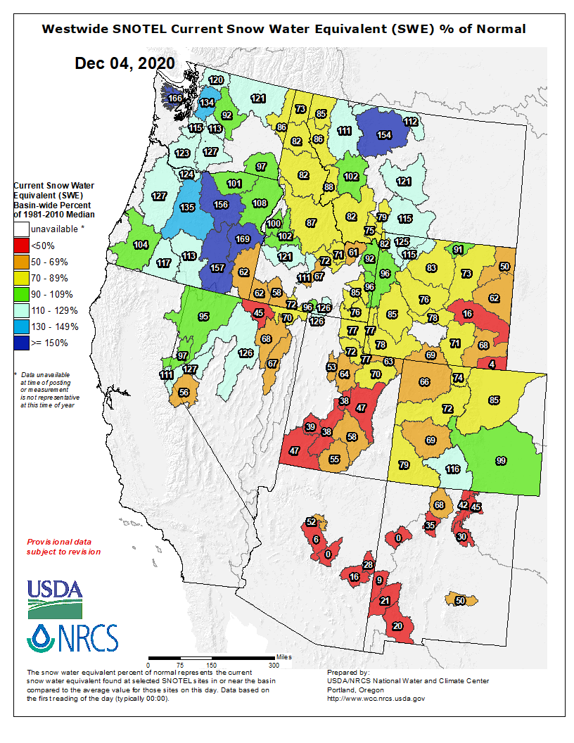
Here’s the Westwide SNOTEL basin-filled map for December 4, 2020.
Westwide SNOTEL basin-filled map December 4, 2020 via the NRCS.
The drought that kept its grip on Pitkin County and most of Colorado all summer is now reaching into early winter.
November was the eighth month this year that precipitation at the Aspen Water Treatment Plant was below average…
There’s not much relief at least over the next weeks, [Kris Sanders] said. Expect generally dry conditions with an occasional storm…
The La Niña weather pattern that’s in place generally favors precipitation in the Northern Rockies. Colorado is in the transition zone, with conditions generally drier farther to the south. That leaves Aspen in a toss-up area.
The weather report filed by the Aspen Water Department for November detailed the lack of snow last month.
“There was 14 inches of snowfall recorded at the Water Treatment Plant, noticeably below the average of 21.8 inches,” the report said. “This correlated with below average total precipitation with 1.76 inches of moisture measured. The average is 1.99 inches.”
The dry conditions have affected ski season already. Aspen Highlands will be forced to open later than planned due to sparse snow cover, Aspen Skiing Co. announced Thursday.
January, March, May and July through November all fell short of par. Only February, April and June exceeded average.
For the calendar year, the water plant has received 17.95 inches of precipitation. The average is 20.62, according to data recorded by the water department. That’s a decrease of 8.7%.
The water plant tends to get decent precipitation due to its elevation at 8,148 feet. The farther downvalley, the drier conditions have been this year. At the National Weather Service station at Aspen-Pitkin County Airport, for example, only 8.5 inches of precipitation has fallen year-to-date, well below the average of 16.19 inches.
Graph of Roaring Fork snowpack December 4, 2020 via the NRCS.
The snowpack at the headwaters of the Roaring Fork River was at 69% of median Thursday.
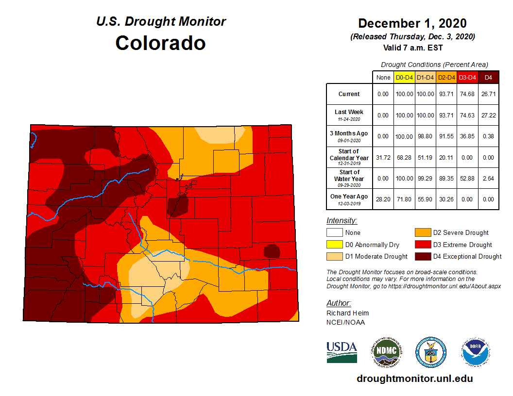
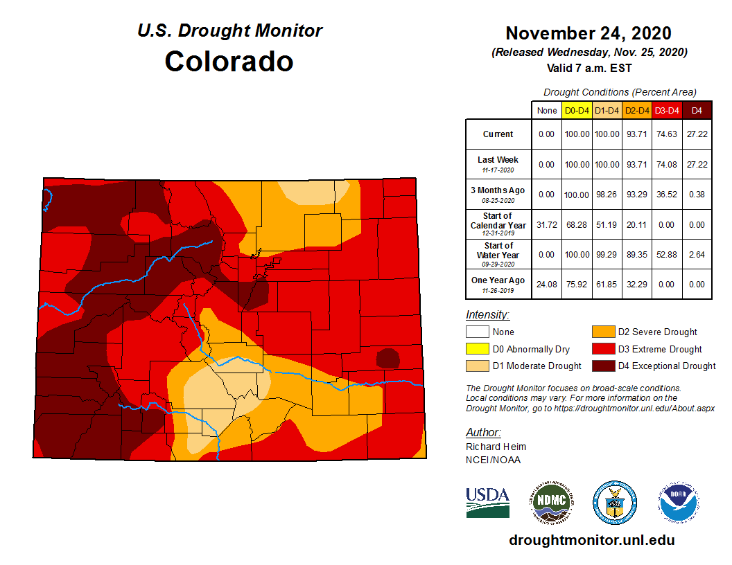
Colorado Drought Monitor December 1, 2020.
The latest map released Thursday by the U.S Drought Monitor showed the western half of Pitkin County remains in the “exceptional drought” category, the highest possible. The eastern half of the county is considered in “extreme drought.” Almost all of Eagle and Garfield counties also are in the “exceptional drought” classification.
The outlook for December is for below average precipitation and above average temperatures for all of Colorado, according to the National Oceanic and Atmospheric Administration’s Climate Prediction Center Long Range Forecasts.
The three-month outlook indicates temperatures will be warmer than average for Colorado. Aspen and the Central Rocky Mountains have an equal chance of precipitation being above or below average.
“Observe, brainstorm, research, build and communicate.” That is what the brilliant young scientist and inventor Gitanjali Rao told actor and activist Angelina Jolie about her process, over Zoom, from her home in Colorado, during a break in her virtual schooling. Just 15 years old, Rao has been selected from a field of more than 5,000 nominees as TIME’s first ever Kid of the Year. She spoke about her astonishing work using technology to tackle issues ranging from contaminated drinking water to opioid addiction and cyberbullying, and about her mission to create a global community of young innovators to solve problems the world over. Even over video chat, her brilliant mind and generous spirit shone through, along with her inspiring message to other young people: don’t try to fix every problem, just focus on one that excites you. “If I can do it,” she said, “anybody can do it.”
This portion of the 58-mile mainstem of the Gunnison River just south of Whitewater has been designated as critical habitat for the Colorado pikeminnow and razorback sucker, which are two species of endangered fish. Programs aimed at reducing salt and selenium in the waterway are showing signs of success. Photo credit: Natalie Keltner-McNeil via Aspen Journalism
State water-quality officials will soon evaluate whether two water-improvement programs in the Gunnison River basin have successfully reduced a chemical that is toxic to endangered fish.
The Colorado Department of Public Health and Environment’s Water Quality Division is analyzing five years of data on selenium levels in the Gunnison, where heightened selenium and salinity have harmed Colorado pikeminnow and razorback sucker populations.
If selenium levels stay at or below the state standard of 4.6 micrograms per liter in any of the segments of river that are analyzed by division staff, those segments will be reclassified from a water body that threatens aquatic life to one that meets state water-quality standards, said Skip Feeney, assessment workgroup leader for the Water Quality Control Division.
After analyzing selenium data, the division will submit a proposal after the first of the year to the CDPHE Water Quality Control Commission recommending a status change if necessary, Feeney said.
“Our goal is to provide an accurate, defensible proposal to the commission and let the commission make an informed decision,” Feeney said. In an October interview, he said he didn’t yet know “what the water-quality status is looking like.” He added: “That’s just part of the process — we’re just getting started.”
Reclassifying the river has been a goal since the establishment nearly a dozen years ago of the Selenium Management Program, a collaboration among government agencies, nonprofits and stakeholders.
Observers have found elevated selenium levels throughout the basin, but a key river segment of focus is the main stretch of the lower Gunnison that winds for 58 miles from Delta to the confluence with the Colorado River in Grand Junction. This section, which begins at the confluence with the Uncompahgre River, was designated in 1994 as essential to pikeminnow and razorback survival by the U.S. Fish and Wildlife Service.
A map showing the main segment of the Gunnison River, between Delta and its confluence with the Colorado River, which has been designated as essential habitat for two endangered fish species. Map via Aspen Journalism
Historically, this segment, which runs through the basin’s most populated and developed corridor, has contained selenium levels toxic to the two species of fish, according to Dave Kanzer, deputy chief engineer for the Colorado River Water Conservation District and a member of the Selenium Management Program.
During the last regulation cycle, which used data gathered from multiple different entities from 2010 to 2015, the calculated level for selenium in the mainstem of the Gunnison was 6.7 micrograms per liter, a level that is 2.1 micrograms above the state standard, according to MaryAnn Nason, the communications and special-projects unit manager at CDPHE.
Yet, the past five years of U.S. Geological Survey data show that selenium levels have stayed below 4.6 micrograms. Each yearly average was below 4.6, with the average for all five years sitting at 3.2, according to an analysis by Aspen Journalism.
Kanzer cautioned that the calculation using only USGS data was “not directly applicable to the CDPHE listing methodology” — because it doesn’t take into account all available data — but he said “it does tell a good story.”
To calculate the final selenium load for each segment in the Gunnison River, CDPHE is analyzing data from the past five years from the USGS; Colorado River Watch, an environmental advocacy organization; the state; and United Companies, a Grand Junction-based construction company that is required by the state to monitor selenium levels near the gravel pits that the company operates.
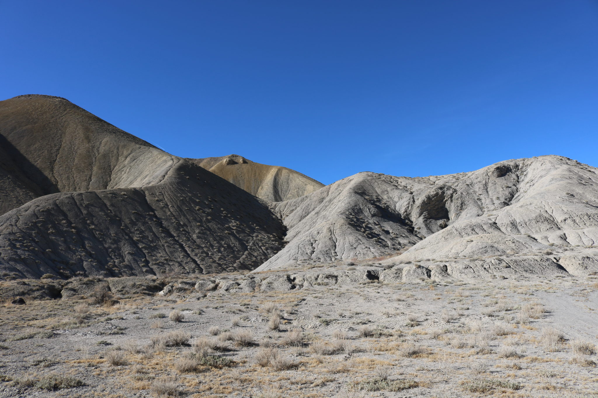
These are hills of exposed Mancos shale in Delta County. Selenium is a natural element found in the soil type that is common in the Uncompahgre and Grand valleys. Photo credit: Natalie Keltner-McNeil/Aspen Journalism
Selenium’s origins and pathway to the rivers
Selenium is a natural element found in Mancos shale, a soil common throughout the Uncompahgre and Grand valleys in the Gunnison River basin. When irrigators transport water to and through their farms in open canals, selenium dissolves in the water and either percolates into groundwater or gets carried into drainage ditches that discharge into the Gunnison.
“Where we have good flows of water, (selenium) concentrations are not an issue because of dilution,” Kanzer said. “But smaller tributaries, smaller water areas or backwater areas where you don’t have good circulation, you get selenium that can accumulate in the ecosystem, really in the sediment and in the food web.”
Colorado pikeminnow and razorback sucker exist only in the Colorado River basin, said Travis Schmidt, a research ecologist for the Wyoming-Montana Water Science Center. The species are able to swim between the Colorado and Gunnison rivers with the aid of a fish passage at the Redlands Diversion Dam on the lower Gunnison, accumulating selenium and transferring the element to their offspring.
Selenium gathers in fish tissues when females ingest algae or smaller fish. It then is transferred to offspring during the egg-laying process, Schmidt said.
“Selenium replaces sulfur in protein bonds, so anything that lays an egg can transfer a lot of selenium to its progeny,” he said.
Once transferred to fish eggs, the element causes neurological, reproductive and other physiological deformities in a significant proportion of both species of fish, Schmidt said. A study that analyzed fish-tissue samples collected by federal and state agencies from 1962 to 2011 found that 63% of Colorado pikeminnows and 35% of razorback suckers exceeded healthy selenium tissue concentrations in the upper Colorado River basin.
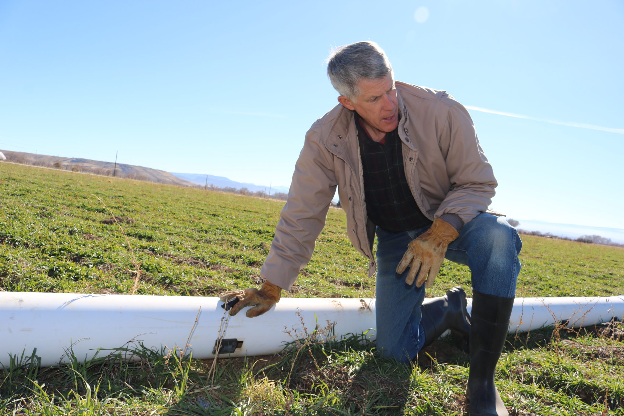
Delta County farmer Paul Kehmeier kneels by gated pipes in his family’s alfalfa field. He received funding to replace an unlined canal with the pipes in 2014 from the U.S. Department of Agriculture’s Natural Resources Conservation Service. Piping unlined canals, which is one of the primary methods used to prevent salt and selenium from leaching into the water supply, is critical to the protection of endangered fish in the Gunnison and Colorado river basins. Photo credit: Natalie Keltner-McNeil/Aspen JournalismAspinall Unit
’A happy, fringe benefit of salinity control’
Selenium was first addressed by the Fish and Wildlife Service in 2009 in a document written for the Bureau of Reclamation. The document analyzed the effects of the Aspinall Unit — a series of three dams on the upper Gunnison River — on Colorado pikeminnow and razorback sucker recovery. In the document, the service concluded that in order to comply with the Endangered Species Act, the Bureau of Reclamation had to increase spring flows downstream of the Aspinall Unit and initiate a management program to reduce selenium in the Gunnison. As a result, the Selenium Management Program was founded in 2009.
“It’s a two-prong type of plan,” Kanzer said of the program’s goals.
The first objective is to meet the state standard for dissolved selenium throughout the Gunnison River basin, particularly for the 58-mile main segment, Kanzer said. The second goal is to help transition the pikeminnow and razorback sucker from endangered populations to self-sustaining populations, Kanzer said.
Program members help irrigators obtain funding from the Bureau of Reclamation and Department of Agriculture, said Lesley McWhirter, the environmental and planning group chief for the bureau’s Western Colorado Area Office. Individual farmers can apply for funding for on-farm irrigation projects through the Department of Agriculture, and ditch companies can apply for funding projects that deliver water to farms through the Bureau of Reclamation’s Salinity Control Program.
The goal of the salinity program, which was started in 1974, is to reduce salt loading into the Colorado River basin. The program awards grants to ditch companies every two to three years. In the last grant cycle, in 2019, the Bureau of Reclamation awarded 11 ditch companies a combined $37 million to line irrigation systems. Of the 11 companies, eight are located in Mesa, Montrose and Delta counties, where the Gunnison River runs, according to McWhirter.
Mancos shale is rich in salt and selenium. So, when farmers receive funding to reduce salt loads, selenium often decreases as well. This is exemplified by a USGS analysis that found selenium loads had decreased by 43% from 1986 to 2017 and by 6,600 pounds annually from 1995 to 2017.
“The selenium control is a happy, fringe benefit of salinity control,” said Delta County farmer Paul Kehmeier.
Delta County farmer Paul Kehmeier stands atop a diversion structure that was built as part of a project to improve irrigation infrastructure completed between 2014 and 2019. Kehmeier served as manager for the ditch-improvement project, which was 90% funded by the Bureau of Reclamation and serves 10 Delta County farms with water diverted from Surface Creek, a tributary of the Gunnison River. Lining and piping ditches, the primary methods used to prevent salt and selenium from leaching into the water supply, are critical to the protection of endangered fish in the Gunnison and Colorado river basins. Photo credit: Natalie Keltner-McNeil/Aspen Journalism
CDPHE plans to submit proposal in January
CDPHE plans to submit its proposal to the Water Quality Control Commission in early January, Nason said.
If the main segment of the Gunnison River is found to have selenium levels below the state standard, it would mean the Selenium Management Program is closer to obtaining the dual goals of fish protection and selenium reduction, Kanzer said.
Even if the main segment of the Gunnison is reclassified, the Selenium Management Program will continue efforts to reduce selenium in the Gunnison basin, Kanzer said. These efforts include data gathering and analysis and facilitating meetings among government agencies, nonprofits and stakeholders.
The Colorado pikeminnow and razorback sucker depend on the entire Gunnison basin, so other segments containing toxic selenium levels require reduction efforts. If any new research shows that fish are harmed by selenium at levels lower than 4.6 micrograms per liter, the state could lower the selenium standard, reclassifying segments of the Gunnison as a danger to aquatic life, Kanzer said.
“The jury’s still out — we’re still trying to understand what levels are acceptable and not acceptable,” he said. “There’s always room for refinement of that standard, and that dialogue is ongoing.”
After the division submits its proposal to the commission, the proposal will be released to stakeholders and anyone who has applied to receive hearing notices or track Colorado’s regulations. The public can submit their own proposals or comments by emailing the commission. In May, the commission will review all proposals and comments to make a decision on the river segment’s 2020 status, Feeney said.
This story ran in the Dec. 3 edition of The Aspen Times.
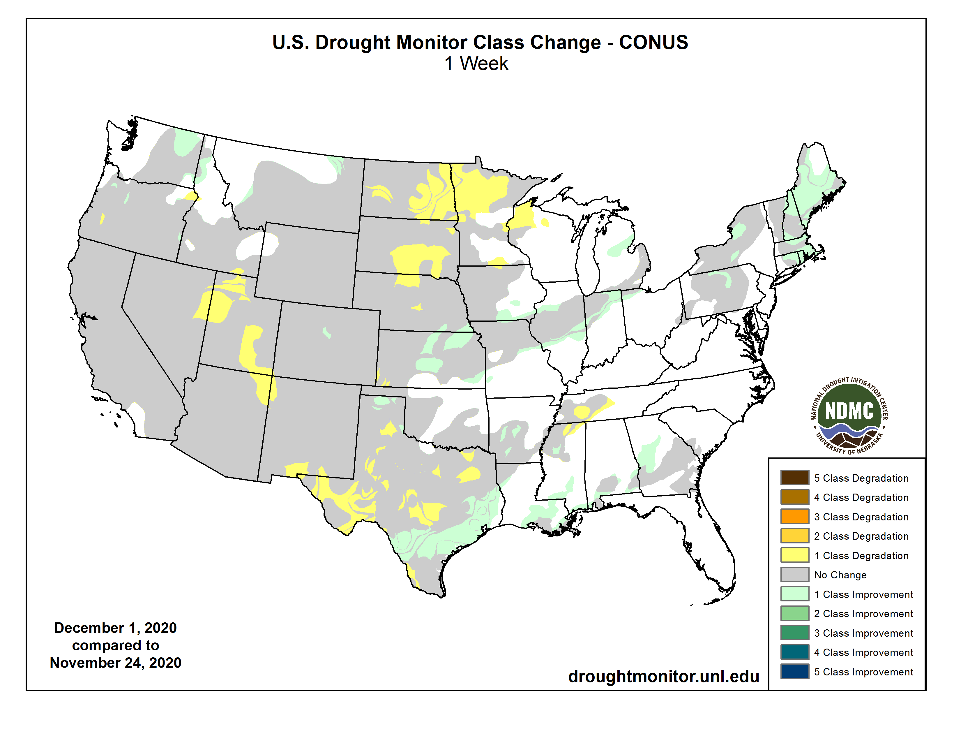
Click on a thumbnail graphic below to view a gallery of drought data from the US Drought Monitor.
US Drought Monitor December 1, 2020.
West Drought Monitor December 1, 2020.
High Plains Drought Monitor December 1, 2020.
Colorado Drought Monitor December 1, 2020.
Click here to go to the US Drought Monitor website. Here’s an excerpt:
This Week’s Drought Summary
A couple Pacific weather systems, in the form of shortwave troughs or closed lows, moved in the jet stream flow across the contiguous U.S. (CONUS) during this U.S. Drought Monitor (USDM) week. The weather systems brought rain or snow to the coastal Pacific Northwest, dried out as they traversed an upper-level ridge over the West, then picked up Gulf of Mexico and Atlantic moisture as they moved across the southern Plains to East Coast. An inch or more, with locally over 3 inches, of precipitation fell over the coastal and Cascade ranges, with up to an inch over parts of the northern Rockies. Otherwise, most of the West was dry. Only a few areas in the Northwest and southern Rockies had more than a quarter inch of precipitation. East of the Rockies, bands of an inch or more of precipitation, with locally 2 inches or more, fell across Kansas to the Great Lakes and along the Ohio River to northeast Ohio. Widespread 2+ inches of rain fell from coastal Texas to the Carolinas, and from Virginia to New England. A large shield of half an inch or more of precipitation surrounded these bands and extended from the southern and central Plains to the East Coast, and from the southern Great Lakes to Gulf of Mexico Coast. Generally the 1+ inch bands of precipitation were wetter than normal, while the areas with less than that were below normal. Much of the northern Plains to Upper Mississippi Valley was dry. Improvement in drought conditions occurred where precipitation was above normal, while drought expanded or intensified in some areas where dryness continued. Temperatures were near to cooler than normal across much of the West, southern Plains, and Lower Mississippi Valley, and warmer than normal in the northern Plains, South Texas, Great Lakes, Gulf Coast, and East Coast. Maps of 7-day, 14-day, and 28-day USGS streamflow measurements are consistent in showing below-normal streamflow from northern California, Nevada, and southern Idaho to the Four Corners states; and across southwest Nebraska to western Texas. They consistently show below-normal streamflow over central Texas, central Illinois to northern Indiana, and western Pennsylvania to western New York. The satellite-based Vegetation Health Index shows stressed vegetation across the California valleys and southern California, the Southwest, parts of the central Plains and Ohio Valley, and especially in southeastern New Mexico to western Texas. Where VegDRI is still in season, it shows drought across the Southwest and west Texas and parts of the Northeast (Maine). Where QuickDRI is still in season, it shows very dry conditions from southeastern Wyoming and western Nebraska, southward across Colorado, New Mexico, and western Kansas. The KBDI shows significantly dry conditions in California, Nevada, Utah, Arizona, New Mexico, and Texas, and a few spots in eastern Wyoming, western Nebraska, northern Florida, southern Alabama, and southern Georgia. NIFC maps show large wildfires still burning in California, and several in Oklahoma, central Appalachians, and a few elsewhere. Evapotranspiration (EDDI) for the last week has been high in California and the Southwest to the southern Plains, in the northern Plains, and in southern Alabama and Georgia. The EDDI shows high evapotranspiration across California and the Southwest, Great Plains, and Southeast to Northeast at the 2- to 3-week time scales, and across much of the West and Plains, Midwest, and Northeast at the 1- to 9-month time scales. USGS real-time groundwater level data show low groundwater at points across the West, in northern Indiana, southern Georgia, and parts of the Northeast, and a couple gauges in southern Alaska. NASA GRACE satellite-based groundwater estimates show low groundwater across most of the West to central and southern High Plains, most of New York to New England, much of Texas, and parts of North Dakota, Pennsylvania, Virginia, Alabama, Georgia, and Florida. Soil moisture is dry across the West from California to the southern and central Rockies, in the southern and central High Plains (especially southwest Nebraska and northwest Kansas), in North Dakota, across Nebraska and Iowa, across central Illinois to northern Indiana, parts of Pennsylvania and New York, and (for some indicators) most of New England (CPC, NLDAS, UCLA/VIC models; satellite-based AAFC/SMOS, GRACE, NASA/SPoRT analyses). SNOTEL snowpack (SWE percentiles) is above normal in Washington, Oregon, the Sierra Nevada, and parts of the other western states, but it is below normal across much of Utah and other parts of Idaho, Montana, Wyoming, Nevada, Colorado, and New Mexico. But this is early in the snow season and normal amounts are low. The Standardized Precipitation Index (SPI) shows dry conditions in various places at different time scales. These include North Dakota to Wyoming, northeast Texas to the Tennessee Valley, and parts of the West (at the 1-month time scale); California to the central and southern Rockies, much of the Great Plains, northern Missouri to northern Indiana, and parts of the Northeast (2 to 4 months); California to the central and southern Rockies, much of the Great Plains, Iowa, northern Indiana to Ohio and Michigan, most of Northeast (6 to 12 months); parts of Pacific Northwest (9 to 12 months); and the Southwest to southern and central High Plains, and parts of Pacific Northwest, Texas, Iowa, Indiana, and the Northeast (24 months). When the desiccating effects of hot temperatures are included, the Standardized Precipitation Evapotranspiration Index (SPEI) shows more intense drought conditions over the SPI dry areas than indicated by the SPI…
Central and eastern parts of Kansas, and strips in northeast and southeast Nebraska, received half an inch or more of precipitation, with over 2 inches falling in northeast Kansas. Parts of Colorado also received above-normal precipitation. But the rest of the High Plains region was dry. Moderate to severe drought shrank in southeast Nebraska and northeast Kansas, but moderate to severe drought expanded in parts of the states from North Dakota to Kansas. Extreme drought expanded slightly in southwest Kansas and was introduced in central North Dakota. Exceptional drought shrank slightly in central Colorado. According to USDA reports, half to two-thirds of the topsoil moisture was short to very short in all of the High Plains states except Colorado, where 83% of the topsoil moisture was short to very short. USDA statistics show that 38% of the winter wheat was in poor to very poor condition in Colorado. In Nebraska and Kansas, the winter wheat statistics were 26% and 22%, respectively, poor to very poor. Nationwide, the U.S. winter wheat condition index was the lowest since 2012…
Even though over 2 inches of precipitation fell locally in the coastal Pacific Northwest, it was still below normal. Only small parts of Montana, Arizona, and New Mexico were wetter than normal this week. The rest of the West had little to no precipitation, or what precipitation that fell was below normal. Abnormal dryness contracted in parts of Washington and northern Idaho where the indicators reflected improving conditions in recent weeks, and drought improved in a few parts of Oregon and worsened in other parts. Severe to exceptional drought expanded in Utah, with exceptional drought expanding in parts of Nevada, Arizona, and Colorado. Extreme and exceptional drought expanded in parts of New Mexico. Parts of northeast Nevada received precipitation this USDM week, but it was still below normal. The failure of the summer monsoon resulted in record dryness to the Southwest states, and record heat over warm season increased evapotranspiration, resulting in record SPEI values over the last 3 to 6 to 9 months. The SPEI values were not only record, they exceeded previous records by huge margins. The expansion of exceptional drought reflected this prolonged dryness. According to USDA reports, topsoil moisture was short to very short across 82% of New Mexico, 81% of Utah, 75% of California, 54% of Montana, 47% of Idaho, 42% of Oregon, and 35% of Nevada. In Oregon, 20% of the winter wheat crop is in poor to very poor condition. Jiggs Reservoir, in northeast Nevada, is nearly dry…
Western parts of Texas remained dry this week, while half an inch or more of rain fell across the rest of the region. Two inches or more fell across parts of southern Texas to Mississippi. Abnormal dryness to exceptional drought contracted in southern Texas, abnormal dryness shrank in Louisiana and Mississippi, and moderate drought was reduced in Arkansas. But moderate to extreme drought expanded in other parts of Texas which were drier than normal for the week, and exceptional drought grew in west Texas. Abnormal dryness and moderate drought expanded in northern Mississippi and western Tennessee where this week’s rainfall was below normal. According to USDA reports, topsoil moisture was short or very short across 61% of Texas, 43% of Oklahoma, and 20% of Mississippi; 34% of the winter wheat was in poor to very poor condition across Texas…
Looking Ahead
The jet stream will continue to be active during the next couple weeks, sending a parade of Pacific weather systems into the CONUS, while an upper-level ridge continues to hold sway over the West. For December 3-7, the coastal portions of the Pacific Northwest will receive precipitation, although not as much as this past week with generally less than an inch predicted by the models. The forecast has about an inch of precipitation falling along the Kansas-Oklahoma border, over parts of east Texas, from southern Louisiana to the Mid-Atlantic coast, and across New England. Two inches or more are progged from Delaware to southern New England. An envelope of an inch or less of precipitation should surround these wetter areas, from the western Great Lakes to the Atlantic Coast, and from the Ohio Valley to Gulf Coast. Most of the West, Texas, central to northern Great Plains, and Midwest have little to no precipitation expected. Temperatures are predicted to be warmer than normal from the central and northern Plains to East Coast, and below normal over the interior West. The outlook for December 8-12 is mostly dry. Odds favor below-normal precipitation across most of the CONUS, with only a strip from the Rockies to northern and central High Plains, as well as Alaska, having odds favoring wetter-than-normal conditions. Odds favor warmer-than-normal temperatures across most of the West, Plains, Midwest, and Northeast, with below-normal temperatures likely across parts of the Southeast and central Alaska.
Just for grins here’s a gallery of early December US Drought Monitor maps for the past few years.
Here at the confluence of the Big Thompson and South Platte rivers near Greeley, a new conservation effort is underway. It restores wetlands and creates mitigation credits that developers can buy to meet their obligations under the federal Clean Water Act to offset any damage to rivers and wetlands they have caused. Credit: Westervelt Ecological Services
Developers often dropped by unannounced at the Allely farm to ask if the family would consider selling their 70-acre property south of Greeley at the confluence of the Big Thompson and South Platte rivers. The answer was always no — the Allelys did not want their land, which had been in the family since in the early 1960s, to be developed, now or in the future.
So when staff from Westervelt Ecological Services first approached the Allelys about creating a habitat preservation program on their farm roughly three years ago, the family was skeptical. But over the course of many months and long conversations, they began to warm to the idea and eventually agreed.
Instead of selling their property to the highest bidder or leaving it to the next generation, the family established a conservation easement — a permanent agreement to never develop the land — and, for a fee, allowed Westervelt to create the new Big Thompson confluence mitigation bank. The project broke ground in late October.
Now, a developer who disrupts wetlands or streams elsewhere along the Front Range and in parts of eastern Colorado can offset that impact by buying credits generated from floodplain and ecosystem restoration work completed on the Allelys’ land. Purchasing credits from this new mitigation bank allows developers to meet their obligations under the federal Clean Water Act.
“It’s a very important piece of property to us as a family,” said Zach Allely, the fifth-oldest of the six children who grew up on the farm. “If there’s an opportunity for us to say, ‘No, this is a place where native fauna, native flora can thrive forever,’ we’ll take that.”
Mitigation banks, explained
Mitigation banks are not new in Colorado — there are some 21 pending, approved, sold-out or suspended throughout the state, according to the U.S. Army Corps of Engineers’ database — but this is the first new mitigation bank approved on the Front Range in 20 years.
Across the country, mitigation banks have become more popular since 2008, when the U.S. Environmental Protection Agency and the U.S. Army Corps of Engineers expressed a preference for mitigation banks (over other types of mitigation) and offered clearer guidance, standards and timelines for these projects.
Mitigation banks like this one are a byproduct of the federal Clean Water Act, first enacted in 1948 as the Federal Water Pollution Control Act and then expanded and reorganized in 1972. More specifically, they relate to Section 404 of the act, which aims to protect the country’s wetlands from the discharge of dredged or fill materials during the construction of dams, levees, highways, airports and other development projects.
Under Section 404, developers must take steps to avoid and minimize damage to wetlands and streams by adjusting the scope, location, design and type of project they wish to undertake. After avoidance and minimization, they must turn to a third mitigation type: compensatory mitigation.
Under compensatory mitigation, developers can restore, establish, enhance or preserve wetlands at the project site or somewhere else nearby. But this type of work isn’t always practical or possible, which is where mitigation banks come into play. Instead of going to all that trouble, a developer can pay for someone else to do the heavy lifting at a different, nearby location.
A mitigation banker, in this case Westervelt, pays for the upfront costs of finding a suitable piece of land, gaining approval from the right regulatory agencies, and doing the actual mitigation work. Then, depending on the scope and size of the project, the banker can sell a certain number of credits to offset the impacts of future development within the bank’s general vicinity.
Restoring historical floodplain
Today, crews are hard at work on the Allely property, re-establishing the historical floodplain to help restore the ecosystem for plants and animals and improve flood resiliency for nearby communities.
This restoration work also creates 34.76 wetland credits and 460 stream credits — released in phases — that developers, public agencies, mining companies and others can buy to help mitigate the unavoidable damage their projects will cause to other Colorado wetlands and streams.
Lucy Harrington, the Rocky Mountain region director for Westervelt Ecological Services, declined to say how much the company is charging for credits from the new 72.4-acre bank, citing variable pricing and bulk discounts.
But the Colorado Department of Transportation, which regularly buys credits from mitigation banks across the state, recently paid $200,000 for a credit from the new bank to help offset the impact of its Central 70 highway improvement project, said Becky Pierce, CDOT’s wetlands program manager.
To find potential mitigation bank sites, Westervelt staffers perform geographic information system (GIS) analyses that take into account a property’s proximity to streams, hydrology, oil and gas infrastructure, and proximity to other conserved properties, among other factors, Harrington said.
The company, which opened its newest regional office in Centennial in 2016, also looks at community-identified areas for wetland restoration and conservation, as was the case with the new Big Thompson confluence bank. Westervelt staff worked with the Middle South Platte River Alliance to understand local priorities and identify possible sites for the new bank. The alliance helped introduce Westervelt to the Allely family.
“It’s really a confluence of technical work, relationship-building and a little bit of luck, to be perfectly honest,” Harrington said.
Westervelt and other mitigation bankers often buy property outright. But in this case, Westervelt paid the Allely family an undisclosed amount to use their land for the mitigation bank and, in return, the Allelys protected the property in perpetuity with a conservation easement, which comes with its own tax benefits and incentives. Westervelt and the Allelys also established a long-term endowment for the site’s management with the National Fish and Wildlife Foundation.
After creating a detailed plan and getting approval from regulatory agencies like the U.S. Army Corps of Engineers, U.S. Fish and Wildlife Service, Colorado Parks and Wildlife and others, Westervelt began work.
Credits going fast
The company has released its first round of credits, which includes 8.69 wetland acres and 115 functional feet of stream credits. So far, the company has sold more than half of the wetland credits, Harrington said.
“Any project, whether it’s a highway widening that may cross a river, home development that may affect ephemeral or perennial drainage, a Walmart parking lot that’s expanding, a pipeline going in, any of those development items that could impact wetlands and streams, instead of having to provide a wetland offset themselves can just come to us, write a check and just walk away,” Harrington said. “We take on all the liability of the site in perpetuity.”
Meanwhile, the Allely family knows that their property will never be developed and is instead being restored to its historical conditions. They can also still access the land under the conservation easement, which is held by the nonprofit land trust Colorado Open Lands.
Staff at Colorado Open Lands say they hope the success of the Big Thompson mitigation bank will inspire other landowners to conserve their land.
“It’s just another tool, another way for us to look at getting creative about protecting open space in Colorado,” said Carmen Farmer, conservation project manager with Colorado Open Lands. “Traditionally, we protect land throughout the state using state tax credits and federal tax deductions and incentives. Sometimes the traditional model doesn’t necessarily pencil out for landowners. This is another way for us to go about incentivizing landowners to help protect their properties and make sure they’re compensated for doing so.”
Sarah Kuta is a freelance writer based in Longmont, Colorado. She can be reached at sarahkuta@gmail.com.
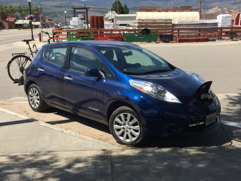
Coyote Gulch’s Leaf charging in the Town of Kremmling Town Park August 21, 2017.
Here’s the release from the Natural Resources Defense Council (Gina McCarthy):
After 50 years, what does the future of the U.S. Environmental Protection Agency hold?
By a margin of more than 6.2 million votes, Americans elected Joe Biden president, largely on his promise to help unite the country and restore the public’s faith in our democracy.
It’s a tall order, but he can make a good start on both by setting the U.S. Environmental Protection Agency (EPA) back on track. Few arms of the government touch all of us more directly or have suffered more harm under Donald Trump.
It was 50 years ago, on December 2, 1970, when Richard Nixon, a Republican president, established the EPA to protect the public from runaway pollution that damaged our health and put our communities at risk.
Since then, the agency has become the worldwide gold standard for environmental protection, dramatically reducing the air pollution, water contamination, and toxic chemicals that make us sick, even as our economy has nearly quadrupled.
The public benefits have been huge. Reductions in air pollution alone saved Americans up to $3.8 trillion just this year, preventing up to 370,000 premature deaths and more than 30 million lost days of work or school. Those benefits accrue to all of us, Republicans and Democrats alike.
The Trump administration, though, has turned the EPA mission on its ear—protecting polluters, not people.
The administration has tied the agency’s hands, crippled or eliminated commonsense safeguards, curbed enforcement of environmental laws, and turned its back on climate change, the central environmental crisis of our time.
Biden has made it clear that polluters have had their day—every day that Team Trump has been in office. Their time’s up. Biden’s EPA will get back to protecting people and restoring the agency to the mission it was founded on 50 years ago.
That begins with naming what I like to call an “Anthony Fauci of the environment” to head the EPA; someone who, whether they’re a scientist or not, has unassailable credibility among scientists, advocates, and the public.
Much as the Trump administration has put our health at heightened and needless risk by ignoring the science behind the coronavirus pandemic and dismissing experts like Dr. Fauci, it has also recklessly disregarded the truth about environmental hazard and harm.
The next EPA administrator must make it clear from the start that sound science, public health, and the rule of law will guide agency actions and decisions. We need an environmental champion who makes equity a core agency value, listens and learns from public comments and concerns, and puts protecting our people’s health, communities, and future first.
That means taking action on climate change now since the last administration squandered four years we couldn’t afford to lose.
The Biden administration is going to hit the ground running. Biden has named former secretary of state John Kerry to oversee international climate policy; former deputy secretary of state Antony Blinken as Secretary of State; and senior foreign service officer Linda Thomas-Greenfield as U.S. ambassador to the United Nations.
This marks a clear return to U.S. climate leadership, at home and abroad. It puts effective climate action at the top of the agenda. And it sends the message to our friends and allies around the world that they can once again take us at our word and depend on our partnership in the vital effort to confront a global crisis that demands global solutions.
That’s 180 degrees from where we’ve spent the past four years.
The Trump administration rolled back vital standards and rules the EPA had put in place to clean up the cars, trucks, and dirty power plants that generate nearly two-thirds of the U.S. carbon pollution that’s driving climate change. We need a new generation of even more ambitious standards now to cut our carbon footprint in half by 2030, as the science tells us we must.
That’s how EPA actions can support the $2 trillion Biden has pledged to invest in energy efficiency, electric vehicles, wind and solar power, modern electricity distribution and storage, and other clean energy infrastructure. Congress should work with Biden from day one to make a substantial down payment on this investment as part of a broader economic recovery package.
When the pandemic hit, there were 3.4 million Americans working in the clean energy sector, making 25 percent more, on average, than the national median wage. Clean energy investment can help to ensure the strong, durable recovery we need, creating millions more good jobs in every community in the country.
Biden has pledged to structure public investment in clean energy in a way that protects low-income communities, people of color, tribal nations, and other vulnerable groups from climate impacts that fall disproportionately on those least able to cope with them. Under his plan, these groups will also receive the benefits of clean energy—better health, improved quality of life, and good jobs—by receiving at least 40 percent of clean energy investment.
Hand in glove with clean energy is the need to conserve more of our public lands and oceans, and to reinstate clean water protections the Trump administration dismantled. By strengthening wetlands, forests, and croplands, we can enhance their natural capacity to absorb carbon from the atmosphere and lock it away in healthy soils.
Fifty years after the EPA was born, we are positioned to restore the agency to being the gold standard for public health and environmental protection, as it was created to be. We have elected a new president with the strongest plan we’ve ever seen to fight the climate crisis in a way that helps to build a healthier, more prosperous, more equitable future for everyone.
This plan shouldn’t divide us into red state or blue. It should unite us, as American people, confident in the road ahead and sure of our ability to travel it together.
From the Water Education Foundation (Gary Pitzer):
Western Water Spotlight: draft assessment of 2007 interim guidelines expected to provide a guide as talks begin on new river operating rules for the iconic southwestern river
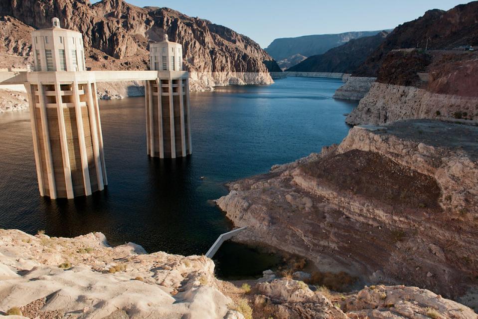
At full pool, Lake Mead is the largest reservoir in the United States by volume, but two decades of drought have dramatically dropped the water level behind Hoover Dam as can be seen in this photo. (Source: U.S. Bureau of Reclamation)
Twenty years ago, the Colorado River Basin’s hydrology began tumbling into a historically bad stretch. The weather turned persistently dry. Water levels in the system’s anchor reservoirs of Lake Powell and Lake Mead plummeted. A river system relied upon by nearly 40 million people, farms and ecosystems across the West was in trouble. And there was no guide on how to respond.
So key players across the Basin’s seven states, including California, came together in 2005 to attack the problem. The result was a set of Interim Guidelines adopted in 2007 that, according to a just-released assessment from the Bureau of Reclamation, mostly worked. Stressing flexibility instead of rigidity, the guidelines stabilized water deliveries in a drought-stressed system and prevented a dreaded shortage declaration by the federal government that would have forced water supply cuts.
Carly Jerla, one of the review’s authors. (Source: U.S. Bureau of Reclamation)
Those guidelines, formally called “Interim Guidelines for Lower Basin Shortages and the Coordinated Operations for Lake Powell and Lake Mead,” are set to expire in 2026 As stakeholders in the Colorado River Basin — including water agencies, states, Native American tribes and nongovernmental organizations — prepare to renegotiate a new set of river operating guidelines, Reclamation’s assessment is expected to provide a guide for future negotiations.
“We find that the guidelines were largely effective,” said Carly Jerla, modeling and research group manager with the Bureau of Reclamation’s Lower Colorado River region and one of the report’s authors. However, the Interim Guidelines could not solve all of the challenges brought by what has become a two-decade-long drought in the Basin. Said Jerla: “We saw risk getting too high and needed additional assets.”
Preserving Lake Mead
With the guidelines as a foundation, those assets arrived in 2019 through drought contingency plans for the Upper and Lower Basin – voluntary reduction commitments that built a firewall against the likelihood of Lake Mead dropping to critically low levels.
Chris Harris, executive director of the Colorado River Board of California, said the guidelines achieved their objective, considering that the drought has essentially persisted since 2000. Even with the severity and longevity of the drought, the guidelines kept the two reservoirs at about 50 percent of capacity since 2007.
“To my mind that’s a pretty good marker that we were generally successful,” Harris said.
Matt Rice, who directs American Rivers’ Colorado Basin Program, argues that future river operating guidelines should factor in environmental considerations. (Source: American Rivers)
Reclamation’s review of the Interim Guidelines was released for public comment in October. It is expected to be finalized in December. After that, discussions are expected to begin to hammer out a new set of operating rules that would be ready to take effect when the existing guidelines expire in 2026.
Reclamation’s review, which was required under the guidelines, focused solely on how effectively the Interim Guidelines managed water shortages and storage in Lake Powell and Lake Mead. It did not include existing environmental management programs such as the Glen Canyon Dam Adaptive Management Program that are independent of the guidelines. The 2026 guidelines should take a broader view, said Matt Rice, director of American Rivers’ Colorado River Basin Program.
“Not just looking at the two big buckets [reservoirs], but how do we ensure the river is healthy and has water for its environmental needs,” he said.
“How do we ensure that communities are considered, certainly the tribes, and how do we evaluate additional future demands, projects like the Lake Powell pipeline (a proposed project to deliver Lake Powell water to Southern Utah).”
Ensuring Tribal Participation
Tribal water rights are a key consideration to future Colorado River water use. Ten federally recognized tribes in the Upper and Lower Basins have reserved water rights, including unresolved claims, to divert about 2.8 million acre-feet of water per year from the river and its tributaries, according to Reclamation’s 2018 Tribal Water Study. These tribes anticipate diverting their full water rights by 2040.
Reclamation’s review emphasizes the need for listening to all voices, most notably tribes. Tribal representatives were largely overlooked in the development of the 2007 Interim Guidelines and tribes want to make sure their voices are heard when the next set of operating rules are drawn up.
“We hope that the review will remind Reclamation of the importance that Indian tribes have played in the stewardship of the Colorado River and underscore the importance of meaningful and sustained participation of the Lower Basin tribes in any future guidelines development regarding management of the Colorado River,” Jon Huey, chair of the Yavapai-Apache Nation in Arizona, wrote in a letter to Reclamation.
Jerla said Reclamation recognizes how important it will be to include the tribes in future discussions.
“We definitely heard that loud and clear,” she said. “I think the critical role that tribes have played in the activities since the Guidelines … their desire to be more involved and more included, they will absolutely be a key part of efforts going forward, no question.”
Balancing Water Uses
There is inherent tension in balancing Colorado River water uses between the two basins. Part of the problem is users in the Lower Basin can use Lake Mead as a bank account, having water released downstream to them as they need it. Lake Powell, on the other hand, sits at the bottom of the Upper Basin’s drainage and water that flows into Powell is largely beyond reach of Upper Basin users.
Lake Powell, behind Glen Canyon Dam, shows the effects of persistent drought in the Colorado River Basin. (Source: U.S. Bureau of Reclamation)
“The guidelines have been partially successful in that they have achieved their principal objective of preventing Lower Basin shortage, as well as establishing a Lower Basin conservation mechanism and avoiding litigation in the Basin,” said Amy Haas, executive director of the Upper Colorado River Commission. “However, from the standpoint of the coordinated operations of Lakes Powell and Mead, a secondary objective of the Guidelines, they have come up short.”
Haas pointed out that between 2015 and 2019, Lake Powell was required to release 9 million acre-feet of water annually under the Guidelines, even with poor inflows into Powell and below-average hydrology in the Upper Basin watershed. That’s more than has historically been required.
“Meanwhile, Lake Mead elevations have not substantially increased under the Guidelines due in large part to overuse in the Lower Basin, also known as the structural deficit,” she said. “These issues must be addressed in the post-2026 operational criteria.”
Protecting the Colorado River
Drought wreaked havoc on the Colorado River Basin between 2000 and 2004, with record dryness that depleted the combined storage of Lake Powell and Lake Mead. Conditions worsened quickly. At the beginning of the 2000 water year, the review said, the combined storage in Lake Powell and Lake Mead was 55.7 million acre-feet. After the worst five-year period of inflow on record ended in 2005, that storage fell to 29.7 million acre-feet – a striking loss of nearly half of the water in the two anchor reservoirs.
Something new had to be done. The business-as-usual approach of determining drought conditions for the Basin on a yearly basis was not going to provide long-term stability or prevent conflict under such historic dryness.
“Failing to develop additional operational guidelines would make sustainable Colorado River management extremely difficult,” Reclamation’s review said.
The Interim Guidelines in 2007 opened the door for Lower Basin water users and Mexico to get creative about how water is managed and used. One example that grew out of the guidelines is Intentionally Created Surplus, allowing downstream parties to bank water in Lake Mead that they could draw upon later.
“One result of this new flexibility was that critical Lake Mead elevations could be protected through the conservation of this water in the lake,” said Tom Buschatzke, director of the Arizona Department of Water Resources. “The Basin states, meanwhile, continued to seek ways to protect reservoir levels and the health of the Colorado River system.”
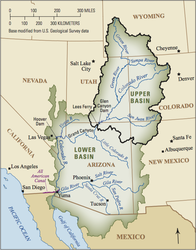
The Colorado River Compact divided the basin into an upper and lower half, with each having the right to develop and use 7.5 million acre-feet of river water annually. (Source: U.S. Geological Survey via The Water Education Foundation)
Saving Intentionally Created Surplus water in Lake Mead turned out to be a critical drought response tool, said Reclamation’s Jerla, ensuring that the lake’s water level did not drop to where water users would be required to take cuts.
Reclamation’s review of the Interim Guidelines notes that there are other areas of interest beyond its scope that should be considered in future discussions, such as impacts of river operations to environmental, recreational and hydropower resources, and more meaningful engagement of Basin partners, stakeholders, tribes and states.
The review notes that since the Interim Guidelines were adopted, Reclamation has expanded its long-term modeling assumptions and worked to identify appropriate methods for analyzing uncertainty.
“Even though the true probability of any combination of conditions … cannot be assessed, a wider range of hydrology and demand assumptions and attention to those ranges … are useful for supporting a common understanding of system vulnerability,” the review says.
The Next Set of Guidelines
The 2007 Interim Guidelines have set the table for the next version of a Colorado River operations agreement. In retrospect, things have generally occurred as expected, Jerla said.
“In terms of where the reservoirs landed, what types of releases Powell made and how successful the Intentionally Created Surplus mechanism became, that is all within the range of what we were projecting,” Jerla said. “It’s informative to know that now and use that thinking about how risk influenced our decisions and how that translates into the next set of action levels.”
Sustaining Lake Mead for the benefit of downstream water users in the Lower Colorado River Basin has been a key objective of the 2007 Interim Guidelines and the 2019 Drought Contingency Plans. (Source: Lighthawk via The Water Desk)
The Interim Guidelines instilled a degree of greater cooperation and innovation on the river and that has fostered partnerships, initiatives and actions that demonstrate what can be done in a Basin that is steadily getting drier.
“Those things have to continue,” Jerla said, adding that Reclamation’s review is one of many sources officials will consult as they draft the next set of guidelines.
Rice, with American Rivers, said he’s optimistic about the prospects of a broad group of stakeholders building the next set of Interim Guidelines.
“I am not suggesting that it’s going to be easy or straightforward by any means,” he said. “We certainly hope there will be greater participation from more stakeholders. The tribes are at the top of the list, but also nongovernmental organizations, which traditionally have not been part of these interbasin negotiations.”
The talks are likely to be frank and will explore thorny issues related to equitable water management.
Amy Haas, executive director of the Upper Colorado River Commission, says the Lower Basin’s structural deficit must be addressed. (Source: UCRC)
Arriving at a satisfactory operational plan beyond 2026 means the Lower Basin’s structural deficit has to be addressed and balancing releases between Lake Powell and Lake Mead should be revisited to reflect actual hydrology, said Haas, with the Upper Colorado River Commission. “Also, the new guidelines should contain a mechanism whereby operations can be adapted and adjusted to meet changing conditions, something the current guidelines are not equipped to do.”
How the next set of river operating guidelines will take shape remains to be seen, but Reclamation’s review suggests the 2007 Interim Guidelines proved their worth in showing how water users can work together and think creatively, lessons that will be invaluable for the future.
The 2007 Interim Guidelines, the review said, “created the operational stability that became the platform for the collaborative decision-making that protected the Colorado River system from crisis.”
Glenwood Springs is spending more than $10 million on repairs and upgrades to water supply infrastructure following Grizzly Creek Fire.
The Grizzly Creek Fire was not even 10% contained. Jumbo jets still were dousing flames as firefighting teams from across the country scrambled to protect Glenwood Springs and a critical watershed above the Colorado River. And teams of scientists were in Glenwood Canyon, too, battling alongside firefighters.
Those hydrologists, biologists, geologists, archaeologists and recreation specialists are still there, even after the flames are gone, waging a behind-the-scenes battle to protect water and natural resources…
Burned Area Emergency Response — or BAER — teams typically come in when a fire is 50% contained to assess damage and create a multi-year restoration plan. Roberts and the Grizzly Creek Fire BAER crew were on the ground when less than 10% of the fire was contained as both forest and fire managers recognized threats to water supplies. In less than three weeks, they had a map detailing where the Grizzly Creek Fire burned hottest, which helped the Colorado Department of Transportation identify areas where rockfall hazards increased in the fire.
In a twist on the BAER assessment — which usually focuses on protecting resources after a fire — the team helped build an emergency communication plan that helped firefighters in the canyon, and identified areas where they could swiftly take cover in the event of rockfall or a sudden rainstorm that could sweep debris and rocks off canyon walls…
It was this early assessment that sparked an urgent plea for help from Glenwood Springs. As firefighters battled back flames on the western edge of the wildfire, the city’s leaders rallied politicians far and wide to acknowledge damage to the city’s water supply infrastructure. Barely three weeks after the wildfire sparked along Interstate 70 in Glenwood Canyon, the city had a list of immediate work needed to protect the city’s watershed.
Sen. Michael Bennet prodded the U.S. Department of Agriculture’s Natural Resource Conservation Service (NRCS) to unleash millions from the federal Emergency Watershed Protection program. Glenwood Springs was first in line, with a clear message that spring snowmelt, or even a rainstorm, could cripple the city’s water supply…
It didn’t take long for Glenwood Springs to identify immediate repairs and upgrades to protect water systems from expected sediment and debris flowing from scorched canyon walls. First on the list were intake systems on Glenwood Canyon’s Grizzly and No Name creeks. The city also needed an upgrade to a backup water intake on the Roaring Fork River, should the systems in the canyon go down. And finally, the city is eager to finish a long-planned bridge that could help residents flee a wildfire on the south end of town.
By early September, less than a month after the Grizzly Creek Fire started, the city had a list of $86 million in projects. And the money started flowing almost immediately.
The city secured more than $1 million from the NRCS’s Emergency Watershed Program for projects to protect intake infrastructure on No Name and Grizzly creeks, high above the Colorado River…
The Grizzly Creek Fire jumped Grizzly Creek north of Glenwood Canyon. (Provided by the City of Glenwood Springs)
The city asked the NRCS for wiggle room on the requirement that municipalities pay 25% of the total grant. The service agreed to an 80-20 split, which meant the city needed a little less than $200,000 to protect the structures that funnel millions of gallons of water a day into the city’s water treatment plant.
Work on the Grizzly Creek intake started first, with helicopters ferrying workers 3.8 miles up the drainage. The workers put in steel plates to protect the diversion and valve systems from debris that could clog the intake during the next big rain or spring melt. They stabilized the banks upstream and downstream of the intake, which required flying 11 cubic yards of cement up the drainage.
New plating at the Glenwood Springs water intake on Grizzly Creek was installed by the city to protect the system’s valve controls and screen before next spring’s snowmelt scours the Grizzly Creek burn zone and potentially clogs the creek with debris. (Provided by the City of Glenwood Springs)
The team finished in October and then turned to No Name Creek, where intake diversions and valves are accessible by truck. That work included similar protections as Grizzly Creek, plus a concrete wall to keep debris from hitting a city structure on No Name Creek.
The No Name work also included upgrades to a 1962 tunnel near the bottom of the creek, with new strainers and filters designed to remove bulky sediment before water reaches the treatment plant. The No Name work is ongoing but will be completed before the spring melt.
In addition to the intake repairs and upgrades, Glenwood Springs this month secured an $8 million loan from the Colorado Water Conservation Board. The money was among the first awarded through the board’s 2020 Wildfire Impact Loan program, which streamlines funding for municipalities racing to protect watersheds after a wildfire. The program offers 30-year loans with no payment necessary for the first three years.
The $8 million will help design and construct new pipelines from the city’s pump station on the Roaring Fork River, which delivers water uphill to the Red Mountain Water Treatment Plant. Glenwood Springs has two water sources: the intake systems on No Name and Grizzly creeks and the pumps on the Roaring Fork River. The Roaring Fork water is a backup in case either of the intakes on the creeks above the Colorado River go down. But the intakes in Glenwood Canyon and the pumps on the Roaring Fork cannot run at the same time, and the city is building a second pipeline into the Red Mountain Water Treatment Plant so the two sources can deliver water simultaneously, if needed.
“This will give us a lot of resiliency moving into the future. Not just fire resiliency, but it gives us a lot of water resource resiliency,” said Matt Langhorst, the public works director for Glenwood Springs. “Having one water source is not acceptable. We need two or three and this would give us three.”
Glenwood Springs is applying for a Department of Local Affairs grant for the pipeline running from the Roaring Fork River, which would reduce its loan amount from the CWCB.
A third project, still part of that $8 million from the Colorado Water Conservation Board, will plan and construct a concrete basin above the Red Mountain Water Treatment plant that will mix water coming from the Grizzly Creek and No Name intakes with the water from the Roaring Fork River. The mixing basin helps remove sediment and creates a consistent type of water so technicians do not need to overhaul various treatment processes to accommodate different sources of water.
A fourth project — and the biggest — would upgrade the entire Red Mountain Water Treatment Plant, which has not been updated since 1977. An upgraded plant, with new technology, would be able to more quickly and efficiently remove sediment from higher volumes of incoming water…
Sprinkling special-made seeds
The Colorado Water Conservation Board’s emergency loan program was developed in response to the 2013 floods. The idea was to get emergency funds approved by the board ahead of time so communities do not have to wait through a prolonged application and review process. The board’s emergency loan program distributed $23 million in emergency watershed protection funding following the devastating floods in September 2013…
With the fire climbing out the canyon by the middle of September and the risk to crews reduced through communication plans and safety maps, Roberts’ BAER team of specialists started their work on emergency stabilization and long-term restoration.
They created a second burn severity map along with a satellite-derived data map of vegetation in the burn zone. The U.S. Geological Survey’s Landslide Hazards Program also created a similar map identifying areas where debris flow could be heaviest during a rainstorm.
The BAER team started hiking into the canyon, sometimes driving up to the top of the canyon and dropping in from above, and sometimes hiking up. They scoured the soil in burn areas for organic, woody debris and intact roots, which raise the likelihood of natural recovery. Roberts said new plants already are pushing through the charred topsoil.
“What we have seen to date is there is a lot of that organic material and native seed left in the soil that is allowing a lot to come back,” Roberts said, describing a patchy burn in a “mosaic” pattern. “We see good potential for recovery.”
[…]
Roberts and her team assisted the natural recovery process, sprinkling seeds as soon as rain and snow dampened the soil. They walked all the fire suppression lines where bulldozers hastily cleared entire swaths of forest and yanked out non-native weeds that took root. And they threw seeds everywhere.
Roberts collected native grass seed from the nearby Flat Tops to create a seed mix for Glenwood Canyon. The mix will produce resilient grasses that help stabilize soil and combat invasive weeds. The team’s reseeding of suppression lines is nearing completion as the snow piles deeper. The stabilization work will continue into next summer.
Emergency trail and road stabilization will pick up in the spring, when Roberts will move into the restoration phase, which includes aggressive mitigation to prevent non-native weeds and monitoring vegetation growth.
Researchers with Utah State University also joined Roberts in the field and launched a year-long study of how the Grizzly Creek Fire impacts runoff and erosion. The researchers expect the data — gathered from USGS gauges upstream and downstream of the burn zone as well as monitoring equipment inside the canyon — will help better calibrate the models used to predict debris flow in areas burned by wildfire.
Latino voters, regardless of partisan differences, support legislation that makes real and lasting climate progress while also growing the economy, according to a new poll from Latino Decisions and Environmental Defense Fund Action.
Scientists have warned time is running out to change course to avoid the worst impacts of climate change, but Esther Sosa, diverse partners project manager with Environmental Defense Action Fund, said too often the focus has been on saving starving polar bears on melting icebergs.
The group’s new poll finds Colorado’s Latino residents — from communities located disproportionately in the shadows of refineries and coal-fired power plants — support policies to reduce pollution by switching to clean energy sources.
“We don’t talk enough about the people whose health and quality of life are harmed,” Sosa said. “The poll found that Latino voters understand the connection between a clean environment and their health.”
The poll says across the political spectrum, more than 90% of Colorado Latino voters want drinking water to be protected from contamination, and 82% want environmental protections reinstated that were rolled back under the Trump administration.
While the administration took steps to prevent job loss in the fossil-fuel sector, nearly 8 in 10 Latino voters want the next president and Congress to jump-start the post-COVID economy through long-term investments in clean energy, including wind and solar.
Latinos earning less than $50,000 a year who lost jobs due to the coronavirus pandemic are more likely to support investments in clean-energy jobs. Sosa said Latino voters understand communities that have long relied on the fossil-fuel sector for good-paying jobs need other options…
Sosa said the poll contradicts long-held assumptions that working-class communities of color aren’t interested in environmental issues. She said it also confirms that communities forced to live in areas subject to air and water pollution, through redlining and other policies, care deeply about the environment and are concerned about further exposure to the worst impacts of climate change.
But what does socialism actually mean to Americans? Although surveys can ask individuals for responses to questions, they don’t reveal what people are saying when they talk among themselves.
As a social media scholar, I study conversations “in the wild” in order to find out what people are actually saying to one another. The method I developed is called netnography and it treats online posts as discourse – a continuing dialogue between real people – rather than as quantifiable data.
As part of an ongoing study on technology and utopia, I read through more than 14,000 social media comments posted on Facebook, Twitter, Reddit and YouTube in 2018 and 2019. They came from 9,155 uniquely named posters.
What I found was both shocking and heartening.
Loyalty and fear
Both support for socialism and attacks on it appear to be on the rise.
Socialism can mean different things to people. Some see it as a system that institutionalizes fairness and citizen rights, bringing higher levels of social solidarity; others focus on heavy-handed government control of free markets that work more effectively when left alone. U.S. Senator Bernie Sanders, a self-described democratic socialist, emphasized the right to quality health care, education, a good job with a living wage, affordable housing and a clean environment in a 2019 speech.
A 2019 Gallup Poll found that 39% of Americans have a favorable opinion of socialism – up from about 20% in 2010; 57% view it negatively.
These and other advocates point to a version of socialism called the “Nordic model,” seen in countries like Denmark, which provide high-quality social services such as health care and education while fostering a strong economy.
President Trump has portrayed socialists as radical, lazy, America-hating communists. His son, Donald Trump Jr., has posted tweets ridiculing socialism.
During the 2020 election season, Republican Senator Majority Leader Mitch McConnell advised that his party could win by being a firewall against socialism. He was on point: Fear of socialism may have been a reason why the Republicans gained seats in the U.S. House of Representatives in 2020.
A ‘tug of words’
Although I wasn’t initially looking for posts on socialism or capitalism, I found plenty of them in my online investigation. Many were what I call a “tug of words” in which people asserted which system was better. People from opposite ends of the political spectrum made pithy observations, posted one-liners or launched strong, emotionally worded broadsides. There was often little dialogue – those who posted were shouting at each other as if using a megaphone.
A YouTube commenter uses a megaphone-like approach to preach about the perils of socialism. Screen shot by Robert Kozinets
I also found a large number of short, nonconversational, megaphone-like posts on visual social media like Instagram and Pinterest.
Some commentary on socialism on Pinterest. Screen shot by Robert Kozinets
But some people were more circumspect. While they were often reactive or one-sided, they raised questions. For example, people questioned whether business bailouts, grants, lobbying or special tax treatment showed that capitalism’s “free markets” weren’t actually all that free.
Making a historical economic argument against socialism and its slippery slope to totalitarianism. Robert Kozinets’ data collection
And some considered what “socialism” actually means to people, linking that meaning to race, nationality and class.
The meaning of socialism discussed on Twitter. Screen shot by Robert Kozinets
Overcoming primitive ‘isms’
Amid all the sound and fury of people shouting from their virtual soapboxes, there were also the calmer voices of those engaging in deeper discussions. These people debated socialism, capitalism and free markets in relation to health care, child care, minimum wage and other issues that affected their lives.
One YouTube discussion explored the notion that we should stop viewing everything “through the primitive lens of the nonsensical ‘isms’ – capitalism, socialism, communism – which have no relevance in a sustainable or socially just and peaceful world.”
Other discussions united both left and right by asserting that the real problem was corruption in the system, not the system itself. Some used social media to try to overcome the ideological blinders of partisan politics. For example, they argued that raising the minimum wage or improving education might be sensible management strategies that could help the economy and working Americans at the same time.
This Reddit post explores the benefits of changes that some might label as socialist. Screen shot by Robert Kozinets.
New forum for discussions
As America’s post-election divisions fester, my work gives me reason for hope. It shows that some Americans – still a small minority, mind you – are thoughtfully using popular social media platforms to have meaningful discussions. What I have provided here is just a small sample of the many thoughtful conversations I encountered.
My analysis of social media doesn’t deny that many people are angry and polarized over social systems. But it has revealed that a significant number of people recognize that labels like socialism, free markets and capitalism have become emotional triggers, used by some journalists and politicians to manipulate, incite and divide.
To unify and move forward together, we may need to better understand the sites and discussion formats that facilitate this kind of thoughtful discourse. If partisans retreat to echo chamber platforms like Parler and Rumble, will these kinds of intelligent conversations between people with diverse viewpoints cease?
As Americans confront the financial challenges of a pandemic, automation, precarious employment and globalization, providing forums where we can discuss divergent ideas in an open-minded rather than an ideological way may make a critical difference to the solutions we choose. Many Americans are already using digital platforms to discuss options, rather than being frightened away by – or attacking – the tired old socialist bogeyman.
Click here to read the update (Megan Holcomb & Tracy Kosloff):
Water Year 2020 has concluded as the 12th warmest water year on record in Colorado since 1895. The winter months presented near normal temperatures with warmer temperatures occurring throughout summer months. Water Year 2020 was the third driest water year on record, trailing only 2002 (driest) and 2018 (2nd driest). October temperatures were above normal and precipitation was below average for the majority of the month, despite a strong cold snap that hit the state just before Halloween. So far in November, eastern Colorado has experienced above average temperatures that are likely to continue, while several decent storms blanketed the mountains, resulting in average snowpack for this time of year in western Colorado. On November 30th, Governor Polis activated Phase 3 of the State Drought Mitigation and Response Plan along with a Municipal Water Impact Task Force to help water providers coordinate and prepare for a potential multi‐year drought.
Colorado Drought Monitor November 24, 2020.
A critically hot spring, high winds, dry summer, and multiple monsoon seasons with poor to no moisture have contributed to 2020’s record breaking fires. The three largest wildfires in Colorado history occurred in the summer and fall of 2020. Historically, Colorado’s largest wildfires occur in June following poor winter snowpack and an early springtime melt out. However, the Cameron Peak and East Troublesome fires experienced rapid and intense expansion in October ‐ a completely unprecedented phenomenon.
The Nov. 25 U.S. Drought Monitor logged 27% of the state in D4 (exceptional) drought conditions; D3 (extreme) drought in 47% of the state; D2 (severe) covering 19%; and D1 (moderate) drought covering 6% of the state.
The 90‐day Standardized Precipitation Index (SPI) (August 19 to Nov 16) values continue to show drier than normal conditions across the state.
The ENSO forecast predicts that moderate La Niña conditions will last through the winter. La Niña generally means an increase in moisture to the north and less to the south. Historically this pattern leads to snowier winters in the northern Rockies and less precipitation to the south.
The NOAA Climate Prediction Center three month outlook maps indicate an increased chance for above average temperatures over the winter with an equal chance (e.g. unclear trend) of precipitation.
Statewide reservoir storage is currently at 82% of average. Storage in the northern half of the state is near average while the southern basins range
Municipal water providers continue to report increased demands and most municipalities report normal to slightly below normal storage. Water providers are closely monitoring conditions due to the likelihood of extended drought to prepare for a dry spring.
Colorado’s second biggest electrical utility will soon identify its path to 80% reduced emissions by 2030. Surely this map will include Arizona and Wyoming.
Tri-State Generation and Transmission last week promised to deliver what Colorado wants, an 80% reduction in carbon emissions by 2030. As for how it will deliver on that pledge, it remains a bit of a mystery.
Less coal production, obviously. More wind and solar, ditto. And, as has been highlighted in recent filings, more transmission to get electricity from renewable sources to its 16 member co-operatives in Colorado.
But how exactly?
For that, a more definitive answer will likely have to wait until Dec. 1 and perhaps beyond. That’s when Tri-State is scheduled to deliver an electric resource plan to state regulators. This plan is to explain in detail how it intends to procure electricity in coming years for its Colorado cooperatives. Colorado’s co-ops together account for about two-thirds of Tri-State’s demand across a four-state area.
Tri-State is Colorado’s second largest utility based on the amount of electricity it delivers in the state. In 2019 it delivered 38% as much electricity as compared to Xcel.
This electric resource plan will be a first for Tri-State. The utility has never been directly regulated by the Colorado Public Utilities Commission. SB 19-236, one of the many laws passed by Colorado legislators in 2019 to complement new economy wide carbon reduction targets adopted in the same session, makes it clear that the PUC has jurisdiction over Tri-State’s resource planning activities. A September filing by the Colorado PUC staff asserted that the “overriding concern” in evaluating Tri-State’s plan is how the utility “can meet Colorado’s emissions reduction cost effectively.”
Foundational to Colorado’s efforts to decarbonize its economy 50% by 2030, with even deeper cuts by mid-century, is removing carbon emissions from the electrical sector and then using electricity for other uses now fulfilled by fossil fuels in the transportation, industrial, and building sectors.
The 2019 legislation laid out an explicit requirement of 80% emissions reductions of Xcel Energy, which had by then agreed to do so. The state’s authority over other utilities, however, is more fuzzy.
In recent months, Will Toor, executive director of the Colorado Energy Office, has secured commitments from Platte River Power Authority, the wholesale provider for four municipalities along the Front Range, and also Colorado Springs Utilities. This commitment by Tri-State binds the overwhelming majority of Colorado electrical production to the emissions reductions identified by legislators.
A smaller utility, Holy Cross Energy, has adopted a more restrained goal of 70% by 2030 but is almost certain to hit that target within the next year.
Tri-State announced in January it would close its Escalante coal plant in New Mexico this year. It did so in September. 2019 photo/Allen Best
Tri-State in January announced it would close the Escalante coal plant in New Mexico this year, which it did in September, and that it would have all the three units near Craig that it operates closed by 2030.
Still, Tri-State has a long, long way to go. Baseline modeling done by the utility in advance of its Dec. 1 filing showed a 34% reduction in Colorado in carbon dioxide emissions by 2030 as compared to a 2005 baseline.
Last week, after Tri-State’s announcement, Tri-Harder, a new coalition of Tri-State members, issued a statement. Speakers were cautious in their praise.
“Telluride can’t meet its carbon reduction goals unless Tri-State takes the lead on carbon reductions, so we’re thrilled with this news,” said Todd Brown, mayor pro-tem of Telluride. “I hope this means that Tri-State will invest in local, clean energy in our communities so that our local economies can benefit as well as the climate.”
Wyoming and Arizona
With Colorado Gov. Jared Polis rubbing virtual elbows, video-conference style, Tri-State chief executive Duane Highley took questions about his utility’s pathway.
Highley said the utility will be adding thousands of megawatts of new generating capacity in wind and solar and expects to be at 50% renewables across its entire system by 2023; in 2019 it was about 30%, about the same as Xcel.
But what will it do about imported power into Colorado? Tri-State imports power to meet needs of Colorado consumers from the Laramie River Station at Wheatland, Wyo., and from the Springerville 3 plant in Arizona. Tri-State is a minority owner in the Laramie River Plant but owns all the output from the unit at Springerville.
Highley said that Tri-State will diminish the power from the Wyoming plant over time, but did not give a time line.
The PUC staff report in September pointed out that aside from natural-gas generation, almost all the other carbon dioxide emissions in 2030 are from these out-of-state coal units.
“According to Tri-State, there are no provisions for modification or early termination” of the contracts” and Tri-State “has not analyzed such an action. The staff report went on to say that the resource planning review before the PUC “may include clear evidence that for Tri-State to meet its cumulative Colorado GHG reduction obligations, it cannot continue to serve Colorado load (demand) using those out-of-state resources.”
Tri-State, in an Oct. 2 filing, said it is developing several scenarios as part of its planning. “These scenarios will address the social cost of carbon on a system-wide basis, as well as specified carbon reduction goals in the state of Colorado,” the filing said. “These scenarios include aggressive levels of renewable energy additions and energy storage, allow for demand-side management, limit thermal additions, allow for retirement of existing resources, and incorporate either base or low-load forecast.”
What its load—the demand for its electricity—will be could be impacted by changes in the oil-and-gas sector, as Tri-State is a major supplier to oil-and-gas fields, but also the potential for existing cooperatives to leave or transition to partial requirements, Tri-State says.
In other words, there are a lot of uncertainties about just how much electricity Tri-State will need.
Another electric resource planning process will commence in 2023, not long after the current one is settled.
This is from the Nov. 20, 2020, issue of Big Pivots, which chronicles the great energy transition in Colorado and beyond. Sign up for copies at BigPivots.com.
Electric resource plans are wonky but rigorous things. Xcel Energy and Black Hills are required to file them. In addition to the filings of the utilities, laying out their plans and answering questions, intervening parties, including environmental groups, independent power producers, and the Office of Consumer Counsel, chip in statements, sometimes lengthy. Printing out all the filings in some of these cases can cost you a box of paper. The plans can drag on for years. Like painting the Golden Gate Bridge, the job is completed and then begins from the other side again.
The Tri-State filing will be a first for the utility itself. It will also be the first time for any resource plan since state legislators adopted the suite of energy laws in 2019. None was more expansive than SB 19-236, which reauthorized existence of the PUC but also delivered new criteria for how commissioners are to evaluate plans by utilities.
One example: The lengthy bill—it runs 64 pages—specifies that the commission must establish the cost of carbon dioxide emissions produced by electric generation resources, starting at not less than $46 per ton. The rate must be escalated based on the work by the federal interagency working group. This is called the social cost of carbon.
The PUC commissioners, at their weekly meeting on Nov. 12, ruled that Tri-State must use cost escalators in the models it submits for future electrical generation on Dec. 1.
Necessarily, the Colorado PUC will be examining Tri-State’s four-state operating system. Already, there are questions.
Reacting to Tri-State’s 80% announcement, Eric Frankowski, director of the Western Clean Energy Campaign, warned against any attempt to make this “an accounting exercise by shipping its expensive, dirty coal to its members outside of Colorado.”
Western Resource Advocates will also be watching carefully how Tri-State explains its accounting of greenhouse gas emissions in the review process.
Gwen Farnsworth, WRA’s senior energy policy advisor, says Tri-State’s announcement puts it at a better starting point for the electric resource plan in December as compared to the data provided by the utility earlier this year. That process before the PUC, she added, “provides a rigorous, evidence-based process to review Tri-State’s plan and emissions reductions claims.”
Tri-State’s cases will be different from the filing by Xcel Energy next March 1 in that the PUC has clear authority over setting rates in the case of Xcel. Tri-State sought oversight by the Federal Energy Regulatory Commission because it operates in four states.
One important area is that of transmission. Transmission has been constructed in a piecemeal fashion in Colorado over the decades. This new push for rapid development of renewable generation calls for a more unified and systematic approach to thinking about both new resources and transmission, instead of considering them separately.
Transmission, too
Transmission was also the subject of Highley’s second significant announcement last week. He said Tri-State and four other power providers have sent letters committing to evaluate expansion of the Southwest Power Pool’s regional transmission organization, or RTO, into the West. The other utilities are Basin Electric Power Cooperative, Deseret Power Electric Cooperative, the Municipal Energy Agency of Nebraska, and the Western Area Power Administration.
Duane Highley via The Mountain Town News
In essence, Tri-State has assembled buddies to challenge the more dominant idea in Colorado that the most logical way to realize benefits of managed markets will be to join with the California and other utilities in the West. Like Tri-State, generation and transmission associations, the one larger and the other much smaller, MEAN is a public power provider of many Colorado towns and cities.
Tri-State and WAPA — the distributor of electricity generated by federal dams in the West— in September 2019 announced they were forming an energy imbalance market with the aid of the Arkansas-based Southwest Power Pool. Xcel Energy and three partners—Platte River Power, Black Hills Energy, and Colorado Springs Utilities—three months later said they were doing the same but with the aid of CAISO, the California-created operator.
Creation of these imbalance markets is seen as a low-risk, low-reward investment in coordinating supplies, especially low-cost renewables, to meet demands. Highley has said that Tri-State can earn back its investment within three years. The far greater benefits will be found in an RTO.
A recent study by Vibrant Clean Energy found that a regional transmission organization, whether operated by SPP or by CAISO, could greatly benefit Colorado consumers, but concluded that the somewhat greater benefits were to be found with the alliance with California.
Asked about that study, Highley disagreed with the conclusion about CAISO but also said that whatever the regional alignment, there will be benefits of integrated transmission and scheduling to share wind, solar, and other resources across broader regions.
Allen Best is a Colorado-based journalist who publishes an e-magazine called Big Pivots. Reach him at allen.best@comcast.net or 303.463.8630.
FromThe High Country News [November 26, 2020] (Jonathan Thompson):
In September, President Donald Trump visited fire-ravaged California and declared that the wildfires that had already burned across millions of acres were the result of forest mismanagement, not a warming climate. “When trees fall down after a short period of time, they become very dry — really like a matchstick. No more water pouring through, and they can explode,” he said. “Also leaves. When you have dried leaves on the ground, it’s just fuel for the fires.”
Trump is right about one thing: Global warming isn’t the only reason the West is burning. The growing number of people in the woods has increased the likelihood of human-caused ignitions, while more than a century of aggressive fire suppression has contributed to the fires’ severity. In addition, unchecked development in fire-prone areas has resulted in greater loss of life and property.
Yet, much as California Gov. Gavin Newsom told Trump, it’s impossible to deny the role a warming planet plays in today’s blazes. “Something’s happening to the plumbing of the world,” Newsom said. “And we come from a perspective, humbly, where we submit the science is in and observed evidence is self-evident that climate change is real, and that is exacerbating this.”
The accompanying graphic includes a few examples of the evidence Newsom mentioned. But then, you only have to step outside for a moment and feel the scorching heat, witness the dwindling streams, and choke on the omnipresent smoke to know that something’s way off-kilter, climate-wise.
But during his September stop outside Sacramento, California, under a blanket of smoke, Trump merely grinned and shrugged it off, again asserting that scientists don’t know what’s happening with the climate. And, anyway, he said: “It’ll start getting cooler. You just watch.”
1. Lewistown, Montana, (70 degrees Fahrenheit) and Klamath Falls, Oregon, (65 degrees) set high-temperature records for the month of February. 2. California had its driest February on record. 3. In April, parts of southern Arizona and California saw the mercury climb past 100 degrees Fahrenheit for multiple days in a row, shattering records. 4. Nome, Alaska, experienced its warmest May since record-keeping began in the early 1900s. 5. Seven large fires burned across more than 75,000 acres in Arizona during May, and in early June, lightning ignited the Bighorn Fire in the Santa Catalina Mountains near Tucson, ultimately torching 120,000 acres. A week later, the Bush Fire broke out in Maricopa County and became the fifth largest in the state’s history. 6. On July 10, Alamosa, Colorado, set a temperature record for a monthly low (37 degrees Fahrenheit). Later that day, it set another record for the monthly high (92 degrees). 7. Phoenix, Arizona, set an all-time record for monthly mean temperature in July (98.3 degrees), only to see that record fall in August (99.1 degrees Fahrenheit). The temperature in the burgeoning city exceeded 100 degrees on 145 days in 2020 — another record. 8. Westwide in August, 214 monthly and 18 all-time high-temperature records were tied or broken, including in Porthill, Idaho (103 degrees), Mazama, Washington (103 degrees) and Goodwin Peak, Oregon (101 degrees). 9. By the end of October, Phoenix had experienced 197 heat-associated deaths — about five times the yearly average during the early 2000s. 10. In Death Valley National Park, the mercury hit 130 on Aug. 16, breaking the previous all-time record set in 2013. 11. Across the Western U.S., hundreds of monthly and all-time high-temperature records were broken in August, including in several places in Idaho and Washington, where the mercury climbed above 100 degrees. 12. Warm temperatures in Alaska caused ice on the Chukchi Sea to melt, leaving record-tying amounts of open sea. 13. During monsoon season (June through August), Phoenix received just 1 inch of rain, or about 37% of average, and then received no precipitation at all in September or October. 14. Grand Junction, Colorado, experienced its driest July and August on record. On July 31, lightning ignited the nearby Pine Gulch Fire, which grew to 139,000 acres, making it (briefly) the largest in state history, only to be eclipsed by the 207,000-acre Cameron Peak Fire in the northern part of the state. 15. Colorado’s wildfire season was not only its most severe on record, but most of the fires also burned far later in the year than normal. In mid-October, when Colorado’s mountains would normally be covered with snow, the East Troublesome Fire west of Boulder tore through high-elevation forests and homes to become the state’s second-largest fire ever. Shortly thereafter, the Ice Fire broke out at nearly 10,000 feet above sea level in what was once known as the “asbestos forest” near Silverton, burning over 500 acres. 16. A dry thunderstorm that generated more than 8,000 recorded lightning strikes hit Central and Northern California in late July, igniting multiple megafires. The resulting August Complex became the largest fire in state history, and together with the SCU Lightning Complex, the LNU Lightning Complex and the North Complex fires, it burned across more than 2 million acres, destroyed 5,000 structures and killed 22 people. 17. Smoke from California’s fires spread across the region, causing particulate matter to build up to levels that were hazardous to health and significantly diminishing solar energy output. 18. In September, several fires were sparked in Oregon’s tinder-dry forests. Fueled by high winds, they went on to burn more than 1 million acres and 4,000 homes. 19. In August the Rio Grande in New Mexico shrank to the lowest mean monthly flow since 1973. Other rivers in the region, including the Colorado, Green and San Juan, ran at far-below-average levels throughout the summer. 20. As of early November, Lake Powell’s surface elevation had declined by 35 feet since the same date in 2019, and summer hydroelectric output from Glen Canyon Dam’s turbines was 13% below the previous summer’s. Sources: National Interagency Fire Center; CalFire; Maricopa County; National Weather Service; National Centers for Environmental Information; National Water Information System (USGS); Energy Information Administration; Oregon Department of Forestry; Environmental Protection Agency; Western Regional Climate Center; United States Drought Monitor
Jonathan Thompson is a contributing editor at High Country News. He is the author of River of Lost Souls: The Science, Politics and Greed Behind the Gold King Mine Disaster. Email him at jonathan@hcn.org
FromThe Grand Junction Daily Sentinel (Dennis Webb):
State water officials are hoping early next year to roll out a draft demand management proposal to help in evaluating the concept as a possible response to managing Colorado River water supplies in times of drought.
Creating a framework of what the program could look like isn’t meant to tie hands and say what the Colorado Water Conservation Board thinks it should look like, CWCB staff member Amy Ostdiek told the board in its meeting earlier this month. Rather, it’s aimed at giving everyone involved the ability to have something to respond to, with the hope of perhaps creating a better draft or a new concept, she said…
The CWCB, which sets state water policy, says demand management would involve temporary, voluntary and compensated reductions in consumptive use of Colorado River Basin water. This is expected to entail use reductions in municipal, agricultural and other uses, with agricultural cuts resulting from measures such as short-term fallowing of fields.
The idea is drawing particular scrutiny from entities such as the Western Slope’s Colorado River District due to concerns about potential economic impacts on agriculture-based communities. A recent study commissioned by a work group including the district found that the secondary economic impacts of paying western Colorado farmers to temporarily fallow fields could be similar to the secondary benefits from the spending of those payments. But it said the dollars from payment spending would flow to different businesses, perhaps shifting to larger towns and cities from smaller, ag-based towns.
Among other criteria for going forward, a demand management program would have to be found to be feasible by every Upper Basin state. This means looking at things such as availability of funding, whether a program would comply with state and federal laws, how it would be administered, etc.
The CWCB began evaluating the concept by establishing work groups involving experts and stakeholders from around the state looking at issues surrounding demand management.
With their input now in hand, the agency is taking the next step in investigating the concept. That will entail considering if it is achievable in terms of things such as funding, worthwhile when it comes to questions such as how much water would be stored, and ultimately advisable to pursue in Colorado.
CWCB plans to continue its evaluation in a public, collaborative way, involving water users, tribal entities, nongovernment organizations and other stakeholders in commenting on the draft proposal, Ostdiek said.
Becky Mitchell, the CWCB’s director, told the board at its meeting that fires and drought affected every Coloradan this year.
She said that with the climate changing and drought becoming more frequent and intense, it would be irresponsible for the CWCB not to look at every tool available to respond, including demand management.
Here’s the release from the Colorado Water Conservation Board:
As severe drought conditions have persisted across 100% of Colorado for over 15 weeks, Governor Jared Polis directed a shift from Phase 2 to Phase 3 (full activation) of the State Drought Mitigation and Response Plan.
This includes convening the Municipal Water Impact Task Force, chaired by staff from the Colorado Water Conservation Board (CWCB) and Department of Local Affairs, with the objective of coordinating with water providers to prepare for anticipated drought-related challenges well into 2021.
“Now with three drought task forces activated going into the winter season, the state will have time to coordinate with agriculture, municipal, and other sectors across the state to develop a plan for mitigation of drought-related impacts starting in spring of 2021,” said CWCB Director Rebecca Mitchell. “Climate outlooks for 2021 indicate that drought conditions are likely to continue into the next year, so it is important that we are proactively thinking about mitigation and that we remain hopeful for strong winter snowpack statewide.”
The Municipal Water Task Force will join the Drought Task Force and the Agricultural Impact Task Force, which were activated in June. Drought condition summaries are released monthly from water and climate specialists on the Water Availability Task Force.
Colorado Departments of Agriculture and Natural Resources are seeking public input about drought impacts in communities across the state. Submit personal and local accounts of drought, including agricultural impacts, on the Virtual Drought Tour platform.
For updates and background on Colorado drought, visit the CWCB website.