#Drought news (April 8, 2021): No change in depiction for #Colorado

Click on a thumbnail graphic to view a gallery of drought data from the US Drought Monitor.

Click here to go to the US Drought Monitor website. Here’s an excerpt:

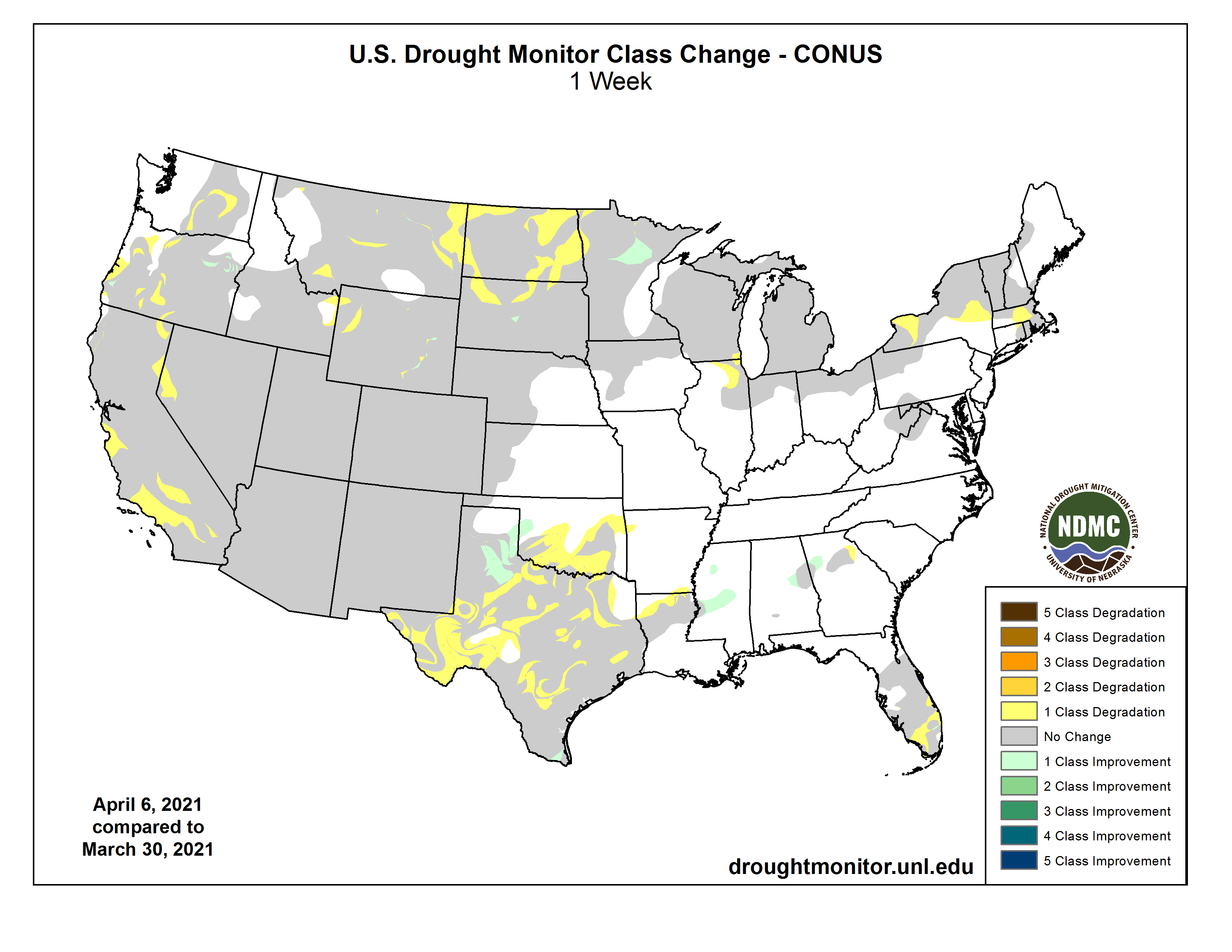
This Week’s Drought Summary

A cold front moving across the eastern half of the country last week brought showers and thunderstorms and left record-breaking cold temperatures in its wake. Meanwhile, dry conditions and warmer than normal temperatures continued in the West with many locations setting daily record high temperatures. The overall effect was a general deterioration of conditions across the Lower 48 as moisture deficits continued to build in the West and in locations in the eastern half of the country that missed out on the heaviest rainfall. Improvements were minimal and limited to parts of the Midwest and Southern Plains…

High Plains

High temperatures in Nebraska and the Dakotas reached the upper 70s to mid-80s last week. With values of about 20 to 30 degrees above normal, many locations set daily records. These warm temperatures combined with low relative humidity and gusty winds to increase fire danger across the region. North and South Dakota declared fire emergencies due to ongoing drought conditions and increased wildfire activity. Severe (D2) and extreme (D3) drought expanded in both states as precipitation deficits continued to grow and increased evaporative demand dried out soils and stressed vegetation. USDA reports that, as of April 4, 92% of North Dakota’s topsoil and 68% of South Dakota’s topsoil was rated short to very short, indicating that soil moisture supplies are significantly less than what is required for normal crop growth development. In North Dakota, county Extension agents report that producers are starting to de-stock livestock herds by culling cows and grain farmers are very concerned about the lack of moisture. Photos show soil drift due to the dry conditions and high winds…

West

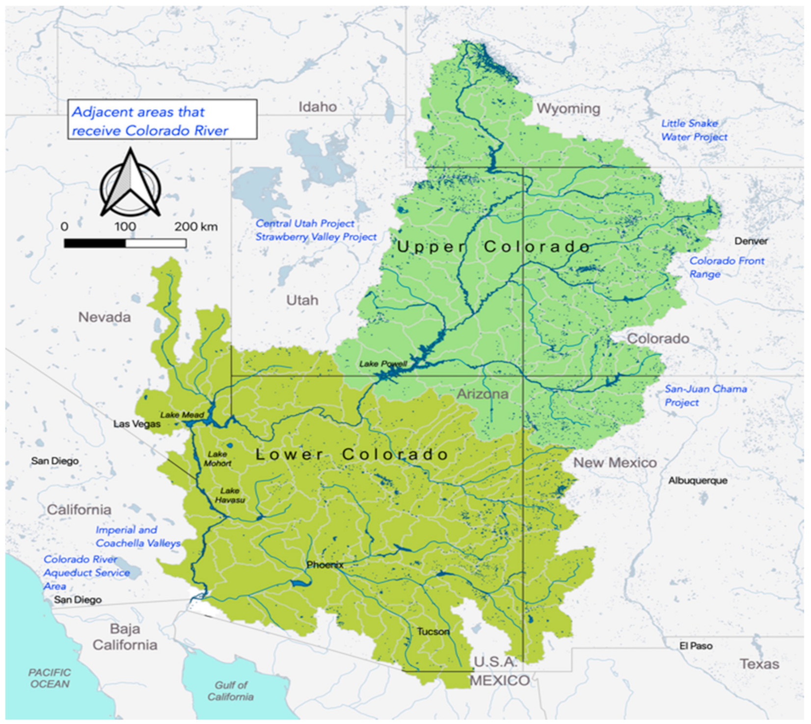
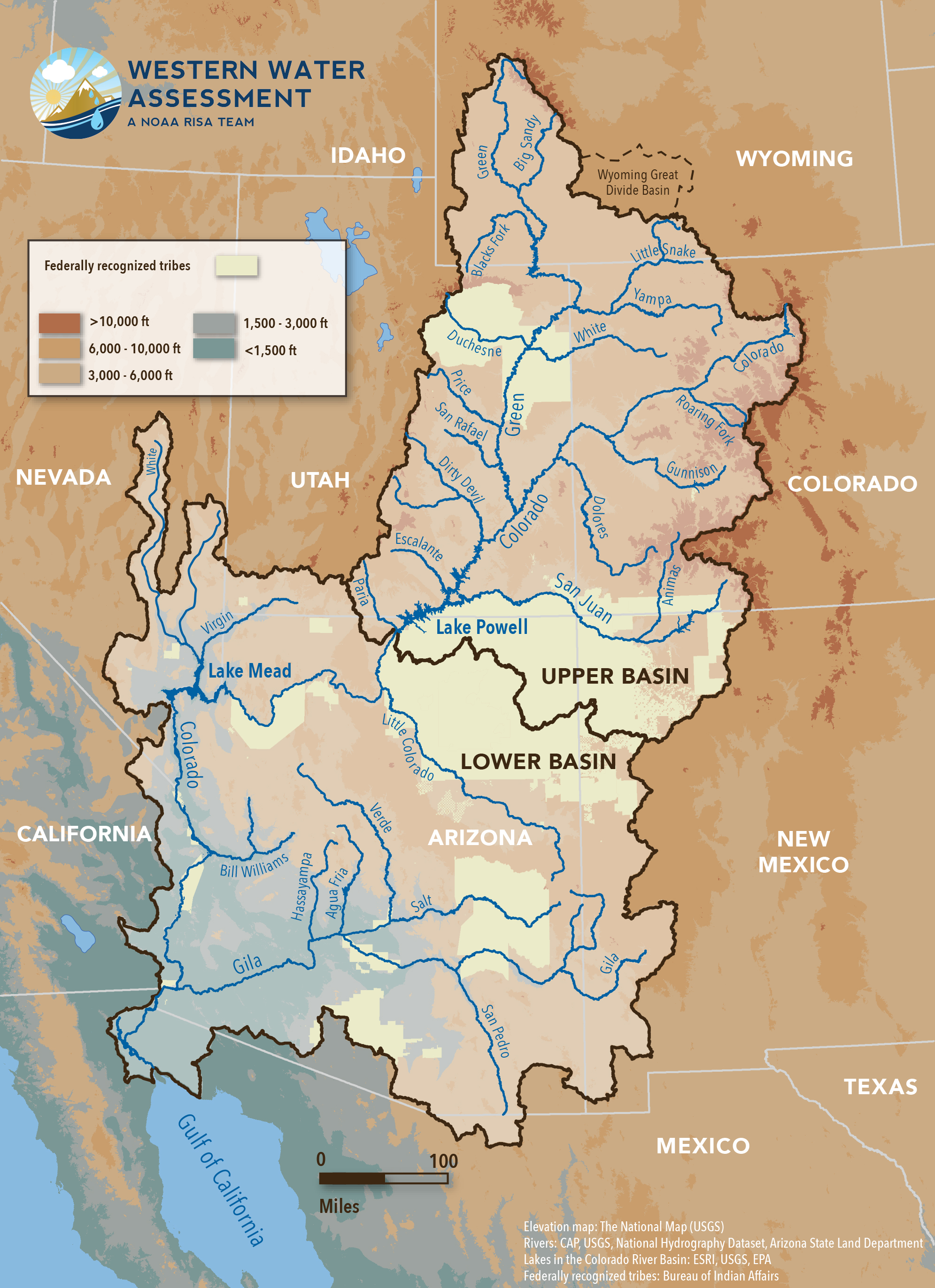
As the wet season begins to wind down in the West, widespread extreme (D3) to exceptional (D4) drought continues across much of the Southwest. Another week of warm, dry weather didn’t help. High temperatures ranged from 4 degrees above normal in the Northwest to 15 degrees above normal in the Southwest while little to no precipitation fell across much of the region. Where exceptions occurred, in the Pacific Northwest and the Northern Rockies, totals generally weren’t enough to overcome shortages. In eastern Washington, abnormal dryness (D0) and moderate drought (D1) expanded as precipitation deficits continued to increase, drying out soils. Conditions also deteriorated in Oregon. Most notably, D3 expanded and D4 was introduced in south central Oregon in response to record low water-year-to-date total precipitation, streamflow and soil moisture. It’s worth noting that since the U.S. Drought Monitor began in 2000, this is only the second time that D4 has occurred in the state (last occurrence in summer and fall of 2003). In California, the April 1 snow survey showed that snow water content in the Sierra Nevada Mountains was at 59% of average and the state, as a whole, received about 50% of its average precipitation for the water year. Two consecutive dry years have left reservoirs about half full. These precipitation deficits, combined with high temperatures, have reduced streamflow, dried out soils, and stressed vegetation. Changes to this week’s map include an expansion of D3 in northern California and western Nevada and an expansion of D2 (severe drought) and D3 in southern California. D1 expanded in northwest Wyoming and southeast Montana to reflect below normal precipitation over the water year and its effect on soil moisture and streamflow. Eastern Montana also saw deteriorating conditions with an expansion of D2 and D3. Here, the lack of precipitation over the last 2 to 3 months has dried out soils and stressed vegetation. USDA reports that, as of April 4, 76% of the state’s topsoil was rated short to very short indicating that soil moisture supplies are significantly less than what is required for normal crop growth development…

South

Showers and thunderstorms impacted the Lower Mississippi and Tennessee valleys last week, resulting in improvements to abnormally dry (D0) areas in Mississippi. Having missed out on the heaviest rainfall, drought and abnormal dryness generally expanded in the western part of the region. In Texas, degradations occurred throughout the state in response to rainfall deficits, increased evaporative demand and vegetation health. Most notable is an expansion of D3 (extreme) and D4 (exceptional) drought in the long-term drought area in the western part of the state. In Oklahoma, this week’s map shows broad expansions of D0 and D1 (moderate drought). Warm, dry weather combined with gusty winds increased evaporative demand, drying out soils and vegetation. The only improvements this week occurred in the Texas Panhandle and western Oklahoma. Despite the lack of rain last week, a reassessment of indicators shows that conditions have started to recover…

Looking Ahead

The National Weather Service Weather Prediction Center forecast for the next 5 days (April 8 through the 12) forecasts heavy rain and the potential for thunderstorms for the central U.S. As the storm system pushes eastward, chances increase for heavy rain and thunderstorms across the Upper Midwest, south-central, and southeastern U.S. In the Northwest, a storm moving in from the Pacific will bring colder than normal temperatures with snow likely falling in the Cascades and Northern Rockies and rain at lower elevations. In the Southwest and southern High Plains, warm, dry weather combined with gusty winds is expected to persist, leading to the potential continuation of dangerous fire weather conditions. Moving into next week, the Climate Prediction Center six- to 10-day outlook (valid April 12 through April 16) favors above normal temperatures across the West, Northeast and Southeast, with the largest probabilities centered over the Great Basin and New England. Below normal temperatures are most likely across the Great Plains, Mississippi Valley and Alaska. The greatest probabilities of above normal precipitation are across the Southern Plains, Southeast and Mid-Atlantic states.

US Drought Monitor one week change map ending April 6, 2021.

#ColoradoRiver basin due for more frequent, intense hydroclimate events — #LosAlamos National Laboratory

Adjacent areas that receive Colorado River water. Map credit: Los Alamos National Laboratory

Here’s the release from the Los Alamos National Laboratory (Charles Poling):

Climate change will drive more drought, heat waves, floods, and low river flows in seven western states

In the vast Colorado River basin, climate change is driving extreme, interconnected events among earth-system elements such as weather and water. These events are becoming both more frequent and more intense and are best studied together, rather than in isolation, according to new research.

“We found that concurrent extreme hydroclimate events, such as high temperatures and unseasonable rain that quickly melt mountain snowpack to cause downstream floods, are projected to increase and intensify within several critical regions of the Colorado River basin,” said Katrina Bennett, a hydrologist at Los Alamos National Laboratory and lead author of the paper in the journal Water. “Concurrent extreme events of more than one kind, rather than isolated events of a single type, will be the ones that actually harm people, society, and the economy.”

Another example of concurrent hydroclimate events might be low precipitation accompanied by high temperatures, which cause drought as an impact. Other factors such as low soil moisture or wildfire burn scars on steep slopes contribute to impacts.

“You never have just a big precipitation event that causes a big flood,” Bennett said. “It results from a combination of impacts, such as fire, topography, and whether it was a wet or dry summer. That’s the way we need to start thinking about these events.”

The Los Alamos study looked heat waves, drought, flooding, and low flows in climate scenarios taken from six earth-system models for the entire Colorado River basin. The basin spans portions of Wyoming, Colorado, New Mexico, Utah, Nevada, Arizona, and California.

Using indicators such as maximum temperature, maximum precipitation, dry days, maximum and minimum streamflow, maximum and minimum soil moisture, and maximum evapotranspiration, the team ran the models for a historical period (1970-1999) and a projected future period (2070-2099). They studied the difference between the two periods (future minus historical) for events at four time scales: daily, monthly, seasonal, and annual.

Overall, precipitation across the Colorado increased by 2.1 millimeters between the future and historical periods, with some models showing increases in precipitation and some showing decreases. Nonetheless, the team found that in all cases, precipitation changes still drove an increase in concurrent extreme events.

Brad Udall: Here’s the latest version of my 4-Panel plot thru Water Year (Oct-Sep) of 2019 of the #coriver big reservoirs, natural flows, precipitation, and temperature. Data goes back or 1906 (or 1935 for reservoirs.) This updates previous work with @GreatLakesPeck

Unsurprisingly, temperature increased across all six models and was an even stronger catalyst of events. Consistently across the entire basin, the study found an average temperature rise of 5.5 degrees Celsius between the future and historical periods.

In every scenario, the number and magnitude of each type of extreme event increased on average across the Colorado River Basin for the future period compared to the historical period. These numbers were given as a statistical expression of the change in frequency between the historical and future period, not as a count of discrete events.

Those increases have significant social, economic, and environmental implications for the entire region, which is a major economic engine for the United States. The study identified four critical watersheds in the Colorado basin — the Blue River basin, Uncompahgre, East Taylor, Salt/Verde watersheds — that are home to important water infrastructures, water resources, and hydrological research that would be particularly vulnerable to extreme events in the future.

More than 40 million people depend on the Colorado River basin for water, and it directly supports $1.4 trillion in agricultural and commercial activity — roughly 1/13 of the U.S. economy, according to 2014 figures.

In Utah, Colorado, Arizona, and New Mexico, flooding, drought, freezing events, wildfire, severe storms, and winter storms have cost approximately $40 billion between 1980–2020.

The Paper: “Concurrent Changes in Extreme Hydroclimate Events in the Colorado River Basin,” Katrina E. Bennett (corresponding author), Carl Talsma, and Riccardo Boero, in Water 2021, 13, 978, April 1, 2021. https://doi.org/10.3390/w13070978

The Funding: This work was funded by the Early Career Laboratory Directed Research and Development (LDRD) program at Los Alamos National Laboratory.

Graphic credit: Western Water Assessment

After Clean Water Act setback, state to ask lawmakers for new authority — @WaterEdCO #dirtywaterrule #WOTUS

Ephemeral streams are streams that do not always flow. They are above the groundwater reservoir and appear after precipitation in the area. Via Socratic.org

From Water Education Colorado (Jerd Smith):

For the second time in less than a year, state health officials plan to ask lawmakers to fast-track permitting authority over hundreds of miles of streams left unprotected after a 2020 Trump Administration rollback of federal Clean Water Act rules.

The Colorado Department of Public Health and Environment’s move comes just weeks after a federal court denied Colorado’s effort to prevent the new federal rules from taking effect.

The CDPHE is holding work group sessions and seeking public comment on a proposed bill that is likely to be introduced in the next two weeks, officials said. The CDPHE declined to comment for this article.

Last May Colorado Attorney General Phil Weiser sued the U.S. Environmental Protection Agency and won a temporary injunction against the new rules, which would have taken effect in June 2020. But a federal appeals court overturned that decision last month.

As a result, the rules are set to take effect in Colorado April 23. Though many expect the Biden Administration to alter the new rules, once again, state health officials say an interim rule is needed to ensure the state has the permitting authority and the funds needed to protect streams.

The CDPHE launched a similar effort last year, but a lack of support for that proposal caused the agency to withdraw it. Now agency officials say they will try again.

Major water interests, such as the nonpartisan Colorado Water Congress, are closely watching the latest legislative effort.

Colorado Water Congress Executive Director Doug Kemper said right now there is too much uncertainty around which streams and which activities will be overseen by federal and state agencies.

“It’s a big deal right now because you don’t really know what activity is covered and what is exempted,” said Kemper. His group has not taken a position on the CDPHE’s initiative, in part because a formal bill has yet to be introduced.

Environmentalists said it’s important that the state moves quickly to assume the permitting authority to protect streams and to allow millions of dollars in construction, dam and road projects to be properly reviewed and permitted.

Industry groups, however, believe new legislation isn’t required right now because the state has some discretion to act already and because the U.S. Army Corps of Engineers, which oversees much of the work on federally protected streams, also has some discretionary authority to review and issue permits.

“We’re concerned that the focus is solely on legislative options,” said John Kolanz, an attorney who represents the Colorado Stone, Sand and Gravel Association. He believes the state could make changes to its own rules, rather than enacting a new law.

“We don’t think it’s advisable to rush through legislation and a complicated rulemaking by the end of the year,” Kolanz said during a public work group meeting hosted by the CDPHE Monday.

Melinda Kassen, general counsel for the Theodore Roosevelt Conservation Partnership who tracks water quality regulation, disagreed, saying the CDPHE must be given new legal authority quickly in order to adequately monitor and fund stream protection work over the next one to two years.

“The biggest part of this legislation is getting some fees so that the [Colorado Water Quality Control] division can do its job and go out and see what’s happening on the ground,” Kassen said Monday.

At issue is what’s known as the Waters of the U.S. (WOTUS) rule. The rule was designed to classify which streams are subject to federal rules and which activities must obtain permits from the Army Corps to ensure those streams are protected even when they are disturbed by home and road building, construction of new storm water systems, and other activities.

But WOTUS has been contested in courts for years over murky definitions about which waterways fall under its jurisdiction, which wetlands must be regulated, what kinds of dredge-and-fill work in waterways should be permitted, what authority the CWA has over activities on farms and Western irrigation ditches, and what is allowable for industries and wastewater treatment plants to discharge into streams.

It has also been difficult to administer because the U.S. is home to such a wide variety of waterways.

In the East and Midwest massive rivers are filled with barge and shipping traffic and are clearly “navigable.” That was the term early courts used to determine how water would be regulated. If a stream was considered navigable, it was subject to federal law.

But Colorado and other Western states rely on shallow streams that don’t carry traditional commercial traffic. The U.S. Geological Survey estimates 44 percent of Colorado’s streams are intermittent, meaning they are sometimes dry, and 24 percent are ephemeral, meaning they can be dry for months or years and appear only after extraordinary rain or snow. Just 32 percent of Colorado streams are classified as being perennial, meaning they flow year round.

Under the new federal rule only perennial and intermittent streams, or those deemed navigable, are regulated, meaning that thousands of miles of streams in Colorado and other Western states are no longer protected under the law.

If the CDPHE’s new legislative effort succeeds, it would give state health officials the authority to issue so-called dredge-and-fill permits on stream segments no longer protected by the federal law.

Jerd Smith is editor of Fresh Water News. She can be reached at 720-398-6474, via email at jerd@wateredco.org or @jerd_smith.

Colorado Rivers. Credit: Geology.com

Holy Cross Energy takes a small but strategic step toward decarbonization and resilience with solar-plus-storage — The Mountain Town News

Solar-plus-storage project at the Spring Valley Campus near Glenwood Springs.

From The Mountain Town News (Allen Best):

Big Pivots

Another small but important piece of the giant puzzle that Holy Cross Energy has set out to solve was revealed Tuesday.

The electrical cooperative serving members in the Vail-Aspen-Rifle area has agreed to purchase electricity from a solar and battery storage project being built by Ameresco Inc. Near Glenwood Springs, on the Spring Valley Campus of Colorado Mountain College, the company will install solar panels capable of generating a maximum of 4.5 megawatts of electricity.

Adjacent to the solar panels it will operate battery storage with a capacity of 5 megawatts (or 15 megawatt hours). Batteries will be charged with electricity generated by the solar panels.

The batteries can be tapped to supply electricity during times of peak demand on a daily basis. In the Vail-Aspen area, peak demand typically occurs in evening hours, with the strongest demand during winter months.

The lithium-iron-phosphate batteries can also augment Holy Cross’s electrical generation during times of disruption, such as caused by wildfires or storms.

“That battery and local generation is an important part of the infrastructure that is real important to creating a resilient energy system for the future,” said Steve Buening, the vice president for power supply and programs at Holy Cross.

The battery storage will be able to have 5 megawatts of power vs. 15 megawatt-hour of capacity. Beuning compares the 5 megawatts to what happens when you press on the gas pedal of an internal-combustion car, while the mega-watt hour is how much the gas tank can hold.

With 45,000 members, Holy Cross is among the larger of Colorado’s 22 electrical cooperatives. As of 2018 it was responsible for 2.2% of electrical sales in the state.

This is from Big Pivots, an e-magazine. To get a free subscription, sign up at http://bigpivots.com

Holy Cross has been assembling disparate pieces of infrastructure, some in and among the communities it services, others hundreds of miles away, as it pursues a goal of completely decarbonizing its electrical supply by 2030.

In addition to the new solar-plus-storage complex near Glenwood Springs, Holy Cross plans a 5-megawatt solar farm on McCain Flats, near the Aspen/Pitkin County Airport. Construction is scheduled to begin this spring.

Complementing this local generation will be electricity generated for Holy Cross at the Arriba wind farm, to be constructed during the next year along Interstate 70 near the eponymously named town 120 miles southeast of Denver. The wind farm will have 100 megawatts of capacity, enough to supply roughly a third of demand by Holy Cross members.

In storage, Holy Cross has something of the same approach, a mixture of local and smaller and elsewhere and larger.

See also Dec. 15, 2020 story: Holy Cross and the ‘Journey to 100%’

Directors of Holy Cross in 2020 adopted a plan that lays out potential strategies, including pumped-storage hydro. Water in pumped-storage projects is released to generate electricity to meet peak demands, then pumped uphill again when electricity is more abundant and hence cheaper.

It’s not new technology. Colorado has two such projects, the larger and older being near Georgetown. There, the Cabin Creek project uses a 1,200 feet vertical drop between two reservoirs to generate a maximum of 324 megawatts. The system went on-line in 1967 but has been upgraded since then.

Bryan Hannegan, the chief executive of Holy Cross, has spoken about the value of small pumped-storage hydro projects in the Aspen-Vail area, perhaps combined with larger capacity pumped-storage projects elsewhere.

Why the battery storage now for Holy Cross instead of waiting for prices to tumble further. Prices of battery storage have dropped about 80% in the last decade and are projected to decline even more, from $137 per kilowatt-hour to as low as $100 by 2023, according to Bloomberg New Energy Finance.

Holy Cross decided that the prices were already good enough.

“One thing that may be holding back investment in utility-scale energy storage is concerns about being an early adopter at higher prices than in the future if battery prices continue their downward trend,” says Buening.

That being noted, the savings are good enough already to yield lower costs of electricity for Holy Cross members.

“We were ready to go ahead,” he says.

Xcel is also planning 275 megawatts of battery storage as it closes two coal-fired power units at Pueblo in the next several years. In a recent filing with the Colorado Public Utilities Commission, the utility plans even more in the years beyond 2024. It’s Colorado’s largest utility with 52.5% of Colorado’s electrical sales for 2018.

Photo at top is rendering of the solar-plus-storage project at the Spring Valley Campus near Glenwood Springs.